bear creek restoration thin - cascade forest · the bear creek restoration project is comprised of:...
TRANSCRIPT
Bear Creek Restoration Thin
Decision Notice and Finding of No Significant Impacts
USDA Forest Service Mt. Adams Ranger District
Gifford Pinchot National Forest Skamania County, Washington
Decision and Reasons for the Decision Background The goal of the Bear Creek Restoration Thin is to improve vegetative conditions and forest in the Bear Creek Municipal Watershed, just north of Carson, Washington on the Mt. Adams Ranger District. The legal land description is T4N, R8E, Willamette Meridian. The planning work is a shared effort of the Forest Service and the South Gifford Pinchot Collaborative. The project aims to restore and expedite the development of old-growth characteristics on dense plantation, Douglas-fir stands; maintain the quality of the domestic water supply in the long-term for the community of Carson, WA and the lower Wind River Valley; improve deer and elk winter range; provide society the benefits of forest products; and provide the local counties the economic benefits of jobs and shared timber receipts. The decision will use variable density tree thinning to retain and/or accelerate tree growth on approximately 533 acres of early-seral forest plantations. Actions also include tree planting for species diversity, forest road restoration to replace undersized culverts, reconstruction of waterbars, and rehabilitation of road shoulders along Forest Service Road 6800. As further restoration, three roads will be decommissioned and/or closed to prevent impacts to water quality and drinking water. Approximately 8,126 mbf (thousand board feet) of timber will be produced. Thinning will recover a small and incidental salvage component from most stands. Decision I have decided to authorize the proposed action as described in the Environmental Assessment, with minor modifications. All project design features and mitigation measures apply to this decision (and are attached as Appendix C to the EA). The Bear Creek Restoration project is comprised of: • Variable density tree thinning, to retain and/or accelerate tree growth, will occur on
approximately 533 acres of early-seral forest plantations. Acreage includes no treatment areas (skips) and ¼ acre openings (gaps).
• Tree thinning within riparian reserves will occur on approximately 91 acres.
• Tree planting, for species diversity, will occur within portions of the thinned areas totaling about 185 acres.
• Forest road restoration to replace undersized culverts, reconstruct waterbars, and rehabilitate road shoulders will occur at 10 locations on Forest Road 6800.
• Decommission and/or closure of forest system roads, presently closed to public use with motor vehicles, will occur on Forest Road 6830 (1.8 miles), Forest Road 6835 (0.9 miles) and Forest Road 6800-602 (0.7 miles).
I have agreed to make the following modification to the decision as described in the EA:
• Where stand 804270 overlaps with a 0.7 mile owl circle, the prescription will change to standard thin. The rest of the unit with no overlap will remain heavy thin. This affects 7.2 acres.
• I will consider extending the operating season as suggested by the South Zone Gifford Pinchot Collaborative. It is currently listed as June 15-September 30. It may be appropriate to allow operations starting June 1 and extending operations into the first half of October.
Conifer Thinning in Tree Plantations via Commercial Timber Sale Utilizing a commercial timber sale, trees will be thinned from dense plantations to improve stand development towards late-successional and old-growth characteristics. These plantations are stocked primarily with Douglas-fir of the same age class and size, and are at densities that will delay the development of large trees, large snags, other tree species, complex crowns, and layered canopy structure. The thinning will remove the smaller Douglas-fir using variable retention methods. Preliminary logging system information is in the appendix of the EA. Two types of conifer thinning treatments are proposed.
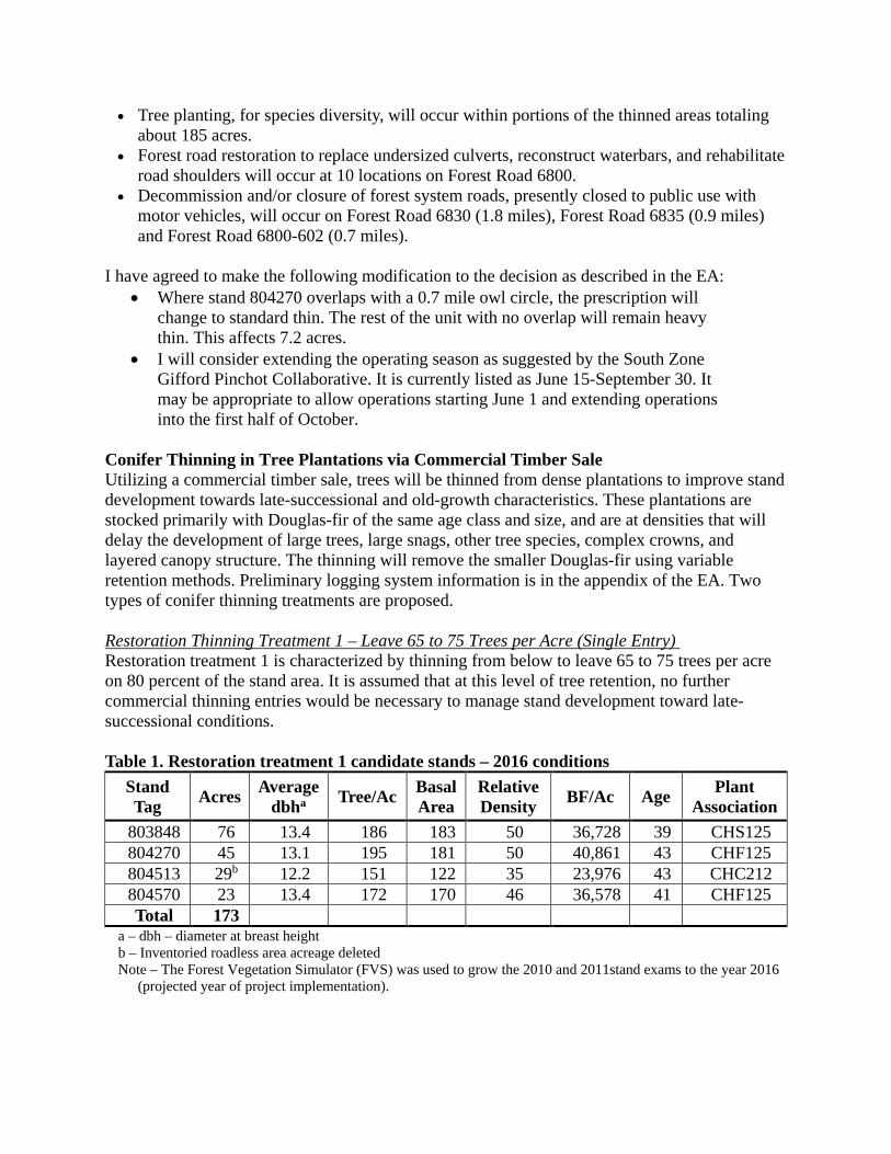
Restoration Thinning Treatment 1 – Leave 65 to 75 Trees per Acre (Single Entry) Restoration treatment 1 is characterized by thinning from below to leave 65 to 75 trees per acre on 80 percent of the stand area. It is assumed that at this level of tree retention, no further commercial thinning entries would be necessary to manage stand development toward late-successional conditions.
Table 1. Restoration treatment 1 candidate stands – 2016 conditions
Stand Tag Acres Average
dbha Tree/Ac Basal Area
Relative Density BF/Ac Age Plant
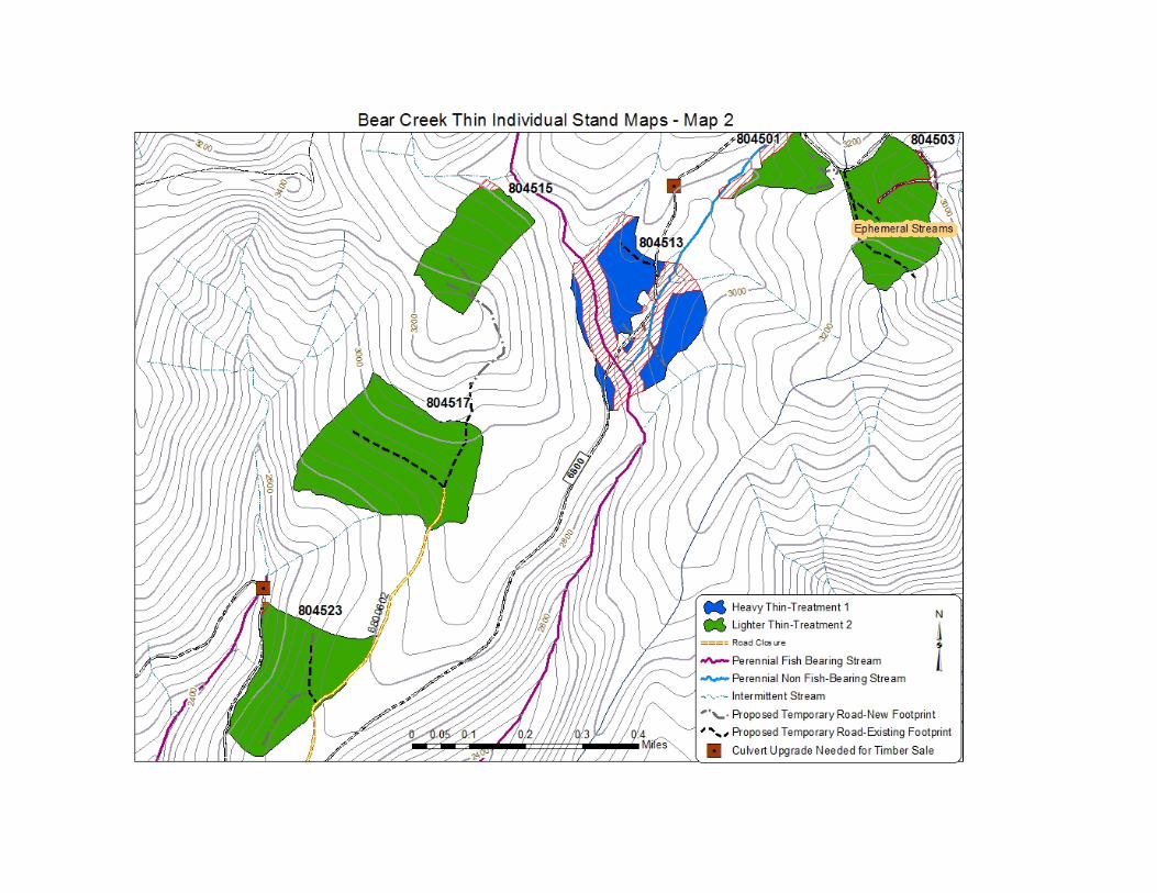
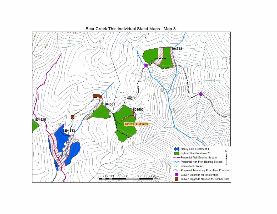
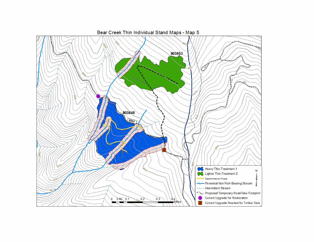
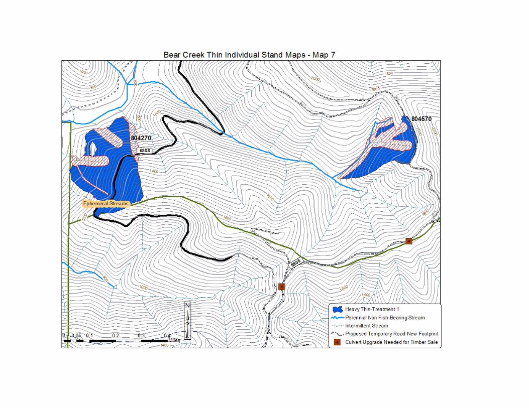
Association 803848 76 13.4 186 183 50 36,728 39 CHS125 804270 45 13.1 195 181 50 40,861 43 CHF125 804513 29b 12.2 151 122 35 23,976 43 CHC212 804570 23 13.4 172 170 46 36,578 41 CHF125 Total 173
a – dbh – diameter at breast height b – Inventoried roadless area acreage deleted Note – The Forest Vegetation Simulator (FVS) was used to grow the 2010 and 2011stand exams to the year 2016
(projected year of project implementation).
Harvest Treatment • 10 percent of stand area – No treatment. (Some units may exceed 10% due to other,
required protection measures.) • 3-5 percent of stand area – Gaps of ¼ acre each, leaving minimum of one conifer. • 3-5 percent of stand area – Heavy thinning in patches ½ to 2 acres each, leaving 35 to 49
conifers/acre. • 80 percent of stand area – General thinning, leaving 65 to 75 conifers/acre. • Retain hardwood tree species where possible. • Construction of temporary road and log landings where needed (see logging details in
Appendix B to the EA). A total of 4.2 miles of temporary road would be utilized for both treatment types, 2.7 of those miles are on existing roadbeds.
• Specified road maintenance where needed on Forest Service roads that would be used for haul including Forest Service roads 65, 68, 6808, 6830, 6835, 6800611, and 6808016 (approximately 28 miles total- see Table 34 in Appendix B of the EA for a list of road work).
• Prevention measures (including pretreatment) to reduce introduction and spread of invasive weeds. The NEPA analysis for pretreatment is covered in the Forest’s Invasive Species EIS.
Post-harvest Treatment • Thinning slash to generally be dispersed. Landing piles burned or removed as firewood or
biomass. • Rehabilitation of temporary roads and landings. • Enhancement tree planting –tree planting activities should occur within 2 years of sale
closure, since the current lack of existing shade tolerant seed sources, within the stands, cannot meet the reforestation objective of improving species diversity. Plant shade tolerant conifers (hemlock, cedar, grand fir) at low densities (e.g. 50 trees per acre) within the heavy thin patches, half of the general thin area, and within the entire riparian thinned portion. Planted cedar would be tubed or otherwise protected from ungulate browse (see appendix – project design features).
• No snag creation is proposed during this entry because of the small diameter trees present. Down woody debris goal in each stand is approximately 5 percent ground cover of wood greater than 6 inches diameter. Three trees per acre are recommended for felling, if additional down wood is needed after harvest.
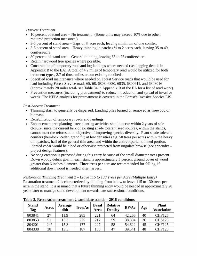
Restoration Thinning Treatment 2 – Leave 115 to 130 Trees per Acre (Multiple Entry) Restoration treatment 2 is characterized by thinning from below to leave 115 to 130 trees per acre in the stand. It is assumed that a future thinning entry would be needed in approximately 20 years later to manage stand development towards late-successional conditions. Table 2. Restoration treatment 2 candidate stands – 2016 conditions
Stand Tag Acres Average
dbh Tree/Ac Basal Area
Relative Density BF/Ac Age Plant
Association 803841 27 11.9 285 221 64 42,266 40 CHF125 803853 51 13.3 225 217 59 38,894 36 CHS125 804201 24a 15.3 177 227 58 54,622 45 CHF125 804338 38 13.5 187 186 47 39,541 48 CHF125
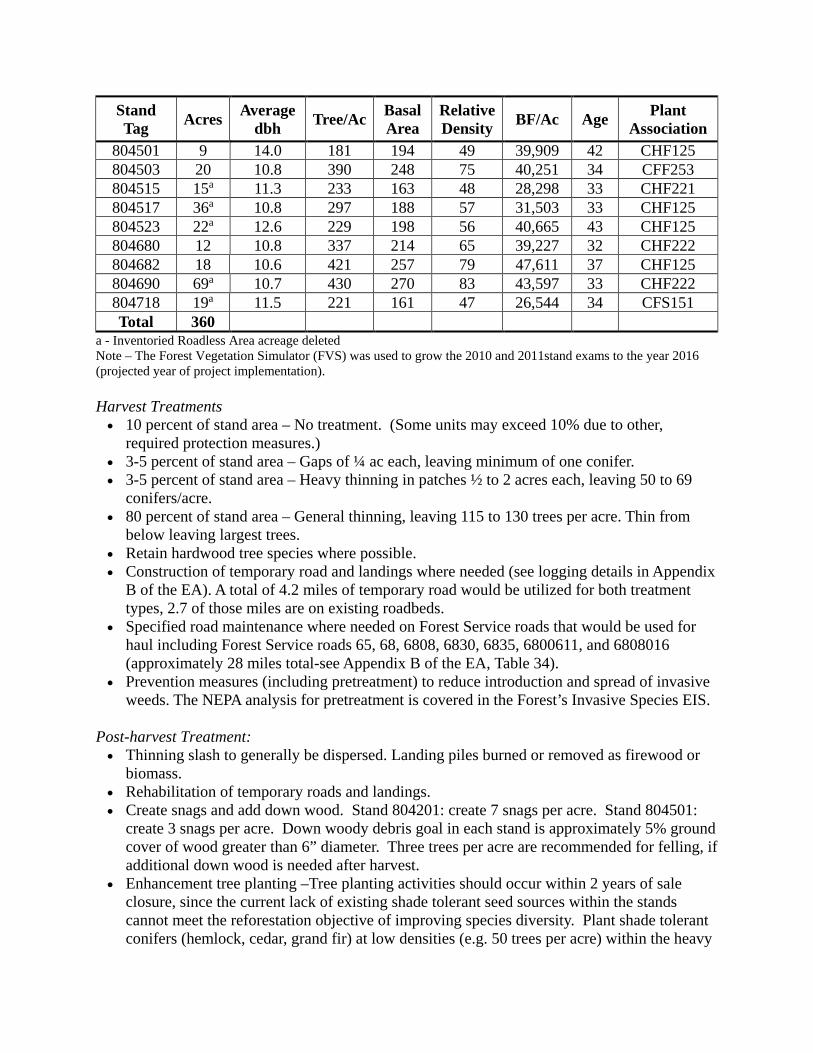
Stand Tag Acres Average
dbh Tree/Ac Basal Area
Relative Density BF/Ac Age Plant
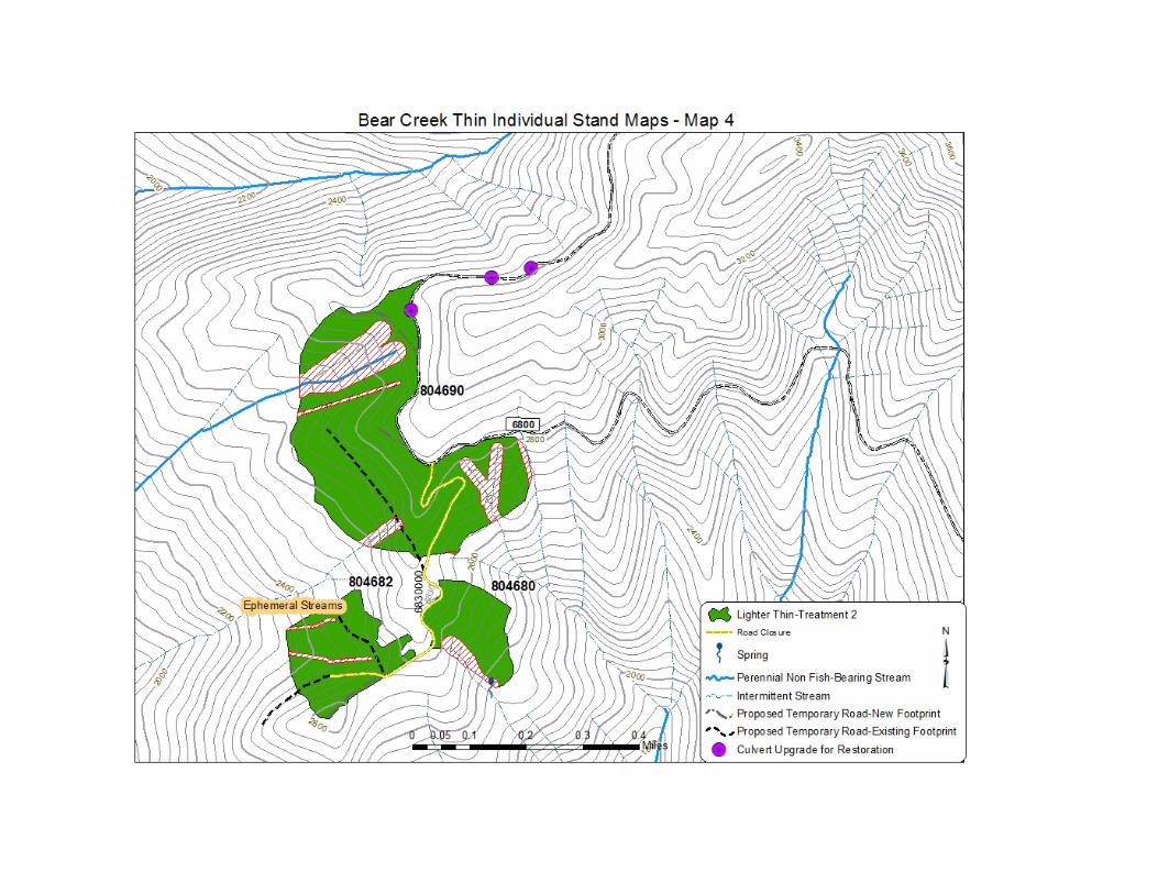
Association 804501 9 14.0 181 194 49 39,909 42 CHF125 804503 20 10.8 390 248 75 40,251 34 CFF253 804515 15a 11.3 233 163 48 28,298 33 CHF221 804517 36a 10.8 297 188 57 31,503 33 CHF125 804523 22a 12.6 229 198 56 40,665 43 CHF125 804680 12 10.8 337 214 65 39,227 32 CHF222 804682 18 10.6 421 257 79 47,611 37 CHF125 804690 69a 10.7 430 270 83 43,597 33 CHF222 804718 19a 11.5 221 161 47 26,544 34 CFS151 Total 360
a - Inventoried Roadless Area acreage deleted Note – The Forest Vegetation Simulator (FVS) was used to grow the 2010 and 2011stand exams to the year 2016 (projected year of project implementation). Harvest Treatments • 10 percent of stand area – No treatment. (Some units may exceed 10% due to other,
required protection measures.) • 3-5 percent of stand area – Gaps of ¼ ac each, leaving minimum of one conifer. • 3-5 percent of stand area – Heavy thinning in patches ½ to 2 acres each, leaving 50 to 69
conifers/acre. • 80 percent of stand area – General thinning, leaving 115 to 130 trees per acre. Thin from
below leaving largest trees. • Retain hardwood tree species where possible. • Construction of temporary road and landings where needed (see logging details in Appendix
B of the EA). A total of 4.2 miles of temporary road would be utilized for both treatment types, 2.7 of those miles are on existing roadbeds.
• Specified road maintenance where needed on Forest Service roads that would be used for haul including Forest Service roads 65, 68, 6808, 6830, 6835, 6800611, and 6808016 (approximately 28 miles total-see Appendix B of the EA, Table 34).
• Prevention measures (including pretreatment) to reduce introduction and spread of invasive weeds. The NEPA analysis for pretreatment is covered in the Forest’s Invasive Species EIS.
Post-harvest Treatment: • Thinning slash to generally be dispersed. Landing piles burned or removed as firewood or
biomass. • Rehabilitation of temporary roads and landings. • Create snags and add down wood. Stand 804201: create 7 snags per acre. Stand 804501:
create 3 snags per acre. Down woody debris goal in each stand is approximately 5% ground cover of wood greater than 6” diameter. Three trees per acre are recommended for felling, if additional down wood is needed after harvest.
• Enhancement tree planting –Tree planting activities should occur within 2 years of sale closure, since the current lack of existing shade tolerant seed sources within the stands cannot meet the reforestation objective of improving species diversity. Plant shade tolerant conifers (hemlock, cedar, grand fir) at low densities (e.g. 50 trees per acre) within the heavy
thin patches, half of the general thin area, and within the entire riparian thinned portion. Planted cedar would be tubed or otherwise protected from ungulate browse (see Appendix C - project design features).
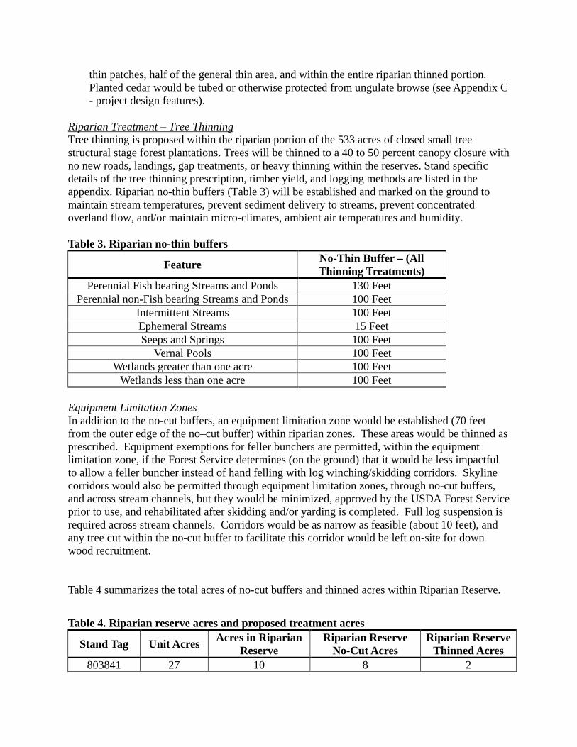
Riparian Treatment – Tree Thinning Tree thinning is proposed within the riparian portion of the 533 acres of closed small tree structural stage forest plantations. Trees will be thinned to a 40 to 50 percent canopy closure with no new roads, landings, gap treatments, or heavy thinning within the reserves. Stand specific details of the tree thinning prescription, timber yield, and logging methods are listed in the appendix. Riparian no-thin buffers (Table 3) will be established and marked on the ground to maintain stream temperatures, prevent sediment delivery to streams, prevent concentrated overland flow, and/or maintain micro-climates, ambient air temperatures and humidity. Table 3. Riparian no-thin buffers
Feature No-Thin Buffer – (All Thinning Treatments)
Perennial Fish bearing Streams and Ponds 130 Feet Perennial non-Fish bearing Streams and Ponds 100 Feet
Intermittent Streams 100 Feet Ephemeral Streams 15 Feet Seeps and Springs 100 Feet
Vernal Pools 100 Feet Wetlands greater than one acre 100 Feet
Wetlands less than one acre 100 Feet Equipment Limitation Zones In addition to the no-cut buffers, an equipment limitation zone would be established (70 feet from the outer edge of the no–cut buffer) within riparian zones. These areas would be thinned as prescribed. Equipment exemptions for feller bunchers are permitted, within the equipment limitation zone, if the Forest Service determines (on the ground) that it would be less impactful to allow a feller buncher instead of hand felling with log winching/skidding corridors. Skyline corridors would also be permitted through equipment limitation zones, through no-cut buffers, and across stream channels, but they would be minimized, approved by the USDA Forest Service prior to use, and rehabilitated after skidding and/or yarding is completed. Full log suspension is required across stream channels. Corridors would be as narrow as feasible (about 10 feet), and any tree cut within the no-cut buffer to facilitate this corridor would be left on-site for down wood recruitment. Table 4 summarizes the total acres of no-cut buffers and thinned acres within Riparian Reserve.
Table 4. Riparian reserve acres and proposed treatment acres
Stand Tag Unit Acres Acres in Riparian Reserve
Riparian Reserve No-Cut Acres
Riparian Reserve Thinned Acres
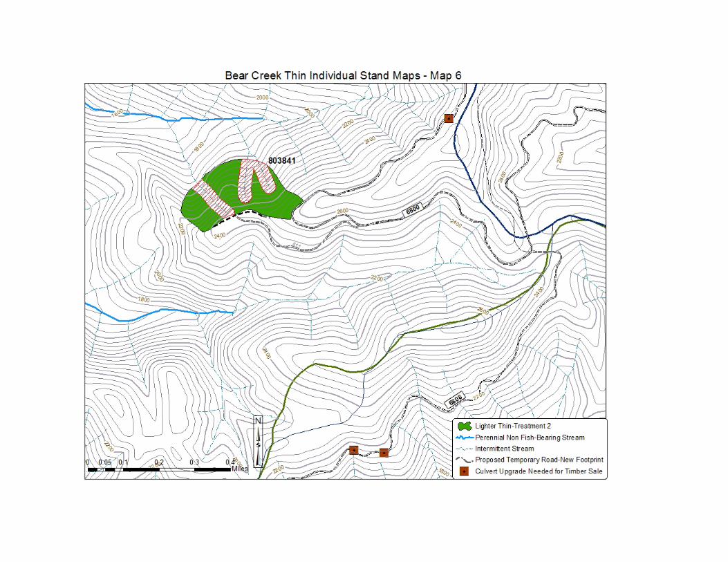
803841 27 10 8 2

Stand Tag Unit Acres Acres in Riparian Reserve
Riparian Reserve No-Cut Acres
Riparian Reserve Thinned Acres
803848 76 31 27 4 803853 51 6 5 1 804201 24 12 8 4 804270 45 16 13 3 804338 38 28 9 19 804501 9 6 6 0 804503 20 5 4 1 804513 29 18 13 5 804515 15 1 0 1 804517 36 3 3 0 804523 22 5 3 2 804570 23 12 10 2 804680 12 7 5 2 804682 18 14 6 8 804690 69 55 21 34 804718 19 8 5 3 Totals 533 237 146 91
Harvest Treatments (Outer Portion of Riparian Reserve) • Thinning from below to leave 40 – 50 percent canopy cover. • Retain hardwood tree species where possible.
Post-harvest Treatments (Outer Portion of Riparian Reserve) • Thinning slash to generally be dispersed. • Create snags in Stand 804201 (7 snags per acre). Stand 804501, create 3 snags per acre. No
other snag creation is proposed because of small diameter trees present. Down woody debris goal in each stand is approximately 5 percent ground cover of wood greater than 6 inches diameter. Three trees per acre are recommended for felling, if additional down wood is needed after harvest.
• Enhancement tree planting – Restoration Treatment 1 and 2 Stands - Tree planting activities should occur within 2 years of sale closure, since the current lack of existing shade tolerant seed sources within the stands cannot meet the reforestation objective of improving species diversity. Plant shade tolerant conifers (hemlock, cedar, grand fir) at low densities (e.g. 50 trees per acre) within the heavy thin patches, half of the general thin area, and within the entire riparian thinned portion. Planted cedar would be tubed or otherwise protected from ungulate browse (see Appendix C of the EA – project design features).
• Invasive weed control. The NEPA analysis for post-treatment is covered in the Forest’s Invasive Species EIS.
Forest Road Decommissioning or Closure The following forest system roads would be decommissioned. These roads are presently closed to public use with motor vehicles.
• Close Forest Road 6830 - 1.8 miles • Decommission Forest Road 6835 - 0.9 miles

• Close Forest Road 6800-602 - 0.7 miles Specific actions to decommission these roads would include some or all of the following:
• Culvert removal • Slope reshaping • Surface ripping • Waterbar construction • Entrance berm construction • Erosion control mulching and grass seeding
Forest Road Restoration There is an opportunity to accomplish road restoration as part of this project. Road work necessary for the timber sale is included in Table 33 and 34 in Appendix B and includes culvert replacements on nine crossings, repair at six additional crossings, and road reconditioning (spot rocking, installing waterbars, cleaning culverts) on 27.36 miles of road within the watershed. These road improvements will be required as part of the timber sale. On top of the required work for the timber sale, the following additional repair or improvement work is needed. These work items rated as either a high or moderate priority in the Gifford Pinchot National Forest Roads Analysis. They are above and beyond what would be required by the timber purchaser and could be funded through stewardship retained receipts or other funds.
• Replace the culvert on Cedar Creek in Unit #804513: The Cedar Creek culvert (on western
side of the unit) is a shotgun culvert. This culvert is a fish barrier with a 3 foot drop, high flow velocity, and no pool below the culvert. Cedar Creek contains good fish habitat and is listed as Lower Columbia River steelhead critical habitat.
• FSR 6800, Milepost 9.15: Replace existing 30 inch culvert with a 48 inch culvert to withstand a 100-year flood event. The original culvert is functioning. A replacement is not needed for timber haul but could be implemented as a restoration project if funds were available to prevent flood impacts in the future.
• FSR 6800, Milepost 9.82: Fill failure upslope of culvert from water running off road due to dip in grade. Remove 4 feet at inlet to 24 inch culvert to increase catchbasin size and reshape ditch on both sides 50 feet.
• FSR 6800, Milepost 9.88: Remove ravel adjacent to pipe inlet and enlarge catchbasin to increase capacity for future ravel. An estimated 25 cubic yards would be removed. In addition, 1 foot of the existing inlet that has been damaged would be removed.
• FSR 6800, Milepost 9.90: Existing culvert has 20 foot drop where ground below outlet is too steep to rebuild fill to support. Remove 20 feet and install 30-foot aluminum downdrain to outlet on grade break at exposed rock.
• FSR 6800, Milepost 10.11: Remove 8-foot steel inlet section, enlarge catch basin and reshape ditch in both directions for 50 feet.
• FSR 6800, Milepost 10.90: Place riprap at outlet (6 by 4 by 2, 2 cubic yards). • FSR 6800, Milepost 11.55: Remove section of settling on shoulder to eliminate possibility of
future slope failure. Lift the sloping shoulder and use asphalt to patch the road. • FSR 6800, Milepost 9.47-12.67: Road reconditioning. • FSR 6800, Milepost 9.89: Fill removal to improve 60 feet of settling fill.

• FSR 6800, Milepost 0.0-17.27 and 6808, Milepost 3.6-10.7: Place waterbars as needed (with an average of 10 waterbars per mile) to move water off road.
Decision Rationale Plantation thinning is needed in the Bear Creek watershed to meet long-term habitat objectives. Much of the project area consists of young stands (40 to 50 years old) composed mostly of single-tree species (Douglas-fir) at high densities. These stands contain high densities of young trees, is causing inter-tree competition for light, water, and nutrients. Thinning these stands will support more rapid development of large trees and varied forest structure. This project will support the development of multiple forest canopy layers where only a single canopy layer currently exists and will also create variability in stand density that better emulates natural diversity. The project will also add snags and coarse woody debris, essential habitat features historically found in the area. Early successional stands that occur in riparian areas are generally lacking in large trees that provide woody debris, bank stability, and shade for streams. This project will help us move these stands toward multiple tree size classes, species diversity, and a variable stand structure. The goal in the long term is to have large patches of old-growth forest which provide habitat for the northern spotted owl and other old-growth dependent species. Because Bear Creek supplies the domestic water for the community of Carson, Washington and residents in the lower Wind River Valley, road maintenance, storm proofing, and road closures permit hydrologic processes in the watershed to function more naturally and improve the current water quality in Bear Creek. Although the condition of road surfaces in the analysis area is good in most sections, the ditch lines are not maintained adequately and there are chronic problems with the culverts. Some are undersized, they are not cleaned often, some have been damaged during cleaning, there have been blowouts at clogged culverts, and culverts are rusting due to age and soil acidity. In addition, there are not enough water bars, especially upslope of the culverts. Maintaining and storm proofing forest roads will reduce drainage problems before catastrophic road failure or gullying occurs, improving hydrologic processes to the Bear Creek watershed and preventing impacts to water quality. Decommissioning or closure of forest roads within the Bear Creek watershed by removing culverts, recontouring road surfaces, and creating cross drains will restore natural surface flow and drainage patterns and protect water quality. Decompacting the road surface will allow water infiltration and vegetation establishment and reduce erosion and sediment transport to streams, which will protect water quality and drinking water. Over 45,000 acres in this late successional reserve are considered deer and elk biological winter range. As an objective secondary to those of the late successional reserve and water quality, this project will provide opportunities to provide forage for deer and elk. Deer and elk will benefit from increased grass, forb, and shrub habitat within moderate-to-heavily thinned areas and from small gaps.
Other Alternatives Considered Alternative A Alternative A is the no action alternative. This alternative is included in accordance with the National Environmental Policy Act (CFR 1502.14 (d)) and provides a baseline to evaluate the

action alternatives. I did not chose this alternative because it would not restore and accelerate timber growth and yield in even-aged, dense stands or promote the development of late-successional structure in Late-Successional Reserves andRiparian Reserves. Stands would be left to develop without any direct human manipulation. No road reconstruction or maintenance along haul routes would occur to reduce erosion. Alternatives Considered but Eliminated from Detailed Study No other alternative was developed to address the purpose and need. Instead, the Forest Service and the South Zone Gifford Pinchot Collaborative worked to modify the original proposal to address resource concerns. No stand-alone alternatives were suggested by the public or agency partners during the scoping period or early planning process, and I found that the questions and concerns raised during scoping could be addressed by clarifying the design of the proposal and elaborating in the disclosure of effects. Public Involvement and Agency Consultation The South Gifford Pinchot Collaborative has provided a leadership role in the project, initially by highlighting the need for the effort and subsequently by adding to the Forest Service’s capacity by acquiring funding from the South Gifford Pinchot National Forest Resource Advisory Committee (a committee that recommends Title II projects under the Secure Rural Schools and Community Self-Determination Act). Title II funds were used to pay local contractors to collect information on the thinning stands and to begin the necessary environmental analysis required under the National Environmental Policy Act. A sub-group of the Collaborative worked together with the Forest Service to develop a proposal that both parties believe fit the need for the watershed. In addition to thinning of dense stands, they considered other important restoration projects such as road maintenance and closures that would improve the watershed as a whole. A packet with information on the early phase of the proposal was sent to the Forest’s mailing list on November 17, 2014 to inform the public and partners of the project and to seek any comments. In addition, the Mt. Adams Ranger District and the South Gifford Pinchot Collaborative co-hosted a public meeting to discuss the proposal on the evening of November 20, 2014 at the Rock Creek Hegewald Center in Stevenson, WA. The Forest received four emails/letters from individuals or groups regarding the project, including a joint letter from the Collaborative on areas of agreement. All of the comments from the public were used to modify the proposed action or add mitigation measures to the design of the project. The Forest Service also invited Federal, State, and tribal entities to engage in informal or formal comment, discussion, and/or consultation on the project. A scoping notice was sent to the Washington Department of Natural Resources, the Washington Department of Ecology, the Environmental Protection Agency, the National Marine Fisheries Service, the US Fish and Wildlife Service, and resource and cultural staff from affected Indian tribes. The Washington Department of Ecology submitted a letter to former District Ranger Mosé Jones-Yellin, concerning toxic clean-up required of any spills that may affect ground or surface water. Mitigations related to spills are included in the EA.
In compliance with 36 CFR 800.3(f), initiation of the National Historic Preservation Act Section 106 process included consultation with the Washington State Historic Preservation Office which was initiated on December 5, 2011 leading to concurrence on December 6, 2011. Consultation was initiated with the Yakama Nation Cultural Resources Director Johnson Meninick on December 9, 2011. No response was received. No other tribes or Tribal Historic Preservation Offices were consulted with for this project. The assessment of effects for the project was “No historic properties affected” (36CFR800.4(d)(1)). Per regulations on interagency cooperation pursuant to Section 7(a)(2) of the Endangered Species Act (1973), as amended, the Forest Service submitted a Biological Assessment to the US Fish and Wildlife Service on February 18, 2016 and requested formal consultation on the project. The US Fish and Wildlife Service sent the Forest a Biological Opinion on May 4, 2016. The Forest Service submitted a Biological Assessment to the National Marine Fisheries Service on June 1, 2016 and requested formal consultation. The National Marine Fisheries Service sent the Forest a Letter of Concurrence on September 16, 2016. The restoration associated with the project is covered under the Aquatic Restoration Biological Opinion (ARBO II); the culvert crossings require project-specific consultation. There were several field trips to the planning area with Forest Service representatives and members of the South Gifford Pinchot Collaborative. The field trips were open to the public. In addition, the collaborative received monthly updates on the project as well as two presentations on the details of the project. The draft EA went out for public comment on July 11, 2016. The Forest heard back from the Department of Ecology ensuring that we included necessary contamination prevention language in the contract. The Forest also received a joint letter from the South Gifford Pinchot Collaborative and a separate letter from the American Forest Resources Council, both showing general support for the project. In their letter, the South Gifford Pinchot Collaborative stressed that while they agreed to equipment limitation zones, they would like to see language allowing skidding and skyline yarding through those equipment limitation zones (where appropriate). They also suggested a longer operating season than what was listed in the draft EA (June 15 to September 30). The group also suggested a standard thinning prescription (rather than heavy thinning) within mapped historic 0.7-mile owl circles. A draft of this decision was made available for a 45-day objection period. No objections were received. Finding of No Significant Impact
After considering the environmental effects described in the EA, I have determined these actions will not have a significant effect on the quality of the human environment taking into account the context and intensity of impacts (40 CFR 1508.27). Thus, an environmental impact statement will not be prepared. I base my finding on the following: 1. Adverse and beneficial impacts have been assessed and found to be not significant. The
analysis considered not only the direct and indirect effects of the projects but also their contribution to cumulative effects (EA, pages 11-103). Adverse effects from the proposed

action have been minimized or eliminated through project design and mitigation measures (EA, Appendix C). My finding of no significant environmental effects is not biased by the beneficial effects of the action. Past, present and foreseeable future actions have been included in the analysis. No significant cumulative or secondary effects were identified.
2. I find there will be no significant effects to public health and safety. No public health and
safety issues were raised during scoping. Project activities are not within high-use recreation areas. The purchaser will be required to sign access roads when vegetation management activities are occurring to alert any recreationists in the area. Other mitigation are included in the EA to ensure the safety of the public (EA, Appendix C).
3. I find there will be no significant effects on unique characteristics or ecologically critical
areas, including historic or cultural resources, park lands, prime farmlands, rangelands, wetlands, or Wild and Scenic Rivers.
A Forest Service archeologist completed a cultural resource report and concluded that there would be no adverse effects to any historic properties (EA, page 104). There are no park lands, farmlands, or rangelands or Wild and Scenic Rivers within the planning area and therefore none would be affected by the project. No thinning would occur in close proximity to streams or wetlands. An inner no- thin buffer was prescribed (see Table 3 in the EA) on all streams, ponds, and wetlands to protect existing shade-producing trees from being cut, and to provide for woody debris in the short and mid-term.
4. The effects on the quality of the human environment are not likely to be highly controversial. The EA discloses the effects to thinning in northern spotted owl habitat and thinning in riparian reserves using the best available science.
5. Through implementation of similar projects across the country, the Forest Service has
authorized activities of this type. The science relied on for determining effects from thinning and have been extensively studied in the past 25 years, thus, I have determined the effects are not uncertain, and do not involve unique or unknown risk.
6. I find this action is one of several similar actions undertaken on National Forest System
lands and is not likely to establish a precedent for future actions with significant effects, or represent a decision in principle. The decision implements the Gifford Pinchot Forest Plan, as amended (EA, page 2).
7. I find the cumulative impacts are not significant. Cumulative impacts are addressed for each
resource area and included in the EA. Adverse effects from the proposed action have been minimized or eliminated through project design and mitigation measures (EA, Appendix C).
8. I find the action will have no significant adverse effect on districts, sites, highways,
structures, or objects listed in or eligible for listing in the National Register of Historic Places. No heritage resource properties which meet the criteria for inclusion were documented in the Area of Potential Effect (Heritage Resource Report, page 1).

9. I have considered the degree to which the actions will adversely affect endangered or
threatened species or their habitat that have been determined to be critical under the Endangered Species Act of 1973. The only federally-listed wildlife species affected by project activities is the northern spotted owl and its critical habitat. During the analysis phase, the team determined that thinning is expected benefit spotted owls in the long-term by accelerating the development of large trees and a mid-story conifer layer. The design of the project mitigated short-term effects to any northern spotted owls present in the planning area. None of the proposed Bear Creek harvest units contain suitable spotted owl habitat; therefore thinning as proposed would not result in any loss of suitable nesting or foraging habitat. In addition, the proposed units range in age from 33 to 48 years old and contain none of the structural characteristics found in older stands. As such, they are not likely to be used by spotted owls for foraging. Thirteen of the proposed units currently minimally meet the definition of spotted owl dispersal habitat. The proposed thinning would result in a net decrease in dispersal habitat of 28 acres in the analysis area, but the effect would be relatively short-term, likely 15 to 20 years. The project would not remove nesting, roosting, or foraging habitat; would not thin within 300 meters of the historical activity centers; and would not utilize heavy thinning within the 0.7 mile home range circle around the historical activity centers. In addition, the total amount of habitat available for spotted owl dispersal would remain above 50 percent within the analysis area as well as within individual spotted owl home ranges. The limited operating period will minimize noise disturbance during the early nesting season, and effects to the owl’s prey species would be minor. Therefore, the project may affect, but is not likely to adversely affect spotted owls (EA, pages 28-32). The Bear Creek timber sale would result in relatively short-term detrimental as well as longer-term beneficial effects to critical habitat. Thinning and other treatments in plantations that are specifically designed to accelerate the development of owl habitat, and either are in areas that do not provide dispersal habitat or where the effects to dispersal capability would be insignificant or discountable, such as with the moderate thinning prescription, would fall into the not likely to adversely affect category (USDI Fish and Wildlife Service 2012, pg. 71939). Heavy thinning would cause a relatively short-term loss of dispersal habitat on 176 acres. Even though the heavy thinning prescription would have long-term beneficial effects, the short-term result is that critical habitat would be adversely affected. At the landscape scale, the relatively short-term reduction of habitat available for dispersal from 73.9 to 73.8 percent in the analysis area is insignificant. At the critical habitat unit subunit scale the reduction in dispersal habitat resulting from the proposed action would be less than 0.1 percent. When combined with ongoing and foreseeable projects on Forest Service lands, overall decrease in dispersal is expected to decline by 0.7 percent, but would remain at 82.8 percent which is well above the 50 percent threshold identified for landscapes capable of supporting successful spotted owl dispersal (Thomas et al. 1990, pp. 309-310). The Bear Creek project would not result in
the loss of any suitable nesting or foraging habitat. The short-term downgrading of dispersal habitat to non-habitat on a net of 28 acres would be insignificant at the analysis area scale, while having adverse effects at the stand scale. The loss of large snags due to danger tree felling would be minor and dispersed. Due to short-term downgrading of dispersal habitat to non-habitat on 211 acres and the loss of large snags due to danger tree felling, the Bear Creek project may affect, and is likely to adversely affect Critical Habitat (EA, pages 32, 33). No botanical species that are federally listed as threatened, endangered, or proposed were detected during surveys of the project area. There is no habitat for Howellia aquatilis, the only federally listed plant species suspected to occur on the Gifford Pinchot National Forest, because this species is confined to emergent wetlands, which were purposely avoided during project planning (EA, page 70). The project may cause direct effects to lower Columbia River steelhead and its critical habitat from culvert replacement activities including the removal of fish prior to dewatering the channel. However, the risk is low given best practices will be implemented during fish removal activities. Sediment inputs from log haul, road work, and riparian reserve thinning would affect steelhead habitat in the analysis area. These effects are expected to be short-term and localized. Positive long-term effects to fish passage and refugia for steelhead will occur from culvert replacements that improve fish passage. Riparian reserves will be positively affected in the long term. Because of the short-term sediment effects to steelhead habitat, the project may affect, but is not likely to adversely affect lower Columbia River steelhead and lower Columbia River steelhead critical habitat (EA, pages 66, 67).
10. I find the actions will not violate Federal, State, and local laws or requirements for the protection of the environment. Applicable laws and regulations were considered in the EA. The action is consistent with the Gifford Pinchot National Forest Land and Resource Management Plan as amended (EA, pages 2-4).
National Forest Management Act/Forest Plan Consistency As required by the National Forest Management Act (NFMA), this decision is tiered to the Final Environmental Impact Statement for Gifford Pinchot National Forest Land and Resource Management Plan (1990) as amended by the Record of Decision for Amendments to Forest Service and Bureau of Land Management Planning Documents Within the Range of the Northern Spotted Owl (1994) (EA, pages 2-4). Forest Service Sensitive Species Wildlife sensitive species that may be affected by the project include the Townsend’s big-eared bat, mountain goat, mountain quail, Van Dyke’s and Cascade torrent salamanders, zigzag darner, and terrestrial mollusks including the Puget Oregonian, warty jumping slug, Malone's jumping slug, keeled jumping slug, panther jumping slug, broadwhorl tightcoil, and blue-gray taildropper. Since Townsend’s big-eared bats prefer to forage along edges, corridors and in riparian areas, and not in dense young forest stands, thinning or regenerating the proposed units as designed would have minimal impacts to foraging habitat for bats. Maintaining a no-cut riparian buffer would
maintain foraging habitat near open water, as well as creating an edge at the boundary of the thinned and unthinned portions of the stands (EA, page 35). Treatment units lack suitable mountain goat habitat, therefore there is no affect to suitable habitat. Because timber haul routes and treatment units are located in fairly close proximity to recent mountain goat sightings in the watershed, there is potential for disturbance of individual mountain goats if in the area during project implementation. However, the potential is low due to sporadic occurrence (EA, page 37). Thinning would likely improve habitat for mountain quail if they exist in the analysis area. Negative indirect impacts could occur if quail inhabited stands while harvest was ongoing; however, the potential for impacts is very low because the species is unlikely to be present in treatment units that are currently considered unsuitable habitat due to high tree densities and low shrub availability (EA, page 35). The no-cut buffers will protect the habitat that is most likely to be occupied by both Van Dyke’s and Cascade torrent salamanders, and the residual canopy cover in the remainder of the riparian reserves would help to maintain microclimatic conditions near the stream edges. There is a minimal potential for short-term impacts to these salamanders by replacing culverts in perennial streams (EA, page 38). The thinning would reduce habitat quality for terrestrial mollusks in the short-term by reducing overstory shading, resulting in warming and drying at the surface. In the long-term, the treatment would improve habitat by increasing the cover and diversity of shrubs and herbaceous understory plants, which is often an indicator of good mollusk habitat in other parts of the Forest, and by accelerating the development of large trees and late-successional habitat (EA, page 40). There would be no impact to any Forest Service sensitive fish species because there are no fish species designated as sensitive in the Bear Creek watershed (Biological Assessment, page 2). No Forest Service sensitive botanical species were detected during surveys of the project area; therefore there would be no impact to any sensitive species (EA, page 70). Management Indicator Species I have considered the effects to management indicator species (MIS) as disclosed in the EA (EA, Fisheries pages 55, 67; Wildlife pages 42-53). MIS on the Gifford Pinchot National Forest include pileated woodpecker and other cavity excavating and late-successional species, pine marten, elk, deer, wood duck, and goldeneye duck, as well as habitat for cutthroat/steelhead and bull trout. Given the lack of impact on any MIS species from the project, the viability of populations of MIS species on the forest would be maintained. Aquatic Conservation Strategy The project is consistent with the Aquatic Conservation Strategy (ACS) objectives. A complete ACS evaluation that includes a description of the existing condition, important physical and biological components of the watersheds within the planning area, and how the action maintains the existing condition or moves it within the range of natural variability was included in the EA (EA, pages 68-69). As a result of that analysis I find that the project meets or does not prevent attainment of the Aquatic Conservation Strategy objectives.
Sustainable Fisheries Act I find this action is consistent with the Sustainable Fisheries Act of 1996 (Public Law 104-267) (which amended the Magnuson-Stevens Fishery Conservation and Management Act). An assessment was conducted by a Forest Service fisheries biologist that determined there would be no effect to essential fish habitat for coho and Chinook (EA, page 67). Clean Water Act I find all applicable State and Federal requirements associated with State water quality laws and the Clean Water Act will be met through planning, application, monitoring and adjustment of Best Management Practices in conformance with the Clean Water Act and Federal guidance and management direction (EA, page 104, 137). Endangered Species Act Per regulations on interagency cooperation pursuant to Section 7(a)(2) of the Endangered Species Act (1973), as amended, the Forest Service submitted a Biological Assessment to the US Fish and Wildlife Service (USFWS) on February 18, 2016 and requested formal consultation for the Bear Creek project. Through a Biological Opinion dated May 4, 2016, the USFWS concurred with the Forest Service determination that the project may affect, but is not likely to adversely affect the northern spotted owl. Also included in the Biological Opinion was an evaluation of adverse effect to critical habitat for the northern spotted owl. The USFWS concurred that the project is likely to adversely affect critical habitat. The Forest Service submitted a Biological Assessment to the National Marine Fisheries Service on June 1, 2016 and requested formal consultation. The National Marine Fisheries Service sent the Forest a Letter of Concurrence on September 16, 2016. Administrative Review/ Objection Process A draft of this decision was published according to the administrative review process detailed in 36 CFR Part 218. No objections were received. Implementation Activities associated with commercial thinning (e.g. road work, cutting and haul, slash disposal, planting, weed control) are scheduled to begin as early as 2017. Restoration work not directly tied to vegetation management may be implemented as soon as 2018. It may take five, or more, years to complete all activities. It is not known yet if activities associated with Bear Creek Thin will be implemented through a Stewardship Contract (Public Law 108-7) or a traditional Forest Service timber sale contract.
Contact For additional information concerning this decision, contact Erin Black, South Zone Planning Team Leader, during normal office hours (weekdays, 8:00 a.m. to 4:30 p.m.) at the Mt. Adams Ranger District office, Phone: (509) 395-3411; e-mail: [email protected]. E. Platt
EMILY PLATT District Ranger Mt. Adams Ranger District
_1-13-17__________________________________ Date Signed
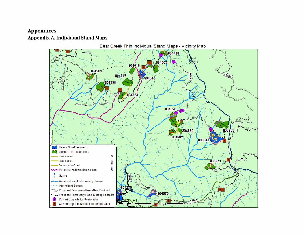
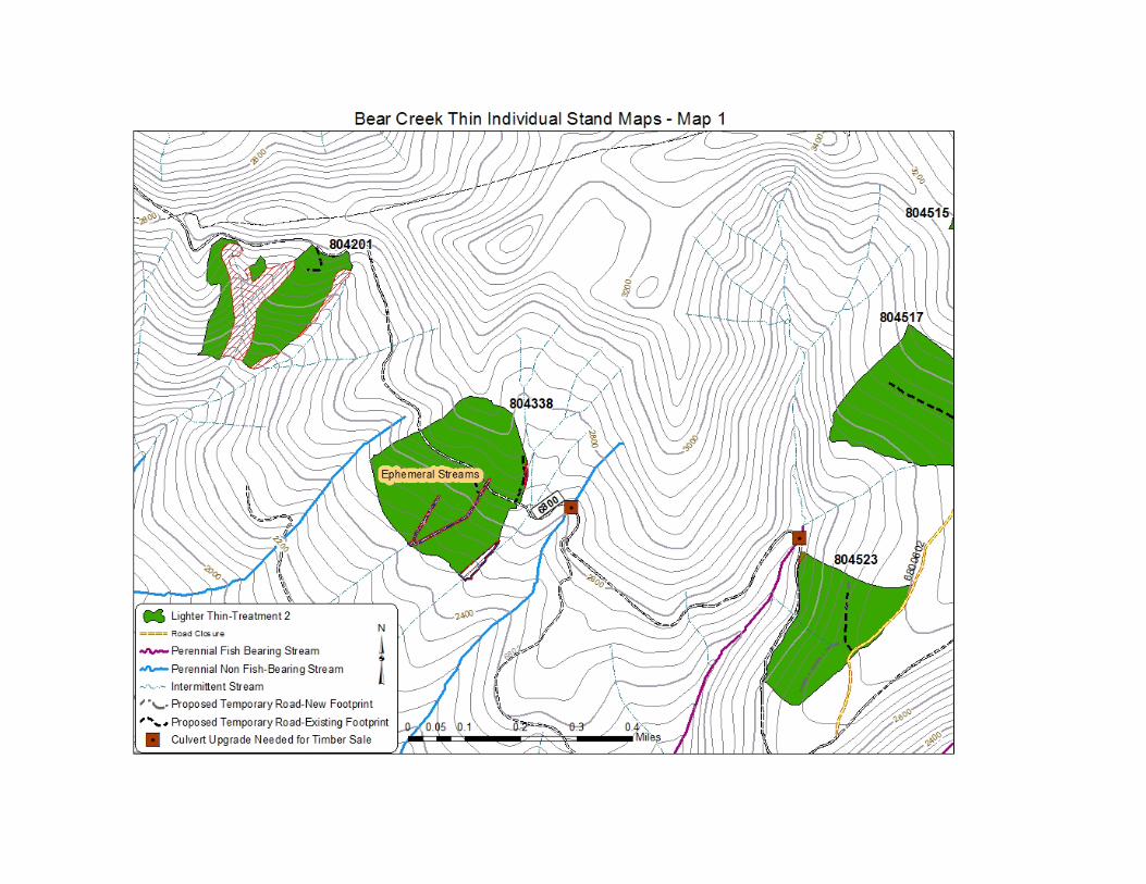
Appendices Appendix A. Individual Stand Maps
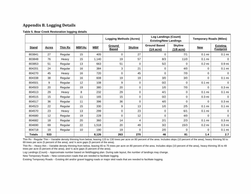
Appendix B. Logging Details Table 5. Bear Creek Restoration logging details
Logging Methods (Acres) Log Landings (Count) Existing/New Landings Temporary Roads (Miles)
Stand Acres Thin Rx MBF/Ac MBF Ground Based Skyline Ground Based
(1/4 acre) Skyline
(1/8 acre) New Existing Footprint
803841 27 Regular 15 405 0 27 0 7/1 0.1 mi 0.1 mi 803848 76 Heavy 15 1,140 19 57 8/3 11/0 0.1 mi 0 803853 51 Regular 13 663 51 0 5/2 0 0.2 mi 0.9 mi 804201 24 Regular 16 384 3 21 0 4/0 0 0.1 mi 804270 45 Heavy 16 720 0 45 0 7/0 0 0 804338 38 Regular 16 608 19 19 3/0 3/0 0 0.1 mi 804501 9 Regular 12 108 9 0 0/2 0 0.1 mi 0 804503 20 Regular 19 380 20 0 1/0 7/0 0 0.3 mi 804513 29 Heavy 8 232 29 0 4/1 0 0.1 mi 0.1 mi 804515 15 Regular 11 165 15 0 0/2 0 0.3 mi 0 804517 36 Regular 11 396 36 0 4/0 0 0 0.3 mi 804523 22 Regular 15 330 9 13 1/0 2/5 0.1 mi 0.1 mi 804570 23 Heavy 13 299 0 23 0 6/1 0.1 mi 0 804680 12 Regular 19 228 0 12 0 4/0 0 0 804682 18 Regular 20 360 14 4 2/1 2/3 0.1 mi 0.3 mi 804690 69 Regular 22 1,518 20 49 3/2 15/3 0.2 mi 0.3 mi 804718 19 Regular 10 190 19 0 2/0 0 0 0.1 mi Totals 533 8,126 263 270 46 81 1.4 2.7
Thin Rx - Regular Thin – Variable density thinning from below, leaving 115 to 130 trees per acre on 80 percent of the area. Includes skips (10 percent of the area), heavy thinning 50 to 69 trees per acre (5 percent of the area), and ¼ acre gaps (5 percent of the area). Thin Rx – Heavy thin – Variable density thinning from below, leaving 65 to 75 trees per acre on 80 percent of the area. Includes skips (10 percent of the area), heavy thinning 35 to 49 trees per acre (5 percent of the area), and ¼ acre gaps (5 percent of the area). Log Landings (Count) – Approximate number based on field/logging plan. During sale layout, the number of landings may change. New Temporary Roads – New construction roads that are needed to facilitate logging. Existing Temporary Roads – Existing dirt and/or gravel logging roads or major skid roads that are needed to facilitate logging.
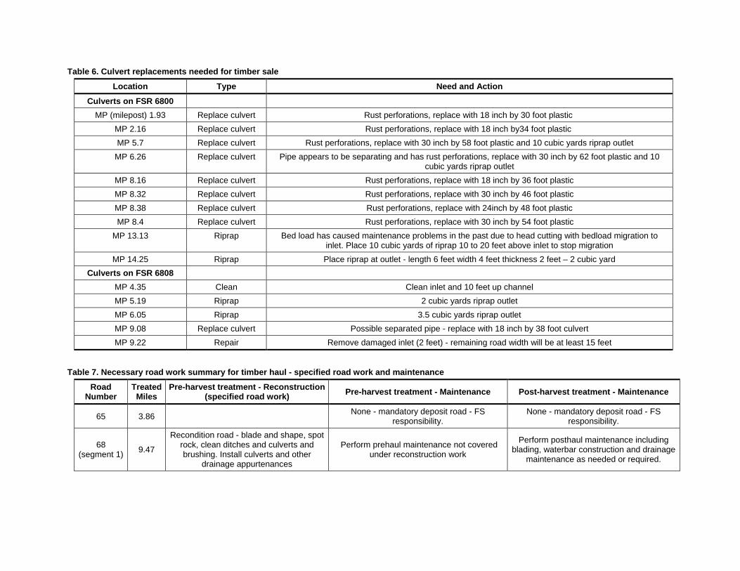
Table 6. Culvert replacements needed for timber sale
Location Type Need and Action
Culverts on FSR 6800 MP (milepost) 1.93 Replace culvert Rust perforations, replace with 18 inch by 30 foot plastic
MP 2.16 Replace culvert Rust perforations, replace with 18 inch by34 foot plastic MP 5.7 Replace culvert Rust perforations, replace with 30 inch by 58 foot plastic and 10 cubic yards riprap outlet
MP 6.26 Replace culvert Pipe appears to be separating and has rust perforations, replace with 30 inch by 62 foot plastic and 10 cubic yards riprap outlet
MP 8.16 Replace culvert Rust perforations, replace with 18 inch by 36 foot plastic MP 8.32 Replace culvert Rust perforations, replace with 30 inch by 46 foot plastic MP 8.38 Replace culvert Rust perforations, replace with 24inch by 48 foot plastic MP 8.4 Replace culvert Rust perforations, replace with 30 inch by 54 foot plastic
MP 13.13 Riprap Bed load has caused maintenance problems in the past due to head cutting with bedload migration to inlet. Place 10 cubic yards of riprap 10 to 20 feet above inlet to stop migration
MP 14.25 Riprap Place riprap at outlet - length 6 feet width 4 feet thickness 2 feet – 2 cubic yard Culverts on FSR 6808
MP 4.35 Clean Clean inlet and 10 feet up channel MP 5.19 Riprap 2 cubic yards riprap outlet MP 6.05 Riprap 3.5 cubic yards riprap outlet MP 9.08 Replace culvert Possible separated pipe - replace with 18 inch by 38 foot culvert MP 9.22 Repair Remove damaged inlet (2 feet) - remaining road width will be at least 15 feet
Table 7. Necessary road work summary for timber haul - specified road work and maintenance
Road Number
Treated Miles
Pre-harvest treatment - Reconstruction (specified road work) Pre-harvest treatment - Maintenance Post-harvest treatment - Maintenance
65 3.86 None - mandatory deposit road - FS responsibility.
None - mandatory deposit road - FS responsibility.
68 (segment 1) 9.47
Recondition road - blade and shape, spot rock, clean ditches and culverts and brushing. Install culverts and other
drainage appurtenances
Perform prehaul maintenance not covered under reconstruction work
Perform posthaul maintenance including blading, waterbar construction and drainage
maintenance as needed or required.
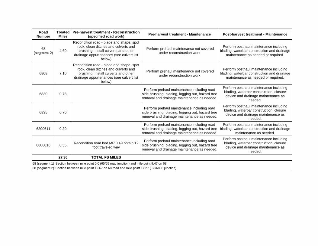
Road Number
Treated Miles
Pre-harvest treatment - Reconstruction (specified road work) Pre-harvest treatment - Maintenance Post-harvest treatment - Maintenance
68 (segment 2) 4.60
Recondition road - blade and shape, spot rock, clean ditches and culverts and brushing. Install culverts and other
drainage appurtenances (see culvert list below)
Perform prehaul maintenance not covered under reconstruction work
Perform posthaul maintenance including blading, waterbar construction and drainage
maintenance as needed or required.
6808 7.10
Recondition road - blade and shape, spot rock, clean ditches and culverts and brushing. Install culverts and other
drainage appurtenances (see culvert list below)
Perform prehaul maintenance not covered under reconstruction work
Perform posthaul maintenance including blading, waterbar construction and drainage
maintenance as needed or required.
6830 0.78 Perform prehaul maintenance including road
side brushing, blading, logging out, hazard tree removal and drainage maintenance as needed.
Perform posthaul maintenance including blading, waterbar construction, closure device and drainage maintenance as
needed.
6835 0.70 Perform prehaul maintenance including road
side brushing, blading, logging out, hazard tree removal and drainage maintenance as needed.
Perform posthaul maintenance including blading, waterbar construction, closure device and drainage maintenance as
needed.
6800611 0.30 Perform prehaul maintenance including road
side brushing, blading, logging out, hazard tree removal and drainage maintenance as needed.
Perform posthaul maintenance including blading, waterbar construction and drainage
maintenance as needed.
6808016 0.55 Recondition road bed MP 0.49 obtain 12 foot traveled way
Perform prehaul maintenance including road side brushing, blading, logging out, hazard tree removal and drainage maintenance as needed.
Perform posthaul maintenance including blading, waterbar construction, closure device and drainage maintenance as
needed. 27.36 TOTAL FS MILES
68 (segment 1) Section between mile point 0.0 (65/65 road junction) and mile point 9.47 on 68
68 (segment 2) Section between mile point 12.67 on 68 road and mile point 17.27 ( 68/6808 junction)
28
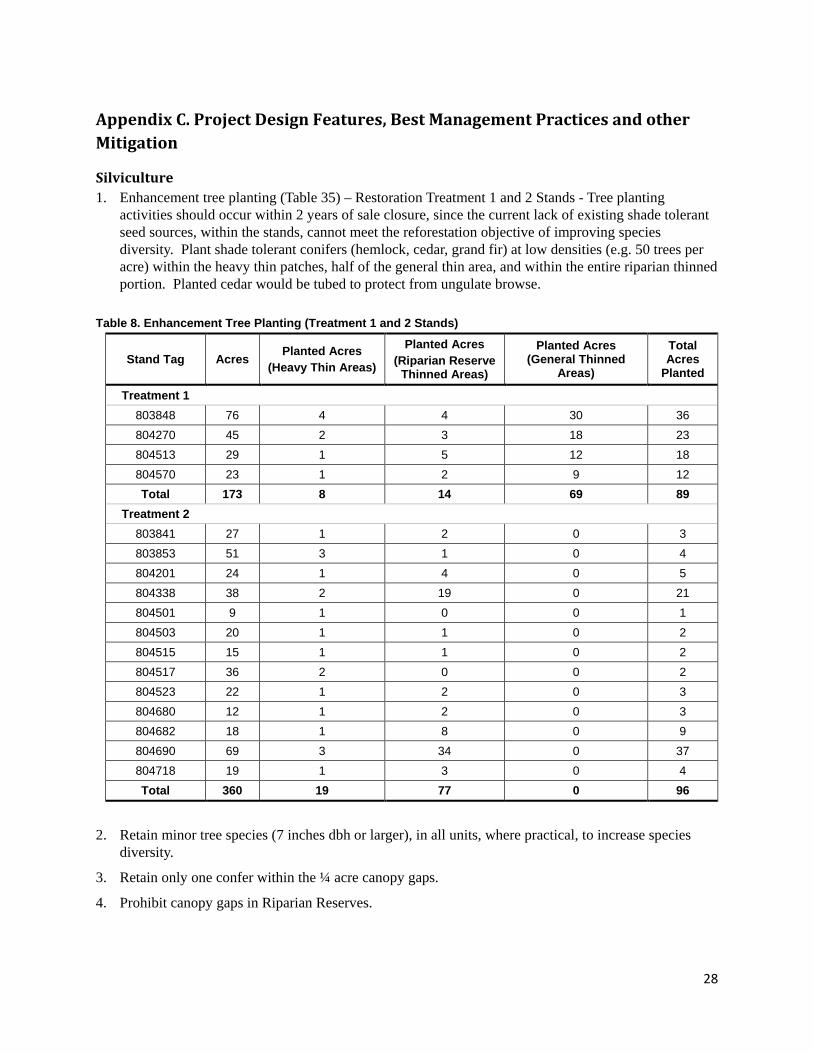
Appendix C. Project Design Features, Best Management Practices and other Mitigation
Silviculture 1. Enhancement tree planting (Table 35) – Restoration Treatment 1 and 2 Stands - Tree planting
activities should occur within 2 years of sale closure, since the current lack of existing shade tolerant seed sources, within the stands, cannot meet the reforestation objective of improving species diversity. Plant shade tolerant conifers (hemlock, cedar, grand fir) at low densities (e.g. 50 trees per acre) within the heavy thin patches, half of the general thin area, and within the entire riparian thinned portion. Planted cedar would be tubed to protect from ungulate browse.
Table 8. Enhancement Tree Planting (Treatment 1 and 2 Stands)
Stand Tag Acres Planted Acres (Heavy Thin Areas)
Planted Acres (Riparian Reserve
Thinned Areas)
Planted Acres (General Thinned
Areas)
Total Acres
Planted
Treatment 1 803848 76 4 4 30 36 804270 45 2 3 18 23 804513 29 1 5 12 18 804570 23 1 2 9 12 Total 173 8 14 69 89
Treatment 2 803841 27 1 2 0 3 803853 51 3 1 0 4 804201 24 1 4 0 5 804338 38 2 19 0 21 804501 9 1 0 0 1 804503 20 1 1 0 2 804515 15 1 1 0 2 804517 36 2 0 0 2 804523 22 1 2 0 3 804680 12 1 2 0 3 804682 18 1 8 0 9 804690 69 3 34 0 37 804718 19 1 3 0 4 Total 360 19 77 0 96
2. Retain minor tree species (7 inches dbh or larger), in all units, where practical, to increase species diversity.
3. Retain only one confer within the ¼ acre canopy gaps.
4. Prohibit canopy gaps in Riparian Reserves.
29
Fire and Fuels 5. Slash disposal- Slash disposal requirements are minimal within the proposed Bear Creek planning
area, because steep terrain limits access, high average annual precipitation mitigates fire risk, and relatively low visitor use levels reduce the probability of human-caused ignitions. Fall hunting season is the heaviest use period for the proposed area, and seasonal rains typically alleviate wildfire concern during that time.
6. Residual loading of woody fuels less than 4 inches diameter should not exceed 25 tons per acre in any treated stand. Residual loading of woody fuels less than 4 inches diameter should not exceed 15 tons per acre within 50 feet of FR 6800 (stands 803848, 804690, 804718, 804503, 804501, 804513, 804523, 804338, 804201). Average residual fuel depth should not exceed 18 inches immediately post-harvest for any treated stand. Fuel continuity should be broken opportunistically and at regular intervals by taking advantage of natural features, skips, and normal variability in fuel concentrations. Excess slash should be piled at landing or alternatively arranged to allow for biomass utilization or firewood collection.
Monitoring Recommendations Post treatment fuel loads should be measured and photo documented.
Wildlife 7. To minimize noise disturbance to nesting spotted owls, implement a limited operating period (LOP)
of March 1 through July 15 for all timber harvest activity adjacent to suitable spotted owl nesting habitat. This would apply to proposed treatment units listed below. If surveys are done to protocol, and no spotted owls are found to be nesting near a given unit, the LOP can be dropped for that unit.
804201 804517 804270 804523 804338 804680 804501 804682 804503 804690 804513 804718 804515
8. To minimize the potential for noise disturbance to nesting spotted owls, implement a limited operating period (LOP) of March 1 through July 15 for all timber harvest activities for the following proposed treatment units. If ground-level reconnaissance by a journey-level wildlife biologist determines that no suitable spotted owl nesting habitat exists adjacent (i.e. within 65 yards) to proposed activities, or if surveys are done to protocol, and no spotted owls are found to be nesting near a given unit, the LOP can be dropped for that unit.
803841 803848 803853
9. To minimize noise disturbance to nesting spotted owls, implement a limited operating period (LOP) of March 1 through July 15 for all danger tree felling in and adjacent to suitable nesting habitat, unless the danger tree is considered to pose an eminent hazard to human health and safety.
10. To minimize noise disturbance to nesting spotted owls, implement a limited operating period (LOP) of March 1 through July 15 for all road decommissioning, rock sources, and culvert replacement projects in and adjacent to suitable nesting habitat.
30
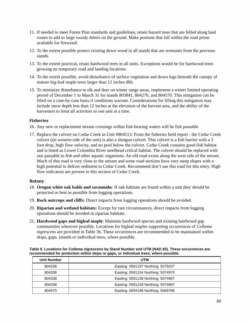
11. If needed to meet Forest Plan standards and guidelines, retain hazard trees that are felled along haul routes to add to large woody debris on the ground. Make portions that fall within the road prism available for firewood.
12. To the extent possible protect existing down wood in all stands that are remnants from the previous stands.
13. To the extent practical, retain hardwood trees in all units. Exceptions would be for hardwood trees growing on temporary road and landing locations.
14. To the extent possible, avoid disturbance of surface vegetation and down logs beneath the canopy of mature big-leaf maple trees larger than 12 inches dbh.
15. To minimize disturbance to elk and deer on winter range areas, implement a winter limited operating period of December 1 to March 31 for stands 803841, 804270, and 804570. This mitigation can be lifted on a case-by-case basis if conditions warrant. Considerations for lifting this mitigation may include snow depth less than 12 inches at the elevation of the harvest area, and the ability of the harvesters to limit all activities to one unit at a time.
Fisheries 16. Any new or replacement stream crossings within fish-bearing waters will be fish passable
17. Replace the culvert on Cedar Creek in Unit #804513: From the fisheries field report - the Cedar Creek culvert (on western side of the unit) is also a shotgun culvert. This culvert is a fish barrier with a 3 foot drop, high flow velocity, and no pool below the culvert. Cedar Creek contains good fish habitat and is listed as Lower Columbia River steelhead critical habitat. The culvert should be replaced with one passable to fish and other aquatic organisms. An old road exists along the west side of the stream. Much of this road is very close to the stream and some road sections have very steep slopes with a high potential to deliver sediment to Cedar Creek. Recommend don’t use this road for this entry. High flow indicators are present in this section of Cedar Creek.
Botany 18. Oregon white oak balds and savannahs: If oak habitats are found within a unit they should be
protected as best as possible from logging operations.
19. Rock outcrops and cliffs: Direct impacts from logging operations should be avoided.
20. Riparian and wetland habitats: Except for rare circumstances, direct impacts from logging operations should be avoided in riparian habitats.
21. Hardwood gaps and bigleaf maple: Maintain hardwood species and existing hardwood gap communities wherever possible. Locations for bigleaf maples supporting occurrences of Collema nigrescens are provided in Table 36. These occurrences are recommended to be maintained within skips, gaps, islands or individual trees, where possible.
Table 9. Locations for Collema nigrescens by Stand Number and UTM (NAD 83). These occurrences are recommended for protection within skips or gaps, or individual trees, where possible.
Unit Number UTM
804338 Easting: 0591197 Northing: 5075037 804338 Easting: 0591154 Northing: 5074970 804338 Easting: 0591138 Northing: 5074967 804338 Easting: 0591159 Northing: 5074897 804570 Easting: 0594198 Northing: 5069785
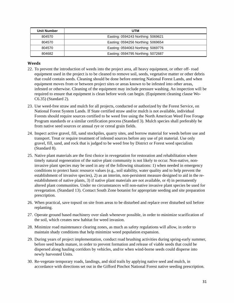
31
Unit Number UTM 804570 Easting: 0594243 Northing: 5069621 804570 Easting: 0594256 Northing: 5069654 804570 Easting: 0594063 Northing: 5069776 804682 Easting: 0594795 Northing: 5072687
Weeds 22. To prevent the introduction of weeds into the project area, all heavy equipment, or other off- road
equipment used in the project is to be cleaned to remove soil, seeds, vegetative matter or other debris that could contain seeds. Cleaning should be done before entering National Forest Lands, and when equipment moves from or between project sites or areas known to be infested into other areas, infested or otherwise. Cleaning of the equipment may include pressure washing. An inspection will be required to ensure that equipment is clean before work can begin. (Equipment cleaning clause Wo-C6.35) (Standard 2).
23. Use weed-free straw and mulch for all projects, conducted or authorized by the Forest Service, on National Forest System Lands. If State certified straw and/or mulch is not available, individual Forests should require sources certified to be weed free using the North American Weed Free Forage Program standards or a similar certification process (Standard 3). Mulch species shall preferably be from native seed sources or annual rye or cereal grain fields.
24. Inspect active gravel, fill, sand stockpiles, quarry sites, and borrow material for weeds before use and transport. Treat or require treatment of infested sources before any use of pit material. Use only gravel, fill, sand, and rock that is judged to be weed free by District or Forest weed specialists (Standard 8).
25. Native plant materials are the first choice in revegetation for restoration and rehabilitation where timely natural regeneration of the native plant community is not likely to occur. Non-native, non-invasive plant species may be used in any of the following situations: 1) when needed in emergency conditions to protect basic resource values (e.g., soil stability, water quality and to help prevent the establishment of invasive species), 2) as an interim, non-persistent measure designed to aid in the re-establishment of native plants, 3) if native plant materials are not available, or 4) in permanently altered plant communities. Under no circumstances will non-native invasive plant species be used for revegetation. (Standard 13). Contact South Zone botanist for appropriate seeding and site preparation prescription.
26. When practical, save topsoil on site from areas to be disturbed and replace over disturbed soil before replanting.
27. Operate ground based machinery over slash whenever possible, in order to minimize scarification of the soil, which creates new habitat for weed invasion.
28. Minimize road maintenance clearing zones, as much as safety regulations will allow, in order to maintain shady conditions that help minimize weed population expansion.
29. During years of project implementation, conduct road brushing activities during spring-early summer, before seed heads mature, in order to prevent formation and release of viable seeds that could be dispersed along hauling corridors by vehicles, and/or when wind-borne seeds could disperse into newly harvested Units.
30. Re-vegetate temporary roads, landings, and skid trails by applying native seed and mulch, in accordance with directions set out in the Gifford Pinchot National Forest native seeding prescription.
32
31. Treatments should be implemented prior to, and as soon as possible, following project activities: harvesting and decommissioning. Treatments should be continued on a yearly basis for 3 three years following the project, as needed.
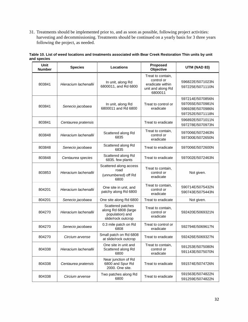
Table 10. List of weed locations and treatments associated with Bear Creek Restoration Thin units by unit and species
Unit Number Species Locations Proposed
Objective UTM (NAD 83)
803841 Hieracium lachenallii In unit, along Rd 6800011, and Rd 6800
Treat to contain, control or
eradicate within unit and along Rd
6800011
596822E/5071023N 597225E/5071110N
803841 Senecio jacobaea In unit, along Rd 6800011 and Rd 6800
Treat to control or eradicate
597214E/5070856N 597055E/5070981N 596928E/5070986N 597252E/5071118N
803841 Centaurea pratensis Treat to eradicate 596892E/5071011N 597278E/5070973N
803848 Hieracium lachenallii Scattered along Rd 6835
Treat to contain, control or eradicate
597006E/5072463N 597300E/5072650N
803848 Senecio jacobaea Scattered along Rd 6835 Treat to eradicate 597006E/5072600N
803848 Centaurea species Scattered along Rd 6835. few plants Treat to eradicate 597002E/5072463N
803853 Hieracium lachenallii
Scattered along access road
(unnumbered) off Rd 6800
Treat to contain, control or eradicate
Not given.
804201 Hieracium lachenallii One site in unit, and patchy along Rd 6800
Treat to contain, control or eradicate
590714E/5075432N 590743E/5075443N
804201 Senecio jacobaea One site along Rd 6800 Treat to eradicate Not given.
804270 Hieracium lachenallii
Scattered patches along Rd 6808 (large
population) and slide/rock outcrop
Treat to contain, control or eradicate
592420E/5069321N
804270 Senecio jacobaea 0.3 mile patch on Rd 6808
Treat to control or eradicate 592794E/5069617N
804270 Circium arvense Small patch on Rd 6808 at slide/rock outcrop Treat to eradicate 592426E/5069327N
804338 Hieracium lachenallii One site in unit and Scattered along Rd
6800
Treat to contain, control or eradicate
591253E/5075080N 591143E/5075070N
804338 Centaurea pratensis Near junction of Rd 6800 and Spur Rd
2000. One site. Treat to eradicate 591574E/5074726N
804338 Circium arvense Two patches along Rd 6800 Treat to eradicate
591563E/5074822N 591259E/5074822N
33
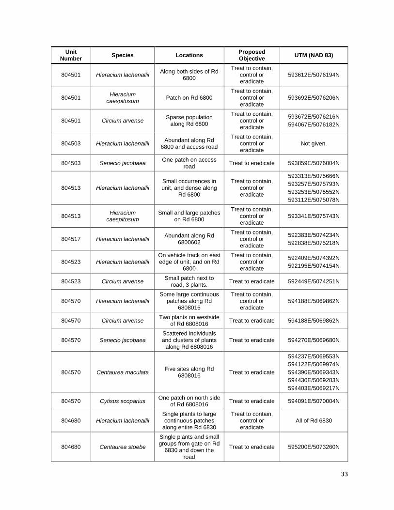
Unit Number Species Locations Proposed
Objective UTM (NAD 83)
804501 Hieracium lachenallii Along both sides of Rd 6800
Treat to contain, control or eradicate
593612E/5076194N
804501 Hieracium caespitosum Patch on Rd 6800
Treat to contain, control or eradicate
593692E/5076206N
804501 Circium arvense Sparse population along Rd 6800
Treat to contain, control or eradicate
593672E/5076216N 594067E/5076182N
804503 Hieracium lachenallii Abundant along Rd 6800 and access road
Treat to contain, control or eradicate
Not given.
804503 Senecio jacobaea One patch on access road Treat to eradicate 593859E/5076004N
804513 Hieracium lachenallii Small occurrences in unit, and dense along
Rd 6800
Treat to contain, control or eradicate
593313E/5075666N 593257E/5075793N 593253E/5075552N 593112E/5075078N
804513 Hieracium caespitosum
Small and large patches on Rd 6800
Treat to contain, control or eradicate
593341E/5075743N
804517 Hieracium lachenallii Abundant along Rd 6800602
Treat to contain, control or eradicate
592383E/5074234N 592838E/5075218N
804523 Hieracium lachenallii On vehicle track on east edge of unit, and on Rd
6800
Treat to contain, control or eradicate
592409E/5074392N 592195E/5074154N
804523 Circium arvense Small patch next to road, 3 plants. Treat to eradicate 592449E/5074251N
804570 Hieracium lachenallii Some large continuous
patches along Rd 6808016
Treat to contain, control or eradicate
594188E/5069862N
804570 Circium arvense Two plants on westside of Rd 6808016 Treat to eradicate 594188E/5069862N
804570 Senecio jacobaea Scattered individuals and clusters of plants
along Rd 6808016 Treat to eradicate 594270E/5069680N
804570 Centaurea maculata Five sites along Rd 6808016 Treat to eradicate
594237E/5069553N 594122E/5069974N 594390E/5069343N 594430E/5069283N 594403E/5069217N
804570 Cytisus scoparius One patch on north side of Rd 6808016 Treat to eradicate 594091E/5070004N
804680 Hieracium lachenallii Single plants to large continuous patches
along entire Rd 6830
Treat to contain, control or eradicate
All of Rd 6830
804680 Centaurea stoebe
Single plants and small groups from gate on Rd
6830 and down the road
Treat to eradicate 595200E/5073260N
34
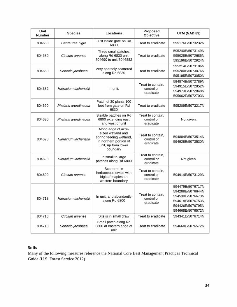
Unit Number Species Locations Proposed
Objective UTM (NAD 83)
804680 Centaurea nigra Just inside gate on Rd 6830 Treat to eradicate 595176E/5073232N
804680 Circium arvense Three small patches along Rd 6830 unit
804690 to unit 8046882 Treat to eradicate
595240E/5073149N 595028E/5072685N 595196E/5072924N
804680 Senecio jacobaea Very sparsely scattered along Rd 6830 Treat to eradicate
595214E/5073106N 595200E/5073076N 595195E/5073050N
804682 Hieracium lachenallii In unit. Treat to contain,
control or eradicate
594874E/5072789N 594915E/5072852N 594973E/5072848N 595062E/5072703N
804690 Phalaris arundinacea Patch of 30 plants 100 feet from gate on Rd
6830 Treat to eradicate 595209E/5073217N
804690 Phalaris arundinacea Sizable patches on Rd 6800 extending east
and west of unit
Treat to contain, control or eradicate
Not given.
804690 Hieracium lachenallii
Along edge of acre-sized wetland and
spring feeding wetland, in northern portion of unit, up from lower
boundary
Treat to contain, control or eradicate
594884E/5073514N 594928E/5073530N
804690 Hieracium lachenallii In small to large patches along Rd 6800
Treat to contain, control or eradicate
Not given.
804690 Circium arvense
Scattered in herbaceous swale with
bigleaf maples on western boundary
Treat to contain, control or eradicate
594914E/5073129N
804718 Hieracium lachenallii In unit, and abundantly along Rd 6800
Treat to contain, control or eradicate
594479E/5076717N 594288E/5076644N 594530E/5076673N 594618E/5076753N 594426E/5076795N 594668E/5076572N
804718 Circium arvense Site is in small draw Treat to eradicate 594341E/5076714N
804718 Senecio jacobaea Small patch along Rd
6800 at eastern edge of unit
Treat to eradicate 594668E/5076572N
Soils Many of the following measures reference the National Core Best Management Practices Technical Guide (U.S. Forest Service 2012).
35
32. Ground-based machinery will not be operated where soil water content is high enough to cause detrimental puddling, defined as when the depth of ruts or imprints is six inches or deeper, for 10 feet or longer.
33. Use existent access roads and skidding trails as much as practical. Equipment, when traveling away from approved skid trails or roads will operate on ground cover, such as slash, existing vegetation, downed saplings, or broken limbs.
34. Temporary roads will be closed, restored, and access denied after harvest and related activities are complete. Actions may include de-compaction, installing drainage features such as water-baring.
35. Equipment may be allowed on slopes up to 35 percent, and shall be approved on a unit-by-unit basis on slopes up to 45 percent prior to start of operation. However equipment should not travel uphill on forest soils greater than 30 percent slope.
36. All currently closed system roads used by the project will be closed and stabilized or decommissioned after sale activities have been completed. These roads will be left in a self-maintaining condition with features such as a barrier at the road junction to prevent vehicle use, or cross-ditches on steep-gradient sections and at culverts or other drainage locations. The objective of this measure is to prevent chronic drainage problems, reduce compaction, minimize negative impacts of mass wasting, and help restore hydrologic and biological process.
37. Timing of erosion control treatment shall be prior to the wet season (October 1 to June 30) for cross drains and grade breaks on all non-system roads, skid trails, landings, and skyline corridors. The objective of this measure is to reduce risk of soil displacement through rill, gully, and splash erosion processes.
38. Proposed action calls for leaving up to 3 trees down per acre. Given the low amount of coarse wood down this action should be considered in every unit with exception of oak release and unit 803853. Trees should be limbed and lop and scatter of branches to compliment ground cover, or augment areas where cover may have been compromised by yarding. It also will help leave in place boles closer to the ground for rapid decomposition.
Aquatics 39. Any proposals to change the following design measures should involve consultation with an aquatics
or soils resource specialist.
40. Riparian no-thin buffers (Table 3) will be established and marked on the ground to maintain stream temperatures, prevent sediment delivery to streams, prevent concentrated overland flow, and/or maintenance of micro-climates, ambient air temperatures and humidity.
41. Mapped ephemeral streams in 6 units would receive a 15 foot buffer. Ephemeral streams are those features that carry water in response to stormflow and snowmelt, but that do not show evidence of annual scour and deposition. They represent a broad category of features that may flow once per year, once every other year or more, or numerous times per year. As a result they run the spectrum in terms of their visibility on the ground when there is no runoff occurring. It would be impractical and even impossible to identify every one of them, but it is very possible to identify the more established examples of them. Ephemeral streams that show no annual scour or deposition do not receive a Riparian Reserve under the Northwest Forest Plan, and are not given a prescribed buffer. During layout it’s important to document their location (if evident) and to mark leave trees along the base of the channel to protect it from incision. Location data should be relayed to Sale administrators so that skid trails and temp roads are not located on the ephemeral stream.
36
42. In addition to the no-cut buffers, an equipment limitation zone would be established (70 feet from the outer edge of the no–cut buffer) within riparian zones. Equipment exemptions for feller bunchers are permitted, within the equipment limitation zone, if the Forest Service determines (on the ground) that it would be less impactful to allow a feller buncher instead of hand felling with log winching/skidding corridors. Skyline corridors would also be permitted through equipment limitation zones, through no-cut buffers, and across stream channels, but they would be minimized, approved by the USDA Forest Service prior to use, and rehabilitated after skidding and/or yarding is completed. Full log suspension is required across stream channels. Corridors would be as narrow as feasible (about 10 feet), and any tree cut within the no-cut buffer to facilitate this corridor would be left on-site for down wood recruitment.
43. Ground-based machinery will not be operated where soil water content is high enough to cause detrimental puddling, defined as when the depth of ruts or imprints is six inches or more (Forest Service Manual, Chapter 2520, R-6 Supplement No. 2500.98-1). This design feature will limit the degree of detrimental soil rutting and puddling as well as reduce the potential for sediment delivery to streams.
44. Equipment traveling away from approved skid trails or temporary roads will operate on a slash mat of limbs and tops that is deposited directly in front of the machine wherever possible. The slash mat will be made as thick and continuous as practical as a means to reduce soil disturbance. Activity would be planned to make as few trips as possible. The objective is to limit soil compaction and displacement, to provide water infiltration and protect the topsoil for vegetative growth.
45. Streams within or adjacent to units will be protected to maintain or improve riparian reserve conditions in accordance with the Aquatic Conservation Strategy of the Northwest Forest Plan and the Clean Water Act. Thinning is prescribed in the outer perimeter of the Riparian Reserves. A no-cut riparian buffer immediately adjacent to streams within the riparian reserves prohibiting equipment operation, timber removal and temporary road construction or reconstruction is designated as 60 feet unless otherwise identified in unit specific project design features (Table 25). Exceptions include a greater no-cut riparian buffer width and/or pre-approved activities such as temporary road construction, reconstruction of old logging roads including intermittent stream crossings, system road improvements, and system road use for timber haul. Skyline yarding corridors are permitted through no harvest buffers on intermittent streams, providing full suspension can be achieved within the entire no harvest buffer width and less than 10 percent of the no-cut riparian buffer is affected by the corridor. A 60 foot no-cut riparian buffer is prescribed for all wetlands greater than 1 acre.
46. Harvested trees will be felled away from streams, springs or wetlands including the no harvest buffers around these hydrologic features. Exceptions would be trees which are leaning towards these features, or when conditions would not allow safe felling. Any portion of a felled tree that lands in the no harvest buffer will be left on the ground. The objective of this is to prevent damage to riparian vegetation and soils within Riparian Reserves.
47. One-end log suspension will be required for ground-based and cable yarding systems (except during winching or lateral yarding). No skidding is permitted across streams, unless it is done across a temporary road. This will reduce the risk of soil compaction and displacement from dragging entire logs along the ground. The objective of this is to minimize erosion and potential sediment delivery to streams.
48. Areas of gouging or soil displacement resulting from suspended cable yarding systems and/or mobile yarding systems will be treated to prevent rill and gully erosion and potential sediment delivery to stream courses. Go-back trails used for equipment fueling and servicing will be rehabilitated post use. Steep slopes will not be subsoiled. Erosion control treatment may include, but is not limited to, repositioning displaced soil to restore the hillslope contour of disturbed sites, creating small ditches or
37
diversions to redirect surface water movement, and scattering slash material to create flow disruption and surface soil stability. Erosion control measures will be designed by watershed or aquatic resource specialists prior to the close of the timber sale, and implemented by the purchaser by October 1st. The objective of this measure is to prevent surface soil erosion resulting from timber related ground disturbance.
49. Landings, skid trails and skyline corridors will be approved by the sale administrator prior to timber felling. Skid trails must be located outside of all no-cut riparian buffers, unless skidding is done across a temporary road. Skid trails will be spaced a minimum of 150 feet apart. Skid trails will be re-established at previous skid trail locations except where existing skid trails from prior entry are causing detrimental soil or hydrologic conditions that could be further avoided with alternative skid trail location. Skid trails will be subsoiled after use where compacted, with a few exceptions as identified. Subsoiling must be to a depth of 18 inches (minimum) and accomplished immediately following logging activities. Available logging slash will be placed across the subsoiled surface.
50. Temporary roads will be located where past logging roads were located, unless a new location would cause less resource effect or where no past logging roads were used to harvest the unit. Rock will be applied only where needed to reduce erosion, puddling and compaction. Temporary road stream crossing structures will be designed to comply with standards and guidelines for permanent structures which accommodate high winter flows unless seasonal restrictions are in place. If a seasonal restriction is in place, temporary road stream crossing structures will be designed to accommodate a range of summer flows and removed prior to the fall wet season. The objective of this is to provide channel transport function and hydrologic connectivity, and to reduce the risk of sediment delivery to streams from culvert failures.
51. Landings will be located outside of all no-cut riparian buffers. Landings will be limited to the area needed for safe and efficient yarding and loading operations and have proper drainage. Certified weed free straw bale catchments or silt fences will be used to avoid sediment transport to road ditches or streams. The catchments will be located to intercept runoff from the landing prior to reaching any road ditch or stream.
52. Any sediment that is captured and deposited behind sediment catchments will be cleaned prior to the wet season and deposited out on the forest floor to ensure it does not have a direct flow path to a system road ditch or stream and will be captured by vegetation on the forest floor. These catchments will be removed following one wet season.
53. Activities conducted in stream courses will follow all provisions specified in the Memorandum of Understanding with Washington State Department of Fish and Wildlife including consideration of the recommended allowable work windows specified for certain activities.
54. All permanent culverts installed on system roads will be designed to accommodate 100-year flow events to be consistent with Gifford Pinchot Land Resource Management Plan Standards and Guidelines (USDA 1995). Road improvement will be designed to effectively allow water to be conveyed through the road prism without causing erosion or loss of slope stability. The objective of this design feature is to ensure channel transport function and hydrologic connectivity.
55. A spill plan will be developed and pre-approved prior to project implementation. The plan will include appropriate operational measures for handling hazardous materials. A Hazardous Material kit will be on site, and would contain materials to control/contain a spill of fuel, oils, and/or hydraulic fluid. Fueling equipment will be located outside of riparian reserves. All service work on heavy machinery and refueling will be done on an established system road at a site approved by the Forest Service. The objective of this design feature is to reduce the potential for damage to the stream and flood plain as a result of a hazardous material spill.
38
56. After activities are complete, temporary roads and landings will be closed and restored. Restoration will include having all stream crossings structures removed which were installed for the timber sale, including any road fill and road surfacing (rock) from within bankfull width of the stream course. Temporary roads and landings which were established for the timber sale will be ripped, de-compacted, or subsoiled to a depth of 18 inches (minimum). The result will be an uneven, rough surface without furrows, and be accomplished immediately following logging activities. De-compaction will encompass the entire landing and the sight distance (to discourage a bypass) from the beginning of the road, no less than 200 feet, and waterbars will be installed where needed. The rest of the road will have drainage reestablished. Available logging slash will be placed across the de-compacted surface. No ground-based equipment will be operated on subsoiled portions of roads and landings after de-compaction is completed to prevent re-compacting treated roadways and landings. Post-harvest motorized access to temporary roads will also be prevented by construction of an approved closure device (e.g., construction of a 4-foot high earth berm or other suitable material at the road entrance). Closure to vehicles is required to prevent subsoiled areas from being re-compacted, prevent erosion and sediment delivery, and to allow vegetation to develop. The objective of this measure is to rehabilitate areas compacted during management activities, accelerate recovery of compacted soils, and facilitate water infiltration and re-vegetation on those disturbed areas. These measures will also provide ground cover for exposed soils in order to reduce the potential for offsite erosion and maintain soil organic matter to prevent nutrient and carbon cycle deficits.
57. Monitoring of feller buncher activity will be performed by the sale administrator in order to prevent/rectify resource damage that may occur as a result of ground disturbing activities. Resource damage includes forming of ponds, ruts, or rills; culvert blockages, stream channel instability, and the occurrence of scour or sediment transport and deposition downstream of cross drains. Project activities will be curtailed and corrective action taken, before work is allowed to resume, if resource damage is occurring. Implementation and effectiveness monitoring of best management practices will be documented by the sale administrator and made available to the line officer in order to determine when adjustments need to be made to prevent excessive resource damage. The objective of this is to minimize erosion and potential sediment delivery to streams, and oversee the harvest methods introduced by the project Forest Plan Amendment of the Pepper Cat Timber Sale.
58. Pre- bunching will be approved on a unit by unit basis on slopes up to 45 percent prior to start of operation. Feller bunchers will not operate over erosive soils on slopes greater than 35 percent. Amendment for pre-bunching on steep slopes allows ground based equipment to travel on slopes greater than 35 percent and away from designated landings, temporary roads, or skid trails for the purpose of pre-bunching. The mechanical harvester will:
a. Enter the harvest unit on planned trails and be limited to slopes less than 45 percent, including short, steep pitches.
b. Avoid traveling across the slope and turning on steep slopes. c. Operate on a slash mat of limbs and tops that is deposited directly in front of the machine, as
described previously. d. Not enter into no-cut riparian buffers and unstable slopes, except for the crossing of a field-
verified, intermittent stream along the northeast boundary of Unit 14. e. Excavation of road prism for feller buncher access, upon verification with a cultural resource
specialist, will be minimized and restored when pre-bunching activities are complete.
59. Go-back trails used for equipment fueling and servicing will be approved by the Forest Service and be located where suitable grade and minimal impacts to soils and water quality exist, and be rehabilitated post use. The objective of this is to prevent surface soil erosion resulting from timber related ground disturbance and compliance with the project-specific Forest Plan Amendment for Wildcat Timber Sale.

39
60. Hazard trees within a site potential tree height distance from a stream, also known as the riparian management zone, will be felled towards the stream and left on the ground. In the case that the felled tree would be at risk of interfering with surface flow into a culvert or culvert inlet area, they can be felled away from the stream.