bayview hunters point neighborhood transportation plan › sites › default › files ›...
TRANSCRIPT
SAN FRANCISCO COUNTY TRANSPORTATION AUTHORITY
PRESENTED TO THE AUTHORITY BOARD, JUNE 2010
Bayview Hunters Point Neighborhood Transportation Plan
FINAL REPORT
ACKNOWLEDGEMENTSThis study has been a collaborative effort, reflecting the energy and enthusiasm of many individuals.
San Francisco County Transportation Authority
Staff
Jesse Koehler, Project ManagerTilly Chang, Deputy Director for Planning
Interns
Lucas WoodwardDorina Pojani
Literacy for Environmental Justice (LEJ)
Rachel Russell – Youth With A Plan ManagerPamela Calvert – Deputy DirectorJessica Farkas, Alicia Ivy-Horace, Brittany Johnson, Frank Nelson, Tashwan William – Youth Leaders
Bayview Hunters Point Mobilization for Adolescent Growth In Our Communities (BMAGIC)
Yvette Mari Robles – DirectorMarquez Gray – Community ConvenerJulia Weisner – Research and Program Coordinator
Consultant Team
Bonnie Nelson, Steve Boland, Rachel Ede – Nelson\Nygaard Consulting AssociatesDonna Pittman – Pittman & Associates; Turnstone Consulting CorporationMeghan Mitman, Matt Plumb, Todd Henry – Fehr & Peers Transportation ConsultantsThomas Kronemeyer, Amy Sommer – Community Design + Architecture
Technical Advisory Committee
Association of Bay Area Governments: Maureen GaffneyCalifornia Department of Transportation: Blanche DeLeon, Noreen Rodriguez, Fredrick Schermer, Paul SvederskyMetropolitan Transportation Commission: Therese Trivedi, Jennifer YeamansPort of San Francisco: David Beaupre, Kanya DorlandSan Francisco Department of Public Health: Michael Radetsky, Tom Rivard, Megan WierSan Francisco Department of Public Works: James ChiaSan Francisco Department of the Environment: Anne EngSan Francisco Mayor’s Office of Greening: Astrid HaryatiSan Francisco Municipal Transportation Agency: Peter Albert, Adam Gubser, Laura Stonehill, Peter Straus, Britt Tanner,
Tony YoungSan Francisco Planning Department: Lily Langlois, Andres Power, Mat SnyderSan Francisco Redevelopment Agency: Vanessa Dandridge, Tom Evans, Lila Hussain, Kelley Kahn, Lisa Zayas-Chien
This project was funded by the California Department of Transportation, the Metropolitan Transportation Commission, and the San Francisco County Transportation Authority.
Contents
Executive Summary 5Study Overview 5Community Involvement 6Needs, Community Priorities, and Study Focus 6Mobility Barriers and Community Transportation 7Parking 8Third Street Corridor Analysis 11Physical Design Improvements 12Funding and Implementation 13
1. Introduction and Study Overview 15Neighborhood Transportation Planning Program 15Setting, Context, and Approach 15Community Involvement 17Report Organization 18
2. Needs, Community Priorities, and Study Focus 19Overview of Technical and Outreach Activities 19Other Studies and Initiatives – Findings and Current Projects 20Community Input – Needs and Priorities 22NTP Focus Issues and Transportation Goals 23
3. Mobility Barriers and Community Transportation 25Background 25Existing Strategies 26Community-Based Transportation—Models and Examples 27Recommendations 32
4. Parking 35Demographics, Policies, and Configuration 35Community Input 36Management Strategies 37Parking Survey 40Recommendations 43
5. Third Street Corridor Analysis 47Background 47Existing Usage and Configuration 47Community Input 48Pedestrian Analysis 50Multimodal Analysis 51Recommendations 53
continued next page
BAYVIEW HUNTERS POINT NEIGHBORHOOD TRANSPORTATION PLAN • SAN FRANCISCO COUNTY TRANSPORTATION AUTHORITY
JUNE, 2010 • FINAL REPORT
1455 Market Street, 22nd Floor, San Francisco, CA 94103tel 415.522.4800 fax 415.522.4829
email [email protected] web www.sfcta.org
S A N F R A N C I S C O C O U N T Y T R A N S P O R TAT I O N A U T H O R I T Y
6. Physical Design Improvements 55Background 55Streetscape and Parking Reconfiguration 56Neighborhood Transit Nodes 62Recommendations 69
7. Recommendations and Implementation 71Community Transportation Recommendations 71Parking Management Recommendations 72Third Street Recommendations 74Physical Design Recommendations 74Funding 76Conclusion 77
Appendices

provided planning, design, and engineering services; Pittman & Associ-ates and Turnstone Consulting developed the public outreach strategy and guided community involvement activities over the course of the NTP process. Literacy for Environmental Justice (LEJ), a Bayview Hunters Point CBO, also joined the study team as a community partner. The study team was advised by a Technical Advisory Committee (TAC) composed
of representatives from City depart-ments and agencies.
The study is part of both the Bay Area Community-Based Transporta-tion Planning (CBTP) program—an MTC initiative that directs planning funds to low-income and minority communities in the region—and the Authority’s Neighborhood Transpor-tation Planning (NTP) program. The goal of both programs is to partner with communities to build consensus on transportation issues and identify solutions to address high-priority needs.
The Bayview NTP study area includes most of the Bayview Hunters Point district, which is located in southeastern San Francisco. A tailored plan-ning approach was developed at the outset of the NTP process in order
to respond to the unique context and history of the Bayview. The NTP empha-sized three core elements in its approach: 1) effective involvement of commu-nity members throughout the NTP; 2) identification of pressing transportation-related issues confront-
ExecutiveSummary
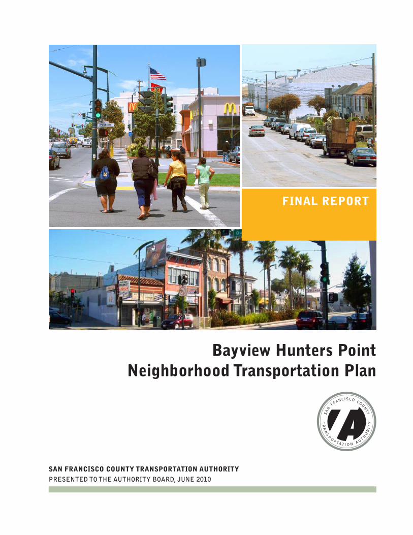
ES. 1 Study Overview
The Bayview Hunters Point Neighborhood Transportation Plan
(NTP) is a community-based transportation planning study, led by
the San Francisco County Transportation Authority (Authority), in
collaboration with community residents, stakeholder groups, neigh-
borhood leaders, and community-based organizations (CBOs). The
NTP was funded by the California Department of Transportation
(Caltrans), the Metropolitan Transportation Commission (MTC), and
the Authority. A technical consulting team led by Nelson\Nygaard
BAYVIEW HUNTERS POINT NEIGHBORHOOD TRANSPORTATION PLAN • SAN FRANCISCO COUNTY TRANSPORTATION AUTHORITY
JUNE, 2010 • FINAL REPORT
PAGE 5
EXECUTIVE SUMMARY
PAGE 6
SAN FRANCISCO COUNTY TRANSPORTATION AUTHORITY • BAYVIEW HUNTERS POINT NEIGHBORHOOD TRANSPORTATION PLAN
FINAL REPORT • JUNE, 2010
EXECUTIVE SUMMARY
ES.3 Needs, Community Priorities, and Study FocusBayview Hunters Point has been the focus of numerous planning studies that have identified transportation needs and poten-tial solutions. In particular, the Bayview Hunters Point Community Revitalization Concept Plan—developed with the leader-ship of the Bayview Hunters Point Project
Area Com-mittee (PAC), a commu-nity-based, publicly-elect-ed body—ar-ticulated the community’s goals and vi-sion regarding transportation (among other
issues). The challenge—and opportunity—for the NTP was to focus technical activi-ties on high-priority community needs in light of other efforts and the goals of the NTP program. To inform the refinement of study focus, the study team undertook a thorough technical review of transporta-tion data, conducted field observations, and analyzed the findings of past studies. In parallel with these technical activities, the team undertook an extensive out-
ing current members of the Bayview Hunters Point community; and 3) development of solutions that could be advanced in a near to medium-term time frame. Further, the planning approach was sensitive to the multitude of completed and in-progress planning and implementation efforts in the Bayview, and thus actively sought to coordinate with agency and community partners, while focusing on transportation needs that are not the primary focus of other initiatives.
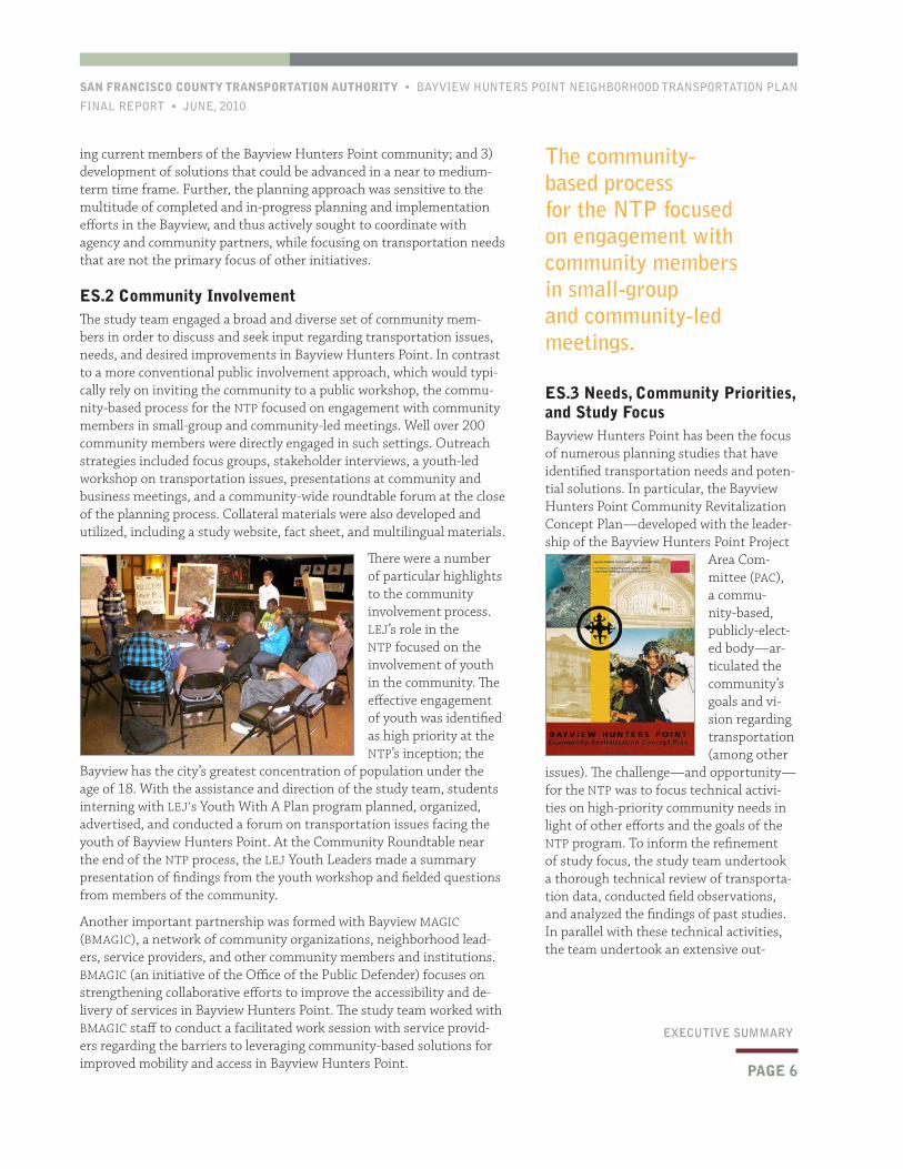
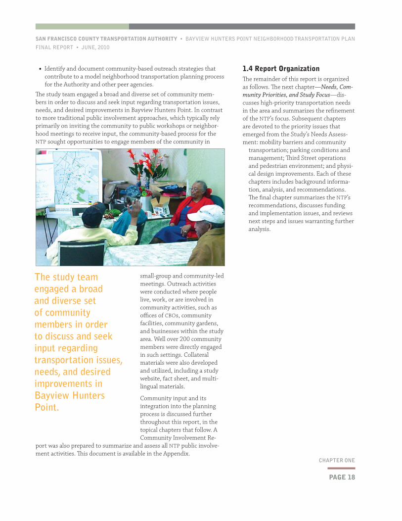
ES.2 Community InvolvementThe study team engaged a broad and diverse set of community mem-bers in order to discuss and seek input regarding transportation issues, needs, and desired improvements in Bayview Hunters Point. In contrast to a more conventional public involvement approach, which would typi-cally rely on inviting the community to a public workshop, the commu-nity-based process for the NTP focused on engagement with community members in small-group and community-led meetings. Well over 200 community members were directly engaged in such settings. Outreach strategies included focus groups, stakeholder interviews, a youth-led workshop on transportation issues, presentations at community and business meetings, and a community-wide roundtable forum at the close of the planning process. Collateral materials were also developed and utilized, including a study website, fact sheet, and multilingual materials.
There were a number of particular highlights to the community involvement process. LEJ’s role in the NTP focused on the involvement of youth in the community. The effective engagement of youth was identified as high priority at the NTP’s inception; the
Bayview has the city’s greatest concentration of population under the age of 18. With the assistance and direction of the study team, students interning with LEJ’s Youth With A Plan program planned, organized, advertised, and conducted a forum on transportation issues facing the youth of Bayview Hunters Point. At the Community Roundtable near the end of the NTP process, the LEJ Youth Leaders made a summary presentation of findings from the youth workshop and fielded questions from members of the community.
Another important partnership was formed with Bayview MAGIC (BMAGIC), a network of community organizations, neighborhood lead-ers, service providers, and other community members and institutions. BMAGIC (an initiative of the Office of the Public Defender) focuses on strengthening collaborative efforts to improve the accessibility and de-livery of services in Bayview Hunters Point. The study team worked with BMAGIC staff to conduct a facilitated work session with service provid-ers regarding the barriers to leveraging community-based solutions for improved mobility and access in Bayview Hunters Point.
The community-based process for the NTP focused on engagement with community members in small-group and community-led meetings.

BAYVIEW HUNTERS POINT NEIGHBORHOOD TRANSPORTATION PLAN • SAN FRANCISCO COUNTY TRANSPORTATION AUTHORITY
JUNE, 2010 • FINAL REPORT
PAGE 7
EXECUTIVE SUMMARY
The three needs that emerged as community priorities that were well-matched to the overall NTP model and to the Bayview NTPproject-specif-ic approach were as follows:
• The need to improve mobility for community members with no or limited automobile access;
• The need to better manage parking and address parking concerns in the neighborhood; and
• The need to provide a safer pedestrian environment for those walking along and across Third and improve the balance among the various uses of the critical Third Street corridor.
ES.4 Mobility Barriers and Community TransportationTraveling to or within Bayview Hunters Point without a car is difficult. Although the neigh-borhood as a whole has higher automobile ownership and mode share than San Fran-cisco as a whole, many individuals—especially in groups of particular concern such as youth,
seniors, and public housing residents—face significant barriers to mobility. Community members with minimal automobile access are challenged to reach jobs, schools, grocery stores, and other important destinations in a safe and timely manner. The NTP’s public outreach and technical analyses point to several issues that strongly contribute to the transportation gaps in the community:
• Walking and bicycling are often not seen as pleasant or practical means of travel.
• Safety concerns further limit the attractiveness of non-automobile modes.
• Beyond the Third Street corridor, Muni can be unreliable and is rela-tively infrequent.
• There are no regional transit stations within the community and local transit does not directly serve many trips.
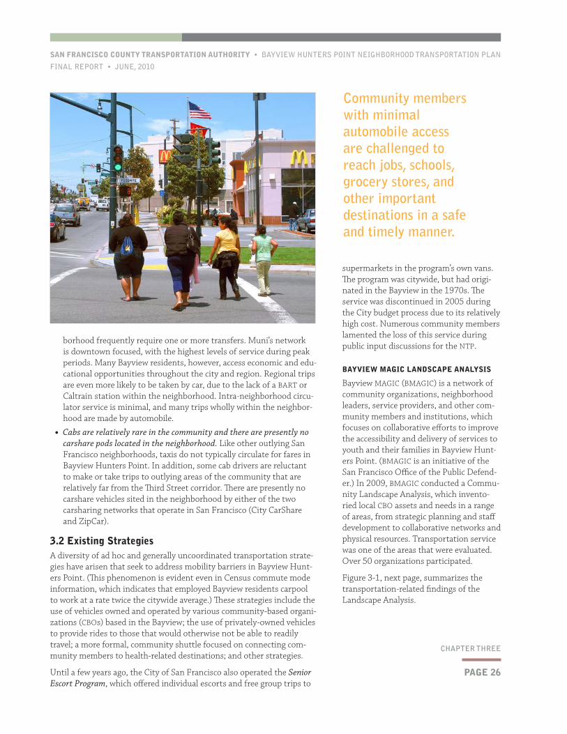
• Cabs are relatively rare in the community and there are presently no carshare pods located in the neighborhood.
A diversity of ad hoc and generally uncoordinated transportation strategies have arisen that seek to address mobility barriers in Bayview Hunters Point. These include the use of vehicles owned and operated by various community-based organizations (CBOs) based in the Bay-view; the use of privately-owned vehicles to provide rides to those that would otherwise not be able to readily travel; a more formal, community shuttle focused on connecting community members to health-related destinations; and other strategies. In 2009, Bayview MAGIC (BMAGIC), which convenes a network of community service providers in the Bay-view, conducted a Community Landscape Analysis, which inventoried local CBO assets and needs in a range of areas including transportation.
reach program that involved stakeholder interviews with community leaders, focus groups, presentations at various commu-nity meetings, the aforementioned youth focus group, and other activities.
Despite the diversity of the Bayview, there is significant consensus on high-priority transportation-related needs that con-front current members of the community. Most prominent among these issues are the following concerns raised by Bayview stakeholders:
• Walking is not a safe or pleasant way to travel in the neighborhood.
• It is difficult to get around the Bayview or go beyond the neighborhood with-out an automobile.
• Muni service is infrequent and unreli-able, particularly beyond the Third Street corridor.
• On-street parking supplies are con-strained and not well managed.
• It is a challenge to access regional tran-sit services from the neighborhood.
• Automobile and truck traffic negatively impacts residential streets.
• Implementation of the T-Third light rail system has brought new challenges and concerns to the neighborhood, particu-larly for pedestrians traveling along and across the corridor.
Community members with minimal automobile access are challenged to reach jobs, schools, grocery stores, and other important destinations in a safe and timely manner.
PAGE 8
SAN FRANCISCO COUNTY TRANSPORTATION AUTHORITY • BAYVIEW HUNTERS POINT NEIGHBORHOOD TRANSPORTATION PLAN
FINAL REPORT • JUNE, 2010
EXECUTIVE SUMMARY
transportation programs is also being studied as part of the Authority’s Stra-tegic Analysis Report (SAR) on Alterna-tive Transit Service Delivery Options, which is currently being developed.
• Pursue other initiatives to improve mo-bility and accessibility in the community. In addition to pursuing the aforemen-tioned study, the NTP recommends support for complementary projects and programs that address community transportation barriers. These include the promotion of carsharing; public safety measures and infrastructure improvements that support walking, bicycling, and transit ridership; identifi-cation of transit operating funding to reverse recent Muni service cuts that have affected the Bayview and other neighborhoods; and improved regional transit access, including the design and construction of a Caltrain station at Oakdale Avenue. This recommendation is an ongoing recommendation (near, medium, and long-term time horizons).
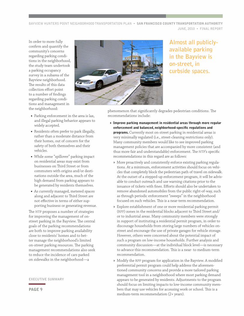
ES.5 ParkingParking issues are a high-priority concern in Bayview Hunters Point. Community members consistently expressed concerns regarding parking conditions and regula-tions both for the residential areas of the neighborhood and along the Third Street commercial core. Almost all publicly-avail-able parking in the Bayview is on-street, in curbside spaces. Many residences have private garages (although some garages are used for storage or living space, rather than vehicular parking). Along the Third Street corridor, issues of concern include double-parking, commercial loading, and business access for customers and employees. In residential areas, issues of concern include constrained availability, sidewalk incursion by vehicles, and insufficient regulation and enforcement.
This analysis found that while some CBOs do operate their own vehicles, these organiza-tions have not been able to effectively collaborate to more efficiently utilize resources and build collective service capacity.
There is significant interest in the community—particularly among CBOs—in overcoming the hurdles associated with coordination, resource-sharing, and collaborative capacity-building in providing improved community transportation. The NTP reviewed successful approaches from other com-munities, but further planning analysis and concerted commu-
nity involvement is necessary to develop a community-based transporta-tion program.
The goal of the community transportation recommendations is to leverage and empower community knowledge and resources to improve mobility and accessibility in Bayview Hunters Point. The NTP’s recom-mendations in this area are as follows:
• Undertake a focused, in-depth technical and community study to advance a community-based transportation program to implementation ready-status. The NTP recommends developing one or more pilots of innovative, community-based solutions, such as a volunteer driver program or a coordinated vehicle collaborative program. To advance such a demonstration project, the NTP recommends that a focused follow-on study be undertaken. Future work is expected to focus on the most promising models for the community: a volunteer driver program and/or a coordinated vehicle collaborative program. The potential to use a carsharing model (and/or technologies or adminis-trative model) to some extent as part of such a program should also be evaluated.
The subsequent stage of analysis will build on the NTP by partnering with the community to develop the full set of technical documents and agreements that are necessary to implement a community-based transportation program. This work will entail the development of a business plan, the identification of partner/participating organiza-tions and agencies, and the assessment of operational, legal, finan-
cial, and institutional issues.
This is a near-term recommendation, and the follow-on study will be initiated as soon as funding is available. The issue of community-based
There is significant interest in the community in overcoming the hurdles associated with coordination, resource-sharing, and collaborative capacity-building in providing improved community transportation.
BAYVIEW HUNTERS POINT NEIGHBORHOOD TRANSPORTATION PLAN • SAN FRANCISCO COUNTY TRANSPORTATION AUTHORITY
JUNE, 2010 • FINAL REPORT
PAGE 9
EXECUTIVE SUMMARY
phenomenon that significantly degrades pedestrian conditions. The recommendations include:
• Improve parking management in residential areas through more regular enforcement and balanced, neighborhood-specific regulations and programs. Currently most on-street parking in residential areas is very minimally regulated (i.e., street-cleaning restrictions only). Many community members would like to see improved parking management policies that are accompanied by more consistent (and thus more fair and understandable) enforcement. The NTP’s specific recommendations in this regard are as follows:
» More proactively and consistently enforce existing parking regula-tions. At a minimum, enforcement activities should focus on vehi-cles that completely block the pedestrian path of travel on sidewalk. At the outset of a stepped-up enforcement program, it will be advis-able to conduct outreach and use warning citations prior to the issuance of tickets with fines. Efforts should also be undertaken to remove abandoned automobiles from the public right-of-way, such as through periodic enforcement “sweeps” in the neighborhood focused on such vehicles. This is a near-term recommendation.
» Explore establishment of one or more residential parking permit (RPP) zones in the residential blocks adjacent to Third Street and/or to industrial areas. Many community members were strongly in support of instituting a residential permit program, in order to discourage households from storing large numbers of vehicles on-street and encourage the use of private garages for vehicle storage. However, others were concerned about the potential impact of such a program on low-income households. Further analysis and community discussion—at the individual block level—is necessary to advance this recommendation. This is a near- to medium-term recommendation.
» Modify the RPP program for application in the Bayview. A modified preferential permit program could help address the aforemen-tioned community concerns and provide a more tailored parking management tool in a neighborhood where most parking demand appears to be generated by residents. Adjustments to the program should focus on limiting impacts to low-income community mem-bers that may use vehicles for accessing work or school. This is a medium-term recommendation (2+ years).
In order to more fully confirm and quantify the community’s concerns regarding parking condi-tions in the neighborhood, the study team undertook a parking occupancy survey in a subarea of the Bayview neighborhood. The results of this data collection effort point to a number of findings regarding parking condi-tions and management in the neighborhood:
• Parking enforcement in the area is lax, and illegal parking behavior appears to widely accepted.
• Residents often prefer to park illegally, rather than a moderate distance from their homes, out of concern for the safety of both themselves and their vehicles.
• While some “spillover” parking impact on residential areas may exist from businesses on Third Street or from commuters with origins and/or desti-nations outside the area, much of the high demand from parking appears to be generated by residents themselves.
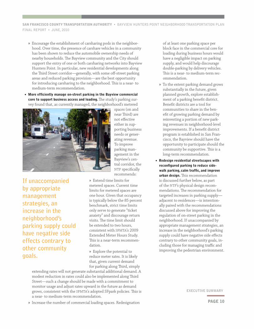
• As currently managed, metered spaces along and adjacent to Third Street are not effective in terms of either sup-porting business or generating revenue.
The NTP proposes a number of strategies for improving the management of on-street parking in the Bayview. The central goals of the parking recommendations are both to improve parking availability close to residents’ homes and to bet-ter manage the neighborhood’s limited on-street parking resources. The parking management recommendations also seek to reduce the incidence of cars parked on sidewalks in the neighborhood—a
Almost all publicly-available parking in the Bayview is on-street, in curbside spaces.
PAGE 10
SAN FRANCISCO COUNTY TRANSPORTATION AUTHORITY • BAYVIEW HUNTERS POINT NEIGHBORHOOD TRANSPORTATION PLAN
FINAL REPORT • JUNE, 2010
EXECUTIVE SUMMARY
of at least one parking space per block face in the commercial core for loading during business hours would have a negligible impact on parking supply, and would help discourage double-parking by delivery vehicles. This is a near- to medium-term rec-ommendation.
» To the extent parking demand grows substantially in the future, given planned growth, explore establish-ment of a parking benefit district. Benefit districts are a tool for communities to share in the ben-efit of growing parking demand by reinvesting a portion of new park-ing revenues in neighborhood-level improvements. If a benefit district program is established in San Fran-cisco, the Bayview should have the opportunity to participate should the community be supportive. This is a long-term recommendation.
• Redesign residential streetscapes with reconfigured parking to reduce side-walk parking, calm traffic, and improve urban design. This recommendation is discussed further below, as part of the NTP’s physical design recom-mendations. The recommendation for targeted increases in parking supply—adjacent to residences—is intention-ally paired with the recommendations discussed above for improving the regulation of on-street parking in the neighborhood. If unaccompanied by appropriate management strategies, an increase in the neighborhood’s parking supply could have negative side effects contrary to other community goals, in-cluding those for managing traffic and improving the pedestrian environment.
» Encourage the establishment of carsharing pods in the neighbor-hood. Over time, the presence of carshare vehicles in a community has been shown to reduce the automobile ownership needs of nearby households. The Bayview community and the City should support the entry of one or both carsharing networks into Bayview Hunters Point. In particular, new residential developments along the Third Street corridor—generally, with some off-street parking areas and reduced parking provision—are the best opportunity for introducing carsharing to the neighborhood. This is a near- to medium-term recommendation.
• More efficiently manage on-street parking in the Bayview commercial core to support business access and loading. The study’s parking sur-vey found that, as currently managed, the neighborhood’s metered
spaces (on and near Third) are not effective either in sup-porting business needs or gener-ating revenue. To improve parking man-agement in the Bayview’s cen-tral corridor, the NTP specifically recommends:
» Extend time limits for metered spaces. Current time limits for metered spaces are one hour. Given that occupancy is typically below the 85 percent benchmark, strict time limits only serve to generate “ticket anxiety” and discourage return visits. The time limit should be extended to two hours, consistent with SFMTA’s 2009 Extended Meter Hours Study. This is a near-term recommen-dation.
» Explore the potential to reduce meter rates. It is likely that, given current demand for parking along Third, simply
extending rates will not generate substantial additional demand. A modest reduction in rates could also be implemented along Third Street—such a change should be made with a commitment to monitor usage and adjust rates upward in the future as demand grows, consistent with the SFMTA’s adopted SFpark policies. This is a near- to medium-term recommendation.
» Increase the number of commercial loading spaces. Redesignation
If unaccompanied by appropriate management strategies, an increase in the neighborhood’s parking supply could have negative side effects contrary to other community goals.
BAYVIEW HUNTERS POINT NEIGHBORHOOD TRANSPORTATION PLAN • SAN FRANCISCO COUNTY TRANSPORTATION AUTHORITY
JUNE, 2010 • FINAL REPORT
PAGE 11
EXECUTIVE SUMMARY
walking environment in the neighborhood’s most active pedestrian area, while minimizing impacts to other modes, particularly transit. The recommendations are as follows:
• Modify the current pro-gramming of traffic signals along Third Street in the Bay-view’s commercial core to im-prove pedestrian conditions. The NTP’s analysis indicates that there are ways to alter the signal programming along Third Street with little or no impact to transit trav-
el time. A “fixed-time” system would allow a pedestrian walk signal to be automatically provided with each phase. A “free-running” system would not eliminate the current pushbutton actuation requirement, but would make the pushbuttons more “responsive” and reduce delay for those who cross legally. This is a near-term recommendation.
• To the extent the actuation requirement is maintained, improve pedes-trian awareness of the actuation system. The NTP does not recommend punitive measures for reducing jaywalking (e.g., ticketing campaigns). Even if walk signals are automatically provided in a portion of the corridor, the actuation requirement will be maintained in some loca-tions. The NTP recommends that additional outreach and education be conducted to encourage safer pedestrian travel in the corridor. This should include improved signage in multiple languages. This is a near-term recommendation.
• Take steps to reduce delay in other segments of the T-Third line. The NTP is strongly supportive of SFMTA’s efforts to improve transit per-formance along the corridor as a whole. Travel time improvements anywhere along the route will benefit transit riders from the Bayview and from other communities served by the T-Third, such as Visita-cion Valley and the Central Waterfront. This is a near- to medium-term recommendation.
• In the longer-term, explore the applicability of alternate approaches to surface-running transit signalization. Even where the T-Third operates in a dedicated right of way (outside of the Bayview commercial core), it must contend with delays at traffic signals. The current system of transit signal priority helps reduce travel time impacts at these intersections, but signal delay remains a significant component of overall travel time. In the future, SFMTA should assess the potential for deploying (potentially on a demonstration or pilot basis) innova-tive approaches to surface-running transit operations. Implementing such a strategy or strategies would require further technical analysis and, if advanced, appropriate approvals for piloting a nonstandard traffic control system, to the extent applicable. Third Street is un-likely to be the most appropriate corridor for initial demonstration. This is a long-term recommendation (5+ years).
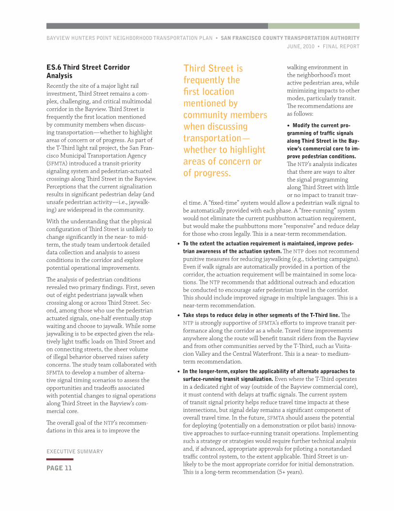
ES.6 Third Street Corridor AnalysisRecently the site of a major light rail investment, Third Street remains a com-plex, challenging, and critical multimodal corridor in the Bayview. Third Street is frequently the first location mentioned by community members when discuss-ing transportation—whether to highlight areas of concern or of progress. As part of the T-Third light rail project, the San Fran-cisco Municipal Transportation Agency (SFMTA) introduced a transit-priority signaling system and pedestrian-actuated crossings along Third Street in the Bayview. Perceptions that the current signalization results in significant pedestrian delay (and unsafe pedestrian activity—i.e., jaywalk-ing) are widespread in the community.
With the understanding that the physical configuration of Third Street is unlikely to change significantly in the near- to mid-term, the study team undertook detailed data collection and analysis to assess conditions in the corridor and explore potential operational improvements.
The analysis of pedestrian conditions revealed two primary findings. First, seven out of eight pedestrians jaywalk when crossing along or across Third Street. Sec-ond, among those who use the pedestrian actuated signals, one-half eventually stop waiting and choose to jaywalk. While some jaywalking is to be expected given the rela-tively light traffic loads on Third Street and on connecting streets, the sheer volume of illegal behavior observed raises safety concerns. The study team collaborated with SFMTA to develop a number of alterna-tive signal timing scenarios to assess the opportunities and tradeoffs associated with potential changes to signal operations along Third Street in the Bayview’s com-mercial core.
The overall goal of the NTP’s recommen-dations in this area is to improve the
Third Street is frequently the first location mentioned by community members when discussing transportation—whether to highlight areas of concern or of progress.
PAGE 12
SAN FRANCISCO COUNTY TRANSPORTATION AUTHORITY • BAYVIEW HUNTERS POINT NEIGHBORHOOD TRANSPORTATION PLAN
FINAL REPORT • JUNE, 2010
EXECUTIVE SUMMARY
in this prioritization. The involvement and support of block residents will be very important for any candidate loca-tion, just as has been the case with the Newcomb project.
The improvement of Bayview streetscapes will occur over time. In ad-dition to high-amenity designs such as the initial Model Block, the City should consider the potential for using less-intensive (and less expensive) design improvements within the neighbor-hood to spread benefits more broadly and also pilot new design and traffic management strategies. The City’s Pavement-to-Parks initiative has illus-trated the benefits associated with this innovative approach to implementing design improvements in an incremen-tal and flexible fashion
• Improve transit accessibility by enhanc-ing bus stops in outlying parts of the community. The NTP recommends that the Neighborhood Transit Node design concept be advanced for bus stops in Bayview Hunters Point. The transit node design grew out of the concerns expressed by community members regarding the barriers to mobility in the community and the poor conditions at
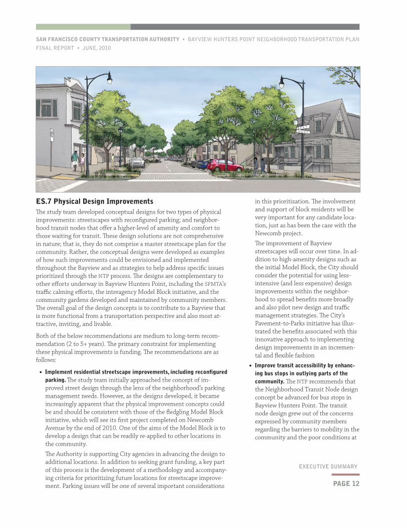
ES.7 Physical Design ImprovementsThe study team developed conceptual designs for two types of physical improvements: streetscapes with reconfigured parking; and neighbor-hood transit nodes that offer a higher-level of amenity and comfort to those waiting for transit. These design solutions are not comprehensive in nature; that is, they do not comprise a master streetscape plan for the community. Rather, the conceptual designs were developed as examples of how such improvements could be envisioned and implemented throughout the Bayview and as strategies to help address specific issues prioritized through the NTP process. The designs are complementary to other efforts underway in Bayview Hunters Point, including the SFMTA’s traffic calming efforts, the interagency Model Block initiative, and the community gardens developed and maintained by community members. The overall goal of the design concepts is to contribute to a Bayview that is more functional from a transportation perspective and also most at-tractive, inviting, and livable.
Both of the below recommendations are medium to long-term recom-mendation (2 to 5+ years). The primary constraint for implementing these physical improvements is funding. The recommendations are as follows:
• Implement residential streetscape improvements, including reconfigured parking. The study team initially approached the concept of im-proved street design through the lens of the neighborhood’s parking management needs. However, as the designs developed, it became increasingly apparent that the physical improvement concepts could be and should be consistent with those of the fledgling Model Block initiative, which will see its first project completed on Newcomb Avenue by the end of 2010. One of the aims of the Model Block is to develop a design that can be readily re-applied to other locations in the community.
The Authority is supporting City agencies in advancing the design to additional locations. In addition to seeking grant funding, a key part of this process is the development of a methodology and accompany-ing criteria for prioritizing future locations for streetscape improve-ment. Parking issues will be one of several important considerations
BAYVIEW HUNTERS POINT NEIGHBORHOOD TRANSPORTATION PLAN • SAN FRANCISCO COUNTY TRANSPORTATION AUTHORITY
JUNE, 2010 • FINAL REPORT
PAGE 13
EXECUTIVE SUMMARY
ES.8 Funding and ImplementationThe NTP recommends a range of types of transportation solutions for Bayview Hunters Point. As such, funding must be sought from a variety of sources. Given the nontraditional nature of some proposed improve-ments, funds may be sought from non-traditional sources, such as foundation grants. In addition to seeking funding, continued advocacy and engagement by members of the community and community-based organizations will be critical to advancing the recommendations of the NTP.
Some of the NTP’s recommendations, such as operational improvements for the Third Street corridor are relatively low-cost, high-impact solu-tions that are feasible to deliver in the near-term using existing funding sources.
many bus stops in the community cur-rently, which are often poorly-lit and provide no shelter or real-time infor-mation. While safer and more comfort-able bus stop will not address issues of transit frequency and reliability, such improvements would help address some of the community’s concerns regarding transit accessibility.
The NTP assessed bus stops in the com-munity and developed a preliminary prioritization of locations for deploying the Neighborhood Transit Node design toolkit. Further technical analysis and outreach to adjacent residents (and/or land owners) will be necessary to confirm feasibility and desirability at some locations. Some improvements are already set to advance. As part of the Hunters View Revitalizations proj-ect, bus stops will be improved along Middle Point Road. The Palou and Phelps site was previously prioritized as part of Phase III of the Bayview Con-nections project.
The designs are complementary to other efforts underway in Bayview Hunters Point, including the SFMTA’s traffic calming efforts, the interagency Model Block initiative, and the community gardens developed and maintained by community members.

SAN FRANCISCO COUNTY TRANSPORTATION AUTHORITY • BAYVIEW HUNTERS POINT NEIGHBORHOOD TRANSPORTATION PLAN
FINAL REPORT • JUNE, 2010
This page left intentionally blank
BAYVIEW HUNTERS POINT NEIGHBORHOOD TRANSPORTATION PLAN • SAN FRANCISCO COUNTY TRANSPORTATION AUTHORITY
JUNE, 2010 • FINAL REPORT
PAGE 15
CHAPTER ONE
The NTP was led by the Authority, in collaboration with community residents, stakeholder groups, neighborhood leaders, and community-based organizations (CBOs). A technical consulting team led by Nelson\Nygaard Consulting Associates provided planning, design, and engineer-ing services; Pittman & Associates and Turnstone Consulting developed the public outreach strategy and guided community involvement activi-ties over the course of the NTP process. Literacy for Environmental Jus-tice (LEJ), a Bayview Hunters Point CBO, also joined the study team with a focus on the engagement and involvement of youth in the community.
This introductory chapter includes summary descriptions of the Neighbor-hood Transportation Planning program, of the context and approach of the Bayview NTP, and of the organization and content of this Final Report.
1.1 Neighborhood Transportation Planning ProgramThe Bayview NTP is part of both the Authority’s NTP program and the Bay Area Community-Based Trans-portation Planning (CBTP) program, an MTC initiative. The goal of these programs is to build consensus within communities on transporta-tion problems and identify solutions to address high-priority needs. Each NTP study:
• Works with the community to identify pressing transportation is-sues and needs;
• Collaborates with community-based organizations to substantively involve and engage members of the community throughout the study process;
• Develops high-priority transpor-tation solutions through technical
analysis, agency participation, and public outreach; and
• Builds the capacity of the community for continued involvement to help advance recommendations to implementation.
1.2 Setting, Context, and ApproachThe NTP program is designed to be flexible, in order to respond to the unique context of individual neighborhoods. In the case of the Bayview NTP, particular concern was given to tailor the study approach, in order to develop a meaningful community-based transportation plan for Bay-view Hunters Point, a neighborhood with many distinct characteristics as compared to other areas of San Francisco.
STUDY AREA
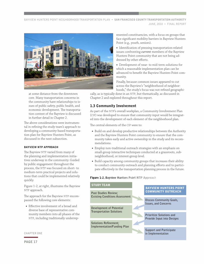
The NTP study area includes most of the Bayview Hunters Point district, which is located in southeastern San Francisco, adjacent to Executive
The Bayview Hunters Point Neighborhood Transportation Plan
(NTP) is a community-based study designed to prioritize transporta-
tion needs and develop near- and medium-term improvements in the
Bayview Hunters Point neighborhood of San Francisco. The Study
is referred to herein as the “Bayview NTP” or simply the “NTP.”
The NTP was funded by the California Department of Transportation
(Caltrans), the Metropolitan Transportation Commission (MTC), and
the San Francisco County Transportation Authority (Authority).
1Introduction and Study Overview

PAGE 16
CHAPTER ONE
SAN FRANCISCO COUNTY TRANSPORTATION AUTHORITY • BAYVIEW HUNTERS POINT NEIGHBORHOOD TRANSPORTATION PLAN
FINAL REPORT • JUNE, 2010
to the unique conditions and context of Bayview Hunters Point:
• Many initiatives underway in the com-munity. In the past decade, more than a dozen major planning studies have been carried out in the Bayview. (Key findings from these plans and studies are discussed in Chapter 2.) Communi-ty planning goals and vision have been explored and documented extensively through these efforts. In particular, the Bayview Hunters Point Community Revitalization Concept Plan articulated the community’s goals and vision in an-ticipation of the subsequent adoption of the Bayview Hunters Point Redevel-opment Plan.
Currently, many public agencies and community-based organizations (CBOs) have active initiatives in the study area. Given these issues, there is a degree of weariness or “planning fatigue” within the community regarding planning initiatives.
• Land use and demographic changes and pressures. The Bayview and adjacent areas are planned to accommodate significant housing and employment growth over the next few decades. Already, growth pressures and the Navy Shipyard closure have contributed to the shifting demographics of what has been historically a working-class African-American community. There is significant concern and heightened at-tention among neighborhood residents and advocates to issues of gentrifica-tion, affordable housing, economic development, and other related issues.
• Unique challenges and high level of need. The Bayview’s transportation chal-lenges are unique in many respects as compared to other San Francisco neigh-borhoods, although there are parallels to some of the city’s other communities
Park and Visitacion Valley to the south, the Portola and Bernal Heights districts to the west, and the Central Water-front area to the north. As shown in Figure 1-1, below, the study area is bordered by Cargo Way and the Islais Creek Chan-nel to the north, the Hunters Point and Candlestick Point redevelopment areas to the east, Bayview Hill to the south, and Highways 101 and 280 to
the west. The study area is referred to in this report as Bayview Hunters Point or simply the Bayview.
PLANNING CONTEXT
During the first phase of the Bayview NTP—including a technical review of past studies, meetings with partner agency staff, and stakeholder meetings—a number of significant considerations emerged with regard
The NTP program is designed to be flexible, in order to respond to the unique context of individual neighborhoods.
Figure 1-1. Study Area
Source: GIS Data Source SFGIS, Caltrain
BAYVIEW HUNTERS POINT NEIGHBORHOOD TRANSPORTATION PLAN • SAN FRANCISCO COUNTY TRANSPORTATION AUTHORITY
JUNE, 2010 • FINAL REPORT
PAGE 17
CHAPTER ONE
resented constituencies, with a focus on groups that face significant mobility barriers in Bayview Hunters Point (e.g., youth, seniors).
• Identification of pressing transportation-related issues confronting current members of the Bayview Hunters Point community that are not being ad-dressed by other efforts.
• Development of near- to mid-term solutions for which a reasonable implementation plan can be advanced to benefit the Bayview Hunters Point com-munity.
Finally, because common issues appeared to cut across the Bayview’s “neighborhood of neighbor-hoods,” the study’s focus was not refined geographi-
cally, as is typically done in an NTP, but thematically, as discussed in Chapter 2 and explored throughout this report.
1.3 Community InvolvementAs part of the NTP’s overall workplan, a Community Involvement Plan (CIP) was developed to ensure that community input would be integrat-ed into the development of each element of the neighborhood plan.
The central elements of the CIP were to:
• Build on and develop productive relationships between the Authority and the Bayview Hunters Point community to ensure that the com-munity takes early and active ownership in the study and its recom-mendations.
• Employ non-traditional outreach strategies with an emphasis on small-group interactive techniques conducted at a grassroots, sub-neighborhood, or interest-group level.
• Build capacity among community groups that increases their ability to conduct community outreach and planning efforts and to partici-pate effectively in the transportation planning process in the future.
at some distance from the downtown core. Many transportation concerns in the community have relationships to is-sues of public safety, public health, and economic development. The transporta-tion context of the Bayview is discussed in further detail in Chapter 2.
The above considerations were instrumen-tal in refining the study team’s approach to developing a community-based transporta-tion plan for Bayview Hunters Point, as discussed in the next subsection.
BAYVIEW NTP APPROACH
The Bayview NTP varied from many of the planning and implementation initia-tives underway in the community. Guided by public engagement throughout the process, the NTP was focused on short- to medium-term practical projects and solu-tions that could be implemented relatively quickly.
Figure 1-2, at right, illustrates the Bayview NTP approach.
The approach for the Bayview NTP encom-passed the following core elements:
• Effective involvement of a broad and diverse base of representative com-munity members into all phases of the NTP, including traditionally underrep-
Figure 1-2. Bayview Hunters Point NTP Approach
Past Studies Review; Existing Conditions Assessment
Discuss Community Goals, Issues, and Concerns
STUDY TEAMBAYVIEW HUNTERS POINT COMMUNITY OUTREACH
Development of Potential Transportation Solutions
Prioritize Solutions and Provide Input into Designs
Solutions Refinement; Implementation/Funding Plan
Support and Participate in Implementation
PAGE 18
CHAPTER ONE
SAN FRANCISCO COUNTY TRANSPORTATION AUTHORITY • BAYVIEW HUNTERS POINT NEIGHBORHOOD TRANSPORTATION PLAN
FINAL REPORT • JUNE, 2010
1.4 Report OrganizationThe remainder of this report is organized as follows. The next chapter—Needs, Com-munity Priorities, and Study Focus—dis-cusses high-priority transportation needs in the area and summarizes the refinement of the NTP’s focus. Subsequent chapters are devoted to the priority issues that emerged from the Study’s Needs Assess-ment: mobility barriers and community
transportation; parking conditions and management; Third Street operations and pedestrian environment; and physi-cal design improvements. Each of these chapters includes background informa-tion, analysis, and recommendations. The final chapter summarizes the NTP’s recommendations, discusses funding and implementation issues, and reviews next steps and issues warranting further analysis.
• Identify and document community-based outreach strategies that contribute to a model neighborhood transportation planning process for the Authority and other peer agencies.
The study team engaged a broad and diverse set of community mem-bers in order to discuss and seek input regarding transportation issues, needs, and desired improvements in Bayview Hunters Point. In contrast to more traditional public involvement approaches, which typically rely primarily on inviting the community to public workshops or neighbor-hood meetings to receive input, the community-based process for the NTP sought opportunities to engage members of the community in
small-group and community-led meetings. Outreach activities were conducted where people live, work, or are involved in community activities, such as offices of CBOs, community facilities, community gardens, and businesses within the study area. Well over 200 community members were directly engaged in such settings. Collateral materials were also developed and utilized, including a study website, fact sheet, and multi-lingual materials.
Community input and its integration into the planning process is discussed further throughout this report, in the topical chapters that follow. A Community Involvement Re-
port was also prepared to summarize and assess all NTP public involve-ment activities. This document is available in the Appendix.
The study team engaged a broad and diverse set of community members in order to discuss and seek input regarding transportation issues, needs, and desired improvements in Bayview Hunters Point.
BAYVIEW HUNTERS POINT NEIGHBORHOOD TRANSPORTATION PLAN • SAN FRANCISCO COUNTY TRANSPORTATION AUTHORITY
JUNE, 2010 • FINAL REPORT
PAGE 19
CHAPTER TWO
2.1 Overview of Technical and Outreach ActivitiesBayview Hunters Point is a neighborhood that has been the subject of numerous studies that identify transportation needs and potential improvements. Many of these improvements have already been imple-mented, some are in the process of being implemented, and others are the subject of current planning or environmental review processes. The challenge—and opportunity—for the NTP was to focus technical activi-ties on high-priority community needs in light of these other efforts and the goals of the NTP program.
TECHNICAL APPROACH
Technical steps to identify transportation needs and assess existing conditions included:
• Analysis of findings and recom-mendations from other relevant planning studies completed in Bayview Hunters Point;
• Consideration of anticipated changes to the transportation network in the neighborhood, including currently planned and/or programmed improvements;
• Field observations and site visits;
• U.S. Census dataæ, for demo-graphic information;
• Travel patterns and mode shares estimated using the official San Francisco travel demand model (SF-CHAMP), which is maintained by the Authority;
• Evaluation of data from the Statewide Integrated Traffic Re-cords System (SWITRS) on colli-sions involving pedestrians in the neighborhood;
• Transit ridership, travel time, and on-time performance data; and
• Analysis of traffic conditions, including traffic volumes and traffic operations modeling to assess congestion levels.
COMMUNITY INPUT AND INVOLVEMENT
In parallel with these technical activities, the study team engaged com-munity members in order to discuss and seek input regarding transpor-tation issues, barriers, and needs in Bayview Hunters Point. The NTP focused on engagement with community members in small-group and community-led settings. This initial phase of outreach is documented in the NTP Community Involvement Report, which is available in the Ap-pendix. Highlights of the public involvement activities included:
• Stakeholder Interviews with community leaders and representatives of community-based organizations;
This chapter summarizes the NTP’s identification of high-priority
transportation needs in Bayview Hunters Point and discusses the
process for refining the study’s focus. The result of this process was a
limited set of transportation issues that were advanced for technical
analysis and solutions development through the NTP. The effort also
resulted in a set of community-based goals to help guide the solu-
tions development process.
2 Needs, Community Priorities, and Study Focus
PAGE 20
SAN FRANCISCO COUNTY TRANSPORTATION AUTHORITY • BAYVIEW HUNTERS POINT NEIGHBORHOOD TRANSPORTATION PLAN
FINAL REPORT • JUNE, 2010
CHAPTER TWO
• The neighborhood’s topography and development history have resulted in a poorly connected network of streets. Isolated by freeways, waterways, and industrial areas to the north and west, the neighborhood is connected to the rest of the city by a limited set of thor-oughfares. The neighborhood includes multiple hilly areas such as Hunters Point Hill and Silver Terrace, where street patterns are circuitous and many streets dead-end. In industrial areas, many streets dead-end, and streets in these areas are typically lacking in amenities and are unimproved.
• Impacts from traffic are disproportion-ate to levels of traffic. Although severe traffic congestion is generally not pres-ent in the neighborhood, the impacts of traffic on residents, businesses, and other users of the street are magni-fied by high speeds, reckless driving, truck traffic and deficient pedestrian infrastructure.
• Pedestrian conditions, both in terms of the street environment and public safety, are a major concern. Pedestrian conditions in the neighborhood are impacted not just by traffic or a lack of amenities, but also by limited lighting, street crime, and gang activity.
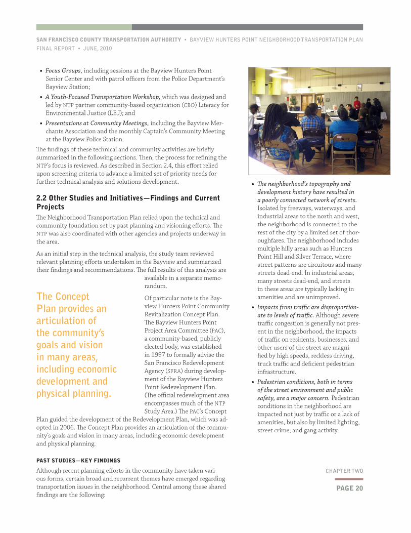
• Focus Groups, including sessions at the Bayview Hunters Point Senior Center and with patrol officers from the Police Department’s Bayview Station;
• A Youth-Focused Transportation Workshop, which was designed and led by NTP partner community-based organization (CBO) Literacy for Environmental Justice (LEJ); and
• Presentations at Community Meetings, including the Bayview Mer-chants Association and the monthly Captain’s Community Meeting at the Bayview Police Station.
The findings of these technical and community activities are briefly summarized in the following sections. Then, the process for refining the NTP’s focus is reviewed. As described in Section 2.4, this effort relied upon screening criteria to advance a limited set of priority needs for further technical analysis and solutions development.
2.2 Other Studies and Initiatives—Findings and Current ProjectsThe Neighborhood Transportation Plan relied upon the technical and community foundation set by past planning and visioning efforts. The NTP was also coordinated with other agencies and projects underway in the area.
As an initial step in the technical analysis, the study team reviewed relevant planning efforts undertaken in the Bayview and summarized their findings and recommendations. The full results of this analysis are
available in a separate memo-randum.
Of particular note is the Bay-view Hunters Point Community Revitalization Concept Plan. The Bayview Hunters Point Project Area Committee (PAC), a community-based, publicly elected body, was established in 1997 to formally advise the San Francisco Redevelopment Agency (SFRA) during develop-ment of the Bayview Hunters Point Redevelopment Plan. (The official redevelopment area encompasses much of the NTP Study Area.) The PAC’s Concept
Plan guided the development of the Redevelopment Plan, which was ad-opted in 2006. The Concept Plan provides an articulation of the commu-nity’s goals and vision in many areas, including economic development and physical planning.
PAST STUDIES—KEY FINDINGS
Although recent planning efforts in the community have taken vari-ous forms, certain broad and recurrent themes have emerged regarding transportation issues in the neighborhood. Central among these shared findings are the following:
The Concept Plan provides an articulation of the community’s goals and vision in many areas, including economic development and physical planning.
BAYVIEW HUNTERS POINT NEIGHBORHOOD TRANSPORTATION PLAN • SAN FRANCISCO COUNTY TRANSPORTATION AUTHORITY
JUNE, 2010 • FINAL REPORT
PAGE 21
CHAPTER TWO
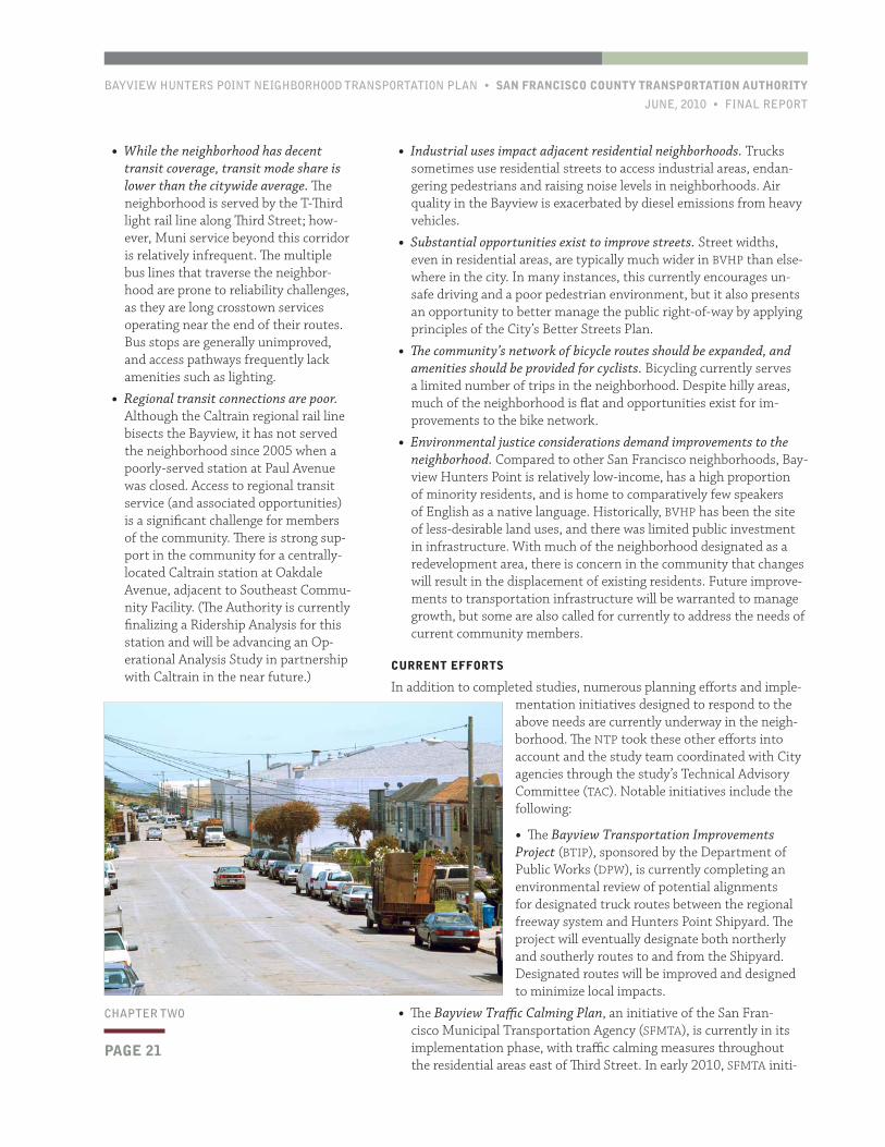
• Industrial uses impact adjacent residential neighborhoods. Trucks sometimes use residential streets to access industrial areas, endan-gering pedestrians and raising noise levels in neighborhoods. Air quality in the Bayview is exacerbated by diesel emissions from heavy vehicles.
• Substantial opportunities exist to improve streets. Street widths, even in residential areas, are typically much wider in BVHP than else-where in the city. In many instances, this currently encourages un-safe driving and a poor pedestrian environment, but it also presents an opportunity to better manage the public right-of-way by applying principles of the City’s Better Streets Plan.
• The community’s network of bicycle routes should be expanded, and amenities should be provided for cyclists. Bicycling currently serves a limited number of trips in the neighborhood. Despite hilly areas, much of the neighborhood is flat and opportunities exist for im-provements to the bike network.
• Environmental justice considerations demand improvements to the neighborhood. Compared to other San Francisco neighborhoods, Bay-view Hunters Point is relatively low-income, has a high proportion of minority residents, and is home to comparatively few speakers of English as a native language. Historically, BVHP has been the site of less-desirable land uses, and there was limited public investment in infrastructure. With much of the neighborhood designated as a redevelopment area, there is concern in the community that changes will result in the displacement of existing residents. Future improve-ments to transportation infrastructure will be warranted to manage growth, but some are also called for currently to address the needs of current community members.
CURRENT EFFORTS
In addition to completed studies, numerous planning efforts and imple-mentation initiatives designed to respond to the above needs are currently underway in the neigh-borhood. The NTP took these other efforts into account and the study team coordinated with City agencies through the study’s Technical Advisory Committee (TAC). Notable initiatives include the following:
• The Bayview Transportation Improvements Project (BTIP), sponsored by the Department of Public Works (DPW), is currently completing an environmental review of potential alignments for designated truck routes between the regional freeway system and Hunters Point Shipyard. The project will eventually designate both northerly and southerly routes to and from the Shipyard. Designated routes will be improved and designed to minimize local impacts.
• The Bayview Traffic Calming Plan, an initiative of the San Fran-cisco Municipal Transportation Agency (SFMTA), is currently in its implementation phase, with traffic calming measures throughout the residential areas east of Third Street. In early 2010, SFMTA initi-
• While the neighborhood has decent transit coverage, transit mode share is lower than the citywide average. The neighborhood is served by the T-Third light rail line along Third Street; how-ever, Muni service beyond this corridor is relatively infrequent. The multiple bus lines that traverse the neighbor-hood are prone to reliability challenges, as they are long crosstown services operating near the end of their routes. Bus stops are generally unimproved, and access pathways frequently lack amenities such as lighting.
• Regional transit connections are poor. Although the Caltrain regional rail line bisects the Bayview, it has not served the neighborhood since 2005 when a poorly-served station at Paul Avenue was closed. Access to regional transit service (and associated opportunities) is a significant challenge for members of the community. There is strong sup-port in the community for a centrally-located Caltrain station at Oakdale Avenue, adjacent to Southeast Commu-nity Facility. (The Authority is currently finalizing a Ridership Analysis for this station and will be advancing an Op-erational Analysis Study in partnership with Caltrain in the near future.)
PAGE 22
SAN FRANCISCO COUNTY TRANSPORTATION AUTHORITY • BAYVIEW HUNTERS POINT NEIGHBORHOOD TRANSPORTATION PLAN
FINAL REPORT • JUNE, 2010
CHAPTER TWO
Stockton streets. Currently, the T-Third uses a circuitous alignment to access the Market Street Subway via the Embarcadero. The project schedule anticipates revenue service commenc-ing in 2018.
• Environmental analysis for the rede-velopment of Candlestick Point and Hunters Point Shipyard is currently underway. The associated transpor-tation plan contemplates a number of long-term changes to corridors accessing these sites, which are along the neighborhood’s eastern edge. These improvements include transit priority treatments along Palou Avenue.
2.3 Community Input—Needs and PrioritiesAs discussed in Section 2.1, the initial phase of outreach was focused on identify-ing and discussing transportation-related needs faced by current members of the community. Members of the Bayview community often focus these discussions on everyday challenges and concerns, rather than on specific solutions or desired transportation improvements. This is likely due to the extent to which many of transportation issues in the community are associated with other social, economic, and public safety needs.
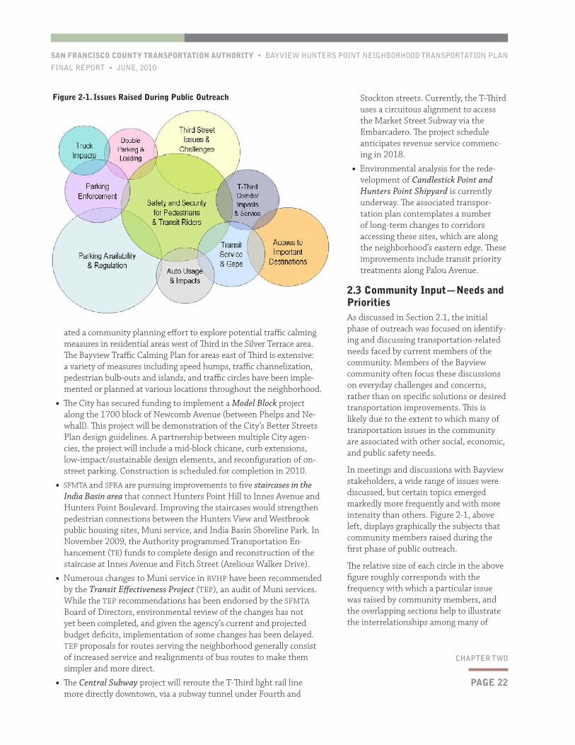
In meetings and discussions with Bayview stakeholders, a wide range of issues were discussed, but certain topics emerged markedly more frequently and with more intensity than others. Figure 2-1, above left, displays graphically the subjects that community members raised during the first phase of public outreach.
The relative size of each circle in the above figure roughly corresponds with the frequency with which a particular issue was raised by community members, and the overlapping sections help to illustrate the interrelationships among many of
ated a community planning effort to explore potential traffic calming measures in residential areas west of Third in the Silver Terrace area. The Bayview Traffic Calming Plan for areas east of Third is extensive: a variety of measures including speed humps, traffic channelization, pedestrian bulb-outs and islands, and traffic circles have been imple-mented or planned at various locations throughout the neighborhood.
• The City has secured funding to implement a Model Block project along the 1700 block of Newcomb Avenue (between Phelps and Ne-whall). This project will be demonstration of the City’s Better Streets Plan design guidelines. A partnership between multiple City agen-cies, the project will include a mid-block chicane, curb extensions, low-impact/sustainable design elements, and reconfiguration of on-street parking. Construction is scheduled for completion in 2010.
• SFMTA and SFRA are pursuing improvements to five staircases in the India Basin area that connect Hunters Point Hill to Innes Avenue and Hunters Point Boulevard. Improving the staircases would strengthen pedestrian connections between the Hunters View and Westbrook public housing sites, Muni service, and India Basin Shoreline Park. In November 2009, the Authority programmed Transportation En-hancement (TE) funds to complete design and reconstruction of the staircase at Innes Avenue and Fitch Street (Arelious Walker Drive).
• Numerous changes to Muni service in BVHP have been recommended by the Transit Effectiveness Project (TEP), an audit of Muni services. While the TEP recommendations has been endorsed by the SFMTA Board of Directors, environmental review of the changes has not yet been completed, and given the agency’s current and projected budget deficits, implementation of some changes has been delayed. TEP proposals for routes serving the neighborhood generally consist of increased service and realignments of bus routes to make them simpler and more direct.
• The Central Subway project will reroute the T-Third light rail line more directly downtown, via a subway tunnel under Fourth and
Figure 2-1. Issues Raised During Public Outreach
BAYVIEW HUNTERS POINT NEIGHBORHOOD TRANSPORTATION PLAN • SAN FRANCISCO COUNTY TRANSPORTATION AUTHORITY
JUNE, 2010 • FINAL REPORT
• Muni service is infrequent and unreliable, particularly beyond the Third Street corridor.
• On-street parking supplies are constrained and not well managed.
• It is a challenge to access regional transit services from the neighbor-hood.
• Automobile and truck traffic negatively impacts residential streets.
• Implementation of the T-Third light rail system has brought new challenges and concerns to the neighborhood, particularly for pedes-trians traveling along and across the corridor.
2.4 NTP Focus Issues and Transportation GoalsAs discussed above in Section 2.2, many of the transportation issues of concern to members of the Bayview Hunters Point community are cur-rently the subject of other initiatives and projects. Some are long-range challenges that would not be effectively addressed through the NTP process.
these topics. As is evident, public safety concerns—particularly for pedestrians and transit riders—is a key need underlying many of the transportation challenges in Bayview Hunters Point.
Despite the diversity of the Bayview, there is significant consensus on the important transportation-related needs that con-front current members of the community. Bayview stakeholders are most concerned about the following issues:
• Walking is not a safe or pleasant way to travel in the neighborhood.
• It is difficult to get around the Bayview or go beyond the neighborhood with-out an automobile.
ISSUECOMMUNITY PRIORITY
LEVEL OF NEED
POTENTIAL FOR NEAR- TO MID-TERM IMPROVEMENT
EXTENT NOT ADDRESSED BY OTHER EFFORT
Transportation needs of those with limited/no auto access ▲▲High
▲▲High
▲Medium
▲▲High
Tran
sit
SF Transit—waiting environment ▲Medium
▲▲High
▲▲High
▲Medium
SF Transit—service profile (routing, gaps, etc.) ▲▲High
▲▲High
▬Low
▬Low
SF Transit—performance (reliability, travel time, etc.) ▲▲High
▲Medium
▬Low
▬Low
Regional Transit—access and connections ▲Medium
▲▲High
▬Low
▲Medium
Regional Transit—service (destinations, fares, etc.) ▲Medium
▲▲High
▬Low
▲Medium
Traf
fic Automobile traffic and speeding ▲
Medium▲
Medium▲▲High
▬Low
Truck routing, loading, and emissions ▲Medium
▲▲High
▲Medium
▬Low
Par
king
Residential On-Street Parking—availability ▲▲High
▲Medium
▲Medium
▲▲High
Residential On-Street Parking – regulation and enforcement ▲▲High
▲▲High
▲Medium
▲▲High
Third Street—parking availability, loading, and access ▲Medium
▲Medium
▲Medium
▲Medium
Thi
rd
Str
eet
Third Street—signal operations and pedestrian conditions ▲▲High
▲▲High
▲▲High
▲▲High
Non
-m
otor
ized Pedestrian environment and safety ▲▲
High▲▲High
▲Medium
▲Medium
Bicycle infrastructure and safety ▬Low
▲Medium
▲Medium
▲Medium
Source: TK
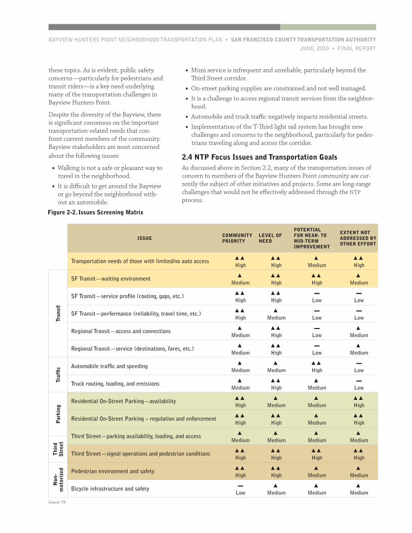
Figure 2-2. Issues Screening Matrix
PAGE 24
SAN FRANCISCO COUNTY TRANSPORTATION AUTHORITY • BAYVIEW HUNTERS POINT NEIGHBORHOOD TRANSPORTATION PLAN
FINAL REPORT • JUNE, 2010
CHAPTER TWO
3
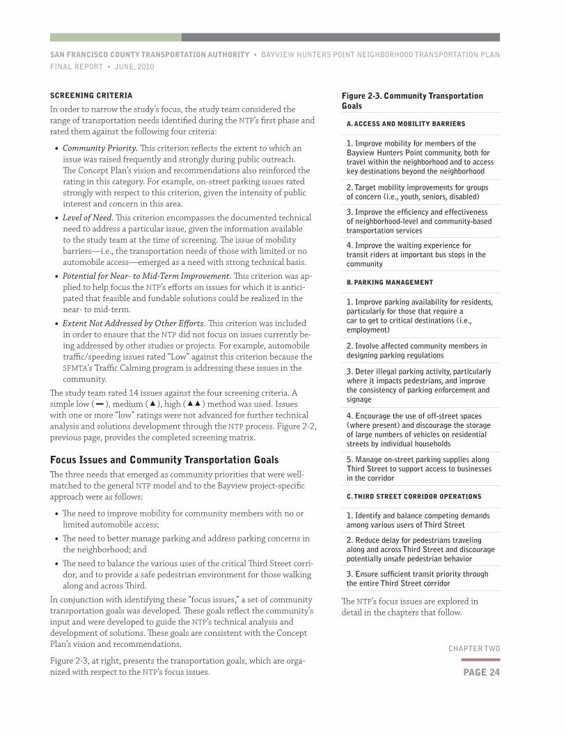
Figure 2-3. Community Transportation Goals
A. ACCESS AND MOBILITY BARRIERS
1. Improve mobility for members of the Bayview Hunters Point community, both for travel within the neighborhood and to access key destinations beyond the neighborhood
2. Target mobility improvements for groups of concern (i.e., youth, seniors, disabled)
3. Improve the efficiency and effectiveness of neighborhood-level and community-based transportation services
4. Improve the waiting experience for transit riders at important bus stops in the community
B. PARKING MANAGEMENT
1. Improve parking availability for residents, particularly for those that require a car to get to critical destinations (i.e., employment)
2. Involve affected community members in designing parking regulations
3. Deter illegal parking activity, particularly where it impacts pedestrians, and improve the consistency of parking enforcement and signage
4. Encourage the use of off-street spaces (where present) and discourage the storage of large numbers of vehicles on residential streets by individual households
5. Manage on-street parking supplies along Third Street to support access to businesses in the corridor
C. THIRD STREET CORRIDOR OPERATIONS
1. Identify and balance competing demands among various users of Third Street
2. Reduce delay for pedestrians traveling along and across Third Street and discourage potentially unsafe pedestrian behavior
3. Ensure sufficient transit priority through the entire Third Street corridor
The NTP’s focus issues are explored in detail in the chapters that follow.
SCREENING CRITERIA
In order to narrow the study’s focus, the study team considered the range of transportation needs identified during the NTP’s first phase and rated them against the following four criteria:
• Community Priority. This criterion reflects the extent to which an issue was raised frequently and strongly during public outreach. The Concept Plan’s vision and recommendations also reinforced the rating in this category. For example, on-street parking issues rated strongly with respect to this criterion, given the intensity of public interest and concern in this area.
• Level of Need. This criterion encompasses the documented technical need to address a particular issue, given the information available to the study team at the time of screening. The issue of mobility barriers—i.e., the transportation needs of those with limited or no automobile access—emerged as a need with strong technical basis.
• Potential for Near- to Mid-Term Improvement. This criterion was ap-plied to help focus the NTP’s efforts on issues for which it is antici-pated that feasible and fundable solutions could be realized in the near- to mid-term.
• Extent Not Addressed by Other Efforts. This criterion was included in order to ensure that the NTP did not focus on issues currently be-ing addressed by other studies or projects. For example, automobile traffic/speeding issues rated “Low” against this criterion because the SFMTA’s Traffic Calming program is addressing these issues in the community.
The study team rated 14 issues against the four screening criteria. A simple low ( ▬ ), medium ( ▲), high ( ▲▲) method was used. Issues with one or more “low” ratings were not advanced for further technical analysis and solutions development through the NTP process. Figure 2-2, previous page, provides the completed screening matrix.
Focus Issues and Community Transportation GoalsThe three needs that emerged as community priorities that were well-matched to the general NTP model and to the Bayview project-specific approach were as follows:
• The need to improve mobility for community members with no or limited automobile access;
• The need to better manage parking and address parking concerns in the neighborhood; and
• The need to balance the various uses of the critical Third Street corri-dor, and to provide a safe pedestrian environment for those walking along and across Third.
In conjunction with identifying these “focus issues,” a set of community transportation goals was developed. These goals reflect the community’s input and were developed to guide the NTP’s technical analysis and development of solutions. These goals are consistent with the Concept Plan’s vision and recommendations.
Figure 2-3, at right, presents the transportation goals, which are orga-nized with respect to the NTP’s focus issues.

BAYVIEW HUNTERS POINT NEIGHBORHOOD TRANSPORTATION PLAN • SAN FRANCISCO COUNTY TRANSPORTATION AUTHORITY
JUNE, 2010 • FINAL REPORT
PAGE 25
CHAPTER THREE
3.1 BackgroundTraveling to or within Bayview Hunters Point without a car is difficult. Although the neighborhood as a whole has higher automobile ownership and mode share than San Francisco as a whole, many individuals—espe-cially in groups of particular concern such as youth, seniors, and public housing residents—face significant barriers to mobility. Community members with minimal automobile access are challenged to reach jobs, schools, grocery stores, and other important destinations in a safe and timely manner.
These mobility barriers are the result of numerous factors, many of which are interrelated. However, the NTP’s public outreach and technical analyses point to several issues that strongly contribute to the transpor-
tation gaps in the community:
• Walking and bicycling are often not seen as pleasant or practical means of travel. Pedestrian and bicycle travel is hampered in the community for a variety of rea-sons. Many residential areas lack local-serving establishments within close proximity that would encour-age community members to take short walking trips. Hilly topogra-phy, indirect and narrow streets, deficient pedestrian and bicycle infrastructure, and limited lighting further discourage pedestrian and bicycle activity. Although sidewalks are wide in many locations, cars are frequently parked along or across the pedestrian right-of-way (see Chapter 4).
• Safety concerns limit the attrac-tiveness of non-automobile modes. In addition to the issues described
immediately above, public safety concerns are a major contributor to the mobility barriers in the community. Bayview Hunters Point residents are often reluctant to use (or wait for) public transportation or walk, particularly at night. Recent incidents of violence on Muni in the neighborhood have heightened these concerns.
• Beyond the Third Street corridor, Muni can be unreliable and is relatively infrequent. Multiple bus lines extend into the Bayview from the community’s central spine of Third Street; however, these services are long crosstown lines near the end of their routes, making them less reliable. Service frequency is also a concern, particularly during off-peak hours, meaning that transit riders often have to wait for some time at bus stops that are often unimproved and not well lit. Recent service cuts have exacerbated this issue.
• There are no regional transit stations within the community and local transit does not directly serve many trips. Transit trips to important destinations, such as school or employment, from within the neigh-
This chapter explores the roots of mobility gaps in Bayview Hunters
Point; discusses approaches currently in place in the Bayview that
currently seek to address these gaps; reviews potential community-
based transportation models; and makes recommendations for ad-
vancing a community-based transportation program in the commu-
nity.
3 Mobility Barriers and Community Transportation
PAGE 26
SAN FRANCISCO COUNTY TRANSPORTATION AUTHORITY • BAYVIEW HUNTERS POINT NEIGHBORHOOD TRANSPORTATION PLAN
FINAL REPORT • JUNE, 2010
CHAPTER THREE
supermarkets in the program’s own vans. The program was citywide, but had origi-nated in the Bayview in the 1970s. The service was discontinued in 2005 during the City budget process due to its relatively high cost. Numerous community members lamented the loss of this service during public input discussions for the NTP.
BAYVIEW MAGIC LANDSCAPE ANALYSIS
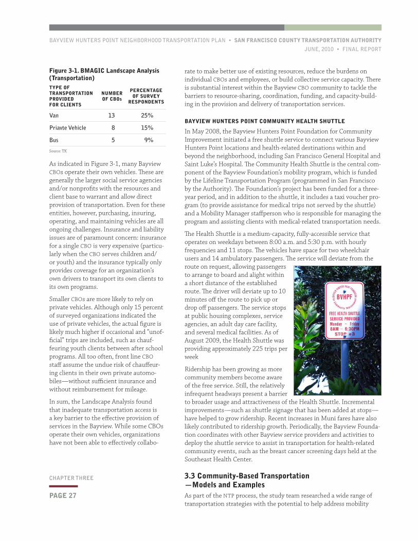
Bayview MAGIC (BMAGIC) is a network of community organizations, neighborhood leaders, service providers, and other com-munity members and institutions, which focuses on collaborative efforts to improve the accessibility and delivery of services to youth and their families in Bayview Hunt-ers Point. (BMAGIC is an initiative of the San Francisco Office of the Public Defend-er.) In 2009, BMAGIC conducted a Commu-nity Landscape Analysis, which invento-ried local CBO assets and needs in a range of areas, from strategic planning and staff development to collaborative networks and physical resources. Transportation service was one of the areas that were evaluated. Over 50 organizations participated.
Figure 3-1, next page, summarizes the transportation-related findings of the Landscape Analysis.
borhood frequently require one or more transfers. Muni’s network is downtown focused, with the highest levels of service during peak periods. Many Bayview residents, however, access economic and edu-cational opportunities throughout the city and region. Regional trips are even more likely to be taken by car, due to the lack of a BART or Caltrain station within the neighborhood. Intra-neighborhood circu-lator service is minimal, and many trips wholly within the neighbor-hood are made by automobile.
• Cabs are relatively rare in the community and there are presently no carshare pods located in the neighborhood. Like other outlying San Francisco neighborhoods, taxis do not typically circulate for fares in Bayview Hunters Point. In addition, some cab drivers are reluctant to make or take trips to outlying areas of the community that are relatively far from the Third Street corridor. There are presently no carshare vehicles sited in the neighborhood by either of the two carsharing networks that operate in San Francisco (City CarShare and ZipCar).
3.2 Existing StrategiesA diversity of ad hoc and generally uncoordinated transportation strate-gies have arisen that seek to address mobility barriers in Bayview Hunt-ers Point. (This phenomenon is evident even in Census commute mode information, which indicates that employed Bayview residents carpool to work at a rate twice the citywide average.) These strategies include the use of vehicles owned and operated by various community-based organi-zations (CBOs) based in the Bayview; the use of privately-owned vehicles to provide rides to those that would otherwise not be able to readily travel; a more formal, community shuttle focused on connecting com-munity members to health-related destinations; and other strategies.
Until a few years ago, the City of San Francisco also operated the Senior Escort Program, which offered individual escorts and free group trips to
Community members with minimal automobile access are challenged to reach jobs, schools, grocery stores, and other important destinations in a safe and timely manner.
BAYVIEW HUNTERS POINT NEIGHBORHOOD TRANSPORTATION PLAN • SAN FRANCISCO COUNTY TRANSPORTATION AUTHORITY
JUNE, 2010 • FINAL REPORT
PAGE 27
CHAPTER THREE
rate to make better use of existing resources, reduce the burdens on individual CBOs and employees, or build collective service capacity. There is substantial interest within the Bayview CBO community to tackle the barriers to resource-sharing, coordination, funding, and capacity-build-ing in the provision and delivery of transportation services.
BAYVIEW HUNTERS POINT COMMUNITY HEALTH SHUTTLE
In May 2008, the Bayview Hunters Point Foundation for Community Improvement initiated a free shuttle service to connect various Bayview Hunters Point locations and health-related destinations within and beyond the neighborhood, including San Francisco General Hospital and Saint Luke’s Hospital. The Community Health Shuttle is the central com-ponent of the Bayview Foundation’s mobility program, which is funded by the Lifeline Transportation Program (programmed in San Francisco by the Authority). The Foundation’s project has been funded for a three-year period, and in addition to the shuttle, it includes a taxi voucher pro-gram (to provide assistance for medical trips not served by the shuttle) and a Mobility Manager staffperson who is responsible for managing the program and assisting clients with medical-related transportation needs.
The Health Shuttle is a medium-capacity, fully-accessible service that operates on weekdays between 8:00 a.m. and 5:30 p.m. with hourly frequencies and 11 stops. The vehicles have space for two wheelchair users and 14 ambulatory passengers. The service will deviate from the route on request, allowing passengers to arrange to board and alight within a short distance of the established route. The driver will deviate up to 10 minutes off the route to pick up or drop off passengers. The service stops at public housing complexes, service agencies, an adult day care facility, and several medical facilities. As of August 2009, the Health Shuttle was providing approximately 225 trips per week
Ridership has been growing as more community members become aware of the free service. Still, the relatively infrequent headways present a barrier to broader usage and attractiveness of the Health Shuttle. Incremental improvements—such as shuttle signage that has been added at stops—have helped to grow ridership. Recent increases in Muni fares have also likely contributed to ridership growth. Periodically, the Bayview Founda-tion coordinates with other Bayview service providers and activities to deploy the shuttle service to assist in transportation for health-related community events, such as the breast cancer screening days held at the Southeast Health Center.
3.3 Community-Based Transportation —Models and ExamplesAs part of the NTP process, the study team researched a wide range of transportation strategies with the potential to help address mobility
As indicated in Figure 3-1, many Bayview CBOs operate their own vehicles. These are generally the larger social service agencies and/or nonprofits with the resources and client base to warrant and allow direct provision of transportation. Even for these entities, however, purchasing, insuring, operating, and maintaining vehicles are all ongoing challenges. Insurance and liability issues are of paramount concern: insurance for a single CBO is very expensive (particu-larly when the CBO serves children and/or youth) and the insurance typically only provides coverage for an organization’s own drivers to transport its own clients to its own programs.
Smaller CBOs are more likely to rely on private vehicles. Although only 15 percent of surveyed organizations indicated the use of private vehicles, the actual figure is likely much higher if occasional and “unof-ficial” trips are included, such as chauf-feuring youth clients between after school programs. All too often, front line CBO staff assume the undue risk of chauffeur-ing clients in their own private automo-biles—without sufficient insurance and without reimbursement for mileage.
In sum, the Landscape Analysis found that inadequate transportation access is a key barrier to the effective provision of services in the Bayview. While some CBOs operate their own vehicles, organizations have not been able to effectively collabo-
Figure 3-1. BMAGIC Landscape Analysis (Transportation)TYPE OF TRANSPORTATION PROVIDED FOR CLIENTS
NUMBER OF CBOs
PERCENTAGE OF SURVEY
RESPONDENTS
Van 13 25%
Priavte Vehicle 8 15%
Bus 5 9%
Source: TK
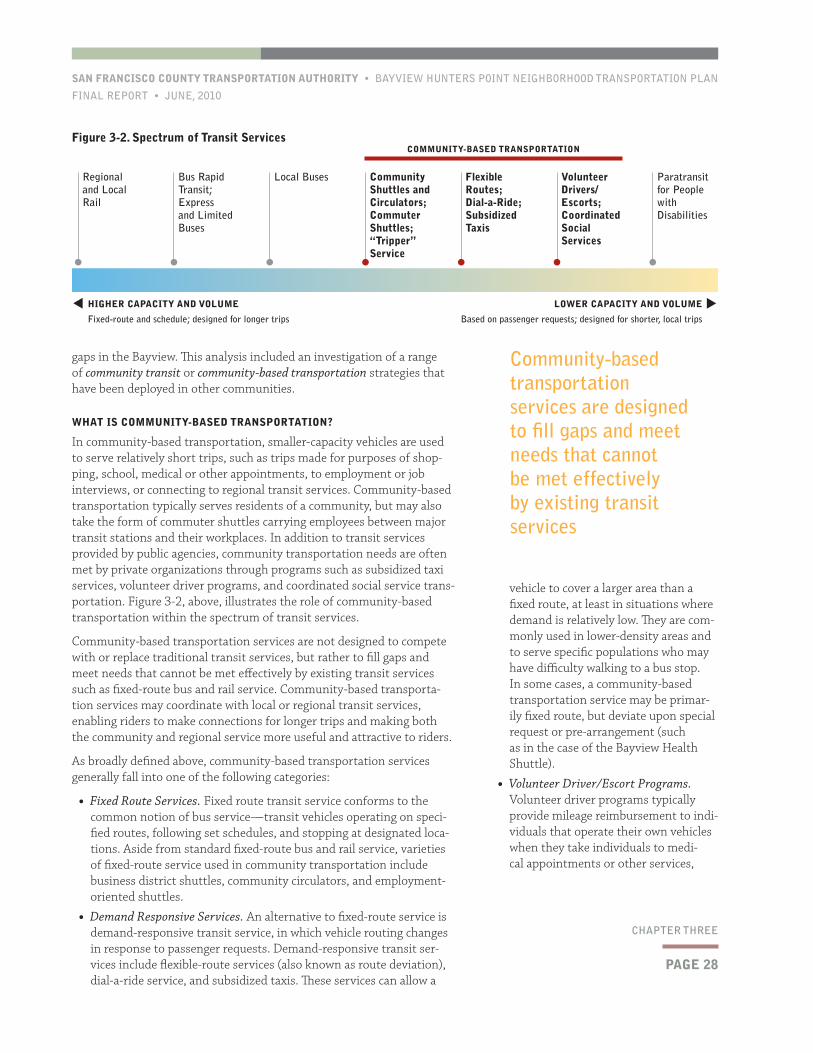
PAGE 28
SAN FRANCISCO COUNTY TRANSPORTATION AUTHORITY • BAYVIEW HUNTERS POINT NEIGHBORHOOD TRANSPORTATION PLAN
FINAL REPORT • JUNE, 2010
CHAPTER THREE
vehicle to cover a larger area than a fixed route, at least in situations where demand is relatively low. They are com-monly used in lower-density areas and to serve specific populations who may have difficulty walking to a bus stop. In some cases, a community-based transportation service may be primar-ily fixed route, but deviate upon special request or pre-arrangement (such as in the case of the Bayview Health Shuttle).
• Volunteer Driver/Escort Programs. Volunteer driver programs typically provide mileage reimbursement to indi-viduals that operate their own vehicles when they take individuals to medi-cal appointments or other services,
gaps in the Bayview. This analysis included an investigation of a range of community transit or community-based transportation strategies that have been deployed in other communities.
WHAT IS COMMUNITY-BASED TRANSPORTATION?
In community-based transportation, smaller-capacity vehicles are used to serve relatively short trips, such as trips made for purposes of shop-ping, school, medical or other appointments, to employment or job interviews, or connecting to regional transit services. Community-based transportation typically serves residents of a community, but may also take the form of commuter shuttles carrying employees between major transit stations and their workplaces. In addition to transit services provided by public agencies, community transportation needs are often met by private organizations through programs such as subsidized taxi services, volunteer driver programs, and coordinated social service trans-portation. Figure 3-2, above, illustrates the role of community-based transportation within the spectrum of transit services.
Community-based transportation services are not designed to compete with or replace traditional transit services, but rather to fill gaps and meet needs that cannot be met effectively by existing transit services such as fixed-route bus and rail service. Community-based transporta-tion services may coordinate with local or regional transit services, enabling riders to make connections for longer trips and making both the community and regional service more useful and attractive to riders.
As broadly defined above, community-based transportation services generally fall into one of the following categories:
• Fixed Route Services. Fixed route transit service conforms to the common notion of bus service—transit vehicles operating on speci-fied routes, following set schedules, and stopping at designated loca-tions. Aside from standard fixed-route bus and rail service, varieties of fixed-route service used in community transportation include business district shuttles, community circulators, and employment-oriented shuttles.
• Demand Responsive Services. An alternative to fixed-route service is demand-responsive transit service, in which vehicle routing changes in response to passenger requests. Demand-responsive transit ser-vices include flexible-route services (also known as route deviation), dial-a-ride service, and subsidized taxis. These services can allow a
Figure 3-2. Spectrum of Transit Services
HIGHER CAPACITY AND VOLUME
Fixed-route and schedule; designed for longer trips
LOWER CAPACITY AND VOLUME
Based on passenger requests; designed for shorter, local trips
Regional and Local Rail
Bus Rapid Transit; Express and Limited Buses
Local Buses Community Shuttles and Circulators; Commuter Shuttles; “Tripper” Service
Flexible Routes; Dial-a-Ride; Subsidized Taxis
Volunteer Drivers/Escorts; Coordinated Social Services
Paratransit for People with Disabilities
COMMUNITY-BASED TRANSPORTATION
t
t
Community-based transportation services are designed to fill gaps and meet needs that cannot be met effectively by existing transit services
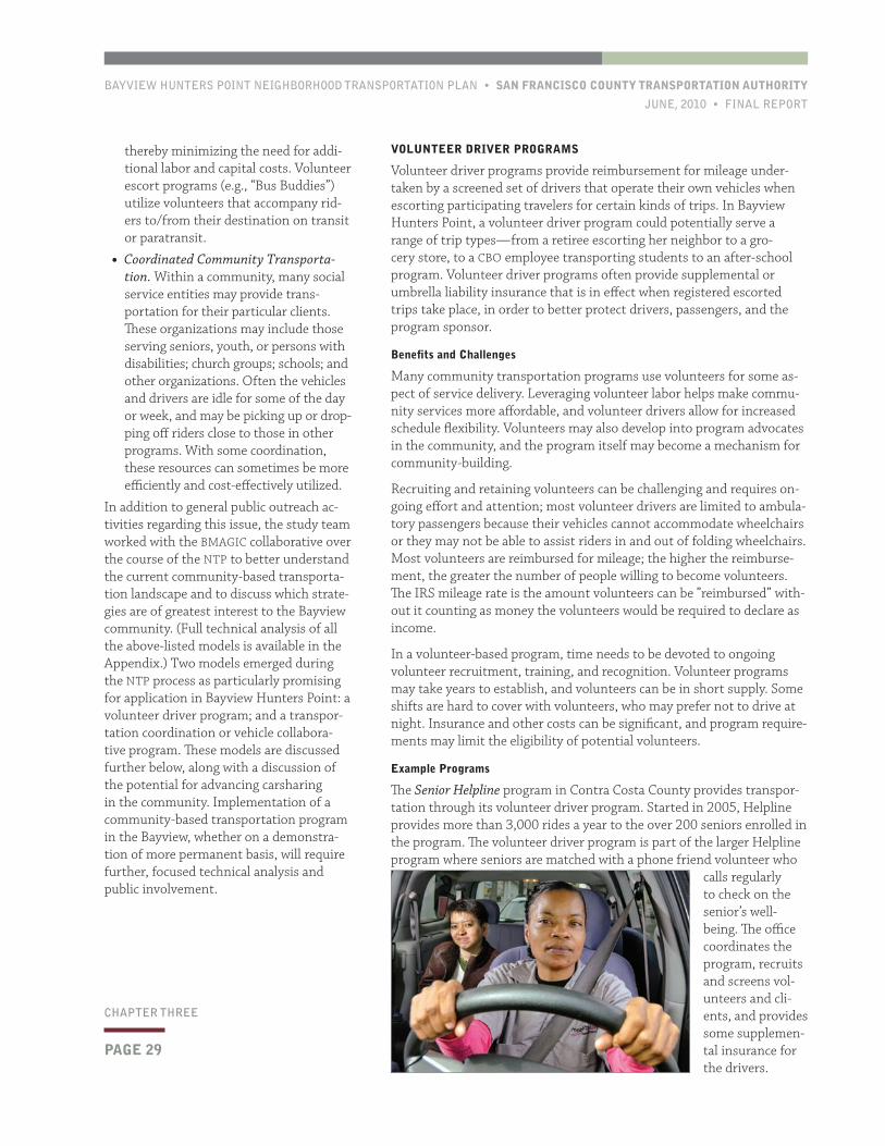
BAYVIEW HUNTERS POINT NEIGHBORHOOD TRANSPORTATION PLAN • SAN FRANCISCO COUNTY TRANSPORTATION AUTHORITY
JUNE, 2010 • FINAL REPORT
PAGE 29
CHAPTER THREE
VOLUNTEER DRIVER PROGRAMS
Volunteer driver programs provide reimbursement for mileage under-taken by a screened set of drivers that operate their own vehicles when escorting participating travelers for certain kinds of trips. In Bayview Hunters Point, a volunteer driver program could potentially serve a range of trip types—from a retiree escorting her neighbor to a gro-cery store, to a CBO employee transporting students to an after-school program. Volunteer driver programs often provide supplemental or umbrella liability insurance that is in effect when registered escorted trips take place, in order to better protect drivers, passengers, and the program sponsor.
Benefits and Challenges
Many community transportation programs use volunteers for some as-pect of service delivery. Leveraging volunteer labor helps make commu-nity services more affordable, and volunteer drivers allow for increased schedule flexibility. Volunteers may also develop into program advocates in the community, and the program itself may become a mechanism for community-building.
Recruiting and retaining volunteers can be challenging and requires on-going effort and attention; most volunteer drivers are limited to ambula-tory passengers because their vehicles cannot accommodate wheelchairs or they may not be able to assist riders in and out of folding wheelchairs. Most volunteers are reimbursed for mileage; the higher the reimburse-ment, the greater the number of people willing to become volunteers. The IRS mileage rate is the amount volunteers can be ”reimbursed” with-out it counting as money the volunteers would be required to declare as income.
In a volunteer-based program, time needs to be devoted to ongoing volunteer recruitment, training, and recognition. Volunteer programs may take years to establish, and volunteers can be in short supply. Some shifts are hard to cover with volunteers, who may prefer not to drive at night. Insurance and other costs can be significant, and program require-ments may limit the eligibility of potential volunteers.
Example Programs
The Senior Helpline program in Contra Costa County provides transpor-tation through its volunteer driver program. Started in 2005, Helpline provides more than 3,000 rides a year to the over 200 seniors enrolled in the program. The volunteer driver program is part of the larger Helpline program where seniors are matched with a phone friend volunteer who
calls regularly to check on the senior’s well-being. The office coordinates the program, recruits and screens vol-unteers and cli-ents, and provides some supplemen-tal insurance for the drivers.
thereby minimizing the need for addi-tional labor and capital costs. Volunteer escort programs (e.g., “Bus Buddies”) utilize volunteers that accompany rid-ers to/from their destination on transit or paratransit.
• Coordinated Community Transporta-tion. Within a community, many social service entities may provide trans-portation for their particular clients. These organizations may include those serving seniors, youth, or persons with disabilities; church groups; schools; and other organizations. Often the vehicles and drivers are idle for some of the day or week, and may be picking up or drop-ping off riders close to those in other programs. With some coordination, these resources can sometimes be more efficiently and cost-effectively utilized.
In addition to general public outreach ac-tivities regarding this issue, the study team worked with the BMAGIC collaborative over the course of the NTP to better understand the current community-based transporta-tion landscape and to discuss which strate-gies are of greatest interest to the Bayview community. (Full technical analysis of all the above-listed models is available in the Appendix.) Two models emerged during the NTP process as particularly promising for application in Bayview Hunters Point: a volunteer driver program; and a transpor-tation coordination or vehicle collabora-tive program. These models are discussed further below, along with a discussion of the potential for advancing carsharing in the community. Implementation of a community-based transportation program in the Bayview, whether on a demonstra-tion of more permanent basis, will require further, focused technical analysis and public involvement.
PAGE 30
SAN FRANCISCO COUNTY TRANSPORTATION AUTHORITY • BAYVIEW HUNTERS POINT NEIGHBORHOOD TRANSPORTATION PLAN
FINAL REPORT • JUNE, 2010
CHAPTER THREE
Given the complexities of coordinating the diverse needs and resources of multiple participants in a coordinated program (and depending on program scope), the coordinating function would likely require a dedicated (i.e., funded) administrative position to manage the program on a day-to-day basis.
Example Programs
Ride Connection in Portland, Oregon is a non-profit community service organization run for and by older adults. The program coordinates the transportation operations of 33 small community-based providers of elderly and disabled transportation. Ride Connection’s partner network includes a variety of human service organizations serving elders and people with disabilities throughout the Portland metropolitan region. By partnering with these agencies, the program is able to provide transpor-tation services customized for different geographic areas and different client groups much more efficiently than if the cooperating agencies acted independently. Ride Connection’s services include: service coordination between partners, and sched-uling for some partners; driver training; fundraising and advocacy; grant-writing and fiscal agent functions; equipment procurement and administration of shared use vehicle programs; technical assistance, contract administration, and new service planning; and administration of a volun-teer driver program.
Ride Connection is a very mature and extensive example of a transportation co-ordination organization. Ride Connection’s service partners include the local chapter of the American Red Cross, faith-based groups, senior centers, residential care facilities, and multi-service centers. The network operates a fleet of approximately 100 accessible vans and small buses, in addition to volunteer-owned vehicles. Of
Trips are limited to medical and dental appointments, pharmacy trips, and grocery shopping. Riders must be ambulatory—they can use a cane, walker, or crutch, but the program can-not accommodate wheelchair users. The Helpline program is funded through multiple sources, including federal New Freedom funds. Other sources are county funds and donations from businesses, private family foundations, social organiza-tions, churches, and individual donors.
The Catch a Ride project is part of Clackamas County Oregon’s Transportation Reaching People (TRP) program. Catch a Ride serves low-income transpor-tation-disadvantaged citizens
in the Milwaukie and Oregon City areas. With the help of community partners, the Catch a Ride project provides about 2,000 rides annually to approximately 100 very low-income riders struggling to improve their self-sufficiency. An innovative element of the project is the use of welfare recipients as volunteer van drivers. Through Catch a Ride, TRP trains and assists at least 10 welfare recipients each year to find living wage jobs as professional drivers. TRP receives funds from federal and state sources, along with funding from the Social Services Department of Clackamas County.
COORDINATED COMMUNITY TRANSPORTATION PROGRAMS
Transportation coordination programs provide some degree of central-ization of community-based transportation services, resources, and advocacy. The level of coordination and centralization can vary. In the most centralized model, an umbrella entity assumes full responsibility for insuring, maintaining, and operating vehicles among all member organizations. The coordinating entity also conducts related activities such as training and grant-writing. In a more limited model, member organizations collaborate to reduce transportation costs and improve efficiency by a variety of means, such as making excess vehicular capacity availability to partner organizations (typically for a fee).
Benefits and Challenges
The benefits to coordinating transportation resources are obvious: given the constrained funding environment confronted by community-based organizations, particularly those providing social services, coordinat-ing transportation resources can help save resources and improve the accessibility of services to clients. Organizations with preexisting vans and drivers may be more reluctant to participate, particularly if doing so would involve comingling of clients served by multiple organizations. Liability and insurance concerns are also central challenges to overcome.
Given the constrained funding environment confronted by community-based organizations, coordinating transportation needs can help save resources and improve the accessibility of services to clients
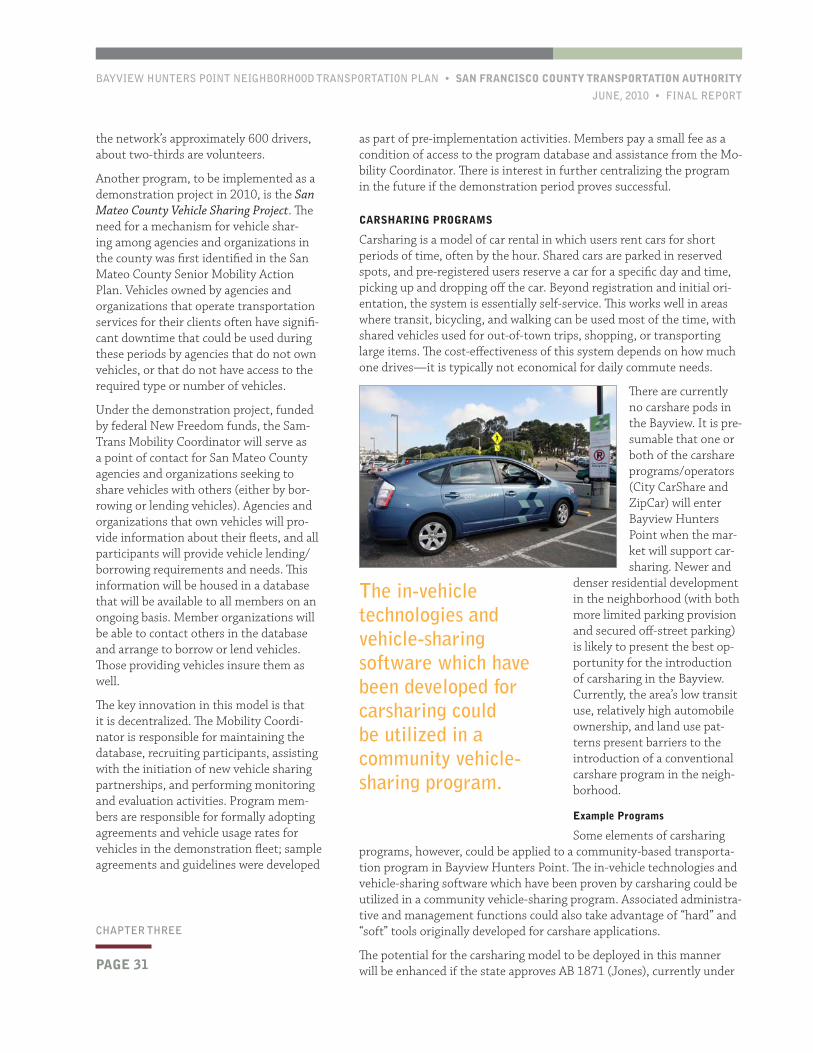
BAYVIEW HUNTERS POINT NEIGHBORHOOD TRANSPORTATION PLAN • SAN FRANCISCO COUNTY TRANSPORTATION AUTHORITY
JUNE, 2010 • FINAL REPORT
PAGE 31
CHAPTER THREE
as part of pre-implementation activities. Members pay a small fee as a condition of access to the program database and assistance from the Mo-bility Coordinator. There is interest in further centralizing the program in the future if the demonstration period proves successful.
CARSHARING PROGRAMS
Carsharing is a model of car rental in which users rent cars for short periods of time, often by the hour. Shared cars are parked in reserved spots, and pre-registered users reserve a car for a specific day and time, picking up and dropping off the car. Beyond registration and initial ori-entation, the system is essentially self-service. This works well in areas where transit, bicycling, and walking can be used most of the time, with shared vehicles used for out-of-town trips, shopping, or transporting large items. The cost-effectiveness of this system depends on how much one drives—it is typically not economical for daily commute needs.
There are currently no carshare pods in the Bayview. It is pre-sumable that one or both of the carshare programs/operators (City CarShare and ZipCar) will enter Bayview Hunters Point when the mar-ket will support car-sharing. Newer and
denser residential development in the neighborhood (with both more limited parking provision and secured off-street parking) is likely to present the best op-portunity for the introduction of carsharing in the Bayview. Currently, the area’s low transit use, relatively high automobile ownership, and land use pat-terns present barriers to the introduction of a conventional carshare program in the neigh-borhood.
Example Programs
Some elements of carsharing programs, however, could be applied to a community-based transporta-tion program in Bayview Hunters Point. The in-vehicle technologies and vehicle-sharing software which have been proven by carsharing could be utilized in a community vehicle-sharing program. Associated administra-tive and management functions could also take advantage of “hard” and “soft” tools originally developed for carshare applications.
The potential for the carsharing model to be deployed in this manner will be enhanced if the state approves AB 1871 (Jones), currently under
the network’s approximately 600 drivers, about two-thirds are volunteers.
Another program, to be implemented as a demonstration project in 2010, is the San Mateo County Vehicle Sharing Project. The need for a mechanism for vehicle shar-ing among agencies and organizations in the county was first identified in the San Mateo County Senior Mobility Action Plan. Vehicles owned by agencies and organizations that operate transportation services for their clients often have signifi-cant downtime that could be used during these periods by agencies that do not own vehicles, or that do not have access to the required type or number of vehicles.
Under the demonstration project, funded by federal New Freedom funds, the Sam-Trans Mobility Coordinator will serve as a point of contact for San Mateo County agencies and organizations seeking to share vehicles with others (either by bor-rowing or lending vehicles). Agencies and organizations that own vehicles will pro-vide information about their fleets, and all participants will provide vehicle lending/borrowing requirements and needs. This information will be housed in a database that will be available to all members on an ongoing basis. Member organizations will be able to contact others in the database and arrange to borrow or lend vehicles. Those providing vehicles insure them as well.
The key innovation in this model is that it is decentralized. The Mobility Coordi-nator is responsible for maintaining the database, recruiting participants, assisting with the initiation of new vehicle sharing partnerships, and performing monitoring and evaluation activities. Program mem-bers are responsible for formally adopting agreements and vehicle usage rates for vehicles in the demonstration fleet; sample agreements and guidelines were developed
The in-vehicle technologies and vehicle-sharing software which have been developed for carsharing could be utilized in a community vehicle-sharing program.
PAGE 32
SAN FRANCISCO COUNTY TRANSPORTATION AUTHORITY • BAYVIEW HUNTERS POINT NEIGHBORHOOD TRANSPORTATION PLAN
FINAL REPORT • JUNE, 2010
CHAPTER THREE
cies, and the assessment of operational, legal, financial, and institutional issues. It is anticipated that these activities will include the following:
• Detailed survey of existing community-provided transportation services. This effort would build on the BMAGIC Landscape Analysis to provide a more detailed assessment of the specific transportation resources and costs (in-cluding insurance) of CBOs, as well as their interest in (and requirements for) resource-sharing and collaboration.
• Alternatives as applied to Bayview Hunters Point. This element would move beyond the general case studies explored in the NTP to assess potential models as specifically applied to Bay-view Hunters Point. This work would include the development of planning-level cost estimates and detailed comparisons.
• Planning analysis regarding program design issues. These activities would plan solutions for (and assess risks as-sociated with) specific operational and organizational issues such as training, driver and vehicle pooling, mainte-nance, cost recovery, etc.
consideration by the legislature. The bill would slightly modify state insurance law to remove a key barrier to the establishment of “personal” carsharing. In a personal carshare program, a vehicle owner makes his or her car available during certain times for lending, whether to an entire “open” pool of carshare members or to a “closed” pool of specific indi-viduals or organizations (neighbors, partner agencies, etc.). The owner is compensated for use by others, and a third-party administrator or fiscal agent would receive a small portion of the usage fee to defray admin-istrative costs. Existing carshare companies/organizations could have varying levels of involvement in such a system, from licensing various technologies to providing system administration. AB 1871 would change state law so that receiving compensation for the use of a private vehicle would not invalidate the vehicle’s insurance (as it does under current state insurance law).
Another innovative approach to carsharing has been implemented in a partnership between Bay Area Wilderness Training (BAWT) and City CarShare. BAWT supports outdoor education programs by supplying transportation to educational groups. BAWTpurchased two all-wheel-drive minivans and placed them in City CarShare’s fleet of shared ve-hicles. Through the BAWTmobile Program, teachers and youth educators can join City CarShare as BAWT-approved members. Then they simply reserve the BAWTmobiles online, access them, and go. This unique program allows youth education programs to avoid legal, administrative, and financial drawbacks that are often obstacles to taking outdoor field trips. Registered program participants pay a one-time application fee of $30, and get a special reduced daily and hourly rate on the use of the van. As with all City CarShare vehicles, gas, insurance, and maintenance are included in the usage rate. Partnering with City CarShare in this way simplifies the process, relieves BAWT of managing and maintaining the vans, and allows City CarShare to allow others (i.e., the general pool of City CarShare members) to use the vans as well, at the regular rate.
3.4 RecommendationsAdvancing community-based mobility and transportation solutions dif-fers from implementing many of the other types of transportation solu-tions that may emerge from a neighborhood planning process. In order to be successful, a community-based program must reflect community goals and values, yet must also be financially sustainable and satisfy legal requirements. The NTP recommends developing one or more pilots of innovative, community-based solutions, such as a volunteer driver program or a coordinated vehicle collaborative program. To advance such a demonstration project, the NTP recommends that a focused follow-on study be undertaken to advance a community-based transportation pro-gram to implementation-ready status. This section briefly outlines the components of this subsequent study. The potential to use a carsharing model (to whatever extent appropriate or necessary) to improve mobility in the community should be explored through this effort.
The subsequent stage of analysis will build on the NTP by partnering with the community to develop the full set of technical documents and agreements that are necessary to implement a community-based trans-portation program. This work will entail the development of a business plan, the identification of partner/participating organizations and agen-
The NTP recommends developing one or more pilots of innovative, community-based solutions, such as a volunteer driver program or a coordinated vehicle collaborative program.
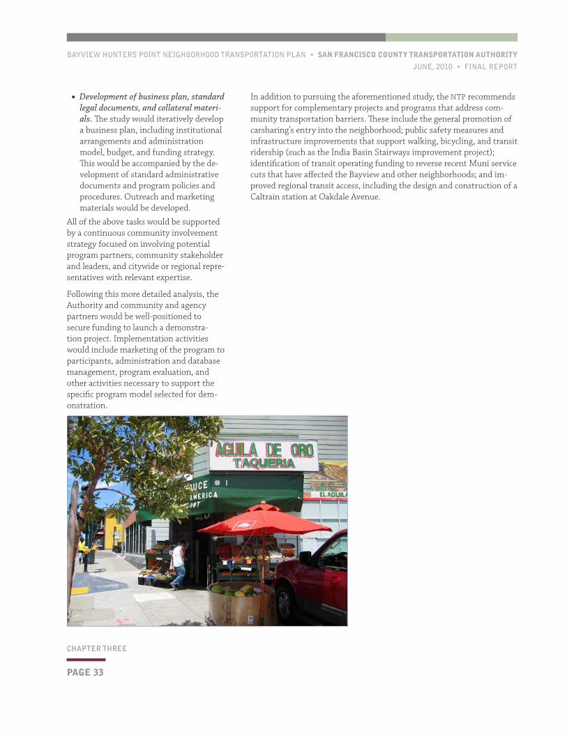
BAYVIEW HUNTERS POINT NEIGHBORHOOD TRANSPORTATION PLAN • SAN FRANCISCO COUNTY TRANSPORTATION AUTHORITY
JUNE, 2010 • FINAL REPORT
PAGE 33
CHAPTER THREE
In addition to pursuing the aforementioned study, the NTP recommends support for complementary projects and programs that address com-munity transportation barriers. These include the general promotion of carsharing’s entry into the neighborhood; public safety measures and infrastructure improvements that support walking, bicycling, and transit ridership (such as the India Basin Stairways improvement project); identification of transit operating funding to reverse recent Muni service cuts that have affected the Bayview and other neighborhoods; and im-proved regional transit access, including the design and construction of a Caltrain station at Oakdale Avenue.
• Development of business plan, standard legal documents, and collateral materi-als. The study would iteratively develop a business plan, including institutional arrangements and administration model, budget, and funding strategy. This would be accompanied by the de-velopment of standard administrative documents and program policies and procedures. Outreach and marketing materials would be developed.
All of the above tasks would be supported by a continuous community involvement strategy focused on involving potential program partners, community stakeholder and leaders, and citywide or regional repre-sentatives with relevant expertise.
Following this more detailed analysis, the Authority and community and agency partners would be well-positioned to secure funding to launch a demonstra-tion project. Implementation activities would include marketing of the program to participants, administration and database management, program evaluation, and other activities necessary to support the specific program model selected for dem-onstration.

SAN FRANCISCO COUNTY TRANSPORTATION AUTHORITY • BAYVIEW HUNTERS POINT NEIGHBORHOOD TRANSPORTATION PLAN
FINAL REPORT • JUNE, 2010
This page left intentionally blank
BAYVIEW HUNTERS POINT NEIGHBORHOOD TRANSPORTATION PLAN • SAN FRANCISCO COUNTY TRANSPORTATION AUTHORITY
JUNE, 2010 • FINAL REPORT
PAGE 35
CHAPTER FOURCHAPTER FOUR
The chapter’s first section reviews current parking policies and discusses the general configuration of parking in the neighborhood. The subse-quent section reviews relevant community input regarding parking con-ditions in the Bayview. In the third section, findings from best practices research conducted by the study team regarding neighborhood parking policies are summarized.
Then, findings from a data collection effort conducted for the Bayview NTP are detailed. The chapter’s final section presents several recommen-dations regarding to parking in Bayview Hunters Point.
4.1 Demographics, Policies, and Configuration
DEMOGRAPHICS
A number of demographic indica-tors are relevant to parking phe-nomena in the Bayview. Specifically, parking demand in residential areas of the Bayview can be expected to be relatively high, as automobile usage is high relative to other San Francisco neighborhoods. In addi-tion, average household sizes in the Bayview are well above the citywide average, and automobile ownership rates are also elevated. These demo-graphic comparisons are presented in Figure 4-1, next page.
POLICIES AND CONFIGURATION
Almost all public parking in the Bayview is on-street, in curbside spaces. A few businesses offer off-street lots for customers, but most do not. Many residences have private garages (although some garages are used for storage or living space, rather than vehicular parking).
Generally, there are five types of on-street parking in Bayview Hunters Point:
• Parking along the Third Street corridor, some of which is metered
• Unregulated parking in “flatland” residential areas
• Unregulated parking in transitional “hillside” residential areas
• Unregulated parking in “hilltop” residential areas
• Unregulated parking in industrial zones and in transitional areas between industrial and residential areas
Typical configurations of parking in flatland, hillside, and hilltop residen-tial areas are distinct in a number of ways. In flatland areas, primarily located east of Third Street, legal parking is generally limited to curbsides and residential garages, and curb cuts are frequent. There are few drive-ways; instead, there are typically wide sidewalks extending from curb to building wall, and illegal parking on sidewalks and blocking curb cuts is common.
In this chapter, parking conditions in Bayview Hunters Point are
considered and recommendations are made regarding both parking
policy and configuration.
Parking
4
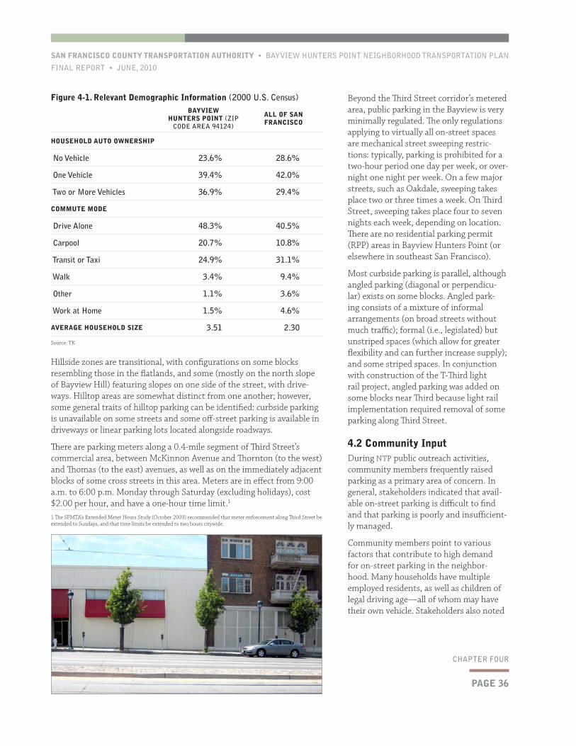
PAGE 36
SAN FRANCISCO COUNTY TRANSPORTATION AUTHORITY • BAYVIEW HUNTERS POINT NEIGHBORHOOD TRANSPORTATION PLAN
FINAL REPORT • JUNE, 2010
CHAPTER FOUR
Beyond the Third Street corridor’s metered area, public parking in the Bayview is very minimally regulated. The only regulations applying to virtually all on-street spaces are mechanical street sweeping restric-tions: typically, parking is prohibited for a two-hour period one day per week, or over-night one night per week. On a few major streets, such as Oakdale, sweeping takes place two or three times a week. On Third Street, sweeping takes place four to seven nights each week, depending on location. There are no residential parking permit (RPP) areas in Bayview Hunters Point (or elsewhere in southeast San Francisco).
Most curbside parking is parallel, although angled parking (diagonal or perpendicu-lar) exists on some blocks. Angled park-ing consists of a mixture of informal arrangements (on broad streets without much traffic); formal (i.e., legislated) but unstriped spaces (which allow for greater flexibility and can further increase supply); and some striped spaces. In conjunction with construction of the T-Third light rail project, angled parking was added on some blocks near Third because light rail implementation required removal of some parking along Third Street.
4.2 Community InputDuring NTP public outreach activities, community members frequently raised parking as a primary area of concern. In general, stakeholders indicated that avail-able on-street parking is difficult to find and that parking is poorly and insufficient-ly managed.
Community members point to various factors that contribute to high demand for on-street parking in the neighbor-hood. Many households have multiple employed residents, as well as children of legal driving age—all of whom may have their own vehicle. Stakeholders also noted
Hillside zones are transitional, with configurations on some blocks resembling those in the flatlands, and some (mostly on the north slope of Bayview Hill) featuring slopes on one side of the street, with drive-ways. Hilltop areas are somewhat distinct from one another; however, some general traits of hilltop parking can be identified: curbside parking is unavailable on some streets and some off-street parking is available in driveways or linear parking lots located alongside roadways.
There are parking meters along a 0.4-mile segment of Third Street’s commercial area, between McKinnon Avenue and Thornton (to the west) and Thomas (to the east) avenues, as well as on the immediately adjacent blocks of some cross streets in this area. Meters are in effect from 9:00 a.m. to 6:00 p.m. Monday through Saturday (excluding holidays), cost $2.00 per hour, and have a one-hour time limit.1
1 The SFMTA’s Extended Meter Hours Study (October 2009) recommended that meter enforcement along Third Street be extended to Sundays, and that time limits be extended to two hours citywide.
Figure 4-1. Relevant Demographic Information (2000 U.S. Census)BAYVIEW
HUNTERS POINT (ZIP CODE AREA 94124)
ALL OF SAN FRANCISCO
HOUSEHOLD AUTO OWNERSHIP
No Vehicle 23.6% 28.6%
One Vehicle 39.4% 42.0%
Two or More Vehicles 36.9% 29.4%
COMMUTE MODE
Drive Alone 48.3% 40.5%
Carpool 20.7% 10.8%
Transit or Taxi 24.9% 31.1%
Walk 3.4% 9.4%
Other 1.1% 3.6%
Work at Home 1.5% 4.6%
AVERAGE HOUSEHOLD SIZE 3.51 2.30
Source: TK
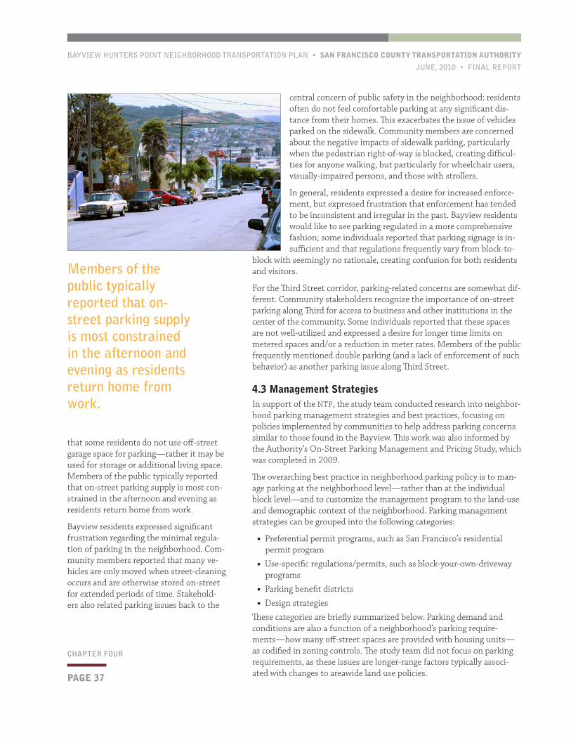
BAYVIEW HUNTERS POINT NEIGHBORHOOD TRANSPORTATION PLAN • SAN FRANCISCO COUNTY TRANSPORTATION AUTHORITY
JUNE, 2010 • FINAL REPORT
PAGE 37
CHAPTER FOUR
central concern of public safety in the neighborhood: residents often do not feel comfortable parking at any significant dis-tance from their homes. This exacerbates the issue of vehicles parked on the sidewalk. Community members are concerned about the negative impacts of sidewalk parking, particularly when the pedestrian right-of-way is blocked, creating difficul-ties for anyone walking, but particularly for wheelchair users, visually-impaired persons, and those with strollers.
In general, residents expressed a desire for increased enforce-ment, but expressed frustration that enforcement has tended to be inconsistent and irregular in the past. Bayview residents would like to see parking regulated in a more comprehensive fashion; some individuals reported that parking signage is in-sufficient and that regulations frequently vary from block-to-
block with seemingly no rationale, creating confusion for both residents and visitors.
For the Third Street corridor, parking-related concerns are somewhat dif-ferent. Community stakeholders recognize the importance of on-street parking along Third for access to business and other institutions in the center of the community. Some individuals reported that these spaces are not well-utilized and expressed a desire for longer time limits on metered spaces and/or a reduction in meter rates. Members of the public frequently mentioned double parking (and a lack of enforcement of such behavior) as another parking issue along Third Street.
4.3 Management StrategiesIn support of the NTP, the study team conducted research into neighbor-hood parking management strategies and best practices, focusing on policies implemented by communities to help address parking concerns similar to those found in the Bayview. This work was also informed by the Authority’s On-Street Parking Management and Pricing Study, which was completed in 2009.
The overarching best practice in neighborhood parking policy is to man-age parking at the neighborhood level—rather than at the individual block level—and to customize the management program to the land-use and demographic context of the neighborhood. Parking management strategies can be grouped into the following categories:
• Preferential permit programs, such as San Francisco’s residential permit program
• Use-specific regulations/permits, such as block-your-own-driveway programs
• Parking benefit districts
• Design strategies
These categories are briefly summarized below. Parking demand and conditions are also a function of a neighborhood’s parking require-ments—how many off-street spaces are provided with housing units— as codified in zoning controls. The study team did not focus on parking requirements, as these issues are longer-range factors typically associ-ated with changes to areawide land use policies.
that some residents do not use off-street garage space for parking—rather it may be used for storage or additional living space. Members of the public typically reported that on-street parking supply is most con-strained in the afternoon and evening as residents return home from work.
Bayview residents expressed significant frustration regarding the minimal regula-tion of parking in the neighborhood. Com-munity members reported that many ve-hicles are only moved when street-cleaning occurs and are otherwise stored on-street for extended periods of time. Stakehold-ers also related parking issues back to the
Members of the public typically reported that on-street parking supply is most constrained in the afternoon and evening as residents return home from work.
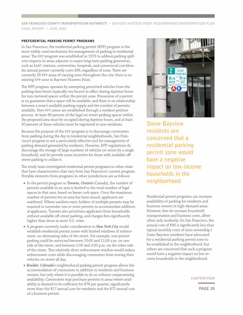
PAGE 38
SAN FRANCISCO COUNTY TRANSPORTATION AUTHORITY • BAYVIEW HUNTERS POINT NEIGHBORHOOD TRANSPORTATION PLAN
FINAL REPORT • JUNE, 2010
CHAPTER FOUR
Residential permit programs can increase availability of parking for residents and business owners in high-demand areas. However, fees do increase household transportation and business costs, albeit often only modestly. (In San Francisco, the annual cost of $96 is significantly less than typical monthly costs of auto ownership.) Some Bayview residents have advocated for a residential parking permit zone to be established in the neighborhood, but others are concerned that such a program would have a negative impact on low-in-come households in the neighborhood.
PREFERENTIAL PARKING PERMIT PROGRAMS
In San Francisco, the residential parking permit (RPP) program is the most widely used mechanism for management of parking in residential areas. The RPP program was established in 1976 to address parking spill-over impacts in areas adjacent to major long-term parking generators, such as BART stations, universities, hospitals, and commercial corridors. An annual permit currently costs $96, regardless of zone. There are currently 28 RPP areas of varying sizes throughout the city; there is no existing RPP zone in Bayview Hunters Point.
The RPP program operates by exempting permitted vehicles from the parking time limits (typically two hours) in effect during daytime hours for non-metered spaces within the permit zone. Possession of a permit is no guarantee that a space will be available, and there is no relationship between a zone’s available parking supply and the number of permits available. New RPP zones are established through a resident petition process. At least 80 percent of the legal on-street parking spaces within the proposed area must be occupied during daytime hours, and at least 50 percent of these vehicles must be registered to non-residents.
Because the purpose of the RPP program is to discourage commuters from parking during the day in residential neighborhoods, San Fran-cisco’s program is not a particularly effective tool for management of parking demand generated by residents. However, RPP regulations do discourage the storage of large numbers of vehicles on-street by a single household, and do provide some incentive for those with available off-street parking to utilize it.
The study team investigated residential permit programs in other cities that have characteristics that vary from San Francisco’s current program. Notable elements from programs in other jurisdictions are as follows:
• In the permit program in Toronto, Ontario (Canada), the number of permits available in an area is limited to the total number of legal spaces in that area, based on linear curb space. Once the maximum number of permits for an area has been issued, applicants are waitlisted. Where waitlists exist, holders of multiple permits may be required to surrender one or more permits to accommodate addition-al applicants. Toronto also prioritizes applicants from households without available off-street parking, and charges fees significantly higher than those in most U.S. cities.
• A program currently under consideration in New York City would establish residential permit zones with limited windows of enforce-ment, on alternating sides of the street. For example, non-permit parking could be restricted between 10:00 and 11:00 a.m. on one side of the street, and between 2:00 and 3:00 p.m. on the other side of the street. This relatively short enforcement window would reduce enforcement costs while discouraging commuters from storing their vehicles on-street all day.
• Boulder, Colorado’s neighborhood parking permit program allows the accommodation of commuters in addition to residents and business owners, but only where it is possible to do so without compromising availability. Commuters may purchase permits in areas where avail-ability is deemed to be sufficient for $78 per quarter, significantly more than the $17 annual cost for residents and the $75 annual cost of a business permit.
Some Bayview residents are concerned that a residential parking permit zone would have a negative impact on low-income households in the neighborhood.
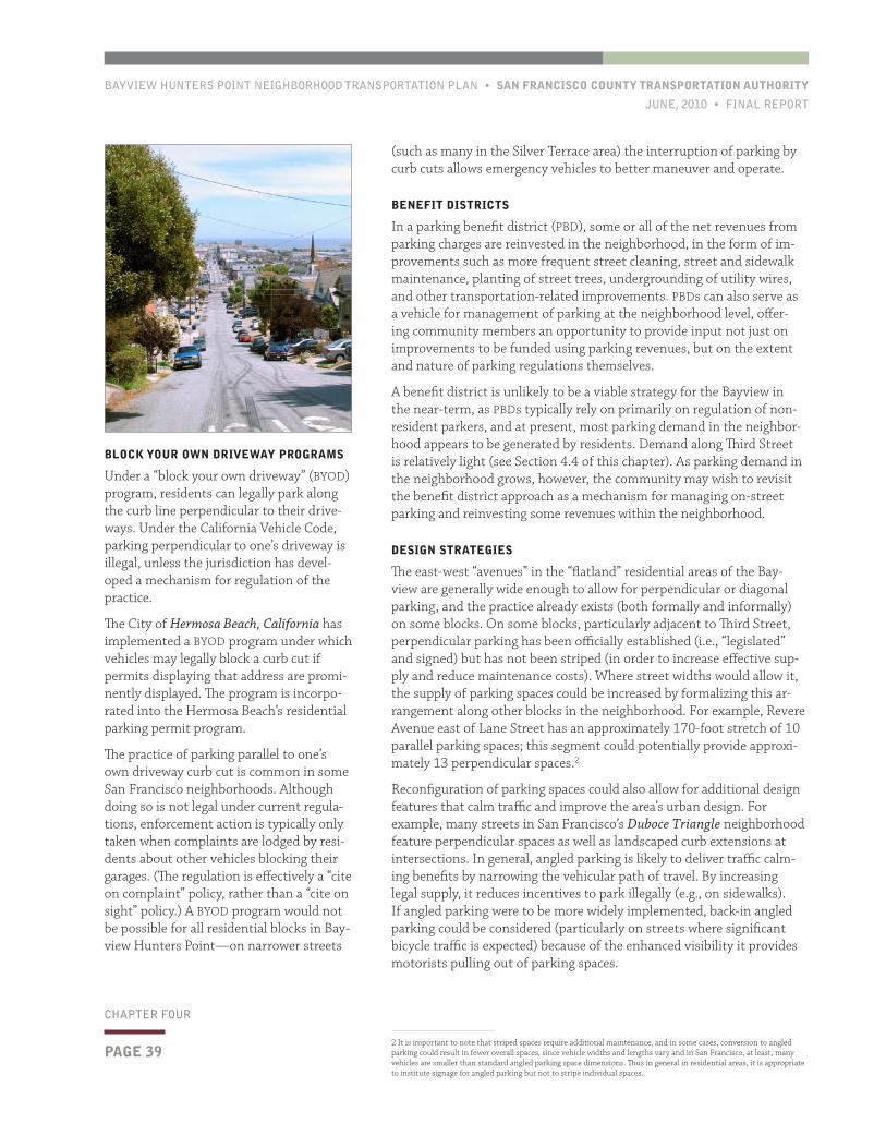
BAYVIEW HUNTERS POINT NEIGHBORHOOD TRANSPORTATION PLAN • SAN FRANCISCO COUNTY TRANSPORTATION AUTHORITY
JUNE, 2010 • FINAL REPORT
PAGE 39
CHAPTER FOUR
(such as many in the Silver Terrace area) the interruption of parking by curb cuts allows emergency vehicles to better maneuver and operate.
BENEFIT DISTRICTS
In a parking benefit district (PBD), some or all of the net revenues from parking charges are reinvested in the neighborhood, in the form of im-provements such as more frequent street cleaning, street and sidewalk maintenance, planting of street trees, undergrounding of utility wires, and other transportation-related improvements. PBDs can also serve as a vehicle for management of parking at the neighborhood level, offer-ing community members an opportunity to provide input not just on improvements to be funded using parking revenues, but on the extent and nature of parking regulations themselves.
A benefit district is unlikely to be a viable strategy for the Bayview in the near-term, as PBDs typically rely on primarily on regulation of non-resident parkers, and at present, most parking demand in the neighbor-hood appears to be generated by residents. Demand along Third Street is relatively light (see Section 4.4 of this chapter). As parking demand in the neighborhood grows, however, the community may wish to revisit the benefit district approach as a mechanism for managing on-street parking and reinvesting some revenues within the neighborhood.
DESIGN STRATEGIES
The east-west “avenues” in the “flatland” residential areas of the Bay-view are generally wide enough to allow for perpendicular or diagonal parking, and the practice already exists (both formally and informally) on some blocks. On some blocks, particularly adjacent to Third Street, perpendicular parking has been officially established (i.e., “legislated” and signed) but has not been striped (in order to increase effective sup-ply and reduce maintenance costs). Where street widths would allow it, the supply of parking spaces could be increased by formalizing this ar-rangement along other blocks in the neighborhood. For example, Revere Avenue east of Lane Street has an approximately 170-foot stretch of 10 parallel parking spaces; this segment could potentially provide approxi-mately 13 perpendicular spaces.2
Reconfiguration of parking spaces could also allow for additional design features that calm traffic and improve the area’s urban design. For example, many streets in San Francisco’s Duboce Triangle neighborhood feature perpendicular spaces as well as landscaped curb extensions at intersections. In general, angled parking is likely to deliver traffic calm-ing benefits by narrowing the vehicular path of travel. By increasing legal supply, it reduces incentives to park illegally (e.g., on sidewalks). If angled parking were to be more widely implemented, back-in angled parking could be considered (particularly on streets where significant bicycle traffic is expected) because of the enhanced visibility it provides motorists pulling out of parking spaces.
2 It is important to note that striped spaces require additional maintenance, and in some cases, conversion to angled parking could result in fewer overall spaces, since vehicle widths and lengths vary and in San Francisco, at least, many vehicles are smaller than standard angled parking space dimensions. Thus in general in residential areas, it is appropriate to institute signage for angled parking but not to stripe individual spaces.
BLOCK YOUR OWN DRIVEWAY PROGRAMS
Under a “block your own driveway” (BYOD) program, residents can legally park along the curb line perpendicular to their drive-ways. Under the California Vehicle Code, parking perpendicular to one’s driveway is illegal, unless the jurisdiction has devel-oped a mechanism for regulation of the practice.
The City of Hermosa Beach, California has implemented a BYOD program under which vehicles may legally block a curb cut if permits displaying that address are promi-nently displayed. The program is incorpo-rated into the Hermosa Beach’s residential parking permit program.
The practice of parking parallel to one’s own driveway curb cut is common in some San Francisco neighborhoods. Although doing so is not legal under current regula-tions, enforcement action is typically only taken when complaints are lodged by resi-dents about other vehicles blocking their garages. (The regulation is effectively a “cite on complaint” policy, rather than a “cite on sight” policy.) A BYOD program would not be possible for all residential blocks in Bay-view Hunters Point—on narrower streets
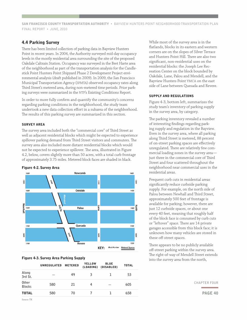
PAGE 40
SAN FRANCISCO COUNTY TRANSPORTATION AUTHORITY • BAYVIEW HUNTERS POINT NEIGHBORHOOD TRANSPORTATION PLAN
FINAL REPORT • JUNE, 2010
CHAPTER FOUR
While most of the survey area is in the flatlands, blocks in its eastern and western corners are on the slopes of Silver Terrace and Hunters Point Hill. There are also two significant, non-residential uses on the residential blocks: the Joseph Lee Rec-reation Center on the block bounded by Oakdale, Lane, Palou and Mendell, and the Bayview Hunters Point YMCA on the east side of Lane between Quesada and Revere.
SUPPLY AND REGULATIONS
Figure 4-3, bottom left, summarizes the study team’s inventory of parking supply in the survey area, by category.
The parking inventory revealed a number of interesting findings regarding park-ing supply and regulation in the Bayview. Even in the survey area, where all parking along Third Street is metered, 88 percent of on-street parking spaces are effectively unregulated. There are relatively few com-mercial loading zones in the survey area—just three in the commercial core of Third Street and four scattered throughout the neighborhood near commercial uses in the residential areas.
Frequent curb cuts in residential areas significantly reduce curbside parking supply. For example, on the north side of Palou between Newhall and Third Street, approximately 500 feet of frontage is available for parking; however, there are just 12 curbside spaces, or about one every 40 feet, meaning that roughly half of the block face is consumed by curb cuts or “leftover” space. There are 14 private garages accessible from this block face; it is unknown how many vehicles are stored in these off-street spaces.
There appears to be no publicly available off-street parking within the survey area. The right-of-way of Mendell Street extends into the survey area from the north,
4.4 Parking SurveyThere has been limited collection of parking data in Bayview Hunters Point in recent years. In 2004, the Authority surveyed mid-day occupancy levels in the mostly residential area surrounding the site of the proposed Oakdale Caltrain Station. Occupancy was surveyed in the Bret Harte area of the neighborhood as part of the transportation analysis for the Candle-stick Point Hunters Point Shipyard Phase 2 Development Project envi-ronmental analysis (draft published in 2009). In 2009, the San Francisco Municipal Transportation Agency (SFMTA) observed occupancy rates along Third Street’s metered area, during non-metered time periods. Prior park-ing surveys were summarized in the NTP’s Existing Conditions Report.
In order to more fully confirm and quantify the community’s concerns regarding parking conditions in the neighborhood, the study team undertook a new data collection effort in a subarea of the neighborhood. The results of this parking survey are summarized in this section.
SURVEY AREA
The survey area included both the “commercial core” of Third Street as well as adjacent residential blocks which might be expected to experience spillover parking demand from Third Street visitors and commuters. The survey area also included more distant residential blocks which would not be expected to experience spillover. The area, illustrated in Figure 4.2, below, covers slightly more than 50 acres, with a total curb frontage of approximately 3.75 miles. Metered block faces are shaded in black.
Figure 4-2. Survey Area
Figure 4-3. Survey Area Parking Supply
UNREGULATED METEREDYELLOW
(LOADING)BLUE
(DISABLED)TOTAL
Along 3rd St. — 49 3 1 53
Other Blocks 580 21 4 — 605
TOTAL 580 70 7 1 658
Source: TK
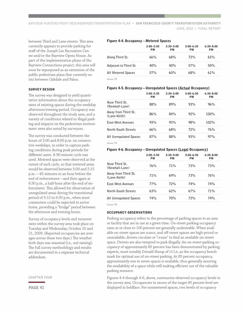
BAYVIEW HUNTERS POINT NEIGHBORHOOD TRANSPORTATION PLAN • SAN FRANCISCO COUNTY TRANSPORTATION AUTHORITY
JUNE, 2010 • FINAL REPORT
PAGE 41
CHAPTER FOUR
OCCUPANCY OBSERVATIONS
Parking occupancy refers to the percentage of parking spaces in an area or facility that are in use at a given time. On-street parking occupancy rates at or close to 100 percent are generally undesirable. When avail-able on-street spaces are scarce, and off-street spaces are high-priced or unavailable, drivers circulate or “cruise” to find an available on-street space. Drivers are also tempted to park illegally. An on-street parking oc-cupancy of approximately 85 percent has been demonstrated by parking experts, most notably Donald Shoup of UCLA, as the occupancy bench-mark for optimal use of on-street parking. At 85 percent occupancy, approximately one in seven spaces is available, thus generally assuring the availability of a space while still making efficient use of the valuable parking resource.
Figures 4-4 through 4-6, above, summarize observed occupancy levels in the survey area. Occupancies in excess of the target 85 percent level are displayed in boldface. For nonmetered spaces, two levels of occupancy
between Third and Lane streets. This area currently appears to provide parking for staff of the Joseph Lee Recreation Cen-ter and/or the Bayview Opera House. As part of the implementation phase of the Bayview Connections project, this area will soon be repurposed as an extension of the public pedestrian plaza that currently ex-ists between Oakdale and Palou.
SURVEY DESIGN
The survey was designed to yield quanti-tative information about the occupancy rates of existing spaces during the weekday afternoon/evening period. Occupancy was observed throughout the study area, and a variety of conditions related to illegal park-ing and impacts on the pedestrian environ-ment were also noted by surveyors.
The survey was conducted between the hours of 2:00 and 8:00 p.m. on consecu-tive weekdays, in order to capture park-ing conditions during peak periods for different users. A 90-minute cycle was used. Metered spaces were observed at the outset of each cycle, so that metered areas would be observed between 5:00 and 5:15 p.m.—45 minutes to an hour before the end of enforcement—and then again at 6:30 p.m., a half-hour after the end of en-forcement. This allowed for observation of unregulated areas during the transitional period of 5:15 to 6:30 p.m., when most commuters could be expected to arrive home, providing a “bridge” period between the afternoon and evening hours.
Survey of occupancy levels and turnover rates within the survey area took place on Tuesday and Wednesday, October 20 and 21, 2009. (Reported occupancies are aver-ages across these two days.) The weather both days was seasonal (i.e., not raining). The full survey methodology and results are documented in a separate technical addendum.
Figure 4-4. Occupancy—Metered Spaces2:00–3:30
PM3:30–5:00
PM5:00–6:30
PM6:30–8:00
PM
Along Third St. 66% 68% 72% 65%
Adjacent to Third St. 40% 40% 57% 50%
All Metered Spaces 57% 60% 68% 61%
Source: TK
Figure 4-5. Occupancy—Unregulated Spaces (Actual Occupancy)2:00–3:30
PM3:30–5:00
PM5:00–6:30
PM6:30–8:00
PM
Near Third St. (Newhall-Lane) 88% 89% 93% 96%
Away from Third St. (Lane-Keith) 86% 84% 92% 100%
East-West Avenues 93% 93% 98% 102%
North-South Streets 66% 68% 72% 76%
All Unregulated Spaces 87% 88% 93% 97%
Source: TK
Figure 4-6. Occupancy—Unregulated Spaces (Legal Occupancy)2:00–3:30
PM3:30–5:00
PM5:00–6:30
PM6:30–8:00
PM
Near Third St. (Newhall-Lane) 76% 71% 73% 73%
Away from Third St. (Lane-Keith) 71% 69% 73% 76%
East-West Avenues 77% 72% 74% 74%
North-South Streets 63% 62% 67% 71%
All Unregulated Spaces 74% 70% 73% 74%
Source: TK
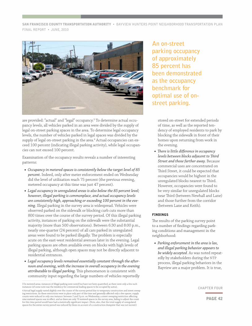
PAGE 42
SAN FRANCISCO COUNTY TRANSPORTATION AUTHORITY • BAYVIEW HUNTERS POINT NEIGHBORHOOD TRANSPORTATION PLAN
FINAL REPORT • JUNE, 2010
CHAPTER FOUR
stored on-street for extended periods of time, as well as the reported ten-dency of employed residents to park by blocking the sidewalk in front of their homes upon returning from work in the evening.
• There is little difference in occupancy levels between blocks adjacent to Third Street and those farther away. Because commercial uses are concentrated on Third Street, it could be expected that occupancies would be highest in the unregulated blocks nearest to Third. However, occupancies were found to be very similar for unregulated blocks near Third (between Newhall and Lane) and those further from the corridor (between Lane and Keith).
FINDINGS
The results of the parking survey point to a number of findings regarding park-ing conditions and management in the neighborhood:
• Parking enforcement in the area is lax, and illegal parking behavior appears to be widely accepted. As was noted repeat-edly by stakeholders during the NTP process, illegal parking behaviors in the Bayview are a major problem. It is true,
are provided: “actual” and “legal” occupancy.3 To determine actual occu-pancy levels, all vehicles parked in an area were divided by the supply of legal on-street parking spaces in the area. To determine legal occupancy levels, the number of vehicles parked in legal spaces was divided by the supply of legal on-street parking in the area.4 Actual occupancies can ex-ceed 100 percent (indicating illegal parking activity), while legal occupan-cies can not exceed 100 percent.
Examination of the occupancy results reveals a number of interesting patterns:
• Occupancy in metered spaces is consistently below the target level of 85 percent. Indeed, only after meter enforcement ended on Wednesday did the level of utilization reach 75 percent (the previous evening, metered occupancy at this time was just 47 percent).
• Legal occupancy in unregulated areas is also below the 85 percent level; however, illegal parking is commonplace, and actual occupancy levels are consistently high, approaching or exceeding 100 percent in the eve-ning. Illegal parking in the survey area is widespread. Vehicles were observed parked on the sidewalk or blocking curb cuts more than 800 times over the course of the survey period. Of this illegal parking activity, instances of parking on the sidewalk were the substantial majority (more than 500 observations). Between 6:30 and 8:00 p.m., nearly one-quarter (24 percent) of all cars parked in unregulated areas were found to be parked illegally. The problem is especially acute on the east-west residential avenues later in the evening. Legal parking spaces are often available even on blocks with high levels of illegal parking, although open spaces may not be directly adjacent to residential entrances.
• Legal occupancy levels remained essentially constant through the after-noon and evening, with the increase in overall occupancy in the evening attributable to illegal parking. This phenomenon is consistent with community input regarding the large numbers of vehicles reportedly
3 In metered areas, instances of illegal parking were noted but have not been quantified, as there were only a few such instances (of some note was the tendency for commercial loading spaces to be occupied by autos).
4 Actual legal supply varied slightly over the course of the survey period due to temporary construction and street-sweep-ing restrictions. As these restrictions were in place only part of the time and generally affected only a few spaces, supply counts were reduced in only one instance: between 2 and 3 p.m. on Wednesday, a street-sweeping restriction affecting nine metered spaces was in effect, and as there are only 70 metered spaces in the survey area, failing to adjust the count for this time period would have had a statistically significant impact. (Note, also, that the total supply of unregulated spaces for the entire survey period was reduced by three on account of a construction dumpster that was not moved.)
An on-street parking occupancy of approximately 85 percent has been demonstrated as the occupancy benchmark for optimal use of on-street parking.

BAYVIEW HUNTERS POINT NEIGHBORHOOD TRANSPORTATION PLAN • SAN FRANCISCO COUNTY TRANSPORTATION AUTHORITY
JUNE, 2010 • FINAL REPORT
PAGE 43
CHAPTER FOUR
compared to levels on north-south streets (see Figures 4-5 and 4-6). North-south streets are narrower (64 feet) than east-west avenues (80 feet), and sidewalks are also generally narrower, reducing oppor-tunities for illegal parking. However, north-south streets are different in another important way—residences typically do not face them: there are many fewer opportunities to park immediately adjacent to one’s home on a north-south street. Findings in this regard were telling: both legal and actual occupancy levels are significantly lower on north-south streets. Furthermore, actual occupancy levels for all unregulated areas tended to steadily increase as the evening ap-proached, even as legal occupancy levels remained relatively con-stant. This disparity further suggests that as residents return home from work, they are likely to forego legal parking available in the general area in order to park directly in front of their homes.
• While some “spillover” parking impact on residential areas may exist from businesses on Third Street or from commuters with origins and/or destinations outside the area, much of the high demand from park-ing appears to be generated by residents themselves. The consistently high occupancy levels across the survey area suggest that most of the demand for parking in the area is generated by residents them-selves and that—although duration was not directly observed in the unregulated areas—many vehicles are being stored on-street for extended periods of time.
• As currently managed, metered spaces along and adjacent to Third Street are not effective in terms of either supporting business or gener-ating revenue. From a planning perspective, the objective of parking meters is to manage demand, encourage turnover, and provide suf-ficient availability. Relatively low occupancy levels like those found in the metered spaces in the survey area suggest that rates should be lowered (and time limits extended) to improve utilization of this parking resource.
4.5 RecommendationsThe following recommendations for changes to parking policy and configuration in Bayview Hunters Point were informed by the parking survey, best practices research, and community input, as well as the Au-thority’s 2009 On-Street Parking Management and Pricing Study. Some recommendations would require legislative action, while some call for further study of an issue. Administrative and legislative actions regard-ing on-street parking are under the jurisdiction of the SFMTA.
The recommendations recognize that in a neighborhood such as the Bayview, which has both relatively low income levels and relatively high automobile use, price-based strategies for parking management must be tempered by recognition of potential impacts to lower-income house-holds. Over the longer-term, more extensive changes may be made to citywide parking policy, as informed by SFMTA’s SFpark program (cur-rently in its pilot phase), the Authority’s On-Street Parking Management Study, and other efforts.
The recommendations consist of proposals to more effectively manage existing parking supply as well as to strategically increase supply—where the benefits of doing so would outweigh the negative impacts. The cen-tral goals of the parking recommendations are both to improve parking
as some community members noted, that parking behaviors that leave suf-ficient clear space on the sidewalk for pedestrians to pass are less harmful than behaviors that force sidewalk us-ers into the street. However, by far the most commonly observed illegal behav-ior was parking on the sidewalk, and many of those parked on the sidewalk appeared to be blocking nearly all of it.
• Residents often prefer to park illegally, rather than a moderate distance from their homes, out of concern for the safety of both themselves and their vehicles. Parking on the sidewalk or in front of one’s driveway is not always simply a matter of convenience. As was men-tioned frequently during outreach, residents often park illegally out of con-cern for safety.
• In order to test this theory, occu-pancy levels on east-west avenues was
By far the most commonly observed illegal behavior was parking on the sidewalk, and many of those parked on the sidewalk appeared to be blocking nearly all of it.
PAGE 44
SAN FRANCISCO COUNTY TRANSPORTATION AUTHORITY • BAYVIEW HUNTERS POINT NEIGHBORHOOD TRANSPORTATION PLAN
FINAL REPORT • JUNE, 2010
CHAPTER FOUR
as long-term storage of vehicles on the street by residents, as even the relatively low cost of an annual permit would encourage some households to park vehicles in garages (where available) and potentially to get rid of unused or minimally used vehicles cur-rently stored on the street for extended periods of time.
• To the extent possible, modify the RPP program for application in the Bayview. As explored more fully in the Author-ity’s Parking Management Study, the City’s RPP program is an inflexible tool for addressing parking challenges in residential areas. For application in the Bayview, warranted program adjust-ments would include: limiting the total number of permits available; charging graduated rates; and restricting periods of enforcement to a short window. The most equitable among these would be aligning the total number of permits issued in a zone with the total number of on-street spaces in the area, and charging a higher rate for a household’s third or fourth permit. In Bayview Hunters Point, it would potentially be appropriate to charge a reduced rate for a household’s first permit in conjunction with the policy of higher charges for multiple permits. These adjustments are intended to minimize impacts on households with just one or two cars. Impacts on these resi-dents could further be minimized, and enforcement costs could be reduced, by limiting the hours of enforcement to a few hours a day, rather than the 8 a.m. to 6 p.m. period that is used in most RPP zones currently. Even a four-hour window could effectively discourage both commuter parking and long-term storage of excess vehicles in the street by residents.
• Encourage the establishment of carshar-
availability close to residents’ homes and to better manage the neighborhood’s limited on-street parking resources. The parking management recom-mendations also seek to reduce the incidence of cars parked on sidewalks in the neighbor-hood—a phenomenon that sig-nificantly degrades pedestrian conditions.
The recommendations rely large-ly on the available “toolbox” of parking management measures in San Francisco. In practice, this means that the current RPP program—an imperfect vehicle
for parking management, but one that would introduce a framework for management—is contemplated, with some recommended modifications.
MANAGEMENT RECOMMENDATIONS (AREAWIDE)
Recommendations relating to parking management for the neighbor-hood as a whole are as follows:
• To improve pedestrian safety and, to some extent, increase parking availability, more proactively and consistently enforce existing parking regulations. While there is some resistance in the community to the idea of ticketing vehicles parked on sidewalks, support also exists for measures to ensure that pedestrian paths are kept clear and safe. At the least, enforcement of sidewalk parking violations should focus on vehicles that completely block the pedestrian path of travel. At the outset of a stepped-up enforcement program, it will be advisable to conduct outreach and potentially use warning citations prior to the issuance of tickets with fines.
Community members have also identified long-term storage of private vehicles in the public right-of-way as a problem for neigh-borhood residents. This occurs both in residential areas and along residential/industrial “fringe” areas where many vehicles appear to have been abandoned in public parking spaces. Steps should be taken to ensure that vehicles receiving multiple tickets for street-sweeping violations are towed. This could entail periodic efforts (i.e., every few months) to remove abandoned vehicles from the public right-of-way.
• Where residents support doing so, explore establishment of one or more residential permit zones in the residential blocks adjacent to Third Street and/or to industrial areas. Under the existing RPP program, it may not be possible to establish permit zones in the Bayview—one of the program’s conditions is that at least 50 percent of the vehicles parked on the street in the proposed area must be non-resident vehicles.5 RPPs are intended to address “spillover” (i.e., nonresident) parking impacts. However, an RPP zone could prove useful as a means to discourage whatever commuter parking does exist, as well
5 Analysis of vehicular registration of vehicles parked on-street (i.e., a license plate survey) was not conducted during this study phase.
It would potentially be appropriate to charge a reduced rate for a household’s first permit in conjunction with the policy of higher charges for multiple permits.
BAYVIEW HUNTERS POINT NEIGHBORHOOD TRANSPORTATION PLAN • SAN FRANCISCO COUNTY TRANSPORTATION AUTHORITY
JUNE, 2010 • FINAL REPORT
PAGE 45
CHAPTER FOUR
occupancy levels of well below 85 percent suggest that rates are too high. Rates should be reduced, potentially on a trial basis, to $1.00 to $1.50 per hour. Occupancy should then be observed again 6 to 12 months later (in order to allow for awareness of the new rates). If de-mand has not been significantly increased, further reductions might be merited. Over the longer-term, rates should be adjusted to keep occupancy near the 85 percent target. These actions are consistent with the SFMTA’s adopted SFpark principles.
• Increase the number of commercial loading spaces in the commercial core of Third Street. Businesses in the commercial core of Third Street do not typically have rear loading areas, meaning that at least one curbside loading space should ideally be made available on all com-mercial blocks. The relatively low occupancies observed along Third Street indicate that there is an opportunity to designate a modest number of additional yellow loading zones where on-street parking is present. On the seven block faces in the commercial core in the survey area with curbside parking, there are currently just three load-ing spaces, all on the same block face. Redesignation of one space for loading during business hours on each of the remaining block faces would have a negligible impact on parking supply, and would help discourage double-parking by delivery vehicles.
• In the longer-term, if a program of parking benefit districts is intro-duced in San Francisco, explore the establishment of a benefit district in Bayview Hunters Point. Given the low demand for metered parking currently, a benefit district is not an appropriate strategy at pres-ent. However, as parking demand grows in the neighborhood (given planned growth), a benefit district could be an effective mechanism for the commu-nity to proactively manage parking and benefit from this growth in parking demand. PBDs are a more effective tool for comprehensive management of parking at the community level than the City’s current RPP program, which is limited in both scope and flexibility. PBDs also provide for the reinvestment of some rev-enues in the community, which helps to mitigate impacts from new and/or higher parking fees.
DESIGN RECOMMENDATIONS
As part of developing parking-related solutions during the Bayview NTP, the study team completed a preliminary analysis of the potential to convert parallel parking spaces to perpendicular configuration in order to increase supply and provide pedestrian safety benefits. In the flat-lands, east-west avenues are typically 80 feet in width and are thus wide enough to reconfigure parking and travel lanes. Three different concepts for reconfiguration of parking on these streets were developed. These design concepts are described in detail in Chapter 6.
ing pods in the community. As discussed in Chapter 3, neither of San Francisco’s carsharing programs (the commercial ZipCar and nonprofit City CarShare) currently offers locations in Bayview Hunters Point. To the extent that residents are hesitant for safety reasons to walk very far to parked cars, the ef-fectiveness of introduction of carshar-ing to the neighborhood may be limited in some areas. However, carsharing programs are a relatively simply way to reduce household auto ownership needs, potentially improving parking availability while also reducing house-hold expenses.
MANAGEMENT RECOMMENDATIONS
(THIRD STREET CORRIDOR)
Recommendations relating to parking management specific to the metered areas along the Third Street corridor are as fol-lows.
• Extend time limits for metered spaces. Time limits for metered spaces are intended to promote turnover and ensure availability. However, in areas such as the metered zones along and adjacent to Third Street—where oc-cupancy is well below the optimal level of 85 percent—strict time limits only serve to generate “ticket anxiety” and discourage return visits. Extension of the current one-hour limit could benefit businesses at virtually no cost, and would be consistent with recom-mendations of the SFMTA’s October 2009 Extended Meter Hours study, which recommended extending time limits in commercial areas citywide to two hours.
• Reduce meter rates. While the current $2.00 per-hour charge is the lowest lev-ied in San Francisco (in line with other neighborhood commercial districts),
Extension of the current one-hour limit could benefit businesses at virtually no cost.

SAN FRANCISCO COUNTY TRANSPORTATION AUTHORITY • BAYVIEW HUNTERS POINT NEIGHBORHOOD TRANSPORTATION PLAN
FINAL REPORT • JUNE, 2010
This page left intentionally blank
BAYVIEW HUNTERS POINT NEIGHBORHOOD TRANSPORTATION PLAN • SAN FRANCISCO COUNTY TRANSPORTATION AUTHORITY
JUNE, 2010 • FINAL REPORT
PAGE 47
CHAPTER FIVE
5.1 BackgroundThird Street is the busiest corridor in the Bayview for all modes and is the street onto which most of the neighborhood’s storefronts face. Still, it was not initially anticipated that Third Street would be a focus of the NTP: the street recently underwent extensive redesign and reconstruc-tion. In discussions with community stakeholders, however, issues and concerns regarding the corridor—particularly related to signalization and pedestrian conditions—were raised early and frequently. With the understanding that the physical configuration of Third Street is unlikely to change significantly in the near- to mid-term, the study team under-took detailed data collection and analysis to assess conditions in the corridor and explore potential operational improvements.
5.2 Existing Usage and ConfigurationOver several years ending in 2006, Third Street between the Mis-sion Bay district and its transition to Bayshore Boulevard (at the southern edge of the Bayview) was completely reconstructed as part of the T-Third light rail transit (LRT) project. Within the Bayview, the street now features two travel lanes in each direction (plus left-turn lanes at some locations). Between Kirkwood and Thornton avenues in the commercial core, light rail vehicles (LRVs) operate in mixed traffic in the center travel lanes; in all other segments LRVs operate in a dedicated median transitway. Where light rail vehicles operate in mixed flow, on-street parking is provided on both sides of the street. Elsewhere, on-street parking is present intermittently, as right-of-way allows. All light rail stops are high-level platforms. Landscaped
medians are present in a few locations between Kirkwood and Thornton. Sidewalks are relatively narrow for a commercial corridor—typically just nine feet—although corner bulbouts, which shorten crossing distances, are present in many locations.
As the primary commercial and institutional area in the neighborhood, the Third Street corridor experiences the highest intersection-level pe-destrian volumes in Bayview Hunters Point. Figure 5-1, next page, which displays pedestrian volumes at three intersections in the corridor, shows that pedestrian activity peaks in the center of the community near the transit node at Palou Avenue.
Third Street is an official city bicycle route, but it is a Class 3 bicycle facil-ity, meaning that cyclists must share travel lanes with vehicles. Bicycle volumes are relatively light along and across Third Street in the Bayview.
This chapter summarizes the NTP’s analysis of pedestrian conditions
and traffic signal timing along Third Street in the commercial core
of the Bayview. This analysis informs the chapter’s recommendations
regarding signal operations in the corridor. These recommendations
have been developed in coordination with the San Francisco Munici-
pal Transportation Agency (SFMTA). Additional technical analysis
and field testing will be necessary to implement operational im-
provements in the corridor.
5Third Street Corridor Analysis
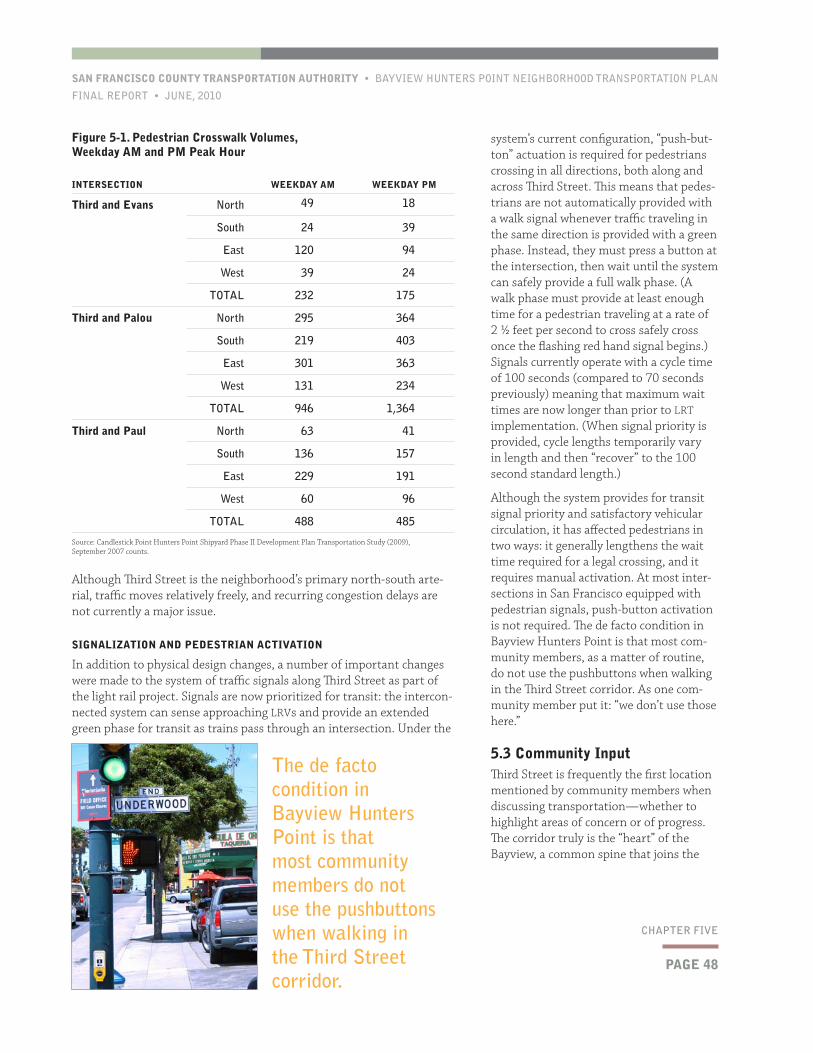
PAGE 48
SAN FRANCISCO COUNTY TRANSPORTATION AUTHORITY • BAYVIEW HUNTERS POINT NEIGHBORHOOD TRANSPORTATION PLAN
FINAL REPORT • JUNE, 2010
CHAPTER FIVE
system’s current configuration, “push-but-ton” actuation is required for pedestrians crossing in all directions, both along and across Third Street. This means that pedes-trians are not automatically provided with a walk signal whenever traffic traveling in the same direction is provided with a green phase. Instead, they must press a button at the intersection, then wait until the system can safely provide a full walk phase. (A walk phase must provide at least enough time for a pedestrian traveling at a rate of 2 ½ feet per second to cross safely cross once the flashing red hand signal begins.) Signals currently operate with a cycle time of 100 seconds (compared to 70 seconds previously) meaning that maximum wait times are now longer than prior to LRT implementation. (When signal priority is provided, cycle lengths temporarily vary in length and then “recover” to the 100 second standard length.)
Although the system provides for transit signal priority and satisfactory vehicular circulation, it has affected pedestrians in two ways: it generally lengthens the wait time required for a legal crossing, and it requires manual activation. At most inter-sections in San Francisco equipped with pedestrian signals, push-button activation is not required. The de facto condition in Bayview Hunters Point is that most com-munity members, as a matter of routine, do not use the pushbuttons when walking in the Third Street corridor. As one com-munity member put it: “we don’t use those here.”
5.3 Community InputThird Street is frequently the first location mentioned by community members when discussing transportation—whether to highlight areas of concern or of progress. The corridor truly is the “heart” of the Bayview, a common spine that joins the
Although Third Street is the neighborhood’s primary north-south arte-rial, traffic moves relatively freely, and recurring congestion delays are not currently a major issue.
SIGNALIZATION AND PEDESTRIAN ACTIVATION
In addition to physical design changes, a number of important changes were made to the system of traffic signals along Third Street as part of the light rail project. Signals are now prioritized for transit: the intercon-nected system can sense approaching LRVs and provide an extended green phase for transit as trains pass through an intersection. Under the
Figure 5-1. Pedestrian Crosswalk Volumes, Weekday AM and PM Peak Hour
INTERSECTION WEEKDAY AM WEEKDAY PM
Third and Evans North 49 18
South 24 39
East 120 94
West 39 24
TOTAL 232 175
Third and Palou North 295 364
South 219 403
East 301 363
West 131 234
TOTAL 946 1,364
Third and Paul North 63 41
South 136 157
East 229 191
West 60 96
TOTAL 488 485
Source: Candlestick Point Hunters Point Shipyard Phase II Development Plan Transportation Study (2009), September 2007 counts.
The de facto condition in Bayview Hunters Point is that most community members do not use the pushbuttons when walking in the Third Street corridor.
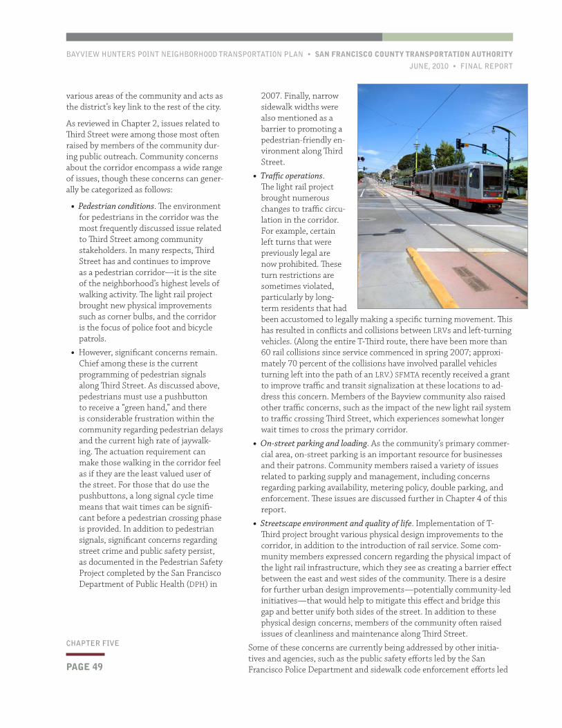
BAYVIEW HUNTERS POINT NEIGHBORHOOD TRANSPORTATION PLAN • SAN FRANCISCO COUNTY TRANSPORTATION AUTHORITY
JUNE, 2010 • FINAL REPORT
PAGE 49
CHAPTER FIVE
2007. Finally, narrow sidewalk widths were also mentioned as a barrier to promoting a pedestrian-friendly en-vironment along Third Street.
• Traffic operations. The light rail project brought numerous changes to traffic circu-lation in the corridor. For example, certain left turns that were previously legal are now prohibited. These turn restrictions are sometimes violated, particularly by long-term residents that had been accustomed to legally making a specific turning movement. This has resulted in conflicts and collisions between LRVs and left-turning vehicles. (Along the entire T-Third route, there have been more than 60 rail collisions since service commenced in spring 2007; approxi-mately 70 percent of the collisions have involved parallel vehicles turning left into the path of an LRV.) SFMTA recently received a grant to improve traffic and transit signalization at these locations to ad-dress this concern. Members of the Bayview community also raised other traffic concerns, such as the impact of the new light rail system to traffic crossing Third Street, which experiences somewhat longer wait times to cross the primary corridor.
• On-street parking and loading. As the community’s primary commer-cial area, on-street parking is an important resource for businesses and their patrons. Community members raised a variety of issues related to parking supply and management, including concerns regarding parking availability, metering policy, double parking, and enforcement. These issues are discussed further in Chapter 4 of this report.
• Streetscape environment and quality of life. Implementation of T-Third project brought various physical design improvements to the corridor, in addition to the introduction of rail service. Some com-munity members expressed concern regarding the physical impact of the light rail infrastructure, which they see as creating a barrier effect between the east and west sides of the community. There is a desire for further urban design improvements—potentially community-led initiatives—that would help to mitigate this effect and bridge this gap and better unify both sides of the street. In addition to these physical design concerns, members of the community often raised issues of cleanliness and maintenance along Third Street.
Some of these concerns are currently being addressed by other initia-tives and agencies, such as the public safety efforts led by the San Francisco Police Department and sidewalk code enforcement efforts led
various areas of the community and acts as the district’s key link to the rest of the city.
As reviewed in Chapter 2, issues related to Third Street were among those most often raised by members of the community dur-ing public outreach. Community concerns about the corridor encompass a wide range of issues, though these concerns can gener-ally be categorized as follows:
• Pedestrian conditions. The environment for pedestrians in the corridor was the most frequently discussed issue related to Third Street among community stakeholders. In many respects, Third Street has and continues to improve as a pedestrian corridor—it is the site of the neighborhood’s highest levels of walking activity. The light rail project brought new physical improvements such as corner bulbs, and the corridor is the focus of police foot and bicycle patrols.
• However, significant concerns remain. Chief among these is the current programming of pedestrian signals along Third Street. As discussed above, pedestrians must use a pushbutton to receive a “green hand,” and there is considerable frustration within the community regarding pedestrian delays and the current high rate of jaywalk-ing. The actuation requirement can make those walking in the corridor feel as if they are the least valued user of the street. For those that do use the pushbuttons, a long signal cycle time means that wait times can be signifi-cant before a pedestrian crossing phase is provided. In addition to pedestrian signals, significant concerns regarding street crime and public safety persist, as documented in the Pedestrian Safety Project completed by the San Francisco Department of Public Health (DPH) in
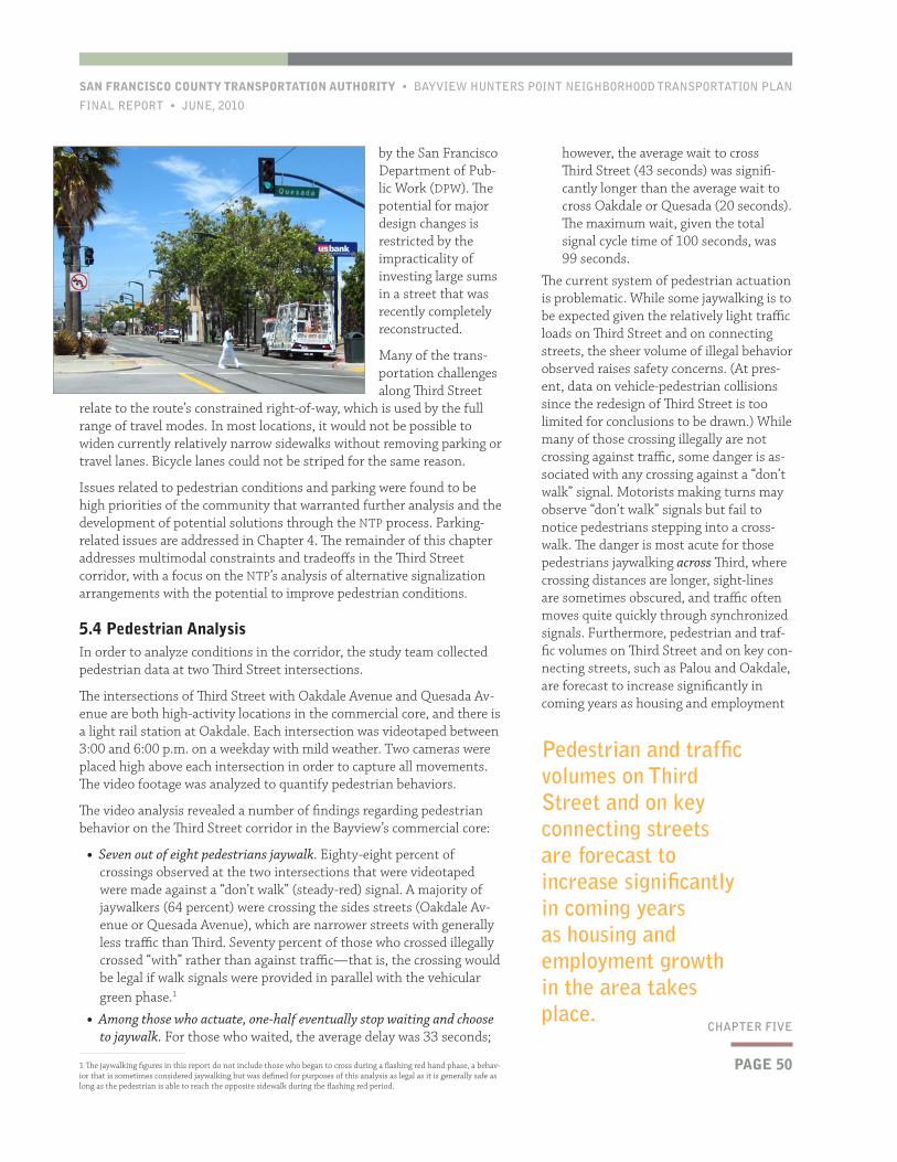
PAGE 50
SAN FRANCISCO COUNTY TRANSPORTATION AUTHORITY • BAYVIEW HUNTERS POINT NEIGHBORHOOD TRANSPORTATION PLAN
FINAL REPORT • JUNE, 2010
CHAPTER FIVE
however, the average wait to cross Third Street (43 seconds) was signifi-cantly longer than the average wait to cross Oakdale or Quesada (20 seconds). The maximum wait, given the total signal cycle time of 100 seconds, was 99 seconds.
The current system of pedestrian actuation is problematic. While some jaywalking is to be expected given the relatively light traffic loads on Third Street and on connecting streets, the sheer volume of illegal behavior observed raises safety concerns. (At pres-ent, data on vehicle-pedestrian collisions since the redesign of Third Street is too limited for conclusions to be drawn.) While many of those crossing illegally are not crossing against traffic, some danger is as-sociated with any crossing against a “don’t walk” signal. Motorists making turns may observe “don’t walk” signals but fail to notice pedestrians stepping into a cross-walk. The danger is most acute for those pedestrians jaywalking across Third, where crossing distances are longer, sight-lines are sometimes obscured, and traffic often moves quite quickly through synchronized signals. Furthermore, pedestrian and traf-fic volumes on Third Street and on key con-necting streets, such as Palou and Oakdale, are forecast to increase significantly in coming years as housing and employment
by the San Francisco Department of Pub-lic Work (DPW). The potential for major design changes is restricted by the impracticality of investing large sums in a street that was recently completely reconstructed.
Many of the trans-portation challenges along Third Street
relate to the route’s constrained right-of-way, which is used by the full range of travel modes. In most locations, it would not be possible to widen currently relatively narrow sidewalks without removing parking or travel lanes. Bicycle lanes could not be striped for the same reason.
Issues related to pedestrian conditions and parking were found to be high priorities of the community that warranted further analysis and the development of potential solutions through the NTP process. Parking-related issues are addressed in Chapter 4. The remainder of this chapter addresses multimodal constraints and tradeoffs in the Third Street corridor, with a focus on the NTP’s analysis of alternative signalization arrangements with the potential to improve pedestrian conditions.
5.4 Pedestrian AnalysisIn order to analyze conditions in the corridor, the study team collected pedestrian data at two Third Street intersections.
The intersections of Third Street with Oakdale Avenue and Quesada Av-enue are both high-activity locations in the commercial core, and there is a light rail station at Oakdale. Each intersection was videotaped between 3:00 and 6:00 p.m. on a weekday with mild weather. Two cameras were placed high above each intersection in order to capture all movements. The video footage was analyzed to quantify pedestrian behaviors.
The video analysis revealed a number of findings regarding pedestrian behavior on the Third Street corridor in the Bayview’s commercial core:
• Seven out of eight pedestrians jaywalk. Eighty-eight percent of crossings observed at the two intersections that were videotaped were made against a “don’t walk” (steady-red) signal. A majority of jaywalkers (64 percent) were crossing the sides streets (Oakdale Av-enue or Quesada Avenue), which are narrower streets with generally less traffic than Third. Seventy percent of those who crossed illegally crossed “with” rather than against traffic—that is, the crossing would be legal if walk signals were provided in parallel with the vehicular green phase.1
• Among those who actuate, one-half eventually stop waiting and choose to jaywalk. For those who waited, the average delay was 33 seconds;
1 The jaywalking figures in this report do not include those who began to cross during a flashing red hand phase, a behav-ior that is sometimes considered jaywalking but was defined for purposes of this analysis as legal as it is generally safe as long as the pedestrian is able to reach the opposite sidewalk during the flashing red period.
Pedestrian and traffic volumes on Third Street and on key connecting streets are forecast to increase significantly in coming years as housing and employment growth in the area takes place.
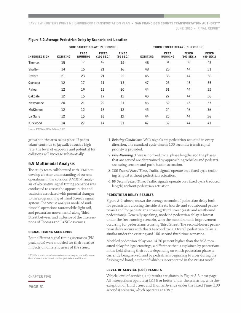
BAYVIEW HUNTERS POINT NEIGHBORHOOD TRANSPORTATION PLAN • SAN FRANCISCO COUNTY TRANSPORTATION AUTHORITY
JUNE, 2010 • FINAL REPORT
PAGE 51
CHAPTER FIVE
growth in the area takes place. If pedes-trians continue to jaywalk at such a high rate, the level of exposure and potential for collisions will increase substantially.
5.5 Multimodal AnalysisThe study team collaborated with SFMTA to develop a better understanding of current operations in the corridor. A VISSIM2 analy-sis of alternative signal timing scenarios was conducted to assess the opportunities and tradeoffs associated with potential changes to the programming of Third Street’s signal system. The VISSIM analysis modeled mul-timodal operations (automobile, light rail, and pedestrian movements) along Third Street between and inclusive of the intersec-tions of Thomas and La Salle avenues.
SIGNAL TIMING SCENARIOS
Four different signal timing scenarios (PM peak hour) were modeled for their relative impacts on different users of the street:
2 VISSIM is a microsimulation software that analyzes the traffic opera-tions of cars, trucks, transit vehicles, pedestrians, and bicycles.
Figure 5-2. Average Pedestrian Delay by Scenario and Location
SIDE STREET DELAY (IN SECONDS) THIRD STREET DELAY (IN SECONDS)
INTERSECTION EXISTINGFREE
RUNNINGFIXED
(100 SEC.)FIXED
(80 SEC.) EXISTINGFREE
RUNNINGFIXED
(100 SEC.)FIXED
(80 SEC.)
Thomas 15 17 42 15 48 31 39 48
Shafter 14 15 21 16 48 23 44 31
Revere 21 23 21 22 46 33 44 36
Quesada 12 17 11 13 47 23 45 35
Palou 12 19 12 20 44 31 44 35
Oakdale 12 15 17 15 43 27 44 36
Newcombe 20 21 22 21 43 32 43 33
McKinnon 12 12 18 12 45 24 46 36
La Salle 12 15 16 13 44 25 44 36
Kirkwood 14 27 14 21 47 32 44 41
Source: SFMTA and Fehr & Peers, 2010
1. Existing Conditions. Walk signals are pedestrian-actuated in every direction. The standard cycle time is 100 seconds; transit signal priority is provided.
2. Free-Running. There is no fixed cycle: phase lengths and the phases that are served are determined by approaching vehicles and pedestri-ans using sensors and push-button actuation.
3. 100 Second Fixed Time. Traffic signals operate on a fixed cycle (exist-ing length) without pedestrian actuation.
4. 80 Second Fixed Time. Traffic signals operate on a fixed cycle (reduced length) without pedestrian actuation.
PEDESTRIAN DELAY RESULTS
Figure 5-2, above, shows the average seconds of pedestrian delay both for pedestrians crossing the side streets (north- and southbound pedes-trians) and for pedestrians crossing Third Street (east- and westbound pedestrians). Generally speaking, modeled pedestrian delay is lowest under the free running scenario, with the most dramatic improvement occurring for pedestrians crossing Third Street. The second-lowest pedes-trian delay occurs with the 80-second cycle. Overall pedestrian delay is similar under the existing and 100-second fixed time scenarios.
Modeled pedestrian delay was 14-20 percent higher than the field-mea-sured delay for legal crossings, a difference that is explained by pedestrians in the field altering their route depending on which pedestrian phase is currently being served, and by pedestrians beginning to cross during the flashing red hand, neither of which is incorporated in the VISSIM model.
LEVEL OF SERVICE (LOS) RESULTS
Vehicle level of service (LOS) results are shown in Figure 5-3, next page. All intersections operate at LOS B or better under the scenarios, with the exception of Third Street and Thomas Avenue under the Fixed Time (100 seconds) scenario, which operates at LOS C.
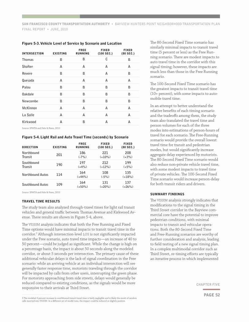
PAGE 52
SAN FRANCISCO COUNTY TRANSPORTATION AUTHORITY • BAYVIEW HUNTERS POINT NEIGHBORHOOD TRANSPORTATION PLAN
FINAL REPORT • JUNE, 2010
CHAPTER FIVE
The 80-Second Fixed Time scenario has similarly minimal impacts to transit travel time (5 percent or less) as the Free Run-ning scenario. There are modest impacts to auto travel time in the corridor with this signal timing; however, these impacts are much less than those in the Free Running scenario.
The 100-Second Fixed Time scenario has the greatest impacts to transit travel time (10+ percent), with some impacts to auto-mobile travel time.
In an attempt to better understand the relative benefits of each timing scenario and the tradeoffs among them, the study team also translated the travel time and person volumes for each of the three modes into estimations of person-hours of travel for each scenario. The Free-Running scenario would provide the overall lowest travel time for transit and pedestrian modes, but would significantly increase aggregate delay experienced by motorists. The 80-Second Fixed Time scenario would also reduce non-private vehicle travel time, with some modest impacts to travel time of private vehicles. The 100-Second Fixed Time scenario would increase person-delay for both transit riders and drivers.
SUMMARY FINDINGS
The VISSIM analysis strongly indicates that modifications to the signal timing in the Third Street corridor in the Bayview com-mercial core have the potential to improve pedestrian conditions, with minimal impacts to transit and vehicular opera-tions. Both the 80-Second Fixed Time and Free-Running scenarios are worthy of further consideration and analysis, leading to field testing of a new signal timing plan. In a complex multimodal corridor such as Third Street, re-timing efforts are typically an iterative process in which implemented
TRAVEL TIME RESULTS
The study team also analyzed through-travel times for light rail transit vehicles and general traffic between Thomas Avenue and Kirkwood Av-enue. These results are shown in Figure 5-4, above.
The VISSIM analysis indicates that both the Free Running and Fixed Time options would have minimal impacts to transit travel time in the corridor.3 Although intersection-level LOS is not significantly impacted under the Free scenario, auto travel time impacts—an increase of 40 to 50 percent—could be judged as significant. While the change is high on a percentage basis, the impact is about 50 seconds along the modeled corridor, or about 5 seconds per intersection. The primary cause of these additional vehicular delays is the lack of signal coordination in the Free scenario: while an arriving vehicle at an individual intersection will see generally faster response time, motorists traveling through the corridor will be impacted by calls from other users, interrupting the green phase. For motorists approaching from side streets, delays would generally be reduced compared to existing conditions, as the signals would be more responsive to their arrivals at Third Street.
3 The modeled 4 percent increase in southbound transit travel time is fairly negligible and is likely the result of random calls inserted into VISSIM. In a different set of model runs, the impact could be reduced or slightly positive.
Figure 5-3. Vehicle Level of Service by Scenario and Location
INTERSECTION EXISTINGFREE
RUNNINGFIXED
(100 SEC.)FIXED
(80 SEC.)
Thomas B B C B
Shafter A A A A
Revere B B A B
Quesada A A A A
Palou B B B B
Oakdale B B B B
Newcombe B B B B
McKinnon A A A A
La Salle A A A A
Kirkwood A B A A
Source: SFMTA and Fehr & Peers, 2010
Figure 5-4. Light Rail and Auto Travel Time (seconds) by Scenario
DIRECTION EXISTINGFREE
RUNNINGFIXED
(100 SEC.)FIXED
(80 SEC.)
Northbound Transit 201 186
(-7%)221
(+10%)208
(+3%)
Southbound Transit 190 197
(+4%)212
(+12%)199
(+5%)
Northbound Autos 114 164 (+44%)
108 (-5%)
135 (+18%)
Southbound Autos 109 164 (+50%)
131 (+20%)
137 (+26%)
Source: SFMTA and Fehr & Peers, 2010
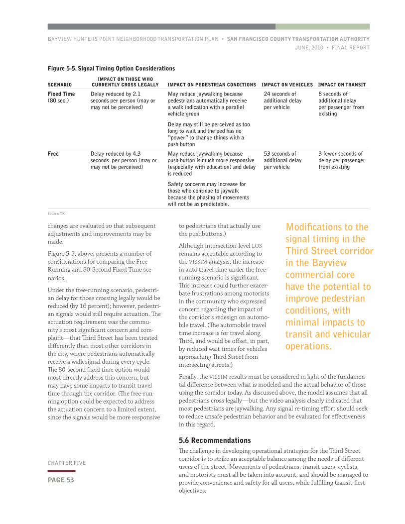
BAYVIEW HUNTERS POINT NEIGHBORHOOD TRANSPORTATION PLAN • SAN FRANCISCO COUNTY TRANSPORTATION AUTHORITY
JUNE, 2010 • FINAL REPORT
PAGE 53
CHAPTER FIVE
to pedestrians that actually use the pushbuttons.)
Although intersection-level LOS remains acceptable according to the VISSIM analysis, the increase in auto travel time under the free-running scenario is significant. This increase could further exacer-bate frustrations among motorists in the community who expressed concern regarding the impact of the corridor’s redesign on automo-bile travel. (The automobile travel time increase is for travel along Third, and would be offset, in part, by reduced wait times for vehicles approaching Third Street from intersecting streets.)
Finally, the VISSIM results must be considered in light of the fundamen-tal difference between what is modeled and the actual behavior of those using the corridor today. As discussed above, the model assumes that all pedestrians cross legally—but the video analysis clearly indicated that most pedestrians are jaywalking. Any signal re-timing effort should seek to reduce unsafe pedestrian behavior and be evaluated for effectiveness in this regard.
5.6 RecommendationsThe challenge in developing operational strategies for the Third Street corridor is to strike an acceptable balance among the needs of different users of the street. Movements of pedestrians, transit users, cyclists, and motorists must all be taken into account, and should be managed to provide convenience and safety for all users, while fulfilling transit-first objectives.
changes are evaluated so that subsequent adjustments and improvements may be made.
Figure 5-5, above, presents a number of considerations for comparing the Free Running and 80-Second Fixed Time sce-narios.
Under the free-running scenario, pedestri-an delay for those crossing legally would be reduced (by 16 percent); however, pedestri-an signals would still require actuation. The actuation requirement was the commu-nity’s most significant concern and com-plaint—that Third Street has been treated differently than most other corridors in the city, where pedestrians automatically receive a walk signal during every cycle. The 80-second fixed time option would most directly address this concern, but may have some impacts to transit travel time through the corridor. (The free-run-ning option could be expected to address the actuation concern to a limited extent, since the signals would be more responsive
Figure 5-5. Signal Timing Option Considerations
SCENARIOIMPACT ON THOSE WHO
CURRENTLY CROSS LEGALLY IMPACT ON PEDESTRIAN CONDITIONS IMPACT ON VEHICLES IMPACT ON TRANSIT
Fixed Time (80 sec.)
Delay reduced by 2.1 seconds per person (may or may not be perceived)
May reduce jaywalking because pedestrians automatically receive a walk indication with a parallel vehicle green
Delay may still be perceived as too long to wait and the ped has no “power” to change things with a push button
24 seconds of additional delay per vehicle
8 seconds of additional delay per passenger from existing
Free Delay reduced by 4.3 seconds per person (may or may not be perceived)
May reduce jaywalking because push button is much more responsive (especially with education) and delay is reduced
Safety concerns may increase for those who continue to jaywalk because the phasing of movements will not be as predictable.
53 seconds of additional delay per vehicle
3 fewer seconds of delay per passenger from existing
Source: TK
Modifications to the signal timing in the Third Street corridor in the Bayview commercial core have the potential to improve pedestrian conditions, with minimal impacts to transit and vehicular operations.
PAGE 54
SAN FRANCISCO COUNTY TRANSPORTATION AUTHORITY • BAYVIEW HUNTERS POINT NEIGHBORHOOD TRANSPORTATION PLAN
FINAL REPORT • JUNE, 2010
CHAPTER FIVE
The overall goal of the NTP’s recommendations in this area is to improve the walking environment in the neighborhood’s most active pedestrian area, while minimizing impacts to other modes, particularly transit. The recommendations do not call for enforcement efforts that would target jaywalking, as such tactics are generally of little lasting effect in an active pedestrian area such as Third Street. Operational, design-related, and other non-punitive measures such as educational campaigns should be pursued to improve pedestrian conditions in the corridor.
The NTP’s recommendations for Third Street corridor operations are as follows:
• Modify the current programming of traffic signals along Third Street to improve pedestrian conditions. The NTP’s VISSIM modeling indicates that free-running or reduced fixed time signal timing arrangements would improve pedestrian conditions. The Authority and SFMTA will cooperate to conduct further analysis and evaluate any signal changes that are made in the field.
• If/where the actuation requirement is maintained, improve pedes-trian awareness of the actuation system. Some pedestrians are likely unaware that they have to take action in order to activate a walk signal along Third Street. The majority of San Francisco walk signals automatically provide for pedestrian movement with each cycle. In the Bayview, the presence of substantial immigrant populations increases the likelihood that a pedestrian will be unfamiliar with the system. Still, it is likely that most pedestrians are aware of the sys-tem, but that most of those who do not actuate signals simply find the current signal timing inconvenient, while seeing jaywalking as a relatively safe activity.
• Even if walk signals are automatically provided in a portion of the corridor, the actuation requirement will be maintained in some locations. To the extent that awareness can be improved and the rate of safe, legal crossing increased using relatively simple, low-cost measures, there is little reason not to do so. The explanatory signs posted near pushbuttons should provide instructions in multiple languages (i.e., Spanish and Chinese) in addition to English. (Push-button signage on light rail platforms is in fact in multiple languages already.) An educational campaign could also be pursued. Such a campaign might take advantage of signage opportunities at T-Third stations in the corridor. SFMTA has experience in marketing and education campaigns targeting safety issues for pedestrians, transit riders, bicyclists, and motorists.
• Take steps to reduce delay in other segments of the T-Third line. Any changes to signal timing along Third Street in the Bayview should seek to avoid significant impacts to transit. While areas of San Francisco outside of Bayview Hunters Point are beyond the purview of this study, the NTP is strongly supportive of SFMTA’s efforts to improve transit performance along the corridor as a whole. For ex-ample, T-Third riders often experience significant delay at the inter-section of Fourth and King streets—in some cases multiple minutes. SFMTA is currently studying relatively low-cost improvements to reduce delay at this intersection, through physical and operational changes that will allow for reduced conflicts between N-Judah and T-
Third LRVs accessing adjacent stations.
• In the longer-term, explore the appli-cability of alternate solutions to issues of transit and pedestrian delay to the Bayview and other surface-running light rail corridors. Even where the T-Third operates in a dedicated right of way (outside of the Bayview commercial core), it must contend with delays at traffic signals. The current system of transit signal priority helps reduce travel time impacts at these intersec-tions, but signal delay remains a signifi-cant component of overall travel time. In the future, SFMTA should assess the potential for deploying (potentially on a demonstration or pilot basis) innova-tive approaches to surface-running transit operations. These approaches could include measures or approaches that are not contemplated in current statewide or national standards. Imple-menting such a strategy or strategies would require further technical analysis and, if advanced, appropriate approvals for piloting a nonstandard traffic con-trol system, to the extent applicable. Third Street is unlikely to be the most appropriate corridor for initial dem-onstration, but could follow successful implementation in a different surface-running light rail corridor in the city.
The Authority will continue to work with SFMTA and corridor stakeholders to review the findings and preliminary recommenda-tions presented in this chapter, discuss ad-ditional analysis that may be needed, and advance a plan for any signal adjustments. As has been the case in other multimodal corridors in the city—such as the Geary and O’Farrell couplet pair in the greater downtown—re-timing efforts are an itera-tive process in which implemented changes are monitored so that subsequent adjust-ments and improvements may be made.
BAYVIEW HUNTERS POINT NEIGHBORHOOD TRANSPORTATION PLAN • SAN FRANCISCO COUNTY TRANSPORTATION AUTHORITY
JUNE, 2010 • FINAL REPORT
PAGE 55
CHAPTER SIX
The improvements described in this chapter include conceptual designs for the reconfiguration of on-street parking on some residential streets (Section 6.2). This solution is not a parking management strategy in the conventional sense, but would address key neighborhood concerns relating to parking while improving pedestrian safety and comfort. It is appropriate to advance such improvements in parallel with the parking management and policy strategies discussed in Chapter 4.
A prototypical design for a “Neighborhood Transit Node” is presented in Section 6.3, along with a discussion of key bus stops beyond the Third Street corridor that are potentially suitable for design improvements. The Transit Node design would help address the pedestrian and tran-sit waiting environment and reduce barriers to safely accessing transit service in the neighborhood.
6.1 BackgroundThe natural and built forms of Bayview Hunters Point are accom-panied by a number of transporta-tion-related challenges, including the constrained right-of-way of the district’s primary transportation corridor, Third Street (as explored in Chapter 5) and the isolation of some of the community’s residen-tial areas, particularly those on hillsides and hilltops some distance from the neighborhood’s center. Various other initiatives are seeking to address some of these challenges, such as the City’s HOPE-SF initia-tive, which will rebuild numerous public housing sites in the city including Hunters View—a project that includes redesigning the currently circuitous and poorly-connected street grid at this site adjacent to Middle Point and West Point roads.
Still, there are further opportuni-ties to improve public space and improve multimodal connections in the neighborhood. The Bayview’s existing street network presents opportu-nities for physical designs that improve the balance among various street users. East-west avenues in the neighborhood’s “flatlands” residential areas are generally quite broad, with east-west avenues having a typi-cal width of 80 feet. Currently, the broad right-of-way on these streets is underutilized and minimally designed: most of the avenues include 15-foot sidewalks on either side of a 50-foot roadway. In most cases the 50-foot swath of pavement provides on-street parking (both sides) and a single lane of travel in each direction. Travel lanes are generally not striped but are effectively 17 to 18 feet wide—about 50 percent wider than a standard freeway lane.
Unsurprisingly, then, many of the community’s transportation concerns
As discussed in Chapter 2, the three focus areas prioritized for proj-
ect development through the NTP were:
• Mobility and access barriers;
• Parking management; and
• Third Street corridor issues.
This chapter supplements the chapters that preceded it by discuss-
ing and presenting physical improvements that would help address—
from a design perspective—the first and second areas.
6Physical Design Improvements
PAGE 56
SAN FRANCISCO COUNTY TRANSPORTATION AUTHORITY • BAYVIEW HUNTERS POINT NEIGHBORHOOD TRANSPORTATION PLAN
FINAL REPORT • JUNE, 2010
CHAPTER SIX
There are three basic street types in the standard grid in the Bayview:
• Street Type A: East-west avenues with 80-foot right-of-way, two travel lanes, and parallel parking on both sides of the street.
• Street Type B: East-west avenues with 80-foot right-of-way, two lanes, paral-lel parking, and an area between the roadway (lower elevation) and side-walks (elevated) used for driveways and landscaping. This street type occurs along the contours of hillsides.
• Street Type C: North-south street with 64-foot right-of-way. This street type is too narrow to allow for reconfiguration of parking.
These street types are illustrated in Figure 6.1 (only flatland residential streets east of Third Street were surveyed). It should be noted that a variant of the cross-section of Street Type A exists on Gilman Avenue and on a section of Palou Avenue (street type “A-1”). In these cases, space within the right-of-way is allocated differently: instead of one (unstriped) lane of traffic in each direction, there are three striped traffic lanes (one eastbound and two westbound). These streets are designed to accommodate traffic leaving events at Candlestick Park.
relate to speeding and reckless driving. At the same time, the relatively low pedestrian volumes on residential side streets suggest that sidewalks do not need to be widened; rather, their use as sidewalks should be rein-forced by taking steps to reduce rates of illegal parking on the sidewalks (see Chapter 4). The Bayview’s residential streets are often rather barren: landscaping in the public right-of-way is sporadic, and because most buildings are not set back from the sidewalk, street-facing landscaping is relatively rare. All of these factors amplify the rationale for physical improvements that address issues of pedestrian safety and comfort, as well as urban design. Design solutions that improve conditions for those accessing transit will also help to address some of the mobility and access challenges faced by residents of the more isolated areas of the community.
It should be noted that the design solutions presented in this chapter are not comprehensive in nature: they do not comprise a master streetscape plan for the community. Rather, these conceptual designs were devel-oped as examples of how such improvements could be envisioned and implemented throughout the Bayview and as strategies to help address specific issues identified through the NTP process. However, as discussed throughout this chapter, the designs are complementary with other efforts underway in the Bayview, including the City’s traffic calming efforts, the interagency Model Block initiative, and the community gardens that have been developed and maintained by residents of the neighborhood. The design concepts are meant to contribute to a Bayview Hunters Point that is more functional from a transportation perspective and also more attractive, inviting, and livable.
6.2 Streetscape and Parking ReconfigurationThis section describes conceptual designs for residential blocks along the Bayview’s east-west avenues, with a focus on the reorganization of on-street parking. This concept was briefly introduced at the end of Chapter 4.
As was noted in this report’s parking analysis, the primary objectives of these designs are to increase parking availability within a short distance of homes, and, in turn, to reduce instances of residents parking on the sidewalk out of a desire to park immediately adjacent to their homes (whether for reasons of security, convenience, or both). It is illegal under the California Vehicle Code for vehicles to park on sidewalks, and in the Bayview noncompliance is particularly acute: illegally parked vehicles often block the travel path of pedestrians. Addressing this issue would significantly improve the pedestrian environment, particularly for wheel-chair users, visually-impaired persons, and pedestrians with strollers.
TYPOLOGY OF BAYVIEW STREETS
The design effort for parking reconfiguration focused on the broad ave-nues (in the relatively flat area of the neighborhood) that were discussed in Section 6.1, above. Designs were not developed for the curvilinear streets in hilly areas of the community. These areas offer fewer opportu-nities for reconfiguration, either because streets are typically narrower (as in the case of Silver Terrace) or because parking is generally less con-strained (as is the case on Hunters Point Hill). Further, the irregularity of the street grid makes it difficult to develop a design concept that could be applied to multiple blocks.
Low pedestrian volumes on residential side streets suggest that sidewalks do not need to be widened; rather, their use as sidewalks should be reinforced by taking steps to reduce rates of illegal parking on the sidewalks.
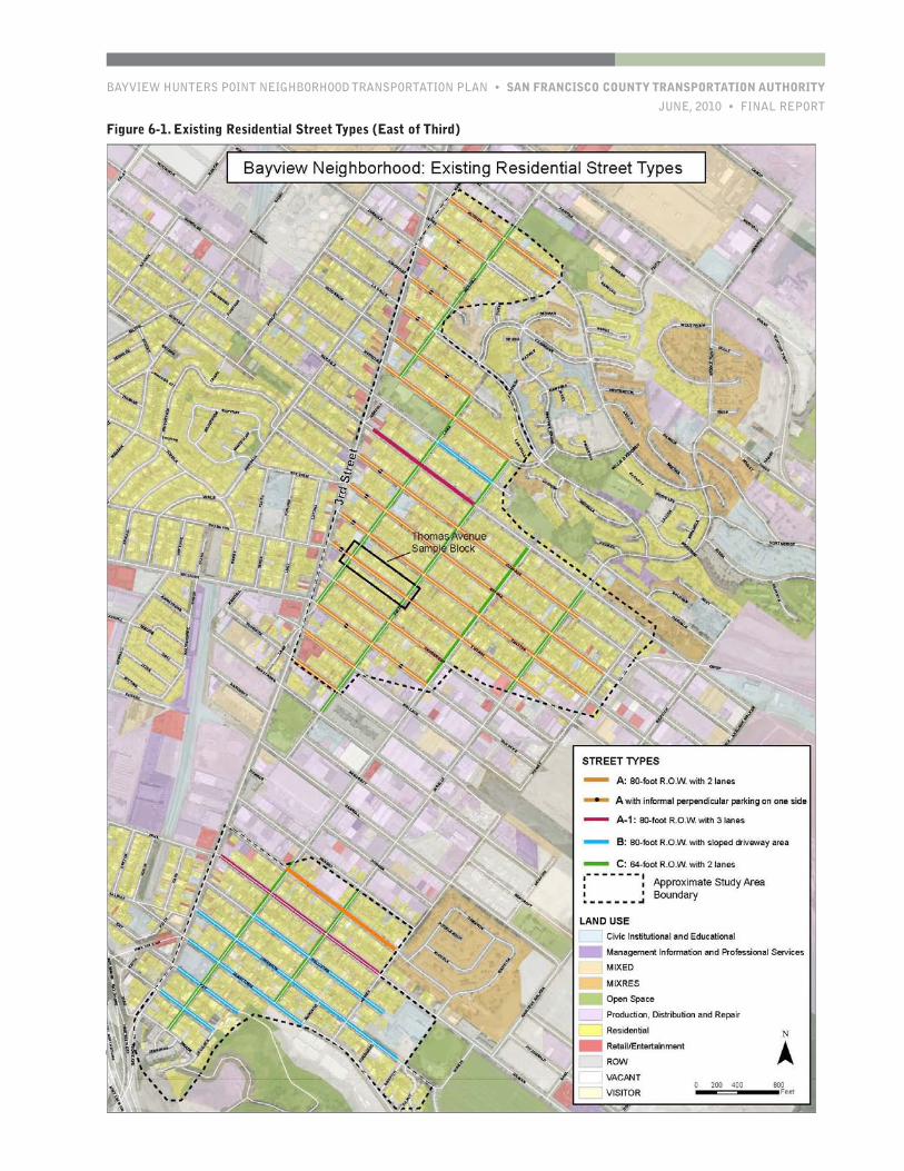
BAYVIEW HUNTERS POINT NEIGHBORHOOD TRANSPORTATION PLAN • SAN FRANCISCO COUNTY TRANSPORTATION AUTHORITY
JUNE, 2010 • FINAL REPORT
PAGE 57
CHAPTER ONE
Figure 6-1. Existing Residential Street Types (East of Third)
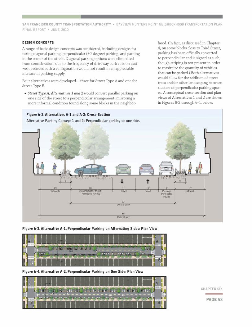
PAGE 58
SAN FRANCISCO COUNTY TRANSPORTATION AUTHORITY • BAYVIEW HUNTERS POINT NEIGHBORHOOD TRANSPORTATION PLAN
FINAL REPORT • JUNE, 2010
CHAPTER SIX
hood. (In fact, as discussed in Chapter 4, on some blocks close to Third Street, parking has been officially converted to perpendicular and is signed as such, though striping is not present in order to maximize the quantity of vehicles that can be parked.) Both alternatives would allow for the addition of street trees and/or other landscaping between clusters of perpendicular parking spac-es. A conceptual cross-section and plan views of Alternatives 1 and 2 are shown in Figures 6-2 through 6-4, below.
DESIGN CONCEPTS
A range of basic design concepts was considered, including designs fea-turing diagonal parking, perpendicular (90-degree) parking, and parking in the center of the street. Diagonal parking options were eliminated from consideration: due to the frequency of driveway curb cuts on east-west avenues such a configuration would not result in an appreciable increase in parking supply.
Four alternatives were developed—three for Street Type A and one for Street Type B.
• Street Type A, Alternatives 1 and 2 would convert parallel parking on one side of the street to a perpendicular arrangement, mirroring a more informal condition found along some blocks in the neighbor-
Figure 6-3. Alternative A-1, Perpendicular Parking on Alternating Sides: Plan View
Figure 6-4. Alternative A-2, Perpendicular Parking on One Side: Plan View
Figure 6-2. Alternatives A-1 and A-2: Cross-Section
Alternative Parking Concept 1 and 2: Perpendicular parking on one side.
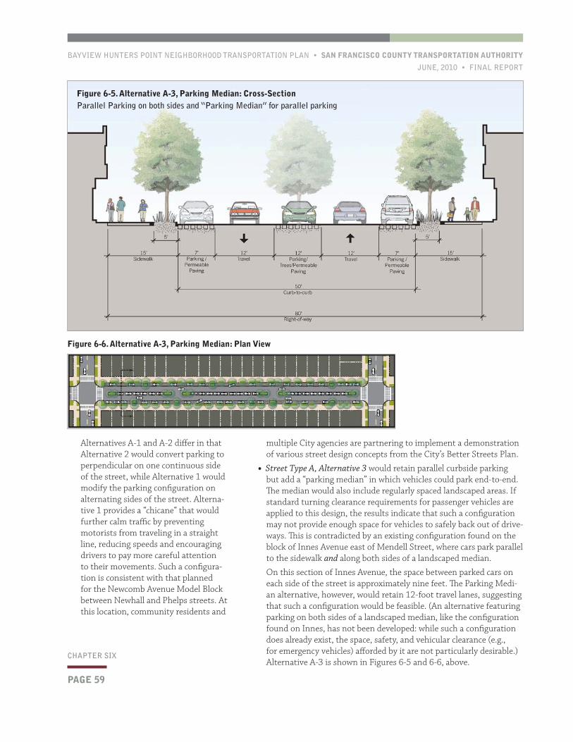
BAYVIEW HUNTERS POINT NEIGHBORHOOD TRANSPORTATION PLAN • SAN FRANCISCO COUNTY TRANSPORTATION AUTHORITY
JUNE, 2010 • FINAL REPORT
PAGE 59
CHAPTER SIX
multiple City agencies are partnering to implement a demonstration of various street design concepts from the City’s Better Streets Plan.
• Street Type A, Alternative 3 would retain parallel curbside parking but add a “parking median” in which vehicles could park end-to-end. The median would also include regularly spaced landscaped areas. If standard turning clearance requirements for passenger vehicles are applied to this design, the results indicate that such a configuration may not provide enough space for vehicles to safely back out of drive-ways. This is contradicted by an existing configuration found on the block of Innes Avenue east of Mendell Street, where cars park parallel to the sidewalk and along both sides of a landscaped median.
On this section of Innes Avenue, the space between parked cars on each side of the street is approximately nine feet. The Parking Medi-an alternative, however, would retain 12-foot travel lanes, suggesting that such a configuration would be feasible. (An alternative featuring parking on both sides of a landscaped median, like the configuration found on Innes, has not been developed: while such a configuration does already exist, the space, safety, and vehicular clearance (e.g., for emergency vehicles) afforded by it are not particularly desirable.) Alternative A-3 is shown in Figures 6-5 and 6-6, above.
Alternatives A-1 and A-2 differ in that Alternative 2 would convert parking to perpendicular on one continuous side of the street, while Alternative 1 would modify the parking configuration on alternating sides of the street. Alterna-tive 1 provides a “chicane“ that would further calm traffic by preventing motorists from traveling in a straight line, reducing speeds and encouraging drivers to pay more careful attention to their movements. Such a configura-tion is consistent with that planned for the Newcomb Avenue Model Block between Newhall and Phelps streets. At this location, community residents and
Figure 6-5. Alternative A-3, Parking Median: Cross-SectionParallel Parking on both sides and “Parking Median” for parallel parking
Figure 6-6. Alternative A-3, Parking Median: Plan View

PAGE 60
SAN FRANCISCO COUNTY TRANSPORTATION AUTHORITY • BAYVIEW HUNTERS POINT NEIGHBORHOOD TRANSPORTATION PLAN
FINAL REPORT • JUNE, 2010
CHAPTER SIX
Figure 6-9 illustrates the following design elements:
• Bulb-outs at the corners reducing cross-ing distances for pedestrians, protect-ing parked cars, and adding more space for landscaping.
• Treatment of crosswalks with a stamped pattern or special pavers to increase visibility and further improve pedes-trian conditions.
• Treatment of parking spaces with per-meable pavers allowing stormwater to be absorbed on-site, thereby helping to
The Street Type B Alternative would use a retaining wall to create a flat perpendicular parking area in place of portions of the sloped landscape/driveway area. As can be seen in Figures 6-7 and 6-8, above, these park-ing “coves” could most easily be located at the ends of blocks that have lots with their sides to the street, due to the lack of driveways.
Of the four alternatives, Alternative A-1 offers the greatest overall ben-efits due to its traffic calming potential, urban design elements, and con-sistency with the Model Block project. This design was also well received by members of the community during public outreach discussions. In addition to parking supply and traffic calming benefits, the alternative includes elements from the Newcomb Model Block design that would provide a range of amenities. In Figure 6-9, perspective sketch render-ings are used to demonstrate the range of improvements that could be implemented as part of Alternative A-1. The renderings are based on the block of Thomas Avenue between Lane and Keith streets, but this block is used only as an example—the design could be applied to many of the east-west avenues throughout the Bayview’s flatland areas, and specific blocks for implementation must be the subject of further community input (at both the neighborhood and individual block level) and inter-agency coordination, following the completion of the Newcomb project later in 2010.
Figure 6-8. Alternative B, Perpendicular Parking in Hillside Areas: Plan View
Figure 6-7. Alternative B, Perpendicular Parking in Hillside Areas: Cross-SectionParallel parking on one side, perpendicular parking on the other side in coves created by retainint wall as needed
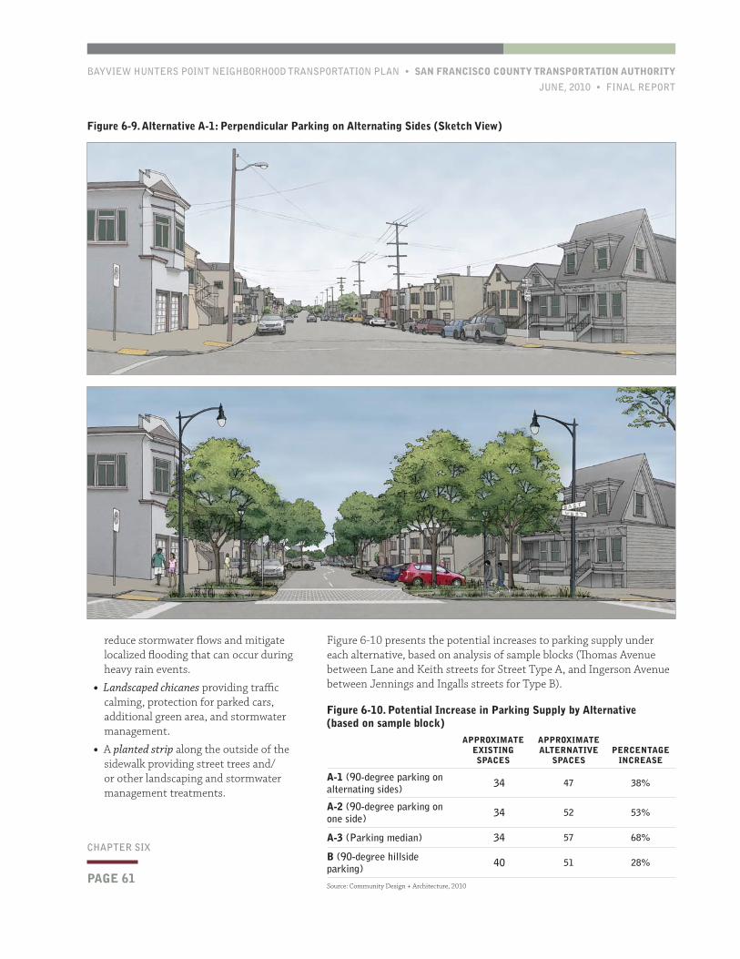
BAYVIEW HUNTERS POINT NEIGHBORHOOD TRANSPORTATION PLAN • SAN FRANCISCO COUNTY TRANSPORTATION AUTHORITY
JUNE, 2010 • FINAL REPORT
PAGE 61
CHAPTER SIX
Figure 6-10 presents the potential increases to parking supply under each alternative, based on analysis of sample blocks (Thomas Avenue between Lane and Keith streets for Street Type A, and Ingerson Avenue between Jennings and Ingalls streets for Type B).
reduce stormwater flows and mitigate localized flooding that can occur during heavy rain events.
• Landscaped chicanes providing traffic calming, protection for parked cars, additional green area, and stormwater management.
• A planted strip along the outside of the sidewalk providing street trees and/or other landscaping and stormwater management treatments.
Figure 6-9. Alternative A-1: Perpendicular Parking on Alternating Sides (Sketch View)
Figure 6-10. Potential Increase in Parking Supply by Alternative (based on sample block)
APPROXIMATE EXISTING SPACES
APPROXIMATE ALTERNATIVE
SPACESPERCENTAGE
INCREASE
A-1 (90-degree parking on alternating sides) 34 47 38%
A-2 (90-degree parking on one side) 34 52 53%
A-3 (Parking median) 34 57 68%
B (90-degree hillside parking) 40 51 28%
Source: Community Design + Architecture, 2010
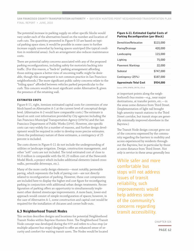
PAGE 62
SAN FRANCISCO COUNTY TRANSPORTATION AUTHORITY • BAYVIEW HUNTERS POINT NEIGHBORHOOD TRANSPORTATION PLAN
FINAL REPORT • JUNE, 2010
CHAPTER SIX
The potential increase in parking supply on other specific blocks would vary under each of the alternatives based on the number and location of curb cuts. The quantities presented in Figure 6-10 are based on typi-cal parking space sizes; it would be possible in some cases to further increase supply somewhat by leaving spaces unstriped (the typical condi-tion in residential areas). Such an arrangement also reduces maintenance costs.
There are potential safety concerns associated with any of the proposed parking reconfigurations, including safety for motorists backing into traffic. (For this reason, a “back-in” parking arrangement affording those exiting spaces a better view of oncoming traffic might be desir-able, though this arrangement is not common practice in San Francisco neighborhoods.) The more significant public safety concerns relate to the “hiding space” afforded between vehicles parked perpendicular to the curb. This concern would be most significant under Alternative B, given the presence of the retaining wall.
ESTIMATED COSTS
Figure 6-11, right, itemizes estimated capital costs for conversion of one block based on Alternative A-1 at the current level of conceptual design level. (Alternative A-2 would have comparable costs.) The estimate is based on unit cost information provided by City agencies including the San Francisco Municipal Transportation Agency (SFMTA) and the San Francisco Department of Public Works (DPW). However, site-specific costs can vary widely for a number of reasons, and further design devel-opment would be required in order to develop more precise estimates. Given the preliminary nature of these estimates, a contingency of 25 percent is included.
The costs shown in Figure 6-11 do not include the undergrounding of utilities or landscape irrigation. Design, construction management, and other “soft” costs are not included. The total estimated cost of close to $1.0 million is comparable with the $1.25 million cost of the Newcomb Model Block, a project which includes additional elements (raised cross-walks, permeable driveways, etc.).
Many of the more costly design elements—most notably, permeable paving, which represents the bulk of paving cost—are not directly related to reconfiguration of parking. However, these cost components are included here to display the higher end cost figure for reconfiguring parking in conjunction with additional urban design treatments. Recon-figuration of parking offers an opportunity to simultaneously imple-ment other desired streetscape improvements. A more basic, lower-end approach would consist of simple reconfiguration of spaces; however, in the case of Alternative A-1, some construction and capital cost would be required for the installation of chicanes and corner bulb-outs.
6.3 Neighborhood Transit NodesThis section describes designs and locations for potential Neighborhood Transit Nodes within Bayview Hunters Point. The Neighborhood Transit Node concept was developed during the NTP and refers to a bus stop (or multiple adjacent bus stops) designed to offer an enhanced sense of se-curity and comfort for waiting transit users. The Nodes would be located
at important points along the neigh-borhood’s bus routes—e.g., near major destinations, at transfer points, etc.—in the areas some distance from Third Street. (Implementation of light rail brought high-amenity transit stations to the Third Street corridor, but transit stops are gener-ally minimally improved elsewhere in the Bayview.)
The Transit Node design concept grew out of the concerns expressed by the commu-nity regarding the barriers to mobility and access experienced by residents through-out the Bayview, but in particular by those at some distance from Third Street. Not only is service in these areas generally less
Figure 6-11. Estimated Capital Costs of Parking Reconfiguration (per Block)
Demolition/Relocation $115,000
Paving/Drainage 420,000
Landscaping 115,000
Lighting 75,000
Pavement Markings 22,000
Subtotal $747,000
Contingency (25%) $187,000
Approximate Total Cost $934,000
Source: DPW, SFMTA, SFCTA, CD+A
While safer and more comfortable bus stops will not address issues of transit reliability, such improvements would help address some of the community’s concerns regarding transit accessibility.
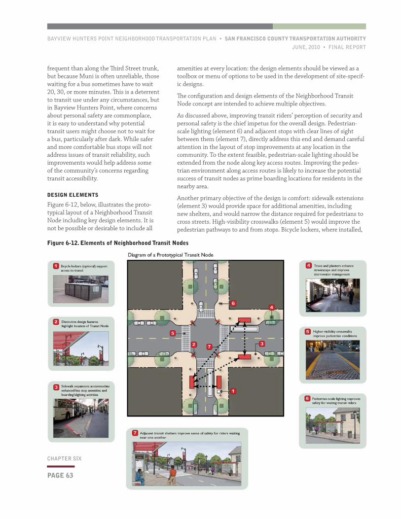
BAYVIEW HUNTERS POINT NEIGHBORHOOD TRANSPORTATION PLAN • SAN FRANCISCO COUNTY TRANSPORTATION AUTHORITY
JUNE, 2010 • FINAL REPORT
PAGE 63
CHAPTER ONE
amenities at every location: the design elements should be viewed as a toolbox or menu of options to be used in the development of site-specif-ic designs.
The configuration and design elements of the Neighborhood Transit Node concept are intended to achieve multiple objectives.
As discussed above, improving transit riders’ perception of security and personal safety is the chief impetus for the overall design. Pedestrian-scale lighting (element 6) and adjacent stops with clear lines of sight between them (element 7), directly address this end and demand careful attention in the layout of stop improvements at any location in the community. To the extent feasible, pedestrian-scale lighting should be extended from the node along key access routes. Improving the pedes-trian environment along access routes is likely to increase the potential success of transit nodes as prime boarding locations for residents in the nearby area.
Another primary objective of the design is comfort: sidewalk extensions (element 3) would provide space for additional amenities, including new shelters, and would narrow the distance required for pedestrians to cross streets. High-visibility crosswalks (element 5) would improve the pedestrian pathways to and from stops. Bicycle lockers, where installed,
frequent than along the Third Street trunk, but because Muni is often unreliable, those waiting for a bus sometimes have to wait 20, 30, or more minutes. This is a deterrent to transit use under any circumstances, but in Bayview Hunters Point, where concerns about personal safety are commonplace, it is easy to understand why potential transit users might choose not to wait for a bus, particularly after dark. While safer and more comfortable bus stops will not address issues of transit reliability, such improvements would help address some of the community’s concerns regarding transit accessibility.
DESIGN ELEMENTS
Figure 6-12, below, illustrates the proto-typical layout of a Neighborhood Transit Node including key design elements. It is not be possible or desirable to include all
Figure 6-12. Elements of Neighborhood Transit Nodes
PAGE 63
CHAPTER SIX
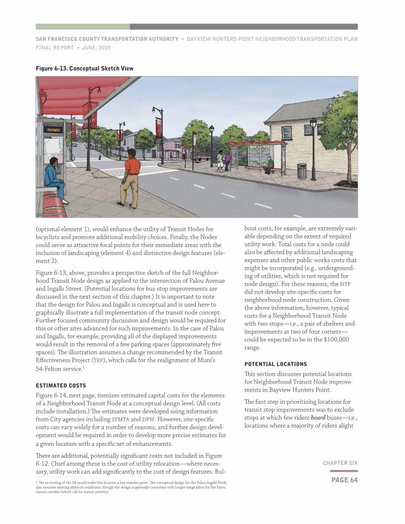
PAGE 64
SAN FRANCISCO COUNTY TRANSPORTATION AUTHORITY • BAYVIEW HUNTERS POINT NEIGHBORHOOD TRANSPORTATION PLAN
FINAL REPORT • JUNE, 2010
CHAPTER SIX
bout costs, for example, are extremely vari-able depending on the extent of required utility work. Total costs for a node could also be affected by additional landscaping expenses and other public works costs that might be incorporated (e.g., underground-ing of utilities, which is not required for node design). For these reasons, the NTP did not develop site-specific costs for neighborhood node construction. Given the above information, however, typical costs for a Neighborhood Transit Node with two stops—i.e., a pair of shelters and improvements at two of four corners—could be expected to be in the $100,000 range.
POTENTIAL LOCATIONS
This section discusses potential locations for Neighborhood Transit Node improve-ments in Bayview Hunters Point.
The first step in prioritizing locations for transit stop improvements was to exclude stops at which few riders board buses—i.e., locations where a majority of riders alight
(optional element 1), would enhance the utility of Transit Nodes for bicyclists and promote additional mobility choices. Finally, the Nodes could serve as attractive focal points for their immediate areas with the inclusion of landscaping (element 4) and distinctive design features (ele-ment 2).
Figure 6-13, above, provides a perspective sketch of the full Neighbor-hood Transit Node design as applied to the intersection of Palou Avenue and Ingalls Street. (Potential locations for bus stop improvements are discussed in the next section of this chapter.) It is important to note that the design for Palou and Ingalls is conceptual and is used here to graphically illustrate a full implementation of the transit node concept. Further focused community discussion and design would be required for this or other sites advanced for such improvements. In the case of Palou and Ingalls, for example, providing all of the displayed improvements would result in the removal of a few parking spaces (approximately five spaces). The illustration assumes a change recommended by the Transit Effectiveness Project (TEP), which calls for the realignment of Muni’s 54-Felton service.1
ESTIMATED COSTS
Figure 6-14, next page, itemizes estimated capital costs for the elements of a Neighborhood Transit Node at a conceptual design level. (All costs include installation.) The estimates were developed using information from City agencies including SFMTA and DPW. However, site-specific costs can vary widely for a number of reasons, and further design devel-opment would be required in order to develop more precise estimates for a given location with a specific set of enhancements.
There are additional, potentially significant costs not included in Figure 6-12. Chief among these is the cost of utility relocation—where neces-sary, utility work can add significantly to the cost of design features. Bul-
1 The re-routing of the 54 would make this location a key transfer point. The conceptual design for the Palou-Ingalls Node also assumes existing physical conditions, though the design is generally consistent with longer-range plans for the Palou transit corridor (which call for transit priority).
Figure 6-13. Conceptual Sketch View
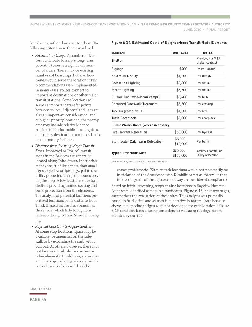
BAYVIEW HUNTERS POINT NEIGHBORHOOD TRANSPORTATION PLAN • SAN FRANCISCO COUNTY TRANSPORTATION AUTHORITY
JUNE, 2010 • FINAL REPORT
PAGE 65
CHAPTER SIX
comes problematic. (Sites at such locations would not necessarily be in violation of the Americans with Disabilities Act as sidewalks that follow the grade of the adjacent roadway are considered compliant.)
Based on initial screening, stops at nine locations in Bayview Hunters Point were identified as possible candidates. Figure 6-15, next two pages, summarizes the evaluation of these sites. This analysis was primarily based on field visits, and as such is qualitative in nature. (As discussed above, site-specific designs were not developed for each location.) Figure 6-15 considers both existing conditions as well as re-routings recom-mended by the TEP.
from buses, rather than wait for them. The following criteria were then considered:
• Potential for Usage. A number of fac-tors contribute to a site’s long-term potential to serve a significant num-ber of riders. These include existing numbers of boardings, but also how routes would serve the location if TEP recommendations were implemented. In many cases, routes connect to important destinations or other major transit stations. Some locations will serve as important transfer points between routes. Adjacent land uses are also an important consideration, and at higher-priority locations, the nearby area may include relatively dense residential blocks, public housing sites, and/or key destinations such as schools or community facilities.
• Distance from Existing Major Transit Stops. Improved or “major” transit stops in the Bayview are generally located along Third Street. Most other stops consist of little more than small signs or yellow stripes (e.g., painted on utility poles) indicating the routes serv-ing the stop. A few locations offer basic shelters providing limited seating and some protection from the elements. The analysis of potential locations pri-oritized locations some distance from Third; these sites are also sometimes those from which hilly topography makes walking to Third Street challeng-ing.
• Physical Constraints/Opportunities. At some stop locations, space may be available for amenities on the side-walk or by expanding the curb with a bulbout. At others, however, there may not be space available for shelters or other elements. In addition, some sites are on a slope: where grades are over 5 percent, access for wheelchairs be-
Figure 6-14. Estimated Costs of Neighborhood Transit Node Elements
ELEMENT UNIT COST NOTES
Shelter –Provided via MTA shelter contract
Signage $400 Route signage
NextMuni Display $1,200 Per display
Pedestrian Lighting $2,800 Per fixture
Street Lighting $3,500 Per fixture
Bulbout (incl. wheelchair ramps) $8,400 Per bulb
Enhanced Crosswalk Treatment $5,500 Per crossing
Tree (in grated well) $4,000 Per tree
Trash Receptacle $2,000 Per receptacle
Public Works Costs (where necessary)
Fire Hydrant Relocation $50,000 Per hydrant
Stormwater Catchbasin Relocation$6,000– $10,000
Per basin
Typical Per Node Cost$75,000– $150,000
Assumes no/minimal utility relocation
Sources: SFDPW, SFMTA, SFCTA, CD+A, Nelson\Nygaard
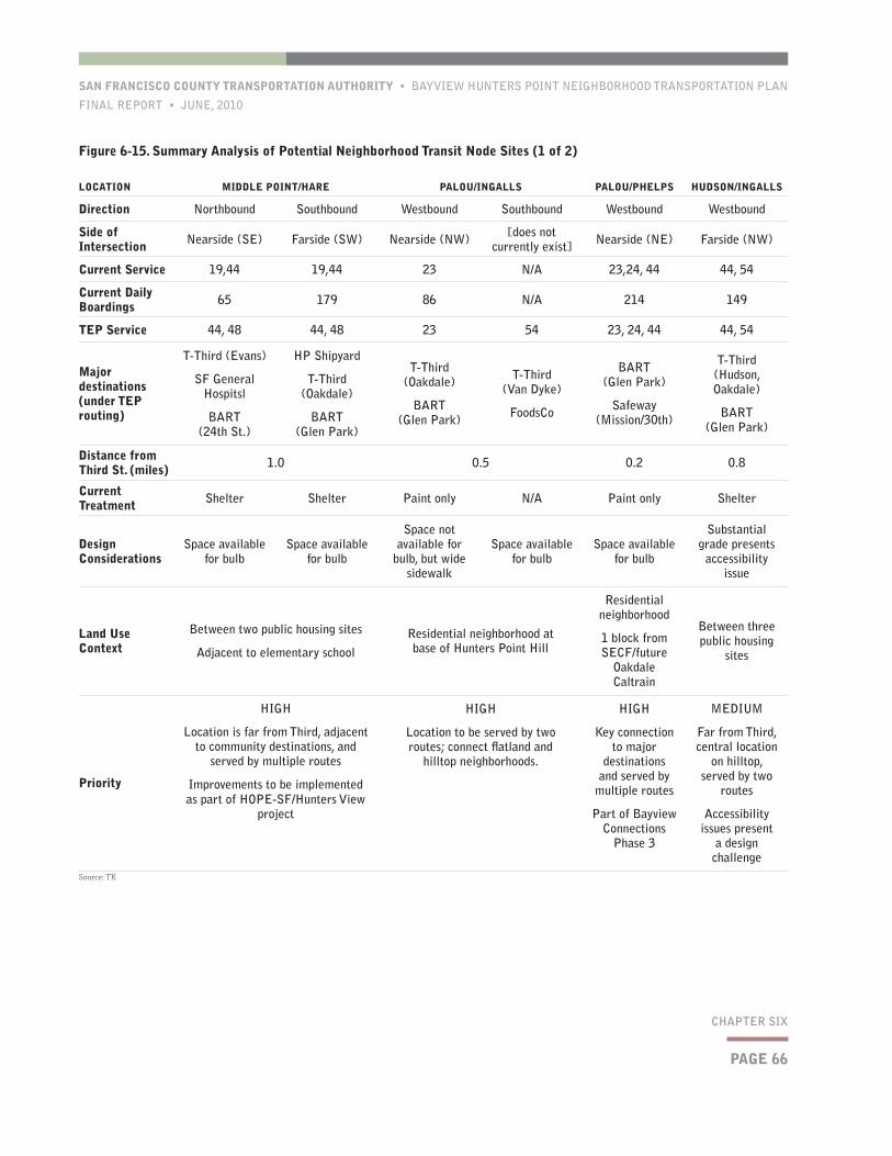
PAGE 66
SAN FRANCISCO COUNTY TRANSPORTATION AUTHORITY • BAYVIEW HUNTERS POINT NEIGHBORHOOD TRANSPORTATION PLAN
FINAL REPORT • JUNE, 2010
CHAPTER SIX
Figure 6-15. Summary Analysis of Potential Neighborhood Transit Node Sites (1 of 2)
LOCATION MIDDLE POINT/HARE PALOU/INGALLS PALOU/PHELPS HUDSON/INGALLS
Direction Northbound Southbound Westbound Southbound Westbound Westbound
Side of Intersection Nearside (SE) Farside (SW) Nearside (NW) [does not
currently exist] Nearside (NE) Farside (NW)
Current Service 19,44 19,44 23 N/A 23,24, 44 44, 54
Current Daily Boardings 65 179 86 N/A 214 149
TEP Service 44, 48 44, 48 23 54 23, 24, 44 44, 54
Major destinations (under TEP routing)
T-Third (Evans)
SF General Hospitsl
BART (24th St.)
HP Shipyard
T-Third (Oakdale)
BART (Glen Park)
T-Third (Oakdale)
BART (Glen Park)
T-Third (Van Dyke)
FoodsCo
BART (Glen Park)
Safeway (Mission/30th)
T-Third (Hudson, Oakdale)
BART (Glen Park)
Distance from Third St. (miles) 1.0 0.5 0.2 0.8
Current Treatment Shelter Shelter Paint only N/A Paint only Shelter
Design Considerations
Space available for bulb
Space available for bulb
Space not available for
bulb, but wide sidewalk
Space available for bulb
Space available for bulb
Substantial grade presents
accessibility issue
Land Use Context
Between two public housing sites
Adjacent to elementary school
Residential neighborhood at base of Hunters Point Hill
Residential neighborhood
1 block from SECF/future
Oakdale Caltrain
Between three public housing
sites
Priority
HIGH
Location is far from Third, adjacent to community destinations, and
served by multiple routes
Improvements to be implemented as part of HOPE-SF/Hunters View
project
HIGH
Location to be served by two routes; connect flatland and
hilltop neighborhoods.
HIGH
Key connection to major
destinations and served by
multiple routes
Part of Bayview Connections
Phase 3
MEDIUM
Far from Third, central location
on hilltop, served by two
routes
Accessibility issues present
a design challenge
Source: TK
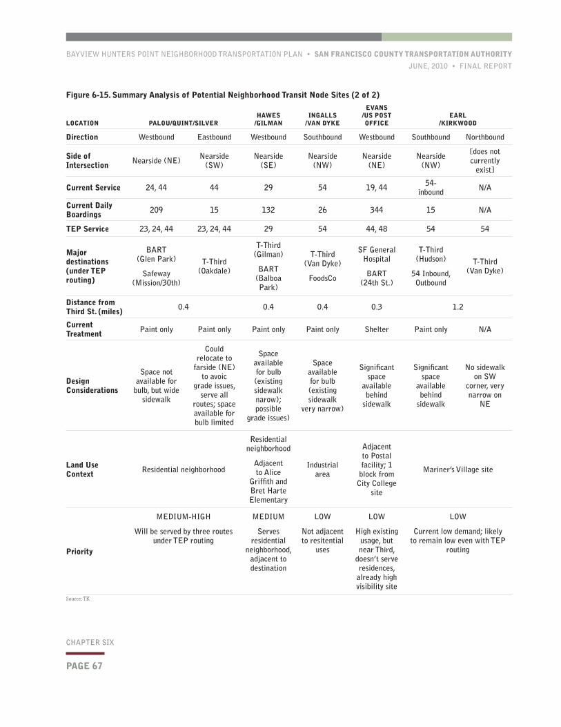
BAYVIEW HUNTERS POINT NEIGHBORHOOD TRANSPORTATION PLAN • SAN FRANCISCO COUNTY TRANSPORTATION AUTHORITY
JUNE, 2010 • FINAL REPORT
PAGE 67
CHAPTER SIX
Figure 6-15. Summary Analysis of Potential Neighborhood Transit Node Sites (2 of 2)
LOCATION PALOU/QUINT/SILVERHAWES
/GILMANINGALLS
/VAN DYKE
EVANS /US POST OFFICE
EARL /KIRKWOOD
Direction Westbound Eastbound Westbound Southbound Westbound Southbound Northbound
Side of Intersection Nearside (NE) Nearside
(SW)Nearside
(SE)Nearside
(NW)Nearside
(NE)Nearside
(NW)
[does not currently
exist]
Current Service 24, 44 44 29 54 19, 44 54- inbound N/A
Current Daily Boardings 209 15 132 26 344 15 N/A
TEP Service 23, 24, 44 23, 24, 44 29 54 44, 48 54 54
Major destinations (under TEP routing)
BART (Glen Park)
Safeway (Mission/30th)
T-Third (Oakdale)
T-Third (Gilman)
BART (Balboa Park)
T-Third (Van Dyke)
FoodsCo
SF General Hospital
BART (24th St.)
T-Third (Hudson)
54 Inbound, Outbound
T-Third (Van Dyke)
Distance from Third St. (miles) 0.4 0.4 0.4 0.3 1.2
Current Treatment Paint only Paint only Paint only Paint only Shelter Paint only N/A
Design Considerations
Space not available for
bulb, but wide sidewalk
Could relocate to
farside (NE) to avoic
grade issues, serve all
routes; space available for bulb limited
Space available for bulb (existing sidewalk narow); possible
grade issues)
Space available for bulb (existing sidewalk
very narrow)
Significant space
available behind
sidewalk
Significant space
available behind
sidewalk
No sidewalk on SW
corner, very narrow on
NE
Land Use Context Residential neighborhood
Residential neighborhood
Adjacent to Alice
Griffith and Bret Harte Elementary
Industrial area
Adjacent to Postal facility; 1 block from
City College site
Mariner’s Village site
Priority
MEDIUM-HIGH
Will be served by three routes under TEP routing
MEDIUM
Serves residential
neighborhood, adjacent to destination
LOW
Not adjacent to resitential
uses
LOW
High existing usage, but near Third,
doesn’t serve residences,
already high visibility site
LOW
Current low demand; likely to remain low even with TEP
routing
Source: TK
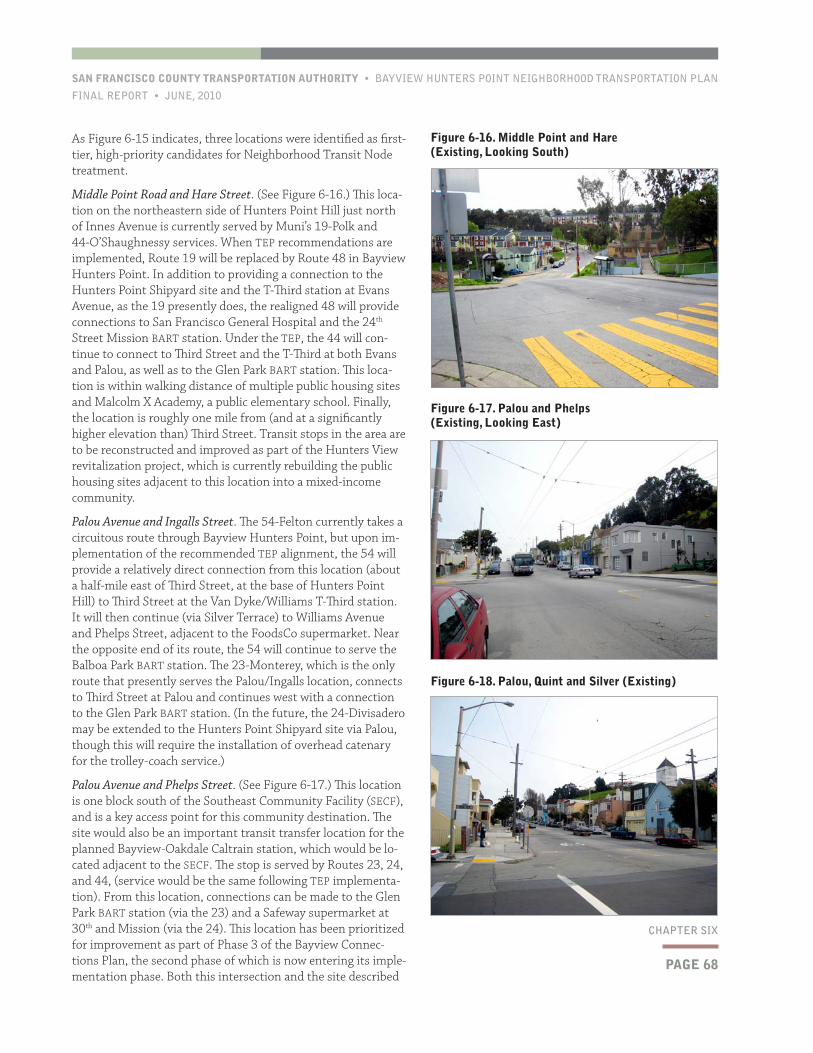
PAGE 68
SAN FRANCISCO COUNTY TRANSPORTATION AUTHORITY • BAYVIEW HUNTERS POINT NEIGHBORHOOD TRANSPORTATION PLAN
FINAL REPORT • JUNE, 2010
CHAPTER SIX
As Figure 6-15 indicates, three locations were identified as first-tier, high-priority candidates for Neighborhood Transit Node treatment.
Middle Point Road and Hare Street. (See Figure 6-16.) This loca-tion on the northeastern side of Hunters Point Hill just north of Innes Avenue is currently served by Muni’s 19-Polk and 44-O’Shaughnessy services. When TEP recommendations are implemented, Route 19 will be replaced by Route 48 in Bayview Hunters Point. In addition to providing a connection to the Hunters Point Shipyard site and the T-Third station at Evans Avenue, as the 19 presently does, the realigned 48 will provide connections to San Francisco General Hospital and the 24th Street Mission BART station. Under the TEP, the 44 will con-tinue to connect to Third Street and the T-Third at both Evans and Palou, as well as to the Glen Park BART station. This loca-tion is within walking distance of multiple public housing sites and Malcolm X Academy, a public elementary school. Finally, the location is roughly one mile from (and at a significantly higher elevation than) Third Street. Transit stops in the area are to be reconstructed and improved as part of the Hunters View revitalization project, which is currently rebuilding the public housing sites adjacent to this location into a mixed-income community.
Palou Avenue and Ingalls Street. The 54-Felton currently takes a circuitous route through Bayview Hunters Point, but upon im-plementation of the recommended TEP alignment, the 54 will provide a relatively direct connection from this location (about a half-mile east of Third Street, at the base of Hunters Point Hill) to Third Street at the Van Dyke/Williams T-Third station. It will then continue (via Silver Terrace) to Williams Avenue and Phelps Street, adjacent to the FoodsCo supermarket. Near the opposite end of its route, the 54 will continue to serve the Balboa Park BART station. The 23-Monterey, which is the only route that presently serves the Palou/Ingalls location, connects to Third Street at Palou and continues west with a connection to the Glen Park BART station. (In the future, the 24-Divisadero may be extended to the Hunters Point Shipyard site via Palou, though this will require the installation of overhead catenary for the trolley-coach service.)
Palou Avenue and Phelps Street. (See Figure 6-17.) This location is one block south of the Southeast Community Facility (SECF), and is a key access point for this community destination. The site would also be an important transit transfer location for the planned Bayview-Oakdale Caltrain station, which would be lo-cated adjacent to the SECF. The stop is served by Routes 23, 24, and 44, (service would be the same following TEP implementa-tion). From this location, connections can be made to the Glen Park BART station (via the 23) and a Safeway supermarket at 30th and Mission (via the 24). This location has been prioritized for improvement as part of Phase 3 of the Bayview Connec-tions Plan, the second phase of which is now entering its imple-mentation phase. Both this intersection and the site described
Figure 6-16. Middle Point and Hare (Existing, Looking South)
Figure 6-17. Palou and Phelps (Existing, Looking East)
Figure 6-18. Palou, Quint and Silver (Existing)
BAYVIEW HUNTERS POINT NEIGHBORHOOD TRANSPORTATION PLAN • SAN FRANCISCO COUNTY TRANSPORTATION AUTHORITY
JUNE, 2010 • FINAL REPORT
PAGE 69
CHAPTER SIX
the same stop, the existing eastbound 24 and 44 stops on Palou and Silver to the west of the intersection would have to be eliminated, and a combined stop developed on the intersection’s southeastern corner. However, a curb cut at this location serves a garage attached to a church, which could impede the design of a sidewalk extension.
Hudson Avenue and Ingalls Street. This intersection is on Hunters Point Hill far from Third and could provide strong connectivity. Service is provided by the 44 and 54 (with no change under the TEP). The site lies on a relatively steep grade, however, which would make it a challenging location to provide a full shelter with level space for wheelchair access.
Hawes Street and Gilman Avenue. This location in the southern part of Bayview Hunters Point is served by the 29-Sunset. The site is adjacent to Bret Harte Elementary School and the Alice Griffith (Double Rock) public housing site. The westbound stop provides connections to Balboa Park BART and City College; grade-related issues would need to be re-solved in any site-specific design.
The remaining three locations were assessed as low priorities: Ingalls Street and Van Dyke Avenue, which does not serve a residential area; Evans Avenue at the U.S. Post Office facility, which is close to Third Street and is current a relatively high visibility stop; and Earl Street and Kirkwood Avenue, which is in a relatively remote area and does not serve nearly as many riders as the higher-priority locations.
6.4 RecommendationsThe NTP recommends that both the parking reconfiguration and transit node concepts be further developed, through more detailed design, agency coordination, and prioritization for funding opportunities. In ad-vancing the parking reconfiguration alternatives, Alternative A-1, which is consistent with the Newcomb Model Block, should be prioritized (though certain locations will require modified designs). The Author-ity is coordinating with and supporting City agencies in advancing the design to additional locations in the Bayview following completion of the Newcomb Project. One of the key goals of the Newcomb Model Block is to use a readily duplicable design that can be deployed across the neighborhood as funding—including Redevelopment and external grant monies—becomes available.
Estimated capital costs for the physical improvements were discussed in this chapter; potential locations for Neighborhood Transit Nodes have also been identified. One important step toward implementation that was not addressed during the NTP process is the prioritization of locations for parking reconfiguration. The parking occupancy survey (Chapter 4) covered a relatively small area of the community. Given that parking demand in the Bayview is largely from residents and remains relatively constant in residential areas, many blocks in the flatland and hillside areas would be suitable for such treatments. In addition, criteria other than parking conditions—such as resident support—will be im-portant in the prioritization of locations for streetscape improvements. The Authority is working with City agencies on a methodology and accompanying prioritization criteria to guide the deployment of further streetscape improvements in the neighborhood following the comple-tion of the Newcomb project.
next below, two blocks to the west, are surrounded by residential land uses.
Of the six remaining locations identified by the study team, three were rated “medium” priority. Of these, one is somewhat higher-priority (“medium-high”). The locations are as follows:
Palou Avenue, Quint Street, and Silver Avenue. (See Figure 6-18.) This intersection was rated as “medium-high,” as in many respects it presents an opportunity for a quality transit node serving many riders. However, it is relatively close to the Palou and Phelps location, which has already been highly prioritized through the Bay-view Connections Plan and the Oakdale Caltrain Station Study. This five-way inter-section is roughly 2,000 feet west of Third Street and is currently the point at which the 24 and 44 diverge, with Route 24 continuing on Palou and Route 44 running southwest via Silver. Upon TEP implemen-tation, these routes would be joined by the 23. To the west, connections are the same as with the Palou/Phelps node described above; to the east, the routes could offer frequent combined service to the Third Street corridor. Design challenges do exist at this location: most notably, if combined eastbound service were to be offered from
One of the key goals of the Newcomb Model Block is to use a readily duplicable design that can be deployed across the neighborhood as funding becomes available.
SAN FRANCISCO COUNTY TRANSPORTATION AUTHORITY • BAYVIEW HUNTERS POINT NEIGHBORHOOD TRANSPORTATION PLAN
FINAL REPORT • JUNE, 2010
This page left intentionally blank
BAYVIEW HUNTERS POINT NEIGHBORHOOD TRANSPORTATION PLAN • SAN FRANCISCO COUNTY TRANSPORTATION AUTHORITY
JUNE, 2010 • FINAL REPORT
PAGE 71
CHAPTER SEVEN
The Study recommendations are based on:
• Community-identified transportation needs and priorities;
• Research and technical analysis;
• Input and guidance from members of the NTP Technical Advisory Committee (TAC); and
• Community feedback on potential solutions.
The NTP’s main recommendations are organized into four categories:
• Community transportation;
• Parking management policies;
• Third Street corridor operations; and
• Physical design improvements.
The NTP recommendations are a mix of physical projects, opera-tional and management strategies, new policy measures, and issues recommended for additional study. In the sections that follow, each recommendation from the preced-ing chapters is briefly discussed and summarized.
7.1 Community Transportation RecommendationsChapter 3 of this report discussed the mobility barriers that confront many members of the Bayview Hunters Point community and preliminarily assessed existing and potential approaches for reducing these barriers through community-
based solutions. Currently, various essentially uncoordinated strategies seek to address transportation gaps in the Bayview. There is significant interest in the community—particularly among community-based orga-nizations (CBOs)—in overcoming the hurdles associated with coordina-tion, resource-sharing, and collaborative capacity-building in providing improved community transportation. The NTP reviewed successful approaches from other communities, but further planning analysis and concerted community involvement is necessary to develop a communi-ty-based transportation program.
The goal of the community transportation recommendations is to leverage and empower community knowledge and resources to improve mobility and accessibility in Bayview Hunters Point.
1.1 Undertake a focused, in-depth technical and community study to ad-vance a community-based transportation program to implementation ready-status. The NTP recommends developing one or more pilots of innova-tive, community-based solutions, such as a volunteer driver program or a coordinated vehicle collaborative program. To advance such a demon-stration project, the NTP recommends that a focused follow-on study be
This concluding chapter reviews the NTP’s recommendations and
outlines issues associated with funding and implementing these pro-
posals. Implementation hurdles and next steps are discussed, includ-
ing areas for which further analysis and public involvement are war-
ranted.
7Recommendations and Implementation
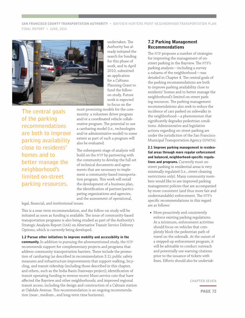
PAGE 72
SAN FRANCISCO COUNTY TRANSPORTATION AUTHORITY • BAYVIEW HUNTERS POINT NEIGHBORHOOD TRANSPORTATION PLAN
FINAL REPORT • JUNE, 2010
CHAPTER SEVEN
7.2 Parking Management RecommendationsThe NTP proposes a number of strategies for improving the management of on-street parking in the Bayview. The NTP’s parking analysis—including a survey a subarea of the neighborhood—was detailed in Chapter 4. The central goals of the parking recommendations are both to improve parking availability close to residents’ homes and to better manage the neighborhood’s limited on-street park-ing resources. The parking management recommendations also seek to reduce the incidence of cars parked on sidewalks in the neighborhood—a phenomenon that significantly degrades pedestrian condi-tions. Administrative and legislative actions regarding on-street parking are under the jurisdiction of the San Francisco Municipal Transportation Agency (SFMTA).
2.1 Improve parking management in residen-tial areas through more regular enforcement and balanced, neighborhood-specific regula-tions and programs. Currently most on-street parking in residential areas is very minimally regulated (i.e., street-cleaning restrictions only). Many community mem-bers would like to see improved parking management policies that are accompanied by more consistent (and thus more fair and understandable) enforcement. The NTP’s specific recommendations in this regard are as follows:
• More proactively and consistently enforce existing parking regulations. At a minimum, enforcement activities should focus on vehicles that com-pletely block the pedestrian path of travel on the sidewalk. At the outset of a stepped-up enforcement program, it will be advisable to conduct outreach and potentially use warning citations prior to the issuance of tickets with fines. Efforts should also be undertak-
undertaken. The Authority has al-ready initiated the search for funding for this phase of work, and in April 2010, submitted an application for a Caltrans Planning Grant to fund the follow-on study. Future work is expected to focus on the
most promising models for the com-munity: a volunteer driver program and/or a coordinated vehicle collab-orative program. The potential to use a carsharing model (i.e., technologies and/or administrative model) to some extent as part of such a program will also be evaluated.
The subsequent stage of analysis will build on the NTP by partnering with the community to develop the full set of technical documents and agree-ments that are necessary to imple-ment a community-based transporta-tion program. This work will entail the development of a business plan, the identification of partner/partici-pating organizations and agencies, and the assessment of operational,
legal, financial, and institutional issues.
This is a near-term recommendation, and the follow-on study will be initiated as soon as funding is available. The issue of community-based transportation programs is also being studied as part of the Authority’s Strategic Analysis Report (SAR) on Alternative Transit Service Delivery Options, which is currently being developed.
1.2 Pursue other initiatives to improve mobility and accessibility in the community. In addition to pursuing the aforementioned study, the NTP recommends support for complementary projects and programs that address community transportation barriers. These include the promo-tion of carsharing (as described in recommendation 3.1); public safety measures and infrastructure improvements that support walking, bicy-cling, and transit ridership (including those described in this chapter, and others, such as the India Basin Stairways project); identification of transit operating funding to reverse recent Muni service cuts that have affected the Bayview and other neighborhoods; and improved regional transit access, including the design and construction of a Caltrain station at Oakdale Avenue. This recommendation is an ongoing recommenda-tion (near-, medium-, and long-term time horizons).
The central goals of the parking recommendations are both to improve parking availability close to residents’ homes and to better manage the neighborhood’s limited on-street parking resources.

BAYVIEW HUNTERS POINT NEIGHBORHOOD TRANSPORTATION PLAN • SAN FRANCISCO COUNTY TRANSPORTATION AUTHORITY
JUNE, 2010 • FINAL REPORT
PAGE 73
CHAPTER SEVEN
developments along the Third Street corridor—generally, with some off-street parking areas and reduced parking provision—are the best opportunity for introducing carsharing to the neighborhood. This is a near- to medium-term recommendation.
2.2 More efficiently manage on-street parking in the Bayview commercial core to support business access and loading. The study’s parking survey found that, as currently managed, the neighborhood’s metered spaces (on and near Third) are not effective either in supporting business needs or generating revenue. To improve parking management in the Bayview’s central corridor, the NTP specifically recommends:
• Extend time limits for metered spaces. Current time limits for metered spaces are one hour. Given that occupancy is typically below the 85 percent benchmark, strict time limits only serve to generate “ticket anxiety” and discourage return visits. The time limit should be extended to two hours, consistent with the recommendations of SFMTA’s 2009 Extended Meter Hours Study. This is a near-term recommendation.
• Explore the potential to reduce meter rates. It is likely that, given current demand for parking along Third, simply extending rates will not generate substantial additional demand. A modest reduction in rates could also be implemented along Third Street—such a change should be made with a commitment to monitor usage and adjust rates upward in the future as demand grows, consistent with the SFMTA’s adopted SFpark policies. This is a near- to medium-term recommendation.
• Increase the number of commercial loading spaces. Redesignation of at least one parking space per block face in the commercial core for loading during business hours would have a negligible impact on parking supply, and would help discourage double-parking by deliv-ery vehicles. This is a near- to medium-term recommendation.
• To the extent parking demand grows substantially in the future, given planned growth, explore establishment of a parking benefit district. Benefit districts are a tool for communities to share in the benefit of growing parking demand by reinvesting a portion of new parking revenues in neighborhood-level improvements. If a benefit district program is established in San Francisco, the Bayview should have the opportunity to participate should the community be sup-portive. This is a long-term recommendation.
2.3 Redesign residential streetscapes with reconfigured parking to reduce sidewalk parking, calm traffic, and improve urban design. This recommen-dation is discussed further in Section 7.4, below, along with other physi-cal design recommendations. The NTP’s recommendation for targeted increases in parking supply—adjacent to residences—is intentionally paired with the recommendations discussed above for improving the regulation of on-street parking in the neighborhood. If unaccompanied by appropriate management strategies, an increase in the neighbor-hood’s parking supply could have negative side effects contrary to other neighborhood goals, including those for managing traffic and improving the pedestrian environment.
en to remove abandoned automobiles from the public right-of-way, such as through periodic enforcement “sweeps” in the neighborhood focused on such vehicles. This is a near-term recommen-dation.
• Explore establishment of one or more residential parking permit (RPP) zones in the residential blocks adjacent to Third Street and/or to industrial areas. Many community members were strongly in support of instituting a residential permit program, in order to discourage households from storing large numbers of vehicles on-street and encourage the use of private garages for vehicle storage. However, others were concerned about the potential impact of such a program on low-income households. Further analysis and com-munity discussion—at the individual block level—is necessary to advance this recommendation. This is a near- to medium-term recommendation.
• Modify the RPP program for application in the Bayview. A modified preferential permit program could help address the aforementioned community concerns and provide a more tailored parking management tool. Adjustments to the program should focus on limiting impacts to low-income community members that use vehicles for accessing work or school. This is a medium-term recommendation (2+ years).
• Encourage the establishment of carsharing pods in the neighborhood. Over time, the presence of carshare ve-hicles in a community has been shown to reduce the automobile ownership needs of nearby households. The Bay-view community and the City should support the entry of one or both car-sharing networks into Bayview Hunters Point. In particular, new residential
PAGE 74
SAN FRANCISCO COUNTY TRANSPORTATION AUTHORITY • BAYVIEW HUNTERS POINT NEIGHBORHOOD TRANSPORTATION PLAN
FINAL REPORT • JUNE, 2010
CHAPTER SEVEN
but signal delay remains a significant component of overall travel time. In the future, SFMTA should assess the potential for deploying (potentially on a demonstra-tion or pilot basis) innovative approaches to surface-running transit operations. These approaches could include measures or approaches that are not contemplated in current statewide or national standards. Implementing such a strategy or strategies would require further technical analysis and, if advanced, appropriate approvals for piloting a nonstandard traffic control system, to the extent applicable. Third Street is unlikely to be the most appropri-ate corridor for initial demonstration, but could follow successful implementation in a different surface-running light rail cor-ridor in the city.
This is a long-term recommendation (5+ years).
7.4 Physical Design RecommendationsThe NTP study team developed concep-tual designs, presented in Chapter 6, for two types of physical improvements: streetscapes with reconfigured parking; and neighborhood transit nodes. These design solutions are not comprehensive in nature; that is, they do not comprise a master streetscape plan for the community. Rath-er, the conceptual designs were developed as examples of how such improvements could be envisioned and implemented throughout the Bayview and as strategies to help address specific issues prioritized through the NTP process. The designs are complementary to other efforts underway in Bayview Hunters Point, including the SFMTA’s traffic calming efforts, the inter-agency Model Block initiative, and the community gardens developed and main-tained by community members. The overall goal of the design concepts is to contribute to a Bayview that is more functional from
7.3 Third Street RecommendationsAs presented in Chapter 5, the study team collaborated with the SFMTA to conduct an analysis of pedestrian conditions and multimodal opera-tions along Third Street in the Bayview. The overall goal of the NTP’s rec-ommendations in this area is to improve the walking environment in the neighborhood’s most active pedestrian area, while minimizing impacts to other modes, particularly transit.
3.1 Modify the current programming of traffic signals along Third Street in the Bayview’s commercial core to improve pedestrian conditions. The NTP’s analysis indicates that there are ways to alter the signal program-ming along Third Street with little or no impact to transit travel time. A fixed-time system with reduced cycle length (approximately 80 seconds) would allow a pedestrian walk signal to be automatically provided with each phase. A free-running system would not eliminate the current pushbutton actuation requirement, but would make the pushbuttons more “responsive” and reduce delay for those who cross legally.
The NTP’s analysis was based on microsimulation modeling of corridor operations. The NTP recommends that the SFMTA advance a modified signal timing plan for the corridor for testing in the field. Improvements to signalization in a corridor as complex as Third will be an iterative process; evaluation of operational changes will allow necessary further adjustments to be made.
This is a near-term recommendation.
3.2 To the extent the actuation requirement is maintained, improve pedes-trian awareness of the actuation system. The NTP does not recommend punitive measures for reducing jaywalking (e.g., ticketing campaigns). Even if walk signals are automatically provided in a portion of the corri-dor, the actuation requirement will be maintained in some locations. The NTP recommends that additional outreach and education be conducted to encourage safer pedestrian travel in the corridor. This should include improved signage in multiple languages. Informational materials should be targeted to the community at large, including those who drive along the corridor.
This is a near- to medium-term recommendation.
3.3 Take steps to reduce delay in other segments of the T-Third line. The NTP is strongly supportive of SFMTA’s efforts to improve transit perfor-mance along the corridor as a whole. Travel time improvements any-where along the route will benefit transit riders from the Bayview and from other communities served by the T-Third, such as Visitacion Valley and the Central Waterfront.
This is a near- to medium-term recommendation, and is particularly im-portant prior to the opening of the Central Subway for revenue service (scheduled for 2018). Improving T-Third travel time involves a mix of operational and capital improvements.
3.4 In the longer-term, explore the applicability of alternate approaches to surface-running transit signalization. Even where the T-Third operates in a dedicated right of way (outside of the Bayview commercial core), it must contend with delays at traffic signals. The current system of transit signal priority helps reduce travel time impacts at these intersections,
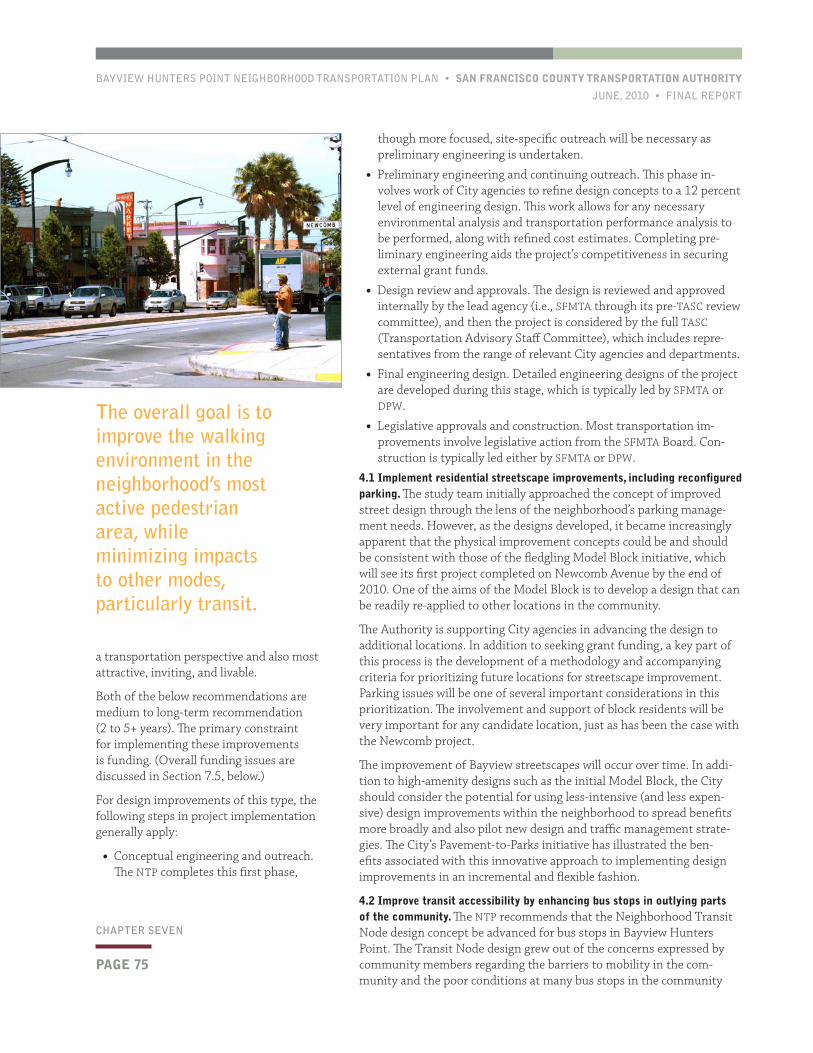
BAYVIEW HUNTERS POINT NEIGHBORHOOD TRANSPORTATION PLAN • SAN FRANCISCO COUNTY TRANSPORTATION AUTHORITY
JUNE, 2010 • FINAL REPORT
PAGE 75
CHAPTER SEVEN
though more focused, site-specific outreach will be necessary as preliminary engineering is undertaken.
• Preliminary engineering and continuing outreach. This phase in-volves work of City agencies to refine design concepts to a 12 percent level of engineering design. This work allows for any necessary environmental analysis and transportation performance analysis to be performed, along with refined cost estimates. Completing pre-liminary engineering aids the project’s competitiveness in securing external grant funds.
• Design review and approvals. The design is reviewed and approved internally by the lead agency (i.e., SFMTA through its pre-TASC review committee), and then the project is considered by the full TASC (Transportation Advisory Staff Committee), which includes repre-sentatives from the range of relevant City agencies and departments.
• Final engineering design. Detailed engineering designs of the project are developed during this stage, which is typically led by SFMTA or DPW.
• Legislative approvals and construction. Most transportation im-provements involve legislative action from the SFMTA Board. Con-struction is typically led either by SFMTA or DPW.
4.1 Implement residential streetscape improvements, including reconfigured parking. The study team initially approached the concept of improved street design through the lens of the neighborhood’s parking manage-ment needs. However, as the designs developed, it became increasingly apparent that the physical improvement concepts could be and should be consistent with those of the fledgling Model Block initiative, which will see its first project completed on Newcomb Avenue by the end of 2010. One of the aims of the Model Block is to develop a design that can be readily re-applied to other locations in the community.
The Authority is supporting City agencies in advancing the design to additional locations. In addition to seeking grant funding, a key part of this process is the development of a methodology and accompanying criteria for prioritizing future locations for streetscape improvement. Parking issues will be one of several important considerations in this prioritization. The involvement and support of block residents will be very important for any candidate location, just as has been the case with the Newcomb project.
The improvement of Bayview streetscapes will occur over time. In addi-tion to high-amenity designs such as the initial Model Block, the City should consider the potential for using less-intensive (and less expen-sive) design improvements within the neighborhood to spread benefits more broadly and also pilot new design and traffic management strate-gies. The City’s Pavement-to-Parks initiative has illustrated the ben-efits associated with this innovative approach to implementing design improvements in an incremental and flexible fashion.
4.2 Improve transit accessibility by enhancing bus stops in outlying parts of the community. The NTP recommends that the Neighborhood Transit Node design concept be advanced for bus stops in Bayview Hunters Point. The Transit Node design grew out of the concerns expressed by community members regarding the barriers to mobility in the com-munity and the poor conditions at many bus stops in the community
The overall goal is to improve the walking environment in the neighborhood’s most active pedestrian area, while minimizing impacts to other modes, particularly transit.
a transportation perspective and also most attractive, inviting, and livable.
Both of the below recommendations are medium to long-term recommendation (2 to 5+ years). The primary constraint for implementing these improvements is funding. (Overall funding issues are discussed in Section 7.5, below.)
For design improvements of this type, the following steps in project implementation generally apply:
• Conceptual engineering and outreach. The NTP completes this first phase,
PAGE 76
SAN FRANCISCO COUNTY TRANSPORTATION AUTHORITY • BAYVIEW HUNTERS POINT NEIGHBORHOOD TRANSPORTATION PLAN
FINAL REPORT • JUNE, 2010
CHAPTER SEVEN
by the Metropolitan Transportation Commission (MTC) and is currently in its first funding cycle. The BACI’s Inno-vative Grants Program funds projects that will reduce transportation-related greenhouse gas emission.
• Foundation and/or Nonprofit Grants. Depending on the nature of the pro-gram, it may require relatively mod-est funding to get off the ground and demonstrate effectiveness and realize cost-savings for participating organiza-tions. Such a program could be eligible for various foundation grants, par-ticularly from sources with programs focused on urban issues, elderly and/or senior transportation, environmental sustainability and livability, community and economic development, and other relevant concerns.
• Federal programs. There are a number of federal programs, such as the Elderly and Disable Specialized Transit Pro-gram (FTA 5310) that could potentially be tapped for a community-based transportation program. Federal pro-grams are often quite competitive and can be complex to administer.
FUNDING FOR CAPITAL IMPROVEMENTS
San Francisco has limited local funding to implement physical design improvements such as those discussed in Section 7.4. Proposition K funds—administered by the Authority—are prioritized every several years through the Five-Year Prioritiza-tion Program (5YPP) process. There are a number of Prop K categories for which the NTP’s recommendations would be eligible and Prop K is likely to be component of funding plans for specific improve-ments. The level of demand for Prop K funds, however, far exceeds the program’s capacity, and leveraging of other local and regionally-competitive grant funds is the surest way to realize project implementa-tion. Key non-Prop K fund sources include:
currently, which are often poorly-lit and provide no shelter or real-time information. While safer and more comfortable bus stop will not address issues of transit frequency and reliability, such improvements would help address some of the community’s concerns regarding transit accessibility.
The NTP assessed bus stops in the community and developed a prelimi-nary prioritization of locations for deploying the Neighborhood Transit Node design toolkit. Further technical analysis and outreach to adjacent residents (and/or land owners) will be necessary to confirm feasibility and desirability at some locations. Some improvements are already set to advance. As part of the Hunters View project, bus stops will be improved along Middle Point Road. The Palou and Phelps location was previously prioritized for transit stop improvements as part of Phase III of the Bayview Connections project.
A number of community members did raise some concerns about the transit node design concept. These concerns typically centered on issues of maintenance and cleanliness. Residents stressed the need to ensure that improved transit stops not become locations for significant loiter-ing, gang activity, or homeless congregation.
7.5 FundingThe NTP recommends a range of types of transportation solutions for Bayview Hunters Point. As such, funding must be sought from a variety of sources. Figure 7-1, provided at the end of this chapter, provides a table of all plan recommendations and notes potential funding sources and implementation timeframe.
This section provides a brief summary of important potential fund sources for implementing plan recommendations. Given the fluid nature of transportation funding programs, other sources are likely to be avail-able in the future while other programs may evolve or be discontinued.
FUNDING FOR COMMUNITY TRANSPORTATION RECOMMENDATIONS
As discussed in Section 7.1, the key next step for advancing the commu-nity transportation recommendations is to undertake focused follow-on planning study. The Authority recently applied for a Caltrans Planning Grant to fund this next phase of work. Funding from other sources will also be sought for a pilot demonstration project.
In order to initiate a demonstration project (and/or a potentially longer project operating period), funding will be sought from various sources. Potential funding sources include, but are not limited to:
• Lifeline Transportation Program (LTP). LTP is a regional program focused on implementing projects identified in community-based transportation plans conducted in low-income and minority com-munities such as the Bayview NTP. LTP administered by the Metro-politan Transportation Commission (MTC) in partnership with Bay Area congestion management agencies (CMAs). The Authority is San Francisco’s CMA. Calls for projects are issued approximately every 2 years. LTP is one of the few discretionary programs for which operat-ing projects (i.e., non-capital) are eligible.
• Bay Area Climate Initiatives Program (BACI). This program was in-cluded in the most recent regional transportation plan (RTP) adopted
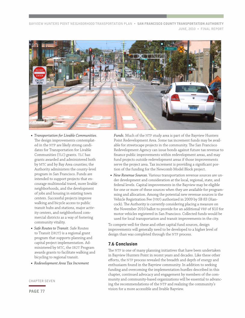
BAYVIEW HUNTERS POINT NEIGHBORHOOD TRANSPORTATION PLAN • SAN FRANCISCO COUNTY TRANSPORTATION AUTHORITY
JUNE, 2010 • FINAL REPORT
PAGE 77
CHAPTER SEVEN
Funds. Much of the NTP study area is part of the Bayview Hunters Point Redevelopment Area. Some tax increment funds may be avail-able for streetscape projects in the community. The San Francisco Redevelopment Agency can issue bonds against future tax revenue to finance public improvements within redevelopment areas, and may fund projects outside redevelopment areas if those improvements serve the project area. Tax increment is providing a significant por-tion of the funding for the Newcomb Model Block project.
• New Revenue Sources. Various transportation revenue sources are un-der development and consideration at the local, regional, state, and federal levels. Capital improvements in the Bayview may be eligible for one or more of these sources when they are available for program-ming and allocation. Among the potential new revenue sources is the Vehicle Registration Fee (VRF) authorized in 2009 by SB 83 (Han-cock). The Authority is currently considering placing a measure on the November 2010 ballot to provide for an additional VRF of $10 for motor vehicles registered in San Francisco. Collected funds would be used for local transportation and transit improvements in the city.
To compete well for these and other capital fund sources, design improvements will generally need to be developed to a higher level of design than was completed through the NTP process.
7.6 ConclusionThe NTP is one of many planning initiatives that have been undertaken in Bayview Hunters Point in recent years and decades. Like these other efforts, the NTP process revealed the breadth and depth of energy and enthusiasm found in the Bayview community. In addition to seeking funding and overcoming the implementation hurdles described in this chapter, continued advocacy and engagement by members of the com-munity and community-based organizations will be essential to advanc-ing the recommendations of the NTP and realizing the community’s vision for a more accessible and livable Bayview.
• Transportation for Livable Communities. The design improvements contemplat-ed in the NTP are likely strong candi-dates for Transportation for Livable Communities (TLC) grants. TLC has grants awarded and administered both by MTC and by Bay Area counties; the Authority administers the county-level program in San Francisco. Funds are intended to support projects that en-courage multimodal travel, more livable neighborhoods, and the development of jobs and housing in existing town centers. Successful projects improve walking and bicycle access to public transit hubs and stations, major activ-ity centers, and neighborhood com-mercial districts as a way of fostering community vitality.
• Safe Routes to Transit. Safe Routes to Transit (SR2T) is a regional grant program that supports planning and capital project implementation. Ad-ministered by MTC, the SR2T Program awards grants to facilitate walking and bicycling to regional transit.
• Redevelopment Area Tax Increment
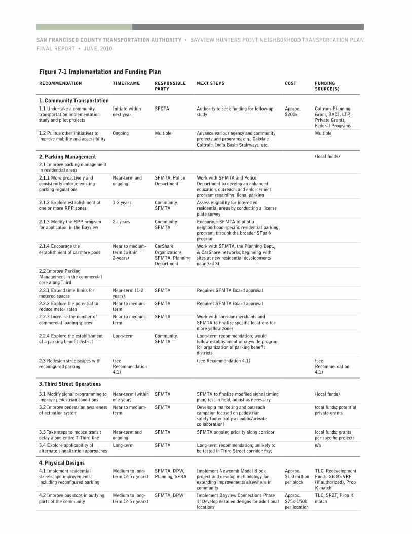
SAN FRANCISCO COUNTY TRANSPORTATION AUTHORITY • BAYVIEW HUNTERS POINT NEIGHBORHOOD TRANSPORTATION PLAN
FINAL REPORT • JUNE, 2010
Figure 7-1 Implementation and Funding Plan
RECOMMENDATION TIMEFRAME RESPONSIBLE PARTY
NEXT STEPS COST FUNDING SOURCE(S)
1. Community Transportation1.1 Undertake a community transportation implementation study and pilot projects
Initiate within next year
SFCTA Authority to seek funding for follow-up study
Approx. $200k
Caltrans Planning Grant, BACI, LTP, Private Grants, Federal Programs
1.2 Pursue other initiatives to improve mobility and accessibility
Ongoing Multiple Advance various agency and community projects and programs, e.g., Oakdale Caltrain, India Basin Stairways, etc.
Multiple
2. Parking Management (local funds)
2.1 Improve parking management in residential areas
2.1.1 More proactively and consistently enforce existing parking regulations
Near-term and ongoing
SFMTA, Police Department
Work with SFMTA and Police Department to develop an enhanced education, outreach, and enforcement program regarding illegal parking
2.1.2 Explore establishment of one or more RPP zones
1-2 years Community, SFMTA
Assess eligibility for interested residential areas by conducting a license plate survey
2.1.3 Modify the RPP program for application in the Bayview
2+ years Community, SFMTA
Encourage SFMTA to pilot a neighborhood-specific residential parking program, through the broader SFpark program
2.1.4 Encourage the establishment of carshare pods
Near to medium-term (within 2-years)
CarShare Organizations, SFMTA, Planning Department
Work with SFMTA, the Planning Dept., & CarShare networks, beginning with sites at new residential developments near 3rd St
2.2 Improve Parking Management in the commercial core along Third
2.2.1 Extend time limits for metered spaces
Near-term (1-2 years)
SFMTA Requires SFMTA Board approval
2.2.2 Explore the potential to reduce meter rates
Near to medium-term
SFMTA Requires SFMTA Board approval
2.2.3 Increase the number of commercial loading spaces
Near to medium-term
SFMTA Work with corridor merchants and SFMTA to finalize specific locations for more yellow zones
2.2.4 Explore the establishment of a parking benefit district
Long-term Community, SFMTA
Long-term recommendation; would follow establishment of citywide program for organization of parking benefit districts
2.3 Redesign streetscapes with reconfigured parking
(see Recommendation 4.1)
(see Recommendation 4.1) (see Recommendation 4.1)
3. Third Street Operations
3.1 Modify signal programming to improve pedestrian conditions
Near-term (within one year)
SFMTA SFMTA to finalize modfiied signal timing plan; test in field; adjust as necessary
(local funds)
3.2 Improve pedestrian awareness of actuation system
Near to medium-term
SFMTA Develop a marketing and outreach campaign focused on pedestrian safety (potentially as public/private collaboration)
local funds; potential private grants
3.3 Take steps to reduce transit delay along entire T-Third line
Near-term and ongoing
SFMTA SFMTA ongoing priority along corridor local funds; grants per specific projects
3.4 Explore applicability of alternate signalization approaches
Long-term SFMTA Long-term recommendation; unlikely to be tested in Third Street corridor first
n/a
4. Physical Designs4.1 Implement residential streetscape improvements, including reconfigured parking
Medium to long-term (2-5+ years)
SFMTA, DPW, Planning, SFRA
Implement Newcomb Model Block project and develop methodology for extending improvements elsewhere in community
Approx. $1.0 million per block
TLC, Redevelopment Funds, SB 83 VRF (if authorized), Prop K match
4.2 Improve bus stops in outlying parts of the community
Medium to long-term (2-5+ years)
SFMTA, DPW Implement Bayview Connections Phase 3; Develop detailed designs for additional locations
Approx. $75k-150k per location
TLC, SR2T, Prop K match
BAYVIEW HUNTERS POINT NEIGHBORHOOD TRANSPORTATION PLAN • SAN FRANCISCO COUNTY TRANSPORTATION AUTHORITY
JUNE, 2010 • FINAL REPORT
PAGE 79
APPENDIX A
Figure 3-2. Parking Turnover, Weekday Mid-day/Evening Commercial Areas
AVERAGE VEHICLE TURNOVER (NUMBER OF VEHICLES IN A SIX-HOUR TIME PERIOD)
30 MINUTE METERED
1 HOUR METERED
2 HOUR METERED
2 HOUR LIMITED
Bernal Heights 5.1 veh. 5.4 veh. n/a
1.5 veh.1
3.8 veh.
Source: Wilbur Smith Associates. Note: 1 Indicates observations for vehicles with RPPs.
Figure 3-8. Business Survey, Perceived Willingness of Customers to Pay for Enhancements
POTENTIAL PARKING ENHANCEMENTAVERAGE RATING
Being able to find a parking space more quickly 3.0s More willingExtended parking meter time limits 2.9
Parking closer to business establishment 2.7
t Less
willingImproved landscaping, lighting, maintenance and safety 2.4
Source: Godbe Research.
Parking References
BooksTodd Litman, 2006. Parking Management Best Practices. Plan-ners Press, 2006.
some 15-minute and 30-minute spaces.1
Figure 2-1. San Francisco On-Street Parking
TYPE OF PARKING SPACE QUANTITY
Total On-Street Parking 320,000 (includes meters)
White zones (passenger loading) 1,575
Source: SFMTA.
1 Metering of on-street spaces by local jurisdictions is authorized by the state Vehicle Code (Section 22508). The Vehicle Code is silent as to the manner of administration of collection and expenditure of meter revenues, leaving the issue to the local jurisdiction.
Figure 1-1. Downtown Parking Supply (quantity of spaces)DOWNTOWN CORE GREATER DOWNTOWN
City-Owned Garages 9,300 10,700
Source: Authority calculations based on information from SFMTA (SFpark) and the Planning Department (Downtown Plan Monitor-ing Report, 2004).
Note: Greater Downtown refers to Census Superdistrict 1. The Downtown Core quantities shown for City-owned garage spaces and SFpark on-street pilots correspond with SFpark’s “Downtown” pilot area, which aligns closely with the C-3 downtown office district.
wn in Figure 2-4, below.
Figure 2-4. New Port of San Francisco Meter Rates (per hour)ZONE 7:00 A.M. – 7:00 P.M. 7:00 P.M. – 11:00 P.M.
South of Bryant Street $1.00 (12 hour time limit)
$0.25 (12 hour time limit)
Source: Port of San Francisco. Note: Rates will be higher during special events, such as baseball games.
Backgroundand Purpose1
1. 1 Introduction
Under-regulated on-street parking results in limited parking avail-
ability, inefficient.
ESTABLISHMENT AND MODIFICATION OF RPP ZONES
New RPP zones are established through a petition process. To establish a ntary strategies as a way to manage demand for parking at on-street locations and off-street facilities managed by SFMTA.
1. 2 Study Purpose and ObjectivesThe San Francisco County Transportation Authority (Authority) undertook the On-Street Parking Management and Pricing Study (Study) to:
• Review San Francisco’s existing on-street parking management programs and neighborhood parking conditions.
While they are related and complementary
ACKNOWLEDGEMENTSThe Authority is indebted to the team of staff and
consultants who helped with make this study.
Chapter 1: Background and PurposeIntroduction 10
BOX 1. Parking ConceptsOccupancy: The percentage of parking spaces in an area or facility that are in use at a given time. For example, a neighborhood
SUPPLY Seventy-six percent of all curbside parking spaces in the study area are either regular metered spaces or RPP spaces available for general use.
Figure 3-1. Parking Occupancy, Summary
NEIGHBORHOOD
RESIDENTIAL COMMERCIAL
EARLY MORNING MID-DAY EVENING MID-DAY EVENING
Bernal Heights 99% weekday
63% weekday
77% weekday
87% weekday
87% weekday80% weekend 96% weekend
Source: Wilbur Smith Associates.
Figure 3-2. Parking Turnover, Weekday Mid-day/Evening Commercial Areas
AVERAGE VEHICLE TURNOVER (NUMBER OF VEHICLES IN A SIX-HOUR TIME PERIOD)
30 MINUTE METERED
1 HOUR METERED
2 HOUR METERED
2 HOUR LIMITED
Bernal Heights 5.1 veh. 5.4 veh. n/a
1.5 veh.1
3.8 veh.
Source: Wilbur Smith Associates. Note: 1 Indicates observations for vehicles with RPPs.
Figure 3-8. Business Survey, Perceived Willingness of Customers to Pay for Enhancements
POTENTIAL PARKING ENHANCEMENTAVERAGE RATING
Being able to find a parking space more quickly 3.0s More willingExtended parking meter time limits 2.9
Parking closer to business establishment 2.7
t Less
willingImproved landscaping, lighting, maintenance and safety 2.4
Source: Godbe Research.
Figure 1: Case Study NeighborhoodsBERNAL HEIGHTS COW HOLLOW HAYES VALLEY WEST PORTAL
Population 19,170 18,800 12,300 5,646
Source: Census 2000. (Off-street parking information is from field observations, Wilbur Smith Associates.)
some 15-minute and 30-minute spaces.1
Figure 2-1. San Francisco On-Street Parking
TYPE OF PARKING SPACE QUANTITY
Total On-Street Parking 320,000 (includes meters)
White zones (passenger loading) 1,575
Source: SFMTA.
1 Metering of on-street spaces by local jurisdictions is authorized by the state Vehicle Code (Section 22508). The Vehicle Code is silent as to the manner of administration of collection and expenditure of meter revenues, leaving the issue to the local jurisdiction.
Figure 1-1. Downtown Parking Supply (quantity of spaces)DOWNTOWN CORE GREATER DOWNTOWN
City-Owned Garages 9,300 10,700
Source: Authority calculations based on information from SFMTA (SFpark) and the Planning Department (Downtown Plan Monitor-ing Report, 2004).
Note: Greater Downtown refers to Census Superdistrict 1. The Downtown Core quantities shown for City-owned garage spaces and SFpark on-street pilots correspond with SFpark’s “Downtown” pilot area, which aligns closely with the C-3 downtown office district.
Figure 2-3. Meter District Rates (per hour)
METER DISTRICT
HOURLY RATE MOTORCYCLE RATE
QUANTITY OF METERS METERING HOURS
BEFORE JULY 1
EFFECTIVE JULY 1
BEFORE JULY 1
EFFECTIVE JULY 1
1. Downtown $3.00 $3.50 $0.25 $0.70 3,391 7am-6pm, Mon-Sat
Source: SFMTA. Note: the quantity of meters does not include metered spaces designated for motorcycles, which total 1,361 across the city.
Figure 1. Parking Priorities by Community Parking DistrictPARKING DISTRICT ADVISORY BOARD PRIORITIES FOR USE OF PARKING FUNDS
Downtown /Centre City
Centre City Development Corporation Construction of new parking facilities
On-street revenue collection
Meter upgrades (multi-space)