bangladesh - rohingya refugee crisis - cox's bazar … 205-047 205-048 205-049 205-050 205-051...
TRANSCRIPT
CAMP 3
CAMP 5
CAMP 1W
CAMP 17
202-010
202-011
202-020
202-021
202-023
202-024
202-025
202-052
202-053
202-054
202-056
205-001
205-002205-003
205-004 205-005
205-006
205-007
205-008
205-009
205-010
205-011
205-017
205-018
205-021
205-023
205-026
205-029
205-033
205-034
205-038
205-042
205-043
205-044
205-045
205-046
205-047
205-048
205-049
205-050
205-051
205-052
205-053
205-054
205-055
205-056
205-057
205-058
205-059
205-060
205-061205-062
205-063205-064
205-065
205-066
205-067
205-068205-069
205-070205-071
205-072
205-073
205-074
205-075
205-076
205-077
205-078
205-079
205-080
205-081
206-001
206-002
206-003
206-004
206-005
206-006
206-007
206-008
206-009
206-010
206-011
206-012
206-013
206-014
206-015
206-016
206-017
206-018
206-019
206-020
206-021
206-022
206-023
206-024 206-024
206-025
206-026
206-027
206-028
206-029
206-030
206-031206-032
206-033
206-034
206-035
206-036
206-037
206-038
206-039
206-040
206-041
206-042
206-043
206-044
206-046
206-047
206-048
209-001
209-002
209-003
209-006209-007
209-008
209-009
209-011
209-016
209-017
209-018
209-020209-020
209-021
209-048
New
2122
299
303
309
373
375
376
490
491
492493
494
496
497
498
601
602
603604
605
607608
610
647
648
649650651
652
654
655656 657
658
659660
661662
663664
665
666
981
983
988
1046
1048
1053
23
301302
304
305
306
307308
310
372
374
495
499
606
609
653
980
982
984
985
986
987
1045
1047
1049
1050
10511052
043
027
028
030
036
037
040
044
046
171
172
295525
10151016
1019
1077
1080
1092
1098
1103
1107
1111
1112
1114
1117
1118
1120
11291132
1136
1138
1141
1144
1146
1149
1151
1153
1308
1320
70
73
83
8586
93
119
120
121
294
300 301
302
303304
309
315
316
509
517
518
521
522
526
528
1013
1014
1017
1018
1037
1040
1075
1076
1078
1079
1081
1082
1083
1084
1085
1086
1087
1088
10891090
1091
1093
10941095
1096
1097
10991100
1101
1102
1104
1105
1106
1108
1109
1110
1113
1115
1116
1121
1122
1123
1126
1127
1133
11341135
1140
1142
1143
1145
1147
1148
1194
1195
1199
1306
1307
1309
1310
1311
1312
1319
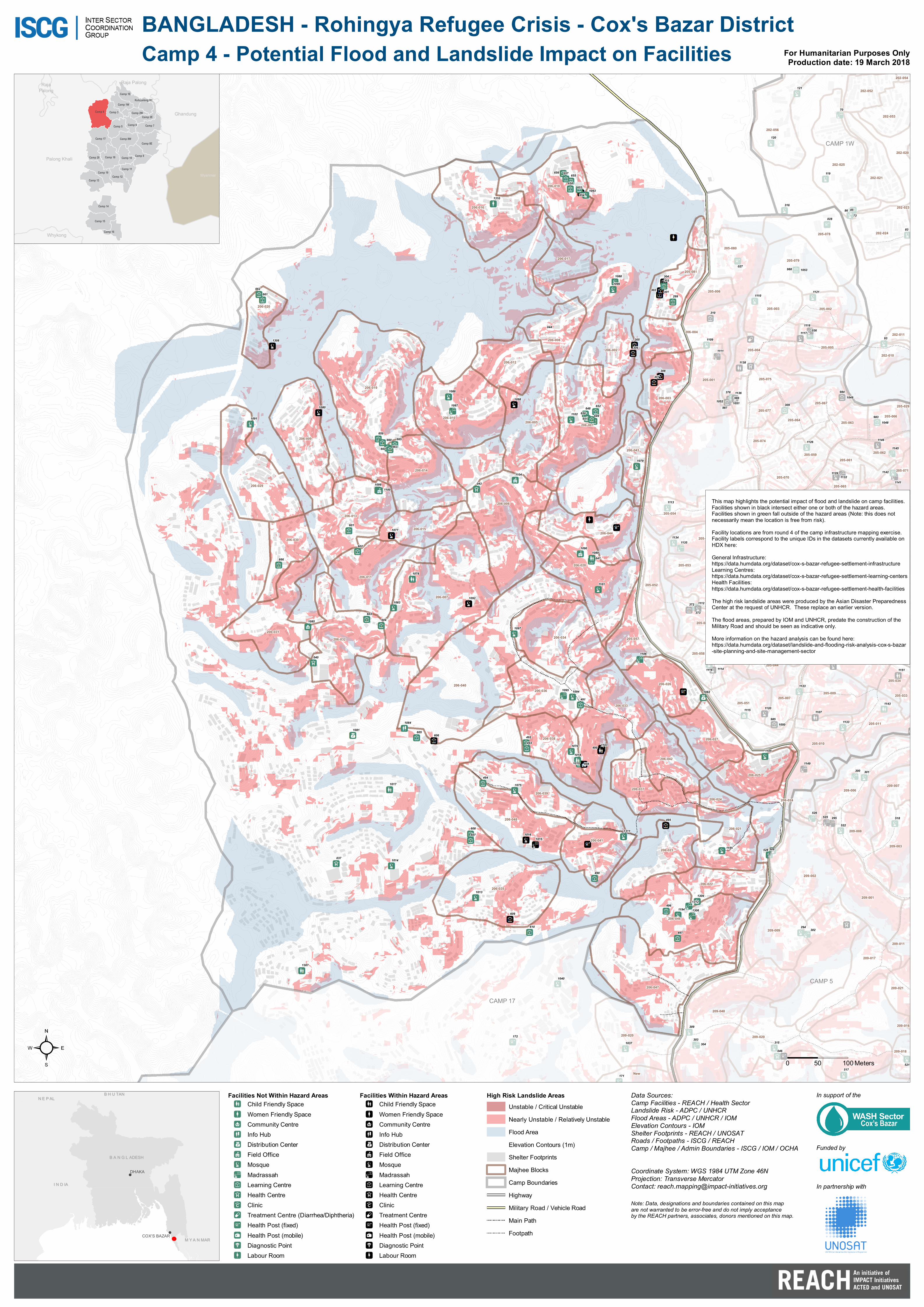
BANGLADESH - Rohingya Refugee Crisis - Cox's Bazar District
!
!
B H U TANB H U TAN
M Y A N MARM Y A N MAR
I N D IAI N D IA
N E P ALN E P AL
B A N G L ADESHB A N G L ADESH
DHAKA
COX'S BAZAR
Note: Data, designations and boundaries contained on this mapare not warranted to be error-free and do not imply acceptanceby the REACH partners, associates, donors mentioned on this map.
Data Sources:Camp Facilities - REACH / Health SectorLandslide Risk - ADPC / UNHCRFlood Areas - ADPC / UNHCR / IOMElevation Contours - IOMShelter Footprints - REACH / UNOSATRoads / Footpaths - ISCG / REACHCamp / Majhee / Admin Boundaries - ISCG / IOM / OCHA
Coordinate System: WGS 1984 UTM Zone 46NProjection: Transverse MercatorContact: [email protected]
²
Camp 4 - Potential Flood and Landslide Impact on Facilities
0 50 100 Meters
For Humanitarian Purposes OnlyProduction date: 19 March 2018
Ghandung
Whykong
RajaPalong
Raja Palong
Palong Khali
Camp 16
Camp 2E
Camp 7
Camp 15
Kutupalong RC
Camp 9Camp 10Camp 18
Camp 8W
Camp 4 Camp 3
Camp 5
Camp 19
Camp 1W
Camp 6
Camp 14
Camp 8E
Camp 2W
Camp 11
Camp 12
Camp 1E
Camp 13
Camp 20
Camp 17
Myanmar
In support of the
Funded by
In partnership with
Facilities Not Within Hazard AreasChild Friendly SpaceWomen Friendly SpaceCommunity CentreInfo HubDistribution CenterField OfficeMosqueMadrassahLearning CentreHealth CentreClinicTreatment Centre (Diarrhea/Diphtheria)Health Post (fixed)Health Post (mobile)Diagnostic PointLabour Room
Facilities Within Hazard AreasChild Friendly SpaceWomen Friendly SpaceCommunity CentreInfo HubDistribution CenterField OfficeMosqueMadrassahLearning CentreHealth CentreClinicTreatment CentreHealth Post (fixed)Health Post (mobile)Diagnostic PointLabour Room
High Risk Landslide AreasUnstable / Critical UnstableNearly Unstable / Relatively UnstableFlood AreaElevation Contours (1m)Shelter FootprintsMajhee BlocksCamp BoundariesHighwayMilitary Road / Vehicle RoadMain PathFootpath
This map highlights the potential impact of flood and landslide on camp facilities. Facilities shown in black intersect either one or both of the hazard areas. Facilities shown in green fall outside of the hazard areas (Note: this does not necessarily mean the location is free from risk).Facility locations are from round 4 of the camp infrastructure mapping exercise. Facility labels correspond to the unique IDs in the datasets currently available on HDX here: General Infrastructure: https://data.humdata.org/dataset/cox-s-bazar-refugee-settlement-infrastructureLearning Centres: https://data.humdata.org/dataset/cox-s-bazar-refugee-settlement-learning-centersHealth Facilities: https://data.humdata.org/dataset/cox-s-bazar-refugee-settlement-health-facilitiesThe high risk landslide areas were produced by the Asian Disaster Preparedness Center at the request of UNHCR. These replace an earlier version.The flood areas, prepared by IOM and UNHCR, predate the construction of the Military Road and should be seen as indicative only.More information on the hazard analysis can be found here: https://data.humdata.org/dataset/landslide-and-flooding-risk-analysis-cox-s-bazar-site-planning-and-site-management-sector