back pack trips 2 3 days - james madison university pack trips 2‐3 days ... for the next 3.0 miles...
TRANSCRIPT

Back Pack Trips 2‐3 Days
Hike 14: Ramsey’s Draft
Length Difficulty Streams Views Solitude Camping 16.8 miles 5 stars 5 stars 3 star 4 stars 5 stars
Hike Time: 2 days
Elevation Gain: 3,170 ft with multiple ascents
Hike Description: The Ramsey's Draft Loop is beautiful with ridge line valley views, springs and streams but is tiring with long ascents and knob traverses on the 11.0 mile first day. Unlike most ridge trails the Bald Ridge Trail is a long series of ascents and descents of six knobs. It is 6+ hours of hiking to one of several great camp spots anywhere from Hiner Spring and below. Also note that some portions of the trails are hard to spot and not well marked. Start out at the end of the parking lot for 150 yards then turn right where a trail will cross Ramsey's Draft. We needed to go about 50 yards upstream to find a low water spot to cross. Follow the trail as it begins to ascend the mountain for the longest steepest section of the loop as it winds up to the ridge in 2.0 miles. At the ridge turn left as the trail you have been following now continues down the other side of the mountain. Follow the ridge trail 4.5 miles (yellow diamond marked in places) as it crosses The Peak, Bald Ridge Knob, The Pinnacle and Gordon Peak before arriving at the next trail junction. There is a small clearing with a trail coming in from the right and pond to your left. Continue around the pond on the right side where the trail continues uphill, then descends and in 1.7 miles arrives at the next trail junction. Turn hard left at this junction and gradually ascend for 1.3 miles to arrive at Hiner Spring. There are several good camp sites here. Turn hard left downhill staying to the left of the stream down the valley (the trail does not become apparent for about 150 yards as it passes over rocks). In 0.3 miles you will pass several great camp sites. Choose one for your camping spot. Continue down the trail as crosses the steam and in 0.4 miles turns more to the right. For the next 3.0 miles you will cross Ramsey's Draft several more times before arriving at the intersection of the Jerry's Run Trail that comes in from the right. Cross the draft again continuing down the trail as it crosses back and forth several more times for 2.1 miles where you will arrive at the next rail intersection. Stay left continuing next to the draft for the remaining 0.1 miles back to the parking area.
Driving Directions: Follow 81 south out of Harrisonburg. Take exit 225 ‐ VA 275 toward Staunton. Stay on VA 275 for 5 miles to State Hwy 250. Turn right on US 250 20 miles. Turn Right At Ramsey’s Draft parking

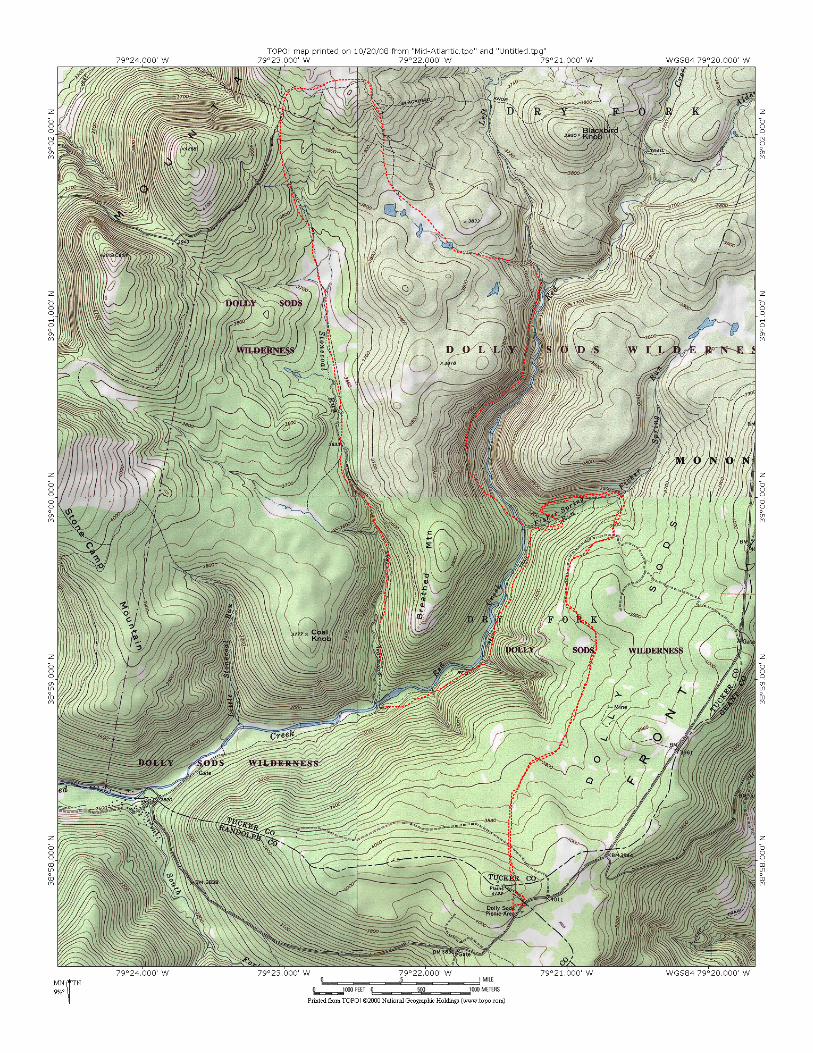
Hike 15: Dolly Sods – West Virginia
Length Difficulty Streams Views Solitude Camping 19.5 miles 3 stars 2 stars 5 star 3 stars 2 stars
Hike Time: Approximately 2‐3 days depending on speed and stopping time
Elevation gain: 2700 ft
Hike Description: Trail Notes: The trails in Dolly Sods ARE NOT color blazed. Start your hike on the Rohrbough Plains Trail, forest Trail No. 508, which begins just north of the Dolly Sods Picnic Area. Scramble up the road bank and come to an elaborate trail board about the Dolly sods. This trail starts as a footpath and is not the gated road just south of the picnic area. Enter a beech, cherry, and spruce forest lined with rhododendron. Begin to descend at 0.4 mile, crossing a railroad grad a t0.7 mile. A couple of tiny stream crossings precede skirting the edge of glade at mile 1.2. You are now on an old railroad bed. Keep hiking northwesterly. The rocky trail seems elevated – this is the grade being raised over marshy areas. Rock cairns mark the rhododendron lined trail. Cross the first significant stream at mile 2.3, which can easily by rock hopped. At mile 2.4 on your left, a rock face offers good views, then the views improve as the outcrop extends farther from the forest. This is a great place to find a campsite. There is a great view of Red Creek Gorge below. Rocky Point on Breathed Mtn is just across the chasm.
Start day two by continuing north on the Rohrbaugh Plains Trail. Leave the outcrops, pass through a field, and follow an old road and a wide open walk. Watch for a pile of rocks to the left of the road, indicating a trail junction at mile 3.1 of your loop hike. Straight ahead, the road is now the Wildlife Trail. You turn left on the Rohrbaugh Plains Trail and follow an old railroad grad downhill. Descend and cross fisher Spring Run at mile 3.4. Immediately enter a boulder field before coming to the unction with the Fisher Spring Run Trail, which intersects from your right by a pile of rocks at mile 3.5. The main railroad grade is not the Fisher Spring Run Trail. Keep forward on the grade in the boulder‐laden valley. Leave the grade at mile 3.9 and dive down to the left via switchbacks to cross Fisher Spring Run again. Work your way around a washed out section of trail, ultimately keeping downstream. Red Creek is off to your right down a steep embankment. Come to a pile of cairns and another trail junction, while still high on the mountain side. Below you is a campsite. Take the trail leading to the campsite, which is the Red Creek Trail. Parallel Red Creek downstream just below a waterfall and big pool, and ford Red Creek. Climb out of the flood‐scoured creekbed, coming to another junction at mile 4.4 on the far side of Red Creek. The Rocky Point Trail goes left. You go right, upstream along Red Creek Trail. The trail leave the valley at mile 4.6 and climbs steeply through a rhododendron thicket. Cross one railroad grad, but pick up the second grade at mile 4.8. this provides a gentle ascent through a forest accentuated with rock outcrops and ferns everywhere. Come to the Breathed Mtn Trail at mile 6.0 turn left and climb steeple amid a boulder garden to top out on a grassy plateau at mile 6.3. The trail works across the plateau through clearing in dense spruce thickets and areas where filed and forest are mixed. Little rills meander toward the lowlands. Cross several small streams and mucky area before coming to a grassy clearing and a junction with Big Stonecoal Trail at mile 8.5. Turn left on the Big Stonecoal Trail and immediately descend across a wet area on footlogs and stones. Make a couple of watery crossings. Cross Big Stonecoal Run at mil 10. There is a wide open field with a great view to your right and a planting of red pine to your left. Wind your way through the red pines‐ after this there are many open glades, woods and small streams, crossing Big Stonecoal again at mile 10.8. Intersect the Dunkenbarger Trail, coming in on your right at mile 11. Stay forward on the Big Stonecoal Trial, quickly making another crossing, then stay on the grade as Big Stonecoal Run Drops off to your right. Intersect the Rocky Point Trail at mile 11.6 which comes at you on the railroad grade. You, however drop sharply right down a footpath, still on the Big Stonecoal Trail and immediately passing a side trail to a rock outcrop with a view of a falls on Big Stonecoal Run. The stream is far below, but the noisy water course is clearly audible on the mtn side. Keep dropping and pick up another grade. At mile 12.5 work around a slide that has eroded the railroad grade. Drop steeply down just before coming to Red Creek. At mile12.9, the trail seemingly ends in a bluff. Make your way down to the water and make the wet booted ford above the confluence of Big Stonecoal and Red Creek, coming to the Red Creek Trail and a flat with many campsites at mile 13. This is your second night’s destination.
Start day three by heading upstream on the Red Creek Trail. Follow a railroad grade up for .2 mile, watching for a footpath that splinters off to the right away from the grade. Climb up along the mountain side, crossing a seep and then a stream at mile 13.4 of your loop hike. You are way above the river before dropping down to a side stream at mile 13.9. Look for a side trail dropping down to a falls on this stream. Keep on the Red Creek Trail, coming to a junction with the fisher Spring Run Trail at mile 14.7. From this point forward you are retracing your steps coming to the Rohrbaugh Plains Trail at mile 15.9, the Wildlife Trail at mile 16.3, and the first night’s camp by the outcrop at mile 17. Return to the picnic Area at mile 19.4
Directions:
Follow 33 West form Harrisonburg to WV Rt 28. Follow road signs as Rt 33 turns as it goes through mountains and towns. Turn right on WV 28/55. Turn left on Jordan Run road. Follow Jordon Run Rd 1 mile to Forest Road 19 turn left. Follow FS 19 for 6 miles to the junction with FS 75. Stay left on FS 19 drive 1.2 miles to Dolly sods Picnic Area