auckland regional land transport plan - at.govt.nz · our vision auckland regional land transport...
TRANSCRIPT
2018–2028
Auckland Regional Land Transport Plan

Introduction
Auckland Regional Land Transport Plan 2018–2028
2
Introduction
Auckland Regional Land Transport Plan 2018–2028
3
Introduction from the Chair
Dr Lester Levy, CNZMChair, Auckland Transport
For the first time, through the Auckland Transport Alignment Project (ATAP) the priorities of Auckland and the Government are absolutely aligned and more importantly funded. Consequently, this Regional Land Transport Programme (RLTP) outlines an exciting and very ambitious programme of work for Auckland.
The RLTP is a statutory document required under legislation. But it is much more important than that, it is our ‘contract’ with the ratepayers and taxpayers to contribute to the development of an economically, socially, culturally and environmentally successful Auckland.
Many thousands of individuals and organisations, including Local Boards who represent their wider communities, took the time and effort to review our draft plan and make formal submissions.
It was both pleasing and encouraging that the vast majority of those submitters backed the general direction of the plan.
The key issues that we, along with our partners the Auckland Council, Government (through the Transport Agency) and KiwiRail, identified have also been validated by substantially all submitters.
ATAP is not just another plan that will gather dust on a shelf, it has money firmly behind it and this RLTP demonstrates that we are getting on with delivering. The joined-up thinking that ATAP represents is critical, because Northland and the rest of the North Island can only connect through Auckland. On a national scale, for New Zealand to thrive, Auckland must thrive.
The pace and scale at which Auckland is growing, and the associated challenges, have been well documented. These growth-related challenges require urgent and flexible services and solutions for the travelling public.
Our relatively new Chief Executive, Shane Ellison, has a clear brief from the Board to transform the culture of Auckland Transport (AT) and to deliver results in several key areas.
Reliable, frequent and affordable public transport must continue to be a focus. New electric trains will be added to our existing fleet by early 2020, and important local improvements such as bus priority lanes made this year to ensure more people move through congested roading networks more frequently. There will be an ongoing and enhanced emphasis on active transport, which we still strongly believe is a highly credible (and reliable and affordable) modal option.
Every detail of the network is being worked on, including traffic signals, to enable smoother flows – as an example over 200 intersections are being reviewed this year alone.
But it’s not only about hard infrastructure such as roads, vehicles, buses, trains and ferries. People are at the heart of everything we do and tragically, every day someone is killed or seriously injured on our transport network – this must stop!
Recently the AT Board commissioned an independent, expert review into road safety in Auckland. This hard-hitting report produced 45 recommendations, all of which we have adopted without question. However, we cannot achieve our road safety ambitions and objectives by ourselves, we will need the support of many agencies and importantly that of each and every Aucklander.
This emphasis on safety as the top priority is reflected throughout this RLTP and along with the rest of the AT Board, I cannot stress enough how important this element of our work programme will be going forward.
Finally, I take this opportunity to once again thank and acknowledge all our key partners and stakeholders – working together Aucklanders will see the sort of transformational change that they not only need but deserve.
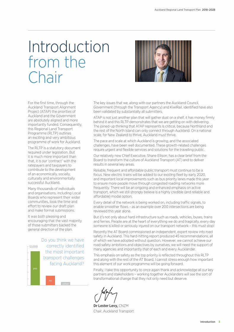
Do you think we have correctly identified
the most important transport challenges
facing Auckland?
12,000
yes
noother

Contents
Auckland Regional Land Transport Plan 2018–2028
4
Table ofcontentsIntroduction from the Chair 3
01. Our vision 6
02. Feedback from consultation 7
03. Purpose and scope of the Regional Land Transport Plan 12
04. Auckland’s challenges 16
05. Addressing Auckland’s challenges 30
06. Maintaining and renewing existing assets 46
07. Inter-regional priorities 48
08. Measuring outcomes 49
09. Funding and expenditure 50
AppendicesAppendix 1 Auckland Transport Capital Programme 54
Appendix 2 NZ Transport Agency Investment Programme 70
Appendix 3 Rail Infrastructure Capital Programme 76
Appendix 4 Department of Conservation Programme 78
Appendix 5 Significance Policy 80
Appendix 6 Glossary 82
Contents 5
Auckland Regional Land Transport Plan 2018–2028
Our Vision
Auckland Regional Land Transport Plan 2018–2028
6
01.Our visionAuckland is New Zealand’s largest city and home to almost 1.7 million people. Its population has grown strongly over the past few years, and over the 10 years of this Regional Land Transport Plan (RLTP) Auckland is expected to grow by a further 300,000 people.
Growth brings opportunities to improve prosperity and wellbeing through the greater diversity of social, cultural and economic opportunities that a larger population provides. However, rapid population growth has brought challenges, including increased congestion, reduced accessibility, increased deaths and serious injuries on the road network, and increasing negative impacts on the environment.
The refresh of ATAP has provided the opportunity for Auckland to make a major step forward in addressing these challenges. Through ATAP, the Government and Auckland Council agreed on a transformative and visionary plan for Auckland, supported by a $28 billion package of transport investment over the next 10 years.
The 10-year programme set out in this RLTP is built on this agreed investment package. It provides for significant improvements to be made in public transport, including rapid transit, walking and cycling, network initiatives to help to address congestion, and support for greenfield and urban redevelopment. It also provides for a major focus on improving safety on Auckland’s road network.
The programme set out in this RLTP will enable the delivery of a safe, reliable and accessible transport system that supports and shapes Auckland’s development. It will encourage the move away from single-occupant vehicles as the dominant mode of travel, enabling public transport, walking and cycling to play a significant role in the transport system.
It will lead Auckland towards being a city where there is growth without increased congestion, where it is easy to access employment and services, where it is safe to drive, walk and cycle, where there are genuine travel choices, and where the negative impacts of the transport system on people and the environment are minimised.
Feedback from Consultation 7
Auckland Regional Land Transport Plan 2018–2028
02.Feedback from consultationIntroduction
This section summarises the feedback received through submissions on the draft RLTP.
Consultation
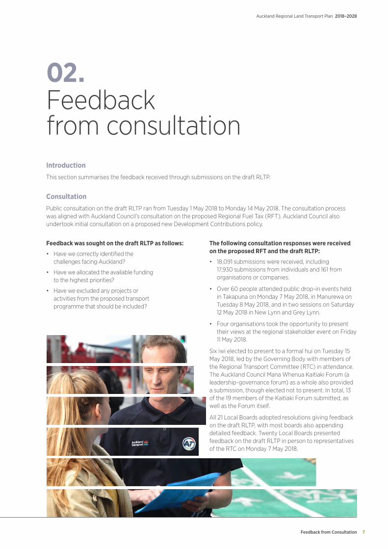
Public consultation on the draft RLTP ran from Tuesday 1 May 2018 to Monday 14 May 2018. The consultation process was aligned with Auckland Council’s consultation on the proposed Regional Fuel Tax (RFT). Auckland Council also undertook initial consultation on a proposed new Development Contributions policy.
Feedback was sought on the draft RLTP as follows:
• Have we correctly identified the challenges facing Auckland?
• Have we allocated the available funding to the highest priorities?
• Have we excluded any projects or activities from the proposed transport programme that should be included?
The following consultation responses were received on the proposed RFT and the draft RLTP:
• 18,091 submissions were received, including 17,930 submissions from individuals and 161 from organisations or companies.
• Over 60 people attended public drop-in events held in Takapuna on Monday 7 May 2018, in Manurewa on Tuesday 8 May 2018, and in two sessions on Saturday 12 May 2018 in New Lynn and Grey Lynn.
• Four organisations took the opportunity to present their views at the regional stakeholder event on Friday 11 May 2018.
Six iwi elected to present to a formal hui on Tuesday 15 May 2018, led by the Governing Body with members of the Regional Transport Committee (RTC) in attendance. The Auckland Council Mana Whenua Kaitiaki Forum (a leadership-governance forum) as a whole also provided a submission, though elected not to present. In total, 13 of the 19 members of the Kaitiaki Forum submitted, as well as the Forum itself.
All 21 Local Boards adopted resolutions giving feedback on the draft RLTP, with most boards also appending detailed feedback. Twenty Local Boards presented feedback on the draft RLTP in person to representatives of the RTC on Monday 7 May 2018.
Feedback from Consultation
Auckland Regional Land Transport Plan 2018–2028
8
Feedback from individuals and organisations
02. Feedback from consultation cont.
Yes
No
Other comments
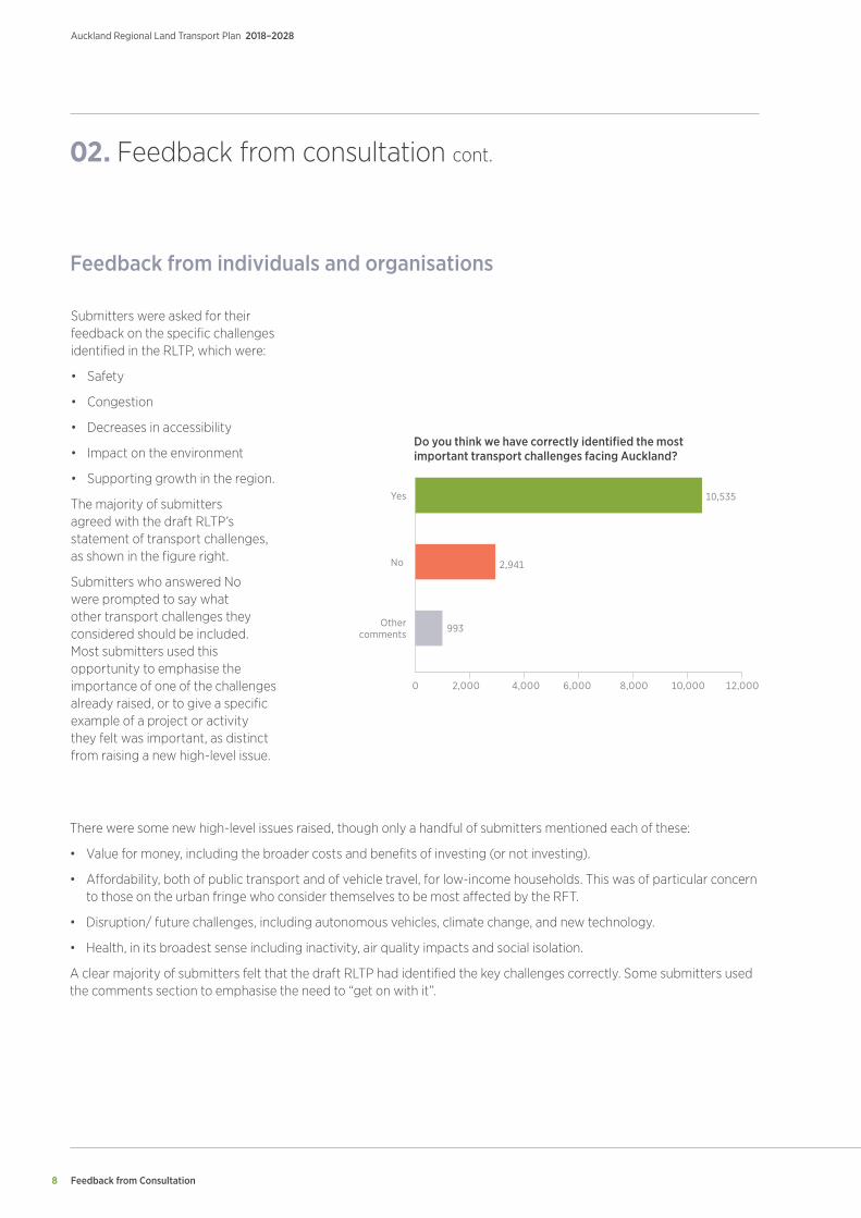
Do you think we have correctly identified the most important transport challenges facing Auckland?
0 2,000 4,000 6,000 8,000 10,000 12,000
Submitters were asked for their feedback on the specific challenges identified in the RLTP, which were:
• Safety
• Congestion
• Decreases in accessibility
• Impact on the environment
• Supporting growth in the region.
The majority of submitters agreed with the draft RLTP’s statement of transport challenges, as shown in the figure right.
Submitters who answered No were prompted to say what other transport challenges they considered should be included. Most submitters used this opportunity to emphasise the importance of one of the challenges already raised, or to give a specific example of a project or activity they felt was important, as distinct from raising a new high-level issue.
There were some new high-level issues raised, though only a handful of submitters mentioned each of these:
• Value for money, including the broader costs and benefits of investing (or not investing).
• Affordability, both of public transport and of vehicle travel, for low-income households. This was of particular concern to those on the urban fringe who consider themselves to be most affected by the RFT.
• Disruption/ future challenges, including autonomous vehicles, climate change, and new technology.
• Health, in its broadest sense including inactivity, air quality impacts and social isolation.
A clear majority of submitters felt that the draft RLTP had identified the key challenges correctly. Some submitters used the comments section to emphasise the need to “get on with it”.
10,535
2,941
993

Feedback from Consultation 9
Auckland Regional Land Transport Plan 2018–2028
Please indicate how important the following areas are to you
Public Transport
Network Optimisation
Safety
Grolth Area
Environment
Corridor Improvements
Walking & Cycling
Very important Moderately important Less important
0% 20% 40% 60% 80% 100%
Public transport improvements - improve existing services, park and ride, improve/extend heavy rail, light rail, bus and ferry
Corridor improvements - upgrades to existing road, extended or upgraded motorways, seal extensions
Additional Walking & Cycling projects (mainly cycling)
Additional support for growth areas
Additional Safety projects
Additional Network Optimisation projects
Additional Environment projects
Please indicate activities and projects that should be included
0% 1,000 2,000 3,000 4,000 5,000 6,000 7,000
The draft RLTP consultation also sought feedback on the level of support for specific areas of focus, to inform the prioritisation of funding. Overall, there was a high level of support (over 80%) for investment in the areas listed in the draft RLTP, as shown in the figure right. The exception to this was walking and cycling, with 34 percent of submitters saying that walking and cycling were “less important” to them.
Submitters were also asked if there were any projects or activities they thought should be included. These responses show a clear preference for emphasis on public transport improvements, as shown in the figure below.
Feedback from Consultation
Auckland Regional Land Transport Plan 2018–2028
10
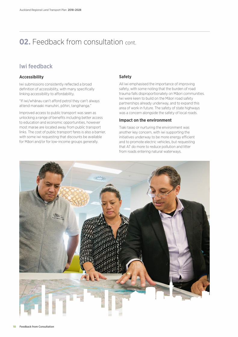
Iwi feedback
Accessibility
Iwi submissions consistently reflected a broad definition of accessibility, with many specifically linking accessibility to affordability.
“If iwi/whānau can’t afford petrol they can’t always attend manaaki manuhiri, pōhiri, tangihanga.”
Improved access to public transport was seen as unlocking a range of benefits including better access to education and economic opportunities, however most marae are located away from public transport links. The cost of public transport fares is also a barrier, with some iwi requesting that discounts be available for Māori and/or for low-income groups generally.
02. Feedback from consultation cont.
Safety
All iwi emphasised the importance of improving safety, with some noting that the burden of road trauma falls disproportionately on Māori communities. Iwi were keen to build on the Māori road safety partnerships already underway, and to expand this area of work in future. The safety of state highways was a concern alongside the safety of local roads.
Impact on the environment
Tiaki taiao or nurturing the environment was another key concern, with iwi supporting the initiatives underway to be more energy efficient and to promote electric vehicles, but requesting that AT do more to reduce pollution and litter from roads entering natural waterways.
Feedback from Consultation 11
Auckland Regional Land Transport Plan 2018–2028
Local Board feedback
Transport challenges
Local Boards were overwhelmingly in support of the transport challenges identified, with all but four Local Board submissions specifically agreeing with the vision and direction, and on the identified challenges. Several Local Boards commented on the alignment with Local Board Plans.
Safety
Safety was identified as the major concern. Every Local Board commented on the need to improve road safety, and five Local Boards specifically commended the proposed Vision Zero approach.
Congestion
Eighteen of the Local Boards specifically mentioned congestion, often in the context of a specific project to reduce local congestion.
Decreases in accessibility
Only five Local Boards mentioned accessibility specifically, although support for accessibility was reflected in all Local Board feedback.
Local Boards in low income areas were passionate about affordability, and the need for the RLTP to benefit low income communities:
“Most of our families live tough and we are literally bracing ourselves for the implications of the looming RFT to hit our pockets! It is important therefore that public transport is cheaper and easier to access.” (Mangere-Otahuhu)
Impact on the environment
Local Boards supported the inclusion of “impact on the environment” on the list of challenges.
Supporting growth in the region
All 21 Local Boards emphasised the importance of supporting growth in their areas. Urban Local Boards emphasised that intensification is as important as greenfield growth, with Waitematā pointing out that it is the fastest-growing Local Board area.
Priorities
Key points about funding priorities made by multiple Local Boards included:
Safety
Safety was identified as a high priority for funding. Local Board feedback was consistent with the emphasis on high-risk road upgrades, speed management and monitoring.
Public transport
Local Boards agreed that public transport is a priority, and each made suggestions for public transport expansions/ improvements in their areas. Local Boards were especially keen to help improve access to the Rapid Transit Network, through a combination of walking and cycling links, feeder services, park-and-ride and land use integration.
Walking and cycling
Local Boards were all in favour of the emphasis on walking and cycling, and in particular for a connected, safe, off-road network. The role of Local Boards in local placemaking was emphasised, as was the need to work together to achieve this. Local Boards were optimistic about the opportunities to work with AT to deliver better local connections, and saw this as an opportunity to invest the increased Local Board Improvements Fund to achieve good transport outcomes.
Supporting growth areas
Local Boards emphasised the sheer scale and speed of growth, and the need to think differently, because new challenges cannot be met by old thinking. All of the Local Boards except Great Barrier saw themselves as “growth areas” with the need to support intensification being at least as significant a challenge as support for greenfield growth.
Environment
Several Local Boards noted that the environment priority was aligned with the priorities in Local Board Plans. One Local Board submitted that environmental sustainability should cover the whole programme – how we do things, rather than a separate budget area.
Network optimisation and corridor improvements
Local Boards generally supported corridor improvements and network optimisation, and were generally more focused on regional issues than individual submitters, with many expressing support for improvements not in their areas.
Purpose and Scope of the Regional Land Transport Plan
Auckland Regional Land Transport Plan 2018–2028
12
03.Purpose and scope of the Regional Land Transport PlanPurpose of the Regional Land Transport Plan (RLTP)
An RLTP sets out the region’s land transport objectives, priorities and measures for at least 10 years. It must be prepared every six years in accordance with the Land Transport Management Act 2003 (LTMA) and include a 10-year programme of activities to support the achievement of these objectives. It includes the land transport activities of Auckland Transport (AT), the New Zealand Transport Agency (the Transport Agency), KiwiRail and other agencies.
The RLTP must contribute to the purpose of the LTMA that seeks an effective, efficient and safe land transport system in the public interest. It is also required to be consistent with the Government Policy Statement on Land Transport (GPS). It must take into account a range of other matters, including likely funding from any source and any relevant national and regional policy statements.
All publicly funded land transport activities in Auckland are contained in the RLTP, including:
• Transport planning and investment in improvements for customers
• The road network, including state highways
• Road safety activities delivered in partnership by AT, the Transport Agency, and the New Zealand Police
• Public transport (bus, rail and ferry) services
• Improvements to bus stops, rail stations and ferry wharves, and the creation of transport interchanges and park-and-ride facilities
• Footpaths and cycleways
• Management and improvement of rail track infrastructure by KiwiRail and City Rail Link Limited (CRLL)
• Parking provision and enforcement activities
• Travel demand management.
The RTC is required to complete a review of the RLTP during the six months prior to the end of the third year of the Plan, to ensure that the Plan is relevant, aligned with the strategic context, and that it gives effect to the GPS. Public consultation is required if the RLTP is revised.
The RTC (which comprises the AT Board and a representative of the Transport Agency) decided that, given Auckland’s rapid growth and the change in government priorities, a full revision of the RLTP was warranted.
Strategic context
Key planning documents and other information that have guided the preparation of this RLTP are briefly described below.
Government Policy Statement on Land Transport (GPS)
The purpose of the GPS is to guide investment in land transport over the next 10 years by providing a longer-term strategic view, and by setting out where the Government intends to focus its resources.
The Government’s revised draft GPS 2018 identified the four strategic priorities for 2018-28:
• Safety
• Access
• Environment
• Value for money.
Safety and access are the two key strategic priorities for the Government and these are supported by the priorities of environment and value for money.
Purpose and Scope of the Regional Land Transport Plan 13
Auckland Regional Land Transport Plan 2018–2028
Each strategic priority has a number of objectives:
• Safety: a land transport system that is a safe system free of death and serious injury
• Access: a land transport system that:
° provides increased access to economic and social opportunities
° enables transport choice and access
° is resilient
• Environment: a land transport system that reduces the adverse effects on the climate, local environment and public health
• Value for money: a land transport system that delivers the right infrastructure to the right level at the best cost.
The draft GPS also includes themes to assist understanding of how to deliver effectively on priorities. These themes are:
• A mode neutral approach to transport planning and investment decisions
• Incorporating technology and innovation into the design and delivery of land transport investment
• Integrating land use and transport planning and delivery.
The draft GPS 2018 signals that a second stage GPS is likely to be required to fully realise the Government’s direction for land transport. This is expected to address a range of matters, including how funding for rail and coastal shipping might be incorporated into the GPS framework, the development of a new road safety strategy, investigating interventions to improve the affordability of public transport, and any future recommendations and targets produced by the Climate Change Commission.
The Auckland Plan
The Auckland Plan is a long-term strategy for managing Auckland’s growth and development over the next 30 years, which brings together social, economic environmental and cultural objectives.
Auckland Council undertook a refresh of the Auckland Plan and consulted on the revised draft plan in conjunction with the Long-term Plan 2018-28.
The Auckland Plan identifies the three major challenges facing Auckland:
• Population growth and its implications
• Sharing prosperity with all Aucklanders
• Reducing environmental degradation.
To address these challenges, the Auckland Plan is structured around six integrated outcomes that are spatially reflected in a development strategy. The six outcomes are:
• Belonging and participation
• Māori Identity and wellbeing
• Homes and places
• Transport and access
• Environment and cultural heritage
• Opportunity and prosperity.
Transport contributes to achieving all six outcomes, with the strongest links to Transport and access. The Auckland Plan strategic directions and focus areas for the Transport and access outcome are set out in the table below.

Purpose and Scope of the Regional Land Transport Plan
Auckland Regional Land Transport Plan 2018–2028
14
Auckland Plan – Transport and access outcome
Aucklanders will be more easily able to get to where they want to go, and will have choices about how they get around.
Auckland Transport Alignment Project (ATAP)
The impact of Auckland’s growth on the transport system was the subject of detailed examination through ATAP in 2016. This process involved central and local government working together to identify an aligned strategic approach for the development of Auckland’s transport system.
The Minister of Transport and the Mayor of Auckland agreed in late 2017 to reconvene ATAP to refresh its recommendations to give effect to the Government’s intention for its transport priorities to shape Auckland’s urban form and development. This includes placing greater weight on the Government’s priorities and developing a transport system for Auckland that provides safe, reliable and sustainable access. This means that transport:
• Easily connects people, goods and services to where they need to go
• Provides high quality and affordable travel choices for people of all ages and abilities
• Seeks to eliminate harm to people and the environment
• Supports and shapes Auckland’s growth
• Creates a prosperous, vibrant and inclusive city.
The ATAP Report provides advice on recommended investment priorities for 2018-28 to reflect the Government and Auckland Council’s shared direction for transport in Auckland. The ATAP report recommended a package of investments (the ATAP Package) to provide direction to the RLTP and the National Land Transport Plan (NLTP), and other statutory documents.
The ATAP Package contains around $28 billion of investment in Auckland’s transport system over the next decade. This is based on planned and assumed funding, including an expected increase of $4.6 billion on previous funding plans from the following sources:
• An additional $2.8 billion from the National Land Transport Fund (NLTF)
• $1.5 billion from the proposed RFT scheme
• $360 million from Crown Infrastructure Partners.
The ATAP Package seeks to balance transformational change while also addressing the critical transport challenges that Auckland currently faces. The key outcomes expected from the ATAP package include:
• Supporting substantial growth in key rapid transit corridors, to enhance capacity and the potential for housing growth
• Initial support to enable greenfield development where around 30 per cent of Auckland’s growth is expected to occur
• Support for an increase in public transport and cycling mode share, with flow on benefits for health, safety, the environment and congestion
• Improved access as a result of more congestion free alternatives for travel and changes in land use enabled by rapid transit investment
• A 60 per cent reduction in deaths and serious injuries on Auckland’s transport network, from 813 in 2017 to no more than 325 by 2027
• Improved environmental outcomes through the provision of lower carbon alternatives for travel and by encouraging less single-occupant travel.
In addition to the ATAP Transport Package, the report also identifies further priority investments that should be progressed as funding becomes available. Further bus priority investments are recommended as the highest priority for additional funding. More investment for walking and cycling, a more extensive network optimisation programme, increased funding for greenfield growth, and further rail network upgrades are noted as important for Auckland.
03. Purpose and scope of the Regional Land Transport Plan cont.
Directions
Better connect people, places, goods and services
Increase genuine travel choices for a healthy, vibrant and equitable Auckland
Maximise safety and environmental protection
Focus Areas
Make better use of existing transport networks
Better integrate land use and transport decisions
Target new transport investment to the most significant challenges
Move to a safe transport network, free from death and serious injury
Maximise the benefits from transport technology
Develop a sustainable and resilient transport system
Make walking, cycling and public transport preferred choices for many more Aucklanders
Purpose and Scope of the Regional Land Transport Plan 15
Auckland Regional Land Transport Plan 2018–2028
National Energy and Conservation Strategy 2017-22
The National Energy and Conservation Strategy is prepared by the Energy Efficiency and Conservation Authority. Its goal is to guide and promote an energy productive and low emissions economy. The current strategy was put in place in 2017 and has three priority areas:
• Renewable and efficient use of process heat
• Efficient and low emissions transport
• Innovative and efficient use of electricity.
The target for efficient and low emissions transport in the strategy is for electric vehicles to make up two per cent of the vehicle fleet by the end of 2021.
Māori outcomes
Māori outcomes in this RLTP are guided by the key directions and focus areas identified in the revised Auckland Plan. The key direction areas for Māori Identity and Wellbeing are:
• Advance Māori wellbeing
• Promote Māori success, innovation and enterprise
• Recognise and provide for Te Tiriti o Waitangi outcomes
• Showcase Auckland’s Māori identity and vibrant Māori culture.
The mana whenua groups who comprise the majority of Auckland’s iwi have agreed five strategic pou for Māori aspirations. These have direct relevance for transport in Auckland:
• Cultural identity. We will work to preserve and enhance the unique cultural identity of Māori and its place at the forefront of New Zealand’s way of life.
• Economic wellbeing. Opportunities will be sought to provide economic development for Māori businesses and people consistent with procurement requirements.
• Leadership and influence. We will continue to work with mana whenua to recognise their role under the Treaty of Waitangi for kawanatanga
• Infrastructure and property. We will continue to work with mana whenua on land use issues and in the design and construction of facilities and infrastructure
• Natural environment. We have a large impact on the environment. We will work with mana whenua to minimise adverse impacts and to preserve and enhance the natural environment.
These strategic priorities are consistent with other strategic planning priorities and are incorporated into the resources and programme for the next 10 years.
Auckland Transport Māori Responsiveness Plan
Auckland Transport’s commitment to meeting its legal and relationship responsibilities, and how AT will be responsive to Māori, are set out in its Māori Responsiveness Plan. The Plan focuses on three areas:
• Empowering AT to respond more effectively to Māori through strong, committed and coordinated leadership, by enhancing the capability and capacity of our people and processes to respond more effectively to Māori
• Ensuring AT has the right relationships and processes in place to enable partnership with mana whenua and effective participation in decision-making, including meaningful, timely and inclusive engagement at all levels
• Developing AT’s current and future role in contributing to and delivering positive outcomes for and with Māori. This involves integrating activities and operations across outcomes and connecting Māori communities to opportunities in support of their development needs and aspirations.
AT ensures that its transport partners in Auckland are fully aware of AT’s legal and relationship responsibilities under the AT Māori Responsiveness Plan.
03. Purpose and scope of the Regional Land Transport Plan cont.
Auckland’s challenges
Auckland Regional Land Transport Plan 2018–2028
16
04.Auckland’s challenges
Introduction
Auckland has experienced rapid growth in recent years, which has impacted on travel demand and Auckland’s transport system. This growth has led to Auckland facing significant challenges. This section describes the key challenges to be addressed over the 10 years of this RLTP.
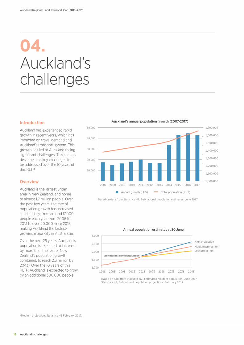
Overview
Auckland is the largest urban area in New Zealand, and home to almost 1.7 million people. Over the past few years, the rate of population growth has increased substantially, from around 17,000 people each year from 2006 to 2013 to over 40,000 since 2015, making Auckland the fastest-growing major city in Australasia.
Over the next 25 years, Auckland’s population is expected to increase by more than the rest of New Zealand’s population growth combined, to reach 2.3 million by 2043.1 Over the 10 years of this RLTP, Auckland is expected to grow by an additional 300,000 people.
1,700,00050,000
40,000
30,000
20,000
10,000
2007 2008 2009 2010 2011 2012 2013 2014 2015 2016 2017
1,600,000
1,500,000
1,400,000
1,300,000
1,200,000
1,100,000
1,000,000
Annual growth (LHS) Total population (RHS)
Based on data from Statistics NZ, Subnational population estimates: June 2017
Auckland’s annual population growth (2007-2017)
3,000
2,500
2,000
1,500
1,0001998 2003 2008 2013 2018 2023 2028 2033 2038 2043
High projection
Medium projectionLow projection
Based on data from Statistics NZ, Estimated resident population: June 2017Statistics NZ, Subnational population projections: February 2017
Estimated residential population
Annual population estimates at 30 June
1 Medium projection, Statistics NZ February 2017.
Auckland’s challenges 17
Auckland Regional Land Transport Plan 2018–2028
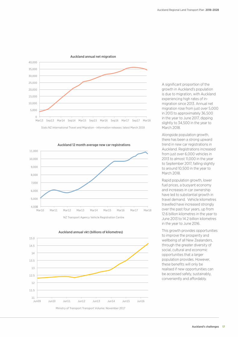
A significant proportion of the growth in Auckland’s population is due to migration, with Auckland experiencing high rates of in-migration since 2013. Annual net migration rose from just over 5,000 in 2013 to approximately 36,500 in the year to June 2017, dipping slightly to 34,500 in the year to March 2018.
Alongside population growth, there has been a strong upward trend in new car registrations in Auckland. Registrations increased from just over 6,000 vehicles in 2013 to almost 11,000 in the year to September 2017, falling slightly to around 10,500 in the year to March 2018.
Rapid population growth, lower fuel prices, a buoyant economy and increases in car ownership have led to substantial growth in travel demand. Vehicle kilometres travelled have increased strongly over the past four years, up from 12.6 billion kilometres in the year to June 2013 to 14.2 billion kilometres in the year to June 2016.
This growth provides opportunities to improve the prosperity and wellbeing of all New Zealanders, through the greater diversity of social, cultural and economic opportunities that a larger population provides. However, these benefits will only be realised if new opportunities can be accessed safely, sustainably, conveniently and affordably.
40,000
35,000
30,000
25,000
20,000
15,000
10,000
5,000
0Mar13 Sep13 Mar14 Sep14 Mar15 Sep15 Mar16 Sep16 Mar17 Sep17 Mar18
Stats NZ International Travel and Migration - information releases: latest March 2018
Auckland annual net migration
11,000
10,000
9,000
8,000
7,000
6,000
5,000
4,0000Mar10 Mar11 Mar12 Mar13 Mar14 Mar15 Mar16 Mar17 Mar18
NZ Transport Agency Vehicle Registration Centre
Auckland 12 month average new car registrations
15.0
14.5
14
13.5
13
12.5
12
11.5
11Jun09 Jun10 Jun11 Jun12 Jun13 Jun14 Jun15 Jun16
Ministry of Transport Transport Volume: November 2017
Auckland annual vkt (billions of kilometres)
Auckland’s Challenges
Auckland Regional Land Transport Plan 2018–2028
18
Safety
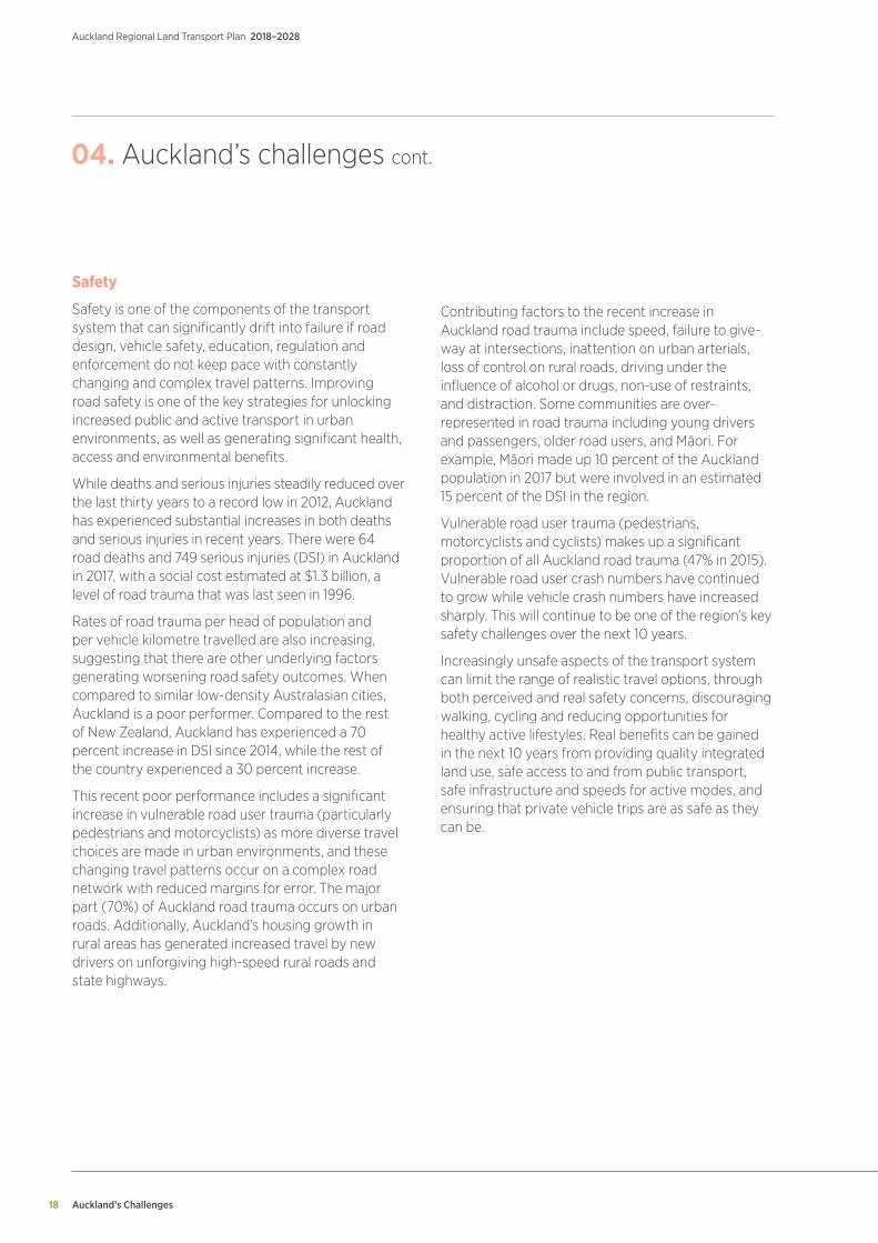
Safety is one of the components of the transport system that can significantly drift into failure if road design, vehicle safety, education, regulation and enforcement do not keep pace with constantly changing and complex travel patterns. Improving road safety is one of the key strategies for unlocking increased public and active transport in urban environments, as well as generating significant health, access and environmental benefits.
While deaths and serious injuries steadily reduced over the last thirty years to a record low in 2012, Auckland has experienced substantial increases in both deaths and serious injuries in recent years. There were 64 road deaths and 749 serious injuries (DSI) in Auckland in 2017, with a social cost estimated at $1.3 billion, a level of road trauma that was last seen in 1996.
Rates of road trauma per head of population and per vehicle kilometre travelled are also increasing, suggesting that there are other underlying factors generating worsening road safety outcomes. When compared to similar low-density Australasian cities, Auckland is a poor performer. Compared to the rest of New Zealand, Auckland has experienced a 70 percent increase in DSI since 2014, while the rest of the country experienced a 30 percent increase.
This recent poor performance includes a significant increase in vulnerable road user trauma (particularly pedestrians and motorcyclists) as more diverse travel choices are made in urban environments, and these changing travel patterns occur on a complex road network with reduced margins for error. The major part (70%) of Auckland road trauma occurs on urban roads. Additionally, Auckland’s housing growth in rural areas has generated increased travel by new drivers on unforgiving high-speed rural roads and state highways.
04. Auckland’s challenges cont.
Contributing factors to the recent increase in Auckland road trauma include speed, failure to give-way at intersections, inattention on urban arterials, loss of control on rural roads, driving under the influence of alcohol or drugs, non-use of restraints, and distraction. Some communities are over-represented in road trauma including young drivers and passengers, older road users, and Māori. For example, Māori made up 10 percent of the Auckland population in 2017 but were involved in an estimated 15 percent of the DSI in the region.
Vulnerable road user trauma (pedestrians, motorcyclists and cyclists) makes up a significant proportion of all Auckland road trauma (47% in 2015). Vulnerable road user crash numbers have continued to grow while vehicle crash numbers have increased sharply. This will continue to be one of the region’s key safety challenges over the next 10 years.
Increasingly unsafe aspects of the transport system can limit the range of realistic travel options, through both perceived and real safety concerns, discouraging walking, cycling and reducing opportunities for healthy active lifestyles. Real benefits can be gained in the next 10 years from providing quality integrated land use, safe access to and from public transport, safe infrastructure and speeds for active modes, and ensuring that private vehicle trips are as safe as they can be.
Auckland’s challenges 19
Auckland Regional Land Transport Plan 2018–2028
Congestion
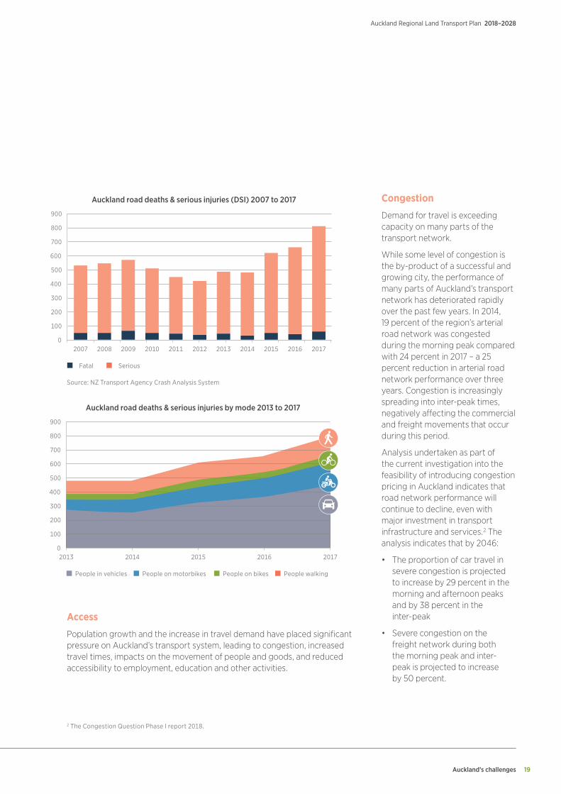
Demand for travel is exceeding capacity on many parts of the transport network.
While some level of congestion is the by-product of a successful and growing city, the performance of many parts of Auckland’s transport network has deteriorated rapidly over the past few years. In 2014, 19 percent of the region’s arterial road network was congested during the morning peak compared with 24 percent in 2017 – a 25 percent reduction in arterial road network performance over three years. Congestion is increasingly spreading into inter-peak times, negatively affecting the commercial and freight movements that occur during this period.
Analysis undertaken as part of the current investigation into the feasibility of introducing congestion pricing in Auckland indicates that road network performance will continue to decline, even with major investment in transport infrastructure and services.2 The analysis indicates that by 2046:
• The proportion of car travel in severe congestion is projected to increase by 29 percent in the morning and afternoon peaks and by 38 percent in the inter-peak
• Severe congestion on the freight network during both the morning peak and inter- peak is projected to increase by 50 percent.
Access
Population growth and the increase in travel demand have placed significant pressure on Auckland’s transport system, leading to congestion, increased travel times, impacts on the movement of people and goods, and reduced accessibility to employment, education and other activities.
900
700
600
500
400
300
200
100
02007 2008 2009 2010 2011 2012 2013 2014 2015 2016 2017
Auckland road deaths & serious injuries (DSI) 2007 to 2017
800
Fatal Serious
Source: NZ Transport Agency Crash Analysis System
900
700
600
500
400
300
200
100
02013 2014 2015 2016 2017
Auckland road deaths & serious injuries by mode 2013 to 2017
800
People in vehicles People on motorbikes People on bikes People walking
2 The Congestion Question Phase I report 2018.
Auckland’s Challenges
Auckland Regional Land Transport Plan 2018–2028
20
04. Auckland’s challenges cont.
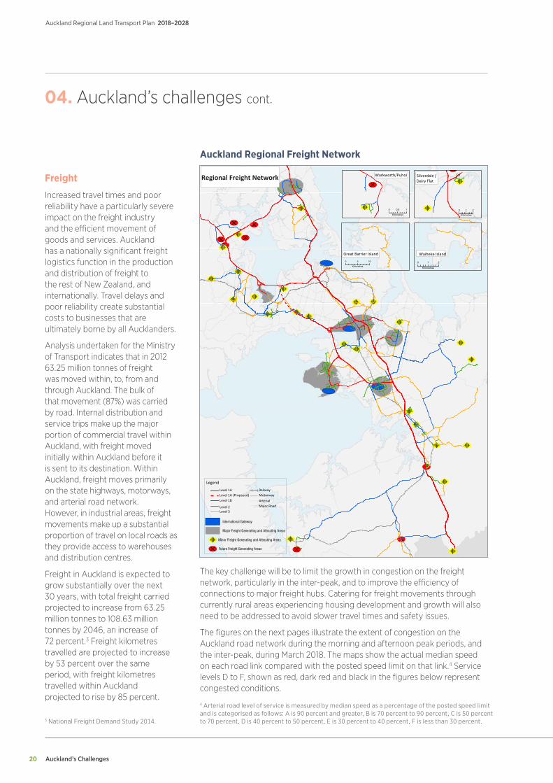
Freight
Increased travel times and poor reliability have a particularly severe impact on the freight industry and the efficient movement of goods and services. Auckland has a nationally significant freight logistics function in the production and distribution of freight to the rest of New Zealand, and internationally. Travel delays and poor reliability create substantial costs to businesses that are ultimately borne by all Aucklanders.
Analysis undertaken for the Ministry of Transport indicates that in 2012 63.25 million tonnes of freight was moved within, to, from and through Auckland. The bulk of that movement (87%) was carried by road. Internal distribution and service trips make up the major portion of commercial travel within Auckland, with freight moved initially within Auckland before it is sent to its destination. Within Auckland, freight moves primarily on the state highways, motorways, and arterial road network. However, in industrial areas, freight movements make up a substantial proportion of travel on local roads as they provide access to warehouses and distribution centres.
Freight in Auckland is expected to grow substantially over the next 30 years, with total freight carried projected to increase from 63.25 million tonnes to 108.63 million tonnes by 2046, an increase of 72 percent.3 Freight kilometres travelled are projected to increase by 53 percent over the same period, with freight kilometres travelled within Auckland projected to rise by 85 percent.
Level 1ALevel 1A (Proposed)Level 1B
Level 3Level 2
RailwayMotorwayArterialMajor Road
0 0.5 1
Kilometres
Silverdale /Dairy Flat
0 1 2
Kilometres
Waiheke Island
0 1 2
Kilometres
Legend
Great Barrier Island0 5 10
Kilometres
International Gateway
Major Freight Generating and Attracting Areas
Minor Freight Generating and Attracting Areas
Future Freight Generating Areas
Warkworth/PuhoiRegional Freight Network
Auckland Regional Freight Network
The key challenge will be to limit the growth in congestion on the freight network, particularly in the inter-peak, and to improve the efficiency of connections to major freight hubs. Catering for freight movements through currently rural areas experiencing housing development and growth will also need to be addressed to avoid slower travel times and safety issues.
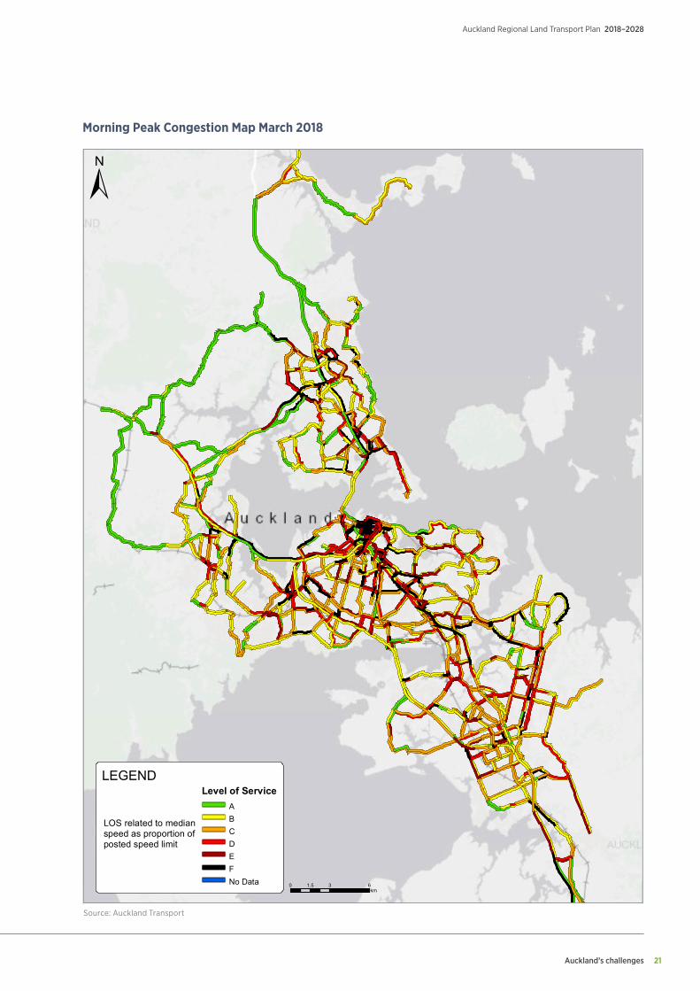
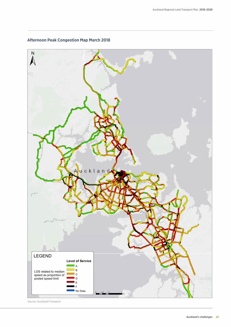
The figures on the next pages illustrate the extent of congestion on the Auckland road network during the morning and afternoon peak periods, and the inter-peak, during March 2018. The maps show the actual median speed on each road link compared with the posted speed limit on that link.4 Service levels D to F, shown as red, dark red and black in the figures below represent congested conditions.
3 National Freight Demand Study 2014.
4 Arterial road level of service is measured by median speed as a percentage of the posted speed limit and is categorised as follows: A is 90 percent and greater, B is 70 percent to 90 percent, C is 50 percent to 70 percent, D is 40 percent to 50 percent, E is 30 percent to 40 percent, F is less than 30 percent.
Auckland’s challenges 21
Auckland Regional Land Transport Plan 2018–2028
Morning Peak Congestion Map March 2018
±
0 3 61.5km
LEGENDSnitch Traffic AM Level of Service
ABCDEFNo Data
LOS related to medianspeed as proportion ofposted speed limit
Source: Auckland TransportSource: Auckland Transport

Auckland’s Challenges
Auckland Regional Land Transport Plan 2018–2028
22
Inter-peak Congestion Map March 2018
±
0 3 61.5km
LEGENDSnitch Traffic AM Level of Service
ABCDEFNo Data
LOS related to medianspeed as proportion ofposted speed limit
Source: Auckland TransportSource: Auckland Transport
Auckland’s challenges 23
Auckland Regional Land Transport Plan 2018–2028
Afternoon Peak Congestion Map March 2018
±
0 3 61.5km
LEGENDSnitch Traffic AM Level of Service
ABCDEFNo Data
LOS related to medianspeed as proportion ofposted speed limit
Source: Auckland TransportSource: Auckland Transport
Auckland’s Challenges
Auckland Regional Land Transport Plan 2018–2028
24
Accessibility
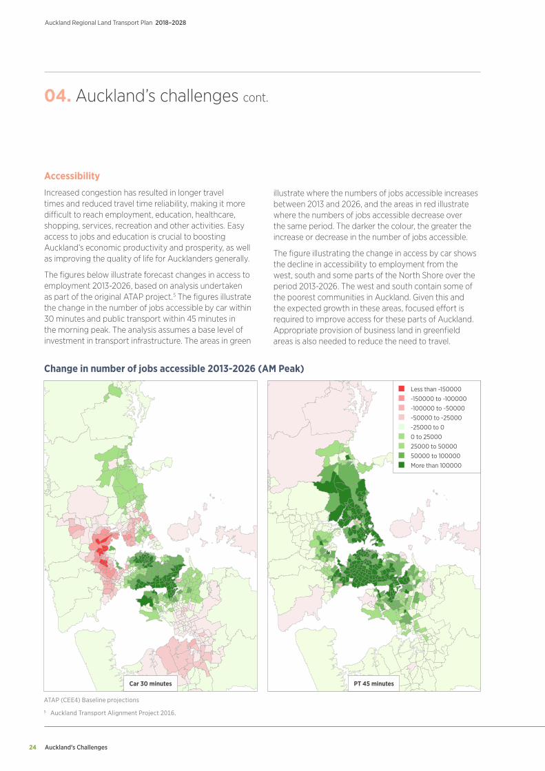
Increased congestion has resulted in longer travel times and reduced travel time reliability, making it more difficult to reach employment, education, healthcare, shopping, services, recreation and other activities. Easy access to jobs and education is crucial to boosting Auckland’s economic productivity and prosperity, as well as improving the quality of life for Aucklanders generally.
The figures below illustrate forecast changes in access to employment 2013-2026, based on analysis undertaken as part of the original ATAP project.5 The figures illustrate the change in the number of jobs accessible by car within 30 minutes and public transport within 45 minutes in the morning peak. The analysis assumes a base level of investment in transport infrastructure. The areas in green
04. Auckland’s challenges cont.
illustrate where the numbers of jobs accessible increases between 2013 and 2026, and the areas in red illustrate where the numbers of jobs accessible decrease over the same period. The darker the colour, the greater the increase or decrease in the number of jobs accessible.
The figure illustrating the change in access by car shows the decline in accessibility to employment from the west, south and some parts of the North Shore over the period 2013-2026. The west and south contain some of the poorest communities in Auckland. Given this and the expected growth in these areas, focused effort is required to improve access for these parts of Auckland. Appropriate provision of business land in greenfield areas is also needed to reduce the need to travel.
Change in number of jobs accessible 2013-2026 (AM Peak)
ATAP (CEE4) Baseline projections
5 Auckland Transport Alignment Project 2016.
Less than -150000 -150000 to -100000 -100000 to -50000 -50000 to -25000 -25000 to 0 0 to 25000 25000 to 50000 50000 to 100000 More than 100000
PT 45 minutesCar 30 minutes
Auckland’s challenges 25
Auckland Regional Land Transport Plan 2018–2028
The availability of public transport is also a key factor influencing accessibility. Extending public transport coverage and service frequency will play a key part in improving accessibility and increasing public transport mode share.
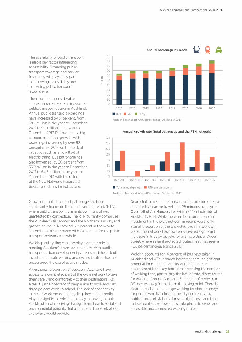
There has been considerable success in recent years in increasing public transport uptake in Auckland. Annual public transport boardings have increased by 31 percent, from 69.7 million in the year to December 2013 to 91.1 million in the year to December 2017. Rail has been a big component of that growth, with boardings increasing by over 92 percent since 2013, on the back of initiatives such as a new fleet of electric trains. Bus patronage has also increased, by 20 percent from 53.9 million in the year to December 2013 to 64.6 million in the year to December 2017, with the rollout of the New Network, integrated ticketing and new fare structure.
Growth in public transport patronage has been significantly higher on the rapid transit network (RTN) where public transport runs in its own right of way, unaffected by congestion. The RTN currently comprises the Auckland rail network and the Northern Busway, and growth on the RTN totalled 12.7 percent in the year to December 2017 compared with 7.4 percent for the public transport network as a whole.
Walking and cycling can also play a greater role in meeting Auckland’s transport needs. As with public transport, urban development patterns and the lack of investment in safe walking and cycling facilities has not encouraged the use of active modes.
A very small proportion of people in Auckland have access to a completed part of the cycle network to take them safely and comfortably to their destinations. As a result, just 1.2 percent of people ride to work and just three percent cycle to school. The lack of connectivity in the network means that cycling does not currently play the significant role it could play in moving people. Auckland is not receiving the significant health, social and environmental benefits that a connected network of safe cycleways would provide.
Nearly half of peak time trips are under six kilometres, a distance that can be travelled in 25 minutes by bicycle. Over half of Aucklanders live within a 15-minute ride of Auckland’s RTN. While there has been an increase in investment in the cycle network in recent years, only a small proportion of the protected cycle network is in place. This network has however delivered significant increases in trips by bicycle, for example Upper Queen Street, where several protected routes meet, has seen a 406 percent increase since 2013.
Walking accounts for 14 percent of journeys taken in Auckland and AT’s research indicates there is significant potential for more. The quality of the pedestrian environment is the key barrier to increasing the number of walking trips, particularly the lack of safe, direct routes for walking. Around Auckland 51 percent of pedestrian DSI occurs away from a formal crossing point. There is clear potential to encourage walking for short journeys for people who live close to the city centre, nearby public transport stations, for school journeys and trips to local centres, supported by safe places to cross, and accessible and connected walking routes.
100
Mill
ion
80
70
60
50
40
30
20
10
0
-5%
0%
5%
10%
15%
20%
25%
30%
2010
Dec 2011 Dec 2013 Dec 2014 Dec 2015 Dec 2016 Dec 2017
2011 2012 2013 2014 2015 2016 2017
Annual patronage by mode
Annual growth rate (total patronage and the RTN network)
90
Bus Rail Ferry
Total annual growth RTN annual growth
Auckland Transport Annual Patronage: December 2017
Auckland Transport Annual Patronage: December 2017
Dec 2012
Auckland’s Challenges
Auckland Regional Land Transport Plan 2018–2028
26
Environment
Auckland’s transport network forms a large part of the region’s public space. Where the balance between movement and place is tilted towards moving vehicles, the network can create a number of unwanted impacts on people and communities.
These impacts include noise and air pollution that can affect visual amenity, sense of community, and reduce physical connections between key local destinations and within communities. As transport corridors become more congested, it becomes increasingly difficult to manage the balance between movement and place, and to create attractive and welcoming public spaces. This is particularly the case in the city centre, and where major arterial routes pass through local and regional centres. Historical development patterns and legacy practices have also resulted in significant disparity in tree cover in different parts of the region, including within the road corridor.
Transport also has significant impacts on surrounding ecosystems. These include:
• contributing to the contamination of waterways through run-off
• flooding and stormwater overflow due to infrastructure being unable to cope with extreme weather events
• visual and noise pollution
• loss of green space
• disruption to ecosystems with the construction of new transport infrastructure
• soil and groundwater contamination.
At the local level, runoff from the transport network contributes to the pollution of waterways while the construction of new transport infrastructure has the potential to generate environmental, cultural and social impacts that need to be appropriately mitigated.
Particulates and other vehicle emissions compromise air quality and harm the health of Aucklanders. Unattractive environments for walking and cycling contribute to lower levels of physical activity and a wide variety of associated health problems, including obesity and diabetes.
Transport is Auckland’s largest contributor to greenhouse gas emissions at 40 percent, which is much higher than the 18 percent national average, the majority of which comes from road transport. This in turn contributes to the global challenge of climate change. Reducing greenhouse gas emissions from the transport system is fundamental to meeting regional, national and international commitments to mitigate the impact of climate change.
Addressing greenhouse gas targets represents a significant challenge and opportunity with the growth anticipated within Auckland. The Government will be undertaking engagement on the Zero Carbon Bill in 2018. Auckland Council will also be updating Low Carbon Auckland in 2018.
04. Auckland’s challenges cont.
Growth
Accommodating Auckland’s rapid population growth requires accelerating the construction of housing and business development. Opening up rural land for development, and facilitating redevelopment of existing urban areas to higher densities, is frequently dependent upon the provision of new transport infrastructure and services.
At current rates of population growth and household occupancy, Auckland will likely require another 320,000 dwellings to be built by 2050.6 Two thirds are expected to be built in existing urban areas, and the rest in areas that are currently rural.
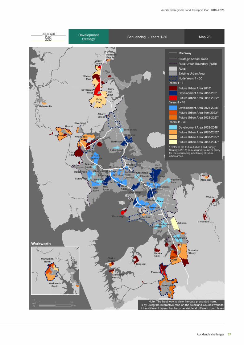
Significant investment is required to enable and support growth in the region. The Unitary Plan identifies around 15,000 hectares of rural land for future urbanisation to accommodate around 135,000 dwellings. This will require new transport, water and wastewater infrastructure in targeted growth areas. While this infrastructure will be partly provided by developers, it will require significant public sector investment. The map below illustrates the scale and location of key areas of proposed development in the Auckland region over the next 30 years.
Managing the transport impacts of both private and public sector development will also be a major challenge over the next decade. While integrated planning of new development can assist in reducing travel demand, the direct impacts of accommodating demand generated by new developments, and those arising from the provision of transport infrastructure, will be significant.
6 Auckland Plan 2050.
Auckland’s challenges 27
Auckland Regional Land Transport Plan 2018–2028
Manurewa
Otara
ClarksBeach
GlenbrookBeach
Kingseat
Pukekohe
Paerata
DruryWest
Opaheke/ Drury
Papakura
ClendonTakanini
Papatoetoe
Clevedon
Whitford
KarakaNorth
TamakiHighlandPark
Pakuranga
GlenInnes
SylviaPark
EllerslieGreenlaneDominion
RoadCorridor
Puhinui
Otahuhu
Mangere
Oruarangi
ThreeKings
Onehunga
NewtonMorningside
St Lukes
Mt Roskill
NewLynn
GlenEden
Mt AlbertAvondale
Te AtatuSouth
Te AtatuPeninsula
Glendene
Sunnyvale Kelston
Henderson
WestgateRedHills
Kumeu
HuapaiRiverhead
Whenuapai
Sunnynook
Takapuna
Northcote
Birkenhead
AlbanyVillage
Helensville
DairyFlatEast
DairyFlat
SilverdaleWest
WainuiEast
UpperOrewa
HatfieldsBeach
Hingaia
Maraetai
-
-
-
-
- - -
-
-
-
-
Sequencing - Years 1-30
0 5 10km
Map 28
Motorway
Strategic Arterial RoadRural Urban Boundary (RUB)RuralExisting Urban AreaNode Years 1 - 30
Years 1 - 3
Future Urban Area 2018*Development Area 2018-2021Future Urban Area 2018-2022*
Years 4 - 10
Development Area 2021-2028Future Urban Area from 2022*Future Urban Area 2023-2027*
Years 11 - 30
Development Area 2028-2048Future Urban Area 2028-2032*Future Urban Area 2033-2037*Future Urban Area 2043-2047*
DevelopmentStrategy
* Refer to the Future Urban Land SupplyStrategy (2017) as Auckland Council's policyfor the sequencing and timing of futureurban areas.
WarkworthSouth
WarkworthNorth
Warkworth
Note: The best way to view the data presented here,is by using the interactive map on the Auckland Council website.It has different layers that become visible at different zoom levels

Auckland’s Challenges
Auckland Regional Land Transport Plan 2018–2028
28
Value for money
A major challenge in Auckland is to ensure ratepayers and taxpayers receive value for money in the delivery of transport services and infrastructure in an environment where there are significant growth pressures, rapid increases in property, land and construction costs, and an increasing number of parties delivering transport infrastructure.
Added to this are the difficulties of building infrastructure in already developed areas, such as the city centre, and the increasing complexity of the infrastructure required. Such examples include the Waterview Tunnel, which opened in mid-2017, and the City Rail Link (CRL), which is currently under construction.
Construction costs have increased significantly since 2011, with particularly strong growth since 2014. The figure above illustrates the national trend in construction costs since 2009, with particularly strong upward growth evident since 2014.
The increasing number of parties involved in the delivery of transport infrastructure also creates the challenge of ensuring that transport investment is made in the most cost-effective way. The need to clearly define roles, responsibilities, interface arrangements and agree risk allocation can add time, cost and complexity to the planning, funding and delivery of transport projects and services.
Several parties have been established to deliver transport infrastructure over the past two years, including the City Rail Link Limited (CRLL) to deliver the CRL, and Crown Infrastructure Partners to assist in the delivery of roading infrastructure to support housing development. There is potential for additional agencies to be established during the period of this RLTP.
04. Auckland’s challenges cont.
1,300 10%
9%
8%
7%
6%
5%
5%
3%
2%
1%
0%
1,200
1,300
1,200
900Jun 09 Jun 17Jun 16Jun 15Jun 14Jun 13Jun 12Jun 11Jun 10
Index, CGPI all constructions Population (LHS) GGPI annual % increases (RHS)
Stats NZ Price indexes for the construction industry: September 2017
Capital goods price index all construction, indexed at June 2009
Auckland’s Challenges 29
Auckland Regional Land Transport Plan 2018–2028
Addressing Auckland’s Challenges
Auckland Regional Land Transport Plan 2018–2028
30
05.Addressing Auckland’s challenges
Introduction
This chapter describes the funded transport programme for the 10 years of this RLTP.
The programme seeks to align the outcomes sought by the Auckland Plan, the GPS 2018, and the ATAP recommendations, consistent with the funding available over the next decade, including the Auckland RFT scheme. It reflects the feedback received during public consultation on the draft RLTP.
Appendix 1 provides AT’s programme shown in two parts. Table 1A of Appendix 1 lists the projects included in the funded transport programme described in this chapter. Table 1B lists projects that are not currently included in
the funded programme, but which may be considered for inclusion should additional funding become available.
Appendix 2 provides the Transport Agency’s Investment Programme including committed projects, and major state highway and rapid transit projects.
Appendix 3 lists rail infrastructure projects included in the funded transport programme. Appendix 3 also includes provision for inter-regional and express rail services, identified in ATAP as a priority as further funding becomes available.
Appendix 4 lists projects to be undertaken by the Department of Conservation.
Addressing Auckland’s Challenges 31
Auckland Regional Land Transport Plan 2018–2028
Strategic approach
The programme set out in this RLTP will enable Auckland to address its current challenges and take advantage of future growth, while at the same time enabling the creation of an accessible, well-connected, safe and sustainable region.
It will support the move away from a city where the dominant mode of travel is by single-occupant private vehicles, to a city where public transport and walking and cycling play a more important role. Significant investment in transport infrastructure such as light rail, mass transit, bus priority and cycleways, supported by improvements to bus, rail and ferry services, will support Auckland achieving these goals. This will be supported by a much greater focus on customer needs and improving customer experience.
Investment in walking and cycling facilities will be supported by the provision of more shared spaces, amenity improvements, cycleways and footpaths, better network connections, end of journey facilities, more and improved pedestrian crossings, signal phasing that prioritises pedestrians, and safer traffic speeds.
Addressing the negative impacts of the transport system is a core element of the programme in this RLTP, in particular to reduce deaths and serious injuries (DSI). This will be achieved through a comprehensive programme of safety improvements, including targeted initiatives such as improvements to high-risk intersections and corridors, and speed management.
Minimising transport impacts on the environment is also a core focus of the programme, through better design, greater use of more sustainable travel options, the rollout of LED lighting, the installation of pollutant traps to minimise the impacts of road stormwater damage, and encouraging the uptake of electric vehicles.
Improving network capacity and performance by making the most of the existing transport system is key. For example, optimising the network through targeted changes such as improving the coordination of traffic lights, the use of dynamic lanes at peak times, and removing bottlenecks to mitigate congestion. Maximising the benefits from new technology and taking opportunities to influence travel demand through encouraging car sharing and mobility as a service (MaaS) are also important, and in the longer term considering the introduction of pricing to address congestion.
While the primary focus is to reduce reliance on the private car, there is still a need to invest in roads. The programme in this RLTP addresses congestion on the arterial road network, supporting the movement of freight including access to key freight locations, the port and Auckland Airport, and enabling public transport to support housing and development.
Addressing Auckland’s Challenges
Auckland Regional Land Transport Plan 2018–2028
32
05. Addressing Auckland’s Challenges cont.
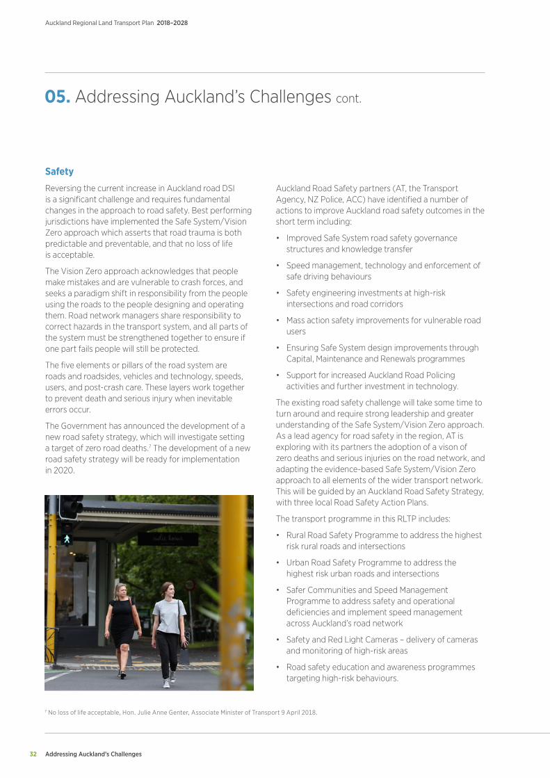
Safety
Reversing the current increase in Auckland road DSI is a significant challenge and requires fundamental changes in the approach to road safety. Best performing jurisdictions have implemented the Safe System/Vision Zero approach which asserts that road trauma is both predictable and preventable, and that no loss of life is acceptable.
The Vision Zero approach acknowledges that people make mistakes and are vulnerable to crash forces, and seeks a paradigm shift in responsibility from the people using the roads to the people designing and operating them. Road network managers share responsibility to correct hazards in the transport system, and all parts of the system must be strengthened together to ensure if one part fails people will still be protected.
The five elements or pillars of the road system are roads and roadsides, vehicles and technology, speeds, users, and post-crash care. These layers work together to prevent death and serious injury when inevitable errors occur.
The Government has announced the development of a new road safety strategy, which will investigate setting a target of zero road deaths.7 The development of a new road safety strategy will be ready for implementation in 2020.
Auckland Road Safety partners (AT, the Transport Agency, NZ Police, ACC) have identified a number of actions to improve Auckland road safety outcomes in the short term including:
• Improved Safe System road safety governance structures and knowledge transfer
• Speed management, technology and enforcement of safe driving behaviours
• Safety engineering investments at high-risk intersections and road corridors
• Mass action safety improvements for vulnerable road users
• Ensuring Safe System design improvements through Capital, Maintenance and Renewals programmes
• Support for increased Auckland Road Policing activities and further investment in technology.
The existing road safety challenge will take some time to turn around and require strong leadership and greater understanding of the Safe System/Vision Zero approach. As a lead agency for road safety in the region, AT is exploring with its partners the adoption of a vison of zero deaths and serious injuries on the road network, and adapting the evidence-based Safe System/Vision Zero approach to all elements of the wider transport network. This will be guided by an Auckland Road Safety Strategy, with three local Road Safety Action Plans.
The transport programme in this RLTP includes:
• Rural Road Safety Programme to address the highest risk rural roads and intersections
• Urban Road Safety Programme to address the highest risk urban roads and intersections
• Safer Communities and Speed Management Programme to address safety and operational deficiencies and implement speed management across Auckland’s road network
• Safety and Red Light Cameras – delivery of cameras and monitoring of high-risk areas
• Road safety education and awareness programmes targeting high-risk behaviours.
7 No loss of life acceptable, Hon. Julie Anne Genter, Associate Minister of Transport 9 April 2018.
Addressing Auckland’s Challenges 33
Auckland Regional Land Transport Plan 2018–2028
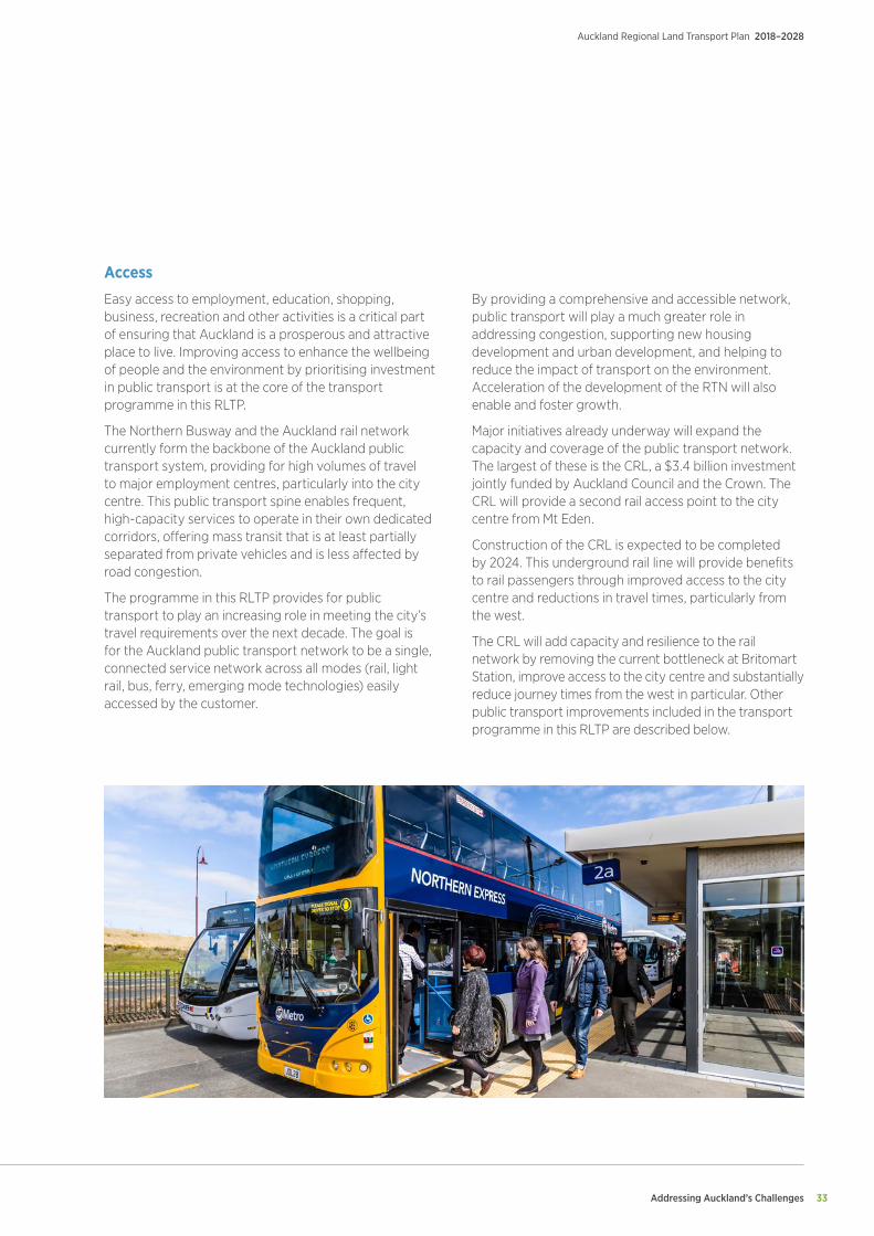
Access
Easy access to employment, education, shopping, business, recreation and other activities is a critical part of ensuring that Auckland is a prosperous and attractive place to live. Improving access to enhance the wellbeing of people and the environment by prioritising investment in public transport is at the core of the transport programme in this RLTP.
The Northern Busway and the Auckland rail network currently form the backbone of the Auckland public transport system, providing for high volumes of travel to major employment centres, particularly into the city centre. This public transport spine enables frequent, high-capacity services to operate in their own dedicated corridors, offering mass transit that is at least partially separated from private vehicles and is less affected by road congestion.
The programme in this RLTP provides for public transport to play an increasing role in meeting the city’s travel requirements over the next decade. The goal is for the Auckland public transport network to be a single, connected service network across all modes (rail, light rail, bus, ferry, emerging mode technologies) easily accessed by the customer.
By providing a comprehensive and accessible network, public transport will play a much greater role in addressing congestion, supporting new housing development and urban development, and helping to reduce the impact of transport on the environment. Acceleration of the development of the RTN will also enable and foster growth.
Major initiatives already underway will expand the capacity and coverage of the public transport network. The largest of these is the CRL, a $3.4 billion investment jointly funded by Auckland Council and the Crown. The CRL will provide a second rail access point to the city centre from Mt Eden.
Construction of the CRL is expected to be completed by 2024. This underground rail line will provide benefits to rail passengers through improved access to the city centre and reductions in travel times, particularly from the west.
The CRL will add capacity and resilience to the rail network by removing the current bottleneck at Britomart Station, improve access to the city centre and substantially reduce journey times from the west in particular. Other public transport improvements included in the transport programme in this RLTP are described below.
Addressing Auckland’s Challenges
Auckland Regional Land Transport Plan 2018–2028
34
05. Addressing Auckland’s Challenges cont.
Rapid transit and buses
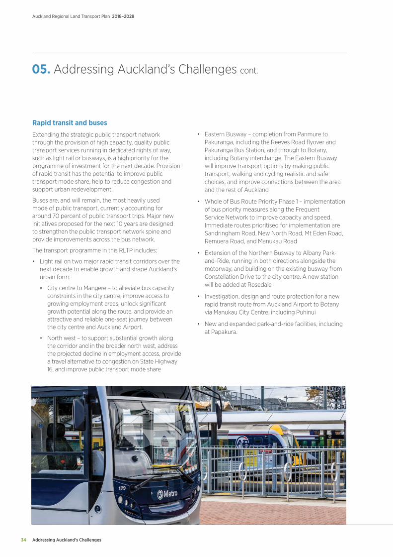
Extending the strategic public transport network through the provision of high capacity, quality public transport services running in dedicated rights of way, such as light rail or busways, is a high priority for the programme of investment for the next decade. Provision of rapid transit has the potential to improve public transport mode share, help to reduce congestion and support urban redevelopment.
Buses are, and will remain, the most heavily used mode of public transport, currently accounting for around 70 percent of public transport trips. Major new initiatives proposed for the next 10 years are designed to strengthen the public transport network spine and provide improvements across the bus network.
The transport programme in this RLTP includes:
• Light rail on two major rapid transit corridors over the next decade to enable growth and shape Auckland’s urban form:
° City centre to Mangere – to alleviate bus capacity constraints in the city centre, improve access to growing employment areas, unlock significant growth potential along the route, and provide an attractive and reliable one-seat journey between the city centre and Auckland Airport.
° North west – to support substantial growth along the corridor and in the broader north west, address the projected decline in employment access, provide a travel alternative to congestion on State Highway 16, and improve public transport mode share
• Eastern Busway – completion from Panmure to Pakuranga, including the Reeves Road flyover and Pakuranga Bus Station, and through to Botany, including Botany interchange. The Eastern Busway will improve transport options by making public transport, walking and cycling realistic and safe choices, and improve connections between the area and the rest of Auckland
• Whole of Bus Route Priority Phase 1 – implementation of bus priority measures along the Frequent Service Network to improve capacity and speed. Immediate routes prioritised for implementation are Sandringham Road, New North Road, Mt Eden Road, Remuera Road, and Manukau Road
• Extension of the Northern Busway to Albany Park-and-Ride, running in both directions alongside the motorway, and building on the existing busway from Constellation Drive to the city centre. A new station will be added at Rosedale
• Investigation, design and route protection for a new rapid transit route from Auckland Airport to Botany via Manukau City Centre, including Puhinui
• New and expanded park-and-ride facilities, including at Papakura.
Addressing Auckland’s Challenges 35
Auckland Regional Land Transport Plan 2018–2028
Ferries
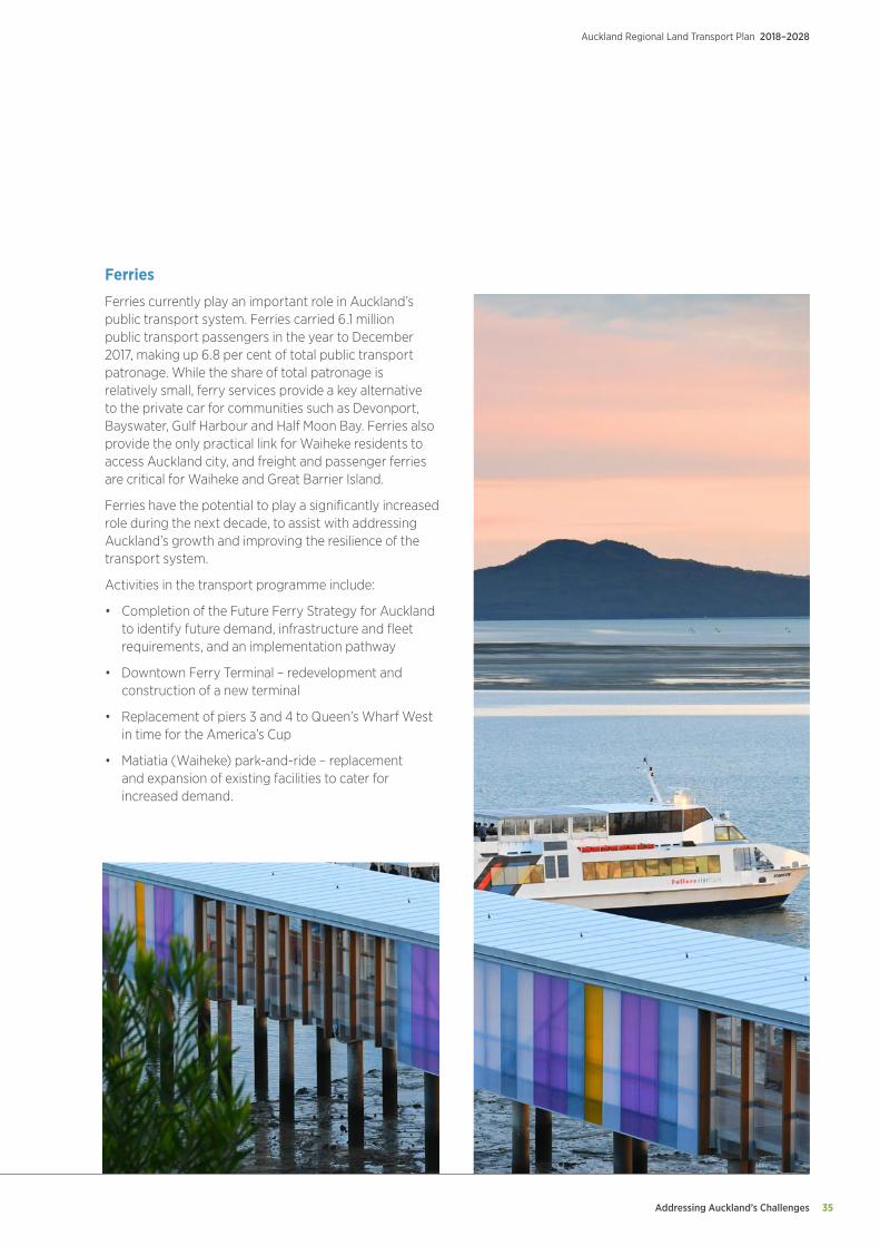
Ferries currently play an important role in Auckland’s public transport system. Ferries carried 6.1 million public transport passengers in the year to December 2017, making up 6.8 per cent of total public transport patronage. While the share of total patronage is relatively small, ferry services provide a key alternative to the private car for communities such as Devonport, Bayswater, Gulf Harbour and Half Moon Bay. Ferries also provide the only practical link for Waiheke residents to access Auckland city, and freight and passenger ferries are critical for Waiheke and Great Barrier Island.
Ferries have the potential to play a significantly increased role during the next decade, to assist with addressing Auckland’s growth and improving the resilience of the transport system.
Activities in the transport programme include:
• Completion of the Future Ferry Strategy for Auckland to identify future demand, infrastructure and fleet requirements, and an implementation pathway
• Downtown Ferry Terminal – redevelopment and construction of a new terminal
• Replacement of piers 3 and 4 to Queen’s Wharf West in time for the America’s Cup
• Matiatia (Waiheke) park-and-ride – replacement and expansion of existing facilities to cater for increased demand.
Addressing Auckland’s Challenges
Auckland Regional Land Transport Plan 2018–2028
36
05. Addressing Auckland’s Challenges cont.
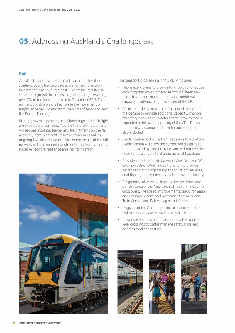
Rail
Auckland’s rail network forms a key part of the city’s strategic public transport system and freight network. Investment in rail over the past 15 years has resulted in substantial growth in rail passenger boardings, reaching over 20 million trips in the year to December 2017. The rail network also plays a key role in the movement of freight, especially to and from the Ports of Auckland, and the Port of Tauranga.
Strong growth in passenger rail boardings and rail freight are expected to continue. Meeting this growing demand will require more passenger and freight trains on the rail network, increasing conflict between services unless ongoing investment occurs. More intensive use of the rail network will also require investment to increase capacity, improve network resilience and maintain safety.
The transport programme in this RLTP includes:
• New electric trains to provide for growth and reduce crowding that would otherwise occur. Fifteen new trains have been ordered to provide additional capacity in advance of the opening of the CRL
• A further order of new trains is planned for later in the decade to provide additional capacity, improve train frequencies and to cater for the growth that is expected to follow the opening of the CRL. Provision for stabling, cleaning, and maintenance facilities is also included
• Electrification of the line from Papakura to Pukekohe. Electrification will allow the current old diesel fleet to be replaced by electric trains, and will remove the need for passengers to change trains at Papakura
• Provision of a third main between Westfield and Wiri and upgrade of Westfield rail junction to provide better separation of passenger and freight services, enabling higher frequencies and improved reliability
• Programme of works to improve the resilience and performance of the Auckland rail network, including crossovers, line speed improvements, track, formation and drainage works, and provision of an Auckland Train Control and Rail Management Centre
• Upgrade of the Onehunga Line to accommodate higher frequency services and longer trains
• Progressive improvement and removal of road/rail level crossings to better manage safety risks and address road congestion.
Addressing Auckland’s Challenges 37
Auckland Regional Land Transport Plan 2018–2028
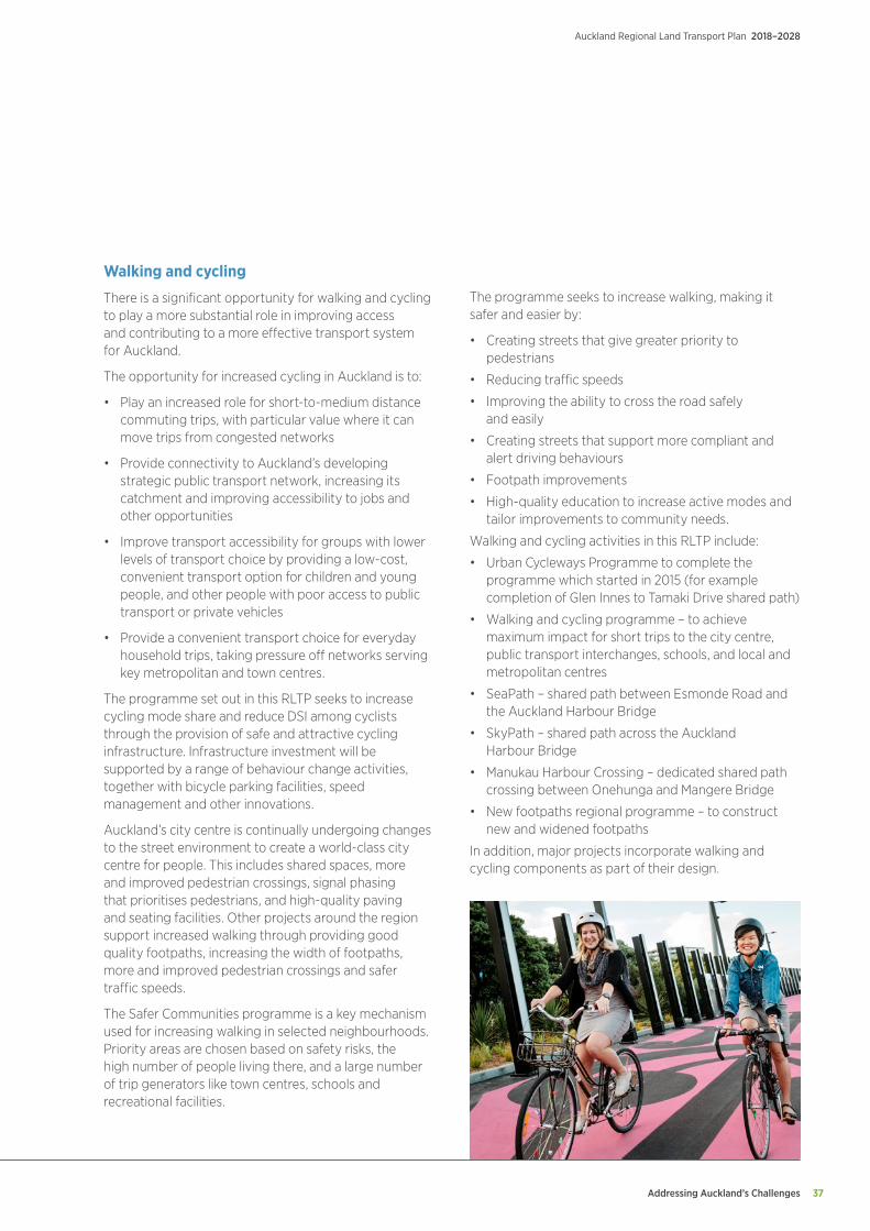
Walking and cycling
There is a significant opportunity for walking and cycling to play a more substantial role in improving access and contributing to a more effective transport system for Auckland.
The opportunity for increased cycling in Auckland is to:
• Play an increased role for short-to-medium distance commuting trips, with particular value where it can move trips from congested networks
• Provide connectivity to Auckland’s developing strategic public transport network, increasing its catchment and improving accessibility to jobs and other opportunities
• Improve transport accessibility for groups with lower levels of transport choice by providing a low-cost, convenient transport option for children and young people, and other people with poor access to public transport or private vehicles
• Provide a convenient transport choice for everyday household trips, taking pressure off networks serving key metropolitan and town centres.
The programme set out in this RLTP seeks to increase cycling mode share and reduce DSI among cyclists through the provision of safe and attractive cycling infrastructure. Infrastructure investment will be supported by a range of behaviour change activities, together with bicycle parking facilities, speed management and other innovations.
Auckland’s city centre is continually undergoing changes to the street environment to create a world-class city centre for people. This includes shared spaces, more and improved pedestrian crossings, signal phasing that prioritises pedestrians, and high-quality paving and seating facilities. Other projects around the region support increased walking through providing good quality footpaths, increasing the width of footpaths, more and improved pedestrian crossings and safer traffic speeds.
The Safer Communities programme is a key mechanism used for increasing walking in selected neighbourhoods. Priority areas are chosen based on safety risks, the high number of people living there, and a large number of trip generators like town centres, schools and recreational facilities.
The programme seeks to increase walking, making it safer and easier by:
• Creating streets that give greater priority to pedestrians
• Reducing traffic speeds
• Improving the ability to cross the road safely and easily
• Creating streets that support more compliant and alert driving behaviours
• Footpath improvements
• High-quality education to increase active modes and tailor improvements to community needs.
Walking and cycling activities in this RLTP include:
• Urban Cycleways Programme to complete the programme which started in 2015 (for example completion of Glen Innes to Tamaki Drive shared path)
• Walking and cycling programme – to achieve maximum impact for short trips to the city centre, public transport interchanges, schools, and local and metropolitan centres
• SeaPath – shared path between Esmonde Road and the Auckland Harbour Bridge
• SkyPath – shared path across the Auckland Harbour Bridge
• Manukau Harbour Crossing – dedicated shared path crossing between Onehunga and Mangere Bridge
• New footpaths regional programme – to construct new and widened footpaths
In addition, major projects incorporate walking and cycling components as part of their design.
Addressing Auckland’s Challenges
Auckland Regional Land Transport Plan 2018–2028
38
City centre
The city centre and surrounding area is projected to be one of the fastest growing employment areas in Auckland over the next 30 years. The city centre is also important for the visitor economy, playing host to significant events, including the America’s Cup and APEC summit in 2021.
Strong growth is expected to continue in the city centre, accompanied by a substantial increase in population, tertiary students and visitors. The city centre is the economic powerhouse of the region, accounting for 20 percent of Auckland’s GDP while only occupying 0.08 per cent of the region’s land area.
Completion of the CRL, together with rapid transit initiatives and improvements to the bus network, will significantly improve access to the city centre and facilitate ongoing modal shift.
City centre upgrades in this RLTP include:
• City centre bus improvements – delivery of bus infrastructure in the city centre including bus priority along Wellesley Street, and a new Learning Quarter bus interchange
• Downtown bus improvements – delivery of new bus interchanges on Quay Street East and Lower Albert Street in conjunction with the CRL and Auckland Council’s Downtown projects.
Auckland Airport
Auckland Airport is the international gateway to New Zealand and key to the tourism economy. It is a major and growing regional employment hub and a key freight destination, particularly for high-value and time-sensitive goods. Auckland Airport handles around 20 million passengers per year and about 15 percent of New Zealand’s foreign trade by value, making it the country’s third largest port. Auckland Airport and businesses in the surrounding area currently employ over 30,000 people, and employment is projected to grow to approximately 90,000 by 2044.
Record levels of both freight and passenger air travel combined with general increases in traffic around the airport precinct have led to journey time unreliability and significant congestion. Daily trips to and from the area are expected to grow from 63,000 to 140,000 over the next 30 years.
Activities in this RLTP to improve access to and from Auckland Airport include:
• Provision of progressively enhanced rapid, high frequency bus services taking advantage of bus/high-ccupancy lanes on State Highway 20B
• Upgrade of Puhinui rail station to provide high quality connections between rail and buses serving Auckland Airport
• Implementation of bus priority measures between Auckland Airport and Botany
• Eastern Airport Access – upgrade to provide an additional lane in each direction between Puhinui and Auckland Airport to support bus, carpool, and freight movements, and an upgrade to the State Highway 20/State Highway 20B Interchange.
These will complement developments undertaken by Auckland Airport to improve pedestrian facilities, bus lanes and stops, lighting and cycling facilities within the Airport precinct.
05. Addressing Auckland’s Challenges cont.
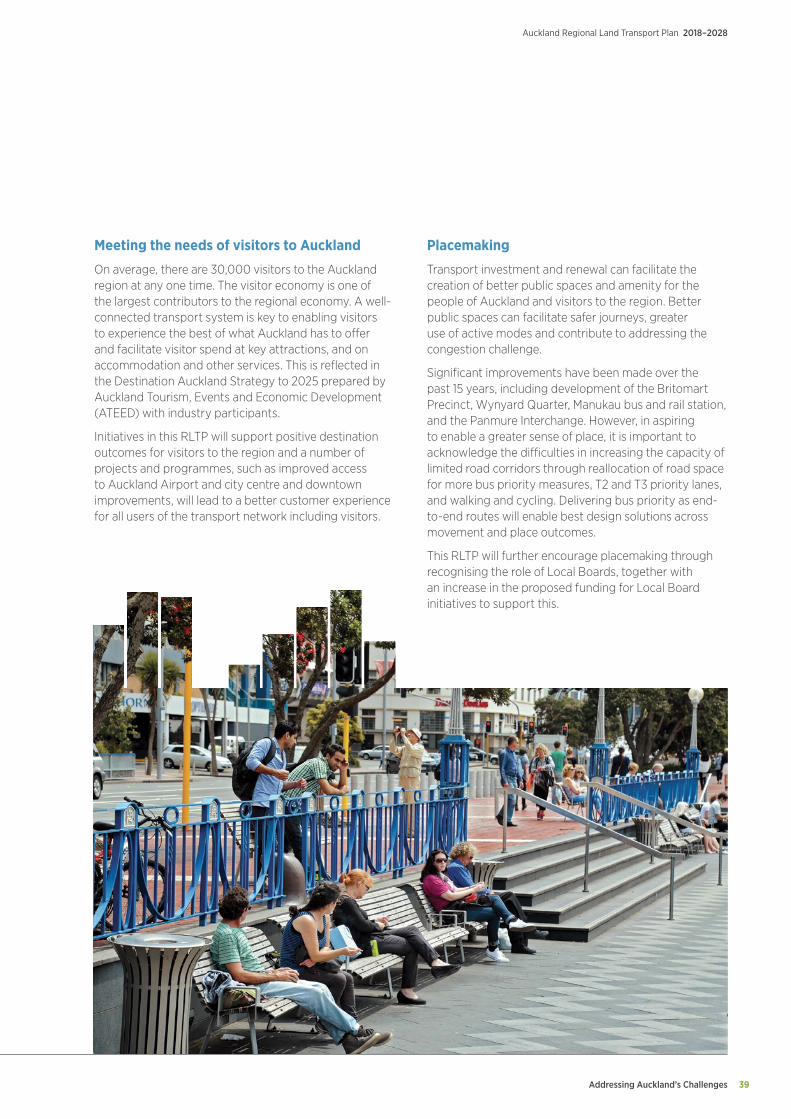
Addressing Auckland’s Challenges 39
Auckland Regional Land Transport Plan 2018–2028
Meeting the needs of visitors to Auckland
On average, there are 30,000 visitors to the Auckland region at any one time. The visitor economy is one of the largest contributors to the regional economy. A well- connected transport system is key to enabling visitors to experience the best of what Auckland has to offer and facilitate visitor spend at key attractions, and on accommodation and other services. This is reflected in the Destination Auckland Strategy to 2025 prepared by Auckland Tourism, Events and Economic Development (ATEED) with industry participants.
Initiatives in this RLTP will support positive destination outcomes for visitors to the region and a number of projects and programmes, such as improved access to Auckland Airport and city centre and downtown improvements, will lead to a better customer experience for all users of the transport network including visitors.
Placemaking
Transport investment and renewal can facilitate the creation of better public spaces and amenity for the people of Auckland and visitors to the region. Better public spaces can facilitate safer journeys, greater use of active modes and contribute to addressing the congestion challenge.
Significant improvements have been made over the past 15 years, including development of the Britomart Precinct, Wynyard Quarter, Manukau bus and rail station, and the Panmure Interchange. However, in aspiring to enable a greater sense of place, it is important to acknowledge the difficulties in increasing the capacity of limited road corridors through reallocation of road space for more bus priority measures, T2 and T3 priority lanes, and walking and cycling. Delivering bus priority as end-to-end routes will enable best design solutions across movement and place outcomes.
This RLTP will further encourage placemaking through recognising the role of Local Boards, together with an increase in the proposed funding for Local Board initiatives to support this.
Addressing Auckland’s Challenges
Auckland Regional Land Transport Plan 2018–2028
40
Network capacity and performance improvements
Auckland has an extensive transport network and, within the existing urban area, there are few opportunities remaining to build new corridors or to expand existing corridors without community and environmental impacts. As a result, the major part of Auckland’s future growth in travel demand will need to be accommodated by existing routes.
Auckland needs to make better use of its existing transport system, increasing the number of people who can travel through key routes and corridors. Auckland also needs to ensure that the operation of existing transport infrastructure and services is optimised so that new investment is made only when all existing capacity has been fully utilised.
There are substantial opportunities for improvement across the transport system, including roads and the public transport network. These include improving connectivity to key public transport hubs and interchanges, improving the efficiency and coordination of traffic signals to boost throughput and reduce delays, using dynamic traffic lanes to improve peak traffic flows, and providing priority for freight on key freight connections.
New and emerging technologies provide opportunities to influence travel demand, including moving toward the use of pricing to manage congestion as well as initiatives to encourage higher vehicle occupancy.
A further element of demand management is encouraging higher vehicle occupancy, given the significant proportion of single occupant vehicles on Auckland’s road network. While public transport has a key role to play in encouraging drivers to leave their cars at home, initiatives to encourage higher vehicle occupancy are also important, including priority lanes for high-occupancy vehicles, carpooling applications and ride-share parking spots at public transport hubs. Existing programmes such as travel planning, walking school buses and travel management initiatives with businesses also help to manage demand.
While innovation in ridesharing may in general be led by the private sector, public sector agencies have a key role to play in encouraging progress through reducing regulatory barriers, promoting pilot schemes, ensuring open access to data and exploring opportunities to reallocate road space where it increases overall throughput. Public sector agencies also have a key role in assuring the safety and security of service users.
An investigation into the feasibility of introducing congestion pricing to improve network performance and reduce congestion is currently underway. The study will inform decisions on whether or not to proceed with introducing such pricing in Auckland. The potential impact of introducing congestion pricing has not been taken into account in this RLTP.
Activities in this RLTP include:
• Auckland Transport Operations Centre integration to provide a single transport operations centre with the capacity to effectively manage incidents and emergencies and reduce disruption and delay
• Intelligent Transport Systems Programme to utilise emerging technologies to better manage congestion, improve safety and influence travel demand
• Network Optimisation Programme providing a package of targeted small-to-medium scale infrastructure projects to optimise routes through synchronisation of traffic signals, optimising road layout, dynamic traffic lanes and managing traffic restrictions
• On-demand services
• T2/T3 priority lanes.
05. Addressing Auckland’s Challenges cont.

Addressing Auckland’s Challenges 41
Auckland Regional Land Transport Plan 2018–2028
Technology and Information
Technology improvements such as the AT HOP card and real-time travel information have made a significant contribution to current rapid increases in public transport use. Ongoing investment in technology will enable further improvements to real time information displays, Wi-Fi, and mobile applications to enhance customer information.
Developing transport technologies also provide new opportunities to better plan, integrate and manage travel demand. These developments will be particularly beneficial in areas where household and employment density is too low to support frequent public transport services.
Mobility as a service (MaaS) provides the opportunity to integrate public transport, demand-responsive services, ride-sharing, and active modes into a single, connected, personalised transport system. Payment for these various modes of transport, parking and other transport related services can be via a single national gateway and personal account.
While each mode on its own is unlikely to fully meet individual mobility needs, in combination MaaS can potentially provide an alternative to owning or using a private vehicle. Collaboration will be key in the delivery of MaaS, in particular how the public sector can work with and enable private sector initiatives in this.
Information gathered by AT and other agencies is increasingly important in delivering improvements for customers. For information to be used effectively, it needs to be incorporated into planning and managed through its life cycle. Improvements in information management will enable better decision making and planning, support optimisation of transport networks and safety improvements, and provide a better understanding of customer needs.
Technology and information activities in this RLTP include:
• Integrated Ticketing – to extend, enhance and replace AT HOP equipment and systems with a new national system. Payment by bar codes and mobile phones, and a move to an account-based system to support MaaS will be investigated
• Metro business technology – improvements to support public transport customer experience and operations, including extending the real time system to ferries, and the addition of customer personalised travel planning and alerts. Enabling integrated real-time management of all modes of transport, including disruptions, will be extended
• Core technology upgrades – to support and enhance systems such as Journey Planner, web and mobile applications, asset management, CCTV and network upgrades to improve performance, resilience and safety of customers
• Transport planning – collection of real-time data from a range of new sensors including CCTV, Bluetooth, Google and other sources will enable enhanced planning across the network
• Predictive analytics – to optimise transport network timetable and reliability, and extension of the AT Data Lake with a wide range of sensors and other transport data to enable new insights and mobile applications
• Communications – infrastructure to vehicle communications will be trialled, including for the commercial vehicle fleet, together with upgrades to the traffic lights system to improve resilience and environmental outcomes and complement traffic management.
Addressing Auckland’s Challenges
Auckland Regional Land Transport Plan 2018–2028
42
Environment
Improved land use and transport integration, enhanced operations and maintenance practices, low emission transport modes, improved design standards for projects, and new technologies all provide opportunities to meet the challenges presented by the environmental impacts of the transport network.
For example, rail electrification enabled a reduction in greenhouse gas emissions of 85 percent per passenger kilometre. Street sweeping practices prevented approximately 6,000 tonnes of material entering waterways and harbours in the year to June 2017.
Many of the activities included in this RLTP, such as the CRL, replacing diesel trains with electric units, and investment in walking and cycling, will contribute to reducing greenhouse gas emissions and environmental harm.
05. Addressing Auckland’s Challenges cont.
The RLTP also includes:
• Rollout of LED street lighting across the Auckland region to reduce energy use
• Tetratraps – installation of catchpit pollutant traps in the city centre, industrial areas, and marine sensitive areas to protect from road stormwater discharge
• Inclusion of water sensitive design as part of infrastructure development
• Tamaki Drive resilience – investigation to determine how to address the impacts of sea level rise
• Investigating how to reduce emissions from marine transport including ferries
• Ensuring maintenance and operational practices minimise impacts on the environment
• Improving waste practices across infrastructure construction and facilities management
• Facilitating the increased uptake of electric vehicles, including enabling the private sector to invest in and expand charging infrastructure.
Addressing Auckland’s Challenges 43
Auckland Regional Land Transport Plan 2018–2028
Supporting growth
Accommodating Auckland’s rapid population growth requires accelerating the construction of housing and business development. Opening up rural land for development, or facilitating redevelopment of existing urban areas to higher densities, is frequently dependent upon the provision of new transport infrastructure and services.
Around two-thirds of Auckland’s future growth is expected to occur through the redevelopment of existing urban areas to higher densities. About 15,000 hectares of greenfield (mainly rural) land has been identified for development in the Unitary Plan. This includes areas zoned Future Urban (rural land identified for future urban development), as well rural land that has been ‘live zoned’ (zoned for immediate urban development). Major new greenfield growth areas will occur in the south, northwest, north and Warkworth. Over the next decade, this growth will mostly occur around Wainui in the north, Red Hills and Whenuapai in the north-west, and Pukekohe/Paerata and Drury West in the south.
Auckland Council’s Future Urban Land Supply Strategy (FULSS) identifies a programme to sequence when future urban land will be development ready. In the first decade, the proposed development ready land will enable 64,800 new homes to be delivered.8
Greenfield areas need substantial investment before significant development can occur. Some investment is needed to open up land for development, alongside larger scale improvements needed to connect these areas to the rest of Auckland, and to address the impact of increased travel demands to and from these new urban areas. New construction and protecting routes for longer-term projects are required.
Also important is working closely with developers to ensure that greenfield developments and urban intensification projects are designed to reduce reliance on private vehicles, and encourages the use of public transport, walking and cycling. An appropriate balance between private and public transport investment for new development is also needed.
A transport network plan, known as the Supporting Growth Programme, has been developed to support these future urban areas. This identifies a preferred network which enables the sequence of land release specified in the FULSS, and improves access to places where people live and work.
This RLTP provides for:
• $275 million fund for high-priority greenfield areas, including Trig Road and a new Redhills arterial connection
• Wainui transport infrastructure.
It is anticipated that Crown Infrastructure Partners will assist in the delivery of transport infrastructure in the Drury/Pukekohe/Paerata and Wainui East/Silverdale/Dairy Flat growth areas.
The Local Residential Growth Fund (LRGF) provides funding for transport infrastructure for residential growth. Current committed projects include the replacement of Lucas Creek Bridge, and a new road link connecting Gills Road to Oteha Valley Road. Other projects to be supported by the LRGF have yet to be confirmed.
8 Auckland Future Urban Land Supply Strategy July 2017.
Addressing Auckland’s Challenges
Auckland Regional Land Transport Plan 2018–2028
44
Corridor improvements
Auckland’s arterial roads, together with state highways, form the backbone of the road network. They provide for a wide variety of travel and the highest traffic volumes, link major parts of Auckland and the rest of New Zealand, carry the heaviest freight volumes and provide access to the Ports of Auckland, Auckland Airport and inter-regional connections. Efficient movement of people and goods is the primary consideration.
Congestion on the arterial network, at peak times and increasingly in inter-peak periods is a significant concern. It is important to limit the growth in congestion on the freight network, particularly in the inter-peak, to support productivity and efficient connections to major freight hubs, including the Ports of Auckland and Auckland Airport. The completion of the Western Ring Route through the Waterview Connection demonstrates the benefits that can arise from the completion of gaps in the strategic road network. Investment in infrastructure needs to be supported with better analysis and planning for freight, along with making the best use of new technologies.
The approach to corridor improvement is to add capacity primarily on the outer parts of the network, to improve access to the Ports of Auckland and Auckland Airport, provide new corridors in greenfield growth areas and improve connections to existing urban areas, and to improve the efficiency of existing urban corridors.
The transport programme in this RLTP includes:
• Mill Road Stage 1 – targeted improvements along the corridor including:
° improved intersections to address the most severe congestion
° improved northern section to address the most severe safety issues
° construction of new sections to support housing development as these develop
° construction of the new Drury South Interchange
° route protection and land purchase of the southern section.
• Penlink – provision of a new tolled connection between the Northern Motorway and the Whangaparaoa Peninsula to:
° bypass the constrained Silverdale interchange
° support growth and major planned development around the Silverdale interchange
° provide significant time savings.
• Northern Corridor improvements – completion of the final section of the Western Ring Route providing a new continuous motorway link between the Northern and Upper Harbour motorways
• Southern Corridor improvements – completion of the widening of the Southern motorway between Manukau and Papakura, with the addition of a third lane in each direction between Papakura and Drury to support growth
• Puhoi to Warkworth – an 18 kilometre extension of the Northern Motorway to improve travel time reliability, safety and provide a bypass of Warkworth
• Glenvar Road/East Coast Road improvements – improvements including road widening and upgrading intersections to support the Long Bay Development area
• Matakana Link Road – road connection between Matakana and State Highway 1 north of Warkworth
• Lincoln Road – improvements to accommodate additional transit/bus lanes, intersection and safety improvements, and footpath widening
• Lake Road, Devonport/Takapuna – improvements to Lake Road and Esmonde Road to improve journey time reliability
• Additional seal extensions – acceleration of the seal extension programme in rural areas.
05. Addressing Auckland’s Challenges cont.
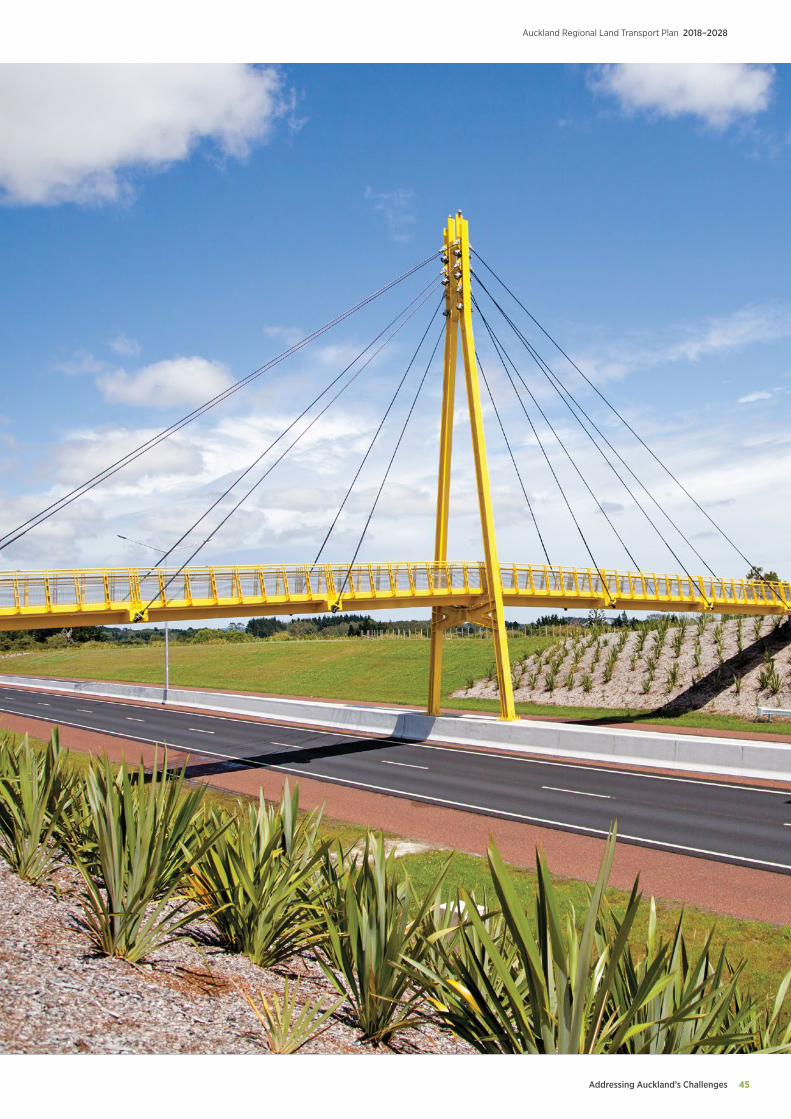
Addressing Auckland’s Challenges 45
Auckland Regional Land Transport Plan 2018–2028
Maintaining and Renewing Existing Assets
Auckland Regional Land Transport Plan 2018–2028
46
Asset maintenance and renewals
Auckland Transport is responsible for road network assets with a replacement value of $12 billion,9 including the roads themselves, footpaths and cycleways, streetlights and traffic systems. The local road network carried 8.3 billion kilometres of vehicle travel in 2016/17, 18 percent of all vehicle travel in NZ.10
AT’s public transport assets have a replacement value of $1.4 billion.9 This includes 57 electric trains and 42 active rail stations as well as busway stations, bus shelters and ferry wharves.
AT’s asset base is continuing to increase as Auckland grows and new assets are added to the network. Analysis of recent trends indicates that 40 kilometres of new roads are likely to be added to the local road network each year, and traffic will grow by 2.4 percent each year.
For this RLTP, AT has undertaken a comprehensive review of its asset renewals programme to ensure that it is delivering a fit-for-purpose level of service and achieving value for money. The Asset Management Programme (AMP) provided for within this RLTP emphasises the importance of making best use of the existing transport network as the essential foundation for improving transport outcomes.
It incorporates the recommendations of the One Network Road Classification (ONRC) framework, developed jointly by the Transport Agency and Local Government New Zealand.11
The AMP reflects the objectives of the Auckland Plan, the GPS and ATAP. The key principles underpinning the AMP are:
• Deliver fit-for-purpose levels of service aligned with ONRC
• Manage risk: avoid failure of critical transport assets, adopt a proactive approach to asset maintenance and renewals, and manage risk at acceptable levels
• Whole-of-life approach: including reprioritisation of maintenance to reduce the need for costlier renewals
• Clarify the costs of growth: including assessing the impacts of growth on asset deterioration in particular on the rural road network.
The asset management programme will ensure the overall condition of the network will be maintained in a stable state over the 10 years of the RLTP. The programme identifies levels of service, issues and problems, and the proposed strategic response and actions in the following key areas:
• Safety
• Resilience
• Amenity
• Accessibility
• Travel time reliability
• Value for money
• Lifecycle asset management
• Sustainability.
06.Maintaining and renewing existing assets
9 Auckland Transport Annual Report 2016/17.10 NZ Transport Agency – Data and Tools (www.nzta.govt.nz)11 NZ Transport Agency One Network Road Classification (www.nzta.govt.nz)
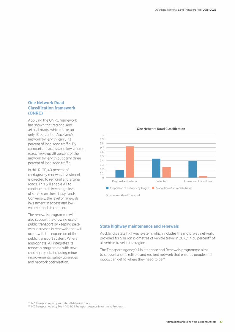
Maintaining and Renewing Existing Assets 47
Auckland Regional Land Transport Plan 2018–2028
One Network Road Classification framework (ONRC)
Applying the ONRC framework has shown that regional and arterial roads, which make up only 18 percent of Auckland’s network by length, carry 73 percent of local road traffic. By comparison, access and low volume roads make up 38 percent of the network by length but carry three percent of local road traffic.
In this RLTP, 40 percent of carriageway renewals investment is directed to regional and arterial roads. This will enable AT to continue to deliver a high level of service on these busy roads. Conversely, the level of renewals investment in access and low-volume roads is reduced.
The renewals programme will also support the growing use of public transport by keeping pace with increases in renewals that will occur with the expansion of the public transport system. Where appropriate, AT integrates its renewals programme with new capital projects including minor improvements, safety upgrades and network optimisation.
State highway maintenance and renewals
Auckland’s state highway system, which includes the motorway network, provided for 5 billion kilometres of vehicle travel in 2016/17, 38 percent12 of all vehicle travel in the region.
The Transport Agency’s Maintenance and Renewals programme aims to support a safe, reliable and resilient network that ensures people and goods can get to where they need to be.13
1
0.9
0.8
0.7
0.6
0.5
0.4
0.3
0.2
0.1
0Regional and arterial Collector Access and low volume
Proportion of network by length Proportion of all vehicle travel
Source: Auckland Transport
One Network Road Classification
12 NZ Transport Agency website, all data and tools.13 NZ Transport Agency Draft 2018-29 Transport Agency Investment Proposal.
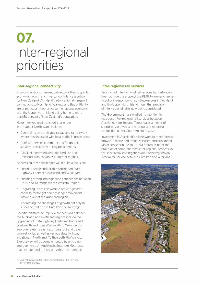
Inter-Regional Priorities
Auckland Regional Land Transport Plan 2018–2028
48
07.Inter-regional priorities Inter-regional connectivity
Providing a strong inter-modal network that supports economic growth and investor confidence is critical for New Zealand. Auckland’s inter-regional transport connections to Northland, Waikato and Bay of Plenty are of particular importance to the national economy, with the Upper North Island being home to more than 50 percent of New Zealand’s population.
Major inter-regional transport challenges in the Upper North Island include:
• Constraints on the strategic road and rail network where they intersect with local traffic in urban areas
• Conflict between commuter and freight rail services, particularly during peak periods
• A lack of integrated strategic land use and transport planning across different regions.
Addressing these challenges will require a focus on:
• Ensuring a safe and reliable corridor on State Highway 1 between Auckland and Whangarei
• Ensuring strong strategic road connections between Drury and Tauranga via the Waikato Region
• Upgrading the rail network to provide greater capacity for freight and passenger movement into and out of the Auckland region
• Addressing the challenges of growth not only in Auckland, but also in Hamilton and Tauranga.
Specific initiatives to improve connections between the Auckland and Northland regions include the upgrading of State Highway 1 between Puhoi and Warkworth and from Warkworth to Wellsford to improve safety, resilience, throughput and travel time reliability, as well as various state highway initiatives in Northland. To the south, the Waikato Expressway will be complemented by on-going improvements on Auckland’s Southern Motorway that are intended to increase vehicle throughput.
Inter-regional rail services
Provision of inter-regional rail services has historically been outside the scope of the RLTP. However, changes in policy in response to growth pressures in Auckland and the Upper North Island mean that provision of inter-regional rail is now being considered.
The Government has signalled its intention to introduce inter-regional rail services between Auckland, Hamilton and Tauranga as a means of supporting growth, and housing, and reducing congestion on the Southern Motorway.14
Investment in Auckland’s rail network to meet forecast growth in metro and freight services, and provide for faster services in the south, is a prerequisite for the provision of comprehensive inter-regional services. In the short term, investigations are underway into an interim rail service between Hamilton and Auckland.
14 Study shows need for rail investment, Hon. Phil Twyford, 27 November 2017.
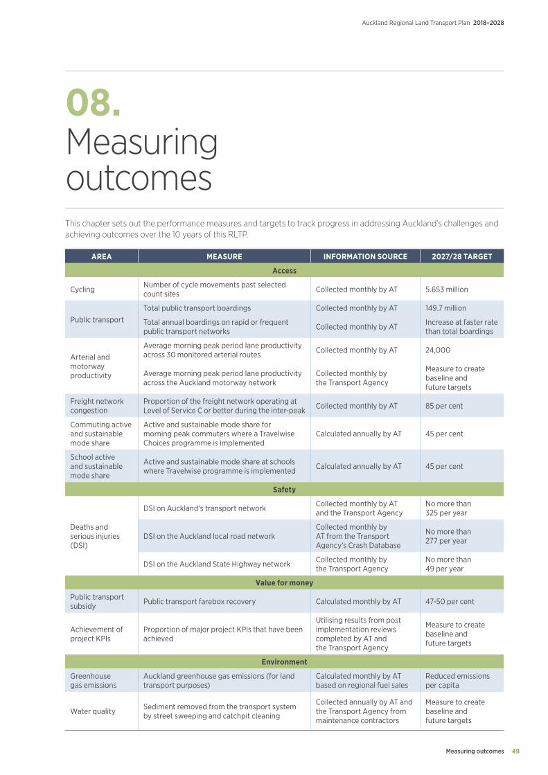
Measuring outcomes 49
Auckland Regional Land Transport Plan 2018–2028
08.Measuring outcomes This chapter sets out the performance measures and targets to track progress in addressing Auckland’s challenges and achieving outcomes over the 10 years of this RLTP.
AREA MEASURE INFORMATION SOURCE 2027/28 TARGET
Access
Cycling Number of cycle movements past selected count sites Collected monthly by AT 5.653 million
Public transportTotal public transport boardings Collected monthly by AT 149.7 million
Total annual boardings on rapid or frequent public transport networks Collected monthly by AT Increase at faster rate
than total boardings
Arterial and motorway productivity
Average morning peak period lane productivity across 30 monitored arterial routes Collected monthly by AT 24,000
Average morning peak period lane productivity across the Auckland motorway network
Collected monthly by the Transport Agency
Measure to create baseline and future targets
Freight network congestion
Proportion of the freight network operating at Level of Service C or better during the inter-peak Collected monthly by AT 85 per cent
Commuting active and sustainable mode share
Active and sustainable mode share for morning peak commuters where a Travelwise Choices programme is implemented
Calculated annually by AT 45 per cent
School active and sustainable mode share
Active and sustainable mode share at schools where Travelwise programme is implemented Calculated annually by AT 45 per cent
Safety
Deaths and serious injuries (DSI)
DSI on Auckland’s transport network Collected monthly by AT and the Transport Agency
No more than 325 per year
DSI on the Auckland local road networkCollected monthly by AT from the Transport Agency’s Crash Database
No more than 277 per year
DSI on the Auckland State Highway network Collected monthly by the Transport Agency
No more than 49 per year
Value for money
Public transport subsidy Public transport farebox recovery Calculated monthly by AT 47-50 per cent
Achievement of project KPIs
Proportion of major project KPIs that have been achieved
Utilising results from post implementation reviews completed by AT and the Transport Agency
Measure to create baseline and future targets
Environment
Greenhouse gas emissions
Auckland greenhouse gas emissions (for land transport purposes)
Calculated monthly by AT based on regional fuel sales
Reduced emissions per capita
Water quality Sediment removed from the transport system by street sweeping and catchpit cleaning
Collected annually by AT and the Transport Agency from maintenance contractors
Measure to create baseline and future targets
Funding and Expenditure
Auckland Regional Land Transport Plan 2018–2028
50
09.Funding and expenditure Funding sources
Over the past 15 years, transport investment in Auckland has increased four-fold, from around $500 million in 2000 to around $2 billion in 2017. Transport is Auckland Council’s largest and central government’s fourth-largest area of investment.
The transport programme set out in this RLTP is funded from a combination of:
• The NLTF for State Highways, local roads, public transport, walking and cycling, traffic policing, and other transport activities approved for funding through the National Land Transport Programme (NLTP). The NLTF is sourced from fuel excise duties, road user charges, registration and licensing fees and is administered by the Transport Agency
• Funding from Auckland Council, sourced from rates, targeted rates, development contributions, and the RFT
• AT’s third-party revenue, including public transport fares, advertising, income from land held for future transport needs, and parking and enforcement revenue
• Direct investment from central government into the CRL.
Auckland Council and Government are also exploring new models of funding transport and other infrastructure. The Housing Infrastructure Fund (HIF) will make $1 billion available in loans to assist high-growth councils to advance infrastructure projects important to increasing housing supply. Around $300 million has been allocated to Auckland for transport in greenfield areas and for Three Waters bulk infrastructure in the North-west of Auckland.
Crown Infrastructure Partners is expected to fund and deliver around $360 million of growth projects in the Drury/Pukekohe/Paerata and Wainui East/Silverdale/Dairy Flat growth areas.
Funding assumptions
Transport Agency funding
ATAP was established in 2015 to improve local and central government collaboration on transport planning and funding for Auckland. Revision of the ATAP 2016 work was commenced earlier this year and a final report was released by the Minister of Transport and the Mayor of Auckland on 26 April 2018.
The ATAP report included a $28 billion funded programme of investment in transport activities for Auckland. The ATAP report included NLTF funding of $16.3 billion of which $8.1 billion is to support the activities of AT (both capital and operating expenditure).
This level of support is significantly higher than has historically been provided to local government in Auckland, and higher than would be provided under existing funding arrangements. The ATAP report identified that delivery would require changes to current funding arrangements, including a more flexible approach to GPS activity class limits and funding assistance rates (FARs). To advance this the report identified areas for further work, including considering what changes may be required to transport planning and funding process and project evaluation tools to achieve the Government and Auckland Council’s direction for transport in Auckland.
Subsidy levels for different activity classes can vary and are set by the Transport Agency. Individual projects are assessed for subsidy through a business case process. This RLTP assumes that funding from the NLTF will be made up of $3.1 billion of operating subsidies and $5 billion of capital subsidies.
This RLTP also assumes that the Transport Agency will be responsible for funding rapid transit projects. It also assumes that there is no local share for investment from the Transitional Rail Activity class.
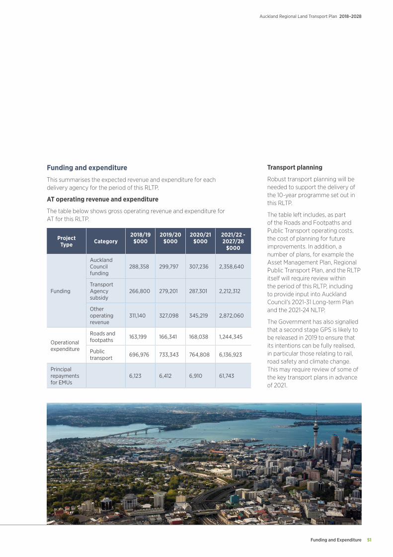
Funding and Expenditure 51
Auckland Regional Land Transport Plan 2018–2028
Funding and expenditure
This summarises the expected revenue and expenditure for each delivery agency for the period of this RLTP.
AT operating revenue and expenditure
The table below shows gross operating revenue and expenditure for AT for this RLTP.
Project Type Category
2018/19 $000
2019/20 $000
2020/21 $000
2021/22 - 2027/28
$000
Funding
Auckland Council funding
288,358 299,797 307,236 2,358,640
Transport Agency subsidy
266,800 279,201 287,301 2,212,312
Other operating revenue
311,140 327,098 345,219 2,872,060
Operational expenditure
Roads and footpaths 163,199 166,341 168,038 1,244,345
Public transport 696,976 733,343 764,808 6,136,923
Principal repayments for EMUs
6,123 6,412 6,910 61,743
Transport planning
Robust transport planning will be needed to support the delivery of the 10-year programme set out in this RLTP.
The table left includes, as part of the Roads and Footpaths and Public Transport operating costs, the cost of planning for future improvements. In addition, a number of plans, for example the Asset Management Plan, Regional Public Transport Plan, and the RLTP itself will require review within the period of this RLTP, including to provide input into Auckland Council’s 2021-31 Long-term Plan and the 2021-24 NLTP.
The Government has also signalled that a second stage GPS is likely to be released in 2019 to ensure that its intentions can be fully realised, in particular those relating to rail, road safety and climate change. This may require review of some of the key transport plans in advance of 2021.
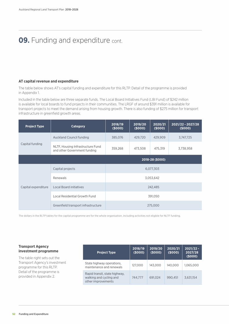
Funding and Expenditure
Auckland Regional Land Transport Plan 2018–2028
52
Project Type Category 2018/19 ($000)
2019/20 ($000)
2020/21 ($000)
2021/22 - 2027/28 ($000)
Capital funding
Auckland Council funding 385,076 429,720 429,909 3,747,725
NLTF, Housing Infrastructure Fund and other Government funding 359,268 473,508 475,319 3,738,958
2018-28 ($000)
Capital expenditure
Capital projects 6,077,303
Renewals 3,053,642
Local Board initiatives 242,485
Local Residential Growth Fund 391,050
Greenfield transport infrastructure 275,000
AT capital revenue and expenditure
The table below shows AT’s capital funding and expenditure for this RLTP. Detail of the programme is provided in Appendix 1.
Included in the table below are three separate funds. The Local Board Initiatives Fund (LBI Fund) of $242 million is available for local boards to fund projects in their communities. The LRGF of around $391 million is available for transport projects to meet the demand arising from housing growth. There is also funding of $275 million for transport infrastructure in greenfield growth areas.
09. Funding and expenditure cont.
Transport Agency investment programme
The table right sets out the Transport Agency’s investment programme for this RLTP. Detail of the programme is provided in Appendix 2.
Project Type2018/19 ($000)
2019/20 ($000)
2020/21 ($000)
2021/22 - 2027/28 ($000)
State highway operations, maintenance and renewals 127,000 143,000 140,000 1,065,000
Rapid transit, state highway, walking and cycling and other improvements
744,777 691,024 990,451 3,631,154
The dollars in the RLTP tables for the capital programme are for the whole organisation, including activities not eligible for NLTF funding.
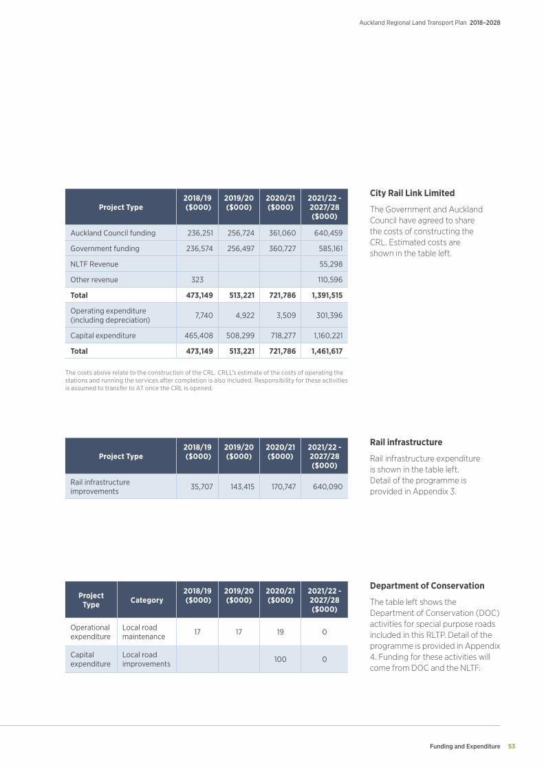
Funding and Expenditure 53
Auckland Regional Land Transport Plan 2018–2028
Project Type Category
2018/19 ($000)
2019/20 ($000)
2020/21 ($000)
2021/22 - 2027/28 ($000)
Operational expenditure
Local road maintenance 17 17 19 0
Capital expenditure
Local road improvements 100 0
Department of Conservation
The table left shows the Department of Conservation (DOC) activities for special purpose roads included in this RLTP. Detail of the programme is provided in Appendix 4. Funding for these activities will come from DOC and the NLTF.
City Rail Link Limited
The Government and Auckland Council have agreed to share the costs of constructing the CRL. Estimated costs are shown in the table left.
Project Type2018/19 ($000)
2019/20 ($000)
2020/21 ($000)
2021/22 - 2027/28 ($000)
Auckland Council funding 236,251 256,724 361,060 640,459
Government funding 236,574 256,497 360,727 585,161
NLTF Revenue 55,298
Other revenue 323 110,596
Total 473,149 513,221 721,786 1,391,515
Operating expenditure (including depreciation) 7,740 4,922 3,509 301,396
Capital expenditure 465,408 508,299 718,277 1,160,221
Total 473,149 513,221 721,786 1,461,617
Rail infrastructure
Rail infrastructure expenditure is shown in the table left. Detail of the programme is provided in Appendix 3.
Project Type2018/19 ($000)
2019/20 ($000)
2020/21 ($000)
2021/22 - 2027/28 ($000)
Rail infrastructure improvements 35,707 143,415 170,747 640,090
The costs above relate to the construction of the CRL. CRLL’s estimate of the costs of operating the stations and running the services after completion is also included. Responsibility for these activities is assumed to transfer to AT once the CRL is opened.
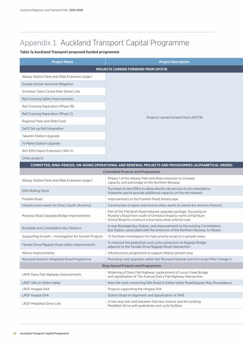
Auckland Transport Capital Programme
Auckland Regional Land Transport Plan 2018–2028
54
Project Name Project Description Prioritisation Duration 2018/19 2019/20 2020/21 2021/22 2022/23 2023/24 2024/25 - 2027/28
PROJECTS CARRIED FORWARD FROM 2017/18 ($m)
Albany Station Park-and-Ride Extension stage 1
Projects carried forward from 2017/18
1 2018/19 0.5
Double Decker Network Mitigation 1 2018/19 3.7
Ormiston Town Centre Main Street Link 1 2018/19 6.9
Rail Crossing Safety Improvements 1 2018/19 0.2
Rail Crossing Separation (Phase 1B) 1 2018/19 1.9
Rail Crossing Separation (Phase 2) 1 2018/19 3.3
Regional Park-and-Ride Fund 1 2018/19 2.5
SaFE Set-up Rail Integration 1 2018/19 1.0
Takanini Station Upgrade 1 2018/19 1.1
Te Mahia Station Upgrade 1 2018/19 0.9
Wiri EMU Depot Extension (Wiri II) 1 2018/19 6.0
Other projects 1 2018/19 38.0
COMMITTED, RING-FENCED, ON-GOING OPERATIONAL AND RENEWAL PROJECTS AND PROGRAMMES (ALPHABETICAL ORDER) ($m)
Committed Projects and Programmes
Albany Station Park-and-Ride Extension stage 1 Phases 1 of the Albany Park-and-Ride extension to increase capacity and patronage on the Northern Busway 1 2018/19 0.8 0.0 0.0 0.0 0.0 0.0 0.0
EMU Rolling Stock Purchase of new EMUs to allow electric rail services to be extended to Pukekohe and to provide additional capacity on the rail network 1 2018/19 - 2020/21 6.4 117.0 9.0 0.0 0.0 0.0 0.0
Franklin Road Improvements to the Franklin Road streetscape 1 2018/19 6.0 0.0 0.0 0.0 0.0 0.0 0.0
Infrastructure works for Drury South (Ararimu) Construction of spine road and ancillary works to unlock the Ararimu Precinct 1 2018/19 - 2019/20 9.5 0.5 0.0 0.0 0.0 0.0 0.0
Murphys Road Upgrade Bridge ImprovementsPart of the Flat Bush Road network upgrade package, focussing on Murphy's Road from south of Ormiston Road to north of Flat Bush School Road to construct a four-lane urban arterial road
1 2018/19 - 2019/20 6.2 5.0 0.0 0.0 0.0 0.0 0.0
Rosedale and Constellation Bus Stations A new Rosedale Bus Station, and improvements to the existing Constellation Bus Station, associated with the extension of the Northern Busway to Albany 1 2018/19 - 2024/25 4.1 12.3 31.1 66.9 1.9 0.5 0.1
Supporting Growth – Investigation for Growth Projects To facilitate investigation for high priority projects in growth areas 1 2018/19 - 2026/27 10.5 10.0 10.6 19.1 11.3 6.8 13.1
Tamaki Drive/Ngapipi Road safety Improvements To improve the pedestrian and cycle connection on Ngapipi Bridge adjacent to the Tamaki Drive/Ngapipi Road intersection 1 2018/19 3.1 0.0 0.0 0.0 0.0 0.0 0.0
Wainui Improvements Infrastructure programme to support Wainui growth area 1 2020/21 - 2022/23 0.0 0.0 2.0 11.5 11.5 0.0 0.0
Wynyard Quarter Integrated Road Programme Providing road upgrades within the Wynyard Quarter precinct as per Plan Change 4 1 2018/19 - 2024/25 15.9 13.0 1.2 18.3 15.7 10.6 2.8
Ring-fenced Projects and Programmes
LRGF Dairy Flat Highway Improvements Widening of Dairy Flat Highway, replacement of Lucas Creek Bridge and signalisation of The Avenue/Dairy Flat Highway Intersection 1 2018/19 - 2020/21 2.0 6.8 8.0 0.0 0.0 0.0 0.0
LRGF Gills to Oteha Valley New link road connecting Gills Road to Oteha Valley Road/Appian Way Roundabout 1 2018/19 - 2020/21 0.7 9.1 13.9 0.0 0.0 0.0 0.0
LRGF Hingaia SHA Projects supporting the Hingaia SHA 1 2018/19 - 2019/20 0.1 5.5 0.0 0.0 0.0 0.0 0.0
LRGF Huapai SHA Station Road re-alignment and signalisation of SH16 1 2018/19 - 2020/21 7.3 14.6 15.5 0.0 0.0 0.0 0.0
LRGF Medallion Drive Link A two-way link road between Fairview Avenue and the existing Medallion Drive with pedestrian and cycle facilities 1 2018/19 - 2020/21 8.0 4.6 0.5 0.0 0.0 0.0 0.0
Appendix 1 Auckland Transport Capital Programme Table 1a Auckland Transport proposed funded programme
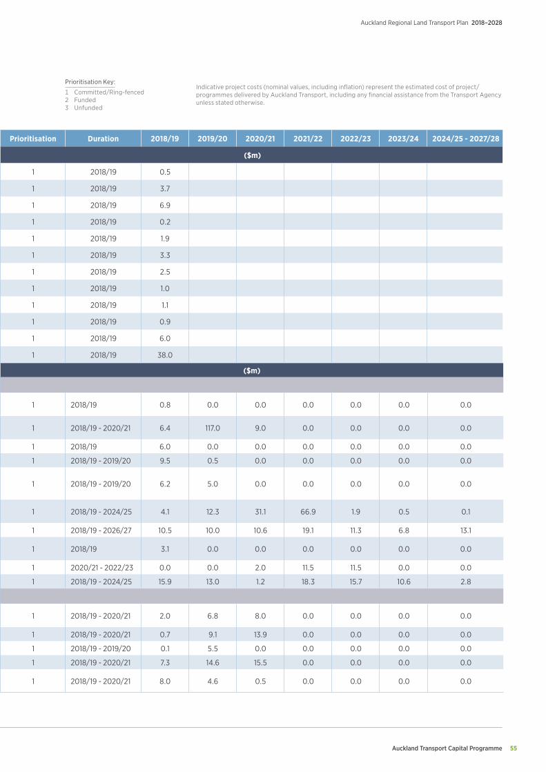
Auckland Transport Capital Programme 55
Auckland Regional Land Transport Plan 2018–2028
Project Name Project Description Prioritisation Duration 2018/19 2019/20 2020/21 2021/22 2022/23 2023/24 2024/25 - 2027/28
PROJECTS CARRIED FORWARD FROM 2017/18 ($m)
Albany Station Park-and-Ride Extension stage 1
Projects carried forward from 2017/18
1 2018/19 0.5
Double Decker Network Mitigation 1 2018/19 3.7
Ormiston Town Centre Main Street Link 1 2018/19 6.9
Rail Crossing Safety Improvements 1 2018/19 0.2
Rail Crossing Separation (Phase 1B) 1 2018/19 1.9
Rail Crossing Separation (Phase 2) 1 2018/19 3.3
Regional Park-and-Ride Fund 1 2018/19 2.5
SaFE Set-up Rail Integration 1 2018/19 1.0
Takanini Station Upgrade 1 2018/19 1.1
Te Mahia Station Upgrade 1 2018/19 0.9
Wiri EMU Depot Extension (Wiri II) 1 2018/19 6.0
Other projects 1 2018/19 38.0
COMMITTED, RING-FENCED, ON-GOING OPERATIONAL AND RENEWAL PROJECTS AND PROGRAMMES (ALPHABETICAL ORDER) ($m)
Committed Projects and Programmes
Albany Station Park-and-Ride Extension stage 1 Phases 1 of the Albany Park-and-Ride extension to increase capacity and patronage on the Northern Busway 1 2018/19 0.8 0.0 0.0 0.0 0.0 0.0 0.0
EMU Rolling Stock Purchase of new EMUs to allow electric rail services to be extended to Pukekohe and to provide additional capacity on the rail network 1 2018/19 - 2020/21 6.4 117.0 9.0 0.0 0.0 0.0 0.0
Franklin Road Improvements to the Franklin Road streetscape 1 2018/19 6.0 0.0 0.0 0.0 0.0 0.0 0.0
Infrastructure works for Drury South (Ararimu) Construction of spine road and ancillary works to unlock the Ararimu Precinct 1 2018/19 - 2019/20 9.5 0.5 0.0 0.0 0.0 0.0 0.0
Murphys Road Upgrade Bridge ImprovementsPart of the Flat Bush Road network upgrade package, focussing on Murphy's Road from south of Ormiston Road to north of Flat Bush School Road to construct a four-lane urban arterial road
1 2018/19 - 2019/20 6.2 5.0 0.0 0.0 0.0 0.0 0.0
Rosedale and Constellation Bus Stations A new Rosedale Bus Station, and improvements to the existing Constellation Bus Station, associated with the extension of the Northern Busway to Albany 1 2018/19 - 2024/25 4.1 12.3 31.1 66.9 1.9 0.5 0.1
Supporting Growth – Investigation for Growth Projects To facilitate investigation for high priority projects in growth areas 1 2018/19 - 2026/27 10.5 10.0 10.6 19.1 11.3 6.8 13.1
Tamaki Drive/Ngapipi Road safety Improvements To improve the pedestrian and cycle connection on Ngapipi Bridge adjacent to the Tamaki Drive/Ngapipi Road intersection 1 2018/19 3.1 0.0 0.0 0.0 0.0 0.0 0.0
Wainui Improvements Infrastructure programme to support Wainui growth area 1 2020/21 - 2022/23 0.0 0.0 2.0 11.5 11.5 0.0 0.0
Wynyard Quarter Integrated Road Programme Providing road upgrades within the Wynyard Quarter precinct as per Plan Change 4 1 2018/19 - 2024/25 15.9 13.0 1.2 18.3 15.7 10.6 2.8
Ring-fenced Projects and Programmes
LRGF Dairy Flat Highway Improvements Widening of Dairy Flat Highway, replacement of Lucas Creek Bridge and signalisation of The Avenue/Dairy Flat Highway Intersection 1 2018/19 - 2020/21 2.0 6.8 8.0 0.0 0.0 0.0 0.0
LRGF Gills to Oteha Valley New link road connecting Gills Road to Oteha Valley Road/Appian Way Roundabout 1 2018/19 - 2020/21 0.7 9.1 13.9 0.0 0.0 0.0 0.0
LRGF Hingaia SHA Projects supporting the Hingaia SHA 1 2018/19 - 2019/20 0.1 5.5 0.0 0.0 0.0 0.0 0.0
LRGF Huapai SHA Station Road re-alignment and signalisation of SH16 1 2018/19 - 2020/21 7.3 14.6 15.5 0.0 0.0 0.0 0.0
LRGF Medallion Drive Link A two-way link road between Fairview Avenue and the existing Medallion Drive with pedestrian and cycle facilities 1 2018/19 - 2020/21 8.0 4.6 0.5 0.0 0.0 0.0 0.0
Indicative project costs (nominal values, including inflation) represent the estimated cost of project/programmes delivered by Auckland Transport, including any financial assistance from the Transport Agency unless stated otherwise.
Prioritisation Key:
1 Committed/Ring-fenced 2 Funded3 Unfunded
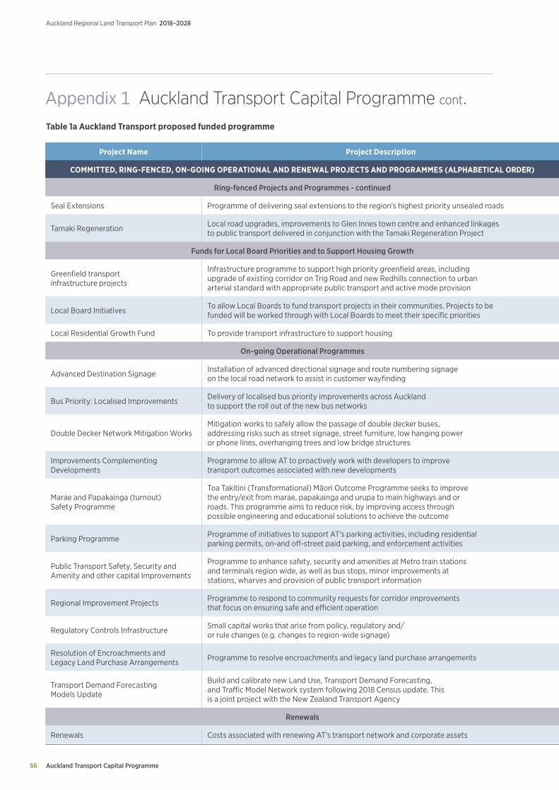
Auckland Transport Capital Programme
Auckland Regional Land Transport Plan 2018–2028
56
Project Name Project Description Prioritisation Duration 2018/19 2019/20 2020/21 2021/22 2022/23 2023/24 2024/25 - 2027/28
COMMITTED, RING-FENCED, ON-GOING OPERATIONAL AND RENEWAL PROJECTS AND PROGRAMMES (ALPHABETICAL ORDER) ($m)
Ring-fenced Projects and Programmes - continued
Seal Extensions Programme of delivering seal extensions to the region's highest priority unsealed roads 1 2018/19 - 2027/28 3.1 3.0 3.3 3.1 3.0 3.9 17.1
Tamaki Regeneration Local road upgrades, improvements to Glen Innes town centre and enhanced linkages to public transport delivered in conjunction with the Tamaki Regeneration Project 1 2018/19 - 2027/28 5.6 2.9 5.1 5.1 2.9 1.5 18.0
Funds for Local Board Priorities and to Support Housing Growth
Greenfield transport infrastructure projects
Infrastructure programme to support high priority greenfield areas, including upgrade of existing corridor on Trig Road and new Redhills connection to urban arterial standard with appropriate public transport and active mode provision
2 2018/19 - 2027/28 11.6 0.4 1.8 22.3 47.1 49.4 142.4
Local Board Initiatives To allow Local Boards to fund transport projects in their communities. Projects to be funded will be worked through with Local Boards to meet their specific priorities 2 2018/19 - 2027/28 20.8 19.7 21.8 20.5 19.9 26.0 113.8
Local Residential Growth Fund To provide transport infrastructure to support housing 2 2018/19 - 2027/28 0.0 0.0 0.0 28.3 14.7 34.4 313.7
On-going Operational Programmes
Advanced Destination Signage Installation of advanced directional signage and route numbering signage on the local road network to assist in customer wayfinding 2 2018/19 - 2027/28 0.4 0.4 0.4 0.5 0.5 0.8 3.1
Bus Priority: Localised Improvements Delivery of localised bus priority improvements across Auckland to support the roll out of the new bus networks 2 2018/19 - 2027/28 4.5 4.3 4.7 4.5 4.3 5.6 24.7
Double Decker Network Mitigation WorksMitigation works to safely allow the passage of double decker buses, addressing risks such as street signage, street furniture, low hanging power or phone lines, overhanging trees and low bridge structures
2 2018/19 - 2020/21 7.3 3.0 3.7 0.0 0.0 0.0 0.0
Improvements Complementing Developments
Programme to allow AT to proactively work with developers to improve transport outcomes associated with new developments 2 2021/22 - 2027/28 0.0 0.0 0.0 0.9 0.9 1.2 7.9
Marae and Papakainga (turnout) Safety Programme
Toa Takitini (Transformational) Māori Outcome Programme seeks to improve the entry/exit from marae, papakainga and urupa to main highways and or roads. This programme aims to reduce risk, by improving access through possible engineering and educational solutions to achieve the outcome
2 2018/19 - 2027/28 1.0 1.0 1.1 1.0 1.0 1.3 5.7
Parking Programme Programme of initiatives to support AT's parking activities, including residential parking permits, on-and off-street paid parking, and enforcement activities 2 2018/19 - 2027/28 3.4 6.2 6.0 3.5 3.2 4.1 18.1
Public Transport Safety, Security and Amenity and other capital Improvements
Programme to enhance safety, security and amenities at Metro train stations and terminals region wide, as well as bus stops, minor improvements at stations, wharves and provision of public transport information
2 2018/19 - 2027/28 12.4 7.3 6.4 11.6 10.2 15.9 57.1
Regional Improvement Projects Programme to respond to community requests for corridor improvements that focus on ensuring safe and efficient operation 2 2018/19 - 2027/28 2.5 2.8 3.4 3.8 3.6 5.4 40.8
Regulatory Controls Infrastructure Small capital works that arise from policy, regulatory and/or rule changes (e.g. changes to region-wide signage) 2 2018/19 - 2027/28 0.1 0.1 0.1 0.1 0.1 0.1 0.6
Resolution of Encroachments and Legacy Land Purchase Arrangements Programme to resolve encroachments and legacy land purchase arrangements 2 2021/22 - 2027/28 0.0 0.0 0.0 1.3 1.2 1.6 11.0
Transport Demand Forecasting Models Update
Build and calibrate new Land Use, Transport Demand Forecasting, and Traffic Model Network system following 2018 Census update. This is a joint project with the New Zealand Transport Agency
2 2021/22 - 2027/28 0.0 0.0 0.0 2.3 2.5 0.9 0.2
Renewals
Renewals Costs associated with renewing AT's transport network and corporate assets 2 2018/19 - 2027/28 188.0 185.6 215.2 234.4 253.0 322.1 1655.4
Appendix 1 Auckland Transport Capital Programme cont. Table 1a Auckland Transport proposed funded programme
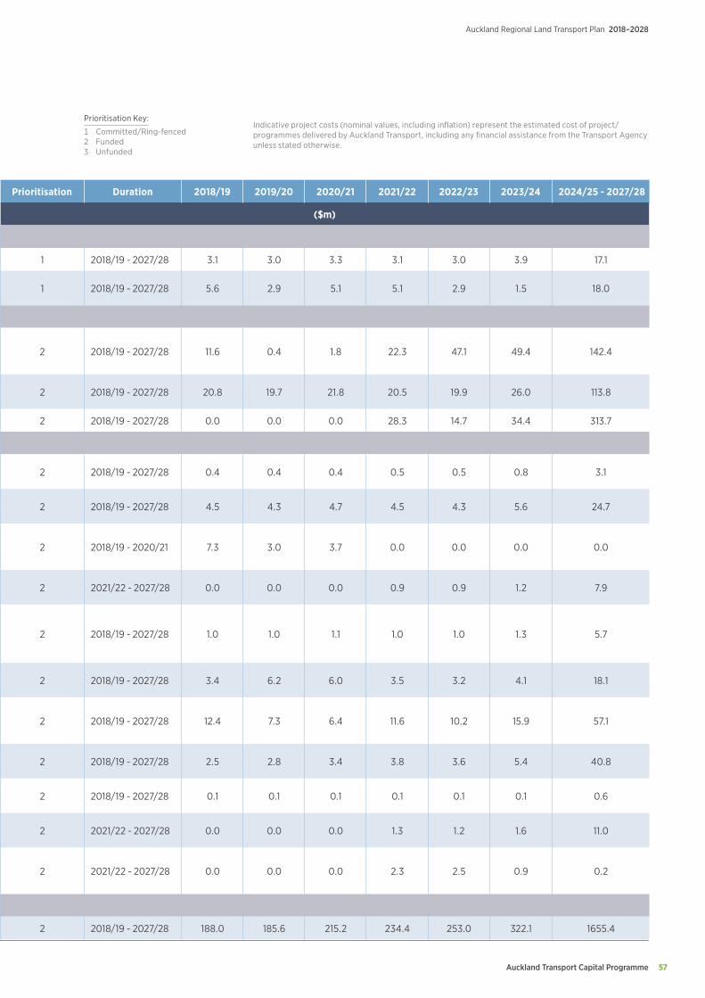
Auckland Transport Capital Programme 57
Auckland Regional Land Transport Plan 2018–2028
Project Name Project Description Prioritisation Duration 2018/19 2019/20 2020/21 2021/22 2022/23 2023/24 2024/25 - 2027/28
COMMITTED, RING-FENCED, ON-GOING OPERATIONAL AND RENEWAL PROJECTS AND PROGRAMMES (ALPHABETICAL ORDER) ($m)
Ring-fenced Projects and Programmes - continued
Seal Extensions Programme of delivering seal extensions to the region's highest priority unsealed roads 1 2018/19 - 2027/28 3.1 3.0 3.3 3.1 3.0 3.9 17.1
Tamaki Regeneration Local road upgrades, improvements to Glen Innes town centre and enhanced linkages to public transport delivered in conjunction with the Tamaki Regeneration Project 1 2018/19 - 2027/28 5.6 2.9 5.1 5.1 2.9 1.5 18.0
Funds for Local Board Priorities and to Support Housing Growth
Greenfield transport infrastructure projects
Infrastructure programme to support high priority greenfield areas, including upgrade of existing corridor on Trig Road and new Redhills connection to urban arterial standard with appropriate public transport and active mode provision
2 2018/19 - 2027/28 11.6 0.4 1.8 22.3 47.1 49.4 142.4
Local Board Initiatives To allow Local Boards to fund transport projects in their communities. Projects to be funded will be worked through with Local Boards to meet their specific priorities 2 2018/19 - 2027/28 20.8 19.7 21.8 20.5 19.9 26.0 113.8
Local Residential Growth Fund To provide transport infrastructure to support housing 2 2018/19 - 2027/28 0.0 0.0 0.0 28.3 14.7 34.4 313.7
On-going Operational Programmes
Advanced Destination Signage Installation of advanced directional signage and route numbering signage on the local road network to assist in customer wayfinding 2 2018/19 - 2027/28 0.4 0.4 0.4 0.5 0.5 0.8 3.1
Bus Priority: Localised Improvements Delivery of localised bus priority improvements across Auckland to support the roll out of the new bus networks 2 2018/19 - 2027/28 4.5 4.3 4.7 4.5 4.3 5.6 24.7
Double Decker Network Mitigation WorksMitigation works to safely allow the passage of double decker buses, addressing risks such as street signage, street furniture, low hanging power or phone lines, overhanging trees and low bridge structures
2 2018/19 - 2020/21 7.3 3.0 3.7 0.0 0.0 0.0 0.0
Improvements Complementing Developments
Programme to allow AT to proactively work with developers to improve transport outcomes associated with new developments 2 2021/22 - 2027/28 0.0 0.0 0.0 0.9 0.9 1.2 7.9
Marae and Papakainga (turnout) Safety Programme
Toa Takitini (Transformational) Māori Outcome Programme seeks to improve the entry/exit from marae, papakainga and urupa to main highways and or roads. This programme aims to reduce risk, by improving access through possible engineering and educational solutions to achieve the outcome
2 2018/19 - 2027/28 1.0 1.0 1.1 1.0 1.0 1.3 5.7
Parking Programme Programme of initiatives to support AT's parking activities, including residential parking permits, on-and off-street paid parking, and enforcement activities 2 2018/19 - 2027/28 3.4 6.2 6.0 3.5 3.2 4.1 18.1
Public Transport Safety, Security and Amenity and other capital Improvements
Programme to enhance safety, security and amenities at Metro train stations and terminals region wide, as well as bus stops, minor improvements at stations, wharves and provision of public transport information
2 2018/19 - 2027/28 12.4 7.3 6.4 11.6 10.2 15.9 57.1
Regional Improvement Projects Programme to respond to community requests for corridor improvements that focus on ensuring safe and efficient operation 2 2018/19 - 2027/28 2.5 2.8 3.4 3.8 3.6 5.4 40.8
Regulatory Controls Infrastructure Small capital works that arise from policy, regulatory and/or rule changes (e.g. changes to region-wide signage) 2 2018/19 - 2027/28 0.1 0.1 0.1 0.1 0.1 0.1 0.6
Resolution of Encroachments and Legacy Land Purchase Arrangements Programme to resolve encroachments and legacy land purchase arrangements 2 2021/22 - 2027/28 0.0 0.0 0.0 1.3 1.2 1.6 11.0
Transport Demand Forecasting Models Update
Build and calibrate new Land Use, Transport Demand Forecasting, and Traffic Model Network system following 2018 Census update. This is a joint project with the New Zealand Transport Agency
2 2021/22 - 2027/28 0.0 0.0 0.0 2.3 2.5 0.9 0.2
Renewals
Renewals Costs associated with renewing AT's transport network and corporate assets 2 2018/19 - 2027/28 188.0 185.6 215.2 234.4 253.0 322.1 1655.4
Indicative project costs (nominal values, including inflation) represent the estimated cost of project/programmes delivered by Auckland Transport, including any financial assistance from the Transport Agency unless stated otherwise.
Prioritisation Key:
1 Committed/Ring-fenced 2 Funded3 Unfunded
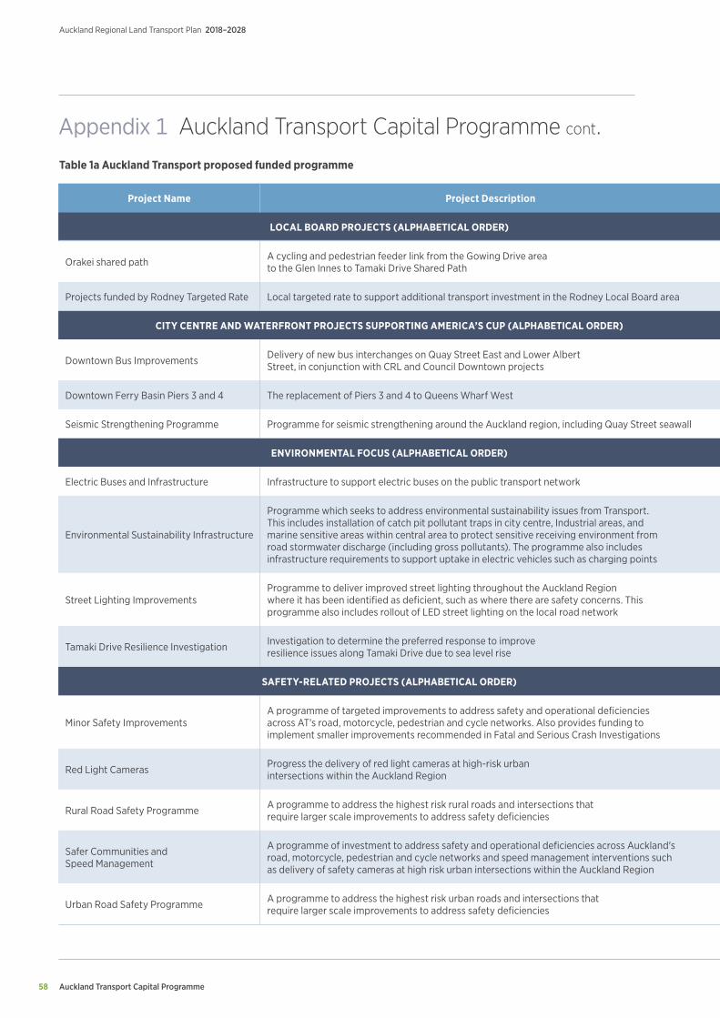
Auckland Transport Capital Programme
Auckland Regional Land Transport Plan 2018–2028
58
Project Name Project Description Prioritisation Duration 2018/19 2019/20 2020/21 2021/22 2022/23 2023/24 2024/25 - 2027/28
LOCAL BOARD PROJECTS (ALPHABETICAL ORDER) ($m)
Orakei shared path A cycling and pedestrian feeder link from the Gowing Drive area to the Glen Innes to Tamaki Drive Shared Path 2 2019/20 - 2020/21 0.0 4.2 0.4 0.0 0.0 0.0 0.0
Projects funded by Rodney Targeted Rate Local targeted rate to support additional transport investment in the Rodney Local Board area 2 2018/19 - 2027/28 7.1 1.6 1.6 1.6 1.7 1.7 7.5
CITY CENTRE AND WATERFRONT PROJECTS SUPPORTING AMERICA’S CUP (ALPHABETICAL ORDER) ($m)
Downtown Bus Improvements Delivery of new bus interchanges on Quay Street East and Lower Albert Street, in conjunction with CRL and Council Downtown projects 2 2018/19 - 2020/21 3.3 25.4 10.8 0.0 0.0 0.0 0.0
Downtown Ferry Basin Piers 3 and 4 The replacement of Piers 3 and 4 to Queens Wharf West 2 2018/19 - 2019/20 11.5 5.4 0.0 0.0 0.0 0.0 0.0
Seismic Strengthening Programme Programme for seismic strengthening around the Auckland region, including Quay Street seawall 2 2018/19 - 2027/28 26.7 27.4 5.5 15.5 24.8 2.6 14.1
ENVIRONMENTAL FOCUS (ALPHABETICAL ORDER) ($m)
Electric Buses and Infrastructure Infrastructure to support electric buses on the public transport network 2 2018/19 - 2020/21 3.1 3.0 2.5 0.0 0.0 0.0 0.0
Environmental Sustainability Infrastructure
Programme which seeks to address environmental sustainability issues from Transport. This includes installation of catch pit pollutant traps in city centre, Industrial areas, and marine sensitive areas within central area to protect sensitive receiving environment from road stormwater discharge (including gross pollutants). The programme also includes infrastructure requirements to support uptake in electric vehicles such as charging points
2 2018/19 - 2027/28 1.6 1.5 1.6 1.5 1.5 1.9 8.5
Street Lighting ImprovementsProgramme to deliver improved street lighting throughout the Auckland Region where it has been identified as deficient, such as where there are safety concerns. This programme also includes rollout of LED street lighting on the local road network
2 2018/19 - 2027/28 5.5 5.5 8.1 7.9 8.0 10.7 12.5
Tamaki Drive Resilience Investigation Investigation to determine the preferred response to improve resilience issues along Tamaki Drive due to sea level rise 2 2023/24 0.0 0.0 0.0 0.0 0.0 5.2 0.0
SAFETY-RELATED PROJECTS (ALPHABETICAL ORDER) ($m)
Minor Safety ImprovementsA programme of targeted improvements to address safety and operational deficiencies across AT's road, motorcycle, pedestrian and cycle networks. Also provides funding to implement smaller improvements recommended in Fatal and Serious Crash Investigations
2 2018/19 - 2027/28 5.3 10.6 20.6 7.2 8.6 13.2 114.7
Red Light Cameras Progress the delivery of red light cameras at high-risk urban intersections within the Auckland Region 2 2018/19 - 2027/28 0.7 0.8 0.8 0.8 0.8 0.9 3.7
Rural Road Safety Programme A programme to address the highest risk rural roads and intersections that require larger scale improvements to address safety deficiencies 2 2018/19 - 2027/28 18.5 18.2 21.8 13.4 14.1 16.3 19.6
Safer Communities and Speed Management
A programme of investment to address safety and operational deficiencies across Auckland's road, motorcycle, pedestrian and cycle networks and speed management interventions such as delivery of safety cameras at high risk urban intersections within the Auckland Region
2 2018/19 - 2027/28 11.3 23.3 16.6 16.5 24.1 21.7 81.4
Urban Road Safety Programme A programme to address the highest risk urban roads and intersections that require larger scale improvements to address safety deficiencies 2 2018/19 - 2027/28 16.9 20.7 47.5 27.5 20.5 25.7 38.5
Table 1a Auckland Transport proposed funded programme
Appendix 1 Auckland Transport Capital Programme cont.

Auckland Transport Capital Programme 59
Auckland Regional Land Transport Plan 2018–2028
Project Name Project Description Prioritisation Duration 2018/19 2019/20 2020/21 2021/22 2022/23 2023/24 2024/25 - 2027/28
LOCAL BOARD PROJECTS (ALPHABETICAL ORDER) ($m)
Orakei shared path A cycling and pedestrian feeder link from the Gowing Drive area to the Glen Innes to Tamaki Drive Shared Path 2 2019/20 - 2020/21 0.0 4.2 0.4 0.0 0.0 0.0 0.0
Projects funded by Rodney Targeted Rate Local targeted rate to support additional transport investment in the Rodney Local Board area 2 2018/19 - 2027/28 7.1 1.6 1.6 1.6 1.7 1.7 7.5
CITY CENTRE AND WATERFRONT PROJECTS SUPPORTING AMERICA’S CUP (ALPHABETICAL ORDER) ($m)
Downtown Bus Improvements Delivery of new bus interchanges on Quay Street East and Lower Albert Street, in conjunction with CRL and Council Downtown projects 2 2018/19 - 2020/21 3.3 25.4 10.8 0.0 0.0 0.0 0.0
Downtown Ferry Basin Piers 3 and 4 The replacement of Piers 3 and 4 to Queens Wharf West 2 2018/19 - 2019/20 11.5 5.4 0.0 0.0 0.0 0.0 0.0
Seismic Strengthening Programme Programme for seismic strengthening around the Auckland region, including Quay Street seawall 2 2018/19 - 2027/28 26.7 27.4 5.5 15.5 24.8 2.6 14.1
ENVIRONMENTAL FOCUS (ALPHABETICAL ORDER) ($m)
Electric Buses and Infrastructure Infrastructure to support electric buses on the public transport network 2 2018/19 - 2020/21 3.1 3.0 2.5 0.0 0.0 0.0 0.0
Environmental Sustainability Infrastructure
Programme which seeks to address environmental sustainability issues from Transport. This includes installation of catch pit pollutant traps in city centre, Industrial areas, and marine sensitive areas within central area to protect sensitive receiving environment from road stormwater discharge (including gross pollutants). The programme also includes infrastructure requirements to support uptake in electric vehicles such as charging points
2 2018/19 - 2027/28 1.6 1.5 1.6 1.5 1.5 1.9 8.5
Street Lighting ImprovementsProgramme to deliver improved street lighting throughout the Auckland Region where it has been identified as deficient, such as where there are safety concerns. This programme also includes rollout of LED street lighting on the local road network
2 2018/19 - 2027/28 5.5 5.5 8.1 7.9 8.0 10.7 12.5
Tamaki Drive Resilience Investigation Investigation to determine the preferred response to improve resilience issues along Tamaki Drive due to sea level rise 2 2023/24 0.0 0.0 0.0 0.0 0.0 5.2 0.0
SAFETY-RELATED PROJECTS (ALPHABETICAL ORDER) ($m)
Minor Safety ImprovementsA programme of targeted improvements to address safety and operational deficiencies across AT's road, motorcycle, pedestrian and cycle networks. Also provides funding to implement smaller improvements recommended in Fatal and Serious Crash Investigations
2 2018/19 - 2027/28 5.3 10.6 20.6 7.2 8.6 13.2 114.7
Red Light Cameras Progress the delivery of red light cameras at high-risk urban intersections within the Auckland Region 2 2018/19 - 2027/28 0.7 0.8 0.8 0.8 0.8 0.9 3.7
Rural Road Safety Programme A programme to address the highest risk rural roads and intersections that require larger scale improvements to address safety deficiencies 2 2018/19 - 2027/28 18.5 18.2 21.8 13.4 14.1 16.3 19.6
Safer Communities and Speed Management
A programme of investment to address safety and operational deficiencies across Auckland's road, motorcycle, pedestrian and cycle networks and speed management interventions such as delivery of safety cameras at high risk urban intersections within the Auckland Region
2 2018/19 - 2027/28 11.3 23.3 16.6 16.5 24.1 21.7 81.4
Urban Road Safety Programme A programme to address the highest risk urban roads and intersections that require larger scale improvements to address safety deficiencies 2 2018/19 - 2027/28 16.9 20.7 47.5 27.5 20.5 25.7 38.5
Indicative project costs (nominal values, including inflation) represent the estimated cost of project/programmes delivered by Auckland Transport, including any financial assistance from the Transport Agency unless stated otherwise.
Prioritisation Key:
1 Committed/Ring-fenced 2 Funded3 Unfunded
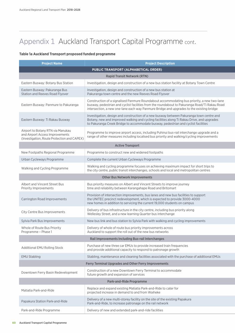
Auckland Transport Capital Programme
Auckland Regional Land Transport Plan 2018–2028
60
Project Name Project Description Prioritisation Duration 2018/19 2019/20 2020/21 2021/22 2022/23 2023/24 2024/25 - 2027/28
PUBLIC TRANSPORT (ALPHABETICAL ORDER) ($m)
Rapid Transit Network (RTN)
Eastern Busway: Botany Bus Station Investigation, design and construction of a new bus station facility at Botany Town Centre 2 2018/19 - 2026/27 0.7 0.3 0.5 2.2 7.9 20.9 42.7
Eastern Busway: Pakuranga Bus Station and Reeves Road Flyover
Investigation, design and construction of a new bus station at Pakuranga town centre and the new Reeves Road Flyover 2 2018/19 - 2023/24 14.9 19.4 1.0 76.7 126.2 78.2 0.0
Eastern Busway: Panmure to PakurangaConstruction of a signalised Panmure Roundabout accommodating bus priority, a new two-lane busway, pedestrian and cyclist facilities from the roundabout to Pakuranga Road/Ti Rakau Road intersection, a new one-lane each way Panmure Bridge and upgrades to the existing bridge
2 2018/19 - 2021/22 21.0 64.4 75.7 8.6 0.0 0.0 0.0
Eastern Busway: Ti Rakau BuswayInvestigation, design and construction of a new busway between Pakuranga town centre and Botany, new and improved walking and cycling facilities along Ti Rakau Drive, and upgrades to Pakuranga Creek Bridge to accommodate busway, pedestrian and cyclist facilities
2 2018/19 - 2024/25 63.4 12.6 7.5 57.8 30.6 91.5 87.2
Airport to Botany RTN via Manukau and Airport Access Improvements (Investigation, Route Protection and CAPEX)
Programme to improve airport access, including Puhinui bus-rail interchange upgrade and a range of other measures including localised bus priority and walking/cycling improvements 2 2018/19 - 2020/21 11.6 30.3 36.6 0.0 0.0 0.0 0.0
Active Transport
New Footpaths Regional Programme Programme to construct new and widened footpaths 2 2018/19 - 2027/28 3.8 3.6 4.0 3.8 3.7 4.8 21.1
Urban Cycleways Programme Complete the current Urban Cycleways Programme 2 2018/19 - 2020/21 52.0 49.2 52.1 0.0 0.0 0.0 0.0
Walking and Cycling Programme Walking and cycling programme focuses on achieving maximum impact for short trips to the city centre, public transit interchanges, schools and local and metropolitan centres 2 2019/20 - 2027/28 0.0 7.1 11.6 28.4 35.5 56.6 198.7
Other Bus Network Improvements
Albert and Vincent Street Bus Priority Improvements
Bus priority measures on Albert and Vincent Streets to improve journey time and reliability between Karangahape Road and Britomart 2 2024/25 - 2027/28 0.0 0.0 0.0 0.0 0.0 0.0 6.8
Carrington Road ImprovementsProvision of intersection improvements, bus lanes and new bus facilities to support the UNITEC precinct redevelopment, which is expected to provide 3000-4000 new homes in addition to servicing the current 19,000 students on campus
2 2021/22 - 2027/28 0.0 0.0 0.0 1.8 2.8 1.1 16.5
City Centre Bus Improvements Delivery of bus infrastructure in the city centre, including bus priority along Wellesley Street, and a new learning Quarter bus interchange 2 2018/19 - 2026/27 1.8 7.5 10.0 11.9 18.3 28.5 39.0
Sylvia Park Bus Improvements New bus link and bus station to Sylvia Park with walking and cycling improvements 2 2018/19 - 2020/21 6.1 8.3 0.8 0.0 0.0 0.0 0.0
Whole of Route Bus Priority Programme – Phase 1
Delivery of whole of route bus priority improvements across Auckland to support the roll out of the new bus networks 2 2018/19 - 2025/26 10.5 16.5 23.8 20.1 21.4 35.4 86.9
Rail Improvements Including Bus-rail Interchanges
Additional EMU Rolling Stock Purchase of new three car EMUs to provide increased train frequencies and provide additional capacity to respond to patronage growth 2 2022/23 - 2025/26 0.0 0.0 0.0 0.0 7.7 48.2 201.8
EMU Stabling Stabling, maintenance and cleaning facilities associated with the purchase of additional EMUs 2 2022/23 - 2025/26 0.0 0.0 0.0 0.0 24.7 39.7 73.8
Ferry Terminal Upgrades and Other Ferry Improvements
Downtown Ferry Basin Redevelopment Construction of a new Downtown Ferry Terminal to accommodate future growth and expansion of services 2 2019/20 - 2024/25 0.0 0.9 1.0 9.6 20.9 18.4 5.9
Park-and-Ride Programme
Matiatia Park-and-Ride Replace and expand existing Matiatia Park-and-Ride to cater for projected increase in demand to and from Waiheke 2 2018/19 - 2021/22 0.1 0.7 7.1 7.4 0.0 0.0 0.0
Papakura Station Park-and-Ride Delivery of a new multi-storey facility on the site of the existing Papakura Park-and-Ride, to increase patronage on the rail network 2 2018/19 - 2020/21 5.2 5.9 0.6 0.0 0.0 0.0 0.0
Park-and-Ride Programme Delivery of new and extended park-and-ride facilities 2 2024/25 - 2026/27 0.0 0.0 0.0 0.0 0.0 0.0 51.0
Table 1a Auckland Transport proposed funded programme
Appendix 1 Auckland Transport Capital Programme cont.
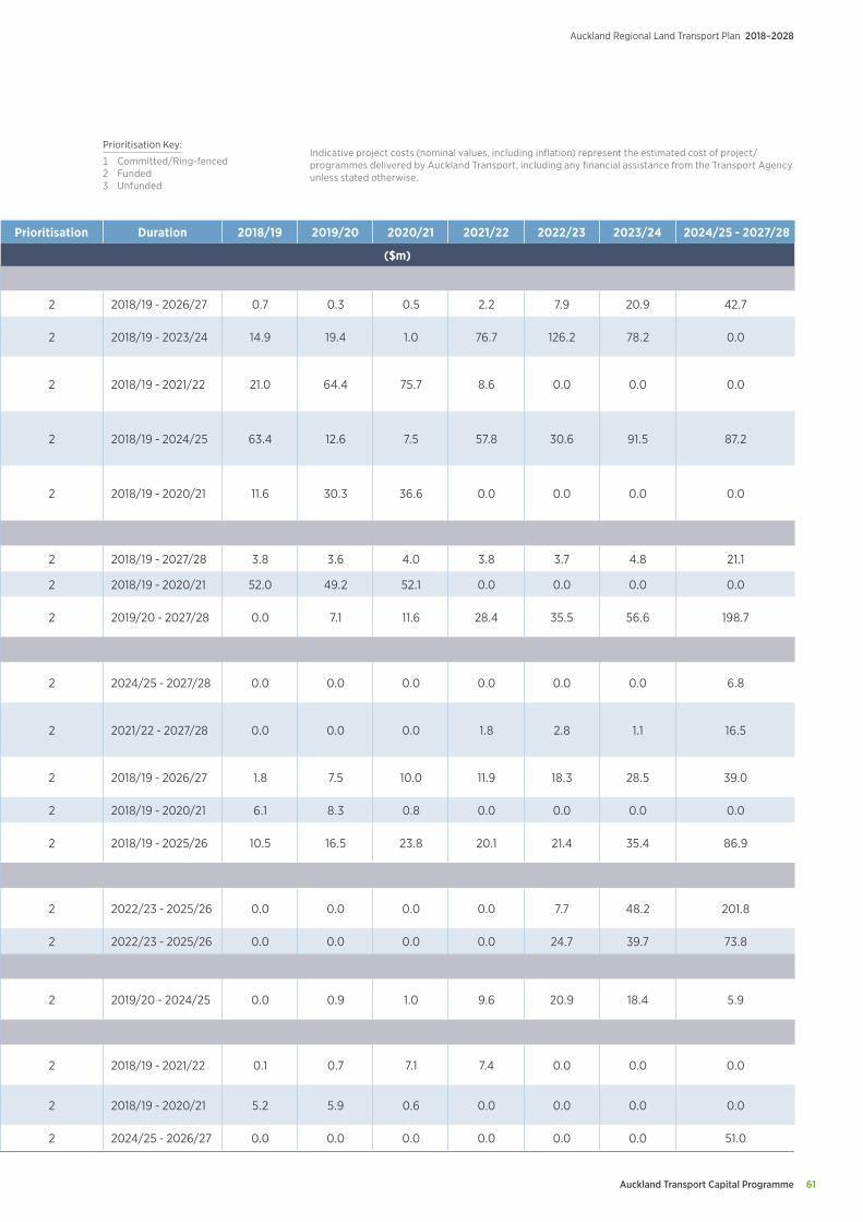
Auckland Transport Capital Programme 61
Auckland Regional Land Transport Plan 2018–2028
Project Name Project Description Prioritisation Duration 2018/19 2019/20 2020/21 2021/22 2022/23 2023/24 2024/25 - 2027/28
PUBLIC TRANSPORT (ALPHABETICAL ORDER) ($m)
Rapid Transit Network (RTN)
Eastern Busway: Botany Bus Station Investigation, design and construction of a new bus station facility at Botany Town Centre 2 2018/19 - 2026/27 0.7 0.3 0.5 2.2 7.9 20.9 42.7
Eastern Busway: Pakuranga Bus Station and Reeves Road Flyover
Investigation, design and construction of a new bus station at Pakuranga town centre and the new Reeves Road Flyover 2 2018/19 - 2023/24 14.9 19.4 1.0 76.7 126.2 78.2 0.0
Eastern Busway: Panmure to PakurangaConstruction of a signalised Panmure Roundabout accommodating bus priority, a new two-lane busway, pedestrian and cyclist facilities from the roundabout to Pakuranga Road/Ti Rakau Road intersection, a new one-lane each way Panmure Bridge and upgrades to the existing bridge
2 2018/19 - 2021/22 21.0 64.4 75.7 8.6 0.0 0.0 0.0
Eastern Busway: Ti Rakau BuswayInvestigation, design and construction of a new busway between Pakuranga town centre and Botany, new and improved walking and cycling facilities along Ti Rakau Drive, and upgrades to Pakuranga Creek Bridge to accommodate busway, pedestrian and cyclist facilities
2 2018/19 - 2024/25 63.4 12.6 7.5 57.8 30.6 91.5 87.2
Airport to Botany RTN via Manukau and Airport Access Improvements (Investigation, Route Protection and CAPEX)
Programme to improve airport access, including Puhinui bus-rail interchange upgrade and a range of other measures including localised bus priority and walking/cycling improvements 2 2018/19 - 2020/21 11.6 30.3 36.6 0.0 0.0 0.0 0.0
Active Transport
New Footpaths Regional Programme Programme to construct new and widened footpaths 2 2018/19 - 2027/28 3.8 3.6 4.0 3.8 3.7 4.8 21.1
Urban Cycleways Programme Complete the current Urban Cycleways Programme 2 2018/19 - 2020/21 52.0 49.2 52.1 0.0 0.0 0.0 0.0
Walking and Cycling Programme Walking and cycling programme focuses on achieving maximum impact for short trips to the city centre, public transit interchanges, schools and local and metropolitan centres 2 2019/20 - 2027/28 0.0 7.1 11.6 28.4 35.5 56.6 198.7
Other Bus Network Improvements
Albert and Vincent Street Bus Priority Improvements
Bus priority measures on Albert and Vincent Streets to improve journey time and reliability between Karangahape Road and Britomart 2 2024/25 - 2027/28 0.0 0.0 0.0 0.0 0.0 0.0 6.8
Carrington Road ImprovementsProvision of intersection improvements, bus lanes and new bus facilities to support the UNITEC precinct redevelopment, which is expected to provide 3000-4000 new homes in addition to servicing the current 19,000 students on campus
2 2021/22 - 2027/28 0.0 0.0 0.0 1.8 2.8 1.1 16.5
City Centre Bus Improvements Delivery of bus infrastructure in the city centre, including bus priority along Wellesley Street, and a new learning Quarter bus interchange 2 2018/19 - 2026/27 1.8 7.5 10.0 11.9 18.3 28.5 39.0
Sylvia Park Bus Improvements New bus link and bus station to Sylvia Park with walking and cycling improvements 2 2018/19 - 2020/21 6.1 8.3 0.8 0.0 0.0 0.0 0.0
Whole of Route Bus Priority Programme – Phase 1
Delivery of whole of route bus priority improvements across Auckland to support the roll out of the new bus networks 2 2018/19 - 2025/26 10.5 16.5 23.8 20.1 21.4 35.4 86.9
Rail Improvements Including Bus-rail Interchanges
Additional EMU Rolling Stock Purchase of new three car EMUs to provide increased train frequencies and provide additional capacity to respond to patronage growth 2 2022/23 - 2025/26 0.0 0.0 0.0 0.0 7.7 48.2 201.8
EMU Stabling Stabling, maintenance and cleaning facilities associated with the purchase of additional EMUs 2 2022/23 - 2025/26 0.0 0.0 0.0 0.0 24.7 39.7 73.8
Ferry Terminal Upgrades and Other Ferry Improvements
Downtown Ferry Basin Redevelopment Construction of a new Downtown Ferry Terminal to accommodate future growth and expansion of services 2 2019/20 - 2024/25 0.0 0.9 1.0 9.6 20.9 18.4 5.9
Park-and-Ride Programme
Matiatia Park-and-Ride Replace and expand existing Matiatia Park-and-Ride to cater for projected increase in demand to and from Waiheke 2 2018/19 - 2021/22 0.1 0.7 7.1 7.4 0.0 0.0 0.0
Papakura Station Park-and-Ride Delivery of a new multi-storey facility on the site of the existing Papakura Park-and-Ride, to increase patronage on the rail network 2 2018/19 - 2020/21 5.2 5.9 0.6 0.0 0.0 0.0 0.0
Park-and-Ride Programme Delivery of new and extended park-and-ride facilities 2 2024/25 - 2026/27 0.0 0.0 0.0 0.0 0.0 0.0 51.0
Indicative project costs (nominal values, including inflation) represent the estimated cost of project/programmes delivered by Auckland Transport, including any financial assistance from the Transport Agency unless stated otherwise.
Prioritisation Key:
1 Committed/Ring-fenced 2 Funded3 Unfunded
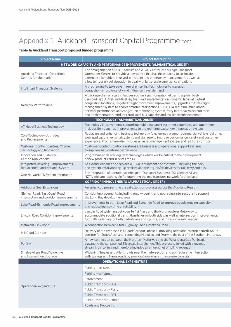
Auckland Transport Capital Programme
Auckland Regional Land Transport Plan 2018–2028
62
Project Name Project Description Prioritisation Duration 2018/19 2019/20 2020/21 2021/22 2022/23 2023/24 2024/25 - 2027/28
NETWORK CAPACITY AND PERFORMANCE IMPROVEMENTS (ALPHABETICAL ORDER) ($m)
Auckland Transport Operations Centres Amalgamation
The amalgamation of ATOC Smales and ATOC Central into a single Transport Operations Centre, to provide a new centre that has the capacity to co-locate external stakeholders involved in incident and emergency management, as well as allow temporary collaboration to deal with large-scale emergency situations
2 2019/20 - 2021/22 0.0 0.2 5.0 0.6 0.0 0.0 0.0
Intelligent Transport Systems A programme to take advantage of emerging technologies to manage congestion, improve safety and influence travel demand 2 2018/19 - 2027/28 2.0 3.6 5.7 8.6 10.0 13.7 66.3
Network Performance
A package of small scale initiatives such as synchronisation of traffic signals, best-use road layout, first-and-final leg trials and implementation, dynamic lanes at highest congestion locations, targeted freight movement improvements, upgrades to traffic light management system to enable smarter intersections, BIG DATA real-time multi modal network performance and congestion monitoring system, ferry interpeak/weekend trials and implementation, and targeted local bus capacity and resilience enhancements
2 2018/19 - 2027/28 7.2 8.2 10.3 15.5 15.1 22.7 101.0
TECHNOLOGY (ALPHABETICAL ORDER) ($m)
AT Metro Business Technology Technology improvements supporting public transport customer experience and operations. Includes items such as improvements to the real-time passenger information system 2 2018/19 - 2027/28 6.2 4.2 2.7 3.3 3.1 4.7 14.1
Core Technology Upgrades and Replacements
Replacing and enhancing business technology (e.g. journey planner, commercial vehicle real time, web applications, external systems and signage) to improve performance, safety and customer experience. Programme also includes an asset management system and rail fibre corridor
2 2018/19 - 2027/28 5.8 5.2 5.6 6.4 6.1 9.1 33.8
Customer Contact Centres, Channel Technology and Innovation
Customer Contact solutions systems are business and operational support systems to improve AT's customer experience 2 2018/19 - 2027/28 1.6 1.5 1.6 1.9 1.9 2.8 11.4
Innovation and Customer Centric Applications
Programme to deliver digital technologies which will be critical to the development of new products and services for AT 2 2018/19 - 2027/28 0.8 1.5 2.3 3.4 4.0 5.5 22.5
Integrated Ticketing – Improvements, Replacement and National System
To extend, enhance and replace AT HOP equipment and systems – including the back-end system, retail and top-up devices and the tag-on/off devices for rail, ferry and bus 2 2018/19 - 2027/28 14.7 8.4 16.1 3.0 0.5 3.9 72.6
One Network ITS System Integration The integration of operational Intelligent Transport Systems (ITS) used by AT and NZTA who are responsible for operating the one transport network for Auckland 2 2018/19 - 2025/26 4.2 2.0 0.2 0.0 0.0 1.0 0.5
CORRIDOR IMPROVEMENTS (ALPHABETICAL ORDER) ($m)
Additional Seal Extensions An enhanced programme of seal extension projects across the Auckland Region 2 2018/19 - 2027/28 1.6 2.0 3.0 5.5 6.1 11.0 55.7
Glenvar Road/East Coast Road intersection and corridor improvements
Corridor improvements, including road widening and upgrading intersections to support the Long Bay development area 2 2018/19 - 2021/22 2.9 14.9 24.9 2.9 0.0 0.0 0.0
Lake Road/Esmonde Road Improvements Improvements to both Lake Road and Esmonde Road to improve people moving capacity and reduce journey time unreliability 2 2018/19 - 2021/22 2.2 3.1 33.5 7.7 0.0 0.0 0.0
Lincoln Road Corridor ImprovementsLincoln Road widening between Te Pai Place and the Northwestern Motorway to accommodate additional transit/bus lanes on both sides, as well as intersection improvements, footpath widening for both pedestrians and cyclists, and installing a solid median
2 2018/19 - 2021/22 24.2 6.9 27.1 26.5 0.0 0.0 0.0
Matakana Link Road A connection between State Highway 1 and Matakana Road 2 2018/19 - 2021/22 19.2 23.0 24.8 21.9 0.0 0.0 0.0
Mill Road Corridor Delivery of the proposed Mill Road Corridor (phase 1) providing additional strategic North-South corridor for South Auckland, connecting Manukau and Drury to the east of the Southern Motorway 2 2018/19 - 2027/28 5.8 5.0 0.0 0.0 0.0 13.8 482.4
PenlinkA new connection between the Northern Motorway and the Whangaparāoa Peninsula, bypassing the constrained Silverdale interchange. This project is linked with a revenue stream from tolling and therefore includes an amount net of tolling revenue
2 2018/19 - 2027/28 2.0 4.5 7.5 0.0 0.0 0.0 186.0
Smales Allens Road Widening and Intersection Upgrade
Widening Smales and Allens roads near their intersection and upgrading the intersection with Springs and Harris roads by providing more lanes to increase capacity 2 2023/24 - 2025/26 0.0 0.0 0.0 0.0 0.0 2.9 10.7
OPERATIONAL EXPENDITURE ($m)
Operational expenditure
Parking – on-street 1 2018/19-2027/28 4.3 4.4 4.4 4.4 4.5 4.5 18.4
Parking – off-street 1 2018/19-2027/28 9.0 9.4 9.5 9.7 9.8 10.0 41.9
Enforcement 1 2018/19-2027/28 22.9 22.8 22.3 21.7 20.9 20.1 71.4
Public Transport – Bus 1 2018/19-2027/28 376.0 405.5 427.5 457.7 482.2 507.6 2292.3
Public Transport – Ferry 1 2018/19-2027/28 26.1 27.2 30.9 32.2 33.4 34.8 155.2
Public Transport – Rail 1 2018/19-2027/28 207.2 210.4 215.9 211.0 211.5 215.5 863.3
Public Transport – Other 1 2018/19-2027/28 51.5 53.7 54.2 54.9 56.2 57.1 234.8
Roads and Footpaths 1 2018/19-2027/28 163.2 166.3 168.0 170.5 173.0 175.5 725.2
Table 1a Auckland Transport proposed funded programme
Appendix 1 Auckland Transport Capital Programme cont.
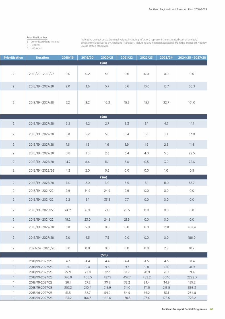
Auckland Transport Capital Programme 63
Auckland Regional Land Transport Plan 2018–2028
Project Name Project Description Prioritisation Duration 2018/19 2019/20 2020/21 2021/22 2022/23 2023/24 2024/25 - 2027/28
NETWORK CAPACITY AND PERFORMANCE IMPROVEMENTS (ALPHABETICAL ORDER) ($m)
Auckland Transport Operations Centres Amalgamation
The amalgamation of ATOC Smales and ATOC Central into a single Transport Operations Centre, to provide a new centre that has the capacity to co-locate external stakeholders involved in incident and emergency management, as well as allow temporary collaboration to deal with large-scale emergency situations
2 2019/20 - 2021/22 0.0 0.2 5.0 0.6 0.0 0.0 0.0
Intelligent Transport Systems A programme to take advantage of emerging technologies to manage congestion, improve safety and influence travel demand 2 2018/19 - 2027/28 2.0 3.6 5.7 8.6 10.0 13.7 66.3
Network Performance
A package of small scale initiatives such as synchronisation of traffic signals, best-use road layout, first-and-final leg trials and implementation, dynamic lanes at highest congestion locations, targeted freight movement improvements, upgrades to traffic light management system to enable smarter intersections, BIG DATA real-time multi modal network performance and congestion monitoring system, ferry interpeak/weekend trials and implementation, and targeted local bus capacity and resilience enhancements
2 2018/19 - 2027/28 7.2 8.2 10.3 15.5 15.1 22.7 101.0
TECHNOLOGY (ALPHABETICAL ORDER) ($m)
AT Metro Business Technology Technology improvements supporting public transport customer experience and operations. Includes items such as improvements to the real-time passenger information system 2 2018/19 - 2027/28 6.2 4.2 2.7 3.3 3.1 4.7 14.1
Core Technology Upgrades and Replacements
Replacing and enhancing business technology (e.g. journey planner, commercial vehicle real time, web applications, external systems and signage) to improve performance, safety and customer experience. Programme also includes an asset management system and rail fibre corridor
2 2018/19 - 2027/28 5.8 5.2 5.6 6.4 6.1 9.1 33.8
Customer Contact Centres, Channel Technology and Innovation
Customer Contact solutions systems are business and operational support systems to improve AT's customer experience 2 2018/19 - 2027/28 1.6 1.5 1.6 1.9 1.9 2.8 11.4
Innovation and Customer Centric Applications
Programme to deliver digital technologies which will be critical to the development of new products and services for AT 2 2018/19 - 2027/28 0.8 1.5 2.3 3.4 4.0 5.5 22.5
Integrated Ticketing – Improvements, Replacement and National System
To extend, enhance and replace AT HOP equipment and systems – including the back-end system, retail and top-up devices and the tag-on/off devices for rail, ferry and bus 2 2018/19 - 2027/28 14.7 8.4 16.1 3.0 0.5 3.9 72.6
One Network ITS System Integration The integration of operational Intelligent Transport Systems (ITS) used by AT and NZTA who are responsible for operating the one transport network for Auckland 2 2018/19 - 2025/26 4.2 2.0 0.2 0.0 0.0 1.0 0.5
CORRIDOR IMPROVEMENTS (ALPHABETICAL ORDER) ($m)
Additional Seal Extensions An enhanced programme of seal extension projects across the Auckland Region 2 2018/19 - 2027/28 1.6 2.0 3.0 5.5 6.1 11.0 55.7
Glenvar Road/East Coast Road intersection and corridor improvements
Corridor improvements, including road widening and upgrading intersections to support the Long Bay development area 2 2018/19 - 2021/22 2.9 14.9 24.9 2.9 0.0 0.0 0.0
Lake Road/Esmonde Road Improvements Improvements to both Lake Road and Esmonde Road to improve people moving capacity and reduce journey time unreliability 2 2018/19 - 2021/22 2.2 3.1 33.5 7.7 0.0 0.0 0.0
Lincoln Road Corridor ImprovementsLincoln Road widening between Te Pai Place and the Northwestern Motorway to accommodate additional transit/bus lanes on both sides, as well as intersection improvements, footpath widening for both pedestrians and cyclists, and installing a solid median
2 2018/19 - 2021/22 24.2 6.9 27.1 26.5 0.0 0.0 0.0
Matakana Link Road A connection between State Highway 1 and Matakana Road 2 2018/19 - 2021/22 19.2 23.0 24.8 21.9 0.0 0.0 0.0
Mill Road Corridor Delivery of the proposed Mill Road Corridor (phase 1) providing additional strategic North-South corridor for South Auckland, connecting Manukau and Drury to the east of the Southern Motorway 2 2018/19 - 2027/28 5.8 5.0 0.0 0.0 0.0 13.8 482.4
PenlinkA new connection between the Northern Motorway and the Whangaparāoa Peninsula, bypassing the constrained Silverdale interchange. This project is linked with a revenue stream from tolling and therefore includes an amount net of tolling revenue
2 2018/19 - 2027/28 2.0 4.5 7.5 0.0 0.0 0.0 186.0
Smales Allens Road Widening and Intersection Upgrade
Widening Smales and Allens roads near their intersection and upgrading the intersection with Springs and Harris roads by providing more lanes to increase capacity 2 2023/24 - 2025/26 0.0 0.0 0.0 0.0 0.0 2.9 10.7
OPERATIONAL EXPENDITURE ($m)
Operational expenditure
Parking – on-street 1 2018/19-2027/28 4.3 4.4 4.4 4.4 4.5 4.5 18.4
Parking – off-street 1 2018/19-2027/28 9.0 9.4 9.5 9.7 9.8 10.0 41.9
Enforcement 1 2018/19-2027/28 22.9 22.8 22.3 21.7 20.9 20.1 71.4
Public Transport – Bus 1 2018/19-2027/28 376.0 405.5 427.5 457.7 482.2 507.6 2292.3
Public Transport – Ferry 1 2018/19-2027/28 26.1 27.2 30.9 32.2 33.4 34.8 155.2
Public Transport – Rail 1 2018/19-2027/28 207.2 210.4 215.9 211.0 211.5 215.5 863.3
Public Transport – Other 1 2018/19-2027/28 51.5 53.7 54.2 54.9 56.2 57.1 234.8
Roads and Footpaths 1 2018/19-2027/28 163.2 166.3 168.0 170.5 173.0 175.5 725.2
Indicative project costs (nominal values, including inflation) represent the estimated cost of project/programmes delivered by Auckland Transport, including any financial assistance from the Transport Agency unless stated otherwise.
Prioritisation Key:
1 Committed/Ring-fenced 2 Funded3 Unfunded
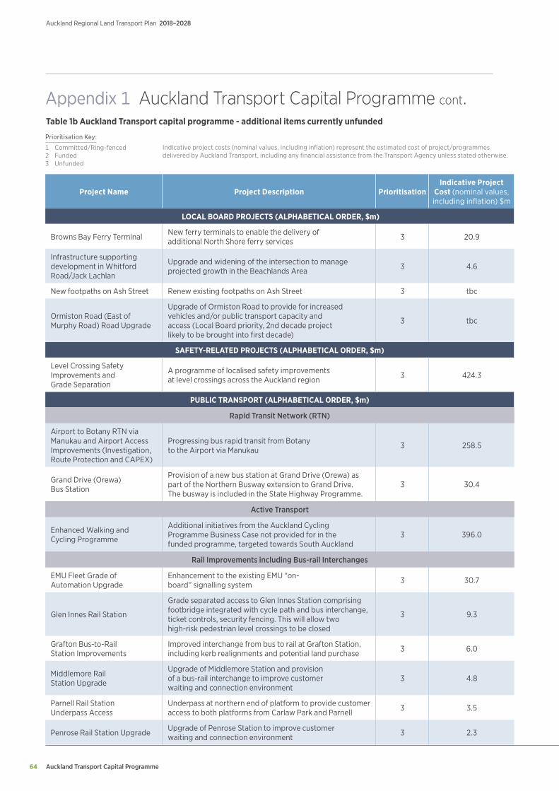
Auckland Transport Capital Programme
Auckland Regional Land Transport Plan 2018–2028
64
Project Name Project Description PrioritisationIndicative Project
Cost (nominal values, including inflation) $m
LOCAL BOARD PROJECTS (ALPHABETICAL ORDER, $m)
Browns Bay Ferry Terminal New ferry terminals to enable the delivery of additional North Shore ferry services 3 20.9
Infrastructure supporting development in Whitford Road/Jack Lachlan
Upgrade and widening of the intersection to manage projected growth in the Beachlands Area 3 4.6
New footpaths on Ash Street Renew existing footpaths on Ash Street 3 tbc
Ormiston Road (East of Murphy Road) Road Upgrade
Upgrade of Ormiston Road to provide for increased vehicles and/or public transport capacity and access (Local Board priority, 2nd decade project likely to be brought into first decade)
3 tbc
SAFETY-RELATED PROJECTS (ALPHABETICAL ORDER, $m)
Level Crossing Safety Improvements and Grade Separation
A programme of localised safety improvements at level crossings across the Auckland region 3 424.3
PUBLIC TRANSPORT (ALPHABETICAL ORDER, $m)
Rapid Transit Network (RTN)
Airport to Botany RTN via Manukau and Airport Access Improvements (Investigation, Route Protection and CAPEX)
Progressing bus rapid transit from Botany to the Airport via Manukau 3 258.5
Grand Drive (Orewa) Bus Station
Provision of a new bus station at Grand Drive (Orewa) as part of the Northern Busway extension to Grand Drive. The busway is included in the State Highway Programme.
3 30.4
Active Transport
Enhanced Walking and Cycling Programme
Additional initiatives from the Auckland Cycling Programme Business Case not provided for in the funded programme, targeted towards South Auckland
3 396.0
Rail Improvements including Bus-rail Interchanges
EMU Fleet Grade of Automation Upgrade
Enhancement to the existing EMU “on-board” signalling system 3 30.7
Glen Innes Rail Station
Grade separated access to Glen Innes Station comprising footbridge integrated with cycle path and bus interchange, ticket controls, security fencing. This will allow two high-risk pedestrian level crossings to be closed
3 9.3
Grafton Bus-to-Rail Station Improvements
Improved interchange from bus to rail at Grafton Station, including kerb realignments and potential land purchase 3 6.0
Middlemore Rail Station Upgrade
Upgrade of Middlemore Station and provision of a bus-rail interchange to improve customer waiting and connection environment
3 4.8
Parnell Rail Station Underpass Access
Underpass at northern end of platform to provide customer access to both platforms from Carlaw Park and Parnell 3 3.5
Penrose Rail Station Upgrade Upgrade of Penrose Station to improve customer waiting and connection environment 3 2.3
Indicative project costs (nominal values, including inflation) represent the estimated cost of project/programmes delivered by Auckland Transport, including any financial assistance from the Transport Agency unless stated otherwise.
Prioritisation Key:
1 Committed/Ring-fenced 2 Funded3 Unfunded
Table 1b Auckland Transport capital programme - additional items currently unfunded
Appendix 1 Auckland Transport Capital Programme cont.
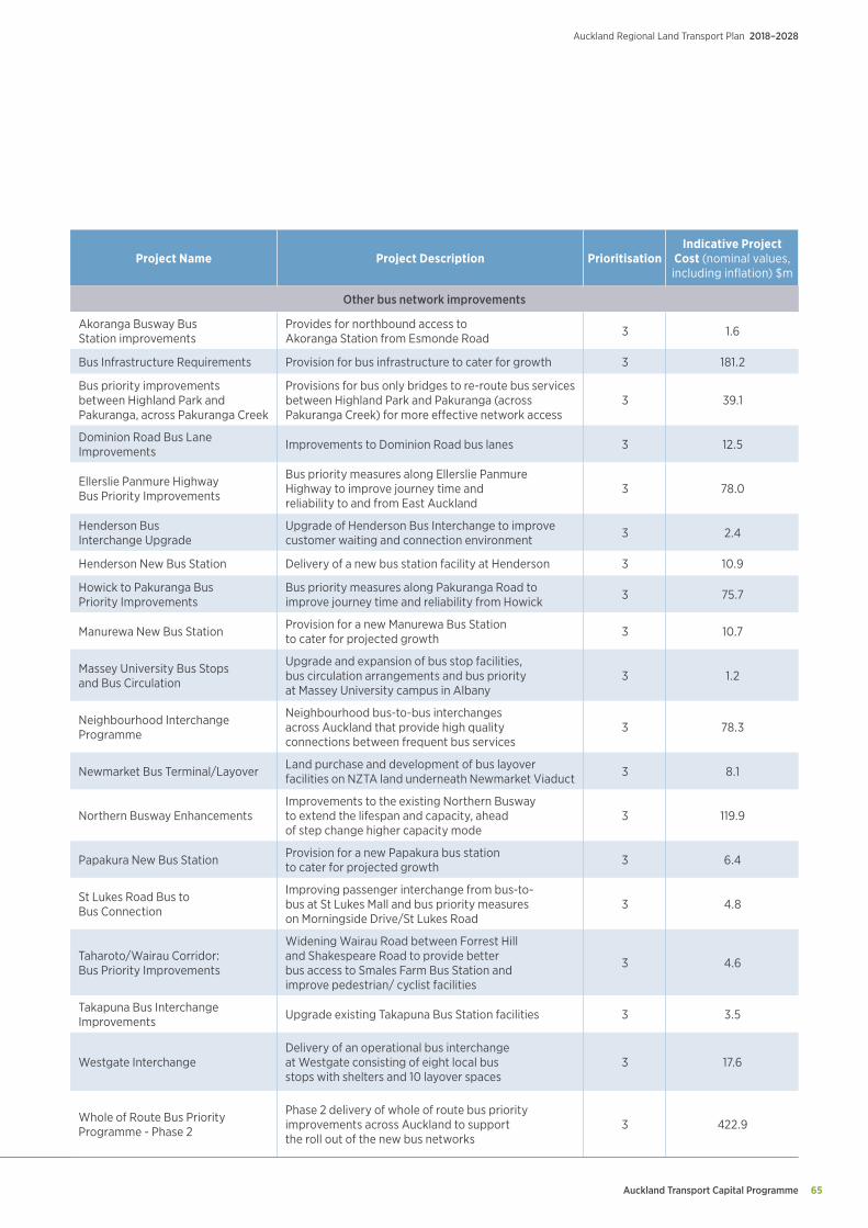
Auckland Transport Capital Programme 65
Auckland Regional Land Transport Plan 2018–2028
Project Name Project Description PrioritisationIndicative Project
Cost (nominal values, including inflation) $m
Other bus network improvements
Akoranga Busway Bus Station improvements
Provides for northbound access to Akoranga Station from Esmonde Road 3 1.6
Bus Infrastructure Requirements Provision for bus infrastructure to cater for growth 3 181.2
Bus priority improvements between Highland Park and Pakuranga, across Pakuranga Creek
Provisions for bus only bridges to re-route bus services between Highland Park and Pakuranga (across Pakuranga Creek) for more effective network access
3 39.1
Dominion Road Bus Lane Improvements Improvements to Dominion Road bus lanes 3 12.5
Ellerslie Panmure Highway Bus Priority Improvements
Bus priority measures along Ellerslie Panmure Highway to improve journey time and reliability to and from East Auckland
3 78.0
Henderson Bus Interchange Upgrade
Upgrade of Henderson Bus Interchange to improve customer waiting and connection environment 3 2.4
Henderson New Bus Station Delivery of a new bus station facility at Henderson 3 10.9
Howick to Pakuranga Bus Priority Improvements
Bus priority measures along Pakuranga Road to improve journey time and reliability from Howick 3 75.7
Manurewa New Bus Station Provision for a new Manurewa Bus Station to cater for projected growth 3 10.7
Massey University Bus Stops and Bus Circulation
Upgrade and expansion of bus stop facilities, bus circulation arrangements and bus priority at Massey University campus in Albany
3 1.2
Neighbourhood Interchange Programme
Neighbourhood bus-to-bus interchanges across Auckland that provide high quality connections between frequent bus services
3 78.3
Newmarket Bus Terminal/Layover Land purchase and development of bus layover facilities on NZTA land underneath Newmarket Viaduct 3 8.1
Northern Busway EnhancementsImprovements to the existing Northern Busway to extend the lifespan and capacity, ahead of step change higher capacity mode
3 119.9
Papakura New Bus Station Provision for a new Papakura bus station to cater for projected growth 3 6.4
St Lukes Road Bus to Bus Connection
Improving passenger interchange from bus-to-bus at St Lukes Mall and bus priority measures on Morningside Drive/St Lukes Road
3 4.8
Taharoto/Wairau Corridor: Bus Priority Improvements
Widening Wairau Road between Forrest Hill and Shakespeare Road to provide better bus access to Smales Farm Bus Station and improve pedestrian/ cyclist facilities
3 4.6
Takapuna Bus Interchange Improvements Upgrade existing Takapuna Bus Station facilities 3 3.5
Westgate InterchangeDelivery of an operational bus interchange at Westgate consisting of eight local bus stops with shelters and 10 layover spaces
3 17.6
Whole of Route Bus Priority Programme - Phase 2
Phase 2 delivery of whole of route bus priority improvements across Auckland to support the roll out of the new bus networks
3 422.9
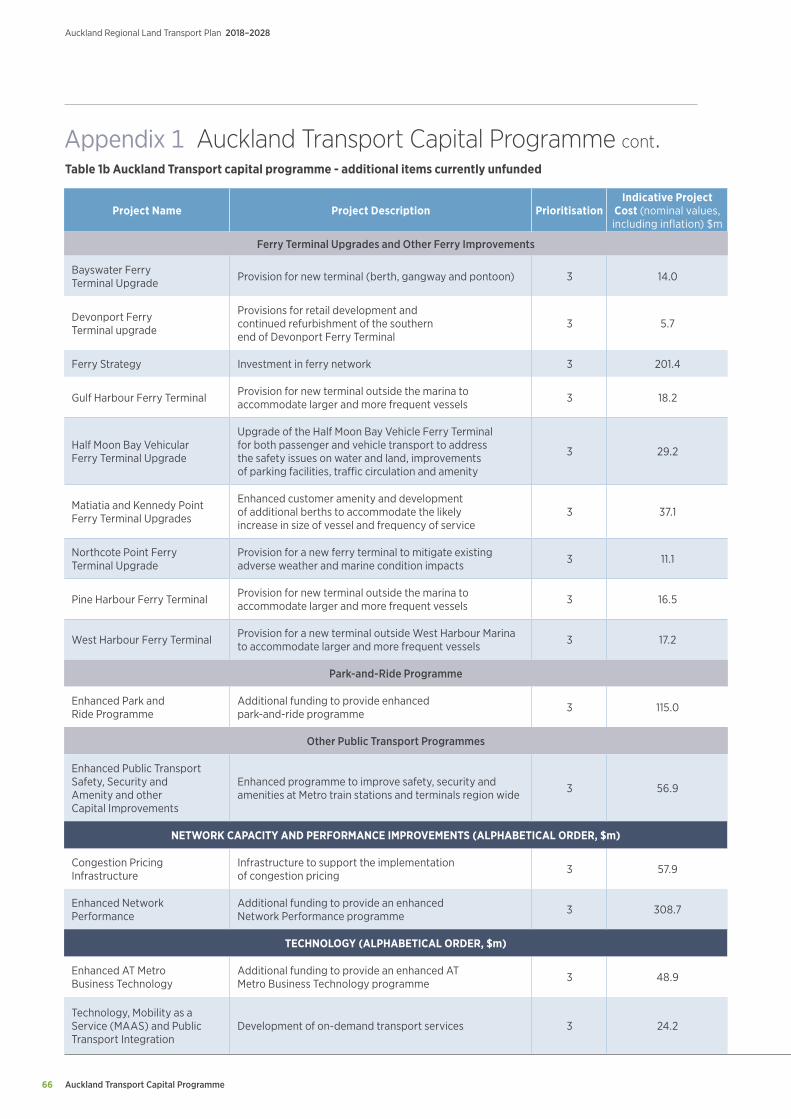
Auckland Transport Capital Programme
Auckland Regional Land Transport Plan 2018–2028
66
Project Name Project Description PrioritisationIndicative Project
Cost (nominal values, including inflation) $m
Ferry Terminal Upgrades and Other Ferry Improvements
Bayswater Ferry Terminal Upgrade Provision for new terminal (berth, gangway and pontoon) 3 14.0
Devonport Ferry Terminal upgrade
Provisions for retail development and continued refurbishment of the southern end of Devonport Ferry Terminal
3 5.7
Ferry Strategy Investment in ferry network 3 201.4
Gulf Harbour Ferry Terminal Provision for new terminal outside the marina to accommodate larger and more frequent vessels 3 18.2
Half Moon Bay Vehicular Ferry Terminal Upgrade
Upgrade of the Half Moon Bay Vehicle Ferry Terminal for both passenger and vehicle transport to address the safety issues on water and land, improvements of parking facilities, traffic circulation and amenity
3 29.2
Matiatia and Kennedy Point Ferry Terminal Upgrades
Enhanced customer amenity and development of additional berths to accommodate the likely increase in size of vessel and frequency of service
3 37.1
Northcote Point Ferry Terminal Upgrade
Provision for a new ferry terminal to mitigate existing adverse weather and marine condition impacts 3 11.1
Pine Harbour Ferry Terminal Provision for new terminal outside the marina to accommodate larger and more frequent vessels 3 16.5
West Harbour Ferry Terminal Provision for a new terminal outside West Harbour Marina to accommodate larger and more frequent vessels 3 17.2
Park-and-Ride Programme
Enhanced Park and Ride Programme
Additional funding to provide enhanced park-and-ride programme 3 115.0
Other Public Transport Programmes
Enhanced Public Transport Safety, Security and Amenity and other Capital Improvements
Enhanced programme to improve safety, security and amenities at Metro train stations and terminals region wide 3 56.9
NETWORK CAPACITY AND PERFORMANCE IMPROVEMENTS (ALPHABETICAL ORDER, $m)
Congestion Pricing Infrastructure
Infrastructure to support the implementation of congestion pricing 3 57.9
Enhanced Network Performance
Additional funding to provide an enhanced Network Performance programme 3 308.7
TECHNOLOGY (ALPHABETICAL ORDER, $m)
Enhanced AT Metro Business Technology
Additional funding to provide an enhanced AT Metro Business Technology programme 3 48.9
Technology, Mobility as a Service (MAAS) and Public Transport Integration
Development of on-demand transport services 3 24.2
Table 1b Auckland Transport capital programme - additional items currently unfunded
Appendix 1 Auckland Transport Capital Programme cont.
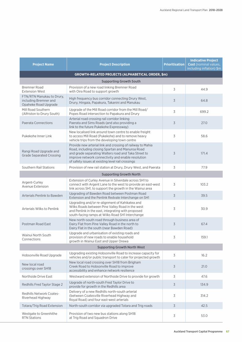
Auckland Transport Capital Programme 67
Auckland Regional Land Transport Plan 2018–2028
Project Name Project Description PrioritisationIndicative Project
Cost (nominal values, including inflation) $m
GROWTH-RELATED PROJECTS (ALPHABETICAL ORDER, $m)
Supporting Growth South
Bremner Road Extension West
Provision of a new road linking Bremner Road with Oira Road to support growth 3 44.9
FTN/RTN Manukau to Drury, including Bremner and Opaheke Road Upgrade
High frequency bus corridor connecting Drury West, Drury, Hingaia, Papakura, Takanini and Manukau 3 64.8
Mill Road Southern (Alfriston to Drury South)
Upgrade of the Mill Road corridor from the Mill Road/Popes Road intersection to Papakura and Drury 3 699.2
Paerata ConnectionsArterial road crossing rail corridor linking Paerata and Sims Roads (and also providing a link to the future Pukekohe Expressway)
3 27.0
Pukekohe Inner LinkNew localised link around town centre to enable freight to access Mill Road (Pukekohe) and to remove heavy vehicle trips from the developing town centre
3 58.6
Rangi Road Upgrade and Grade Separated Crossing
Provide new arterial link and crossing of railway to Mahia Road, including closing Spartan and Manuroa Road and grade separating Walters road and Taka Street to improve network connectivity and enable resolution of safety issues at existing level rail crossings
3 171.4
Southern Rail Stations Provision of new rail station at Drury, Drury West, and Paerata 3 77.9
Supporting Growth North
Argent-Curley Avenue Extension
Extension of Curley Avenue in Silverdale across SH1 to connect with Argent Lane to the west to provide an east-west link across SH1, to support the growth in the Wainui area
3 103.2
Arterials Penlink to Bawden Upgrading of Bawden Road between Postman Road Extension and the Penlink Redvale Interchange on SH1 3 39.5
Arterials Wilks to Penlink
Upgrading and/or re-alignment of Kahikatea and Wilks Roads between Pine Valley Road in the west and Penlink in the east, integrating with proposed south-facing ramps at Wilks Road SH1 Interchange
3 30.9
Postman Road EastNew north-south road through business area of Dairy Flat from Pine Valley Road in the north to Dairy Flat in the south (near Bawden Road)
3 67.4
Wainui North South Connections
Upgrade and urbanisation of existing roads and provision of new roads to enable household growth in Wainui East and Upper Orewa
3 159.1
Supporting Growth North West
Hobsonville Road Upgrade Upgrading existing Hobsonville Road to increase capacity for vehicles and/or public transport to cater for projected growth 3 16.2
New local road crossings over SH18
New local road crossing over SH18 from Brigham Creek Road to Hobsonville Road to improve accessibility and enhance network resilience
3 21.0
Northside Drive East Westward extension of Northside Drive to provide for growth 3 47.6
Redhills Fred Taylor Stage 2 Upgrade of north-south Fred Taylor Drive to provide for growth in the Redhills area 3 134.9
Redhills Network Coates-Riverhead Highway
Delivery of a new Redhills north-south arterial (between Coatesville Riverhead Highway and Royal Road) and four east-west arterials
3 314.2
Totara/Trig Road Extension North-south corridor via upgraded Totara and Trig roads 3 42.5
Westgate to Greenhithe RTN Stations
Provision of two new bus stations along SH18 at Trig Road and Squadron Drive 3 53.0
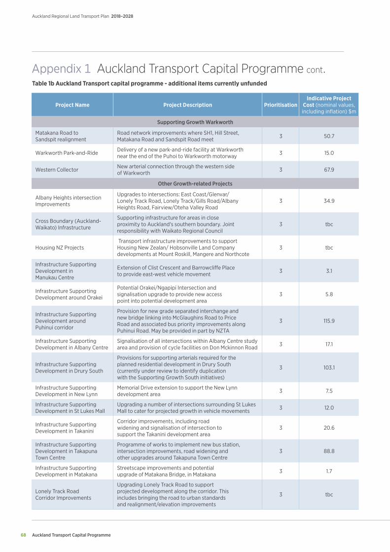
Auckland Transport Capital Programme
Auckland Regional Land Transport Plan 2018–2028
68
Project Name Project Description PrioritisationIndicative Project
Cost (nominal values, including inflation) $m
Supporting Growth Warkworth
Matakana Road to Sandspit realignment
Road network improvements where SH1, Hill Street, Matakana Road and Sandspit Road meet 3 50.7
Warkworth Park-and-Ride Delivery of a new park-and-ride facility at Warkworth near the end of the Puhoi to Warkworth motorway 3 15.0
Western Collector New arterial connection through the western side of Warkworth 3 67.9
Other Growth-related Projects
Albany Heights intersection Improvements
Upgrades to intersections: East Coast/Glenvar/Lonely Track Road, Lonely Track/Gills Road/Albany Heights Road, Fairview/Oteha Valley Road
3 34.9
Cross Boundary (Auckland-Waikato) Infrastructure
Supporting infrastructure for areas in close proximity to Auckland's southern boundary. Joint responsibility with Waikato Regional Council
3 tbc
Housing NZ Projects Transport infrastructure improvements to support Housing New Zealan/ Hobsonville Land Company developments at Mount Roskill, Mangere and Northcote
3 tbc
Infrastructure Supporting Development in Manukau Centre
Extension of Clist Crescent and Barrowcliffe Place to provide east-west vehicle movement 3 3.1
Infrastructure Supporting Development around Orakei
Potential Orakei/Ngapipi Intersection and signalisation upgrade to provide new access point into potential development area
3 5.8
Infrastructure Supporting Development around Puhinui corridor
Provision for new grade separated interchange and new bridge linking into McGlaughins Road to Price Road and associated bus priority improvements along Puhinui Road. May be provided in part by NZTA
3 115.9
Infrastructure Supporting Development in Albany Centre
Signalisation of all intersections within Albany Centre study area and provision of cycle facilities on Don Mckinnon Road 3 17.1
Infrastructure Supporting Development in Drury South
Provisions for supporting arterials required for the planned residential development in Drury South (currently under review to identify duplication with the Supporting Growth South initiatives)
3 103.1
Infrastructure Supporting Development in New Lynn
Memorial Drive extension to support the New Lynn development area 3 7.5
Infrastructure Supporting Development in St Lukes Mall
Upgrading a number of intersections surrounding St Lukes Mall to cater for projected growth in vehicle movements 3 12.0
Infrastructure Supporting Development in Takanini
Corridor improvements, including road widening and signalisation of intersection to support the Takanini development area
3 20.6
Infrastructure Supporting Development in Takapuna Town Centre
Programme of works to implement new bus station, intersection improvements, road widening and other upgrades around Takapuna Town Centre
3 88.8
Infrastructure Supporting Development in Matakana
Streetscape improvements and potential upgrade of Matakana Bridge, in Matakana 3 1.7
Lonely Track Road Corridor Improvements
Upgrading Lonely Track Road to support projected development along the corridor. This includes bringing the road to urban standards and realignment/elevation improvements
3 tbc
Table 1b Auckland Transport capital programme - additional items currently unfunded
Appendix 1 Auckland Transport Capital Programme cont.
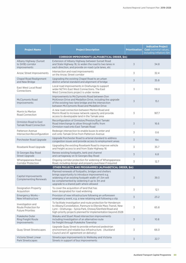
Auckland Transport Capital Programme 69
Auckland Regional Land Transport Plan 2018–2028
Project Name Project Description PrioritisationIndicative Project
Cost (nominal values, including inflation) $m
CORRIDOR IMPROVEMENTS (ALPHABETICAL ORDER, $m)Albany Highway (Sunset to SH18) corridor improvements
Extension of Albany Highway between Sunset Road and State Highway 18, to widen the road to two lanes in each direction, and provide on-road cycle lanes, etc
3 34.8
Anzac Street Improvements Intersection and road improvements on the Anzac Street corridor 3 32.4
Chapel Road Realignment and New Bridge
Upgrading the existing Chapel Road to an urban district arterial standard and alignment of bridge 3 35.8
East West Local Road Connections
Local road improvements in Onehunga to support wider NZTA's East West Connections. The East West Connections project is under review
3 118.8
McClymonts Road Improvements
Improvements to McClymonts Road between Don McKinnon Drive and Medallion Drive, including the upgrade of the existing two-lane bridge and the intersection between McClymonts Road and Medallion Drive
3 15.1
Morrin to Merton Road Connection
A new road connection between Merton Road and Morrin Road to increase network capacity and provide access to developable land in the Tamaki area
3 187.7
Ormiston Road to East Tamaki Road Connection
Reconfiguration of Ormiston/Preston/East Tamaki Road Interchange to allow through traffic from Ormiston road onto East Tamaki Road
3 16.6
Patterson Avenue Intersection Reconfiguration
Redesign intersection to enable buses to enter and exit onto Tamaki Drive from Patterson Avenue 3 0.6
Porchester Road Upgrade Upgrade Porchester Road to arterial standard to address congestion issues and provide access to employment areas 3 tbc
Rosebank Road Upgrade Upgrading the existing Rosebank Road to improve vehicle and freight access to and from State Highway 16 3 35.7
St Georges Bay Road Street Upgrade
Renew existing footpaths, kerb and channel and carriageway on St Georges Bay Road 3 6.8
Whangaparaoa Road Corridor Protection
Ongoing corridor protection for widening of Whangaparaoa Road, including design and property purchase if required 3 12.7
OTHER PROJECTS AND PROGRAMMES (ALPHABETICAL ORDER, $m)
Capital Improvements Complementing Renewals
Planned renewals of footpaths, bridges and shelters brings opportunity to introduce improvement e.g. widening of an existing footpath width of 1.5m will be complemented by widening it up to 3m and upgrade to a shared path where allowed
3 39.3
Designation Property Acquisition
To cover the acquisition of land that has been designated for road widening 3 12.1
Emergency Works – New Infrastructure
Provision of new infrastructure following an unforeseen emergency event, e.g. a new retaining wall following a slip 3 23.2
Investigation and Route Protection for Future Priorities
To facilitate investigation and route protection for Henderson to Albany/Constellation, Panmure to Ellerslie Mass Transit, New Lynn - Onehunga – Sylvia Park, Onewa/Glenfield Road and high-priority projects planned for implementation beyond 2028
3 65.8
Pukekohe Outer Ring Freight Route Improvements
Waiuku and Stuart Road intersection improvements including Investigation of an alternative route for freight through Pukekohe Township
3 10.8
Quay Street StreetscapesUpgrade Quay Street to provide enhanced pedestrian environment and reliable bus infrastructure. (Auckland Council and AT agreement on delivery)
3 66.0
Victoria Street Linear Park Streetscapes
Streetscape improvements to Wellesley and Victoria Streets in support of bus improvements 3 22.7
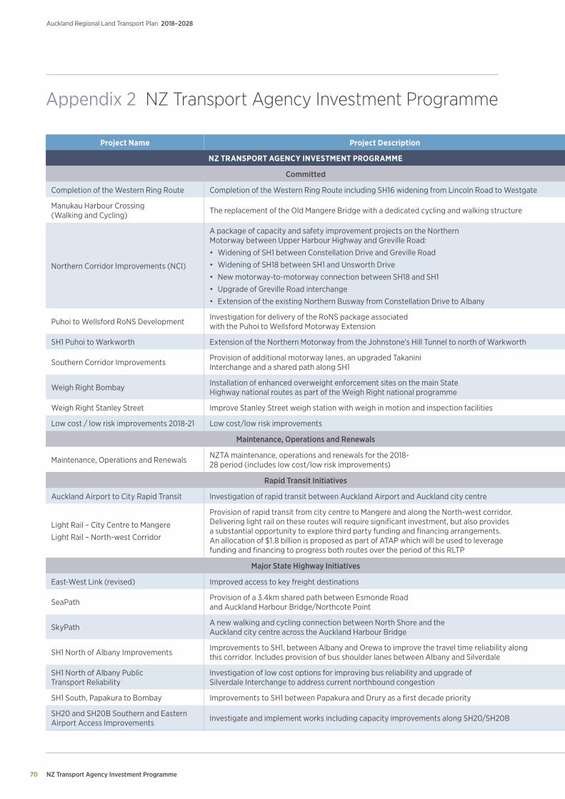
NZ Transport Agency Investment Programme
Auckland Regional Land Transport Plan 2018–2028
70
Appendix 2 NZ Transport Agency Investment Programme
Project Name Project Description Prioritisation Duration 2018/19 2019/20 2020/21 2021/22 2022/23 2023/24 2024/25 - 2027/28
NZ TRANSPORT AGENCY INVESTMENT PROGRAMME ($m)
Committed
Completion of the Western Ring Route Completion of the Western Ring Route including SH16 widening from Lincoln Road to Westgate 1 2018/19 - 2019/20 24.0 1.6 0.0 0.0 0.0 0.0 0.0
Manukau Harbour Crossing (Walking and Cycling) The replacement of the Old Mangere Bridge with a dedicated cycling and walking structure 1 2018/19 15.9 0.0 0.0 0.0 0.0 0.0 0.0
Northern Corridor Improvements (NCI)
A package of capacity and safety improvement projects on the Northern Motorway between Upper Harbour Highway and Greville Road:
• Widening of SH1 between Constellation Drive and Greville Road
• Widening of SH18 between SH1 and Unsworth Drive
• New motorway-to-motorway connection between SH18 and SH1
• Upgrade of Greville Road interchange
• Extension of the existing Northern Busway from Constellation Drive to Albany
1 2018/19 - 2021/22 196.2 176.3 168.9 109.0 0.0 0.0 0.0
Puhoi to Wellsford RoNS Development Investigation for delivery of the RoNS package associated with the Puhoi to Wellsford Motorway Extension 1 2018/19 - 2019/20 15.0 10.3 0.0 0.0 0.0 0.0 0.0
SH1 Puhoi to Warkworth Extension of the Northern Motorway from the Johnstone's Hill Tunnel to north of Warkworth 1 2018/19 - 2027/28 19.5 8.6 12.2 109.7 84.8 84.8 349.6
Southern Corridor Improvements Provision of additional motorway lanes, an upgraded Takanini Interchange and a shared path along SH1 1 2018/19 - 2019/20 63.6 4.1 0.0 0.0 0.0 0.0 0.0
Weigh Right Bombay Installation of enhanced overweight enforcement sites on the main State Highway national routes as part of the Weigh Right national programme 1 2018/19 - 2020/21 0.1 3.8 4.0 0.0 0.0 0.0 0.0
Weigh Right Stanley Street Improve Stanley Street weigh station with weigh in motion and inspection facilities 1 2018/19 - 2019/20 1.0 0.2 0.0 0.0 0.0 0.0 0.0
Low cost / low risk improvements 2018-21 Low cost/low risk improvements 1 2018/19 - 2020/21 4.8 4.9 5.0 0.0 0.0 0.0 0.0
Maintenance, Operations and Renewals
Maintenance, Operations and Renewals NZTA maintenance, operations and renewals for the 2018-28 period (includes low cost/low risk improvements) 1 2018/19 - 2027/28 127.0 143.0 140.0 148.0 153.0 158.0 606.0
Rapid Transit Initiatives
Auckland Airport to City Rapid Transit Investigation of rapid transit between Auckland Airport and Auckland city centre 2 2018/19 14.4 0.0 0.0 0.0 0.0 0.0 0.0
Light Rail – City Centre to Mangere
Light Rail – North-west Corridor
Provision of rapid transit from city centre to Mangere and along the North-west corridor. Delivering light rail on these routes will require significant investment, but also provides a substantial opportunity to explore third party funding and financing arrangements. An allocation of $1.8 billion is proposed as part of ATAP which will be used to leverage funding and financing to progress both routes over the period of this RLTP
2 2018/19 - 2026/27 143.6 205.2 410.4 205.2 168.8 205.2 461.7
Major State Highway Initiatives
East-West Link (revised) Improved access to key freight destinations 2 2018/19 - 2026/27 38.9 25.7 25.7 20.5 93.4 107.7 488.9
SeaPath Provision of a 3.4km shared path between Esmonde Road and Auckland Harbour Bridge/Northcote Point 2 2018/19 - 2019/20 17.4 14.1 0.0 0.0 0.0 0.0 0.0
SkyPath A new walking and cycling connection between North Shore and the Auckland city centre across the Auckland Harbour Bridge 2 2018/19 - 2022/23 0.5 10.3 25.7 25.7 4.6 0.0 0.0
SH1 North of Albany Improvements Improvements to SH1, between Albany and Orewa to improve the travel time reliability along this corridor. Includes provision of bus shoulder lanes between Albany and Silverdale 2 2018/19 - 2021/22 39.9 0.0 0.0 292.4 0.0 0.0 0.0
SH1 North of Albany Public Transport Reliability
Investigation of low cost options for improving bus reliability and upgrade of Silverdale Interchange to address current northbound congestion 2 2018/19 - 2020/21 0.8 2.1 5.1 0.0 0.0 0.0 0.0
SH1 South, Papakura to Bombay Improvements to SH1 between Papakura and Drury as a first decade priority 2 2018/19 - 2024/25 15.9 37.5 117.1 125.1 115.6 0.5 0.5
SH20 and SH20B Southern and Eastern Airport Access Improvements Investigate and implement works including capacity improvements along SH20/SH20B 2 2018/19 - 2026/27 7.7 2.7 65.4 66.5 60.0 61.4 190.1

NZ Transport Agency Investment Programme 71
Auckland Regional Land Transport Plan 2018–2028
Project Name Project Description Prioritisation Duration 2018/19 2019/20 2020/21 2021/22 2022/23 2023/24 2024/25 - 2027/28
NZ TRANSPORT AGENCY INVESTMENT PROGRAMME ($m)
Committed
Completion of the Western Ring Route Completion of the Western Ring Route including SH16 widening from Lincoln Road to Westgate 1 2018/19 - 2019/20 24.0 1.6 0.0 0.0 0.0 0.0 0.0
Manukau Harbour Crossing (Walking and Cycling) The replacement of the Old Mangere Bridge with a dedicated cycling and walking structure 1 2018/19 15.9 0.0 0.0 0.0 0.0 0.0 0.0
Northern Corridor Improvements (NCI)
A package of capacity and safety improvement projects on the Northern Motorway between Upper Harbour Highway and Greville Road:
• Widening of SH1 between Constellation Drive and Greville Road
• Widening of SH18 between SH1 and Unsworth Drive
• New motorway-to-motorway connection between SH18 and SH1
• Upgrade of Greville Road interchange
• Extension of the existing Northern Busway from Constellation Drive to Albany
1 2018/19 - 2021/22 196.2 176.3 168.9 109.0 0.0 0.0 0.0
Puhoi to Wellsford RoNS Development Investigation for delivery of the RoNS package associated with the Puhoi to Wellsford Motorway Extension 1 2018/19 - 2019/20 15.0 10.3 0.0 0.0 0.0 0.0 0.0
SH1 Puhoi to Warkworth Extension of the Northern Motorway from the Johnstone's Hill Tunnel to north of Warkworth 1 2018/19 - 2027/28 19.5 8.6 12.2 109.7 84.8 84.8 349.6
Southern Corridor Improvements Provision of additional motorway lanes, an upgraded Takanini Interchange and a shared path along SH1 1 2018/19 - 2019/20 63.6 4.1 0.0 0.0 0.0 0.0 0.0
Weigh Right Bombay Installation of enhanced overweight enforcement sites on the main State Highway national routes as part of the Weigh Right national programme 1 2018/19 - 2020/21 0.1 3.8 4.0 0.0 0.0 0.0 0.0
Weigh Right Stanley Street Improve Stanley Street weigh station with weigh in motion and inspection facilities 1 2018/19 - 2019/20 1.0 0.2 0.0 0.0 0.0 0.0 0.0
Low cost / low risk improvements 2018-21 Low cost/low risk improvements 1 2018/19 - 2020/21 4.8 4.9 5.0 0.0 0.0 0.0 0.0
Maintenance, Operations and Renewals
Maintenance, Operations and Renewals NZTA maintenance, operations and renewals for the 2018-28 period (includes low cost/low risk improvements) 1 2018/19 - 2027/28 127.0 143.0 140.0 148.0 153.0 158.0 606.0
Rapid Transit Initiatives
Auckland Airport to City Rapid Transit Investigation of rapid transit between Auckland Airport and Auckland city centre 2 2018/19 14.4 0.0 0.0 0.0 0.0 0.0 0.0
Light Rail – City Centre to Mangere
Light Rail – North-west Corridor
Provision of rapid transit from city centre to Mangere and along the North-west corridor. Delivering light rail on these routes will require significant investment, but also provides a substantial opportunity to explore third party funding and financing arrangements. An allocation of $1.8 billion is proposed as part of ATAP which will be used to leverage funding and financing to progress both routes over the period of this RLTP
2 2018/19 - 2026/27 143.6 205.2 410.4 205.2 168.8 205.2 461.7
Major State Highway Initiatives
East-West Link (revised) Improved access to key freight destinations 2 2018/19 - 2026/27 38.9 25.7 25.7 20.5 93.4 107.7 488.9
SeaPath Provision of a 3.4km shared path between Esmonde Road and Auckland Harbour Bridge/Northcote Point 2 2018/19 - 2019/20 17.4 14.1 0.0 0.0 0.0 0.0 0.0
SkyPath A new walking and cycling connection between North Shore and the Auckland city centre across the Auckland Harbour Bridge 2 2018/19 - 2022/23 0.5 10.3 25.7 25.7 4.6 0.0 0.0
SH1 North of Albany Improvements Improvements to SH1, between Albany and Orewa to improve the travel time reliability along this corridor. Includes provision of bus shoulder lanes between Albany and Silverdale 2 2018/19 - 2021/22 39.9 0.0 0.0 292.4 0.0 0.0 0.0
SH1 North of Albany Public Transport Reliability
Investigation of low cost options for improving bus reliability and upgrade of Silverdale Interchange to address current northbound congestion 2 2018/19 - 2020/21 0.8 2.1 5.1 0.0 0.0 0.0 0.0
SH1 South, Papakura to Bombay Improvements to SH1 between Papakura and Drury as a first decade priority 2 2018/19 - 2024/25 15.9 37.5 117.1 125.1 115.6 0.5 0.5
SH20 and SH20B Southern and Eastern Airport Access Improvements Investigate and implement works including capacity improvements along SH20/SH20B 2 2018/19 - 2026/27 7.7 2.7 65.4 66.5 60.0 61.4 190.1
Indicative project costs (nominal values, including inflation) represent the estimated cost of project/programmes.
Prioritisation Key:
1 Committed/Ring-fenced 2 Funded3 Unfunded
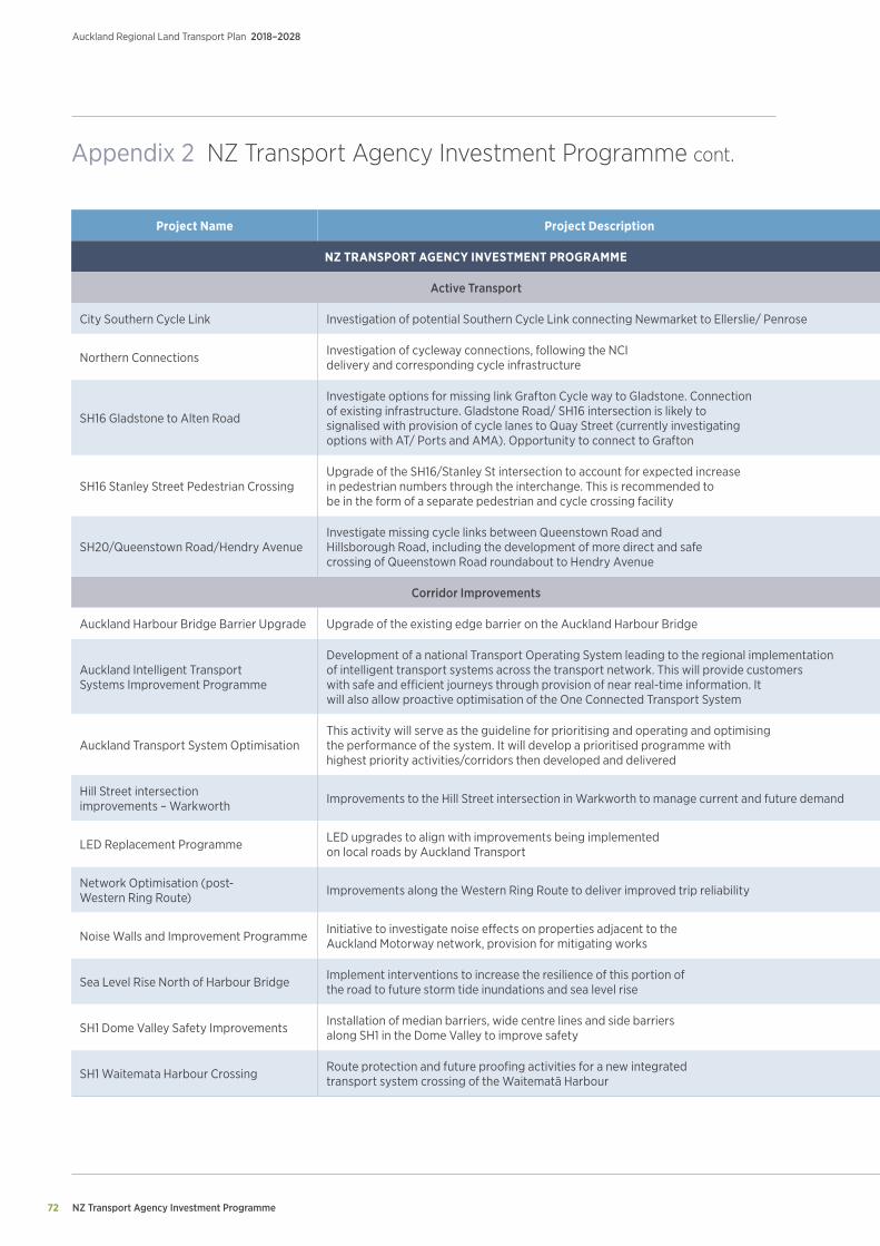
NZ Transport Agency Investment Programme
Auckland Regional Land Transport Plan 2018–2028
72
Appendix 2 NZ Transport Agency Investment Programme cont.
Project Name Project Description Prioritisation Duration 2018/19 2019/20 2020/21 2021/22 2022/23 2023/24 2024/25 - 2027/28
NZ TRANSPORT AGENCY INVESTMENT PROGRAMME ($m)
Active Transport
City Southern Cycle Link Investigation of potential Southern Cycle Link connecting Newmarket to Ellerslie/ Penrose 2 2018/19 - 2020/21 1.5 0.8 0.8 0.0 0.0 0.0 0.0
Northern Connections Investigation of cycleway connections, following the NCI delivery and corresponding cycle infrastructure 2 2020/21 - 2022/23 0.0 0.0 1.5 0.5 0.5 0.0 0.0
SH16 Gladstone to Alten Road
Investigate options for missing link Grafton Cycle way to Gladstone. Connection of existing infrastructure. Gladstone Road/ SH16 intersection is likely to signalised with provision of cycle lanes to Quay Street (currently investigating options with AT/ Ports and AMA). Opportunity to connect to Grafton
2 2019/20 - 2020/21 0.0 1.5 1.5 0.0 0.0 0.0 0.0
SH16 Stanley Street Pedestrian CrossingUpgrade of the SH16/Stanley St intersection to account for expected increase in pedestrian numbers through the interchange. This is recommended to be in the form of a separate pedestrian and cycle crossing facility
2 2018/19 - 2020/21 2.1 2.1 1.0 0.0 0.0 0.0 0.0
SH20/Queenstown Road/Hendry Avenue Investigate missing cycle links between Queenstown Road and Hillsborough Road, including the development of more direct and safe crossing of Queenstown Road roundabout to Hendry Avenue
2 2018/19 - 2020/21 1.5 0.8 0.8 0.0 0.0 0.0 0.0
Corridor Improvements
Auckland Harbour Bridge Barrier Upgrade Upgrade of the existing edge barrier on the Auckland Harbour Bridge 2 2018/19 - 2020/21 0.5 1.5 1.0 0.0 0.0 0.0 0.0
Auckland Intelligent Transport Systems Improvement Programme
Development of a national Transport Operating System leading to the regional implementation of intelligent transport systems across the transport network. This will provide customers with safe and efficient journeys through provision of near real-time information. It will also allow proactive optimisation of the One Connected Transport System
2 2018/19 - 2020/21 2.4 7.1 10.5 0.0 0.0 0.0 0.0
Auckland Transport System OptimisationThis activity will serve as the guideline for prioritising and operating and optimising the performance of the system. It will develop a prioritised programme with highest priority activities/corridors then developed and delivered
2 2018/19 - 2027/28 2.6 1.0 1.0 3.1 2.1 2.1 8.2
Hill Street intersection improvements – Warkworth Improvements to the Hill Street intersection in Warkworth to manage current and future demand 2 2018/19 - 2025/26 0.8 1.0 0.5 0.8 1.2 12.3 12.1
LED Replacement Programme LED upgrades to align with improvements being implemented on local roads by Auckland Transport 2 2018/19 - 2020/21 2.6 3.1 2.4 0.0 0.0 0.0 0.0
Network Optimisation (post-Western Ring Route) Improvements along the Western Ring Route to deliver improved trip reliability 2 2018/19 - 2019/20 7.9 5.1 0.0 0.0 0.0 0.0 0.0
Noise Walls and Improvement Programme Initiative to investigate noise effects on properties adjacent to the Auckland Motorway network, provision for mitigating works 2 2018/19 - 2023/24 23.4 21.5 31.0 27.9 10.1 16.2 0.0
Sea Level Rise North of Harbour Bridge Implement interventions to increase the resilience of this portion of the road to future storm tide inundations and sea level rise 2 2018/19 - 2021/22 7.0 1.6 13.8 17.6 0.0 0.0 0.0
SH1 Dome Valley Safety Improvements Installation of median barriers, wide centre lines and side barriers along SH1 in the Dome Valley to improve safety 2 2018/19 - 2020/21 8.8 11.2 9.8 0.0 0.0 0.0 0.0
SH1 Waitemata Harbour Crossing Route protection and future proofing activities for a new integrated transport system crossing of the Waitematā Harbour 2 2018/19 - 2020/21 7.4 49.1 5.0 0.0 0.0 0.0 0.0
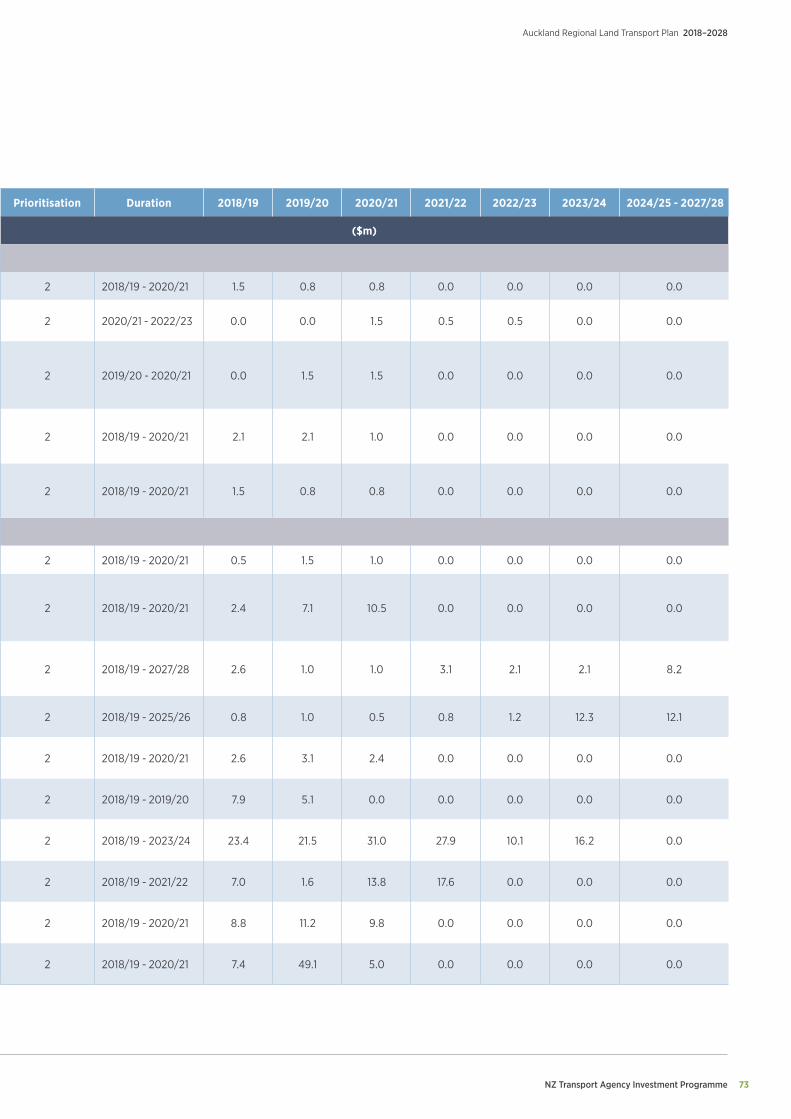
NZ Transport Agency Investment Programme 73
Auckland Regional Land Transport Plan 2018–2028
Project Name Project Description Prioritisation Duration 2018/19 2019/20 2020/21 2021/22 2022/23 2023/24 2024/25 - 2027/28
NZ TRANSPORT AGENCY INVESTMENT PROGRAMME ($m)
Active Transport
City Southern Cycle Link Investigation of potential Southern Cycle Link connecting Newmarket to Ellerslie/ Penrose 2 2018/19 - 2020/21 1.5 0.8 0.8 0.0 0.0 0.0 0.0
Northern Connections Investigation of cycleway connections, following the NCI delivery and corresponding cycle infrastructure 2 2020/21 - 2022/23 0.0 0.0 1.5 0.5 0.5 0.0 0.0
SH16 Gladstone to Alten Road
Investigate options for missing link Grafton Cycle way to Gladstone. Connection of existing infrastructure. Gladstone Road/ SH16 intersection is likely to signalised with provision of cycle lanes to Quay Street (currently investigating options with AT/ Ports and AMA). Opportunity to connect to Grafton
2 2019/20 - 2020/21 0.0 1.5 1.5 0.0 0.0 0.0 0.0
SH16 Stanley Street Pedestrian CrossingUpgrade of the SH16/Stanley St intersection to account for expected increase in pedestrian numbers through the interchange. This is recommended to be in the form of a separate pedestrian and cycle crossing facility
2 2018/19 - 2020/21 2.1 2.1 1.0 0.0 0.0 0.0 0.0
SH20/Queenstown Road/Hendry Avenue Investigate missing cycle links between Queenstown Road and Hillsborough Road, including the development of more direct and safe crossing of Queenstown Road roundabout to Hendry Avenue
2 2018/19 - 2020/21 1.5 0.8 0.8 0.0 0.0 0.0 0.0
Corridor Improvements
Auckland Harbour Bridge Barrier Upgrade Upgrade of the existing edge barrier on the Auckland Harbour Bridge 2 2018/19 - 2020/21 0.5 1.5 1.0 0.0 0.0 0.0 0.0
Auckland Intelligent Transport Systems Improvement Programme
Development of a national Transport Operating System leading to the regional implementation of intelligent transport systems across the transport network. This will provide customers with safe and efficient journeys through provision of near real-time information. It will also allow proactive optimisation of the One Connected Transport System
2 2018/19 - 2020/21 2.4 7.1 10.5 0.0 0.0 0.0 0.0
Auckland Transport System OptimisationThis activity will serve as the guideline for prioritising and operating and optimising the performance of the system. It will develop a prioritised programme with highest priority activities/corridors then developed and delivered
2 2018/19 - 2027/28 2.6 1.0 1.0 3.1 2.1 2.1 8.2
Hill Street intersection improvements – Warkworth Improvements to the Hill Street intersection in Warkworth to manage current and future demand 2 2018/19 - 2025/26 0.8 1.0 0.5 0.8 1.2 12.3 12.1
LED Replacement Programme LED upgrades to align with improvements being implemented on local roads by Auckland Transport 2 2018/19 - 2020/21 2.6 3.1 2.4 0.0 0.0 0.0 0.0
Network Optimisation (post-Western Ring Route) Improvements along the Western Ring Route to deliver improved trip reliability 2 2018/19 - 2019/20 7.9 5.1 0.0 0.0 0.0 0.0 0.0
Noise Walls and Improvement Programme Initiative to investigate noise effects on properties adjacent to the Auckland Motorway network, provision for mitigating works 2 2018/19 - 2023/24 23.4 21.5 31.0 27.9 10.1 16.2 0.0
Sea Level Rise North of Harbour Bridge Implement interventions to increase the resilience of this portion of the road to future storm tide inundations and sea level rise 2 2018/19 - 2021/22 7.0 1.6 13.8 17.6 0.0 0.0 0.0
SH1 Dome Valley Safety Improvements Installation of median barriers, wide centre lines and side barriers along SH1 in the Dome Valley to improve safety 2 2018/19 - 2020/21 8.8 11.2 9.8 0.0 0.0 0.0 0.0
SH1 Waitemata Harbour Crossing Route protection and future proofing activities for a new integrated transport system crossing of the Waitematā Harbour 2 2018/19 - 2020/21 7.4 49.1 5.0 0.0 0.0 0.0 0.0
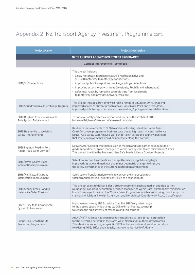
NZ Transport Agency Investment Programme
Auckland Regional Land Transport Plan 2018–2028
74
Appendix 2 NZ Transport Agency Investment Programme cont.
Project Name Project Description Prioritisation Duration 2018/19 2019/20 2020/21 2021/22 2022/23 2023/24 2024/25 - 2027/28
NZ TRANSPORT AGENCY INVESTMENT PROGRAMME ($m)
Corridor Improvements - continued
SH16/18 Connections
This project includes:
• a new motorway interchange at SH16 Northside Drive and SH16/18 motorway to motorway connections
• improved public transport and walking/cycling connections
• improving access to growth areas (Westgate, Redhills and Whenuapai)
• safer local roads by removing strategic trips from local roads to motorway and provides network resilience
2 2018/19 - 2022/23 2.1 5.1 8.2 12.3 8.2 0.0 0.0
SH18 Squadron Drive Interchange Upgrade This project includes providing west facing ramps at Squadron Drive, enabling improved access to current growth areas (Hobsonville Point and Scotts Point), improved public transport access and new walking/cycling/multi-modal facilities
2 2018/19 - 2023/24 2.1 14.4 26.7 23.6 0.5 0.5 0.0
SH16 Brigham Creek to Waimauku Safe System Enhancement
To improve safety and efficiency for road users on the stretch of SH16 between Brigham Creek and Waimauku in Auckland 2 2018/19 - 2020/21 26.0 31.6 8.1 0.0 0.0 0.0 0.0
SH16 Helensville to Wellsford Safety Improvements
Resilience improvements to SH16 to address flooding. Identified in the Twin Coast Discovery programme business case due to high crash risk and resilience issues. Also Safety Gap Analysis work undertaken across the country identified that safety improvements would be necessary along this corridor
2 2023/24 - 2026/27 0.0 0.0 0.0 0.0 0.0 3.4 10.3
SH16 Ingleton Road to Port Albert Road Safer Corridor
Deliver Safer Corridor treatments such as median and side barrier, roundabouts or grade separation, or speed managed to within Safe System (harm minimisation) limits. This project is within the Proposed New Safe Roads Alliance Corridor Projects
2 2021/22 - 2023/24 0.0 0.0 0.0 0.1 0.0 1.6 0.0
SH16/Joyce Adams Place intersection Improvement
Safer Intersection treatments such as splitter islands, right-turning bays, improved signage and markings and minor geometric changes to improve the safety performance of the current intersection arrangement
2 2018/19 - 2020/21 0.1 0.0 1.3 0.0 0.0 0.0 0.0
SH16/Kahikatea Flat Road Intersection Improvement
Safe System Transformation works to convert the intersection to a safer arrangement (e.g. priority controlled to a roundabout) 2 2018/19 - 2020/21 0.1 0.0 1.7 0.0 0.0 0.0 0.0
SH16 Stoney Creek Road to Helensville Safer Corridor
This project seeks to deliver Safer Corridor treatments such as median and side barrier, roundabouts or grade separation, or speed managed to within Safe System (harm minimisation) limits. This project is within the 20-Year View Programme which aims to bring corridors up to a standard which is in line with its function and hierarchical (One Network Road) Classification
2 2018/19 6.7 0.0 0.0 0.0 0.0 0.0 0.0
SH22 Drury to Pukekohe Safe System Enhancement
Improvements along SH22 corridor from the SH1 Drury interchange to the posted speed limit change (to 70km/hr) at Paerata township to reduce the high severity of crashes along this corridor
2 2018/19 - 2021/22 10.3 20.4 20.5 22.3 0.0 0.0 0.0
Supporting Growth Route Protection Programme
An AT/NZTA Alliance has been recently established to look at route protection for the preferred network in the North west, North and Southern growth areas. This also includes looking at specific NZTA activities such as alternative corridors to existing SH16, SH22, and capacity improvements North of Albany
2 2018/19 - 2021/22 9.8 4.8 3.7 1.9 0.0 0.0 0.0
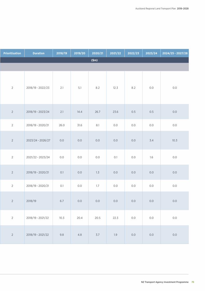
NZ Transport Agency Investment Programme 75
Auckland Regional Land Transport Plan 2018–2028
Project Name Project Description Prioritisation Duration 2018/19 2019/20 2020/21 2021/22 2022/23 2023/24 2024/25 - 2027/28
NZ TRANSPORT AGENCY INVESTMENT PROGRAMME ($m)
Corridor Improvements - continued
SH16/18 Connections
This project includes:
• a new motorway interchange at SH16 Northside Drive and SH16/18 motorway to motorway connections
• improved public transport and walking/cycling connections
• improving access to growth areas (Westgate, Redhills and Whenuapai)
• safer local roads by removing strategic trips from local roads to motorway and provides network resilience
2 2018/19 - 2022/23 2.1 5.1 8.2 12.3 8.2 0.0 0.0
SH18 Squadron Drive Interchange Upgrade This project includes providing west facing ramps at Squadron Drive, enabling improved access to current growth areas (Hobsonville Point and Scotts Point), improved public transport access and new walking/cycling/multi-modal facilities
2 2018/19 - 2023/24 2.1 14.4 26.7 23.6 0.5 0.5 0.0
SH16 Brigham Creek to Waimauku Safe System Enhancement
To improve safety and efficiency for road users on the stretch of SH16 between Brigham Creek and Waimauku in Auckland 2 2018/19 - 2020/21 26.0 31.6 8.1 0.0 0.0 0.0 0.0
SH16 Helensville to Wellsford Safety Improvements
Resilience improvements to SH16 to address flooding. Identified in the Twin Coast Discovery programme business case due to high crash risk and resilience issues. Also Safety Gap Analysis work undertaken across the country identified that safety improvements would be necessary along this corridor
2 2023/24 - 2026/27 0.0 0.0 0.0 0.0 0.0 3.4 10.3
SH16 Ingleton Road to Port Albert Road Safer Corridor
Deliver Safer Corridor treatments such as median and side barrier, roundabouts or grade separation, or speed managed to within Safe System (harm minimisation) limits. This project is within the Proposed New Safe Roads Alliance Corridor Projects
2 2021/22 - 2023/24 0.0 0.0 0.0 0.1 0.0 1.6 0.0
SH16/Joyce Adams Place intersection Improvement
Safer Intersection treatments such as splitter islands, right-turning bays, improved signage and markings and minor geometric changes to improve the safety performance of the current intersection arrangement
2 2018/19 - 2020/21 0.1 0.0 1.3 0.0 0.0 0.0 0.0
SH16/Kahikatea Flat Road Intersection Improvement
Safe System Transformation works to convert the intersection to a safer arrangement (e.g. priority controlled to a roundabout) 2 2018/19 - 2020/21 0.1 0.0 1.7 0.0 0.0 0.0 0.0
SH16 Stoney Creek Road to Helensville Safer Corridor
This project seeks to deliver Safer Corridor treatments such as median and side barrier, roundabouts or grade separation, or speed managed to within Safe System (harm minimisation) limits. This project is within the 20-Year View Programme which aims to bring corridors up to a standard which is in line with its function and hierarchical (One Network Road) Classification
2 2018/19 6.7 0.0 0.0 0.0 0.0 0.0 0.0
SH22 Drury to Pukekohe Safe System Enhancement
Improvements along SH22 corridor from the SH1 Drury interchange to the posted speed limit change (to 70km/hr) at Paerata township to reduce the high severity of crashes along this corridor
2 2018/19 - 2021/22 10.3 20.4 20.5 22.3 0.0 0.0 0.0
Supporting Growth Route Protection Programme
An AT/NZTA Alliance has been recently established to look at route protection for the preferred network in the North west, North and Southern growth areas. This also includes looking at specific NZTA activities such as alternative corridors to existing SH16, SH22, and capacity improvements North of Albany
2 2018/19 - 2021/22 9.8 4.8 3.7 1.9 0.0 0.0 0.0
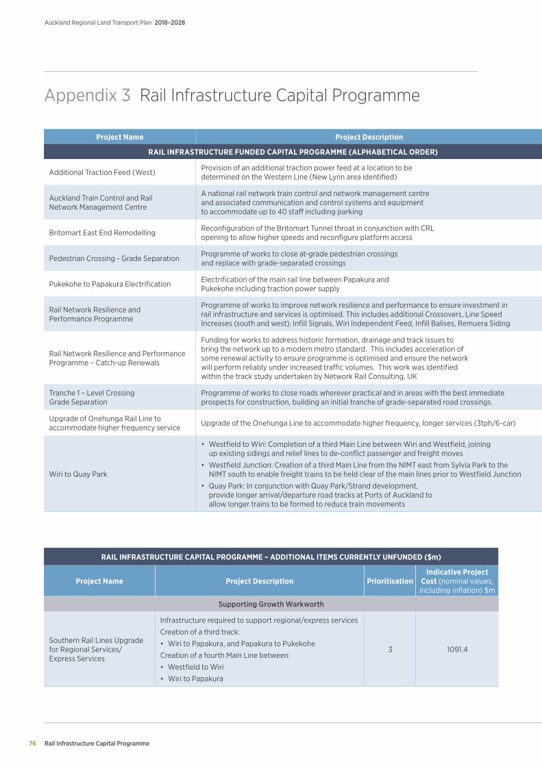
Rail Infrastructure Capital Programme
Auckland Regional Land Transport Plan 2018–2028
76
Appendix 3 Rail Infrastructure Capital Programme
Project Name Project Description Prioritisation Duration 2018/19 2019/20 2020/21 2021/22 2022/23 2023/24 2024/25 - 2027/28
RAIL INFRASTRUCTURE FUNDED CAPITAL PROGRAMME (ALPHABETICAL ORDER) ($m)
Additional Traction Feed (West) Provision of an additional traction power feed at a location to be determined on the Western Line (New Lynn area identified) 2 2018/19 - 2022/23 0.5 0.6 5.9 1.8 21.8 0.0 0.0
Auckland Train Control and Rail Network Management Centre
A national rail network train control and network management centre and associated communication and control systems and equipment to accommodate up to 40 staff including parking
2 2018/19 - 2022/23 2.3 2.8 4.7 7.2 6.7 0.0 0.0
Britomart East End Remodelling Reconfiguration of the Britomart Tunnel throat in conjunction with CRL opening to allow higher speeds and reconfigure platform access 2 2026/27 0.0 0.0 0.0 0.0 0.0 0.0 31.4
Pedestrian Crossing - Grade Separation Programme of works to close at-grade pedestrian crossings and replace with grade-separated crossings 2 2018/19 - 2022/22 1.1 5.7 11.7 4.8 0.0 0.0 0.0
Pukekohe to Papakura Electrification Electrification of the main rail line between Papakura and Pukekohe including traction power supply 2 2018/19 - 2022/23 4.4 64.6 53.8 73.0 36.4 0.0 0.0
Rail Network Resilience and Performance Programme
Programme of works to improve network resilience and performance to ensure investment in rail infrastructure and services is optimised. This includes additional Crossovers, Line Speed Increases (south and west), Infill Signals, Wiri Independent Feed, Infill Balises, Remuera Siding
2 2018/19 - 2023/24 1.1 3.6 11.5 11.5 0.0 14.7 0.0
Rail Network Resilience and Performance Programme – Catch-up Renewals
Funding for works to address historic formation, drainage and track issues to bring the network up to a modern metro standard. This includes acceleration of some renewal activity to ensure programme is optimised and ensure the network will perform reliably under increased traffic volumes. This work was identified within the track study undertaken by Network Rail Consulting, UK
2 2018/19 - 2025/26 5.5 5.7 11.7 12.1 24.9 25.6 40.0
Tranche 1 – Level Crossing Grade Separation
Programme of works to close roads wherever practical and in areas with the best immediate prospects for construction, building an initial tranche of grade-separated road crossings. 2 2018/19 - 2027/28 2.2 14.8 23.4 24.1 24.9 25.6 124.1
Upgrade of Onehunga Rail Line to accommodate higher frequency service Upgrade of the Onehunga Line to accommodate higher frequency, longer services (3tph/6-car) 2 2022/23 - 2023/24 0.0 0.0 0.0 0.0 32.3 36.9 0.0
Wiri to Quay Park
• Westfield to Wiri: Completion of a third Main Line between Wiri and Westfield, joining up existing sidings and relief lines to de-conflict passenger and freight moves
• Westfield Junction: Creation of a third Main Line from the NIMT east from Sylvia Park to the NIMT south to enable freight trains to be held clear of the main lines prior to Westfield Junction
• Quay Park: In conjunction with Quay Park/Strand development, provide longer arrival/departure road tracks at Ports of Auckland to allow longer trains to be formed to reduce train movements
2 2018/19 - 2022/23 18.6 45.6 48.0 32.9 27.4 0.0 0.0
RAIL INFRASTRUCTURE CAPITAL PROGRAMME – ADDITIONAL ITEMS CURRENTLY UNFUNDED ($m)
Project Name Project Description PrioritisationIndicative Project
Cost (nominal values, including inflation) $m
Supporting Growth Warkworth
Southern Rail Lines Upgrade for Regional Services/Express Services
Infrastructure required to support regional/express services
Creation of a third track:
• Wiri to Papakura, and Papakura to Pukekohe
Creation of a fourth Main Line between:
• Westfield to Wiri
• Wiri to Papakura
3 1091.4
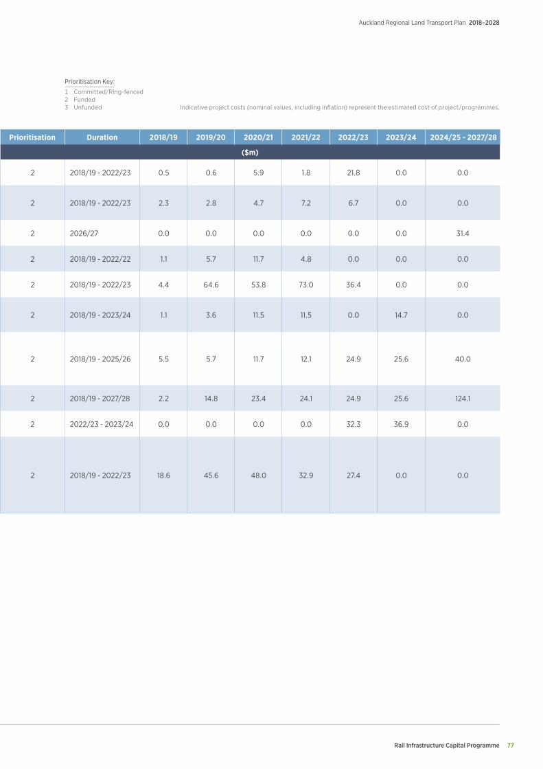
Rail Infrastructure Capital Programme 77
Auckland Regional Land Transport Plan 2018–2028
Project Name Project Description Prioritisation Duration 2018/19 2019/20 2020/21 2021/22 2022/23 2023/24 2024/25 - 2027/28
RAIL INFRASTRUCTURE FUNDED CAPITAL PROGRAMME (ALPHABETICAL ORDER) ($m)
Additional Traction Feed (West) Provision of an additional traction power feed at a location to be determined on the Western Line (New Lynn area identified) 2 2018/19 - 2022/23 0.5 0.6 5.9 1.8 21.8 0.0 0.0
Auckland Train Control and Rail Network Management Centre
A national rail network train control and network management centre and associated communication and control systems and equipment to accommodate up to 40 staff including parking
2 2018/19 - 2022/23 2.3 2.8 4.7 7.2 6.7 0.0 0.0
Britomart East End Remodelling Reconfiguration of the Britomart Tunnel throat in conjunction with CRL opening to allow higher speeds and reconfigure platform access 2 2026/27 0.0 0.0 0.0 0.0 0.0 0.0 31.4
Pedestrian Crossing - Grade Separation Programme of works to close at-grade pedestrian crossings and replace with grade-separated crossings 2 2018/19 - 2022/22 1.1 5.7 11.7 4.8 0.0 0.0 0.0
Pukekohe to Papakura Electrification Electrification of the main rail line between Papakura and Pukekohe including traction power supply 2 2018/19 - 2022/23 4.4 64.6 53.8 73.0 36.4 0.0 0.0
Rail Network Resilience and Performance Programme
Programme of works to improve network resilience and performance to ensure investment in rail infrastructure and services is optimised. This includes additional Crossovers, Line Speed Increases (south and west), Infill Signals, Wiri Independent Feed, Infill Balises, Remuera Siding
2 2018/19 - 2023/24 1.1 3.6 11.5 11.5 0.0 14.7 0.0
Rail Network Resilience and Performance Programme – Catch-up Renewals
Funding for works to address historic formation, drainage and track issues to bring the network up to a modern metro standard. This includes acceleration of some renewal activity to ensure programme is optimised and ensure the network will perform reliably under increased traffic volumes. This work was identified within the track study undertaken by Network Rail Consulting, UK
2 2018/19 - 2025/26 5.5 5.7 11.7 12.1 24.9 25.6 40.0
Tranche 1 – Level Crossing Grade Separation
Programme of works to close roads wherever practical and in areas with the best immediate prospects for construction, building an initial tranche of grade-separated road crossings. 2 2018/19 - 2027/28 2.2 14.8 23.4 24.1 24.9 25.6 124.1
Upgrade of Onehunga Rail Line to accommodate higher frequency service Upgrade of the Onehunga Line to accommodate higher frequency, longer services (3tph/6-car) 2 2022/23 - 2023/24 0.0 0.0 0.0 0.0 32.3 36.9 0.0
Wiri to Quay Park
• Westfield to Wiri: Completion of a third Main Line between Wiri and Westfield, joining up existing sidings and relief lines to de-conflict passenger and freight moves
• Westfield Junction: Creation of a third Main Line from the NIMT east from Sylvia Park to the NIMT south to enable freight trains to be held clear of the main lines prior to Westfield Junction
• Quay Park: In conjunction with Quay Park/Strand development, provide longer arrival/departure road tracks at Ports of Auckland to allow longer trains to be formed to reduce train movements
2 2018/19 - 2022/23 18.6 45.6 48.0 32.9 27.4 0.0 0.0
Indicative project costs (nominal values, including inflation) represent the estimated cost of project/programmes.
Prioritisation Key:
1 Committed/Ring-fenced 2 Funded3 Unfunded
Department of Conservation
Auckland Regional Land Transport Plan 2018–2028
78
Appendix 4 Department of Conservation
Project Name Project Description Prioritisation Duration 2018/19 2019/20 2020/21 2021/22 2022/23 2023/24 2024/25 - 2027/28
DEPARTMENT OF CONSERVATION - FUNDED PROGRAMME ($000)
Low cost/low risk improvements 2018-21 Low cost/low risk improvements 1 2020/21 0.0 0.0 100.0 0 0 0 0
Maintenance, Operations and Renewals Programme 2018-21
Includes sealed pavement maintenance, unsealed pavement maintenance, routine drainage maintenance, structures maintenance, environmental maintenance, traffic services maintenance, drainage renewals and network and asset management
1 2018/19-2020/21 16.9 16.9 19.5 0 0 0 0

Department of Conservation 79
Auckland Regional Land Transport Plan 2018–2028
Project Name Project Description Prioritisation Duration 2018/19 2019/20 2020/21 2021/22 2022/23 2023/24 2024/25 - 2027/28
DEPARTMENT OF CONSERVATION - FUNDED PROGRAMME ($000)
Low cost/low risk improvements 2018-21 Low cost/low risk improvements 1 2020/21 0.0 0.0 100.0 0 0 0 0
Maintenance, Operations and Renewals Programme 2018-21
Includes sealed pavement maintenance, unsealed pavement maintenance, routine drainage maintenance, structures maintenance, environmental maintenance, traffic services maintenance, drainage renewals and network and asset management
1 2018/19-2020/21 16.9 16.9 19.5 0 0 0 0
Indicative project costs (nominal values, including inflation) represent the estimated cost of project/programmes.
Prioritisation Key:
1 Committed/Ring-fenced 2 Funded3 Unfunded
Significance Policy
Auckland Regional Land Transport Plan 2018–2028
80
Appendix 5 Significance Policy
Purpose
The purpose of this Significance Policy is to determine significance in respect of various matters in relation to the Auckland RLTP.
Section 106(2) of the Land Transport Management Act (LTMA) 2003 requires, for Auckland, the Regional Transport Committee to adopt a policy that determines significance in respect of:
• Variations made to the regional land transport plan under section 18D; and
• The activities that are included in the Regional Land Transport Plan under section 16.
This policy sets out how to:
• Determine the significance of variations to the Auckland RLTP under section 18D of the LTMA 2003.
• Determine what is a significant activity for the purpose of section 16 of the LTMA 2003.
The following variations are considered to be significant:
• The addition or removal of an improvement activity or group of activities that the AT Board considers to be of strategic importance. These are activities that either have a significant effect on the objectives in the RLTP or have significant network, economic or land use implications or impact on other regions.
• A new AT activity, or a change to the scope of an existing AT activity, which the AT Board considers to represent a 30 percent or greater increase or decrease in AT’s total gross operating or capital expenditure in any one year.
• A new Transport Agency activity or a change to the scope of an existing Transport Agency activity, which the AT Board considers would increase expenditure by more than 30 percent of the Transport Agency’s total gross expenditure in Auckland in any one year.
• Any variation that is defined as significant in the Auckland Council’s Significance Policy as it applies to AT.
• A variation to the RLTP that results in a significant variation to the Regional Public Transport Plan.
The following variations will generally not be significant:
• A change to the duration and/or order of priority of an activity or project that does not substantially change the balance of the programme.
• Replacement of an activity or project by another activity or project of the same or substantially similar type.
• Cost or timing changes that do not affect the scope of an activity or project.
• A scope change for a project that does not significantly alter its original objectives.
• An activity that has previously been consulted on.
• A decision to progress emergency works.
If a variation to the RLTP is not considered significant, or the variation arises from the declaration or revocation of a State Highway, then the variation can be made by the AT Board.
Significance of variations to the Regional Land Transport Plan
Legislation provides for an RLTP to remain in force for six years. However, the Regional Transport Committee may prepare a variation to the RLTP either following a review under section 18CA, or where good reason exists. In accordance with section 18D of the Act, consultation will be required on a variation if the variation is significant.
Significance Policy 81
Auckland Regional Land Transport Plan 2018–2028
Significant activities for the Regional Land Transport Plan
Under the LTMA, an activity means a land transport output or capital project, and includes any combination of activities. An activity class means a grouping of similar activities.
An activity will be considered to be significant, and therefore needs to be shown in the order of priority in this RLTP in accordance with section 16(3)(d), if it is a large new improvement project that:
• The AT Board considers to be of strategic importance i.e. activities that either have significant effect on the objectives in this RLTP or have significant network, economic or land use implications or impact on other regions; or
• Has a total capital cost of $20 million or more.
For the purposes of identifying what is a large new improvement project, such a project excludes:
• Committed activities (existing commitments arising from approved activities)
• Business as usual activities:
° Local road and state highway maintenance and renewals
° Local road and state highway minor capital works
° Existing public transport services
° On-going operational programmes such as minor road safety projects and programmes
° Transport studies.
Activities with inter-regional significance for the Regional Land Transport Plan
An activity will be considered to have inter-regional significance, and therefore needs to be shown in the RLTP in accordance with section 16(2) (d), if it is a significant activity and it has implications for connectivity with other regions and/or for which cooperation with other regions is required.
Glossary
Auckland Regional Land Transport Plan 2018–2028
82
Appendix 6: Glossary
AC Auckland Council
AT Auckland Transport
CRL City Rail Link
CRLL City Rail Link Limited
DSI Deaths and Serious Injuries
FTN Frequent Transit Network (key bus and ferry routes)
FARS Financial Assistance Rates
GPS Government Policy Statement on land transport
KPIs Key performance indicators
LGA Local Government Act 2002
LRGF Local Residential Growth Fund
LTMA Land Transport Management Act 2003
NLTF National Land Transport Fund
NLTP National Land Transport Programme
NZTA NZ Transport Agency
RFT Regional Fuel Tax
RLTP Regional Land Transport Plan
RTN Rapid Transit Network
SH State Highway

Glossary 83
Auckland Regional Land Transport Plan 2018–2028