atmospheric wind sensing with doppler · pdf fileatmospheric wind sensing with doppler lidar...
TRANSCRIPT
Atmospheric Wind Sensing with Doppler LidarResults of Impact Studies of Airborne Wind Lidar Observations
and Progress Towards the Space Mission ADM-Aeolus
ECMWF
Institut für
Physik der Atmosphäre
Oliver ReitebuchGerman Aerospace Center DLR
Institute of Atmospheric Physics IPAOberpfaffenhofen, Germany
with co-authors for airborne impact studyAndreas Dörnbrack, Stephan Rahm, Martin Weissmann (DLR-IPA)
Carla Cardinali (ECMWF Reading, UK)
with co-author for ADM-AeolusMartin Endemann (ESA-ESTEC Noordwijk, The Netherlands)
Institut für Physik der Atmosphäre JCSDA Seminar, NOAA World Weather Building, Camp Springs (MD), 15 May 2006 2
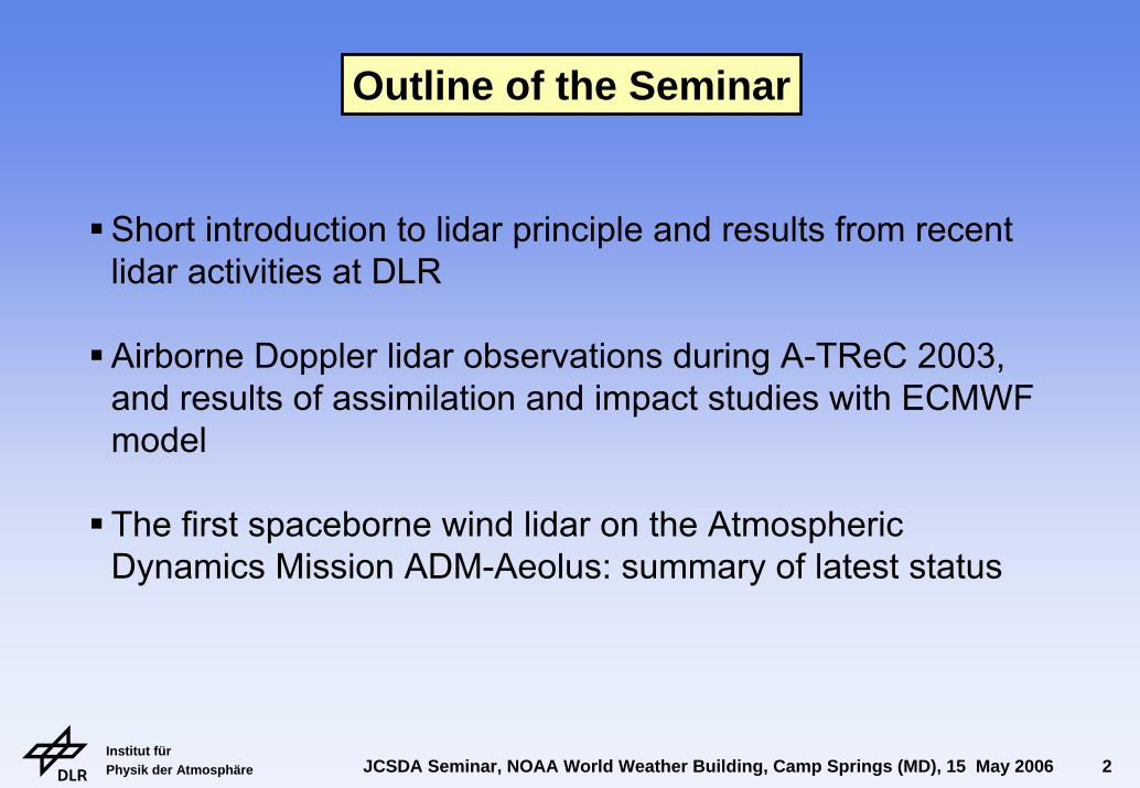
Outline of the Seminar
Short introduction to lidar principle and results from recent lidar activities at DLR
Airborne Doppler lidar observations during A-TReC 2003, and results of assimilation and impact studies with ECMWF model
The first spaceborne wind lidar on the Atmospheric Dynamics Mission ADM-Aeolus: summary of latest status
Institut für Physik der Atmosphäre JCSDA Seminar, NOAA World Weather Building, Camp Springs (MD), 15 May 2006 3
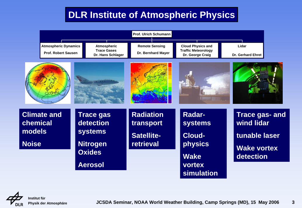
Atmospheric Dynamics
Prof. Robert Sausen
AtmosphericTrace Gases
Dr. Hans Schlager
Remote Sensing
Dr. Bernhard Mayer
Cloud Physics andTraffic Meteorology
Dr. George Craig
Lidar
Dr. Gerhard Ehret
Prof. Ulrich Schumann
Climate and chemicalmodels
Noise
Trace gas detectionsystems
NitrogenOxides
Aerosol
Radiationtransport
Satellite-retrieval
Radar-systems
Cloud-physics
Wakevortexsimulation
Trace gas- and wind lidar
tunable laser
Wake vortexdetection
DLR Institute of Atmospheric Physics
Institut für Physik der Atmosphäre JCSDA Seminar, NOAA World Weather Building, Camp Springs (MD), 15 May 2006 4
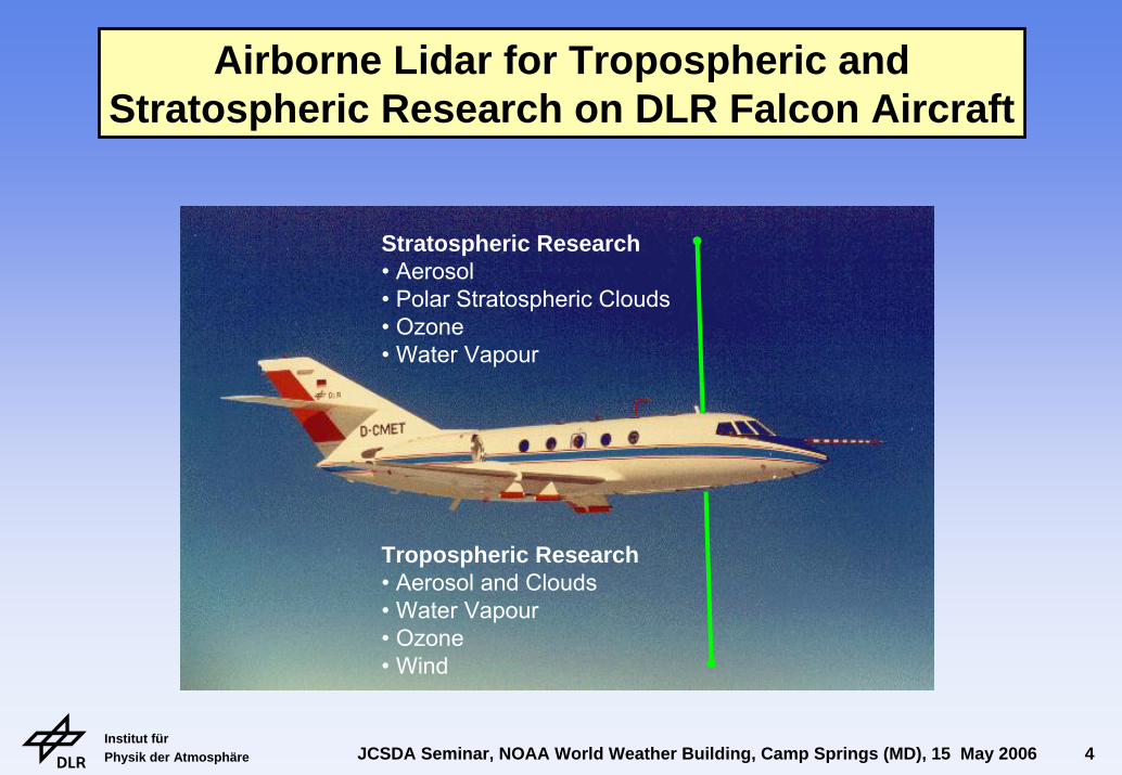
Airborne Lidar for Tropospheric andStratospheric Research on DLR Falcon Aircraft
Stratospheric Research• Aerosol• Polar Stratospheric Clouds• Ozone• Water Vapour
Tropospheric Research• Aerosol and Clouds• Water Vapour• Ozone• Wind
Institut für Physik der Atmosphäre JCSDA Seminar, NOAA World Weather Building, Camp Springs (MD), 15 May 2006 5
tracegas
differentialabsorption
of 2 wavelengths
frequency shift due to
Doppler effect
wind speed
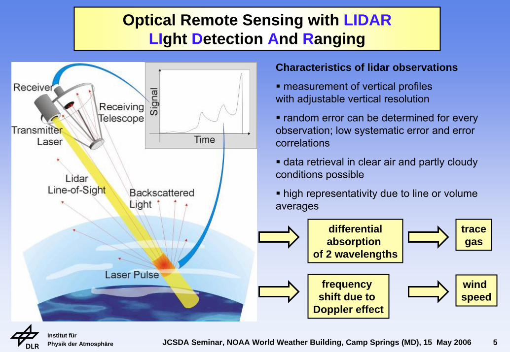
Characteristics of lidar observations
measurement of vertical profiles with adjustable vertical resolution
random error can be determined for every observation; low systematic error and error correlations
data retrieval in clear air and partly cloudy conditions possible
high representativity due to line or volume averages
Optical Remote Sensing with LIDARLIght Detection And Ranging
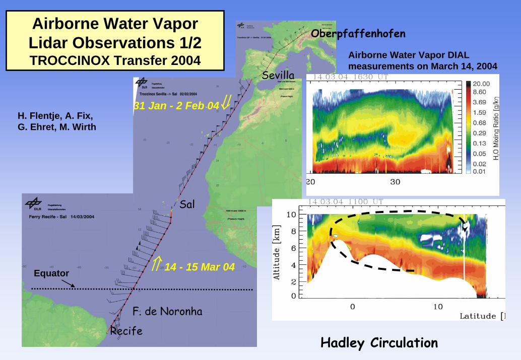
Oberpfaffenhofen
Recife
F. de Noronha
Sal
Sevilla
31 Jan - 2 Feb 04⇓
⇑ 14 - 15 Mar 04Equator
H. Flentje, A. Fix, G. Ehret, M. Wirth
Airborne Water VaporLidar Observations 1/2TROCCINOX Transfer 2004
Hadley Circulation
Airborne Water Vapor DIAL measurements on March 14, 2004
Institut für Physik der Atmosphäre JCSDA Seminar, NOAA World Weather Building, Camp Springs (MD), 15 May 2006 7
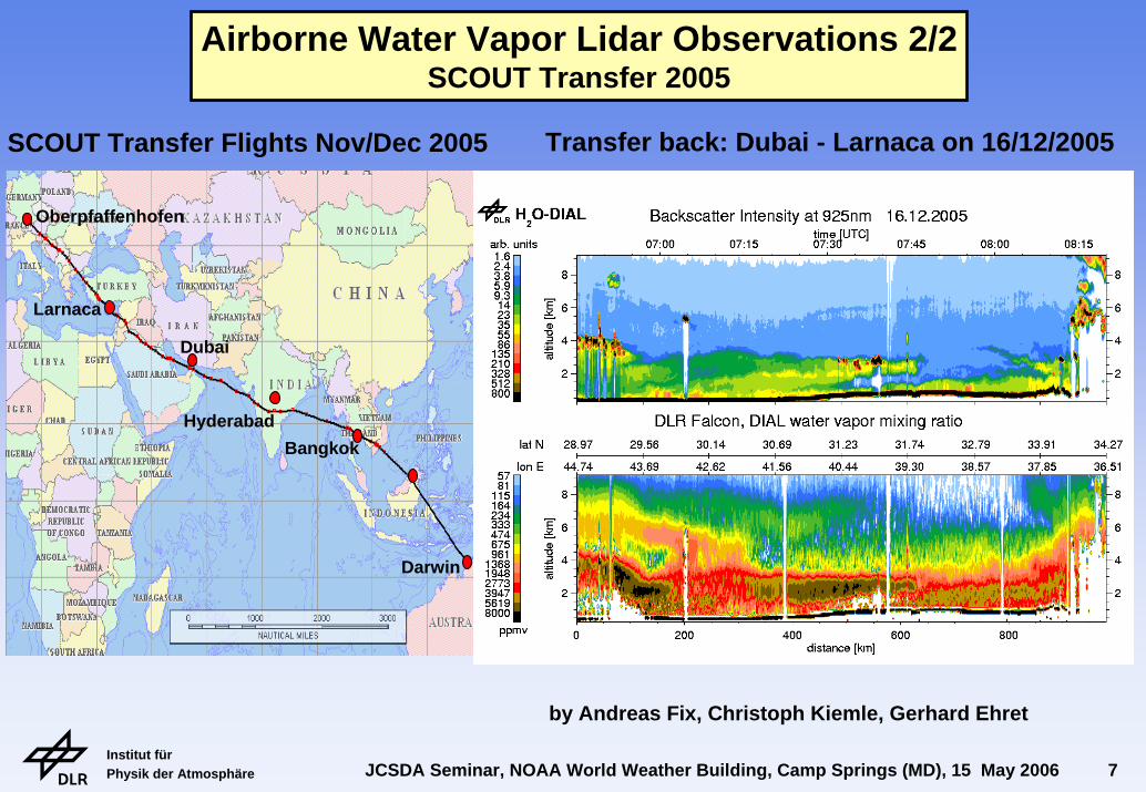
Oberpfaffenhofen
Larnaca
Dubai
HyderabadBangkok
Darwin
Airborne Water Vapor Lidar Observations 2/2SCOUT Transfer 2005
SCOUT Transfer Flights Nov/Dec 2005 Transfer back: Dubai - Larnaca on 16/12/2005
by Andreas Fix, Christoph Kiemle, Gerhard Ehret
Institut für Physik der Atmosphäre JCSDA Seminar, NOAA World Weather Building, Camp Springs (MD), 15 May 2006 8
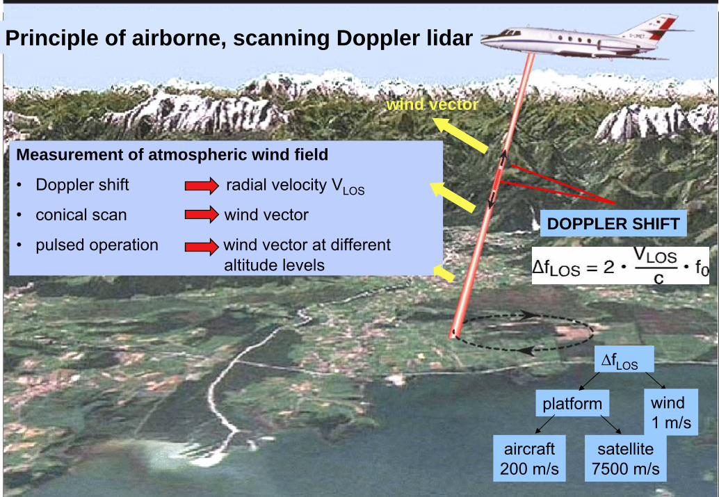
Measurement of atmospheric wind field
• Doppler shift radial velocity VLOS
• conical scan wind vector
• pulsed operation wind vector at differentaltitude levels
wind vector
∆fLOS
platform
aircraft200 m/s
satellite7500 m/s
wind1 m/s
DOPPLER SHIFT
Principle of airborne, scanning Doppler lidar
Institut für Physik der Atmosphäre JCSDA Seminar, NOAA World Weather Building, Camp Springs (MD), 15 May 2006 9
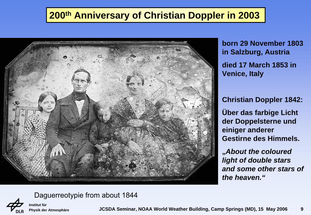
Daguerreotypie from about 1844
born 29 November 1803 in Salzburg, Austria
died 17 March 1853 in Venice, Italy
Christian Doppler 1842:
Über das farbige Licht der Doppelsterne und einiger anderer Gestirne des Himmels.
„About the colouredlight of double starsand some other stars of the heaven.“
200th Anniversary of Christian Doppler in 2003

Institut für Physik der Atmosphäre JCSDA Seminar, NOAA World Weather Building, Camp Springs (MD), 15 May 2006 10
10 µm System WINDDLR/CNRS/CNES/Meteo-Francedevelopment: since end 80'svert./hor. res.: 250 m, 3-15 kmaccuracy: 0.5 - 2 m/sfirst flight: 1999
2-µm SystemDLR/CTI-MAG1since 2000100 m, 3-10 km0.2 - 2 m/s2001
Airborne Doppler Lidar at DLR 1/2
Werner et al. 2001, Opt. Eng.
Reitebuch et al. 2001, J. Atmos. Ocean. Tech.
Reitebuch et al. 2003, Quart. J. Roy. Met. Soc.
Köpp, Rahm,Smalikho 2004, J. Atmos.Ocean. Tech.
Institut für Physik der Atmosphäre JCSDA Seminar, NOAA World Weather Building, Camp Springs (MD), 15 May 2006 11
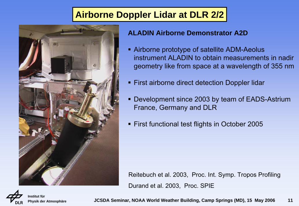
ALADIN Airborne Demonstrator A2D
Airborne prototype of satellite ADM-Aeolus instrument ALADIN to obtain measurements in nadir geometry like from space at a wavelength of 355 nm
First airborne direct detection Doppler lidar
Development since 2003 by team of EADS-AstriumFrance, Germany and DLR
First functional test flights in October 2005
Airborne Doppler Lidar at DLR 2/2
Reitebuch et al. 2003, Proc. Int. Symp. Tropos Profiling
Durand et al. 2003, Proc. SPIE

Institut für Physik der Atmosphäre JCSDA Seminar, NOAA World Weather Building, Camp Springs (MD), 15 May 2006 12
Munich
2-µm Doppler lidar on Falcon, 19 July 2002, 1514-1534 VAD, 1536-1554 UTC LOS
5 km (VAD), 360 m (LOS) horizontal resolution 100 m vertical resolution, total length 198 km
Airborne Doppler Lidar ObservationsMesoscale Advection Towards the Alps in 2003
Weissmann, Braun, Gantner, Mayr, Rahm, Reitebuch 2005, Mon. Weath. Rev.
Winkler, Lugauer, Reitebuch2006; promet
Institut für Physik der Atmosphäre JCSDA Seminar, NOAA World Weather Building, Camp Springs (MD), 15 May 2006 13
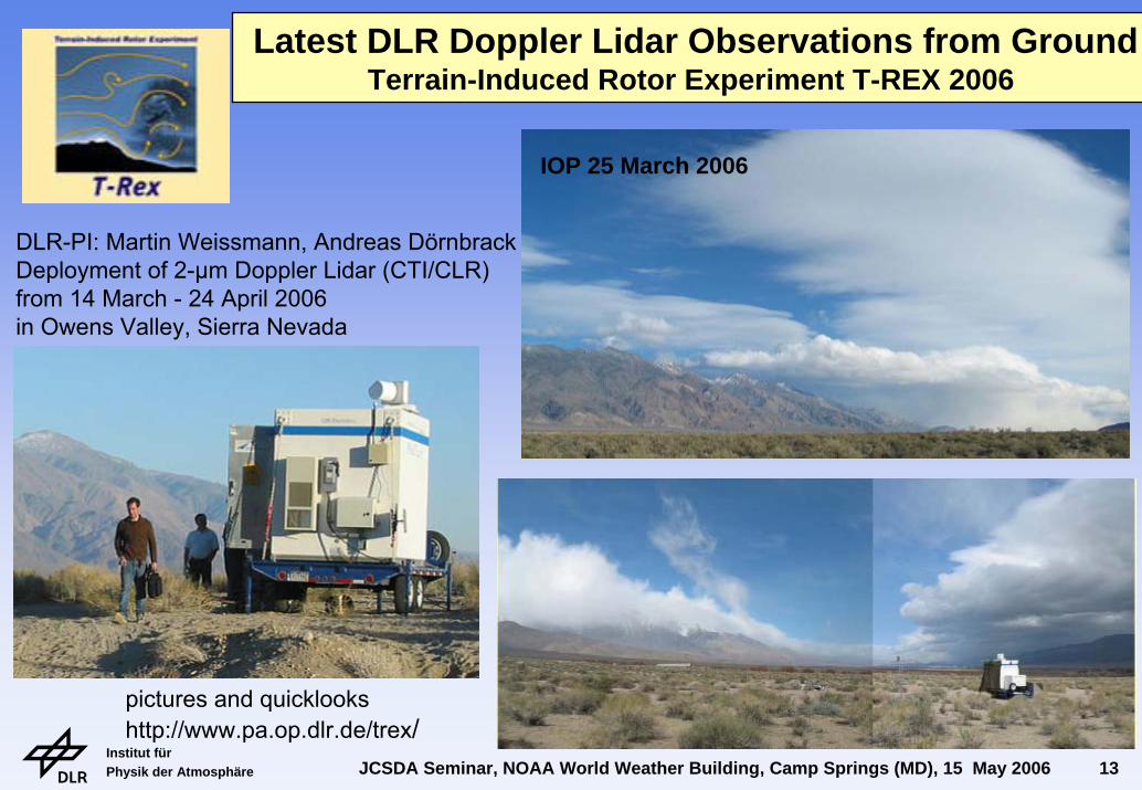
Latest DLR Doppler Lidar Observations from GroundTerrain-Induced Rotor Experiment T-REX 2006
pictures and quicklookshttp://www.pa.op.dlr.de/trex/
DLR-PI: Martin Weissmann, Andreas DörnbrackDeployment of 2-µm Doppler Lidar (CTI/CLR) from 14 March - 24 April 2006 in Owens Valley, Sierra Nevada
IOP 25 March 2006
Institut für Physik der Atmosphäre JCSDA Seminar, NOAA World Weather Building, Camp Springs (MD), 15 May 2006 14
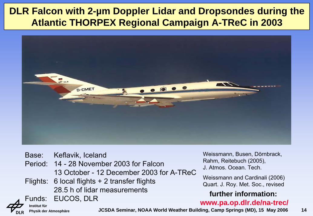
DLR Falcon with 2-µm Doppler Lidar and Dropsondes during the Atlantic THORPEX Regional Campaign A-TReC in 2003
2-µm Doppler lidar20° off nadir conical scan
49 Väisälädropsondes
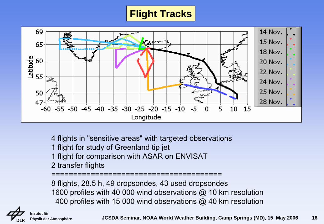
Base: Keflavik, IcelandPeriod: 14 - 28 November 2003 for Falcon
13 October - 12 December 2003 for A-TReCFlights: 6 local flights + 2 transfer flights
28.5 h of lidar measurementsFunds: EUCOS, DLR
Weissmann, Busen, Dörnbrack, Rahm, Reitebuch (2005), J. Atmos. Ocean. Tech.
Weissmann and Cardinali (2006)Quart. J. Roy. Met. Soc., revised
further information: www.pa.op.dlr.de/na-trec/
Institut für Physik der Atmosphäre JCSDA Seminar, NOAA World Weather Building, Camp Springs (MD), 15 May 2006 15
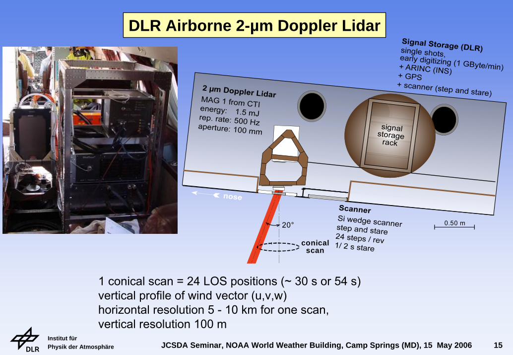
conicalscan
20° 0.50 m
1 conical scan = 24 LOS positions (~ 30 s or 54 s)vertical profile of wind vector (u,v,w)horizontal resolution 5 - 10 km for one scan,vertical resolution 100 m
DLR Airborne 2-µm Doppler Lidar
Institut für Physik der Atmosphäre JCSDA Seminar, NOAA World Weather Building, Camp Springs (MD), 15 May 2006 16
4 flights in "sensitive areas" with targeted observations1 flight for study of Greenland tip jet1 flight for comparison with ASAR on ENVISAT2 transfer flights=======================================8 flights, 28.5 h, 49 dropsondes, 43 used dropsondes1600 profiles with 40 000 wind observations @ 10 km resolution400 profiles with 15 000 wind observations @ 40 km resolution
Flight Tracks
Institut für Physik der Atmosphäre JCSDA Seminar, NOAA World Weather Building, Camp Springs (MD), 15 May 2006 17
Institut für Physik der Atmosphäre JCSDA Seminar, NOAA World Weather Building, Camp Springs (MD), 15 May 2006 18
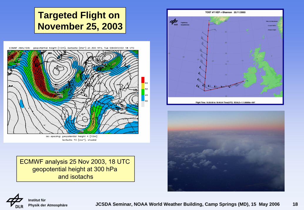
Targeted Flight on November 25, 2003
ECMWF analysis 25 Nov 2003, 18 UTC geopotential height at 300 hPa
and isotachs
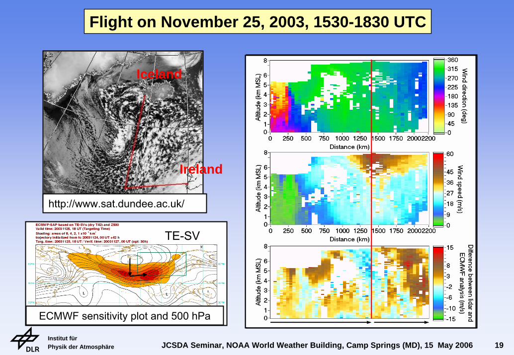
Institut für Physik der Atmosphäre JCSDA Seminar, NOAA World Weather Building, Camp Springs (MD), 15 May 2006 19
Iceland
Ireland
ECMWF sensitivity plot and 500 hPa
http://www.sat.dundee.ac.uk/
Flight on November 25, 2003, 1530-1830 UTC
TE-SV
Institut für Physik der Atmosphäre JCSDA Seminar, NOAA World Weather Building, Camp Springs (MD), 15 May 2006 20
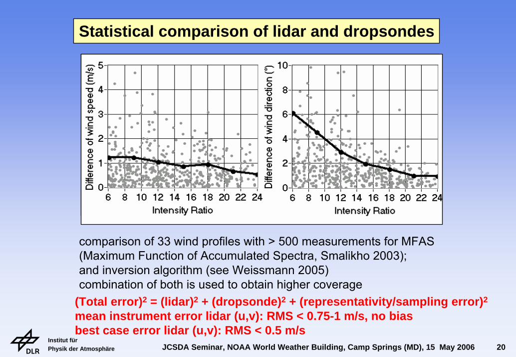
comparison of 33 wind profiles with > 500 measurements for MFAS (Maximum Function of Accumulated Spectra, Smalikho 2003); and inversion algorithm (see Weissmann 2005)combination of both is used to obtain higher coverage
(Total error)2 = (lidar)2 + (dropsonde)2 + (representativity/sampling error)2
mean instrument error lidar (u,v): RMS < 0.75-1 m/s, no biasbest case error lidar (u,v): RMS < 0.5 m/s
Statistical comparison of lidar and dropsondes
Institut für Physik der Atmosphäre JCSDA Seminar, NOAA World Weather Building, Camp Springs (MD), 15 May 2006 21
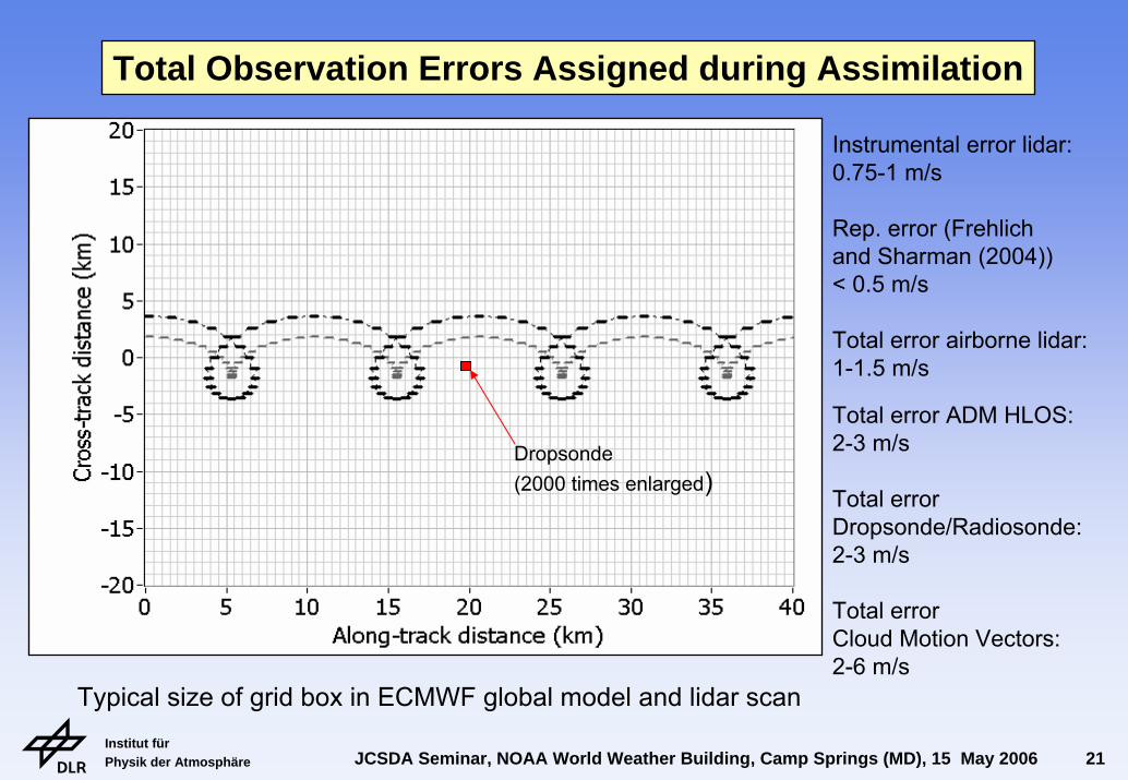
Dropsonde(2000 times enlarged)
Instrumental error lidar:0.75-1 m/s
Rep. error (Frehlichand Sharman (2004))< 0.5 m/s
Total error airborne lidar:1-1.5 m/s
Total error ADM HLOS:2-3 m/s
Total errorDropsonde/Radiosonde:2-3 m/s
Total errorCloud Motion Vectors:2-6 m/s
Total Observation Errors Assigned during Assimilation
Typical size of grid box in ECMWF global model and lidar scan

Institut für Physik der Atmosphäre JCSDA Seminar, NOAA World Weather Building, Camp Springs (MD), 15 May 2006 22
wavenumber T511: 40 x 40 km 60 Levels between 0 und 65 km
4DVAR: 4-Dimensional variational assimilation with 12 hour window with T95/T159minimisation of global cost-function = difference measurement and first-guess (background)analyses = 80% background + 20% observationsbackground = model + earlier observations
ECMWF Global Model used for Assimilation Experiments
Institut für Physik der Atmosphäre JCSDA Seminar, NOAA World Weather Building, Camp Springs (MD), 15 May 2006 23
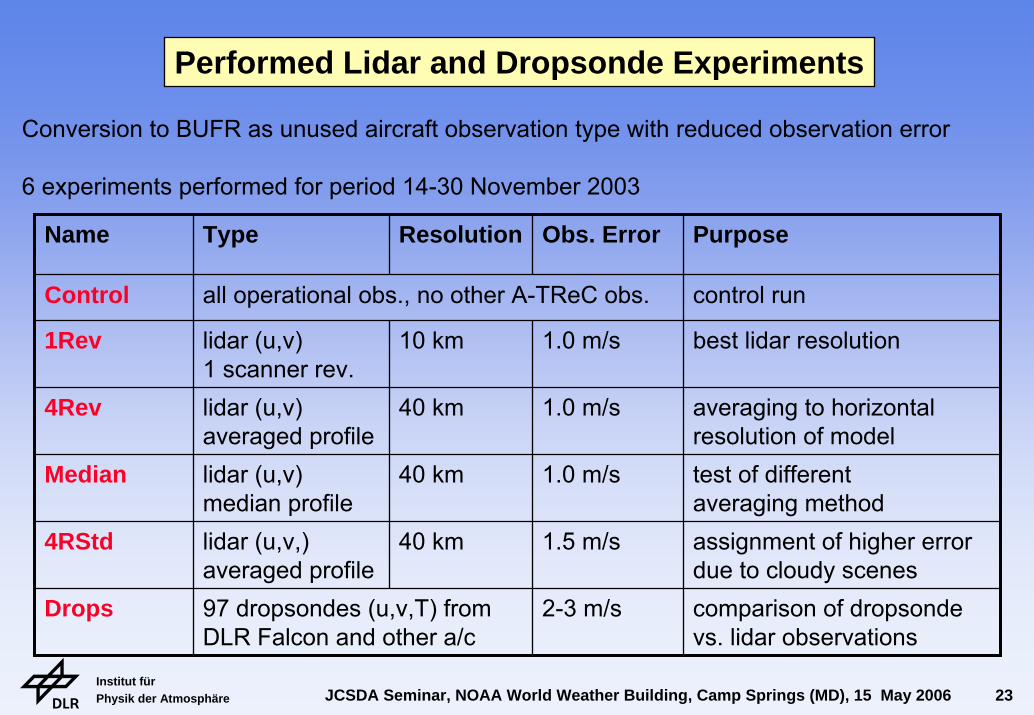
Conversion to BUFR as unused aircraft observation type with reduced observation error
6 experiments performed for period 14-30 November 2003
Performed Lidar and Dropsonde Experiments
Name Type Resolution Obs. Error Purpose
Control all operational obs., no other A-TReC obs. control run
best lidar resolution
averaging to horizontal resolution of model
Median lidar (u,v)median profile
40 km 1.0 m/s test of different averaging methodassignment of higher error due to cloudy scenescomparison of dropsonde vs. lidar observations
1Rev lidar (u,v)1 scanner rev.
10 km 1.0 m/s
4Rev lidar (u,v)averaged profile
40 km 1.0 m/s
4RStd lidar (u,v,)averaged profile
40 km 1.5 m/s
Drops 97 dropsondes (u,v,T) from DLR Falcon and other a/c
2-3 m/s
Institut für Physik der Atmosphäre JCSDA Seminar, NOAA World Weather Building, Camp Springs (MD), 15 May 2006 24
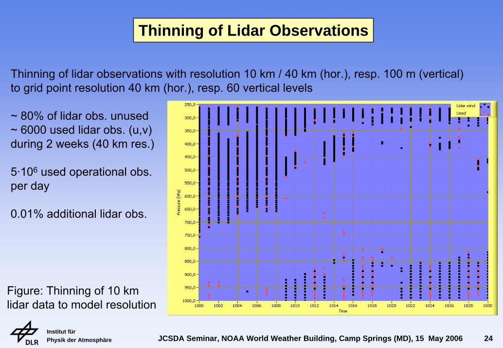
Thinning of lidar observations with resolution 10 km / 40 km (hor.), resp. 100 m (vertical)to grid point resolution 40 km (hor.), resp. 60 vertical levels
~ 80% of lidar obs. unused~ 6000 used lidar obs. (u,v)during 2 weeks (40 km res.)
5·106 used operational obs.per day
0.01% additional lidar obs.
Thinning of Lidar Observations
Figure: Thinning of 10 km lidar data to model resolution
Institut für Physik der Atmosphäre JCSDA Seminar, NOAA World Weather Building, Camp Springs (MD), 15 May 2006 25
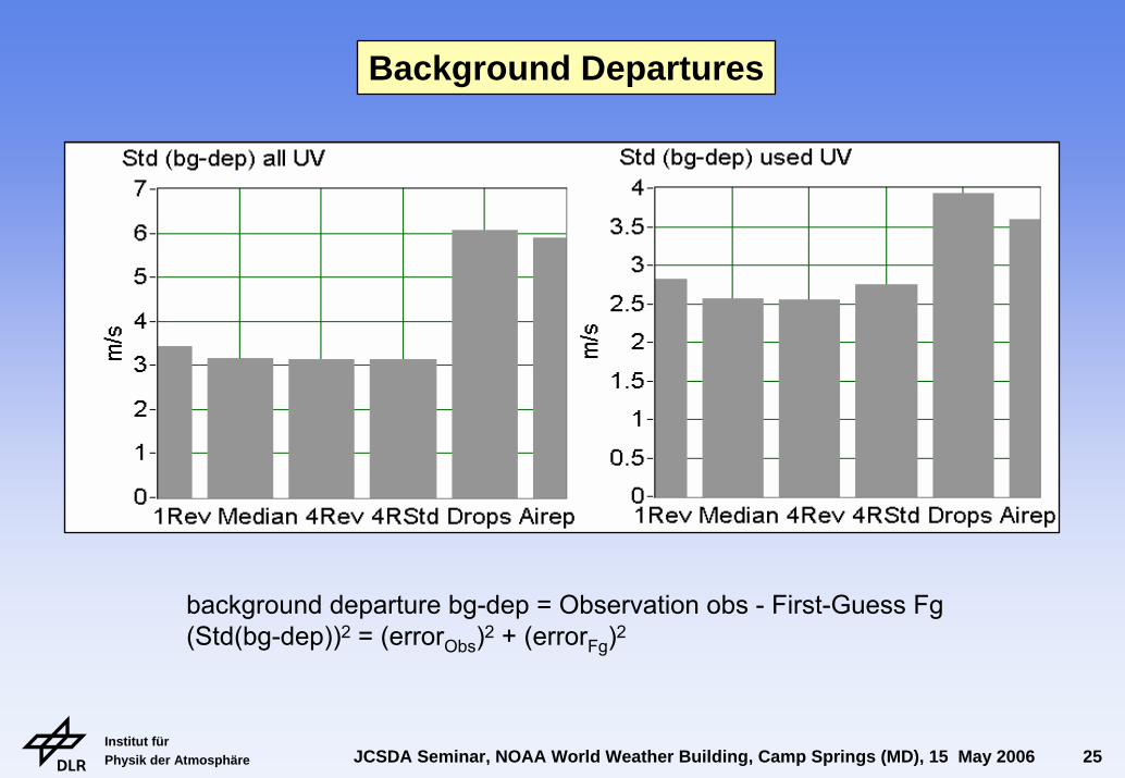
background departure bg-dep = Observation obs - First-Guess Fg(Std(bg-dep))2 = (errorObs)2 + (errorFg)2
Background Departures
Institut für Physik der Atmosphäre JCSDA Seminar, NOAA World Weather Building, Camp Springs (MD), 15 May 2006 26
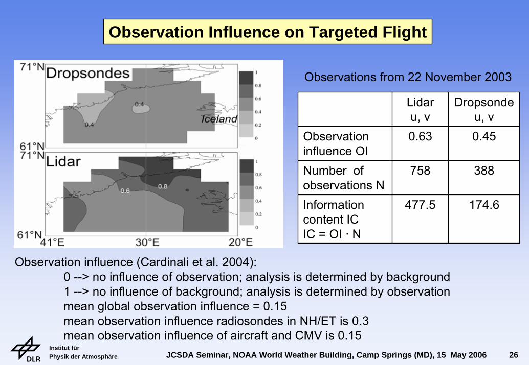
Lidaru, v
Dropsondeu, v
Observation influence OI
0.63 0.45
Number of observations N
758 388
Information content ICIC = OI · N
477.5 174.6
Observation influence (Cardinali et al. 2004):0 --> no influence of observation; analysis is determined by background1 --> no influence of background; analysis is determined by observationmean global observation influence = 0.15mean observation influence radiosondes in NH/ET is 0.3mean observation influence of aircraft and CMV is 0.15
Observation Influence on Targeted Flight
Observations from 22 November 2003
Institut für Physik der Atmosphäre JCSDA Seminar, NOAA World Weather Building, Camp Springs (MD), 15 May 2006 27
520
560
560
560
60°N60°N
0°
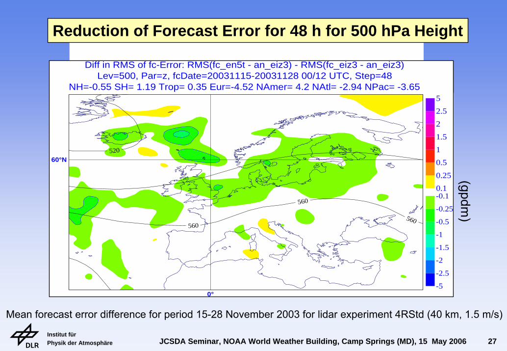
0°NH=-0.55 SH= 1.19 Trop= 0.35 Eur=-4.52 NAmer= 4.2 NAtl= -2.94 NPac= -3.65Lev=500, Par=z, fcDate=20031115-20031128 00/12 UTC, Step=48
Diff in RMS of fc-Error: RMS(fc_en5t - an_eiz3) - RMS(fc_eiz3 - an_eiz3)
-5
-2.5
-2
-1.5
-1
-0.5
-0.25
-0.10.1
0.25
0.5
1
1.5
2
2.5
5
(gpdm)
Reduction of Forecast Error for 48 h for 500 hPa Height
Mean forecast error difference for period 15-28 November 2003 for lidar experiment 4RStd (40 km, 1.5 m/s)
Institut für Physik der Atmosphäre JCSDA Seminar, NOAA World Weather Building, Camp Springs (MD), 15 May 2006 28
-0.25
-0.25
-0.25
-0.25
-0.25
-0.25
-0.25520
560
560
560
60°N60°N
0°
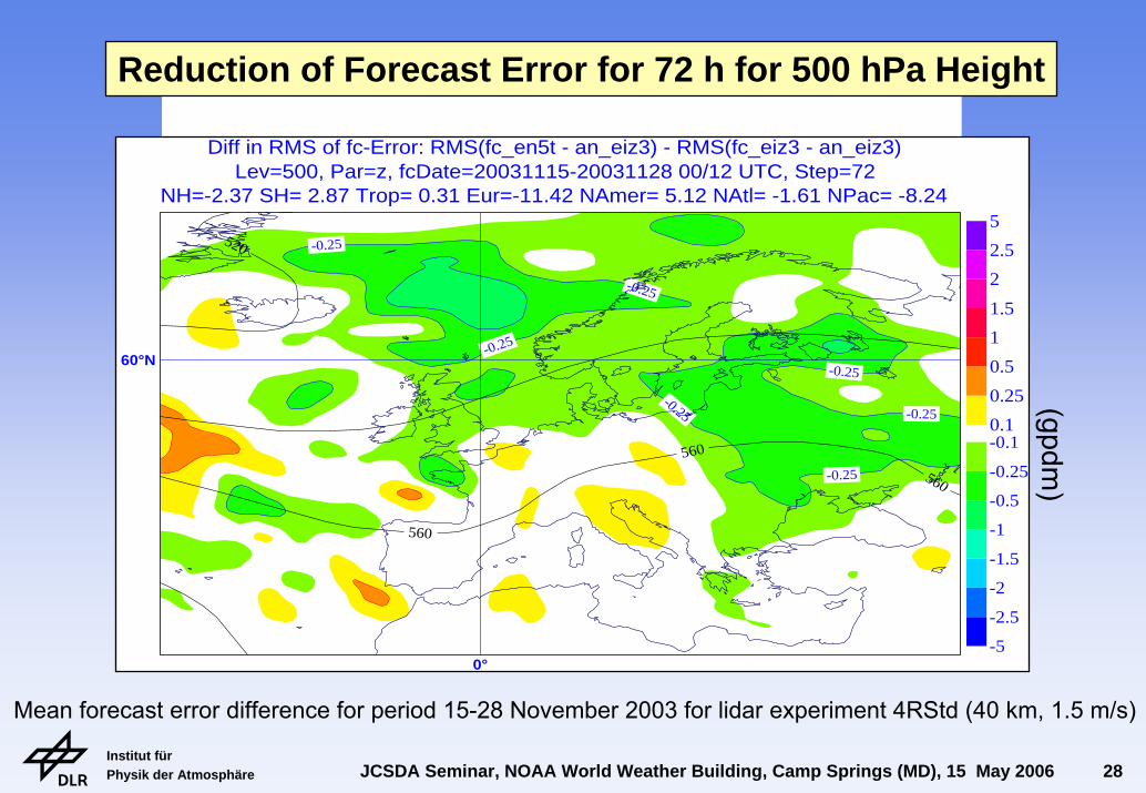
0°NH=-2.37 SH= 2.87 Trop= 0.31 Eur=-11.42 NAmer= 5.12 NAtl= -1.61 NPac= -8.24Lev=500, Par=z, fcDate=20031115-20031128 00/12 UTC, Step=72
Diff in RMS of fc-Error: RMS(fc_en5t - an_eiz3) - RMS(fc_eiz3 - an_eiz3)
-5
-2.5
-2
-1.5
-1
-0.5
-0.25
-0.10.1
0.25
0.5
1
1.5
2
2.5
5
(gpdm)
Reduction of Forecast Error for 72 h for 500 hPa Height
Mean forecast error difference for period 15-28 November 2003 for lidar experiment 4RStd (40 km, 1.5 m/s)
Institut für Physik der Atmosphäre JCSDA Seminar, NOAA World Weather Building, Camp Springs (MD), 15 May 2006 29
-0.25
-0.25
-0.25
-0.25
-0.25
520
560560
560
60°N60°N
0°
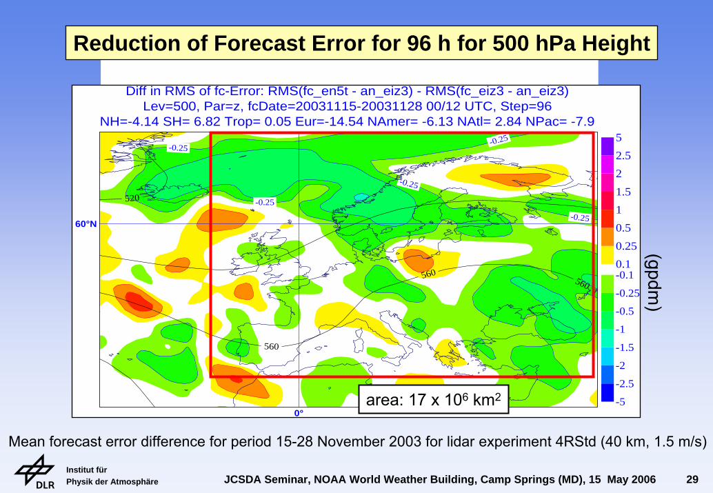
0°NH=-4.14 SH= 6.82 Trop= 0.05 Eur=-14.54 NAmer= -6.13 NAtl= 2.84 NPac= -7.9Lev=500, Par=z, fcDate=20031115-20031128 00/12 UTC, Step=96
Diff in RMS of fc-Error: RMS(fc_en5t - an_eiz3) - RMS(fc_eiz3 - an_eiz3)
-5
-2.5
-2
-1.5
-1
-0.5
-0.25
-0.10.1
0.25
0.5
1
1.5
2
2.5
5
area: 17 x 106 km2
(gpdm)
Reduction of Forecast Error for 96 h for 500 hPa Height
Mean forecast error difference for period 15-28 November 2003 for lidar experiment 4RStd (40 km, 1.5 m/s)
Institut für Physik der Atmosphäre JCSDA Seminar, NOAA World Weather Building, Camp Springs (MD), 15 May 2006 30
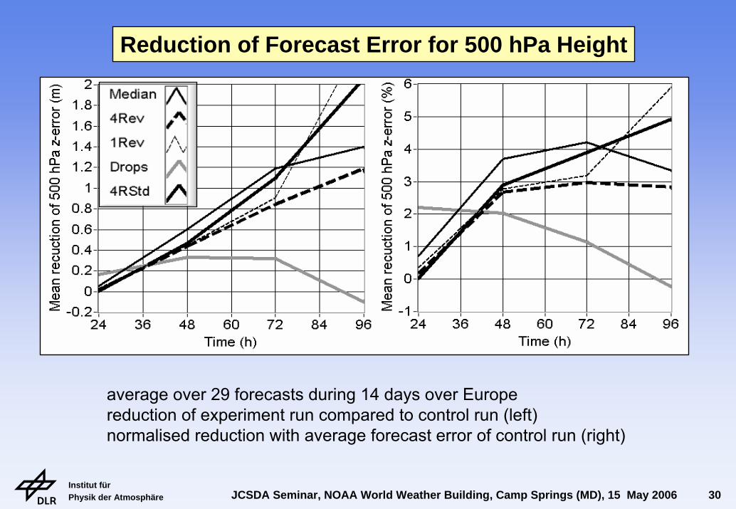
average over 29 forecasts during 14 days over Europereduction of experiment run compared to control run (left)normalised reduction with average forecast error of control run (right)
Reduction of Forecast Error for 500 hPa Height
Institut für Physik der Atmosphäre JCSDA Seminar, NOAA World Weather Building, Camp Springs (MD), 15 May 2006 31
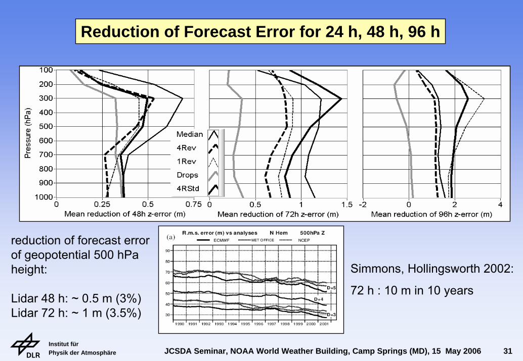
Reduction of Forecast Error for 24 h, 48 h, 96 h
reduction of forecast errorof geopotential 500 hPaheight:
Lidar 48 h: ~ 0.5 m (3%)Lidar 72 h: ~ 1 m (3.5%)
Simmons, Hollingsworth 2002:
72 h : 10 m in 10 years
Institut für Physik der Atmosphäre JCSDA Seminar, NOAA World Weather Building, Camp Springs (MD), 15 May 2006 32
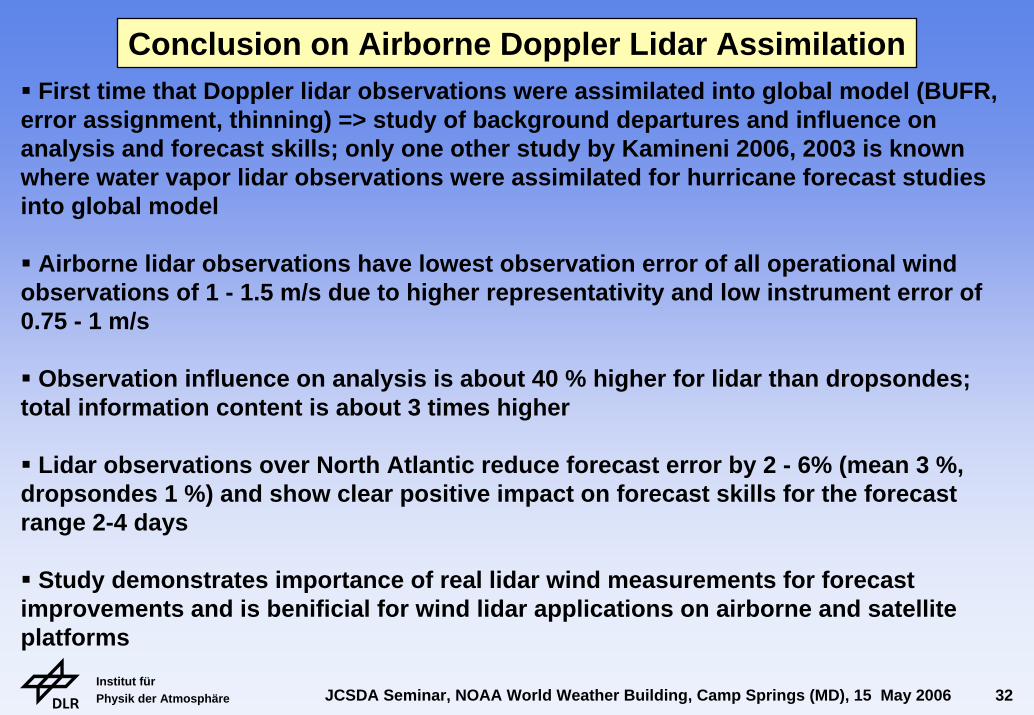
First time that Doppler lidar observations were assimilated into global model (BUFR, error assignment, thinning) => study of background departures and influence on analysis and forecast skills; only one other study by Kamineni 2006, 2003 is knownwhere water vapor lidar observations were assimilated for hurricane forecast studiesinto global model
Airborne lidar observations have lowest observation error of all operational wind observations of 1 - 1.5 m/s due to higher representativity and low instrument error of 0.75 - 1 m/s
Observation influence on analysis is about 40 % higher for lidar than dropsondes; total information content is about 3 times higher
Lidar observations over North Atlantic reduce forecast error by 2 - 6% (mean 3 %, dropsondes 1 %) and show clear positive impact on forecast skills for the forecastrange 2-4 days
Study demonstrates importance of real lidar wind measurements for forecastimprovements and is benificial for wind lidar applications on airborne and satelliteplatforms
Conclusion on Airborne Doppler Lidar Assimilation
Institut für Physik der Atmosphäre JCSDA Seminar, NOAA World Weather Building, Camp Springs (MD), 15 May 2006 33
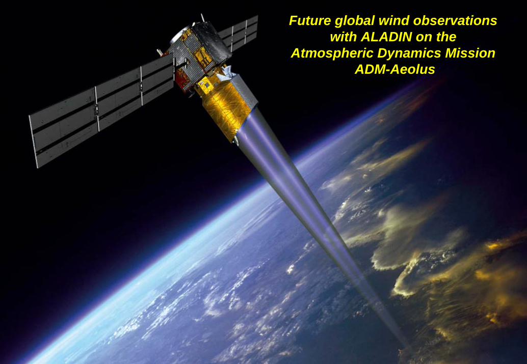
Future global wind observations with ALADIN on the
Atmospheric Dynamics Mission ADM-Aeolus
Institut für Physik der Atmosphäre JCSDA Seminar, NOAA World Weather Building, Camp Springs (MD), 15 May 2006 34
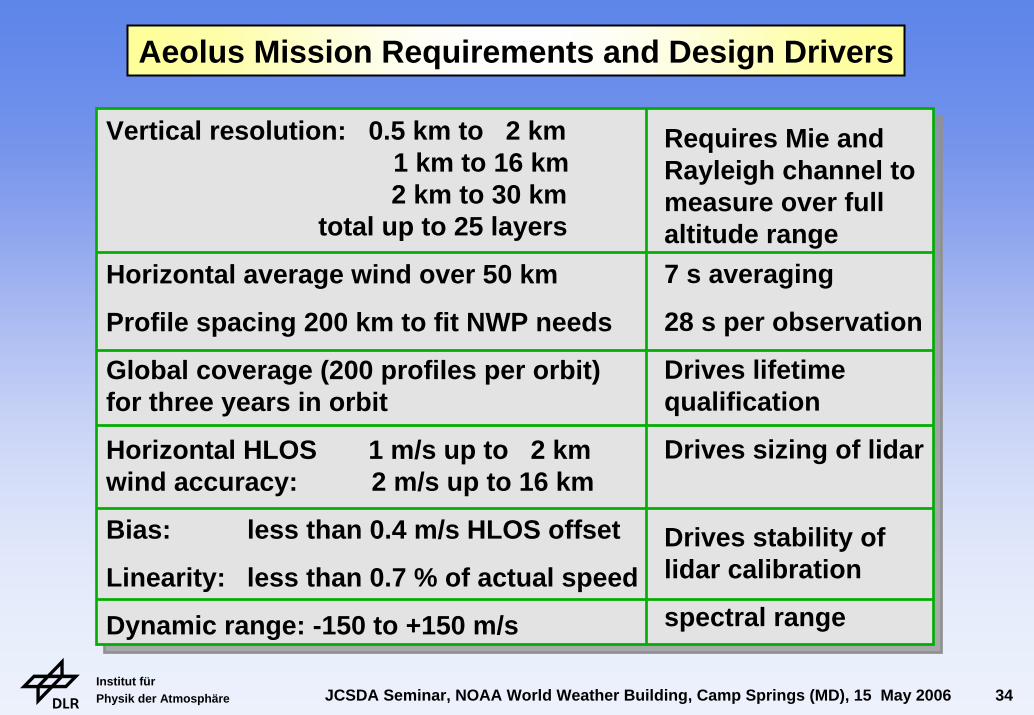
Vertical resolution: 0.5 km to 2 km 1 km to 16 km2 km to 30 km
total up to 25 layers
Horizontal average wind over 50 km
Profile spacing 200 km to fit NWP needs
Global coverage (200 profiles per orbit)for three years in orbit
Horizontal HLOS 1 m/s up to 2 kmwind accuracy: 2 m/s up to 16 km
Bias: less than 0.4 m/s HLOS offset
Linearity: less than 0.7 % of actual speed
Dynamic range: -150 to +150 m/s
Requires Mie and Rayleigh channel to measure over full altitude range7 s averaging
28 s per observation
Drives lifetime qualification
Drives sizing of lidar
Drives stability of lidar calibration
spectral range
Aeolus Mission Requirements and Design Drivers
Institut für Physik der Atmosphäre JCSDA Seminar, NOAA World Weather Building, Camp Springs (MD), 15 May 2006 35
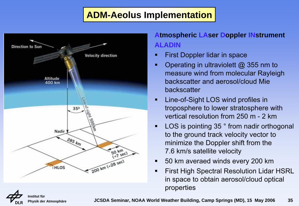
Atmospheric LAser Doppler INstrumentALADIN
First Doppler lidar in spaceOperating in ultraviolett @ 355 nm to measure wind from molecular Rayleigh backscatter and aerosol/cloud Mie backscatterLine-of-Sight LOS wind profiles in troposphere to lower stratosphere with vertical resolution from 250 m - 2 kmLOS is pointing 35 ° from nadir orthogonal to the ground track velocity vector to minimize the Doppler shift from the 7.6 km/s satellite velocity50 km averaed winds every 200 kmFirst High Spectral Resolution Lidar HSRL in space to obtain aerosol/cloud optical properties
ADM-Aeolus Implementation
Institut für Physik der Atmosphäre JCSDA Seminar, NOAA World Weather Building, Camp Springs (MD), 15 May 2006 36
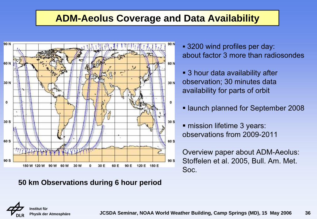
ADM-Aeolus Coverage and Data Availability
3200 wind profiles per day: about factor 3 more than radiosondes
3 hour data availability afterobservation; 30 minutes dataavailability for parts of orbit
launch planned for September 2008
mission lifetime 3 years: observations from 2009-2011
Overview paper about ADM-Aeolus:Stoffelen et al. 2005, Bull. Am. Met. Soc.
50 km Observations during 6 hour period
Institut für Physik der Atmosphäre JCSDA Seminar, NOAA World Weather Building, Camp Springs (MD), 15 May 2006 37
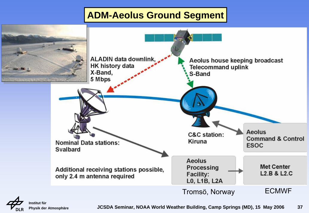
ADM-Aeolus Ground Segment
Tromsö, Norway ECMWF
Institut für Physik der Atmosphäre JCSDA Seminar, NOAA World Weather Building, Camp Springs (MD), 15 May 2006 38
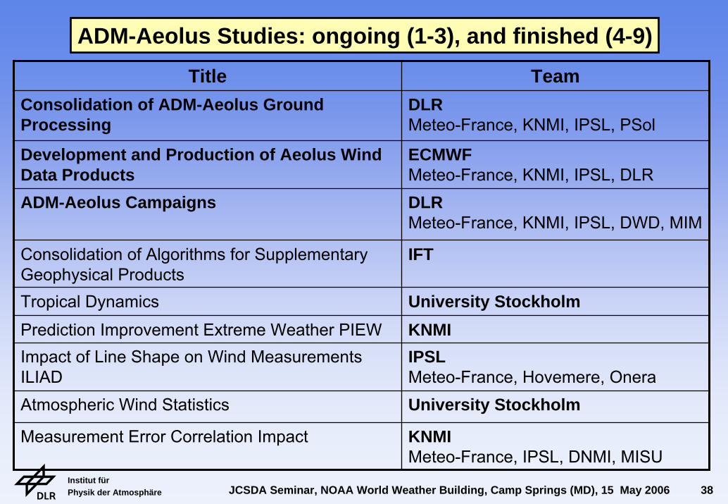
ADM-Aeolus Studies: ongoing (1-3), and finished (4-9)Title Team
Consolidation of ADM-Aeolus Ground Processing
DLRMeteo-France, KNMI, IPSL, PSol
ECMWFMeteo-France, KNMI, IPSL, DLRDLRMeteo-France, KNMI, IPSL, DWD, MIM
Consolidation of Algorithms for Supplementary Geophysical Products
IFT
Tropical Dynamics University StockholmKNMIIPSLMeteo-France, Hovemere, OneraUniversity Stockholm
KNMIMeteo-France, IPSL, DNMI, MISU
Development and Production of Aeolus Wind Data ProductsADM-Aeolus Campaigns
Prediction Improvement Extreme Weather PIEWImpact of Line Shape on Wind Measurements ILIADAtmospheric Wind Statistics
Measurement Error Correlation Impact
Institut für Physik der Atmosphäre JCSDA Seminar, NOAA World Weather Building, Camp Springs (MD), 15 May 2006 39
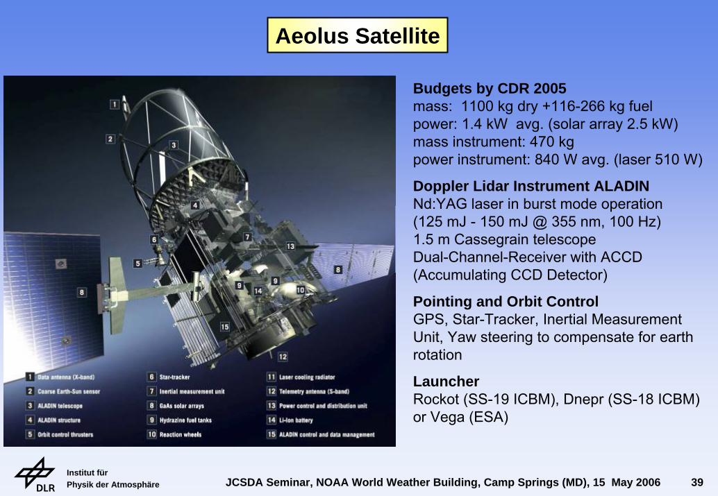
Aeolus Satellite
Budgets by CDR 2005mass: 1100 kg dry +116-266 kg fuelpower: 1.4 kW avg. (solar array 2.5 kW)mass instrument: 470 kgpower instrument: 840 W avg. (laser 510 W)
Doppler Lidar Instrument ALADIN Nd:YAG laser in burst mode operation(125 mJ - 150 mJ @ 355 nm, 100 Hz)1.5 m Cassegrain telescopeDual-Channel-Receiver with ACCD (Accumulating CCD Detector)
Pointing and Orbit ControlGPS, Star-Tracker, Inertial Measurement Unit, Yaw steering to compensate for earth rotation
LauncherRockot (SS-19 ICBM), Dnepr (SS-18 ICBM) or Vega (ESA)
Institut für Physik der Atmosphäre JCSDA Seminar, NOAA World Weather Building, Camp Springs (MD), 15 May 2006 40
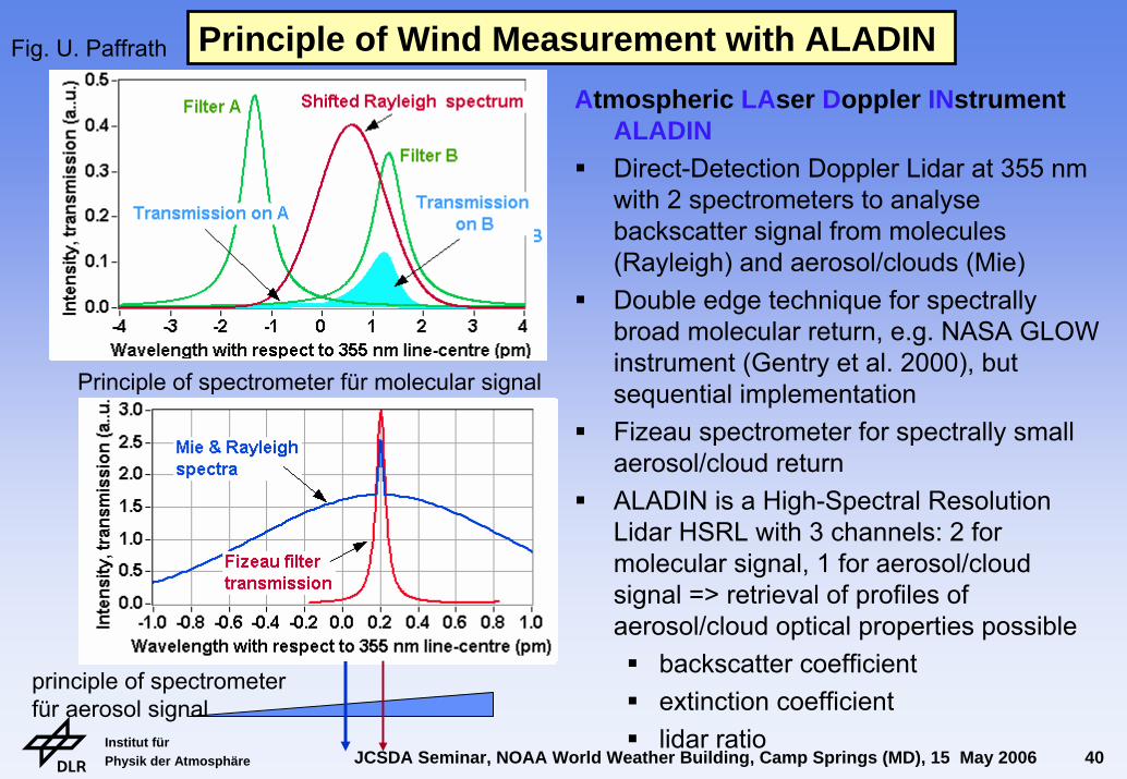
Principle of Wind Measurement with ALADIN Atmospheric LAser Doppler INstrument
ALADINDirect-Detection Doppler Lidar at 355 nmwith 2 spectrometers to analyse backscatter signal from molecules (Rayleigh) and aerosol/clouds (Mie)Double edge technique for spectrally broad molecular return, e.g. NASA GLOW instrument (Gentry et al. 2000), but sequential implementation Fizeau spectrometer for spectrally small aerosol/cloud returnALADIN is a High-Spectral Resolution Lidar HSRL with 3 channels: 2 for molecular signal, 1 for aerosol/cloud signal => retrieval of profiles of aerosol/cloud optical properties possible
backscatter coefficientextinction coefficientlidar ratio
Principle of spectrometer für molecular signal
Fig. U. Paffrath
principle of spectrometer für aerosol signal
Institut für Physik der Atmosphäre JCSDA Seminar, NOAA World Weather Building, Camp Springs (MD), 15 May 2006 41
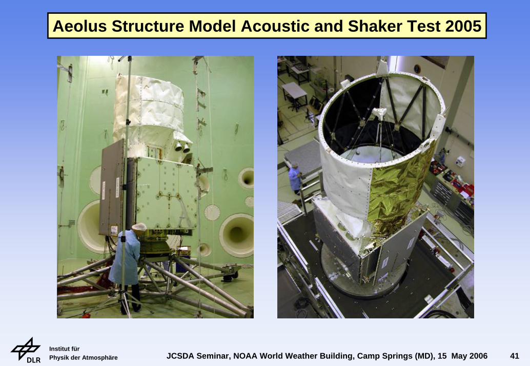
Aeolus Structure Model Acoustic and Shaker Test 2005
Institut für Physik der Atmosphäre JCSDA Seminar, NOAA World Weather Building, Camp Springs (MD), 15 May 2006 42
PLH-1
RLH-2RLH-1 OBA
PLH-2
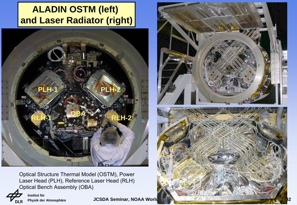
ALADIN OSTM (left) and Laser Radiator (right)
Optical Structure Thermal Model (OSTM), Power Laser Head (PLH), Reference Laser Head (RLH) Optical Bench Assembly (OBA)
Institut für Physik der Atmosphäre JCSDA Seminar, NOAA World Weather Building, Camp Springs (MD), 15 May 2006 43
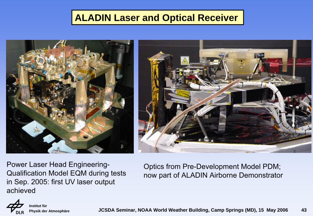
Power Laser Head Engineering-Qualification Model EQM during tests in Sep. 2005: first UV laser output achieved
ALADIN Laser and Optical Receiver
Optics from Pre-Development Model PDM; now part of ALADIN Airborne Demonstrator
Institut für Physik der Atmosphäre JCSDA Seminar, NOAA World Weather Building, Camp Springs (MD), 15 May 2006 44
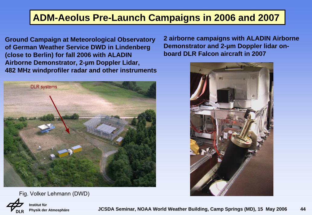
Fig. Volker Lehmann (DWD)
ADM-Aeolus Pre-Launch Campaigns in 2006 and 2007
Ground Campaign at Meteorological Observatoryof German Weather Service DWD in Lindenberg(close to Berlin) for fall 2006 with ALADINAirborne Demonstrator, 2-µm Doppler Lidar, 482 MHz windprofiler radar and other instruments
2 airborne campaigns with ALADIN Airborne Demonstrator and 2-µm Doppler lidar on-board DLR Falcon aircraft in 2007
Institut für Physik der Atmosphäre JCSDA Seminar, NOAA World Weather Building, Camp Springs (MD), 15 May 2006 45
Summary of ADM-Aeolus status by May 2006
Structural, environmental, optical test program passed successfully (June 2005)
Critical Design Review CDR of instrument and satellite passed successfully (Sept. 2005)
Manufacturing of Flight Model FM parts ongoing and partly finished, e.g. structure finished, instrument electronics and detection units finished, telescope mirrors polished (1 yr) and coated, spectrometer manufacturing almost completed, first FM laser under construction, laser diode stacks completed and endurance test started, optical alignment and test of the receiver will start in June 2006
First versions of L1B Processor delivered, ground segment activities ongoing
Launch planned for September 2008
Pre-Launch Campaign Activities with ALADIN Airborne Demonstrator in 2006 and 2007
ADM-Aeolus will path the way for operational wind lidar satellites => constellation of 2-3 satellites should be achieved for denser global coverage (KNMI study PIEW)
Institut für Physik der Atmosphäre JCSDA Seminar, NOAA World Weather Building, Camp Springs (MD), 15 May 2006 46
Outlook for Lidar Activities at DLRStudy of single cases of targeted observations and
quantification of impact in regional verification areas
Study impact of water vapor lidar observations on global models with existing datasets of IHOP 2002, TROCCINOX 2004, 2005, and SCOUT 2005
Next campaign activities:African Monsoon AMMA: 10-µm Doppler Lidar
WIND on Falcon in July 2006ADM Pre-Launch Campaigns: 2-µm and A2D
from ground in 2006 and airborne in 2007Convective and Orographically-Induced
Precipitation Study COPS: H2O-DIAL and 2-µm Doppler lidar on Falcon in June-Aug 2007
Interest in involvement in THORPEX Pacific-AsianRegional Campaign PARC in 2008, but funding open
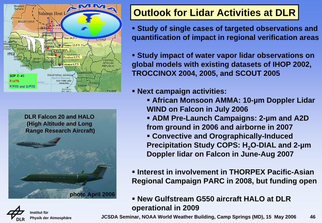
New Gulfstream G550 aircraft HALO at DLR operational in 2009
DLR Falcon 20 and HALO (High Altitude and Long Range Research Aircraft)
photo April 2006

Institut für Physik der Atmosphäre JCSDA Seminar, NOAA World Weather Building, Camp Springs (MD), 15 May 2006 47
Significant improvement of 12 h forecast of water vapour column of up to 20% along the flight path over the North Atlantic
Measurement of WV cross sections with IPA's airborne H2O-DIAL on the DLR Falcon during the IHOP transfer flight from Germany - Oklahoma from 13-15 May 2002 (A. Fix, G. Ehret, H. Flentje, G. Poberaj)
relative change of 12 h forecast error of total water vapour over the North Atlantic
Tropopause height
Hei
ght
WV
mixing ratio [g/kg]
rel. change of total WV
long.
lat.Significant decrease of 12 h
forecast error by 4D-VAR assimilation of H2O-DIAL datainto T511 global ECMWF model(Elias Holm, ECMWF, Reading)
First Assimilation of Water Vapor Observations
Institut für Physik der Atmosphäre JCSDA Seminar, NOAA World Weather Building, Camp Springs (MD), 15 May 2006 48
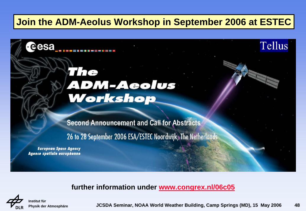
Join the ADM-Aeolus Workshop in September 2006 at ESTEC
further information under www.congrex.nl/06c05
Institut für Physik der Atmosphäre JCSDA Seminar, NOAA World Weather Building, Camp Springs (MD), 15 May 2006 49
C
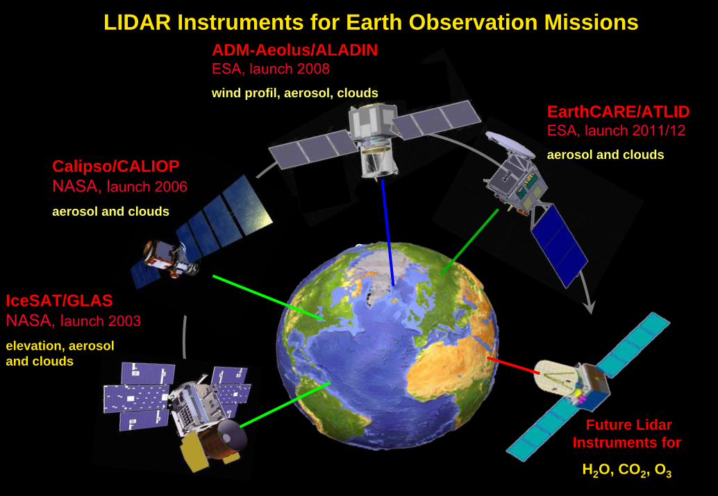
LIDAR Instruments for Earth Observation MissionsADM-Aeolus/ALADINESA, launch 2008wind profil, aerosol, clouds
EarthCARE/ATLIDESA, launch 2011/12aerosol and clouds
Future Lidar Instruments for
H2O, CO2, O3
Calipso/CALIOPNASA, launch 2006aerosol and clouds
IceSAT/GLASNASA, launch 2003elevation, aerosoland clouds

Institut für Physik der Atmosphäre JCSDA Seminar, NOAA World Weather Building, Camp Springs (MD), 15 May 2006 50