atmospheric correction and cloud masking · atmospheric correction and cloud ... photo 1 4.2” x...
TRANSCRIPT

Photo 2
5.51” x 10.31”
Position
x: 8.53”, y: .18”
Photo 1
4.2” x 10.31”
Position
x: 4.36”, y: .18”
Atmospheric
correction
and cloud
masking
Paramaribo,
Suriname
Nov 5th – 9th, 2013
Max Wright
Remote sensing analyst

Photo 1
4.2” x 10.31”
Position
x: 8.74”, y: .18”
• Atmospheric correction (sometime referred to
as radiometric correction) is the process by
which images are corrected to account for
atmospheric contaminants, sensor viewing
angle, and sun position.
What is atmospheric correction?

Photo 1
4.2” x 10.31”
Position
x: 8.74”, y: .18”
Why is it important?
• Correcting for atmospheric contamination is
important because it converts pixel values to
“actual” surafce reflectance
• In general this will also lead to great contrast
and depth in the values in the image
• Especially important when mosaicing or
combining multiple images

• There are many methods for performing atmospheric correction and
most software packages contain correction tools (EDRAS, IDRIS,
ENVI)
• The method that is used at CI is called LEDAPS (Landsat Ecosystem
Distrubance Adaptive Processing System)
• LEDAPS uses satellite image data, metadata, and daily atmospheric
data to correct images and detect clouds
• LEDAPS processed TM5 and ETM+7 images can now be
downloaded directly from the USGS Earth Explorer website as part of
the Climate Data Record (CDR) dataset
What are the methods?

Before atmospheric correction
Landsat 5, path 229 row 57.
Image date 11/15/2009

After atmospheric correction
Landsat 5, path 229 row 57.
Image date 11/15/2009

Cloud masking
One of the most important feature of LEDAPS pre-processing is that it
can be used to generate cloud masks
Masking the clouds from your image is useful because it lowers the
amount of variability that you need to train on
Removing clouds also tends to remove spectral outliers from the
image

Atmospherically corrected image
Landsat 5, path 229 row 57.
Image date 9/28/2009

Cloud Masked Image
Landsat 5, path 229 row 57.
Image date 9/28/2009

Gap-filling
Cloud-masking is important, but in may tropical regions that experience
high levels of cloud-cover it may also be necessary to fill the cloud holes
using additional imagery
Some things to consider when gap-filling:
Seasonality!!
Image dates
Gap-filling order

Gap-filled Image
Base image date: 9/28/2009
Fill image date: 11/15/2009
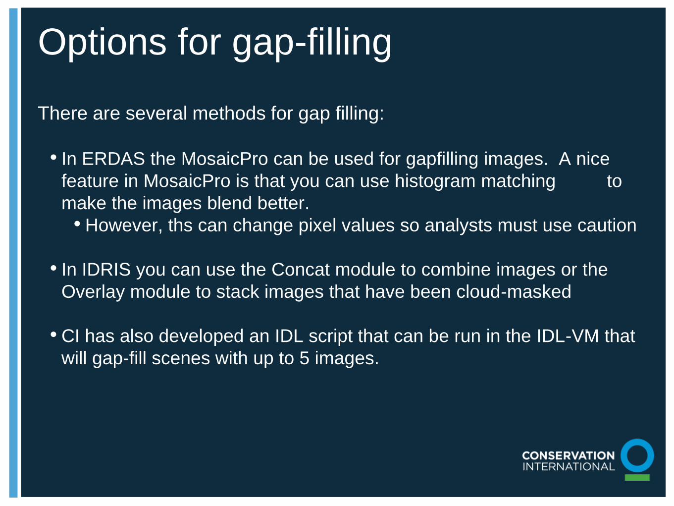
Options for gap-filling
There are several methods for gap filling:
• In ERDAS the MosaicPro can be used for gapfilling images. A nice
feature in MosaicPro is that you can use histogram matching to
make the images blend better.
• However, ths can change pixel values so analysts must use caution
• In IDRIS you can use the Concat module to combine images or the
Overlay module to stack images that have been cloud-masked
• CI has also developed an IDL script that can be run in the IDL-VM that
will gap-fill scenes with up to 5 images.

Gap-filling with IDL-VM script
• The program uses the surface reflectance product from LEDAPS (or
data from the CDR dataset)
• Converts Hierarchical Data Format (HDF) scientific datasets into
geoTIFF images
• Calculates binary cloud and SLC-off mask from HDF using bit flags
from clouds and shadows
• Mask clouds and shadows on each band
• Aligns multiple Landsat scenes into a common frame (using a slightly
modified reframe.pro program from NASA)
• Fill the cloud and SLC-off gaps using fill images

Correction in practice
A) shows an unstretched “true-color
composite” The black lines are SLC-off data gaps.
B) shows the same image, but a Gaussian stretch was
applied to the data histogram.
C) shows a common assignment for a “false-color
composite” that allows visual exploration of the
infrared data.
D) shows the same, but after atmospheric correction
and a cloud / cloud-shadow mask have been applied
using LEDAPS.
E) shows a mosaic of two atmospherically corrected
images, but with no histogram matching between
them applied; note the orange-tone artifacts that
appear to the left of the remaining cloud gaps in the
upper-left of the image.
F) shows the same two images combined into a
mosaic image, but with histogram matching applied;
note that the artifacts in E) are no longer visible.

Photo 1
4.2” x 10.31”
Position
x: 8.74”, y: .18”
Conclusions
• While not necessarily required for 2-date
image classification, atmospheric correction is
useful to enhance spectral characteristics of
the imagery
• Cloud and shadow masking can save a lot of
time later on when classifying images
• Gap-filling holes in the imagery to account for
clouds and shadows provides much better
coverage and it practically essential when
working in areas of the tropics with persistent
clod cover