astm ph1 esa 104320 columbian 111810 - · pdf file · 2015-08-25astm phase i...
TRANSCRIPT


ASTM Phase I Environmental Site Assessment 135 Main Street, Lubec, ME November 18, 2010
GEI Consultants, Inc. i
Table of Contents
Executive Summary iii
1.0 Purpose and Scope 1 1.1 Purpose 1 1.2 Scope 1
2.0 Site Location and History 2 2.1 Site Location 2 2.2 Site History 2
3.0 Site Visit and Description 4 3.1 Site Description 4
3.1.1 Building Interiors 4 3.1.2 Site Grounds 5
3.2 Site Utilities 5 3.3 Storage Tanks 6 3.4 Waste Management 6
4.0 Environmental Setting 7 4.1 Surface Topography 7 4.2 Geologic Setting 7 4.3 Hydrogeologic Setting 7
5.0 Environmental Data Review 8 5.1 Municipal Records 8 5.2 State and Federal Documents 8
5.2.1 Environmental Data Resources Database 8 5.2.2 Maine DEP Sites List 9 5.2.3 User Information 9
6.0 Conclusions 11 6.1 Findings 11 6.2 Data Gaps and Uncertainties 12 6.3 Environmental Professional Statement 12
7.0 Limitations 13
8.0 References 14

ASTM Phase I Environmental Site Assessment 135 Main Street, Lubec, ME November 18, 2010
GEI Consultants, Inc. ii
Figures 1. Location Map 2. Approximate Site Boundary
Appendices A. Sanborn Fire Insurance Maps B. Historical Aerial Photographs C. Local Records D. Site Visit Photographs E. Environmental Data Resources Radius Maps with Geocheck Report F. Resumes TC/bdp: Y:\PROJECTS\2010\104320 Columbian Factory\ASTM PH1 ESA 104320 Columbian 111810.docx

ASTM Phase I Environmental Site Assessment 135 Main Street, Lubec, ME November 18, 2010
GEI Consultants, Inc. iii
Executive Summary
GEI Consultants, Inc. conducted an American Society for Testing and Materials (ASTM) Phase I Environmental Site Assessment (ESA) on behalf of the Maine Department of Environmental Protection (Maine DEP) Brownfields Program for the former Columbian Factory located at 135 Main Street in Lubec, Maine (the Site). The approximately 7-acre Site is owned by the Lubec Historical Society and includes the Historical Society building and the remains of the Columbian Factory building. The historical society building was formerly an office and store for the Columbian Factory.
The Site was occupied by a fish curing and cannery operation from around 1908 to the early 1960s. The Site appears to have been inactive until it was purchased by the Lubec Historical Society in 2000. The historical society occupies the former Columbian Factory store and office for storage of artifacts, an office, exhibit space and educational programs. Much of the former Columbian Factory building, wharfs and related structures have been destroyed by fire and storm damage. The Site is served by public water and sewer.
Based on our evaluation of current Site conditions and review of available Site records, we have identified the following RECs for the Site:
A copper line extending from one of two 275-gal fuel oil tanks in the basement of the historical society building was observed to be leaking. The fuel supply valve was closed, but an unknown amount of fuel oil has leaked into a gravel perimeter drain near the tank.
A sheen was observed on surface water running to a swale behind the historical society building. The swale appears to be downslope from the basement fuel oil tank where the fuel oil leak was observed.
Gasoline was reportedly stored in an underground tank located adjacent to the historical society building from at least 1933 to 1961. Vent pipes for one or more tanks were observed disconnected at the rear of the building. GEI identified no information on the current status of the gasoline tank.
Fuel oil was stored in above ground tanks at the Site, and leaks or spills of oil may have occurred from fuel handling operations.
The Site historically contained various industrial facilities. These facilities likely used and stored oil and hazardous material, such as lubricants, solvents, and waste oil. Leaks or spills of such materials may have occurred.
The embankment and shoreline at the Site could contain fill material. Fill material such as coal slag or ash could contain metals and organic contaminants (e.g., polynuclear aromatic hydrocarbons).

ASTM Phase I Environmental Site Assessment 135 Main Street, Lubec, ME November 18, 2010
GEI Consultants, Inc. iv
Evidence of dumping on the Site was observed. Discarded materials could contain oil or hazardous materials resulting in a release to the environment.
The nature and extent of potential releases of OHM associated with the RECs can be evaluated with an ASTM Phase II ESA. Potential Phase II activities include conducting a subsurface investigation comprised of soil sampling, monitoring well installation, groundwater sampling, and soil and groundwater chemical testing. Phase II could also include assessing potential migration of volatile organic compounds in soil gas. Concerns surrounding asbestos and lead-based paint are outside the scope of a Phase I ESA under the ASTM (Standard E1527 05). However, given the age of the buildings on the Site, asbestos and/or lead-based paint may be present.

ASTM Phase I Environmental Site Assessment 135 Main Street, Lubec, ME November 18, 2010
GEI Consultants, Inc. 1
1.0 Purpose and Scope
GEI completed this Phase I ESA on behalf of the Maine Department of Environmental Protection (Maine DEP), for the property located at 135 Main Street in Lubec, Maine (the Site). The property is presently owned by the Lubec Historical Society.
1.1 Purpose
The purpose of this Site Assessment was to identify Recognized Environmental Conditions (RECs), defined by American Society for Testing and Materials (ASTM) as a condition with the potential for a past, current, or future release of oil or hazardous material (OHM) at a property.
1.2 Scope
In accordance with Phase I ESA protocol under ASTM E 1527-05, we:
Reviewed available records and interviewed personnel with the Town of Lubec and the Lubec Historical Society.
Reviewed documents and maps regarding local geologic and hydrogeologic conditions for the Site.
Reviewed the Maine DEP Hazardous and Oil Spill System On-Line Reports for Lubec.
Reviewed federal and state regulatory database records pertaining to the Site and surrounding area.
Visited the Site.
Prepared this report.
This ESA conforms to the requirements for a Phase I ESA established by the ASTM (Standard E1527 05), with the exceptions noted in Section 6. This report summarizes the information gathered during the Site Assessment.

ASTM Phase I Environmental Site Assessment 135 Main Street, Lubec, ME November 18, 2010
GEI Consultants, Inc. 2
2.0 Site Location and History
2.1 Site Location
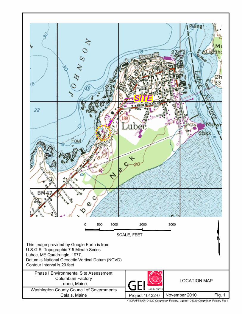
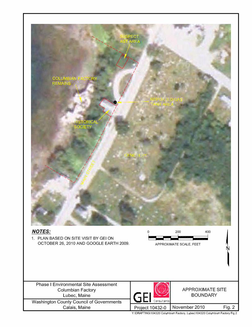
The Site is located in Lubec, Maine (Figs. 1 and 2) and is identified by the Town of Lubec as 135 Main Street (Map 18, Lots 19, 20, and 20-1) [1]. The approximately 7-acre Site is occupied by the remains of a former fish packing company along the shore and an intact building owned and operated by the Lubec Historical Society adjacent to Main Street.
The Site is in an area of commercial and residential use. Adjacent properties include [2]:
To the north: Private residence
To the east: Cemetery across Main Street
To the south: Residence and apparent home-based fisheries business
To the west: Johnson Bay
2.2 Site History
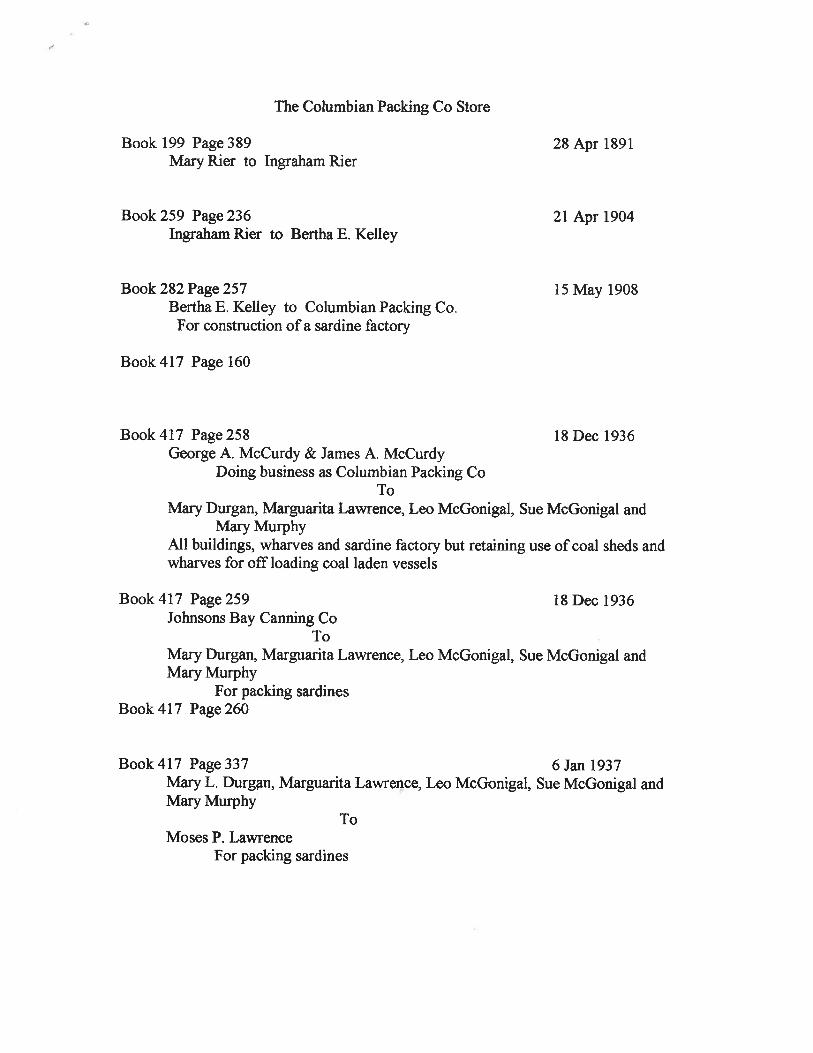
We compiled the history of the Site by reviewing the Sanborn Fire Insurance Maps (Appendix A), aerial photographs (Appendix B), records from the Town of Lubec and Lubec Historical Society (Appendix C), and interviews with Messrs. Ron Pesha and Bernard Ross of the Historical Society [3]. The earliest known developed use of the Site was prior to 1908 as indicated by several structures indicated on the Site on a 1908 United States Geological Survey (USGS) Topographic Map [4]. Based on size and location, these structures may be a mix of residences and marine-related businesses.
Site ownership history provided by the Lubec Historical Society indicates sale of the property from Bertha E. Kelley to the Columbian Packing Company in 1908 for construction of a sardine factory [5]; refer to Appendix C. A 1921 Sanborn Insurance Map indicates development of the Site with the “Columbia Canning Company Sardine Factory” [6]. The map shows an expansive wharf occupied by a smoke house, canning factory, fish sluice, and salting and stringing shed. Nine dwellings, and a combined grocery and office building are located on Site property adjacent to Main Street. The grocery and office appear to be the building that is now occupied by the Lubec Historical Society adjacent to Main Street.
The 1921 Sanborn map indicates the factory was heated by steam and powered by coal and mill waste; an apparent boiler house is located north (seaward) of the canning building. A structure labeled “oil house” was located near the northeast corner of the Site along Main Street. A 2-inch water line is shown extending from Main Street to the Site.

ASTM Phase I Environmental Site Assessment 135 Main Street, Lubec, ME November 18, 2010
GEI Consultants, Inc. 3
The 1933 Sanborn map shows a building layout similar to that in 1921. Notable differences include the apparent demolition of all but one of the residences along Main Street and the addition of a gas tank along the north wall of the combined store and office building along Main Street. An additional business entity is identified for the buildings on the southern portion of the Site as “Johnson’s Bay Packing.” The owner is identified as Columbia Packing Company.
In 1946 the cannery was sold to Booth Fisheries Corporation which appears to have operated until the early 1960s [5]. A 1949 Sanborn map identifies the cannery building as “Booth Fisheries Corporation” engaged in fish curing. Buildings on the southern portion of the Site (formerly Johnson’s Bay Packing) are labeled “Columbia Packing Co. Coal Dealers & Fish Curing.” The boiler house north of the cannery building is now labeled “smoke house.”
The 1961 Sanborn maps indicated the cannery as a “Limited Operation.” The layout of the buildings appears similar to that on the 1949 insurance map.
The 1961 Sanborn map indicates that the abutting property had been developed for cat food manufacturing by “National Pet Food, Inc.” The Town of Lubec tax map indicates that the Lubec Historical Society owns approximately 0.3 acres of land that formed the southern tip of this abutting property [1].
As indicated on the 1961 Sanborn map, two above ground oil tanks were located on the National Pet Food property, a 6,000 gal oil tank located 280 ft north of the northern Site boundary, and a fuel tank of unspecified capacity located on or near the northern Site boundary, adjacent to Main Street. Mr. Ross of the Lubec Historical Society recalled that the tanks were above ground [3].
Lubec Historical Society records indicate that the Site changed hands several times over the four decades between 1960 and 2000. None of these entities appeared to have engaged in commercial operations at the Site (Appendix C). The Site was purchased by the Lubec Historical Society in March 2000.
The historical data reviewed indicate little change in the Site neighborhood since the early 1900s. The cemetery across Main Street was identified on the 1908 USGS topographic map. With the exception of the National Pet Food factory constructed north of the Site, development in the neighborhood appears to be primarily residential.

ASTM Phase I Environmental Site Assessment 135 Main Street, Lubec, ME November 18, 2010
GEI Consultants, Inc. 4
3.0 Site Visit and Description
GEI visited the Site on October 26, 2010 to collect information, document property conditions, and observe and document conditions related to the potential presence of OHM [2]. Ron Pesha and Bernard Ross of the Lubec Historical Society, and Jean Firth with Maine DEP accompanied GEI during the visit. Photographs taken during the Site visit are included in Appendix D.
3.1 Site Description
The Site consists of an approximately 7-acre parcel occupied by:
1. An approximately 10,000 square ft vacant two-story, slab-on-grade concrete-framed building (former cannery) along the shore. This building is severely deteriorated with portions of the roof, concrete and brick walls and flooring that have collapsed.
2. An approximately 1,600 square ft two-story wooden building with full, unfinished basement adjacent to Main Street. The building is presently used for an office, exhibit space and for storage of artifacts by the Lubec Historical Society. The building was formerly used as a store and office for the former Columbian Factory.
The Site neighborhood includes an historic cemetery to the east, the bay to the west, and residential properties to the north and south. The residence to the south appears to include a home-based fisheries related business. GEI noted no obvious evidence of oil or hazardous material handling or storage on adjacent properties that would likely impact the Site.
3.1.1 Building Interiors
Cannery Building
The former Columbian Factory cannery building contains primarily wood, metal, and concrete and brick rubble. The floors are concrete and have been cracked with portions dislodged due to building decay and storm damage. Several of the wood timbers in the building were charred, indicating past fire damage.
It appears the contents of the former cannery operations had been removed with the exception of several wood bins located on the first floor. GEI noted no floor drains or stained flooring; however, much of the flooring had been damaged or was covered by debris.
Portions of the first floor of the building appear to be exposed to tide and wave action, and there was numerous plastic containers, drift wood, fish netting and other debris in these areas. GEI observed no obvious evidence of leaks or spills of oil or hazardous material from the containers.

ASTM Phase I Environmental Site Assessment 135 Main Street, Lubec, ME November 18, 2010
GEI Consultants, Inc. 5
Historical Society Building
The Lubec Historical Society building was in generally good condition with wooden floors, clapboards and asphalt roofing. The building contained numerous artifacts ranging from historical documents to antique machinery and marine electronics. Other uses of the building include an office, meeting area, exhibit area and former radio studio on the second floor.
The basement contained a furnace and two 275-gal above ground fuel oil tanks. The connection between the copper supply line and oil filter appeared to be leaking onto a sand and gravel floor. The sand and gravel appeared to be part of a building perimeter drain cut into the surrounding concrete floor. The sand and gravel was stained, and a fuel oil odor was noted between the fuel tank and the northwest corner of the basement. Bernard Ross of the historical society closed the fuel oil feed valve and agreed to coordinate repair of the leak with his fuel oil provider.
The basement contained building maintenance supplies and apparent waste oil contained in an open 5 gal pail and closed plastic gallon jug. The concrete floor near the containers was discolored, although the containers did not appear to be leaking.
3.1.2 Site Grounds
The ground surface at the Site slopes steeply from the rear of the historical society building to the shoreline and former cannery building. The slope was overgrown with scrub and littered with metal, glass, plastic, wood and other debris. One apparently empty rusty 55-gal drum was observed adjacent to the northern factory wall; GEI observed no staining of the ground associated with this drum or other debris surrounding the factory building.
Apparent oil-stained soil and a slight petroleum odor were noted on soil at the southwest corner of the historical society building. Water in a drainage swale at the northwest corner of the building contained an oil sheen and exhibited a petroleum odor. This area appears to receive discharge from the perimeter drain in the historical society building.
3.2 Site Utilities
The Lubec Historical Society building is served by municipal water and sewer; water service is no longer provided to the former cannery building [3]. According to historic records and interviews with Ron Pesha and Bernard Ross, there is no indication that the Site historically had a septic system or private drinking well [3].
Electricity at the Site is supplied by Bangor Hydro. GEI observed no transformers or other electrical equipment associated with current or historic Site operations.

ASTM Phase I Environmental Site Assessment 135 Main Street, Lubec, ME November 18, 2010
GEI Consultants, Inc. 6
3.3 Storage Tanks
GEI observed two fill and vent pipes on the exterior north wall of the historical society building. These pipes are connected to two 275-gal above ground tanks located in the building basement.
GEI observed two apparent underground storage tank vent pipes behind the west wall of the historical society building. The vent pipes were disconnected and lying on the ground. Representatives of the historical society did not recall where the vent pipes were located, but did recall at least one underground gasoline tank being located near the building. Tank fill pipes or other evidence of the location of the former underground tank(s) were not observed.
Bernard Ross of the Lubec Historical Society recalled at least one above ground fuel storage tank located north of the historical society building and pointed out the remains of a concrete tank crib on the edge of the scrub-covered slope. No obvious oil stains or petroleum odors were evident in this area.
3.4 Waste Management
The 1921 Sanborn insurance map notes “mill waste” as a fuel for the cannery boilers. GEI identified no other records or local knowledge regarding historic waste management practices [3,6]. Given the proximity of the factory to the shore, it is likely that some waste was historically discharged to the bay.

ASTM Phase I Environmental Site Assessment 135 Main Street, Lubec, ME November 18, 2010
GEI Consultants, Inc. 7
4.0 Environmental Setting
4.1 Surface Topography
The Site slopes relatively steeply from the rear of the historical society building to the shore. Elevations range from around 30 ft at the historical society building to near sea level at the former cannery building.
4.2 Geologic Setting
Surficial geologic mapping indicates the Site is underlain by glacial marine deposits of the Presumpscot Formation. These deposits generally consist of silt, clay and sand, commonly a clayey silt. Localized sand, gravel and till deposits may also be encountered [8]. GEI observed the shoreline adjacent to the former cannery building to be covered with silt, sand, gravel, cobbles and boulders.
According to the Bedrock Geologic Map of Maine, edited by Phil H. Osberg, Arthur M. Hussey II, Gary M. Boone, bedrock at the Site area consists of volcanic rocks of the Eastport Formation [9]. GEI observed bedrock outcrops along the shoreline adjacent to the Site [2].
The shoreline of the Site along Johnson Bay appears to be located in the 100-year flood zone as mapped by the Federal Emergency Management Agency (FEMA) [11]. A portion of the Site near the shore also appears to lie within the National Wetland Inventory [11].
4.3 Hydrogeologic Setting
Based on Site topography and drainage, GEI estimates that groundwater flows northwest towards Johnson Bay. GEI identified no water supply wells on the Site; public water supply is available to the Site and vicinity.
The database search by Environmental Data Resource, Inc. (Appendix E) identified public water supply wells located ½ to 1 mile northeast of the Site. The public water supply is identified as the Lubec Water District and reportedly includes three gravel packed wells (about 35 ft deep) and one spring [11].
The site is not located on a Significant Sand and Gravel Aquifer [10]. The closest Significant Sand and Gravel Aquifer is located about 1 mile the southwest of the Site. Significant Sand and Gravel Aquifers are mapped by the Maine Geological Survey and have the potential to produce relatively high yields of groundwater to supply wells.

ASTM Phase I Environmental Site Assessment 135 Main Street, Lubec, ME November 18, 2010
GEI Consultants, Inc. 8
5.0 Environmental Data Review
5.1 Municipal Records
Town of Lubec tax assessor’s records indicate the Site is owned by the Lubec Historical Society, and includes Lots 19, 20, and 20-1 on tax map 18 [1].
GEI spoke with Town Administrator John Sutherland about development plans for the Site. Mr. Sutherland indicated there has been some discussion about reuse of a portion of the Site for a breakwater with shore access, and possible parking accommodations. He commented that no firm plans have been developed for the project. GEI also spoke with personnel from the Lubec Fire Department on November 3, 2010. Fire department personnel indicated no knowledge of responses to fire or oil or hazardous material releases at the Site; the individual interviewed has served the fire department for 10 years.
5.2 State and Federal Documents
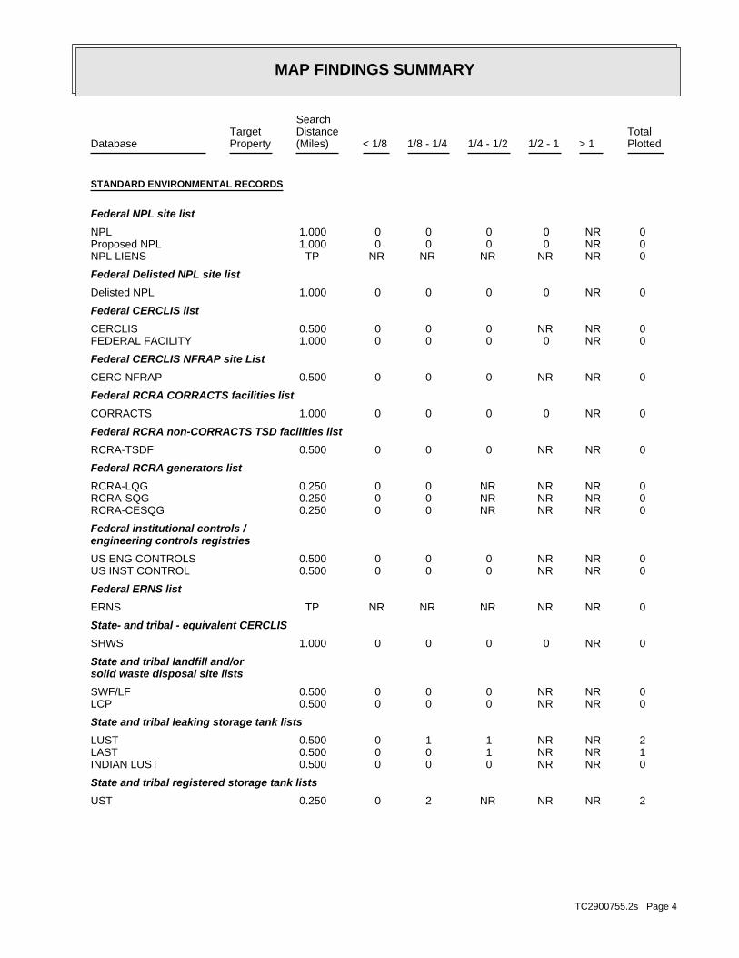
5.2.1 Environmental Data Resources Database EDR conducted a search of federal and state databases for properties within one mile of the Site [11]. The following information is summarized from the EDR report contained in Appendix F:
The Site is not listed as an NPL site. There are no NPL sites, proposed NPL sites, or delisted NPL sites within a 1-mile radius of the Site.
The Site is not a RCRA TSD facility. There are no RCRA-TSD facilities located within a ½-mile radius of the Site.
The Site is not a RCRA-LQG or RCRA-SQG facility. There are no RCRA-LQG or SQG facilities located within a ¼-mile radius of the Site.
The Site is not listed as a RCRA CORRACTS site; one CORRACTS site is located within a 1-mile radius of the Site.
The Site is not on the list of Leaking Underground Storage Tanks (LUST). There are two LUST sites located within a ½-mile radius of the Site.
The Site is not on the list of Leaking Aboveground Storage Tanks (LAST); however there is one LAST site located within a ½-mile radius of the Site.
The Site is not identified on the list of registered storage tanks.
The Site is not listed as a landfill/solid waste disposal site nor are there any disposal sites within a ½-mile radius of the Site.

ASTM Phase I Environmental Site Assessment 135 Main Street, Lubec, ME November 18, 2010
GEI Consultants, Inc. 9
The Site is not a CERCLIS listed site. No CERCLIS sites are located within a ½-mile radius of the Site.
The Site is not encumbered with a land use restriction or environmental lien.
The Site is not a Manufactured Gas Plant. No Manufactured Gas Plans were listed within a 1-mile radius of the Site.
EDR provided findings from review of numerous other environmental databases (Appendix E). The databases include, for example, Brownfields sites, PCB transformer sites and Underground Injection Control sites. Neither the Site nor properties within applicable search radii were identified on these supplemental databases [11]. Further information on sites identified in the EDR database search are provided below.
LUST Sites The two LUST sites identified in the EDR report are the Quick Shop Convenience Store and Lubec Consolidated School, located about 0.2 and 0.3 miles from the Site, respectively. The status of both sites is designated “Final Report” with no further action identified. Based on distance from the Site, groundwater flow direction and regulatory status, these LUST sites are not likely to impact the subject Site. Leaking ASTs EDR identified one Leaking Above Ground Storage Tank (LAST) site located about 0.5 miles from the Site (listed as 28 Washington Street). The site status is listed as “Final Report” with no further action identified. Based on distance from the Site, groundwater flow direction and regulatory status, this LUST site is not likely to impact the subject Site. 5.2.2 Maine DEP Sites List GEI reviewed the Maine DEP Hazardous and Oil Spill System Online Report Service on November 5, 2010. This database lists spills and contains associated spill reports documented by the Maine DEP since 1985. GEI identified no spills at the Site or on properties adjacent to the Site. The database is consistent with the report filed by EDR for the Site and vicinity [11]. 5.2.3 User Information As required by ASTM Standard E1527-05, GEI requested that Bernard Ross of the Lubec Historical Society complete a “User Questionnaire” about environmental liens, activity and use limitations, specialized or common knowledge on environmental Site conditions, fair market value impacts, and obvious indicators of contamination at the Site. Mr. Ross reported no knowledge regarding environmental liens, activity and use limitations, or impacts on property

ASTM Phase I Environmental Site Assessment 135 Main Street, Lubec, ME November 18, 2010
GEI Consultants, Inc. 10
value due to environmental conditions. Mr. Ross was familiar with the general historical use of the Site and past storage of fuel oil and gasoline in storage tanks as reported herein [13].

ASTM Phase I Environmental Site Assessment 135 Main Street, Lubec, ME November 18, 2010
GEI Consultants, Inc. 11
6.0 Conclusions
6.1 Findings
GEI conducted an ASTM Phase I ESA on behalf of the Maine DEP Brownfields Program for the property located at 135 Main Street in Lubec, Maine. The approximately 7-acre Site is owned by the Lubec Historical Society and includes the Historical Society building and the remains of the Columbian Factory building. The historical society building was formerly an office and store for the Columbian Factory.
Based on our evaluation of current Site conditions and review of available Site records, we have identified the following RECs for the Site:
A copper line extending from one of two 275-gal fuel oil tanks in the basement of the historical society building was observed to be leaking. The fuel supply valve was closed, but an unknown amount of fuel oil has leaked into a gravel perimeter drain near the tank.
A sheen was observed on surface water running to a swale behind the historical society building. The swale appears to be downslope from the basement fuel oil tank where the fuel oil leak was observed.
Gasoline was reportedly stored in an underground tank located adjacent to the historical society building from at least 1933 to 1961. Vent pipes for one or more tanks were observed disconnected at the rear of the building. GEI identified no information on the current status of the gasoline tank.
Fuel oil was stored in above ground tanks at the Site, and leaks or spills of oil may have occurred from fuel handling operations.
The Site historically contained various industrial facilities. These facilities likely used and stored oil and hazardous material, such as lubricants, solvents, and waste oil. Leaks or spills of such materials may have occurred.
The embankment and shoreline at the Site could contain fill material. Fill material such as coal slag or ash could contain metals and organic contaminants (e.g., polynuclear aromatic hydrocarbons).
Evidence of dumping on the Site was observed. Discarded materials could contain oil or hazardous materials resulting in a release to the environment.
The nature and extent of potential releases of OHM associated with the RECs can be evaluated with a Phase II ESA. Potential Phase II activities include conducting a subsurface investigation comprised of soil sampling, monitoring well installation, groundwater sampling, and soil and groundwater chemical testing. Phase II could also include assessing potential migration of volatile organic compounds in soil gas.

ASTM Phase I Environmental Site Assessment 135 Main Street, Lubec, ME November 18, 2010
GEI Consultants, Inc. 12
Concerns surrounding asbestos and lead-based paint are outside the scope of a Phase I ESA under the ASTM (Standard E1527 05). However, given the age of the buildings on the Site, asbestos and/or lead-based paint may be present.
6.2 Data Gaps and Uncertainties
Data gaps and uncertainties associated with these findings include the following:
The absence of specific groundwater flow information for the Site.
We could not determine the exact location of some of the releases that were listed as orphan sites in the EDR report.
We are uncertain as to the specific nature of oil and hazardous material use at the Site, including types and exact location on the property.
The history of the Site can only be determined back to 1908 – the year of the oldest recorded Site development identified.
These data gaps and uncertainties are not expected to impact our conclusions.
6.3 Environmental Professional Statement
Resumes for staff involved in the preparation of this report are attached in Appendix F. To the best of our professional knowledge and belief, we meet the definition of an Environmental Professional, as defined in 40 CFR 312.10. We have the specific qualifications based on education, training, and experience to assess a property of the nature, history, and setting of the subject Site. We have developed and performed the appropriate inquiries in conformance with the standards and practices set forth in 40 CFR 312.

ASTM Phase I Environmental Site Assessment 135 Main Street, Lubec, ME November 18, 2010
GEI Consultants, Inc. 13
7.0 Limitations
This report was prepared for the use of the Maine DEP and Lubec Historical Society, exclusively. This report meets the general requirements for a Phase I ESA established by ASTM Standard E1527 05. Our conclusions are based on the information reported in this report. Additional information not available to us at the time this report was prepared may result in a modification of the findings.
The Maine DEP or Site owner did not provide recorded land title records and we did not conduct an independent review of these documents. Alternatively, we relied upon land use restriction and environmental lien data provided by EDR, records maintained by the Lubec Historical Society and interviews with persons knowledgeable about the site.
A survey for asbestos, lead paint, radon gas, molds and fungus, and lead in drinking water was not performed. A subsurface investigation was also not performed. This report has been prepared in accordance with generally accepted engineering and geo-hydrological practices. No warranty, expressed or implied, is made.

ASTM Phase I Environmental Site Assessment 135 Main Street, Lubec, ME November 18, 2010
GEI Consultants, Inc. 14
8.0 References
[1] GEI, 2010. Town of Lubec Assessor’s Office data review, October 25.
[2] GEI, 2010. Visit to Lubec, Maine on October 26.
[3] GEI, 2010. Interview with Ron Pesha and Bernard Ross of the Lubec Historical Society, October 26.
[4] United States Geological Survey, 1908, reprinted 1935. Eastport Quadrangle, ME, 15 Minute Map Series, 1:62,500 scale.
[5] Lubec Historical Society, undated. History of ownership for the Columbian Factory.
[6] EDR, 2010. EDR Environmental Data Resources Inc., Certified Sanborn Map Report, 135 Main Street, Lubec, ME, Inquiry Number: 2900755.3, Milford, CT, October 21.
[7] Google Earth, 2010. Google Earth Imagery and Topographic Data; accessed November 5.
[8] Maine Geological Survey, 1975. “Reconnaissance Surficial Geology of the Eastport Quadrangle, Maine,” Open File No. 75-2, by Harold W. Borns, Jr..
[9] Maine Geological Survey, 1983. “Bedrock Geologic Map of Maine,” Department of Conservation, edited by Philip H. Osberg, Arthur M. Hussey II, and Gary M. Boone.
[10] Maine Geological Survey, 2000. “Significant Sand and Gravel Aquifers,” Open-File No. 00-119.
[11] EDR, 2010. EDR Environmental Data Resources Inc., The EDR Radius Map™ Report with GeoCheck®, 135 Main Street, Lubec, Maine, Report ID: 2900755.2s, Milford, CT, October 21.
[12] MaineDEP, 2010. MDEP Sites database accessed on November 5.
[13] Lubec Historical Society, 2010. ASTM “User Questionnaire,” completed by Bernard Ross on November 5, 2010.
ASTM Phase I Environmental Site Assessment 135 Main Street, Lubec, ME November 18, 2010
GEI Consultants, Inc.
Appendix A
Sanborn Fire Insurance Maps

Certified Sanborn® Map Report
Columbian Factory
135 Main Street
Lubec, ME 04652
Inquiry Number: 2900755.3
October 21, 2010

Certified Sanborn® Map Report 10/21/10
Site Name:Columbian Factory135 Main StreetLubec, ME 04652
Client Name:GEI Consultants, Inc.400 Unicorn Park DriveWoburn, MA 01801
EDR Inquiry # 2900755.3 Contact: Brenda Pinkham
The complete Sanborn Library collection has been searched by EDR, and fire insurance maps covering the targetproperty location provided by GEI Consultants, Inc. were identified for the years listed below. The certified SanbornLibrary search results in this report can be authenticated by visiting www.edrnet.com/sanborn and entering thecertification number. Only Environmental Data Resources Inc. (EDR) is authorized to grant rights for commercialreproduction of maps by Sanborn Library LLC, the copyright holder for the collection.
Certified Sanborn Results:
Site Name: Columbian FactoryAddress: 135 Main StreetCity, State, Zip: Lubec, ME 04652Cross Street:P.O. # NAProject: 104320-1000Certification # 459E-4388-9C01
Library of Congress
University Publications of America
EDR Private Collection
The Sanborn Library LLC Since 1866™
The Sanborn Library includes more than 1.2 millionSanborn fire insurance maps, which track historicalproperty usage in approximately 12,000 Americancities and towns. Collections searched:
Sanborn® Library search resultsCertification # 459E-4388-9C01
Maps Provided:
1961
1949
1933
1921
Limited Permission To Make CopiesGEI Consultants, Inc. (the client) is permitted to make up to THREE photocopies of this Sanborn Map transmittal and each fire insurance mapaccompanying this report solely for the limited use of its customer. No one other than the client is authorized to make copies. Upon request madedirectly to an EDR Account Executive, the client may be permitted to make a limited number of additional photocopies. This permission isconditioned upon compliance by the client, its customer and their agents with EDR's copyright policy; a copy of which is available upon request.
Disclaimer - Copyright and Trademark noticeThis Report contains certain information obtained from a variety of public and other sources reasonably available to Environmental Data Resources, Inc. It cannot beconcluded from this Report that coverage information for the target and surrounding properties does not exist from other sources. NO WARRANTY EXPRESSED ORIMPLIED, IS MADE WHATSOEVER IN CONNECTION WITH THIS REPORT. ENVIRONMENTAL DATA RESOURCES, INC. SPECIFICALLY DISCLAIMS THEMAKING OF ANY SUCH WARRANTIES, INCLUDING WITHOUT LIMITATION, MERCHANTABILITY OR FITNESS FOR A PARTICULAR USE OR PURPOSE. ALLRISK IS ASSUMED BY THE USER. IN NO EVENT SHALL ENVIRONMENTAL DATA RESOURCES, INC. BE LIABLE TO ANYONE, WHETHER ARISING OUT OFERRORS OR OMISSIONS, NEGLIGENCE, ACCIDENT OR ANY OTHER CAUSE, FOR ANY LOSS OF DAMAGE, INCLUDING, WITHOUT LIMITATION, SPECIAL,INCIDENTAL CONSEQUENTIAL, OR EXEMPLARY DAMAGES. ANY LIABILITY ON THE PART OF ENVIRONMENTAL DATA RESOURCES, INC. IS STRICTLYLIMITED TO A REFUND OF THE AMOUNT PAID FOR THIS REPORT. Purchaser accepts this Report "AS IS". Any analyses, estimates, ratings, environmental risklevels or risk codes provided in this Report are provided for illustrative purposes only, and are not intended to provide, nor should they be interpreted as providingany facts regarding, or prediction or forecast of, any environmental risk for any property. Only a Phase I Environmental Site Assessment performed by anenvironmental professional can provide information regarding the environmental risk for any property. Additionally, the information provided in this Report is not to beconstrued as legal advice.
Copyright 2010 by Environmental Data Resources, Inc. All rights reserved. Reproduction in any media or format, in whole or in part, of any report or map ofEnvironmental Data Resources, Inc., or its affiliates, is prohibited without prior written permission.
EDR and its logos (including Sanborn and Sanborn Map) are trademarks of Environmental Data Resources, Inc. or its affiliates. All other trademarks used herein arethe property of their respective owners.
2900755 - 3 page 2

Sanborn Sheet Thumbnails
This Certified Sanborn Map Report is based upon the following SanbornFire Insurance map sheets.
1961 Source Sheets
Volume 1, Sheet 11
1949 Source Sheets
Volume 1, Sheet 11
1933 Source Sheets
Volume 1, Sheet 11
1921 Source Sheets
Volume 1, Sheet 14
2900755 - 3 page 3

1961 Certified Sanborn Map
459E-4388-9C
01
Order Date:EDR Inquiry:
Client:
Site Name:
Address:
City, ST, ZIP:
Certification #
Copyright: 1961
10/21/2010 1:20:24 PM2900755.3
GEI Consultants, Inc.
Columbian Factory
135 Main Street
Lubec ME 04652
459E-4388-9C01
This Certified Sanborn Map combines the following sheets.Outlined areas indicate map sheets within the collection.
Volume 1, Sheet 11
0 Feet 150 300 600
2900755 - 3 page 4

1949 Certified Sanborn Map
459E-4388-9C
01
Order Date:EDR Inquiry:
Client:
Site Name:
Address:
City, ST, ZIP:
Certification #
Copyright: 1949
10/21/2010 1:20:24 PM2900755.3
GEI Consultants, Inc.
Columbian Factory
135 Main Street
Lubec ME 04652
459E-4388-9C01
This Certified Sanborn Map combines the following sheets.Outlined areas indicate map sheets within the collection.
Volume 1, Sheet 11
0 Feet 150 300 600
2900755 - 3 page 5

1933 Certified Sanborn Map
459E-4388-9C
01
Order Date:EDR Inquiry:
Client:
Site Name:
Address:
City, ST, ZIP:
Certification #
Copyright: 1933
10/21/2010 1:20:24 PM2900755.3
GEI Consultants, Inc.
Columbian Factory
135 Main Street
Lubec ME 04652
459E-4388-9C01
This Certified Sanborn Map combines the following sheets.Outlined areas indicate map sheets within the collection.
Volume 1, Sheet 11
0 Feet 150 300 600
2900755 - 3 page 6

1921 Certified Sanborn Map
459E-4388-9C
01
Order Date:EDR Inquiry:
Client:
Site Name:
Address:
City, ST, ZIP:
Certification #
Copyright: 1921
10/21/2010 1:20:24 PM2900755.3
GEI Consultants, Inc.
Columbian Factory
135 Main Street
Lubec ME 04652
459E-4388-9C01
This Certified Sanborn Map combines the following sheets.Outlined areas indicate map sheets within the collection.
Volume 1, Sheet 14
0 Feet 150 300 600
2900755 - 3 page 7

ASTM Phase I Environmental Site Assessment 135 Main Street, Lubec, ME November 18, 2010
GEI Consultants, Inc.
Appendix B
Historical Aerial Photographs

The EDR Aerial Photo Decade Package
Columbian Factory
135 Main Street
Lubec, ME 04652
Inquiry Number: 2900755.4
October 25, 2010

EDR Aerial Photo Decade Package
Environmental Data Resources, Inc. (EDR) Aerial Photo Decade Package is a screening tool designed to assistenvironmental professionals in evaluating potential liability on a target property resulting from past activities. EDR’sprofessional researchers provide digitally reproduced historical aerial photographs, and when available, provide one photoper decade.
When delivered electronically by EDR, the aerial photo images included with this report are for ONE TIME USEONLY. Further reproduction of these aerial photo images is prohibited without permission from EDR. For moreinformation contact your EDR Account Executive.
Thank you for your business.Please contact EDR at 1-800-352-0050
with any questions or comments.
Disclaimer - Copyright and Trademark Notice
This Report contains certain information obtained from a variety of public and other sources reasonably available to Environmental Data Resources, Inc.It cannot be concluded from this Report that coverage information for the target and surrounding properties does not exist from other sources. NOWARRANTY EXPRESSED OR IMPLIED, IS MADE WHATSOEVER IN CONNECTION WITH THIS REPORT. ENVIRONMENTAL DATARESOURCES, INC. SPECIFICALLY DISCLAIMS THE MAKING OF ANY SUCH WARRANTIES, INCLUDING WITHOUT LIMITATION,MERCHANTABILITY OR FITNESS FOR A PARTICULAR USE OR PURPOSE. ALL RISK IS ASSUMED BY THE USER. IN NO EVENT SHALLENVIRONMENTAL DATA RESOURCES, INC. BE LIABLE TO ANYONE, WHETHER ARISING OUT OF ERRORS OR OMISSIONS, NEGLIGENCE,ACCIDENT OR ANY OTHER CAUSE, FOR ANY LOSS OF DAMAGE, INCLUDING, WITHOUT LIMITATION, SPECIAL, INCIDENTAL,CONSEQUENTIAL, OR EXEMPLARY DAMAGES. ANY LIABILITY ON THE PART OF ENVIRONMENTAL DATA RESOURCES, INC. IS STRICTLYLIMITED TO A REFUND OF THE AMOUNT PAID FOR THIS REPORT. Purchaser accepts this Report AS IS. Any analyses, estimates, ratings,environmental risk levels or risk codes provided in this Report are provided for illustrative purposes only, and are not intended to provide, nor should theybe interpreted as providing any facts regarding, or prediction or forecast of, any environmental risk for any property. Only a Phase I Environmental SiteAssessment performed by an environmental professional can provide information regarding the environmental risk for any property. Additionally, theinformation provided in this Report is not to be construed as legal advice.
Copyright 2010 by Environmental Data Resources, Inc. All rights reserved. Reproduction in any media or format, in whole or in part, of any report or mapof Environmental Data Resources, Inc., or its affiliates, is prohibited without prior written permission.
EDR and its logos (including Sanborn and Sanborn Map) are trademarks of Environmental Data Resources, Inc. or its affiliates. All other trademarksused herein are the property of their respective owners.

Date EDR Searched Historical Sources:Aerial PhotographyOctober 25, 2010
Target Property:135 Main Street
Lubec, ME 04652
Year Scale Details Source
1942 Aerial Photograph. Scale: 1"=1000' Panel #: 44066-G8, Lubec, ME;/Flight Date: October 04, 1942 EDR
1975 Aerial Photograph. Scale: 1"=1000' Panel #: 44066-G8, Lubec, ME;/Flight Date: October 27, 1975 EDR
1983 Aerial Photograph. Scale: 1"=1000' Panel #: 44066-G8, Lubec, ME;/Flight Date: May 18, 1983 EDR
1991 Aerial Photograph. Scale: 1"=750' Panel #: 44066-G8, Lubec, ME;/Flight Date: May 30, 1991 EDR
1996 Aerial Photograph. Scale: 1"=750' Panel #: 44066-G8, Lubec, ME;/Flight Date: May 15, 1996 EDR
2006 Aerial Photograph. Scale: 1"=604' Panel #: 44066-G8, Lubec, ME;/Flight Date: January 01, 2006 EDR
2900755.42

INQUIRY #:
YEAR:
2900755.4
1942
= 1000'

INQUIRY #:
YEAR:
2900755.4
1975
= 1000'

INQUIRY #:
YEAR:
2900755.4
1983
= 1000'

INQUIRY #:
YEAR:
2900755.4
1991
= 750'

INQUIRY #:
YEAR:
2900755.4
1996
= 750'

INQUIRY #:
YEAR:
2900755.4
2006
= 604'

ASTM Phase I Environmental Site Assessment 135 Main Street, Lubec, ME November 18, 2010
GEI Consultants, Inc.
Appendix C
Local Records


ASTM Phase I Environmental Site Assessment 135 Main Street, Lubec, ME November 18, 2010
GEI Consultants, Inc.
Appendix D
Site Visit Photographs

Lubec Historical Society and former Columbian Factory Store/Office (facing west).
Apparent UST vent pipes at northwest corner of Historical Society Building.
Oil sheen on drainage near northwest corner of Historical Society Building.
Leaking fuel line connected to 275‐gallon storage tank in Historical Society Basement.
Oil‐stained floor in northwest corner of Historical Society basement.
Former Columbian Factory cannery building (facing east).
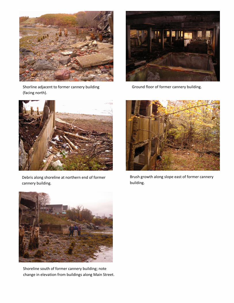
Shorline adjacent to former cannery building (facing north).
Ground floor of former cannery building.
Debris along shoreline at northern end of former cannery building.
Brush growth along slope east of former cannery building.
Shoreline south of former cannery building; note change in elevation from buildings along Main Street.

ASTM Phase I Environmental Site Assessment 135 Main Street, Lubec, ME November 18, 2010
GEI Consultants, Inc.
Appendix E
Environmental Data Resources Radius Map with Geocheck Report

FORM-BPK-PVC
®kcehCoeG htiw tropeR ™paM suidaR RDE ehT
440 Wheelers Farms RoadMilford, CT 06461Toll Free: 800.352.0050www.edrnet.com
Columbian Factory135 Main StreetLubec, ME 04652
Inquiry Number: 2900755.2sOctober 21, 2010

SECTION PAGE
Executive Summary ES1
Overview Map 2
Detail Map 3
Map Findings Summary 4
Map Findings 7
Orphan Summary 24
Government Records Searched/Data Currency Tracking GR-1
GEOCHECK ADDENDUM
Physical Setting Source Addendum A-1
Physical Setting Source Summary A-2
Physical Setting SSURGO Soil Map A-5
Physical Setting Source Map A-10
Physical Setting Source Map Findings A-12
Physical Setting Source Records Searched A-24
TC2900755.2s Page 1
Thank you for your business.Please contact EDR at 1-800-352-0050
with any questions or comments.
Disclaimer - Copyright and Trademark Notice
This Report contains certain information obtained from a variety of public and other sources reasonably available to Environmental DataResources, Inc. It cannot be concluded from this Report that coverage information for the target and surrounding properties does not exist fromother sources. NO WARRANTY EXPRESSED OR IMPLIED, IS MADE WHATSOEVER IN CONNECTION WITH THIS REPORT. ENVIRONMENTALDATA RESOURCES, INC. SPECIFICALLY DISCLAIMS THE MAKING OF ANY SUCH WARRANTIES, INCLUDING WITHOUT LIMITATION,MERCHANTABILITY OR FITNESS FOR A PARTICULAR USE OR PURPOSE. ALL RISK IS ASSUMED BY THE USER. IN NO EVENT SHALLENVIRONMENTAL DATA RESOURCES, INC. BE LIABLE TO ANYONE, WHETHER ARISING OUT OF ERRORS OR OMISSIONS, NEGLIGENCE,ACCIDENT OR ANY OTHER CAUSE, FOR ANY LOSS OF DAMAGE, INCLUDING, WITHOUT LIMITATION, SPECIAL, INCIDENTAL,CONSEQUENTIAL, OR EXEMPLARY DAMAGES. ANY LIABILITY ON THE PART OF ENVIRONMENTAL DATA RESOURCES, INC. IS STRICTLYLIMITED TO A REFUND OF THE AMOUNT PAID FOR THIS REPORT. Purchaser accepts this Report "AS IS". Any analyses, estimates, ratings,environmental risk levels or risk codes provided in this Report are provided for illustrative purposes only, and are not intended to provide, norshould they be interpreted as providing any facts regarding, or prediction or forecast of, any environmental risk for any property. Only a Phase IEnvironmental Site Assessment performed by an environmental professional can provide information regarding the environmental risk for anyproperty. Additionally, the information provided in this Report is not to be construed as legal advice.
Copyright 2010 by Environmental Data Resources, Inc. All rights reserved. Reproduction in any media or format, in wholeor in part, of any report or map of Environmental Data Resources, Inc., or its affiliates, is prohibited without prior written permission.
EDR and its logos (including Sanborn and Sanborn Map) are trademarks of Environmental Data Resources, Inc. or its affiliates. All othertrademarks used herein are the property of their respective owners.
TABLE OF CONTENTS

EXECUTIVE SUMMARY
TC2900755.2s EXECUTIVE SUMMARY 1
A search of available environmental records was conducted by Environmental Data Resources, Inc (EDR).The report was designed to assist parties seeking to meet the search requirements of EPA’s Standardsand Practices for All Appropriate Inquiries (40 CFR Part 312), the ASTM Standard Practice forEnvironmental Site Assessments (E 1527-05) or custom requirements developed for the evaluation ofenvironmental risk associated with a parcel of real estate.
TARGET PROPERTY INFORMATION
ADDRESS
135 MAIN STREETLUBEC, ME 04652
COORDINATES
44.855400 - 44˚ 51’ 19.4’’Latitude (North): 66.993400 - 66˚ 59’ 36.2’’Longitude (West): Zone 19Universal Tranverse Mercator: 658552.9UTM X (Meters): 4968629.0UTM Y (Meters): 6 ft. above sea levelElevation:
USGS TOPOGRAPHIC MAP ASSOCIATED WITH TARGET PROPERTY
44066-G8 LUBEC, METarget Property Map:1977Most Recent Revision:
44067-G1 WEST LUBEC, MEWest Map:1975Most Recent Revision:
AERIAL PHOTOGRAPHY IN THIS REPORT
2006, 2007Portions of Photo from:USDASource:
TARGET PROPERTY SEARCH RESULTS
The target property was not listed in any of the databases searched by EDR.
DATABASES WITH NO MAPPED SITES
No mapped sites were found in EDR’s search of available ("reasonably ascertainable ") governmentrecords either on the target property or within the search radius around the target property for thefollowing databases:
STANDARD ENVIRONMENTAL RECORDS
Federal NPL site list
NPL National Priority List

EXECUTIVE SUMMARY
TC2900755.2s EXECUTIVE SUMMARY 2
Proposed NPL Proposed National Priority List SitesNPL LIENS Federal Superfund Liens
Federal Delisted NPL site list
Delisted NPL National Priority List Deletions
Federal CERCLIS list
CERCLIS Comprehensive Environmental Response, Compensation, and Liability Information SystemFEDERAL FACILITY Federal Facility Site Information listing
Federal CERCLIS NFRAP site List
CERC-NFRAP CERCLIS No Further Remedial Action Planned
Federal RCRA CORRACTS facilities list
CORRACTS Corrective Action Report
Federal RCRA non-CORRACTS TSD facilities list
RCRA-TSDF RCRA - Treatment, Storage and Disposal
Federal RCRA generators list
RCRA-LQG RCRA - Large Quantity GeneratorsRCRA-SQG RCRA - Small Quantity GeneratorsRCRA-CESQG RCRA - Conditionally Exempt Small Quantity Generator
Federal institutional controls / engineering controls registries
US ENG CONTROLS Engineering Controls Sites ListUS INST CONTROL Sites with Institutional Controls
Federal ERNS list
ERNS Emergency Response Notification System
State- and tribal - equivalent CERCLIS
SHWS Remediation Sites List
State and tribal landfill and/or solid waste disposal site lists
SWF/LF Solid Waste Facility ListLCP Municipal Landfill Closure Database
State and tribal leaking storage tank lists
INDIAN LUST Leaking Underground Storage Tanks on Indian Land
State and tribal registered storage tank lists
AST Aboveground Storage Tanks

EXECUTIVE SUMMARY
TC2900755.2s EXECUTIVE SUMMARY 3
INDIAN UST Underground Storage Tanks on Indian LandFEMA UST Underground Storage Tank Listing
State and tribal institutional control / engineering control registries
INST CONTROL Remediation Sites List
State and tribal voluntary cleanup sites
VCP Remediation Sites ListINDIAN VCP Voluntary Cleanup Priority Listing
State and tribal Brownfields sites
BROWNFIELDS Remediation Sites List
ADDITIONAL ENVIRONMENTAL RECORDS
Local Brownfield lists
US BROWNFIELDS A Listing of Brownfields Sites
Local Lists of Landfill / Solid Waste Disposal Sites
ODI Open Dump InventoryDEBRIS REGION 9 Torres Martinez Reservation Illegal Dump Site LocationsINDIAN ODI Report on the Status of Open Dumps on Indian Lands
Local Lists of Hazardous waste / Contaminated Sites
US CDL Clandestine Drug LabsALLSITES Remediation Sites ListDEL SHWS Sites Removed from the Uncontrolled Sites ListUS HIST CDL National Clandestine Laboratory Register
Local Land Records
LIENS 2 CERCLA Lien InformationLUCIS Land Use Control Information SystemLIENS Environmental Liens Information Listing
Records of Emergency Release Reports
HMIRS Hazardous Materials Information Reporting SystemSPILLS Hazardous Material and Oil Spill System Database
Other Ascertainable Records
RCRA-NonGen RCRA - Non GeneratorsDOT OPS Incident and Accident DataDOD Department of Defense SitesFUDS Formerly Used Defense SitesCONSENT Superfund (CERCLA) Consent DecreesROD Records Of Decision

EXECUTIVE SUMMARY
TC2900755.2s EXECUTIVE SUMMARY 4
UMTRA Uranium Mill Tailings SitesMINES Mines Master Index FileTRIS Toxic Chemical Release Inventory SystemTSCA Toxic Substances Control ActFTTS FIFRA/ TSCA Tracking System - FIFRA (Federal Insecticide, Fungicide, & Rodenticide Act)/TSCA (Toxic Substances Control Act)HIST FTTS FIFRA/TSCA Tracking System Administrative Case ListingSSTS Section 7 Tracking SystemsICIS Integrated Compliance Information SystemPADS PCB Activity Database SystemMLTS Material Licensing Tracking SystemRADINFO Radiation Information DatabaseFINDS Facility Index System/Facility Registry SystemRAATS RCRA Administrative Action Tracking SystemNPDES Wastewater Facilities ListingUIC Underground Injection ControlDRYCLEANERS Drycleaner FacilitiesAIRS Emissions Inventory DataTIER 2 Tier 2 Information ListingINDIAN RESERV Indian ReservationsSCRD DRYCLEANERS State Coalition for Remediation of Drycleaners ListingCOAL ASH EPA Coal Combustion Residues Surface Impoundments ListCOAL ASH DOE Sleam-Electric Plan Operation DataPCB TRANSFORMER PCB Transformer Registration Database
EDR PROPRIETARY RECORDS
EDR Proprietary Records
Manufactured Gas Plants EDR Proprietary Manufactured Gas Plants
SURROUNDING SITES: SEARCH RESULTS
Surrounding sites were identified in the following databases.
Elevations have been determined from the USGS Digital Elevation Model and should be evaluated ona relative (not an absolute) basis. Relative elevation information between sites of close proximityshould be field verified. Sites with an elevation equal to or higher than the target property have beendifferentiated below from sites with an elevation lower than the target property.Page numbers and map identification numbers refer to the EDR Radius Map report where detaileddata on individual sites can be reviewed.
Sites listed in bold italics are in multiple databases.
Unmappable (orphan) sites are not considered in the foregoing analysis.
STANDARD ENVIRONMENTAL RECORDS
State and tribal leaking storage tank lists
LUST: The Leaking Underground Storage Tank Incident Reports contain an inventory of reported

EXECUTIVE SUMMARY
TC2900755.2s EXECUTIVE SUMMARY 5
leaking underground storage tank incidents. The data come from the Department of Environmental Protection’sHazardous Material and Oil Spill System Database (H.O.S.S.).
A review of the LUST list, as provided by EDR, and dated 08/07/2010 has revealed that there are 2 LUST sites within approximately 0.5 miles of the target property.
PageMap IDDirection / Distance Address Equal/Higher Elevation ____________________ ________ ___________________ _____ _____
QUICK SHOP CONVENIENCE STORE 96 MAON STREET NE 1/8 - 1/4 (0.202 mi.) A2 12 LUBEC CONSOLIDATED SCHOOL 20 SOUTH STREET ENE 1/4 - 1/2 (0.322 mi.) 4 18
LAST: A listing of leaking aboveground storage tanks.
A review of the LAST list, as provided by EDR, and dated 08/07/2010 has revealed that there is 1 LAST site within approximately 0.5 miles of the target property.
PageMap IDDirection / Distance Address Equal/Higher Elevation ____________________ ________ ___________________ _____ _____
BRENT TAYLOR 28 WASHINGTON ST ENE 1/4 - 1/2 (0.459 mi.) 5 20
State and tribal registered storage tank lists
UST: The Underground Storage Tank database contains registered USTs. USTs are regulated underSubtitle I of the Resource Conservation and Recovery Act (RCRA). The data come from the Department ofEnvironmental Protection’s Underground Storage Tank Database.
A review of the UST list, as provided by EDR, and dated 08/02/2010 has revealed that there are 2 UST sites within approximately 0.25 miles of the target property.
PageMap IDDirection / Distance Address Equal/Higher Elevation ____________________ ________ ___________________ _____ _____
QUODDY DOLPHIN 106 MAIN ST NE 1/8 - 1/4 (0.188 mi.) A1 7 QUIK SHOP INC 94 MAIN ST NE 1/8 - 1/4 (0.204 mi.) A3 15

EXECUTIVE SUMMARY
TC2900755.2s EXECUTIVE SUMMARY 6
Due to poor or inadequate address information, the following sites were not mapped:
Site Name Database(s)____________ ____________
LUBEC DUMP SWF/LFBARGAIN BOX (NOLA GREEN) LUSTA.W. FOLEY AND SON LUSTJONES’ STORE LUSTBROWN, LARRY M USTMCFADDEN VARIETY USTFITZHENRYS STORE USTMAIN ST RCRA-NonGen, FINDS, USTBAYVIEW PARK APARTMENTS USTLUBEC SCHOOL UST

EDR Inc.EDR Inc.EDR Inc.EDR Inc.EDR Inc.EDR Inc.EDR Inc.EDR Inc.EDR Inc.EDR Inc.EDR Inc.EDR Inc.EDR Inc.EDR Inc.EDR Inc.EDR Inc.EDR Inc.EDR Inc.EDR Inc.EDR Inc.EDR Inc.EDR Inc.EDR Inc.EDR Inc.EDR Inc.EDR Inc.EDR Inc.EDR Inc.EDR Inc.EDR Inc.EDR Inc.EDR Inc.EDR Inc.EDR Inc.EDR Inc.EDR Inc.EDR Inc.EDR Inc.EDR Inc.EDR Inc.
8 04 0
8 0
4 0
4 0
40
40
40
4 0
40
4 0
80
8 0
40
4 0
40
4 0
80
80
80
80
40
40
40
40
4 0
4 0
40
40

EDR Inc.EDR Inc.EDR Inc.EDR Inc.EDR Inc.EDR Inc.EDR Inc.EDR Inc.EDR Inc.EDR Inc.EDR Inc.EDR Inc.EDR Inc.EDR Inc.EDR Inc.EDR Inc.EDR Inc.EDR Inc.EDR Inc.EDR Inc.EDR Inc.EDR Inc.EDR Inc.EDR Inc.EDR Inc.EDR Inc.EDR Inc.EDR Inc.EDR Inc.EDR Inc.EDR Inc.EDR Inc.EDR Inc.EDR Inc.EDR Inc.EDR Inc.EDR Inc.EDR Inc.EDR Inc.EDR Inc.
80
80
80
40
MAP FINDINGS SUMMARY
SearchTarget Distance Total
Database Property (Miles) < 1/8 1/8 - 1/4 1/4 - 1/2 1/2 - 1 > 1 Plotted
STANDARD ENVIRONMENTAL RECORDS
Federal NPL site list
0 NR 0 0 0 0 1.000NPL 0 NR 0 0 0 0 1.000Proposed NPL 0 NR NR NR NR NR TPNPL LIENS
Federal Delisted NPL site list
0 NR 0 0 0 0 1.000Delisted NPL
Federal CERCLIS list
0 NR NR 0 0 0 0.500CERCLIS 0 NR 0 0 0 0 1.000FEDERAL FACILITY
Federal CERCLIS NFRAP site List
0 NR NR 0 0 0 0.500CERC-NFRAP
Federal RCRA CORRACTS facilities list
0 NR 0 0 0 0 1.000CORRACTS
Federal RCRA non-CORRACTS TSD facilities list
0 NR NR 0 0 0 0.500RCRA-TSDF
Federal RCRA generators list
0 NR NR NR 0 0 0.250RCRA-LQG 0 NR NR NR 0 0 0.250RCRA-SQG 0 NR NR NR 0 0 0.250RCRA-CESQG
Federal institutional controls /engineering controls registries
0 NR NR 0 0 0 0.500US ENG CONTROLS 0 NR NR 0 0 0 0.500US INST CONTROL
Federal ERNS list
0 NR NR NR NR NR TPERNS
State- and tribal - equivalent CERCLIS
0 NR 0 0 0 0 1.000SHWS
State and tribal landfill and/orsolid waste disposal site lists
0 NR NR 0 0 0 0.500SWF/LF 0 NR NR 0 0 0 0.500LCP
State and tribal leaking storage tank lists
2 NR NR 1 1 0 0.500LUST 1 NR NR 1 0 0 0.500LAST 0 NR NR 0 0 0 0.500INDIAN LUST
State and tribal registered storage tank lists
2 NR NR NR 2 0 0.250UST
TC2900755.2s Page 4

MAP FINDINGS SUMMARY
SearchTarget Distance Total
Database Property (Miles) < 1/8 1/8 - 1/4 1/4 - 1/2 1/2 - 1 > 1 Plotted
0 NR NR NR 0 0 0.250AST 0 NR NR NR 0 0 0.250INDIAN UST 0 NR NR NR 0 0 0.250FEMA UST
State and tribal institutionalcontrol / engineering control registries
0 NR NR 0 0 0 0.500INST CONTROL
State and tribal voluntary cleanup sites
0 NR NR 0 0 0 0.500VCP 0 NR NR 0 0 0 0.500INDIAN VCP
State and tribal Brownfields sites
0 NR NR 0 0 0 0.500BROWNFIELDS
ADDITIONAL ENVIRONMENTAL RECORDS
Local Brownfield lists
0 NR NR 0 0 0 0.500US BROWNFIELDS
Local Lists of Landfill / SolidWaste Disposal Sites
0 NR NR 0 0 0 0.500ODI 0 NR NR 0 0 0 0.500DEBRIS REGION 9 0 NR NR 0 0 0 0.500INDIAN ODI
Local Lists of Hazardous waste /Contaminated Sites
0 NR NR NR NR NR TPUS CDL 0 NR NR 0 0 0 0.500ALLSITES 0 NR 0 0 0 0 1.000DEL SHWS 0 NR NR NR NR NR TPUS HIST CDL
Local Land Records
0 NR NR NR NR NR TPLIENS 2 0 NR NR 0 0 0 0.500LUCIS 0 NR NR NR NR NR TPLIENS
Records of Emergency Release Reports
0 NR NR NR NR NR TPHMIRS 0 NR NR NR NR NR TPSPILLS
Other Ascertainable Records
0 NR NR NR 0 0 0.250RCRA-NonGen 0 NR NR NR NR NR TPDOT OPS 0 NR 0 0 0 0 1.000DOD 0 NR 0 0 0 0 1.000FUDS 0 NR 0 0 0 0 1.000CONSENT 0 NR 0 0 0 0 1.000ROD 0 NR NR 0 0 0 0.500UMTRA
TC2900755.2s Page 5

MAP FINDINGS SUMMARY
SearchTarget Distance Total
Database Property (Miles) < 1/8 1/8 - 1/4 1/4 - 1/2 1/2 - 1 > 1 Plotted
0 NR NR NR 0 0 0.250MINES 0 NR NR NR NR NR TPTRIS 0 NR NR NR NR NR TPTSCA 0 NR NR NR NR NR TPFTTS 0 NR NR NR NR NR TPHIST FTTS 0 NR NR NR NR NR TPSSTS 0 NR NR NR NR NR TPICIS 0 NR NR NR NR NR TPPADS 0 NR NR NR NR NR TPMLTS 0 NR NR NR NR NR TPRADINFO 0 NR NR NR NR NR TPFINDS 0 NR NR NR NR NR TPRAATS 0 NR NR NR NR NR TPNPDES 0 NR NR NR NR NR TPUIC 0 NR NR NR 0 0 0.250DRYCLEANERS 0 NR NR NR NR NR TPAIRS 0 NR NR NR NR NR TPTIER 2 0 NR 0 0 0 0 1.000INDIAN RESERV 0 NR NR 0 0 0 0.500SCRD DRYCLEANERS 0 NR NR 0 0 0 0.500COAL ASH EPA 0 NR NR NR NR NR TPCOAL ASH DOE 0 NR NR NR NR NR TPPCB TRANSFORMER
EDR PROPRIETARY RECORDS
EDR Proprietary Records
0 NR 0 0 0 0 1.000Manufactured Gas Plants
NOTES:
TP = Target Property
NR = Not Requested at this Search Distance
Sites may be listed in more than one database
TC2900755.2s Page 6

MAP FINDINGSMap IDDirection
EDR ID NumberDistanceEPA ID NumberDatabase(s)SiteElevation
REMOVEDTank Sub Status: REMOVEDTank Status: STEEL - BARE OR ASPHALT COATED.Tank Material: 2Tank Number:
UNKNOWNOverfill: REMOVEDPipe Status Label: GALVANIZED STEELPipe Material Label: Not reportedPipe Date Installed: 05/01/1990Pipe Status Date: REMOVEDPipe Status: LEADED GASOLINEProduct Type: 3000Volume (gallons): 1Chamber ID: Not reportedLongitude: Not reportedLatitude: UNKNOWNOverfill Protection Label: UNKNOWNPipe Leak Detection Label: UNKNOWNChamber Pump type Desc: UNKNOWNChamber Pump Type Label: UNKNOWNTank Leak Detection Label: Not reportedOn Aquifer Label: Not reportedNearby Water Other Owner Label: Not reportedNear Public Water Label: Not reportedNear Private Water Label: NoOn Aquifer: NoNear Other Water: NoNear Pvt Water: NoNear Public Water: 11/18/1988Reg Date: 11/01/1977Installation Date: BELOWGROUNDTank Above/Below: 3000Tank Volume in Gallons: Not reportedTank Sub Status Label: REMOVEDTank Status Label: 05/01/1990Tank Status Date: REMOVEDTank Sub Status: REMOVEDTank Status: STEEL - BARE OR ASPHALT COATED.Tank Material: 1Tank Number:
MANIFIELD, ZORNOperator Contact: Not reportedOwner Telephone: NAPLES, FL 34109 1592Owner City/State/Zip: 10341 REGENT CIROwner Delivery Address: Not reportedOwner Contact: ZORN, MANFREDOwner Name: YesFed Reg Ind: RETAIL OILFacility Code: LUBECFacility Location2: 15291Facility ID:
UST:
993 ft. Site 1 of 3 in cluster A0.188 mi.
Relative:Higher
Actual:48 ft.
1/8-1/4 LUBEC, ME NE 106 MAIN ST N/AA1 USTQUODDY DOLPHIN U000234605
TC2900755.2s Page 7

MAP FINDINGSMap IDDirection
EDR ID NumberDistanceEPA ID NumberDatabase(s)SiteElevation
UNKNOWNOverfill Protection Label: UNKNOWNPipe Leak Detection Label: UNKNOWNChamber Pump type Desc: UNKNOWNChamber Pump Type Label: UNKNOWNTank Leak Detection Label: Not reportedOn Aquifer Label: Not reportedNearby Water Other Owner Label: Not reportedNear Public Water Label: Not reportedNear Private Water Label: NoOn Aquifer: NoNear Other Water: NoNear Pvt Water: NoNear Public Water: 11/18/1988Reg Date: 10/01/1984Installation Date: BELOWGROUNDTank Above/Below: 6000Tank Volume in Gallons: Not reportedTank Sub Status Label: REMOVEDTank Status Label: 05/01/1990Tank Status Date: REMOVEDTank Sub Status: REMOVEDTank Status: STEEL - BARE OR ASPHALT COATED.Tank Material: 3Tank Number:
UNKNOWNOverfill: REMOVEDPipe Status Label: GALVANIZED STEELPipe Material Label: Not reportedPipe Date Installed: 05/01/1990Pipe Status Date: REMOVEDPipe Status: REGULAR GASOLINEProduct Type: 6000Volume (gallons): 1Chamber ID: Not reportedLongitude: Not reportedLatitude: UNKNOWNOverfill Protection Label: UNKNOWNPipe Leak Detection Label: UNKNOWNChamber Pump type Desc: UNKNOWNChamber Pump Type Label: UNKNOWNTank Leak Detection Label: Not reportedOn Aquifer Label: Not reportedNearby Water Other Owner Label: Not reportedNear Public Water Label: Not reportedNear Private Water Label: NoOn Aquifer: NoNear Other Water: NoNear Pvt Water: NoNear Public Water: 11/18/1988Reg Date: 10/01/1984Installation Date: BELOWGROUNDTank Above/Below: 6000Tank Volume in Gallons: Not reportedTank Sub Status Label: REMOVEDTank Status Label: 05/01/1990Tank Status Date:
QUODDY DOLPHIN (Continued) U000234605
TC2900755.2s Page 8

MAP FINDINGSMap IDDirection
EDR ID NumberDistanceEPA ID NumberDatabase(s)SiteElevation
Not reportedTank Sub Status Label: OUT OF SERVICETank Status Label: 09/26/2002Tank Status Date: OUT_OF_SERVICETank Sub Status: OUT_OF_SERVICETank Status: JACKETED TANK - DOUBLE-WALLEDTank Material: 5Tank Number:
UNKNOWNOverfill: REMOVEDPipe Status Label: GALVANIZED STEELPipe Material Label: Not reportedPipe Date Installed: 05/01/1990Pipe Status Date: REMOVEDPipe Status: DIESELProduct Type: 3000Volume (gallons): 1Chamber ID: Not reportedLongitude: Not reportedLatitude: UNKNOWNOverfill Protection Label: UNKNOWNPipe Leak Detection Label: UNKNOWNChamber Pump type Desc: UNKNOWNChamber Pump Type Label: UNKNOWNTank Leak Detection Label: Not reportedOn Aquifer Label: Not reportedNearby Water Other Owner Label: Not reportedNear Public Water Label: Not reportedNear Private Water Label: NoOn Aquifer: NoNear Other Water: NoNear Pvt Water: NoNear Public Water: 11/18/1988Reg Date: 11/01/1977Installation Date: BELOWGROUNDTank Above/Below: 3000Tank Volume in Gallons: Not reportedTank Sub Status Label: REMOVEDTank Status Label: 05/01/1990Tank Status Date: REMOVEDTank Sub Status: REMOVEDTank Status: STEEL - BARE OR ASPHALT COATED.Tank Material: 4Tank Number:
UNKNOWNOverfill: REMOVEDPipe Status Label: GALVANIZED STEELPipe Material Label: Not reportedPipe Date Installed: 05/01/1990Pipe Status Date: REMOVEDPipe Status: UNLEADED GASOLINEProduct Type: 6000Volume (gallons): 1Chamber ID: Not reportedLongitude: Not reportedLatitude:
QUODDY DOLPHIN (Continued) U000234605
TC2900755.2s Page 9

MAP FINDINGSMap IDDirection
EDR ID NumberDistanceEPA ID NumberDatabase(s)SiteElevation
2Chamber ID: -66.99100696Longitude: 44.85713079Latitude: DROP TUBEOverfill Protection Label: SECONDARY CONTAINMENT / CONT ELEC MONPipe Leak Detection Label: PRESSURIZEDChamber Pump type Desc: PRESSURIZEDChamber Pump Type Label: SECONDARY CONTAINMENT / CONT ELEC MONTank Leak Detection Label: Not reportedOn Aquifer Label: Not reportedNearby Water Other Owner Label: Not reportedNear Public Water Label: Not reportedNear Private Water Label: NoOn Aquifer: NoNear Other Water: NoNear Pvt Water: NoNear Public Water: 11/18/1988Reg Date: 05/01/1990Installation Date: BELOWGROUNDTank Above/Below: 12000Tank Volume in Gallons: Not reportedTank Sub Status Label: OUT OF SERVICETank Status Label: 09/26/2002Tank Status Date: OUT_OF_SERVICETank Sub Status: OUT_OF_SERVICETank Status: JACKETED TANK - DOUBLE-WALLEDTank Material: 5Tank Number:
DROP_TUBEOverfill: OUT OF SERVICEPipe Status Label: F/GLASS - SEC CONTAINMENT - PETRO ONLYPipe Material Label: 05/01/1990Pipe Date Installed: 09/26/2002Pipe Status Date: OUT_OF_SERVICEPipe Status: PREMIUM UNLEADEDProduct Type: 7000Volume (gallons): 1Chamber ID: -66.99100696Longitude: 44.85713079Latitude: DROP TUBEOverfill Protection Label: SECONDARY CONTAINMENT / CONT ELEC MONPipe Leak Detection Label: PRESSURIZEDChamber Pump type Desc: PRESSURIZEDChamber Pump Type Label: SECONDARY CONTAINMENT / CONT ELEC MONTank Leak Detection Label: Not reportedOn Aquifer Label: Not reportedNearby Water Other Owner Label: Not reportedNear Public Water Label: Not reportedNear Private Water Label: NoOn Aquifer: NoNear Other Water: NoNear Pvt Water: NoNear Public Water: 11/18/1988Reg Date: 05/01/1990Installation Date: BELOWGROUNDTank Above/Below: 12000Tank Volume in Gallons:
QUODDY DOLPHIN (Continued) U000234605
TC2900755.2s Page 10

MAP FINDINGSMap IDDirection
EDR ID NumberDistanceEPA ID NumberDatabase(s)SiteElevation
05/01/1990Installation Date: BELOWGROUNDTank Above/Below: 12000Tank Volume in Gallons: Not reportedTank Sub Status Label: OUT OF SERVICETank Status Label: 09/26/2002Tank Status Date: OUT_OF_SERVICETank Sub Status: OUT_OF_SERVICETank Status: JACKETED TANK - DOUBLE-WALLEDTank Material: 7Tank Number:
DROP_TUBEOverfill: OUT OF SERVICEPipe Status Label: F/GLASS - SEC CONTAINMENT - PETRO ONLYPipe Material Label: 05/01/1990Pipe Date Installed: 09/26/2002Pipe Status Date: OUT_OF_SERVICEPipe Status: REGULAR GASOLINEProduct Type: 9000Volume (gallons): 1Chamber ID: -66.99100696Longitude: 44.85713079Latitude: DROP TUBEOverfill Protection Label: SECONDARY CONTAINMENT / CONT ELEC MONPipe Leak Detection Label: PRESSURIZEDChamber Pump type Desc: PRESSURIZEDChamber Pump Type Label: SECONDARY CONTAINMENT / CONT ELEC MONTank Leak Detection Label: Not reportedOn Aquifer Label: Not reportedNearby Water Other Owner Label: Not reportedNear Public Water Label: Not reportedNear Private Water Label: NoOn Aquifer: NoNear Other Water: NoNear Pvt Water: NoNear Public Water: 11/18/1988Reg Date: 05/01/1990Installation Date: BELOWGROUNDTank Above/Below: 12000Tank Volume in Gallons: Not reportedTank Sub Status Label: OUT OF SERVICETank Status Label: 09/26/2002Tank Status Date: OUT_OF_SERVICETank Sub Status: OUT_OF_SERVICETank Status: JACKETED TANK - DOUBLE-WALLEDTank Material: 7Tank Number:
DROP_TUBEOverfill: OUT OF SERVICEPipe Status Label: F/GLASS - SEC CONTAINMENT - PETRO ONLYPipe Material Label: 05/01/1990Pipe Date Installed: 09/26/2002Pipe Status Date: OUT_OF_SERVICEPipe Status: UNLEADED GASOLINEProduct Type: 5000Volume (gallons):
QUODDY DOLPHIN (Continued) U000234605
TC2900755.2s Page 11

MAP FINDINGSMap IDDirection
EDR ID NumberDistanceEPA ID NumberDatabase(s)SiteElevation
DROP_TUBEOverfill: OUT OF SERVICEPipe Status Label: F/GLASS - SEC CONTAINMENT - PETRO ONLYPipe Material Label: 05/01/1990Pipe Date Installed: 09/26/2002Pipe Status Date: OUT_OF_SERVICEPipe Status: DIESELProduct Type: 3000Volume (gallons): 2Chamber ID: -66.99100696Longitude: 44.85713079Latitude: DROP TUBEOverfill Protection Label: SECONDARY CONTAINMENT / CONT ELEC MONPipe Leak Detection Label: PRESSURIZEDChamber Pump type Desc: PRESSURIZEDChamber Pump Type Label: SECONDARY CONTAINMENT / CONT ELEC MONTank Leak Detection Label: Not reportedOn Aquifer Label: Not reportedNearby Water Other Owner Label: Not reportedNear Public Water Label: Not reportedNear Private Water Label: NoOn Aquifer: NoNear Other Water: NoNear Pvt Water: NoNear Public Water: 11/18/1988Reg Date:
QUODDY DOLPHIN (Continued) U000234605
Not reportedMaterial Disposal Info: Not reportedInc Source: Terminal - Service StationInc Location: UST Tank AnomalyDetection Method: Subject/SpillerReporter Type: FalseFurther Response Action: FalseDtree Completed Flag: 0Number Wells Impacted: 0Number Wells At Risk: TrueActual Spill Date Unknown: Not reportedActual Spill Datetime: Final ReportReport Status: SPILLSModify By: 12/07/2001Modify Date: SPILLSCreate By: 12/07/2001Create Date: 29260MCD Value: TrueUST Registered Flag: FalseRemoval Flag: Underground Tank(s) InvolvedInc Tank: Non-Oil, Non-Hazardous IncidentSpill Type: Other - No CauseSpill Cause: B-84-2000Spill Number:
Event:
LUST:
1067 ft. Site 2 of 3 in cluster A0.202 mi.
Relative:Higher
Actual:50 ft.
1/8-1/4 LUBEC, ME NE 96 MAON STREET N/AA2 LUSTQUICK SHOP CONVENIENCE STORE S105109600
TC2900755.2s Page 12
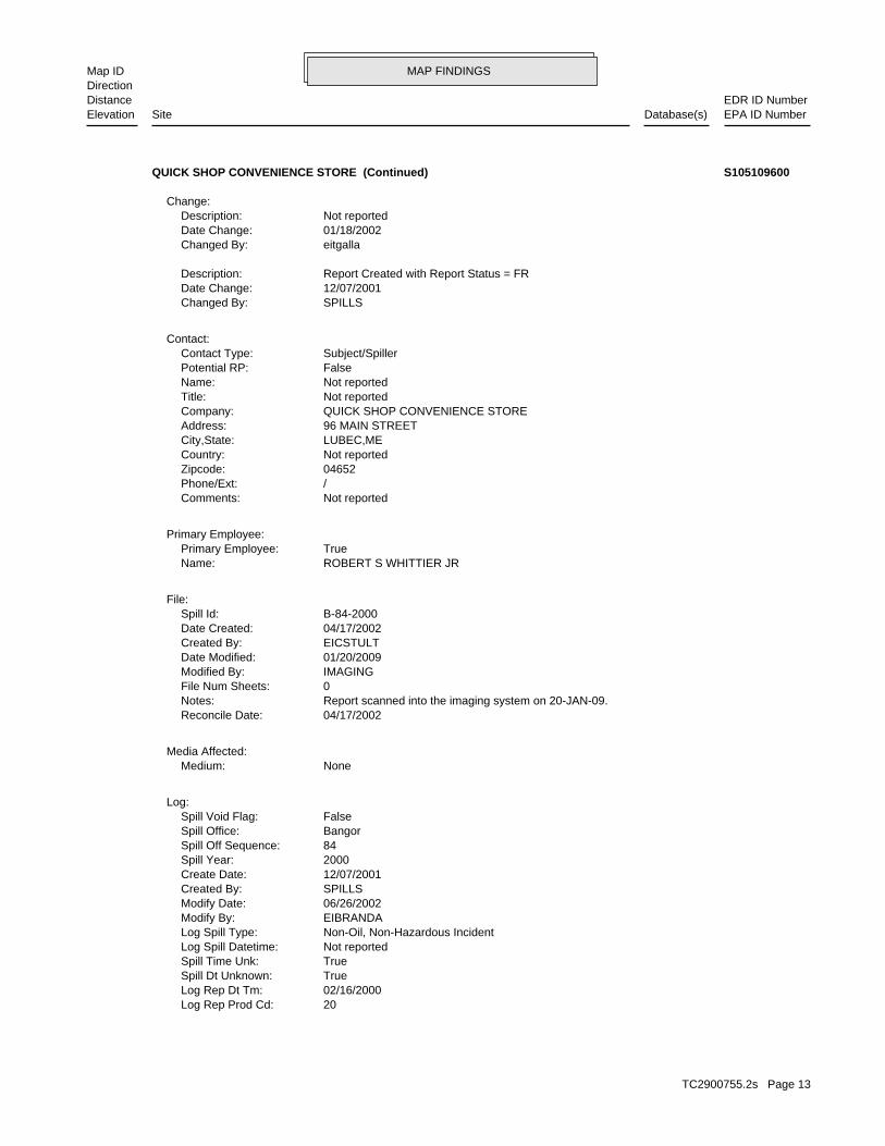
MAP FINDINGSMap IDDirection
EDR ID NumberDistanceEPA ID NumberDatabase(s)SiteElevation
20Log Rep Prod Cd: 02/16/2000Log Rep Dt Tm: TrueSpill Dt Unknown: TrueSpill Time Unk: Not reportedLog Spill Datetime: Non-Oil, Non-Hazardous IncidentLog Spill Type: EIBRANDAModify By: 06/26/2002Modify Date: SPILLSCreated By: 12/07/2001Create Date: 2000Spill Year: 84Spill Off Sequence: BangorSpill Office: FalseSpill Void Flag:
Log:
NoneMedium:Media Affected:
04/17/2002Reconcile Date: Report scanned into the imaging system on 20-JAN-09.Notes: 0File Num Sheets: IMAGINGModified By: 01/20/2009Date Modified: EICSTULTCreated By: 04/17/2002Date Created: B-84-2000Spill Id:
File:
ROBERT S WHITTIER JRName: TruePrimary Employee:
Primary Employee:
Not reportedComments: /Phone/Ext: 04652Zipcode: Not reportedCountry: LUBEC,MECity,State: 96 MAIN STREETAddress: QUICK SHOP CONVENIENCE STORECompany: Not reportedTitle: Not reportedName: FalsePotential RP: Subject/SpillerContact Type:
Contact:
SPILLSChanged By: 12/07/2001Date Change: Report Created with Report Status = FRDescription:
eitgallaChanged By: 01/18/2002Date Change: Not reportedDescription:
Change:
QUICK SHOP CONVENIENCE STORE (Continued) S105109600
TC2900755.2s Page 13

MAP FINDINGSMap IDDirection
EDR ID NumberDistanceEPA ID NumberDatabase(s)SiteElevation
Not reportedFile Modify Date: Not reportedFile Size: Not reportedFile Code: Not reportedFile Name: Not reportedAttach Type: Not reportedDescription:
Attachments:
FalsePrimary Product: ACTUALProduct Amt Qualifier: gals.Product Amt Unit: 0Product Amt: Not reportedProduct Other: NoneProduct Code:
Product:
TrueGIS Sync Flag: 13291GIS Object Id: Response_Spill_PointsGIS Feature Class: Not reportedGPS Time: Not reportedGPS Date: TANKSGPS Unit: 658755.97999999998UTM East: 4969087.7000000002UTM North: ASPPoint Type Code: EICHALSTModify By: 7/15/2009Modify Date: EICHALSTCreated By: 9/10/2008Create Date:
Spill Point:
NoneRecovery Method:
ACTUALMaterial Amt Qualifier: gals.Material Units: 0Material Amount: NoneMaterial Recovered: NOMaterial Recovered Type:
Material Recovered:
Not reportedNotes: Underground Tank(s) InvolvedLog Tank Involved: LUBECLog Location Town: Not reportedLocation: ROBERT S WHITTIER JRLog Emp Name: Gasoline UnspecifiedLog Rep Prod:
QUICK SHOP CONVENIENCE STORE (Continued) S105109600
TC2900755.2s Page 14

MAP FINDINGSMap IDDirection
EDR ID NumberDistanceEPA ID NumberDatabase(s)SiteElevation
REMOVEDTank Sub Status: REMOVEDTank Status: STEEL - BARE OR ASPHALT COATED.Tank Material: 2Tank Number:
UNKNOWNOverfill: REMOVEDPipe Status Label: GALVANIZED STEELPipe Material Label: Not reportedPipe Date Installed: 01/15/1992Pipe Status Date: REMOVEDPipe Status: UNLEADED GASOLINEProduct Type: 10000Volume (gallons): 1Chamber ID: Not reportedLongitude: Not reportedLatitude: UNKNOWNOverfill Protection Label: UNKNOWNPipe Leak Detection Label: UNKNOWNChamber Pump type Desc: UNKNOWNChamber Pump Type Label: UNKNOWNTank Leak Detection Label: Not reportedOn Aquifer Label: Not reportedNearby Water Other Owner Label: Not reportedNear Public Water Label: Not reportedNear Private Water Label: NoOn Aquifer: NoNear Other Water: NoNear Pvt Water: NoNear Public Water: 05/21/1987Reg Date: 01/01/1958Installation Date: BELOWGROUNDTank Above/Below: 10000Tank Volume in Gallons: Not reportedTank Sub Status Label: REMOVEDTank Status Label: 01/15/1992Tank Status Date: REMOVEDTank Sub Status: REMOVEDTank Status: STEEL - BARE OR ASPHALT COATED.Tank Material: 1Tank Number:
MARY & SCOTT GREENEOperator Contact: 2077332422Owner Telephone: LUBEC, ME 04652Owner City/State/Zip: 94 MAIN STOwner Delivery Address: MARY & SCOTT GREENEOwner Contact: QUIK SHOP INCOwner Name: YesFed Reg Ind: RETAIL OILFacility Code: LUBECFacility Location2: 13557Facility ID:
UST:
1079 ft. Site 3 of 3 in cluster A0.204 mi.
Relative:Higher
Actual:51 ft.
1/8-1/4 LUBEC, ME NE 94 MAIN ST N/AA3 USTQUIK SHOP INC U003229348
TC2900755.2s Page 15

MAP FINDINGSMap IDDirection
EDR ID NumberDistanceEPA ID NumberDatabase(s)SiteElevation
DROP TUBEOverfill Protection Label: CONFORMING SUCTION SYSTEMPipe Leak Detection Label: SUCTIONChamber Pump type Desc: SUCTIONChamber Pump Type Label: SECONDARY CONTAINMENT / CONT ELEC MONTank Leak Detection Label: Not reportedOn Aquifer Label: Not reportedNearby Water Other Owner Label: Not reportedNear Public Water Label: Not reportedNear Private Water Label: NoOn Aquifer: NoNear Other Water: NoNear Pvt Water: NoNear Public Water: 05/21/1987Reg Date: 12/01/1991Installation Date: BELOWGROUNDTank Above/Below: 12000Tank Volume in Gallons: Not reportedTank Sub Status Label: ACTIVETank Status Label: 12/20/1991Tank Status Date: ACTIVETank Sub Status: ACTIVETank Status: JACKETED TANK - DOUBLE-WALLEDTank Material: 3Tank Number:
UNKNOWNOverfill: REMOVEDPipe Status Label: GALVANIZED STEELPipe Material Label: Not reportedPipe Date Installed: 01/15/1992Pipe Status Date: REMOVEDPipe Status: PREMIUM UNLEADEDProduct Type: 4000Volume (gallons): 1Chamber ID: Not reportedLongitude: Not reportedLatitude: UNKNOWNOverfill Protection Label: UNKNOWNPipe Leak Detection Label: UNKNOWNChamber Pump type Desc: UNKNOWNChamber Pump Type Label: UNKNOWNTank Leak Detection Label: Not reportedOn Aquifer Label: Not reportedNearby Water Other Owner Label: Not reportedNear Public Water Label: Not reportedNear Private Water Label: NoOn Aquifer: NoNear Other Water: NoNear Pvt Water: NoNear Public Water: 05/21/1987Reg Date: 01/01/1977Installation Date: BELOWGROUNDTank Above/Below: 4000Tank Volume in Gallons: Not reportedTank Sub Status Label: REMOVEDTank Status Label: 01/15/1992Tank Status Date:
QUIK SHOP INC (Continued) U003229348
TC2900755.2s Page 16

MAP FINDINGSMap IDDirection
EDR ID NumberDistanceEPA ID NumberDatabase(s)SiteElevation
DROP_TUBEOverfill: ACTIVEPipe Status Label: F/GLASS - PETROLEUMPipe Material Label: 12/01/1991Pipe Date Installed: 12/01/1991Pipe Status Date: ACTIVEPipe Status: UNLEADED GASOLINEProduct Type: 8000Volume (gallons): 1Chamber ID: -66.99069711Longitude: 44.85752855Latitude: DROP TUBEOverfill Protection Label: CONFORMING SUCTION SYSTEMPipe Leak Detection Label: SUCTIONChamber Pump type Desc: SUCTIONChamber Pump Type Label: SECONDARY CONTAINMENT / CONT ELEC MONTank Leak Detection Label: Not reportedOn Aquifer Label: Not reportedNearby Water Other Owner Label: Not reportedNear Public Water Label: Not reportedNear Private Water Label: NoOn Aquifer: NoNear Other Water: NoNear Pvt Water: NoNear Public Water: 05/21/1987Reg Date: 12/01/1991Installation Date: BELOWGROUNDTank Above/Below: 12000Tank Volume in Gallons: Not reportedTank Sub Status Label: ACTIVETank Status Label: 12/20/1991Tank Status Date: ACTIVETank Sub Status: ACTIVETank Status: JACKETED TANK - DOUBLE-WALLEDTank Material: 3Tank Number:
DROP_TUBEOverfill: ACTIVEPipe Status Label: F/GLASS - PETROLEUMPipe Material Label: 12/01/1991Pipe Date Installed: 12/01/1991Pipe Status Date: ACTIVEPipe Status: PREMIUM UNLEADEDProduct Type: 4000Volume (gallons): 2Chamber ID: -66.99069711Longitude: 44.85752855Latitude:
QUIK SHOP INC (Continued) U003229348
TC2900755.2s Page 17

MAP FINDINGSMap IDDirection
EDR ID NumberDistanceEPA ID NumberDatabase(s)SiteElevation
SPILLSCreated By: 09/26/1995Date Created: B-359-1995Spill Id:
File:
ROBERT RANDALLName: TruePrimary Employee:
Primary Employee:
Not reportedComments: /Phone/Ext: 04652Zipcode: Not reportedCountry: LUBEC,MECity,State: 20 SOUTH STREETAddress: LUBEC CONSOLIDATED SCHOOLCompany: Not reportedTitle: Not reportedName: FalsePotential RP: Subject/SpillerContact Type:
Contact:
SPILLSChanged By: 12/07/2001Date Change: Report Created with Report Status = FRDescription:
Change:
Minor contamination, remained on site.Material Disposal Info: Not reportedInc Source: Government, Municipal or Religious FacilityInc Location: Tank and/or Piping RemovalDetection Method: Contractor/ConsultantReporter Type: FalseFurther Response Action: FalseDtree Completed Flag: 0Number Wells Impacted: 0Number Wells At Risk: TrueActual Spill Date Unknown: Not reportedActual Spill Datetime: Final ReportReport Status: SPILLSModify By: 12/07/2001Modify Date: SPILLSCreate By: 12/07/2001Create Date: 29260MCD Value: TrueUST Registered Flag: FalseRemoval Flag: Underground Tank(s) InvolvedInc Tank: Oil IncidentSpill Type: Other - UnknownSpill Cause: B-359-1995Spill Number:
Event:
LUST:
1701 ft.0.322 mi.
Relative:Higher
Actual:43 ft.
1/4-1/2 LUBEC, ME ENE 20 SOUTH STREET N/A4 LUSTLUBEC CONSOLIDATED SCHOOL S104996499
TC2900755.2s Page 18

MAP FINDINGSMap IDDirection
EDR ID NumberDistanceEPA ID NumberDatabase(s)SiteElevation
TrueGIS Sync Flag: 6803GIS Object Id: Response_Spill_PointsGIS Feature Class: Not reportedGPS Time: Not reportedGPS Date: UnknownGPS Unit: 658969UTM East: 4968815UTM North: ASPPoint Type Code: EICHALSTModify By: 9/5/2008Modify Date: SPILLSCreated By: 12/10/2001Create Date:
Spill Point:
NoneRecovery Method:
Not reportedMaterial Amt Qualifier: Not reportedMaterial Units: Not reportedMaterial Amount: Not reportedMaterial Recovered: Not reportedMaterial Recovered Type:
Material Recovered:
Not reportedNotes: Underground Tank(s) InvolvedLog Tank Involved: LUBECLog Location Town: Not reportedLocation: ROBERT RANDALLLog Emp Name: #2 Fuel OilLog Rep Prod: 02Log Rep Prod Cd: 07/07/1995Log Rep Dt Tm: TrueSpill Dt Unknown: TrueSpill Time Unk: Not reportedLog Spill Datetime: Oil IncidentLog Spill Type: SPILLSModify By: 12/07/2001Modify Date: SPILLSCreated By: 12/07/2001Create Date: 1995Spill Year: 359Spill Off Sequence: BangorSpill Office: FalseSpill Void Flag:
Log:
LandMedium:Media Affected:
Not reportedReconcile Date: Report scanned into the imaging system on 20-MAR-07.Notes: 0File Num Sheets: IMAGINGModified By: 03/20/2007Date Modified:
LUBEC CONSOLIDATED SCHOOL (Continued) S104996499
TC2900755.2s Page 19

MAP FINDINGSMap IDDirection
EDR ID NumberDistanceEPA ID NumberDatabase(s)SiteElevation
Not reportedFile Modify Date: Not reportedFile Size: Not reportedFile Code: Not reportedFile Name: Not reportedAttach Type: Not reportedDescription:
Attachments:
FalsePrimary Product: Not reportedProduct Amt Qualifier: Not reportedProduct Amt Unit: Not reportedProduct Amt: Not reportedProduct Other: #2 Fuel OilProduct Code:
Product:
LUBEC CONSOLIDATED SCHOOL (Continued) S104996499
01Spill Cause Code: Storage Unit - Aboveground Storage TankInc Source: TAInc Source Code: Residential - Single FamilyInc Location: SFInc Location Code: Odor/Vapor/MistDetection Method: HDetection Method Code: Subject/SpillerReporter Type: 2Reporter Type Code: Oil IncidentSpill Type: OSpill Type Code: FalseFurther response action: 29260MCD Value: FalseDTREE completed flag: 0Number of wells impacted: 0Number of wells at risk: TrueSpill Time Unknown: TrueSpill Date Unknown: Not reportedSpill Datetime: Final ReportReport Status: FRReport Status Code: 04/14/2004Modify By: 04/14/2004Modify Date: EICLECKECreate By: 03/02/2004Create Date: FalseAST inside flag: FalseUST registered flag: FalseRemoval Flag: Above Ground Tank(s) InvolvedInc Tank: AInc Tank Code: B-31-2004Spill Number:
Event:
LAST:
2422 ft.0.459 mi.
Relative:Higher
Actual:40 ft.
1/4-1/2 LUBEC, ME ENE 28 WASHINGTON ST N/A5 LASTBRENT TAYLOR S106403935
TC2900755.2s Page 20

MAP FINDINGSMap IDDirection
EDR ID NumberDistanceEPA ID NumberDatabase(s)SiteElevation
LandMedium:Media Affected:
04/15/2004Reconcile Date: Report scanned into the imaging system on 18-FEB-05.Notes: 0File Num Sheets: IMAGINGModified By: 02/18/2005Date Modified: EIPLAMBECreated By: 04/15/2004Date Created: B-31-2004Spill Id:
File:
CLEVE LECKEYName: TruePrimary Employee:
ROBERT F SHANNONName: FalsePrimary Employee:
Primary Employee:
Not reportedComments: /Phone/Ext: 04652Zipcode: USACountry: LUBEC,MECity,State: 28 WASHINGTON STAddress: Not reportedCompany: Not reportedTitle: BRENT TAYLORName: TruePotential RP: Subject/SpillerContact Type:
Contact:
EICLECKEChanged By: 03/02/2004Date Change: Report Created with Report Status = DRDescription:
EICLECKEChanged By: 03/04/2004Date Change: Report Status change from DR to DRVDescription:
EITGALLAChanged By: 04/14/2004Date Change: Report Status change from DQA to FRDescription:
EIBRANDAChanged By: 03/10/2004Date Change: Report Status change from DRV to DQADescription:
Change:
pile. tank and the rest he picked up with pads that he put on the town burn The spiller recovered about 35 gallons of liquid product to his supplyMaterial Disposal Info: Corrosion - TankSpill Cause:
BRENT TAYLOR (Continued) S106403935
TC2900755.2s Page 21
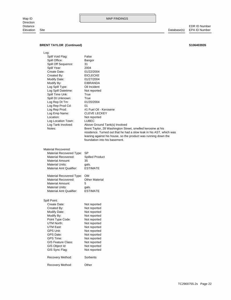
MAP FINDINGSMap IDDirection
EDR ID NumberDistanceEPA ID NumberDatabase(s)SiteElevation
OtherRecovery Method:
SorbentsRecovery Method:
Not reportedGIS Sync Flag: Not reportedGIS Object Id: Not reportedGIS Feature Class: Not reportedGPS Time: Not reportedGPS Date: Not reportedGPS Unit: Not reportedUTM East: Not reportedUTM North: Not reportedPoint Type Code: Not reportedModify By: Not reportedModify Date: Not reportedCreated By: Not reportedCreate Date:
Spill Point:
ESTIMATEMaterial Amt Qualifier: gals.Material Units: 5Material Amount: Other MaterialMaterial Recovered: OMMaterial Recovered Type:
ESTIMATEMaterial Amt Qualifier: gals.Material Units: 35Material Amount: Spilled ProductMaterial Recovered: SPMaterial Recovered Type:
Material Recovered:
foundation into his basement. leaning against his house, so the product was running down the residence. Turned out that he had a slow leak in his AST, which was Brent Taylor, 28 Washington Street, smelled kerosine at hisNotes: Above Ground Tank(s) InvolvedLog Tank Involved: LUBECLog Location Town: Not reportedLocation: CLEVE LECKEYLog Emp Name: #1 Fuel Oil - KeroseneLog Rep Prod: 01Log Rep Prod Cd: 01/20/2004Log Rep Dt Tm: TrueSpill Dt Unknown: TrueSpill Time Unk: Not reportedLog Spill Datetime: Oil IncidentLog Spill Type: EIBRANDAModify By: 01/27/2004Modify Date: EICLECKECreated By: 01/22/2004Create Date: 2004Spill Year: 31Spill Off Sequence: BangorSpill Office: FalseSpill Void Flag:
Log:
BRENT TAYLOR (Continued) S106403935
TC2900755.2s Page 22

MAP FINDINGSMap IDDirection
EDR ID NumberDistanceEPA ID NumberDatabase(s)SiteElevation
Not reportedFile Modify Date: Not reportedFile Size: Not reportedFile Code: Not reportedFile Name: Not reportedAttach Type: Not reportedDescription:
Attachments:
TruePrimary Product: ESTIMATEProduct Amt Qualifier: gals.Product Amt Unit: 40Product Amt: Not reportedProduct Other: #1 Fuel Oil - KeroseneProduct Code:
Product:
BRENT TAYLOR (Continued) S106403935
TC2900755.2s Page 23

ORPHAN SUMMARY
City EDR ID Site Name Site Address Zip Database(s)
LUBEC S106795218 BARGAIN BOX (NOLA GREEN) RT 1 04652 LUSTLUBEC U002163056 BROWN, LARRY M RT 1 04652 USTLUBEC U002161146 MCFADDEN VARIETY HWY 189 04652 USTLUBEC S106790485 A.W. FOLEY AND SON RT 189 04652 LUSTLUBEC U003096863 FITZHENRYS STORE RT 191 04652 USTLUBEC S106796876 JONES’ STORE 189 RT 2 04652 LUSTLUBEC S110310310 LUBEC DUMP S LUBEC RD SWF/LFLUBEC 1000112232 MAIN ST 04652 RCRA-NonGen, FINDS, USTLUBEC U003560628 BAYVIEW PARK APARTMENTS MAIN ST 04652 USTLUBEC U000241589 LUBEC SCHOOL SOUTH ST 04652 UST
TC2900755.2s Page 24

To maintain currency of the following federal and state databases, EDR contacts the appropriate governmental agencyon a monthly or quarterly basis, as required.
Number of Days to Update: Provides confirmation that EDR is reporting records that have been updated within 90 daysfrom the date the government agency made the information available to the public.
STANDARD ENVIRONMENTAL RECORDS
Federal NPL site list
NPL: National Priority ListNational Priorities List (Superfund). The NPL is a subset of CERCLIS and identifies over 1,200 sites for prioritycleanup under the Superfund Program. NPL sites may encompass relatively large areas. As such, EDR provides polygoncoverage for over 1,000 NPL site boundaries produced by EPA’s Environmental Photographic Interpretation Center(EPIC) and regional EPA offices.
Date of Government Version: 07/02/2010Date Data Arrived at EDR: 07/14/2010Date Made Active in Reports: 10/04/2010Number of Days to Update: 82
Source: EPATelephone: N/ALast EDR Contact: 10/13/2010Next Scheduled EDR Contact: 01/24/2011Data Release Frequency: Quarterly
NPL Site Boundaries
Sources:
EPA’s Environmental Photographic Interpretation Center (EPIC)Telephone: 202-564-7333
EPA Region 1 EPA Region 6Telephone 617-918-1143 Telephone: 214-655-6659
EPA Region 3 EPA Region 7Telephone 215-814-5418 Telephone: 913-551-7247
EPA Region 4 EPA Region 8Telephone 404-562-8033 Telephone: 303-312-6774
EPA Region 5 EPA Region 9Telephone 312-886-6686 Telephone: 415-947-4246
EPA Region 10Telephone 206-553-8665
Proposed NPL: Proposed National Priority List SitesA site that has been proposed for listing on the National Priorities List through the issuance of a proposed rulein the Federal Register. EPA then accepts public comments on the site, responds to the comments, and places onthe NPL those sites that continue to meet the requirements for listing.
Date of Government Version: 07/02/2010Date Data Arrived at EDR: 07/14/2010Date Made Active in Reports: 10/04/2010Number of Days to Update: 82
Source: EPATelephone: N/ALast EDR Contact: 10/13/2010Next Scheduled EDR Contact: 01/24/2011Data Release Frequency: Quarterly
NPL LIENS: Federal Superfund LiensFederal Superfund Liens. Under the authority granted the USEPA by CERCLA of 1980, the USEPA has the authorityto file liens against real property in order to recover remedial action expenditures or when the property ownerreceived notification of potential liability. USEPA compiles a listing of filed notices of Superfund Liens.
Date of Government Version: 10/15/1991Date Data Arrived at EDR: 02/02/1994Date Made Active in Reports: 03/30/1994Number of Days to Update: 56
Source: EPATelephone: 202-564-4267Last EDR Contact: 08/16/2010Next Scheduled EDR Contact: 11/29/2010Data Release Frequency: No Update Planned
TC2900755.2s Page GR-1
GOVERNMENT RECORDS SEARCHED / DATA CURRENCY TRACKING

Federal Delisted NPL site list
DELISTED NPL: National Priority List DeletionsThe National Oil and Hazardous Substances Pollution Contingency Plan (NCP) establishes the criteria that theEPA uses to delete sites from the NPL. In accordance with 40 CFR 300.425.(e), sites may be deleted from theNPL where no further response is appropriate.
Date of Government Version: 07/02/2010Date Data Arrived at EDR: 07/14/2010Date Made Active in Reports: 10/04/2010Number of Days to Update: 82
Source: EPATelephone: N/ALast EDR Contact: 10/13/2010Next Scheduled EDR Contact: 01/24/2011Data Release Frequency: Quarterly
Federal CERCLIS list
CERCLIS: Comprehensive Environmental Response, Compensation, and Liability Information SystemCERCLIS contains data on potentially hazardous waste sites that have been reported to the USEPA by states, municipalities,private companies and private persons, pursuant to Section 103 of the Comprehensive Environmental Response, Compensation,and Liability Act (CERCLA). CERCLIS contains sites which are either proposed to or on the National PrioritiesList (NPL) and sites which are in the screening and assessment phase for possible inclusion on the NPL.
Date of Government Version: 01/29/2010Date Data Arrived at EDR: 02/09/2010Date Made Active in Reports: 04/12/2010Number of Days to Update: 62
Source: EPATelephone: 703-412-9810Last EDR Contact: 10/01/2010Next Scheduled EDR Contact: 01/10/2011Data Release Frequency: Quarterly
FEDERAL FACILITY: Federal Facility Site Information listingA listing of National Priority List (NPL) and Base Realignment and Closure (BRAC) sites found in the ComprehensiveEnvironmental Response, Compensation and Liability Information System (CERCLIS) Database where EPAa??s FederalFacilities Restoration and Reuse Office is involved in cleanup activities.
Date of Government Version: 06/23/2009Date Data Arrived at EDR: 01/15/2010Date Made Active in Reports: 02/10/2010Number of Days to Update: 26
Source: Environmental Protection AgencyTelephone: 703-603-8704Last EDR Contact: 10/13/2010Next Scheduled EDR Contact: 01/24/2011Data Release Frequency: Varies
Federal CERCLIS NFRAP site List
CERCLIS-NFRAP: CERCLIS No Further Remedial Action PlannedArchived sites are sites that have been removed and archived from the inventory of CERCLIS sites. Archived statusindicates that, to the best of EPA’s knowledge, assessment at a site has been completed and that EPA has determinedno further steps will be taken to list this site on the National Priorities List (NPL), unless information indicatesthis decision was not appropriate or other considerations require a recommendation for listing at a later time.This decision does not necessarily mean that there is no hazard associated with a given site; it only means that,based upon available information, the location is not judged to be a potential NPL site.
Date of Government Version: 06/23/2009Date Data Arrived at EDR: 09/02/2009Date Made Active in Reports: 09/21/2009Number of Days to Update: 19
Source: EPATelephone: 703-412-9810Last EDR Contact: 10/01/2010Next Scheduled EDR Contact: 12/13/2010Data Release Frequency: Quarterly
Federal RCRA CORRACTS facilities list
CORRACTS: Corrective Action ReportCORRACTS identifies hazardous waste handlers with RCRA corrective action activity.
TC2900755.2s Page GR-2
GOVERNMENT RECORDS SEARCHED / DATA CURRENCY TRACKING

Date of Government Version: 05/25/2010Date Data Arrived at EDR: 06/02/2010Date Made Active in Reports: 10/04/2010Number of Days to Update: 124
Source: EPATelephone: 800-424-9346Last EDR Contact: 08/16/2010Next Scheduled EDR Contact: 11/29/2010Data Release Frequency: Quarterly
Federal RCRA non-CORRACTS TSD facilities list
RCRA-TSDF: RCRA - Treatment, Storage and DisposalRCRAInfo is EPA’s comprehensive information system, providing access to data supporting the Resource Conservationand Recovery Act (RCRA) of 1976 and the Hazardous and Solid Waste Amendments (HSWA) of 1984. The databaseincludes selective information on sites which generate, transport, store, treat and/or dispose of hazardous wasteas defined by the Resource Conservation and Recovery Act (RCRA). Transporters are individuals or entities thatmove hazardous waste from the generator offsite to a facility that can recycle, treat, store, or dispose of thewaste. TSDFs treat, store, or dispose of the waste.
Date of Government Version: 02/17/2010Date Data Arrived at EDR: 02/19/2010Date Made Active in Reports: 05/17/2010Number of Days to Update: 87
Source: Environmental Protection AgencyTelephone: (888) 372-7341Last EDR Contact: 10/07/2010Next Scheduled EDR Contact: 01/17/2011Data Release Frequency: Quarterly
Federal RCRA generators list
RCRA-LQG: RCRA - Large Quantity GeneratorsRCRAInfo is EPA’s comprehensive information system, providing access to data supporting the Resource Conservationand Recovery Act (RCRA) of 1976 and the Hazardous and Solid Waste Amendments (HSWA) of 1984. The databaseincludes selective information on sites which generate, transport, store, treat and/or dispose of hazardous wasteas defined by the Resource Conservation and Recovery Act (RCRA). Large quantity generators (LQGs) generateover 1,000 kilograms (kg) of hazardous waste, or over 1 kg of acutely hazardous waste per month.
Date of Government Version: 02/17/2010Date Data Arrived at EDR: 02/19/2010Date Made Active in Reports: 05/17/2010Number of Days to Update: 87
Source: Environmental Protection AgencyTelephone: (888) 372-7341Last EDR Contact: 10/07/2010Next Scheduled EDR Contact: 01/17/2011Data Release Frequency: Quarterly
RCRA-SQG: RCRA - Small Quantity GeneratorsRCRAInfo is EPA’s comprehensive information system, providing access to data supporting the Resource Conservationand Recovery Act (RCRA) of 1976 and the Hazardous and Solid Waste Amendments (HSWA) of 1984. The databaseincludes selective information on sites which generate, transport, store, treat and/or dispose of hazardous wasteas defined by the Resource Conservation and Recovery Act (RCRA). Small quantity generators (SQGs) generatebetween 100 kg and 1,000 kg of hazardous waste per month.
Date of Government Version: 02/17/2010Date Data Arrived at EDR: 02/19/2010Date Made Active in Reports: 05/17/2010Number of Days to Update: 87
Source: Environmental Protection AgencyTelephone: (888) 372-7341Last EDR Contact: 10/07/2010Next Scheduled EDR Contact: 01/17/2011Data Release Frequency: Quarterly
RCRA-CESQG: RCRA - Conditionally Exempt Small Quantity GeneratorsRCRAInfo is EPA’s comprehensive information system, providing access to data supporting the Resource Conservationand Recovery Act (RCRA) of 1976 and the Hazardous and Solid Waste Amendments (HSWA) of 1984. The databaseincludes selective information on sites which generate, transport, store, treat and/or dispose of hazardous wasteas defined by the Resource Conservation and Recovery Act (RCRA). Conditionally exempt small quantity generators(CESQGs) generate less than 100 kg of hazardous waste, or less than 1 kg of acutely hazardous waste per month.
Date of Government Version: 02/17/2010Date Data Arrived at EDR: 02/19/2010Date Made Active in Reports: 05/17/2010Number of Days to Update: 87
Source: Environmental Protection AgencyTelephone: (888) 372-7341Last EDR Contact: 10/07/2010Next Scheduled EDR Contact: 01/17/2011Data Release Frequency: Varies
TC2900755.2s Page GR-3
GOVERNMENT RECORDS SEARCHED / DATA CURRENCY TRACKING

Federal institutional controls / engineering controls registries
US ENG CONTROLS: Engineering Controls Sites ListA listing of sites with engineering controls in place. Engineering controls include various forms of caps, buildingfoundations, liners, and treatment methods to create pathway elimination for regulated substances to enter environmentalmedia or effect human health.
Date of Government Version: 12/20/2009Date Data Arrived at EDR: 01/20/2010Date Made Active in Reports: 04/12/2010Number of Days to Update: 82
Source: Environmental Protection AgencyTelephone: 703-603-0695Last EDR Contact: 09/13/2010Next Scheduled EDR Contact: 12/27/2010Data Release Frequency: Varies
US INST CONTROL: Sites with Institutional ControlsA listing of sites with institutional controls in place. Institutional controls include administrative measures,such as groundwater use restrictions, construction restrictions, property use restrictions, and post remediationcare requirements intended to prevent exposure to contaminants remaining on site. Deed restrictions are generallyrequired as part of the institutional controls.
Date of Government Version: 12/20/2009Date Data Arrived at EDR: 01/20/2010Date Made Active in Reports: 04/12/2010Number of Days to Update: 82
Source: Environmental Protection AgencyTelephone: 703-603-0695Last EDR Contact: 09/13/2010Next Scheduled EDR Contact: 12/27/2010Data Release Frequency: Varies
Federal ERNS list
ERNS: Emergency Response Notification SystemEmergency Response Notification System. ERNS records and stores information on reported releases of oil and hazardoussubstances.
Date of Government Version: 07/09/2010Date Data Arrived at EDR: 07/09/2010Date Made Active in Reports: 08/17/2010Number of Days to Update: 39
Source: National Response Center, United States Coast GuardTelephone: 202-267-2180Last EDR Contact: 10/06/2010Next Scheduled EDR Contact: 01/17/2011Data Release Frequency: Annually
State- and tribal - equivalent CERCLIS
SHWS: Remediation Sites ListUncontrolled Sites locations included in the Remediation Sites List.
Date of Government Version: 07/08/2010Date Data Arrived at EDR: 08/12/2010Date Made Active in Reports: 08/31/2010Number of Days to Update: 19
Source: Department of Environmental ProtectionTelephone: 207-287-4850Last EDR Contact: 07/27/2010Next Scheduled EDR Contact: 11/08/2010Data Release Frequency: Semi-Annually
State and tribal landfill and/or solid waste disposal site lists
SWF/LF: Solid Waste Facility ListSolid Waste Facilities/Landfill Sites. SWF/LF type records typically contain an inventory of solid waste disposalfacilities or landfills in a particular state. Depending on the state, these may be active or inactive facilitiesor open dumps that failed to meet RCRA Subtitle D Section 4004 criteria for solid waste landfills or disposalsites.
Date of Government Version: 08/16/2010Date Data Arrived at EDR: 08/16/2010Date Made Active in Reports: 08/31/2010Number of Days to Update: 15
Source: Department of Environmental ProtectionTelephone: 207-287-2651Last EDR Contact: 08/16/2010Next Scheduled EDR Contact: 11/29/2010Data Release Frequency: Annually
TC2900755.2s Page GR-4
GOVERNMENT RECORDS SEARCHED / DATA CURRENCY TRACKING
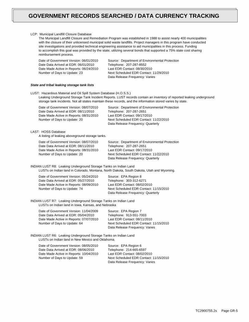
LCP: Municipal Landfill Closure DatabaseThe Municipal Landfill Closure and Remediation Program was established in 1988 to assist nearly 400 municipalitieswith the closure of their unlicensed municipal solid waste landfills. Project managers in this program have conductedsite investigations and provided technical engineering assistance to aid municipalities in this process. Fundingto accomplish this goal was provided by the state, utilizing several bonds that supported a 75% state cost sharingreimbursement process.
Date of Government Version: 06/01/2010Date Data Arrived at EDR: 06/01/2010Date Made Active in Reports: 06/24/2010Number of Days to Update: 23
Source: Department of Environmental ProtectionTelephone: 207-287-8552Last EDR Contact: 08/30/2010Next Scheduled EDR Contact: 11/29/2010Data Release Frequency: Varies
State and tribal leaking storage tank lists
LUST: Hazardous Material and Oil Spill System Database (H.O.S.S.)Leaking Underground Storage Tank Incident Reports. LUST records contain an inventory of reported leaking undergroundstorage tank incidents. Not all states maintain these records, and the information stored varies by state.
Date of Government Version: 08/07/2010Date Data Arrived at EDR: 08/11/2010Date Made Active in Reports: 08/31/2010Number of Days to Update: 20
Source: Department of Environmental ProtectionTelephone: 207-287-2651Last EDR Contact: 09/17/2010Next Scheduled EDR Contact: 11/22/2010Data Release Frequency: Quarterly
LAST: HOSS DatabaseA listing of leaking aboveground storage tanks.
Date of Government Version: 08/07/2010Date Data Arrived at EDR: 08/11/2010Date Made Active in Reports: 08/31/2010Number of Days to Update: 20
Source: Department of Environmental ProtectionTelephone: 207-287-2651Last EDR Contact: 09/17/2010Next Scheduled EDR Contact: 11/22/2010Data Release Frequency: Quarterly
INDIAN LUST R8: Leaking Underground Storage Tanks on Indian LandLUSTs on Indian land in Colorado, Montana, North Dakota, South Dakota, Utah and Wyoming.
Date of Government Version: 05/24/2010Date Data Arrived at EDR: 05/27/2010Date Made Active in Reports: 08/09/2010Number of Days to Update: 74
Source: EPA Region 8Telephone: 303-312-6271Last EDR Contact: 08/02/2010Next Scheduled EDR Contact: 11/15/2010Data Release Frequency: Quarterly
INDIAN LUST R7: Leaking Underground Storage Tanks on Indian LandLUSTs on Indian land in Iowa, Kansas, and Nebraska
Date of Government Version: 11/04/2009Date Data Arrived at EDR: 05/04/2010Date Made Active in Reports: 07/07/2010Number of Days to Update: 64
Source: EPA Region 7Telephone: 913-551-7003Last EDR Contact: 08/11/2010Next Scheduled EDR Contact: 11/15/2010Data Release Frequency: Varies
INDIAN LUST R6: Leaking Underground Storage Tanks on Indian LandLUSTs on Indian land in New Mexico and Oklahoma.
Date of Government Version: 08/05/2010Date Data Arrived at EDR: 08/06/2010Date Made Active in Reports: 10/04/2010Number of Days to Update: 59
Source: EPA Region 6Telephone: 214-665-6597Last EDR Contact: 08/02/2010Next Scheduled EDR Contact: 11/15/2010Data Release Frequency: Varies
TC2900755.2s Page GR-5
GOVERNMENT RECORDS SEARCHED / DATA CURRENCY TRACKING

INDIAN LUST R1: Leaking Underground Storage Tanks on Indian LandA listing of leaking underground storage tank locations on Indian Land.
Date of Government Version: 02/19/2009Date Data Arrived at EDR: 02/19/2009Date Made Active in Reports: 03/16/2009Number of Days to Update: 25
Source: EPA Region 1Telephone: 617-918-1313Last EDR Contact: 08/02/2010Next Scheduled EDR Contact: 11/15/2010Data Release Frequency: Varies
INDIAN LUST R10: Leaking Underground Storage Tanks on Indian LandLUSTs on Indian land in Alaska, Idaho, Oregon and Washington.
Date of Government Version: 08/05/2010Date Data Arrived at EDR: 08/06/2010Date Made Active in Reports: 10/04/2010Number of Days to Update: 59
Source: EPA Region 10Telephone: 206-553-2857Last EDR Contact: 08/02/2010Next Scheduled EDR Contact: 11/15/2010Data Release Frequency: Quarterly
INDIAN LUST R4: Leaking Underground Storage Tanks on Indian LandLUSTs on Indian land in Florida, Mississippi and North Carolina.
Date of Government Version: 08/27/2010Date Data Arrived at EDR: 08/30/2010Date Made Active in Reports: 10/04/2010Number of Days to Update: 35
Source: EPA Region 4Telephone: 404-562-8677Last EDR Contact: 08/02/2010Next Scheduled EDR Contact: 11/15/2010Data Release Frequency: Semi-Annually
INDIAN LUST R9: Leaking Underground Storage Tanks on Indian LandLUSTs on Indian land in Arizona, California, New Mexico and Nevada
Date of Government Version: 08/30/2010Date Data Arrived at EDR: 08/30/2010Date Made Active in Reports: 10/04/2010Number of Days to Update: 35
Source: Environmental Protection AgencyTelephone: 415-972-3372Last EDR Contact: 08/02/2010Next Scheduled EDR Contact: 11/15/2010Data Release Frequency: Quarterly
State and tribal registered storage tank lists
UST: Underground Storage Tank DatabaseRegistered Underground Storage Tanks. UST’s are regulated under Subtitle I of the Resource Conservation and RecoveryAct (RCRA) and must be registered with the state department responsible for administering the UST program. Availableinformation varies by state program.
Date of Government Version: 08/02/2010Date Data Arrived at EDR: 08/24/2010Date Made Active in Reports: 08/31/2010Number of Days to Update: 7
Source: Department of Environmental ProtectionTelephone: 207-287-2651Last EDR Contact: 08/24/2010Next Scheduled EDR Contact: 12/06/2010Data Release Frequency: Quarterly
AST: Aboveground Storage TanksRegistered Aboveground Storage Tanks.
Date of Government Version: 12/31/2009Date Data Arrived at EDR: 08/23/2010Date Made Active in Reports: 08/31/2010Number of Days to Update: 8
Source: Maine Emergency Management AgencyTelephone: 207-626-4503Last EDR Contact: 08/16/2010Next Scheduled EDR Contact: 10/04/2010Data Release Frequency: Semi-Annually
INDIAN UST R1: Underground Storage Tanks on Indian LandThe Indian Underground Storage Tank (UST) database provides information about underground storage tanks on Indianland in EPA Region 1 (Connecticut, Maine, Massachusetts, New Hampshire, Rhode Island, Vermont and ten TribalNations).
TC2900755.2s Page GR-6
GOVERNMENT RECORDS SEARCHED / DATA CURRENCY TRACKING

Date of Government Version: 02/19/2009Date Data Arrived at EDR: 02/19/2009Date Made Active in Reports: 03/16/2009Number of Days to Update: 25
Source: EPA, Region 1Telephone: 617-918-1313Last EDR Contact: 08/02/2010Next Scheduled EDR Contact: 11/15/2010Data Release Frequency: Varies
INDIAN UST R4: Underground Storage Tanks on Indian LandThe Indian Underground Storage Tank (UST) database provides information about underground storage tanks on Indianland in EPA Region 4 (Alabama, Florida, Georgia, Kentucky, Mississippi, North Carolina, South Carolina, Tennesseeand Tribal Nations)
Date of Government Version: 08/27/2010Date Data Arrived at EDR: 08/30/2010Date Made Active in Reports: 10/04/2010Number of Days to Update: 35
Source: EPA Region 4Telephone: 404-562-9424Last EDR Contact: 08/02/2010Next Scheduled EDR Contact: 11/15/2010Data Release Frequency: Semi-Annually
INDIAN UST R9: Underground Storage Tanks on Indian LandThe Indian Underground Storage Tank (UST) database provides information about underground storage tanks on Indianland in EPA Region 9 (Arizona, California, Hawaii, Nevada, the Pacific Islands, and Tribal Nations).
Date of Government Version: 08/30/2010Date Data Arrived at EDR: 08/30/2010Date Made Active in Reports: 10/04/2010Number of Days to Update: 35
Source: EPA Region 9Telephone: 415-972-3368Last EDR Contact: 08/02/2010Next Scheduled EDR Contact: 11/15/2010Data Release Frequency: Quarterly
INDIAN UST R6: Underground Storage Tanks on Indian LandThe Indian Underground Storage Tank (UST) database provides information about underground storage tanks on Indianland in EPA Region 6 (Louisiana, Arkansas, Oklahoma, New Mexico, Texas and 65 Tribes).
Date of Government Version: 08/03/2010Date Data Arrived at EDR: 08/04/2010Date Made Active in Reports: 10/04/2010Number of Days to Update: 61
Source: EPA Region 6Telephone: 214-665-7591Last EDR Contact: 08/02/2010Next Scheduled EDR Contact: 11/15/2010Data Release Frequency: Semi-Annually
INDIAN UST R8: Underground Storage Tanks on Indian LandThe Indian Underground Storage Tank (UST) database provides information about underground storage tanks on Indianland in EPA Region 8 (Colorado, Montana, North Dakota, South Dakota, Utah, Wyoming and 27 Tribal Nations).
Date of Government Version: 05/24/2010Date Data Arrived at EDR: 05/27/2010Date Made Active in Reports: 08/09/2010Number of Days to Update: 74
Source: EPA Region 8Telephone: 303-312-6137Last EDR Contact: 08/02/2010Next Scheduled EDR Contact: 11/15/2010Data Release Frequency: Quarterly
INDIAN UST R10: Underground Storage Tanks on Indian LandThe Indian Underground Storage Tank (UST) database provides information about underground storage tanks on Indianland in EPA Region 10 (Alaska, Idaho, Oregon, Washington, and Tribal Nations).
Date of Government Version: 08/05/2010Date Data Arrived at EDR: 08/06/2010Date Made Active in Reports: 10/04/2010Number of Days to Update: 59
Source: EPA Region 10Telephone: 206-553-2857Last EDR Contact: 08/02/2010Next Scheduled EDR Contact: 11/15/2010Data Release Frequency: Quarterly
INDIAN UST R7: Underground Storage Tanks on Indian LandThe Indian Underground Storage Tank (UST) database provides information about underground storage tanks on Indianland in EPA Region 7 (Iowa, Kansas, Missouri, Nebraska, and 9 Tribal Nations).
TC2900755.2s Page GR-7
GOVERNMENT RECORDS SEARCHED / DATA CURRENCY TRACKING

Date of Government Version: 04/01/2008Date Data Arrived at EDR: 12/30/2008Date Made Active in Reports: 03/16/2009Number of Days to Update: 76
Source: EPA Region 7Telephone: 913-551-7003Last EDR Contact: 08/11/2010Next Scheduled EDR Contact: 11/15/2010Data Release Frequency: Varies
INDIAN UST R5: Underground Storage Tanks on Indian LandThe Indian Underground Storage Tank (UST) database provides information about underground storage tanks on Indianland in EPA Region 5 (Michigan, Minnesota and Wisconsin and Tribal Nations).
Date of Government Version: 02/11/2010Date Data Arrived at EDR: 02/11/2010Date Made Active in Reports: 04/12/2010Number of Days to Update: 60
Source: EPA Region 5Telephone: 312-886-6136Last EDR Contact: 08/02/2010Next Scheduled EDR Contact: 11/15/2010Data Release Frequency: Varies
FEMA UST: Underground Storage Tank ListingA listing of all FEMA owned underground storage tanks.
Date of Government Version: 01/01/2010Date Data Arrived at EDR: 02/16/2010Date Made Active in Reports: 04/12/2010Number of Days to Update: 55
Source: FEMATelephone: 202-646-5797Last EDR Contact: 07/19/2010Next Scheduled EDR Contact: 11/01/2010Data Release Frequency: Varies
State and tribal institutional control / engineering control registries
INST CONTROL: Remediation Sites ListSites with Institutional Controls in place included in the Remediation Sites List. Institutional Controls arelegally enforceable site use restrictions recorded on the property deed and therefore operate in perpetuity regardlessof change in site ownership.
Date of Government Version: 07/08/2010Date Data Arrived at EDR: 08/12/2010Date Made Active in Reports: 08/31/2010Number of Days to Update: 19
Source: Department of Environmental ProtectionTelephone: 207-287-2651Last EDR Contact: 07/27/2010Next Scheduled EDR Contact: 11/08/2010Data Release Frequency: Semi-Annually
State and tribal voluntary cleanup sites
VCP: Remediation Sites ListVoluntary Response Action Program sites included in the Remediation Sites List. VRAP promotes the investigation,remediation and redevelopment of contaminated properties by offering liability assurances/protections from stateenforcement actions for applicants to the program.
Date of Government Version: 07/08/2010Date Data Arrived at EDR: 08/12/2010Date Made Active in Reports: 08/31/2010Number of Days to Update: 19
Source: Department of Environmental ProtectionTelephone: 207-287-4854Last EDR Contact: 07/27/2010Next Scheduled EDR Contact: 11/08/2010Data Release Frequency: Varies
INDIAN VCP R7: Voluntary Cleanup Priority LisitngA listing of voluntary cleanup priority sites located on Indian Land located in Region 7.
Date of Government Version: 03/20/2008Date Data Arrived at EDR: 04/22/2008Date Made Active in Reports: 05/19/2008Number of Days to Update: 27
Source: EPA, Region 7Telephone: 913-551-7365Last EDR Contact: 04/20/2009Next Scheduled EDR Contact: 07/20/2009Data Release Frequency: Varies
TC2900755.2s Page GR-8
GOVERNMENT RECORDS SEARCHED / DATA CURRENCY TRACKING

INDIAN VCP R1: Voluntary Cleanup Priority ListingA listing of voluntary cleanup priority sites located on Indian Land located in Region 1.
Date of Government Version: 04/02/2008Date Data Arrived at EDR: 04/22/2008Date Made Active in Reports: 05/19/2008Number of Days to Update: 27
Source: EPA, Region 1Telephone: 617-918-1102Last EDR Contact: 10/04/2010Next Scheduled EDR Contact: 01/17/2011Data Release Frequency: Varies
State and tribal Brownfields sites
BROWNFIELDS: Remediation Sites ListBrownfields site locations included in the Remediation Sites List. Brownfields are "Real property, the expansion,redevelopment, or reuse of which may be complicated by the presence or potential presence of a hazardous substance,pollutant, or contaminant".
Date of Government Version: 07/08/2010Date Data Arrived at EDR: 08/12/2010Date Made Active in Reports: 08/31/2010Number of Days to Update: 19
Source: Department of Environmental ProtectionTelephone: 207-287-7716Last EDR Contact: 07/27/2010Next Scheduled EDR Contact: 11/08/2010Data Release Frequency: Varies
ADDITIONAL ENVIRONMENTAL RECORDS
Local Brownfield lists
US BROWNFIELDS: A Listing of Brownfields SitesIncluded in the listing are brownfields properties addresses by Cooperative Agreement Recipients and brownfieldsproperties addressed by Targeted Brownfields Assessments. Targeted Brownfields Assessments-EPA’s Targeted BrownfieldsAssessments (TBA) program is designed to help states, tribes, and municipalities--especially those without EPABrownfields Assessment Demonstration Pilots--minimize the uncertainties of contamination often associated withbrownfields. Under the TBA program, EPA provides funding and/or technical assistance for environmental assessmentsat brownfields sites throughout the country. Targeted Brownfields Assessments supplement and work with other effortsunder EPA’s Brownfields Initiative to promote cleanup and redevelopment of brownfields. Cooperative AgreementRecipients-States, political subdivisions, territories, and Indian tribes become Brownfields Cleanup RevolvingLoan Fund (BCRLF) cooperative agreement recipients when they enter into BCRLF cooperative agreements with theU.S. EPA. EPA selects BCRLF cooperative agreement recipients based on a proposal and application process. BCRLFcooperative agreement recipients must use EPA funds provided through BCRLF cooperative agreement for specifiedbrownfields-related cleanup activities.
Date of Government Version: 06/24/2010Date Data Arrived at EDR: 06/25/2010Date Made Active in Reports: 08/17/2010Number of Days to Update: 53
Source: Environmental Protection AgencyTelephone: 202-566-2777Last EDR Contact: 09/29/2010Next Scheduled EDR Contact: 01/10/2011Data Release Frequency: Semi-Annually
Local Lists of Landfill / Solid Waste Disposal Sites
ODI: Open Dump InventoryAn open dump is defined as a disposal facility that does not comply with one or more of the Part 257 or Part 258Subtitle D Criteria.
Date of Government Version: 06/30/1985Date Data Arrived at EDR: 08/09/2004Date Made Active in Reports: 09/17/2004Number of Days to Update: 39
Source: Environmental Protection AgencyTelephone: 800-424-9346Last EDR Contact: 06/09/2004Next Scheduled EDR Contact: N/AData Release Frequency: No Update Planned
DEBRIS REGION 9: Torres Martinez Reservation Illegal Dump Site LocationsA listing of illegal dump sites location on the Torres Martinez Indian Reservation located in eastern RiversideCounty and northern Imperial County, California.
TC2900755.2s Page GR-9
GOVERNMENT RECORDS SEARCHED / DATA CURRENCY TRACKING

Date of Government Version: 01/12/2009Date Data Arrived at EDR: 05/07/2009Date Made Active in Reports: 09/21/2009Number of Days to Update: 137
Source: EPA, Region 9Telephone: 415-947-4219Last EDR Contact: 10/18/2010Next Scheduled EDR Contact: 01/10/2011Data Release Frequency: Varies
INDIAN ODI: Report on the Status of Open Dumps on Indian LandsLocation of open dumps on Indian land.
Date of Government Version: 12/31/1998Date Data Arrived at EDR: 12/03/2007Date Made Active in Reports: 01/24/2008Number of Days to Update: 52
Source: Environmental Protection AgencyTelephone: 703-308-8245Last EDR Contact: 09/07/2010Next Scheduled EDR Contact: 11/22/2010Data Release Frequency: Varies
Local Lists of Hazardous waste / Contaminated Sites
US CDL: Clandestine Drug LabsA listing of clandestine drug lab locations. The U.S. Department of Justice ("the Department") provides thisweb site as a public service. It contains addresses of some locations where law enforcement agencies reportedthey found chemicals or other items that indicated the presence of either clandestine drug laboratories or dumpsites.In most cases, the source of the entries is not the Department, and the Department has not verified the entryand does not guarantee its accuracy. Members of the public must verify the accuracy of all entries by, for example,contacting local law enforcement and local health departments.
Date of Government Version: 05/07/2010Date Data Arrived at EDR: 06/18/2010Date Made Active in Reports: 08/17/2010Number of Days to Update: 60
Source: Drug Enforcement AdministrationTelephone: 202-307-1000Last EDR Contact: 09/17/2010Next Scheduled EDR Contact: 12/20/2010Data Release Frequency: Quarterly
ALLSITES: Remediation Sites ListThe Sites List Database is the public record of information regarding properties that have been, are now, or areplanned to be addressed by the Division of Remediation of the Bureau of Remediation and Waste Management. Thisdatabase is not intended to be a comprehensive, all-inclusive source of information regarding the properties listedtherein.
Date of Government Version: 07/08/2010Date Data Arrived at EDR: 08/12/2010Date Made Active in Reports: 08/31/2010Number of Days to Update: 19
Source: Department of Environmental ProtectionTelephone: 207-287-4850Last EDR Contact: 07/27/2010Next Scheduled EDR Contact: 11/08/2010Data Release Frequency: Quarterly
DEL HWS: Sites Removed from the Uncontrolled Sites ListSites are removed from the List once it is determined that they are not "worthy of listing". This term is usedas there are a number of reasons to remove a site from the List, including: no file exists, the site was reportedas an oil spill, there is no evidence of a hazardous substance release or based on an investigation the site isreferred to another program unrelated to hazardous substance or hazardous waste. Sites are removed on a case bycase basis. The USP intends this to be an on-going process, as time and resources allow.
Date of Government Version: 07/08/2010Date Data Arrived at EDR: 08/12/2010Date Made Active in Reports: 08/31/2010Number of Days to Update: 19
Source: Department of Environmental ProtectionTelephone: 207-287-2651Last EDR Contact: 07/27/2010Next Scheduled EDR Contact: 11/08/2010Data Release Frequency: Semi-Annually
US HIST CDL: National Clandestine Laboratory RegisterA listing of clandestine drug lab locations. The U.S. Department of Justice ("the Department") provides thisweb site as a public service. It contains addresses of some locations where law enforcement agencies reportedthey found chemicals or other items that indicated the presence of either clandestine drug laboratories or dumpsites.In most cases, the source of the entries is not the Department, and the Department has not verified the entryand does not guarantee its accuracy. Members of the public must verify the accuracy of all entries by, for example,contacting local law enforcement and local health departments.
TC2900755.2s Page GR-10
GOVERNMENT RECORDS SEARCHED / DATA CURRENCY TRACKING

Date of Government Version: 09/01/2007Date Data Arrived at EDR: 11/19/2008Date Made Active in Reports: 03/30/2009Number of Days to Update: 131
Source: Drug Enforcement AdministrationTelephone: 202-307-1000Last EDR Contact: 03/23/2009Next Scheduled EDR Contact: 06/22/2009Data Release Frequency: No Update Planned
Local Land Records
LIENS 2: CERCLA Lien InformationA Federal CERCLA (’Superfund’) lien can exist by operation of law at any site or property at which EPA has spentSuperfund monies. These monies are spent to investigate and address releases and threatened releases of contamination.CERCLIS provides information as to the identity of these sites and properties.
Date of Government Version: 05/06/2010Date Data Arrived at EDR: 05/11/2010Date Made Active in Reports: 08/09/2010Number of Days to Update: 90
Source: Environmental Protection AgencyTelephone: 202-564-6023Last EDR Contact: 08/02/2010Next Scheduled EDR Contact: 11/15/2010Data Release Frequency: Varies
LUCIS: Land Use Control Information SystemLUCIS contains records of land use control information pertaining to the former Navy Base Realignment and Closureproperties.
Date of Government Version: 12/09/2005Date Data Arrived at EDR: 12/11/2006Date Made Active in Reports: 01/11/2007Number of Days to Update: 31
Source: Department of the NavyTelephone: 843-820-7326Last EDR Contact: 09/08/2010Next Scheduled EDR Contact: 12/06/2010Data Release Frequency: Varies
LIENS: Environmental Liens Information ListingAn Environmental Lien is a charge, security, or encumbrance upon title to a property to secure the payment ofa cost, damage, debt, obligation, or duty arising out of response actions, cleanup, or other remediation of hazardoussubstances or petroleum products upon a property, including (but not limited to) liens imposed pursuant to CERCLA42 USC ? 9607(1) and similar state or local laws. In other words: a lien placed upon a property’s title dueto an environmental condition
Date of Government Version: 08/02/2010Date Data Arrived at EDR: 08/02/2010Date Made Active in Reports: 08/31/2010Number of Days to Update: 29
Source: Department of Environmental ProtectionTelephone: 207-287-2651Last EDR Contact: 08/02/2010Next Scheduled EDR Contact: 11/15/2010Data Release Frequency: Varies
Records of Emergency Release Reports
HMIRS: Hazardous Materials Information Reporting SystemHazardous Materials Incident Report System. HMIRS contains hazardous material spill incidents reported to DOT.
Date of Government Version: 04/06/2010Date Data Arrived at EDR: 04/07/2010Date Made Active in Reports: 05/27/2010Number of Days to Update: 50
Source: U.S. Department of TransportationTelephone: 202-366-4555Last EDR Contact: 10/07/2010Next Scheduled EDR Contact: 01/17/2011Data Release Frequency: Annually
SPILLS: Hazardous Material and Oil Spill System DatabaseThe database contains surface, groundwater and hazardous material spills.
Date of Government Version: 08/07/2010Date Data Arrived at EDR: 08/11/2010Date Made Active in Reports: 08/31/2010Number of Days to Update: 20
Source: Department of Environmental ProtectionTelephone: 207-287-2651Last EDR Contact: 09/17/2010Next Scheduled EDR Contact: 11/22/2010Data Release Frequency: Quarterly
TC2900755.2s Page GR-11
GOVERNMENT RECORDS SEARCHED / DATA CURRENCY TRACKING

Other Ascertainable Records
RCRA-NonGen: RCRA - Non GeneratorsRCRAInfo is EPA’s comprehensive information system, providing access to data supporting the Resource Conservationand Recovery Act (RCRA) of 1976 and the Hazardous and Solid Waste Amendments (HSWA) of 1984. The databaseincludes selective information on sites which generate, transport, store, treat and/or dispose of hazardous wasteas defined by the Resource Conservation and Recovery Act (RCRA). Non-Generators do not presently generate hazardouswaste.
Date of Government Version: 02/17/2010Date Data Arrived at EDR: 02/19/2010Date Made Active in Reports: 05/17/2010Number of Days to Update: 87
Source: Environmental Protection AgencyTelephone: (888) 372-7341Last EDR Contact: 10/07/2010Next Scheduled EDR Contact: 01/17/2011Data Release Frequency: Varies
DOT OPS: Incident and Accident DataDepartment of Transporation, Office of Pipeline Safety Incident and Accident data.
Date of Government Version: 01/12/2010Date Data Arrived at EDR: 02/09/2010Date Made Active in Reports: 04/12/2010Number of Days to Update: 62
Source: Department of Transporation, Office of Pipeline SafetyTelephone: 202-366-4595Last EDR Contact: 08/11/2010Next Scheduled EDR Contact: 11/22/2010Data Release Frequency: Varies
DOD: Department of Defense SitesThis data set consists of federally owned or administered lands, administered by the Department of Defense, thathave any area equal to or greater than 640 acres of the United States, Puerto Rico, and the U.S. Virgin Islands.
Date of Government Version: 12/31/2005Date Data Arrived at EDR: 11/10/2006Date Made Active in Reports: 01/11/2007Number of Days to Update: 62
Source: USGSTelephone: 703-692-8801Last EDR Contact: 07/22/2010Next Scheduled EDR Contact: 11/01/2010Data Release Frequency: Semi-Annually
FUDS: Formerly Used Defense SitesThe listing includes locations of Formerly Used Defense Sites properties where the US Army Corps of Engineersis actively working or will take necessary cleanup actions.
Date of Government Version: 12/31/2008Date Data Arrived at EDR: 09/30/2009Date Made Active in Reports: 12/01/2009Number of Days to Update: 62
Source: U.S. Army Corps of EngineersTelephone: 202-528-4285Last EDR Contact: 09/14/2010Next Scheduled EDR Contact: 12/27/2010Data Release Frequency: Varies
CONSENT: Superfund (CERCLA) Consent DecreesMajor legal settlements that establish responsibility and standards for cleanup at NPL (Superfund) sites. Releasedperiodically by United States District Courts after settlement by parties to litigation matters.
Date of Government Version: 04/11/2010Date Data Arrived at EDR: 04/19/2010Date Made Active in Reports: 05/17/2010Number of Days to Update: 28
Source: Department of Justice, Consent Decree LibraryTelephone: VariesLast EDR Contact: 10/04/2010Next Scheduled EDR Contact: 01/17/2011Data Release Frequency: Varies
ROD: Records Of DecisionRecord of Decision. ROD documents mandate a permanent remedy at an NPL (Superfund) site containing technicaland health information to aid in the cleanup.
Date of Government Version: 06/01/2010Date Data Arrived at EDR: 06/16/2010Date Made Active in Reports: 08/17/2010Number of Days to Update: 62
Source: EPATelephone: 703-416-0223Last EDR Contact: 09/15/2010Next Scheduled EDR Contact: 12/27/2010Data Release Frequency: Annually
TC2900755.2s Page GR-12
GOVERNMENT RECORDS SEARCHED / DATA CURRENCY TRACKING

UMTRA: Uranium Mill Tailings SitesUranium ore was mined by private companies for federal government use in national defense programs. When the millsshut down, large piles of the sand-like material (mill tailings) remain after uranium has been extracted fromthe ore. Levels of human exposure to radioactive materials from the piles are low; however, in some cases tailingswere used as construction materials before the potential health hazards of the tailings were recognized.
Date of Government Version: 12/14/2009Date Data Arrived at EDR: 09/29/2010Date Made Active in Reports: 10/04/2010Number of Days to Update: 5
Source: Department of EnergyTelephone: 505-845-0011Last EDR Contact: 09/01/2010Next Scheduled EDR Contact: 12/13/2010Data Release Frequency: Varies
MINES: Mines Master Index FileContains all mine identification numbers issued for mines active or opened since 1971. The data also includesviolation information.
Date of Government Version: 05/07/2010Date Data Arrived at EDR: 06/09/2010Date Made Active in Reports: 08/30/2010Number of Days to Update: 82
Source: Department of Labor, Mine Safety and Health AdministrationTelephone: 303-231-5959Last EDR Contact: 09/09/2010Next Scheduled EDR Contact: 12/20/2010Data Release Frequency: Semi-Annually
TRIS: Toxic Chemical Release Inventory SystemToxic Release Inventory System. TRIS identifies facilities which release toxic chemicals to the air, water andland in reportable quantities under SARA Title III Section 313.
Date of Government Version: 12/31/2008Date Data Arrived at EDR: 01/13/2010Date Made Active in Reports: 02/18/2010Number of Days to Update: 36
Source: EPATelephone: 202-566-0250Last EDR Contact: 09/01/2010Next Scheduled EDR Contact: 12/13/2010Data Release Frequency: Annually
TSCA: Toxic Substances Control ActToxic Substances Control Act. TSCA identifies manufacturers and importers of chemical substances included on theTSCA Chemical Substance Inventory list. It includes data on the production volume of these substances by plantsite.
Date of Government Version: 12/31/2002Date Data Arrived at EDR: 04/14/2006Date Made Active in Reports: 05/30/2006Number of Days to Update: 46
Source: EPATelephone: 202-260-5521Last EDR Contact: 10/01/2010Next Scheduled EDR Contact: 01/10/2011Data Release Frequency: Every 4 Years
FTTS: FIFRA/ TSCA Tracking System - FIFRA (Federal Insecticide, Fungicide, & Rodenticide Act)/TSCA (Toxic Substances Control Act)FTTS tracks administrative cases and pesticide enforcement actions and compliance activities related to FIFRA,TSCA and EPCRA (Emergency Planning and Community Right-to-Know Act). To maintain currency, EDR contacts theAgency on a quarterly basis.
Date of Government Version: 04/09/2009Date Data Arrived at EDR: 04/16/2009Date Made Active in Reports: 05/11/2009Number of Days to Update: 25
Source: EPA/Office of Prevention, Pesticides and Toxic SubstancesTelephone: 202-566-1667Last EDR Contact: 08/30/2010Next Scheduled EDR Contact: 12/13/2010Data Release Frequency: Quarterly
FTTS INSP: FIFRA/ TSCA Tracking System - FIFRA (Federal Insecticide, Fungicide, & Rodenticide Act)/TSCA (Toxic Substances Control Act)A listing of FIFRA/TSCA Tracking System (FTTS) inspections and enforcements.
Date of Government Version: 04/09/2009Date Data Arrived at EDR: 04/16/2009Date Made Active in Reports: 05/11/2009Number of Days to Update: 25
Source: EPATelephone: 202-566-1667Last EDR Contact: 08/30/2010Next Scheduled EDR Contact: 12/13/2010Data Release Frequency: Quarterly
TC2900755.2s Page GR-13
GOVERNMENT RECORDS SEARCHED / DATA CURRENCY TRACKING

HIST FTTS: FIFRA/TSCA Tracking System Administrative Case ListingA complete administrative case listing from the FIFRA/TSCA Tracking System (FTTS) for all ten EPA regions. Theinformation was obtained from the National Compliance Database (NCDB). NCDB supports the implementation of FIFRA(Federal Insecticide, Fungicide, and Rodenticide Act) and TSCA (Toxic Substances Control Act). Some EPA regionsare now closing out records. Because of that, and the fact that some EPA regions are not providing EPA Headquarterswith updated records, it was decided to create a HIST FTTS database. It included records that may not be includedin the newer FTTS database updates. This database is no longer updated.
Date of Government Version: 10/19/2006Date Data Arrived at EDR: 03/01/2007Date Made Active in Reports: 04/10/2007Number of Days to Update: 40
Source: Environmental Protection AgencyTelephone: 202-564-2501Last EDR Contact: 12/17/2007Next Scheduled EDR Contact: 03/17/2008Data Release Frequency: No Update Planned
HIST FTTS INSP: FIFRA/TSCA Tracking System Inspection & Enforcement Case ListingA complete inspection and enforcement case listing from the FIFRA/TSCA Tracking System (FTTS) for all ten EPAregions. The information was obtained from the National Compliance Database (NCDB). NCDB supports the implementationof FIFRA (Federal Insecticide, Fungicide, and Rodenticide Act) and TSCA (Toxic Substances Control Act). SomeEPA regions are now closing out records. Because of that, and the fact that some EPA regions are not providingEPA Headquarters with updated records, it was decided to create a HIST FTTS database. It included records thatmay not be included in the newer FTTS database updates. This database is no longer updated.
Date of Government Version: 10/19/2006Date Data Arrived at EDR: 03/01/2007Date Made Active in Reports: 04/10/2007Number of Days to Update: 40
Source: Environmental Protection AgencyTelephone: 202-564-2501Last EDR Contact: 12/17/2008Next Scheduled EDR Contact: 03/17/2008Data Release Frequency: No Update Planned
SSTS: Section 7 Tracking SystemsSection 7 of the Federal Insecticide, Fungicide and Rodenticide Act, as amended (92 Stat. 829) requires allregistered pesticide-producing establishments to submit a report to the Environmental Protection Agency by March1st each year. Each establishment must report the types and amounts of pesticides, active ingredients and devicesbeing produced, and those having been produced and sold or distributed in the past year.
Date of Government Version: 12/31/2008Date Data Arrived at EDR: 01/06/2010Date Made Active in Reports: 02/10/2010Number of Days to Update: 35
Source: EPATelephone: 202-564-4203Last EDR Contact: 08/16/2010Next Scheduled EDR Contact: 11/15/2010Data Release Frequency: Annually
ICIS: Integrated Compliance Information SystemThe Integrated Compliance Information System (ICIS) supports the information needs of the national enforcementand compliance program as well as the unique needs of the National Pollutant Discharge Elimination System (NPDES)program.
Date of Government Version: 04/24/2010Date Data Arrived at EDR: 04/29/2010Date Made Active in Reports: 05/17/2010Number of Days to Update: 18
Source: Environmental Protection AgencyTelephone: 202-564-5088Last EDR Contact: 09/27/2010Next Scheduled EDR Contact: 01/10/2011Data Release Frequency: Quarterly
PADS: PCB Activity Database SystemPCB Activity Database. PADS Identifies generators, transporters, commercial storers and/or brokers and disposersof PCB’s who are required to notify the EPA of such activities.
Date of Government Version: 02/01/2010Date Data Arrived at EDR: 04/22/2010Date Made Active in Reports: 08/09/2010Number of Days to Update: 109
Source: EPATelephone: 202-566-0500Last EDR Contact: 07/30/2010Next Scheduled EDR Contact: 11/01/2010Data Release Frequency: Annually
TC2900755.2s Page GR-14
GOVERNMENT RECORDS SEARCHED / DATA CURRENCY TRACKING

MLTS: Material Licensing Tracking SystemMLTS is maintained by the Nuclear Regulatory Commission and contains a list of approximately 8,100 sites whichpossess or use radioactive materials and which are subject to NRC licensing requirements. To maintain currency,EDR contacts the Agency on a quarterly basis.
Date of Government Version: 03/18/2010Date Data Arrived at EDR: 04/06/2010Date Made Active in Reports: 05/27/2010Number of Days to Update: 51
Source: Nuclear Regulatory CommissionTelephone: 301-415-7169Last EDR Contact: 09/13/2010Next Scheduled EDR Contact: 12/27/2010Data Release Frequency: Quarterly
RADINFO: Radiation Information DatabaseThe Radiation Information Database (RADINFO) contains information about facilities that are regulated by U.S.Environmental Protection Agency (EPA) regulations for radiation and radioactivity.
Date of Government Version: 07/13/2010Date Data Arrived at EDR: 07/14/2010Date Made Active in Reports: 08/09/2010Number of Days to Update: 26
Source: Environmental Protection AgencyTelephone: 202-343-9775Last EDR Contact: 10/14/2010Next Scheduled EDR Contact: 01/24/2011Data Release Frequency: Quarterly
FINDS: Facility Index System/Facility Registry SystemFacility Index System. FINDS contains both facility information and ’pointers’ to other sources that contain moredetail. EDR includes the following FINDS databases in this report: PCS (Permit Compliance System), AIRS (AerometricInformation Retrieval System), DOCKET (Enforcement Docket used to manage and track information on civil judicialenforcement cases for all environmental statutes), FURS (Federal Underground Injection Control), C-DOCKET (CriminalDocket System used to track criminal enforcement actions for all environmental statutes), FFIS (Federal FacilitiesInformation System), STATE (State Environmental Laws and Statutes), and PADS (PCB Activity Data System).
Date of Government Version: 04/14/2010Date Data Arrived at EDR: 04/16/2010Date Made Active in Reports: 05/27/2010Number of Days to Update: 41
Source: EPATelephone: (617) 918-1111Last EDR Contact: 09/15/2010Next Scheduled EDR Contact: 12/27/2010Data Release Frequency: Quarterly
RAATS: RCRA Administrative Action Tracking SystemRCRA Administration Action Tracking System. RAATS contains records based on enforcement actions issued under RCRApertaining to major violators and includes administrative and civil actions brought by the EPA. For administrationactions after September 30, 1995, data entry in the RAATS database was discontinued. EPA will retain a copy ofthe database for historical records. It was necessary to terminate RAATS because a decrease in agency resourcesmade it impossible to continue to update the information contained in the database.
Date of Government Version: 04/17/1995Date Data Arrived at EDR: 07/03/1995Date Made Active in Reports: 08/07/1995Number of Days to Update: 35
Source: EPATelephone: 202-564-4104Last EDR Contact: 06/02/2008Next Scheduled EDR Contact: 09/01/2008Data Release Frequency: No Update Planned
BRS: Biennial Reporting SystemThe Biennial Reporting System is a national system administered by the EPA that collects data on the generationand management of hazardous waste. BRS captures detailed data from two groups: Large Quantity Generators (LQG)and Treatment, Storage, and Disposal Facilities.
Date of Government Version: 12/31/2007Date Data Arrived at EDR: 02/25/2010Date Made Active in Reports: 05/12/2010Number of Days to Update: 76
Source: EPA/NTISTelephone: 800-424-9346Last EDR Contact: 08/24/2010Next Scheduled EDR Contact: 12/06/2010Data Release Frequency: Biennially
TC2900755.2s Page GR-15
GOVERNMENT RECORDS SEARCHED / DATA CURRENCY TRACKING

NPDES: Wastewater Facilities ListingA listing of wastewater facility locations.
Date of Government Version: 07/08/2010Date Data Arrived at EDR: 07/09/2010Date Made Active in Reports: 07/30/2010Number of Days to Update: 21
Source: Department of Environmental ProtectionTelephone: 207-287-3901Last EDR Contact: 10/06/2010Next Scheduled EDR Contact: 01/17/2011Data Release Frequency: Quarterly
UIC: Underground Injection ControlAn injection well is any bored, drilled or driven shaft, or dug hole whose depth is greater than its largest surfacedimension; an improved sinkhole; or a subsurface distribution system used to discharge fluids underground. Thesewells range from deep, highly technical, and more frequently monitored wells to shallow on-site drainage systems,such as septic systems, cesspools, and storm water drainage wells.
Date of Government Version: 10/28/2009Date Data Arrived at EDR: 12/23/2009Date Made Active in Reports: 01/20/2010Number of Days to Update: 28
Source: Department of Environmental ProtectionTelephone: 207-287-7814Last EDR Contact: 09/14/2010Next Scheduled EDR Contact: 12/06/2010Data Release Frequency: Varies
DRYCLEANERS: Drycleaner FacilitiesA listing of drycleaning facilities that use perchloroethylene.
Date of Government Version: 08/03/2010Date Data Arrived at EDR: 08/03/2010Date Made Active in Reports: 08/31/2010Number of Days to Update: 28
Source: Department of Environmental ProtectionTelephone: 207-287-7030Last EDR Contact: 08/02/2010Next Scheduled EDR Contact: 11/15/2010Data Release Frequency: Varies
AIRS: Emissions Inventory DataPoint Source Criteria Pollutant Emissions Inventory data. Criteria air pollutant emissions, expressed in tons,by facility and pollutant.
Date of Government Version: 12/31/2007Date Data Arrived at EDR: 03/25/2010Date Made Active in Reports: 04/22/2010Number of Days to Update: 28
Source: Department of Environmental ProtectionTelephone: 207-287-7036Last EDR Contact: 10/01/2010Next Scheduled EDR Contact: 01/03/2011Data Release Frequency: Annually
TIER 2: Tier 2 Information ListingA listing of facilities which store or manufacture hazardous materials and submit a chemical inventory report.
Date of Government Version: 12/31/2009Date Data Arrived at EDR: 08/23/2010Date Made Active in Reports: 08/31/2010Number of Days to Update: 8
Source: Maine Emergency Management AgencyTelephone: 207-624-4441Last EDR Contact: 09/20/2010Next Scheduled EDR Contact: 01/03/2011Data Release Frequency: Annually
INDIAN RESERV: Indian ReservationsThis map layer portrays Indian administered lands of the United States that have any area equal to or greaterthan 640 acres.
Date of Government Version: 12/31/2005Date Data Arrived at EDR: 12/08/2006Date Made Active in Reports: 01/11/2007Number of Days to Update: 34
Source: USGSTelephone: 202-208-3710Last EDR Contact: 07/22/2010Next Scheduled EDR Contact: 11/01/2010Data Release Frequency: Semi-Annually
TC2900755.2s Page GR-16
GOVERNMENT RECORDS SEARCHED / DATA CURRENCY TRACKING

SCRD DRYCLEANERS: State Coalition for Remediation of Drycleaners ListingThe State Coalition for Remediation of Drycleaners was established in 1998, with support from the U.S. EPA Officeof Superfund Remediation and Technology Innovation. It is comprised of representatives of states with establisheddrycleaner remediation programs. Currently the member states are Alabama, Connecticut, Florida, Illinois, Kansas,Minnesota, Missouri, North Carolina, Oregon, South Carolina, Tennessee, Texas, and Wisconsin.
Date of Government Version: 05/12/2010Date Data Arrived at EDR: 05/13/2010Date Made Active in Reports: 08/17/2010Number of Days to Update: 96
Source: Environmental Protection AgencyTelephone: 615-532-8599Last EDR Contact: 08/23/2010Next Scheduled EDR Contact: 11/08/2010Data Release Frequency: Varies
FEDLAND: Federal and Indian LandsFederally and Indian administrated lands of the United States. Lands included are administrated by: Army Corpsof Engineers, Bureau of Reclamation, National Wild and Scenic River, National Wildlife Refuge, Public Domain Land,Wilderness, Wilderness Study Area, Wildlife Management Area, Bureau of Indian Affairs, Bureau of Land Management,Department of Justice, Forest Service, Fish and Wildlife Service, National Park Service.
Date of Government Version: 12/31/2005Date Data Arrived at EDR: 02/06/2006Date Made Active in Reports: 01/11/2007Number of Days to Update: 339
Source: U.S. Geological SurveyTelephone: 888-275-8747Last EDR Contact: 07/22/2010Next Scheduled EDR Contact: 11/01/2010Data Release Frequency: N/A
PCB TRANSFORMER: PCB Transformer Registration DatabaseThe database of PCB transformer registrations that includes all PCB registration submittals.
Date of Government Version: 01/01/2008Date Data Arrived at EDR: 02/18/2009Date Made Active in Reports: 05/29/2009Number of Days to Update: 100
Source: Environmental Protection AgencyTelephone: 202-566-0517Last EDR Contact: 08/10/2010Next Scheduled EDR Contact: 11/15/2010Data Release Frequency: Varies
COAL ASH EPA: Coal Combustion Residues Surface Impoundments ListA listing of coal combustion residues surface impoundments with high hazard potential ratings.
Date of Government Version: 11/09/2009Date Data Arrived at EDR: 12/18/2009Date Made Active in Reports: 02/10/2010Number of Days to Update: 54
Source: Environmental Protection AgencyTelephone: N/ALast EDR Contact: 09/15/2010Next Scheduled EDR Contact: 12/27/2010Data Release Frequency: Varies
COAL ASH DOE: Sleam-Electric Plan Operation DataA listing of power plants that store ash in surface ponds.
Date of Government Version: 12/31/2005Date Data Arrived at EDR: 08/07/2009Date Made Active in Reports: 10/22/2009Number of Days to Update: 76
Source: Department of EnergyTelephone: 202-586-8719Last EDR Contact: 07/21/2010Next Scheduled EDR Contact: 11/01/2010Data Release Frequency: Varies
EDR PROPRIETARY RECORDS
EDR Proprietary Records
Manufactured Gas Plants: EDR Proprietary Manufactured Gas PlantsThe EDR Proprietary Manufactured Gas Plant Database includes records of coal gas plants (manufactured gas plants)compiled by EDR’s researchers. Manufactured gas sites were used in the United States from the 1800’s to 1950’sto produce a gas that could be distributed and used as fuel. These plants used whale oil, rosin, coal, or a mixtureof coal, oil, and water that also produced a significant amount of waste. Many of the byproducts of the gas production,such as coal tar (oily waste containing volatile and non-volatile chemicals), sludges, oils and other compoundsare potentially hazardous to human health and the environment. The byproduct from this process was frequentlydisposed of directly at the plant site and can remain or spread slowly, serving as a continuous source of soiland groundwater contamination.
TC2900755.2s Page GR-17
GOVERNMENT RECORDS SEARCHED / DATA CURRENCY TRACKING

Date of Government Version: N/ADate Data Arrived at EDR: N/ADate Made Active in Reports: N/ANumber of Days to Update: N/A
Source: EDR, Inc.Telephone: N/ALast EDR Contact: N/ANext Scheduled EDR Contact: N/AData Release Frequency: No Update Planned
OTHER DATABASE(S)
Depending on the geographic area covered by this report, the data provided in these specialty databases may or may not becomplete. For example, the existence of wetlands information data in a specific report does not mean that all wetlands in thearea covered by the report are included. Moreover, the absence of any reported wetlands information does not necessarilymean that wetlands do not exist in the area covered by the report.
CT MANIFEST: Hazardous Waste Manifest DataFacility and manifest data. Manifest is a document that lists and tracks hazardous waste from the generator throughtransporters to a tsd facility.
Date of Government Version: 12/31/2007Date Data Arrived at EDR: 08/26/2009Date Made Active in Reports: 09/11/2009Number of Days to Update: 16
Source: Department of Environmental ProtectionTelephone: 860-424-3375Last EDR Contact: 08/25/2010Next Scheduled EDR Contact: 12/06/2010Data Release Frequency: Annually
NJ MANIFEST: Manifest InformationHazardous waste manifest information.
Date of Government Version: 12/31/2009Date Data Arrived at EDR: 07/22/2010Date Made Active in Reports: 08/26/2010Number of Days to Update: 35
Source: Department of Environmental ProtectionTelephone: N/ALast EDR Contact: 10/19/2010Next Scheduled EDR Contact: 01/31/2011Data Release Frequency: Annually
NY MANIFEST: Facility and Manifest DataManifest is a document that lists and tracks hazardous waste from the generator through transporters to a TSDfacility.
Date of Government Version: 07/28/2010Date Data Arrived at EDR: 08/11/2010Date Made Active in Reports: 09/24/2010Number of Days to Update: 44
Source: Department of Environmental ConservationTelephone: 518-402-8651Last EDR Contact: 08/11/2010Next Scheduled EDR Contact: 11/22/2010Data Release Frequency: Annually
PA MANIFEST: Manifest InformationHazardous waste manifest information.
Date of Government Version: 12/31/2008Date Data Arrived at EDR: 12/01/2009Date Made Active in Reports: 12/14/2009Number of Days to Update: 13
Source: Department of Environmental ProtectionTelephone: 717-783-8990Last EDR Contact: 08/23/2010Next Scheduled EDR Contact: 12/06/2010Data Release Frequency: Annually
RI MANIFEST: Manifest informationHazardous waste manifest information
Date of Government Version: 12/31/2009Date Data Arrived at EDR: 07/19/2010Date Made Active in Reports: 08/26/2010Number of Days to Update: 38
Source: Department of Environmental ManagementTelephone: 401-222-2797Last EDR Contact: 08/30/2010Next Scheduled EDR Contact: 12/13/2010Data Release Frequency: Annually
TC2900755.2s Page GR-18
GOVERNMENT RECORDS SEARCHED / DATA CURRENCY TRACKING

VT MANIFEST: Hazardous Waste Manifest DataHazardous waste manifest information.
Date of Government Version: 03/29/2010Date Data Arrived at EDR: 05/14/2010Date Made Active in Reports: 06/22/2010Number of Days to Update: 39
Source: Department of Environmental ConservationTelephone: 802-241-3443Last EDR Contact: 07/26/2010Next Scheduled EDR Contact: 11/08/2010Data Release Frequency: Annually
Oil/Gas Pipelines: This data was obtained by EDR from the USGS in 1994. It is referred to by USGS as GeoData Digital Line Graphsfrom 1:100,000-Scale Maps. It was extracted from the transportation category including some oil, but primarilygas pipelines.
Electric Power Transmission Line DataSource: Rextag Strategies Corp.Telephone: (281) 769-2247U.S. Electric Transmission and Power Plants Systems Digital GIS Data
Sensitive Receptors: There are individuals deemed sensitive receptors due to their fragile immune systems and special sensitivityto environmental discharges. These sensitive receptors typically include the elderly, the sick, and children. While the location of allsensitive receptors cannot be determined, EDR indicates those buildings and facilities - schools, daycares, hospitals, medical centers,and nursing homes - where individuals who are sensitive receptors are likely to be located.
AHA Hospitals:Source: American Hospital Association, Inc.Telephone: 312-280-5991The database includes a listing of hospitals based on the American Hospital Association’s annual survey of hospitals.
Medical Centers: Provider of Services ListingSource: Centers for Medicare & Medicaid ServicesTelephone: 410-786-3000A listing of hospitals with Medicare provider number, produced by Centers of Medicare & Medicaid Services,a federal agency within the U.S. Department of Health and Human Services.
Nursing HomesSource: National Institutes of HealthTelephone: 301-594-6248Information on Medicare and Medicaid certified nursing homes in the United States.
Public SchoolsSource: National Center for Education StatisticsTelephone: 202-502-7300The National Center for Education Statistics’ primary database on elementaryand secondary public education in the United States. It is a comprehensive, annual, national statisticaldatabase of all public elementary and secondary schools and school districts, which contains data that arecomparable across all states.
Private SchoolsSource: National Center for Education StatisticsTelephone: 202-502-7300The National Center for Education Statistics’ primary database on private school locations in the United States.
Daycare Centers: child Care ListingSource: Department of Human ServicesTelephone: 207-287-5060
Flood Zone Data: This data, available in select counties across the country, was obtained by EDR in 2003 & 2009 from the FederalEmergency Management Agency (FEMA). Data depicts 100-year and 500-year flood zones as defined by FEMA.
NWI: National Wetlands Inventory. This data, available in select counties across the country, was obtained by EDRin 2002 and 2005 from the U.S. Fish and Wildlife Service.
State Wetlands Data: Wetlands InventorySource: Office of Geographic Information SystemsTelephone: 207-287-6144
TC2900755.2s Page GR-19
GOVERNMENT RECORDS SEARCHED / DATA CURRENCY TRACKING

Scanned Digital USGS 7.5’ Topographic Map (DRG)Source: United States Geologic SurveyA digital raster graphic (DRG) is a scanned image of a U.S. Geological Survey topographic map. The map imagesare made by scanning published paper maps on high-resolution scanners. The raster imageis georeferenced and fit to the Universal Transverse Mercator (UTM) projection.
STREET AND ADDRESS INFORMATION
© 2010 Tele Atlas North America, Inc. All rights reserved. This material is proprietary and the subject of copyright protectionand other intellectual property rights owned by or licensed to Tele Atlas North America, Inc. The use of this material is subjectto the terms of a license agreement. You will be held liable for any unauthorized copying or disclosure of this material.
TC2900755.2s Page GR-20
GOVERNMENT RECORDS SEARCHED / DATA CURRENCY TRACKING

TC2900755.2s Page A-1
geologic strata.of the soil, and nearby wells. Groundwater flow velocity is generally impacted by the nature of theGroundwater flow direction may be impacted by surface topography, hydrology, hydrogeology, characteristics
2. Groundwater flow velocity. 1. Groundwater flow direction, and
Assessment of the impact of contaminant migration generally has two principle investigative components:
forming an opinion about the impact of potential contaminant migration.EDR’s GeoCheck Physical Setting Source Addendum is provided to assist the environmental professional in
1975Most Recent Revision:44067-G1 WEST LUBEC, MEWest Map:
1977Most Recent Revision:44066-G8 LUBEC, METarget Property Map:
USGS TOPOGRAPHIC MAP
6 ft. above sea levelElevation:4968629.0UTM Y (Meters): 658552.9UTM X (Meters): Zone 19Universal Tranverse Mercator: 66.9934 - 66˚ 59’ 36.2’’Longitude (West): 44.85540 - 44˚ 51’ 19.4’’Latitude (North):
TARGET PROPERTY COORDINATES
LUBEC, ME 04652135 MAIN STREETCOLUMBIAN FACTORY
TARGET PROPERTY ADDRESS
GEOCHECK - PHYSICAL SETTING SOURCE ADDENDUM®

TC2900755.2s Page A-2
should be field verified.on a relative (not an absolute) basis. Relative elevation information between sites of close proximitySource: Topography has been determined from the USGS 7.5’ Digital Elevation Model and should be evaluated
SURROUNDING TOPOGRAPHY: ELEVATION PROFILES
Ele
vatio
n (f
t)E
leva
tion
(ft)
TP
TP0 1/2 1 Miles
✩Target Property Elevation: 6 ft.
North South
West East
00000
26
38
7361
6
19000000000 0 0 0 0 0 0 0 0 6
40 33 30 22 11
18 0 0 0
General NNWGeneral Topographic Gradient:TARGET PROPERTY TOPOGRAPHY
should contamination exist on the target property, what downgradient sites might be impacted.assist the environmental professional in forming an opinion about the impact of nearby contaminated properties or,Surface topography may be indicative of the direction of surficial groundwater flow. This information can be used toTOPOGRAPHIC INFORMATION
collected on nearby properties, and regional groundwater flow information (from deep aquifers).sources of information, such as surface topographic information, hydrologic information, hydrogeologic datausing site-specific well data. If such data is not reasonably ascertainable, it may be necessary to rely on otherGroundwater flow direction for a particular site is best determined by a qualified environmental professionalGROUNDWATER FLOW DIRECTION INFORMATION
GEOCHECK - PHYSICAL SETTING SOURCE SUMMARY®

TC2900755.2s Page A-3
Not Reported
GENERAL DIRECTIONLOCATIONGROUNDWATER FLOWFROM TPMAP ID
hydrogeologically, and the depth to water table.authorities at select sites and has extracted the date of the report, groundwater flow direction as determinedflow at specific points. EDR has reviewed reports submitted by environmental professionals to regulatoryEDR has developed the AQUIFLOW Information System to provide data on the general direction of groundwater
AQUIFLOW®
Search Radius: 1.000 Mile.
contamination exist on the target property, what downgradient sites might be impacted.environmental professional in forming an opinion about the impact of nearby contaminated properties or, shouldof groundwater flow direction in the immediate area. Such hydrogeologic information can be used to assist theHydrogeologic information obtained by installation of wells on a specific site can often be an indicatorHYDROGEOLOGIC INFORMATION
YES - refer to the Overview Map and Detail MapLUBEC
NATIONAL WETLAND INVENTORYNWI ElectronicData CoverageNWI Quad at Target Property
2301390010C - FEMA Q3 Flood data00000000000 - FEMA Q3 Flood dataAdditional Panels in search area:
2301390005C - FEMA Q3 Flood dataFlood Plain Panel at Target Property:
YES - refer to the Overview Map and Detail MapWASHINGTON, ME
FEMA FLOOD ZONEFEMA FloodElectronic DataTarget Property County
and bodies of water).Refer to the Physical Setting Source Map following this summary for hydrologic information (major waterways
contamination exist on the target property, what downgradient sites might be impacted.the environmental professional in forming an opinion about the impact of nearby contaminated properties or, shouldSurface water can act as a hydrologic barrier to groundwater flow. Such hydrologic information can be used to assistHYDROLOGIC INFORMATION
GEOCHECK - PHYSICAL SETTING SOURCE SUMMARY®

TC2900755.2s Page A-4
Map, USGS Digital Data Series DDS - 11 (1994).of the Conterminous U.S. at 1:2,500,000 Scale - a digital representation of the 1974 P.B. King and H.M. BeikmanGeologic Age and Rock Stratigraphic Unit Source: P.G. Schruben, R.E. Arndt and W.J. Bawiec, Geology
ROCK STRATIGRAPHIC UNIT GEOLOGIC AGE IDENTIFICATION
Plutonic and Intrusive RocksCategory:PaleozoicEra:MississippianSystem:Paleozoic mafic intrusivesSeries:PzmiCode: (decoded above as Era, System & Series)
at which contaminant migration may be occurring.Geologic information can be used by the environmental professional in forming an opinion about the relative speedGEOLOGIC INFORMATION IN GENERAL AREA OF TARGET PROPERTY
move more quickly through sandy-gravelly types of soils than silty-clayey types of soils.characteristics data collected on nearby properties and regional soil information. In general, contaminant plumesto rely on other sources of information, including geologic age identification, rock stratigraphic unit and soilusing site specific geologic and soil strata data. If such data are not reasonably ascertainable, it may be necessaryGroundwater flow velocity information for a particular site is best determined by a qualified environmental professionalGROUNDWATER FLOW VELOCITY INFORMATION
GEOCHECK - PHYSICAL SETTING SOURCE SUMMARY®

EDR Inc.EDR Inc.EDR Inc.EDR Inc.EDR Inc.EDR Inc.EDR Inc.EDR Inc.EDR Inc.EDR Inc.EDR Inc.EDR Inc.EDR Inc.EDR Inc.EDR Inc.EDR Inc.EDR Inc.EDR Inc.EDR Inc.EDR Inc.EDR Inc.EDR Inc.EDR Inc.EDR Inc.EDR Inc.EDR Inc.EDR Inc.EDR Inc.EDR Inc.EDR Inc.EDR Inc.EDR Inc.EDR Inc.EDR Inc.EDR Inc.EDR Inc.EDR Inc.EDR Inc.EDR Inc.EDR Inc.
2
1
3 1
4
5
0 1/16 1/8 1/4 Miles

TC2900755.2s Page A-6
No Layer Information available.
> 0 inchesDepth to Watertable Min:
> 0 inchesDepth to Bedrock Min:
Not ReportedCorrosion Potential - Uncoated Steel:
Hydric Status: All hydricSoil Drainage Class:
Not reportedHydrologic Group:
gravelly sandy loamSoil Surface Texture:
WATERSoil Component Name:
Soil Map ID: 2
Min: 4.5Max: 7.8
Min: 0.42Max: 141.14
Gravelfines, SiltyGravels withSOILS, Gravels,COARSE-GRAINED
Soils.200), Siltypassing No.than 35 pct.Materials (moreSilt-Clay
loamgravelly sandy64 inches 0 inches 1
Soil Layer Information
Boundary Classification Saturatedhydraulicconductivitymicro m/sec
Layer Upper Lower Soil Texture Class AASHTO Group Unified Soil Soil Reaction(pH)
> 0 inchesDepth to Watertable Min:
> 0 inchesDepth to Bedrock Min:
Not ReportedCorrosion Potential - Uncoated Steel:
Hydric Status: Not hydric
Moderately well drainedSoil Drainage Class:
Not reportedHydrologic Group:
gravelly sandy loamSoil Surface Texture:
UDORTHENTSSoil Component Name:
Soil Map ID: 1
in a landscape. The following information is based on Soil Conservation Service SSURGO data.for privately owned lands in the United States. A soil map in a soil survey is a representation of soil patternsSurvey (NCSS) and is responsible for collecting, storing, maintaining and distributing soil survey informationThe U.S. Department of Agriculture’s (USDA) Soil Conservation Service (SCS) leads the National Cooperative Soil
DOMINANT SOIL COMPOSITION IN GENERAL AREA OF TARGET PROPERTY
GEOCHECK - PHYSICAL SETTING SOURCE SUMMARY®

TC2900755.2s Page A-7
Well drainedSoil Drainage Class:
movement of water, or soils with moderately fine or fine textures.Class C - Slow infiltration rates. Soils with layers impeding downwardHydrologic Group:
fine sandy loamSoil Surface Texture:
MARLOWSoil Component Name:
Soil Map ID: 4
Min: 5.6Max: 7.3
Min: 0.01Max: 1.41
silt.more), Elasticlimit 50% orClays (liquidSOILS, Silts andFINE-GRAINED
Soils.200), Clayeypassing No.than 35 pct.Materials (moreSilt-Clayclay64 inches29 inches 3
Min: 5.6Max: 7.3
Min: 0.01Max: 1.41
silt.more), Elasticlimit 50% orClays (liquidSOILS, Silts andFINE-GRAINED
Soils.200), Clayeypassing No.than 35 pct.Materials (moreSilt-Claysilty clay29 inches11 inches 2
Min: 5.6Max: 7.3
Min: 0.01Max: 1.41
silt.more), Elasticlimit 50% orClays (liquidSOILS, Silts andFINE-GRAINED
Soils.200), Clayeypassing No.than 35 pct.Materials (moreSilt-Claysilt loam11 inches 0 inches 1
Soil Layer Information
Boundary Classification Saturatedhydraulicconductivitymicro m/sec
Layer Upper Lower Soil Texture Class AASHTO Group Unified Soil Soil Reaction(pH)
> 15 inchesDepth to Watertable Min:
> 0 inchesDepth to Bedrock Min:
HighCorrosion Potential - Uncoated Steel:
Hydric Status: All hydric
Poorly drainedSoil Drainage Class:
water table, or are shallow to an impervious layer.Class D - Very slow infiltration rates. Soils are clayey, have a highHydrologic Group:
silt loamSoil Surface Texture:
SCANTICSoil Component Name:
Soil Map ID: 3
GEOCHECK - PHYSICAL SETTING SOURCE SUMMARY®

TC2900755.2s Page A-8
Poorly drainedSoil Drainage Class:
movement of water, or soils with moderately fine or fine textures.Class C - Slow infiltration rates. Soils with layers impeding downwardHydrologic Group:
sandSoil Surface Texture:
KINSMANSoil Component Name:
Soil Map ID: 5
3.6Max: 6 Min:
Min: 0.42Max: 4.23
Silty Sand.Sands with fines,SOILS, Sands,COARSE-GRAINEDClayey sand.Sands with fines,SOILS, Sands,COARSE-GRAINED
Soils.200), Siltypassing No.than 35 pct.Materials (moreSilt-Clayfine sandy loam64 inches22 inches 3
3.6Max: 6 Min:
Min: 0.42Max: 4.23
Silty Sand.Sands with fines,SOILS, Sands,COARSE-GRAINEDClayey sand.Sands with fines,SOILS, Sands,COARSE-GRAINED
Soils.200), Siltypassing No.than 35 pct.Materials (moreSilt-Clayfine sandy loam22 inches 7 inches 2
3.6Max: 6 Min:
Min: 0.42Max: 4.23
Silty Sand.Sands with fines,SOILS, Sands,COARSE-GRAINEDClayey sand.Sands with fines,SOILS, Sands,COARSE-GRAINED
Soils.200), Siltypassing No.than 35 pct.Materials (moreSilt-Clayfine sandy loam 7 inches 0 inches 1
Soil Layer Information
Boundary Classification Saturatedhydraulicconductivitymicro m/sec
Layer Upper Lower Soil Texture Class AASHTO Group Unified Soil Soil Reaction(pH)
> 61 inchesDepth to Watertable Min:
> 0 inchesDepth to Bedrock Min:
LowCorrosion Potential - Uncoated Steel:
Hydric Status: Not hydric
GEOCHECK - PHYSICAL SETTING SOURCE SUMMARY®
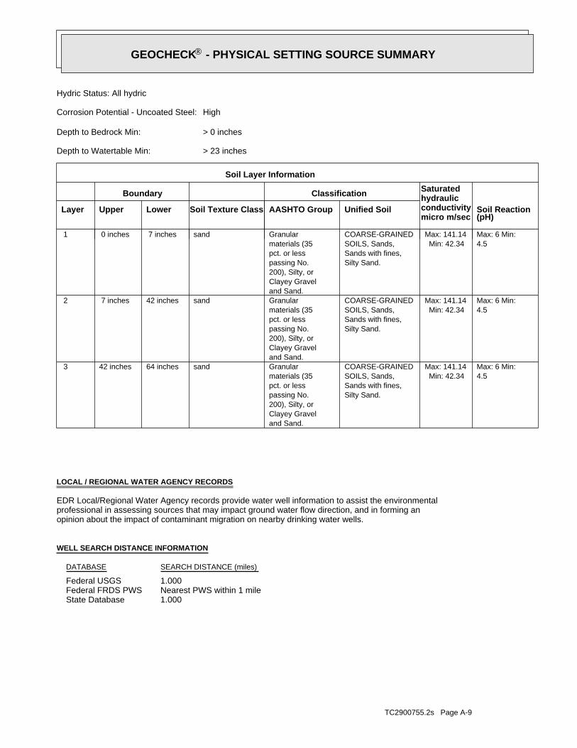
TC2900755.2s Page A-9
1.000State DatabaseNearest PWS within 1 mileFederal FRDS PWS1.000Federal USGS
WELL SEARCH DISTANCE INFORMATION
SEARCH DISTANCE (miles)DATABASE
opinion about the impact of contaminant migration on nearby drinking water wells.professional in assessing sources that may impact ground water flow direction, and in forming anEDR Local/Regional Water Agency records provide water well information to assist the environmental
LOCAL / REGIONAL WATER AGENCY RECORDS
4.5Max: 6 Min:
Min: 42.34Max: 141.14
Silty Sand.Sands with fines,SOILS, Sands,COARSE-GRAINED
and Sand.Clayey Gravel200), Silty, orpassing No.pct. or lessmaterials (35Granularsand64 inches42 inches 3
4.5Max: 6 Min:
Min: 42.34Max: 141.14
Silty Sand.Sands with fines,SOILS, Sands,COARSE-GRAINED
and Sand.Clayey Gravel200), Silty, orpassing No.pct. or lessmaterials (35Granularsand42 inches 7 inches 2
4.5Max: 6 Min:
Min: 42.34Max: 141.14
Silty Sand.Sands with fines,SOILS, Sands,COARSE-GRAINED
and Sand.Clayey Gravel200), Silty, orpassing No.pct. or lessmaterials (35Granularsand 7 inches 0 inches 1
Soil Layer Information
Boundary Classification Saturatedhydraulicconductivitymicro m/sec
Layer Upper Lower Soil Texture Class AASHTO Group Unified Soil Soil Reaction(pH)
> 23 inchesDepth to Watertable Min:
> 0 inchesDepth to Bedrock Min:
HighCorrosion Potential - Uncoated Steel:
Hydric Status: All hydric
GEOCHECK - PHYSICAL SETTING SOURCE SUMMARY®

TC2900755.2s Page A-10
No Wells Found
STATE DATABASE WELL INFORMATION
LOCATIONFROM TPWELL IDMAP ID
Note: PWS System location is not always the same as well location.
1/2 - 1 Mile NEME0090900 2
FEDERAL FRDS PUBLIC WATER SUPPLY SYSTEM INFORMATION
LOCATIONFROM TPWELL IDMAP ID
1/2 - 1 Mile EastUSGS2045642 1
FEDERAL USGS WELL INFORMATION
LOCATIONFROM TPWELL IDMAP ID
GEOCHECK - PHYSICAL SETTING SOURCE SUMMARY®

EDR Inc.EDR Inc.EDR Inc.EDR Inc.EDR Inc.EDR Inc.EDR Inc.EDR Inc.EDR Inc.EDR Inc.EDR Inc.EDR Inc.EDR Inc.EDR Inc.EDR Inc.EDR Inc.EDR Inc.EDR Inc.EDR Inc.EDR Inc.EDR Inc.EDR Inc.EDR Inc.EDR Inc.EDR Inc.EDR Inc.EDR Inc.EDR Inc.EDR Inc.EDR Inc.EDR Inc.EDR Inc.EDR Inc.EDR Inc.EDR Inc.EDR Inc.EDR Inc.EDR Inc.EDR Inc.EDR Inc.
1 2 0
1 208 040
4 0
40
8 04 01 60
8
0
1 2 0
1 2 0
8 0
80
4 0
4 0
40
4 0
40
40
40
1 2 0
8 0
80
8 0
4 0
4 0
80
40
4 0
80
8 0
4
4 0
40
4 0
4 0
40
40
80
408 0
804 0
4 0
80
80
80
8 0
80
40
40
4 0
40
40
40
4 0
40
40
4 0
40
ME

TC2900755.2s Page A-12
disinfectionTreatment objective:hypochlorination, postTreatment process:Treatment_plantFacility type:
TREAT FACILITY NO. 1Facility name:1729Facility id:
Local_GovtOwner type:ActiveStatus:CWSPws type:GroundwaterPWS Source:
700Pwssvcconn:1750Population Served:LUBEC WATER DISTRICTPws name:
WashingtonCounty:MEState:01Epa region:ME0090900Pwsid:
2NE1/2 - 1 MileHigher
ME0090900FRDS PWS
Ground-water levels, Number of Measurements: 0
Not ReportedGround water data count:Not ReportedGround water data end date:Ground water data begin date: Not ReportedNot ReportedWater quality data count:Not ReportedWater quality data end date:Not ReportedWater quality data begin date:Not ReportedPeak flow data count:Not ReportedPeak flow data end date:Not ReportedPeak flow data begin date:Not ReportedDaily flow data count:Not ReportedDaily flow data end date:Not ReportedDaily flow data begin date:Not ReportedReal time data flag:
Not ReportedProject number:Not ReportedSource of depth data:
Not ReportedHole depth:45.0Well depth:Not ReportedAquifer:Not ReportedAquifer Type:Single well, other than collector or Ranney typeType of ground water site:YLocal standard time flag:
ESTMean greenwich time offset:Not ReportedDate inventoried:1971Date construction:Ground-water other than SpringSite type:
Not ReportedTopographic:Maine Coastal. Maine. Area = 4880 sq.mi.Hydrologic:National Geodetic Vertical Datum of 1929Altitude datum:Not ReportedAltitude accuracy:Interpolated from topographic mapAltitude method:15.00Altitude:
Not ReportedMap scale:BASIC DATA NO 8Location map:Not ReportedLand net:USCountry:029County:23State:23District:NAD83Dec latlong datum:NAD27Latlong datum:SCoor accr:MCoor meth:-66.981923Dec lon:44.85646889Dec lat:0665857Longitude:USGS2045642EDR Site id:445123Latitude:
WW 684Site name:445123066585701Site no:USGSAgency cd:
1East1/2 - 1 MileHigher
USGS2045642FED USGS
Map IDDirectionDistanceElevation EDR ID NumberDatabase
GEOCHECK - PHYSICAL SETTING SOURCE MAP FINDINGS®

TC2900755.2s Page A-13
disinfectionTreatment objective:hypochlorination, postTreatment process:WellFacility type:
GP WELL 35’ AKA #2 WELLFacility name:3115Facility id:
Local_GovtOwner type:ActiveStatus:CWSPws type:GroundwaterPWS Source:
700Pwssvcconn:1750Population Served:LUBEC WATER DISTRICTPws name:
WashingtonCounty:MEState:01Epa region:ME0090900Pwsid:
04652Contact zip:LUBECContact city:Not ReportedContact address2:
PO BOX 128 PUMPING STATION RDContact address1:207-733-5526Contact phone:O’BRIEN, JOEOriginal name:O’BRIEN, JOEContact name:disinfectionTreatment objective:
hypochlorination, postTreatment process:StorageFacility type:TOWN TANKFacility name:263Facility id:
Local_GovtOwner type:ActiveStatus:CWSPws type:GroundwaterPWS Source:
700Pwssvcconn:1750Population Served:LUBEC WATER DISTRICTPws name:
WashingtonCounty:MEState:01Epa region:ME0090900Pwsid:
04652Contact zip:LUBECContact city:Not ReportedContact address2:
PO BOX 128 PUMPING STATION RDContact address1:207-733-5526Contact phone:O’BRIEN, JOEOriginal name:O’BRIEN, JOEContact name:disinfectionTreatment objective:
hypochlorination, postTreatment process:StorageFacility type:WEST LUBECFacility name:262Facility id:
Local_GovtOwner type:ActiveStatus:CWSPws type:GroundwaterPWS Source:
700Pwssvcconn:1750Population Served:LUBEC WATER DISTRICTPws name:
WashingtonCounty:MEState:01Epa region:ME0090900Pwsid:
04652Contact zip:LUBECContact city:Not ReportedContact address2:
PO BOX 128 PUMPING STATION RDContact address1:207-733-5526Contact phone:O’BRIEN, JOEOriginal name:O’BRIEN, JOEContact name:
GEOCHECK - PHYSICAL SETTING SOURCE MAP FINDINGS®

TC2900755.2s Page A-14
disinfectionTreatment objective:hypochlorination, postTreatment process:WellFacility type:
GP WELL (WELL #4)Facility name:4133Facility id:
Local_GovtOwner type:ActiveStatus:CWSPws type:GroundwaterPWS Source:
700Pwssvcconn:1750Population Served:LUBEC WATER DISTRICTPws name:
WashingtonCounty:MEState:01Epa region:ME0090900Pwsid:
04652Contact zip:LUBECContact city:Not ReportedContact address2:
PO BOX 128 PUMPING STATION RDContact address1:207-733-5526Contact phone:O’BRIEN, JOEOriginal name:O’BRIEN, JOEContact name:disinfectionTreatment objective:
hypochlorination, postTreatment process:WellFacility type:GP WELLFacility name:3316Facility id:
Local_GovtOwner type:ActiveStatus:CWSPws type:GroundwaterPWS Source:
700Pwssvcconn:1750Population Served:LUBEC WATER DISTRICTPws name:
WashingtonCounty:MEState:01Epa region:ME0090900Pwsid:
04652Contact zip:LUBECContact city:Not ReportedContact address2:
PO BOX 128 PUMPING STATION RDContact address1:207-733-5526Contact phone:O’BRIEN, JOEOriginal name:O’BRIEN, JOEContact name:disinfectionTreatment objective:
hypochlorination, postTreatment process:WellFacility type:SPRING (WELL #1)Facility name:3315Facility id:
Local_GovtOwner type:ActiveStatus:CWSPws type:GroundwaterPWS Source:
700Pwssvcconn:1750Population Served:LUBEC WATER DISTRICTPws name:
WashingtonCounty:MEState:01Epa region:ME0090900Pwsid:
04652Contact zip:LUBECContact city:Not ReportedContact address2:
PO BOX 128 PUMPING STATION RDContact address1:207-733-5526Contact phone:O’BRIEN, JOEOriginal name:O’BRIEN, JOEContact name:
GEOCHECK - PHYSICAL SETTING SOURCE MAP FINDINGS®

TC2900755.2s Page A-15
disinfectionTreatment objective:hypochlorination, postTreatment process:Sampling_stationFacility type:
EP (3 GP WELLS 35’ 1 SPRING)Facility name:8468Facility id:
Local_GovtOwner type:ActiveStatus:CWSPws type:GroundwaterPWS Source:
700Pwssvcconn:1750Population Served:LUBEC WATER DISTRICTPws name:
WashingtonCounty:MEState:01Epa region:ME0090900Pwsid:
04652Contact zip:LUBECContact city:Not ReportedContact address2:
PO BOX 128 PUMPING STATION RDContact address1:207-733-5526Contact phone:O’BRIEN, JOEOriginal name:O’BRIEN, JOEContact name:disinfectionTreatment objective:
hypochlorination, postTreatment process:Distribution_system_zoneFacility type:DISTRIBUTION SYSTEMFacility name:8467Facility id:
Local_GovtOwner type:ActiveStatus:CWSPws type:GroundwaterPWS Source:
700Pwssvcconn:1750Population Served:LUBEC WATER DISTRICTPws name:
WashingtonCounty:MEState:01Epa region:ME0090900Pwsid:
04652Contact zip:LUBECContact city:Not ReportedContact address2:
PO BOX 128 PUMPING STATION RDContact address1:207-733-5526Contact phone:O’BRIEN, JOEOriginal name:O’BRIEN, JOEContact name:disinfectionTreatment objective:
hypochlorination, postTreatment process:Sampling_stationFacility type:HISTORICAL DATAFacility name:6154Facility id:
Local_GovtOwner type:ActiveStatus:CWSPws type:GroundwaterPWS Source:
700Pwssvcconn:1750Population Served:LUBEC WATER DISTRICTPws name:
WashingtonCounty:MEState:01Epa region:ME0090900Pwsid:
04652Contact zip:LUBECContact city:Not ReportedContact address2:
PO BOX 128 PUMPING STATION RDContact address1:207-733-5526Contact phone:O’BRIEN, JOEOriginal name:O’BRIEN, JOEContact name:
GEOCHECK - PHYSICAL SETTING SOURCE MAP FINDINGS®

TC2900755.2s Page A-16
otherTreatment objective:fluoridationTreatment process:StorageFacility type:
TOWN TANKFacility name:263Facility id:
Local_GovtOwner type:ActiveStatus:CWSPws type:GroundwaterPWS Source:
700Pwssvcconn:1750Population Served:LUBEC WATER DISTRICTPws name:
WashingtonCounty:MEState:01Epa region:ME0090900Pwsid:
04652Contact zip:LUBECContact city:Not ReportedContact address2:
PO BOX 128 PUMPING STATION RDContact address1:207-733-5526Contact phone:O’BRIEN, JOEOriginal name:O’BRIEN, JOEContact name:otherTreatment objective:
fluoridationTreatment process:StorageFacility type:WEST LUBECFacility name:262Facility id:
Local_GovtOwner type:ActiveStatus:CWSPws type:GroundwaterPWS Source:
700Pwssvcconn:1750Population Served:LUBEC WATER DISTRICTPws name:
WashingtonCounty:MEState:01Epa region:ME0090900Pwsid:
04652Contact zip:LUBECContact city:Not ReportedContact address2:
PO BOX 128 PUMPING STATION RDContact address1:207-733-5526Contact phone:O’BRIEN, JOEOriginal name:O’BRIEN, JOEContact name:otherTreatment objective:
fluoridationTreatment process:Treatment_plantFacility type:TREAT FACILITY NO. 1Facility name:1729Facility id:
Local_GovtOwner type:ActiveStatus:CWSPws type:GroundwaterPWS Source:
700Pwssvcconn:1750Population Served:LUBEC WATER DISTRICTPws name:
WashingtonCounty:MEState:01Epa region:ME0090900Pwsid:
04652Contact zip:LUBECContact city:Not ReportedContact address2:
PO BOX 128 PUMPING STATION RDContact address1:207-733-5526Contact phone:O’BRIEN, JOEOriginal name:O’BRIEN, JOEContact name:
GEOCHECK - PHYSICAL SETTING SOURCE MAP FINDINGS®

TC2900755.2s Page A-17
otherTreatment objective:fluoridationTreatment process:WellFacility type:
GP WELLFacility name:3316Facility id:
Local_GovtOwner type:ActiveStatus:CWSPws type:GroundwaterPWS Source:
700Pwssvcconn:1750Population Served:LUBEC WATER DISTRICTPws name:
WashingtonCounty:MEState:01Epa region:ME0090900Pwsid:
04652Contact zip:LUBECContact city:Not ReportedContact address2:
PO BOX 128 PUMPING STATION RDContact address1:207-733-5526Contact phone:O’BRIEN, JOEOriginal name:O’BRIEN, JOEContact name:otherTreatment objective:
fluoridationTreatment process:WellFacility type:SPRING (WELL #1)Facility name:3315Facility id:
Local_GovtOwner type:ActiveStatus:CWSPws type:GroundwaterPWS Source:
700Pwssvcconn:1750Population Served:LUBEC WATER DISTRICTPws name:
WashingtonCounty:MEState:01Epa region:ME0090900Pwsid:
04652Contact zip:LUBECContact city:Not ReportedContact address2:
PO BOX 128 PUMPING STATION RDContact address1:207-733-5526Contact phone:O’BRIEN, JOEOriginal name:O’BRIEN, JOEContact name:otherTreatment objective:
fluoridationTreatment process:WellFacility type:GP WELL 35’ AKA #2 WELLFacility name:3115Facility id:
Local_GovtOwner type:ActiveStatus:CWSPws type:GroundwaterPWS Source:
700Pwssvcconn:1750Population Served:LUBEC WATER DISTRICTPws name:
WashingtonCounty:MEState:01Epa region:ME0090900Pwsid:
04652Contact zip:LUBECContact city:Not ReportedContact address2:
PO BOX 128 PUMPING STATION RDContact address1:207-733-5526Contact phone:O’BRIEN, JOEOriginal name:O’BRIEN, JOEContact name:
GEOCHECK - PHYSICAL SETTING SOURCE MAP FINDINGS®

TC2900755.2s Page A-18
otherTreatment objective:fluoridationTreatment process:Distribution_system_zoneFacility type:
DISTRIBUTION SYSTEMFacility name:8467Facility id:
Local_GovtOwner type:ActiveStatus:CWSPws type:GroundwaterPWS Source:
700Pwssvcconn:1750Population Served:LUBEC WATER DISTRICTPws name:
WashingtonCounty:MEState:01Epa region:ME0090900Pwsid:
04652Contact zip:LUBECContact city:Not ReportedContact address2:
PO BOX 128 PUMPING STATION RDContact address1:207-733-5526Contact phone:O’BRIEN, JOEOriginal name:O’BRIEN, JOEContact name:otherTreatment objective:
fluoridationTreatment process:Sampling_stationFacility type:HISTORICAL DATAFacility name:6154Facility id:
Local_GovtOwner type:ActiveStatus:CWSPws type:GroundwaterPWS Source:
700Pwssvcconn:1750Population Served:LUBEC WATER DISTRICTPws name:
WashingtonCounty:MEState:01Epa region:ME0090900Pwsid:
04652Contact zip:LUBECContact city:Not ReportedContact address2:
PO BOX 128 PUMPING STATION RDContact address1:207-733-5526Contact phone:O’BRIEN, JOEOriginal name:O’BRIEN, JOEContact name:otherTreatment objective:
fluoridationTreatment process:WellFacility type:GP WELL (WELL #4)Facility name:4133Facility id:
Local_GovtOwner type:ActiveStatus:CWSPws type:GroundwaterPWS Source:
700Pwssvcconn:1750Population Served:LUBEC WATER DISTRICTPws name:
WashingtonCounty:MEState:01Epa region:ME0090900Pwsid:
04652Contact zip:LUBECContact city:Not ReportedContact address2:
PO BOX 128 PUMPING STATION RDContact address1:207-733-5526Contact phone:O’BRIEN, JOEOriginal name:O’BRIEN, JOEContact name:
GEOCHECK - PHYSICAL SETTING SOURCE MAP FINDINGS®

TC2900755.2s Page A-19
0Violmeasur:State Compliance AchievedEnf action:
8/11/2000 0:00:00Enfdate:6/30/2000 0:00:00Complperen:6/1/2000 0:00:00Complperbe:MCL, Monthly (TCR)Viol. Type:
COLIFORM (TCR)Contaminant:100000Vioid:CPwstypecod:1750Retpopsrvd:
LUBEC WATER DISTRICTPwsname:ME0090900Pwsid:03/31/2009Truedate:
0Violmeasur:State Public Notif RequestedEnf action:
6/23/2000 0:00:00Enfdate:6/30/2000 0:00:00Complperen:6/1/2000 0:00:00Complperbe:MCL, Monthly (TCR)Viol. Type:
COLIFORM (TCR)Contaminant:100000Vioid:CPwstypecod:1750Retpopsrvd:
LUBEC WATER DISTRICTPwsname:ME0090900Pwsid:03/31/2009Truedate:
ENFORCEMENT INFORMATION:
Violations information not reported.
1750Population:UntreatedTreatment Class:DENNYSVILLECity Served:
066 59 04Facility Longitude:44 51 38Facility Latitude:
Not ReportedAddressee / Facility:
LUBEC, ME 04652PO BOX 128LUBEC WATER & ELECTRIC DISTLUBEC WATER & ELEC DISTRICTPWS Name:
Not ReportedDate Deactivated:Not ReportedDate Initiated:ME0090900PWS ID:
04652Contact zip:LUBECContact city:Not ReportedContact address2:
PO BOX 128 PUMPING STATION RDContact address1:207-733-5526Contact phone:O’BRIEN, JOEOriginal name:O’BRIEN, JOEContact name:otherTreatment objective:
fluoridationTreatment process:Sampling_stationFacility type:EP (3 GP WELLS 35’ 1 SPRING)Facility name:8468Facility id:
Local_GovtOwner type:ActiveStatus:CWSPws type:GroundwaterPWS Source:
700Pwssvcconn:1750Population Served:LUBEC WATER DISTRICTPws name:
WashingtonCounty:MEState:01Epa region:ME0090900Pwsid:
04652Contact zip:LUBECContact city:Not ReportedContact address2:
PO BOX 128 PUMPING STATION RDContact address1:207-733-5526Contact phone:O’BRIEN, JOEOriginal name:O’BRIEN, JOEContact name:
GEOCHECK - PHYSICAL SETTING SOURCE MAP FINDINGS®

TC2900755.2s Page A-20
State Compliance AchievedEnf. Action:8/11/2000 0:00:00Enforcement Date:100000Violation ID:6/1/2000 0:00:00 - 6/30/2000 0:00:00Compliance Period:COLIFORM (TCR)Contaminant:MCL, Monthly (TCR)Violation Type:LUBEC WATER DISTRICTSystem Name:
State Public Notif RequestedEnf. Action:6/23/2000 0:00:00Enforcement Date:100000Violation ID:6/1/2000 0:00:00 - 6/30/2000 0:00:00Compliance Period:COLIFORM (TCR)Contaminant:MCL, Monthly (TCR)Violation Type:LUBEC WATER DISTRICTSystem Name:
State Compliance AchievedEnf. Action:2000-01-07Enforcement Date:0000001Violation ID:1999-12-01 - 1999-12-31Compliance Period:COLIFORM (TCR)Contaminant:MCL, Monthly (TCR)Violation Type:LUBEC WATER & ELEC DISTRICSystem Name:
0Violmeasur:State Public Notif RequestedEnf action:
10/2/2000 0:00:00Enfdate:9/30/2000 0:00:00Complperen:9/1/2000 0:00:00Complperbe:MCL, Monthly (TCR)Viol. Type:
COLIFORM (TCR)Contaminant:100200Vioid:CPwstypecod:1750Retpopsrvd:
LUBEC WATER DISTRICTPwsname:ME0090900Pwsid:03/31/2009Truedate:
0Violmeasur:State Compliance AchievedEnf action:
10/13/2000 0:00:00Enfdate:9/30/2000 0:00:00Complperen:9/1/2000 0:00:00Complperbe:MCL, Monthly (TCR)Viol. Type:
COLIFORM (TCR)Contaminant:100200Vioid:CPwstypecod:1750Retpopsrvd:
LUBEC WATER DISTRICTPwsname:ME0090900Pwsid:03/31/2009Truedate:
0Violmeasur:State Compliance AchievedEnf action:
9/8/2000 0:00:00Enfdate:8/31/2000 0:00:00Complperen:8/1/2000 0:00:00Complperbe:MCL, Monthly (TCR)Viol. Type:
COLIFORM (TCR)Contaminant:100100Vioid:CPwstypecod:1750Retpopsrvd:
LUBEC WATER DISTRICTPwsname:ME0090900Pwsid:03/31/2009Truedate:
0Violmeasur:State Public Notif RequestedEnf action:
8/30/2000 0:00:00Enfdate:8/31/2000 0:00:00Complperen:8/1/2000 0:00:00Complperbe:MCL, Monthly (TCR)Viol. Type:
COLIFORM (TCR)Contaminant:100100Vioid:CPwstypecod:1750Retpopsrvd:
LUBEC WATER DISTRICTPwsname:ME0090900Pwsid:03/31/2009Truedate:
GEOCHECK - PHYSICAL SETTING SOURCE MAP FINDINGS®

TC2900755.2s Page A-21
State Compliance AchievedEnf. Action:10/13/2000 0:00:00Enforcement Date:100200Violation ID:9/1/2000 0:00:00 - 9/30/2000 0:00:00Compliance Period:COLIFORM (TCR)Contaminant:MCL, Monthly (TCR)Violation Type:LUBEC WATER DISTRICTSystem Name:
State Compliance AchievedEnf. Action:10/13/2000 0:00:00Enforcement Date:100200Violation ID:9/1/2000 0:00:00 - 9/30/2000 0:00:00Compliance Period:COLIFORM (TCR)Contaminant:MCL, Monthly (TCR)Violation Type:LUBEC WATER DISTRICTSystem Name:
State Public Notif RequestedEnf. Action:10/2/2000 0:00:00Enforcement Date:100200Violation ID:9/1/2000 0:00:00 - 9/30/2000 0:00:00Compliance Period:COLIFORM (TCR)Contaminant:MCL, Monthly (TCR)Violation Type:LUBEC WATER DISTRICTSystem Name:
State Compliance AchievedEnf. Action:9/8/2000 0:00:00Enforcement Date:100100Violation ID:8/1/2000 0:00:00 - 8/31/2000 0:00:00Compliance Period:COLIFORM (TCR)Contaminant:MCL, Monthly (TCR)Violation Type:LUBEC WATER DISTRICTSystem Name:
State Public Notif RequestedEnf. Action:8/30/2000 0:00:00Enforcement Date:100100Violation ID:8/1/2000 0:00:00 - 8/31/2000 0:00:00Compliance Period:COLIFORM (TCR)Contaminant:MCL, Monthly (TCR)Violation Type:LUBEC WATER DISTRICTSystem Name:
State Public Notif RequestedEnf. Action:8/30/2000 0:00:00Enforcement Date:100100Violation ID:8/1/2000 0:00:00 - 8/31/2000 0:00:00Compliance Period:COLIFORM (TCR)Contaminant:MCL, Monthly (TCR)Violation Type:LUBEC WATER DISTRICTSystem Name:
State Compliance AchievedEnf. Action:9/8/2000 0:00:00Enforcement Date:100100Violation ID:8/1/2000 0:00:00 - 8/31/2000 0:00:00Compliance Period:COLIFORM (TCR)Contaminant:MCL, Monthly (TCR)Violation Type:LUBEC WATER DISTRICTSystem Name:
State Compliance AchievedEnf. Action:8/11/2000 0:00:00Enforcement Date:100000Violation ID:6/1/2000 0:00:00 - 6/30/2000 0:00:00Compliance Period:COLIFORM (TCR)Contaminant:MCL, Monthly (TCR)Violation Type:LUBEC WATER DISTRICTSystem Name:
State Public Notif RequestedEnf. Action:6/23/2000 0:00:00Enforcement Date:100000Violation ID:6/1/2000 0:00:00 - 6/30/2000 0:00:00Compliance Period:COLIFORM (TCR)Contaminant:MCL, Monthly (TCR)Violation Type:LUBEC WATER DISTRICTSystem Name:
ENFORCEMENT INFORMATION:
GEOCHECK - PHYSICAL SETTING SOURCE MAP FINDINGS®

TC2900755.2s Page A-22
ME, 04 207-7LUBECAddress 2:PO BOX 128 PUMPING STATION RDAddress:
Not ReportedPhone:O’BRIEN, JOEContact:1750Population:LUBEC WATER DISTRICTName:
CONTACT INFORMATION:
Not ReportedEnf. Action:Not ReportedEnforcement Date:9900002Violation ID:1999-09-01 - 1999-09-30Compliance Period:COLIFORM (TCR)Contaminant:MCL, Acute (TCR)Violation Type:LUBEC WATER & ELEC DISTRICSystem Name:
State Public Notif RequestedEnf. Action:1999-12-27Enforcement Date:9900002Violation ID:1999-12-01 - 1999-12-31Compliance Period:COLIFORM (TCR)Contaminant:MCL, Monthly (TCR)Violation Type:LUBEC WATER & ELEC DISTRICSystem Name:
Not ReportedEnf. Action:Not ReportedEnforcement Date:9900001Violation ID:1999-08-01 - 1999-08-31Compliance Period:COLIFORM (TCR)Contaminant:MCL, Monthly (TCR)Violation Type:LUBEC WATER & ELEC DISTRICSystem Name:
State Public Notif RequestedEnf. Action:1996-02-21Enforcement Date:9600001VViolation ID:1995-01-01 - 1995-12-31Compliance Period:NITRATEContaminant:Monitoring, RegularViolation Type:LUBEC WATER & ELEC DISTRICSystem Name:
State Public Notif RequestedEnf. Action:10/2/2000 0:00:00Enforcement Date:100200Violation ID:9/1/2000 0:00:00 - 9/30/2000 0:00:00Compliance Period:COLIFORM (TCR)Contaminant:MCL, Monthly (TCR)Violation Type:LUBEC WATER DISTRICTSystem Name:
ENFORCEMENT INFORMATION:
GEOCHECK - PHYSICAL SETTING SOURCE MAP FINDINGS®

TC2900755.2s Page A-23
0%18%82%2.779 pCi/LBasementNot ReportedNot ReportedNot ReportedNot ReportedLiving Area - 2nd Floor0%0%100%0.729 pCi/LLiving Area - 1st Floor
% >20 pCi/L% 4-20 pCi/L% <4 pCi/LAverage ActivityArea
Number of sites tested: 34
Federal Area Radon Information for WASHINGTON COUNTY, ME
: Zone 3 indoor average level < 2 pCi/L. : Zone 2 indoor average level >= 2 pCi/L and <= 4 pCi/L. Note: Zone 1 indoor average level > 4 pCi/L.
Federal EPA Radon Zone for WASHINGTON County: 2
0.7B046520.8B04652
_______________ResultsFloorCityZip
Radon Test Results
State Database: ME Radon
AREA RADON INFORMATION
GEOCHECK - PHYSICAL SETTING SOURCE MAP FINDINGSRADON
®
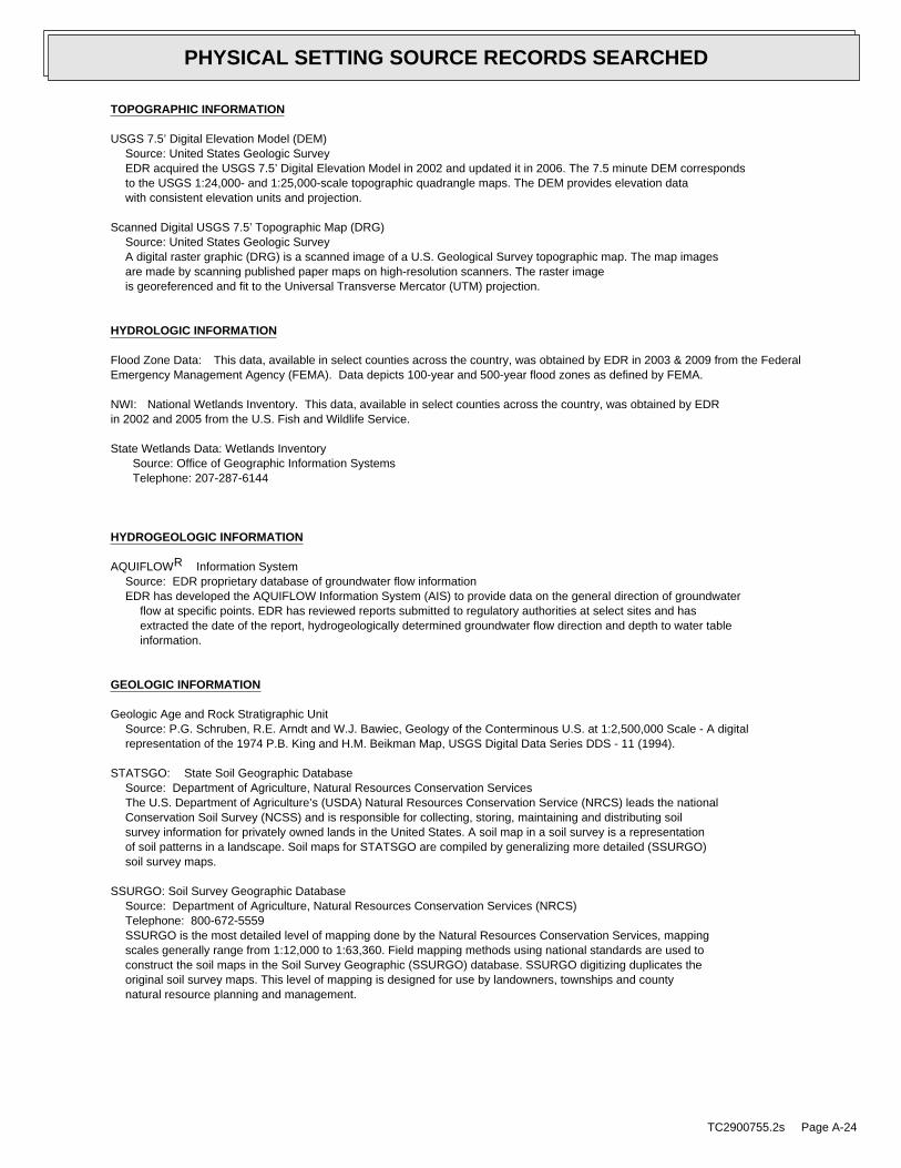
TOPOGRAPHIC INFORMATION
USGS 7.5’ Digital Elevation Model (DEM)Source: United States Geologic SurveyEDR acquired the USGS 7.5’ Digital Elevation Model in 2002 and updated it in 2006. The 7.5 minute DEM correspondsto the USGS 1:24,000- and 1:25,000-scale topographic quadrangle maps. The DEM provides elevation datawith consistent elevation units and projection.
Scanned Digital USGS 7.5’ Topographic Map (DRG)Source: United States Geologic SurveyA digital raster graphic (DRG) is a scanned image of a U.S. Geological Survey topographic map. The map imagesare made by scanning published paper maps on high-resolution scanners. The raster imageis georeferenced and fit to the Universal Transverse Mercator (UTM) projection.
HYDROLOGIC INFORMATION
Flood Zone Data: This data, available in select counties across the country, was obtained by EDR in 2003 & 2009 from the FederalEmergency Management Agency (FEMA). Data depicts 100-year and 500-year flood zones as defined by FEMA.
NWI: National Wetlands Inventory. This data, available in select counties across the country, was obtained by EDRin 2002 and 2005 from the U.S. Fish and Wildlife Service.
State Wetlands Data: Wetlands InventorySource: Office of Geographic Information SystemsTelephone: 207-287-6144
HYDROGEOLOGIC INFORMATION
AQUIFLOW Information SystemR
Source: EDR proprietary database of groundwater flow informationEDR has developed the AQUIFLOW Information System (AIS) to provide data on the general direction of groundwater
flow at specific points. EDR has reviewed reports submitted to regulatory authorities at select sites and hasextracted the date of the report, hydrogeologically determined groundwater flow direction and depth to water tableinformation.
GEOLOGIC INFORMATION
Geologic Age and Rock Stratigraphic UnitSource: P.G. Schruben, R.E. Arndt and W.J. Bawiec, Geology of the Conterminous U.S. at 1:2,500,000 Scale - A digitalrepresentation of the 1974 P.B. King and H.M. Beikman Map, USGS Digital Data Series DDS - 11 (1994).
STATSGO: State Soil Geographic DatabaseSource: Department of Agriculture, Natural Resources Conservation ServicesThe U.S. Department of Agriculture’s (USDA) Natural Resources Conservation Service (NRCS) leads the nationalConservation Soil Survey (NCSS) and is responsible for collecting, storing, maintaining and distributing soilsurvey information for privately owned lands in the United States. A soil map in a soil survey is a representationof soil patterns in a landscape. Soil maps for STATSGO are compiled by generalizing more detailed (SSURGO)soil survey maps.
SSURGO: Soil Survey Geographic DatabaseSource: Department of Agriculture, Natural Resources Conservation Services (NRCS)Telephone: 800-672-5559SSURGO is the most detailed level of mapping done by the Natural Resources Conservation Services, mappingscales generally range from 1:12,000 to 1:63,360. Field mapping methods using national standards are used toconstruct the soil maps in the Soil Survey Geographic (SSURGO) database. SSURGO digitizing duplicates theoriginal soil survey maps. This level of mapping is designed for use by landowners, townships and countynatural resource planning and management.
TC2900755.2s Page A-24
PHYSICAL SETTING SOURCE RECORDS SEARCHED

LOCAL / REGIONAL WATER AGENCY RECORDS
FEDERAL WATER WELLS
PWS: Public Water SystemsSource: EPA/Office of Drinking WaterTelephone: 202-564-3750Public Water System data from the Federal Reporting Data System. A PWS is any water system which provides water to at
least 25 people for at least 60 days annually. PWSs provide water from wells, rivers and other sources.
PWS ENF: Public Water Systems Violation and Enforcement DataSource: EPA/Office of Drinking WaterTelephone: 202-564-3750Violation and Enforcement data for Public Water Systems from the Safe Drinking Water Information System (SDWIS) after
August 1995. Prior to August 1995, the data came from the Federal Reporting Data System (FRDS).
USGS Water Wells: USGS National Water Inventory System (NWIS)This database contains descriptive information on sites where the USGS collects or has collected data on surfacewater and/or groundwater. The groundwater data includes information on wells, springs, and other sources of groundwater.
STATE RECORDS
Public Water Supply Wells DatabaseSource: Department of Human Services, Drinking Water ProgramTelephone: 207-287-6196There are 3 types of public water systems in Maine: Transient Systems; Community Systems and Non-transient Non-community
Systems
OTHER STATE DATABASE INFORMATION
RADON
Maine Radon Test ResultsSource: Department of Human ServicesTelephone: 207-287-5698The state of Maine Radiation Control Program’s - Radon/Indor Air Quality Section’s position on radon map, is thatthey should be used neither to predict the presence of high nor low values in any given geographic or geologicarea. The only conclusion that should be drawn from this data is that radon in omnipresent in the soil gassesin the state of Maine, and therefore all residences and buildings that come in contact with the ground shouldbe tested for radon.
Area Radon InformationSource: USGSTelephone: 703-356-4020The National Radon Database has been developed by the U.S. Environmental Protection Agency(USEPA) and is a compilation of the EPA/State Residential Radon Survey and the National Residential Radon Survey.The study covers the years 1986 - 1992. Where necessary data has been supplemented by information collected atprivate sources such as universities and research institutions.
EPA Radon ZonesSource: EPATelephone: 703-356-4020Sections 307 & 309 of IRAA directed EPA to list and identify areas of U.S. with the potential for elevated indoorradon levels.
OTHER
Airport Landing Facilities: Private and public use landing facilitiesSource: Federal Aviation Administration, 800-457-6656
Epicenters: World earthquake epicenters, Richter 5 or greaterSource: Department of Commerce, National Oceanic and Atmospheric Administration
TC2900755.2s Page A-25
PHYSICAL SETTING SOURCE RECORDS SEARCHED

STREET AND ADDRESS INFORMATION
© 2010 Tele Atlas North America, Inc. All rights reserved. This material is proprietary and the subject of copyright protectionand other intellectual property rights owned by or licensed to Tele Atlas North America, Inc. The use of this material is subjectto the terms of a license agreement. You will be held liable for any unauthorized copying or disclosure of this material.
TC2900755.2s Page A-26
PHYSICAL SETTING SOURCE RECORDS SEARCHED

ASTM Phase I Environmental Site Assessment 135 Main Street, Lubec, ME November 18, 2010
GEI Consultants, Inc.
Appendix F
Resumes

Todd Coffin, C.G., P.G. 1
Todd Coffin, C.G., P.G., Senior Project Manager
Education M.S., Engineering Geology, Purdue University, 1986 B.A., Geology, Colby College, 1983
Registration Professional Geologist: Maine and New Hampshire
Background
Mr. Coffin is a Senior Project Manager with GEI Consultants, Inc. and has over twenty-two years of consulting experience.
While practicing in Maine and New England over the past 20 years, Todd has worked on a vast array of projects ranging from environmental site assessments to environmental closure of nuclear and fossil-fueled power plants. His core strengths include team leadership, client development, management of multi-faceted projects, and client-community interface.
Todd has extensive experience in brownfields site redevelopment, environmental permitting, litigation support, contingency plan development, implementing environmental management systems, conducting audits of regulatory compliance, industrial hygiene, and pollution prevention practices.
Experience
Irving Forest Products, Environmental Permitting for OSB Facility, Limestone Maine. Project Manager for completion of all environmental permits under Maine’s Site Location of Development Law. Components include: air discharge licensing under EPA and Maine DEP regulation, wetlands, wastewater, storm water, groundwater resource protection, and noise impacts, among others.
UPC Wind, Environmental Assessment for Stetson Wind Project, Mattawamkeag, Maine. Project Manager for Phase I and Phase II environmental due diligence of proposed turbine array and power line easement.
First Wind, Environmental Assessment for confidential wind project, Northern, Maine. Project Manager for Phase I environmental due diligence for a proposed turbine array and power line easement.
Maritimes and Northeast Pipeline, Pipeline Impact Assessment, Maine and New Hampshire. Project Geologist for pre-construction assessment of water supplies, structures, and natural resources for construction of natural gas pipeline.
Maine Yankee Nuclear Power Company, Resource Conservation and Recovery Act (RCRA) Investigation for Nuclear Power Plant Decommissioning, Wiscasset, Maine. Project hydrogeologist for preparation of field sampling plans, health and safety plans, and quality assurance plans. The sampling plans encompassed soils, groundwater, biota, surface water, and demolition debris.
MBNA America, Maine Site Location of Development Permitting for Corporate Campus in Northport, Maine. Project hydrogeologist for completion of Maine Site Law permits for water supply, wellhead protection, and subsurface wastewater disposal. Components included demonstrating adequate water supply capacity, no adverse impacts from nitrate loading and identification of risks to water supply.

Todd Coffin, C.G., P.G. 2
Maine Department of Transportation, Multiple-Site Oil and Hazardous Material Evaluation for Maine DOT, South Portland, Maine. Project manager for the environmental assessment for the Portland-South Portland Bridge Replacement Project. The assessment included identification of potential oil and hazardous material release sites along the construction corridor. Findings were integrated with construction plans to minimize delays when encountering contaminated soils and/or groundwater.
Central Maine Power Company, Environmental Assessment of Bulk Oil Storage Facility, Wiscasset, Maine. Managed evaluation of oil terminal along the Sheepscot River for impacts from petroleum storage and handling. The evaluation included nested wells, tide-groundwater relationships, slug testing, and chemical testing of groundwater and surface water.
Maine Department of Transportation, Compliance Audits of Maintenance Facilities. Managed an audit of several MDOT maintenance garages for RCRA hazardous waste compliance. The audit scope included waste containment, labeling, storage limits, manifests, training, and record-keeping. Corrective Action Plans were developed for areas of concern.
Maine Department of Environmental Protection, Development of Quality Management System (QMS) and Quality Auditing Program (QAP), Augusta, Maine. Co-lead the project development and implementation of a quality management system for Maine DEP in accordance with ANSI standard ANSI/ASQC E4-1994. Implementation was followed by DEP internal auditor training and audits of conformance with the QMS.
Maine Department of Transportation, Statewide review of Operations and Management Systems at DOT Maintenance Garages. Project Manager for major DOT initiative designed to minimize waste, prevent pollution, and assure regulatory compliance. The study involved a review of maintenance facility operations and applicable environmental management systems. Findings led to improved housekeeping, new training programs, and implementation of an environmental audit plan.
Pioneer Plastics Corporation, Integrated Spill Prevention and Emergency Response Plan, Auburn, Maine. Project Manager for developing an integrated spill prevention and response plan encompassing requirements under EPA Oil Spill Prevention Control and Countermeasures (SPCC) planning, OSHA hazardous materials spill and waste management, RCRA Hazardous Waste Contingency Planning, and Maine hazardous materials spill response. Planning included numerous industrial waste sources including fuel oil, phenol, formaldehyde, acetone, and methylene chloride, among others.
Androscoggin Energy, Preparation of Risk Management Plan, Jay, Maine. Prepared risk management plan for storage of aqueous ammonia at a co-generation facility in accordance with Clean Air Act Section 112(R). The plan included modeling of worst-case and alternative releases, impact assessment using Landview III environmental mapping software, and development of a release prevention program.
Corning Costar Corporation, Wastewater Permitting and Management, Scarborough, Maine. Manager for completing a permit for an industrial discharge containing phenolic-based residuals. The permit required waste stream characterization, waste minimization measures, and assessment of aquatic toxicity. The permit was approved following negotiations with DEP and the Scarborough Sanitary District, and preparation of a wastewater management plan.
Stratex, LLC, Environmental Audit of the Penobscot Energy Recovery Facility, Orrington, Maine. Managed a comprehensive environmental audit of a major trash-to-energy incinerator. The audit scope included site permitting under the Maine Site Location of Development Law, hazardous and solid waste management, storm water and wastewater permitting, air licensing and Community Right-to-Know under Superfund Amendments and Reauthorization Act (SARA) Title III.

Todd Coffin, C.G., P.G. 3
Stratex, LLC, Environmental Audit of KTI Biofuels, Auburn, Maine. Completed a comprehensive environmental audit at the site of a treated wood recycling facility. The audit scope included site permitting under the Maine Site Location of Development Law, hazardous and solid waste management, storm water permitting, municipal ordinances, and hazardous materials management.
PCI Synthesis, Document Review and Response to EPA Compliance Violations. Project Manager for assisting a pharmaceutical research and development company with development of hazardous waste contingency and emergency response plans. Assisted legal team with preparation of responses to an EPA citation.
Dragon Cement Co., Noise Assessment for Quarry, Portland, Maine. Led an assessment of noise levels at a quarry and cement plant in Portland, Maine, for compliance with city and state standards. Testing was performed as part of a proposed expansion of quarrying operations at the facility in a residentially zoned area of Portland.
Environmental Soil Management, Inc., Environmental Noise Monitoring for Proposed Expanded Plant Operating Hours, Loudon, New Hampshire. Project Manager for environmental noise study at the site of a contaminated soils recycling facility. The plant proposed to expand operating hours into the evening, raising concerns of local residents. Several noise monitors were placed at the plant and at private residences to map the noise impacts during trial operations. Noise data were compared with guidelines for protection of public health and welfare.
Maine Department of Environmental Protection, RI/FS for Contaminated Bedrock Aquifer, Boothbay, Maine. Project manager for the remedial investigation and feasibility study for the release of gasoline and fuel oil to a fractured bedrock aquifer. Monitoring data from several multi-level piezometers and water supply wells were used to assess the nature and distribution of groundwater contamination and changes in water quality over time. Pilot testing to assess feasibility of remedial alternatives included geophysical logging, packer testing, soil vapor extraction testing, and a groundwater pumping test.
LEDA Associates, Remediation Design and Implementation, Farwell Mill, Lisbon, Maine. Project manager for design and implementation of a remediation system designed to recover No. 6 fuel oil observed seeping into a nearby river. The system employed a 350-foot-long interceptor drain with downgradient geotextile barrier.
Key Bank of Maine, Remediation of Gasoline Spill, Islesboro, Maine. Project manager for design and implementation of a combined soil venting/groundwater treatment system. The system was designed to remediate gasoline-saturated soils near the source while protecting downgradient water supply wells.
Central Maine Power Company, Remediation of Fuel Oil Spill, Sanford Service Building, Sanford, Maine. Project manager for remediation of fuel-oil-contaminated soils spilled from an underground tank. Contaminated soils and groundwater were remediated by active soil venting and enhanced biodegradation through oxidation and nutrient addition. DEP approved site closure based on monitoring data and implementation of spill prevention measures.
Maine DEP, Remediation of Gasoline Spill, Brown’s Mobil, Bethel, Maine. Designed and implemented a free-product- and vapor-phase gasoline recovery system at an operating convenience store and gas station. The vapor recovery system consists of both horizontal and vertical slotted piping within outwash sands and gravel. Free product is recovered using a pneumatic phase-selective hydrocarbon pump; to date, more than 2,000 gallons of liquid and vapor-phase gasoline have been recovered.

Todd Coffin, C.G., P.G. 4
Maine DEP, Multi-Phase Remediation at Caribou Office Park, Caribou, Maine. Managed the design, construction, and operation of a multi-phase gasoline recovery system at the site of a former gasoline station. The system was designed to collect gasoline vapor and contaminated water using high vacuum pumps and air/liquid separation. The cleanup focused on mitigation of gasoline vapors permeating into the basement of a nearby office building.
Maine DEP Brownfields Program, Assessment and Remediation: Former Generator House, Long Island, Maine. Project manager for site assessment and abatement of asbestos and PCB contamination at a former WWII facility. The work included mercury screening, asbestos survey, PCB wipe testing, and soils investigation. Prepared bids for abatement and documented cleanup activities.
Brickstone Square Associates, Hydrogeologic Assessment for Bioremediation of TCE Release, Andover, Massachusetts. Project hydrogeologist for bedrock aquifer investigation including geophysical assessment, pump testing, and groundwater modeling.
Landfill Siting Study, Tarrant County, Texas. Project hydrogeologist for county-wide screening to identify favorable sites for a municipal sanitary landfill. Site suitability was evaluated relative to environmental sensitivity, flood potential, land use, and site geologic and hydrologic characteristics.
Hydrogeologic Evaluation for Municipal Landfill Permit Application, Houston, Texas. Conducted hydrogeologic characterization of proposed landfill site including groundwater flow parameters, geochemistry, and suitability of in situ soils for liner and cover materials.
Training OSHA Hazardous Materials Supervisor Training, 1990 40-Hour OSHA Hazardous Materials Training, 1988 (annual updates thereafter) Publications Coffin, D. Todd. (1985) “Field Application of Fracture Mechanics Analysis to Small Rock Slopes,” with T. Tharp, 26th United States Symposium on Rock Mechanics, South Dakota School of Mines and Technology, Rapid City, South Dakota.
Coffin, D. Todd. (1991) “Fuel Oil Migration Below the Water Table and Implications for Recovery System Design.” Proceedings of the Focus Conference on Eastern Regional Groundwater Issues, Portland, Maine.
Coffin, D. Todd, Cavallo, Jon R., and Barnard, Everett B. (1995) “Lead-Based Paint Management Program for Maine Department of Transportation.” Steel Structures Painting Council Eighth Annual Industrial Lead Paint Abatement and Removal Conference, Chicago, Illinois.
Coffin, D. Todd. (1995) “Pilot Testing for Venting of Soils and Bedrock—A Compendium of Three Case Histories.” The Conference on Lessons Learned in the Remediation of Petroleum-Contaminated Sites in Maine, Augusta, Maine.
Coffin, D. Todd. (1997) “Managing Releases from Residential ASTs: Lessons from a Case History.” The Conference on Lessons Learned in the Remediation of Petroleum-Contaminated Sites in Maine, Augusta, Maine.
Coffin, D. Todd. (1998) “An Overview of Respiratory Protection for Abrasive Blasting.” The Proceedings of the SPCC 1998 Seminars, The Society for Protective Coatings International Conference and Exhibition, Orlando Florida, November.

Todd Coffin, C.G., P.G. 5
Coffin, D. Todd, Nicholson, Bruce S., and Cohn-Connor, Jeanne T. (1999) “Transferring and Financing Residential Property.” Maine State Bar Association Continuing Legal Education, Environmental Aspects of Real Estate Transactions, February.
Coffin, D. Todd and Pritchard, Melodi. (1999) “First Steps to EMS Development: Initial Review & Management Plan”, and “Overcoming the Obstacles to Successful EMS Implementation.” The 7th Annual Environmental Compliance and Due Diligence Conference, Workshops and Technologies Exposition, Toronto, Ontario, April.
Coffin, D. Todd. (2001) “Development of Environmental Management Systems within the Maine Department of Transportation.” Northeast Association of State Transportation Officials (NASTO) Annual Conference, Portland, Maine, May 12-15.
Coffin, D. Todd. (2004) “Sanborn Pond Oil Spill.” Colby College Environmental Studies Department Lunchtime Colloquium, April.
Coffin, D. Todd. (2005) “Maine Yankee RCRA Closure Investigation.” Colby College Geology Department Seminar, April.