aspect-related microclimatic influences on slope …eps · aspect-related microclimatic influences...
TRANSCRIPT

Aspect-related microclimatic influences on slope forms and processes,
northeastern Arizona
Benjamin N. Burnett,1 Grant A. Meyer,1 and Leslie D. McFadden1
Received 1 March 2007; revised 6 August 2007; accepted 27 March 2008; published 23 July 2008.
[1] Climate is a major control on geomorphology, yet the effects of aspect-relateddifferences in microclimate have been little studied. We examined several 60–100-m-deepcanyons in semiarid northeastern Arizona, where rock type and structure are essentiallyconstant, but where field data and a high-resolution digital elevation model revealconsistent morphologic and microclimatic differences between asymmetric north- andsouth-facing sideslopes. Cliffs account for 29% of the vertical relief of south-facing slopesbut only 2.5% of north-facing slopes. Excluding cliffs, south-facing slopes are 1–3�steeper than north-facing slopes and have significantly less weathered bedrock. Wemonitored air, surface and subsurface temperatures and soil moisture at 0.5-h intervals atfour locations over 1 year. South-facing slopes were 1.4–5.6�C warmer and soilmoisture tension at 10-cm-depth averages at least 78 kPa lower (drier) than on north-facing slopes. The dominant rock type in the study area, Morrison formation sandstone,weathers primarily by clay hydration. These sandstones form disaggregated mantleswhere weathering exceeds erosion but also maintain steep slopes and cliffs where littleweathered. South-facing slopes were too dry during most of the instrumented year forsignificant clay expansion, whereas the north-facing bedrock slope was moist allyear. Cliff growth thus occurs preferentially on warmer and drier slopes, where weatheringis reduced. Small north-facing cliffs (typically <3 m) could have formed during theHolocene but cliffs up to 70 m high on southerly aspects require more time to form andlikely persisted or expanded under cooler and wetter late Pleistocene climates.
Citation: Burnett, B. N., G. A. Meyer, and L. D. McFadden (2008), Aspect-related microclimatic influences on slope forms and
processes, northeastern Arizona, J. Geophys. Res., 113, F03002, doi:10.1029/2007JF000789.
1. Introduction
[2] Understanding climatic controls on geomorphicprocesses is a fundamental goal of geomorphology, onethat has been addressed using a variety of field andmodeling approaches. Relatively few studies, however,have taken advantage of the contrasting microclimatebetween slopes of different aspect, termed topoclimate byThornthwaite [1961], to investigate climate-related differ-ences in processes and landforms [e.g., Melton, 1960;Churchill, 1981, 1982; Branson and Shown, 1989; Kirkbyet al., 1990]. Because rock type, base level control, and otherinfluences can be held essentially constant, topoclimateprovides a powerful tool for understanding the geomorphiceffects of persistent climatic differences on otherwisesimilar slopes. Previous work shows that topoclimaticcontrasts may produce asymmetric valley morphologythrough control of slope weathering, erosional, and deposi-tional processes. These slope processes are also a functionof local geologic, vegetative, and environmental controls,and slope evolution has occurred over long timescales
subject to Quaternary climate change. Thus, although theinfluence of aspect is often apparent, valley asymmetry canhave complex and disparate origins, as evident in reviewsby Wilson [1968], Kennedy [1976], Dohrenwend [1978],and Naylor and Gabet [2007]. We apply a topoclimaticapproach to three small (�0.5 km2) canyons east of thesmall town of Blue Gap, northeastern Arizona, where astrong asymmetry is apparent: south-facing slopes aresteeper than north-facing slopes, and have more cliff areaand exposed bedrock (Figures 1 and 2).[3] Sandstones of the Morrison formation dominate the
canyon sides in this area and form south-facing cliffs over70 m high, but the same sandstone units underlie moderateslopes that dominate northerly aspects (Figure 1). Wehypothesize that these contrasts in geomorphic expressionresult from aspect-related differences in insolation thatinfluence temperature, evapotranspiration and ultimatelymoisture availability for bedrock weathering. Highly weath-erable bedrock has been shown to exhibit large geomorphicresponses to minor climate fluctuations in semiarid regions,especially in rocks with moisture sensitive minerals orcements [Bull, 1991; McFadden and McAuliffe, 1997]. Inaddition, steep topography combines with intense solarradiation in the clear, dry air and high altitude of northeast-ern Arizona to produce large differences in effective inso-lation and topoclimate on different slope aspects. We
JOURNAL OF GEOPHYSICAL RESEARCH, VOL. 113, F03002, doi:10.1029/2007JF000789, 2008ClickHere
for
FullArticle
1Department of Earth and Planetary Sciences, University of NewMexico, Albuquerque, New Mexico, USA.
Copyright 2008 by the American Geophysical Union.0148-0227/08/2007JF000789$09.00
F03002 1 of 18

measured temperature, soil moisture, and slope character-istics to link topoclimate to hillslope processes and resultinggeomorphology. The effects of topoclimate on slope pro-cesses and forms are inferred from four main types ofmeasurements: (1) characteristics of slope facets measuredin the field; (2) slope and cliff properties calculated froma digital elevation model (DEM); (3) stratigraphy andpetrography of differentially weathered sandstones; and(4) modeled insolation and measured near-surface temper-ature and soil moisture on north- and south-facing slopes.
2. Study Area
[4] The study area lies in the southern Colorado plateau,along the eastern Black Mesa escarpment in northeasternArizona (Figure 2). Basins informally designated 1 through5 are canyons cut into the escarpment. Stepped pedimentremnants indicate episodic canyon cutting within the lateQuaternary [Tillery et al., 2003]. All five drainages are wellgraded to the same master stream, thus slope evolutionwas affected equally by base level control in each basin.Minor net aggradation of valley floors occurred in the lateHolocene, as discussed by Tillery et al. [2003], who studiedbasins 1–3. We focus on basins 3, 4, and 5, which draineastward and have predominantly north- and south-facingsideslopes with about 100 m of relief. Asymmetry of thesideslopes is unlikely to be a function of differential
undercutting by axial streams [cf. Melton, 1960;Dohrenwend, 1978], as the valley floors are mostly broad,flat alluvial fill surfaces and there is no evidence forsystematic lateral displacement of the channel by sideslopesediment inputs (Figures 1 and 2). Except in some steep,narrow canyon heads, toeslope colluvial wedges are thinand do not impinge on the channel, and small, low-gradientfans built by some sideslope drainages are mostly sandy,with limited potential to displace the axial channel. Activetectonic tilting causing preferential channel migration is alsohighly improbable, as there is no evidence for local-scaleQuaternary deformation in this part of the Colorado Plateau[Graf et al., 1987]. Therefore, valley asymmetry in thestudy area can be assessed in light of aspect-influencedhillslope processes, without complications arising fromdifferential lateral erosion of footslopes [Churchill, 1981].[5] Most parts of the study area canyons are cut into the
weakly cemented sandstones and mudstones of the JurassicMorrison formation and overlying sandstones and shalesof the Cretaceous Dakota formation. Relatively resistant,silica-cemented Dakota sandstones are of variable thicknessand form a caprock where the weak overlying MancosShale has been stripped away, or a ledge with a distinctbreak in slope angle. This study focuses on the canyonsideslopes, which extend from this break in slope to therelatively flat alluvial floor. Above the upper ends of thecanyons, slopes descending from the high Toadindaaska
Figure 1. (a) Canyon asymmetry illustrated in a view looking east from the canyon rim at the head ofbasin 4. (b) N-S topographic profile across the study canyons showing stratigraphy (sandstones are lightpatterned whereas shales are dark patterned). The Dakota formation comprises about the top 10 m oneach ridge crest. Profile location shown in Figure 2.
F03002 BURNETT ET AL.: ASPECT CONTROL ON SLOPE FORMS, ARIZONA
2 of 18
F03002

Mesa are formed on the capping Toreva formation sand-stones of the Cretaceous Mesa Verde group and the under-lying Mancos Shale [Franczyk, 1988].[6] The Salt Wash member of the Morrison formation
underlies the majority of the sideslopes and consists oflenticular bodies of fluvial sandstone and lesser shale up to10m thick [Anderson and Lucas, 1994, 1997]. In basins 1–3,Tillery [2003] found that except for local resistant calcite-cemented concretions, the Morrison formation sandstonesare cemented almost exclusively by smectite and kaoliniteclays. Expansion and contraction of smectite cement andmatrix during wetting and drying cycles causes granulardisintegration [Tillery, 2003]. Where weathering exceedserosion, a weathered mantle up to 20 cm thick developsover more competent sandstone (Figure 3). The weatheredmantle has high infiltration rates [Burnett, 2004] and shouldrarely produce surface runoff. Unweathered bedrock slopeshave very low infiltration rates and show clear evidence of
surface runoff generation, including rilling and stripping ofthe mantle on weathered slopes below.[7] Steep Morrison formation slopes commonly have
high drainage density. Gullies are typically shallow, butare somewhat more incised and integrated on north-facingslopes (Figure 2). Exposures of smooth unweathered sand-stone (i.e., ‘‘slickrock’’) are common on upper slopes belowcliffs. Debris-covered slopes are often mantled by pebble- tosmall-boulder-sized clasts of Dakota sandstone in a loamymatrix. Locally below cliffs, large Jurassic and Cretaceoussandstone blocks form bouldery talus. Slope debris derivedsolely from the Morrison formation is mostly of loamytexture, but ranges from silty clay loam to loamy sand.Where present, colluvium thickness averages �60 cm, andtends to thin in the upslope direction. Active slope erosionalprocesses observed in the study area include rockfall fromcliffs (including slab failures and topples), small massfailures of colluvium, and surface runoff producing sheet-
Figure 2. (a) Shaded relief image and topography of study area showing location of stratigraphicsections (red bars), sensor locations (light blue points), and topographic profile (green line) in Figure 1b.(b) The 1997 NAPP air photo of the study area with basins numbered. (c) Map showing distributions ofcolluvium, weathered bedrock, and unweathered bedrock on the sideslopes. (d) Location map showingthe southwestern United States. Study area is marked with a star.
F03002 BURNETT ET AL.: ASPECT CONTROL ON SLOPE FORMS, ARIZONA
3 of 18
F03002

wash, gullying, and locally small debris flows. Althoughsapping is often considered to be a major control on masswasting of cliffs on the Colorado Plateau [Howard et al.,1988], clear evidence of this process is rare within the studyarea. Most of the cliffs have very limited potential contrib-uting area for groundwater discharge. Some salt precipita-tion occurs near the Cretaceous-Jurassic unconformity, butnot at most lithologic contacts or slope-to-cliff transitions.The lower parts of high cliffs are often overhanging, whichis commonly attributed to sapping, but in most cases there isno lithologic contact at the base of these cliffs that wouldlocalize discharge (Figure 4).[8] Vegetation in the study area appears denser on north-
facing slopes (Figure 1), as supported by visual estimates ofpercent cover [Burnett, 2004]. Trees are mostly pinon(Pinus edulis) and juniper (Juniperus osteosperma). Prom-inent grasses are blue grama (Bouteloua gracilis) andricegrass (Oryzopsis hymenoides), and common shrubsinclude Utah serviceberry (Amelanchier utahensis), whitesagebrush (Artemisia ludoviciana), and Stansbury cliffrose(Purshia stansburiana).
3. Methods
3.1. Bedrock Stratigraphy and Structure
[9] To examine whether changes in bedrock stratigraphyand structure might be responsible for differences in slopeangles, ten stratigraphic sections were described through theMorrison and Dakota formations, including lithology, bedforms, and concretions (Figure 2a).
3.2. Insolation Modeling and Temperature and SoilMoisture Monitoring
[10] Given the hypothesis that differences in slope anglesand valley asymmetry are a function of aspect-relateddifferences in microclimate, we examined potential insola-tion differences on study area slopes using a model thatincorporates daily changes in sun angle, incidence angle ontopography, and topographic shading calculated from a 3-mDEM. Solar Analyst 1.0 (http://www.fs.fed.us/informs/,Helios Environmental Modeling Institute) was used to
model monthly and daily insolation for the year 2003.The model does not incorporate actual atmospheric con-ditions such as clouds and humidity that affect energyreceived at the ground, but parameters can be adjusted to
Figure 3. (a) Slope on sandstone with abrupt transition from a weathered mantle (W) to an unweathered(U) state in a small gully. A mobile layer (M) of weathered material transported from upslope is commonon weathered surfaces. (b) Larger view of the slope in Figure 3a showing steep, bare sandstone slopeabove, where the weathered mantle has been stripped. (c) The lower line represents the modern slope-cliffcontact, former positions of the contact are traced onto the cliff above. The conversion is occurring alonga cliff parallel fracture. Other cliff parallel fractures, aligned roughly with fracture set 1 are exposed in theslope to the right.
Figure 4. South-facing slopes of basins 3 and 4. (a) A darkline marks the slope-cliff transition and is crossed by linesmarking shale units in basin 3. Arrow points downvalley.(b) This transition is lower in major gullies (marked by aand b) and bedrock ridges (marked by c and d).
F03002 BURNETT ET AL.: ASPECT CONTROL ON SLOPE FORMS, ARIZONA
4 of 18
F03002

model approximate average conditions. A diffuse propor-tion of 0.25 and transmissivity of 0.6 were used to representmostly clear skies [Fu and Rich, 2000].[11] We also measured air, surface, and shallow subsur-
face temperatures over a 1-year period using sensor arrays atfour contrasting topoclimatic sites (Figure 2a). As watercontent is a fundamental control on weathering rates andplant growth, we installed soil moisture potential sensors ateach array. Sensor arrays were installed at 1990–2000 melevation on slopes of NW, NE, SE, and SW aspect in basin4. The westerly arrays are on weathered bedrock slopes,whereas the easterly arrays are on colluvium-mantledslopes. Sensor arrays on the easterly colluvial slopes consistof (1) a shielded air temperature sensor 10 cm above thesurface, (2) a surface temperature sensor, (3) a soil moisturesensor at 10 cm depth, and (4) a soil moisture sensor at30 cmdepth.Thewesterly arrayshave the sameair andsurfacetemperature sensors, but only a shallow moisture sensor at10cmdepth.The fourth sensormeasured temperature at 10cmdepth within the weathered bedrock mantle.[12] The sensors were installed in July 2002 and soil
moisture sensors were fully equilibrated with the environ-ment by 15 August. Data were collected at half-hourintervals for 1 year beginning 1 September 2002. Sensorsrecording with the same variable on opposite sides of thecanyon were paired, and monthly and annual differences intemperature or soil moisture were calculated for each sensorpair by subtracting the north-facing slope record from thesouth-facing slope record. Average monthly temperatureswere compared with those at Canyon DeChelly NationalMonument (1720 m elevation, 35 km east of Blue Gap)during the year of record and for 1974–2003 (WesternRegional Climate Center, www.wrcc.dri.edu).
3.3. Slope Properties
[13] Field data collected to characterize slope propertiesat observation points include (1) location via global posi-tioning system (GPS), (2) slope angle and aspect, (3) under-lying bedrock formation and rock type, (4) surficial rockstrength as a proxy for weathering and erodibility (primarilyby surface runoff), (5) thickness of any weathered mantleand overlying debris, and (6) plant types and estimatedpercent vegetation cover. Slope angle and aspect weremeasured by Brunton compass for over 400 slope facets.Facets were defined as an approximately planar area of
slope with consistent angle and aspect, therefore vary insurface area depending on slope complexity. The field-collected slope facet data are more accurate for small areasthan the DEM-derived data described below, and are thususeful in comparison of more complicated slopes, butexclude cliffs because of difficult access. For each facet,slope type was classified as unweathered bedrock, weath-ered bedrock or colluvium. Colluvial debris cover thicknesswas measured, or estimated if thicker than 30 cm. Where thedebris cover was thin, patchy, or absent, the bedrock surfacewas classified as unweathered if a Schmidt hammer reboundvalue was registered at the surface (corresponding to aYoung’s modulus of >0.16 MPa), or weathered where aSchmidt hammer reading could be taken only at a depth of1 cm or more.[14] Slope orientation data were also derived from a 3-m
resolution digital elevation model (DEM) produced usingphotogrammetry on three National Aerial PhotographyProgram (NAPP) air photos (Figure 2). For analysis, theDEM was clipped to include only the canyon sideslopes.Average slope angles derived from DEMs decrease atcoarser resolutions because of smoothing of slopes [Gao,1997], therefore the 3-m DEM was used to improveresolution over 10-m USGS DEMs. ArcGIS 8.x was usedto calculate the steepest slope, aspect, and surface area ofeach cell. The three slope types (unweathered bedrock,weathered bedrock, colluvium) were field-mapped at1:6000 scale and imported to ArcGIS 8.x for DEM analysis.The field map is not fully accurate to 3 m, but 9-m featuresshow up clearly, and this resolution was used only forcalculations involving slope-type categories.[15] Angle and aspect data were used together to test for
significant differences in slope angle as a function of aspect.The distribution of the slope data is bimodal, with modes of30–40� and 60–70� (Figure 5). Data must be normallydistributed to use parametric T tests to compare the meansof different slope angle distributions, thus we used theShapiro-Wilk test to determine normality of the slope angledistributions.
3.4. Bedrock Surface Strength and Physical Properties
[16] To provide proxy data for the degree of weatheringand erodibility of bedrock surfaces, we used standardengineering techniques for estimating rock strength. A typeN Proceq Schmidt hammer was used to measure rockstrength (elasticity) for 200 of the field-defined slope facets[e.g., Hucka, 1965; Selby, 1980; Sjoberg and Broadbent,1991]. For each facet, up to 15 Schmidt hammer reboundmeasurements were taken within a �3 m diameter andaveraged, and a corresponding Young’s modulus was esti-mated using a relationship for sandstones and limestones[Katz et al., 2000]:
ln Eð Þ ¼ �8:967þ 3:091� ln Rð Þ r2 ¼ 0:994� �
ð1Þ
where E is Young’s modulus and R is Schmidt hammerrebound value.[17] If bedrock was at or within 30 cm of the surface, the
lithology was noted and rock strength measured. Weatheredbedrock that was too soft for a measurement was excavateduntil either a measurement could be taken (R > 10 or E >0.16 GPa) or a maximum depth of 30 cm was reached. The
Figure 5. Slope angle distributions of canyon sideslopescalculated using the DEM.
F03002 BURNETT ET AL.: ASPECT CONTROL ON SLOPE FORMS, ARIZONA
5 of 18
F03002

depth to competent bedrock (R > 10 or E > 0.16 GPa) wasmeasured on these slope facets. To scale the strength ofweathered bedrock to Young’s modulus, over 30 dynamiccone penetrometer (DCP) profiles [Webster et al., 1992]were obtained. The penetrometer was excavated after eachtest and Schmidt hammer readings taken throughout theprofile. A strong linear correlation was observed betweendepth to competent bedrock (i.e., the first detectableSchmidt hammer reading) and incremental penetration(IP) measured with the DCP (r2 = 0.80, p < 0.05). Thiswas used to assign IP values to facets where rock strengthcould only be measured below the surface.[18] Schmidt hammer values from the DCP profiles were
then used to develop a correlation between rock strength(Young’s modulus) and IP at the same depth (Figure 6). TheYoung’s modulus data span several orders of magnitude,and power law functions typically provided the best fit ofany models tested, though not all assumptions were met forthe regression. The IP values assigned to facets with
weathered bedrock at the surface were thus converted toYoung’s modulus.[19] Nine Morrison sandstone hand samples of variable
strength (0.018–16 MPa) were collected to examine rela-tionships between rock strength, bulk density, and physicalproperties relating to weathering. Bulk density was mea-sured by two methods. Seven samples were cut intorectangular prisms and their volume and mass measured.All samples were also coated with paraffin wax, and theirmasses in air and water were measured. The samples werethen made into thin sections. Point count methods devel-oped specifically for sandstones [Cochran et al., 1986] wereused to determine the proportion of quartz, feldspar, lithics,cement, pore space and clay-rich matrix. The samples weregenerally fine-grained, subrounded, subarkosic wackes[Burnett, 2004]. Grain counts were used to determinerounding, grain size, and the average number of point andtangential contacts between grains [Pettijohn et al., 1973].A tangential contact exists where the edges of two grains are
Figure 6. (a) Linear correlation between the weakness of the uppermost weathered bedrock (dynamiccone penetrometer incremental penetration (IP)) and the depth at which the Schmidt hammer yielded ameasurable result. (b) Power law correlation between IP and Young’s modulus derived from Schmidthammer measurements taken after the penetrometer profile was excavated.
F03002 BURNETT ET AL.: ASPECT CONTROL ON SLOPE FORMS, ARIZONA
6 of 18
F03002
flush, whereas a point contact is where only a corner of agrain touches another grain.
4. Results
4.1. Bedrock Stratigraphy and Structure
[20] Bedrock is well exposed throughout the study area,allowing correlation between stratigraphic sections,although smaller lenses typically pinch out between sections.The units dip slightly (<5�) to the southwest (Figure 1b). Nosignificant faults exist, but three main sets of nearly verticaljoints or fractures were revealed by measurements inunweathered bedrock [Burnett, 2004]. Sandstones comprise60–80% of each stratigraphic section, and sandstoneproportion did not vary significantly between sections onnorth-facing slopes (75%) and south-facing slopes (73%).These observations indicate that valley asymmetry is highlyunlikely to be related to differences in rock type across
valleys. Potential effects of bedrock stratigraphy and struc-ture on valley asymmetry are further discussed below.
4.2. Topoclimatic Differences With Aspect
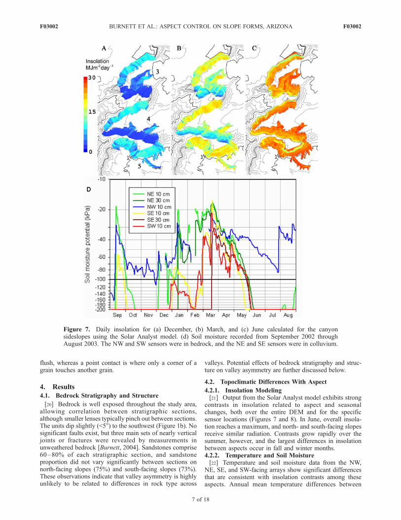
4.2.1. Insolation Modeling[21] Output from the Solar Analyst model exhibits strong
contrasts in insolation related to aspect and seasonalchanges, both over the entire DEM and for the specificsensor locations (Figures 7 and 8). In June, overall insola-tion reaches a maximum, and north- and south-facing slopesreceive similar radiation. Contrasts grow rapidly over thesummer, however, and the largest differences in insolationbetween aspects occur in fall and winter months.4.2.2. Temperature and Soil Moisture[22] Temperature and soil moisture data from the NW,
NE, SE, and SW-facing arrays show significant differencesthat are consistent with insolation contrasts among theseaspects. Annual mean temperature differences between
Figure 7. Daily insolation for (a) December, (b) March, and (c) June calculated for the canyonsideslopes using the Solar Analyst model. (d) Soil moisture recorded from September 2002 throughAugust 2003. The NW and SW sensors were in bedrock, and the NE and SE sensors were in colluvium.
F03002 BURNETT ET AL.: ASPECT CONTROL ON SLOPE FORMS, ARIZONA
7 of 18
F03002

paired sensors ranged from 1.4 to 5.6�C warmer at thesensors with southerly aspects (Table 1). Differences weregreatest at the subsurface temperature sensors and least inthe air sensors. Temperatures differences between north-and south-facing sensors are maximized with low sunangles in winter months, when daily mean temperatureswere as much as 8�C higher at the south-facing surface andsubsurface sensors (Figure 8b). Temperature differences arelower during the late spring and summer months, but south-facing aspects were still warmer over most of this period,and the subsurface sensors consistently remained about 4�Cwarmer. Temperature differences at the sensor locationsmimic differences in daily insolation at those locations(Figure 8b). The insolation model correlates best withsurface temperature differences between sensors on north-and south-facing slopes (Pearson r2 = 0.78, a < 0.05).[23] Average temperatures recorded in the field for the
year were 0.2�C cooler than at Canyon DeChelly NationalMonument but closely mimic temperature changes there[Burnett, 2004]. Temperatures were 1.1�C warmer than the30-year average at Canyon DeChelly, and 2003 was thewarmest on record at the time, with the most anomalousmonths being January, May, and July. At both Canyon
DeChelly and the field site, these months were all morethan 3.0�C warmer than the 30-year average.[24] Freeze-thaw cycles were calculated from each tem-
perature record using two algorithms. First, each day whenthe temperature dropped below freezing was counted. Airand surface temperatures experienced many such freeze-thaw cycles during the winter. Southwest aspects experi-enced the fewest cycles, otherwise differences betweenaspects are not obvious. Subsurface sensors at 10 cm depthin bedrock recorded 0�C temperatures in only a few cycles,on westerly aspects [Burnett, 2004]. Second, each time thetemperature dropped below �5.0�C and returned to above0.0�C was counted as a single cycle, as frost wedging ismost effective at �5.0 to �14.0�C [Walder and Hallet,1985]. About 9–27% of the air and surface cycles reached aminimum temperature of �5.0�C, but neither subsurfacetemperature sensor recorded a value that low [Burnett,2004].[25] The soil moisture data are not likely to represent
long-term average conditions, as precipitation for the yearof record was 164 mm at Canyon DeChelly, only 46% ofthe mean of 240 ± 84 mm. Nonetheless, seasonal soilmoisture changes and contrasts among aspects are quiteinstructive. Soil moisture remained relatively high fromJanuary through April (Figure 7d). Only the northwest-facing sensor, however, retained moisture from the winterthrough most of the summer. Large summer and fall rainevents (e.g., 29 July and 9 September) also had a profoundeffect on moisture over subsequent weeks. Soil moisturedifferences between north and south aspects are greatestduring the early summer and fall, before and after thesummer monsoonal period, and when temperatures are high.Although insolation differences between the SW and NWsensor sites are largest in winter, soil moisture differenceswere less pronounced, most likely because low temperaturesminimize evaporation and transpiration. Gaps in the north-facing records exist when the ground froze.[26] Many weathering processes are controlled by
changes in water content, which are greatest above�100 kPa [Brady and Weil, 2000]. The northwest-facingbedrock sensor experienced 14 wetting cycles of at least10 kPa in magnitude above �100 kPa, whereas the othersensors experienced 8 or fewer of these cycles. This soilmoisture sensor also recorded more than twice as many daysabove �100 kPa as any other sensor, and the south-facingsensors recorded the fewest. Overall, the soil moisture dataindicate large differences in moisture availability for near-surface weathering that are consistent with aspect-relateddifferences in insolation and temperature.
4.3. Slope Properties
4.3.1. DEM Slope Angles[27] The DEM covered 482,148 m2 and included 42,587
cells, with mean cell area 11.3 m2. Cells were classified infour groups corresponding to each cardinal direction, e.g.,
Figure 8. (a) Daily insolation for each month calculatedfor the facets that the four sensor arrays are installed on(labeled by aspect). (b) Average daily temperature andinsolation differences between the two sensor networks onweathered bedrock for each month (southwest-facing sensorminus northwest-facing sensor).
Table 1. Annual Mean Temperature Differencesa
Subsurface Surface Air
SE–NE . . . 3.2 2.1SW–NW 5.6 3.9 1.4
aGiven in �C.
F03002 BURNETT ET AL.: ASPECT CONTROL ON SLOPE FORMS, ARIZONA
8 of 18
F03002

east-facing aspects have azimuths between 46 and 135�. Inplaces where cliffs are observed in the field, the DEMtypically showed slopes in the 60–90� range. For thisanalysis, we defined cliffs as slopes of > 60� [Small andClark, 1982]. In order to enable comparisons between theDEM and facet data, and to normalize distributions, we firstexcluded cliffs from the statistical analysis of slope angles.The distribution of cliffs with aspect is also of obviousimportance, and is discussed later.[28] The DEM data populations are very large, and
although not strictly normal, Shapiro-Wilk coefficients arevery high (>0.98), so parametric T tests were used to assessdifferences in mean slope angle between aspects (Table 2).The differing area of individual cells due to slope angle isnot accounted for, but this effect is minimal when skewnessis low and high slope angles are removed. The mean angleof south-facing slopes is slightly (�1.4�) greater than onother aspects, and T tests indicated small but significantdifferences between aspects except between north-and east-facing slopes, which only differed by 0.2�.4.3.2. Facet Slope Angles[29] Slope angle distributions of slope facets measured in
the field are not normal for any of the four aspect classes.Removing outliers (defined as >2s from the mean, outsideof the 2.5–97.5 percentile range, or more than 8� from theremaining data) reduced standard deviation, kurtosis, andskewness values, so that Shapiro-Wilk coefficients indicatedthat all but the west-facing data could be used in parametrictests. Most outliers were high values from near the slope-cliff transition, likely influenced by cliff-forming processes.Means of north- and east-facing slope facet angles are notsignificantly different from each other, but both are signif-icantly steeper than the south-facing slopes (Table 3). Aswith mean slope facet angles, nonparametric Mann-WhitneyU test showed that median angles of north- and east-facingfacets are similar (Table 4). South- and west-facing facetsare also not significantly different from each other, but bothare significantly steeper than the north- and east-facingfacets.4.3.3. Comparison of DEM and Facet Slope Angles[30] Differences in the nature of the DEM and slope facet
data must be considered in interpretation. The DEM coversall valley sideslopes, and slope values are measured for alarge number of cells with known surface areas. By com-
parison, field definition of facets is somewhat subjective,and data populations are 2 orders of magnitude smaller.Nonetheless, direct field measurements of slope angle andaspect are more accurate than DEM data, and include small-scale features that are smoothed in the DEM. Statistics onslope facets are biased toward smaller, typically steeperslope areas, since these are more common than large,smooth slope areas.[31] Mean and median slope angles for the DEM were
lower than those for slope facets (Tables 2, 3, and 4). Thiscan be attributed to both smoothing in the DEM and the biasin facet data toward short, steep slopes. South- and west-facing slopes show larger disparities between angles fromthe two methods, so it is likely that these slopes have moreshort, steep facets. Slope facet data also exhibit a greaterdifference in angles between north- and south-facing slopes(about 3�), as compared to the DEM (1.3�) because thesesmaller-scale features are emphasized. West-facing slopeshave the greatest difference in slope angle between the twomethods. They are the steepest set of facets, but have thelowest angle by area in the DEM, where west-facing slopesare dominated by two large areas of relatively gentle slope.In contrast, most west-facing facets are small, steep gullywalls. In the DEM, only 54 of 113 gullies identified in thefield could be discerned, again illustrating the greateraccuracy of field observations.
Table 2. T Tests for Differences in Mean Slope Angles in the
DEMa
Mean (�) [n] West-Facing South-Facing East-Facing
Mean (�) [n] 26.6 [4009] 30.7 [13493] 29.2 [10361]North-facing 29.4 [12689] <0.01 <0.01 0.14East-facing 29.2 [10361] <0.01 <0.01South-facing 30.7 [13493] <0.01
aThe two-tailed p value for each test is shown. Significant results arebold.
Table 3. T Tests for Differences in Mean Slope Facet Anglesa
Mean South-Facing East-Facing
Mean 40.3� 35.6�North-facing 37.1� 0.01 0.18East-facing 35.6� <0.01
aThe two-tailed p value for each test is shown. Significant results arebold.
Table 4. Mann-Whitney U Tests for Differences in Median Slope
Facet Anglesa
Median West-Facing South-Facing East-Facing
Median 41� 39� 36�North-facing 37� <0.01 0.02 0.15East-facing 36� <0.01 <0.01South-facing 39� 0.23
aThe two-tailed p value for each test is shown. Significant results arebold.
Figure 9. Rose diagram of cliff proportion (vertical cliffarea divided by vertical slope area) with the mean vector(161�) and radial variance (32�).
F03002 BURNETT ET AL.: ASPECT CONTROL ON SLOPE FORMS, ARIZONA
9 of 18
F03002

4.3.4. Cliff Area and Aspect[32] The proportion of cliffs in the DEM varies dramat-
ically by aspect (Figure 9; Table 5). South-facing slopeshave nearly twice the mean cliff area for all aspects, whereasnorth-facing slopes have a very small proportion. East-facing slopes have a cliff proportion similar to the averagefor all aspects. Because the canyons drain east, west-facingcliffs are uncommon. Cliff proportion calculated using onlythe vertical component of DEM cell area also shows a muchgreater cliff area on south faces (Table 5). All proportionsare significantly different using a Z test for proportions.4.3.5. Slope Type[33] Slope type (unweathered bedrock, weathered bed-
rock, and colluvium) varies dramatically between differentaspect groups and measurement methods (Figure 10).South-facing slopes have the least weathered bedrock andthe most unweathered bedrock, whereas north-facing slopeshave the least unweathered bedrock. The DEM and facetdata agree for north- and east-facing slopes, but a largedisparity exists between the two methods for south- andwest-facing slopes. South- and west-facing facets have alarger proportion of unweathered bedrock, and less weath-ered bedrock and colluvium, than calculated for the sameaspects in the DEM. These differences are again consistentwith the observation that many west-facing facets are short,steep gully walls of unweathered bedrock not represented inthe DEM data.[34] The three slope types also have distinct slope angle
distributions calculated using the DEM. Weathered bedrockand colluvial slopes show similar slope angle distributions,except that weathered bedrock dominates the least steepslopes and has a mode slightly less than that for colluvialslopes (Figure 10c). Unweathered bedrock has a bimodaldistribution, where the higher mode represents steep, barebedrock slopes and cliffs. The lower mode is near the angleof repose, suggesting a former debris cover, but unweath-ered bedrock makes up very little of the gentler slopes(Figure 10c).[35] The distribution of colluvium on major gully walls
also varies by aspect (Figure 10d). Of 113 total, gully wallfacets with easterly aspects are more commonly mantled bycolluvium (n = 68) than are west-facing facets (n = 16); 29gullies had an even distribution of colluvium. All propor-tions were significantly different at a = 0.05 using a Z testfor proportions.
4.4. Bedrock Surface Strength and Physical Properties
[36] Low Shapiro-Wilk coefficients indicate that rockstrength distributions are not normal (Figure 11). Extreme
Table 5. Slope Surface Area and Calculated Vertical Area
Covered by Slopes and Cliffs
Area (m2)Vertical Area
Component (m2)
Slope CliffPercentCliff Slope Cliff
PercentCliff
All slopes 433176 48972 10 217771 45162 17North-facing 134402 1914 1.4 67007 1735 2.5East-facing 110687 11960 10 55229 10961 17South-facing 146294 34216 19 76350 31663 29West-facing 41793 882 2.1 19185 802 4.0
Figure 10. (a) Slope-type distribution for slope facet data.(b) Slope-type distributions calculated in the DEM. (c) Slopeangle distributions for the three slope types calculated usingthe DEM. (d) South-facing slope of basin 4 near the head ofthe canyon. Note that colluvium is more common onsoutheast-facing slopes (SE) and bedrock is exposed overmore of the southwest-facing slopes (SW).
F03002 BURNETT ET AL.: ASPECT CONTROL ON SLOPE FORMS, ARIZONA
10 of 18
F03002

high values are numerous (Figure 11) and typically repre-sent unweathered bedrock on steep facets transitional tocliffs. The nonparametric Mann-Whitney U test shows thatbedrock on north-facing slopes is similar to east-facingslopes, but is significantly weaker than on west- andsouth-facing slopes that have less moisture available forweathering. The difference between east- and west-facingslopes is not significant (Table 6).[37] Sandstone samples show weathering-related changes
that markedly reduce rock strength. The sandstones arelargely cemented by clay (2–11%) and to a lesser extentby hematite (1–3%). Correlations between rock strength,density, pore space, cement, matrix and average number ofgrain contacts show that as the sandstones weather, theybecome weaker, less dense, and less grain supported(Figure 12). The relationship between rock strength andbulk density is well modeled by a power law equation withSpearman r of 0.97 (Figure 12). Correlations between rockstrength and pore space are weaker but still significant. Nosignificant relationships were found between rock strengthand sand grain mineralogy or matrix content [Burnett,2004], however, suggesting that chemical weathering isinsignificant, at least in comparison with primary mineral-ogical variability. Morrison sandstone weathering appears toprimarily cause volumetric expansion, resulting in reduceddensity and grain contacts and an increase in pore space.
5. Discussion
[38] Greater weathering and lower rock strength onnortherly aspects is consistent with a strong control ofbedrock erosional resistance through hydration weathering,since northerly aspects have lower insolation and more soilmoisture retention. Accordingly, the proportion of cliff areais much higher and noncliff slopes are slightly steeper onsoutherly aspects, where weathering is reduced androck strength is greater. Topoclimatic differences and result-
ing slope characteristics are discussed below, and process-oriented models of slope evolution are discussed furtherbelow with emphasis on implications for long-term slopeevolution.
5.1. Topoclimatic Contrasts With Aspect
[39] Annual air temperatures on south-facing canyonslopes in the study area were 1.4–2.1�C warmer thannorth-facing slopes (Table 1), and differences in winterwere 2–3�C warmer (Figure 8). Modern vertical tempera-ture gradients in the southern Colorado Plateau are 5–6�C/1000 m [Stute et al., 1995], thus air temperature differencesamong aspects (Table 1) are roughly analogous to elevationdifferences of about 230–600 m. Paleoclimatic reconstruc-tions for the southern Colorado Plateau and adjacent areasindicate a 2–4�C range of mean annual temperatures in theHolocene, and late Pleistocene temperatures 4–6�C coolerthan present [Phillips et al., 1986; Cole, 1990; Davis andShafer, 1992; Anderson, 1993; Stute et al., 1995; Zhu et al.,1998]. Temperature differences between north- and south-facing slopes thus approach long-term differences in Holo-cene mean temperatures, but both analogies are limited. Forexample, precipitation generally increases with elevation,and late Quaternary climate changes are likely associatedwith precipitation changes as well. In contrast, topoclimateson opposing aspects have small precipitation differences,and temperature contrasts change dramatically over the
Figure 11. Distributions of bedrock strength data collected with a Schmidt hammer and grouped byaspect. Medians are marked by a horizontal bar within the boxes. Boxes extend from the lower quartile tothe upper quartile. The interquartile range (IQR) is the range between the upper and lower quartile.Whiskers extend through data within 1.5 IQRs of the median, and circles represent high strengthmeasurements that are more than 3 IQRs above the median.
Table 6. Mann-Whitney U Tests for Differences in Median
Young’s Modulusa
Median (GPa) West-Facing South-Facing East-Facing
Median (GPa) 0.16 2.36 0.04North-facing 0.01 0.01 <0.01 0.14East-facing 0.04 0.10 <0.01South-facing 2.36 <0.01
aThe two-tailed p value for each test is shown. Significant results arebold.
F03002 BURNETT ET AL.: ASPECT CONTROL ON SLOPE FORMS, ARIZONA
11 of 18
F03002

seasons. Numerical modeling of desert soils, however,implies that a temperature decrease of 4�C, with no precip-itation increase, significantly increases infiltration depth,leaching, and weathering rates [McFadden and Tinsley,1985].[40] Ultimately, soil moisture is likely the most important
aspect-influenced control on weathering and slope form inthe study area. Differences in field-measured moisturepotential are probably most related to differential evapo-transpiration driven by insolation and temperature [Kirkbyet al., 1990], as both latent heat transfer and evaporation areproportional to temperature and net radiation [Barry andChorley, 1998]. Lower soil moisture is observed on southaspects during the warm season except during brief periodsin the summer monsoon (Figure 7d). Evapotranspiration ishigher on south-facing slopes, as indicated by more rapiddrying after storm events and during the spring. In contrast,only the north-facing sensor on bedrock indicated a rela-tively high potential all year. Soil moisture potential ishighest in winter, but the contrasts between aspects aresmallest, even though insolation and temperature differ-ences between north- and south-facing slopes reach their
highest magnitude with low-angle winter sun. With lowertemperatures, winter evapotranspiration is generally lowerthan precipitation, and soil moisture increases on all slopes,reducing differences between north and south aspects.[41] Windward slopes experience greater precipitation
and evapotranspiration [Barry and Chorley, 1998], but thenet effect of wind on soil moisture in the study area isunknown. Prevailing winds indicated by Holocene eolianfeatures in northeast Arizona [Stokes and Breed, 1993] andnorthwest New Mexico [Wells et al., 1990] are southwest-erly. Wind direction during storms is much more variable. Itis not likely that wind-generated precipitation contrastsbetween north and south slopes are large, as the study areacanyons probably channel winds subparallel to both aspects.[42] Only a relative assessment of the effects of soil
moisture on slope vegetation can be made, as the permanentwilting point for plants is about �1500 kPa [Brady andWeil, 2000], well below the minimum potential resolved bythe field instruments (�200 kPa). Calculations of evapo-transpiration, potential evapotranspiration and water stressare also impossible without humidity data. Higher potentialat north-facing sensors implies less water stress, particularly
Figure 12. Correlations between Young’s modulus, bulk density, pore space, and grain contactsmeasured in nine Morrison formation sandstones.
F03002 BURNETT ET AL.: ASPECT CONTROL ON SLOPE FORMS, ARIZONA
12 of 18
F03002

during the summer, which likely allows for almost threetimes greater vegetation cover on north aspects than onsouth-facing slopes [Burnett, 2004].
5.2. Slope Processes and Asymmetry
[43] Excluding cliffs, the mean angle of south-facingslopes is statistically greater than north-facing slopes, butdifferences are quite small. Slope gradients range broadlyaround the angle of repose (Figure 5) and are controlledover substantial areas by the mobility of the cover ofweathered bedrock and colluvium. Many unweathered bed-rock slopes lie near the angle of repose as well (Figure 10c)and were probably covered by a weathered mantle orcolluvium in the recent past. Some unweathered bedrockslopes well exceed the angle of repose, however, and gradeinto cliffs, and gentle slopes exist on highly weatheredsandstone and shale. If the small aspect differences innoncliff slope angles between north and south slopes arereal, they probably relate to these weathering and bedrockstrength contrasts. The difference in cliff area betweennorth- and south-facing slopes, however, is very large(Table 5) and is the principal element of asymmetry withinthe canyons. Cliffs of 5–70 m height exist along the entirelength of south facing-slopes except at one place in westernbasin 5. In contrast, north-facing slopes have no cliffshigher than 1–2 m, except in narrow canyon heads.[44] Asymmetry in the study area canyons has similar
aspect relations to that in the South Dakota badlands onweak rocks [Churchill, 1982], and is most likely the resultof topoclimatically controlled weathering and erosion pro-cesses. Enhanced weathering and debris formation on north-facing slopes keeps slope angles lower by providing moreerodible surface material, rapidly reducing ledges, andminimizing the area of cohesive bedrock that can hold steepslopes. Bedrock on little-weathered south-facing slopes,however, is strong enough to hold cliffs at least 70 m high,and noncliff slopes are also slightly steeper on average.[45] In contrast, asymmetry documented elsewhere in the
western U.S. is often characterized by steeper north-facingslopes [Melton, 1960; Dohrenwend, 1978; Branson andShown, 1989; McMahon, 1998]. This pattern has beenattributed largely to greater vegetation density on moisternorth slopes that (1) reduces runoff through increasedrainfall interception, infiltration rates, and surface roughnessand (2) increases erosion resistance through root strength[Melton, 1960; Selby, 1993; Schmidt et al., 2001]. As inChurchill’s [1982] badlands study, however, vegetationcover in our study area is low even on north-facingslopes [Burnett, 2004], with limited effect on erosion bysurface runoff. Nevertheless, the greater vegetation cover onnorth-facing slopes may somewhat moderate slope angleasymmetry.[46] By itself, bedding within 10� of horizontal has
limited effect on slope stability [Selby, 1980, 1993], butgiven sapping processes, even slight inclination of a cap-rock unit may produce slope asymmetry with a steeper scarpslope facing away from the dip direction [Howard andSelby, 1994]. The slight southwesterly dip of the strata inour study area, however, would tend to favor cliffs on north-facing slopes, opposite of the pattern we document. Inaddition, asymmetry with steeper south faces exists whereonly the Morrison formation is present, and is also quite
apparent in basins 1 and 2 where the Dakota caprock iscompletely absent. Caprock cliffs in the study area may beeither Dakota or Morrison formation sandstones. Erosion ofthe weaker rocks below undermines cliffs [Howard andSelby, 1994], and cliff height in our study area is probablylargely a function of weathering and erosion rates on theunderlying slopes.[47] An aspect of asymmetry that is apparent but unquan-
tified is the greater development of stream drainages onnorth-facing slopes (Figure 2). This may result from thegreater area for surface runoff generation on slopes asopposed to cliffs, as well as greater erodibility of moreweathered north-facing slopes. Also, once a major cliffdevelops, focused headward erosion along a drainage islimited by the cliff face itself.
5.3. Morrison Formation Weathering
[48] Because slope processes in the study area changedramatically with weathering, we further consider weather-ing processes and effects. With progressive weathering ofMorrison formation sandstones, Young’s modulus and bulkdensity are reduced, and porosity increases. Strength reduc-tion probably results from both loss of cohesion in the claycements and reduced grain contact friction. Progressivereduction in bulk density requires mechanisms that expandthe pore spaces (Figure 12) and (or) isovolumetricallyremove mass without substantial compaction. There isno reduction in cement or matrix with weathering, but moreweathered samples are less grain supported, indicatingsignificant rock expansion [Burnett, 2004]. If mass islost by leaching, it is likely small and subordinate tophysical weathering by expansion. Frost action andthe swelling of clays are two processes that can causevolumetric expansion.[49] The specific processes involved in frost action are
poorly understood for soft, porous rocks. Frost action inmost bedrock requires temperatures of �5�C and �10�Cand moisture conditions near saturation [Walder and Hallet,1985; Matsuoka, 1990], but strain experiments [Matsuoka,1988] in porous rocks indicated that most expansion occursbetween 0 and �5�C. Winter surface temperatures in thestudy area often fell below freezing, and frost heave hasbeen observed in the upper 1 cm of slope debris, buttemperatures at 10 cm depth in weathered bedrock rarelycooled below 0�C and never reached �5�C, even with a1–2�C correction for warmer than average temperatures inwinter 2002–2003. The bedrock never reached saturation(>�10 kPa), but was relatively moist (>�100 kPa) on northfaces all winter and on south faces March through May(Figure 7d). Soil moisture in colluvium also decreased withdepth (Figure 7d), implying that frost action could not beresponsible for producing >30 cm thick weathered mantleson bedrock. Temperature and moisture conditions are unfa-vorable for frost action below a few centimeters depth, butcould accelerate breakdown of near-surface materials.[50] In contrast, Schumm and Chorley [1966] inferred
that frost action was the most important weathering processcausing disintegration of sandstone talus on the ColoradoPlateau. They measured mass loss of boulders exposed tonatural weather augmented by simulated rainfall over�1.5 year in Denver, Colorado. The most mass loss perunit precipitation occurred with freeze-thaw cycles, but with
F03002 BURNETT ET AL.: ASPECT CONTROL ON SLOPE FORMS, ARIZONA
13 of 18
F03002

reduced evaporation in winter, hydration would also beenhanced. Also, since precipitation was artificially doubled,the rocks were more likely near saturation during freeze-thaw cycles. The most rapid weathering occurred when80 mm of simulated rainfall was applied during midwinter,and when the rocks were buried in intermittently meltingsnow. These are not common conditions in our study area,and in particular, saturated conditions are unlikely onmoderate to steep bedrock slopes and cliffs. Frost actionis probably most effective in talus weathering in our studyarea, consistent with Schumm and Chorley’s [1966] obser-vations and experimental design.[51] Swelling of smectite clays within the sandstones has
been suggested as the primary weathering mechanism in theMorrison formation [Tillery, 2003] and in other clay-richsandstones [Vicente, 1983]. X-ray diffraction analysis ofMorrison sandstones reveals that the major clays are smec-tite and kaolinite [Tillery, 2003]. Swelling of smectites isdirectly related to the mass water content in soils [Fu et al.,1990; Cygan, 2002]. Since volumetric and mass watercontents in sandy materials change only slightly below�100 kPa [Brady and Weil, 2000], we assume that onlyfluctuations in moisture potential above this limit areimportant for smectite hydration. The period over whichsoil moisture potential is above �100 kPa or the number ofwetting cycles recorded provide estimates of weatheringpotential, and both measures suggest that potential clayexpansion on north-facing slopes is twice that of south-facing slopes [Burnett, 2004]. The moisture on north-facingslopes is also more likely to reach greater depths andproduce thick weathered mantles.[52] Clay expansion is also likely to be the dominant
weathering process in shale units of the Morrison, Dakota,and Mancos formations. Weathered surfaces on these unitsexhibit ‘‘popcorn’’ morphology attributed to cycles of clayhydration [e.g., Churchill, 1982]. Shattered pieces of well-cemented Dakota sandstone comprise most of the coarsematerial in colluvium, showing that they weather muchmore slowly than Morrison formation sandstones.
5.4. Slope Processes and Implications for LandscapeEvolution
[53] Repeat ground-based LiDAR measurements in thestudy area have shown that prolonged, intense precipitationcauses significant erosion of the weathered sandstone man-tle and some debris slopes [Wawrzyniec et al., 2007]. Theimportance of heavy rainfall in stripping weathered materialis supported by soil and dendrogeomorphic data in the study
area that indicate rapid erosion in major storms followingprolonged droughts [McAuliffe et al., 2006]. Once bedrockis exposed (e.g., Figure 3), surface runoff increases dramat-ically. These observations imply that two major positivefeedbacks exist between weathering, erosion, infiltrationand runoff on the Morrison formation (Figure 13). Infeedback 1, increased soil moisture enhances productionof a weathered mantle. This weathered bedrock increasessoil moisture infiltration and retention that accelerateshydration weathering, and maintains or expands the mantle[cf. Wahrhaftig, 1965]. Feedback 1 is directly linked toevapotranspiration differences driven by topoclimatic con-trasts in insolation and temperature and is largely responsi-ble for the differences in weathering and rock strengthobserved on north- and south-facing slopes. Feedback 1enhances weathering on moist north-facing slopes andincreases erodibility, but reduces surface runoff, the primaryagent of slope erosion.[54] A second positive feedback (Figure 13) helps prevent
development of a weathered mantle on unweathered bed-rock. High runoff generation on unweathered slopes stripsaway weathered material below, maintaining or expandingthe area of unweathered bedrock (Figure 3). Feedback 2 hasthe greatest effect where a drier topoclimate hinders weath-ering, and is negated where a thick weathered mantle limitsrunoff. The two feedbacks push slope evolution toward twoend-member geomorphic expressions for this sandstonebedrock: (1) a transport-limited slope mantled by 10 to30 cm of disintegrated bedrock and (2) an unweathered,sediment-limited bedrock slope. The observed behavior ofthis overall slope system is similar to that proposed byGilbert [1877, p. 97], where presence of a soil mantlepromotes water retention and further weathering (althoughweathering is thought to slow with increasing thickness);but where the mantle is stripped, weathering is negated. Thesystem may thus be approximated by a ‘‘humped’’ curve ofsoil production rate as a function of soil depth, where themaximum production rate (by weathering) exists at somenonzero soil depth, and declines with either increasing ordecreasing depth [Carson and Kirkby, 1972; Ahnert, 1976].This system contrasts with models of exponentially declin-ing soil production rate with soil depth proposed for morecontinuously soil-mantled landscapes, where the productionrate is maximum at zero soil depth [e.g., Heimsath et al.,1997].[55] The prevalence of south-facing cliffs implies that
steepening of drier bedrock slopes ultimately proceeds to amass failure-dominated system. Slab failures and topplestypically result from slope erosion removing support fromcliff bases, where overburden stress is highest [Selby, 1982].Runoff from cliffs may also promote slab failures byenhancing hydration weathering and erosion of the slopesnear the base of a cliff, causing undercutting. Erosionprocesses therefore differ markedly with aspect. Neitherfeedback directly implies that long-term erosion rates aredifferent with aspect, but if cliff retreat rate is controlledmainly by the rate of undermining by slope erosion below,then south-facing canyon walls may erode more slowly.[56] The potential for gully incision and erosion is also
enhanced by bedrock weathering, but buildup of coarsedebris in channels inhibits flow and sediment transport, andarmoring can lead to enhanced lateral erosion and channel
Figure 13. Feedbacks between the weathered mantle andthe (a) soil moisture and (b) runoff systems. Arrow linksindicate a positive relationship between the two elementsjoined, and a links that end in dots indicate a negativerelationship between the elements.
F03002 BURNETT ET AL.: ASPECT CONTROL ON SLOPE FORMS, ARIZONA
14 of 18
F03002

migration [Bryan, 1940; Mills, 1981; Twidale andCampbell, 1986]. East-facing gully sideslopes are gentlerand more often debris covered than opposing west-facingsideslopes (Table 3, Figure 10). Material from the eastsideslopes armors that channel wall, forcing undercuttingof the less protected west-facing wall, resulting in a steepersideslopes with more exposed bedrock, and eastward gullymigration. This also undercuts any colluvial mantle on theadjacent east-facing slope, but the west-facing wall is toosteep to maintain a debris cover, so that colluvium adds tothe armor. Small debris flows are also common, and theirdeposits may have aided the armoring process in somegullies. These self-reinforcing processes produce short,steep bedrock slopes that are most common in the west-facing facet data.[57] Cliff formation and destruction processes are clearly
key in interpreting long-term landscape evolution in thesecanyons. Cliffs appear to begin as either steep unweatheredMorrison slickrock slopes (Figure 3b) or as small resistantledges in the Dakota formation. Where headward gullyerosion or slopewash exceeds weathering on Morrisonformation slopes, progressively stronger bedrock is exposed(Figure 14a, line a). Under low soil moisture, the upperslopes remain unweathered and become steeper, as theyerode more slowly than the slopes below that receive runoff(Figure 14a, line b). The unweathered slopes expand later-ally and vertically until failure occurs along tectonic orslope parallel unloading fractures (Figure 14a, line c).Where weathering exceeds erosion, steep slickrock slopesrequired for cliff initiation in the Morrison formation cannotform. Cliff initiation also occurs where Dakota or upperMorrison formation sandstones behave as erosion resistant
caprocks. Slopes below the caprock continue to erode,leaving a cliff below the resistant unit until overburdenstresses cause the weaker lower unit to fail [Koons, 1955].Both of these processes are diminished on north-facing slopes that generally have enhanced moisture andweathering.[58] Conversion of slopes to cliffs is rarely discussed in
landscape evolution models, but is commonly apparent onsouth-facing slopes in these canyons. The slope-cliff tran-sition is wavy and rarely follows lithologic contacts; con-tinuous rock units pass laterally from cliff to slope and backto cliff (Figure 4). Depressions in the slope-cliff transitionoccur where erosion is enhanced by tributaries that drainover the canyon rim and by runoff from steep bedrockslopes (Figure 4). The contact is also depressed near theeastern mesa points, where two major cliffs intersect. Theslope-cliff transition is thus controlled by weathering anderosion rather than by stratigraphy[59] Once initiated, cliffs may expand downward by slope
erosion combined with relative stability of the near-verticalface. Slab failure along stress fractures parallel to the clifffree face also facilitates rapid conversion of bedrock slopesto cliffs. Cliff parallel fractures were observed mostly inslopes below higher cliffs or those aligned with the maintectonic fracture set. The fractures also extend into bedrockbelow cliffs (Figures 3c and 14d) and aid infiltration,weathering and erosion of cliff-fronting slopes.[60] On north-facing slopes, cliff reduction processes
have clearly dominated. Enhanced weathering and debrisaccumulation on slopes below cliffs leads to a reduction incliff height (Figure 14c), similar to classic slope decline andreplacement models [Davis, 1899; Penck, 1924]. A persis-
Figure 14. Cliff initiation from a slope. (a) Headward gully erosion produces a steep, unweatheredupper slope (dotted lines a and b), which is ultimately undercut and fails along a nearly vertical fractureproducing a cliff (line c). This process will continue and extend the existing cliff. (b) Where unweatheredbedrock slopes are not extensive and not long-lived, slope parallel retreat occurs with only small ledgesforming where resistant units (shaded area), typically Dakota Sandstones, outcrop. (c) Cliff reduction canoccur where high weathering and sediment production rates on the cliff and upper slope reduce retreatrates of the lower slopes. (d) Cliff expansion is also aided where near-vertical unloading joints or tectonicfractures (dashed lines) facilitate slope weathering and provide a vertical erosional contact.
F03002 BURNETT ET AL.: ASPECT CONTROL ON SLOPE FORMS, ARIZONA
15 of 18
F03002

tent weathered mantle or debris cover on moister north-facing slopes retards slope retreat and cliff expansion,instead promoting upward extension of the slope. Thedebris mantle shed from retreating Dakota sandstone cap-rock is unlikely to be the primary factor controlling long-term slope erosion, as present debris covers are thin mobilelayers, and relict talus slopes or ‘‘flatirons’’ [Howard andSelby, 1994] are not present. Cliffs in the study area are notobserved to buried by basal debris. Thus, valley asymmetryis largely a reflection of the net relative effectiveness ofinitiation, growth and reduction processes of cliffs, largelycontrolled by bedrock weathering and erosional processeson subjacent north- versus south-facing slopes. Moderntopoclimatic contrasts are sufficient to place north- andsouth-facing slopes in different modes of development.Under modern and Holocene climates, cliff expansion hasclearly been dominant on south-facing slopes, but north-facing slopes show more diversity, and some evidence forcliff initiation, growth and decline can be locally observedon slopes of all aspects at present.[61] Although strongly suggestive, modern monitoring
data cannot directly indicate whether topoclimatic differ-ences were effective over timescales sufficient for slopeevolution, under very different, pre-Holocene climates.Estimated slope retreat rates in the study area based ondendrogeomorphic analyses [McAuliffe et al., 2006] andcosmogenic nuclide accumulation in Jurassic sandstoneconcretions [McFadden et al., 2005] are similar at a fewmm per year, despite 10–102 and 103 year measurementtimescales, respectively. Perhaps coincidentally, retreat ratesover 107 year based on assumed post-Laramide initialescarpment positions are also a few mm per year [Schmidt,1989]. These data suggest that major changes in slopemorphology could occur over 104–105 years in the middleto late Quaternary.[62] Although Pleistocene climates were not uniformly
wetter than present, episodes of greater effective moisturemay have favored cliff reduction and debris slope processes,with very little cliff area on north aspects. It is possible thatat times in the Quaternary, cliffs were mostly erased fromthese canyons, with slopes covered by continuous debrisblankets, as inferred on other Colorado Plateau escarpments[Howard and Selby, 1994], but no field evidence exists totest this. Modern debris slopes appear to be largely relictlate Pleistocene features that are degrading, particularly onsouth-facing slopes where backwasting of the escarpmentappears minimal at present. While some smaller south-facing cliffs may have formed entirely within the Holocene,many are too high for this to be the case given estimatedrates of slope retreat and cliff formation. For example,cliffs in the eastern study area are up to 70 m tall, whichrequires an unlikely combination of vertical slope loweringof 7 mm a�1 (where a is years) and a virtually noneroding,downward-extending cliff, if restricted to the Holocene.Even faster slope lowering is necessary if some cliff retreatis allowed. Thus, some net growth likely occurred on thosecliffs within the late Pleistocene.
6. Conclusions
[63] Topographically induced microclimate has had aprofound effect on weathering, erosion and slope evolution
in canyons cut in the Morrison and Dakota formations innortheastern Arizona. Bedrock stratigraphy places animportant but not overriding control on slope morphology.Aspect very strongly influences slope and cliff processesthrough differences in soil moisture, which plays a keyrole in weathering of Morrison formation sandstones.The predominantly smectite clay cement in these rocks[Tillery, 2003] undergoes hydration expansion weathering(Figure 12). Feedbacks between moisture, weatheredmantle, and infiltration (Figure 13) enhance aspect-relateddifferences in process and lead to major differences inerodibility of bedrock exposed opposing slopes (Figure 10).South-facing slopes receive more insolation (Figure 7) yield-ing generally warmer and drier conditions, and are only moistfor a few months in the winter when evapotranspiration islowest and after the snowmelt episodes in spring (Figure 7d).In contrast, the wetter north-facing bedrock slopes holdsufficient moisture to allow weathering throughout the year.Although greater plant cover on north aspects retards erosionand maintains steeper slopes in more densely vegetated areasof the western U.S. [Melton, 1960; Branson and Shown,1989;McMahon et al., 1996;McMahon, 1998], in our studyarea rock resistance has a greater influence, making lessweathered noncliff slopes slightly steeper and promotingmuch greater cliff area on south aspects (Figure 9).[64] Cliff initiation and expansion require exposures of
unweathered bedrock at the surface and enhanced erosioncaused by headward gully expansion, concentration ofrunoff from slickrock slopes, or run-on from slopes abovethe canyon. The high weathering rates on north-facingslopes inhibit cliff formation by preventing precursorunweathered slickrock slopes from forming. The smallledges and cliffs (<3 m) that are common on north-facingslopes, however, are potentially the result of warm, dryclimates in the Holocene, given slope and scarp retreat ratesof a few mm per year [Schmidt, 1989; McFadden et al.,2005; McAuliffe et al., 2006]. High cliffs (10–70 m) onsouth-facing slopes indicate that cliff expansion has beenthe dominant mode throughout at least the Holocene andlatest Pleistocene. With wetter climatic episodes in the latePleistocene, cliff formation would be lessened on mostslopes, and cliff reduction or elimination would have likelyoccurred on north-facing slopes. Overall, aspect-relatedcontrols on slope evolution have played out in the contextof long-term relief generation, escarpment retreat, andclimatic change on the Colorado Plateau.
[65] Acknowledgments. We especially thank the Navajo Nation forpermitting our work on their lands. This study was greatly enhanced bydiscussions with Dave Gutzler, Louis Scuderi, and Ann Tillery. BethanyBurnett gave invaluable advice, editing, and field assistance. We also thankKelin Whipple and Alan Howard for their insightful comments and edits.Funding was provided by the GSA Gladys Cole Memorial Research Grantto Grant Meyer, NSF grant MMIA 9909140 to Louis Scuderi, and the UNMEarth and Planetary Sciences Department including the Jean-Luc MiossecMemorial Scholarship.
ReferencesAhnert, F. (1976), Brief description of a comprehensive three-dimensionalprocess-response model of landform development, Z. Geomorphol.Suppl., 25, 29–49.
Anderson, O. J., and S. J. Lucas (1994), Middle Jurassic stratigraphy,sedimentation and paleogeography in the southern Colorado plateauand southern High Plains, in Mesozoic Systems of the Rocky Mountain
F03002 BURNETT ET AL.: ASPECT CONTROL ON SLOPE FORMS, ARIZONA
16 of 18
F03002

Region, USA, edited by M. V. Caputo, J. A. Peterson, and K. J. Franczyk,pp. 299–314, Soc. Sediment. Geol., Denver, Colo.
Anderson, O. J., and S. J. Lucas (1997), The Upper Jurassic Morrisonformation in the Four Corners region: Mesozoic geology and paleontologyof the Four Corners region, paper presented at 48th Annual FieldConference, N. M. Geol. Soc., Albuquerque, N. M.
Anderson, R. S. (1993), A 35,000 year vegetation and climate history fromPotato Lake, Mogollon Rim, Arizona, Quat. Res., 40, 351 – 359,doi:10.1006/qres.1993.1088.
Barry, R. G., and R. J. Chorley (1998), Atmosphere, Weather and Climate,409 pp., Routledge, New York.
Brady, N. C., and R. R. Weil (2000), Elements of the Nature and Propertiesof Soils, 606 pp., Prentice-Hall, Upper Saddle River, N. J.
Branson, F. A., and L. M. Shown (1989), Contrasts of vegetation, soilsmicroclimates, and geomorphic processes between north- and south-facing slopes on Green Mountain near Denver, Colorado, U.S. Geol.Surv. Water Resour. Invest. Rep., 89-4094.
Bryan, K. (1940), Gully gravure—A method of slope retreat, J. Geomor-phology, 3, 89–106.
Bull, W. B. (1991), Geomorphic Responses to Climate Change, 326 pp.,Oxford Univ. Press, New York.
Burnett, B. N. (2004), Aspect and microclimatic influences on hillslopegeomorphology, northeastern Arizona, M.S. thesis, 85 pp., Univ. ofN. M., Albuquerque, N. M.
Carson, M. A., and M. J. Kirkby (1972), Hillslope Form and Process,475 pp., Cambridge Univ. Press, Cambridge, U. K.
Churchill, R. R. (1981), Aspect-related differences in badlands slopemorphology, Ann. Assoc. Am. Geogr., 71, 374–388.
Churchill, R. R. (1982), Aspect-induced differences in hillslope processes,Earth Surf. Processes Landforms, 7 , 171 – 182, doi:10.1002/esp.3290070209.
Cochran, A., J. M. Ajdukiewicz, M. J. Klosterman, F. C. Lin, S. T. Paxton,and J. O. Szabo (1986), Standardized Point-Count Classification andProcedures for Sandstone Petrology, Exxon Prod. Res.Co., Houston, Tex.
Cole, K. L. (1990), Reconstruction of past desert vegetation alongthe Colorado River using packrat middens, Paleogeog. Paleoclim.Paleoecol., 76, 349–366, doi:10.1016/0031-0182(90)90120-V.
Cygan, R. T. (2002), Interactions of biomolecules with clay minerals, inLinking the Geosciences to Emerging Biological-EngineeringTechnologies, edited by R. T. Cygan, C. K. Ho, and C. J. Weiss, Rep.SAND2002-3690, pp. 10–24, Sandia Natl. Lab., Albuquerque, N. M.
Davis, O. K., and D. S. Shafer (1992), A Holocene climatic record for theSonoran Desert from pollen analysis of Montezuma Well, Arizona, USA,Paleogeog. Paleoclim. Paleoecol., 92, 107–119, doi:10.1016/0031-0182(92)90137-T.
Davis, W. M. (1899), The peneplain, Am. Geol., 23, 207–239.Dohrenwend, J. C. (1978), Systematic valley asymmetry in the centralCalifornia Coast Ranges, Geol. Soc. Am. Bull., 89, 891 – 900,doi:10.1130/0016-7606(1978)89<891:SVAITC>2.0.CO;2.
Franczyk, K. J. (1988), Stratigraphic revision and depositionalenvironments of the Upper Cretaceous Toreva formation in the northernBlack Mesa area, Navajo and Apache counties, Arizona, U.S. Geol. Surv.Bull., 1685, 1–32.
Fu, M. H., Z. Z. Zhang, and P. F. Low (1990), Changes in the properties ofa montmorillonite-water system during the adsorption and desorption ofwater: Hysteresis, Clays Clay Miner., 38, 485 – 492, doi:10.1346/CCMN.1990.0380504.
Fu, P., and P. M. Rich (2000), The Solar Analyst 1.0 User Manual, 48 pp.,Helios Environ. Model. Inst., Lawerence, Kans. (Available at http://www.fs.fed.us/informs/solaranalyst/solar_analyst_users_guide.pdf)
Gao, J. (1997), Resolution and accuracy of terrain representation by gridDEMs at a micro-scale, Int. Geogr. Inf. Sci., 11, 199–212, doi:10.1080/136588197242464.
Gilbert, G. K. (1877), Report on the Geology of the Henry Mountains, U.S.Geol. Surv., Washington, D. C.
Graf, W., R. Hereford, J. E. Laity, and R. A. Young (1987), The Coloradoplateau, in Geomorphic Systems of North America, vol. 2, edited byW. Graf, pp. 259–302, Geol. Soc. of Am., Boulder, Colo.
Heimsath, A. M., W. E. Dietrich, K. Nishiizumi, and R. C. Finkel (1997),The soil production function and landscape equilibrium, Nature, 388,358–361, doi:10.1038/41056.
Howard, A. D., and M. J. Selby (1994), Rockslopes, in Geomorphology ofDesert Environments, edited by A. D. Abrahams and A. J. Parsons,pp. 123–172, Chapman and Hall, London.
Howard, A. D., R. C. Kochel, and H. E. Holt (1988), Sapping Features ofthe Colorado Plateau: A Comparative Planetary Geology Field Guide,108 pp., NASA, Washington, D. C.
Hucka, V. (1965), A rapid method of determining the strength of rocks insitu, Int. J. Rock Mech. Min. Sci., 2, 127 –134, doi:10.1016/0148-9062(65)90009-4.
Katz, O., Z. Reches, and J. C. Roegiers (2000), Evaluation of mechanicalrock properties using a Schmidt Hammer, Int. J. Rock Mech. Min. Sci.,37, 723–728, doi:10.1016/S1365-1609(00)00004-6.
Kennedy, B. A. (1976), Valley-side slopes and climate, in Geomorphologyand Climate, edited by E. Derbyshire, pp. 171 –201, John Wiley,New York.
Kirkby, M. J., K. Atkinson, and J. G. Lockwood (1990), Aspect, vegetationcover, and erosion on semi-arid hillslopes, in Vegetation and Erosion,edited by J. B. Thornes, pp. 25–39, John Wiley, New York.
Koons, D. (1955), Cliff retreat in the southwestern United States, Am.J. Sci., 253, 44–52.
Matsuoka, N. (1988), Laboratory experiments on frost shattering of rocks,Sci. Rep. Inst.Geosci. Univ. Tsukuba Sec. A, 9, 1–36.
Matsuoka, N. (1990), The rate of bedrock weathering by frost action: Fieldmeasurements and a predictive model, Earth Surf. Processes Landforms,15, 73–90, doi:10.1002/esp.3290150108.
McAuliffe, J. R., L. Scuderi, and L. D. McFadden (2006), Tree-ring recordof hillslope erosion and valley floor dynamics: Landscape responses toclimate variation during the last 400 years in the Colorado plateau, north-eastern Arizona, Global Planet. Change, 50, 184–201, doi:10.1016/j.gloplacha.2005.12.003.
McFadden, L. D., and J. R. McAuliffe (1997), Lithologically influencedgeomorphic responses to Holocene climatic changes in the SouthernColorado plateau, Arizona: A soil-geomorphic and ecologic perspective,Geomorphology, 19, 303–332, doi:10.1016/S0169-555X(97)00017-2.
McFadden, L. D., and J. C. Tinsley (1985), The rate and depth of accumu-lation of pedogenic carbonate accumulation in soils: Formulation andtesting of a compartment model, in Soils and Quaternary Geology ofthe Southwestern United States, Geol. Soc. Am. Spec. Pap., vol. 203,edited by D. L. Weide and M. L. Faber, pp. 23–42, Geol. Soc. Am.,Boulder, Colo.
McFadden, L. D., J. Gosse, J. R. McAuliffe, L. Scuderi, G. Meyer, andB. N. Burnett (2005), Determination of hillslope erosion rates during thelate Holocene based on cosmogenic surface age dating of hoodoos, north-eastern Arizona, Geol. Soc. Am. Abstr. Programs, 37(7), 232.
McMahon, D. R. (1998), Soil, landscape and vegetation interactions in a smallsemi-arid drainage basin: Sevilleta National Wildlife Refuge, New Mexico,M.S. thesis, 174 pp., N. M. Inst. of Min. and Technol., Socorro, N. M.
McMahon, D. R., J. B. J. Harrison, J. M. H. Hendrickx, and E. Muldavin(1996), Microclimatic controls on soil formation across opposite-lyinghillslopes in a semi-arid drainage basin in central New Mexico, Geol.Soc. Am. Abstr. Programs, 28(7), 111.
Melton, M. A. (1960), Intravalley variation in slope angles related tomicroclimate and erosional environment, Geol. Soc. Am. Bull., 71,133–144, doi:10.1130/0016-7606(1960)71[133:IVISAR]2.0.CO;2.
Mills, H. H. (1981), Boulder deposits and the retreat of mountain slopes, or,‘‘gully gravure’’ revisited, J. Geol., 89, 649–660.
Naylor, S., and E. J. Gabet (2007), Valley asymmetry and glacial versusnonglacial erosion in the Bitterroot Range, Montana, USA, Geology, 35,375–378, doi:10.1130/G23283A.1.
Penck, W. (1924), Die Morphologishe Analyse: Ein Kapitel derPhysicalischen Geologie, Geogr. Abh. Reihe, vol. 2, Engelhorn, Stuttgart,Germany.
Pettijohn, F. J., P. E. Potter, and R. Siever (1973), Sand and Sandstone,553 pp., Springer-Verlag, Berlin.
Phillips, F. M., L. A. Peeters, M. K. Tansey, and S. N. Davis (1986),Paleoclimatic inferences from an isotopic investigation of groundwaterin the central San Juan basin, New Mexico, Quat. Res., 26(2), 179–193,doi:10.1016/0033-5894(86)90103-1.
Schmidt, K. H. (1989), The significance of scarp retreat for Cenozoic land-form evolution on the Colorado plateau, USA, Earth Surf. ProcessesLandforms, 14, 93–105, doi:10.1002/esp.3290140202.
Schmidt, K.M., J. J. Roering, J. D. Stock,W. E. Dietrich, D. R.Montgomery,and T. Schaub (2001), The variability of root cohesion as an influence onshallow landslide susceptibility in the Oregon Coast Range,Can. Geotech.J., 38, 995–1024, doi:10.1139/cgj-38-5-995.
Schumm, S. A., and R. J. Chorley (1966), Talus weathering and scarprecession in the Colorado plateaus, Z. Geomorphol., 10, 11–36.
Selby, M. J. (1980), A rock mass strength classification for geomorphicpurposes: With tests from Antarctica and New Zealand, Z. Geomorphol.,24(1), 31–51.
Selby, M. J. (1982), Controls on the stability and inclinations of hillslopesformed on hard rock, Earth Surf. Processes Landforms, 7, 449–467,doi:10.1002/esp.3290070506.
Selby, M. J. (1993), Hillslope Materials and Processes, 480 pp., OxfordUniv. Press, Oxford, UK.
Sjoberg, R., and N. Broadbent (1991), Measurement and calibration ofweathering, using the Schmidt hammer, on wave washed moraines onthe upper Norrland coast, Sweden, Earth Surf. Processes Landforms, 16,57–64, doi:10.1002/esp.3290160107.
F03002 BURNETT ET AL.: ASPECT CONTROL ON SLOPE FORMS, ARIZONA
17 of 18
F03002

Small, R. J., and M. J. Clark (1982), Slopes and Weathering, 112 pp.,Cambridge Univ. Press, Cambridge, UK.
Stokes, S., and C. S. Breed (1993), A chronostratigraphic re-evaluation ofthe Tusayan Dunes, Moenkopi plateau and southern Ward Terrace,Northeastern Arizona, in The Dynamics and Environmental Context ofAeolian Sedimentary Systems, Geol. Soc. Am. Spec. Publ., vol. 72, editedby K. Pye, pp. 75–90, Geol. Soc. Am., Boulder, Colo.
Stute, M., J. F. Clark, P. Schlosser, and W. S. Broecker (1995), A 30,000 yrcontinental paleotemperature record derived from noble gasses dissolvedin groundwater from the San Juan basin, New Mexico, Quat. Res., 43,209–220, doi:10.1006/qres.1995.1021.
Thornthwaite, C. W. (1961), The task ahead, Ann. Assoc. Am. Geogr., 51,345–356, doi:10.1111/j.1467-8306.1961.tb00385.x.
Tillery, A., P. Fawcett, L. McFadden, L. Scuderi, and J. McAuliffe (2003),Late Holocene behavior of small drainage basins on the Coloradoplateau: Influences of lithology, basin form, and climate change, inGeology of the Zuni Plateau, edited by S. Lucas et al., pp. 197–207,N. M. Geol. Soc., Socorro, N. M.
Tillery, A. C. (2003), Late Holocene behavior of small basins on theColorado plateau near Blue Gap, Arizona: Lithologic, morphometricand climatic influences, M.S. thesis, 173 pp., Univ. of N. M.,Albuquerque, N. M.
Twidale, C. R., and E. M. Campbell (1986), Localized inversion on steephillslopes: Gully gravure in weak and resistant rocks, Z. Geomorphol.,30, 35–46.
Vicente, M. A. (1983), Clay mineralogy as the key factor in weathering of‘‘Arenisca dorada’’ (Golden Sandstone) of Salamanca, Spain, ClayMiner., 18, 215–217, doi:10.1180/claymin.1983.018.2.11.
Wahrhaftig, C. (1965), Stepped topography of the southern Sierra Nevada,California, Geol. Soc. Am. Bull., 76, 1165–1190, doi:10.1130/0016-7606(1965)76[1165:STOTSS]2.0.CO;2.
Walder, J., and B. Hallet (1985), A theoretical model of the fracture of rockduring freezing, Geol. Soc. Am. Bull., 96, 336–346, doi:10.1130/0016-7606(1985)96<336:ATMOTF>2.0.CO;2.
Wawrzyniec, T. F., L. D. McFadden, A. Ellwein, G. A. Meyer, L. Scuderi,J. McAuliffe, and P. Fawcett (2007), Chronotopographic analysis directlyfrom point cloud data: A method for detecting small, seasonal hillslopechange, Black Mesa escarpment, NE Arizona, Geosphere, 3, 550–567,doi:10.1130/GES00110.1.
Webster, S. L., R. H. Grau, and T. P. Williams (1992), Description andApplication of Dual Mass Dynamic Cone Penetrometer, U.S. Army Corpsof Eng., Vicksburg, Miss.
Wells, S. G., L. D. McFadden, and J. D. Schultz (1990), Eolian landscapeevolution and soil formation in the Chaco dune field, southern Coloradoplateau, New Mexico, Geomorphology, 3, 517–546, doi:10.1016/0169-555X(90)90019-M.
Wilson, L. (1968), Asymmetric valleys, in The Encyclopedia of Geomor-phology, edited by R. W. Fairbridge, pp. 30–33, Reinhold, New York.
Zhu, C., R. K. Waddell, I. Star, and M. Ostrander (1998), Responses ofground water in the Black Mesa basin, northeastern Arizona, to paleocli-matic changes during the late Pleistocene and Holocene, Geology, 26,127–130, doi:10.1130/0091-7613(1998)026<0127:ROGWIT>2.3.CO;2.
�����������������������B. N. Burnett, L. D. McFadden, and G. A. Meyer, Department of Earth
and Planetary Sciences, University of New Mexico, Albuquerque, NM87131, USA. ([email protected]; [email protected]; [email protected])
F03002 BURNETT ET AL.: ASPECT CONTROL ON SLOPE FORMS, ARIZONA
18 of 18
F03002