ariadne: extended crm
TRANSCRIPT
D14.1: Extended CRM
Authors: Martin Doerr, FORTHMaria Theodoridou, FORTH
Ariadne is funded by the European Commission’s 7th Framework Programme.
ARIADNED14.1(Public)
Version:1.0(final) 14thApril2016
Authors: MartinDoerr,FORTH
MariaTheodoridou,FORTH
Contributingpartners: Paola Ronzino, PIN
Achille Feliccetti, PIN
Edeltraud Aspöck, OEAW
Sara di Giorgio, MIBAC-ICCU
Philipp Gerth, DAI
Carlo Meghini, CNR-ISTI
Nicola Aloia, CNR-ISTI
Paola Ronzino, PIN
ARIADNE is a project funded by the European Commission under the Community’sSeventh Framework Programme, contract no. FP7-INFRASTRUCTURES-2012-1-313193.The views and opinions expressed in this report are the sole responsibility of theauthorsanddonotnecessarilyreflecttheviewsoftheEuropeanCommission.
ARIADNE D14.1 (Public)
3
Table of Contents
Table of Contents .................................................................................................................. 3
1 Document History ........................................................................................................... 4
2 Executive Summary ........................................................................................................ 5
3 Introduction and Objectives ............................................................................................ 6
4 Tailoring CIDOC CRM to archaeological requirements ...................................................... 7
4.1 Approach .......................................................................................................................................... 7
4.2 Workshops ....................................................................................................................................... 9
4.3 Mapping Activities ......................................................................................................................... 11
4.3.1 Numismatics ........................................................................................................................................ 11
4.3.2 The ÖAW datasets ............................................................................................................................... 12
4.3.3 The ICCD form ...................................................................................................................................... 12
4.3.4 The DAI datasets .................................................................................................................................. 13
4.3.5 The SITAR datasets............................................................................................................................... 13
4.3.6 The ACDM ............................................................................................................................................ 14
5 ARIADNE Reference Model ........................................................................................... 15
5.1.1 Naming Conventions ................................................................................................................. 16
5.1.2 CIDOC CRM Special Interest Group ........................................................................................... 16
6 CRMinf ......................................................................................................................... 18
7 CRMsci ......................................................................................................................... 20
8 CRMgeo ........................................................................................................................ 22
9 CRMdig ......................................................................................................................... 23
10 CRMba .......................................................................................................................... 24
11 CRMarchaeo ................................................................................................................. 27
11.1 The harmonization of CRMba and CRMarchaeo conceptual models ....................................... 28
12 Conclusions .................................................................................................................. 30
13 References .................................................................................................................... 31
14 Publications .................................................................................................................. 33
Appendix A .......................................................................................................................... 35
ARIADNE D14.1 (Public)
4
1 Document History
15.03.2016 – Draft Version 0.1
03.04.2016 – Draft Version 0.2
04.04.2016 – Draft Version 0.3
04.04.2016 – Draft Version 0.4
07.04.2016 – Draft Version 0.5
08.04.2016 – Draft Version 0.6, quality control
14.04.2016 – Final Version 1.0
ARIADNE D14.1 (Public)
5
2 Executive Summary
This deliverable describes both the activities carried out by the different partners within Work
Package 14 (WP14) of the ARIADNE project and the results achieved by this work package.
The exponential growth of the Web and the availability of large numbers of digital datasets has
revealed the need for integrated access to heterogeneous and autonomous data sources. In the
Cultural Heritage domain, ARIADNE brings together and integrates existing archaeological research
data infrastructures so that researchers can use the various distributed datasets and new and
powerful technologies as an integral component of the archaeological research methodology. An
immense number of archaeological digital datasets and encoded facts are placed on the Web, in
digital repositories and other information systems every day. They are the accumulated outcome of
the research of individuals, teams and institutions, but form a vast and fragmented corpus and their
potential is constrained by difficult access and non-homogenous perspectives.
It is therefore important to build infrastructure and web-services that will allow for exploration,
data-mining, semantic integration and experimentation across all these rich resources.
Therefore the ARIADNE Infrastructure project aims to go beyond the current Digital Library paradigm
which uses simple resource discovery tools, by laying the foundation for the integration of rich,
structured information from all heterogeneous sources that may be relevant for answering research
questions.
The first aim is a common, consistent representation of data that have a potential bearing on
questions beyond their local context of creation and use, so that directly and indirectly related facts
(at a deep level) can be filtered effectively in order to support further interpretation by the
researcher. The primary role of the CIDOC CRM (ISO 21127:2006) is to enable information exchange
and integration between heterogeneous sources of cultural heritage information. As such, CIDOC
CRM was chosen as a good starting point for defining the ARIADNE Reference Model, a coherent
global ontology for deep integration of scientific and cultural-historical evidence and facts.
ARIADNE D14.1 (Public)
6
3 Introduction and Objectives
Data-driven science has emerged as a new model that enables researchers in archaeology and other
fields, to move to a new paradigm for scientific discovery based on large-scale, distributed data
aggregation environments. Hundreds of thousands of new digital objects and immense numbers of
encoded facts are placed on the Web, in digital repositories and other information systems every
day, supporting and enabling research processes not only in science, but also in education, culture
and government. It is therefore important to build infrastructure and web-services that will allow
for exploration, data-mining, semantic integration and experimentation across all these rich
resources.
Archaeology as a discipline relies upon access to an immense amount of information, diverse
methods and in different contexts, which may have a bearing on a particular micro-, meso- or
macro-hypothesis. Therefore the ARIADNE Infrastructure project aims to go beyond the current
Digital Library paradigm which uses simple resource discovery tools, by laying the foundation for the
integration of rich, structured information from all heterogeneous sources that may be relevant for
answering a research question. The first aim is a common, consistent representation of data that
have a potential bearing on questions beyond their local context of creation and use, so that directly
and indirectly related facts (at a deep level) can be filtered effectively to support further
interpretation by the researcher.
Only Semantic Web technologies and formal ontologies allow this level of representation and
effective management of large-scale archaeological data resources. The technologies are advancing
rapidly. Therefore the current challenge is not to adapt data models to what may still be limited
performance of current platforms, but to develop a global, extensible schema which is a formal
ontology allowing integration without loss of meaning, rather than “core fields” and “application
profiles”. In the end, this appears to be a more demanding task than the development of performant
platforms. Also, the creation and maintenance of data in adequate form exceeds the cost of the
development of platforms by some order of magnitude. Therefore manually restructuring data at
each technological step should be replaced by mapping data to comprehensive structures with
expected long-term validity, interoperability and extensibility. This is a task of highly interdisciplinary
ontology engineering.
ARIADNE D14.1 (Public)
7
4 Tailoring CIDOC CRM to archaeological
requirements
In order to address the complexity of archaeological data integration, partners within the ARIADNE
are implementing the requirement to employ and extend the CIDOC CRM1 as the cultural-historical
ontology which comprises most applied experience in this field. The CIDOC CRM (ISO21127) is a
formal ontology intended to facilitate the integration, mediation and interchange of heterogeneous
cultural heritage information. It was developed by interdisciplinary teams of experts, coming from
fields such as computer science, archaeology, museum documentation, history of arts, natural
history, library science, physics and philosophy, under the aegis of the International Committee for
Documentation (CIDOC) of the International Council of Museums (ICOM). It started bottom up, by
reengineering and integrating the semantic contents of more and more database schemata and
documentation structures from all kinds of museum disciplines, archives and recently libraries, as an
empirical base.
The development team applied strict methodological principles admitting only concepts that serve
the functionality of global information integration and imposing more philosophical restrictions
about the kind of discourse to be supported. The application of these principles was successful in
two ways. On the one hand, the model became very compact without compromising adequacy. On
the other, the more schemata from memory institutions were analyzed, the fewer changes were
needed in the model. Nevertheless, archaeology is basically an empirical science — once
observation of evidence is an argument; the details of the observation and argumentation processes
go beyond what is encountered in the standard documentation of memory institutions, and their
conservation departments which served as the empirical base for the CIDOC CRM. In particular, this
means that the large archives of excavation records and the ability to relate them to preserved
objects, are a key challenge in archaeology.
4.1 Approach
In order to systematically produce an empirical base of archaeological data structures for ontological
analysis, we have identified the following data distinct categories that possibly required extensions
of the CIDOC CRM and were collecting examples:
Special collections: numismatic, epigraphy
Excavation records: context sheets, stratigraphic units, finds, description of structures
Survey records and remote sensing data
Analytical investigation records: dating methods, materials analysis, DNA analysis
1 www.cidoc-crm.org
ARIADNE D14.1 (Public)
8
Reference sets of analytic data:
o calibration and comparison data of dating methods (dendrochronology etc.)
o material characteristics by provenance
o archaeobotany and zooarchaeology data
o anthropological, osteological data
Empirical 3D Models and virtual reconstructions
Geoinformation: GIS based find distributions and spatiotemporal maps
Spatiotemporal gazetteers and period thesauri.
SMR records with references to protection zones and excavation licenses
Simulation: population behavior, site prediction analysis, land use etc.
We have developed a work program by subdividing the above categories into related subdisciplines.
To address all in detail would exceed the resources of the project, therefore they have been
prioritized, mainly based on the amount of data available, the relevance in the reasoning chain and
the expectation to find concepts new to the CRM. For each field addressed, sample data structures
and example data were collected and mapped to the CIDOC CRM, in order to identify missing
concepts and develop the respective extensions. FORTH-ICS provided an initial analysis of the
empirical data, and invited experts participated in systematic interdisciplinary workshops for related
subdisciplines, in order to clarify together the semantics of their data, and draft the necessary new
concepts. These were later formally elaborated upon by FORTH-ICS, and the resulting new ontology
extensions have been circulated among the experts for revision.
The effort has been complimented with work in other European and national projects within which
FORTH-ICS has been participating: for the European project 3D-COFORM, CRMdig has been
developed, a CRM compatible extension for describing the empirical provenance of 3D and other
scanning data, i.e. all steps and parameters from data capture down to the end-user 3D model. The
latter can easily be adapted to remote sensing data. In the European project iMarine (which focuses
on integrating marine species ecological data), the European project InGeoClouds (which focuses on
integrating geological observational data, such as water sampling, seismic events and landslides),
and the national Greek project LIFEWATCH Greece (which focuses on biodiversity), FORTH-ICS has
been developing models for a range of scientific observations. These models generalize and improve
standards such as INSPIRE, OBOE, DarwinCore, Open Provenance Model, Provenance Vocabulary,
Provenir and Premise.
These models inform and support the further conceptualization of archaeological concepts, because
experience from their development allows the detection of similarities and powerful generalizations
to be made across disciplines. Besides being a proof that archaeological and other domain methods
are not as idiosyncratic and incommensurable with other domains as often assumed, such
generalizations allow the pooling resources from different domains to develop effective information
systems, which is particularly beneficial for the cultural-historical research, which typically has access
to lower resources.
ARIADNE D14.1 (Public)
9
4.2 Workshops
Coordinated research within the ARIADNE work package “Addressing Complexity”, three catalytic
workshops in Crete, and one working meeting at the German Archaeological Institute allowed
clarification and modelling consistently key concepts of scientific observation for archaeology and
beyond, including excavation data and key concepts of space and time used in archaeological
argumentation.
In a first exploratory workshop about “Excavation Data and Applications” in Crete in May 2013,
partners from the UK, Germany, Austria, Italy, Cyprus and Greece presented examples of
archaeological databases comprising descriptions of sites and monuments, of cemeteries, of image
collections, of coins and other find collections. Also the problem of spatiotemporal gazetteers was
presented. The method of ontology development by mapping from empirical data structures was
presented and discussed. In the discussion, only the concept of “issuing a coin” in the coin databases
was recognized as a particular challenge among these examples as being not yet adequately covered
by the CRM, as well as the question of temporality of place names.
In the sequence, the workshop engaged in a hands-on exercise to map the “dFMRÖ” database of the
Austrian Academy of Sciences to the CRM. A first draft of the missing concept (corresponding to a
series of production events of objects of the same type or “model”) and its properties were
designed. The method was recognized as effective, and two more workshops were decided, one on
archaeological excavation and one on analytical measurements:
The workshop on Context, Stratigraphic Unit, Excavated Matter and Period Thesaurus and
Gazetteer Definition has compared five of the most prominent site, excavation and find recording
sheets in Europe and Israel2. A comprehensive, generic model could be found comprising and
improving over all the compared recording sheets and related methods. For example, the notions of
“positive” and “negative” stratigraphic units were generalized to stratigraphic “volumes” and
“interfaces”, and the subjective term “find” could be identified as a kind of “documented encounter
event”; a particular case of observation. The full results appeared as the CRMarcheo model. The goal
of this model is to provide the means to document excavations so that the following functionality is
supported:
2 Austria: Bundesdenkmalamtes (2012) Richtlinien für archäologische Maßnahmen
United Kingdom: Museum of London Archaeology Service (1994): ARCHAEOLOGICAL SITE MANUAL
English Heritage (2006) English Heritage Recording Manual; CRIPPS, P., GRENNHALGH A., FELLOWS D., Fellows, MAY K., ROBINSON D. , 2004. Ontological Modelling of the work of the Centre for Archaeology
Germany: Bayerisches Landesamt für Denkmalpflege (2012): Vorgaben zur Dokumentation archäologischer Ausgrabungen
in Bayern ; LVR-Amt für Bodendenkmalpflege im Rheinland (2011); Prospektions- und Grabungsrichtlinien für
drittfinanzierte archäologische Maßnahmen
Israel: Locus Card, Wall Card http://www.antiquities.org.il/about_eng.aspx?Modul_id=118

ARIADNE D14.1 (Public)
10
1. Maximize interpretation capability after excavation. Understand goals of excavations, i.e., what was the archaeological question?
2. Possibility of knowledge revision after excavation based on existing data. 3. Comparing previous excavations in the same site or space. 4. A variety of comprehensive statistical studies.
CRMarcheo is supported by the CRMgeo model of spacetime volumes, combining place and time.
The latter connects CIDOC CRM and OGC standards, and makes fundamental distinctions between
the true (fuzzy) spatiotemporal extent of real things and events and their approximation by
geometric data. It also led to an innovative revision of the representation of period thesauri and
temporal gazetteers, which could be finalized in a meeting with the German Archaeological Institute
in Berlin. All previously mentioned models of scientific observation were harmonized with
CRMarcheo, and their generic concepts were collected into CRMsci, a new model of scientific
observation, generalizing over biodiversity, archaeology and geology. As a characteristic example of
cross-disciplinary similarities, “encounters” in biodiversity differ from archaeology primarily in that
the “finds” made by archaeologists don’t try to flee, but all basic parameters of “encounters” with
objects in both disciplines are the same.
In parallel with the workshop, the PhD of Paola Ronzino provided the CRMba ontology about the
documentation of archaeological buildings (Ronzino 2015, Ronzino et al. 2015). The model was
conceived to support the process of recording the evidences and the discontinuities of matter on
archaeological buildings, in order to identify the evolution of the structure throughout the centuries
and to record the relationships between each of the building components among them and with the
building as a whole. It aims at expressing the semantic relations of the stratigraphic units of a
standing building, taking into account stratigraphic analysis theory for standing buildings
The following Workshop on Scientific Data focused on scientific investigation methods for archaeology, but took into account scientific investigation in biodiversity and geology. For the first time, scientists from six different disciplines were brought together to directly compare the detailed protocols of their methods and to identify which metadata representation would be adequate so that later research can re-estimate precision and reevaluate results based on old and new evidence.
Six different methods were presented, analyzed, and compared:
Geophysical Survey Workflow
DNA analysis
Dendrochronology
Isotope analysis
TL/OSL ceramics analysis
Elemental Analysis of Archaeological Objects
The presentations focused on the methods employed, potential problems, reasoning on quality and accuracy, calibration etc. The workshop also focused on the creation and maintenance of reference data collections that allow for inference from measured properties the provenance, kind, identity or events in the past of the analyzed objects. During the workshop, the ontologies CIDOC CRM, CRMgeo, CRMdig, CRMsci and CRMarchaeo, which are now part of the ARIADNE Reference Model, were also presented and some examples of how they could be used to model scientific data were shown. The workshop revealed the individual steps of sample selection, sample description, preparation, calibration of devices, measurement parameters and post-processing were amazingly analogous across all disciplines. It also became apparent that the models needed to be slightly
ARIADNE D14.1 (Public)
11
extended in order to cover the creation of scientific reference data collections. Partners agreed that these generic findings could inform new methodologies and guidelines of effective metadata generation, and contribute to a deeper understanding of the requirements of research infrastructures to support an actual knowledge ecosystem of scientific research interaction, and implementation of better IT services for such “ecosystems”.
Several partners have actively participated in these productive workshops in a pleasant and
effective collaboration including: Nicola Aloia, Chrysoula Bekiari, Agiatis Benardou, Katerina
Dimitraki, Achille Felicetti, Reinhard Foertsch, Philipp Gerth, Sara Di Giorgio, Sorin Hermon, Gerald
Hiebel, Dimitris Kafetzopoulos, Tuna Kalayci, Nikolaos Kazakis, Athina Kritsotaki, Niki Kyriacou,
Dominik Lukas, Anja Masur, Keith May, Carlo Meghini, Franco Niccolucci, Elisabeth Pichler, Paola
Ronzino, Wolfgang Schmidle, Benjamin Stular, Maria Theodoridou, Despoina Tsiafaki, Nestor
Tsirliganis, and Jacqueline Wilson.
4.3 Mapping Activities
In parallel with the research pursued with the workshops, several mapping activities were initiated
to convert existing schemata of archaeological data to CIDOC CRM and the extensions. Content
providers were supported by FORTH and the Mapping Memory Management (3M) tool was used to
perform the mappings.
4.3.1 Numismatics
Numismatics is a very traditional science with a lot of experience and early initiatives in
standardization of the existing data. Overall, numismatics provided a very good starting point for
testing the item-level integration of archaeological datasets, as it is highly standardized and data is
widely available to demonstrate the usefulness of using ontologies. The details of the mappings
regarding the coin databases are presented in [2] and include:
1. The dFMRÖ digital Coin-finds of the Roman Period in Austria, an online MySQL database of
the Numismatic Research Group of the Austrian Academy of Sciences [1]. The dFMRÖ
archive was chosen as the first hands-on exercise to map a relational data base schema to
CIDOC CRM, since it represents a large class of well-defined traditional databases.
2. Numismatic archives from the COINS project which include a set of 1670 numismatic records
coming from the Cambridge Fitzwilliam Museum archive (FWM) and a set of 630 records
coming from the Sprintendenza Archeologica di Roma (SAR) database.
3. Arachne3 is the central object database of the German Archaeological Institute (DAI).
Currently it contains more than 3,500,000 datasets with corresponding metadata including
structured descriptions of artifacts of archaeological interest and images. Also Arachne
allows research projects to store, manage and publish their data in online available catalogs.
Coming out of digitized museum inventory and research project data, there are currently
485 coins with varying metadata quality. Some are of excellent quality, as the 107 coins with
3 arachne.dainst.org
ARIADNE D14.1 (Public)
12
figures related to harbours coming from the DFG founded "SPP-Häfen". In addition to a
detailed description, these provide extensive information about bibliographic references and
dating opinions of different authors.
4. iDAI.field: Since the first usage in 2005, the field research database iDAI.field was adopted by
around 35 archaeological projects. The modular system contains also a finds module with
specific attributes for coins, which were found during excavations or surveys. For a first
integration test 517 coins of the Pergamon project were used with detailed information
about the archaeological context.
5. MuseiD-Italia collections: Integration of the collections of MuseiD-Italia, the digital library
aggregated by CulturaItalia, has also been investigated. The collections are available in
CIDOC CRM form, were extracted via the OAI-PMH interface of the CulturaItalia repository,
but need to be harmonized with the other collections. MuseiD-Italia includes several
collections of coins from Italian museums such as:
Museo archeologico nazionale di Venezia
o Il medagliere: serie romana - imitazioni o falsificazioni moderne, 86 coins
o Il medagliere: serie greca e bizantina, 758 coins
o Il medagliere: serie romana e barbarica, 2307 coins
Museo archeologico nazionale di Crotone
o Reperti archeologici e Numismatica, 31 coins
Collezione Museo Archeologico Nazionale - Reggio di Calabria, 136 coins
Collezione numismatica Museo Archeologico Nazionale di Altamura, 99 coins
3008 coins from Regione Umbria
4.3.2 The ÖAW datasets
ÖAW also worked on mapping three data bases:
UK Material Pool Database (Site DB)
UK Thunau Database (Image DB)
Franzhausen Kokoron Database (Cemetery DB)
4.3.3 The ICCD form
The organic documentation and management of Italian heritage is carried out by the ICCD with the
support of various cataloguing standards developed since 1970, which are constantly updated
(Mancinelli 2004). The standards are complemented with guidelines for their compilation to
guarantee quality and consistency of information. The logical arrangement of the standards within
the SIGEC allow the evidence to be organized into an organic framework that ranges from the site –
regarded as the territorial container - to the archaeological findings, and vice versa. Through
relationships between the forms documenting each asset, the movable and immovable
archaeological heritage of various types are linked to the archaeological site where they were found.
ARIADNE D14.1 (Public)
13
The relations facilitate the establishment of functional or typological links between the items, to
recompose burial context, or to group objects belonging to cargoes from shipwrecks, collections,
etc. The MA/CA form, is the one adopted for cataloguing single monuments (a mausoleum, an
amphitheater, a tower, a church, a section of road, an aqueduct, etc.) or monumental complexes
constituted by groups of buildings (a fortified town, a shrine, a thermal complex, etc.), regardless of
their state of preservation.
The MA/CA elements have been mapped to the CIDOC CRM to verify the ability of the model to
integrate complex entities and relations, and to enable a more accurate documentation of complex
situations (Ronzino 2015). The mapping was performed with the support of the Mapping Memory
Manager editor, developed by the research team at FORTH to facilitate the mapping process and its
validation. The complexity of the MA/CA elements was modeled with the classes and properties of
the CIDOC CRM (version 5.1) availing, when required, of the more specialized classes and properties
of CRMarcheo, CRMgeo, CRMsci and CRMinf extensions.
4.3.4 The DAI datasets
The majority of the excavations of the German Archaeological Institut (DAI) use iDAI.field4, a
Filemaker database, which supports the different needs of archaeological field research projects in a
modularized way, supporting f.e. surveys, excavations, single finds and building historical research.
The mostly used tables and attributes of iDAI.field were mapped to CIDOC CRM, using the extensions
CRMarchaeo and CRMsci in the 3M mapping editor.
The object database Arachne5 contains over 3.5 million datasets derived from more than 60 object
centric projects, collections, data publications and historical books. The existing CIDOC CRM mapping
was revised and refined, while the OAI-PMH interface got an overhaul to make these mappings
available. The iDAI.Gazetteer6, DAI’s webservice for the standardization of places and place names,
were mapped to CIDOC CRM as well.
The Athenian Agora excavation of the Athenian School of Athens is presenting their highly
contextualized research data online7. It provides access to more than 280,000 datasets, and the
most relevant parts were mapped to CIDOC-CRM, using the extension CRMarchaeo and CRMsci in
the 3M mapping editor.
4.3.5 The SITAR datasets
SITAR is the Archaeological Territorial Informative System of Rome managed by the Special
Superintendence for the Colosseum and the Archaeological Heritage of Rome (SS-Col). The system
manages different types of data sets, ranging from monuments to archaeological finds such as
4https://www.dainst.org/forschung/forschung-digital/idai.welt/data/projekte/-
/asset_publisher/Pt831IfwO8uH/content/id/220141 5 http://arachne.dainst.org/
6 http://gazetteer.dainst.org/
7 http://agora.ascsa.net/
ARIADNE D14.1 (Public)
14
information and metadata, short references to bibliographies, documents/surveys and
internal/external archive documents of excavations, topographical and territorial study and
conservation intervention, carried out in the territory of Cities of Rome and Fiumicino, since about
1860.
The objective of the work was both to define the mapping between the SITAR database schema and
the concepts of the semantic model CIDOC CRM and CRMarchaeo and to extract, transform and
represent in RDF, the data contained in the current database instance.
The work was carried out by the Department of Computer Science (University of Verona) Italy under
the supervision of Alberto Belussi and in strict cooperation with the domain experts of the
“Soprintendenza Speciale per il Colosseo, il Museo Nazionale Romano e l'Area Archeologica di
Roma” (SSCol).
4.3.6 The ACDM
In the context of Ariadne a crucial concept to integrate and manage different resources is the
catalog, or registry. The catalog of Ariadne lists and describes what is available from the project
partners, and more generally the whole community of archaeologists [15]. Data registries is a well-
known data organization and management approach that provides an environment in which
datasets, collections, metadata schemas and vocabularies along with their mappings are hosted and
described by a common schema. Actually, the data registries enhance the accessibility and re-
usability of the (research) data. The basis on which the catalog of Ariadne has been implemented is
the model named Ariadne Catalog Data Model (ACDM) that extends some existing data registry
standards. In particular, to describe Data resources, the DCAT vocabulary has been extended. For
language resources the ISO/IEC 11179 Specification has been used. To describe Services the Dbpedia
software vocabulary has been extended.
The central notion of the ACDM model is the class ArchaeologicalResource, specialized in the classes:
(i) DataResource, whose instances represent the various types of data containers (e.g. collections,
GIS, datasets) owned by the ARIADNE partners and lent to the project for integration; (ii)
LanguageResource, having as instances vocabularies, metadata schemas, gazetteers and mappings
(between language resources); (iii) Services, whose instances represent the services owned by the
Ariadne partners and lent to the project for integration. An important role in the model is
represented by the class foaf:Agent, which describes the various actors involved in the
creation/management/publication/etc of data and services. The registry, currently in use by the
Ariadne partners, is a software component that allows you to store/modify resources descriptions
via a Web GUI, REST API, OAI-PMH and/or through files in different formats. The collected ACDM
records are exported to ElasticSearch that supply exploration functionality to the ARIADNE portal.
The collected ACDM records are also exported to an XML file that is used to map ACDM in CIDOC-
CRM.
A mapping of the ARIADNE catalogue to CIDOC CRM is ongoing in order to achieve integration both
at the catalogue and at the item level. The ACDM model is mapped to CIDOC CRM and a set of
integrated queries are being implemented. This step is necessary in order to validate the adequacy
of the models.
ARIADNE D14.1 (Public)
15
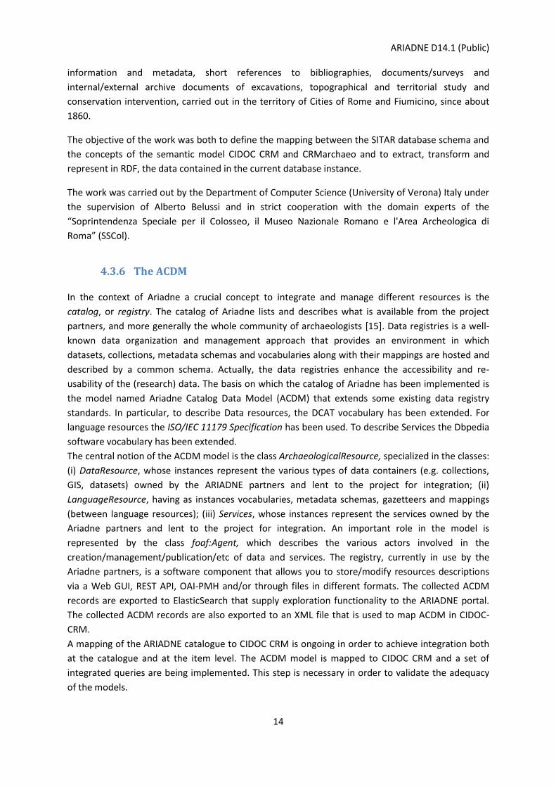
5 ARIADNE Reference Model
The research activities described in the previous sections had as an outcome the definition of the
ARIADNE Reference Model version 1.0, which is presented in Figure 1 and comprises the following
extensions:
Figure 1: ARIADNE Reference Model (ARIADNE RM)
CRMinf (CRMinf, 2015): the Argumentation Model is a formal ontology intended to be used as a global schema for integrating metadata about argumentation and inference making in descriptive and empirical sciences.
CRMsci (CRMsci, 2016): the Scientific Observation Model is a formal ontology intended to be used as a global schema for integrating metadata about scientific observation, measurements and processed data in descriptive and empirical sciences.
CRMgeo (CRMgeo, 2013): a spatiotemporal model that provides an “articulation” (linkage) between the standards of the geospatial and the Cultural Heritage community in particular between GeoSPARQL and CIDOC CRM.
CRMdig (CRMdig, 2014): a model for provenance metadata is an ontology to encode metadata about the steps and methods of production (“provenance”) of digitization products and synthetic digital representations such as 2D, 3D or even animated models created by various technologies.
CRMba (CRMba, 2016; Ronzino, 2015): the Buildings Archaeology is an ontology developed for investigating historic and prehistoric buildings, the relations between building
ARIADNE D14.1 (Public)
16
components, functional spaces, topological relations and construction phases through time and space.
CRMarchaeo (CRMarchaeo, 2016): the Excavation Model is an ontology to encode metadata about the archaeological excavation process.
5.1.1 Naming Conventions
The classes and the properties declared in all the extensions were given both a name and an
identifier, constructed according to the conventions used in the CIDOC CRM model. The class
identifier consists of one or two letters followed by a number. The property identifier consists of one
or two letters followed by a number, which in turn is followed by the letter “i” every time the
property is mentioned “backwards”, i.e., from target to domain (inverse link). The letters do not
have any meaning. They correspond respectively to the letters “E” and “P” in the CIDOC CRM naming
conventions, where “E” originally meant “entity” (although the CIDOC CRM “entities” are now
consistently called “classes”), and “P” means “property”. A color code is also used to facilitate the
distinction of the classes (see Figure 1: ARIADNE Reference Model (ARIADNE RM)). The identifiers
are as follows:
• CIDOC CRM classes are denoted by E and properties by P
• CRMinf classes are denoted by I and properties by J
• CRMsci classes are denoted by S and properties by O
• CRMgeo classes are denoted by SP and properties by Q
• CRMdig classes are denoted by D and properties by L
• CRMba classes are denoted by B and properties by BP
• CRMarchaeo: classes are denoted by A and properties by AP
5.1.2 CIDOC CRM Special Interest Group
All the extensions have been submitted to the CIDOC CRM Special Interest Group for discussion and
approval (http://cidoc-crm.org/special_interest_meetings.html):
CIDOC-CRM Special Interest Group Meeting, 29/9-2/10/2014, Heraklion, Greece
o Presentation of CRMarchaeo: the Excavation Model, An Extension of CIDOC-CRM to support archaeological excavations
o Presentation of Logical foundations of the CIDOC CRM including a first-order and an OWL expression of the CRM
CIDOC2014 Access and Understanding – Networking in the Digital Era, 6-11/9/2014 Dresden,
Germany
o Tutorial on CRMsci and CRMarchaeo
http://www.cidoc2014.de/index.php/en/home/program-information/workshops-en
ARIADNE D14.1 (Public)
17
CIDOC-CRM Special Interest Group Meeting, 9-12/2/2015, Oxford, UK
o Discussion on CRMarchaeo, CRMsci and CRMinf
o Discussion on the extension of CRM for buildings
CIDOC-CRM Special Interest Group Meeting, 19-22/5/2015, Nuremberg, Germany
o Martin Doerr presented CIDOC CRM Family, Harmonized models for the Digital
World: CIDOC CRM and extensions
CIDOC-CRM Special Interest Group Meeting, 6 – 9/10/2015, Heraklion, Crete, Greece
o Carlo Meghini, Formalization of the CRM: A first-order attempt
o Maria Theodoridou, Data Provision and Aggregation
Mapping Culture Semantically with CIDOC-CRM & 3M CRM SIG
o Achille Felicetti, Conceptual Spaces: Organising Geographical Knowledge
o Paola Ronzino, CRMba and CRMarchaeo models harmonization
o Achille Felicetti, CIDOC CRM and Epigraphy: a Hermeneutic Challenge
CIDOC-CRM SIG Meeting, 24–26/2/2016, Prato, Florence, Italy
o Franco Niccolucci, Using the CRM for Archaeological Science
o Franco Niccolucci, Expressing Reliability with the CRM: Are You Sure?
ARIADNE Reference Model is continuously validated in the context of the ARIADNE project and new
versions will be released in the future whenever changes in the individual extensions occur.
The scope, the main classes and the properties of each extension are presented in the following
sections.
ARIADNE D14.1 (Public)
18
6 CRMinf
CRMinf is a formal ontology produced by Stephen Stead, Paveprime Ltd and collaborators and is
intended to be used as a global schema for integrating metadata about argumentation and
inference- making in descriptive and empirical sciences such as biodiversity, geology, geography,
archaeology, cultural heritage conservation, research IT environments and research data libraries. Its
primary purpose is facilitating the management, integration, mediation, interchange and access to
data about reasoning by a description of the semantic relationships between the premises,
conclusions and activities of reasoning.
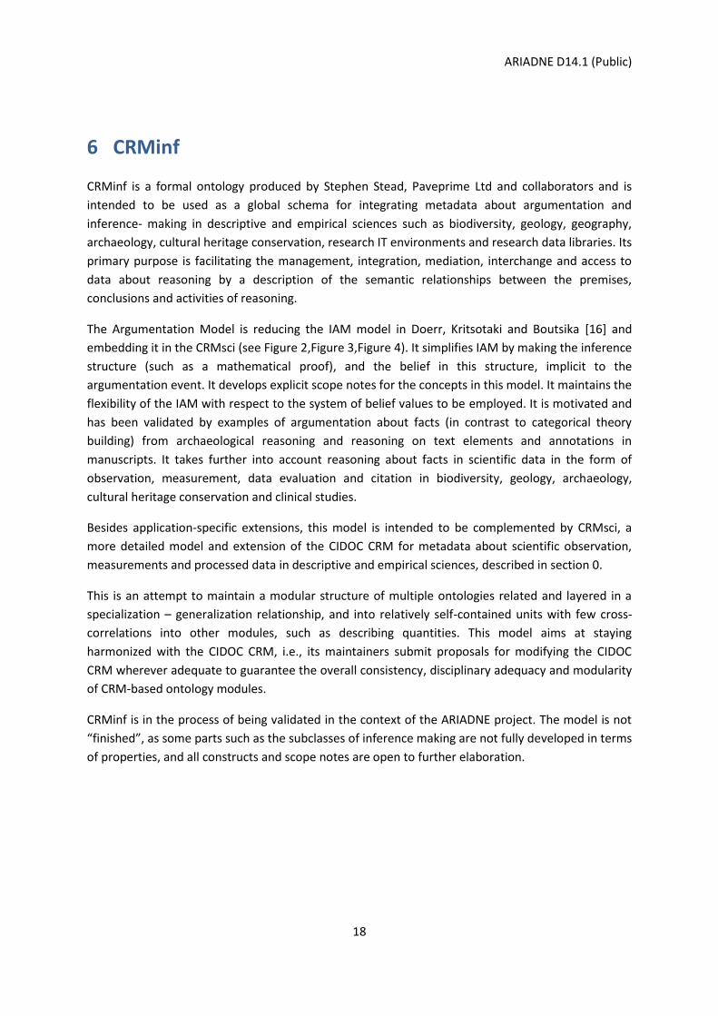
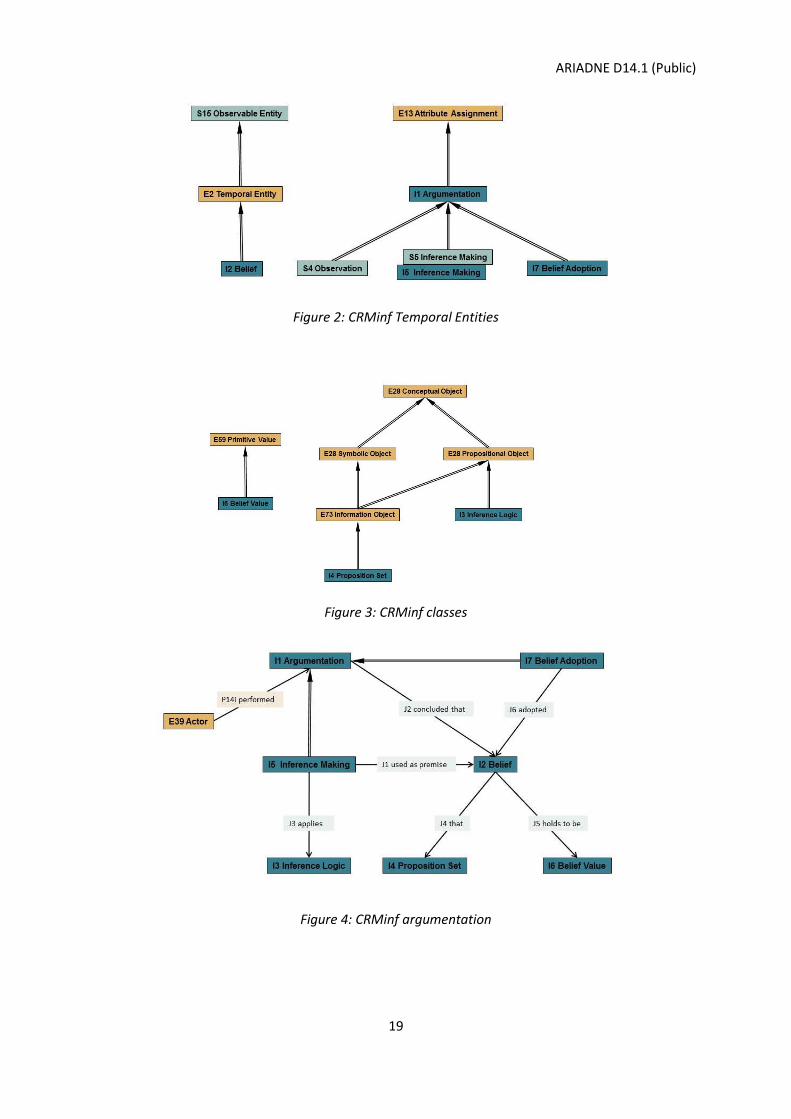
The Argumentation Model is reducing the IAM model in Doerr, Kritsotaki and Boutsika [16] and
embedding it in the CRMsci (see Figure 2,Figure 3,Figure 4). It simplifies IAM by making the inference
structure (such as a mathematical proof), and the belief in this structure, implicit to the
argumentation event. It develops explicit scope notes for the concepts in this model. It maintains the
flexibility of the IAM with respect to the system of belief values to be employed. It is motivated and
has been validated by examples of argumentation about facts (in contrast to categorical theory
building) from archaeological reasoning and reasoning on text elements and annotations in
manuscripts. It takes further into account reasoning about facts in scientific data in the form of
observation, measurement, data evaluation and citation in biodiversity, geology, archaeology,
cultural heritage conservation and clinical studies.
Besides application-specific extensions, this model is intended to be complemented by CRMsci, a
more detailed model and extension of the CIDOC CRM for metadata about scientific observation,
measurements and processed data in descriptive and empirical sciences, described in section 0.
This is an attempt to maintain a modular structure of multiple ontologies related and layered in a
specialization – generalization relationship, and into relatively self-contained units with few cross-
correlations into other modules, such as describing quantities. This model aims at staying
harmonized with the CIDOC CRM, i.e., its maintainers submit proposals for modifying the CIDOC
CRM wherever adequate to guarantee the overall consistency, disciplinary adequacy and modularity
of CRM-based ontology modules.
CRMinf is in the process of being validated in the context of the ARIADNE project. The model is not
“finished”, as some parts such as the subclasses of inference making are not fully developed in terms
of properties, and all constructs and scope notes are open to further elaboration.
ARIADNE D14.1 (Public)
19
Figure 2: CRMinf Temporal Entities
Figure 3: CRMinf classes
Figure 4: CRMinf argumentation
ARIADNE D14.1 (Public)
20
7 CRMsci
The “Scientific Observation Model” is a formal ontology intended to be used as a global schema for
integrating metadata about scientific observation, measurement and process data in descriptive and
empirical sciences such as biodiversity, geology, geography, archaeology, cultural heritage
conservation and others in research IT environments and research data libraries. Its primary purpose
is facilitating the management, integration, mediation, interchange and access to research data by
description of semantic relationships, in particular causal ones. It is not primarily a model to process
the data themselves in order to produce new research results, even though its representations offer
themselves to be used for some kind of processing.
It uses and extends the CIDOC CRM (ISO21127) as a general ontology of human activity, to describe
things and events happening in spacetime. CRMsci has been developed bottom up from specific
metadata examples from biodiversity, geology, archaeology, cultural heritage conservation and
clinical studies, such as water sampling in aquifer systems, earthquake event recordings, landslides,
excavation processes, species occurrence and detection of new species, tissue sampling in cancer
research, 3D digitization, based on communication with the domain experts and the implementation
and validation in concrete applications. It takes into account relevant standards, such as INSPIRE,
OBOE, national archaeological standards for excavation, digital provenance models and others. For
each application, another set of extensions is needed in order to describe these data at an adequate
level of specificity, such as semantics of excavation layers or specimen capture in biology. However,
the model presented here describes, together with the CIDOC CRM, a discipline neutral level of
genericity, which can be used to implement effective management functions and powerful queries
for related data. It aims at providing superclasses and superproperties for any application-specific
extension, such that any entity referred to by a compatible extension can be reached with a more
general query based on this model (see Figure 5).
Besides application-specific extensions, this model is intended to be complemented by CRMgeo, a
more detailed model and extension of the CIDOC CRM of generic spatiotemporal topology and
geometric description, described in section 8. This is an attempt to maintain a modular structure of
multiple ontologies related and layered in a specialization – generalization relationship, and into
relatively self-contained units with few cross-correlations into other modules, such as describing
quantities. This model aims at staying harmonized with the CIDOC CRM, i.e., its maintainers submit
proposals for modifying the CIDOC CRM wherever necessary to guarantee the overall consistency,
disciplinary adequacy and modularity of CRM-based ontology modules.
CRMsci is in the process of being validated in the context of the ARIADNE project. The model is not
“finished”, and all constructs and scope notes are open to further elaboration.
ARIADNE D14.1 (Public)
21
Figure 5: CRMsci scientific events

ARIADNE D14.1 (Public)
22
8 CRMgeo
CRMgeo is an extension to the CIDOC CRM to provide an “articulation” (linkage) between the
standards for the geospatial and cultural heritage community, and in particular between GeoSPARQL
and CIDOC CRM. The model was developed from the analysis of the epistemological processes of
defining, using and determining places. This means that an analysis of a question, such as “is this the
place of the Varus Battle” or “is this the place where Lord Nelson died”, can be verified or falsified,
including geometric specifications [14]. Consequently, we reached at a detailed model which seems
to give a complete account of all practical components necessary to verify such a question, in
agreement with the laws of physics, the practice of geometric measurement and archaeological
reasoning (see Figure 6). This model indeed appears to have the capability to link both ontologies
and shows how to correctly reconcile data at any scale and time—not by inventing precision or truth
that cannot be acquired, but by quantifying or delimiting the inherent indeterminacies, as it is good
practice in natural sciences.
Figure 6: Graphical view of Classes and Properties to refine Place representation in the CIDOC CRM
CRMgeo is in the process of being validated in the context of the ARIADNE project. The model is not “finished”, all constructs and scope notes are open to further elaboration.
ARIADNE D14.1 (Public)
23
9 CRMdig
CRMdig is an ontology and RDF Schema to encode metadata about the steps and methods of
production ("provenance") of digitization products and synthetic digital representations such as 2D,
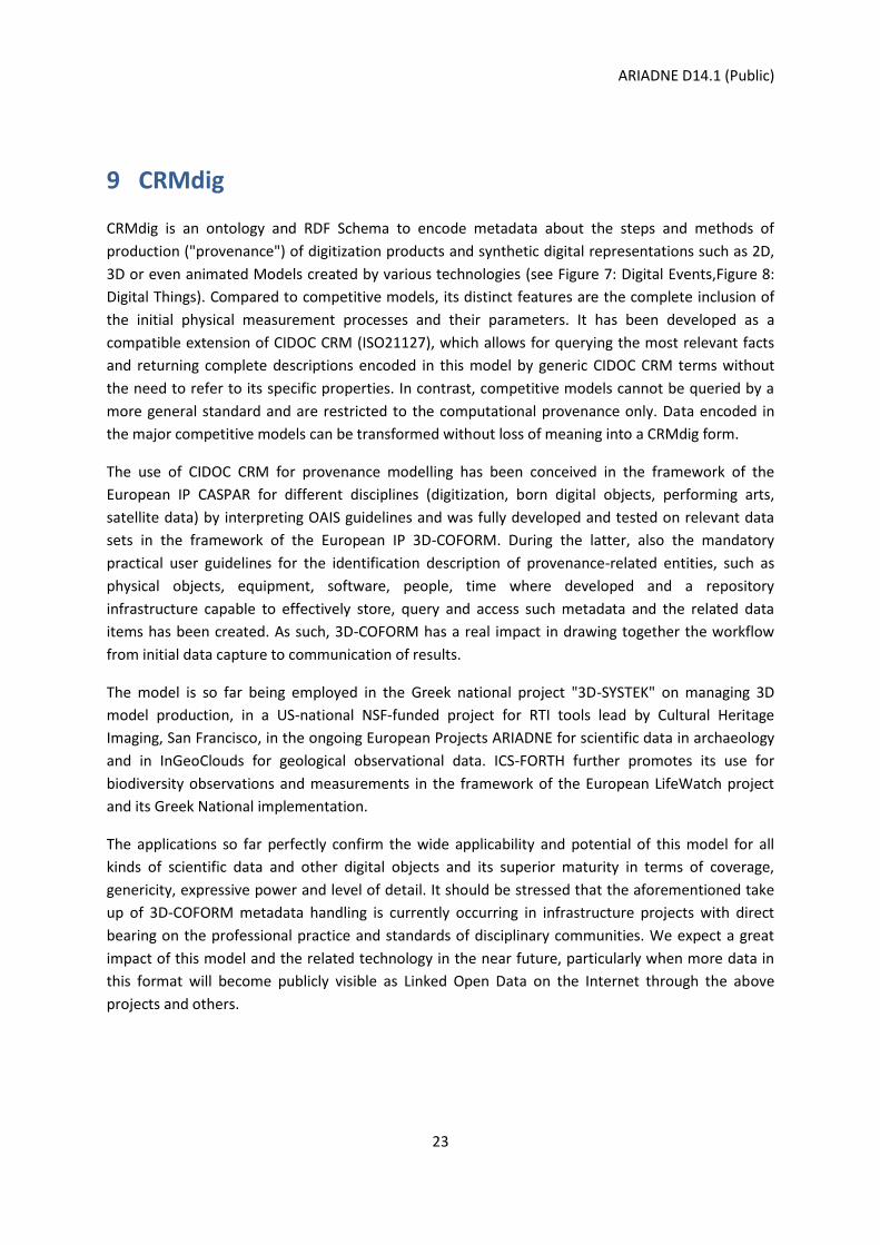
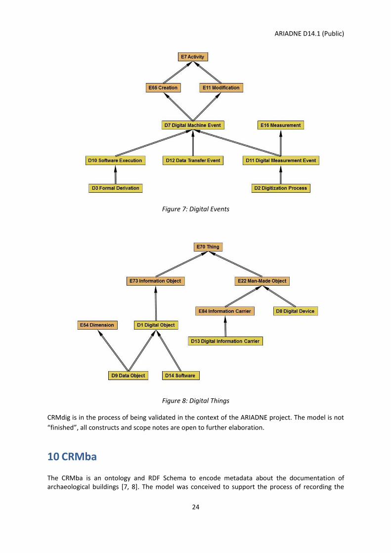
3D or even animated Models created by various technologies (see Figure 7: Digital Events,Figure 8:
Digital Things). Compared to competitive models, its distinct features are the complete inclusion of
the initial physical measurement processes and their parameters. It has been developed as a
compatible extension of CIDOC CRM (ISO21127), which allows for querying the most relevant facts
and returning complete descriptions encoded in this model by generic CIDOC CRM terms without
the need to refer to its specific properties. In contrast, competitive models cannot be queried by a
more general standard and are restricted to the computational provenance only. Data encoded in
the major competitive models can be transformed without loss of meaning into a CRMdig form.
The use of CIDOC CRM for provenance modelling has been conceived in the framework of the
European IP CASPAR for different disciplines (digitization, born digital objects, performing arts,
satellite data) by interpreting OAIS guidelines and was fully developed and tested on relevant data
sets in the framework of the European IP 3D-COFORM. During the latter, also the mandatory
practical user guidelines for the identification description of provenance-related entities, such as
physical objects, equipment, software, people, time where developed and a repository
infrastructure capable to effectively store, query and access such metadata and the related data
items has been created. As such, 3D-COFORM has a real impact in drawing together the workflow
from initial data capture to communication of results.
The model is so far being employed in the Greek national project "3D-SYSTEK" on managing 3D
model production, in a US-national NSF-funded project for RTI tools lead by Cultural Heritage
Imaging, San Francisco, in the ongoing European Projects ARIADNE for scientific data in archaeology
and in InGeoClouds for geological observational data. ICS-FORTH further promotes its use for
biodiversity observations and measurements in the framework of the European LifeWatch project
and its Greek National implementation.
The applications so far perfectly confirm the wide applicability and potential of this model for all
kinds of scientific data and other digital objects and its superior maturity in terms of coverage,
genericity, expressive power and level of detail. It should be stressed that the aforementioned take
up of 3D-COFORM metadata handling is currently occurring in infrastructure projects with direct
bearing on the professional practice and standards of disciplinary communities. We expect a great
impact of this model and the related technology in the near future, particularly when more data in
this format will become publicly visible as Linked Open Data on the Internet through the above
projects and others.
ARIADNE D14.1 (Public)
24
Figure 7: Digital Events
Figure 8: Digital Things
CRMdig is in the process of being validated in the context of the ARIADNE project. The model is not
“finished”, all constructs and scope notes are open to further elaboration.
10 CRMba
The CRMba is an ontology and RDF Schema to encode metadata about the documentation of archaeological buildings [7, 8]. The model was conceived to support the process of recording the
ARIADNE D14.1 (Public)
25
evidences and the discontinuities of matter in archaeological buildings, in order to identify the evolution of the structure throughout the centuries and to record the relationships between each of the building components among them and with the building as a whole. It aims to express the semantic relations of the stratigraphic units of a standing building, taking into account the stratigraphic analysis theory of the standing buildings. Historic buildings are in most cases the product of a series of addition and removal, and of construction and destruction activities that modify their appearance over various historical periods. The identification of these processes, together with the analysis of the different building techniques and materials utilized over its existence, provides archaeologists with an understanding of the continuity and discontinuity of matter and activities on a built structure. All these strands of information can be used to produce a detailed understanding of the development of any building, whether standing or in ruins, and to identify significant phases of the monument’s appearance throughout the centuries. After an accurate analysis of specific metadata standards for the documentation of built heritage, a complex mapping between them was carried out to understand whether these standards enable the recording of the semantics of the building’s components. The results of the mapping [9] demonstrated that such standards, although very rich in their structure, fail in describing the completeness of information about the building and the internal relationships among its parts and with the whole. Moreover, the mapping between the Archaeological Monument/Archaeological Complex (MA/CA) form - the most complete among the standards analysed - and the CIDOC CRM, highlighted the need to add more specialized concepts to the latter to describe the very complex structure of the buildings, especially as concerns the analytical description of the asset (static and functional components) and the relationship among its parts [8]. The goal of the CRMba conceptual model is to provide support to:
understand the building structure and its development;
recognize the use of a building and how it has evolved over the years;
identify the various phases of the building as a result of construction, transformation, modification and reuse;
support the investigation and interpretation of the material evidence in the standing structures;
understand the correlation between parts of a buildings and whole;
recognize, analyse and interpret the stratigraphy of standing structures and of ruins;
support the dating process through the identification of the Stratigraphic Relationship (SR) between the various Stratigraphic Units (SU), which can be inferred by the identification of the Stratigraphic Interfaces (SI).
The model is built on the same principles of the CIDOC CRM. As with the CRM, the semantics of the building are rendered as properties between two classes. The model reuses, when appropriate, parts of the CIDOC CRM classes and properties, and refers to other CRM extensions developed to ensure the completeness of documentation (see Figure 9). In particular, the CRMba model incorporates parts of CRMgeo, a detailed model of generic spatio-temporal topology and geometric description [11] (see section 8); parts of CRMsci, a model for scientific observation, measurements and processed data in descriptive and empirical sciences (see section 0) and CRMarcheo, a model developed for the documentation of archaeological excavations (see section 11).

ARIADNE D14.1 (Public)
26
Figure 9: The CRMba conceptual model
CRMba is in the process of being validated in the context of the ARIADNE project. The model is not “finished”, all constructs and scope notes are open to further elaboration.
ARIADNE D14.1 (Public)
27
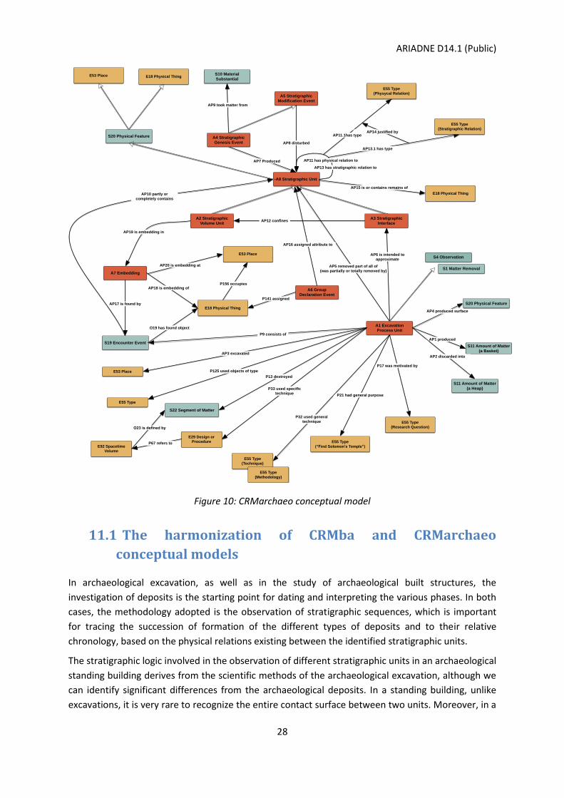
11 CRMarchaeo
CRMarchaeo is an ontology and RDF Schema to encode metadata about the archaeological
excavation process. The model was created to support this process and all the various entities and
activities related to it. The model has been created starting with standards and models already in
use by national and international cultural heritage institutions, and has been enriched by continuous
collaboration with various communities of archaeologists from different countries and schools.
CRMarchaeo is intended to provide all necessary tools to manage and integrate existing
documentation in order to formalise knowledge extracted from observations made by
archaeologists, recorded in various ways and adopting different standards. Its purpose is to facilitate
the semantic encoding, exchange, interoperability and access of existing archaeological
documentation. The model documents, in a transparent way, the various aspects of the
archaeological excavation process, including the technical details concerning different methods of
excavation, the reasons for their application and the observations made by archaeologists during
their activities in the field. This approach allows the creation of an objective documentation that can
guarantee the scientific validity of the results, making them revisable following further investigations
and reusable in different research contexts, in order to answer further (and potentially different)
research questions.
CRMarchaeo is the result of collaboration between many cultural heritage institutions and the
unifying efforts of many European projects, including ARIADNE [4]. The first need that the model
attempts to meet is to create common ground for the integration of archaeological records on every
level, from raw excavation data to official documentation produced according to national and
institutional standards. The document describes a community model, which has been approved by
CRM SIG to be formally and methodologically compatible with CIDOC CRM. However, in a broader
sense, it is always open to any possible integration and addition that may become necessary as a
result of its practical use on real archaeological problems on a large scale. The model is intended to
be maintained and promoted as an international standard.
ARIADNE D14.1 (Public)
28
Figure 10: CRMarchaeo conceptual model
11.1 The harmonization of CRMba and CRMarchaeo
conceptual models
In archaeological excavation, as well as in the study of archaeological built structures, the
investigation of deposits is the starting point for dating and interpreting the various phases. In both
cases, the methodology adopted is the observation of stratigraphic sequences, which is important
for tracing the succession of formation of the different types of deposits and to their relative
chronology, based on the physical relations existing between the identified stratigraphic units.
The stratigraphic logic involved in the observation of different stratigraphic units in an archaeological
standing building derives from the scientific methods of the archaeological excavation, although we
can identify significant differences from the archaeological deposits. In a standing building, unlike
excavations, it is very rare to recognize the entire contact surface between two units. Moreover, in a
E53 Place
A1 Excavation
Process Unit
AP19 is embedding in
A8 Stratigraphic Unit
E18 Physical Thing
AP5 removed part of all of
(was partially or totally removed by)
A2 Stratigraphic
Volume Unit
A3 Stratigraphic
Interface
S20 Physical Feature
A7 Embedding
S19 Encounter Event
AP12 confines
E18 Physical Thing
AP18 is embedding of
E53 Place
AP20 is embedding at
P156 occupies
O19 has found object
P9 consists of
AP17 is found by
AP6 is intended to
approximate
S22 Segment of Matter
P13 destroyed
AP4 produced surface
S20 Physical Feature
S11 Amount of Matter
(a Basket)
AP1 produced
S11 Amount of Matter
(a Heap)
AP2 discarded into
E55 Type
(Research Question)
P17 was motivated by
E55 Type
(“Find Solomon’s Temple”)
P21 had general purpose
P32 used general
technique
E55 Type
(Technique)
E55 Type
(Methodology)
P33 used specific
technique
E29 Design or
ProcedureP67 refers toE92 Spacetime
Volume
O23 is defined by
AP3 excavated
E53 Place P125 used objects of type
E55 Type
AP10 partly or
completely contains
AP11 has physical relation to
AP11.1has type
E55 Type
(Physycal Relation)
AP7 Produced
S10 Material
Substantial
A4 Stratigraphic
Genesis Event
AP9 took matter from
A5 Stratigraphic
Modification Event
AP8 disturbed
AP13 has stratigraphic relation to
AP13.1 has type
E55 Type
(Stratigraphic Relation)AP14 justified by
A6 Group
Declaration Event
AP16 assigned attribute to
P141 assigned
S4 Observation
S1 Matter Removal
E18 Physical Thing
AP15 is or contains remains of
ARIADNE D14.1 (Public)
29
built structure most of the observed stratigraphic units are the result of human activities, which are
intentionally performed, the exception being the effects caused by the weathering and
anthropogenic actions a building surface is constantly exposed to.
Archaeological deposits are, instead, mainly the result of natural deposits, land development,
abandonment or collapse of the buildings within which, in most cases, only the foundations are
preserved. While subsurface deposits can be excavated to ascertain their stratigraphic relationships,
the study of a built structure cannot be made with traditional and destructive excavation techniques,
as this would compromise its conservation status. Another difference between a subsurface natural
deposit and the stratification of a built work is that the former does not follow the natural
stratigraphy.
Intentionality may be considered one of the main differences in the creation of a natural deposit and
the stratifications that are observable in built structures, whether they are standing above ground or
are buried. The result of the activities carried out in the framework of the ARIADNE project, recently
submitted for publication on an international scientific journal [13] has shown how the modelling
principles of the CRMba can be extended to the analysis of the stratifications of buildings or part of
buildings that are found, either connected or unconnected, in subsurface stratifications.
CRMarchaeo is in the process of being validated in the context of the ARIADNE project. The model is
not “finished”, all constructs and scope notes are open to further elaboration.
ARIADNE D14.1 (Public)
30
12 Conclusions
The work of the ARIADNE work package “Addressing Complexity” has been successful in providing a
new, powerful and extremely compact conceptualization for the majority of archaeological data. The
CIDOC CRM itself could be improved by this research, and these modifications have been submitted
to CIDOC. The models CRMarcheo, CRMba, CRMgeo, CRMsci, CRMdig and CRMinf have now been
proposed for approval by CIDOC as recommended models and are under revision by CIDOC working
groups. The German Archaeological Institute envisages implementing the new method of using the
temporal gazetteer definition in the next year. This method is based on the idea that a placename
refers to a phenomenon in spacetime. Suitable classification, with terms such as “settlement
activity” in contrast to “geopolitical unit”, will allow for unambiguous definition of the meaning in
spacetime. The subsequent interpretation as a particular, definite extent in space depends on the
intended time of reference, and not on the phenomenon. Approximations of the spacetime extent
of the phenomena by coordinates make the gazetteer more precise, but their meaning does not
depend on them.
Particular selected archaeological resources were automatically transformed and integrated into the
new models and the ability to answer research questions across heterogeneous resources will be
demonstrated. Additional work into the analysis of reference databases for analytical methods, in
the standardization efforts of the new models in collaboration with CIDOC-ICOM and their further
consolidation in practical application needs to be done.
ARIADNE D14.1 (Public)
31
13 References
1. dFMRÖ - digitale Fundmünzen der Römischen Zeit in Österreich.
Available from:http://www.oeaw.ac.at/antike/index.php?id=358,
2. Felicetti, P. Gerth, C. Meghini, and M. Theodoridou. Integrating heterogeneous coin datasets
in the context of archaeological research. Workshop for Extending, Mapping and Focusing
the CRM - co-located with TPDL’2015, September 2015.
3. Felicetti, T. Scarselli, M. Mancinelli, and F. Niccolucci. Mapping ICCD archaeological data to
CIDOCCRM: the RA schema. A Mapping of CIDOC CRM Events to German Wordnet for Event
Detection in Texts, page 11, 2013.
4. ARIADNE 2013, www.ariadne-infrastructure.eu, accessed April 2016.
5. CIDOC CRM (2015). Current Official Version of the CIDOC Conceptual Reference Model. The version 6.2 of the reference model is available at http://www.cidoc-crm.org/docs/cidoc crm version 6.2.pdf, accessed April 2016.
6. CRMarchaeo, 2016. CRMarchaeo: the Excavation Model, version 1.4 Available at http://www.ics.forth.gr/isl/CRMext/CRMarchaeo/docs/CRMarchaeo_v1.4.pdf, accessed April 2016.
7. Ronzino, P., Niccolucci, F., Felicetti, A., and Doerr, M. (2015). CRMba a CRM extension for the documentation of standing buildings. International Journal on Digital Libraries, Special Issue on Networked Knowledge Organization Systems (NKOS). doi:10.1007/s00799-015-0160-4; http://link.springer.com/10.1007/s00799-015-0160-4
8. Ronzino, P., (2015). CIDOC CRMba A CRM Extension for buildings archaeology information modelling. (Unpublished doctoral thesis). The Cyprus Institute, Nicosia, Cyprus
9. Ronzino, P., Amico, N. and Niccolucci, F., 2011. Assessment and comparison of metadata schemas for architectural heritage. In CIPA Symposium. Prague. Available at https://www.conferencepartners.cz/cipa/proceedings/pdfs/C-3/Niccolucci.pdf, accessed April 2016.
10. CRMsci, 2016. CRMsci: the Scientific Observation Model, version 1.2.3. Available at http://www.ics.forth.gr/isl/CRMext/CRMsci/docs/CRMsci1.2.3.pdf, accessed April 2016.
11. Doerr M., Hiebel G., 2013. CRMgeo: Linking the CIDOC CRM to GeoSPARQL through a Spatiotemporal Refinement. TECHNICAL REPORT: ICS-FORTH/TR-435, April 2013. Available at http://www.ics.forth.gr/isl/CRMext/CRMgeo/docs/TR435-CRMgeo.pdf, accessed April 2016.
12. CRMinf, 2015. CRMinf: the Argumentation Model, version 0.7. Available at http://www.ics.forth.gr/isl/CRMext/CRMinf/docs/CRMinf-0.7.pdf, accessed April 2016).
13. Ronzino, P., (2016). Harmonizing the CRMba and CRMarchaeo models. International Journal on Digital Libraries, Special Issue on Extending, Mapping and Focusing the CIDOC CRM (submitted for publication)
14. M. Doerr, G. Hiebel (2013). CRMgeo: Linking the CIDOC CRM to GeoSPARGL through a Spatiotemporal Refinement, TECHNICAL REPORT: ICS-FORTH/TR-435, April 2013
ARIADNE D14.1 (Public)
32
15. N. Aloia, C. Meghini, C. Papatheodorou, D. Gavrilis, and F. Debole (2014). Designing and implementing data registries: A case study for archaeology. In Proceedings of ODBASE 2014, The conference on Ontologies, DataBases, and Applications of Semantics for Large Scale Information Systems, volume 8841 of Lecture Notes in Computer Science, pages 768–775, Amantea, October 2014.
16. Doerr, M., Kritsotaki, A., & Boutsika, A. (2011). Factual argumentation - a core model for
assertions making. ACM Journal on Computing and Cultural Heritage (JOCCH), 3(3), 34, New
York, NY, USA, doi:10.1145/1921614.1921615; http://dl.acm.org/citation.cfm?id=1921615.
17. CRMba, 2016. CRMba: The Buildings Archaeology Model, version 1.4. Available at :
http://www.ics.forth.gr/isl/CRMext/CRMba/docs/CRMba_v1.4.pdf, Accessed April 2016
ARIADNE D14.1 (Public)
33
14 Publications
1. A. Felicetti, P. Gerth, C. Meghini, and M. Theodoridou. Integrating heterogeneous coin datasets in the context of archaeological research. Workshop for Extending, Mapping and Focusing the CRM - co-located with TPDL’2015, September 2015.
2. A. Felicetti, T. Scarselli, M. Mancinelli, and F. Niccolucci. Mapping ICCD archaeological data to CIDOC CRM: the RA schema. A Mapping of CIDOC CRM Events to German Wordnet for Event Detection inTexts, page 11, 2013.
3. M. Doerr, M. Theodoridou, E. Aspöck, and A. Masur. Mapping archaeological databases to cidoc-crm. Proceedings of the 43rd Computer Applications and Quantitative Methods in Archaeology Conference (CAA2015, Siena, Italy), April 2015. Available from:
http://www.archaeopress.com/Public/download.asp?id={77DEDD4E-DE8F-43A4-B115-ABE0BB038DA7}
4. Ronzino, P., (2015). CIDOC CRMba A CRM Extension for buildings archaeology information modelling. (Unpublished doctoral thesis). The Cyprus Institute, Nicosia, Cyprus
5. Ronzino, P., Niccolucci, F., Felicetti, A., and Doerr, M. (2015). CRMba a CRM extension for the documentation of standing buildings. International Journal on Digital Libraries, Special Issue on Networked Knowledge Organization Systems (NKOS). doi:10.1007/s00799-015-0160-4; http://link.springer.com/10.1007/s00799-015-0160-4
6. Ronzino, P., (2016). Harmonizing the CRMba and CRMarchaeo models. International Journal on Digital Libraries, Special Issue on Extending, Mapping and Focusing the CIDOC CRM (submitted for publication)
7. Amico, N., P. Ronzino, A. Felicetti, F. Niccolucci (2013) Quality management of 3D cultural heritage replicas with CIDOC-CRM, Vladimir Alexiev, Vladimir Ivanov, Maurice Grinberg (eds.): Practical Experiences with CIDOC CRM and its Extensions (CRMEX 2013) Workshop, 17th International Conference on Theory and Practice of Digital Libraries (TPDL 2013), Valetta, Malta, September 26, 2013, CEUR-WS.org/Vol-1117, pp 61-69, urn:nbn:de:0074-1117-1 [Paper: http://ceur-ws.org/Vol-1117/paper6.pdf ]
8. Ronzino, P., N. Amico, A. Felicetti and F. Niccolucci (2013) European standards for the documentation of historic buildings and their relationship with CIDOC CRM, Vladimir Alexiev, Vladimir Ivanov, Maurice Grinberg (eds.): Practical Experiences with CIDOC CRM and its Extensions (CRMEX 2013) Workshop, 17th International Conference on Theory and Practice of Digital Libraries (TPDL 2013), Valetta, Malta, September 26, 2013, CEUR-WS.org/Vol-1117, pp 70-79, urn:nbn:de:0074-1117-1 [Paper: http://ceur-ws.org/Vol-1117/paper7.pdf ]
9. Felicetti, A., Murano, F., Ronzino, P., Niccolucci, F., (2015) CIDOC CRM and Epigraphy: a Hermeneutic Challenge, Paola Ronzino and Franco Niccolucci (eds.): Extending, Mapping and Focusing the CIDOC CRM (CRMEX 2015) Workshop, 19th International Conference on Theory and Practice of Digital Libraries (TPDL 2015), Poznan, Poland, September 17, 2015. Under Publication.
10. Niccolucci, F., Felicetti, A., Ronzino, P., (2015). Mapping Pleiades to CIDOC CRM, Paola Ronzino and Franco Niccolucci (eds.): Extending, Mapping and Focusing the CIDOC CRM

ARIADNE D14.1 (Public)
34
(CRMEX 2015) Workshop, 19th International Conference on Theory and Practice of Digital Libraries (TPDL 2015), Poznan, Poland, September 17, 2015. Under Publication
11. F. Niccolucci, S. Hermon, A. Felicetti, P. Ronzino (2015). Expressing reliability with CIDOC CRM, Paola Ronzino and Franco Niccolucci (eds.): Extending, Mapping and Focusing the CIDOC CRM (CRMEX 2015) Workshop, 19th International Conference on Theory and Practice of Digital Libraries (TPDL 2015), Poznan, Poland, September 17, 2015. Under Publication
12. Ronzino, P., (2015). Standard e interoperabilità in ARIADNE, P. Ronzino, F. Niccolucci (eds.): L’integrazione dei dati archeologici digitali. Esperienze e prospettive in Italia (InDArD-2015), ARIADNE Workshop, Lecce, 1-2 Ottobre 2015. (Under Publication).
13. Guillem, A., Bruseker, G. and Ronzino, P., (2016). Process, Concept or Thing? Some Initial Considerations in the Ontological Modelling of Architecture. Special Issue on Extending, Mapping and Focusing the CIDOC CRM (submitted for publication).
14. Masur, A., May, K., Hiebel, G., Aspöck, E., (2014, online 2014). Comparing and mapping archaeological excavation data from different recording systems for integration using ontologies. Proceedings of 18th Conference on Cultural Heritage and New Technologies (CHNT), 11-13 November 2013. Stadtarchäologie, Museen der Stadt Wien, Wien. [URL: http://www.chnt.at/wp-content/uploads/Masur_etal_2014.pdf ]
15. Gerth, P., Schmidle, W. and Cuy, S. (2016). Sculptures in the Semantic Web. Proceedings of the 44th Computer Applications and Quantitative Methods in Archaeology Conference (CAA2016, Oslo, Norway). Under Publication.
16. G. Bruseker, M. Daskalaki, M. Doerr, M. Theodoridou (2016). Methodological tips for mappings to CIDOC CRM. Proceedings of the 44th Computer Applications and Quantitative Methods in Archaeology Conference (CAA2016, Oslo, Norway). Under Publication.
ARIADNE D14.1 (Public)
35
Appendix A
The ARIADNE Reference Model version 1.0 in detail can be found at the ARIADNE website:
http://www.ariadne-infrastructure.eu/Resources/Ariadne-Reference-Model
Individual Models
CRMinf version 0.7
Reference document: http://www.ics.forth.gr/isl/CRMext/CRMinf/docs/CRMinf-0.7.pdf
RDFS encoding: http://www.ics.forth.gr/isl/CRMext/CRMinf_v0.7.rdfs
CRMsci version 1.2.3
Reference document: http://www.ics.forth.gr/isl/CRMext/CRMsci/docs/CRMsci1.2.3.pdf
RDFS encoding: http://www.ics.forth.gr/isl/CRMext/CRMsci_v1.2.3.rdfs
CRMba version 1.4
Reference document: http://www.ics.forth.gr/isl/CRMext/CRMba/docs/CRMba_v1.4.pdf
RDFS encoding: http://www.ics.forth.gr/isl/CRMext/CRMba_v1.4.rdfs
CRMarchaeo version 1.4
Reference document: http://www.ics.forth.gr/isl/CRMext/CRMarchaeo/docs/CRMarchaeo_v1.4.pdf
RDFS encoding: http://www.ics.forth.gr/isl/CRMext/CRMarchaeo_v1.4.rdfs
CRMdig version 3.2
Reference document: http://www.ics.forth.gr/isl/CRMext/CRMdig/docs/CRMdig3.2.pdf
RDFS encoding: http://www.ics.forth.gr/isl/CRMext/CRMdig_v3.2.rdfs
CRMgeo version 1.2
Reference document: http://www.ics.forth.gr/isl/CRMext/CRMgeo/docs/TR435-CRMgeo.pdf
RDFS encoding: http://www.ics.forth.gr/isl/CRMext/CRMgeo_v1.2.rdfs