archeological study (phase 1a-b)
TRANSCRIPT

E n v i r o n m e n t a l I m p a c t S t a t e m e n t – P r e l i m i n a r y R e n e w a b l e P o w e r G e n e r a t i o n a n d R e s o u r c e s R e c o v e r y P l a n t
N o v e m b e r 2 0 1 0
BARRIO CAMBALACHE OF ARECIBO
Archeolog ica l Study (Phase 1A-B)
A P P E N D I X F
ARCHEOLOGICAL ASSESSMENT REPORT PHASE IA-IB
RENEWABLE POWER GENERATION AND
RESOURCE RECOVERY PLANT
ROAD PR-2, KM 72.8, CAMBALACHE WARD
ARECIBO, PUERTO RICO
PREPARED FOR
CSA GROUP
CSA Plaza, Suite 500, 1064 Ponce de León Ave.
San Juan, Puerto Rico 00907-3740
PREPARED BY
EDUARDO QUESTELL Y ASOCIADOS
EDUARDO QUESTELL RODRÍGUEZ FEDERICO FREYTES RODRÍGUEZ
AUGUST 2010
TABLE OF CONTENT
INTRODUCTION ………………………………………………...………… 1
PHASE IA SURVEY ………………………………………………..……… 5
Project Description ………………………………………………………. 5
Environmental Setting…………………………………………………… 5
Synthesis of Cultural Development ……………………………………… 7
Archival Research ………………………………………………...……… 21
Land Use Pattern ………………………………………………………… 23
Surface Inspection and Sensitivity Study ………………………………. 26
Conclusion of Phase IA ………………………………………………….. 26
PHASE IB SURVEY ………………………………………………………… 26
Survey design and Methodology ……………………………………… 27
Phase IB Survey Results………………………………………………. 30
CONCLUSIONS AND RECOMMENDATIONS ………………………….. 31
BIBLIOGRAPHY …………………………………………………………… 34
APPENDIX A ………………………………………………………………
APPENDIX B ………………………………………………………………
APPENDIX C ………………………………………………………………
APPENDIX D ………………………………………………………………
APPENDIX E ………………………………………………………………
APPENDIX F……… ………………………………………………………

LIST OF FIGURES
FIGURE NUM. 1 ……………………………………………………………. 2
FIGURE NUM. 2 ……………………………………………………………. 6
FIGURE NUM. 3 ……………………………………………………………. 9
FIGURE NUM. 4 ……………………………………………………………. 17
FIGURE NUM. 5 ……………………………………………………………. 18
FIGURE NUM. 6 ……………………………………………………………. 25
FIGURE NUM. 7 ……………………………………………………………. 28

ARCHEOLOGICAL ASSESSMENT REPORT
PHASE IA-IB
RENEWABLE POWER GENERATION AND
RESOURCE RECOVERY PLANT
ROAD PR-2, KM 72.8, CAMBALACHE WARD
ARECIBO, PUERTO RICO
INTRODUCTION
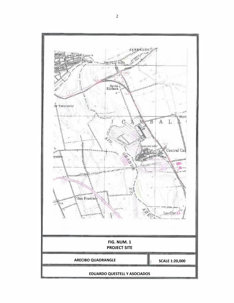
This report shows the results of the Archaeological Assessment Phase IA-IB, for the site
intended for the construction of a Renewable Power Generation and Resource Recovery Plant,
on a property located at Road PR-2, km 72.8, Cambalache Ward in the Municipality of Arecibo
(see Figure 1).
The Project is located on a property measuring approximately 81.30255 cuerdas with the
following boundaries: to the East, Road PR-2; to the South a lot belonging to the Puerto Rico
Land Authority; and West, the right-of-way for the Rio Grande de Arecibo (see map at end of
this report).
This report is prepared for CSA Group, in accordance with Section 10 of Law 112 of July
20, 1988, also known as the Terrestrial Archeology Act of Puerto Rico, and Section 106 of the
National Historic Preservation Act and the Code of Federal Regulations (36CFR), Title 36.
However, the Archeology and Ethnohistory Program of the Institute of Puerto Rican Culture, in a
letter dated August 27, 2010 states that this program "revisó y evaluó los documentos
relacionados al proyecto de referencia" and comments that "La evaluación realizada sugiere
que, basado en los datos existentes al presente, las probabilidades de impactar un recurso
arqueológico, según definido por la Ley 112 del 20 de julio de 1988, según enmendada, son
mínimas”, and concludes; "Por lo tanto, y en virtud de la delegación para la evaluación de
Fases I y II del Consejo para la protección del Patrimonio Arqueológico Terrestre de Puerto
Rico, se autoriza a intervenir el terreno con el proyecto de una Planta de Recuperación de
Recursos Energy Answers Arecibo LLC [same project as this investigation], localizado en la PR-
2
ARECIBO QUADRANGLE
FIG. NUM. 1 PROJECT SITE
SCALE 1:20,000
EDUARDO QUESTELL Y ASOCIADOS

3
2, Km. 72.8 del Barrio Cambalache en el Municipio de Arecibo”, " pertaining to cultural
resources (see Appendix A), so that our report will not be evaluated by the Archeology and
Ethnohistory Program.
However, the letter from the Archeology Program states that: "Este proceso es paralelo
al del Programa de Patrimonio Edificado del Instituto de Cultura Puertorriqueña, si aplica,
permiso que el proponente deberá gestionar de modo adicional al nuestro para cumplir con las
regulaciones de la Ley 374 de 1949 y la Ley 89 de 1955”. Understanding that we have been
contracted to perform an archaeological assessment of the site were this project will be
established and since our report may help obtain the permit from the above mentioned Historic
Built Heritage Program, if required, we are submitting the results from the Phases IA-IB for the
stated site.
These phases have been defined by Arch. John Vetten from the Federal Environmental
Protection Agency (EPA), New York Region, as follows:
"Stage IA: Literature Search and Sensibility Study
The stage IA is the initial level of survey and requires comprehensive
documentary research designed to identify any known or potential historical,
architectural and / or archaeological resources within a project area. A primary
objective of the study, is to evaluate the differential sensibility of the project area
for the presence of cultural resources, this information will be used to guide the
field investigations that follow.
In carrying out the literature search, sources at the State Preservation Office
(S.H.P.O.), universities, local libraries, museums, historical societies and the like,
are to be consulted.
In addition, the nature and extend of the proposed project is evaluated, an initial
walk-over reconnaissance and surface inspection is completed and the effect of
prior ground disturbance of the probability of identifying cultural resources is
assessed.
The final document must focus on the project area and minimally includes:
- a brief description;
- a description of the environmental setting as it pertains to actual or potential
cultural resources locations;
- a synthesis of prehistoric and historic and cultural development and land use
patterns; and
- a definition of sensitivity zones with explicit criteria for ranking undertaking.

4
Stage IB: Field Investigation
Subsurface testing is the major component of this level of survey and is required
unless the presence or absence of resources can be determined by direct
observation or by examination of specific document references.
The areas to be subjected to survey are selected on the basis of the data gathered
in the Stage IA evaluation and the probable location (s) of the undertaking.
The careful location of identified resources with respect to areas of impact of the
proposed project must be established.
The final Stage IB report presents the results of the field investigation, including:
- Description of the survey design and methodology (based on the result of the
stage IA);
- Complete records of soil stratigraphy; an artifact catalogue including
identification, estimated date range and quantity on weight, as appropriate.
The location of all test units must be accurately plotted on a project area map,
with location of identified resources clearly defined. Photographs which illustrate
salient prints of the survey area are a necessary component of the final report.
Detailed recommendation and supporting rational for additional investigation
must be incorporated into the conclusions of the Stage IB study.
If all cultural resources identified through the Stage IA and / Stage IB surveys will
not be impacted by the proposed project, the survey process is completed".
In our report we have followed the Guidelines for Archeological Research of the State
Historic Preservation Office and the Regulation for Filing and Archaeological Evaluation of
Construction and Development Projects from the Council for the Protection of the Terrestrial
Archeological Heritage of Puerto Rico, ascribed to the Institute of Puerto Rican Culture.
5
PHASE IA SURVEY
As established, a Phase IA of an archaeological assessment includes: a description of the
project; a description of the environmental setting of the location; a synthesis of prehistoric and
historic and cultural development, with a sensibility study of the studied site and its land use
patterns.
Project Description
The project consists in the construction of a Renewable Power Generation and Resource
Recovery Plant, were municipal solid wastes will be processed to produce electric energy and
other byproducts (see plan at the end of this report) on a site of approximately 81.30255 cuerdas,
located at Road PR-2, Km 72.8, Cambalache Ward in the Municipality of Arecibo. A paper mill
existed previously on this site.
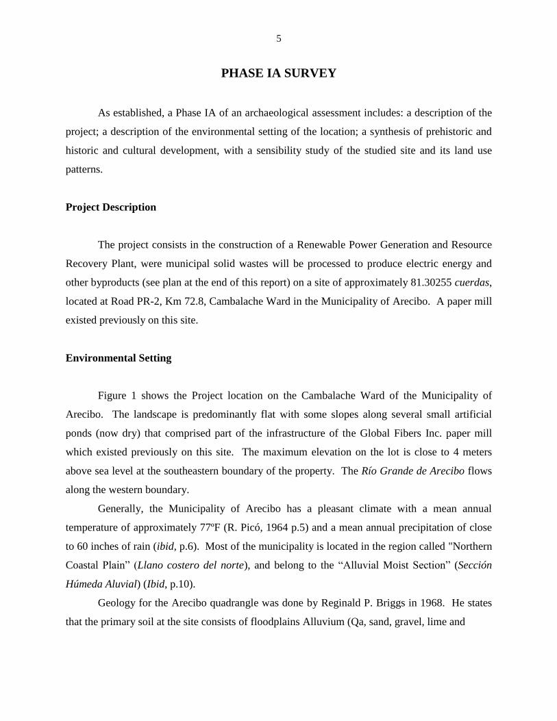
Environmental Setting
Figure 1 shows the Project location on the Cambalache Ward of the Municipality of
Arecibo. The landscape is predominantly flat with some slopes along several small artificial
ponds (now dry) that comprised part of the infrastructure of the Global Fibers Inc. paper mill
which existed previously on this site. The maximum elevation on the lot is close to 4 meters
above sea level at the southeastern boundary of the property. The Río Grande de Arecibo flows
along the western boundary.
Generally, the Municipality of Arecibo has a pleasant climate with a mean annual
temperature of approximately 77ºF (R. Picó, 1964 p.5) and a mean annual precipitation of close
to 60 inches of rain (ibid, p.6). Most of the municipality is located in the region called "Northern
Coastal Plain” (Llano costero del norte), and belong to the “Alluvial Moist Section” (Sección
Húmeda Aluvial) (Ibid, p.10).
Geology for the Arecibo quadrangle was done by Reginald P. Briggs in 1968. He states
that the primary soil at the site consists of floodplains Alluvium (Qa, sand, gravel, lime and

6
GEOLOGIC QUADRANGLE OF ARECIBO
FIG. NUM. 2 GEOLOGY IN THE PROJECT AREA
SCALE 1:20,000
EDUARDO QUESTELL Y ASOCIADOS

7
clay). In several places along the river and near the center of the site we find swamp deposits
(Qs). Figure 2 (page 7) shows the geology of the Project area.
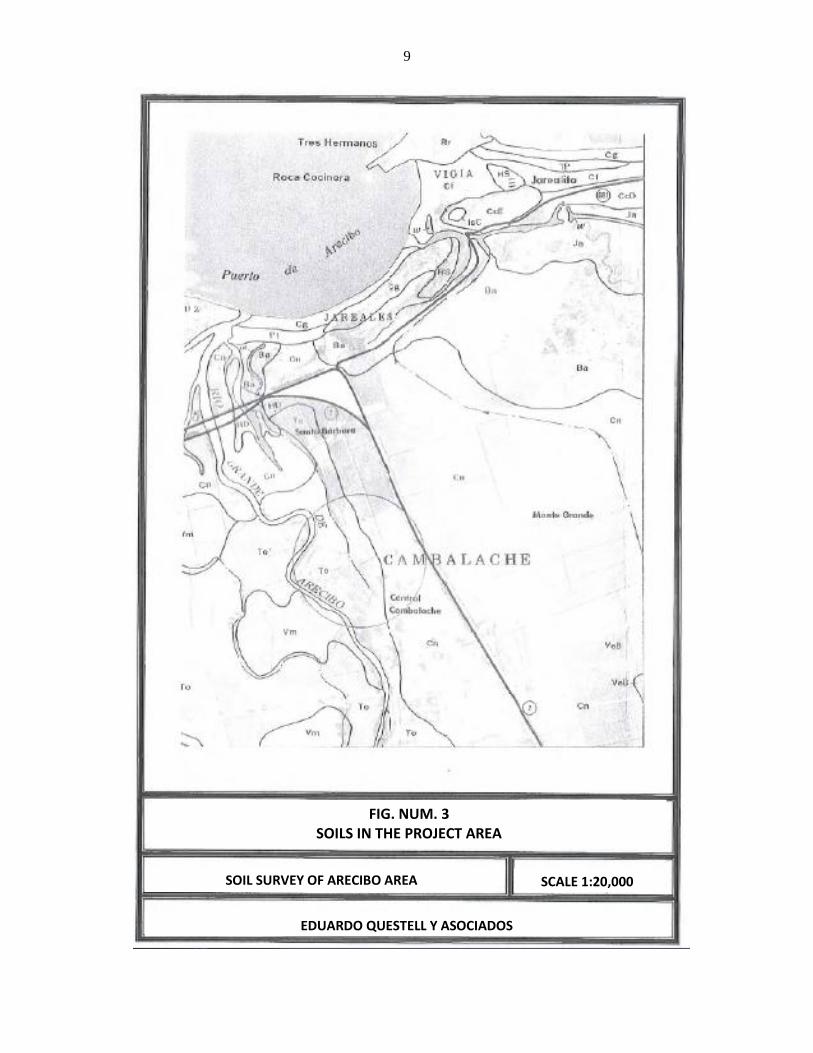
The soils of the zone were studied by Gilberto Acevedo in 1982 (Soil Survey of Arecibo
Area Northern Puerto Rico). He states (leaf no. 3) that the soil to the East of the Project area is
Coloso Clay (Cn, p. 16). This is a deep soil, naturally fertile with high water retention and poor
drainage. Runoff is slow, with limited agricultural crop applications for being prone to flooding
and expansive. To the West the predominant soil is the Toa silty clay loam (To, p. 39). Toa soil
is deep, with moderate permeability and moderate water retention capability. It has a slow
runoff and high natural fertility. The danger of flooding is its main limitation. Figure 3 (p. 9)
shows the soils of the area.
Currently the predominant flora consists of: African tulip tree, tall albizia, Guinea grass,
zarcilla, cocklebur, moriviví (Mimosa), Oxhorn bucida and Madras thorn. Wildlife was
represented by Gray Kingbird, Greater Antillean Grackle, Bananaquit, Cattle Egret, Northern
Mockingbird, White-winged Dove, frogs and lizards.
Synthesis of Cultural Development
The prehistory of the Municipality of Arecibo has been well studied, although the
existing information makes it difficult to adequately reconstruct its past. As we know, Arecibo is
located on the northern coast of Puerto Rico. This condition, in a way, forces the reconstruction
of its past to be set spatially and chronologically within the context of the prehistory of the North
coast. We understand this is an essential framework even if one wishes to study only the
traditional problems of time and space. For the purpose of the present work, we refer to the
prehistory of the North coast as defined by Dr. Irving B. Rouse in his "Scientific Survey of Porto
Rico and the Virgin Islands" (Rouse, 1952, Vol XVIII, part 3, pages 403-405). We consider
these studies essential to our prehistory.
As per Dr. Rouse, the North coast encompasses all the lowlands that drain into the
Atlantic Ocean, encompassing 150 kilometers of seashore and adjacent land, which extend
approximately 15 kilometers inland. Altogether, the area comprises 2,000 square kilometers.
The North coast begins at the west of Punta Borinquen, forms a curve towards the interior

8
through the hills and returns out to arrive at the cape of San Juan. This boundary between the
area of the North coast and the rest of the Island form an arc. The most significant rivers which
constitute topographic features are, from West to East: Río Guajataca, Río Grande de Arecibo,
Río Grande de Manatí, Río Cibuco, La Plata, Bayamón, and Río Grande de Loíza. These rivers
have established floodplains along their banks. A chain of limestone hills with abundant caverns
is found between these plains. Behind these hills are the foothills of the interior mountains. In
front of these, vast marshes prevent walking between them. Dr. Rouse considered the indians
probably had difficulty traveling along the North coast, due to the currents, strong winds and
surf. He points out that the soil is fertile (except for the western end), and has a good supply of
water, so it was possible it could sustain a large pre-Columbian population.
However Dr. Rouse noted very few sites had been found along the North coast, possibly
due to the scarcity of shell middens, which makes it difficult to detect archaeological sites. It
was also possible that the strong winds from the Atlantic Ocean, combined with the shortage of
protected bays and beaches, made the aboriginal population to concentrate in other, more
favorable parts of the Island.
As discussed below, the last 10 years have seen the North coast of Puerto Rico become
the subject of various systematic archaeological surveys that have yielded a complex picture as
to the spatial distribution and chronological placement of many newly discovered archaeological
sites. The picture originally presented by Dr. Rouse has been complicated as new work is
systematically carried out.
In his work "Porto Rican Prehistory" (1952:370) Dr. Rouse follows Coll y Toste and
places 19 chiefdoms on a map, locating the following seven (7) caciques in the northern region:
Mabodomaca in the valley of the Guajataca River, the Río Grande de Arecibo and possibly the
Río Grande de Manatí was ruled by the chief Arasibo; a third cacique, Guacabo, governed the
area of Río Cibuco. Chief Aramaná lived along Río La Plata on the village of Toa. The cacique
Majagua was found on the Río Bayamón. Canóbana was the chieftain located upstream of the
Río Grande de Loíza, with his village Cayniabón. The name of the cacique that controlled the
lower course of the Río Grande de Loíza, in historic times, is unknown, as he died and was
succeeded by a woman, Loiza. It is likely, as indicated by Dr. Rouse, that the existence of this
many chiefs on the North coast responds to this region was widely populated by the settlers and
therefore better known than the rest of the Island.
9
SOIL SURVEY OF ARECIBO AREA
FIG. NUM. 3 SOILS IN THE PROJECT AREA
SCALE 1:20,000
EDUARDO QUESTELL Y ASOCIADOS

10
During the last thirty (30) years, research in the Spanish archives has been intense, and as
a result our knowledge of the ethnohistory of Puerto Rico at the moment of the conquest and
colonization has been expanded. The vast amount of information collected provides new and
more extensive relationships of the caciques of Puerto Rico. Studies in our history, when
analyzing the conquest of Puerto Rico, offer a variety of names and regions pertaining to the
caciques and their chiefdoms, remaining a subject of much controversy. We refer the reader to
the excellent work by Dr. Ricardo Alegría "Apuntes para el Estudio de los Caciques de Puerto
Rico" included in the bibliography of this report.
Among the most prominent researchers who first focused their work primarily on the
North coast of Puerto Rico we find: A.L. Pinart (1893) and Agustín Stahl (1889-90), in the
decade of the1880's; Cayetano Coll y Toste, (1907:40-41) visited various sites on the decade of
1890; Adolfo de Hostos, S.K. Lothrop and J. Alden Mason (1941: 289) in the decade of 1910;
and R.L. Junghams, R. López de Azua and Pablo Morales Cabrera collected some objects from
the years 1920 and of 1930 (Morales Cabrera 1932: 51). J. Walter Fewkes, in 1902, excavated at
the Golondrinas Cave, near Manatí and published his results in 1907 (Fewkes, 1907: 80-89, 155,
181-184). In 1917, De Hostos excavated at the Golondrinas Cave and two caves in the
Municipality of Morovis. Also, in 1923 he excavated a ball court (batey) at the Espíritu Santo
River in Río Grande, and in 1940 at Monserrate, Luquillo. Froelich G. Rainey, then with Yale
University, excavated at the Coto Ward of Isabela and in Monserrate, Luquillo in 1934. Rainey
found the same sequence at both sites: the Crab Culture, characterized by pottery of the Cuevas
Style, and the Shell Culture, with ceramic associated to the Ostiones Style.
This distinguished researcher introduces the method of digging by arbitrary levels and
also, for the first time in Puerto Rico, defines stratigraphically the existence of two pre-
Columbian cultures. By 1934, Rainey, then a graduate student from Yale University, performed
the first systematic excavation in the South portion of Puerto Rico at the Canas site in Ponce. He
called the oldest Crab Culture and Shell Culture the later.
This sequence was also observed at the Coto Ward of Isabela and at the site known as
Monserrate in Luquillo. Using the correlation of these sequences as the basis, Dr Rainey
postulated a hypothesis in which the two cultural components defined represented the migration
of two distinct groups or populations with a possible common origin in South America.

11
Later work by Dr. Rouse demonstrated that, in the case of Puerto Rico, the Shell Culture
component corresponded to a local development which had evolved from the Crab Culture. By
defining the chronologic and stylistic sequences for Puerto Rico, Dr Rouse demonstrated the
existence of a transition.
On the other hand, together with the previous group, or maybe previously, another group
called Huecoid arrived. Huecoids made unpainted pottery and amulets which possibly represent
the Andean condor, and had an origin in the Andes of Venezuela. Huecoids have been
documented at the sites of La Hueca on the island of Vieques and at the site called Punta
Candelero in Humacao. Dr. Osvaldo García Goyco tells us that some archeologists group the
Huecoids with the Saladoids, and differ with regard to the bird-shaped amulets interpretation as
being condors, and therefore point to a migration originating from the Andean mountain range.
Huecoids are also characterized by the manufacture of beads and ornaments made of
semiprecious stones and pearl oyster. Despite the great work done by previous investigators, it
was Dr. Irving B. Rouse, as part of the Scientific Survey of Puerto Rico, who carried out, during
1936 and 1938 a program of stratigraphic excavations of the North coast of Puerto Rico. During
the summers of 1936 to 1938 this investigator dug seven (7) sites that he considered with the
most potential, obtaining said sequences and establishing the correlations with the other regions
of Puerto Rico already defined. The aforementioned researcher tells us that, from a geographical
perspective, his excavations did not cover satisfactorily the area of the North coast. He
excavated only at five sites associated to five of the seven main rivers in the region. During his
survey he couldn't locate, and thereafter excavate, any site associated to the caves and valleys of
the Río Grande de Arecibo and Río Cibuco. In his stylistic and chronological sequence for the
North coast he did not find evidence for his Period I or preceramic, but he did find evidence
supporting the remaining three periods; II, III, and IV. The following sites were excavated:
Carmona (Loíza 4), Coto (Isabela I), Cuevas (Trujillo Alto 4), Los Indios (Manatí 3), Monserrate
(Luquillo 1), Puerta de Tierra (San Juan 1) and Santa Elena (Toa Baja 2).
It is important to highlight some aspects of the conclusions from the excavations of Dr.
Rouse during 1936-1938. He states that four (4) of the seven (7) sites were stratigraphically
significant. The stratigraphical profiles from Rainey’s excavations at Coto Ward confirm the
stylistic and chronological sequence covering periods II, III, and IV. Furthermore, the
excavation at the Cuevas site clearly demonstrated the stylistic transition from Period IIa to

12
Period IIb. At the Santa Elena site he found one of the best examples of the succession of
periods from IIb to IVa and IVb. The Santa Elena site is where the type style Santa Elena was
defined; its stylistic manifestations subsequently classified within the archaeological series
known as Elenoid, whose origin and dissemination point is the Canal de Vieques, to the East of
Puerto Rico. He associated the Santa Elena site with the chiefdom of Aramaná, from the Toa
region, and with the Toa Royal farm established by the Spaniards during the first years of
colonization. The sequence clearly showed the presence of the Santa Elena and Capá styles,
which chronologically went from Period IIIa to Period IVa, respectively.
As for the correlation of the chronological and stylistic sequences, the North coast differs
from other regions in the absence of occupation during period I and by the presence of the Santa
Elena style during periods IIIb to IVa, which seems to point to a development limited to a certain
area of the geography of Puerto Rico.
We have presented these brief data concerning the excavations of Dr. Irving B. Rouse
during the years 1930-1938, because as of today it is one of the few stratigraphic excavations
with published results for the North coast of Puerto Rico. Another reason is the fact that its
spatial time frame, comprising archaeological periods and series for Puerto Rico and the
Caribbean, remains an instrument on which to support archaeological research today.
On the prehistory of Arecibo in particular we have information from the documents
related to the beginning of Spanish colonization which states:
“…Toda la vega Arecibeña regada por el Río Grande y Tanamá donde residían
el Cacique Arecibo y 200 indios y naborías, fue donada por la Corona a Don
Lope de Conchillos; residente en la isla a Pedro Moreno, con el encargo de
administrar los 200 indios y al Cacique Aracibo.” (Villas Roces, 1976).
Of the several sites related to the Aborigines who lived around this municipality and have
been reported in the literature, the one with more antiquity is known as the Cueva del Indio. The
same was reviewed by a French researcher named Alphonse Pinart, who visited the island in the
last third of the last (19th) century:
“… se trove a la Cueva del Islote sur de la Punta Braba a enviaron 5
lieves a l’est d’Arecibo et sur la cote nord de l’isle de Porto Rico. La grotte se
trouve dans une inmense masse noiratre de roche ignee formante ponte

13
e’avancant dans la mer qui deferle contra elle avec furie elle comunique par le
fond avec la rt l’eoiu un penetrant par ce colouir qui est assez etroit product un
migissement formidable.”
The distinguished historian of Puerto Rico, native of Arecibo, Don Cayetano Coll y
Toste, did research around his hometown, and in notes written about another cave in the
mountainous area, wrote:
“La Cueva de Miraflores en la jurisdicción de Arecibo, en un taller de
piedra de los indígenas. La hemos explorado cuidadosamente, tenemos en nuestra
colección un buril de pedernal obtenido por Mr Denton, propietario de la finca
donde radica esta gruta. Todavía se encuentran allí iniciados los trabajos de
algunos “pillar pebbles” de las casas” (Coll y Toste, 1987)
After the change of sovereignty experienced by the Island in 1898, studies were begun on
different aspects of Puerto Rican People, sponsored by American educational institutions.
Among the first researchers who came, Jesse W. Fewkes conducted studies on pre-Columbian
cultures and wrote:
“The ball courts examined by the present author were situated for the most
part on terraces or on land fringing rivers, elevated high enough to be above
freshets and yet lying river valleys that could be cultivated.
Along the banks of the Río Grande de Arecibo and its tributaries there are
still many remnants of ball courts, especially in the high mountain in the middle
of the Island” (Fewkes, 1904).
In 1914 the late researcher, Samuel L. Lothrop, made a list of numerous indian sites. In
this list, Lothrop reported several sites within the territorial limits of Arecibo:
Sabana Hoyos Ward ……..Cave/Pictographs
Miraflores Ward …………...Cave/Petroglyphs
Esperanza Ward …………..Ball Court
Arrozal Ward ……………….Ball Court
Arenalejos Ward …………..Cave/Petroglyphs

14
We have already noted that in the 1930s, then-student at Yale University, Dr. Irving B.
Rouse, visited the Arecibo region and inspected previously known sites, but excavated none.
In 1979 archaeologist Juan Gonzalez Colons made an inventory of sites in Puerto Rico
and reported several in Arecibo:
Poza del Obispo………..…..Residuary
Hato Abajo…………………Residuary
El Caney……………………Residuary
Cueva de Crosier………..….Petroglyphs
Cueva de Matos……...…..…Petroglyphs
Cueva de Carreras…………..Petroglyphs
By taking into consideration information from known sites within the boundaries of the
municipality, it is understood that Igneri, pre Taíno and Taíno groups inhabited the area. In the
case of the Taíno there is evidence in historical sources that subsequently survived the early
years of colonization of the Island.
Among the most recent studies in this county, stands out the inventory carried out by
archaeologist Roberto Martinez, between 1994-1996. The researcher pointed out fifteen places
for the town of Arecibo, highlighting the presence of petroglyphs on rock shelters (Marlene
Ramos Vélez, 1998, p. 8-11).
As for the historical aspects we find that the city of Arecibo is one of the oldest in Puerto
Rico, with its origins linked to the early years of Spanish colonization. The existence of Cacique
Arecibo is known due to his being commissioned with some of his indians for the year 1515.
Don José Limón de Arce, in his pamphlets "Arecibo History" (1935) wrote:
“En la primera división que se hizo de la Isla de Puerto Rico, Arecibo
formaba parte de ésta, en el censo de almas de 1530. Arecibo abarcaba los
pueblos de Ciales, Morovis, Jayuya y Utuado, así como Hatillo, Camuy y
Quebradillas. Se cultivaba el azúcar, el café, tabaco y maíz. Luego, este
Mercado se pierde quedando la caña de azúcar solo”.
“Es interesante señalar que el lugar de la fundación de la ciudad de Arecibo nunca ha
sido cambiado. Por el contrario, Caparra y San Germán fueron movidos de sus lugares
15
originales a otras localizaciones: Caparra fue movida al lugar donde se encuentra San Juan
actualmente en el 1519; San Germán fue trasladada desde la costa sur hacia el centro de la Isla,
en el 1570, al lugar que se encuentra en la actualidad, para protegerse de los ataques de los
indios Caribe” (Cinthia Velásquez: Arecibo… así era, 1998, p. 19).
In Malgarejos' "Memoria" (1582) he notes that by then several neighbors had gathered at
the mouth of the Río Grande de Arecibo. The village was officially recognized as a town in the
early seventeenth century. The so-called "village" on the banks of Arecibo, which already had
some 80 families, was named town with parish on May 1, 1616.
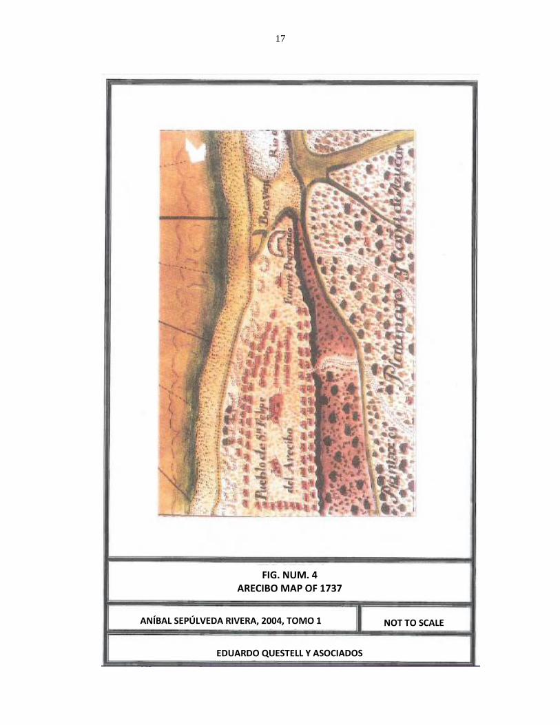
On the other hand, we find the first available graphical representation of Arecibo in a
subsection of a plan by Francisco Fernández Valdelomar, commissioned by Governor Matías de
Abadía, dated 1737, a copy of which we have included as our Figure no. 4. Architect Sepulveda
notes that: "A diferencia de los planos de Aguada y Añasco, [este plano] muestra un pueblo de
considerable tamaño. El pueblo costero estaba compuesto por 95 viviendas de diferentes
tamaños, que formaban una plaza rectangular en la cual se hallaban dos grandes estructuras, la
iglesia parroquial y la capilla de la Concepción. Las siete hileras de casa aparecen alineadas
de este a oeste y definen al menos seis calles. Hacia el este se destaca lo que parece ser otra
capilla (podría ser la del Rosario) y el sitio previsto para una fortificación que en efecto se
construyó poco después. El plano tiene escala gráfica en toesas (antigua medida francesa de
longitud) [equivalente a un metro y 946 milímetros]. El plano ilustra el puerto de Arecibo, la
Boca Vieja del río, la desembocadura del mismo y el morrillo. Incluye una rosa de los vientos.
Muestra los rasgos de la topografía e indica los tipos de sembrados en la periferia del pueblo:
platanares y caña de azúcar. También indica la red de caminos de acceso al pueblo" (Ibid,
p.63). The original plan by Fernández Valdelomar, titled Plano del pequeño puerto de San
Felipe de Arecibo, distante doce leguas de la Aguada sobre la costa norte de la isla de Puerto
Rico, is found at the Archivo General de Indias, in Sevilla, and a copy at the General Archive of
Puerto Rico (Ibid, p.62)
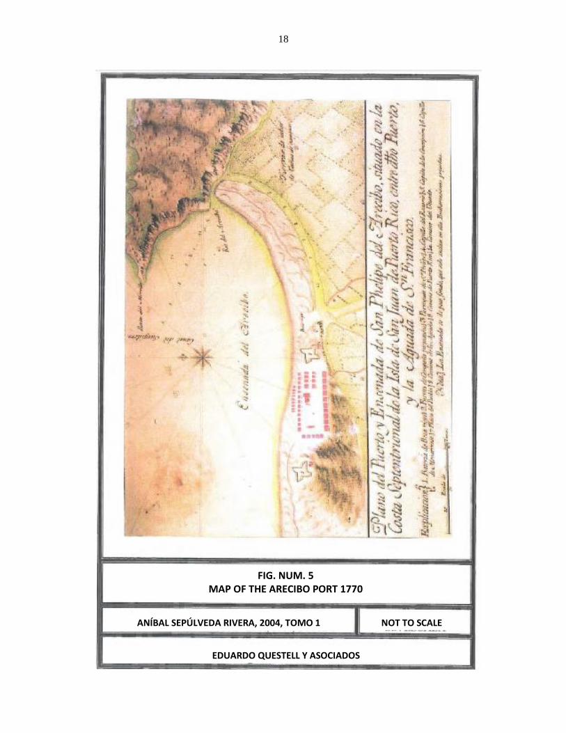
There is a second plan of eighteenth century Arecibo, a copy of which (figure no. 5) we
have again taken from Volume 1 of the said publication by architect Sepúlveda Rivera (p. 63),
titled Plano del puerto de San Felipe del Arecibo, situado en la costa septentrional de la isla de
San Juan de Puerto Rico, entre dicho puerto y el de la Aguada de San Francisco. This plan is
dated close to 1770. Arquitect Sepúlveda states that: "El mapa tiene escala en toesas. Muestra
16
la topografía e incluye las profundidades del canal del surtidero de puerto y del río desde la
desembocadura al pueblo. Ilustra las tierras de labor de caña de azúcar y los caminos de
acceso. El trazado del pueblo aparece definido por cinco estructuras institucionales (iglesia,
tres capillas y la batería) y por 45 casa alineadas la mayoría de este a oeste. La plaza
rectangular se conforma según las disposiciones legales establecidas al comienzo de la
colonización…" (Ibid). The original of this plan is found at the Servicio Geográfico del Ejército,
in Madrid.
The militia infantry captain, Don Fernando Miyares González, published in 1777 his
Noticias Particulares de la Isla y Plaza de San Juan Bautista de Puerto Rico, where he wrote
about the Arecibo Party the following (p.67-68):
“Siempre se ha distinguido este pueblo desde su fundación, que fue la
cuarta de la isla. Así lo acreditó el ano de setecientos dos [1702], que habiendo
desembarcado el enemigo inglés la gente de dos bajeles de guerra, no hallándose
en el pueblo más que once hombres con su capitán don Antonio Correa, por estar
los demás retirados en sus labranzas, los resistió dicho capitán y sin permitirles
unirse en formación les acometió con intrepidez, haciéndole retirar
atropelladamente, de modo que con sumo trabajo pudieron tomar sus lanchas,
pues hasta dentro del mismo mar les siguió. Por esta acción tan gallarda hizo S.
M. [merced] al dicho don Antonio correa, de la medalla de su real efigie y el
título de capitán de infantería con sueldo situado en las caxas de México, que se
le remitía aparte antes que falleciese.
La aplicación de sus vecinos ha hecho floreciente este partido. Hállase
situado en una legua de tierra formada por el mar y el río. Elévase poco sobre el
nivel de ambos, pero hubiera estado mejor fundado en una altura inmediata que
domina los alrededores. Tiene más de doscientas casas unidades, con la tercera
parte de texa, formando calles regulares. Además de una mediana iglesia, hay
tres ermitas y la mejor casa de piedra que sirve de cuartel a las dos compañías de
infantería y una de caballería de milicias disciplinadas. Los campos vecinos son
deliciosos, cubiertos de diferentes géneros de arboledas y con muchos arroyos.
Encuéntrense casas por todas partes; en los montes hay muchos palos de tinte y
maderas de construcción. En suma, no falta más a este partido que los buenos
puertos que sobran a otros”.
As we have seen, by the eighteenth century the town had continued to grow and its
development was recognized by the Casa Real which awarded it with the title of Villa on
January 14, 1778.
17
ANÍBAL SEPÚLVEDA RIVERA, 2004, TOMO 1
FIG. NUM. 4 ARECIBO MAP OF 1737
NOT TO SCALE
EDUARDO QUESTELL Y ASOCIADOS
18
ANÍBAL SEPÚLVEDA RIVERA, 2004, TOMO 1
FIG. NUM. 5 MAP OF THE ARECIBO PORT 1770
NOT TO SCALE
EDUARDO QUESTELL Y ASOCIADOS

19
For those years, Fray Iñigo Abbad y Lasierra describes the named Villa de Arecibo as
follows (1788, p. 12):
“Después de la ribera de Manatí siguiendo la costa del norte hacia el
poniente, hay dos leguas de monte llano, cerrado de robustos árboles, hasta
entrar en la ribera del río Arecibo, que es más extensa y tan feraz como la
antecedente, aunque no mejor empleada, pues toda está dedicada a la cría de
ganados, sin cultivar otros frutos que los regulares y precisos; a esto se ciñe toda
su industria y labranza.
El pueblo dista de la antecedente 7 leguas, tiene tres hileras de casas, que
dejan una buena plaza; situado en una península o arenal formado de la mar y
río Arecibo, que lo circundan. Entre la punta del arenal del Arecibo, la del
Morrillo y un peñasco que se avanza al noroeste, queda una caleta en la cual
desemboca el río, cuyas avenidas forman bancos de arena, e impiden la entrada a
las embarcaciones que calen más de dos brazas de agua, y así rara vez llega
alguna a la caleta de este pueblo. Su iglesia es reducida para el vecindario, que
asciende a 700 familias; estas viven en sus estancias, que se extienden mas de
tres leguas a lo largo de las riberas del río.”
Moreover, the Viaje a la Isla de Puerto Rico en el ago 1797, was published in Paris in
1810, by the French botanist André Pierre Ledrú, where he mentioned the town of Arecibo (p.
71):
“Su situación es en la desembocadura del río de su nombre, y en el que no
puede entrar ningún buque que cale más de tres metros de agua, por los bancos
de arena que obstruyen el paso. Hay en todo el partido 5,155 habitantes,
dedicados al cultivo del arroz, maíz, tabaco y a la crianza de gran número de
ganado vacuno. Tan indolentes como los de Manatí, no saben utilizarse de la
posición ventajosa en que los ha colocado la naturaleza. El río Arecibo nace en
las alturas de la cordillera que atraviesa la Isla en toda su extensión de este a
oeste”.
In 1824 the population had grown to 9.546 souls (De Córdova, p.105) and in 1828
reached 9.963, of which 4.862 were white, 3,256 brown (pardos), 645 blacks and 915 slaves
(Ibid).
Pedro Tomás de Córdova himself, secretary to the Spanish government, provides a good
description of the Arecibo from the decade of 1820:
“Sus terrenos en la mayor parte son vegas frondosas y muy abundantes en
pastos, y en general todas las tierras con fertilísimas para la crianza y labor. Se

20
cosecha con abundancia caña, café, plátanos, tabaco y toda clase de menesteres.
Los caminos están despojados y buenos en tiempo de seca pero se ponen
intransitables en las lluvias, por los muchos pantanos que se forman en las
bajuras y las extraordinarias crecientes de los ríos. Abunda de Piedra de cal y de
sillería, lo mismo que maderas. El partido está dividido en los barrios del
pueblo, Hato Grande, Cuatro Calles, Hato Viejo, Rio Arriba, Arenalejos,
Santana, Factor, Cambalache e Islote. En 1828 había entre los vecinos 112
artesanos, 43 extranjeros domiciliados y naturalizados y 43 emigrados; 119
casas y 126 bojíos en el barrio, y en la jurisdicción 187 casas y 1,366 bojíos, 35
tiendas de todas clases y 28 ventorrillos.” (1831, páginas 105-106)”.
In 1878 Arecibo comprised the Cambalache, Islote, Santana, Factor, Garrochales, Río
Arriba, Hato Arriba, Dominguito and Esperanza wards (Ubeda y Delgado, p.156). In
Cambalache ward there were 175 families, 40 houses, 8 huts and 2 stores. (Ibid. p.157).
For many years since its origin, agriculture was the mainstay of the economy of this
town. During the nineteenth century, a large agricultural development took place in area.
Numerous sugar plantations and coffee estates were developed as well as farms dedicated to
other crops. However, sugar cane was always the major product. In 1841 there were no less
than 18 estates, among which were the Santa Bárbara, property of Doña Bárbara Balseiro, the
Cambalache, owned by Don Francisco Uranga, and Hacienda Claras, property of Francisco
Stuard whom "lo administraba el mismo" (Eileen Y. Cruz Ramirez, 1986, p.29-30). The Santa
Bárbara became the property of the heirs of Don Antonio Roses. It consisted of 360 cuerdas;
200 of which were planted with sugar cane by 1902. The Hacienda Cambalache became a major
sugar mill during the twentieth century, being called Central Cambalache Sugar Mill. Cruz
Ramírez states about the land belonging to the Central Cambalache Sugar Mill: "Hoy forma
parte de las tierras que antes se cultivaban de cana, ahora [1986] se están utilizando para la
siembra de arroz" (Ibid, p. 30). By 1841 there also was the Hacienda Caños, whose owner was
Doña Francisca Torrin, and agent representative José Ramón Lerrieu (Ibid).
Since the 1950s, several high technology companies have established in Arecibo, which
linked to a number of different shops, distilleries and major refineries produce a large number of
jobs. In the 1980 census, Arecibo had 86.776 inhabitants, who had risen to 97.549 by the 1990
census.

21
Archival Research
The archival research consisted of the consultation and detailed study of documents held
by the following main sources:
- Council for the Protection of the Terrestrial Archeological Heritage of Puerto
Rico.
- State Historic Preservation Office (S.H.P.O.)
- Archeological Sites in Puerto Rico of S.K. Lothrop; manuscript copy held by
the authors of this Phase IA-IB report.
- Field notes of the archeological sites of Puerto Rico of Dr. Irving B. Rouse;
manuscript copy corresponding to the municipality of Arecibo held by the State
Historic Preservation Office.
- Inventory of Historic Engineering and Industry of Puerto Rico by Carlos
Rosado/ W. Rodríguez/ L. Pumarada- President Office-University of Puerto
Rico-San Juan 1977. Manuscript in the State Historic Preservation Office
(S.H.P.O).
- Historic American Engineering Record (HAER), Inventory by Osvaldo Rivera/
W Rodríguez-UPR San Juan 1997. Copy of inventory held by S.H.P.O. Office.
- Puerto Rico Architectural Resources Inventory, State Historic Preservation
Office.
- Archeological, historical, geographical, geological, etc. literature, included in
the bibliography of this Phase IA-IB evaluation.
- Local informants.
- Consultation with other archeologists from Puerto Rico.
Detailed consultation of the records related to the inventory of archaeological sites in
Puerto Rico, held by the Council for the Protection of the Terrestrial Archeological Heritage of
Puerto Rico and the State Historic Preservation Office revealed no prehistoric or historic
evidence in the specific area where the Project object of this assessment will be developed. The
nearest reported and/or known archeological site in the topographic quadrangle of Arecibo

22
(which is the quadrangle where the Project site is located) is the one designated as AR005 “El
Caney” located 1,500 meters to the North Northwest of the Project. This site is a residuary under
the streets and residencies of the urban zone of Arecibo, where pottery fragments and remains of
human bones were found. Archeologist Fernando Alvarado (Segregación de treinta y ocho
solares, Arecibo, Puerto Rico, page 15) tells us: “En los años 1940 hasta el 1950 se realizaron
varias excavaciones en el yacimiento conocido como el Caney por el doctor José Oliver, éste
menciona lo siguiente: “En las décadas del 1940 y 1950 efectuó varias excavaciones en solares
al este de la Catedral. Recuerdo cuando hizo excavaciones en el solar en donde hoy existe el
área de aparcamiento del Hospital El Buen Pastor y cuando se reconstruyó la parte del casino
de Arecibo, donde está el salón de baile. Informa el Dr. Oliver haber hallado restos humanos,
no solo de cristianos, sino también de indios, los que distinguió, porque los indios
acostumbraban a enterrar a sus muertos en posición encorvada, con las rodillas pegadas al
pecho” (Lago, 1987)”. Archeologist Alvarado (Ibid, pages 17-18) adds that: “Para el año 1992
se realizó otra incursión al yacimiento registrado como el Caney, por los arqueólogos Juan
González, María Cashion y Jaime Vélez. El arqueólogo González informa: “La data obtenida y
analizada del sector en donde se harán las mejoras, indican la existencia de un sitio
multicomponente; el mismo fue afectado a través de los años por el desarrollo urbano de la
parte antigua de la ciudad de Arecibo. Dentro del perímetro de la propiedad específicamente en
el subsuelo todavía permanecen materiales de origen precolombino e histórico que no han sido
afectados adversamente” (González, 1993)”.
Another place depicted and relatively near is the one called AR004 (Poza del Obispo),
which is located near 2.4 kilometers to the North Northeast of the Project area. Archeologist
Fernando Alvarado (page 16) tells us about this site: “Para el 1987, los arqueólogos Pedro
Alvarado y Harry Alemán, realizaron una Fase II en las cercanías al Faro de Arecibo,
exactamente en el lugar llamado Poza del Obispo (AR-4). En este lugar ellos determinaron lo
siguiente: Las actividades humanas en el lugar las remociones han impedido estudiar el sitio
AR-4 en su contexto cultural original. Pero no todo en vano, ya que de acuerdo a las muestras
de cerámica podemos inferir que el sitio fue habitado por los grupos representativos
estilísticamente por la cerámica estilo Ostiones y Santa Elena” (Alvarado, 1987)”.
Moreover, K.S. Lothrop mentions in his listing several places for Arecibo: a cave with
petroglyphs in Arenalejos Ward; another cave with petroglyphs and two ball courts (bateyes) in

23
Arrozal Ward, one of which he locates at the Biáfara site of this ward, when Biáfara is really
located on Miraflores Ward, and also mentions Cueva Bonilla, with petroglyphs (according to
Pinart) in this ward of Arrozales; the so called “Cueva de los Indios”, with petroglyphs, in Islote
ward; the cave “Miraflores” with petroglyphs in Miraflores Ward, inside M. Denton property; a
cave called the “Convento”, also with petroglyphs, in Sabana Hoyos Ward; and a cave and a ball
court (batey) in Esperanza Ward.
In the National Register of Historic Places, revised on February 4, 2010, there existed
thirteen (13) places listed for the Municipality of Arecibo, all of which are far from the Project
and would not be affected by it. The site with historic value nearest to the Study area is possibly
the one that contains some of the ruins of the old Hacienda Santa Bárbara, which is located
nearly 700 meters to the North Northeast of the Study area, and will not be impacted at all by the
Project.
Included in Appendix D is a photocopy of a portion of the Arecibo quadrangle where the
sites with prehistoric or historic value near the Study area are depicted.
Land Use Pattern
The oldest map that we found for the general area under study (1936, West-Central Sheet,
R.C. Roberts, Soil Survey), tells us that the current Road PR-2 already existed with that number
and crossed to the East of the site. Likewise, it is observed that a branch of the train railway, that
joined the Railroad Company of Puerto Rico railway, ran through the center of the property,
surely for collecting the canes from Hacienda Santa Bárbara and other surrounding lands and
take them to Central Cambalache Sugar Mill. No structure is observed then inside the property
boundaries. Today there is not the slightest evidence of the passage of a train track around the
property. Our figure num. 6 illustrates part of the map of Robert’s soil survey where the Project
area is located.
This is the second time that we conduct an archeological survey of this site. The first
time, in November of 1998, was to evaluate approximately 105 cuerdas for the construction of
an industrial development in the property, belonging then to Global Fibers Inc., a paper mill that
was established on the Site. A report of the archeological assessment was submitted, and
apparently it was never sent to the Institute of Puerto Rican Culture. The current Project

24
includes approximately 81.30255 cuerdas, which comprise some of the cuerdas previously
surveyed, and areas not surveyed, or not adequately surveyed then, due to environmental
challenges.
The property was planted with sugar cane until the decade of 1950. In our 1998
evaluation we talked with informant Ángel Lescano Correa, 63 years old (then), neighbor of the
area, and then employed as a security guard at the paper mill. Mr. Lescano Correa informed us
in 1998 that the paper mill began operations at the site in 1957 under the name Grace Paper Co.,
with the purpose of producing paper in rolls. Afterward, the mill was known as Arecibo Paper
Mill, and later on as International Mill. Its name in 1998, as we said before, was Global Fiber
Inc. The mill closed operations, according to informant Lescano Correa, on December 15 of
1995. In our 1998 property visit, we observed fences, earthen irrigation channels, a concrete and
concrete-blocks warehouse and abundance of modern trash (wood, paper, plastic, care tires,
metal, etc), especially near and on the back (West) of the paper mill. In 1998, the existing
structures were: offices, warehouse, boiler room, operations building and infirmary. All were
abandoned and some rapidly deteriorating. The first floor of the structures was of concrete and
blocks. The walls and ceiling of the second floor were of asbestos-cement sheets.
On the other hand, for the current Project we interviewed Mr. Luis Ocasio as informant.
He worked at the paper mill since 1970 until 1996. Mr. Ocasio stated that the structures
associated to the paper mill were in construction between 1957 and 1959, being the facility
inaugurated in 1960. As from 1957 fill was brought from elsewhere to stabilize certain areas and
roads in the paper mill property. The existing “lagoons” are all artificial, and were built as part
of the paper manufacturing process. Some of these “lagoons” were in use until 1977, and others
until 1996, year when the industry ceased operations. For the construction of these “lagoons” all
their surface was altered with heavy equipment, extracting superficial material in order to
construct the side walls that form the borders.
All the existing structures in the North-Northeast side of the property, says Mr. Ocasio,
were part of the paper manufacturing process. Some structures identified near the river were part
of a pumping system for fire control. During the paper manufacturing process the sugar cane
bagasse form the adjacent Central Cambalache Sugar Mill was used.

25
Other parts of the property are currently vacant and unused, covered by pastures, weeds
and mounds. Included as Appendix E is a copy of the Title Study and of a Deed of Sale with the
pertinent data from the Registry of Property, for Property (finca) num. 20,522, registered on Page
SOIL SURVEY OF ROBERTS AND OTHERS
FIG. NUM. 6 PROJECT SITE (1936)
SCALE 1:50,000
EDUARDO QUESTELL Y ASOCIADOS

26
(folio) 30, of Volume (tomo)1248 of Arecibo, which is the property that is the Study area.
Appendix F includes aerial photographs dating from 1936, 1950, 1963 and 1990, and shows the
Project area.
Surface Inspection and Sensitivity Study
We visited the Project site again in order to perform a surface reconnaissance of the entire
terrain surface. The property is currently vacant, with abundant bushes and shrubs, and the
structures mentioned before are deteriorated (see photos). Modern debris and junk were
observed in several places. Several dirt roads that date from the time of construction of the paper
mill were also seen. Structures associated to the fire pumping system were also observed (see
photos).
The site seems to have a low archeological sensitivity. No evidence of prehistoric or
historic cultural material was detected on the terrain surface other than what was indicated
pertaining to the paper mill. The nearest prehistoric site is located some 1,500 meters to the
North-Northeast of the Project area.
Conclusion of Phase IA
The Project is located in a sector with low sensitivity, with reported or mentioned
archeological sites far away, the nearest being a residuary under the Arecibo urban zone, some
1,500 meters to the North-Northeast of the North limit of the Project area. All the recovered data
of our surface reconnaissance tends to indicate that the land is sterile to the presence of
archeological artifacts, but the above data makes a Phase IB survey for the property necessary.
PHASE IB SURVEY
The phase IB includes, as its main component, the execution of test pits under the land
surface. The areas to be tested by means of subsoil test pits are selected bases on the Phase IA

27
results. This phase’s report should include: the surveys design and its methodology; the results
with the terrain stratigraphy; a catalog of artifacts, if applies; the location of the test pits
excavated; and photographs to clarify certain aspects. Final conclusions and recommendations
have to be included in the report.
Survey Design and Methodology
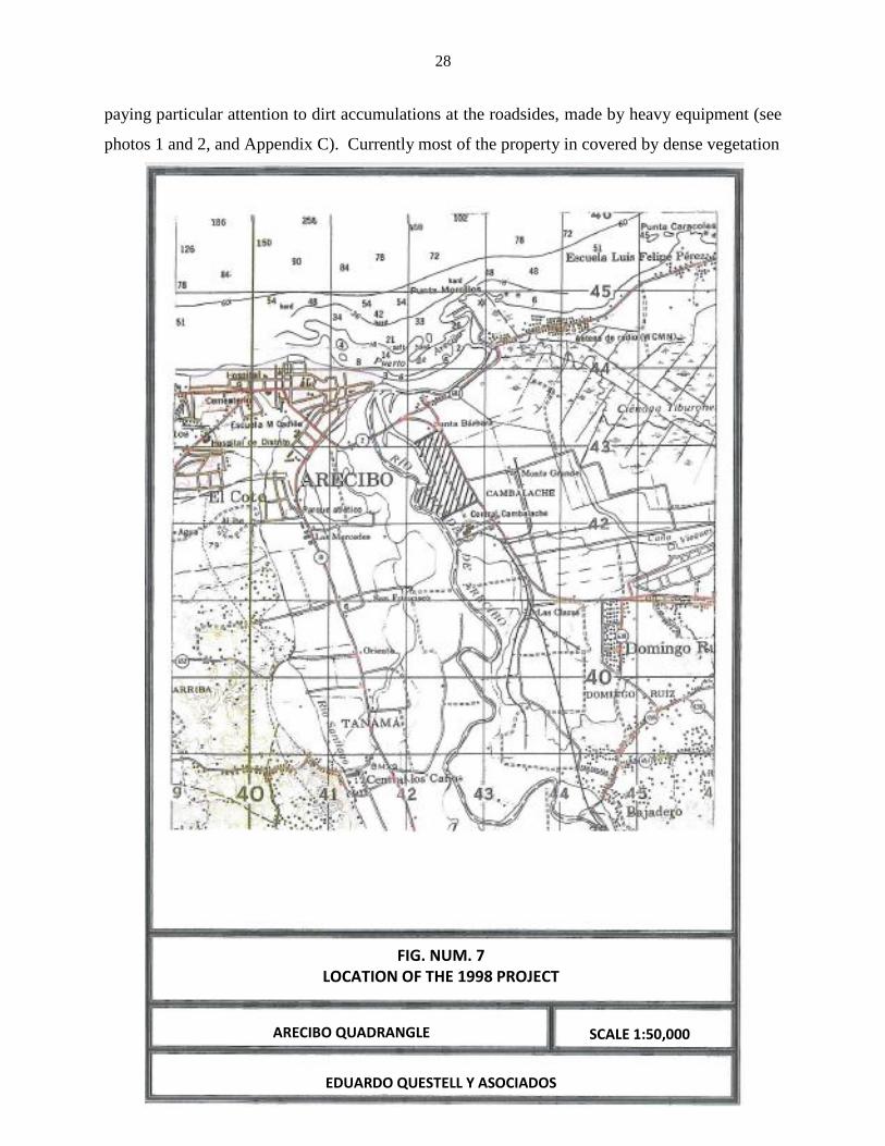
As we mentioned earlier, part of the Project site was surveyed in 1998. In that occasion,
approximately 105 cuerdas were evaluated. Our figure number 7 shows, at a 1:50,000 scale, the
limits of that project. The Site was then divided into three areas: A, B and C, corresponding to
the current areas B and C. The limits of the areas evaluated in 1998 are included in a copy of the
plan used in said year (1998) and the end of this report. Because on area B of the 1998
evaluation six (6) systematic transects were completed, and sixty-two (62) of 106 planned
stratigraphic test pits were excavated, and additional random surface inspections were made, all
with negative results for prehistoric and historic cultural resources, we understand that it is not
necessary to carry out additional studies in said area B. The surface reconnaissance on this area
B was then hampered by a small pond. Other test pits in these area were not dug (mostly those
on the West half of the area) because they were located in sectors that were previously impacted
by the construction of other small ponds, or by the extraction of sand. These last ponds were dry
by 1998, but the soil where they were located was completely removed up to a depth of more
than 2 meters.
In the land corresponding to the then area C, in 1998, eleven (11) transects were
inspected and five (5) stratigraphic test pits were excavated. Even though all resulted negative
for cultural resources, we understand that the area can be evaluated now in a more appropriate or
accurate way, therefore we proceeded to design a research and a methodology for its
archeological assessment.
First, the surface was inspected along some open roads within the property. Most of them
date, as we previously indicated, to the construction epoch of the paper mill. During the surface
inspection we were observant to the possible presence of archeological artifacts over the surface,
28
paying particular attention to dirt accumulations at the roadsides, made by heavy equipment (see
photos 1 and 2, and Appendix C). Currently most of the property in covered by dense vegetation
FIG. NUM. 7 LOCATION OF THE 1998 PROJECT
ARECIBO QUADRANGLE SCALE 1:50,000
EDUARDO QUESTELL Y ASOCIADOS

29
(see photos 3 and 4). The roads and other areas clean of vegetation were the most favorable for
surface inspection.
In the surface inspection, as already indicated, some structures associated to the fire
control system of the old paper mill were found (as was indicated to us by the informant Luis
Ocasio, pump system by the river, see photos 5 and 6), as well as a pair of disperse brick
fragments. Also were evident sector with modern debris accumulations (see photo 7), and
flooded sectors (see photo 8). Likewise, the buildings associated with the paper industry were
evident (see photos 9 and 10), as well as smaller structures, all located in the North-Northeast
side of the property, near the entrance that limits with Road PR-2.
After the above observations and taking in consideration all the parameters previously
indicated, it was decided to use the following methodology to survey the terrain:
1. A series of non-systematic transects will be open with the same equipment or heavy
machinery, throughout the site, with the purpose of clearing vegetation from the sites
where the test pits will be excavated. The transects will be opened across all the West
part of this area, so as to cover a representative portion of it and therefore identify the
sectors with less probability of being altered or impacted by previous terrain
movements and agricultural practices.
2. The survey will be complement with manual and mechanic test pits, spaced at a 40-
meter intervals in those sectors where the environmental conditions permit (see
report’s final site plan).
All the manual test pits will be excavated with a post hole digger, resulting in a pit of
approximately 25 x 25 cm and of variable depth. The depth of the pits is always variable, and
depends, often on the depth of the soil over the decomposed or hard rock, or on the experience
and knowledge of the investigator. The material obtained from the test pits will be sifted, when
necessary, as a measure of control that will allow us to detect any evidence of cultural resources
material.

30
Phase IB Survey Results
The site was investigated as planned, following the study scheme mentioned in the survey
design. Visibility was adequate thanks to the transects and cleaning performed with heavy
equipment.
The terrain presented ample evidence of impact to the subsoil, both for the construction
of the paper mill as for the original roads, as well as for the small artificial ponds associated to
the said industry. As we said, these small ponds are currently dry, and their entire surface was
impacted in order to extract the soil and create their lateral walls (according to informant Luis
Ocasio). Our observations over the terrain corroborate such information, evidencing the impact
from the construction of the small ponds on the original soil of the area. In addition, the entire
site surface, down to at least plowing depth (46 centimeters) must have been previously impacted
by agricultural practices.
The use of a backhoe allowed reaching depths of over a meter, particularly on the alluvial
sector near the riverbank. This proved methodologically sound due to the possibility of
archaeological remains buried at more than one meter of depth by alluvial deposition and flood
events.
The manual test pits were excavated using post hole diggers and digging bar. Each had a
minimum depth of one meter, except in those were fill or rocks were found. Sometimes the
manual test pits were excavated to a maximum depth of 1.20 meters (see photos 11 and 12).
Thirty five manual test pits were excavated and 35 units or trenches, dug with heavy
equipment, were made, for a total of 70 archeological probes. In addition, all the road profiles
and mounds of removed material were inspected for archeological artifacts.
The excavation trenches had a mean size of 2 meters long by 60 centimeters wide. These
trenches had a mean depth of 2 meters, with a maximum depth of 2.75 meters in some. The
machines’ movement during excavations was always supervised by an archeologist or an archeo-
technician (see photos 13 and 14).
All the soil extracted by the manual test pit excavations was sifted thru a ¼ inch mesh.
The excavation trenches were inspected with shovels and trowels, and a representative portion of
the material extracted from them was also sifted.

31
The stratigraphy included clay, fill, and river sand. This river sand was present in much
of the site, particularly on the South section adjacent to the Río Grande de Arecibo.
The first stratum we found was clay and sand, mostly corresponding to the Munsell color
10 YR 3/3 or 3/2. These initial strata had an average thickness of approximately 20-25
centimeter. In some sectors, mainly along the roads, we documented a limestone fill deposited
on the surface. According to informant Luis Ocasio, this fill was deposited in 1977.
As second stratum, we identified both sand and clay, predominant color 10 YR 4/4, with
slight variations and varying depths. We also documented very fine sand, corresponding to the
Munsell color 10 YR 5/2 or 5/4, and sometimes a plastic clay corresponding to the Munsell color
7.5 YR 4/4. In many occasions we identified a kind of “babote” or muddy soil (dark gray or
very dark gray clay, 10 YR 4/1 or 3/1) at the bottom of the trenches, even below the water table.
This “babote” and water table was documented from a 2 m depth. For detailed information on
the stratigraphy in the test pits and trenches refer to Appendix B.
As results for identified materials, beside the modern debris, three test pits resulted
positive to the presence of brick fragments, one in each of the three test pits. These were stray
findings and without any kind of context. The rest of the excavation results were completely
negative to the presence of prehistoric or historic cultural materials.
In general terms the field investigation evidenced that the area has a high level of impact
in large part of its surface, and that it is completely barren of any kind of archeological artifacts.
In Appendix B, as we indicated before, there is a general description of the test pits made
in 1998 and their stratigraphy, and of those carried out in the current Project. Appendix C
includes an index of photographs with many of the photos taken in 1998, plus those taken for the
current evaluation.
CONCLUSIONS AND RECOMMENDATIONS
We have conducted an archeological survey of the terrain of a property of approximately
55 acres (81.30255 cuerdas) in the Cambalache Ward, Road PR-2, KM 72.8, of the Municipality
of Arecibo.
32
The archival, reference literature and other sources investigated did not indicate the
presence of prehistoric or historic archeological sites in the specific Project area. The nearest
reported and/or known archeological sites are: site AR005 (“El Caney”), which is a residuary
located under the streets and residences of the Arecibo urban zone, and that is some 1,500 meters
to the North-Northeast of the Study area; and site AR004 (“Poza del Obispo”), with is another
residuary located some 2,400 meters to the North-Northeast. On the other hand, the nearest
place with historic value may be the ruins of the former Hacienda Santa Bárbara, which are
located some 700 meters to the North-Northeast of the Project site.
This is the second time that we conduct an archeological survey in these lands. The first
time, in November of 1998, was to evaluate approximately 105 cuerdas for the construction of
an industrial development in the property, belonging then to Global Fibers, Inc, a paper mill that
was established at the site. A report of the archeological assessment was submitted, and
apparently it was never sent to the Institute of Puerto Rican Culture. The current Project
includes approximately 81.30255 cuerdas, which comprise some of the cuerdas previously
surveyed, and also some of the land not surveyed, or not adequately surveyed then, due to
environmental challenges.
The site of the 1998 study was divided in three areas: A, B and C, of which the so-called
areas B and C correspond to the area of the current Project. The limits of the areas evaluated in
1998 are included in a copy of the site plan used in the year 1998 at the end of this report. Given
the circumstance that in area B of the 1998 survey six (6) systematic transects were conducted,
and that of the 106 test pits planned, sixty-two (62) were made, plus random surface inspections
throughout the area, all with negative results for the presence of prehistoric or historic cultural
resources, we understand that it is not necessary to conduct additional studies in area B. The
results of the 1998 survey for area B are included in this report.
In the land corresponding to the former area C, in 1998, eleven (11) transects were
inspected and five (5) test pits were made. Even though all resulted negative to cultural
resources, we understand that the land of the former area C could now be evaluated in a more
adequate or accurate way, therefore we proceeded with a research and methodology design for
its archeological assessment.
In this area the property was inspected by means of non-systematic transects, manual test
pits and excavation trenches, using for the latter a mechanical backhoe. A total of 35 manual test

33
pits and also 35 excavation trenches were made. The average size of the trenches was 2 meters
long, by 60 centimeters wide.
The inspection of transects, test pits and excavation trenches showed negative evidence to
prehistoric or historic cultural material in the study area, with the exception of three scattered test
pits where a brick fragment was found in each.
According to the data presented, we conclude and recommend that the Project
development continue as planned. Naturally, it is also recommended that if material remains of
cultural resources are found at any moment during the development of the Project, the works
stop and the authors and concerned agencies be notified.
34
BIBLIOGRAPHY
Abbad y Lasierra, Fray Agustín Iñigo: Historia Geográfica, Civil y Natural de la Isla de San
Juan Bautista de Puerto Rico, Editorial Universitaria, University of Puerto Rico, Río Piedras,
1979.
Acevedo, Gilberto: Soil Survey of Arecibo Area of Northern Puerto Rico, USDA, 1982.
Alegría, Ricardo E.: “On Puerto Rican Archaeology”, American Antiquity, 31: 246-249, 1965.
Alegría, Ricardo E.: “Apuntes para el estudio de los caciques de Puerto Rico”, Adenda of Revista
del Instituto de Cultura Puertorriqueña, núm. 85, 1979.
Alvarado Muñoz, Fernando: Segregación de Treinta y Ocho (38) Solares, PR-681, KM 7.6,
Barrio Islote, Arecibo, Puerto Rico, Cultural Assessment Report Phase IA-IB, 15 October 2007.
Arana Soto, Salvador: Diccionario Geográfico de Puerto Rico, San Juan de Puerto Rico, 1978.
Ayes Suárez, Carlos M.: “Dos Nuevas Localidades Petroglíficas del Barrio Garrochales de
Arecibo”, Ecos de Plazuela 1 (5): 1-21: 1990.
Ayes Suárez, Carlos M.: Urbanización Campos de Toledo, Bo. Hato Arriba, Arecibo, Puerto
Rico, Cultural Assessment Report Phase IA-IB, February 1997.
Briggs, Reginal P.: Geologic Map of the Arecibo Quadrangle, Puerto Rico, USGS Map I-551,
1968.
Cashion Lugo, María A.: Línea de Agua Cruda, Turbinas de Combustión de Cambalache,
Arecibo, Puerto Rico. Cultural Assessment Report Phase IA-IB, 22 August 1996.
Coll y Toste, Cayetano: Boletín Histórico de Puerto Rico, 14 volumes. Tipografía Cantero,
Fernández y Compañía, San Juan, 1918.
Córdova, Pedro Tomás de: Memorias Geográficas, Históricas, Económicas y Estadísticas de la
Isla de Puerto Rico, Institute of Puerto Rican Culture, San Juan de Puerto Rico, 1968, 6 volumes.
Cruz Ramírez, Hielen Y.: Arecibo, Notas para su historia, San Juan, 1986.
Garrow & Associates, Inc.: 1988 Proposal to Perform a Cultural Resources Reconnaissance
within the Proposed Río Grande de Arecibo Flood Control Project, Puerto Rico, submitted to
the US Army Corps of Engineers, Jacksonville District, Fla.
González Colón, Juan: Altos de la Villa, Barrios Hato Abajo y Hato Arriba, Arecibo, Puerto
Rico, Cultural Assessment Report Phase IA-IB, November 2002.

35
González Colón, Juan: Urbanización Húcares, Bo. Hato Arriba, Arecibo, Puerto Rico, Cultural
Assessment Report Phase IA-IB, October 2008.
King, Thomas F.: “The Archeological Survey, Methods and Uses”, Heritage, Conservation and
Recreation Service, US Department of the Interior, Washington, D.C., 1978, page 87.
Lothrop, S.K.: “Archaeological Sites in Puerto Rico”, 1916, manuscript located at the Yale
Peabody Museum Archive, New Haven.
Martínez Torres, Roberto: Urbanización villas Rosa, Bo. Hato Arriba, Arecibo, Puerto Rico,
Cultural Assessment Report Phase IA, February 1999.
Martínez Torres, Roberto: Construcción de Cuarenta Solares en la Propiedad del Sr. Emilio
(Millo) Vélez, Bo. Hato Arriba, Arecibo, Puerto Rico, Cultural Assessment Report Phase IA-IB,
February 1999.
Martínez Torres, Roberto: La Región de Abacoa: Historia y Arqueología, Dissertion submitted
as a requirement to obtain the PhD in Philosophy and Letters with concentration in History,
Centro de Estudios Avanzados de Puerto Rico y el Caribe, San Juan, Puerto Rico, 12 March
2005 (Unpublished).
Martínez Torres, Roberto: Estudio de Evaluación de Recursos Culturales, Fase IA, para el
territorio que comprende el Municipio de Arecibo, Puerto Rico, 2 January 2007.
Martínez Torres, Roberto: C.A.R.I.B. #1, August 2008.
Maurás Casillas, Adalberto: Reestructuración Comunidad El Vigía, Arecibo, Puerto Rico,
Cultural Assessment Report Phase IA-IB, 18 November 2004.
Picó, Rafael: Geografía de Puerto Rico, Editorial Universitaria, University of Puerto Rico, 1964.
Questell Rodríguez, Eduardo: Desarrollo Industrial Terrenos de Global Fibers, Inc., Carretera
PR-2, Bo. Cambalache, Arecibo, Puerto Rico, Cultural Assessment Report Phase IA-IB
(unpublished), November 1998.
Questell Rodríguez, Eduardo: Autódromo de Arecibo, PR-2 y PR-681, Barrio Cambalache,
Arecibo, Puerto Rico, Cultural Assessment Report Phase IA, June 2001.
Questell Rodríguez, Eduardo: Senderos de Miraflores PR-637, KM 2.5, Barrio Miraflores,
Arecibo, Puerto Rico, Cultural Assessment Report Phase IA-IB, September 2007.
Questell Rodríguez, Eduardo: Desarrollo de Terreno, PR-2, KM 61.9, Bo. Sabana Hoyos,
Arecibo, Puerto Rico, Cultural Assessment Report Phase IA-IB, April, 2008.
Rainey, Froelich G.: “Porto Rican Archaeology”, Scientific Survey of Porto Rico and the Virgin
Islands, New York Academy of Sciences, 18 (1), 1940.
36
Rodríguez, Miguel y Yasha N. Rodríguez: Mejoras al Sistema de Abasto de Agua del Municipio
de Arecibo, Área Costera de Arecibo, Barrios Islote y Cambalache, Arecibo, Puerto Rico,
Cultural Assessment Report Phase IA-IB, 12 November 1998.
Rouse, Irving: “Porto Rican Prehistory: Introduction: Excavations in the West and North”,
Scientific Survey of Porto Rico and the Virgin Islands, vol XVIII, part 3, page 336; part 4, pages
465-512.
Rouse, Irving: “Migrations in Prehistory”, Inferring Population Movements from Cultural
Remains, Yale University Press, New Haven, 1986.
Úbeda y Delgado, Manuel: Isla de Puerto Rico, Establecimiento Tipográfico del Boletín, San
Juan, Puerto Rico, 1878.
USGS: Arecibo Quadrangle, 1:20,000.
Velásquez, Cynthia: Arecibo… así era, Editora Alfa & Omega, Dominican Republic, 1998.

Appendix A


Appendix B

Table of Test Pits and
Excavation Trenches
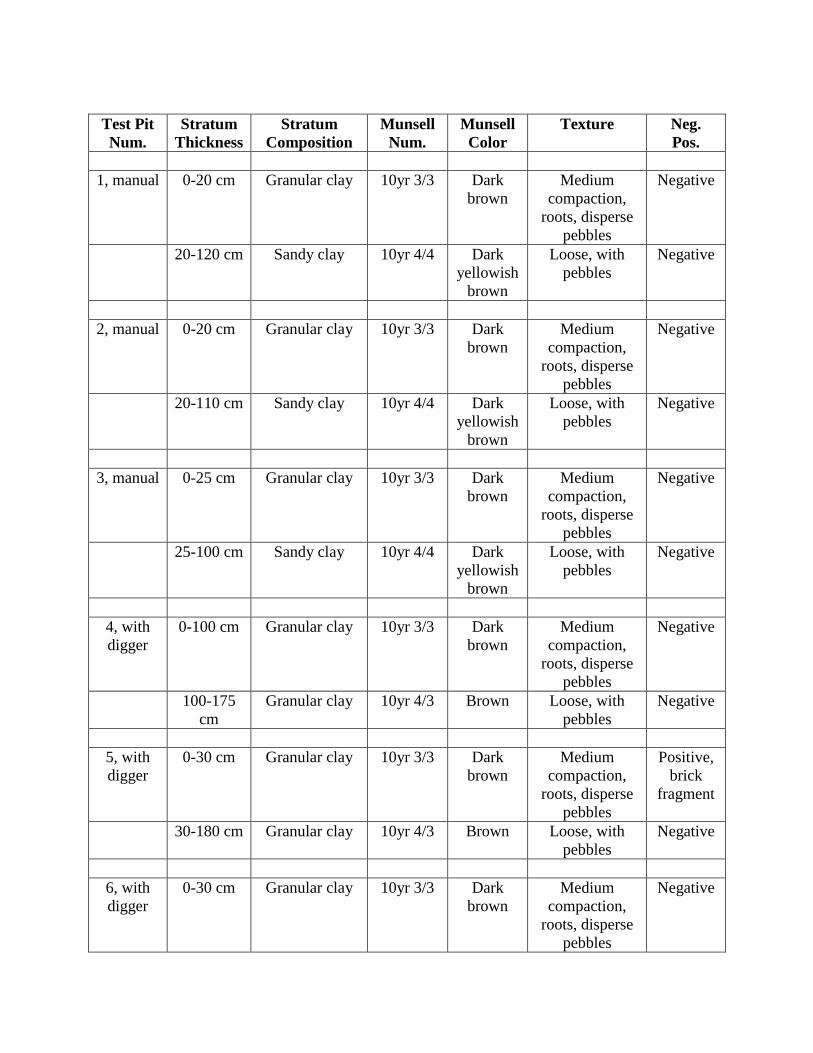
Test Pit
Num.
Stratum
Thickness
Stratum
Composition
Munsell
Num.
Munsell
Color
Texture Neg.
Pos.
1, manual 0-20 cm Granular clay 10yr 3/3 Dark
brown
Medium
compaction,
roots, disperse
pebbles
Negative
20-120 cm Sandy clay 10yr 4/4 Dark
yellowish
brown
Loose, with
pebbles
Negative
2, manual 0-20 cm Granular clay 10yr 3/3 Dark
brown
Medium
compaction,
roots, disperse
pebbles
Negative
20-110 cm Sandy clay 10yr 4/4 Dark
yellowish
brown
Loose, with
pebbles
Negative
3, manual 0-25 cm Granular clay 10yr 3/3 Dark
brown
Medium
compaction,
roots, disperse
pebbles
Negative
25-100 cm Sandy clay 10yr 4/4 Dark
yellowish
brown
Loose, with
pebbles
Negative
4, with
digger
0-100 cm Granular clay 10yr 3/3 Dark
brown
Medium
compaction,
roots, disperse
pebbles
Negative
100-175
cm
Granular clay 10yr 4/3 Brown Loose, with
pebbles
Negative
5, with
digger
0-30 cm Granular clay 10yr 3/3 Dark
brown
Medium
compaction,
roots, disperse
pebbles
Positive,
brick
fragment
30-180 cm Granular clay 10yr 4/3 Brown Loose, with
pebbles
Negative
6, with
digger
0-30 cm Granular clay 10yr 3/3 Dark
brown
Medium
compaction,
roots, disperse
pebbles
Negative

Test Pit
Num.
Stratum
Thickness
Stratum
Composition
Munsell
Num.
Munsell
Color
Texture Neg.
Pos.
30-180 cm Granular clay 10yr 4/3 Brown Loose, with
pebbles
Negative
7, manual 0-20 cm Granular clay 10yr 3/3 Dark
brown
Medium
compaction,
roots, disperse
pebbles
Negative
20-100 cm Granular clay 10yr 4/3 Brown Loose, with
pebbles
Negative
8, with
digger
0-25 cm Granular clay 10yr 3/3 Dark
brown
Medium
compaction,
roots, disperse
pebbles
Negative
25-200 cm Sandy clay 10yr 4/4 Dark
yellowish
brown
Loose, with
pebbles
Negative
9, manual 0-20 cm Granular clay 10yr 3/3 Dark
brown
Medium
compaction,
roots, disperse
pebbles
Negative
20-100 cm Granular clay 10yr 4/3 Brown Loose, with
pebbles
Negative
10, with
digger
0-10 cm
Limestone fill
0-20 cm Sand 10yr 3/3 Dark
brown
Loose, roots,
disperse
pebbles
Negative
20-190 cm Sand 10yr 4/4 Dark
yellowish
brown
Loose, without
pebbles
Negative
11, with
digger
0-10 cm Limestone fill
0-20 cm Sand 10yr 3/3 Dark
brown
Loose, roots,
disperse
pebbles
Positive,
brick
fragment
20-200 cm Sand 10yr 4/4 Dark
yellowish
brown
Loose, without
pebbles
Negative
200 cm Water table

Test Pit
Num.
Stratum
Thickness
Stratum
Composition
Munsell
Num.
Munsell
Color
Texture Neg.
Pos.
12,
manual
0-20 cm Sand 10yr 3/3 Dark
brown
Loose, roots,
disperse
pebbles
Negative
20-100 cm Sand 10yr 4/4 Dark
yellowish
brown
Loose, without
pebbles
Negative
13,
manual
0-25 cm Sand 10yr 3/3 Dark
brown
Loose, roots,
disperse
pebbles
Negative
25-100 cm Sand 10yr 4/4 Dark
yellowish
brown
Loose, without
pebbles
Negative
14, with
digger
0-25 cm Sand 10yr 3/3 Dark
brown
Loose, roots,
disperse
pebbles
Negative
25-190 cm Sand 10yr 4/4 Dark
yellowish
brown
Loose, without
pebbles
Negative
190-200
cm
Babote 10yr 2/1 Black Plastic, humid Negative
200 cm Water table
15, with
digger
0-30 cm Sand 10yr 3/3 Dark
brown
Loose, roots,
disperse
pebbles
Negative
30-180 cm Sand 10yr 4/4 Dark
yellowish
brown
Loose, without
pebbles
Negative
16, with
digger
0-30 cm Sand 10yr 3/3 Dark
brown
Loose, roots,
disperse
pebbles
Negative
30-180 cm Sand 10yr 4/4 Dark
yellowish
brown
Loose, without
pebbles
Negative
17, with
digger
0-20 cm Granular clay 10yr 3/3 Dark
brown
Medium
compaction,
roots, disperse
pebbles
Negative
20-180 cm Granular clay 10yr 4/3 Brown Loose, with
pebbles
Negative

Test Pit
Num.
Stratum
Thickness
Stratum
Composition
Munsell
Num.
Munsell
Color
Texture Neg.
Pos.
18, with
digger
0-30 cm Sand 10yr 3/3 Dark
brown
Loose, roots,
disperse
pebbles
Negative
30-180 cm Sand 10yr 4/4 Dark
yellowish
brown
Loose, without
pebbles
Negative
19,
manual
0-20 cm Granular clay 10yr 3/3 Dark
brown
Medium
compaction,
roots, disperse
pebbles
Negative
20-100 cm Granular clay 10yr 4/3 Brown Loose, with
pebbles
Negative
20,
manual
0-20 cm Granular clay 10yr 3/3 Dark
brown
Medium
compaction,
roots, disperse
pebbles
Negative
20-100 cm Granular clay 10yr 4/3 Brown Loose, with
pebbles
Negative
21, with
digger
0-30 cm Sand 10yr 3/3 Dark
brown
Loose, roots,
disperse
pebbles
Negative
30-180 cm Sand 10yr 4/4 Dark
yellowish
brown
Loose, without
pebbles
Negative
22, with
digger
0-25 cm Sand 10yr 3/3 Dark
brown
Loose, roots,
disperse
pebbles
Negative
25-180 cm
Sand 10yr 4/4 Dark
yellowish
brown
Loose, without
pebbles
Negative
180-200
cm
Babote 10yr 2/1 Black Plastic, humid Negative
200 cm Water table
23, with
digger
0-25 cm Sand 10yr 3/3 Dark
brown
Loose, roots,
disperse
pebbles
Negative
25-190 cm Sand 10yr 4/4 Dark
yellowish
Loose, without
pebbles
Negative
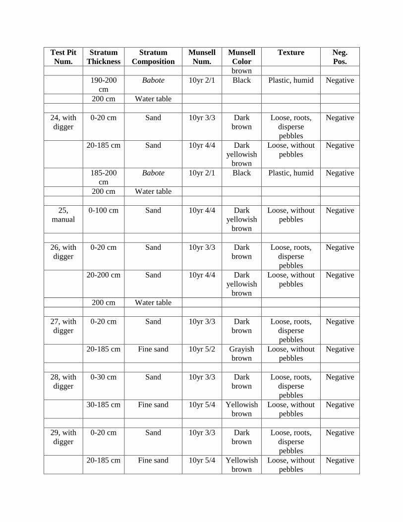
Test Pit
Num.
Stratum
Thickness
Stratum
Composition
Munsell
Num.
Munsell
Color
Texture Neg.
Pos.
brown
190-200
cm
Babote 10yr 2/1 Black Plastic, humid Negative
200 cm Water table
24, with
digger
0-20 cm Sand 10yr 3/3 Dark
brown
Loose, roots,
disperse
pebbles
Negative
20-185 cm Sand 10yr 4/4 Dark
yellowish
brown
Loose, without
pebbles
Negative
185-200
cm
Babote 10yr 2/1 Black Plastic, humid Negative
200 cm Water table
25,
manual
0-100 cm Sand 10yr 4/4 Dark
yellowish
brown
Loose, without
pebbles
Negative
26, with
digger
0-20 cm Sand 10yr 3/3 Dark
brown
Loose, roots,
disperse
pebbles
Negative
20-200 cm Sand 10yr 4/4 Dark
yellowish
brown
Loose, without
pebbles
Negative
200 cm Water table
27, with
digger
0-20 cm Sand 10yr 3/3 Dark
brown
Loose, roots,
disperse
pebbles
Negative
20-185 cm Fine sand 10yr 5/2 Grayish
brown
Loose, without
pebbles
Negative
28, with
digger
0-30 cm Sand 10yr 3/3 Dark
brown
Loose, roots,
disperse
pebbles
Negative
30-185 cm Fine sand 10yr 5/4 Yellowish
brown
Loose, without
pebbles
Negative
29, with
digger
0-20 cm Sand 10yr 3/3 Dark
brown
Loose, roots,
disperse
pebbles
Negative
20-185 cm Fine sand 10yr 5/4 Yellowish
brown
Loose, without
pebbles
Negative

Test Pit
Num.
Stratum
Thickness
Stratum
Composition
Munsell
Num.
Munsell
Color
Texture Neg.
Pos.
30,
manual
0-100 cm Sand 10yr 4/4 Dark
yellowish
brown
Loose, without
pebbles
Negative
31,
manual
0-30 cm Granular clay 10yr 3/3 Dark
brown
Medium
compaction,
roots, disperse
pebbles
Negative
30-100 cm Granular clay 10yr 4/3 Brown Loose, with
pebbles
Negative
32, with
digger
0-20 cm Granular clay 10yr 3/3 Dark
brown
Medium
compaction,
roots, disperse
pebbles
Negative
20-180 cm Granular clay 7.5yr 4/4 Brown Medium
compaction,
with pebbles
Negative
33, with
digger
0-20 cm Granular clay 10yr 3/3 Dark
brown
Medium
compaction,
roots, disperse
pebbles
Negative
20-180 cm Clayey fill 7.5yr 4/4 Brown Mixed with
pebbles and
rubble
Negative
34,
manual
0-20 cm Granular clay 10yr 3/3 Dark
brown
Medium
compaction,
roots, disperse
pebbles
Negative
20-100 cm Clayey fill 7.5yr 4/4 Brown Mixed with
pebbles and
rubble
Negative
35,
manual
0-30 cm Granular clay 10yr 3/3 Dark
brown
Medium
compaction,
roots, disperse
pebbles
Negative
30-100 cm Granular clay 10yr 4/3 Brown Loose, with
pebbles
Negative
36, 0-20 cm Granular clay 10yr 3/3 Dark Medium Negative

Test Pit
Num.
Stratum
Thickness
Stratum
Composition
Munsell
Num.
Munsell
Color
Texture Neg.
Pos.
manual brown compaction,
roots, disperse
pebbles
20-100 cm Plastic clay 7.5yr 4/4 Brown Compact, with
pebbles
Negative
37, with
digger
0-25 cm Sand 10yr 3/2 Very dark
grayish
brown
Loose, roots,
disperse
pebbles
Negative
25-200 cm Fine sand 10yr 5/4 Grayish
brown
Loose, without
pebbles
Negative
38,
manual
0-25 cm Sand 10yr 3/2 Very dark
grayish
brown
Loose, roots,
disperse
pebbles
Negative
25-100 cm Fine sand 10yr 5/4 Grayish
brown
Loose, without
pebbles
Negative
39,
manual
0-5 cm Granular clay 10yr 3/3 Dark
brown
Medium
compaction,
roots, disperse
pebbles
Negative
5-100 cm Granular clay 10yr 4/3 Brown Loose, with
pebbles
Negative
40, with
digger
0-20 cm Sand 10yr 3/3 Dark
brown
Loose, roots,
disperse
pebbles
Negative
20-200 cm Sand 10yr 4/4 Dark
yellowish
brown
Loose, without
pebbles
Negative
41, with
digger
0-20 cm Sand 10yr 3/3 Dark
brown
Loose, roots,
disperse
pebbles
Negative
20-200 cm Sand 10yr 4/4 Dark
yellowish
brown
Loose, without
pebbles
Negative
200 cm Water table
42, with
digger
0-20 cm Sand 10yr 3/3 Dark
brown
Loose, roots,
disperse
pebbles
Negative
20-200 cm Sand 10yr 4/4 Dark Loose, without Negative

Test Pit
Num.
Stratum
Thickness
Stratum
Composition
Munsell
Num.
Munsell
Color
Texture Neg.
Pos.
yellowish
brown
pebbles
43,
manual
0-25 cm Sand 10yr 3/2 Very dark
grayish
brown
Loose, roots,
disperse
pebbles
Negative
25-100 cm Fine sand 10yr 5/2 Grayish
brown
Loose, without
pebbles
Negative
44,
manual
0-20 cm Granular clay 10yr 3/3 Dark
brown
Medium
compaction,
roots, disperse
pebbles
Negative
20-100 cm Plastic clay 7.5yr 4/4 Brown Compact, with
pebbles
Negative
45,
manual
0-20 cm Granular clay 10yr 3/3 Dark
brown
Medium
compaction,
roots, disperse
pebbles
Negative
20-100 cm Plastic clay 7.5yr 4/4 Brown Compact, with
pebbles
Negative
46,
manual
0-30 cm Granular clay 10yr 3/3 Dark
brown
Medium
compaction,
roots, disperse
pebbles
Negative
30-100 cm Plastic clay 7.5yr 4/4 Brown Compact, with
pebbles
Negative
47,
manual
0-20 cm Granular clay 10yr 3/3 Dark
brown
Medium
compaction,
roots, disperse
pebbles
Negative
20-100 cm Plastic clay 7.5yr 4/4 Brown Compact, with
pebbles
Negative
48,
manual
0-25 cm Sand 10yr 3/3 Dark
brown
Loose, roots,
disperse
pebbles
Negative
25-100 cm Sand 10yr 4/4 Dark
yellowish
brown
Loose, without
pebbles
Negative

Test Pit
Num.
Stratum
Thickness
Stratum
Composition
Munsell
Num.
Munsell
Color
Texture Neg.
Pos.
49, with
digger
0-20 cm Sand 10yr 3/3 Dark
brown
Loose, roots,
disperse
pebbles
Negative
20-200 cm Sand 10yr 4/4 Dark
yellowish
brown
Loose, without
pebbles
Negative
50,
manual
0-25 cm Sand 10yr 3/3 Dark
brown
Loose, roots,
disperse
pebbles
Negative
25-100 cm Sand 10yr 4/4 Dark
yellowish
brown
Loose, without
pebbles
Negative
51, with
digger
0-20 cm Sand 10yr 3/3 Dark
brown
Loose, roots,
disperse
pebbles
Negative
20-185 cm Sand 10yr 4/4 Dark
yellowish
brown
Loose, without
pebbles
Negative
185-200
cm
Babote 10yr 2/1 Black Plastic, humid Negative
200 cm Water table
52,
manual
0-20 cm Granular clay 10yr 3/3 Dark
brown
Medium
compaction,
roots, disperse
pebbles
Negative
20-100 cm Granular clay 10yr 4/3 Brown Loose, with
pebbles
Negative
53, with
digger
0-30 cm Granular clay 10yr 3/3 Dark
brown
Medium
compaction,
roots, disperse
pebbles
Negative
30-175 cm Granular clay 10yr 4/3 Brown Loose, with
pebbles
Negative
54,
manual
0-20 cm Granular clay 10yr 3/3 Dark
brown
Medium
compaction,
roots, disperse
pebbles
Negative
20-100 cm Granular clay 10yr 4/3 Brown Loose, with
pebbles
Negative
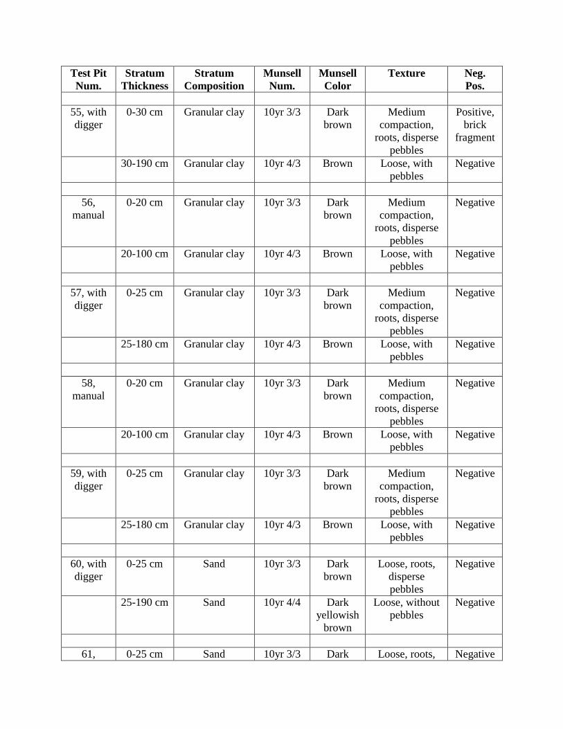
Test Pit
Num.
Stratum
Thickness
Stratum
Composition
Munsell
Num.
Munsell
Color
Texture Neg.
Pos.
55, with
digger
0-30 cm Granular clay 10yr 3/3 Dark
brown
Medium
compaction,
roots, disperse
pebbles
Positive,
brick
fragment
30-190 cm Granular clay 10yr 4/3 Brown Loose, with
pebbles
Negative
56,
manual
0-20 cm Granular clay 10yr 3/3 Dark
brown
Medium
compaction,
roots, disperse
pebbles
Negative
20-100 cm Granular clay 10yr 4/3 Brown Loose, with
pebbles
Negative
57, with
digger
0-25 cm Granular clay 10yr 3/3 Dark
brown
Medium
compaction,
roots, disperse
pebbles
Negative
25-180 cm Granular clay 10yr 4/3 Brown Loose, with
pebbles
Negative
58,
manual
0-20 cm Granular clay 10yr 3/3 Dark
brown
Medium
compaction,
roots, disperse
pebbles
Negative
20-100 cm Granular clay 10yr 4/3 Brown Loose, with
pebbles
Negative
59, with
digger
0-25 cm Granular clay 10yr 3/3 Dark
brown
Medium
compaction,
roots, disperse
pebbles
Negative
25-180 cm Granular clay 10yr 4/3 Brown Loose, with
pebbles
Negative
60, with
digger
0-25 cm Sand 10yr 3/3 Dark
brown
Loose, roots,
disperse
pebbles
Negative
25-190 cm Sand 10yr 4/4 Dark
yellowish
brown
Loose, without
pebbles
Negative
61, 0-25 cm Sand 10yr 3/3 Dark Loose, roots, Negative

Test Pit
Num.
Stratum
Thickness
Stratum
Composition
Munsell
Num.
Munsell
Color
Texture Neg.
Pos.
manual brown disperse
pebbles
25-100 cm Sand 10yr 4/4 Dark
yellowish
brown
Loose, without
pebbles
Negative
62,
manual
0-25 cm Sand 10yr 3/3 Dark
brown
Loose, roots,
disperse
pebbles
Negative
25-100 cm Sand 10yr 4/4 Dark
yellowish
brown
Loose, without
pebbles
Negative
63,
manual
0-25 cm Granular clay 10yr 3/3 Dark
brown
Medium
compaction,
roots, disperse
pebbles
Negative
25-100 cm Granular clay 10yr 4/3 Brown Loose, with
pebbles
Negative
64,
manual
0-25 cm Granular clay 10yr 3/3 Dark
brown
Medium
compaction,
roots, disperse
pebbles
Negative
25-100 cm Granular clay 10yr 4/3 Brown Loose, with
pebbles
Negative
65,
manual
0-25 cm Granular clay 10yr 3/3 Dark
brown
Medium
compaction,
roots, disperse
pebbles
Negative
25-100 cm Granular clay 10yr 4/3 Brown Loose, with
pebbles
Negative
66,
manual
0-25 cm Granular clay 10yr 3/3 Dark
brown
Medium
compaction,
roots, disperse
pebbles
Negative
25-100 cm Granular clay 10yr 4/3 Brown Loose, with
pebbles
Negative
67,
manual
0-10 cm Limestone fill
10-25 cm Granular clay 10yr 3/3 Dark Medium Negative
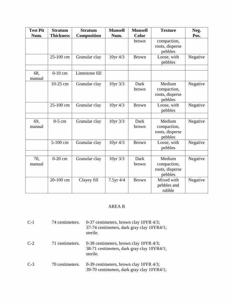
Test Pit
Num.
Stratum
Thickness
Stratum
Composition
Munsell
Num.
Munsell
Color
Texture Neg.
Pos.
brown compaction,
roots, disperse
pebbles
25-100 cm Granular clay 10yr 4/3 Brown Loose, with
pebbles
Negative
68,
manual
0-10 cm Limestone fill
10-25 cm Granular clay 10yr 3/3 Dark
brown
Medium
compaction,
roots, disperse
pebbles
Negative
25-100 cm Granular clay 10yr 4/3 Brown Loose, with
pebbles
Negative
69,
manual
0-5 cm Granular clay 10yr 3/3 Dark
brown
Medium
compaction,
roots, disperse
pebbles
Negative
5-100 cm Granular clay 10yr 4/3 Brown Loose, with
pebbles
Negative
70,
manual
0-20 cm Granular clay 10yr 3/3 Dark
brown
Medium
compaction,
roots, disperse
pebbles
Negative
20-100 cm Clayey fill 7.5yr 4/4 Brown Mixed with
pebbles and
rubble
Negative
AREA B
C-1 74 centimeters. 0-37 centimeters, brown clay 10YR 4/3;
37-74 centimeters, dark gray clay 10YR4/1;
sterile.
C-2 71 centimeters. 0-38 centimeters, brown clay 10YR 4/3;
38-71 centimeters, dark gray clay 10YR4/1;
sterile.
C-3 70 centimeters. 0-39 centimeters, brown clay 10YR 4/3;
39-70 centimeters, dark gray clay 10YR4/1;

sterile.
C-4 76 centimeters. 0-36 brown clay 10YR 4/3;
36-76 centimeters, dark gray clay 10YR4/1;
sterile.
C-5 70 centimeters. 0-37 centimeters, brown clay 10YR 4/3;
37-70 centimeters dark gray clay 10YR4/1;
sterile.
C-6 69 centimeters. 0-39 centimeters, brown clay 10YR 4/3; 39-69
centimeters, dark gray clay 10YR4/1; sterile.
C-7 73 centimeters. 0-38 centimeters, brown clay 10YR 4/3; 38-73
centimeters, dark gray clay 10YR4/1; sterile.
C-8 79 centimeters. 0-36, centimeters brown clay 10YR 4/3; 36-79
centimeters dark gray clay 10YR4/1; sterile.
C-9 78 centimeters. 0-37 centimeters, brown clay 10YR 4/3; 37-78
centimeters, dark gray clay 10YR4/1; sterile.
C-10 Not made Pond.
C-11 71 centimeters. 0-45 centimeters, dark brown clay; 45-71
centimeters, brown clay; sterile.
C-12 73 centimeters. 0-73 centimeters, light brown sand; sterile.
C-13 Not made Dry pond.
C-14 Not made Dry pond.
C-15 Not made Dry pond.
C-16 Not made Dry pond.
C-17 Not made Dry pond.
C-18 Not made Dry pond.
C-19 Not made Dry pond.
C-20 Not made Dry pond.
C-21 Not made Dry pond.
C-22 Not made Dry pond.
C-23 Not made Dry pond.
C-37 80 centimeters. 0-36 centimeters, brown clay 10YR 4/3; 36-80
centimeters, dark gray clay 10YR4/1; sterile.

C-38 72 centimeters. 0-37 centimeters, brown clay 10YR 4/3; 37-72
centimeters, dark gray clay 10YR4/1; sterile.
C-39 71 centimeters. 0-39 centimeters, brown clay 10YR 4/3; 39-71
centimeters, dark gray clay 10YR4/1; sterile.
C-40 71 centimeters. 0-35, centimeters brown clay 10YR 4/3; 35-71
centimeters, dark gray clay 10YR4/1; sterile.
C-41 69 centimeters. 0-33 centimeters, brown clay 10YR 4/3; 33-69
centimeters, dark gray clay 10YR4/1; sterile.
C-42 75 centimeters. 0-38 centimeters, brown clay 10YR 4/3; 38-75
centimeters, dark gray clay 10YR4/1; sterile.
C-43 76 centimeters.
0-36 centimeters, brown clay 10YR 4/3; 36-76
centimeters, dark gray clay 10YR4/1; sterile.
C-44 70 centimeters. 0-39 centimeters, brown clay 10YR 4/3; 39-70
centimeters, dark gray clay 10YR4/1; sterile.
C-45 71 centimeters. 0-37 centimeters, brown clay 10YR 4/3; 37-71
centimeters, dark gray clay 10YR4/1; sterile.
C-46 73 centimeters. 0-32 centimeters, brown clay 10YR 4/3; 32-73
centimeters, dark gray clay 10YR4/1; sterile.
C-47 Not made Pond.
C-48 Not made Flooded.
C-49 Not made Flooded.
C-50 Not made Dry pond.
C-51 Not made Dry pond.
C-52 Not made Dry pond.
C-53 Not made Dry pond.
C-54 Not made Dry pond.
C-55 Not made Dry pond.
C-56 Not made Dry pond.
C-57 Not made Dry pond.
C-58 Not made Dry pond.

C-59 Not made Dry pond.
C-60 Not made Dry pond.
C-61 Not made Dry pond.
C-62 Not made Dry pond.
C-63 Not made Dry pond.
C-64 Not made Dry pond.
C-65 Not made Dry pond.
C-66 Not made Dry pond.
C-67 Not made Dry pond.
C-68 Not made Dry pond.
C-69 Not made Flooded.
C-70 Not made Flooded.
C-71 Not made Pond.
C-72 72 centimeters. 0-37 centimeters, brown clay 10YR 4/3; 37-72
centimeters, dark gray clay 10YR4/1; sterile.
C-73 72 centimeters. 0-36 centimeters, brown clay 10YR 4/3; 32-72
centimeters, dark gray clay 10YR4/1; sterile.
C-74 71 centimeters. 0-39 centimeters, brown clay 10YR 4/3; 39-71
centimeters, dark gray clay 10YR4/1; sterile.
C-75 75 centimeters. 0-38 centimeters, brown clay 10YR 4/3; 38-75
centimeters, dark gray clay 10YR4/1; sterile.
C-76 79 centimeters. 0-34 brown clay 10YR 4/3; 34-79 cms. dark
gray clay 10YR4/1; sterile.
C-77 80 centimeters. 0-33 centimeters, brown clay 10YR 4/3; 33-80
centimeters,. dark gray clay 10YR4/1; sterile.
C-78 71 centimeters. 0-35 centimeters, brown clay 10YR 4/3; 35-71
centimeters, dark gray clay 10YR4/1; sterile.
C-79 73 centimeters. 0-38 centimeters, brown clay 10YR 4/3; 38-73
centimeters, dark gray clay 10YR4/1; sterile.
C-80 70 centimeters. 0-37 centimeters, brown clay 10YR 4/3; 37-70
centimeters, dark gray clay 10YR4/1; sterile.

C-81 69 centimeters. 0-39 centimeters, brown clay 10YR 4/3; 39-69
centimeters, dark gray clay 10YR4/1; sterile.
C-82 75 centimeters. 0-37 centimeters, brown clay 10YR 4/3; 37-75
centimeters, dark gray clay 10YR4/1; sterile.
C-83 78 centimeters. 0-32 centimeters, brown clay 10YR 4/3; 32-78
centimeters, dark gray clay 10YR4/1; sterile.
C-84 78 centimeters. 0-38 centimeters, brown clay 10YR 4/3; 38-78
centimeters, dark gray clay 10YR4/1; sterile.
C-85 74 centimeters. 0-36 centimeters, brown clay 10YR 4/3; 36-74
centimeters, dark gray clay 10YR4/1; sterile.
C-86 81 centimeters. 0-39 centimeters, brown clay 10YR 4/3; 39-81
centimeters, dark gray clay 10YR4/1; sterile.
C-87 79 centimeters. 0-36 centimeters, brown clay 10YR 4/3; 36-79
centimeters, dark gray clay 10YR4/1; sterile.
C-88 75 centimeters. 0-38 centimeters, brown clay 10YR 4/3; 38-75
centimeters, dark gray clay 10YR4/1; sterile.
C-89 74 centimeters. 0-34 centimeters, brown clay 10YR 4/3; 34-74
centimeters, dark gray clay 10YR4/1; sterile.
C-90 76 centimeters. 0-37 centimeters, brown clay 10YR 4/3; 37-76
centimeters, dark gray clay 10YR4/1; sterile.
C-91 77 centimeters. 0-45 centimeters, dark brown clay; 45-77
centimeters, brown clay 10YR4/1; sterile.
C-92 72 centimeters. 0-47 centimeters, dark brown clay; 47-72
centimeters, brown clay 10YR4/1; sterile.
C-93 76 centimeters. 0-44 dark brown clay; 44-76 centimeters.
brown clay 10YR4/1; sterile.
C-94 Not made Dry pond.
C-95 Not made Dry pond.
C-96 Not made Dry pond.
C-97 Not made Dry pond.
C-98 Not made Dry pond.

C-99 Not made Dry pond.
C-100 Not made Dry pond.
C-101 Not made Dry pond.
C-102 Not made Dry pond.
C-103 79 centimeters. 0-79 centimeters, light brown sand; sterile
C-104 Not made Dry pond.
C-105 Not made Dry pond.
C-106 81 centimeters. 0-81 centimeters, light brown sand; sterile
AREA C
C-1 78 centimeters. 0-78 centimeters, light brown sand; sterile
C-2 73 centimeters. 0-73 centimeters, light brown sand; sterile
C-3 79 centimeters. 0-79 centimeters, light brown sand; sterile
C-4 77 centimeters. 0-77 centimeters, light brown sand; sterile
C-5 75 centimeters. 0-38 centimeters, brown clay with pebbles
10YR 4/3; 38-75 centimeters. dark grayish
brown clay; sterile.

Appendix C

Appendix C
List of Photos
Photo Num. 1: View to the West of part of Project’s North boundary.
Photo Num. 2: Another view to the West of part of the same boundary.
Photo Num. 3: Wood and corrugated steel house over the ruins of a concrete structure in
the sector of Hacienda Santa Bárbara.
Photo Num. 4: View to the West of a concrete and block warehouse in the area of
Hacienda Santa Bárbara.
Photo Num. 5: View to the East of the same warehouse.
Photo Num. 6: View to the North of a road in the West limit of the Project, Area A.
Photo Num. 7: Excavating test pit C-8 in Area A.
Photo Num. 8: Modern debris in Area A.
Photo Num. 9: Excavating test pit C-34 in Area A.
Photo Num. 10: Metal pipes possibly signaling soil probes in Area A.
Photo Num. 11: Excavating test pit C-83 in Area A.
Photo Num. 12: Hay bale carried by the floods in Area A.
Photo Num. 13: Excavating test pit C-105 in Area A.
Photo Num. 14: Excavating test pit C-193 in Area A.
Photo Num. 15: View to the South of part of the drainage channel in the East boundary of
the property, Area A / Example of excavated trench.
Photo Num. 16: View to the South of part of the East boundary in Area B/ Example of
water table.
Photo Num. 17: Excavating test pit C-5 in Area B.
Photo Num. 18: Excavating test pit C-8 in Area B.
Photo Num. 19: Small pond in Area B.
Photo Num. 20: Excavating test pit C-54 in Area B.
Photo Num. 21: Excavating test pit C-106 in Area B.
Photo Num. 22: Excavating test pit C-1 in Area C.
Photo Num. 23: Metal in Area C.
Photo Num. 24: Pump to extract water from the river in Area C.
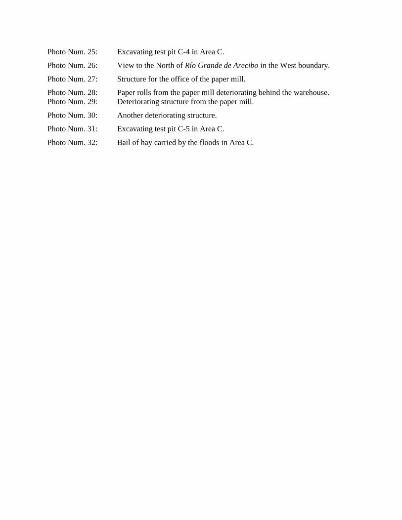
Photo Num. 25: Excavating test pit C-4 in Area C.
Photo Num. 26: View to the North of Río Grande de Arecibo in the West boundary.
Photo Num. 27: Structure for the office of the paper mill.
Photo Num. 28: Paper rolls from the paper mill deteriorating behind the warehouse.
Photo Num. 29: Deteriorating structure from the paper mill.
Photo Num. 30: Another deteriorating structure.
Photo Num. 31: Excavating test pit C-5 in Area C.
Photo Num. 32: Bail of hay carried by the floods in Area C.

Photo 1: Example of one of the roads in the property, looking west.
Photo 2: Removed soil midden, surface inspection. Looking south.
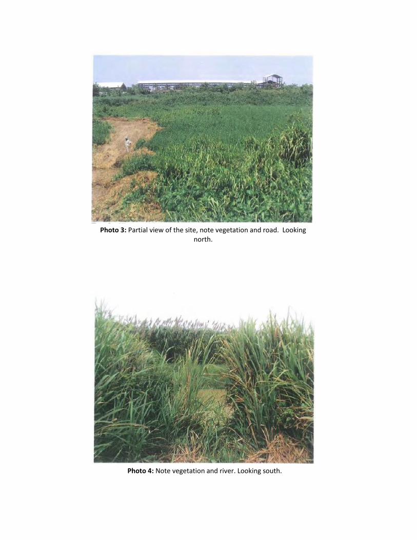
Photo 4: Note vegetation and river. Looking south.
Photo 3: Partial view of the site, note vegetation and road. Looking north.
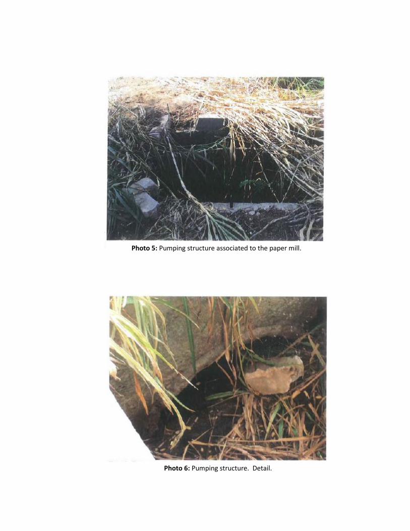
Photo 5: Pumping structure associated to the paper mill.
Photo 6: Pumping structure. Detail.

Photo 7: Modern debris concentration, looking northwest.
Photo 8: Vegetation and flooded area.

Photo 9: Partial view of paper mill, looking south.
Photo 10: Partial view of the paper mill, looking northwest.

Photo 11: Excavation of manual test pit, looking north
Photo 12: Example of manual test pit.
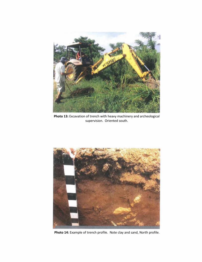
Photo 13: Excavation of trench with heavy machinery and archeological supervision. Oriented south.
Photo 14: Example of trench profile. Note clay and sand, North profile.

Photo 15: Example of trench excavated with heavy machinery, note river sand stratigraphy and water table at the bottom.
Photo 16: Example of water table.

PHOTO NUM. 15
PHOTO NUM. 16
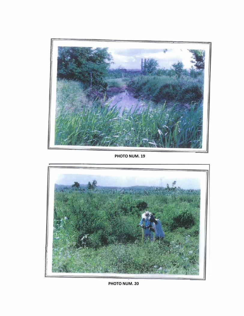
PHOTO NUM. 17
PHOTO NUM. 18
PHOTO NUM. 19
PHOTO NUM. 20

PHOTO NUM. 21
PHOTO NUM. 22

Appendix D

Appendix E


Appendix F


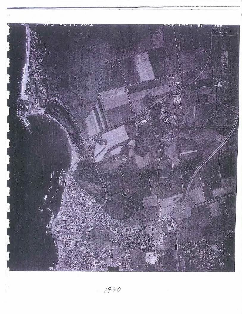

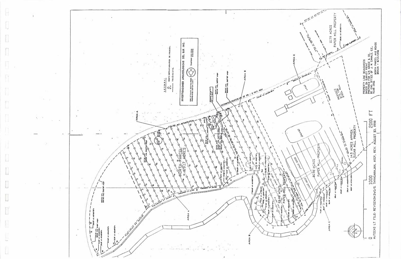

ARCHEOLOGICAL ASSESSMENT REPORT PHASE IA-IB
CONNECTION ROUTES OF THE BRACKISH
WATER LINE AND THE ELECTRICAL LINE
FOR THE RENEWABLE POWER GENERATION
AND RESOURCE RECOVERY PLANT
ISLOTE AND CAMBALACHE WARDS
ARECIBO, PUERTO RICO
PREPARED FOR
CSA GROUP
CSA Plaza, Suite 500, 1064 Ponce de León Ave.
San Juan, Puerto Rico 00907-3740
PREPARED BY
EDUARDO QUESTELL Y ASOCIADOS
EDUARDO QUESTELL RODRÍGUEZ FEDERICO FREYTES RODRÍGUEZ
SEPTEMBER 2010
TABLE OF CONTENT
INTRODUCTION ………………………………………………...………… 1
PHASE IA SURVEY ………………………………………………..……… 5
Project Description ………………………………………………………. 6
Environmental Setting…………………………………………………… 6
Synthesis of Cultural Development ……………………………………… 9
Archival Research ………………………………………………...……… 22
Land Use Pattern ………………………………………………………… 25
Surface Inspection and Sensitivity Study ………………………………. 27
Conclusion of Phase IA ………………………………………………….. 28
PHASE IB SURVEY ………………………………………………………… 29
Survey design and Methodology ……………………………………… 29
Phase IB Survey Results………………………………………………. 30
CONCLUSIONS AND RECOMMENDATIONS ………………………….. 31
BIBLIOGRAPHY …………………………………………………………… 33
APPENDIX A ………………………………………………………………
APPENDIX B ………………………………………………………………
APPENDIX C ………………………………………………………………
APPENDIX D ………………………………………………………………
APPENDIX E ………………………………………………………………

LIST OF FIGURES
FIGURE NUM. 1 ……………………………………………………………. 2
FIGURE NUM. 2 ……………………………………………………………. 3
FIGURE NUM. 3 ……………………………………………………………. 7
FIGURE NUM. 4 ……………………………………………………………. 8
FIGURE NUM. 5 ……………………………………………………………. 18
FIGURE NUM. 6 ……………………………………………………………. 19
FIGURE NUM. 7 ……………………………………………………………. 26
ARCHEOLOGICAL ASSESSMENT REPORT
PHASE IA-IB
CONNECTION ROUTES OF THE BRACKISH WATER
LINE AND THE ELECTRICAL LINE FOR THE
RENEWABLE POWER GENERATION AND RESOURCE
RECOVERY PLANT
ISLOTE AND CAMBALACHE WARDS
ARECIBO, PUERTO RICO
INTRODUCTION
This report shows the results of the Archaeological Assessment Phase IA-IB of the route
intended for a new line of brackish waters and also a new electrical line for the project of a
Renewable Power Generation and Resource Recovery Plant, that would be located in a property
near Road PR-2, KM 72.8, Cambalache Ward of Arecibo (see figures num. 1 and num. 2 for the
location of the new lines).
The project of the new brackish water line includes the excavation of trench for the pipes
in a stretch of about 3,100 linear meters in segments of roads PR-681, PR-6681 and PR-2, in
Islote and Cambalache wards of the Municipality of Arecibo. The project of the new electric
line includes extending such line, part underground and part aerial, along a section of
approximately 1,335 linear meters which is: about 485 linear meters inside de Project area, and
about 850 linear meters, mostly cross country, in lots belonging to the Lands Authority, South of
the planned Project, in Cambalache Ward of Arecibo (see maps at the end of report).
This report has been prepared for CSA Group, in accordance with Section 10 of Law 112
from July 20, 1988, also known as Terrestrial Archeology Act of Puerto Rico, and Section 106 of
the National Historic Preservation Act and the Code of Federal Regulations (36CFR), Title 36.
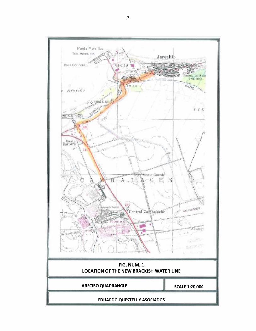
2
ARECIBO QUADRANGLE
FIG. NUM. 1 LOCATION OF THE NEW BRACKISH WATER LINE
SCALE 1:20,000
EDUARDO QUESTELL Y ASOCIADOS

3
ARECIBO QUADRANGLE
FIG. NUM. 2 LOCATION OF THE NEW ELECTRIC LINE
SCALE 1:20,000
EDUARDO QUESTELL Y ASOCIADOS

4
In general terms, agencies may request a Phase IA-IB archeological assessment for the
areas where it is planned to establish both new lines.
This phase has been defined by Arch. John Vetten from the Federal Environmental
Protection Agency (EPA), New York Region, as follows:
"Stage IA: Literature Search and Sensibility Study
The stage IA is the initial level of survey and requires comprehensive
documentary research designed to identify any known or potential historical,
architectural and / or archaeological resources within a project area. A primary
objective of the study, is to evaluate the differential sensibility of the project area
for the presence of cultural resources, this information will be used to guide the
field investigations that follow.
In carrying out the literature search, sources at the State Preservation Office
(S.H.P.O.), universities, local libraries, museums, historical societies and the like,
are to be consulted.
In addition, the nature and extend of the proposed project is evaluated, an initial
walk-over reconnaissance and surface inspection is completed and the effect of
prior ground disturbance of the probability of identifying cultural resources is
assessed.
The final document must focus on the project area and minimally includes:
- a brief description;
- a description of the environmental setting as it pertains to actual or potential
cultural resources locations;
- a synthesis of prehistoric and historic and cultural development and land use
patterns; and
- a definition of sensitivity zones with explicit criteria for ranking undertaking.
Stage IB: Field Investigation
Subsurface testing is the major component of this level of survey and is required
unless the presence or absence of resources can be determined by direct
observation or by examination of specific document references.
The areas to be subjected to survey are selected on the basis of the data gathered
in the Stage IA evaluation and the probable location (s) of the undertaking.
The careful location of identified resources with respect to areas of impact of the
proposed project must be established.

5
The final Stage IB report presents the results of the field investigation, including:
- Description of the survey design and methodology (based on the result of the
stage IA);
- Complete records of soil stratigraphy; an artifact catalogue including
identification, estimated date range and quantity on weight, as appropriate.
The location of all test units must be accurately plotted on a project area map,
with location of identified resources clearly defined. Photographs which illustrate
salient prints of the survey area are a necessary component of the final report.
Detailed recommendation and supporting rational for additional investigation
must be incorporated into the conclusions of the Stage IB study.
If all cultural resources identified through the Stage IA and / Stage IB surveys will
not be impacted by the proposed project, the survey process is completed".
In our report we have followed the Guidelines for Archeological Research of the State
Historic Preservation Office and the Regulation for Filing and Archaeological Evaluation of
Construction and Development Projects from the Council for the Protection of the Terrestrial
Archeological Heritage of Puerto Rico, ascribed to the Institute of Puerto Rican Culture.
PHASE IA SURVEY
As established, a Phase IA of an archaeological assessment includes: a description of the
project; a description of the environmental setting of the location; a synthesis of prehistoric and
historic and cultural development, with a sensibility study of the studied site and its land use
patterns.
6
Project Description
As we said before, the project of the new brackish water line includes the excavation of a
trench for the pipes in a stretch of about 3,100 linear meters in segments of roads PR-681, PR-
6681 and PR-2, in Islote and Cambalache wards of the Municipality of Arecibo, up to the site of
the proposed Renewable Power Generation and Resource Recovery Plant. The project of the
new electric line includes extending such line, part underground and part aerial, along a section
of approximately 1,335 linear meters which is: about 485 linear meters inside de Plant area, and
about 850 linear meters, mainly cross country, in lots belonging to the Puerto Rico Land
Authority, South of the planned Project, in Cambalache Ward of Arecibo (see plans at the end of
report).
Environmental Setting
Figures num. 1 and 2 show the location of both, the new brackish water line, and
electrical line projects, that as we said, are in Islote and Cambalache Wards (the new brackish
water line) and Cambalache Ward (the new electric line), of the Municipality of Arecibo. The
topography is predominantly flat along both routes. The maximum elevation on the lot is close
to 5 meters above sea level at the South boundary of the electric line project. The Río Grande de
Arecibo flows at 400 meters West at its closest point.
Generally, the Municipality of Arecibo has a pleasant climate with a mean annual
temperature of approximately 77ºF (R. Picó, 1964 p.5) and a mean annual precipitation of close
to 60 inches of rain (ibid, p.6). Most of the municipality is located in the region called "Northern
Coastal Plain” (Llano costero del norte), and belongs to the “Alluvial Moist Section” (Sección
Húmeda Aluvial) (Ibid, p.10).
Geology for the Arecibo quadrangle was done by Reginald P. Briggs in 1968. He states
that the primary soil at the new electric line consists of floodplains Alluvium (Qa, sand, gravel,
lime and clay). The West side of the new brackish water line, is predominantly alluvium with fill
deposits (Qf). To the East of this route are swamp deposits (Qs), and at the route’s Eastern limit
emerge cemented dunes (Qcd) and sand from dunes (Qdt). Figure num. 3 shows the geology of
the Project area.

7
GEOLOGIC QUADRANGLE OF ARECIBO
FIG. NUM. 3 GEOLOGY IN THE PROJECT AREA
SCALE 1:20,000
EDUARDO QUESTELL Y ASOCIADOS

8
SOIL SURVEY OF ARECIBO AREA
FIG. NUM. 4 SOILS IN THE PROJECT AREA
SCALE 1:20,000
EDUARDO QUESTELL Y ASOCIADOS
9
The soils of the zone were studied by Gilberto Acevedo in 1982 (Soil Survey of Arecibo
Area Northern Puerto Rico). He states (leaf no. 3) that the soil along the new electric line is
Coloso Clay (Cn, p. 16). This is a deep soil, naturally fertile with high water retention and poor
drainage. Runoff is slow, with limited agricultural crop applications for being prone to flooding
and expansive. To the West of the new brackish water line we also find mostly Coloso Clay soil
(Cn). Towards the East there is Bajura Clay soil (Ba), and then Cataño Sand (Cf), Caracoles
Loam, with a slope of 20 to 40 per cent (CcE), and finally Caracoles Loam with a 5 to 20 per
cent slope (CcD). Bajura soil is deep, poorly drained, and with a slow permeability and high
water retention. Runoff is slow and has high natural fertility. Potential flooding represents a
limitation. Caracoles soils are shallow, with slopes and well drained. Figure 4 shows the soils of
the area.
Currently the predominant flora consists of: African tulip tree, tal albizia, Guinea grass,
zarcilla, red mangrove, coconut palm, Indian almond tree and Madras thorn. Wildlife was
represented by Gray Kingbird, Greater Antillean Crackle, Bananaquit, Cattle Egret, Northern
Mockingbird, White-winged Dove, iguanas and lizards.
Synthesis of Cultural Development
The prehistory of the Municipality of Arecibo has been well studied, although the
existing information makes it difficult to adequately reconstruct its past. As we know, Arecibo is
located on the northern shore of Puerto Rico This condition, in a way, forces the reconstruction
of its past to be set spatially and chronologically within the context of the prehistory of the North
coast. We understand this is an essential framework even if one wishes to study only the
traditional problems of time and space. For the purpose of the present work, we refer to the
prehistory of the North coast as defined by Dr. Irving B. Rouse in his "Scientific Survey of Porto
Rico and the Virgin Islands" (Rouse, 1952, Vol XVIII, part 3, pages 403-405). We consider
these studies essential to our prehistory.
As per Dr. Rouse, the North coast encompasses all the lowlands that drain into the
Atlantic Ocean, encompassing 150 kilometers of seashore and adjacent land, which extend
approximately 15 kilometers inland. Altogether, the area comprises 2,000 square kilometers.
The North coast begins at the west of Punta Borinquen, forms a curve towards the interior

10
through the hills and returns out to arrive at the cape of San Juan. This boundary between the
area of the North coast and the rest of the Island forms an arc. The most significant rivers which
constitute topographic features are, from West to East: Río Guajataca, Río Grande de Arecibo,
Río Grande Manatí, Río Cibuco, La Plata, Bayamón, and Río Grande de Loíza. These rivers
have established floodplains along their banks. A chain of limestone hills with abundant caverns
is found between these plains. Behind these hills are the foothills of the interior mountains. In
front of these, vast marshes prevent walking between them. Dr. Rouse considered the indians
probably had difficulty traveling along the North coast, due to the currents, strong winds and
surf. He points out that the soil is fertile (except for the western end), and has a good supply of
water, so it was possible it could sustain a large pre-Columbian population.
However Dr. Rouse noted very few sites had been found along the North coast, possibly
due to the scarcity of shell middens, which makes it difficult to detect archaeological sites. It
was also possible that the strong winds from the Atlantic Ocean, combined with the shortage of
protected bays and beaches, made the aboriginal population to concentrate in other, more
favorable parts of the Island.
As discussed below, the last 10 years have seen the North coast of Puerto Rico become
the subject of various systematic archaeological surveys that have yielded a complex picture as
to the spatial distribution and chronological placement of many newly discovered archaeological
sites. The picture originally presented by Dr. Rouse has been complicated as new work is
systematically carried out.
In his work "Porto Rican Prehistory" (1952:370) Dr. Rouse follows Coll y Toste and
places 19 chiefdoms on a map, locating the following seven (7) caciques in the northern region:
Mabodomaca in the valley of the Guajataca river, the Río Grande de Arecibo and possibly the
Río Grande de Manatí was ruled by the chief Arasibo; a third cacique, Guacabo, governed the
area of Río Cibuco. Chief Aramaná lived along Río La Plata on the village of Toa. The cacique
Majagua was found on the Río Bayamón. Canóbana was the chieftain located upstream of the
Río Grande de Loíza, with his village Cayniabón. The name of the cacique that controlled the
lower course of the Río Grande de Loíza, in historic times, is unknown, as he died and was
succeeded by a woman, Loiza. It is likely, as indicated by Dr. Rouse, that the existence of this
many chiefs on the North coast responds to this region being widely populated by the settlers and
therefore better known than the rest of the Island.
11
During the last thirty (30) years, research in the Spanish archives has been intense, and as
a result our knowledge of the ethnohistory of Puerto Rico at the moment of the conquest and
colonization has been expanded. The vast amount of information collected provides new and
more extensive relationships about the caciques of Puerto Rico. Studies in our history, when
analyzing the conquest of Puerto Rico, offer a variety of names and regions pertaining to the
caciques and their chiefdoms, remaining a subject of much controversy. We refer the reader to
the excellent work by Dr. Ricardo Alegría "Apuntes para el Estudio de los Caciques de Puerto
Rico" included in the bibliography of this report.
Among the most prominent researchers who first focused their work primarily on the
North coast of Puerto Rico we find: A.L. Pinart (1893) and Agustín Stahl (1889-90), in the
decade of the1880's; Cayetano Coll y Toste, (1907:40-41) visited various sites on the decade of
1890; Adolfo de Hostos, S.K. Lothrop and J. Alden Mason (1941: 289) in the decade of 1910;
and R.L. Junghams, R. López de Azua and Pablo Morales Cabrera collected some objects from
the years 1920 and of 1930 (Morales Cabrera 1932: 51). J. Walter Fewkes, in 1902, excavated at
the Golondrinas Cave, near Manatí and published his results in 1907 (Fewkes, 1907: 80-89, 155,
181-184). In 1917, De Hostos excavated at the Golondrinas Cave and two caves in the
municipality of Morovis. Also, in 1923 he excavated a ball court (batey) at the Espíritu Santo
River in Río Grande, and in 1940 at Monserrate, Luquillo. Froelich G. Rainey, then with Yale
University, excavated at the Coto Ward of Isabela and in Monserrate, Luquillo in 1934. Rainey
found the same sequence at both sites: the Crab Culture, characterized by pottery of the Cuevas
Style, and the Shell Culture, with ceramic associated to the Ostiones Style.
This distinguished researcher introduces the method of digging by arbitrary levels and
also, for the first time in Puerto Rico, defines stratigraphically the existence of two pre-
Columbian cultures. By 1934, Rainey, then a graduate student from Yale University, performed
the first systematic excavation in the South portion of Puerto Rico at the Canas site in Ponce. He
called the oldest Crab Culture and Shell Culture the later.
This sequence was also observed at the Coto Ward of Isabela and at the site known as
Monserrate in Luquillo. Using the correlation of these sequences as the basis, Dr Rainey
postulated a hypothesis in which the two cultural components defined represented the migration
of two distinct groups or populations with a possible common origin in South America.
12
Later work by Dr. Rouse demonstrated that, in the case of Puerto Rico, the Shell culture
component corresponded to a local development which had evolved from the Crab Culture. By
defining the chronologic and stylistic sequences for Puerto Rico, Dr Rouse demonstrated the
existence of a transition.
On the other hand, together with the previous group, or maybe earlier, another group
called Huecoid arrived. Huecoids made unpainted pottery and amulets which possibly represent
the Andean condor, and had an origin in the Andes of Venezuela. Huecoids have been
documented at the sites of La Hueca on the island of Vieques and at the site called Punta
Candelero in Humacao. Dr. Osvaldo García Goyco tells us that some archeologists group the
Huecoids with the Saladoids, and differ with regard to the bird-shaped amulets interpretation as
being condors, and therefore point to a migration originating from the Andean mountain range.
Huecoids are also characterized by the manufacture of beads and ornaments made of
semiprecious stones and pearl oyster.
Despite the great work done by previous investigators, it was Dr. Irving B. Rouse, as part
of the Scientific Survey of Puerto Rico, who carried out, during 1936 and 1938 a program of
stratigraphic excavations of the North coast of Puerto Rico. During the summers of 1936 to
1938 this investigator dug seven (7) sites that he considered with the most potential, obtaining
said sequences and establishing the correlations with the other regions of Puerto Rico already
defined. The aforementioned researcher tells us that, from a geographical perspective, his
excavations did not cover satisfactorily the area of the North coast. He excavated only at five
sites associated to five of the seven main rivers in the region. During his survey he couldn't
locate, and thereafter excavate, any site associated to the caves and valleys of the Río Grande de
Arecibo and Río Cibuco. In his stylistic and chronological sequence for the North coast he did
not find evidence for his Period I or preceramic, but he did find evidence supporting the
remaining three periods; II, III, and IV. The following sites were excavated: Carmona (Loíza 4),
Coto (Isabela I), Cuevas (Trujillo Alto 4), Los Indios (Manatí 3), Monserrate (Luquillo 1), Puerta
de Tierra (San Juan 1) and Santa Elena (Toa Baja 2).
It is important to highlight some aspects of the conclusions from the excavations of Dr.
Rouse during 1936-1938. He states that four (4) of the seven (7) sites were stratigraphically
significant. The stratigraphical profiles from Rainey’s excavations at Coto Ward confirm the
stylistic and chronological sequence covering periods II, III, and IV. Furthermore, the

13
excavation at the Cuevas site clearly demonstrated the stylistic transition from periods IIa to IIb.
At the Santa Elena site he found one of the best examples of the succession of periods from IIb
to IVa and IVb. The Santa Elena site is where the type style Santa Elena was defined; its
stylistic manifestations subsequently classified within the archaeological series known as
Elenoid, whose origin and dissemination point is the Canal de Vieques, to the east of Puerto
Rico. He associated the Santa Elena site with the chiefdom of Aramaná, from the Toa region,
and with the Toa Royal farm established by the Spaniards during the first years of colonization.
The sequence clearly showed the presence of the Santa Elena and Capá styles, which
chronologically went from periods IIIa to IVa, respectively.
As for the correlation of the chronological and stylistic sequences, the North coast differs
from other regions in the absence of occupation during Period I and by the presence of the Santa
Elena style during periods IIIb to IVa, which seems to point to a development limited to a certain
area of the geography of Puerto Rico.
We have presented these brief data concerning the excavations of Dr. Irving B. Rouse
during the years 1930-1938, because as of today it is one of the few stratigraphic excavations
with published results for the North coast of Puerto Rico. Another reason is the fact that its
spatial time frame, comprising archaeological periods and series for Puerto Rico and the
Caribbean, remains an instrument on which to support archaeological research today.
On the prehistory of Arecibo in particular we have information from the documents
related to the beginning of Spanish colonization which states:
“…Toda la vega Arecibeña regada por el Río Grande y Tanamá donde residían
el Cacique Arecibo y 200 indios y naborías, fue donada por la Corona a Don
Lope de Conchillos; residente en la isla a Pedro Moreno, con el encargo de
administrar los 200 indios y al Cacique Aracibo.” (Villas Roces, 1976).
Of the several sites related to the Aborigines who lived around this municipality and have
been reported in the literature, the one with more antiquity is known as the Cueva del Indio. The
same was reviewed by a French researcher named Alphonse Pinart, who visited the island in the
last third of the last century:
“… se trove a la Cueva del Islote sur de la Punta Braba a enviaron 5
lieves a l’est d’Arecibo et sur la cote nord de l’isle de Porto Rico. La grotte se
14
trouve dans une inmense masse noiratre de roche ignee formante ponte
e’avancant dans la mer qui deferle contra elle avec furie elle comunique par le
fond avec la rt l’eoiu un penetrant par ce colouir qui est assez etroit product un
migissement formidable.”
The distinguished historian of Puerto Rico, native of Arecibo, Don Cayetano Coll y
Toste, did research around his hometown, and in notes written about another cave in the
mountainous area, wrote:
“La Cueva de Miraflores en la jurisdicción de Arecibo, en un taller de
piedra de los indígenas. La hemos explorado cuidadosamente, tenemos en nuestra
colección un buril de pedernal obtenido por Mr Denton, propietario de la finca
donde radica esta gruta. Todavía se encuentran allí iniciados los trabajos de
algunos “pillarstones” de las casas” (Coll y Toste, 1987)
After the change of sovereignty experienced by the island in 1898, studies were begun on
different aspects of Puerto Rican People, sponsored by American educational institutions.
Among the first researchers who came, Jesse W. Fewkes conducted studies on pre-Columbian
cultures and wrote:
“The ball courts examined by the present author were situated for the most
part on terraces or on land fringing rivers, elevated high enough to be above
freshets and yet lying river valleys that could be cultivated.
Along the banks of the Río Grande de Arecibo and its tributaries there are
still many remnants of ball courts, especially in the high mountain in the middle
of the Island” (Fewkes, 1904).
In 1914 the late researcher, Samuel L. Lothrop, made a list of numerous indian sites. In
this list, Lothrop reported several sites within the territorial limits of Arecibo:
Sabana Hoyos Ward …….…Cave/Pictographs
Miraflores Ward …………...Cave/Petroglyphs
Esperanza Ward …………...Ball Court
Arrozal Ward …………..….Ball Court
Arenalejos Ward …………...Cave/Petroglyphs

15
We have already noted that in the 1930s, then-student at Yale University, Dr. Irving B.
Rouse, visited the Arecibo region and inspected previously known sites, but excavated none.
In 1979 archaeologist Juan Gonzalez Colon made an inventory of sites in Puerto Rico and
reported several in Arecibo:
Poza del Obispo……………Residuary
Hato Abajo…………………Residuary
El Caney……………………Residuary
Cueva de Crosier………..….Petroglyphs
Cueva de Matos…….....……Petroglyphs
Cueva de Carreras………….Petroglyphs
By taking into consideration information from known sites within the boundaries of the
municipality, it is understood that Igneri, pre Taíno and Taíno groups inhabited the area. In the
case of the Taíno there is evidence in historical sources that subsequently survived the early
years of colonization of the Island.
Among the most recent studies in this county, stands out the inventory carried out by
archaeologist Roberto Martinez, between 1994-1996. The researcher pointed out fifteen places
for the town of Arecibo, highlighting the presence of petroglyphs on rock shelters (Marlene
Ramos Vélez, 1998, p. 8-11).
As for the historical aspects we find that the city of Arecibo is one of the oldest in Puerto
Rico, with its origins linked to the early years of Spanish colonization. The existence of Cacique
Arecibo is known due to his being commissioned with some of his indians for the year 1515.
Don José Limón de Arce, in his pamphlets "Arecibo History" (1935) wrote:
“En la primera división que se hizo de la Isla de Puerto Rico, Arecibo
formaba parte de ésta, en el censo de almas de 1530. Arecibo abarcaba los
pueblos de Ciales, Morovis, Jayuya y Utuado, así como Hatillo, Camuy y
Quebradillas. Se cultivaba el azúcar, el café, tabaco y maíz. Luego, este
Mercado se pierde quedando la caña de azúcar solo”.
“Es interesante señalar que el lugar de la fundación de la ciudad de Arecibo nunca ha
sido cambiado. Por el contrario, Caparra y San Germán fueron movidos de sus lugares

16
originales a otras localizaciones: Caparra fue movida al lugar donde se encuentra San Juan
actualmente, en el 1519: San Germán fue trasladada desde la costa sur hacia el centro de la
isla, en el 1570, al lugar que se encuentra en la actualidad, para protegerse de los ataques de
los indios Caribe” (Cinthia Velásquez: Arecibo… así era, 1998, p. 19).
In Malgarejos' "Memoria" (1582) he notes that by then several neighbors had gathered at
the mouth of the Río Grande de Arecibo. The village was officially recognized as a town in the
early seventeenth century. The so-called "village" on the banks of Arecibo, which already had
some 80 families, was named town with parish on May 1, 1616.
On the other hand, we find the first available graphical representation of Arecibo in a
subsection of a plan by Francisco Fernández Valdelomar, commissioned by Governor Matías de
Abadía, dated 1737, a copy of which we have included as our Figure no. 4. Architect Sepulveda
notes that: "A diferencia de los planos de Aguada y Añasco, [este plano] muestra un pueblo de
considerable tamaño. El pueblo costero estaba compuesto por 95 viviendas de diferentes
tamaños, que formaban una plaza rectangular en la cual se hallaban dos grandes estructuras, la
iglesia parroquial y la capilla de la Concepción. Las siete hileras de casa aparecen alineadas
de este a oeste y definen al menos seis calles. Hacia el este se destaca lo que parece ser otra
capilla (podría ser la del Rosario) y el sitio previsto para una fortificación que en efecto se
construyó poco después. El plano tiene escala gráfica en toesas (antigua medida francesa de
longitud) [equivalente a un metro y 946 milímetros]. El plano ilustra el puerto de Arecibo,
la Boca Vieja del río, la desembocadura del mismo y el morrillo. Incluye una rosa de los
vientos. Muestra los rasgos de la topografía e indica los tipos de sembrados en la periferia del
pueblo: platanares y caña de azúcar. También indica la red de caminos de acceso al pueblo"
(Ibid, p.63). The original plan by Fernández Valdelomar, titled Plano del pequeño puerto de San
Felipe de Arecibo, distante doce leguas de la Aguada sobre la costa norte de la isla de Puerto
Rico, is found at the Archivo General de Indias, in Sevilla, and a copy at the General Archive of
Puerto Rico (Ibid, p.62).
There is a second plan of eighteenth century Arecibo, a copy of which (Figure no. 5) we
have again taken from Volume 1 of the said publication by architect Sepúlveda Rivera (p. 63),
titled Plano del puerto de San Felipe del Arecibo, situado en la costa septentrional de la isla de
San Juan de Puerto Rico, entre dicho puerto y el de la Aguada de San Francisco. This plan is
dated close to 1770. Arquitect Sepúlveda states that: "El mapa tiene escala en toesas. Muestra

17
la topografía e incluye las profundidades del canal del surtidero de puerto y del río desde la
desembocadura al pueblo. Ilustra las tierras de labor de caña de azúcar y los caminos de
acceso. El trazado del pueblo aparece definido por cinco estructuras institucionales (iglesia,
tres capillas y la batería) y por 45 casa alineadas la mayoría de este a oeste. La plaza
rectangular se conforma según las disposiciones legales establecidas al comienzo de la
colonización…" (Ibid). The original of this plan is found at the Servicio Geográfico del Ejército,
in Madrid.
The militia infantry captain, Don Fernando Miyares González, published in 1777 his
Noticias Particulares de la Isla y Plaza de San Juan Bautista de Puerto Rico, where he wrote
about the Arecibo Party the following (p.67-68):
“Siempre se ha distinguido este pueblo desde su fundación, que fue la
cuarta de la isla. Así lo acreditó el año de setecientos dos [1702], que habiendo
desembarcado el enemigo inglés la gente de dos bajeles de guerra, no hallándose
en el pueblo más que once hombres con su capitán don Antonio Correa, por estar
los demás retirados en sus labranzas, los resistió dicho capitán y sin permitirles
unirse en formación les acometió con intrepidez, haciéndole retirar
atropelladamente, de modo que con sumo trabajo pudieron tomar sus lanchas,
pues hasta dentro del mismo mar les siguió. Por esta acción tan gallarda hizo S.
M. [merced] al dicho don Antonio Correa, de la medalla de su real efigie y el
título de capitán de infantería con sueldo situado en las caxas de México, que se
le remitía aparte antes que falleciese.
La aplicación de sus vecinos ha hecho floreciente este partido. Hállase
situado en una legua de tierra formada por el mar y el río. Elévase poco sobre el
nivel de ambos, pero hubiera estado mejor fundado en una altura inmediata que
domina los alrededores. Tiene más de doscientas casas unidades, con la tercera
parte de texa, formando calles regulares. Además de una mediana iglesia, hay
tres ermitas y la mejor casa de piedra que sirve de cuartel a las dos compañías de
infantería y una de caballería de milicias disciplinadas. Los campos vecinos son
deliciosos, cubiertos de diferentes géneros de arboledas y con muchos arroyos.
Encuéntrense casas por todas partes; en los montes hay muchos palos de tinte y
maderas de construcción. En suma, no falta más a este partido que los buenos
puertos que sobran a otros”.
As we have seen, by the eighteenth century the town had continued to grow and its
development was recognized by the Casa Real which awarded it with the title of Villa on
January 14, 1778.

18
ANÍBAL SEPÚLVEDA RIVERA, 2004, TOMO 1
FIG. NUM. 5 ARECIBO MAP OF 1737
NOT TO SCALE
EDUARDO QUESTELL Y ASOCIADOS
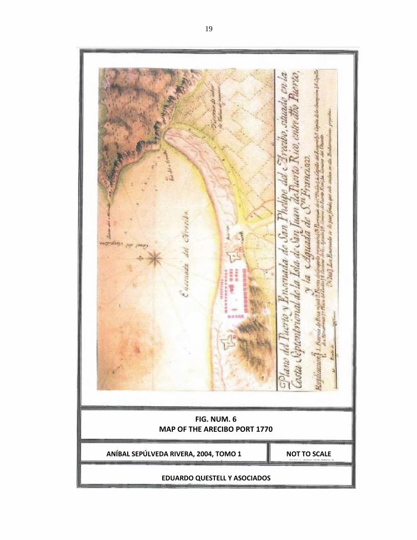
19
ANÍBAL SEPÚLVEDA RIVERA, 2004, TOMO 1
FIG. NUM. 6 MAP OF THE ARECIBO PORT 1770
NOT TO SCALE
EDUARDO QUESTELL Y ASOCIADOS
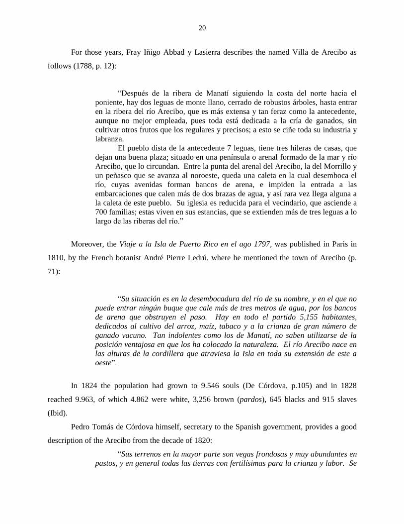
20
For those years, Fray Iñigo Abbad y Lasierra describes the named Villa de Arecibo as
follows (1788, p. 12):
“Después de la ribera de Manatí siguiendo la costa del norte hacia el
poniente, hay dos leguas de monte llano, cerrado de robustos árboles, hasta entrar
en la ribera del río Arecibo, que es más extensa y tan feraz como la antecedente,
aunque no mejor empleada, pues toda está dedicada a la cría de ganados, sin
cultivar otros frutos que los regulares y precisos; a esto se ciñe toda su industria y
labranza.
El pueblo dista de la antecedente 7 leguas, tiene tres hileras de casas, que
dejan una buena plaza; situado en una península o arenal formado de la mar y río
Arecibo, que lo circundan. Entre la punta del arenal del Arecibo, la del Morrillo y
un peñasco que se avanza al noroeste, queda una caleta en la cual desemboca el
río, cuyas avenidas forman bancos de arena, e impiden la entrada a las
embarcaciones que calen más de dos brazas de agua, y así rara vez llega alguna a
la caleta de este pueblo. Su iglesia es reducida para el vecindario, que asciende a
700 familias; estas viven en sus estancias, que se extienden más de tres leguas a lo
largo de las riberas del río.”
Moreover, the Viaje a la Isla de Puerto Rico en el ago 1797, was published in Paris in
1810, by the French botanist André Pierre Ledrú, where he mentioned the town of Arecibo (p.
71):
“Su situación es en la desembocadura del río de su nombre, y en el que no
puede entrar ningún buque que cale más de tres metros de agua, por los bancos
de arena que obstruyen el paso. Hay en todo el partido 5,155 habitantes,
dedicados al cultivo del arroz, maíz, tabaco y a la crianza de gran número de
ganado vacuno. Tan indolentes como los de Manatí, no saben utilizarse de la
posición ventajosa en que los ha colocado la naturaleza. El río Arecibo nace en
las alturas de la cordillera que atraviesa la Isla en toda su extensión de este a
oeste”.
In 1824 the population had grown to 9.546 souls (De Córdova, p.105) and in 1828
reached 9.963, of which 4.862 were white, 3,256 brown (pardos), 645 blacks and 915 slaves
(Ibid).
Pedro Tomás de Córdova himself, secretary to the Spanish government, provides a good
description of the Arecibo from the decade of 1820:
“Sus terrenos en la mayor parte son vegas frondosas y muy abundantes en
pastos, y en general todas las tierras con fertilísimas para la crianza y labor. Se
21
cosecha con abundancia caña, café, plátanos, tabaco y toda clase de menesteres.
Los caminos están despojados y buenos en tiempo de seca pero se ponen
intransitables en las lluvias, por los muchos pantanos que se forman en las
bajuras y las extraordinarias crecientes de los ríos. Abunda de Piedra de cal y de
sillería, lo mismo que maderas. El partido está dividido en los barrios del
pueblo, Hato Grande, Cuatro Calles, Hato Viejo, Rio Arriba, Arenalejos,
Santana, Factor, Cambalache e Islote. En 1828 había entre los vecinos 112
artesanos, 43 extranjeros domiciliados y naturalizados y 43 emigrados; 119
casas y 126 bojíos en el barrio, y en la jurisdicción 187 casas y 1,366 bojíos, 35
tiendas de todas clases y 28 ventorrillos.” (1831, páginas 105-106)”.
In 1878 Arecibo comprised the Cambalache, Islote, Santana, Factor, Garrochales, Río
Arriba, Hato Arriba, Dominguito and Esperanza wards (Ubeda y Delgado, p.156). In
Cambalache ward there were 175 families, 40 houses, 8 huts and 2 stores. (Ibid. p.157).
For many years since its origin, agriculture was the mainstay of the economy of this
town. During the nineteenth century, a large agricultural development took place in the area.
Numerous sugar plantations and coffee estates were developed as well as farms dedicated to
other crops. However, sugar cane was always the major product. In 1841 there were no less
than 18 estates, among which were the Santa Bárbara, property of Doña Bárbara Balseiro, the
Cambalache, owned by Don Francisco Uranga, and Hacienda Claras, property of Francisco
Stuard whom "lo administraba el mismo" (Eileen Y. Cruz Ramirez, 1986, p.29-30). The Santa
Bárbara became the property of the heirs of Don Antonio Roses. It consisted of
360 cuerdas; 200 of which were planted with sugar cane by 1902. The hacienda Cambalache
became a major sugar mill during the twentieth century, being called Central Cambalache Sugar
Mill. Cruz Ramírez states about the land belonging to the Central Cambalache Sugar Mill: "Hoy
forma parte de las tierras que antes se cultivaban de cana, ahora [1986] se están utilizando
para la siembra de arroz" (Ibid, p. 30). By 1841 there also was the Hacienda Caños, whose
owner was Doña Francisca Torrin, and agent representative José Ramón Lerrieu (Ibid).
Since the 1950s, several high technology companies have established in Arecibo, which
linked to a number of different shops, distilleries and major refineries produce a large number of
jobs. In the 1980 census, Arecibo had 86.776 inhabitants, who had risen to 97.549 by the 1990
census.

22
Archival Research
The archival research consisted of the consultation and detailed study of documents held
by the following main sources:
- Council for the Protection of the Terrestrial Archeological Heritage of Puerto
Rico.
- State Historic Preservation Office (S.H.P.O.)
- Archeological Sites in Puerto Rico of S.K. Lothrop; manuscript copy held by
the authors of this Phase IA-IB report.
- Field notes of the archeological sites of Puerto Rico by Dr. Irving B. Rouse;
manuscript copy corresponding to the municipality of Arecibo held by the State
Historic Preservation Office.
- Inventory of Historic Engineering and Industry of Puerto Rico by Carlos
Rosado/ W. Rodríguez/ L. Pumarada- President Office-University of Puerto
Rico-San Juan 1977. Manuscript in the State Historic Preservation Office
(S.H.P.O).
- Historic American Engineering Record (HAER), Inventory by Osvaldo Rivera/
W Rodríguez-UPR San Juan 1997. Copy of inventory held by S.H.P.O. Office.
- Puerto Rico Architectural Resources Inventory, State Historic Preservation
Office.
- Archeological, historical, geographical, geological, etc. literature, included in
the bibliography of this Phase IA-IB evaluation.
- Local informants.
- Consultation with other archeologists from Puerto Rico.
Detailed consultation of the records related to the inventory of archaeological sites in
Puerto Rico, held by the Council for the Protection of the Terrestrial Archeological Heritage of
Puerto Rico and the State Historic Preservation Office revealed no prehistoric or historic
evidence in the specific area where the Project object of this assessment will be developed. The
nearest reported and/or known archeological site in the topographic quadrangle of Arecibo

23
(which is the quadrangle where the Project site is located) is the one designated as AR004 (Poza
del Obispo), located 500 meters North of the new brackish water line. About this site
archeologist Fernando Alvarado (Segregación de treinta y ocho solares, Arecibo, Puerto Rico,
page 16) tells us: “Para el 1987, los arqueólogos Pedro Alvarado y Harry Alemán, realizaron
una Fase II en las cercanías al Faro de Arecibo, exactamente en el lugar llamado Poza del
Obisto (AR-4). En este lugar ellos determinaron lo siguiente: Las actividades humanas en el
lugar las remociones han impedido estudiar el sitio AR-4 en su contexto cultural original. Pero
no todo en vano, ya que de acuerdo a las muestras de cerámica podemos inferir que el sitio fue
habitado por los grupos representativos estilísticamente por la cerámica estilo Ostiones y Santa
Elena” (Alvarado, 1987)”.
Another site, relatively close, is AR005 “El Caney”, which is located 800 mesters North-
northwest of the new brackish water line, in its closest point. This site is a residuary under the
streets and residencies of the urban zone of Arecibo, where pottery fragments and remains of
human bones were found. Archeologist Fernando Alvarado (Ibid, page 15) tells us: “En los años
1940 hasta el 1950 se realizaron varias excavaciones en el yacimiento conocido como el Caney
por el doctor José Oliver, éste menciona lo siguiente: “En las décadas del 1940 y 1950 efectuó
varias excavaciones en solares al este de la Catedral. Recuerdo cuando hizo excavaciones en el
solar en donde hoy existe el área de aparcamiento del Hospital El Buen Pastor y cuando se
reconstruyó la parte del casino de Arecibo, donde está el salón de baile. Informa el Dr. Oliver
haber hallado restos humanos, no solo de cristianos, sino también de indios, los que distinguió,
porque los indios acostumbraban a enterrar a sus muertos en posición encorvada, con las
rodillas pegadas al pecho” (Lago, 1987)”. Archeologist Alvarado (Ibid, pages 17-18) adds that:
“Para el año 1992 se realizó otra incursión al yacimiento registrado como el Caney, por los
arqueólogos Juan González, María Cashion y Jaime Vélez. El arqueólogo González informa:
“La data obtenida y analizada del sector en donde se harán las mejoras, indican la existencia de
un sitio multicomponente; el mismo fue afectado a través de los años por el desarrollo urbano de
la parte antigua de la ciudad de Arecibo. Dentro del perímetro de la propiedad específicamente
en el subsuelo todavía permanecen materiales de origen precolombino e histórico que no han
sido afectados adversamente” (González, 1993)”.
Moreover, K.S. Lothrop mentions in his listing several places for Arecibo: a cave with
petroglyphs in Arenalejos Ward; another cave with petroglyphs and two ball courts (bateyes) in
24
Arrozal Ward, one of which he locates at the Biáfara site of this ward, when Biáfara is really
located on Miraflores Ward, and also mentions Cueva Bonilla, with petroglyphs (according to
Pinart) in the ward of Arrozales; the so called “Cueva de los Indios”, with petroglyphs, in Islote
ward; the cave “Miraflores” with petroglyphs in Miraflores Ward, inside M. Denton property; a
cave called the “Convento”, also with petroglyphs, in Sabana Hoyos Ward; and a cave and a ball
court (batey) in Esperanza Ward.
In the National Register of Historic Places, revised on February 4, 2010, there existed
thirteen (13) places listed for the Municipality of Arecibo, all of which are far from the Project
and would not be affected by it. The site with historic value nearest to the Study area is possibly
the one that contains some of the ruins of the old Hacienda Santa Bárbara, which is located
nearly 700 meters to the North Northeast of the Study area, and will not be impacted at all by the
Project. Included in Appendix A is a photocopy of a portion of the Arecibo quadrangle where the
sites with prehistoric or historic value near the Study area are depicted.
In the archival research conducted for this archeological assessment of the new brackish
water and electric lines of the Renewable Power Generation and Resource Recovery Plant we
examined with detail all the archeological studies conducted in the Islote and Cambalache wards
of the Municipality of Arecibo. Two of them: Estudio Arqueológico Fases IA y IB para el
Proyecto Línea de Agua Cruda, turbinas de Combustión de Cambalache, Arecibo, Puerto Rico,
conducted by archeologist María A. Cashion Lugo in 1996, and Informe de Estudio
Arqueológico Fase IA-IB Proyecto Mejoras al Sistema de Abastos de Agua del Municipio de
Arecibo, Área Costera de Arecibo, Barrios Islote y Cambalache, conducted by archeologists
Miguel Rodríguez and Yasha N. Rodríguez in 1998, deals precisely with water lines that cross
by the current Project route, in which were excavated several test pits along their routes, all with
negative results in the segment of the current water line route. Additionally, the Phase IA-IB
archeological assessment entitled Reestructuración Comunidad El Vigía, Arecibo, Puerto Rico,
conducted by archeologist Adalberto Maurás Casillas in 2004, carried out in the community
adjacent to the water line route of this Project, also resulted negative.

25
Land Use Pattern
The oldest map that we found for the general area under study (1936, West-Central Sheet,
R.C. Roberts, Soil Survey), tells us that the current Road PR-2 already existed with that number
and crossed the study area. Also, current Road PR-681 existed then. Likewise, it is observed
that a branch of the train railway, that joined the Railroad Company of Puerto Rico railway, ran
adjacent to the property, surely for collecting the canes from Hacienda Santa Bárbara and other
surrounding lands and take them to Central Cambalache Sugar Mill. No structures are observed
inside the study area boundaries, besides the roads themselves. Today there is no trace of
evidence of the passage of a train track near the study area. Our Figure num. 7 illustrates part of
the map of Robert’s soil survey where the study area is located.
The environs of the site under study were planted with sugar cane until the decade of
1950. In our 1998 evaluation for another project, we talked with informant Ángel Lescano
Correa, 63 years old (then), neighbor of the area, and then employed as a security guard of a
paper mill that was located on Renewable Power Generation and Resource Recovery Plant site.
Mr. Lescano Correa informed us in 1998 that the paper mill began operations at the site in 1957
under the name Grace Paper Co., with the purpose of producing paper in rolls. Afterward, the
mill was known as Arecibo Paper Mill, and later on as International Mill. Its name in 1998, as
we said before, was Global Fiber Inc. The mill closed operations, according to informant
Lescano Correa, on December 15 of 1995. In our 1998 property visit, we observed fences,
earthen irrigation channels, a concrete and concrete-blocks warehouse and abundance of modern
trash (wood, paper, plastic, care tires, metal, etc), especially near and on the back (West) of the
paper mill. In 1998, the existing structures were: offices, warehouse, boiler room, operations
building and infirmary. All were abandoned and some rapidly deteriorating. The first floor of
the structures was of concrete and blocks. The walls and ceiling of the second floor were of
asbestos-cement sheets.
On the other hand, for the current Project we interviewed Mr. Luis Ocasio as informant.
He worked at the paper mill since 1970 until 1996. Mr. Ocasio stated that the structures
associated to the paper mill were constructed between 1957 and 1959, being the facility
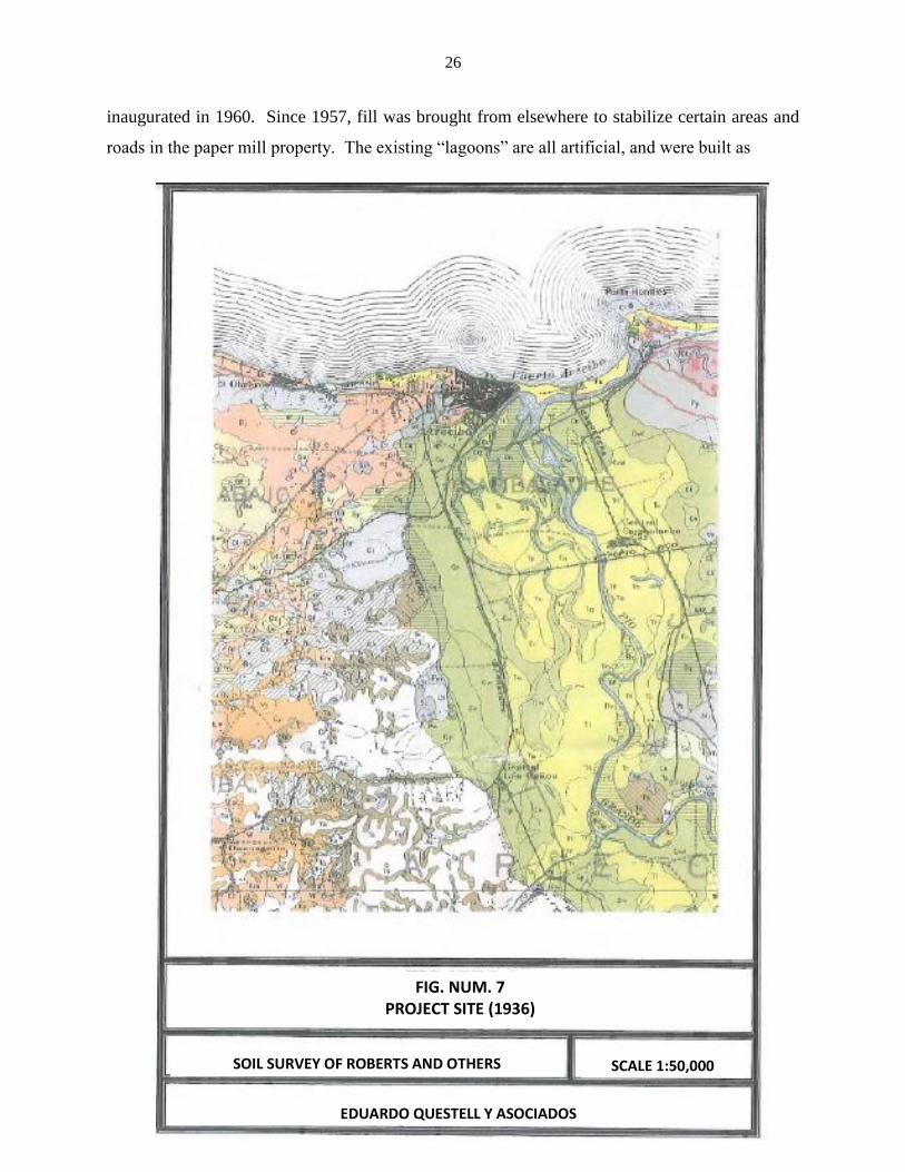
26
inaugurated in 1960. Since 1957, fill was brought from elsewhere to stabilize certain areas and
roads in the paper mill property. The existing “lagoons” are all artificial, and were built as
SOIL SURVEY OF ROBERTS AND OTHERS
FIG. NUM. 7 PROJECT SITE (1936)
SCALE 1:50,000
EDUARDO QUESTELL Y ASOCIADOS

27
part of the paper manufacturing process. Some of these “lagoons” were in use until 1977, and
others until 1996, year when the industry ceased operations. For the construction of these
“lagoons” all their surface was altered with heavy equipment, extracting superficial material in
order to construct the side walls that form the borders.
All the existing structures in the North-Northeast side of the property, says Mr. Ocasio,
were part of the paper manufacturing process. Some structures identified near the river were part
of a pumping system for fire control. During the paper manufacturing process the sugar cane
bagasse form the adjacent Central Cambalache Sugar Mill was used.
Other parts of the property are currently vacant and unused, covered by pastures, weeds
and mounds. Included as Appendix E, from our archeological assessment (Planta de
Generación de Energía Renovable y Recuperación de Recursos, PR-2, KM 72.8, barrio
Cambalache, Arecibo, Puerto Rico, Eduardo Questell Rodríguez and Federico Freytes
Rodríguez, August 2010) is a copy of the Title Study and of a Deed of Sale with the pertinent
data from the Registry of Property, for Property (finca) num. 20,522, registered on Page (folio)
30, of Volume (tomo)1248 of Arecibo, which is the property that is the Study area. Appendix F
of said assessment includes aerial photographs dating from 1936, 1950, 1963 and 1990, showing
its study area, and also including the current line routes.
Surface Inspection and Sensitivity Study
We visited all the route of the new water line of the Renewable Power Generation Plant
to conduct a surface inspection, and we could verify that the route crosses through land of roads
that has been impacted previously several times. Vegetation and adjacent structures were
observed, and photographs were taken along the stretch (see Appendix C). The route begins at
the El Vigía Pumping Station, in Islote Ward of Arecibo, and continues North up to Road PR-
681. From there it continues along the North side of road PR-681 up to the intersection with
Road PR 6681 where it follows the road’s West side and continues South. The route continues
to Road PR 2 where it takes the road’s East side and continues South to the new renewable
power generation plant, where it intersects Road PR 2 towards the plant, and where the route
ends. Appendix D contains the plan of the new water line alignment. We did not identify any
structure of cultural value along the route.
28
The stretch of the new electric line was also visited. This crosses in part through a lot
located northeast of the remnants of the old Central Cambalache Sugar Mill, penetrating thence
to the West-southwest until connecting to the power generation plant located to the South side of
the Sugar Mill. The stretch surveyed covers approximately 850 linear meters. The surface
inspection was completed by two people along its entire trajectory (see photo num. 1). We could
verify that the lot located northeast of the sugar mill is completely waterlogged (see photo num.
2). All the 300 meters of this route’s segment were found under water. Apparently this area is a
seasonal wetland, which in the rainy season turns into a zone covered by runoffs of pluvial
precipitation. The stretch that runs from Road PR 2 up to the power generating plant was not
covered by water. This traverses the properties adjacent to the main structures of Central
Cambalache Sugar Mill. It was evident, based on the debris accumulations and mounds of
removed soil, that this area has been severely impacted by dirt movements caused by heavy
machinery.
One of the researches (Freytes) had the opportunity to visit the remnants of Central
Cambalache Sugar Mill. The main buildings were recently destroyed to be sold as scrap (see
photos num. 3 and 4). Only the two chimneys remained standing and some secondary structures
(see photo num. 5). We could observe fragmented bricks dispersed in the area near the Project’s
route. Those bricks correspond to the former structures of Central Cambalache Sugar Mill. On
the surface of the specific study area we did not identify any kind of archeological resource or
remnant.
The study area along the new water line rout seems to have low archeological sensitivity.
The construction of roads must have impacted the entire route. Also, two previous archeological
assessments carried out on it had negative results. No prehistoric or historic cultural evidence
was detected on the surface of this route, other than what was indicated regarding the paper mill.
The nearest archeological site is 500 meters North of the study area.
The route for the new electric power line is different. The closeness to the old Central
Cambalache makes this route one with a high archeological sensitivity that merits adequate
investigation.
Conclusion of Phase IA

29
The Project is located in two sectors: one with a relatively low sensitivity, with a route
along roads that surely impacted any cultural resources evidence and previous assessments with
negative results, and another very near structures with cultural value. The nearest known
archeological site is located 500 meters north of the new water line route that runs along the
roads. All the information gathered in our surface inspection tends to indicate that the study area
is sterile to archeological material, but the above mentioned data makes it necessary to carry out
a Phase IB survey for the new electric line route.
PHASE IB SURVEY
The phase IB includes, as its main component, the execution of test pits under the land
surface. The areas to be tested by means of subsoil test pits are selected according to the Phase
IA results. This phase’s report should include: the surveys design and methodology; the results
with the terrain stratigraphy; a catalog of artifacts, if applicable; the location of the test pits
excavated; and photographs to clarify certain aspects. Final conclusions and recommendations
have to be included in the report.
Survey Design and Methodology
As we mentioned earlier, this Project consists of a new water line for a power generation
plant and resource recovery plant where a phase IB will not be conducted, and a new electric line
where such phase will be conducted.
For the electric line route, after having made the observations mentioned above and
taking into account all the parameters previously indicated, it was decided to use the following
methodology for surveying the area:
1. One systematic transect (Thomas F. King, 1979, p. 87) along the segment located
inside the Puerto Rico Land Authority property, because the segment located inside
the renewable power generation plant was surveyed in the plant’s assessment.

30
2. The survey will be complement with manual test pits, spaced at a 25-30 meter interval
in those sectors where the environmental conditions allow it.
All the manual test pits will be excavated with a post hole digger, resulting in a pit of
approximately 25 centimeters x 25 centimeters and of variable depth. The depth of the pits is
always variable, and depends, often on the depth of the soil over the decomposed or hard rock, or
on the experience and knowledge of the investigator. The soil obtained from the test pits will be
sifted, when necessary, as a measure of control that will allow us to detect any evidence of
cultural resources material.
Phase IB Survey Results
After conducting the surface inspection, we continue with the excavation of test pits, in
the subsoil. This test pits were made, as we said, using a digging bar and a post hole digger (see
photos num. 6 and 7). All the excavated soil was sifted using a ¼-inches mesh sifter. The test
pits were dug up to a maximum depth of 1.20 meters (see photo num 8). Since almost all the test
pits showed modern trash, the interval between them was expanded to 50 meters. These test pits
were made in the segment that crosses from Road PR-2 towards the west-southwest, connecting
with the power generation plant, for a total of approximately 425 lineal meters.
Generally, we found fill in the first 20 centimeters of most of the test pits, followed by a
dark yellowish brown (10YR 4/4) granular clay, usually with modern trash and traces of having
been impacted in the past. With the exception of two of the test pits, in the rest we reached the
water table between one meter and one meter twenty deep. The last test pit before the power
generation plant could not be excavated due to the presence of several meters of fill. All 8 test
pits excavated were negative to the presence of archeological materials.
For detailed data regarding the stratigraphy of the test pits refer to Appendix B.
Appendix E contains an aerial photograph depicting the location of these test pits.

31
CONCLUSIONS AND RECOMMENDATIONS
We have conducted an archeological survey of the planned route for the installation of
new water and electric lines for a renewable power generation and resource recovery plant in the
Municipality of Arecibo.
The archival, reference literature and other sources investigated did not show the
presence of prehistoric or historic archeological sites in the specific Project area. The nearest
reported and/or known archeological sites are: site AR004 (“Poza del Obispo”), with is a
residuary located some 500 meters to the North of the new water line route; and site AR005 (“El
Caney”), which is another residuary located under the streets and residences of the Arecibo
urban zone, located near 140 m West of the said water line route.
For the archival research conducted for this Project we carefully examined all the
archeological studies carried out at the Islote and Cambalache wards of the Municipality of
Arecibo. Two of them: Estudio Arqueológico Fases IA y IB para el Proyecto Línea de Agua
Cruda, turbinas de Combustión de Cambalache, Arecibo, Puerto Rico, conducted by
archeologist María A. Cashion Lugo in 1996, and Informe de Estudio Arqueológico Fase IA-IB
Proyecto Mejoras al Sistema de Abastos de Agua del Municipio de Arecibo, Área Costera de
Arecibo, Barrios Islote y Cambalache, conducted by archeologists Miguel Rodríguez and Yasha
N. Rodríguez in 1998, deal precisely with water lines that cross through the current Project route,
in which several test pits were excavated along their routes, all with negative results in the
segment of the current water line route. Additionally, the Phase IA-IB archeological assessment
entitled Reestructuración Comunidad El Vigía, Arecibo, Puerto Rico, conducted by archeologist
Adalberto Maurás Casillas in 2004, carried out in the community adjacent to the water line route
of this Project, also resulted negative. For that reason, and given that the construction of roads
must have impacted the entire new water line route, it was decided to conduct a Phase IB only
for the new electric line route.
This route was surveyed by means of a systematic transect and the excavation of manual
test pits. A total of 8 test pits were excavated up to a maximum depth of 1.20 meters.
The transect and the test pits showed negative evidence for prehistoric or historic cultural
material in the study area. The excavated area belonged to what were the environs of the main
buildings of Central Cambalache Sugar Mill. As such, the construction and operation activities

32
of the sugar mill must have impacted the subsoil multiple times. The subsoil excavations
substantiated said data. We documented fill, trash and impacted strata along the entire route of
the proposed Project. We could not find any evidence of archeological material or cultural
resources in the test pits excavated.
According to the data presented, we conclude and recommend that the Project
development continues as planned. Naturally, it is also recommended that if material remains of
cultural resources are found at any moment during the development of the Project, the works
stop and the authors and concerned agencies be notified.

33
BIBLIOGRAPHY
Abbad y Lasierra, Fray Agustín Iñigo: Historia Geográfica, Civil y Natural de la Isla de San
Juan Bautista de Puerto Rico, Editorial Universitaria, University of Puerto Rico, Río Piedras,
1979.
Acevedo, Gilberto: Soil Survey of Arecibo Area of Northern Puerto Rico, USDA, 1982.
Alegría, Ricardo E.: “On Puerto Rican Archaeology”, American Antiquity, 31: 246-249, 1965.
Alegría, Ricardo E.: “Apuntes para el estudio de los caciques de Puerto Rico”, Addendum of
Revista del Instituto de Cultura Puertorriqueña, núm. 85, 1979.
Alvarado Muñoz, Fernando: Segregación de Treinta y Ocho (38) Solares, PR-681, KM 7.6,
Barrio Islote, Arecibo, Puerto Rico, Cultural Assessment Report Phase IA-IB, 15 October 2007.
Arana Soto, Salvador: Diccionario Geográfico de Puerto Rico, San Juan de Puerto Rico, 1978.
Ayes Suárez, Carlos M.: “Dos Nuevas Localidades Petroglíficas del Barrio Garrochales de
Arecibo”, Ecos de Plazuela 1 (5): 1-21: 1990.
Ayes Suárez, Carlos M.: Urbanización Campos de Toledo, Bo. Hato Arriba, Arecibo, Puerto
Rico, Cultural Assessment Report Phase IA-IB, February 1997.
Briggs, Reginal P.: Geologic Map of the Arecibo Quadrangle, Puerto Rico, USGS Map I-551,
1968.
Cashion Lugo, María A.: Línea de Agua Cruda, Turbinas de Combustión de Cambalache,
Arecibo, Puerto Rico. Cultural Assessment Report Phase IA-IB, 22 August 1996.
Coll y Toste, Cayetano: Boletín Histórico de Puerto Rico, 14 volumes. Tipografía Cantero,
Fernández y Compañía, San Juan, 1918.
Córdova, Pedro Tomás de: Memorias Geográficas, Históricas, Económicas y Estadísticas de la
Isla de Puerto Rico, Institute of Puerto Rican Culture, San Juan de Puerto Rico, 1968, 6 volumes.
Cruz Ramírez, Hielen Y.: Arecibo, Notas para su historia, San Juan, 1986.
Garrow & Associates, Inc.: 1988 Proposal to Perform a Cultural Resources Reconnaissance
within the Proposed Río Grande de Arecibo Flood Control Project, Puerto Rico, submitted to
the US Army Corps of Engineers, Jacksonville District, Fla.
González Colón, Juan: Altos de la Villa, Barrios Hato Abajo y Hato Arriba, Arecibo, Puerto
Rico, Cultural Assessment Report Phase IA-IB, November 2002.

34
González Colón, Juan: Urbanización Húcares, Bo. Hato Arriba, Arecibo, Puerto Rico, Cultural
Assessment Report Phase IA-IB, October 2008.
King, Thomas F.: “The Archeological Survey, Methods and Uses”, Heritage, Conservation and
Recreation Service, US Department of the Interior, Washington, D.C., 1978, page 87.
Lothrop, S.K.: “Archaeological Sites in Puerto Rico”, 1916, manuscript located at the Yale
Peabody Museum Archive, New Haven.
Martínez Torres, Roberto: Urbanización villas Rosa, Bo. Hato Arriba, Arecibo, Puerto Rico,
Cultural Assessment Report Phase IA, February 1999.
Martínez Torres, Roberto: Construcción de Cuarenta Solares en la Propiedad del Sr. Emilio
(Millo) Vélez, Bo. Hato Arriba, Arecibo, Puerto Rico, Cultural Assessment Report Phase IA-IB,
February 1999.
Martínez Torres, Roberto: La Región de Abacoa: Historia y Arqueología, Dissertion submitted
as a requirement to obtain the PhD in Philosophy and Letters with concentration in History,
Centro de Estudios Avanzados de Puerto Rico y el Caribe, San Juan, Puerto Rico, 12 March
2005 (Unpublished).
Martínez Torres, Roberto: Estudio de Evaluación de Recursos Culturales, Fase IA, para el
territorio que comprende el Municipio de Arecibo, Puerto Rico, 2 January 2007.
Martínez Torres, Roberto: C.A.R.I.B. #1, August 2008.
Maurás Casillas, Adalberto: Reestructuración Comunidad El Vigía, Arecibo, Puerto Rico,
Cultural Assessment Report Phase IA-IB, 18 November 2004.
Picó, Rafael: Geografía de Puerto Rico, Editorial Universitaria, University of Puerto Rico, 1964.
Questell Rodríguez, Eduardo: Desarrollo Industrial Terrenos de Global Fibers, Inc., Carretera
PR-2, Bo. Cambalache, Arecibo, Puerto Rico, Cultural Assessment Report Phase IA-IB
(unpublished), November 1998.
Questell Rodríguez, Eduardo: Autódromo de Arecibo, PR-2 y PR-681, Barrio Cambalache,
Arecibo, Puerto Rico, Cultural Assessment Report Phase IA, June 2001.
Questell Rodríguez, Eduardo: Senderos de Miraflores PR-637, KM 2.5, Barrio Miraflores,
Arecibo, Puerto Rico, Cultural Assessment Report Phase IA-IB, September 2007.
Questell Rodríguez, Eduardo: Desarrollo de Terreno, PR-2, KM 61.9, Bo. Sabana Hoyos,
Arecibo, Puerto Rico, Cultural Assessment Report Phase IA-IB, April, 2008.
Rainey, Froelich G.: “Porto Rican Archaeology”, Scientific Survey of Porto Rico and the Virgin
Islands, New York Academy of Sciences, 18 (1), 1940.

35
Rodríguez, Miguel y Yasha N. Rodríguez: Mejoras al Sistema de Abasto de Agua del Municipio
de Arecibo, Área Costera de Arecibo, Barrios Islote y Cambalache, Arecibo, Puerto Rico,
Cultural Assessment Report Phase IA-IB, 12 November 1998.
Rouse, Irving: “Porto Rican Prehistory: Introduction: Excavations in the West and North”,
Scientific Survey of Porto Rico and the Virgin Islands, vol XVIII, part 3, page 336; part 4, pages
465-512.
Rouse, Irving: “Migrations in Prehistory”, Inferring Population Movements from Cultural
Remains, Yale University Press, New Haven, 1986.
Úbeda y Delgado, Manuel: Isla de Puerto Rico, Establecimiento Tipográfico del Boletín, San
Juan, Puerto Rico, 1878.
USGS: Arecibo Quadrangle, 1:20,000.
Velásquez, Cynthia: Arecibo… así era, Editora Alfa & Omega, Dominican Republic, 1998.

Appendix A


Appendix B

Table of Test Pits
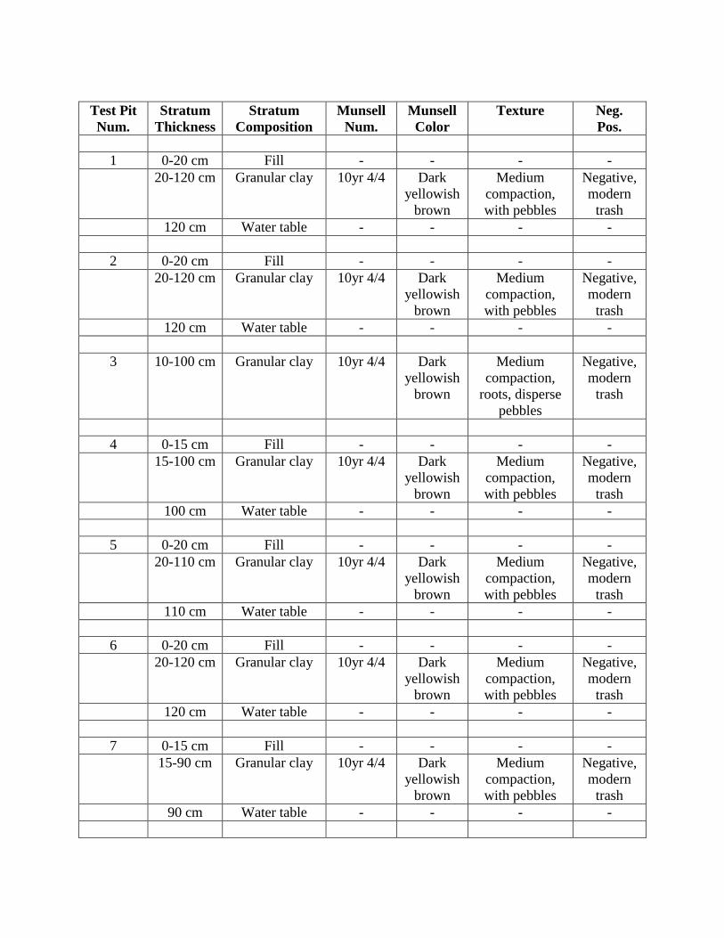
Test Pit
Num.
Stratum
Thickness
Stratum
Composition
Munsell
Num.
Munsell
Color
Texture Neg.
Pos.
1 0-20 cm Fill - - - -
20-120 cm Granular clay 10yr 4/4 Dark
yellowish
brown
Medium
compaction,
with pebbles
Negative,
modern
trash
120 cm Water table - - - -
2 0-20 cm Fill - - - -
20-120 cm Granular clay 10yr 4/4 Dark
yellowish
brown
Medium
compaction,
with pebbles
Negative,
modern
trash
120 cm Water table - - - -
3 10-100 cm Granular clay 10yr 4/4 Dark
yellowish
brown
Medium
compaction,
roots, disperse
pebbles
Negative,
modern
trash
4 0-15 cm Fill - - - -
15-100 cm Granular clay 10yr 4/4 Dark
yellowish
brown
Medium
compaction,
with pebbles
Negative,
modern
trash
100 cm Water table - - - -
5 0-20 cm Fill - - - -
20-110 cm Granular clay 10yr 4/4 Dark
yellowish
brown
Medium
compaction,
with pebbles
Negative,
modern
trash
110 cm Water table - - - -
6 0-20 cm Fill - - - -
20-120 cm Granular clay 10yr 4/4 Dark
yellowish
brown
Medium
compaction,
with pebbles
Negative,
modern
trash
120 cm Water table - - - -
7 0-15 cm Fill - - - -
15-90 cm Granular clay 10yr 4/4 Dark
yellowish
brown
Medium
compaction,
with pebbles
Negative,
modern
trash
90 cm Water table - - - -

Test Pit
Num.
Stratum
Thickness
Stratum
Composition
Munsell
Num.
Munsell
Color
Texture Neg.
Pos.
8 0-100 cm Granular clay 10yr 4/4 Dark
yellowish
brown
Medium
compaction,
with pebbles
Negative,
modern
trash
9 - Fill several feet
deep
- - - Could not
be
excavated.

Appendix C

Appendix C
List of Photos
Photo Num. 1: Area northeast of Central Cambalache Surgar Mill, waterlogged.
Photo Num. 2: Illustrates the waterlogged area.
Photo Num. 3: Shows the ruins of the destroyed buildings of Central Cambalache Sugar
Mill.
Photo Num. 4: Archeotechnician observing the sugar mill debris.
Photo Num. 5: Illustrates the two chimneys of Central Cambalache Sugar Mill.
Photo Num. 6: Test pit excavation using digging bar.
Photo Num. 7: Test pit excavation using post hole digger.
Photo Num. 8: Representative test pit, note water table.
Photo Num. 9: View South of beginning point of new water line route.
Photo Num. 10: View East of route on road PR-681.
Photo Num. 11: Another view in the same road.
Photo Num. 12: Curve in road PR-681 at the intersection with the lighthouse road.
Photo Num. 13: Continuation of route by the Nautical Club of Arecibo.
Photo Num. 14: Other segment of route on road PR-681.
Photo Num. 15: The route continues on road PR-681.
Photo Num. 16: The route at the intersection of roads PR-681 and PR-6681.
Photo Num. 17: Segment of route on road PR-6681.
Photo Num. 18: Route arrives to the intersection of roads PR-6681 and PR-2/
Photo Num. 19: Intersection of the two roads above.
Photo Num. 20: Segment of route on road PR-2.
Photo Num. 21: Another segment of route on said road.
Photo Num. 22: Segment of rout also on road PR-2.
Photo Num. 23: View to the East where the route crosses West of PR-2.
Photo Num. 24: Place where the new water line ends.
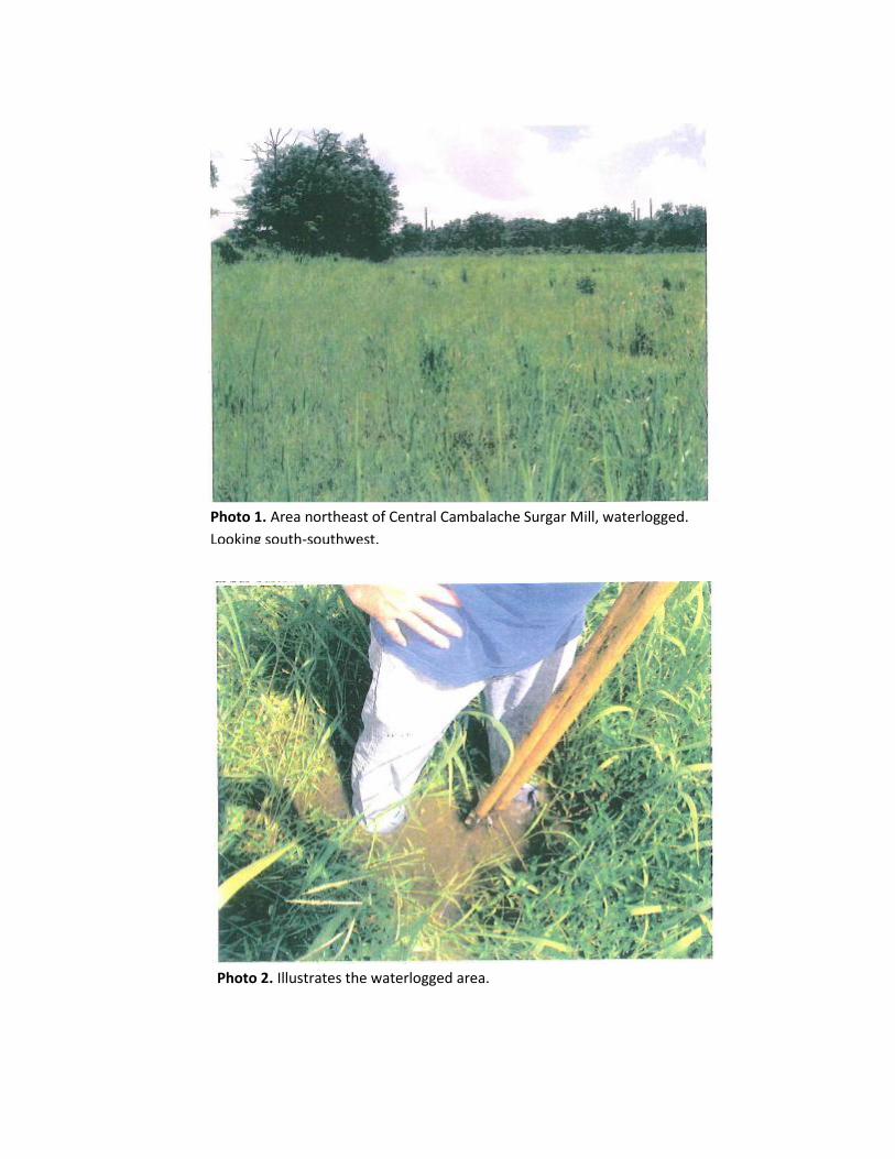
Photo 1. Area northeast of Central Cambalache Surgar Mill, waterlogged.
Looking south-southwest.
Photo 2. Illustrates the waterlogged area.

Photo 3. Shows the ruins of the destroyed buildings of Central Cambalache
Sugar Mill.
Photo 4. Archeotechnician observing the sugar mill debris.

Photo 5. Illustrates the two chimneys of Central Cambalache Sugar Mill. Looking west-
southwest.
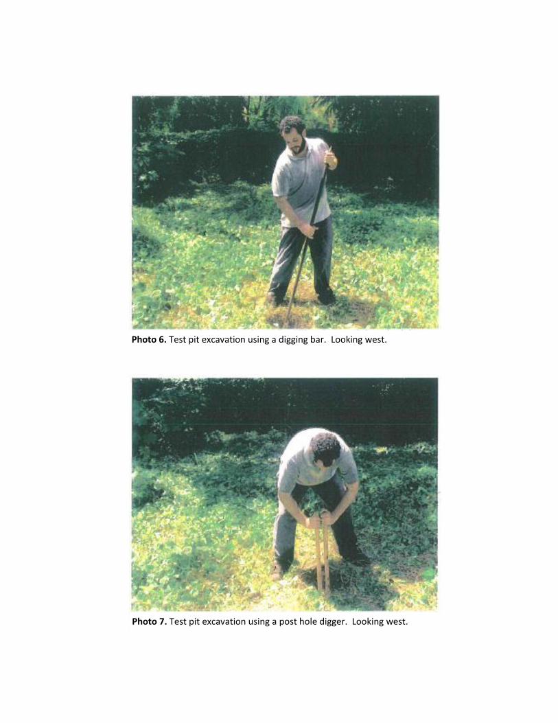
Photo 6. Test pit excavation using a digging bar. Looking west.
Photo 7. Test pit excavation using a post hole digger. Looking west.

Photo 8. Representative test pit, note water table.
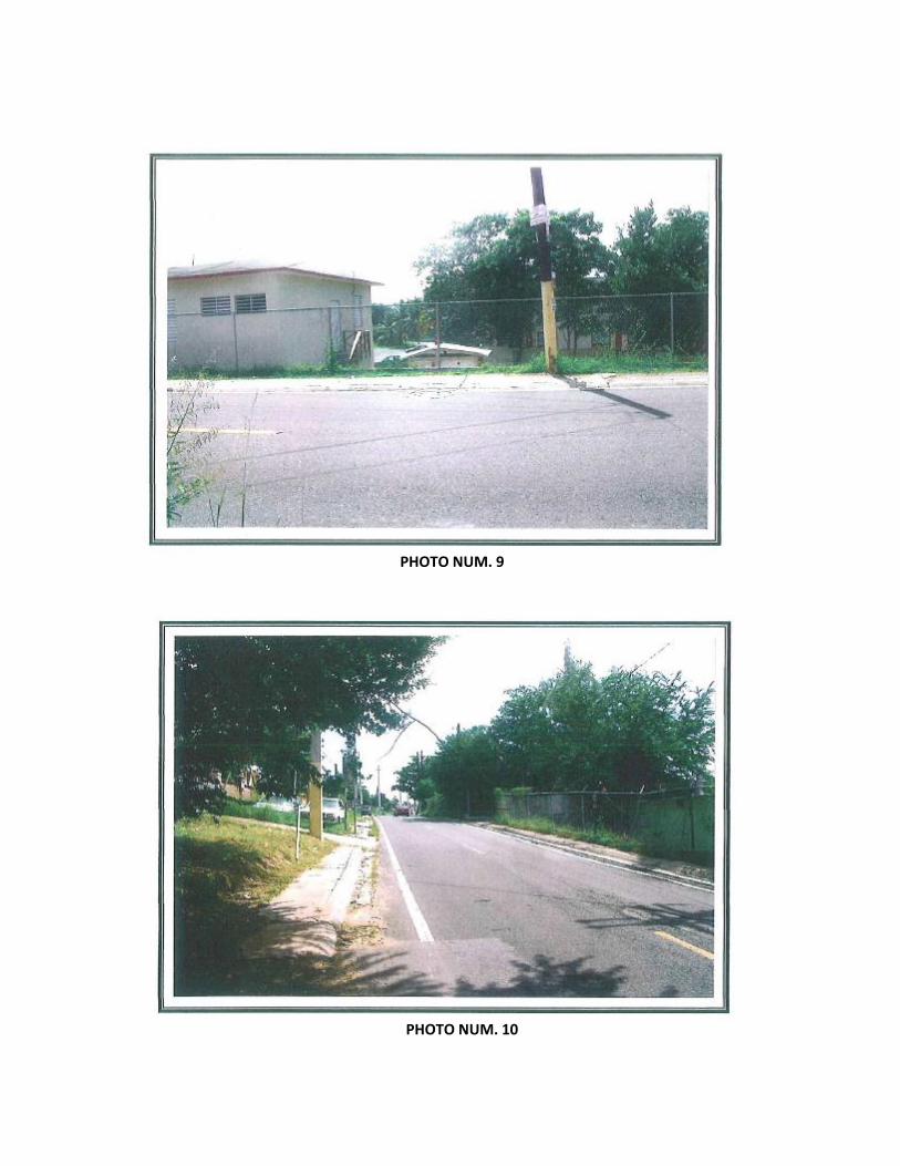
PHOTO NUM. 9
PHOTO NUM. 10

PHOTO NUM. 11
PHOTO NUM. 12
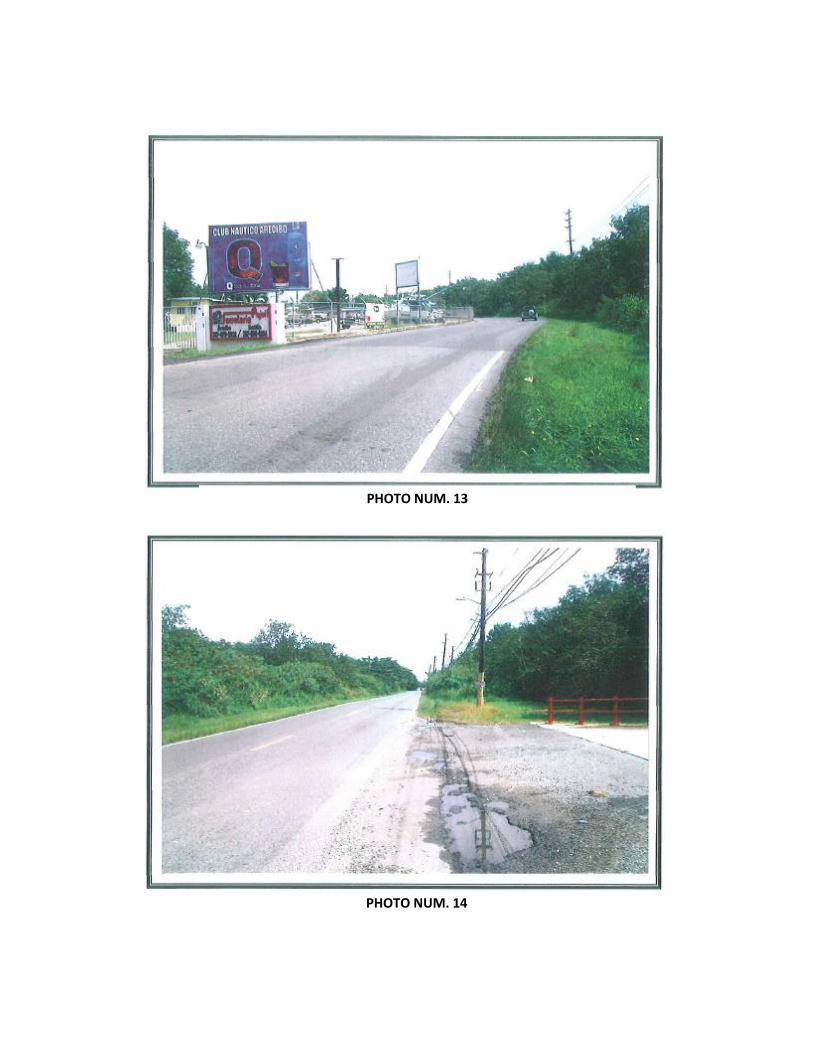
PHOTO NUM. 13
PHOTO NUM. 14

PHOTO NUM. 15
PHOTO NUM. 16

PHOTO NUM. 17
PHOTO NUM. 18

PHOTO NUM. 19
PHOTO NUM. 20

PHOTO NUM. 21
PHOTO NUM. 22
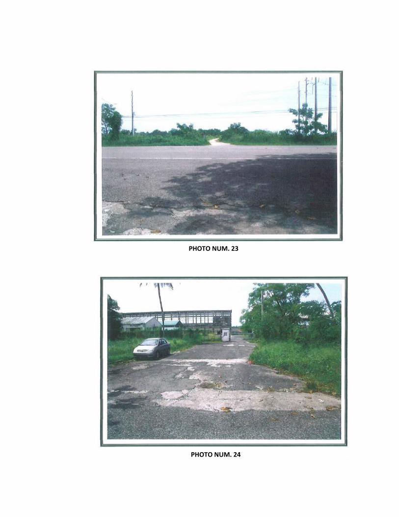
PHOTO NUM. 23
PHOTO NUM. 24

Appendix D

Appendix E