arcgis enterprise building raster analytics workflows · las to raster las dataset to raster clip...
TRANSCRIPT

ArcGIS Enterprise
Building Raster Analytics WorkflowsMike Muller, Jie Zhang

Raster Analytics
Introduction and Context

What is Raster Analytics?
• The ArcGIS way to create and execute spatial analysis
models and image processing chains which leverage
distributed storage and analytics
• ArcGIS Enterprise + ArcGIS Image Server
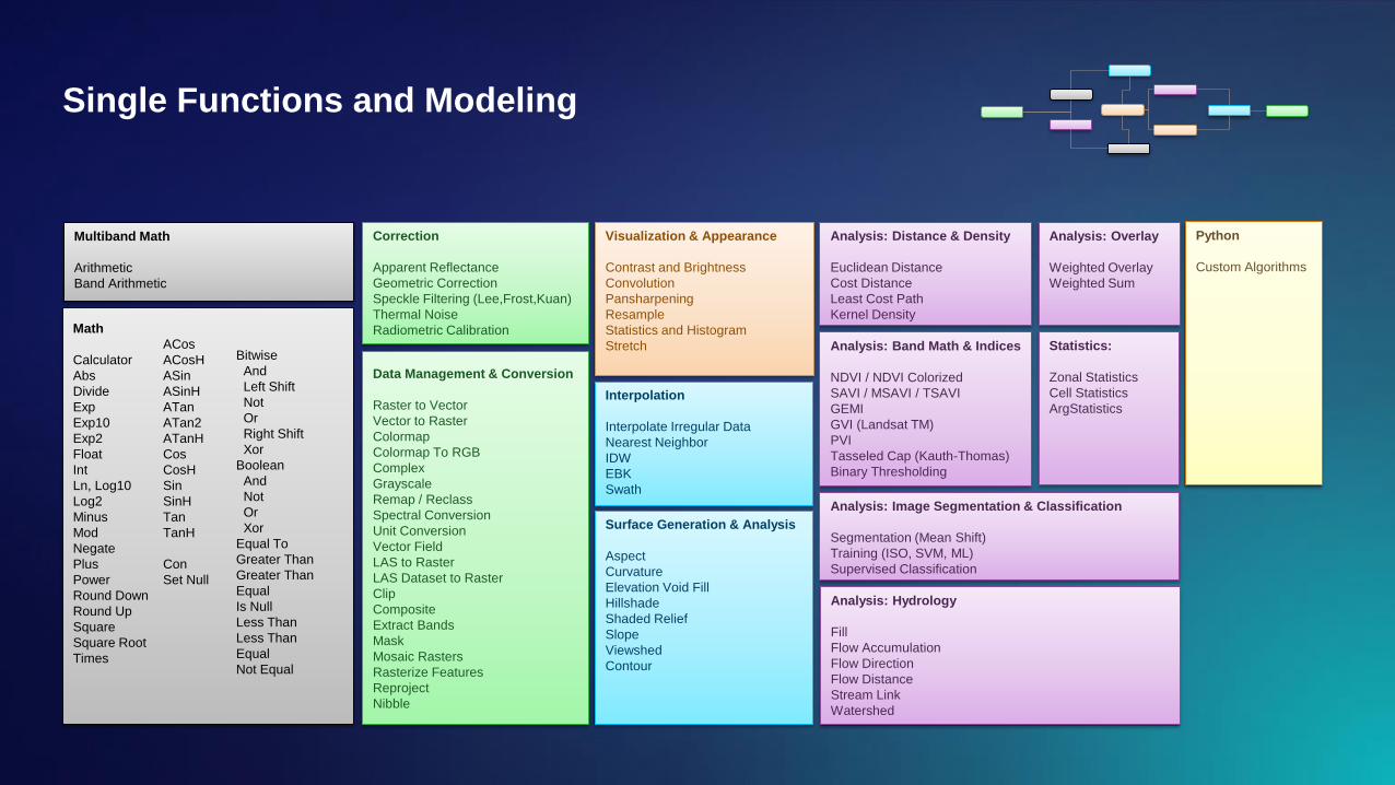
Single Functions and Modeling
Math
Calculator
Abs
Divide
Exp
Exp10
Exp2
Float
Int
Ln, Log10
Log2
Minus
Mod
Negate
Plus
Power
Round Down
Round Up
Square
Square Root
Times
ACos
ACosH
ASin
ASinH
ATan
ATan2
ATanH
Cos
CosH
Sin
SinH
Tan
TanH
Con
Set Null
Data Management & Conversion
Raster to Vector
Vector to Raster
Colormap
Colormap To RGB
Complex
Grayscale
Remap / Reclass
Spectral Conversion
Unit Conversion
Vector Field
LAS to Raster
LAS Dataset to Raster
Clip
Composite
Extract Bands
Mask
Mosaic Rasters
Rasterize Features
Reproject
Nibble
Interpolation
Interpolate Irregular Data
Nearest Neighbor
IDW
EBK
Swath
Correction
Apparent Reflectance
Geometric Correction
Speckle Filtering (Lee,Frost,Kuan)
Thermal Noise
Radiometric Calibration
Analysis: Image Segmentation & Classification
Segmentation (Mean Shift)
Training (ISO, SVM, ML)
Supervised Classification
Visualization & Appearance
Contrast and Brightness
Convolution
Pansharpening
Resample
Statistics and Histogram
Stretch
Surface Generation & Analysis
Aspect
Curvature
Elevation Void Fill
Hillshade
Shaded Relief
Slope
Viewshed
Contour
Analysis: Overlay
Weighted Overlay
Weighted Sum
Analysis: Band Math & Indices
NDVI / NDVI Colorized
SAVI / MSAVI / TSAVI
GEMI
GVI (Landsat TM)
PVI
Tasseled Cap (Kauth-Thomas)
Binary Thresholding
Analysis: Distance & Density
Euclidean Distance
Cost Distance
Least Cost Path
Kernel Density
Statistics:
Zonal Statistics
Cell Statistics
ArgStatistics
Python
Custom Algorithms
Analysis: Hydrology
Fill
Flow Accumulation
Flow Direction
Flow Distance
Stream Link
Watershed
Multiband Math
Arithmetic
Band Arithmetic
Bitwise
And
Left Shift
Not
Or
Right Shift
Xor
Boolean
And
Not
Or
Xor
Equal To
Greater Than
Greater Than
Equal
Is Null
Less Than
Less Than
Equal
Not Equal

Raster Analytics User Experiences
ArcGIS Pro Web ArcGIS API for Python
Workflows
Raster Analytics
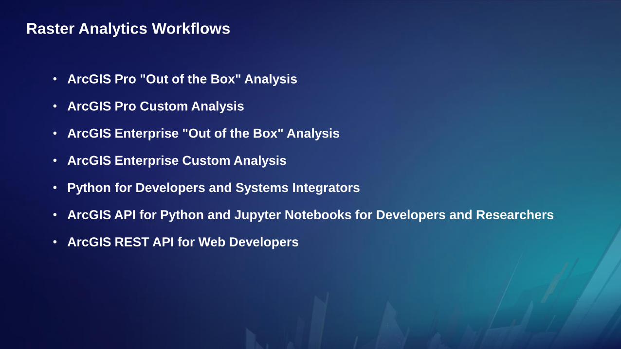
Raster Analytics Workflows
• ArcGIS Pro "Out of the Box" Analysis
• ArcGIS Pro Custom Analysis
• ArcGIS Enterprise "Out of the Box" Analysis
• ArcGIS Enterprise Custom Analysis
• Python for Developers and Systems Integrators
• ArcGIS API for Python and Jupyter Notebooks for Developers and Researchers
• ArcGIS REST API for Web Developers

ArcGIS Pro "Out of the Box" Analysis
• Local Processing
- "on the desktop"
- Image Analyst Tools
- enhanced parallel processing tools
- geoprocessing Model Builder
- leverage all geoprocessing tools
- single raster functions
• Distributed Processing
- "on the server"
- run individually
- best practice for modeling is
writing a script tool

ArcGIS Pro Custom Analysis
• Local Processing
- "on the desktop"
- "on-the-fly" results
- Raster Function Editor
- Output Layer Type = Raster Layer
• Distributed Processing
- "on the server"
- full resolution persistent results
- Raster Function Editor
- Output Layer Type = Web Image Layer
Visual Modeling

Jie Zhang
ArcGIS Pro Demo

ArcGIS Enterprise "Out of the Box" Analysis
• Distributed Processing
- "on the server"
- full resolution persistent results
- via Map Viewer
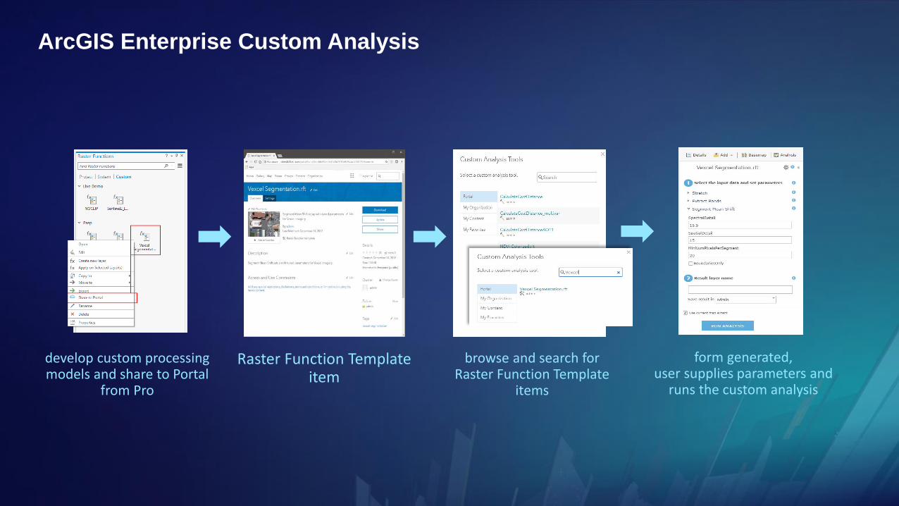
develop custom processing models and share to Portal
from Pro
Raster Function Template item
browse and search forRaster Function Template
items
form generated,user supplies parameters and
runs the custom analysis
ArcGIS Enterprise Custom Analysis
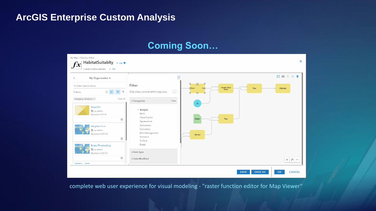
complete web user experience for visual modeling - "raster function editor for Map Viewer"
ArcGIS Enterprise Custom Analysis
Coming Soon…

Jie Zhang
ArcGIS Enterprise
Demo

Python for Developers and Systems Integrators
Python Raster Function API
https://github.com/Esri/raster-functions
arcgis.raster.analytics
distributed as part of the arcgis conda package
enterprise automation
enterprise integration
models built from existing functions
custom algorithms
leverage Python package ecosystem
use in ArcGIS Pro and ArcGIS Enterprise
ArcGIS API for Python

ArcGIS API for Python and Jupyter Notebooks
for Developers and Researchers
• display Image Layers
• apply dynamic on-the-fly processing
• construct raster function chain (i.e. models in code)
• run models using distributed processing
• design, develop, prototype

ArcGIS REST API for Web Developers
• run out of the box analytics
- http://esriurl.com/rarestapi
• model analysis in JSON and run using distributed processing
- http://esriurl.com/rasterfunc
JSON

Jie Zhang
Developer Demo


Please Take Our Survey on the AppDownload the Esri Events
app and find your event
Select the session
you attendedSelect the Feedback tab
Complete answers
and select “Submit”
