a.r drone navigation application design documentmaximkir/ardrone/documents/add/add_v1.0.pdf · a.r...
TRANSCRIPT

A.R Drone Navigation –
Application Design Document
Authors: Yuri Bakulin, Maxim Kirilov & Yuval Kovler
Academic Advisor: Dr. Yuval Elovici
Technical Advisor: Rami Puzis
http://www.cs.bgu.ac.il/~maximkir/ardrone/

AR Drone Navigation Project Page 2 of 43
Table of Contents
1. CHAPTER 1 – USE CASES ............................................................................... 6
1.1. Usage Scenario Number 1 - The AR Drone Takes-Off from the ground .................... 6
1.2. Usage Scenario Number 2 - Drone moves along to the marked path. ......................... 7
1.3. Usage Scenario Number 3 - Checkpoint handling ......................................................... 9
1.4. Usage Scenario Number 4 - Searching for a path........................................................ 10
1.5. Usage Scenario Number 5 - Stop Button pushed - the Drone lands. ......................... 12
2. CHAPTER 2 – SYSTEM ARCHITECTURE ................................................ 13
2.1. Global Architecture ........................................................................................................ 13
2.2. System Architecture ....................................................................................................... 14
3. CHAPTER 3 – DATA MODEL ....................................................................... 16
4. CHAPTER 4 BEHAVIORAL ANALYSIS ..................................................... 17
4.1. Sequence Diagrams......................................................................................................... 17
4.1.1. Taking off .................................................................................................................. 17
4.1.2. Landing ...................................................................................................................... 17
4.1.3. Video frame process .................................................................................................. 18
4.2. Events ............................................................................................................................... 19
4.3. States ................................................................................................................................ 19
4.4. Flow Diagram .................................................................................................................. 20
5. CHAPTER 5 - OBJECT ORIENTED ANALYSIS ....................................... 21
5.1. Class Diagrams ............................................................................................................... 21
5.1.1. Control ....................................................................................................................... 21
5.1.2. Image Processing ....................................................................................................... 22
5.1.3. Navigation ................................................................................................................. 23
5.1.4. Utility ........................................................................................................................ 24
5.2. Class Descriptions Class Descriptions .......................................................................... 25
5.2.1. Communication ......................................................................................................... 25
5.2.1.1. Autopilot ............................................................................................................ 25
5.2.1.2. Drone .................................................................................................................. 25

AR Drone Navigation Project Page 3 of 43
5.2.1.3. UdpWorker ........................................................................................................ 26
5.2.1.4. VideoDataRetriever ........................................................................................... 27
5.2.1.5. NavigationDataRetriever ................................................................................... 27
5.2.1.6. CommandSender ................................................................................................ 27
5.2.2. Image Processing ....................................................................................................... 28
5.2.2.1. SignDetector ...................................................................................................... 28
5.2.2.2. QRcodeDetector ................................................................................................. 28
5.2.2.3. GroundLineDetector .......................................................................................... 28
5.2.2.4. SignSelector ....................................................................................................... 29
5.2.2.5. BiggestSignSelector ........................................................................................... 29
5.2.2.6. FeatureExtractor ................................................................................................. 29
5.2.3. Navigation ................................................................................................................. 30
5.2.3.1. CourseAdvisor ................................................................................................... 30
5.2.4. Utility ........................................................................................................................ 30
5.2.4.1. CheckPointHandler ............................................................................................ 30
5.2.4.2. ImageFormatter .................................................................................................. 31
5.3. Packages .......................................................................................................................... 31
5.3.1. Control Package ........................................................................................................ 31
5.3.2. Utilities Package ........................................................................................................ 31
5.3.3. Navigation Package ................................................................................................... 31
5.3.4. Image Processing Package ........................................................................................ 32
5.4. Unit Testing ..................................................................................................................... 32
5.4.1. Communication ......................................................................................................... 32
5.4.1.1. AutoPilot ............................................................................................................ 32
5.4.1.2. Drone .................................................................................................................. 33
5.4.2. Image Processing ....................................................................................................... 35
5.4.2.1. SignDetector ...................................................................................................... 35
5.4.2.2. BiggetsSignSelector ........................................................................................... 35
5.4.2.3. QRCodeDetector ................................................................................................ 36

AR Drone Navigation Project Page 4 of 43
5.4.2.4. GroundLineDetector .......................................................................................... 36
5.4.2.5. AngleExtractor ................................................................................................... 36
5.4.3. Navigation ................................................................................................................. 37
5.4.3.1. CourseAdvisor ................................................................................................... 37
5.4.4. Utility ........................................................................................................................ 37
5.4.4.1. CheckPointHandler ............................................................................................ 37
6. CHAPTER 6 - USER INTERFACE DRAFT ................................................. 38
7. CHAPTER 7 -TESTING .................................................................................. 39
7.1. General Schema .............................................................................................................. 39
7.2. Testing Functional Requirements ................................................................................. 39
7.3. Testing Non-Functional Requirements ......................................................................... 39
8. CHAPTER 8 - TASK LIST .............................................................................. 41
8.1. Control task list ............................................................................................................... 41
8.2. Utility task list ................................................................................................................. 41
8.3. Image processing task list .............................................................................................. 41
8.4. Navigation task list ......................................................................................................... 42
8.5. User Interface .................................................................................................................. 42
8.6. Auto Pilot ......................................................................................................................... 42
8.7. Documents and Projects Day task list........................................................................... 43

AR Drone Navigation Project Page 5 of 43
Terms commonly used:
1. NavData – Navigation Data that is send approximately 30 times per
second from the drone and includes the following data:
a. Angular position : Psi , Phi , Theta.
b. Altitude.
c. Speed Gaz(Vertical),Yaw (Angular)
d. Battery level
2. Path – Marked Line on the floor.
3. Checkpoint – QRCode (http://en.wikipedia.org/wiki/QR_code) placed on
the floor.
4. AT command – The set of commands that are the communication protocol
of the AR Drone.
5. openCV (Open Source Computer Vision) - is a library of programming
functions for real time computer vision.
6. Emgu CV is a cross platform .Net wrapper to OpenCV .
7. The Battery is charged – means the battery is charge more than 20%.
Important note:
There are a few usages that seem abstract in the Use Cases; those exist because
we have a few “Black Boxes”.
All of the black boxes are those from the side of the AR Drone and its firmware
and SDK – including the video recording and sending, sensors data and
performing the AT Commands.

AR Drone Navigation Project Page 6 of 43
1. Chapter 1 – Use Cases
1.1. Usage Scenario Number 1 - The AR Drone Takes-Off from the ground
ID: 1
Primary actors: AR Drone, Computer , Operator
Trigger: The Operator clicks on the “Start” button.
Pre-conditions:
1. The Drone is sitting on a horizontal ground with the bottom camera
facing down.
2. The Drone is placed without any obstacles on top of him.
3. The drone is placed at the starting point.
4. A Path has been marked.
5. The Auto-pilot Software on the computer is initialized.
6. The Drone and the computer have established a Wi-Fi connection
(network working correctly).
7. The Battery is fully charged.
Post-conditions:
1. The drone is up in the air
Flow of events:
1. The AT Command “Take-Off” is sent by the computer and received by the
Drone.
2. The Drone Starts its Engines and all his sensors.
Alternative flows:
2 .a The Drone is not able to starts its Engines Action:
2. a. 1. The Build in firmware on the Drone will stop the drone’s
actions.
2. a. 2. The drone sends the Navdata to the computer.
2. a. 3. The computer interprets the Navdata and displays a failure
message on the screen.
2. a. 4. End of use case

AR Drone Navigation Project Page 7 of 43
1.2. Usage Scenario Number 2 - Drone moves along to the marked path.
ID: 2
Primary actors: AR Drone, Computer.
Trigger: Video frame received.
Pre-conditions:
1. The Drone’s position is horizontal (moving is correct - with the
bottom camera facing down).
2. A Path has been marked.
3. The Auto-pilot Software on the computer is initialized.
4. The Drone and the computer have established a Wi-Fi connection
(network working correctly).
5. The Battery is charged.
6. Use Case number 1 has finished successfully.
7. Use Case number 3\4 isn’t running.
Post-conditions:
1. The drone moves according to the commands sent to him.
Flow of events:
1. The computer formats the video frame from “source bitmap” to
“image” (EMGU format) and shows it on the screen.
2. The computer checks there isn’t a checkpoint by running the Image
process algorithm for identifying a checkpoint on the formatted
video frame.
3. The computer runs the Image process algorithm for identifying a
path on the formatted video frame and decides on a direction for the
drone to continue.
4. The computer shows the processed video frame on the screen.
5. The computer calculates the set of AT commands that are equal to
the calculated direction.
6. The computer sends the set of AT commands to the drone.
7. The drone receives the AT commands and performs them.
Alternative flows:
1.b The computer is unable to format the video frame.
Action:

AR Drone Navigation Project Page 8 of 43
1.b 1.The computer displays an appropriate message on the screen.
1.b 2.End of use case.
2.a The computer isn’t able to run the Image process algorithm
Action:
2.a 1. The computer displays an appropriate message on the screen.
2.a 2.End of use case.
2.b The computer runs the Image process algorithm and detects a
checkpoint .
Action:
2.b 1. Use Case number 3 - Checkpoint handling is started.
2.b 2.End of use case.
3.a The computer runs the Image process algorithm for identifying a
path and isn’t able to identify a path.
Action:
3.b 1. The computer displays an appropriate message on the screen and
adds to the counter of continuous failures.
3.b 2. If the counter of continuous failures equals to predefined value
then use case 4 – “searching for a path” starts.
3.b 2.End of use case.

AR Drone Navigation Project Page 9 of 43
1.3. Usage Scenario Number 3 - Checkpoint handling
ID: 3
Primary actors: AR Drone, Computer
Trigger: Use case 2 - alternative step 2 .a 1. has been made.
Pre-conditions:
1. The Drone’s position is horizontal (moving is correctly with the
bottom camera facing down).
2. A Checkpoint has been identified.
3. The Auto-pilot Software on the computer is initialized.
4. The Drone and the computer have established a Wi-Fi connection
(network working correctly).
5. The Battery is charged.
6. Use Case number 1 has finished successfully.
Post-conditions:
1. The Drone stays in the same position as it was before.
Flow of events:
1. The computer sends the drone the “Hover” AT Command.
2. The drone receives the “Hover” AT Command and hovers.
3. After a predefined period of time the reverse of “Hover” AT
Command is been sent by the computer to the drone.
4. The drone receives the command and recovers from the “Hover”
mode.

AR Drone Navigation Project Page 10 of 43
1.4. Usage Scenario Number 4 - Searching for a path
ID: 4
Primary actors: AR Drone, Computer
Trigger: Use case 2 - alternative step 5.b. 2 have been made.
Pre-conditions:
1. The Drone’s position is horizontal (moving is correctly with the
bottom camera facing down).
2. A path has been marked.
3. The Auto-pilot Software on the computer is initialized.
4. The Drone and the computer have established a Wi-Fi connection
(network working correctly).
5. The Battery is charged.
6. Use Case number 1 has finished successfully.
Post-conditions:
1. Use case 2 has been activated
Or
The drone lands and an appropriate message is displayed to the user.
Flow of events:
1. The computer sends a command to the drone to go left a predefined
distance.
2. The Drone receives and does the command.
3. The computer receives each frame and runs the Image process
algorithm for identifying a path and fails to recognize a path.
4. The computer sends a command to the drone to go right (to return to
the same place) a predefined distance.
5. The computer sends a command to the drone to go right a
predefined distance.
6. The Drone receives and does the command.
7. The computer receives each frame and runs the Image process
algorithm for identifying a path and fails to recognize a path.
8. The computer sends a command to the drone to go left (to return to
the same place) a predefined distance.

AR Drone Navigation Project Page 11 of 43
9. The computer sends a command to the drone to go toward a
predefined distance .
10. The Drone receives and does the command.
11. The computer receives each frame and runs the Image process
algorithm for identifying a path and fails to recognize a path.
12. The computer sends a “Land” AT command and an appropriate
message is displayed to the computer.
Alternative flows:
3.a\7.a\11.a Image process algorithm for identifying a path
successfully recognizes a path.
3.a\7.a\11.a 1 An appropriate message is displayed to the user.
3.a\7.a\11.a 2 End of use case.

AR Drone Navigation Project Page 12 of 43
1.5. Usage Scenario Number 5 - Stop Button pushed - the Drone lands.
ID: 5
Primary actors: AR Drone, Computer, Operator.
Trigger: The operator clicks on the stop Button.
Pre-conditions:
1. The Auto-pilot Software on the computer is initialized.
2. The Drone and the computer have established a Wi-Fi connection
(network working correctly).
3. The Battery is charged.
4. Use Case number 1 has finished successfully.
Post-conditions:
1. The drone is on the ground.
2. The drone’s engines are off.
Flow of events:
1. The Computer sends a land AT Command to the drone.
2. The drone receives the land command and starts landing.
3. The drone sends Navdata.
4. The computer receives the Navdata and recognizes when the
drone landed and displays an appropriate message on the screen.

AR Drone Navigation Project Page 13 of 43
2. Chapter 2 – System Architecture
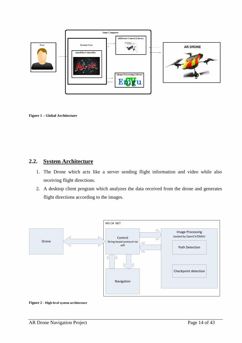
2.1. Global Architecture
Our system has four main parts (Figure 1):
1. ARDrone-Control-.NET –
An application for flying the Parrot AR drone in Windows
This framework is used to abstract the whole Aviation control.
We are using it to receive all the info that is sent from the drone (Video Stream and
NavData), and easily send commands to the drone.
2. AR Drone –
The AR Drone operates on "BusyBox" which is a small embedded Linux distro.
We are using the AR Drone’s built in firmware to communicate with the drone via Wi-Fi
to do the following:
a. Send commands.
b. Receive video stream & navigation data so we could calculate the next move.
3. EMGU –
We are using the .Net wrapper to the Intel OpenCV image processing library
To process the video frames received from ARDrone-Control-.NET framework.
We will run various image processing algorithms for identifying a path\checkpoint using
the library’s functions.
4. Autopilot –
The last and most important part of the system - the part that is developed by us.
In its main responsibilities is coordinating between all the parts of the system – running the
image processing algorithms after receiving the video frame and then calculating the
drones next command, this part will be more detailed in the next section.
AR Drone Navigation Project Page 14 of 43
Figure 1 – Global Architecture
2.2. System Architecture
1. The Drone which acts like a server sending flight information and video while also
receiving flight directions.
2. A desktop client program which analyzes the data received from the drone and generates
flight directions according to the images.
MS C# .NET
DroneControl
String based protocol via wifi
Navigation
Image Processingbacked by OpenCV/EMGU
Path Detection
Checkpoint detection
Figure 2 - High level system architecture

AR Drone Navigation Project Page 15 of 43
The desktop client is written in C# using Microsoft's .NET framework. The system consists of
three main modules:
Control:
This module contains an implementation of the Drone's communication protocol (AT Commands)
and an easy to work with interface for communicating with the drone. It also contains dedicated
worker threads responsible for retrieving updates video and flight information data from the drone
in real time.
Image Processing:
This module consists of two parts:
1. A Path Detection component responsible of identifying the path marker in the image and return
the direction of the target.
2. A Checkpoint Detection component responsible of identifying checkpoint markers and
performing the required action.
The image processing is designed to be interchangeable in order to enable easy testing and use of
different path marking and detection techniques as well as different ways to mark, detect and
respond to checkpoints.
Navigation:
This module is responsible of maintaining the drone's flight path. It incorporates data from the
image processing module to compute 3D navigation directions for the drone.

AR Drone Navigation Project Page 16 of 43
3. Chapter 3 – Data Model
In fact that the project is dealing with live video processing and it is important to
state that there isn’t any data storing the whole issue of developing a data model and
storing data is irrelevant to our project. – meaning it is Not Applicable.

AR Drone Navigation Project Page 17 of 43
4. Chapter 4 Behavioral Analysis
4.1. Sequence Diagrams
4.1.1. Taking off
Figure 3 – Taking off sequence diagram
4.1.2. Landing
Figure 4 – landing sequence diagram

AR Drone Navigation Project Page 18 of 43
4.1.3. Video frame process
Figure 5 – Video Frame Process

AR Drone Navigation Project Page 19 of 43
4.2. Events
Our system is an autonomous system, therefore we think that our software system
isn’t best described and understood in terms of the events but in terms of states .
4.3. States
Figure 4 describes the behavior of the system in state-machine form. We leave out
the take-off and landing phases and describe the main operation loops of the
program and the Drone.
Program normal operation
Wait for new frame
Process image
Compute directionsSend directions
frame arrives / convert the Image
Check Point Detected
Path Detected
Handling Check Point
Check Point Detected
Path Detected
Search PathNothing Detected
Path Found
Check point handled
Failed to find Path
Shut down button pressed
Figure 6 - System state-machine representation.

AR Drone Navigation Project Page 20 of 43
4.4. Flow Diagram
The following is a flow diagram describing the main control flow of our program:
Drone Server
Control Thread
Acquire frame Send frame
Receive directions
Apply directions
Send NavData
Worker Thread
Image Formatter
directions
Checkpoint Detector
Checkpoint HandlerPath Detector
Auto Pilot
Raw frame
image
image
angle
directions
directions
NavData Thread
Video Thread
Directions Thread
frame
NavData
Drone Interface
Figure 7 Flowchart of system operation.

AR Drone Navigation Project Page 21 of 43
5. Chapter 5 - Object Oriented Analysis
5.1. Class Diagrams
5.1.1. Control
Control
+getFrame() : ImageSource+getNavData() : DroneData+Take-off()+Land()+clearEmergencySignal()+connect()+disconnect()+initliaze()+sendCommand(in command : Command)+switchCamera()+getInstance() : Drone
-commander : CommandSender-navdata : NavigationDataRetriever-videoManager : VideoDataRetriever
Drone
+SendQueuedCommand(in command : Command)+SendUnqueuedCommand(in command : Command)+SetCamera()
-commandsToSend : List<String>-initialSequenceNumber : int-commandRefreshTimeout : int-commandModeEnableTimeout : int-currentSequenceNumber : uint-defaultCameraMode
CommandSender
+getCurrentNavigationData() : DroneData
-currentNavigationData : DroneData
NavigationDataRetriever
+getCurrentImage() : Image+getCurrentBitmap() : Bitmap
-currImage : Image-currBitmap : ImageSource-imageFormatter : ImageFormatter
VideoDataRetriever
+SendMessage(in message : string)+CreateUdpSocket(in ip, in port, in timeoutValue) : bool+DisconnectFromSocket()+SendMessage(in buffer : byte[])
UdpWorker
+getPhi() : double+getPsi() : double+getTheta() : double+getVx() : double+getVy() : double+getVz() : double+getAltitude() : int+getBatteryLevel() : int
+phi : double+psi : double+theta : double+vX : double+vY : double+vZ : double+altitude : int+batteryLevel : int
DroneData
+dispose()+init() : bool+startAutoPilot()
-drone : Drone-checkPointDetector : SignDetector-courseAdvisor : CourseAdvisor-courseDetector : SignDetector-checkPointHandler : CheckPointHandler
AutoPilot «uses»
recieve
1
*
1
*
1
*
Figure 8 – Class Diagram of the “Control” Packge

AR Drone Navigation Project Page 22 of 43
5.1.2. Image Processing
Image Process
CheckPointDetectorPathDetector
QRCodeDetectorGroundLineDetector HorizonPlacardDetector
+getCandidateImage() : Image+getRectangle() : Image
-candidateImage : Image-rectangle : Rectangle
SignResult
+DetectSign(in image : Image) : List<SignResult>
-featureTracker : Features2DTracker-surfaceParameters : SURFDetector-octagonStorage : MemStorage-octagonContour : Contour<Point>
SignDetector
+extractSign(in signs : List<SignResult>) : SignResult
SignSelector
BiggestSignSelector
AngleExtractor
+exctractFeature(in signResult : SignResult) : Feature
«interface»FeatureExtractor
+getFeature() : object
«interface»Feature
HorizontalDistanceExtractor
+getAngle() : int+getIntersectionPoint() : Point
-angle : int-intersectionPoint : Point
Angle
+getDistance() : int
-distance : int
Distance
Figure 9 - Class Diagram of the “Image Processing” Packge

AR Drone Navigation Project Page 23 of 43
5.1.3. Navigation
Navigation
+getNavigationAdvice(in result : SignResult) : Directions+getNavigationAdvice(in signs : List<SignResult>) : Directions
-signSelector : SignSelector-featureExtractor : FeatureExtractor
CourseAdvisor
+getYaw() : float+getPitch() : float+getGaz() : float+getRoll() : float
-pitch : float-roll : float-yaw : float-gaz : float
Directions
GroundStripeCourseAdvisor HorizonPlacardCourseAdvisor
«uses»
Figure 10 - Class Diagram of the “Navigation” Packge

AR Drone Navigation Project Page 24 of 43
5.1.4. Utility
Utility
+Connected+NotConnected+Flying+NotFlying+Hovering+NotHovering+Emergency+NotEmergency
«enumeration»CommandStatusPrerequisite
+SetFlying+ClearFlying+SetHovering+ClearHovering+SetEmergency+ClearEmergency+SwitchCamera
«enumeration»CommandStatusOutcome
«enumeration»SupportedFirmwareVersion
+handleCheckPoint(in checkPoint : SignResult) : bool
-handledCheckPoints : Set
CheckPointHandler
CPLights
+BitmapSourceToImage(in Bitmap : BitmapSource) : Image
ImageFormatter
+CreateCommand(in firmwareVersion : SupportedFirmwareVersion) : string+NeedsPrerequisite(in prerequisiteEntry : CommandStatusPrerequisite) : bool+HasOutcome(in outcomeEntry : CommandStatusOutcome) : bool
#sequenceNumber : int-prerequisites : HashSet<CommandStatusPrerequisite>-outcome : HashSet<CommandStatusPrerequisite>
Command
FlatTrimCommand FlightModeCommand FlightMoveCommand
HoverModeCommand
PlayLedAnimationCommand
SetConfigurationCommandSetControlModeCommand
SwitchCameraCommand
WatchDogCommand
Figure 11 - Class Diagram of Utilties

AR Drone Navigation Project Page 25 of 43
5.2. Class Descriptions Class Descriptions
5.2.1. Communication
5.2.1.1. Autopilot
Main class – starts the AR Drone application.
Init:
Establishing connection to the AR Drone.
Pre-Condition: the AR Drone is on & in proper condition and the drone is
actually sits on a horizontal ground.
Post-Condition: return true if and only if all workers have been started.
StartAutoPilot:
Starts the AR Drone autopilot.
Pre-Condition: initialization was finished successfully (return true).
Post-Condition: the AR Drone starts to look for a path.
Dispose:
Shuts down the system.
Pre-Condition: none.
Post-Condition: the system releases all resources and disconnects from the
AR Drone.
5.2.1.2. Drone
Represents the AR Drone.
Take-off:
Sends take off command to the AR Drone.
Pre-Condition: the drone was initialized; the AR Drone sits on a
horizontal ground.
Post-Conditions: the AR Drone is hovering 1 meter above the ground.
Land:
Sends land command to the AR Drone.
Pre-Condition: take off command was invoked.
Post-Condition: the drone is on ground.

AR Drone Navigation Project Page 26 of 43
Connect:
Connects to the AR Drone.
Pre-Condition: the drone Wi-Fi is on.
Post-Condition: the workers start to receive data from the drone.
Disconnect:
Disconnects from the drone.
Pre-Condition: connection to drone is established.
Post-Condition: all open connections were closed.
SendCommand:
Sends command to the AR Drone.
Pre-Condition: connection was established and take-off was invoked.
Post-Condition: none (no grantee that the command was received).
SwitchCamera:
Sends a special command to the drone to switch the video camera feed.
Pre-Condition: connection to the AR Drone was established.
Post-Condition: none (no grantee that the command was received).
GetInstance:
Returns Drone instance (drone is singleton).
Pre-Condition: none.
Post-Condition: none.
5.2.1.3. UdpWorker
Responsible for the communication with different AR Drone components (sensors).
CreateUdpSocket (address, port-number, time-out):
Creates UDP socket to specific port at given address within given
timeout.
Pre-Condition: the AR Drone is running on the address and listening on
the port number given.
Post-Condition: return true if and only if a socket has been established
successfully between the AR Drone and the Worker.

AR Drone Navigation Project Page 27 of 43
SendMessage (message):
Sending message to the AR Drone.
Pre-Condition: a socket is open and the AR Drone is listening on the input
stream.
Post-Condition: none.
DisconnectFromSocket:
Closing connection with the AR Drone component.
Pre-condition: a socket is open and the AR Drone is listening on the input
stream.
Post-Condition: the socket is closed.
5.2.1.4. VideoDataRetriever
Responsible for process (format) received images from the AR Drone.
GetCurrentImage:
Getter of the last received image from the AR Drone.
Pre-Condition: connection to the AR Drone camera was established.
Post-Condition: Return the source in Image format.
5.2.1.5. NavigationDataRetriever
Responsible for parse the received NavData from the AR Drone.
GetCurrentNavigationData:
Getter of the last received NavData from the AR Drone.
Pre-Condition: connection to the AR Drone NavData port was established
Post-Condition: Return AR Drone NavData.
5.2.1.6. CommandSender
Responsible for commands delivery to the AR Drone. In addition this worker keeps
active commands connection to the AR Drone by sending empty commands while
the commands queue is empty.
SendQueuedCommand (command):
Puts the command into commands queue.

AR Drone Navigation Project Page 28 of 43
Pre-Condition: Connection to the AR Drone was established.
Post-Condition: none.
SendUnqueuedCommand (command):
Sends the command immediately.
Pre-Condition: Connection to the AR Drone was established.
Post-Condition: none.
5.2.2. Image Processing
5.2.2.1. SignDetector
Responsible for signs detection. This is a base class for all algorithms for signs
recognition.
DetectSing (image):
Detect sign on input image.
Pre-Condition: image is valid.
Post-Condition: Return list of sign detections if and only if signs are
exists in the image.
5.2.2.2. QRcodeDetector
Responsible for detecting QR code signs.
DetectSing (image):
Detects QR code signs.
Pre-condition: image is valid.
Post-condition: Return list of sign detections if and only if QR code are
exist in the image.
5.2.2.3. GroundLineDetector
Responsible for detecting pre-defined colored strips.
DetectSign (image):
Detect colored strip.
Pre-condition: stripe width should be at least 5 cm.
Post-condition: Return list of sign detections if and only if colored stripe
exist in the image.
AR Drone Navigation Project Page 29 of 43
5.2.2.4. SignSelector
Base class for various algorithms for selecting one sign from list of detected signs.
ExtractSign (image, list of signs):
Extracts one sign from list.
Pre-Condition: legal image and legal signs.
Post-Condition: one sign returned.
5.2.2.5. BiggestSignSelector
Selects the biggest (with the biggest volume) sign from list of detected signs.
ExtractSign (image, list of signs):
Selects one sign from signs list.
Pre-condition: legal image and legal signs.
Post-Condition: Return the biggest detected sign if and only if this sign has the
biggest volume.
5.2.2.6. FeatureExtractor
Interface for different features that can be extracted from detected signs.
ExtractFeature (image, sign-area):
Extracts feature from image.
Pre-Condition: image and area sign are legal values.
Post-Condition: some object that implements the Feature interface is
return.
AngleExtractor (image, sign-area):
Extracts an angle from linear approximation to the sign. The angle is
relative to line intersection with x-axis.

AR Drone Navigation Project Page 30 of 43
Figure 12 –Angle from linear approximation example
Pre-Condition: image and area sign are legal values.
Post-Condition: some object that implements the Feature interface is
return.
HorizontalDistanceExtractor (image, sign-area);
Extracts distance estimation from the sign.
Pre-Condition: image and area sign are legal values.
Post-Condition: some object that implements the Feature interface is
return.
5.2.3. Navigation
5.2.3.1. CourseAdvisor
Base class for course advisors, responsible for directions extraction from detected
signs in image.
GetNavigationAdvice (image, sign-area):
Process the signs according to specific designation.
Pre-Condition: none.
Post-Condition: Return directions if and only if area of sign isn’t empty.
5.2.4. Utility
5.2.4.1. CheckPointHandler
Responsible for handle check points.
HandleCheckPoint (checkpoint):

AR Drone Navigation Project Page 31 of 43
Handles check point according to specific implementation.
Pre-Condition: valid check point.
Post-Condition: Return true if and only if the received check point wasn’t
handled before.
5.2.4.2. ImageFormatter
Responsible for convert an image from a raw type (bitmap source) to Image type.
BitmapSourceToImage (bitmap):
Converts from bitmap source to image.
Pre-Condition: valid image.
Post-Condition: image representation of the bitmap source.
5.3. Packages
The classes are divided into 4 packages as follow:
5.3.1. Control Package
Control- This package contains classes that are responsible of communicating with the AR
Drone.
Control.Workers – This package contains classes that are responsible for handle different
connections to AR Drone.
Control.Tests – Stores all Control package tests.
5.3.2. Utilities Package
Utilities – This package contains different utilities for video, network and configuration.
Utilities.Commands – This package contains AT commands extensions.
Utilities.Configuration – This package contains different configuration files.
Utilities.Tests – Stores all Utilities package tests.
5.3.3. Navigation Package
Navigation – This package contains classes for computation the next flight commands.
Navigation.Tests – Stores all Navigation package tests.

AR Drone Navigation Project Page 32 of 43
5.3.4. Image Processing Package
ImageProcessing – This package contains designated classes for different algorithms for
path and sings recognition.
ImageProcessing.Tests – Stores all Image processing package tests.
5.4. Unit Testing
5.4.1. Communication
5.4.1.1. AutoPilot
Init:
No. Type Description Expected Results
1 Success The AR Drone is on and no other
connection connected to him
Connection to the AR
Drone is established,
all workers started.
True value returned.
2 Failure The AR Drone is off. Exception is thrown
with message: “Cannot
establish connection to
the AR Drone”.
3 Failure The AR Drone is on and other client is
connected to him.
Exception is thrown
(same message as
above).
Dispose:
No. Type Description Expected Results
1 Success Connection to the AR Drone was
established, AR Drone on ground.
All active connections
are closed.
2 Success Connection to the AR Drone established
and AR Drone is flying.
AR Drone lands, all
active connections are
closed.
3 Failure No active connection to the AR Drone. Exception is thrown.

AR Drone Navigation Project Page 33 of 43
5.4.1.2. Drone
GetFrame:
No. Type Description Expected Results
1 Success Connection to the AR Drone was
established, front camera set to
default. Stop sign place before the
AR Drone camera.
The stop sign should
image should be
returned.
2 Failure No active connection to the AR
Drone.
Exception thrown.
GetNavData:
No. Type Description Expected Results
1 Success Connection to the AR Drone was
established. The AR Drone is placed
on horizontal ground.
Drone data should be
return with all values
set to 0.
2
Failure No active connection to the AR
Drone.
Exception thrown.
3 Success Connection to the AR Drone was
established, the AR Drone held 1
meter above the ground.
Drone date returned
with altitude value 1.
TakeOff:
No. Type Description Expected Results
1 Success Connection to AR Drone was
established, the AR Drone sits on a
horizontal ground.
The AR Drone takes
off.
2 Failure No active connection to the AR
Drone.
Exception thrown.
3 Success The AR Drone is flying. Nothing happens.
4 Failure Connection to AR Drone was
established, the AR Drone sits on a
The AR Drone enters
to emergency mode.

AR Drone Navigation Project Page 34 of 43
slope ground.
Land:
No. Type Description Expected Results
1 Success The AR Drone is flying. The AR Drone lands,
2 Success The AR Drone is on ground Nothing happens.
SendCommand:
No. Type Description Expected Results
1 Success The AR Drone is flying. Play led
animation command is send each
second during one minute.
The AR Drone led
lamps change their
color at least once.
2 Failure No active connection to the AR
Drone.
Exception thrown.
3 Success The AR Drone is flying. 3 flight
move forward commands are sent to
the AR Drone.
The AR Drone moves
forward.

AR Drone Navigation Project Page 35 of 43
5.4.2. Image Processing
5.4.2.1. SignDetector
DetectSign (image):
No. Type Description Expected Results
1 Success The method is invoked with legal
image object with one sign.
Sign Result object is
returned with sign
detection.
2 Success The method is invoked with legal
image object without signs.
Null object is returned.
5.4.2.2. BiggetsSignSelector
ExtractSign (image, list of signs):
No. Type Description Expected Results
1 Success The method is invoked with legal
image object and 2 detected signs:
first sign has volume of 10 units and
the other has volume of 2 units.
Sign Result object is
returned with the first
sign.
2 Success The method is invoked with legal
image object with one detected sign.
Sign Result object is
returned with the
received sign.
3 Success The method is invoked with legal
mage object with two identical
detected signs.
Sign result object is
returned with the sign
that his center of mass
is closer to the image
center.

AR Drone Navigation Project Page 36 of 43
5.4.2.3. QRCodeDetector
DetectSign (image):
No. Type Description Expected Results
1 Success The method is invoked with legal
image object with one QR code sign.
Sign Result object is
returned with sign
detection around the
QR code.
2 Failure The method is invoked with legal
image object without QR code sign.
Null object is returned.
5.4.2.4. GroundLineDetector
DetectSign (image):
No. Type Description Expected Results
1 Success The method is invoked with legal
image object with one stripe yellow.
Sign Result object is
returned with sign
detection around the
yellow stripe.
2 Failure The method is invoked with legal
image object without strip sign.
Null object is returned.
5.4.2.5. AngleExtractor
ExtractFeature (image, sign-area):
No. Type Description Expected Results
1 Success The method is invoked with legal
image with detected sign. The
approximation line intersects the x
axis at 45 degree.
Angle object is
returned with angle
value:

AR Drone Navigation Project Page 37 of 43
HorizontalDistanceExtractor (image, sign-area):
No. Type Description Expected Results
1 Success The method is invoked with legal
image with detected sign. The sign
approximate distance from the AR
Drone is 10 meters.
Distance object is
returned with distance
value:
5.4.3. Navigation
5.4.3.1. CourseAdvisor
GetNavigationAdvice (image, sign-area):
No. Type Description Expected Results
1 Success The method is invoked with legal
image and sign area. The image has
sign that his linear approximation is
intersects with the x axis in 60
degrees.
The navigation adviser
will return 10 flight
move commands.
These commands will
turn the AR Drone 30
degrees against
clockwise.
5.4.4. Utility
5.4.4.1. CheckPointHandler
HandleCheckPoint (checkPoint):
No. Type Description Expected Results
1 Success Valid check point that wasn’t
handled before.
Return true value.
2 Failure Valid check point that was handled
before.
Return false value.

AR Drone Navigation Project Page 38 of 43
6. Chapter 6 - User Interface Draft
The user interface is a simple GUI as shown in the next figure :
Figure 13 – user interface example The GUI includes :
1. Navigation data – Gaz ,Pitch, Roll, and Yaw.
2. Status – information on the status of the drone.
3. The original video stream that we receive from the AR DRONE along
with the processed video stream with identified path/checkpoints.
4. User Buttons – the only interaction that the user has are two buttons :
A. The start button – used to take-off the drone and start the
autopilot navigation.
B. The stop button (will be used only in emergencies) – used to land
the drone wherever it is flying.
5. An informative shell in which all the important messages will be
displayed to view (e.g. failure to detect a path).

AR Drone Navigation Project Page 39 of 43
7. Chapter 7 -Testing
7.1. General Schema
The project’s testing is divided to 3 levels of tests:
Unit Tests:
Testing each class as a separate unit.
Components Testing:
We have 3 main components in our system – control, navigation and image processing.
Each of the components are tested separately. Then a connection of each of the
components with components connected to him is being tested using a Stub of all
connected components to him.
End-to-End Testing:
A full flow testing for each user-case scenario. The End to End test contain a full scenario
that is being executed and they allow us to check the properties of the system and all
requirements.
7.2. Testing Functional Requirements
In order to test all functional requirements we will combine the whole system. We will
manually test all functional requirements.
7.3. Testing Non-Functional Requirements
We will test the nonfunctional requirements in the following manner:
1. AR Drone speed – the drone will advance at a speed of at least 0.25 meters in second.
We will measure the path length and the flight time. From this data we will calculate
the average speed.
2. Checkpoint detection – the drone will detect at least 90% of check points marks. We
will calculate the
.
3. Clear and Easy for use Tutorial – we will publish our code and documentation at the
official AR Drone community; from the community feedbacks we can estimate the
quality of our tutorial.

AR Drone Navigation Project Page 40 of 43
4. Path installation space – the path could be set in any open space. During to project
development we will test our drone auto pilot in different places like: university
classes, public parks, dorms corridors etc.

AR Drone Navigation Project Page 41 of 43
8. Chapter 8 - Task List
8.1. Control task list
Task ID Task Name Duration Start Finish Predecessors
1 Control Implementation 5 days
Wed
25/04/12 Tue 01/05/12
2 Implement UdpWorkers 3 days
Wed
25/04/12 Fri 27/04/12
3 Implement Drone 1 day
Mon
30/04/12 Mon 30/04/12 2
4 Testing Drone Functionality 1 day Tue 01/05/12 Tue 01/05/12 2,3
8.2. Utility task list
Task ID Task Name Duration Start Finish Predecessors
5 Utilities Implementation 4 days
Wed
02/05/12
Mon
07/05/12 1
6 Implement CheckPoint Handler 1 day
Wed
02/05/12 Wed 02/05/12
7 Implement Image formatter 1 day
Wed
02/05/12 Wed 02/05/12
8 Unit Tests for Image Formatter 1 day Thu 03/05/12 Thu 03/05/12 7
9 Implement Commands 1 day Fri 04/05/12 Fri 04/05/12 8
10 Unit Tests for commands 1 day
Mon
07/05/12 Mon 07/05/12 9
8.3. Image processing task list
Task ID Task Name Duration Start Finish Predecessors
11 Image Processing Implementation 8 days Thu 03/05/12
Mon
14/05/12 5
12 Implement Sign Detector 1 day Thu 03/05/12 Thu 03/05/12
13 Implement Path Detector 0 days Thu 03/05/12 Thu 03/05/12 12
14 Implement Ground Stripe Detector 1 day Fri 04/05/12 Fri 04/05/12 13
15 Unit Tests for Ground Stripe Detector 1 day
Mon
07/05/12 Mon 07/05/12 14,12,13
16 Implement Check Point Detector 0 days
Mon
07/05/12 Mon 07/05/12 15
17 Implement QR Code Detector 1 day Tue 08/05/12 Tue 08/05/12 16
18 Unit Tests for QR Code Detector 1 day
Wed
09/05/12 Wed 09/05/12 17
19 Implement Sign Selector 0 days Thu 03/05/12 Thu 03/05/12

AR Drone Navigation Project Page 42 of 43
20 Implement Biggest Sign Selector 1 day Thu 03/05/12 Thu 03/05/12 19
21 Unit Tests for Biggest sign selector 1 day Fri 04/05/12 Fri 04/05/12 20
22 Implement Feature Extractor 0 days Thu 03/05/12 Thu 03/05/12
23 Implement Angle Extractor 1 day Thu 03/05/12 Thu 03/05/12 22
24 Unit Tests for Angle extractor 1 day Fri 04/05/12 Fri 04/05/12 23
25 Implement Horizontal Distance
Extractor 1 day Thu 03/05/12 Thu 03/05/12
26 Unit Tests for horizontal distance
extraction 1 day Fri 04/05/12 Fri 04/05/12 25
8.4. Navigation task list
Task ID Task Name Duration Start Finish Predecessors
27 Course Advisor 4 days Tue 15/05/12 Fri 18/05/12 1,5,11
28 Implement CourseAdvisor 3 days Tue 15/05/12 Thu 17/05/12
29 Implement Ground Stripe Course
Advisor 1 day Fri 18/05/12 Fri 18/05/12 28
30 Unit Tests for ground stripe Advisor 2 days Tue 15/05/12 Wed 16/05/12
31 Implement Horizontal Placard Course
Advisor 1 day Tue 15/05/12 Tue 15/05/12
32 Unit tests for horizontal placard
advisor 2 days
Wed
16/05/12 Thu 17/05/12 31
8.5. User Interface
Task ID Task Name Duration Start Finish Predecessors
33 UI 2 days Thu 24/05/12 Fri 25/05/12 36
34 UI Implementation 2 days Thu 24/05/12 Fri 25/05/12
35 Unit Tests for UI 1 day Thu 24/05/12 Thu 24/05/12
8.6. Auto Pilot
Task ID Task Name Duration Start Finish Predecessors
36 AutoPilot Implementation 3 days?
Mon
21/05/12
Wed
23/05/12 27
37 System Integration 1 day? Tue 22/05/12 Tue 22/05/12 39
38 System testing 1 day?
Wed
23/05/12 Wed 23/05/12 37
39 Implement AutoPilot 1 day
Mon
21/05/12 Mon 21/05/12

AR Drone Navigation Project Page 43 of 43
8.7. Documents and Projects Day task list
Task ID Task Name Duration Start Finish Predecessors
40 Documents and Projects Day 219 days Fri 30/09/11
Wed
01/08/12
41 Working on Testing document 12 days Fri 30/03/12 Mon 16/04/12 44
42 Working on Projects Day Poster 7 days Thu 24/05/12 Fri 01/06/12 36
43 Working on User manual 7 days Thu 24/05/12 Fri 01/06/12 36
44 Working on ADD Document 70 days Fri 23/12/11 Thu 29/03/12 46
45 Working on Prototype Presentation 7 days Fri 23/12/11 Mon 02/01/12 46
46 Working on ARD Document 60 days Fri 30/09/11 Thu 22/12/11