aquatic vegetation survey of pleasant...
TRANSCRIPT

Aquatic Vegetation Surveys of Pleasant Lake (DOW 11-0383-00)
Cass County, Minnesota 2007-2008
COPYRIGHT Minnesota Department of Natural Resources 2008
Green Heron on waterlily bed in Pleasant Lake, August 2007.

Aquatic Vegetation Survey of Pleasant Lake (11-0383-00) Cass Co., 2007-2008 ____________________________________________________________________________________________
Copyright MnDNR 2008 Page 2 of 20
Report by: Donna Perleberg and Stephanie Loso
Minnesota Department of Natural Resources Division of Ecological Resources 1601 Minnesota Dr. Brainerd, MN 56401 Phone: 218.833.8727 Email: [email protected]
Lakewide sampling (2007): Donna Perleberg, Aquatic Plant Ecologist Stephanie Loso, Aquatic Biologist Brent Vacinek, Student Intern Rachel Bulman, Student Intern MnDNR Ecological Resources Division, Brainerd Bulrush mapping (2008): Stephanie Loso, MnDNR Ecological Resources Division, Brainerd Report review: Calub Shavlik, Fisheries Specialist, MnDNR Fish and Wildlife, Walker Funding: Collection of these data was made possible by support from the Heritage Enhancement Fund and Game and Fish Fund. A note to readers: Text that appears in Ublue underlineU is a hypertext link to a web page where additional information is provided. If you are connected to the Internet, you can click on the blue underlined text to link to those web pages. This report is also available online at: Uhttp://www.dnr.state.mn.us/eco/pubs_aquatics/veg_reports.html U
This report should be cited as: Perleberg, D. and S. Loso. 2008. Aquatic vegetation of Pleasant Lake (DOW 11-0383-00), Cass County, Minnesota, 2007. Minnesota Department of Natural Resources, Ecological Resources Division, 1601 Minnesota Dr., Brainerd, MN 56401. 20 pp.

Aquatic Vegetation Survey of Pleasant Lake (11-0383-00) Cass Co., 2007-2008 ____________________________________________________________________________________________
Copyright MnDNR 2008 Page 3 of 20
Summary An aquatic vegetation survey of Pleasant Lake (11-0383-00), Cass County, Minnesota, was conducted in August 2007 and included a lakewide assessment of vegetation and water depths at over 500 sample stations and a characterization of near shore substrate types. Emergent and floating-leaf plant beds were mapped in September 2008. Thirty-seven native aquatic plant species were found in the lake and included seven emergent, four floating-leaved, one free-floating species, and 25 submerged species. Non-native aquatic plants were not found in Pleasant Lake. Plants occurred around the entire perimeter of Pleasant Lake. Within the shore to five feet depth zone, 15 percent of the sample sites contained at least one emergent or floating-leaf plant. Four acres of wild rice (Zizania palustris) were mapped at the Boy River inlet on the west shore and smaller beds of bulrush (Scirpus sp.) occurred at scattered locations along the east and west shores. Twenty-five acres of waterlilies (Nymphaea odorata and Nuphar variegata) were delineated in the western and northwestern bays. Submerged plants were found to a depth of 20 feet but were most common from shore to the 15 feet depth where 84 percent of the sample sites contained vegetation. The two most common submerged species were flat-stem pondweed (Potamogeton zosteriformis) (42% occurrence) and muskgrass (Chara sp.) (39% occurrence). Other common submerged plants included bushy pondweed (Najas flexilis), northern watermilfoil (Myriophyllum sibiricum), coontail (Ceratophyllum demersum), Canada waterweed (Elodea canadensis) and several broad-leaf pondweeds (Potamogeton spp.).

Aquatic Vegetation Survey of Pleasant Lake (11-0383-00) Cass Co., 2007-2008 ____________________________________________________________________________________________
Copyright MnDNR 2008 Page 4 of 20
Introduction Pleasant Lake (DOW 11-0383-00) is located in Cass County, north-central Minnesota on the southern edge of the Leech Lake River watershed (Figure 1). Pleasant Lake is one of several lakes connected by the Boy River, which originates in Ten Mile Lake and flows through Pleasant Lake and then continues north to Leech Lake (Figure 2). There are about 250 Cass County lakes that are at least 50 acres in size and Pleasant Lake ranks 18th in size with a surface area of 1,038
Figure 2. Location of Pleasant Lake on Boy River within Leech Lake Watershed.
Leech Lake
Ten Mile
Woman
Boy
Leech LakeWatershedboundary
Boy River
Leech Riverother lakesPleasant Lake
N
0 3 6 Miles
Figure 1. Pleasant Lake, Cass County, MN
[_ ¯0 5025 Miles
Leech Lake RiverWatershed
Pleasant Lake
Cass County
[_

Aquatic Vegetation Survey of Pleasant Lake (11-0383-00) Cass Co., 2007-2008 ____________________________________________________________________________________________
Copyright MnDNR 2008 Page 5 of 20
acres and about 6.25 miles of shoreline. The shoreline of Pleasant Lake is primarily forested with a large wetland on the north end. Much of the shoreline is privately owned and developed with residential homes. There is a public boat launch on the northwest corner of the lake (Figure 3). Pleasant Lake is a hardwater, mesotrophic, or moderately nutrient enriched lake, with relatively high water clarity. It has a maximum depth of 72 feet but nearly 40 percent is less than 15 feet deep. This shallow area that rings the lake shoreline is referred to as the “littoral” zone. Rooted submerged plants are often common in the littoral zone if adequate sunlight reaches the lake bottom.S The HTUSecchi discUTH transparency measures the depth to which a person can see into the lake and provides an estimate of the light penetration into the water column. As a general rule, sunlight can penetrate to a depth of two times the Secchi depth and aquatic plants can grow to a depth of one and a half times the Secchi depth. Between 1983 and 2006, water clarity, as measured by Secchi disc readings, ranged from 13.5 feet to 17 feet, with a mean of 15 feet (MPCA 2007). Based on Secchi disk measurements alone, aquatic plants might be expected to grow to a depth of about 22 feet in these lakes. Other factors that may influence the depth of plant growth include substrate types, wind fetch, and plant species composition. Previous vegetation surveys of Pleasant Lake reported more than 25 different native aquatic plant species and common species included bulrush (Scirpus sp.), white water lily (Nymphaea odorata), yellow water lily (Nuphar variegata), coontail (Ceratophyllum demersum), various pondweeds (Potamogeton spp.), Canada waterweed (Elodea canadensis) and bushy pondweed (Najas flexilis) (MnDNR Fisheries Lake Files). Submerged plants were commonly found to depths of 10 to 15 feet and plant growth was described as abundant in shallow bays and scattered along other shorelines (MnDNR Fisheries).
Figure 3. Depth contours of Pleasant Lake (10 and 20 feet contours based on 2007 data)
h
0 250 500Meters
¯
> 5041 to 5031 to 4021 to 3011 to 200 to 10
Water Depth (Feet)
Public Accessh
Aquatic Vegetation Survey of Pleasant Lake (11-0383-00) Cass Co., 2007-2008 ____________________________________________________________________________________________
Copyright MnDNR 2008 Page 6 of 20
Objectives The purpose of this vegetation survey was to provide a quantitative description of the plant population of Pleasant Lake. Specific objectives included:
1) Describe the shoal sediments of the lake 2) Estimate the maximum depth of rooted vegetation 3) Estimate the percent of the lake occupied by rooted vegetation 4) Record the aquatic plant species that occur in the lake 5) Estimate the abundance of common species 6) Develop distribution maps for the common species
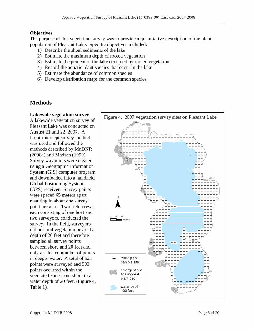
Methods ULakewide vegetation survey A lakewide vegetation survey of Pleasant Lake was conducted on August 21 and 22, 2007. A Point-intercept survey method was used and followed the methods described by MnDNR (2008a) and Madsen (1999). Survey waypoints were created using a Geographic Information System (GIS) computer program and downloaded into a handheld Global Positioning System (GPS) receiver. Survey points were spaced 65 meters apart, resulting in about one survey point per acre. Two field crews, each consisting of one boat and two surveyors, conducted the survey. In the field, surveyors did not find vegetation beyond a depth of 20 feet and therefore sampled all survey points between shore and 20 feet and only a selected number of points in deeper water. A total of 521 points were surveyed and 503 points occurred within the vegetated zone from shore to a water depth of 20 feet. (Figure 4, Table 1).
Figure 4. 2007 vegetation survey sites on Pleasant Lake.
E
E
E
E
E
E
E
E
E
E
E
E
E
E
E
E
E
E
E
E
E
E
E
E
E
E
E
E
E
E
E
E
E
E
E
E
E
E
E
E
E
E
E
E
E
E
E
E
E
E
E
E
E
E
E
E
E
E
E
E
E
E
E
E
E
E
E
E
E
E
E
E
E
E
E
E
E
E
E
E
E
E
E
E
E
E
E
E
E
E
E
E
E
E
E
E
E
E
E
E
E
E
E
E
E
E
E
E
E
E
E
E
E
E
E
E
E
E
E
E
E
E
E
E
E
E
E
E
E
E
E
E
E
E
E
E
E
E
E
E
E
E
E
E
E
E
E
E
E
E
E
E
E
E
E
E
E
E
E
E
E
E
E
E
E
E
E
E
E
E
E
E
E
E
E
E
E
E
E
E
E
E
E
E
E
E
E
E
E
E
E
E
E
E
E
E
E
E
E
E
E
E
E
E
E
E
E
E
E
E
E
E
E
E
E
E
E
E
E
E
E
E
E
E
E
E
E
E
E
E
E
E
E
E
E
E
E
E
E
E
E
E
E
E
E
E
E
E
E
E
E
E
E
E
E
E
E
E
E
E
E
E
E
E
E
E
E
E
E
E
E
E
E
E
E
E
E
E
E
E
E
E
E
E
E
E
E
E
E
E
E
E
E
E
E
E
E
E
E
E
E
E
E
E
E
E
E
E
E
E
E
E
E
E
E
E
E
E
E
E
E
E
E
E
E
E
E
E
E
E
E
E
E
E
E
E
E
E
E
E
E
E
E
E
E
E
E
E
E
E
E
E
E
E
E
E
E
E
E
E
E
E
E
E
E
E
E
E
E
E
E
E
E
E
E
E
E
E
E
E
E
E
E
E
E
E
E
E
E
E
E
E
E
E
E
E
E
E
E
E
E
E
E
E
E
E
E
E
E
E
E
E
E
E
E
E
E
E
E
E
E
E
E
E
E
E
E
E
E
E
E
E
E
E
E
E
E
E
E
E
E
E
E
E
E
E
E
E
E
E
E
E
E
E
E
E
E
E
E
E
E
E
E
E
E
E
E
E
E
E
E
E
E
E
E
E
E
E
E
E
E
E
E
E
E
E
E
E
E
E
E
E
E
E
E
E
E
E
E
E
E
E
E
E
E
E
E
E
E
E
E
E
E
E
E
E
E
E
E
E
E
0 130 260Meters
¯
E 2007 plantsample site
emergent and floating-leafplant bed
water depth >20 feet

Aquatic Vegetation Survey of Pleasant Lake (11-0383-00) Cass Co., 2007-2008 ____________________________________________________________________________________________
Copyright MnDNR 2008 Page 7 of 20
A handheld GPS unit was used to navigate the boat to each sample point. One side of the boat was designated as the sampling area. At each site, water depth was recorded in one-foot increments using a measured stick in water depths less than eight feet and an electronic depth finder in depths greater than eight feet. At each sample site where water depth was seven feet and less, surveyors described the bottom substrate using standard substrate classes (Table 2). If a mixture of substrates occurred at a site, surveyors recorded the most abundant type. The surveyors recorded all plant species found within a one meter squared sample site at the pre-designated side of the boat. A double-headed, weighted garden rake, attached to a rope was used to survey vegetation not visible from the surface (Figure 5). Plant identification and nomenclature followed Crow and Hellquist (2000). Voucher specimens were collected for most plant species and are stored at the MnDNR in Brainerd. If surveyors found additional species outside of sample sites, they recorded them as “present” in the lake but these data were not used in frequency calculations. Data were entered into a Microsoft Access database and frequency of occurrence was calculated for each species as the number of sites in which a species occurred divided by the total number of sample sites. Frequency was calculated for the entire area from shore to 20 feet and sampling points were also grouped by water depth and separated into four depth zones for analysis (Table 1).
Example: In Pleasant Lake there were 503 samples sites in the shore to 20 feet depth zone. Muskgrass (Chara sp.) occurred in 194 of those sites. Frequency of muskgrass in the shore to 20 feet depth zone = 194/503 (*100) = 39 %
Figure 5. Sampling rake.
Table 2. Substrate classes
muck decomposed organic material
marl calcareous material silt fine material with little
grittiness sand Diameter less than 1/8
inch gravel Diameter 1/8 to 3 inches rubble Diameter 3 to 10 inches boulder Diameter over 10 inches
Table 1. Sampling effort by water depth, Pleasant Lake, 2007.
Depth interval in feet
Number of sample points
0 to 5 1626 to 10 172
11 to 15 9016 to 20 79
Total number of points used in calculations
503
21 to 30 18Total number of
sample points 521

Aquatic Vegetation Survey of Pleasant Lake (11-0383-00) Cass Co., 2007-2008 ____________________________________________________________________________________________
Copyright MnDNR 2008 Page 8 of 20
Floating-leaf and emergent vegetation Shallow bays along the west side of Pleasant Lake contain beds of emergent and floating-leaf vegetation. To avoid damage to these plant beds, surveyors did not motor into these sites. Farm Service Administration (FSA) true color aerial photographs (2003-2004) were used to provide an initial delineation of floating-leaf plant beds. Field surveys to map floating-leaf and emergent vegetation were conducted in August 2008. Surveyors mapped bulrush beds in the field by motoring around the lakeside perimeter of major bulrush beds and recording plant bed locations with a handheld GPS receiver. Field data were uploaded to a computer and a GIS software program was used to calculate acreage. Results Shoal substrates Hard substrates of sand, gravel, rubble, rock and occasional boulder were common on the south and east shores of Pleasant Lake. Soft substrates of muck and silt were common in the northwest and western bays (Figure 6).
Figure 6. Shoal sediments of Pleasant Lake, 2007.
"
"
"
"
"
"
"
"
"
"
"
"
"
"
"
"
"
"
"
"
"
"
"
"
"
"
"
"
"
"
"
"
"
"
"
"
"
"
"
"
"
"
"
"
"
"
"
"
"
"
"
"
"
"
"
"
"
"
"
"
"
"
"
"
"
"
"
"
"
"
"
"
"
"
"
"
"
"
"
"
"
"
"
"
"
"
"
"
"
"
"
"
"
"
"
"
"
"
"
"
"
"
"
"
"
"
"
"
"
"
"
"
"
"
"
"
"
"
"
"
"
"
"
"
"
"
"
"
"
"
"
"
"
"
" "
"
"
"
"
"
"
"
"
"
"
"
"
"
"
"
"
"
"
"
"
"
"
"
"
"
"
"
"
"
"
"
"
"
"
"
"
"
"
"
"
"
"
"
"
"
"
"
"
"
"
"
"
"
"
"
"
"
"
"
"
"
"
"
"
"
"
"
"
"
"
"
"
"
"
"
"
"
"
"
"
"
"
"
"
"
"
"
"
"
"
"
"
"
"
"
"
"
"
0 130 260Meters
¯
Water Depth >10 feet
Substrate Types" Boulder, Rock" Gravel, Rubble
" Marl, Silt" Muck
" Sand
" Sand/Silt

Aquatic Vegetation Survey of Pleasant Lake (11-0383-00) Cass Co., 2007-2008 ____________________________________________________________________________________________
Copyright MnDNR 2008 Page 9 of 20
Distribution of aquatic plants Aquatic plants occurred around the entire perimeter of Pleasant Lake and about 53 acres of emergent and floating-leaf beds were mapped with the largest beds occurring on the northwest side of the lake and in the southwestern bays (Figure 7). Vegetation was found to a maximum depth of 20 feet. Eighty-eight percent of the sample sites within the shore to 20 feet depth zone contained plants. Plant occurrence was most frequent in the depth zone from shore to 15 feet where 96 percent of the survey sites contained plants (Figure 8). In water depths of 16 to 20 feet, only 46 percent of the sites were vegetated.
Number and types of plants recorded A total of 37 native aquatic plant species were recorded in Pleasant Lake including seven emergent, four floating-leaved, one free-floating, and 25 submerged plants (Table 3).
Figure 7. Aquatic plant distribution, Pleasant Lake, 2007.
!
!
!
!
!
!
!
!
!
!
!
!
!
!
!
!
!
!
!
!
!
!
!
!
!
!
!
!
!
!
!
!
!
!
!
!
!
!
!
!
!
!
!
!
!
!
!
!
!
!
!
!
!
!
!
!
!
!
!
!
!
!
!
!
!
!
!
!
!
!
!
D
!
!
!
!
!
!
!
!
!
!
!
!
!
!
!
!
!
!
!
!
!
!
!
!
!
!
!
!
!
!
D
!
!
!
!
!
!
!
!
!
!
!
!
!
!
!
!
!
!
!
!
!
!
!
!
!
!
!
!
!
!
!
!
D
!
!
!
!
!
!
!
!
!
!
!
!
!
!
!
!
D
!
!
!
!
!
!
!
!
!
!
!
!
!
!
!
!
!
!
!
!
!
!
!
!
!
!
!
!
D
!
!
!
!
!
D
!
!
!
!
!
!
!
D
!
!
!
D
!
D
D
!
!
D
!
!
!
!
D
D
!
!
!
!
!
!
D
D
!
!
!
!
D
!
!
!
!
!
!
!
!
D
!
!
!
!
!
!
!
!
!
!
!
!
!
!
D
D
!
!
!
!
!
!
!
!
D
D
!
!
!
!
D
D
D
!
D
!
!
!
!
D
!
!
D
D
!
!
!
!
D
D
!
!
!
!
!
D
D
D
!
!
!
D
D
!
!
!
!
!
!
!
!
!
!
D
!
!
!
!
D
D
!
D
!
!
D
!
!
!
!
D
D
!
!
!
!
!
D
D
D
D
!
!
!
!
!
D
!
!
!
!
!
D
D
D
!
D
D
D
D
D
!
!
!
!
!
!
D
!
!
!
D
!
!
D
!
!
D
!
!
!
!
!
D
D
D
D
!
!
!
!
!
!
D
D
!
!
!
!
!
D
D
D
D
D
!
!
!
!
!
!
!
!
!
!
!
!
!
!
!
!
!
!
!
D
!
!
!
!
D
!
!
!
!
!
!
!
!
!
!
D
D
!
!
!
!
!
!
!
!
!
!
!
!
!
!
!
!
!
!
D
D
D
!
!
!
!
!
!
!
!
!
!
!
D
!
D
!
!
!
!
!
!
!
!
!
!
!
!
!
!
!
!
!
!
!
!
!
!
!
!
!
!
!
!
D
!
!
!
!
!
!
!
!
!
!
!
!
!
!
!
!
!
!
!
!
!
!
0 140 280Meters
¯
DVegetation not present atsample site
Vegetation present atsample site
Emergent and Floating-Leaf Plant Beds
Water Depth >20 Feet
!
Figure 8. Plant occurrence at each water depth interval.
0%
20%
40%
60%
80%
100%
0 to 5 6 to 10 11 to 15 16 to 20 21 to 25
water depth (ft)
Perc
ent o
f site
s w
ith v
eget
atio
n

Aquatic Vegetation Survey of Pleasant Lake (11-0383-00) Cass Co., 2007-2008 ____________________________________________________________________________________________
Copyright MnDNR 2008 Page 10 of 20
Table 3. Frequency of aquatic plants in Pleasant Lake Point-intercept survey, August 2007. Frequency is the percent of sample sites in which a plant taxon occurred within the shore to 20 ft water depth.
Life Forms Common Name Scientific Name Frequency
N=503 Muskgrass Chara sp. 39 Large Algae Stonewort Nitella sp. 1 Flat-stem pondweed Potamogeton zosteriformis 42 Robbins pondweed Potamogeton robbinsii 9 Wild celery Vallisneria americana <1 Water stargrass Zosterella dubia <1
Grass-leaf rooted plants
Water bulrush Scirpus subterminalis present Coontail Ceratophyllum demersum 38 Northern water milfoil Myriophyllum sibiricum 36 Water marigold Bidens beckii 2 Greater bladderwort Utricularia vulgaris 1 Humped bladderwort Utricularia gibba <1 Lesser bladderwort Utricularia minor present Flat-leaved bladderwort Utricularia intermedia present
Dissected-leaf rooted plants
White water buttercup Ranunculus aquatilis <1 Canada waterweed Elodea canadensis 15 Bushy pondweed Najas flexilis 13 Narrow-leaf pondweeds Potamogeton sp.* 8 Freis pondweed Potamogeton freisii 4 Small pondweed Potamogeton pusillus <1 Sago pondweed Stuckenia pectinata 2
Small-leaf rooted plants
Marestail Hippuris vulgaris present Illinois pondweed Potamogeton illinoensis 13 White-stem pondweed Potamogeton praelongus 6 Variable pondweed Potamogeton gramineus 5
SUBMERGED These plants grow primarily under the water surface. Upper leaves may float near the surface and flowers may extend above the surface. Plants may or may not be anchored to the lake bottom.
Broad-leaf rooted plants
Clasping-leaf pondweed Potamogeton richardsonii 3 FREE-FLOATING plants Star duckweed Lemna trisulca 1
Yellow waterlily Nuphar variegata 2 White waterlily Nymphaea odorata 2 Floating leaf pondweed Potamogeton natans 2
FLOATING-LEAVED plants are rooted in the lake bottom and have leaves that float on the water surface.
Watershield Brasenia schreberi present Wild Rice Zizania palustris <1 Bulrush Scirpus sp. <1 Spikerush Eleocharis sp. <1 Arrowhead Sagittaria sp. <1 Needlegrass Eleocharis sp. present Water arum Calla palustris present
EMERGENT plants extend well above the water surface and are usually found in shallow water, near shore.
Giant burreed Sparganium eurycarpum present *Some specimens of “narrow-leaved pondweeds” were positively identified as Potamogeton freisii (Freis pondweed) or Potamogeton pusillus (small pondweed). However, it is not known whether other “look-a-like” narrow-leaf pondweed species occurred in the lake. Therefore, a separate group of “unidentified narrow-leaf pondweeds” (Potamogeton sp.) are reported here but not counted in species tally. “Present” indicates the species was found in the lake but did not occur within any of the sample points.

Aquatic Vegetation Survey of Pleasant Lake (11-0383-00) Cass Co., 2007-2008 ____________________________________________________________________________________________
Copyright MnDNR 2008 Page 11 of 20
Figure 9. Number of species found at each depth interval.
0
10
20
30
0 to 5 6 to 10 11 to 15 16 to 20
water depth (feet)nu
mbe
r of s
peci
es
submergedfree-floating
floating-leavedemergent
Figure 10. Number of plant species found per sample site.
!
!
!
!
!
!
!
!
!
!
!
!
!
!
!
!
!
!
!
!
!
!
!
!
!
!
!
!
!
!
!
!
!
!
!
!
!
!
!
!
!
!
!
!
!
!
!
!
!
!
!
!
!
!
!
!
!
!
!
!
!
!
!
!
!
!
!
!
!
!
!
(
!
!
!
!
!
!
!
!
!
!
!
!
!
!
!
!
!
!
!
!
!
!
!
!
!
!
!
!
!
!
(
!
!
!
!
!
!
!
!
!
!
!
!
!
!
!
!
!
!
!
!
!
!
!
!
!
!
!
!
!
!
!
!
(
!
!
!
!
!
!
!
!
!
!
!
!
!
!
!
!
(
!
!
!
!
!
!
!
!
!
!
!
!
!
!
!
!
!
!
!
!
!
!
!
!
!
!
!
!
(
!
!
!
!
!
(
!
!
!
!
!
!
!
(
!
!
!
(
!
(
(
!
!
(
!
!
!
!
(
(
!
!
!
!
!
!
(
(
!
!
!
!
(
!
!
!
!
!
!
!
!
(
!
!
!
!
!
!
!
!
!
!
!
!
!
!
(
(
!
!
!
!
!
!
!
!
(
(
!
!
!
!
(
(
(
!
(
!
!
!
!
(
!
!
(
(
!
!
!
!
(
(
!
!
!
!
!
(
(
(
!
!
!
(
(
!
!
!
!
!
!
!
!
!
!
(
!
!
!
!
(
(
!
(
!
!
(
!
!
!
!
(
(
!
!
!
!
!
(
(
(
(
!
!
!
!
!
(
!
!
!
!
!
(
(
(
!
(
(
(
(
(
!
!
!
!
!
!
(
!
!
!
(
!
!
(
!
!
(
!
!
!
!
!
(
(
(
(
!
!
!
!
!
!
(
(
!
!
!
!
!
(
(
(
(
(
!
!
!
!
!
!
!
!
!
!
!
!
!
!
!
!
!
!
!
(
!
!
!
!
(
!
!
!
!
!
!
!
!
!
!
(
(
!
!
!
!
!
!
!
!
!
!
!
!
!
!
!
!
!
!
(
(
(
!
!
!
!
!
!
!
!
!
!
!
(
!
(
!
!
!
!
!
!
!
!
!
!
!
!
!
!
!
!
!
!
!
!
!
!
!
!
!
!
!
!
(
!
!
!
!
!
!
!
!
!
!
!
!
!
!
!
!
!
!
!
!
!
!
0 130 260Meters
¯
number of plantspecies per site
( 0
1! 2! 3! 4 - 5! 6 - 10
!
Emergent andfloating-leafplant bedsWater Depth >10 feet
The highest number of plant species was found in shallow water, from shore to a depth of five feet (Figure 9). Emergent and floating-leaved plants were restricted to water depths of five feet and less. Submerged rooted plants were found to a maximum depth of 20 feet but only nine species were found in depths greater than ten feet. The number of plant species found at each one meter squared sample site ranged from zero to ten. Sites with the highest number of species occurred in the northwest and western bays where a mixture of emergent, floating-leaved and submerged plants was found (Figure 10). In water depths greater than ten feet, most sample sites had fewer than two species. Wetlands adjacent to lake About 16 acres of emergent wetlands (Figure 11) occurred adjacent to the north and west shores of the lake (Figure 12). These wetlands were not surveyed extensively but included HTUcattailUTH (Typha sp.) and a variety of other emergent species such as sedges (Carex spp.) and arrowhead (Sagittaria spp.). These wetlands act as filters for pollutants, fertilizers, silt and sediments and reduce the amount that enters into the adjacent lake. Wetlands can store water during heavy rainfalls, effectively implementing flood control.

Aquatic Vegetation Survey of Pleasant Lake (11-0383-00) Cass Co., 2007-2008 ____________________________________________________________________________________________
Copyright MnDNR 2008 Page 12 of 20
Figure 12. Major emergent and floating-leaf beds
¯0 150 300
Meters
bulrush
cattail / emergent wetland
wild rice
waterlilies
This water may be released at other times during the year to recharge the groundwater. Wetlands also provide valuable habitat for many wildlife species. Birds use wetlands for feeding, breeding, and nesting areas as well as migratory stopover areas. Fish may utilize wetlands for spawning or for shelter. Numerous plants will grow only in the specific conditions provided by wetlands. Finally, wetlands provide a variety of recreational opportunities, including fishing, hunting, boating, photography, and bird watching. In-lake emergent and floating-leaf plant beds Within the shore to five feet depth zone, 15 percent of the survey sites contained at least one emergent or floating-leaf plant species. Because surveyors avoided motoring into shallow water plant beds, these frequency values underestimate the actual abundance of emergent and floating-leaf plants. The major plant bed types included waterlilies, wild rice and bulrush. Waterlily beds covered about 25 acres (Figure 12) and included HTUwhite waterlilyUTH (Nymphaea odorata) and HTUyellow waterlilyUTH (Nuphar variegata), HTUfloating-leaf pondweedUTH (Potamogeton natans), and HTUwatershieldUTH (Brasenia schreberi). These plants are rooted in the lake bottom with leaves that float on the water surface. These beds often contained scattered bulrush and wild rice as well as
Figure 11. wetland adjacent to Pleasant Lake

Aquatic Vegetation Survey of Pleasant Lake (11-0383-00) Cass Co., 2007-2008 ____________________________________________________________________________________________
Copyright MnDNR 2008 Page 13 of 20
submerged plants (Figure 13). Waterlily beds were often associated with silt or muck substrates. About four acres of HTUWild riceUTH (Zizania palustris) was mapped in silt substrates along the western shore near the inlet (Figure 12). Wild rice is an annual plant that germinates each year from seed that fell to the lake bottom in the previous fall. It prefers soft substrates (Lee 1986, Nichols 1999) and generally requires moving water for growth (MnDNR 2008b). The plant begins growth underwater and then forms a floating-leaf stage before becoming fully emergent. Wild rice is susceptible to disturbance from storms and motorboats because it is weakly rooted to the lake bottom. In addition to its ecological value as habitat and food for wildlife, wild rice has important cultural and economic values in Minnesota (MnDNR 2008b). This valuable plant is increasingly threatened by factors such as lakeshore development and increased water recreational use (MnDNR 2008b). Narrow bands of HTUBulrush UTH (Scirpus sp.) occurred along the east shore and small beds were found within the southwestern bays (Figure 12). Bulrush plants are rooted in the lake bottom and the narrow stems may extend several feet above the water. Bulrush is a perennial plant that can spread by rhizomes in shallow water (Figure 15). Restoration of bulrush beds can be very difficult, making established beds particularly unique and valuable. In Pleasant Lake, bulrush was most often found on sandy or rocky shores. A total of three acres of bulrush or mixed bulrush beds were mapped. These in-lake emergent and floating-leaf plant beds protect shorelines against erosion by buffering the wave action and by holding soil in place. They offer shelter and shade for insects and young fish as well as food, cover and nesting material for waterfowl, marsh birds and muskrats. Submerged plants Submerged plants occurred in 88 percent of the Pleasant Lake sample sites between shore and the 20 feet depth. A mixture of plant types was found including large algae, grass-leaf plants, small-leaf plants, dissected-leaf plants and broad-leaf plants. Four submerged species were widespread in Pleasant Lake and occurred in more than 35 percent of the sample sites: flat-stem pondweed, northern watermilfoil, coontail and muskgrass (Figure 16, Table 3).
Figure 13. Waterlily bed in Pleasant Lake
Figure 14. Wild rice (Zizania palustris)
Figure 15. Bulrush (Scirpus) spread by rhizomes in shallow water of Pleasant Lake

Aquatic Vegetation Survey of Pleasant Lake (11-0383-00) Cass Co., 2007-2008 ____________________________________________________________________________________________
Copyright MnDNR 2008 Page 14 of 20
HTUFlat-stem pondweedUTH (Potamogeton zosteriformis) is named for it’s flattened, grass-like leaves (Figure 17). Depending on water clarity and depth, it may reach the water surface and may produce flowers that extend above the water. It is a perennial plant that is anchored to the lake bottom by underground rhizomes and over-winters by winter buds. Flat-stem pondweed was the most common submerged plant in Pleasant Lake and occurred in 42 percent of the
Figure 16. Submerged species that occur with a widespread distribution in Pleasant Lake.
"
"""
"""
""
"
"""""
""
"
""""""""""
"
""
""""
"""
""""""
""""
""
"
""
"
"
""
"
""""""""
"""""
"
"
"
"
""
"""""
""
"
"""
"""
"
""
"
"
"
"
"""
""
"
"
"
""
""
"
"
"
"
"
"""
"
""
"
"
"
"
"
"
"
"
"
""
"""""
"
""
"
"
"
"
"
"
""
"
"
"
"
"""
""
"
"
"
"""""""""
"
"
"
"
"
"
"
""
"""""""
"
""
""
!
!
!
!
!
!
!
!
!
!
!
!
!
!
!
!
!
!
!
!
!
!
!
!
!
!
!
!
!
!
!
!
!
!
!
!
!
!
!
!
!
!
!
!
!
!
!
!
!
!
!
!
!
!
!
!
!
!
!
!
!
!
!
!
!
!
!
!
!
!
!
!
!
!
!
!
!
!
!
!
!
!
!
!
!
!
!
!
!
!
!
!
!
!
!
!
!
!
!
!
!
!
!
!
!
!
!
!
!
!
!
!
!
!
!
!
!
!
!
!
!
!
!
!
!
!
!
!
!
!
!
!
!
!
!
!
!
!
!
! !
!
!
!
!
!
!
!
!
!
!
!
!
!
!
!
!
!
!
!
!
!
!
!
!
!
!
!
!
!
!
!
!
!
!
!
!
!
!
!
!
!
!
!
!
!
!
!
!
!
!
!
!
!
!
!
!
!
!
!
!
!
!
!
!
!
!
!
!
#
#
#
#
#
#
#
#
#
#
#
#
#
#
#
#
#
#
#
#
#
#
#
#
#
#
#
#
#
#
#
#
#
#
#
#
#
#
#
#
#
#
#
#
#
#
#
#
#
#
#
#
#
#
#
#
#
#
#
#
#
#
#
#
#
#
#
#
#
#
#
#
#
#
#
#
#
#
#
#
#
#
#
#
#
#
#
#
#
#
#
#
#
#
#
#
#
#
#
#
#
#
#
#
#
#
#
#
#
#
#
#
#
#
#
#
#
#
#
#
#
#
#
#
#
#
#
#
#
#
#
#
#
#
#
#
#
#
#
#
#
#
#
#
#
#
#
#
#
#
#
#
#
#
#
#
#
#
#
#
#
#
#
#
#
#
#
#
#
#
#
#
#
#
#
#
#
#
#
0 250 500Meters
¯
!
!
!
!
!
!
!
!
!
!
!
!
!
!
!
!
!
!
!
!
!
!
!
!
!
!
!
!
!
!
!
!
!
!
!
!
!
!
!
!
!
!
!
!
!
!
!
!
!
!
!
!
!
!
!
!
!
!
!
!
!
!
!
!
!
!
!
!
!
!
!
!
!
!
!
!
!
!
!
!
!
!
!
!
!
!
!
!
!
!
!
!
!
!
!
!
!
!
!
!
!
!
!
!
!
!
!
!
!
!
!
!
!
!
!
!
!
!
!
!
!
!
!
!
!
!
!
!
!
!
!
!
!
!
!
!
!
!
!
!
!
!
!
!
!
!
!
!
!
!
!
!
!
!
!
!
!
!
!
!
!
!
!
!
!
!
!
!
!
!
!
!
!
!
!
!
!
!
!
!
!
!
!
!
!
!
!
!
!
!
!
!
!
!
northern watermilfoil
flat-stem pondweed
coontail #! " ! muskgrass water depth> 10 feet
Figure 17. Flat-stem pondweed (Potamogeton zosteriformis)

Aquatic Vegetation Survey of Pleasant Lake (11-0383-00) Cass Co., 2007-2008 ____________________________________________________________________________________________
Copyright MnDNR 2008 Page 15 of 20
sample sites (Table 3). It was found throughout Pleasant Lake and often co-occurred with coontail and northern watermilfoil (Figure 16). Flat-stem pondweed was found to a maximum depth of 17 feet and was the most common species in the six to ten feet depth zone (Figure 18).
HTUCoontailUTH (Ceratophyllum demersum) (Figure 19) is a perennial plant that grows entirely submerged. It is loosely rooted to the lake bottom and spreads primarily by stem fragmentation. It can over-winter as a green plant under the ice and then begins new growth early in the spring. The finely divided leaves of this plant provide a home for insects valuable as fish food. Coontail is adapted to a broad range of lake conditions, including turbid water. In Pleasant Lake, it occurred in 38 percent of the sites (Table 3) and was the most common species in depths greater than ten feet (Figure 16, 18). HTUNorthern watermilfoilUTH (Myriophyllum sibiricum) (Figure 20) is another rooted, perennial submerged plant with finely dissected leaves. It may reach the water surface, particularly in depths less than ten feet, and its flower stalk extends above the water surface. It spreads primarily by stem fragments and over-winters by hardy
Figure 18. Frequency of common plant species by water depth interval. Pleasant Lake, Cass County, MN July 2008.
0%
20%
40%
60%
80%
100%
0 to 5 6 to 10 11 to 15 16 to 20
Water Depth (ft)
Freq
uenc
y of
Occ
uren
ce
Illinois pondweed Bushy pondweedCanada Waterweed MuskgrassNorthern Watermilfoil Flatstem PondweedCoontail
Figure 19. Coontail (Ceratophyllum demersum)
Figure 20. Northern watermilfoil (Myriophyllum sibiricum)

Aquatic Vegetation Survey of Pleasant Lake (11-0383-00) Cass Co., 2007-2008 ____________________________________________________________________________________________
Copyright MnDNR 2008 Page 16 of 20
rootstalks and winter buds. This native plant provides fish shelter and insect habitat. Unlike coontail, northern watermilfoil is not tolerant of turbidity and grows best in clear water lakes. Although it occurred in 36 percent of the Pleasant Lake sample sites (Table 3), it was most often found in water depths less than 15 feet (Figures 16, 18). HTUMuskgrassUTH (Chara sp.) (Figure 21) is a macroscopic, or large, algae that is common in many hard water Minnesota lakes. It has a brittle texture and a characteristic “musky” odor. Because this species does not form true stems, it is a low-growing plant, often found entirely beneath the water surface where it may form low “carpets” on the lake bottom. Beds of muskgrass can provide important habitat for fish spawning and nesting. In Pleasant Lake, Muskgrass occurred in 39 percent of all sample sites (Table 3) and was commonly found in depths of 15 feet and less (Figure 16, 18). Muskgrass is adapted to variety of substrates and is often the first species to colonize open areas of lake bottom where it can act as a sediment stabilizer. It was one of only a few species found along the sandy eastern shores of Pleasant Lake (Figure 16). The other submerged species in Pleasant Lake occurred in 15 percent or less of the sample sites and were most common in the shore to ten feet zone. HTUCanada waterweedUTH (Elodea canadensis) (Figure 22) is a rooted, perennial submerged species that is widespread throughout Minnesota and is adapted to a variety of conditions. It is tolerant of low light and prefers soft substrates. This species can over winter as an evergreen plant and spreads primarily by fragments. The branching stems of this plant can form thick underwater plant beds that are valuable habitat for a variety of fish and invertebrates. In Pleasant Lake, Canada waterweed occurred in 15 percent of all sample sites (Table 3) and was most common from shore to five feet depth zone where it occurred in 31 percent of the sites (Figure 18). It was commonly found in the soft substrates of the northeast bay (Figure 23).
Figure 22. Canada waterweed (Elodea canadensis) photo: Vic Ramey, © 2003, Univ. Florida
Figure 21. Muskgrass (Chara sp.)

Aquatic Vegetation Survey of Pleasant Lake (11-0383-00) Cass Co., 2007-2008 ____________________________________________________________________________________________
Copyright MnDNR 2008 Page 17 of 20
Figure 23. Distribution of submerged species common in shallow water, Pleasant Lake 2007.
"""
"
""
"
"
"
"
"
"
"
" "
"
"
" "
"
"
"
"
"
"
" "
""
"
"
"
""
""
""
""
"
"
"
"""
"
""
"
""
"""
"""
"""""
""""
!
!
!
!
!
!
!
!
!
!
!
!
!
!
! !
!
!
!
!
!
! !
!
!
!
!
!
!
!
!
!
!
!
!
!
!
!
!
!
!
!
!
!
!
!
!
!
!
!
!
!
!
!
!
!
!
!
!
!
!
!
!
#
##
###
#####
#######
###
##
#
#
#
##
#
#
#
##
#
##
#
#
##
#
#
#
##
#
##
#
#
##
#
#
#
#
#
#
#
#
#
#
#
# #
#
#
#
##
##
#
##
#
0 250 500Meters
¯
Bushy pondweed
Illinoispondweed
Canada waterweed
! # "
Water depth>10 feet
HTUBushy pondweedUTH (Najas flexilis) (Figure 24) is unique because it is one of the few annual submerged species in Minnesota and must re-establish every year from seed. The seeds and foliage of this plant are an important duck food and beds of this plant provide good fish cover. In Pleasant Lake, bushy pondweed occurred in 13 percent of the sample sites (Table 3). It was most often found along the eastern shore (Figure 23) in mixed beds of muskgrass and Illinois pondweed.
HTUIllinois pondweedUTH (Potamogeton illinoensis), (Figure 25) is a rooted, perennial plant with broad leaves. It is one of several pondweeds that are often called “cabbage” plants by anglers. These plants are primarily submerged but many will form floating leaves in shallower water. The fruits of pondweeds are a favorite duck food and the broad leaves provide food and shelter for fish. In Pleasant Lake, Illinois pondweed was found in 13 percent of the sample sites (Table 3) and was distributed around the lake except for the northeast bay (Figure 23).
Figure 25. Illinois pondweed (Potamogeton illinoensis). Photo: © 1996 Allison Fox, Univ. Florida
Figure 24. Bushy Pondweed (Najas flexilis)

Aquatic Vegetation Survey of Pleasant Lake (11-0383-00) Cass Co., 2007-2008 ____________________________________________________________________________________________
Copyright MnDNR 2008 Page 18 of 20
Discussion The types and amounts of aquatic vegetation that occur within a lake are influenced by a variety of factors including water clarity, water chemistry, depth, substrate type and wave activity. The water clarity of Pleasant Lake is sufficiently high to allow some species to grow to depths of 20 feet with more diverse plant growth in shallower water. The plant community of Pleasant Lake is similar to that found in other hardwater Cass County lakes. The abundance and diversity of native aquatic plants provide critical fish and wildlife habitat and other lake benefits. (Click here for more information on: HTUvalue of aquatic plants UTH). The high number of plant species found in Pleasant Lake is a reflection of the good water clarity. Many of the plants found require clear water and are not found in lakes with higher turbidity. Another reason for the high diversity of plant types is that Pleasant Lake has a variety of sediment types and a mix of protected bays and open water sites. Plant species with different habitat requirements can exist within this system. A review of past vegetation surveys indicates that, over the past 50 years, the general aquatic plant community has not likely changed greatly in Pleasant Lake. In all survey years, a relatively high number of native plants have been recorded and plants remain well distributed around the lakeshore. Data collected in 2007 can be used to monitor finer-scale changes that may occur, such as an increase in a particular plant species or a change in the depths at which individual species occur. Monitoring change in the aquatic plant community can be helpful in determining whether changes in the lake water quality are occurring and for estimating the quality of vegetation habitat available for fish and wildlife communities. In general, factors that may lead to change in the aquatic plant communities include: • Change in water clarity
If water clarity in Pleasant Lake decreases, submerged vegetation may be restricted to shallower water.
• Change in water level Many aquatic plants are adaptable to water level fluctuations and in low water years, aquatic plants may expand in distribution. The extent and duration of these distribution changes can be difficult to predict.
• Snow and ice cover Many submerged plants have the ability to grow under the ice, especially if there is little snow cover and sunlight reaches the lake bottom. In years following low snow cover, and/or a reduced ice-over period, some submerged plants may increase in abundance.
• Water temperatures / length of growing season In years with cool spring temperatures, submerged plants may be less abundant than in years with early springs and prolonged warm summer days.
• Invasive species Non-native submerged species have not been documented in Pleasant Lake but if they invade the lake, they may directly or indirectly impact the native plant community. Non-native plant species, such as HTUEurasian watermilfoilUTH (Myriophyllum spicatum) or HTUcurly-leaf pondweedUTH (Potamogeton crispus) may form dense surface mats that may shade out native

Aquatic Vegetation Survey of Pleasant Lake (11-0383-00) Cass Co., 2007-2008 ____________________________________________________________________________________________
Copyright MnDNR 2008 Page 19 of 20
plants. The impact of these invasive species varies among lakes but the presence of a healthy native plant community may help mitigate the harmful effects of these exotics.
• Natural fluctuation in plant species abundance Many submerged plants are perennial and regrow in similar locations each year. However, a few species such as bushy pondweed (Najas flexilis) and wild rice (Zizania palustris) are annuals and are dependant on the previous years seed set for regeneration.
• Aquatic plant management activities Humans can impact aquatic plant communities directly by destroying vegetation with herbicide or by mechanical means. For information on the laws pertaining to aquatic plant management, click here: HTUMnDNR APM ProgramUTH or contact your local DNR office. Motorboat activity in vegetated areas can be particularly harmful for species such as bulrush and wild rice. Shoreline and watershed development can also indirectly influence aquatic plant growth if it results in changes to the overall water quality and clarity. Herbicide and mechanical control of aquatic plants can directly impact the aquatic plant community. Limiting these types of activities can help protect native aquatic plant species.

Aquatic Vegetation Survey of Pleasant Lake (11-0383-00) Cass Co., 2007-2008 ____________________________________________________________________________________________
Copyright MnDNR 2008 Page 20 of 20
Literature Cited Crow, G.E. and C.B. Hellquist. 2000. Aquatic and wetland plants of Northeastern North
America. 2 volumes. The University of Wisconsin Press. Lee, P. F. 1986. Ecological relationships of wild rice, Zizania aquatica. 4. Environmental
regions within a wild rice lake. Canadian Journal Botany 64:2037-2044. Madsen, J. D. 1999. Point intercept and line intercept methods for aquatic plant
management. APCRP Technical Notes Collection (TN APCRP-M1-02). U.S. Army Engineer Research and Development Center, Vicksburg, MS. HTUwww.wes.army.mil/el/aquaUTH
MnDNR. 2008a. Minnesota’s Sensitive Lakeshore Identification Manual: a conservation
strategy for Minnesota lakeshores (version 1). Division of Ecological Resources, Minnesota Department of Natural Resources.
MnDNR. 2008b. Natural wild rice in Minnesota. A wild rice study document submitted to the
Minnesota Legislature by the Minnesota Department of Natural Resources, February 15, 2008. 117 pp. HTUhttp://files.dnr.state.mn.us/fish_wildlife/legislativereports/20080215_wildricestudy.pdfUTH
MnDNR Fisheries Lake Files. Minnesota Department of Natural Resources. Division of Fish
and Wildlife, Section of Fisheries, Lake Survey Program. 500 Lafayette Rd., St. Paul, MN 55155.
MPCA. 2008. Minnesota Pollution Control Agency. St. Paul, MN. Lake Water Quality
Assessment Program. Lake Water Quality Data Search website: HTUhttp://www.pca.state.mn.us/water/lkwqSearch.cfmUTH (accessed November 2008)
Nichols, S.A. 1999. Distribution and habitat descriptions of Wisconsin lake plants.
Wisconsin Geological and Natural History Survey. Bulletin 96. Madison. 266 pp.