appendix 39.1 surface water hydrology report - surface... · alterations to surface water hydrology...
TRANSCRIPT

Appendix 39.1 Surface Water Hydrology Report
0010332 December 2006
Jacobs UK Limited 95 Bothwell Street, Glasgow G2 7HX Tel 0141 204 2511 Fax 0141 226 3109
Copyright Jacobs UK Limited. All rights reserved.
No part of this report may be copied or reproduced by any means without prior written permission from Jacobs UK Limited. If you have received this report in error, please destroy all copies in your possession or control and notify Jacobs UK Limited.
This report has been prepared for the exclusive use of the commissioning party and unless otherwise agreed in writing by Jacobs UK Limited, no other party may use, make use of or rely on the contents of this report. No liability is accepted by Jacobs UK Limited for any use of this report, other than for the purposes for which it was originally prepared and provided.
Opinions and information provided in the report are on the basis of Jacobs UK Limited using due skill, care and diligence in the preparation of the same and no explicit warranty is provided as to their accuracy. It should be noted and it is expressly stated that no independent verification of any of the documents or information supplied to Jacobs UK Limited has been made.
Aberdeen Western Peripheral Route Environmental Statement Appendices Part D: Fastlink Appendix A39.1 - Surface Water Hydrology
Contents
1 Introduction.............................................................................................................1
1.1 General Background .........................................................................................1 1.2 Assessment Aims..............................................................................................1
2 Approach and Methods..........................................................................................2
2.1 General Approach .............................................................................................2 2.2 Surface Water Assessment Methodology .........................................................4 2.3 Limitations to Assessment.................................................................................9
3 Baseline ...................................................................................................................9
3.1 Baseline Assessment ........................................................................................9 3.2 Baseline Road Runoff .....................................................................................14 3.3 Baseline Summary ..........................................................................................14
4 Potential Impacts ..................................................................................................15
4.1 Generic Impacts ..............................................................................................15 4.2 Specific Impacts ..............................................................................................17 4.3 Site specific impacts ........................................................................................18 4.4 Scheme Summary...........................................................................................24
5 Mitigation...............................................................................................................25
5.1 Generic Mitigation............................................................................................25 5.2 Site Specific Mitigation ....................................................................................27
6 Residual Impacts ..................................................................................................30
6.1 Site Specific Residual Impact Assessment .....................................................30 6.2 Catchment Impacts..........................................................................................30 6.3 Scheme Summary...........................................................................................30
7 Appendix Summary..............................................................................................40
8 References ............................................................................................................41
9 Glossary ................................................................................................................42
A39.1
Aberdeen Western Peripheral Route Environmental Statement Appendices Part D: Fastlink Appendix A39.1 - Surface Water Hydrology
1 Introduction
1.1 General Background
1.1.1 This hydrological assessment report is a technical appendix of Chapter 39 (Water Environment) of the Environmental Statement for the proposed Aberdeen Western Peripheral Route (AWPR). It focuses specifically on the hydrological impacts of the proposed scheme on watercourses crossed by the road, within the Fastlink study area.
1.1.2 Hydrology is concerned with the natural water cycle and is the earth science of water on or near the land surface. For the purposes of this report, the hydrological assessment addresses impacts on the flow and quantity of water on or near the land surface and associated flood risk. Impacts upon hydrology are intrinsically linked to hydrogeology, water quality, geomorphology and ecology.
1.1.3 Potentially, road schemes can impact on surface water hydrology through the addition of structures and by disturbing the natural characteristics of a watercourse and its catchment. Watercourses may be affected, for example, by direct runoff from the road itself. As a result the natural magnitude, direction and timing of surface water events can become significantly altered (see section 4). Alterations to surface water hydrology could potentially have associated implications for the local ecology, society and economy, as has been recognised by the EU Water Framework Directive and the Risk Framework of Scottish Planning Policy Guidance 7 (SPP7).
1.1.4 Within the study area, 19 watercourses and Fishermyre wetland have been identified as having the potential to be affected as a result of the operation and construction of the Fastlink of the proposed scheme. These watercourses range in size, from small ephemeral field drains to larger fast flowing streams such as the Burn of Muchalls.
1.2 Assessment Aims
1.2.1 This report is a technical appendix providing detailed information to support the assessment of impacts on the water environment and associated ecology. It includes assessment of the potential impacts of the proposed scheme during both the operation and construction phases, and outlines possible mitigation measures that will reduce the impact of the proposed scheme on the hydrology of the watercourses. Changes in hydrology may have implications for fluvial geomorphology, water quality and freshwater ecology, and these are considered in appendices A24.3, A24.4 and A 25.9 respectively.
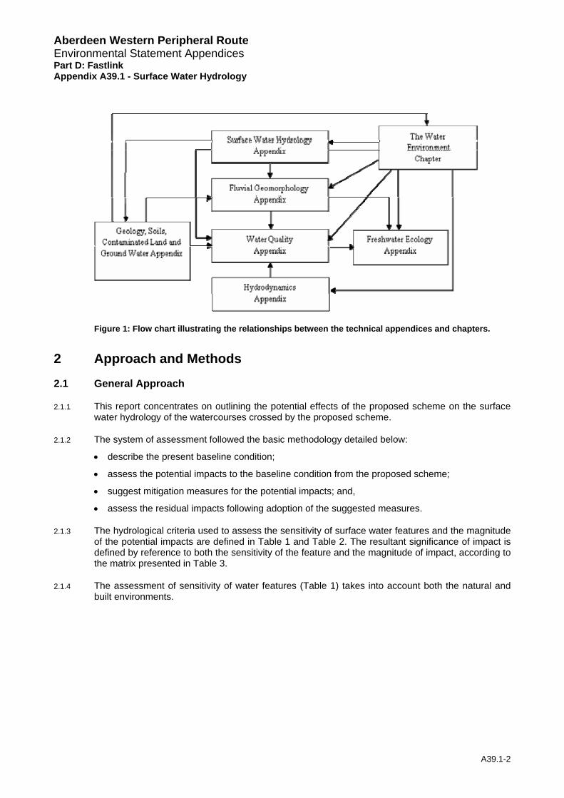
1.2.2 The inter-relationship of the environmental assessment chapters and appendices is illustrated in Figure 1.
A39.1-1
Aberdeen Western Peripheral Route Environmental Statement Appendices Part D: Fastlink Appendix A39.1 - Surface Water Hydrology
Figure 1: Flow chart illustrating the relationships between the technical appendices and chapters.
2 Approach and Methods
2.1 General Approach
2.1.1 This report concentrates on outlining the potential effects of the proposed scheme on the surface water hydrology of the watercourses crossed by the proposed scheme.
2.1.2 The system of assessment followed the basic methodology detailed below:
• describe the present baseline condition;
• assess the potential impacts to the baseline condition from the proposed scheme;
• suggest mitigation measures for the potential impacts; and,
• assess the residual impacts following adoption of the suggested measures.
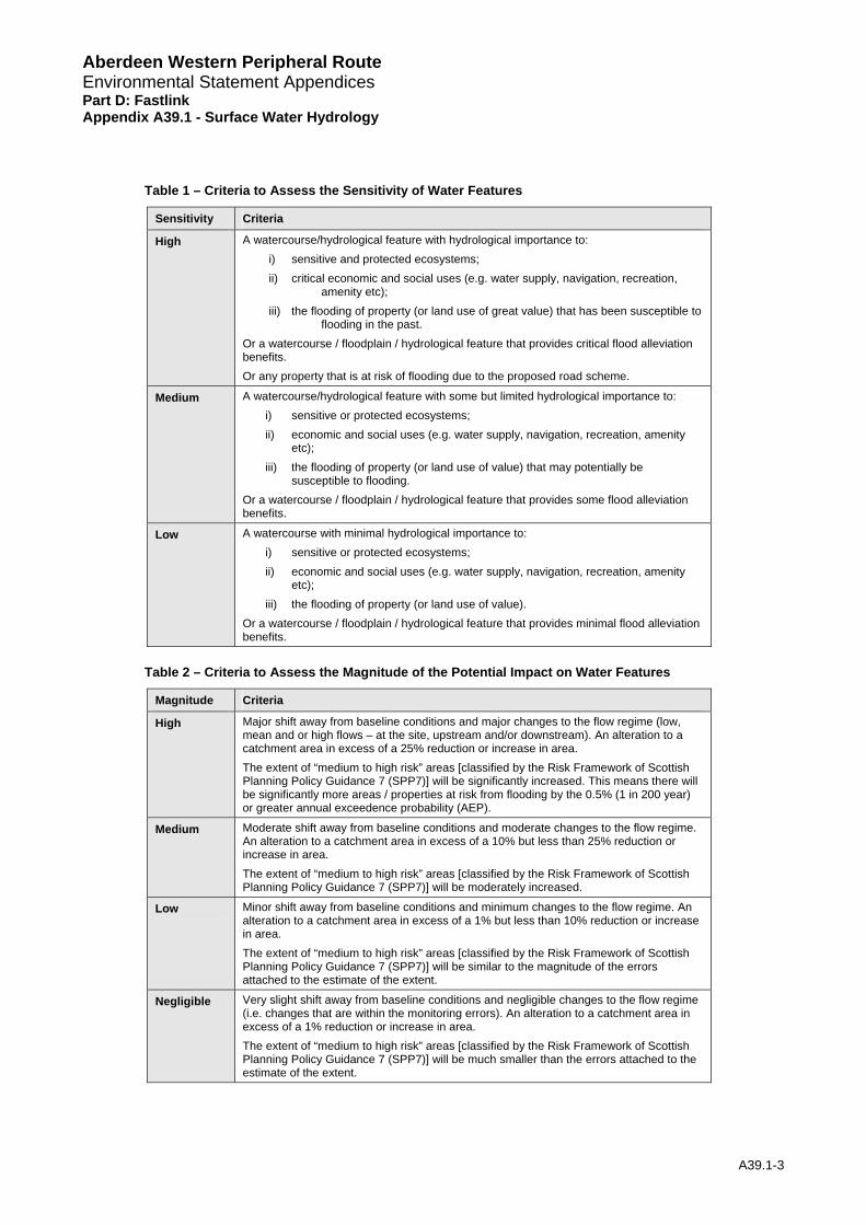
2.1.3 The hydrological criteria used to assess the sensitivity of surface water features and the magnitude of the potential impacts are defined in Table 1 and Table 2. The resultant significance of impact is defined by reference to both the sensitivity of the feature and the magnitude of impact, according to the matrix presented in Table 3.
2.1.4 The assessment of sensitivity of water features (Table 1) takes into account both the natural and built environments.
A39.1-2
Aberdeen Western Peripheral Route Environmental Statement Appendices Part D: Fastlink Appendix A39.1 - Surface Water Hydrology
Table 1 – Criteria to Assess the Sensitivity of Water Features
Sensitivity Criteria
High A watercourse/hydrological feature with hydrological importance to: i) sensitive and protected ecosystems; ii) critical economic and social uses (e.g. water supply, navigation, recreation,
amenity etc); iii) the flooding of property (or land use of great value) that has been susceptible to
flooding in the past. Or a watercourse / floodplain / hydrological feature that provides critical flood alleviation benefits. Or any property that is at risk of flooding due to the proposed road scheme.
Medium A watercourse/hydrological feature with some but limited hydrological importance to: i) sensitive or protected ecosystems; ii) economic and social uses (e.g. water supply, navigation, recreation, amenity
etc); iii) the flooding of property (or land use of value) that may potentially be
susceptible to flooding. Or a watercourse / floodplain / hydrological feature that provides some flood alleviation benefits.
Low A watercourse with minimal hydrological importance to: i) sensitive or protected ecosystems; ii) economic and social uses (e.g. water supply, navigation, recreation, amenity
etc); iii) the flooding of property (or land use of value).
Or a watercourse / floodplain / hydrological feature that provides minimal flood alleviation benefits.
Table 2 – Criteria to Assess the Magnitude of the Potential Impact on Water Features
Magnitude Criteria
High Major shift away from baseline conditions and major changes to the flow regime (low, mean and or high flows – at the site, upstream and/or downstream). An alteration to a catchment area in excess of a 25% reduction or increase in area. The extent of “medium to high risk” areas [classified by the Risk Framework of Scottish Planning Policy Guidance 7 (SPP7)] will be significantly increased. This means there will be significantly more areas / properties at risk from flooding by the 0.5% (1 in 200 year) or greater annual exceedence probability (AEP).
Medium Moderate shift away from baseline conditions and moderate changes to the flow regime. An alteration to a catchment area in excess of a 10% but less than 25% reduction or increase in area. The extent of “medium to high risk” areas [classified by the Risk Framework of Scottish Planning Policy Guidance 7 (SPP7)] will be moderately increased.
Low Minor shift away from baseline conditions and minimum changes to the flow regime. An alteration to a catchment area in excess of a 1% but less than 10% reduction or increase in area. The extent of “medium to high risk” areas [classified by the Risk Framework of Scottish Planning Policy Guidance 7 (SPP7)] will be similar to the magnitude of the errors attached to the estimate of the extent.
Negligible Very slight shift away from baseline conditions and negligible changes to the flow regime (i.e. changes that are within the monitoring errors). An alteration to a catchment area in excess of a 1% reduction or increase in area. The extent of “medium to high risk” areas [classified by the Risk Framework of Scottish Planning Policy Guidance 7 (SPP7)] will be much smaller than the errors attached to the estimate of the extent.
A39.1-3

Aberdeen Western Peripheral Route Environmental Statement Appendices Part D: Fastlink Appendix A39.1 - Surface Water Hydrology
Table 3 – Impact Significance Matrix
Magnitude Sensitivity
High Medium Low Negligible
High Substantial Moderate/Substantial Moderate Slight / Negligible
Medium Moderate/Substantial Moderate Slight Negligible
Low Moderate Slight Negligible Negligible
2.1.5 The assessment took into account guidance of the Scottish Executive ‘Scottish Planning Policy (SPP) 7: Planning and Flooding’ (2004) and guidance of the Design Manual for Roads and Bridges (DMRB) Volume 4, Section 2 “Drainage”.
2.1.6 DMRB (Volume 11 Section 3 Part 10 HA 216/06 2.37 – 2.41) guidance advises that if a proposed scheme might have a significant effect on floodplain capacity, an assessment should be made of:
• the reduction of capacity,
• the effectiveness of the proposed mitigation works and
• the residual impact of the scheme on increased flood risk.
2.1.7 In addition, other appropriate studies should be undertaken where other potentially significant hydrological effects are identified that could impinge on any of the current or proposed uses of the receiving waters.
2.1.8 In addition the requirements of the EU Water Framework Directive were also taken into account when developing the methodology using SEPA policy guidance ‘The Future for Scotland’s Waters, Guiding Principles on the Technical Requirements of the Water Framework Directive’ (SEPA, 2002).
2.2 Surface Water Assessment Methodology
Baseline
2.2.1 For each identified watercourse the following estimates have been calculated for the present conditions;
• 95-percentile flow (Q95);
• mean flow (Qmean);
• bankfull (QBF) and embankment-full (QEBF) flow;
• median annual maximum flood (QMED);
• mean annual maximum flood (QBAR); and
• flood design peak flows including the 1% and 0.5% annual exceedance probability (AEP) flows (also known as the 100-year and 200-year flood design peak flows).
2.2.2 Necessary hydrological catchment characteristics were obtained from Ordnance Survey, soils, geological and land use maps as well as the Flood Estimation Handbook (FEH) CD-ROM
2.2.3 Table 4 identifies the flow parameters and methodologies that were used to calculate these estimates. It is noted that all watercourses in the Fastlink study area which will be crossed by the proposed scheme are small, ungauged catchments. Flow estimation on ungauged watercourses is generally subject to significant uncertainties. In order to increase the confidence in the standard desk based flow estimates, site measurements are recommended. Site measurements aimed at refining several of the hydrological parameters were undertaken for representative catchments in
A39.1-4
Aberdeen Western Peripheral Route Environmental Statement Appendices Part D: Fastlink Appendix A39.1 - Surface Water Hydrology
May 2005. In addition each watercourse was carefully inspected during site visits in 2006. Consequently the hydrological analyses used desk-based procedures; gauged data from donor/analogue catchments; and where appropriate, spot gauging data. The derivational basis of all hydrological parameters and the methodologies used in this report are outlined in Table 4.
Potential Impacts
2.2.4 The significance of a particular impact depends on the baseline conditions of each individual watercourse and the type and position of any road structure (see section 3).
2.2.5 Hydrological pressures and impacts arising from the proposed scheme are highlighted with respect to environmental, economic and social impacts. Potential post-development changes to catchment parameters (Table 4) are highlighted, in addition to potential changes to flood risk and floodplain inundation. These may be assessed through recalculating parameters (Table 4) for a catchment with the road in place. The most significant parameter that is likely to change is catchment area due to the proposed scheme severing existing catchments.
2.2.6 Flood risk can be determined from a desk based assessment of each culverted watercourse. The risk assessment is based on the distance, position and height difference, from Ordnance Survey plans and detailed design plans between the culvert and properties upstream from the culvert entrance. A further identification of land use upstream of the culvert is also required as wooded areas may produce more potential debris by which culverts could become blocked. This broad-brush assessment can be used to identify properties that could potentially be at risk during extreme events.
2.2.7 The impact of watercourse realignment is considered, assuming that a realigned reach is constructed to a specification that would maintain existing channel dimensions, slope and surface runoff pathways. All of these parameters are hydrologically significant.
Allowance for Climate Change in Hydrological Parameters
2.2.8 Guidance on allowance for climate change has been taken from a scoping study regarding climate change and hydrological parameters (SEPA, 2005). SEPA do not define a specific value as an allowance for climate change, but suggests that the sensitivity of flows within flood risk analysis could be carried out up to a 20% increase in flows for the east of Scotland. This is considered the maximum change and evidence suggests that by 2050 there is more likely to be an increase of approximately 15% in the east of Scotland (Environmental Group Research Report, 2003).
2.2.9 The Scottish Executive (2004) states in the SPP7 Planning and Flooding Report that the threshold annual probability floods 0.5% (200 year) and 0.1% (1000 year) include an allowance for climate change. The Scottish Executive also indicates that developments should now be designed to the 0.5% annual probability design flood event instead of the 1% annual probability event in an allowance for possible future climate change increases.
2.2.10 Instead of designing to the 1% AEP (100 year design event), which historically has been standard practice, the 0.5% AEP (200 year) design flood event has been adopted which includes an allowance for climate change, as stated in SPP7. No guidance on the other hydrological parameters has been published by SEPA. Research work to date on these parameters indicates no clear regional patterns. No climate change factor is therefore suggested for these parameters, rather the guidance set out in SPP7, which is specific for Scotland, is followed.
Mitigation
2.2.11 Mitigation measures for surface water hydrology are based on current good practice for highway drainage design, including the DMRB and guidance provided in ‘Sustainable Urban Drainage Systems: design manual for Scotland and Northern Ireland CIRIA C521’ (Construction Industry Research and Information Association (CIRIA), 2000).
A39.1-5
Aberdeen Western Peripheral Route Environmental Statement Appendices Part D: Fastlink Appendix A39.1 - Surface Water Hydrology 2.2.12 Additionally, to allow for the continued habitat and safe passage of fish, the proposed road crossing
should be designed in an appropriate manner in order to mitigate against the decline of fish numbers. Guidance is taken from the Scottish Executive report entitled ‘River Crossings and Migratory Fish: Design Guidance’ (SE, 2006) and the SEPA report ‘Managing River Habitats for Fisheries’ (SEPA, 2003).
Residual Impacts
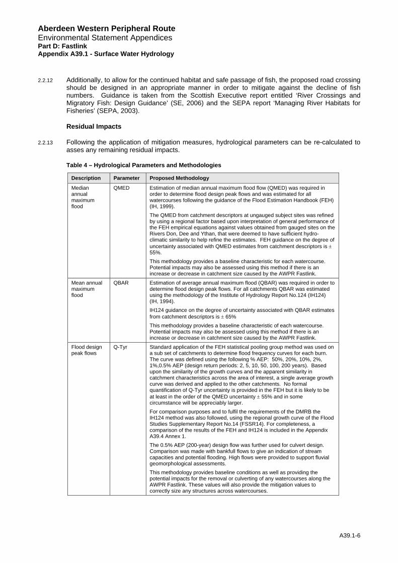
2.2.13 Following the application of mitigation measures, hydrological parameters can be re-calculated to asses any remaining residual impacts.
Table 4 – Hydrological Parameters and Methodologies
Description Parameter Proposed Methodology
Median annual maximum flood
QMED Estimation of median annual maximum flood flow (QMED) was required in order to determine flood design peak flows and was estimated for all watercourses following the guidance of the Flood Estimation Handbook (FEH) (IH, 1999). The QMED from catchment descriptors at ungauged subject sites was refined by using a regional factor based upon interpretation of general performance of the FEH empirical equations against values obtained from gauged sites on the Rivers Don, Dee and Ythan, that were deemed to have sufficient hydro-climatic similarity to help refine the estimates. FEH guidance on the degree of uncertainty associated with QMED estimates from catchment descriptors is ± 55%. This methodology provides a baseline characteristic for each watercourse. Potential impacts may also be assessed using this method if there is an increase or decrease in catchment size caused by the AWPR Fastlink.
Mean annual maximum flood
QBAR Estimation of average annual maximum flood (QBAR) was required in order to determine flood design peak flows. For all catchments QBAR was estimated using the methodology of the Institute of Hydrology Report No.124 (IH124) (IH, 1994). IH124 guidance on the degree of uncertainty associated with QBAR estimates from catchment descriptors is ± 65% This methodology provides a baseline characteristic of each watercourse. Potential impacts may also be assessed using this method if there is an increase or decrease in catchment size caused by the AWPR Fastlink.
Flood design peak flows
Q-Tyr Standard application of the FEH statistical pooling group method was used on a sub set of catchments to determine flood frequency curves for each burn. The curve was defined using the following % AEP: 50%, 20%, 10%, 2%, 1%,0.5% AEP (design return periods: 2, 5, 10, 50, 100, 200 years). Based upon the similarity of the growth curves and the apparent similarity in catchment characteristics across the area of interest, a single average growth curve was derived and applied to the other catchments. No formal quantification of Q-Tyr uncertainty is provided in the FEH but it is likely to be at least in the order of the QMED uncertainty ± 55% and in some circumstance will be appreciably larger. For comparison purposes and to fulfil the requirements of the DMRB the IH124 method was also followed, using the regional growth curve of the Flood Studies Supplementary Report No.14 (FSSR14). For completeness, a comparison of the results of the FEH and IH124 is included in the Appendix A39.4 Annex 1. The 0.5% AEP (200-year) design flow was further used for culvert design. Comparison was made with bankfull flows to give an indication of stream capacities and potential flooding. High flows were provided to support fluvial geomorphological assessments. This methodology provides baseline conditions as well as providing the potential impacts for the removal or culverting of any watercourses along the AWPR Fastlink. These values will also provide the mitigation values to correctly size any structures across watercourses.
A39.1-6
Aberdeen Western Peripheral Route Environmental Statement Appendices Part D: Fastlink Appendix A39.1 - Surface Water Hydrology
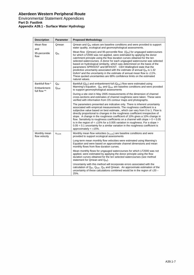
Description Parameter Proposed Methodology
Mean flow and 95-percentile flow
Qmean Q95
Qmean and Q95 values are baseline conditions and were provided to support water quality, ecological and geomorphological assessments. Mean flow (Qmean) and 95-percentile flow (Q95) for ungauged watercourses for which LF2000 was not applied, were estimated by applying the donor catchment principle using the flow duration curves obtained for the ten selected watercourses. A donor for each ungauged watercourse was selected based on hydrological similarity, which was determined on the basis of the parameters SPRHOST and BFIHOST. CEH Wallingford state that the predictive uncertainty associated with the estimate of annual Q95 is 1.32 l/s/km² and the uncertainty in the estimate of annual mean flow is ±11%. These quoted uncertainties are 68% confidence limits on the estimated natural values.
Bankfull flow * Embankment-full flow **
QBF
QEBF
Bankfull (QBF) and embankment-full (QEBF) flow were estimated using Manning’s Equation. QBF and QEBF are baseline conditions and were provided to support geomorphological assessments During a site visit in May 2005 measurements of the dimension of channel cross-sections and estimates of channel roughness were taken. These were verified with information from OS contour maps and photographs. The parameters presented are indicative only. There is inherent uncertainty associated with empirical measurements. The roughness coefficient is a subjective value based on best estimate., which can vary from 0 to 1. Flow is directly proportional to changes in the roughness coefficient irrespective of slope. A change in the roughness coefficient of 10% gives a 10% change in flow. Sensitivity to roughness coefficients on a channel with slope > 0 < 0.05 is in the region of < ±15% for a 0.005 variation in roughness. For a slope > 0.05 < 0.1 uncertainty for a similar variation in the roughness coefficient is approximately < ±15%.
Monthly mean flow velocity
vmonth Monthly mean flow velocities (vmonth) are baseline conditions and were provided to support ecological assessments Long-term mean monthly flow velocities were estimated using Manning’s Equation and were based on approximate channel dimensions and mean monthly flows from flow duration curves. Mean monthly flows for ungauged watercourses for which LF2000 was not applied, were estimated by applying the donor principle using the flow duration curves obtained for the ten selected watercourses (see method statement for Qmean and Q95). Uncertainty with this method will incorporate errors associated with the calculation of QBF, QEBF, Q95 and Qmean. An approximate estimation of the uncertainty of these calculations combined would be in the region of ±20 – 25%.
A39.1-7
Aberdeen Western Peripheral Route Environmental Statement Appendices Part D: Fastlink Appendix A39.1 - Surface Water Hydrology
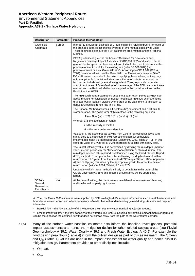
Description Parameter Proposed Methodology
Greenfield runoff rate
q green In order to provide an estimate of Greenfield runoff rates (q green) for each of the drainage outfall locations the average of two methodologies was used. These methodologies are the FEH catchment area method and the Rational Method. SEPA guidance is given in the booklet ‘Guidance for Developers and Regulators Drainage Impact Assessment’ (DP 300 3/02) and states, that in general the two-year one hour rainfall event should be used to determine the pre-development runoff for the existing site (refer DP 300 3/02) (i.e. predevelopment or as a ‘Greenfield site’). According to CIRIA 609 (CIRIA, 2004) common values used for Greenfield runoff rates vary between 5 to 7 l/s/ha. However, care should be taken if applying these values, as they may not be applicable to individual sites, since the runoff rate is dependent on factors that include soil type and site gradient. Thus, to provide more site specific estimates of Greenfield runoff the average of the FEH catchment area method and the Rational Method was applied to the outfall locations on the Fastlink of the AWPR. The FEH catchment area method uses the 2 year return period (QMED, see above method for calculation of median flood flow) FEH flow estimate at the drainage outfall location divided by the area of the catchment to this point to derive a Greenfield runoff rate in l/ s / ha. The Rational Method assumes a 1 hectare (ha) catchment and a 60 minute storm duration. The basic form of this method is the following equation: Peak Flow (l/s) = 2.78 * C * I (mm/hr) * A (ha) Where: C is the coefficient of runoff I is the intensity of rainfall A is the area under consideration Values of C are described as varying from 0.05 to represent flat lawns with sandy soils to a maximum of 0.95 representing almost completely impermeable heavily urbanised areas (Maidment, 1993, Table 9.4.1). In this case the value of C was set at 0.2 to represent rural land with heavy soils. The rainfall intensity value, I, is determined by dividing the rain depth (mm) for various return periods by the ‘Time of Concentration’ or storm duration. The rain depth for each return period is determined using the Flood Studies Report (FSR) method. This approach involves obtaining the depth of rainfall with a return period of 5 years from the standard FSR maps (Wilson, 2004, Appendix A) and multiplying this value by the appropriate growth factor for the desired return period (Wilson, 2004, Tables, 2.6 and 2.7). Uncertainty within these methods is likely to be at least in the order of the QMED uncertainty ± 55% and in some circumstance will be appreciably larger.
SEPA’s Second Generation Flood Maps
N/A At the time of writing, the maps were unavailable due to unresolved licensing and intellectual property right issues.
# The Low Flows 2000 estimates were supplied by CEH Wallingford. Basic input information such as catchment area and boundaries were checked and where necessary refined in line with understanding gained during site visits and mapped information. * Bankful flow = the flow capacity of the watercourse with out any water inundating adjacent ground. ** Embankment-full flow = the flow capacity of the watercourse feature including any artificial embankments or berms. It can be thought of as the confined flow that does not spread away from the path of the watercourse corridor.
2.2.14 Many of the surface water baseline estimates also inform the baseline investigations, potential impact assessments and hence the mitigation design for other related subject areas (see Fluvial Geomorphology A 39.2, Water Quality A 39.3 and Fresh Water Ecology A 40.9). For example the flood design peak flows (Table 4) inform the culvert design as part of this assessment. The Qmean and Q95 (Table 4) values are used in the impact assessment for water quality and hence assist in mitigation design. Parameters provided to other disciplines include:
• Qmean,
• Q95,
A39.1-8

Aberdeen Western Peripheral Environmental Statement Appendices Part D: Fastlink Appe
Route
ndix A39.1 - Surface Water Hydrology
A39.1-9
• QBF, QEBF, and
• Vmonth,
2.3 Limitations to Assessment
2.3.1 The watercourses in the study area are ungauged and therefore inherent uncertainties exist in the estimation of flows. A higher degree of accuracy would require the installation of hydrometric monitoring equipment and the collation of a relatively long period of data (preferably several years of record). This is considered to be outwith the scope of the current study. Where possible, site visits and one-off measurements have been taken to improve the robustness of the estimates.
3 Baseline
3.1 Baseline Assessment
3.1.1 This section describes the baseline hydrological conditions.
3.1.2 A range of sensitivities exist for the watercourses along the Fastlink of the proposed scheme. The Blaikiewell Burn and the Burnhead Burn are impacted by both the Fastlink and the Southern Leg proposals. All assessment conclusions are reported in the Southern Leg report for consistency.
3.1.3 Table 5 details the baseline hydrological conditions of water features in the study area. In support of this information the following is supplied:
• Figures 39.2a-c gives the location plan of catchments, proposed culverts, flow gauges and rain gauges referred to in the assessment.
• Appendix A39.4, Annex 1 compares the estimated flood flows of the two methodologies indicated in the DMRB documents for the estimation of design flood flows in ungauged catchments.
• Northern Leg Appendix A9.5 Annex 21 summarises the flow duration curves derived by using Low Flows 2000 (LF2000) software and compares them to spot gaugings that were taken during a site visit in 2005 for selected Northern Leg, Southern Leg and Fast Link watercourses. The LF2000 information was then applied to other parameters following donor principles, and in that sense are pertinent to this report.
• For a detailed account of all the parameters estimated according to the methodologies indicated in Table 4 refer to Appendix A39.4 Annexes 3- 21.
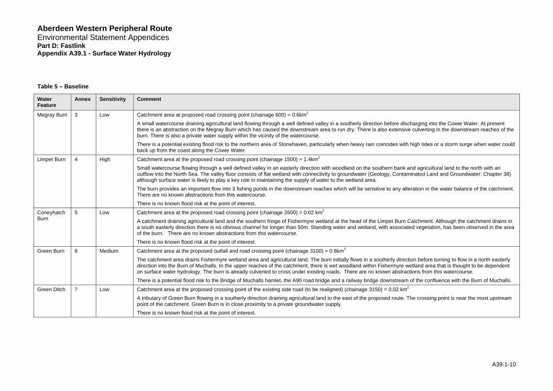
Aberdeen Western Peripheral Route Environmental Statement Appendices Part D: Fastlink Appendix A39.1 - Surface Water Hydrology
Table 5 – Baseline
Water Feature
Annex Sensitivity Comment
Megray Burn 3 Low Catchment area at proposed road crossing point (chainage 600) = 0.6km2
A small watercourse draining agricultural land flowing through a well defined valley in a southerly direction before discharging into the Cowie Water. At present there is an abstraction on the Megray Burn which has caused the downstream area to run dry. There is also extensive culverting in the downstream reaches of the burn. There is also a private water supply within the vicinity of the watercourse. There is a potential existing flood risk to the northern area of Stonehaven, particularly when heavy rain coincides with high tides or a storm surge when water could back up from the coast along the Cowie Water.
Limpet Burn 4 High Catchment area at the proposed road crossing point (chainage 1500) = 1.4km2
Small watercourse flowing through a well defined valley in an easterly direction with woodland on the southern bank and agricultural land to the north with an outflow into the North Sea. The valley floor consists of flat wetland with connectivity to groundwater (Geology, Contaminated Land and Groundwater: Chapter 38) although surface water is likely to play a key role in maintaining the supply of water to the wetland area. The burn provides an important flow into 3 fishing ponds in the downstream reaches which will be sensitive to any alteration in the water balance of the catchment. There are no known abstractions from this watercourse. There is no known flood risk at the point of interest.
Coneyhatch Burn
5 Low Catchment area at the proposed road crossing point (chainage 2600) = 0.02 km2
A catchment draining agricultural land and the southern fringe of Fishermyre wetland at the head of the Limpet Burn Catchment. Although the catchment drains in a south easterly direction there is no obvious channel for longer than 50m. Standing water and wetland, with associated vegetation, has been observed in the area of the burn. There are no known abstractions from this watercourse. There is no known flood risk at the point of interest.
Green Burn 6 Medium Catchment area at the proposed outfall and road crossing point (chainage 3100) = 0.8km2
The catchment area drains Fishermyre wetland area and agricultural land. The burn initially flows in a southerly direction before turning to flow in a north easterly direction into the Burn of Muchalls. In the upper reaches of the catchment, there is wet woodland within Fishermyre wetland area that is thought to be dependent on surface water hydrology. The burn is already culverted to cross under existing roads. There are no known abstractions from this watercourse. There is a potential flood risk to the Bridge of Muchalls hamlet, the A90 road bridge and a railway bridge downstream of the confluence with the Burn of Muchalls.
Green Ditch 7 Low Catchment area at the proposed crossing point of the existing side road (to be realigned) (chainage 3150) = 0.02 km2
A tributary of Green Burn flowing in a southerly direction draining agricultural land to the east of the proposed route. The crossing point is near the most upstream point of the catchment. Green Burn is in close proximity to a private groundwater supply. There is no known flood risk at the point of interest.
A39.1-10
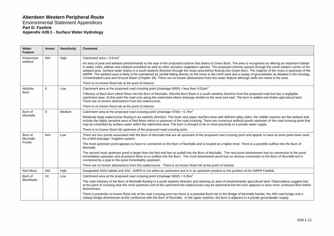
Aberdeen Western Peripheral Route Environmental Statement Appendices Part D: Fastlink Appendix A39.1 - Surface Water Hydrology Water Annex Sensitivity Comment Feature
Fishermyre wetland
N/A High Catchment area = 0.8 km2
An area of peat and wetland predominantly to the east of the proposed scheme that drains to Green Burn. The area is recognised as offering an important habitat to water voles, willows and wetland woodland as well as other sensitive vegetation species. The proposed scheme passes through the south eastern corner of the wetland area. Surface water drains in a south easterly direction through the moss area before flowing into Green Burn. The majority of the moss is upstream of the AWPR. The wetland area is likely to be maintained by rainfall falling directly on the moss to the north west and a supply of groundwater as detailed in the Geology, Contaminated Land and Ground Water (Chapter 38). There are no known abstractions from this water feature although wells are noted in the area. There is no known flood risk at the point of interest.
Allochie Burn
8 Low Catchment area at the proposed road crossing point (chainage 4000) = less than 0.01km2
Tributary of Back Burn which flows into the Burn of Muchalls. Allochie Burn flows in a south westerly direction from the proposed road but has a negligible catchment area. At this point the road runs along the watershed where drainage divides to the west and east. The burn is walled and drains agricultural land. There are no known abstractions from this watercourse. There is no known flood risk at the point of interest.
Burn of Muchalls
9 Medium Catchment area at the proposed road crossing point (chainage 4700) = 6.7km2
Relatively large watercourse flowing in an easterly direction. The lower and upper reaches have well defined valley sides, the middle reaches are flat wetland and include the highly sensitive area of Red Moss which is upstream of the road crossing. There are numerous artificial ponds upstream of the road crossing point that may be controlled by surface water within the catchment area. The burn is thought to be in close proximity to a private water supply. There is no known flood risk upstream of the proposed road crossing point.
Burn of Muchalls Ponds
N/A Low There are four ponds associated with the Burn of Muchalls that are all upstream of the proposed road crossing point and appear to have at some point been used for a field drainage / irrigation system. The most upstream pond appears to have no connection to the Burn of Muchalls and is located at a higher level. There is a possible outflow into the Burn of Muchalls. The second most upstream pond is larger than the first and has an outfall into the Burn of Muchalls. The next pond downstream has no connection to the pond immediately upstream and at present there is no outflow into the Burn. The most downstream pond has no obvious connection to the Burn of Muchalls but is connected by a pipe to the pond immediately upstream. There are no known abstractions from this watercourse. There is no known flood risk at the point of interest.
Red Moss N/A High Designated SSSI habitat and SAC. AWPR is not within its catchment and is in an upstream position to the position of the AWPR Fastlink.
Burn of Blackbutts
10 Low Catchment area at the proposed road crossing point (chainage 5600) = 0.2km2
The main tributary of the Burn of Muchalls flowing in a south easterly direction and draining an area of predominantly agricultural land. Observations suggest that at the point of crossing near the most upstream end of the catchment the watercourse may be ephemeral but the burn appears to have more continued flow further downstream. There is presently no known flood risk at the road crossing point but there is a potential flood risk to the Bridge of Muchalls hamlet, the A90 road bridge and a railway bridge downstream at the confluence with the Burn of Muchalls. In the upper reaches, the burn is adjacent to a private groundwater supply.
A39.1-11

Aberdeen Western Peripheral Route Environmental Statement Appendices Part D: Fastlink Appendix A39.1 - Surface Water Hydrology Water Annex Sensitivity Comment Feature
Cookney Ditch
11 Low Catchment area at the proposed road crossing point (chainage 6500) = 0.2km2
Appears to be part of an agricultural field drainage system with no obvious channel. At the point of interest, the channel is chocked with vegetation but drains in an easterly direction before discharging into the Pheppie Burn. The head of the catchment drains a small area of wetland and gorse. There are no known abstractions from this watercourse. There is no existing flood risk at the proposed road crossing.
Stoney Hill Burn
12 Low Catchment area at the proposed road crossing point (chainage 6900) = 0.2km2
A tributary of the Burn of Elsick flowing in a north easterly direction draining agricultural land predominantly to the east of the proposed route. The crossing point is near the most upstream point of the catchment. There are no known abstractions from this watercourse. There is no known flood risk at the point of interest.
Balnagubs Burn
13 Low Catchment area at the proposed road crossing point (chainage 7550) = 0.2km2
A tributary of the Burn of Elsick with well defined bank lines flowing in a north easterly direction draining agricultural land predominantly to the east of the proposed route. The crossing point is near the most upstream point of the catchment. There are no known abstractions from this watercourse. There is no known flood risk at the point of interest.
Tributary of the Burn of Elsick
14 Low Catchment area at the proposed outfall and road crossing point (chainage 7950) = 1.0km2
A burn draining agricultural land and flowing in an easterly direction into the Burn of Elsick. It is likely that the burn has been modified as part of field drainage system. There is a possibility that the catchment may play a role in the water balance of a pond downstream of the confluence with the Burn of Elsick although it is thought this is unconnected to the burn. There are no known abstractions from this watercourse. There is no known flood risk at the point of interest.
Whiteside Burn
15 Low Catchment area at the proposed road crossing point (chainage 8850) = 0.4km2
A burn draining agricultural land and flowing in an easterly direction into the Burn of Elsick. The upstream end of the burn has been piped and it is likely that the full length of the burn has been modified as part of a field drainage system. There are no known abstractions from this watercourse. There is no known flood risk at the point of interest.
Crossley Burn
16 Low Catchment area at the proposed road crossing point (chainage 9150) = 0.2km2
A small tributary of the Burn of Elsick flowing in a south easterly direction draining agricultural land predominantly to the east of the proposed route. The crossing point is near the most upstream point of the catchment, where the channel is heavily vegetated. Stagnant water has been observed within the channel. It is thought that the full length of the burn has been modified as part of a field drainage system. There are no known abstractions from this watercourse. There is no known flood risk at the point of interest.
Cairns Burn 17 Low Catchment area at the proposed road crossing point (chainage 9200) = 0.01 km2
A small tributary of Crossley Burn flowing in a south easterly direction draining agricultural land predominantly to the west of the proposed route. The crossing point is near the most upstream point of the catchment where the channel is heavily vegetated and stagnant water has been observed within the channel. It is thought that the full length of the burn has been modified as part of a field drainage system. There are no known abstractions from this watercourse. There is no known flood risk at the point of interest.
A39.1-12
Route
ndix A39.1 - Surface Water Hydrology
A39.1-13
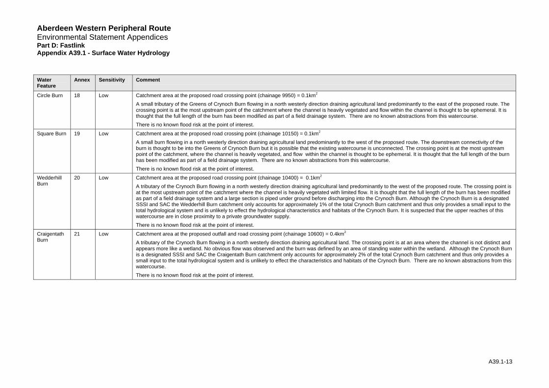
Water Feature
Annex Sensitivity Comment
Circle Burn 18 Low Catchment area at the proposed road crossing point (chainage 9950) = 0.1km2
A small tributary of the Greens of Crynoch Burn flowing in a north westerly direction draining agricultural land predominantly to the east of the proposed route. The crossing point is at the most upstream point of the catchment where the channel is heavily vegetated and flow within the channel is thought to be ephemeral. It is thought that the full length of the burn has been modified as part of a field drainage system. There are no known abstractions from this watercourse. There is no known flood risk at the point of interest.
Square Burn 19 Low Catchment area at the proposed road crossing point (chainage 10150) = 0.1km2
A small burn flowing in a north westerly direction draining agricultural land predominantly to the west of the proposed route. The downstream connectivity of the burn is thought to be into the Greens of Crynoch Burn but it is possible that the existing watercourse is unconnected. The crossing point is at the most upstream point of the catchment, where the channel is heavily vegetated, and flow within the channel is thought to be ephemeral. It is thought that the full length of the burn has been modified as part of a field drainage system. There are no known abstractions from this watercourse. There is no known flood risk at the point of interest.
Wedderhill Burn
20 Low Catchment area at the proposed road crossing point (chainage 10400) = 0.1km2
A tributary of the Crynoch Burn flowing in a north westerly direction draining agricultural land predominantly to the west of the proposed route. The crossing point is at the most upstream point of the catchment where the channel is heavily vegetated with limited flow. It is thought that the full length of the burn has been modified as part of a field drainage system and a large section is piped under ground before discharging into the Crynoch Burn. Although the Crynoch Burn is a designated SSSI and SAC the Wedderhill Burn catchment only accounts for approximately 1% of the total Crynoch Burn catchment and thus only provides a small input to the total hydrological system and is unlikely to effect the hydrological characteristics and habitats of the Crynoch Burn. It is suspected that the upper reaches of this watercourse are in close proximity to a private groundwater supply. There is no known flood risk at the point of interest.
Craigentath Burn
21 Low Catchment area at the proposed outfall and road crossing point (chainage 10600) = 0.4km2
A tributary of the Crynoch Burn flowing in a north westerly direction draining agricultural land. The crossing point is at an area where the channel is not distinct and appears more like a wetland. No obvious flow was observed and the burn was defined by an area of standing water within the wetland. Although the Crynoch Burn is a designated SSSI and SAC the Craigentath Burn catchment only accounts for approximately 2% of the total Crynoch Burn catchment and thus only provides a small input to the total hydrological system and is unlikely to effect the characteristics and habitats of the Crynoch Burn. There are no known abstractions from this watercourse. There is no known flood risk at the point of interest.
Aberdeen Western Peripheral Environmental Statement Appendices Part D: Fastlink Appe
Aberdeen Western Peripheral Route Environmental Statement Appendices Part D: Fastlink Appendix A39.1 - Surface Water Hydrology
3.2 Baseline Road Runoff
3.2.1 Hydrological soil parameters indicate that the ground conditions along the proposed Fastlink of the AWPR are generally of average permeability. Greenfield runoff rate was calculated at 4.7-l/s/ha for the 0.5%AEP (2 year return period) design flows.
3.3 Baseline Summary
3.3.1 In total, the Fastlink section of the proposed scheme would cross 19 watercourses and Fishermyre wetland. All of the watercourses along the proposed route are relatively small.
3.3.2 The watercourse catchments are all mainly rural in character. All catchments are small (areas range between 0.2 to 4.5km2). Average annual rainfall along the entire AWPR route varies between 770 and 840mm, with a slight east to west increase, indicating a drier than average region within Scotland.
3.3.3 Soil parameters of the small catchments suggest middle range permeability and that they would be expected to display flow regimes of average sensitivity to rainfall. This is to say these catchments are unlikely to be especially flashy (i.e. rainfall does not reach the watercourse particularly quickly), but at the same time they will experience appreciable flood flows during and immediately following heavy rain (something that would not be so obvious in particularly permeable catchments where rainfall takes much longer to reach the watercourse). Within the range of responsiveness Green Burn is likely to have the fastest response to rainfall whereas, the Burn of Elsick and Whiteside Burn, are slightly slower to respond. However, it is stressed that none of these catchments exhibit extreme response characteristics.
3.3.4 Generally, the small watercourses flow within well-defined channel corridors through rural land where the route is proposed to cross them. Baseline flood risk from the watercourses is considered to be low in these areas. A review of OS maps suggests there is limited downstream flood risk on these small watercourses. A further review of flood risk will occur once the Second Generation Flood Maps have been received from SEPA.
3.3.5 Limpet Burn has been assigned a high sensitivity due to the connectivity to fishing ponds downstream of the proposed scheme crossing point and the connectivity of surface water to the wetland environment within the valley floor of the burn. There is also an important supply of groundwater to this watercourse which is detailed in the Geology, Contaminated Land and Ground Water (Chapter 38).
3.3.6 Fishermyre wetland is considered a highly sensitive site due to the requirement of a constant supply of surface water to maintain peat deposits (Geology, Contaminated Land and Groundwater: Chapter 38) and the associated flora and fauna of a wetland. This area also has an important supply of groundwater (Geology, Contaminated Land and Groundwater: Chapter 38).
A39.1-14
Aberdeen Western Peripheral Route Environmental Statement Appendices Part D: Fastlink Appendix A39.1 - Surface Water Hydrology
4 Potential Impacts
4.1 Generic Impacts
4.1.1 There will be a number of generic potential impacts associated with the road scheme which will affect all the watercourses. These are divided into operation impacts (long-term) and construction impacts (shorter-term).
4.1.2 The potential impact assessment is presented with the assumption of no mitigation. Unless otherwise stated, the impacts considered are adverse impacts, having an adverse impact on the hydrological regime of a watercourse, channel morphology or natural fluvial processes and are assigned based on the criteria set out in Table 2. The impacts reported are the direct impacts to hydrology and an indication of the indirect impacts on ecology, geomorphology and water quality.
4.1.3 Potentially, road schemes can impact on surface water hydrology as a result of:
• structures such as culverts and bridges;
• surfaces shedding additional runoff as a result of being paved;
• impeding the functionality of floodplains (flood storage and conveyance);
• re-alignment of watercourses;
• disturbance of hydrological features (wetlands, lochans, etc);
• alteration of catchment areas; and
• slteration of surface water runoff pathways.
4.1.4 The associated impacts on surface water hydrology could potentially include changes to:
• magnitude and timing of runoff;
• flow velocities;
• flow pathways; and
• flood risk.
Operation Impacts
4.1.5 Once built, the road would coincide with or be adjacent to surface water features at a number of locations (mainly the crossing of watercourses but also environmental features critically dependent on the surface hydrology). Impacts of the presence of the road on surface hydrology are those that could affect the physical flow and water level regimes. Examples of such circumstances might include:
• Structures: Blockage or constriction, may lead to localised flood risk; potential for increased sediment release and changes to erosion/depositional patterns indirectly affecting the geomorphological and ecological status of a watercourse. When assessing the potential impacts of culverts, all culverts would be considered to be flood flow culverts. Flood flow culverts are designed to convey the 0.5% AEP (200 year flow) but do not include any continuity of bed through the structure and do not have mammal ledges.
• Impermeable Areas: Impermeable areas increase the overall volume of water reaching the watercourse, as less is lost to infiltration. Road runoff may reach the receiving watercourse earlier than if the road did not exist, resulting in the flood response of the catchment becoming more ‘flashy’. This may increase the flood risk downstream of the road outfall and increase stream power.
A39.1-15
Aberdeen Western Peripheral Route Environmental Statement Appendices Part D: Fastlink Appendix A39.1 - Surface Water Hydrology
• Outfall of Road Drainage: Road drainage would be piped to the appropriate outfall and would flow into the specified watercourse. Alterations to the hydrological and flood regimes of outfall watercourses may occur if there is no suitably designed attenuation of surface water runoff.
• Increased Catchment: Watercourse crossing or drainage design may result in the re-direction of one watercourse into another, or in the construction of an outfall to a watercourse, which may increase local flow rates and flood risk. Alterations to flow may have implications for sedimentation patterns along the watercourse which may increase flood risk else where along the watercourse through changes in channel dimensions.
• Severed Catchment: Constriction or severing of established flow paths may lead to an increased flood risk; changes to sediment regime via changes to gradient and size of watercourse leading to impacts upon geomorphology and subsequently water quality. Alterations to the flow regime could also have associated impacts on the ecological status of a watercourse.
• Blocked Pathways: The road and its drainage scheme may act as a barrier to current watercourse catchments; whereby rain is deposited in one catchment and by way of the drainage scheme discharged to another. This could increase flows to receiving watercourses while reducing flows in others. This would be of particular concern if blocked surface water pathways were of particular importance for an environmentally sensitive area such as a raised moss. A reduction in flows may greatly affect the geomorphological, water quality and ecological status of the watercourse.
• Stream Realignment: Any necessary watercourse realignments have the potential to increase flood risk if the correct channel dimensions and slope are not applied to the realignment design.
• Pre-earthworks drainage: Prior to the construction of the road it is necessary to construct a pre-earthworks drainage system to prepare the route for construction. At this stage any small watercourses or catchment areas identified as suitable are incorporated into the pre-earthworks drainage system. The drainage system remains in place throughout the operation of the road and can result in permanent re-direction of discharge for affected watercourses. Consequently catchment areas would increase or decrease depending on the outfall point of the pre-earthworks drainage system. The percentage change in the total catchment area of affected watercourses, as assessed by hydrologists, is viewed as an indicator to the likely impact of the proposed scheme. Catchment changes of 1% or less are considered negligible, changes of less than 10% are considered low, changes of less than 25% are considered medium and changes greater than 25% are considered a high impact. These values have been selected as indicators of the likely significance of changes in catchment area to a watercourse. These values are an estimate; based on professional hydrological judgement, however they provide a guide to the likely significance of a loss / increase of catchment area on a watercourse.
Construction Impacts
4.1.6 Construction impacts in general can include effects such as:
• soil compaction due to works traffic, and
• sedimentation and disturbance / unintentional changes to channel dimensions which may impact on the hydraulic flow characteristics of a watercourse.
4.1.7 These are referred to as “general construction impacts” and would affect all sites where work is taking place. The term is also used to refer to work carried out during the construction of outfall locations, pre-earthworks drainage and the connection of relevant catchment / watercourses.
4.1.8 Temporary haul roads would be built as part of the construction phase of the project. These may cause a temporary increase in runoff due to reduced infiltration rates in the area of the road. Temporary arrangements to control surface water runoff would, however, help to mitigate the effects of increased runoff during construction. The increase in catchment runoff from temporary haul roads is likely to have a negligible effect.
A39.1-16
Aberdeen Western Peripheral Route Environmental Statement Appendices Part D: Fastlink Appendix A39.1 - Surface Water Hydrology 4.1.9 Any work occurring within the main channel of a watercourse, such as bridges, culverts,
realignments and outfalls have the potential to increase localised flood risk through blockages. This may occur directly, through poor construction techniques, or indirectly through increased sediment deposition. This could also heavily affect the supply of surface water further downstream.
4.1.10 During the construction phase, other temporary works that would, or potentially might, have some bearing on the surface hydrology would include the following:
• watercourse diversions to facilitate culvert and bridge construction;
• drainage outfalls (temporary, during works); and
• runoff control measures (temporary, during works), which could include swales and geotextile-wrapped straw bale barriers.
4.1.11 These potential impacts would be of greater significance if construction is taking place in areas of increased sensitivity such as a raised bog or wetland area. The magnitude of impact would be dependent on the schedule of works and weather conditions. The severity of the impacts would be increased during periods of intense or prolonged rainfall.
4.2 Specific Impacts
4.2.1 The proposed scheme has been considered in the context of the general discussion of potential impacts above. The following components of the proposals have the potential to affect the water environment.
Road Drainage Outfalls
4.2.2 Road drainage would outfall to:
• Megray Burn;
• Green Burn;
• Burn of Muchalls; and
• Tributary of the Burn of Elsick
Watercourse Crossings
4.2.3 Bridges are proposed at the crossing over the Limpet Burn and the Burn of Muchalls, due to both the size of these watercourses, and their environmental sensitivity or, in the case of Limpet Burn, the size of its associated gorge feature. Both bridge structures are designed to entirely span the watercourse with no in-channel supports and maintain a 5m set-back from the top of back to ensure riparian connectivity through the structure. All crossings are marked clearly on Figures 39.3a - f.
4.2.4 At other locations, a culvert is proposed. A total of 11 culverts are required, as follows:
• one culvert at Megray Burn, Stoneyhill Ditch, Balnagubs Burn, Tributary of the Burn of Elsick, Whiteside Burn, Crossley Burn, Craignetath Burn; and
• two culverts at Green Burn and Cookney Ditch.
4.2.5 This section of the report assumes that a culvert, sized to convey a range of flows, would be installed level with the existing bed, effectively providing artificial bed and banks. The mitigation section of this chapter discusses the different types of culvert that can be installed in preference to this.
Watercourse Realignments
A39.1-17
Aberdeen Western Peripheral Environmental Statement Appendices Part D: Fastlink Appe
Route
ndix A39.1 - Surface Water Hydrology
A39.1-18
4.3.2 Table 7 summarises potential site specific construction impacts (assuming no mitigation), in terms of both magnitude and significance, for watercourses along the Fastlink of the proposed scheme.
4.3.1 Table 6 summarises potential site specific operation impacts (assuming no mitigation), in terms of both magnitude and significance, for watercourses along the Fastlink of the proposed scheme.
Construction Impacts
4.3 Site specific impacts
Operation Impacts
4.2.8 As noted in the general discussion of potential impacts, certain minor watercourses and drainage ditches would not be culverted, and would instead be routed into pre-earthworks ditches and subsequently into the road drainage system. This is proposed for a limited number of very small ephemeral ditches, and for the following named burns:
4.2.7 Limpet Burn would be extensively realigned in its upper reaches to accommodate the crossing feature, while Megray Burn would undergo a major realignment through the valley to accommodate the road. The remainder would all require extensive realignment of the existing watercourse to allow the installation of a culvert.
Pre-earthworks Drainage
4.2.6 The following watercourse realignments would be required:
• Wedderhill Burn.
• Circle and Square Burn; and
• Stoney Hill Burn;
• Cookney Ditch;
• Burn of Blackbutts;
• Allochie Burn;
• Green Ditch;
• Coneyhatch Burn;
• Craigentath Burn (one realignment of 120m, overall length maintained).
• Cairn Burn (one realignment of 192, resulting in 40m shortening of channel); and
• Crossley Burn (one realignment of 161m, overall length maintained);
• Whiteside Burn (one realignment of 121m, overall length maintained);
• Tributary of the Burn of Elsick (one realignment of 150m, overall length maintained);
• Balnagubs Burn (one realignment of 111m, overall length maintained);
• Limpet Burn (one realignment of 120.52m, resulting in a 2.35 m lengthening of the channel);
• Megray Burn (one extensive realignment of 951m, resulting in 49m extension to the watercourse);
• Green Burn (two realignments of overall length 260m, resulting in a 4m shortening of the channel);
Aberdeen Western Peripheral Route Environmental Statement Appendices Part D: Fastlink Appendix A39.1 - Surface Water Hydrology
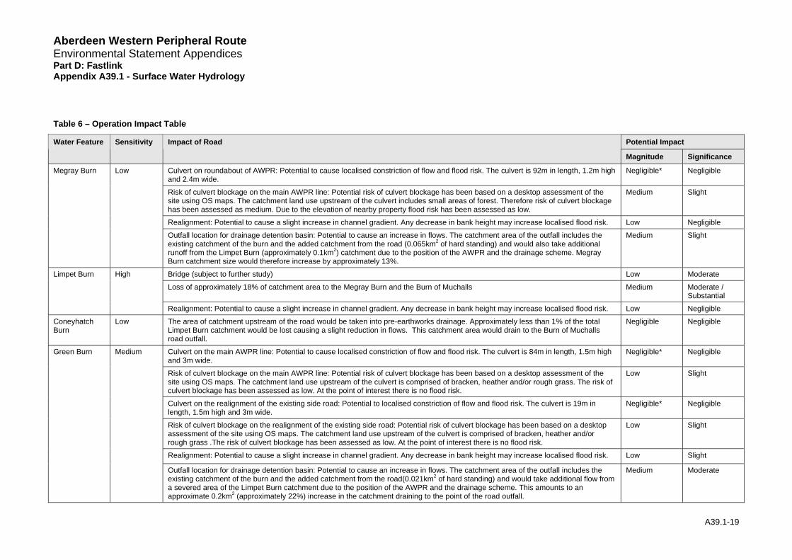
Table 6 – Operation Impact Table
Potential Impact Water Feature Sensitivity Impact of Road
Magnitude Significance
Culvert on roundabout of AWPR: Potential to cause localised constriction of flow and flood risk. The culvert is 92m in length, 1.2m high and 2.4m wide.
Negligible* Negligible
Risk of culvert blockage on the main AWPR line: Potential risk of culvert blockage has been based on a desktop assessment of the site using OS maps. The catchment land use upstream of the culvert includes small areas of forest. Therefore risk of culvert blockage has been assessed as medium. Due to the elevation of nearby property flood risk has been assessed as low.
Medium Slight
Realignment: Potential to cause a slight increase in channel gradient. Any decrease in bank height may increase localised flood risk. Low Negligible
Megray Burn Low
Outfall location for drainage detention basin: Potential to cause an increase in flows. The catchment area of the outfall includes the existing catchment of the burn and the added catchment from the road (0.065km2 of hard standing) and would also take additional runoff from the Limpet Burn (approximately 0.1km2) catchment due to the position of the AWPR and the drainage scheme. Megray Burn catchment size would therefore increase by approximately 13%.
Medium Slight
Bridge (subject to further study) Low Moderate
Loss of approximately 18% of catchment area to the Megray Burn and the Burn of Muchalls Medium Moderate / Substantial
Limpet Burn High
Realignment: Potential to cause a slight increase in channel gradient. Any decrease in bank height may increase localised flood risk. Low Negligible
Coneyhatch Burn
Low The area of catchment upstream of the road would be taken into pre-earthworks drainage. Approximately less than 1% of the total Limpet Burn catchment would be lost causing a slight reduction in flows. This catchment area would drain to the Burn of Muchalls road outfall.
Negligible Negligible
Culvert on the main AWPR line: Potential to cause localised constriction of flow and flood risk. The culvert is 84m in length, 1.5m high and 3m wide.
Negligible* Negligible
Risk of culvert blockage on the main AWPR line: Potential risk of culvert blockage has been based on a desktop assessment of the site using OS maps. The catchment land use upstream of the culvert is comprised of bracken, heather and/or rough grass. The risk of culvert blockage has been assessed as low. At the point of interest there is no flood risk.
Low Slight
Culvert on the realignment of the existing side road: Potential to localised constriction of flow and flood risk. The culvert is 19m in length, 1.5m high and 3m wide.
Negligible* Negligible
Risk of culvert blockage on the realignment of the existing side road: Potential risk of culvert blockage has been based on a desktop assessment of the site using OS maps. The catchment land use upstream of the culvert is comprised of bracken, heather and/or rough grass .The risk of culvert blockage has been assessed as low. At the point of interest there is no flood risk.
Low Slight
Realignment: Potential to cause a slight increase in channel gradient. Any decrease in bank height may increase localised flood risk. Low Slight
Green Burn
Medium
Outfall location for drainage detention basin: Potential to cause an increase in flows. The catchment area of the outfall includes the existing catchment of the burn and the added catchment from the road(0.021km2 of hard standing) and would take additional flow from a severed area of the Limpet Burn catchment due to the position of the AWPR and the drainage scheme. This amounts to an approximate 0.2km2 (approximately 22%) increase in the catchment draining to the point of the road outfall.
Medium Moderate
A39.1-19
Aberdeen Western Peripheral Route Environmental Statement Appendices Part D: Fastlink Appendix A39.1 - Surface Water Hydrology
Potential Impact Water Feature Sensitivity Impact of Road
Magnitude Significance
Green Ditch Low The area of the catchment upstream of the road would be taken into pre-earthworks drainage. This catchment would still drain to Green Burn via the road drainage outfall.
Negligible Negligible
Fishermyre wetland
High Surface water prevented from draining to all areas of the wetland due to the development of the AWPR and associated drainage system. Surface water runoff from the majority of the wetland would not be able to flow to approximately 2% of the wetland due to blockage of surface water runoff pathways. .
High Substantial
Allochie Burn Low The area of the catchment upstream of the road would be taken into pre-earthworks drainage. This catchment would still drain to Burn of Muchalls via the road drainage outfall.
Negligible Negligible
Bridge: Potential to cause a localised constriction of flow due to bridge supports and increase flood risk. Low Slight Burn of Muchalls
Medium
Outfall location for drainage detention basin: Potential to cause an increase in flows. There is likely to be a 0.4% increase in the catchment size at the point of the road crossing due to the position of the road and the direction of the road drainage. There would be approximately 0.080km2 of hard standing draining to this outfall.
Negligible Negligible
Burn of Muchalls Ponds
Low The ponds are located upstream of the proposed AWPR. N/A N/A
Red Moss High N/A. The road passes downstream of Red Moss and therefore has no hydrological impact on the Moss. N/A N/A
Burn of Blackbutts
Low The area of the catchment upstream of the road would be taken into pre-earthworks drainage. The drainage direction would cause this to be added to the Burn of Muchalls further upstream at the AWPR outfall instead of the confluence. Potential to decrease the response time of the Burn of Muchalls.
Low Negligible
Cookney Ditch Low The area of the catchment upstream of the AWPR crossing point would be lost to pre-earthworks and would drain to the Tributary of Elsick Burn outfall. Approximately 6% of the total Pheppie Burn catchment would be lost in the road construction.
Low Negligible
Stoney Hill Burn
Low The area of the catchment upstream of the road would be taken into pre-earthworks drainage. The drainage direction would cause this to be added to the Tributary of Elsick Burn at the AWPR outfall instead of directly into the Burn of Elsick further downstream. There is a potential to decrease the response time of the Tributary of Elsick.
Low Negligible
Culvert: Potential to cause a possible localised constriction of flow and flood risk. The culvert is 48m in length, 1.2m high and 2.4m wide.
Negligible* Negligible
Risk of culvert blockage on the main AWPR line: Potential risk of culvert blockage has been based on a desktop assessment of the site using OS maps. The catchment land use upstream of the culvert is comprised of limited areas of bracken, heather and/or rough grass. The risk of culvert blockage has been assessed as low. At the point of interest there is no flood risk.
Low Negligible
Balnagubs Burn
Low
Realignment: Potential to cause a slight increase in channel gradient. Any decrease in bank height may increase localised flood risk. Low Negligible
Culvert: Potential to cause localised constriction of flow and flood risk. The culvert is 54m in length, 1.5m high and 2.7m wide. Negligible* Negligible Tributary of the Elsick Burn
Low
Risk of culvert blockage on the main AWPR line: Potential risk of culvert blockage has been based on a desktop assessment of the site using OS maps. The catchment land use upstream of the culvert is comprised of pasture land and therefore is unlikely to cause culvert blockage. Risk of culvert blockage has therefore been assessed as negligible. Due to the elevation of nearby properties flood risk has been assessed as low.
Low Negligible
A39.1-20
Aberdeen Western Peripheral Route Environmental Statement Appendices Part D: Fastlink Appendix A39.1 - Surface Water Hydrology
Potential Impact Water Feature Sensitivity Impact of Road
Magnitude Significance
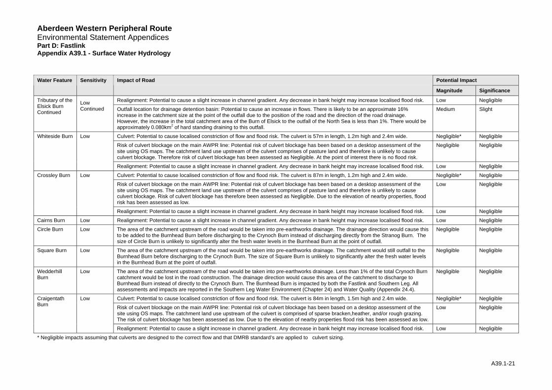
Realignment: Potential to cause a slight increase in channel gradient. Any decrease in bank height may increase localised flood risk. Low Negligible Tributary of the Elsick Burn Continued
Low Continued Outfall location for drainage detention basin: Potential to cause an increase in flows. There is likely to be an approximate 16%
increase in the catchment size at the point of the outfall due to the position of the road and the direction of the road drainage. However, the increase in the total catchment area of the Burn of Elsick to the outfall of the North Sea is less than 1%. There would be approximately 0.080km2 of hard standing draining to this outfall.
Medium Slight
Culvert: Potential to cause localised constriction of flow and flood risk. The culvert is 57m in length, 1.2m high and 2.4m wide. Negligible* Negligible
Risk of culvert blockage on the main AWPR line: Potential risk of culvert blockage has been based on a desktop assessment of the site using OS maps. The catchment land use upstream of the culvert comprises of pasture land and therefore is unlikely to cause culvert blockage. Therefore risk of culvert blockage has been assessed as Negligible. At the point of interest there is no flood risk.
Negligible Negligible
Whiteside Burn Low
Realignment: Potential to cause a slight increase in channel gradient. Any decrease in bank height may increase localised flood risk. Low Negligible
Culvert: Potential to cause localised constriction of flow and flood risk. The culvert is 87m in length, 1.2m high and 2.4m wide. Negligible* Negligible
Risk of culvert blockage on the main AWPR line: Potential risk of culvert blockage has been based on a desktop assessment of the site using OS maps. The catchment land use upstream of the culvert comprises of pasture land and therefore is unlikely to cause culvert blockage. Risk of culvert blockage has therefore been assessed as Negligible. Due to the elevation of nearby properties, flood risk has been assessed as low.
Low Negligible
Crossley Burn Low
Realignment: Potential to cause a slight increase in channel gradient. Any decrease in bank height may increase localised flood risk. Low Negligible
Cairns Burn Low Realignment: Potential to cause a slight increase in channel gradient. Any decrease in bank height may increase localised flood risk. Low Negligible
Circle Burn Low The area of the catchment upstream of the road would be taken into pre-earthworks drainage. The drainage direction would cause this to be added to the Burnhead Burn before discharging to the Crynoch Burn instead of discharging directly from the Stranog Burn. The size of Circle Burn is unlikely to significantly alter the fresh water levels in the Burnhead Burn at the point of outfall.
Negligible Negligible
Square Burn Low The area of the catchment upstream of the road would be taken into pre-earthworks drainage. The catchment would still outfall to the Burnhead Burn before discharging to the Crynoch Burn. The size of Square Burn is unlikely to significantly alter the fresh water levels in the Burnhead Burn at the point of outfall.
Negligible Negligible
Wedderhill Burn
Low The area of the catchment upstream of the road would be taken into pre-earthworks drainage. Less than 1% of the total Crynoch Burn catchment would be lost in the road construction. The drainage direction would cause this area of the catchment to discharge to Burnhead Burn instead of directly to the Crynoch Burn. The Burnhead Burn is impacted by both the Fastlink and Southern Leg. All assessments and impacts are reported in the Southern Leg Water Environment (Chapter 24) and Water Quality (Appendix 24.4).
Negligible Negligible
Culvert: Potential to cause localised constriction of flow and flood risk. The culvert is 84m in length, 1.5m high and 2.4m wide. Negligible* Negligible
Risk of culvert blockage on the main AWPR line: Potential risk of culvert blockage has been based on a desktop assessment of the site using OS maps. The catchment land use upstream of the culvert is comprised of sparse bracken,heather, and/or rough grazing. The risk of culvert blockage has been assessed as low. Due to the elevation of nearby properties flood risk has been assessed as low.
Low Negligible
Craigentath Burn
Low
Realignment: Potential to cause a slight increase in channel gradient. Any decrease in bank height may increase localised flood risk. Low Negligible
* Negligible impacts assuming that culverts are designed to the correct flow and that DMRB standard’s are applied to culvert sizing.
A39.1-21
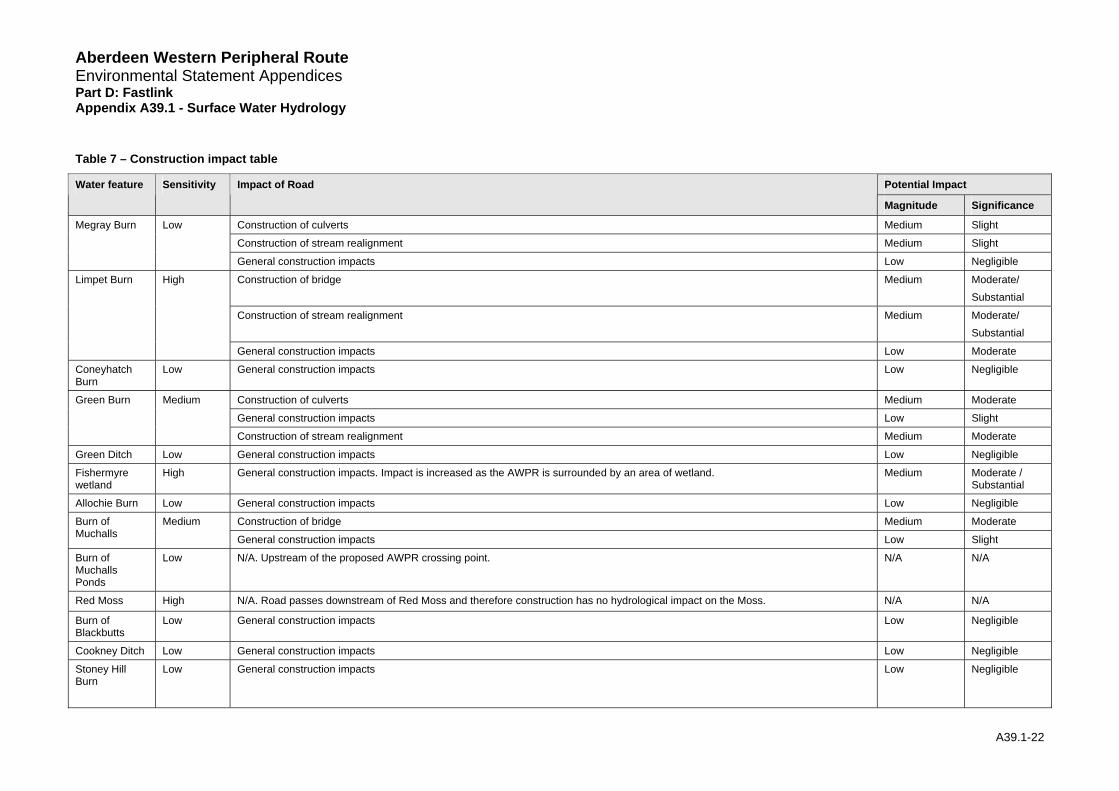
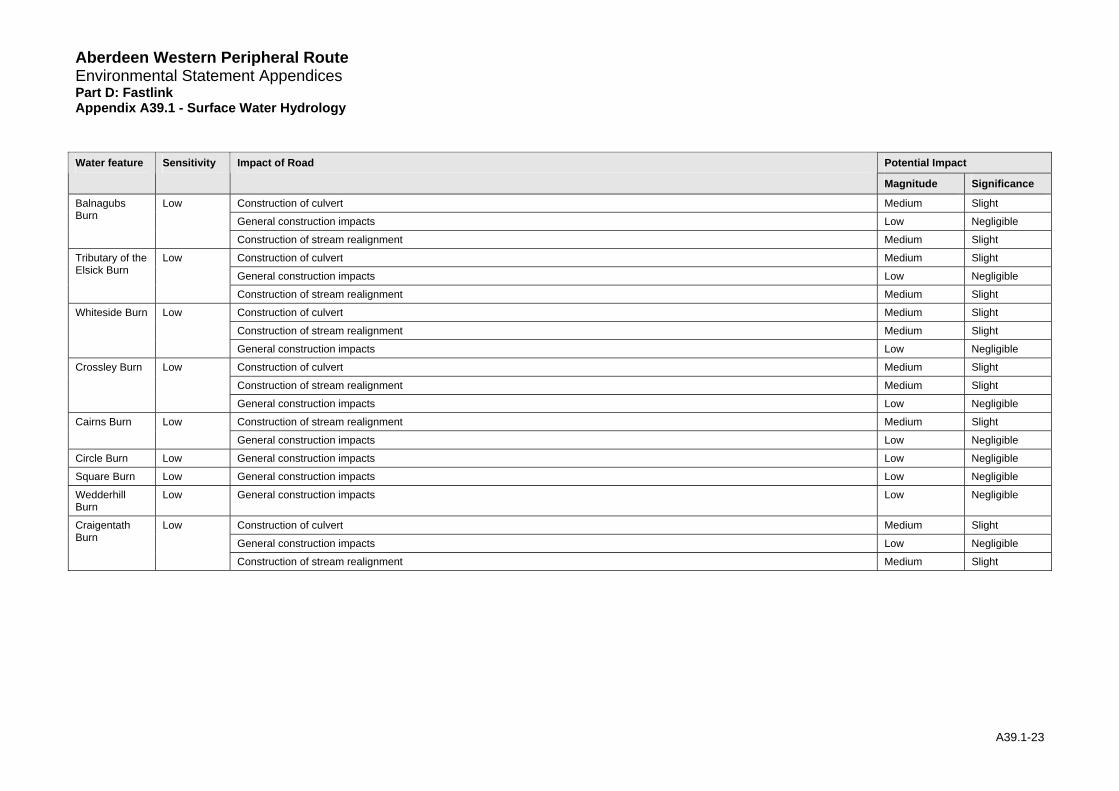
Aberdeen Western Peripheral Route Environmental Statement Appendices Part D: Fastlink Appendix A39.1 - Surface Water Hydrology Table 7 – Construction impact table
Potential Impact Water feature Sensitivity Impact of Road
Magnitude Significance
Construction of culverts Medium Slight
Construction of stream realignment Medium Slight
Megray Burn Low
General construction impacts Low Negligible
Construction of bridge Medium Moderate/ Substantial
Construction of stream realignment Medium Moderate/ Substantial
Limpet Burn High
General construction impacts Low Moderate
Coneyhatch Burn
Low General construction impacts Low Negligible
Construction of culverts Medium Moderate
General construction impacts Low Slight
Green Burn Medium
Construction of stream realignment Medium Moderate
Green Ditch Low General construction impacts Low Negligible
Fishermyre wetland
High General construction impacts. Impact is increased as the AWPR is surrounded by an area of wetland. Medium Moderate / Substantial
Allochie Burn Low General construction impacts Low Negligible
Construction of bridge Medium Moderate Burn of Muchalls
Medium
General construction impacts Low Slight
Burn of Muchalls Ponds
Low N/A. Upstream of the proposed AWPR crossing point. N/A N/A
Red Moss High N/A. Road passes downstream of Red Moss and therefore construction has no hydrological impact on the Moss. N/A N/A
Burn of Blackbutts
Low General construction impacts Low Negligible
Cookney Ditch Low General construction impacts Low Negligible
Stoney Hill Burn
Low General construction impacts Low Negligible
A39.1-22
Route
ndix A39.1 - Surface Water Hydrology
A39.1-23
Potential Impact Water feature Sensitivity Impact of Road
Magnitude Significance
Construction of culvert Medium Slight
General construction impacts Low Negligible
Balnagubs Burn
Low
Construction of stream realignment Medium Slight
Construction of culvert Medium Slight
General construction impacts Low Negligible
Tributary of the Elsick Burn
Low
Construction of stream realignment Medium Slight
Construction of culvert Medium Slight
Construction of stream realignment Medium Slight
Whiteside Burn Low
General construction impacts Low Negligible
Construction of culvert Medium Slight
Construction of stream realignment Medium Slight
Crossley Burn Low
General construction impacts Low Negligible
Construction of stream realignment Medium Slight Cairns Burn Low
General construction impacts Low Negligible
Circle Burn Low General construction impacts Low Negligible
Square Burn Low General construction impacts Low Negligible
Wedderhill Burn
Low General construction impacts Low Negligible
Construction of culvert Medium Slight
General construction impacts Low Negligible
Craigentath Burn
Low
Construction of stream realignment Medium Slight
Aberdeen Western Peripheral Environmental Statement Appendices Part D: Fastlink Appe
Aberdeen Western Peripheral Route Environmental Statement Appendices Part D: Fastlink Appendix A39.1 - Surface Water Hydrology
4.4 Scheme Summary
Operation Impacts
4.4.1 Throughout its operation, the road would generally affect the downstream flow regime, particularly where significant modification to overland flow paths is likely and where culvert upgrading is proposed. Adequately designed culverts are thought to have a Negligible impact on hydrological processes. However, there remains the potential risk of culvert blockage, this has been assessed separately and is detailed in the tables.
4.4.2 Adequately designed bridges with no in-channel supports are also thought to have a minimal impact on hydrological processes. However, the construction of abutments on the river banks has the potential to increase flood risk.
4.4.3 Based on the slope of the road, import and export of runoff from parts of other catchments may occur on a small scale. This transfer of water from one catchment to another could have significant impacts for small catchments over long periods of time.
4.4.4 During operation potential impacts of Substantial significance are anticipated for Fishermyre wetland. Potential impacts of Moderate/Substantial significance are anticipated for the Limpet Burn. Potential impacts of Moderate significance would be likely for Green Burn. Potential impacts on all remaining watercourses are considered to be of Slight or lesser significance.
4.4.5 The blockage of surface water runoff pathways to a small area of Fishermyre wetland has the potential to have an impact of Substantial significance.
4.4.6 Due to their connectivity, Green Burn and Burn of Blackbutts have the potential to have an impact on the Burn of Muchalls. Possible catchment impacts include increased or decreased catchment area draining to the Burn of Muchalls as a result of the road scheme. The Tributary of Elsick Burn is also fed by a number of watercourses, which would be impacted by the road scheme. Watercourses including the Stoneyhill Ditch, Balnagubs Burn, Whiteside Burn and Crossley Burn are all tributaries of the Tributary of Elsick Burn.
4.4.7 The catchment impacts resulting from changes to the drainage of these two watercourses are unlikely to significantly affect either the Burn of Muchalls or the Tributary of Elsick Burn due to the number of tributaries with confluences along their length.
Construction Impacts
4.4.8 Construction impacts are likely to be short-term impacts. Although short term, these impacts can still have significant consequences on the watercourses affected.
4.4.9 Potential impacts of Moderate/Substantial significance are anticipated for:
• Limpet Burn, and
• Fishermyre wetland.
4.4.10 Potential impacts of Moderate significance are considered for:
• Green Burn, and
• Burn of Muchalls.
4.4.11 Potential impacts on all remaining watercourses are considered to be of Slight or lesser significance.
A39.1-24
Aberdeen Western Peripheral Route Environmental Statement Appendices Part D: Fastlink Appendix A39.1 - Surface Water Hydrology 4.4.12 The construction impact on Limpet Burn has been classified as of Moderate/Substantial
significance due to its connectivity and role in the water balance to the fishery ponds further downstream. Any alteration in the hydrology of Limpet Burn could have associated impacts upon the water quality, geomorphology and ecology of the ponds further downstream. Similarly, construction impacts to Fishermyre wetland area have been classified as Moderate/Substantial significance. This is a consequence of the inherent the problems of working within wetland areas since the connectivity of surface water pathways to all areas of the wetland is important. Any alteration in the hydrology of Fishermyre wetland could have associated impacts on the water quality, geomorphology and ecology of the area. To assess the overall impact on the wetland area, the relationship with groundwater should also be considered (Geology, Contaminated Land and Groundwater: Appendix 38).
4.4.13 Catchment impacts due to the construction of the road network may affect the Burn of Muchalls and the Tributary of Elsick Burn as discussed. These catchment impacts are unlikely to significantly affect either the Burn of Muchalls or the Tributary of Elsick Burn due to number of tributaries with confluences along their length. Decreased or increased flow, for example, in one or two small watercourse is unlikely to be a major issue. Some tributaries of the Crynoch Burn (a Southern Leg assessed watercourse) would also be affected by construction of the Fastlink proposal and therefore catchment impacts on the Crynoch Burn may also occur. This has been considered within the Southern Leg of this Environmental Statement (Appendix A24.1).
5 Mitigation
5.1 Generic Mitigation
5.1.1 Mitigation measures are based on current good practice for highway drainage design, including the DMRB and guidance provided in Sustainable Urban Drainage Systems: design manual for Scotland and Northern Ireland CIRIA C521 (Construction Industry Research and Information Association (CIRIA), 2000). It is presumed that legal regulations and guidance as outlined in the Water Environment and Water Services (Scotland) Act 2003 and supported by the Controlled Activities Regulations (Scotland) 2005, and SPP7 are followed. These require that development is designed such that it does not materially increase pre-development flood risk.
5.1.2 Most impacts on surface water hydrology of the proposed AWPR and side roads are due to the operation of culverts, bridges, stream realignment, pre-earthworks and road drainage outfalls. These will be designed to current industry standards and legislation and where possible will be constructed in manner most suited to the watercourse characteristics at that point (see Fluvial Geomorphology A39.2). Other generic guidelines are set out in more detail below.
Operation Mitigation
5.1.3 Mitigation measures for areas with Slight to Substantial operational impact significance with respect to surface water hydrology are highlighted in Table 8.
Crossing Structures
5.1.4 Culvert and bridges will be designed to appropriate return period flows. SEPA requires that culverts are designed to the 0.5%AEP (200 year return period event). SPP7 states that this return period already includes an allowance for climate change consequently all culverts have been designed to this standard. Culvert design further includes a freeboard allowance of 300mm over the 0.5%AEP.
5.1.5 All culverts will be boxed depression invert culverts. There will be substrate added to the culvert bed, mammal ledges to allow the passage of animals and designed to facilitate fish passage. The design of the culverts follows guidance from the Scottish Executive on culverts and migratory fish (SEERAD 2000).
A39.1-25
Aberdeen Western Peripheral Route Environmental Statement Appendices Part D: Fastlink Appendix A39.1 - Surface Water Hydrology 5.1.6 Culvert and bridges will not impinge on floodplains, or obstruct flows nor easily catch debris and
become blocked. Newly installed culverts or bridges will not be smaller than any existing ones in the vicinity or upstream of the new road scheme (unless obviously over-designed). A regular maintenance regime will be set in place to prevent any blockages around culverts and bridge piers that could reduce the capacity of the structure. This may include the removal of debris, and dead vegetation, from the channel and the banks upstream of the structure.
5.1.7 The Burn of Muchalls and Limpet Burn bridge structures will be set back 5m from the bank top of the watercourse. This will occur in order to limit floodplain constriction and sediment connectivity with the watercourse during construction. This will mean that during the majority of flows the works will not impinge on the functioning of the watercourses.
Realignments
5.1.8 New alignments will maintain existing channel dimensions (width and depth) and where possible the overall length and gradient. Any existing storage areas within the realigned area will also be replaced to maintain the capacity of the watercourse, prevent flood risk and sustain connectivity to downstream areas. At sites of long realignments (greater than 50m watercourse length), where appropriate, a period of monitoring will be undertaken after construction to reassess the effects on flood risk.
Road Drainage
5.1.9 Road drainage and pre-earthworks must not enhance flood event runoff into streams compared to the pre-development situation and therefore will allow for storage and attenuation before outfall. This may be achieved within the road ditches and pipes or in specially designed storage basins (SUDS) to appropriate design return period flows. (Refer to the Water Quality Appendix A24.4 for more detail on the proposed SUDS detention basins and treatment ponds for this scheme).
5.1.10 Road drainage and pre-earthworks will be designed to minimise transfer of water across catchments. Outfalls will be located at frequent intervals to avoid the transfer of surface water from one catchment to another. The drainage system will avoid, where possible, storage / flooding of water on land next to the road on the upstream side of newly created embankments.
5.1.11 The proposed road drainage scheme consists of three stages, which ensure flood flows up to the 0.5%AEP (200 year event) are accounted for in the road drainage scheme (based on SPP7, which uses the 0.5%AEP as a guide to account for climate change). Any flows beyond the 0.5%AEP (200 year event) are not accounted for by the proposed road scheme. The components of the road drainage scheme are shown below:
• Filter drains: Flow from the road is proposed to be taken into filter drains at the edge of the road, which will flow into detention basins before out falling to the relevant watercourse. The filter drains will be designed to accommodate the 50% AEP (2 year flow) in order to account for climate change. The filter drains are further checked for surcharging for the 10% AEP (10 year flow) and therefore may be assessed as being designed to hold flows up to this point.
• Pre-earthwork ditches: Flow above the 10% AEP threshold up to the 1.33% AEP (75 year return period flow) will be taken into the pre-earthwork ditches, which will run parallel with the road. The pre-earthwork ditches are therefore designed to the 1.33% AEP as specified in the DMRB (reference HA106/04).
• Detention basins: The detention basins are designed to attenuate the 1% AEP (100 year return period even event) down to discharging the pre-development QMED flow (the pre-development QMED Greenfield runoff values is 4.3 l/s/ha). In order to account for climate change the basins are further checked to ensure the freeboard allowance allows the 0.5% AEP (200 year event) to be stored in the detention basin, prior to release. The road drainage design scheme has been designed to ensure where possible flows between the 1.33% AEP and the 0.5% AEP will flow either down the road or overspill along the ditches to the detention basins prior to out falling to the receiving watercourse.
A39.1-26
Aberdeen Western Peripheral Route Environmental Statement Appendices Part D: Fastlink Appendix A39.1 - Surface Water Hydrology
Construction Mitigation and Recommendations
5.1.12 Recommendations for areas with Slight to Substantial construction impact significance with respect to surface water hydrology are highlighted in Table 9.
5.1.13 General construction mitigation measures include;
• minimising the duration of construction,
• use of environmentally sensitive procedures, such as identification of the suitable construction corridors and stockpile areas, and minimise the number of such areas,
• avoid construction during periods of high flow to minimise flood risk,
• completion of regular checks around the site assessing the effects of surface runoff processes during and after rainfall events,
• extra care during periods of particularly low flow to ensure a supply of water to the immediate downstream reach,
• avoid the release of excessive sedimentation into the watercourses due to the impact on stream capacity and therefore flood risk and,
• construction equipment should be selected to ensure minimal damage to the watercourse and the surrounding catchment.
Crossing Structures
5.1.14 During culvert installation operations flow must be diverted around the works in a suitably sized channel to prevent blockages and flood risk.
5.1.15 Bridges which do not require in-channel works during installation are advantageous as they do not alter the flow regime of the watercourse and will help prevent increased flood risk or reduced downstream connectivity.
Temporary Realignments
5.1.16 Temporary watercourse realignments will be constructed to maintain channel dimensions (width and depth) and length where possible, so as not to alter the flow characteristics (depth / velocity) of the channel. Temporary storage of water will be prevented to maintain the supply of water downstream and minimise localised flood risk. Any temporary realignments, where possible, will be replaced back to their original dimensions after construction in the local area is complete
Road Drainage
5.1.17 During construction, appropriate temporary drainage systems will be designed to alleviate localised flood risk and prevent obstruction of surface runoff pathways. This may be achieved through the use of geotextile matting, ditches, or other methods detailed in the SUDS manual.
5.2 Site Specific Mitigation
5.2.1 In addition to these generic mitigation measures site specific operation and construction phase mitigation measures will be required as a result of local conditions and site specific factors. These site specific mitigation measures focus on watercourse crossings and re-alignments that have a sensitivity following the assessment of potential impacts of Slight to Substantial.
A39.1-27

Aberdeen Western Peripheral Route Environmental Statement Appendices Part D: Fastlink Appendix A39.1 - Surface Water Hydrology
Operation Mitigation
Table 8 – Surface Water Hydrology Mitigation Measures for the Operation
Water Feature Impact Mitigation Measure
Culvert Blockage Conduct regular maintenance on the culvert. Ensure culvert is clear of debris. Remove dead vegetation from banks upstream of the culvert.
Megray Burn
Increase in catchment area at outfall location
Provide road drainage (within design limits) to SUDS treatment with suitable outfall rate based on the QMED.
Bridge Avoid impinging on floodplain storage area or flood flows to ensure against an increased flood risk. At present this design is subject to further investigation.
Limpet Burn
Loss of catchment area Under assessment
Culvert Blockage Conduct regular maintenance on the culvert. Ensure culvert is clear of debris. Remove dead vegetation from banks upstream of the culvert.
Stream realignment Retain stream capacity, slope and channel roughness by naturalising bed sediment and planting of embankments.
Green Burn
Increase in catchment area at outfall location
Provide road drainage (within design limits) to SUDS treatment with suitable outfall rate based on the QMED.
Fishermyre wetland
Blockage of surface runoff pathways
Ensure a suitable supply of groundwater connectivity exists or provide connectivity between the upstream and downstream areas of the wetland.
Burn of Muchalls
Bridge Avoid impinging on floodplain storage area or flood flows to ensure against an increased flood risk.
Tributary of the Elsick Burn
Increase in catchment area at outfall location
Provide road drainage (within design limits) to SUDS treatment with suitable outfall rate based on the QMED.
* Receiving catchment is the main watercourse that is being drained to of the most sensitive catchment downstream of the point of interest.
Construction Mitigation
Table 9 – Surface Water Hydrology Mitigation Measures for the Construction
Water Feature Impact Mitigation Measure
Construction of culvert Minimise duration of construction. Avoid periods of high flow and extreme low flow. Maintain capacity of temporary channel to that of existing channel.
Megray Burn
Construction of stream realignment
Maintain watercourse slope. Ensure appropriate capacity to limit flood risk to existing position or betterment.
Construction of bridge
Minimise duration of construction. Avoid periods of high flow and extreme low flow. Construction footprint should not impinge on flood flows or on the floodplain.
Construction of stream realignment
Maintain watercourse slope. Ensure appropriate capacity to limit flood risk to existing position or betterment.
Limpet Burn
General construction impacts Minimise duration of construction. Avoid periods of high flow and extreme low flow. Keep construction corridors to a minimum. Avoid stock pilling of materials. Surface runoff pathways should be maintained at all times.
Construction of culvert
Minimise duration of construction. Avoid periods of high flow and extreme low flow. Maintain capacity of temporary channel to that of existing channel.
Construction of stream realignment
Maintain watercourse slope. Ensure appropriate capacity to limit flood risk to existing position or betterment.
Green Burn
General construction impacts Minimise duration of construction. Avoid periods of high flow and extreme low flow. Keep construction corridors to a minimum. Avoid stock pilling of materials. Surface runoff pathways should be maintained at all times.
A39.1-28
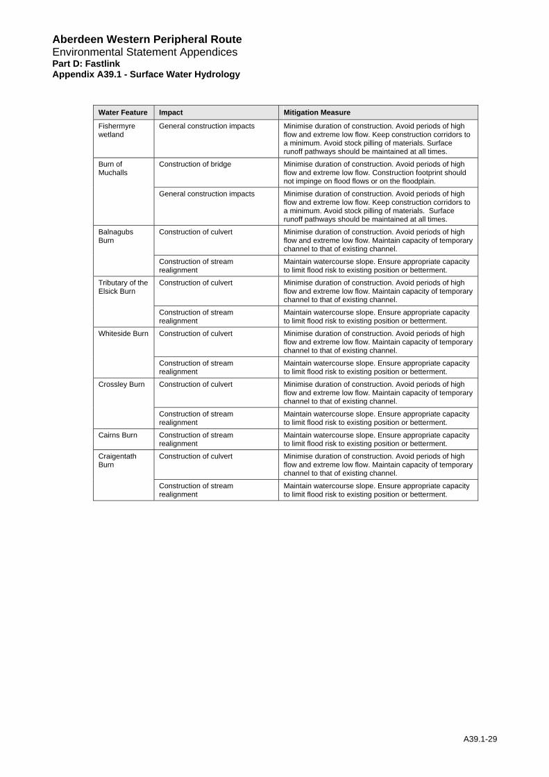
Aberdeen Western Peripheral Route Environmental Statement Appendices Part D: Fastlink Appendix A39.1 - Surface Water Hydrology
Water Feature Impact Mitigation Measure
Fishermyre wetland
General construction impacts Minimise duration of construction. Avoid periods of high flow and extreme low flow. Keep construction corridors to a minimum. Avoid stock pilling of materials. Surface runoff pathways should be maintained at all times.
Construction of bridge
Minimise duration of construction. Avoid periods of high flow and extreme low flow. Construction footprint should not impinge on flood flows or on the floodplain.
Burn of Muchalls
General construction impacts Minimise duration of construction. Avoid periods of high flow and extreme low flow. Keep construction corridors to a minimum. Avoid stock pilling of materials. Surface runoff pathways should be maintained at all times.
Construction of culvert Minimise duration of construction. Avoid periods of high flow and extreme low flow. Maintain capacity of temporary channel to that of existing channel.
Balnagubs Burn
Construction of stream realignment
Maintain watercourse slope. Ensure appropriate capacity to limit flood risk to existing position or betterment.
Construction of culvert Minimise duration of construction. Avoid periods of high flow and extreme low flow. Maintain capacity of temporary channel to that of existing channel.
Tributary of the Elsick Burn
Construction of stream realignment
Maintain watercourse slope. Ensure appropriate capacity to limit flood risk to existing position or betterment.
Construction of culvert Minimise duration of construction. Avoid periods of high flow and extreme low flow. Maintain capacity of temporary channel to that of existing channel.
Whiteside Burn
Construction of stream realignment
Maintain watercourse slope. Ensure appropriate capacity to limit flood risk to existing position or betterment.
Construction of culvert Minimise duration of construction. Avoid periods of high flow and extreme low flow. Maintain capacity of temporary channel to that of existing channel.
Crossley Burn
Construction of stream realignment
Maintain watercourse slope. Ensure appropriate capacity to limit flood risk to existing position or betterment.
Cairns Burn Construction of stream realignment
Maintain watercourse slope. Ensure appropriate capacity to limit flood risk to existing position or betterment.
Construction of culvert Minimise duration of construction. Avoid periods of high flow and extreme low flow. Maintain capacity of temporary channel to that of existing channel.
Craigentath Burn
Construction of stream realignment
Maintain watercourse slope. Ensure appropriate capacity to limit flood risk to existing position or betterment.
A39.1-29
Aberdeen Western Peripheral Environmental Statement Appendices Part D: Fastlink Appe
Route
ndix A39.1 - Surface Water Hydrology
A39.1-30
6.3.3 With the exception of the water features mentioned above, with adequate mitigation including environmentally sound construction practices the residual impacts of the proposed scheme are likely to be of Slight, Slight/Negligible or Negligible significance.
6.3.2 Similarly, residual impacts of Moderate/Substantial significance remain for Limpet Burn during the operational phase. Approximately 18% of the catchment is lost to the Megray and Green Burn as a result of the proposed drainage. Despite mitigation measures proposed in this location the
6.3.1 Following mitigation, the residual impact on Fishermyre wetland is considered to be of Moderate significance for both the operational and construction phases. The blocked surface water pathways and subsequent reduction in water supply are considered to remain significant with mitigation measures in place. Though the size of the area of the wetland affected is small and the impact on groundwater supply to the area Negligible, surface water remains an important component of the water supply to this sensitive habitat. This supply will be lost following the construction and operation of the road.
6.3 Scheme Summary
6.2.1 Catchment impacts upon the Burn of Muchalls and the Burn of Elsick were considered in the potential impact section. No impacts above a Slight significance are anticipated for either sub-catchment. Catchments impacts may further affect the Crynoch Burn, which has been assessed as a Southern Leg watercourse for consistency. Catchment impacts on the Crynoch Burn have therefore been assessed in the Southern Leg report.
6.2 Catchment Impacts
6.1.2 The construction residual impacts assuming the mitigation measures are implemented are shown in Table 11.
6.1.1 The operational residual impacts assuming the mitigation measures are implemented are shown in Table 10.
Construction Impacts
6.1 Site Specific Residual Impact Assessment
Operation Impacts
6 Residual Impacts
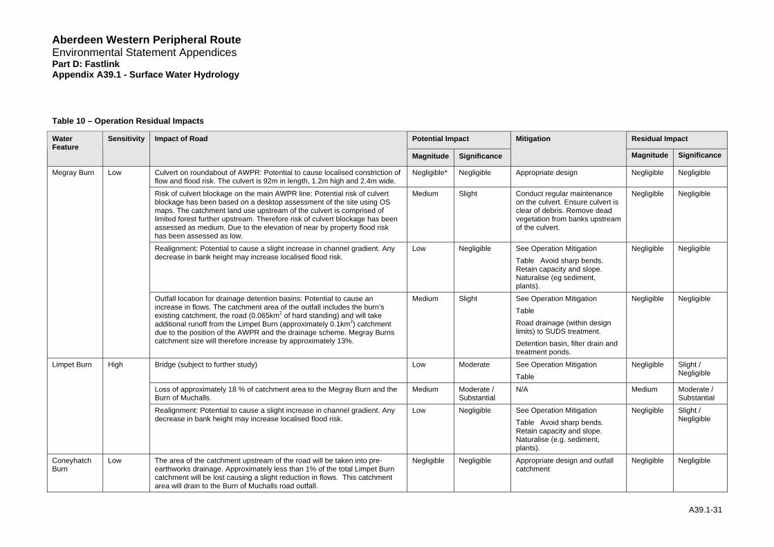
Aberdeen Western Peripheral Route Environmental Statement Appendices Part D: Fastlink Appendix A39.1 - Surface Water Hydrology
Table 10 – Operation Residual Impacts
Potential Impact Residual Impact Water Feature
Sensitivity Impact of Road
Magnitude Significance
Mitigation
Magnitude Significance
Culvert on roundabout of AWPR: Potential to cause localised constriction of flow and flood risk. The culvert is 92m in length, 1.2m high and 2.4m wide.
Negligible* Negligible Appropriate design Negligible Negligible
Risk of culvert blockage on the main AWPR line: Potential risk of culvert blockage has been based on a desktop assessment of the site using OS maps. The catchment land use upstream of the culvert is comprised of limited forest further upstream. Therefore risk of culvert blockage has been assessed as medium. Due to the elevation of near by property flood risk has been assessed as low.
Medium Slight Conduct regular maintenance on the culvert. Ensure culvert is clear of debris. Remove dead vegetation from banks upstream of the culvert.
Negligible Negligible
Realignment: Potential to cause a slight increase in channel gradient. Any decrease in bank height may increase localised flood risk.
Low Negligible See Operation Mitigation Table Avoid sharp bends. Retain capacity and slope. Naturalise (eg sediment, plants).
Negligible Negligible
Megray Burn Low
Outfall location for drainage detention basins: Potential to cause an increase in flows. The catchment area of the outfall includes the burn’s existing catchment, the road (0.065km2 of hard standing) and will take additional runoff from the Limpet Burn (approximately 0.1km2) catchment due to the position of the AWPR and the drainage scheme. Megray Burns catchment size will therefore increase by approximately 13%.
Medium Slight See Operation Mitigation Table Road drainage (within design limits) to SUDS treatment. Detention basin, filter drain and treatment ponds.
Negligible Negligible
Bridge (subject to further study) Low Moderate See Operation Mitigation Table
Negligible Slight / Negligible
Loss of approximately 18 % of catchment area to the Megray Burn and the Burn of Muchalls.
Medium Moderate / Substantial
N/A Medium Moderate / Substantial
Limpet Burn High
Realignment: Potential to cause a slight increase in channel gradient. Any decrease in bank height may increase localised flood risk.
Low Negligible See Operation Mitigation Table Avoid sharp bends. Retain capacity and slope. Naturalise (e.g. sediment, plants).
Negligible Slight / Negligible
Coneyhatch Burn
Low The area of the catchment upstream of the road will be taken into pre-earthworks drainage. Approximately less than 1% of the total Limpet Burn catchment will be lost causing a slight reduction in flows. This catchment area will drain to the Burn of Muchalls road outfall.
Negligible Negligible Appropriate design and outfall catchment
Negligible Negligible
A39.1-31

Aberdeen Western Peripheral Route Environmental Statement Appendices Part D: Fastlink Appendix A39.1 - Surface Water Hydrology
Potential Impact Residual Impact Water Feature
Sensitivity Impact of Road
Magnitude
Mitigation
Magnitude Significance Significance
Culvert on the main AWPR line: Potential to cause localised constriction of flow and flood risk. The culvert is 84m in length, 1.5m high and 3m wide.
Negligible* Negligible Appropriate design Negligible Negligible
Risk of culvert blockage on the main AWPR line: Potential risk of culvert blockage has been based on a desktop assessment of the site using OS maps. The catchment land use upstream of the culvert is comprised bracken, heather and/or rough grass. The risk of culvert blockage has been assessed as low. At the point of interest there is no flood risk.
Low Slight Conduct regular maintenance on the culvert. Ensure culvert is clear of debris. Remove dead vegetation from banks upstream of the culvert.
Negligible Negligible
Culvert on the realignment of the existing side road: Potential to localised constriction of flow and flood risk. The culvert is 19m in length,1.5 m high and 3m wide.
Negligible* Negligible Appropriate design Negligible Negligible
Risk of culvert blockage on the realignment of the existing side road : Potential risk of culvert blockage has been based on a desktop assessment of the site using OS maps. The catchment land use upstream of the culvert is comprised of bracken, heather and/or rough grass. The risk of culvert blockage has been assessed as low. At the point of interest there is no flood risk.
Low Slight Conduct regular maintenance on the culvert. Ensure culvert is clear of debris. Remove dead vegetation from banks upstream of the culvert.
Negligible Negligible
Realignment: Potential to cause a slight increase in channel gradient. Any decrease in bank height may increase localised flood risk.
Low Slight See Operation Mitigation Table Avoid sharp bends. Retain capacity and slope. Naturalise (eg sediment, plants).
Negligible Negligible
Green Burn Medium
Outfall location for drainage detention basin: Potential to cause an increase in flows. The catchment area of the outfall includes the existing catchment of the burn and the added catchment from the road(0.021km2 of hard standing) and will take additional flow from a severed area of the Limpet Burn catchment due to the position of the AWPR and the drainage scheme. This amounts to an approximate 0.2km2 (approximately 22%) increase in the catchment draining to the point of the road outfall.
Medium Moderate See Operation Mitigation Table Road drainage (within design limits) to SUDS treatment. Detention basin, filter drain and treatment ponds.
Negligible Negligible
Green Ditch Low The area of the catchment upstream of the road will be taken into pre-earthworks drainage. This catchment will still drain to Green Burn via the road drainage outfall.
Negligible Negligible Appropriate design and outfall catchment
Negligible Negligible
Fishermyre wetland
High Surface water prevented from draining to all areas of the wetland due to the development of the AWPR and associated drainage system. Approximately 2% of the wetland area will have the supply surface water runoff from the majority of the wetland blocked.
High Substantial Provide suitable connectivity through the AWPR. Maintain groundwater supplies (Geology, Contaminated Land and Ground Water: Chapter 38)
Low Moderate
Allochie Burn Low The area of the catchment upstream of the road will be taken into pre- Negligible Negligible Appropriate design and outfall Negligible Negligible
A39.1-32
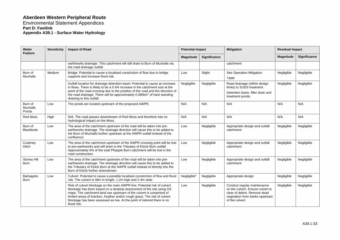
Aberdeen Western Peripheral Route Environmental Statement Appendices Part D: Fastlink Appendix A39.1 - Surface Water Hydrology
Potential Impact Residual Impact Water Feature
Sensitivity Impact of Road
Magnitude
Mitigation
Magnitude Significance Significance
earthworks drainage. This catchment will still drain to Burn of Muchalls via the road drainage outfall.
catchment
Bridge: Potential to cause a localised constriction of flow due to bridge supports and increase flood risk.
Low Slight See Operation Mitigation Table
Negligible Negligible Burn of Muchalls
Medium
Outfall location for drainage detention basin: Potential to cause an increase in flows. There is likely to be a 0.4% increase in the catchment size at the point of the road crossing due to the position of the road and the direction of the road drainage. There will be approximately 0.080km2 of hard standing draining to this outfall.
Negligible Negligible Road drainage (within design limits) to SUDS treatment. Detention basin, filter drain and treatment ponds.
Negligible Negligible
Burn of Muchalls Ponds
Low The ponds are located upstream of the proposed AWPR. N/A N/A N/A N/A N/A
Red Moss High N/A. The road passes downstream of Red Moss and therefore has no hydrological impact on the Moss.
N/A N/A N/A N/A N/A
Burn of Blackbutts
Low The area of the catchment upstream of the road will be taken into pre-earthworks drainage. The drainage direction will cause this to be added to the Burn of Muchalls further upstream at the AWPR outfall instead of the confluence
Low Negligible Appropriate design and outfall catchment
Negligible Negligible
Cookney Ditch
Low The area of the catchment upstream of the AWPR crossing point will be lost to pre-earthworks and will drain to the Tributary of Elsick Burn outfall. Approximately 6% of the total Pheppie Burn catchment will be lost in the road construction.
Low Negligible Appropriate design and outfall catchment
Negligible Negligible
Stoney Hill Burn
Low The area of the catchment upstream of the road will be taken into pre-earthworks drainage. The drainage direction will cause this to be added to the Tributary of Elsick Burn at the AWPR outfall instead of directly into the Burn of Elsick further downstream.
Low Negligible Appropriate design and outfall catchment
Negligible Negligible
Culvert: Potential to cause a possible localised constriction of flow and flood risk. The culvert is 48m in length, 1.2m high and 2.4m wide.
Negligible* Negligible Appropriate design Negligible Negligible Balnagubs Burn
Low
Risk of culvert blockage on the main AWPR line: Potential risk of culvert blockage has been based on a desktop assessment of the site using OS maps. The catchment land use upstream of the culvert is comprised of limited areas of bracken, heather and/or rough grass. The risk of culvert blockage has been assessed as low. At the point of interest there is no flood risk.
Low Negligible Conduct regular maintenance on the culvert. Ensure culvert is clear of debris. Remove dead vegetation from banks upstream of the culvert.
Negligible Negligible
A39.1-33
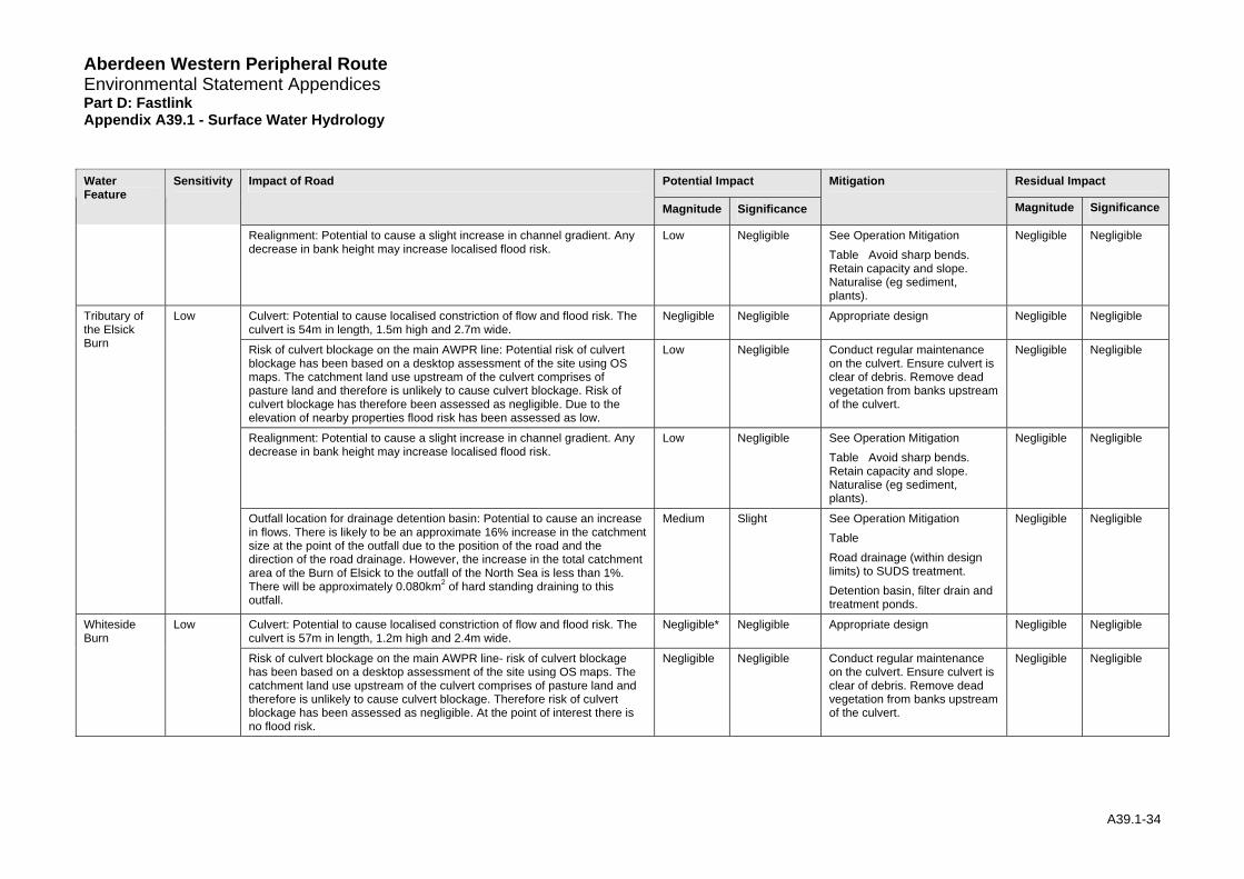
Aberdeen Western Peripheral Route Environmental Statement Appendices Part D: Fastlink Appendix A39.1 - Surface Water Hydrology
Potential Impact Residual Impact Water Feature
Sensitivity Impact of Road
Magnitude
Mitigation
Magnitude Significance Significance
Realignment: Potential to cause a slight increase in channel gradient. Any decrease in bank height may increase localised flood risk.
Low Negligible See Operation Mitigation Table Avoid sharp bends. Retain capacity and slope. Naturalise (eg sediment, plants).
Negligible Negligible
Culvert: Potential to cause localised constriction of flow and flood risk. The culvert is 54m in length, 1.5m high and 2.7m wide.
Negligible Negligible Appropriate design Negligible Negligible
Risk of culvert blockage on the main AWPR line: Potential risk of culvert blockage has been based on a desktop assessment of the site using OS maps. The catchment land use upstream of the culvert comprises of pasture land and therefore is unlikely to cause culvert blockage. Risk of culvert blockage has therefore been assessed as negligible. Due to the elevation of nearby properties flood risk has been assessed as low.
Low Negligible Conduct regular maintenance on the culvert. Ensure culvert is clear of debris. Remove dead vegetation from banks upstream of the culvert.
Negligible Negligible
Realignment: Potential to cause a slight increase in channel gradient. Any decrease in bank height may increase localised flood risk.
Low Negligible See Operation Mitigation Table Avoid sharp bends. Retain capacity and slope. Naturalise (eg sediment, plants).
Negligible Negligible
Tributary of the Elsick Burn
Low
Outfall location for drainage detention basin: Potential to cause an increase in flows. There is likely to be an approximate 16% increase in the catchment size at the point of the outfall due to the position of the road and the direction of the road drainage. However, the increase in the total catchment area of the Burn of Elsick to the outfall of the North Sea is less than 1%. There will be approximately 0.080km2 of hard standing draining to this outfall.
Medium Slight See Operation Mitigation Table Road drainage (within design limits) to SUDS treatment. Detention basin, filter drain and treatment ponds.
Negligible Negligible
Culvert: Potential to cause localised constriction of flow and flood risk. The culvert is 57m in length, 1.2m high and 2.4m wide.
Negligible* Negligible Appropriate design Negligible Negligible Whiteside Burn
Low
Risk of culvert blockage on the main AWPR line- risk of culvert blockage has been based on a desktop assessment of the site using OS maps. The catchment land use upstream of the culvert comprises of pasture land and therefore is unlikely to cause culvert blockage. Therefore risk of culvert blockage has been assessed as negligible. At the point of interest there is no flood risk.
Negligible Negligible Conduct regular maintenance on the culvert. Ensure culvert is clear of debris. Remove dead vegetation from banks upstream of the culvert.
Negligible Negligible
A39.1-34
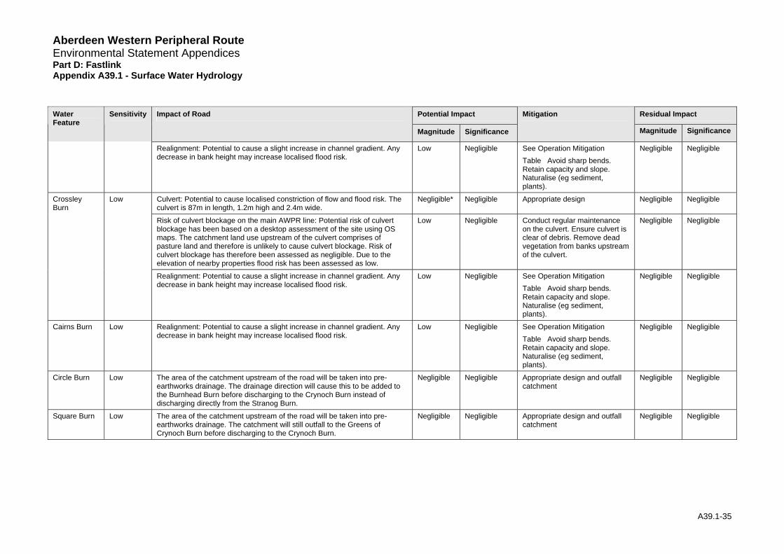
Aberdeen Western Peripheral Route Environmental Statement Appendices Part D: Fastlink Appendix A39.1 - Surface Water Hydrology
Potential Impact Residual Impact Water Feature
Sensitivity Impact of Road
Magnitude
Mitigation
Magnitude Significance Significance
Realignment: Potential to cause a slight increase in channel gradient. Any decrease in bank height may increase localised flood risk.
Low Negligible See Operation Mitigation Table Avoid sharp bends. Retain capacity and slope. Naturalise (eg sediment, plants).
Negligible Negligible
Culvert: Potential to cause localised constriction of flow and flood risk. The culvert is 87m in length, 1.2m high and 2.4m wide.
Negligible* Negligible Appropriate design Negligible Negligible
Risk of culvert blockage on the main AWPR line: Potential risk of culvert blockage has been based on a desktop assessment of the site using OS maps. The catchment land use upstream of the culvert comprises of pasture land and therefore is unlikely to cause culvert blockage. Risk of culvert blockage has therefore been assessed as negligible. Due to the elevation of nearby properties flood risk has been assessed as low.
Low Negligible Conduct regular maintenance on the culvert. Ensure culvert is clear of debris. Remove dead vegetation from banks upstream of the culvert.
Negligible Negligible
Crossley Burn
Low
Realignment: Potential to cause a slight increase in channel gradient. Any decrease in bank height may increase localised flood risk.
Low Negligible See Operation Mitigation Table Avoid sharp bends. Retain capacity and slope. Naturalise (eg sediment, plants).
Negligible Negligible
Cairns Burn Low Realignment: Potential to cause a slight increase in channel gradient. Any decrease in bank height may increase localised flood risk.
Low Negligible See Operation Mitigation Table Avoid sharp bends. Retain capacity and slope. Naturalise (eg sediment, plants).
Negligible Negligible
Circle Burn Low The area of the catchment upstream of the road will be taken into pre-earthworks drainage. The drainage direction will cause this to be added to the Burnhead Burn before discharging to the Crynoch Burn instead of discharging directly from the Stranog Burn.
Negligible Negligible Appropriate design and outfall catchment
Negligible Negligible
Square Burn Low The area of the catchment upstream of the road will be taken into pre-earthworks drainage. The catchment will still outfall to the Greens of Crynoch Burn before discharging to the Crynoch Burn.
Negligible Negligible Appropriate design and outfall catchment
Negligible Negligible
A39.1-35
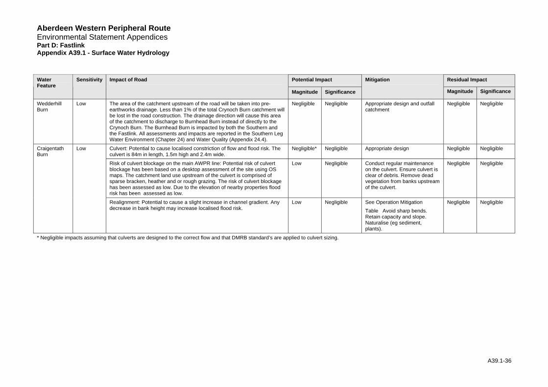
Aberdeen Western Peripheral Route Environmental Statement Appendices Part D: Fastlink Appendix A39.1 - Surface Water Hydrology
Potential Impact Residual Impact Water Feature
Sensitivity Impact of Road
Magnitude
Mitigation
Magnitude Significance Significance
Wedderhill Burn
Low The area of the catchment upstream of the road will be taken into pre-earthworks drainage. Less than 1% of the total Crynoch Burn catchment will be lost in the road construction. The drainage direction will cause this area of the catchment to discharge to Burnhead Burn instead of directly to the Crynoch Burn. The Burnhead Burn is impacted by both the Southern and the Fastlink. All assessments and impacts are reported in the Southern Leg Water Environment (Chapter 24) and Water Quality (Appendix 24.4).
Negligible Negligible Appropriate design and outfall catchment
Negligible Negligible
Culvert: Potential to cause localised constriction of flow and flood risk. The culvert is 84m in length, 1.5m high and 2.4m wide.
Negligible* Negligible Appropriate design Negligible Negligible
Risk of culvert blockage on the main AWPR line: Potential risk of culvert blockage has been based on a desktop assessment of the site using OS maps. The catchment land use upstream of the culvert is comprised of sparse bracken, heather and or rough grazing. The risk of culvert blockage has been assessed as low. Due to the elevation of nearby properties flood risk has been assessed as low.
Low
Craigentath Burn
Low
Negligible Conduct regular maintenance on the culvert. Ensure culvert is clear of debris. Remove dead vegetation from banks upstream of the culvert.
Negligible Negligible
Realignment: Potential to cause a slight increase in channel gradient. Any decrease in bank height may increase localised flood risk.
Low Negligible See Operation Mitigation Table Avoid sharp bends. Retain capacity and slope. Naturalise (eg sediment, plants).
Negligible Negligible
* Negligible impacts assuming that culverts are designed to the correct flow and that DMRB standard’s are applied to culvert sizing.
A39.1-36
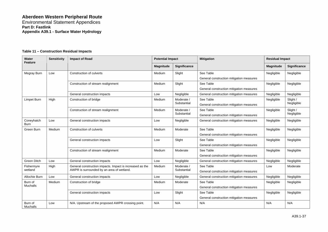
Aberdeen Western Peripheral Route Environmental Statement Appendices Part D: Fastlink Appendix A39.1 - Surface Water Hydrology
Table 11 – Construction Residual Impacts
Potential Impact Residual Impact Water Feature
Sensitivity Impact of Road
Magnitude Significance
Mitigation
Magnitude Significance
Construction of culverts Medium Slight See TableGeneral construction mitigation measures
Negligible Negligible
Construction of stream realignment Medium Slight See TableGeneral construction mitigation measures
Negligible Negligible
Megray Burn Low
General construction impacts Low Negligible General construction mitigation measures Negligible Negligible
Construction of bridge Medium Moderate / Substantial
See TableGeneral construction mitigation measures
Negligible Slight / Negligible
Limpet Burn High
Construction of stream realignment Medium Moderate / Substantial
See TableGeneral construction mitigation measures
Negligible Slight / Negligible
Coneyhatch Burn
Low General construction impacts Low Negligible General construction mitigation measures Negligible Negligible
Construction of culverts Medium Moderate See TableGeneral construction mitigation measures
Negligible Negligible
General construction impacts Low Slight See TableGeneral construction mitigation measures
Negligible Negligible
Green Burn Medium
Construction of stream realignment Medium Moderate See TableGeneral construction mitigation measures
Negligible Negligible
Green Ditch Low General construction impacts Low Negligible General construction mitigation measures Negligible Negligible
Fishermyre wetland
High General construction impacts. Impact is increased as the AWPR is surrounded by an area of wetland.
Medium Moderate / Substantial
See TableGeneral construction mitigation measures
Low Moderate
Allochie Burn Low General construction impacts Low Negligible General construction mitigation measures Negligible Negligible
Construction of bridge Medium Moderate See TableGeneral construction mitigation measures
Negligible Negligible Burn of Muchalls
Medium
General construction impacts Low Slight See TableGeneral construction mitigation measures
Negligible Negligible
Burn of Muchalls
Low N/A. Upstream of the proposed AWPR crossing point. N/A N/A N/A N/A N/A
A39.1-37

Aberdeen Western Peripheral Route Environmental Statement Appendices Part D: Fastlink Appendix A39.1 - Surface Water Hydrology
Potential Impact Residual Impact Water Feature
Sensitivity Impact of Road
Magnitude Significance
Mitigation
Magnitude Significance
Ponds
Red Moss High N/A. Road passes downstream of Red Moss and therefore construction has no hydrological impact on the Moss.
N/A N/A N/A N/A N/A
Burn of Blackbutts
Low General construction impacts Low Negligible General construction mitigation measures Negligible Negligible
Cookney Ditch Low General construction impacts Low Negligible General construction mitigation measures Negligible Negligible
Stoney Hill Burn
Low General construction impacts Low Negligible General construction mitigation measures Negligible Negligible
Construction of culvert Medium Slight See TableGeneral construction mitigation measures
Negligible Negligible
General construction impacts Low Negligible General construction mitigation measures Negligible Negligible
Balnagubs Burn
Low
Construction of stream realignment Medium Slight See TableGeneral construction mitigation measures
Negligible Negligible
Construction of culvert Medium Slight See TableGeneral construction mitigation measures
Negligible Negligible
General construction impacts Low Negligible General construction mitigation measures Negligible Negligible
Tributary of the Elsick Burn
Low
Construction of stream realignment Medium Slight See TableGeneral construction mitigation measures
Negligible Negligible
Construction of culvert Medium Slight See TableGeneral construction mitigation measures
Negligible Negligible Whiteside Burn
Low
Construction of stream realignment Medium Slight See Table General construction mitigation measures
Negligible Negligible
Construction of culvert Medium Slight See TableGeneral construction mitigation measures
Negligible Negligible Crossley Burn Low
Construction of stream realignment Medium Slight See TableGeneral construction mitigation measures
Negligible Negligible
Construction of stream realignment Medium Slight See TableGeneral construction mitigation measures
Negligible Negligible Cairns Burn Low
General construction impacts Low Negligible General construction mitigation measures Negligible Negligible
A39.1-38

Route
ndix A39.1 - Surface Water Hydrology
A39.1-39
Potential Impact Residual Impact Water Feature
Sensitivity Impact of Road
Magnitude Significance
Mitigation
Magnitude Significance
Circle Burn Low General construction impacts Low Negligible General construction mitigation measures Negligible Negligible
Square Burn Low General construction impacts Low Negligible General construction mitigation measures Negligible Negligible
Wedderhill Burn
Low General construction impacts Low Negligible General construction mitigation measures Negligible Negligible
Construction of culvert Medium Slight See TableGeneral construction mitigation measures
Negligible Negligible
General construction impacts Low Negligible General construction mitigation measures Negligible Negligible
Medium Construction of stream realignment Slight See TableGeneral construction mitigation measures
Negligible Negligible
Aberdeen Western Peripheral Environmental Statement Appendices Part D: Fastlink Appe
Craigentath Burn
Low
Aberdeen Western Peripheral Route Environmental Statement Appendices Part D: Fastlink Appendix A39.1 - Surface Water Hydrology
7 Appendix Summary
7.1.1 This technical appendix has focused on the degree to which the operation and construction of the Aberdeen Western Peripheral Route Fastlink will affect the surface water hydrology of the watercourses crossed by the scheme.
7.1.2 In total, the proposed Fastlink section of the proposed scheme would cross 19 watercourses and Fishermyre wetland. All of the watercourses along the proposed route are relatively small.
7.1.3 The baseline hydrological characteristics of the watercourses vary considerably, according to the size of the watercourse, the degree of anthropogenic modification, the role in water balance downstream, habitats within the watercourse and flood risk.
7.1.4 During operation, (permanent) impacts to surface water hydrology include; increased localised flood risk around culverts, bridges and realigned sections; an increase in supply to a catchment; decreased supply to a catchment or a change/blockage in surface water runoff pathways. During construction (temporary) similar impacts have been identified which may be more pronounced for a shorter time period.
7.1.5 Changes to catchment areas could be pronounced if there is an addition or reduction in the supply of water from several watercourses supplying the same catchment. In this instance it is necessary to consider impacts upon sub catchments, made up from a number of impacted watercourses. Within the Fastlink study area of the proposed scheme this is thought to be relevant for the Burn of Muchalls and the Burn of Elsick. However, with correct implementation and maintenance of mitigation measures, the impact of the proposed scheme on each watercourse will be limited and, as a result, any impacts upon these sub-catchments will have a negligible impact.
A39.1-40
Aberdeen Western Peripheral Route Environmental Statement Appendices Part D: Fastlink Appendix A39.1 - Surface Water Hydrology
8 References
Centre for Hydrology and Ecology, 2003. Hydrological Data United Kingdom: Hydrometric Register and Statistics, 1996-2000, Wallingford.
CIRIA, 2000. Sustainable Urban Drainage Systems: Design manual for Scotland and Northern Ireland, Report No CIRIA C521, Construction Industry Research and Information Association, London.
CIRIA (2004) Sustainable Drainage Systems – Hydraulic, Structural and Water Quality Advice CIRIA C609 Wilson, S. Bray, R and Cooper, P ISBN 0-86017-609-6
HR Wallingford, 1994. RIBAMAN, User Manual Version 1.22A. Wallingford
Institute of Hydrology, 1999. Flood Estimation Handbook Vol1-5 and associated software. Wallingford.
Institute of Hydrology, 1994. Flood estimation for small catchments. Report No IH124, Wallingford.
Maidment. D. R. 1993. Handbook of Hydrology. McGraw-Hill, Inc.
Price. D. J and McKenna. J. E. 2003. Climate Change: Review of Levels of Protection Offered by Flood Prevention Schemes UKCIP02 Update (2003). Environment Group Research Report.
Scottish Executive 2006. River Crossing and Migratory Fish: Design Guidance.
Scottish Environment Protection Agency. 2003. Managing River Habitats for Fisheries.
Scottish Executive ‘Scottish Planning Policy 2004. Scottish Planning Policy SPP 7: Planning and Flooding.
SEPA. 2005. The Water Environment (Controlled Activities) (Scotland) Regulations. A Practical Guide.
Sutcliffe. J. V.1978. A Guide to the Flood Studies Report. Institute of Hydrology Report No. 48.
The Highways Agency, Scottish Executive, Welsh Assembly Government, The Department for Regional Development Northern Ireland (2004). Design Manual for Roads and Bridges (DMRB) Volume 4, Section 2 “Drainage”.
Wilson. S. Bray. R. Cooper. P. 2004. Sustainable drainage systems. Hydraulic, structural and water quality advice (C609). CIRIA
Young A. R., Grew R. and Holmes M.G.R. 2003. Low Flows 2000: A national water resources assessment and decision support. Water Science and Technology, 48 (10).
A39.1-41
Aberdeen Western Peripheral Route Environmental Statement Appendices Part D: Fastlink Appendix A39.1 - Surface Water Hydrology
9 Glossary
AEP Annual exceedence probability
AREA Catchment Drainage Area (km2)
AWPR Aberdeen Western Peripheral Road
Baseflow is the continual contribution of groundwater to rivers and is an important source of flow between rainstorms.
BFIHOST Base Flow Index derived using the HOST classification.
FARL Index of Flood Attenuation due to Reservoirs and Lakes
FDC Flow Duration Curve - A cumulative frequency curve that shows the percentage of time that specified discharges are equalled or exceeded.
FEH Flood Estimation Handbook (see references(IH, 1999))
FFC Flood Frequency Curve – A graph showing the recurrence intervals (return periods) that floods of magnitude are equalled or exceeded
HOST Hydrology of Soil Types Classification
LF2000 Low Flows 2000
OS Ordnance Survey
QBAR Mean Annual Flood (m3/s)
Bankfull Flow: the bank is defined at the point where vegetation/soil cover obviously changes between water and air
QBF
Q Embankment-full Flow: the embankment (top of) is defined as the point where water would spill into wider areas (fields/road)
EBF
q green Greenfield runoff rate (l/s/ha)
3Qmean Mean Flow (m /s)
3QMED Median Annual Flood Flow (m /s) (flow with a 2 year return period)
3Q Flow that is expected to be exceeded 95% of the time (m /s) 95
Q-Tyr (eg Q-5yr) Flow associated with a T-year return period (eg 5-year flow)
SAAR 1961-90 standard-period average annual rainfall (mm)
SAC Special Area of Conservation
SPRHOST Standard Percentage Runoff (%) derived using HOST classification
SSSI Site of Special Scientific Interest
A39.1-42

Aberdeen Western Peripheral Route Environmental Statement Appendices Part D: Fastlink Appendix A39.1 - Surface Water Hydrology
SUDS Sustainable Urban Drainage Systems
URBEXT1990 FEH index of fractional urban extent for 1990.
V Velocity (m/s)
A39.1-43