“the bulanjao 2010 geo-tagged report”assets.survival-international.org/documents/176/aldaw...1...
TRANSCRIPT
1
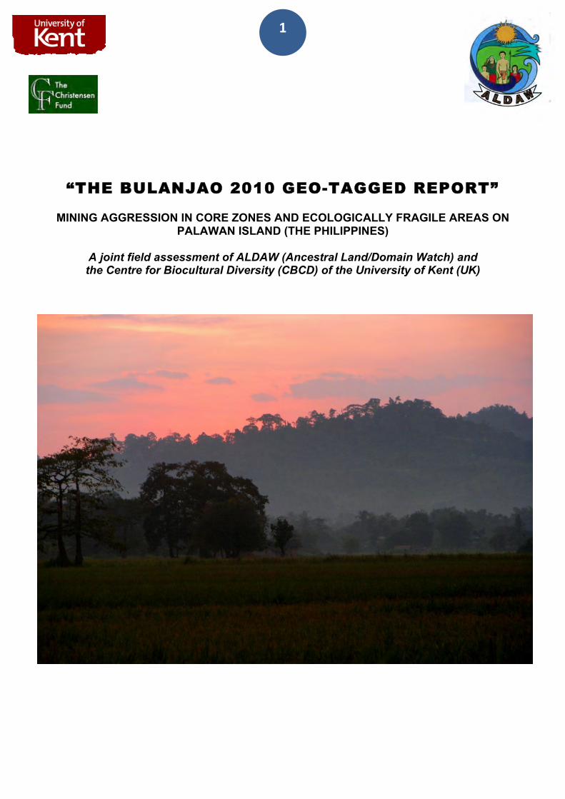
“THE BULANJAO 2010 GEO-TAGGED REPORT” MINING AGGRESSION IN CORE ZONES AND ECOLOGICALLY FRAGILE AREAS ON
PALAWAN ISLAND (THE PHILIPPINES)
A joint field assessment of ALDAW (Ancestral Land/Domain Watch) and the Centre for Biocultural Diversity (CBCD) of the University of Kent (UK)
2
INTRODUCTION Between the 13th and 15th of August 2009, a joined ALDAW-CBCD Mission1 traveled to Barangay Sumbiling, Municipality of Bataraza - to carry out audio-visual documentation in the Bulanjao range.
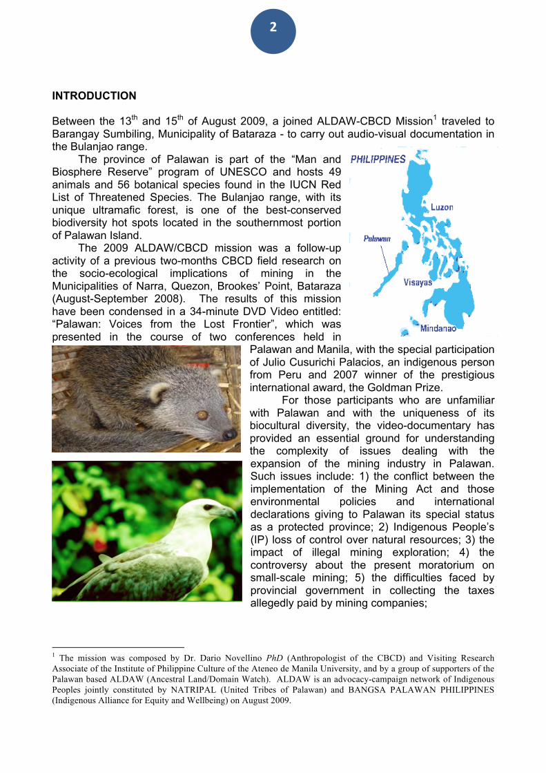
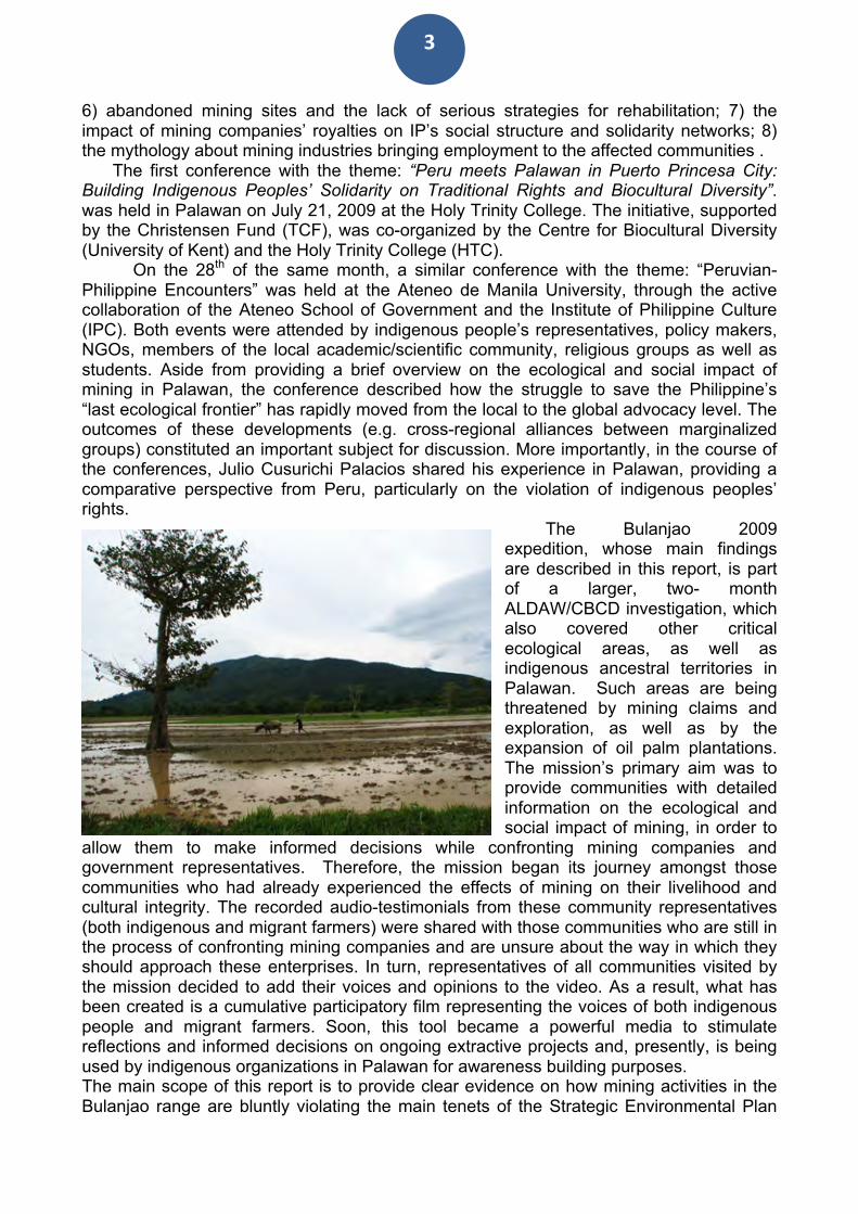
The province of Palawan is part of the “Man and Biosphere Reserve” program of UNESCO and hosts 49 animals and 56 botanical species found in the IUCN Red List of Threatened Species. The Bulanjao range, with its unique ultramafic forest, is one of the best-conserved biodiversity hot spots located in the southernmost portion of Palawan Island.
The 2009 ALDAW/CBCD mission was a follow-up activity of a previous two-months CBCD field research on the socio-ecological implications of mining in the Municipalities of Narra, Quezon, Brookes’ Point, Bataraza (August-September 2008). The results of this mission have been condensed in a 34-minute DVD Video entitled: “Palawan: Voices from the Lost Frontier”, which was presented in the course of two conferences held in
Palawan and Manila, with the special participation of Julio Cusurichi Palacios, an indigenous person from Peru and 2007 winner of the prestigious international award, the Goldman Prize.
For those participants who are unfamiliar with Palawan and with the uniqueness of its biocultural diversity, the video-documentary has provided an essential ground for understanding the complexity of issues dealing with the expansion of the mining industry in Palawan. Such issues include: 1) the conflict between the implementation of the Mining Act and those environmental policies and international declarations giving to Palawan its special status as a protected province; 2) Indigenous People’s (IP) loss of control over natural resources; 3) the impact of illegal mining exploration; 4) the controversy about the present moratorium on small-scale mining; 5) the difficulties faced by provincial government in collecting the taxes allegedly paid by mining companies;
1 The mission was composed by Dr. Dario Novellino PhD (Anthropologist of the CBCD) and Visiting Research Associate of the Institute of Philippine Culture of the Ateneo de Manila University, and by a group of supporters of the Palawan based ALDAW (Ancestral Land/Domain Watch). ALDAW is an advocacy-campaign network of Indigenous Peoples jointly constituted by NATRIPAL (United Tribes of Palawan) and BANGSA PALAWAN PHILIPPINES (Indigenous Alliance for Equity and Wellbeing) on August 2009.
3
6) abandoned mining sites and the lack of serious strategies for rehabilitation; 7) the impact of mining companies’ royalties on IP’s social structure and solidarity networks; 8) the mythology about mining industries bringing employment to the affected communities .
The first conference with the theme: “Peru meets Palawan in Puerto Princesa City: Building Indigenous Peoples’ Solidarity on Traditional Rights and Biocultural Diversity”. was held in Palawan on July 21, 2009 at the Holy Trinity College. The initiative, supported by the Christensen Fund (TCF), was co-organized by the Centre for Biocultural Diversity (University of Kent) and the Holy Trinity College (HTC).
On the 28th of the same month, a similar conference with the theme: “Peruvian-Philippine Encounters” was held at the Ateneo de Manila University, through the active collaboration of the Ateneo School of Government and the Institute of Philippine Culture (IPC). Both events were attended by indigenous people’s representatives, policy makers, NGOs, members of the local academic/scientific community, religious groups as well as students. Aside from providing a brief overview on the ecological and social impact of mining in Palawan, the conference described how the struggle to save the Philippine’s “last ecological frontier” has rapidly moved from the local to the global advocacy level. The outcomes of these developments (e.g. cross-regional alliances between marginalized groups) constituted an important subject for discussion. More importantly, in the course of the conferences, Julio Cusurichi Palacios shared his experience in Palawan, providing a comparative perspective from Peru, particularly on the violation of indigenous peoples’ rights.
The Bulanjao 2009 expedition, whose main findings are described in this report, is part of a larger, two- month ALDAW/CBCD investigation, which also covered other critical ecological areas, as well as indigenous ancestral territories in Palawan. Such areas are being threatened by mining claims and exploration, as well as by the expansion of oil palm plantations. The mission’s primary aim was to provide communities with detailed information on the ecological and social impact of mining, in order to
allow them to make informed decisions while confronting mining companies and government representatives. Therefore, the mission began its journey amongst those communities who had already experienced the effects of mining on their livelihood and cultural integrity. The recorded audio-testimonials from these community representatives (both indigenous and migrant farmers) were shared with those communities who are still in the process of confronting mining companies and are unsure about the way in which they should approach these enterprises. In turn, representatives of all communities visited by the mission decided to add their voices and opinions to the video. As a result, what has been created is a cumulative participatory film representing the voices of both indigenous people and migrant farmers. Soon, this tool became a powerful media to stimulate reflections and informed decisions on ongoing extractive projects and, presently, is being used by indigenous organizations in Palawan for awareness building purposes. The main scope of this report is to provide clear evidence on how mining activities in the Bulanjao range are bluntly violating the main tenets of the Strategic Environmental Plan
4
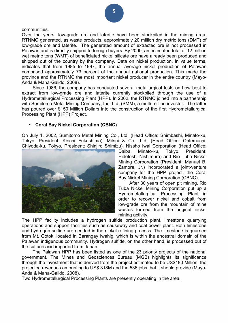
(SEP law) causing serious environmental damages such as landslides, progressive soil erosion and the deforestation of watersheds. As of now, Rio Tuba Nickel Mining Corporation (RTNMC) and its partner, Coral Bay Nickel Corporation (CBNC), have greatly influenced a move by the municipality of Bataraza to amend its own ECAN (Environmentally Critical Area Network) zoning plans with the sole purpose of allowing mining operations in the Bulanjao range. RTNMC and CBNC need to mine nickel ores as part of the expansion of their current Hydrometallurgical Processing Plant (HPP) project. These corporations have constantly invoked their so-called “vested rights” on account of their existing mining claims (Mayo-Anda & Mana-Galido, 2008).
The mission’s key findings are outlined through a selection of geo-tagged (or GPS
geo-referenced) photos showing the exact locations of those ecologically fragile areas in the Bulanjao range, which are being adversely impacted by mining activities. This report is organized in various sections. The first section provides background information on RTNMC and CBNC, and a brief history of the mining threats in the Bulanjao range. For this section, we wish to acknowledge the use of information contained in previous reports prepared by PNNI (Palawan NGO Network Inc) and by ELAC (Environmental Legal Assistance Centre). Friends of the Earth-Japan have kindly provided information on water analysis. Recommendations addressed to mining companies, government authorities and international institutions are contained in the final section. I) BACKGROUND INFORMATION
• Rio Tuba Nickel Mining Corporation (RTNMC) RTNMC is a Filipino-Japanese partnership exporting saprolyte ore to Japan and begun its nickel silicate ore exploration in 1967, completing its project feasibility study in July 1973. Overall, the RTNMC holds 5,265 hectares of which 353 hectares are currently being operated. Nickel deposit in Rio Tuba was discovered in 1967. On September 18, 1970,
the company entered into a Mining Lease Contract with the Republic of the Philippines, covering 126 hectares of public land or 110 Lode Mining claims of nickel, iron and other minerals located in Rio Tuba. Mine construction and development of the RTNMC commenced in 1975 and ore shipments to Japan began two years later (Mayo-Anda & Mana-Galido, 2008).
When the Philippine Mining Act was passed in 1995, the company applied for Mineral Production Sharing Agreement (MPSA) and, on December 11, 1997, it was granted an Environmental Compliance Certificate (ECC). Surprisingly, the RTNMC was able to get an ECC without satisfying the needed legal requirements and despite significant opposition raised by local
5
communities. Over the years, low-grade ore and laterite have been stockpiled in the mining area. RTNMC generated, as waste products, approximately 20 million dry metric tons (DMT) of low-grade ore and laterite. The generated amount of extracted ore is not processed in Palawan and is directly shipped to foreign buyers. By 2000, an estimated total of 12 million wet metric tons (WMT) of beneficiated nickel silicate ore have already been produced and shipped out of the country by the company. Data on nickel production, in value terms, indicates that from 1985 to 1997, the annual average nickel production of Palawan comprised approximately 73 percent of the annual national production. This made the province and the RTNMC the most important nickel producer in the entire country (Mayo-Anda & Mana-Galido, 2008).
Since 1986, the company has conducted several metallurgical tests on how best to extract from low-grade ore and laterite currently stockpiled through the use of a Hydrometallurgical Processing Plant (HPP). In 2002, the RTNMC joined into a partnership with Sumitomo Metal Mining Company, Inc. Ltd. (SMM), a multi-million investor. The latter has poured over $150 Million Dollars into the construction of the first Hydrometallurgical Processing Plant (HPP) Project.
• Coral Bay Nickel Corporation (CBNC) On July 1, 2002, Sumitomo Metal Mining Co., Ltd. (Head Office: Shimbashi, Minato-ku, Tokyo, President: Koichi Fukushima), Mitsui & Co., Ltd. (Head Office: Ohtemachi, Chiyoda-ku, Tokyo, President: Shinjiro Shimizu), Nissho Iwai Corporation (Head Office:
Daiba, Minato-ku, Tokyo, President: Hidetoshi Nishimura) and Rio Tuba Nickel Mining Corporation (President: Manuel B. Zamora, Jr.) incorporated a joint-venture company for the HPP project, the Coral Bay Nickel Mining Corporation (CBNC).
After 30 years of open pit mining, Rio Tuba Nickel Mining Corporation put up a Hydrometallurgical Processing Plant in order to recover nickel and cobalt from low-grade ore from the mountain of mine wastes formed from the original nickel mining activity.
The HPP facility includes a hydrogen sulfide production plant, limestone quarrying operations and support facilities such as causeway and coal power plant. Both limestone and hydrogen sulfide are needed in the nickel refining process. The limestone is quarried from Mt. Gotok, located in Barangay Iwahig, which is within the ancestral domain of the Palawan indigenous community. Hydrogen sulfide, on the other hand, is processed out of the sulfuric acid imported from Japan.
The Palawan HPP has been listed as one of the 23 priority projects of the national government. The Mines and Geosciences Bureau (MGB) highlights its significance through the investment that is derived from the project estimated to be US$180 Million, the projected revenues amounting to US$ 318M and the 536 jobs that it should provide (Mayo-Anda & Mana-Galido, 2008). Two Hydrometallurgical Processing Plants are presently operating in the area.
6
II) CLOSE UP ON BULANJAO
• Location The Bulanjao Range is situated on the southernmost tip of mainland Palawan and covers two municipalities; namely, Bataraza and Rizal. Its highest peak, at 1036 meters above sea level (masl), is located at around 8°36´16”N; & 117º22’10”E. The total land area is estimated at 40,000 to 50,000 hectares covering the highest peak down to the mangrove areas.
Land cover includes around 3,600 hectares of primary/natural and secondary forest classified as core zone at 500-1000 masl, with patches of opened areas for kaingin (swidden cultivation) and other agricultural land with mixed crops, patches of fallow-land under natural regeneration and mangroves. A total of six (6) major rivers from the mountain range supply water to both migrant and indigenous population. Four (4) of these major rivers are located in the eastern side of the municipality of Bataraza, while the remaining two (2) are located in the western side of the mountain range, in the municipality of Rizal.
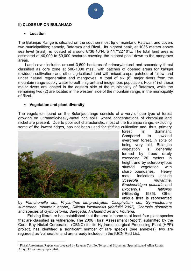
• Vegetation and plant diversity The vegetation found on the Bulanjao range consists of a very unique type of forest growing on ultramafic/heavy-metal rich soils, where concentrations of chromium and nickel are present. Due to poor soil characteristic, most of the Bulanjao range, excluding some of the lowest ridges, has not been used for shifting cultivation and, thus, primary
forest is dominant. Compared to lowland evergreen forest, in spite of being very old, Bulanjao vegetation is generally formed by trees rarely exceeding 20 meters in height and by sclerophyllous stunted vegetation with sharp boundaries. Heavy metal indicators include Scaevola micrantha, Brackenridgea palustris and Exocarpus latifolius (Hilleshög 1985). Other unique flora is represented
by Planchonella sp., Phylanthus lamprophyllus, Calophyllum sp., Gymnostomma sumatrana (mountain agoho), Dillenia luzoniensis (Madulid 2002), Ochrosia glomerata and species of Gymnostoma, Suregada, Archidendron and Pouteria.
Existing literature has established that the area is home to at least four plant species that are classified as vulnerable. The 2006 Floral Assessment Report2, submitted by the Coral Bay Nickel Corporation (CBNC) for its Hydrometallurgical Processing Plant (HPP) project, has identified a significant number of rare species (see annexes); two are regarded as ‘vulnerable’ and are already included in the IUCN Red List.
2 Floral Assessment Report was prepared by Reymar Castillo, Terrestrial Ecosystem Specialist, and Allan Romas Artajo, Flora Survey Specialist,
7
• Legal Status
Under Republic Act No. 7611 or Strategic Environmental Plan for Palawan (SEP), all natural forests form part of the terrestrial core zone or areas of maximum protection. Section 9 of the SEP law prohibits mining activities in areas identified as CORE ZONES and RESTRICTED USE ZONES. The core zone is the area of maximum protection and shall be free of human disruption. “This includes all types of natural forest, including first growth and residual forest, edges of intact forest, endangered habitats and habitats of endangered and rare species”. Tribal communities may be allowed entry into the core zone to enable them to gather forest products for ceremonial and medicinal purposes. The restricted use zone generally surrounds the core zone and provides a protective barrier. Limited and non-consumptive activities may be allowed in this area.
Consistent with this policy, the Environmentally Critical Areas Network (ECAN) map of the municipality of Bataraza has identified Mt. Bulanjao as a core zone. This consideration, by itself, justifies its prioritization for intervention. Thus, under existing SEP law, RTNMC is not allowed to undertake mining operations in Mt. Bulanjao. In fact, one of the conditions specified in the Environmental Compliance Certificate (ECC) issued to RTNMC and CBNC, in 2002, is that core zones - as identified by ECAN - should not be included in the areas of mining operations.
• Human Population and Indigenous Communities
The Bulanjao range is home to thirteen (13) barangays, eight (8) of which are part of
the municipality of Bataraza while the remaining five (5) are part of the municipality of Rizal. The combined population of 25,000 individuals, which is equivalent to 40% of the total combined population of the two municipalities, is dominated by the Palawan
indigenous group. Since the area is not spared from the influx of migrants, a significant portion of the population consists of a combination of migrants from various provinces of Luzon, Visayas, and Mindanao.
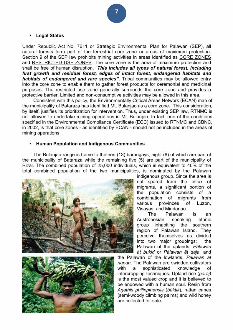
The Palawan is an Austronesian speaking ethnic group inhabiting the southern region of Palawan Island. They perceive themselves as divided into two major groupings: the Pälawan of the uplands, Pälawan ät bukid or Pälawan ät daja, and
the Pälawan of the lowlands, Pälawan ät napan. The Palawan are swidden cultivators with a sophisticated knowledge of intercropping techniques. Upland rice (paräj) is the most valued crop and it is believed to be endowed with a human soul. Resin from Agathis philippinensis (bäktik), rattan canes (semi-woody climbing palms) and wild honey are collected for sale.
8
They also collect starch (natäk) from wild palms and this represents an emergency source of energy. Wild pig, bjäk, is the preferred game and its catch is usually preceded by a request to the ‘master’ of the animal game. Also bees are imagined to have their own master who dwells in the upper-world, and can only be seen by the baljan (shaman) during trance. The more settled Palawan also engage in the cultivation of wet rice, coconut for commercial purposes, raise domestic animals such as caws, buffalos and pigs. Since immemorial time, the Bulanjao range has represented an important foraging and hunting ground for the surrounding Palawan communities. During El Niño, Bulanjao forest has provided local community with a safety net against widespread starvation, thanks to the abundance of wild food and potable water
• Selected statements by indigenous Palawan “There has been much destruction in these mountains, now the land is wounded. If a person is wounded, the blood comes out of the body, and he becomes weaker and weaker. ...The rocks are the bones of the land, the trees are the hairs. When the rocks became exposed, it is like when human bones are exposed... If there is a wound in the world, rice will not grow well”. Murinä, a Palawan from Canipaan, Municipality of Rizal
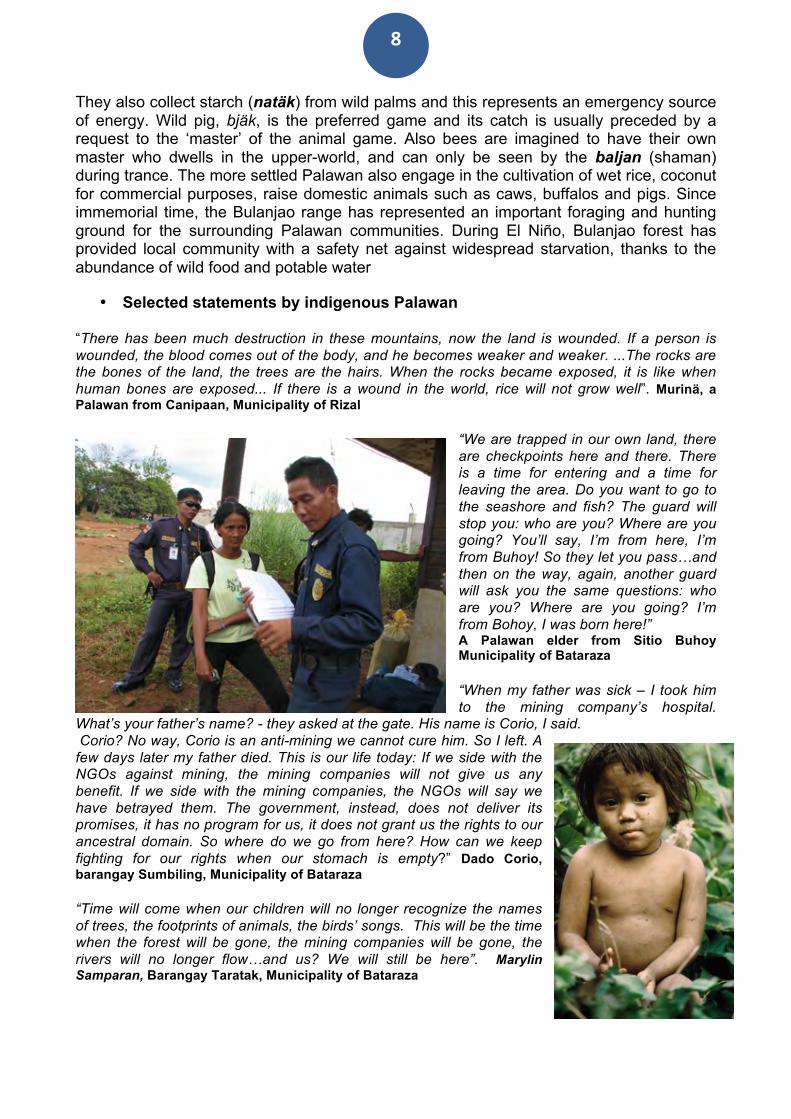
“We are trapped in our own land, there are checkpoints here and there. There is a time for entering and a time for leaving the area. Do you want to go to the seashore and fish? The guard will stop you: who are you? Where are you going? You’ll say, I’m from here, I’m from Buhoy! So they let you pass…and then on the way, again, another guard will ask you the same questions: who are you? Where are you going? I’m from Bohoy, I was born here!” A Palawan elder from Sitio Buhoy Municipality of Bataraza “When my father was sick – I took him to the mining company’s hospital.
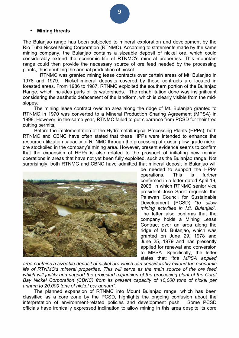
What’s your father’s name? - they asked at the gate. His name is Corio, I said. Corio? No way, Corio is an anti-mining we cannot cure him. So I left. A few days later my father died. This is our life today: If we side with the NGOs against mining, the mining companies will not give us any benefit. If we side with the mining companies, the NGOs will say we have betrayed them. The government, instead, does not deliver its promises, it has no program for us, it does not grant us the rights to our ancestral domain. So where do we go from here? How can we keep fighting for our rights when our stomach is empty?” Dado Corio, barangay Sumbiling, Municipality of Bataraza “Time will come when our children will no longer recognize the names of trees, the footprints of animals, the birds’ songs. This will be the time when the forest will be gone, the mining companies will be gone, the rivers will no longer flow…and us? We will still be here”. Marylin Samparan, Barangay Taratak, Municipality of Bataraza
9
• Mining threats The Bulanjao range has been subjected to mineral exploration and development by the Rio Tuba Nickel Mining Corporation (RTNMC). According to statements made by the same mining company, the Bulanjao contains a sizeable deposit of nickel ore, which could considerably extend the economic life of RTNMC’s mineral properties. This mountain range could then provide the necessary source of ore feed needed by the processing plants, thus doubling the annual production of nickel.
RTNMC was granted mining lease contracts over certain areas of Mt. Bulanjao in 1978 and 1979. Nickel mineral deposits covered by these contracts are located in forested areas. From 1986 to 1987, RTNMC exploited the southern portion of the Bulanjao Range, which includes parts of its watersheds. The rehabilitation done was insignificant considering the aesthetic defacement of the landform, which is clearly visible from the mid-slopes.
The mining lease contract over an area along the ridge of Mt. Bulanjao granted to RTNMC in 1970 was converted to a Mineral Production Sharing Agreement (MPSA) in 1998. However, in the same year, RTNMC failed to get clearance from PCSD for their tree cutting permits.
Before the implementation of the Hydrometallurgical Processing Plants (HPPs), both RTNMC and CBNC have often stated that these HPPs were intended to enhance the resource utilization capacity of RTNMC through the processing of existing low-grade nickel ore stockpiled in the company’s mining area. However, present evidence seems to confirm that the expansion of HPPs is also related to the prospect of initiating new mining operations in areas that have not yet been fully exploited, such as the Bulanjao range. Not surprisingly, both RTNMC and CBNC have admitted that mineral deposit in Bulanjao will
be needed to support the HPPs operations. This is further confirmed in a letter dated April 19, 2006, in which RTNMC senior vice president Jose Saret requests the Palawan Council for Sustainable Development (PCSD) “to allow mining activities in Mt. Bulanjao”. The letter also confirms that the company holds a Mining Lease Contract over an area along the ridge of Mt. Bulanjao, which was granted on June 29, 1978 and June 25, 1979 and has presently applied for renewal and conversion to MPSA. Specifically, the letter states that: “the MPSA applied
area contains a sizeable deposit of nickel ore which can considerably extend the economic life of RTNMC’s mineral properties. This will serve as the main source of the ore feed which will justify and support the projected expansion of the processing plant of the Coral Bay Nickel Corporation (CBNC) from its present capacity of 10,000 tons of nickel per annum to 20,000 tons of nickel per annum”.
The planned expansion of RTNMC into Mount Bulanjao range, which has been classified as a core zone by the PCSD, highlights the ongoing confusion about the interpretation of environment-related policies and development push. Some PCSD officials have ironically expressed inclination to allow mining in this area despite its core
10
zone classification. Interestingly enough, the PCSD has been criticized in the past for allowing environmentally sensitive projects in clear violation of the SEP strategy and despite contrary recommendations by technical studies conducted by its staff (Mayo-Anda & Mana-Galido 2008).
Reference to Bulanjao range as a potentially valuable mining site is also found on the website of overseas companies (http://www.miningnerds.com/stock/mbmi-resources--inc-cdnx). For instance, MBMI Resources, Inc., a company based in Vancouver, Canada states that it “holds joint venture interests in Alpha nickel property, a 3,277 hectare property located in Palawan, the Philippines, as well as in Olympic Group of properties, which include Bethlehem, Mt. Bulanjao, and Malatgao properties located in Palawan, the Philippines”. MBMI Resources Inc. is an exploration stage company, engaged in the acquisition, exploration, and development of mineral properties in the Philippines.
• Evidences of water contamination
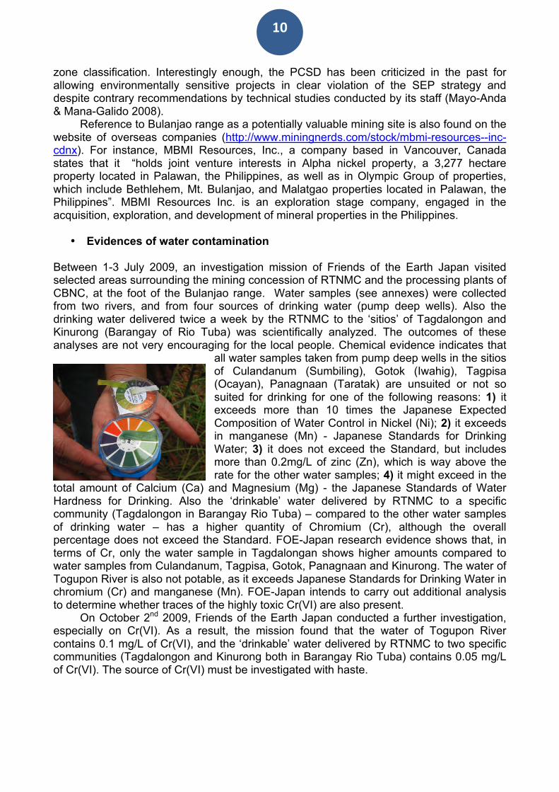
Between 1-3 July 2009, an investigation mission of Friends of the Earth Japan visited selected areas surrounding the mining concession of RTNMC and the processing plants of CBNC, at the foot of the Bulanjao range. Water samples (see annexes) were collected from two rivers, and from four sources of drinking water (pump deep wells). Also the drinking water delivered twice a week by the RTNMC to the ‘sitios’ of Tagdalongon and Kinurong (Barangay of Rio Tuba) was scientifically analyzed. The outcomes of these analyses are not very encouraging for the local people. Chemical evidence indicates that
all water samples taken from pump deep wells in the sitios of Culandanum (Sumbiling), Gotok (Iwahig), Tagpisa (Ocayan), Panagnaan (Taratak) are unsuited or not so suited for drinking for one of the following reasons: 1) it exceeds more than 10 times the Japanese Expected Composition of Water Control in Nickel (Ni); 2) it exceeds in manganese (Mn) - Japanese Standards for Drinking Water; 3) it does not exceed the Standard, but includes more than 0.2mg/L of zinc (Zn), which is way above the rate for the other water samples; 4) it might exceed in the
total amount of Calcium (Ca) and Magnesium (Mg) - the Japanese Standards of Water Hardness for Drinking. Also the ‘drinkable’ water delivered by RTNMC to a specific community (Tagdalongon in Barangay Rio Tuba) – compared to the other water samples of drinking water – has a higher quantity of Chromium (Cr), although the overall percentage does not exceed the Standard. FOE-Japan research evidence shows that, in terms of Cr, only the water sample in Tagdalongan shows higher amounts compared to water samples from Culandanum, Tagpisa, Gotok, Panagnaan and Kinurong. The water of Togupon River is also not potable, as it exceeds Japanese Standards for Drinking Water in chromium (Cr) and manganese (Mn). FOE-Japan intends to carry out additional analysis to determine whether traces of the highly toxic Cr(VI) are also present.
On October 2nd 2009, Friends of the Earth Japan conducted a further investigation, especially on Cr(VI). As a result, the mission found that the water of Togupon River contains 0.1 mg/L of Cr(VI), and the ‘drinkable’ water delivered by RTNMC to two specific communities (Tagdalongon and Kinurong both in Barangay Rio Tuba) contains 0.05 mg/L of Cr(VI). The source of Cr(VI) must be investigated with haste.
11
• Local Government and the Palawan Council for Sustainable Development (PCSD)
Resolution no. 1 of Bataraza Municipality was passed on January 2006 which integrated the ECAN map into the municipal Comprehensive Land and Water Use Plan (CLWUP), hence declaring Mt. Bulanjao closed to mining. However, two months later, the proposed mining activities in Bulanjao gained the support of the Bataraza municipal council. This resulted in the enactment of municipal resolution no. 30 on March 14, requesting the PCSD to amend the ECAN map, in order to allow mining activities in Mt. Bulanjao. On 19 April, of the same year, RTNMC filed a request to PCSD to allow their mining operations in the said mountain range. However, the Committee on Environment of PCSD turned down the said resolution for the failure of the proponent LGU to convince the Committee on the need to amend the ECAN zone.
Overall, the way in which PCSD has been dealing with mining applications indicate that the council has been generally supportive of the mining industry. In fact, there were several cases wherein the PCSD would just fast track the approval of the proposed projects (e.g. application for cutting permit, exploration, commercial mining, etc.) without extensive deliberation. For instance, PCSD failed to give the civil society enough time to raise its opposition on the establishment of the Hydrometallurgical Processing Plants Plant no. 2 and quickly approved the proposal (Mayo-Anda & Mana-Galido, 2008).
• Local opposition
Overall, PNNI, ELAC and local indigenous organizations (NATRIPAL and Bangsa Palawan Philippines) have appealed to various pieces of legislation to question the way in which mining activities are being carried out by both RTNMC and CBNC. Such laws and regulations include Philippine Environmental Impact Statement System and its guidelines; National Caves and Caves Resources Management and Protection Act (Republic Act No. 9072); Strategic Environmental Plan (“SEP”) for Palawan (Republic Act No. 7611), and the SEP's Guidelines on the Environmentally Critical Areas Network (“ECAN”); Philippine Clean Air Act of 1999 (Republic Act No. 8749); Toxic Substances and Hazardous and Nuclear Wastes Control Act of 1990 (Republic Act No. 6969) and its Implementing Rules and Regulations; Forestry Code (Presidential Decree No. 705, as amended); and National Integrated Protected Areas System (Republic Act No. 7586).
As of now, the implementation and operation of the two existing HPP plants has not been able to comply with existing environmental policies and standards. In addition to this, both RTNMC and CBNC have not been able to provide a cost-benefit analysis on the potential health and environmental costs of the HPP project vis-à-vis its economic benefits.
Recently, the indigenous organization, Bangsa Palawan Philippines has lodged a complaint before the PCSD committee questioning the lack of consultation with respect to the approval of the municipal resolution requesting the amendment of the ECAN map to allow mining activities in Mt. Bulanjao. Such resolution was passes without any form of participatory consultation with the indigenous and migrant farmers communities of Taratak and Sumbiling.
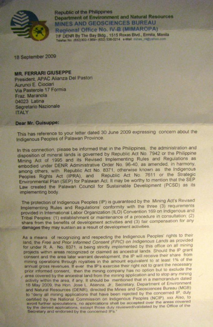
On 18 September 2009, in response to various letters of concern send by different organizations adhering to the 2009 ALDAW/Survival International Campaign for Palawan, Mr Roland A. De Jesus regional director of the DENR Mines and Geosciences Bureau wrote: “…Rio Tuba Nickel Mining Corporation (RTNMC)’s Application for Mineral Agreement denominated as AMA-IVB- 144 situated in the Bulanjao Range is actually a renewal and conversion (into MPSA) of its expired Mining Lease Contracts. The area had already been subjected to exploration and mining activities since 1976 until the early
12
1990’s. Such being the case, the said company is vested with prior rights even before the implementation of the IPRA” (see annexes). Mr De Jesus’s clarification implies that RTNMC activities in Bulanjao do not need to abide to the standards and rules enshrined in the IPRA law and, thus, the environmental plundering of this highly diverse ecological area can continue unabated. Again, under the updated Environmentally Critical Areas Network (ECAN) Map of the Palawan Council for Sustainable Development (PCSD), the Bulanjao range still lays within the non-allowable areas. III) GEO-REFERENCED MISSION’S FINDINGS
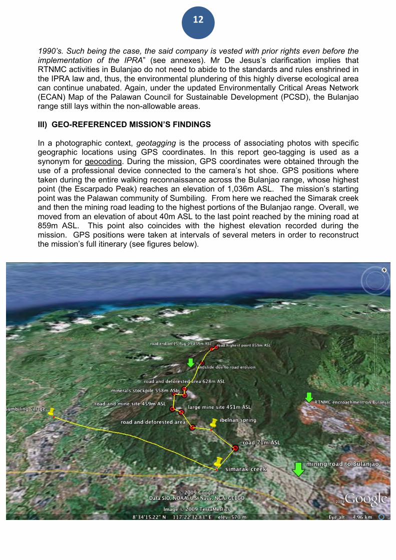
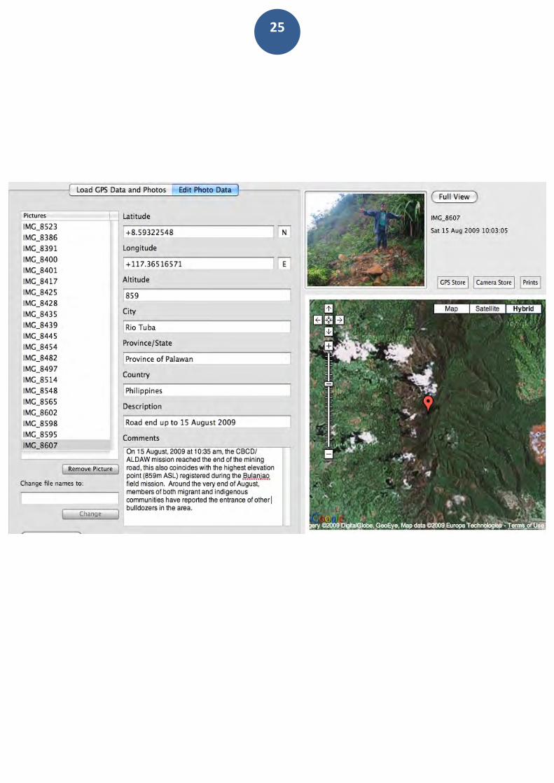
In a photographic context, geotagging is the process of associating photos with specific geographic locations using GPS coordinates. In this report geo-tagging is used as a synonym for geocoding. During the mission, GPS coordinates were obtained through the use of a professional device connected to the camera’s hot shoe. GPS positions where taken during the entire walking reconnaissance across the Bulanjao range, whose highest point (the Escarpado Peak) reaches an elevation of 1,036m ASL. The mission’s starting point was the Palawan community of Sumbiling. From here we reached the Simarak creek and then the mining road leading to the highest portions of the Bulanjao range. Overall, we moved from an elevation of about 40m ASL to the last point reached by the mining road at 859m ASL. This point also coincides with the highest elevation recorded during the mission. GPS positions were taken at intervals of several meters in order to reconstruct the mission’s full itinerary (see figures below).
13
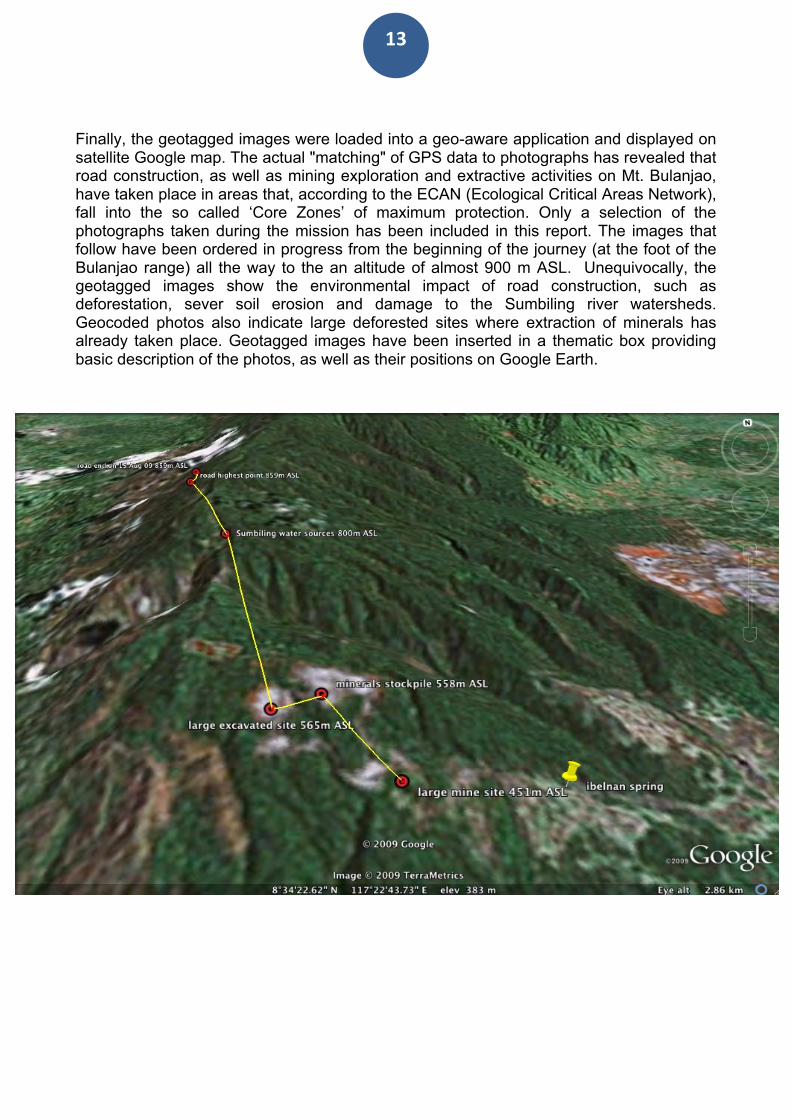
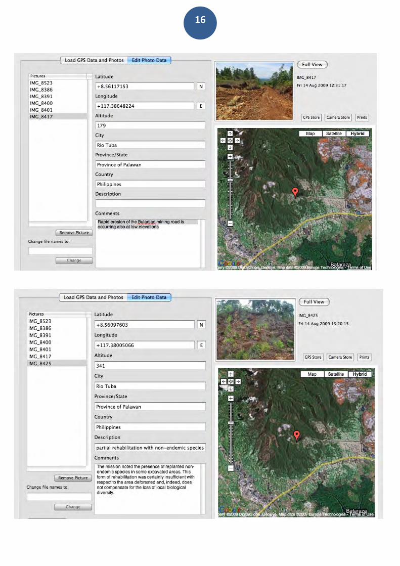
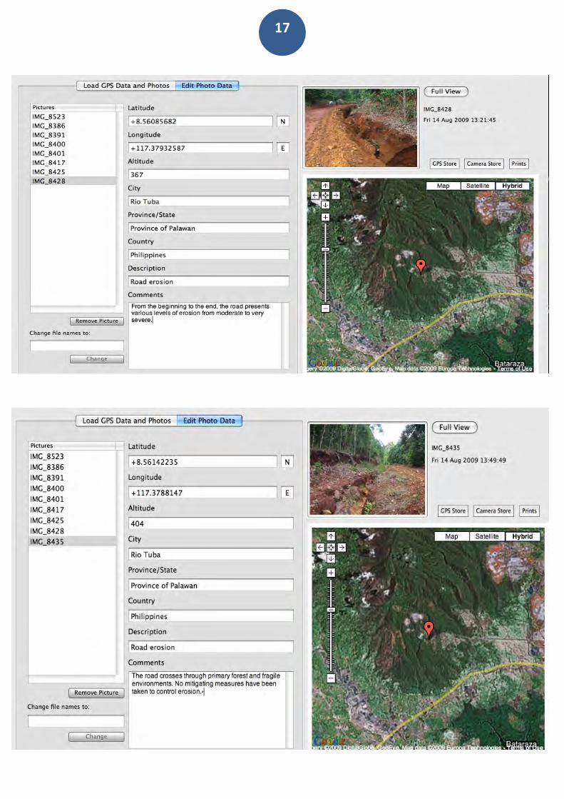
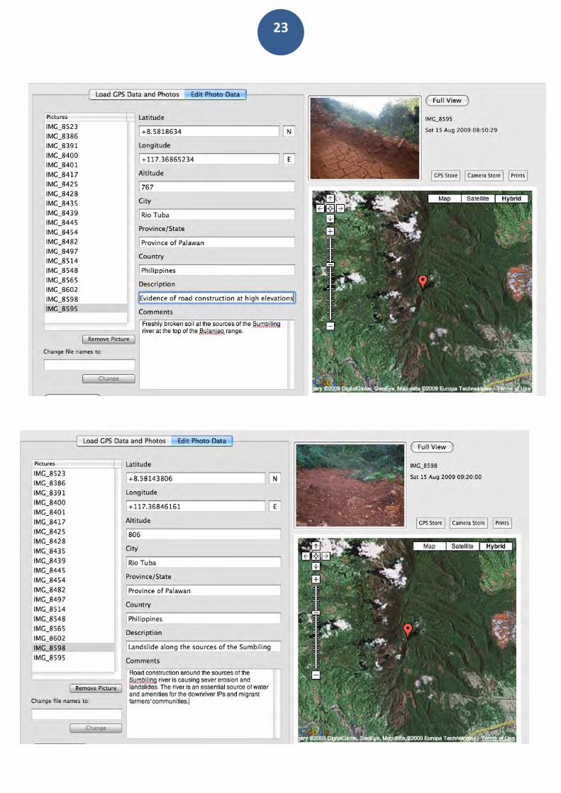
Finally, the geotagged images were loaded into a geo-aware application and displayed on satellite Google map. The actual "matching" of GPS data to photographs has revealed that road construction, as well as mining exploration and extractive activities on Mt. Bulanjao, have taken place in areas that, according to the ECAN (Ecological Critical Areas Network), fall into the so called ‘Core Zones’ of maximum protection. Only a selection of the photographs taken during the mission has been included in this report. The images that follow have been ordered in progress from the beginning of the journey (at the foot of the Bulanjao range) all the way to the an altitude of almost 900 m ASL. Unequivocally, the geotagged images show the environmental impact of road construction, such as deforestation, sever soil erosion and damage to the Sumbiling river watersheds. Geocoded photos also indicate large deforested sites where extraction of minerals has already taken place. Geotagged images have been inserted in a thematic box providing basic description of the photos, as well as their positions on Google Earth.
14
15
16
17
18
19
20
21
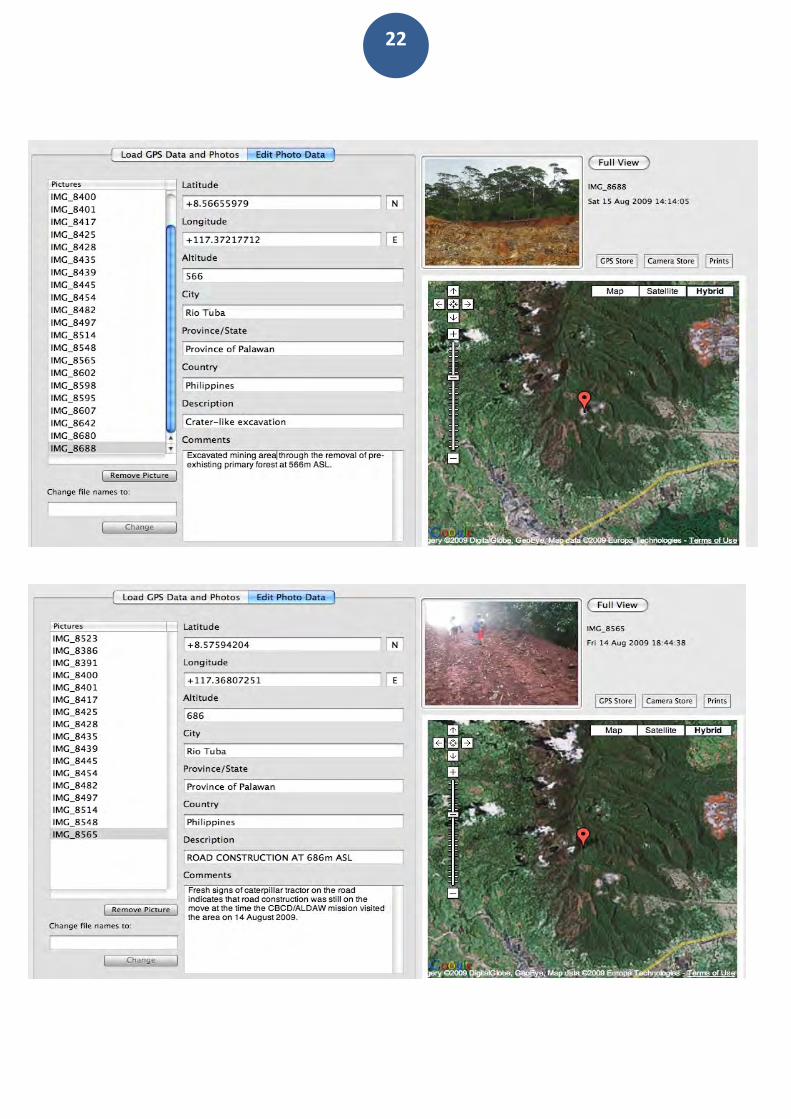
22
23
24
25
26
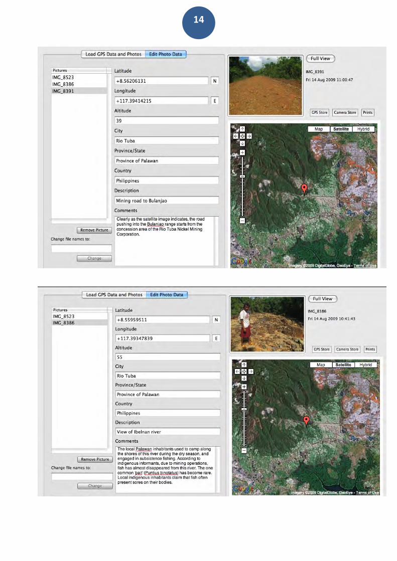
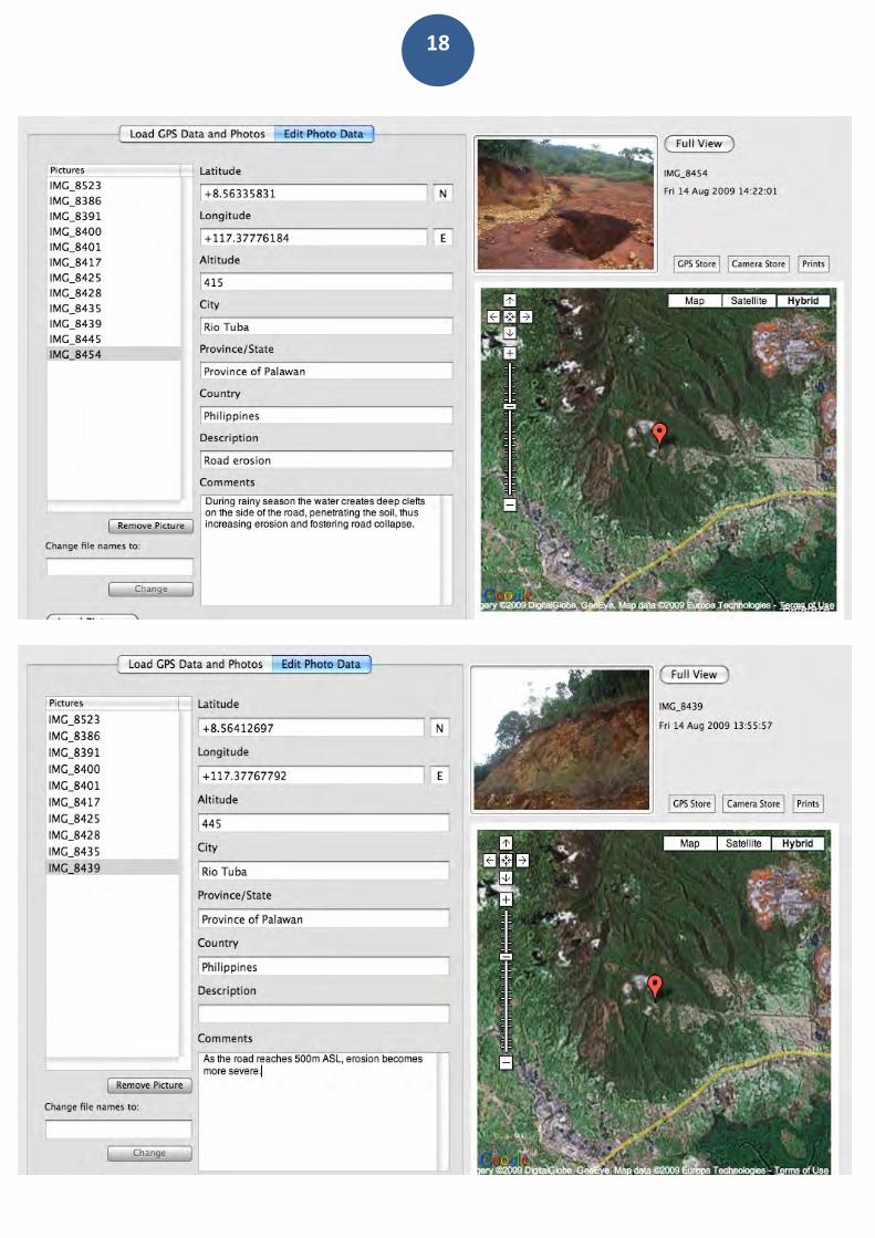
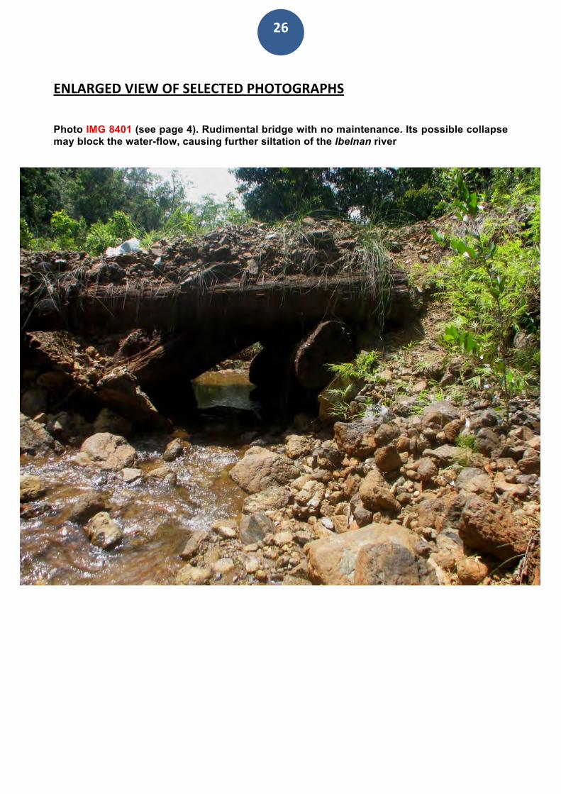
ENLARGEDVIEWOFSELECTEDPHOTOGRAPHS Photo IMG 8401 (see page 4). Rudimental bridge with no maintenance. Its possible collapse may block the water-flow, causing further siltation of the Ibelnan river
27
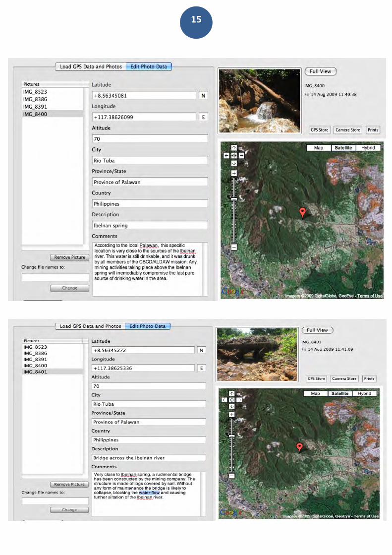
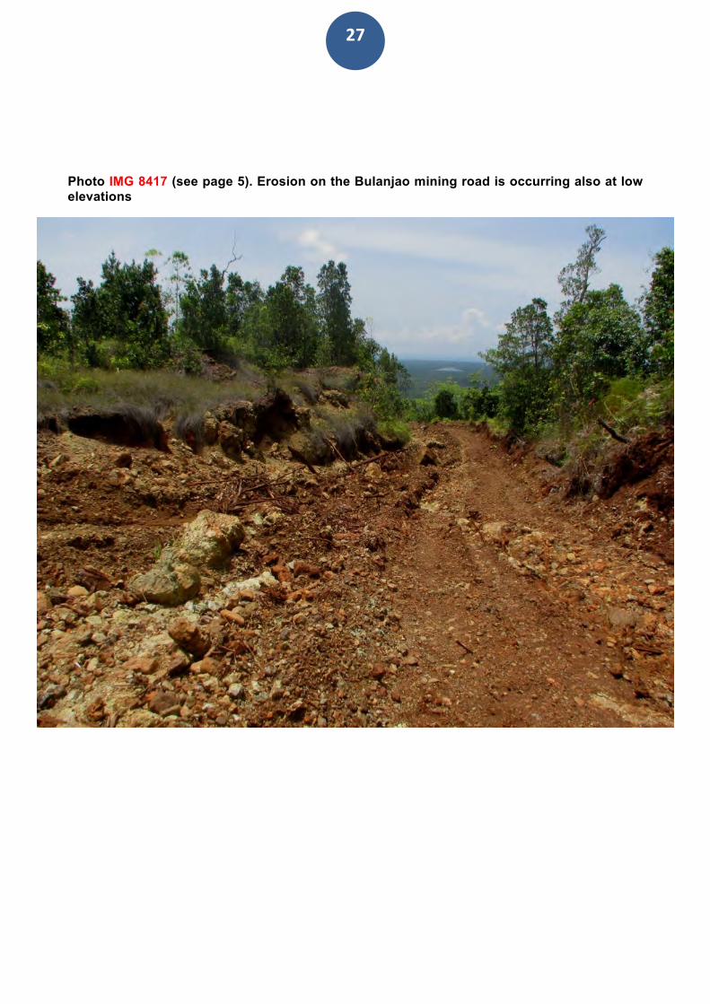
Photo IMG 8417 (see page 5). Erosion on the Bulanjao mining road is occurring also at low elevations
28
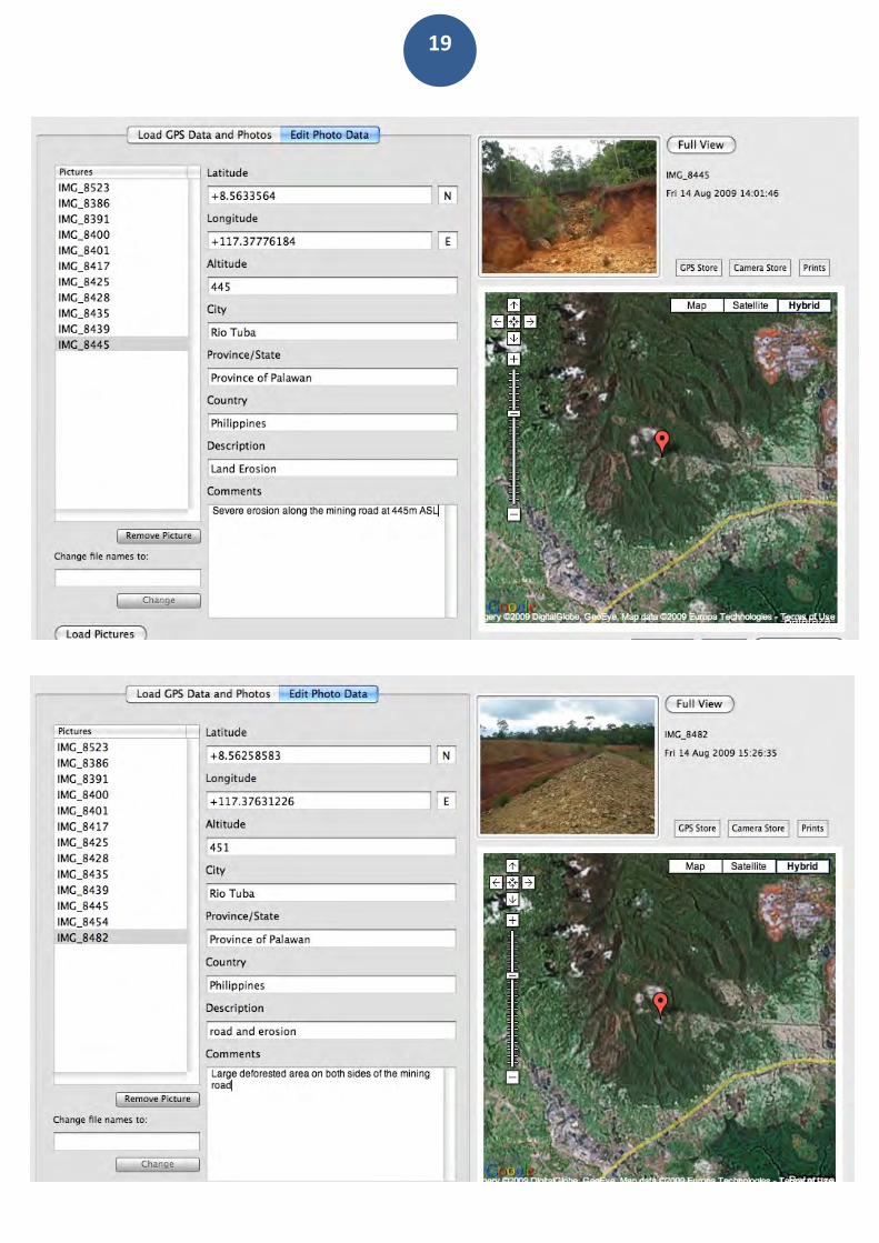
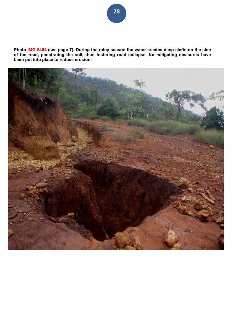
Photo IMG 8454 (see page 7). During the rainy season the water creates deep clefts on the side of the road, penetrating the soil, thus fostering road collapse. No mitigating measures have been put into place to reduce erosion.
29
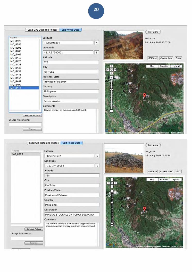
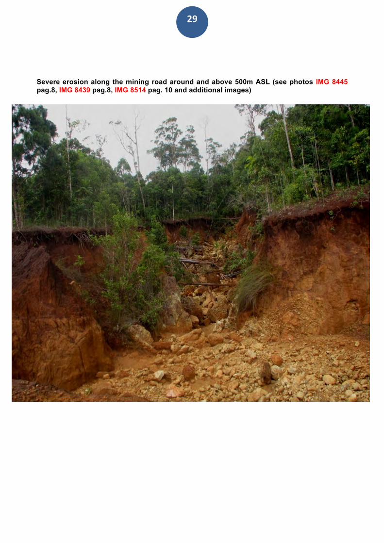
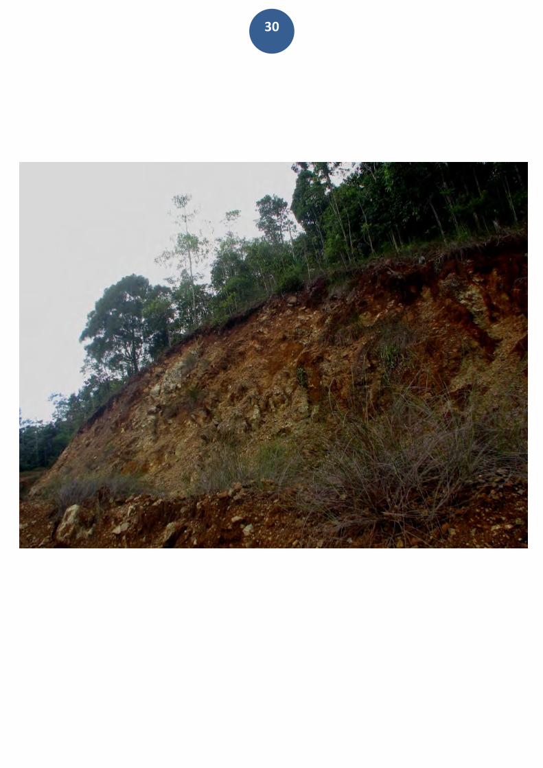
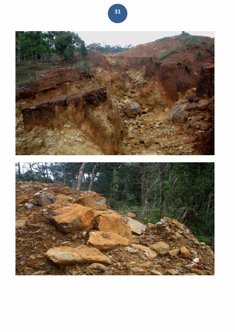
Severe erosion along the mining road around and above 500m ASL (see photos IMG 8445 pag.8, IMG 8439 pag.8, IMG 8514 pag. 10 and additional images)
30
31
32
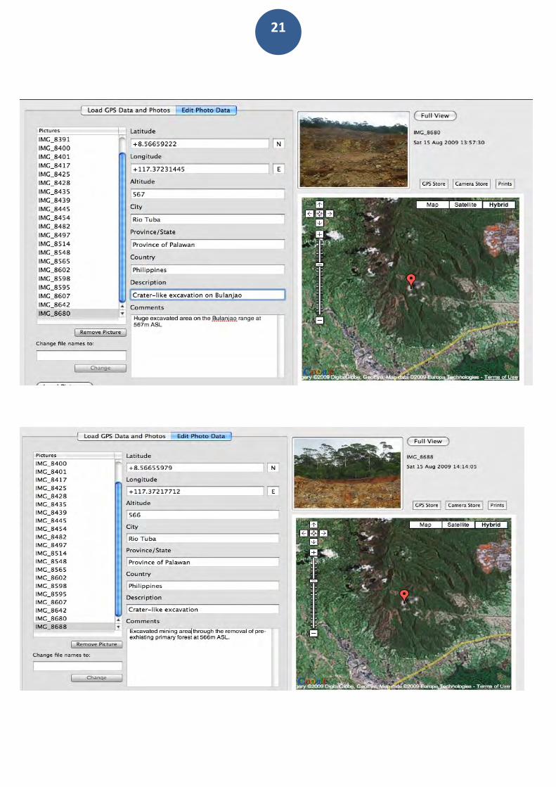
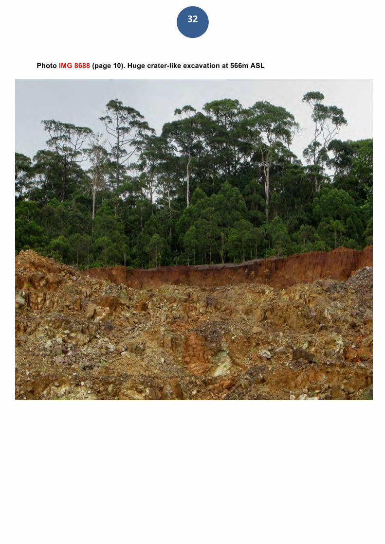
Photo IMG 8688 (page 10). Huge crater-like excavation at 566m ASL
33
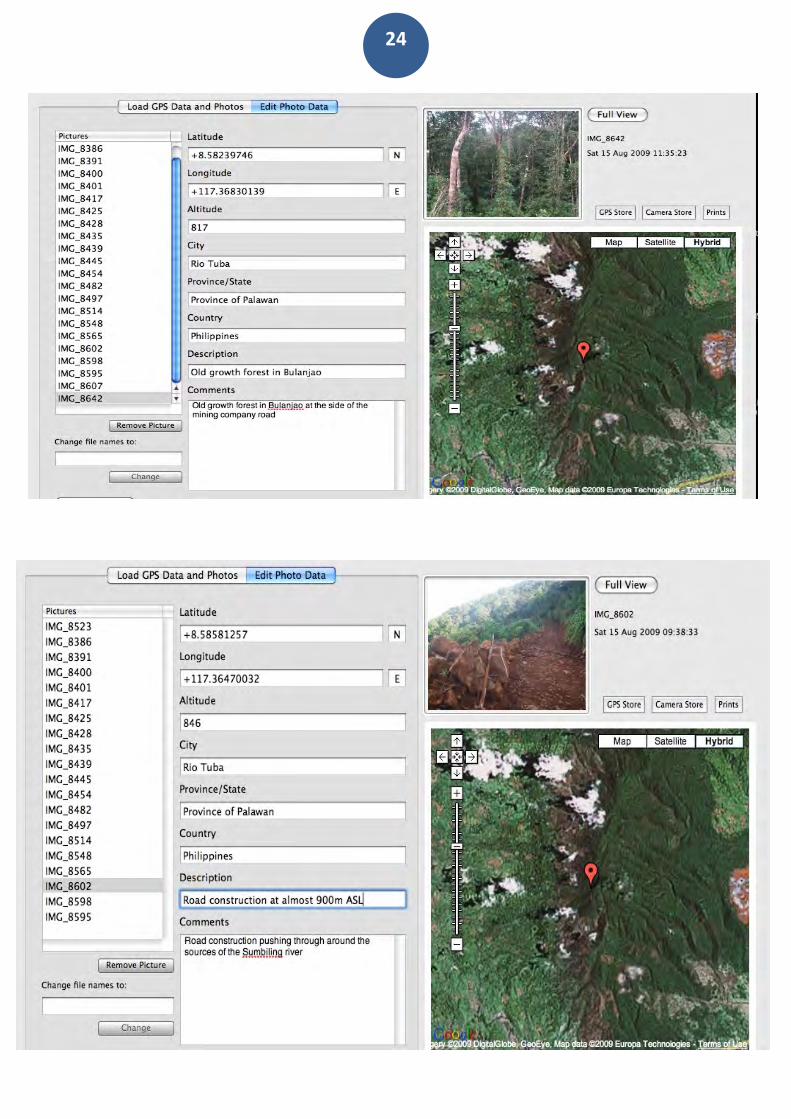
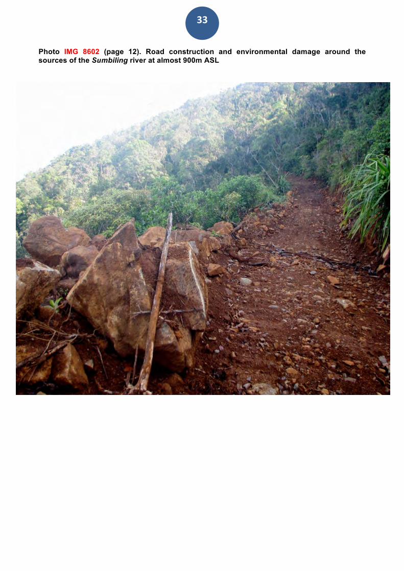
Photo IMG 8602 (page 12). Road construction and environmental damage around the sources of the Sumbiling river at almost 900m ASL
34
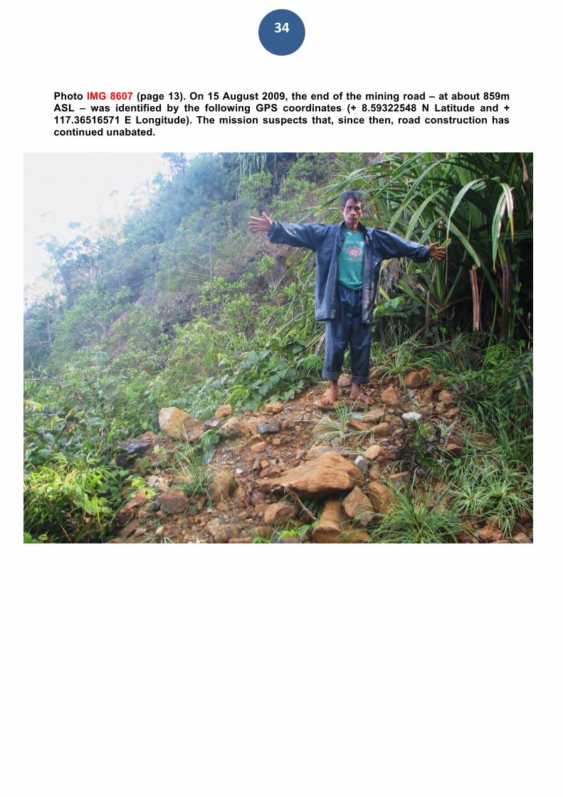
Photo IMG 8607 (page 13). On 15 August 2009, the end of the mining road – at about 859m ASL – was identified by the following GPS coordinates (+ 8.59322548 N Latitude and + 117.36516571 E Longitude). The mission suspects that, since then, road construction has continued unabated.
35
IV) CONCLUSIONS AND RECOMMENDATIONS The continuation of mining activities in Bulanjao will irremediably damage the best-conserved forest in the southern tip of Palawan, with predictable adverse consequences for the food production capacity of both indigenous and migrant farmers communities living at the foot of this mountain range. Because of mining activities taking place at high elevations, the risk of landslides is likely to increase to an unprecedented level. Also the eco-tourism potential of this mountain forest is likely to be jeopardized. Furthermore, some of the areas - around and inside the Bulanjao range include sacred and worship sites that are regarded by the local indigenous people as physical evidence of mythological events and are associated with important cosmological principles. The local inhabitants perceive the destruction of these historical and natural landmarks as an obliteration of their history and collective memories of the past. In response to clear evidence of ecological damage in Bulanjao, the CBCD/ALDAW mission recommends the following: RTNMC and CBNC should:
• Comply with the revised ECAN guidelines and thus cease all mining related activities in Bulanjao. They should further comply with the provisions of the Mining Code, which ban mining development from key environmental zones and ancestral lands of indigenous peoples, and with the main tenets of the IPRA law (Indigenous Peoples Rights Act).
• Rehabilitate with endemic species all damaged and eroded sites found in the Bulanjao range. This should include the replacement of topsoil on the mining road and the reforestation of the same with local tree species.
• Comply with the terms of the MOA entered into between them and the IPs The Mines Geosciences Bureau and the Environmental Management Bureau should:
• Expand membership of the Multipartite Monitoring Team (MMT) to include external evaluators capable of providing scientifically based assessments and an accurate monitoring of the environmental performance of both CBNC and RTNMC. As of now, MMT members have no geologists and chemists. As a result, some MMT members must rely solely on the explanation of the company’s chemists or government staffs. Overall, in the MMT membership there should be a better balance between community-base organizations and representatives of the company and the government. More importantly, non-technical MMT members should be trained on the purpose and process of monitoring and oriented on the nature of the mining projects and their whole operations.
The Palawan Council for Sustainable Development and the concerned DENR agencies should:
• Ensure that RTNMC and CBNC strictly adhere to the Strategic Environmental Plan (SEP) for Palawan. Thus they should reject any request to operate or expand mining operations in Bulanjao;
36
• Reject any request, on the part of the local government of Bataraza, to change the
category and status of ECAN core zones into multiple use zones, in order to allow mining;
• Ensure that a genuine process of FPIC of all indigenous communities living in the immediate vicinity of Bulanjao be carried out by the NCIP, with the external supervision of an independent group composed of selected NGOs members, representatives of indigenous organizations, local and foreign researchers/scientists, anthropologists and other members of the civil society;
• Facilitate parallel FPICs processes amongst the neighboring farmers’ communities living at the foot of the Bulanjao range; The NCIP The National Commission on Indigenous Peoples (NCIP) and the PCSD have a standing Memorandum of Agreement (MOA) which states that any project or activity which needs SEP clearance must secure first a Certification Precondition from NCIP, if the project affects the IPs. Therefore, the NCIP should:
• Ensure that genuine and transparent Free and Prior Informed Consent (FPIC) processes are undertaken in connection with any future activity carried out by RTNMC and CBNC. The Local Government of Bataraza should:
• Ensure that all mining related decisions that are likely to affect local communities and their environment should be discussed with an independent committee of indigenous peoples, local farmers, NGOs and IPs representatives, to enhance transparency and accountability in decision making processes. The ALDAW Network could provide its assistance and expertise in facilitating the creation of such committee, and the preparation of a specific memorandum of agreement to be signed with the Municipal Government of Bataraza. The EU and other international donors should:
• Finance the establishment of an independent scientific mission composed of botanists, zoologists and ethnobiologists in charge of carrying out a detailed survey of the biocultural diversity found inside and around the Bulanjao range. This Strategic Socio/Environmental Appraisal should serve as the basis for declaring Mt. Bulanjao as a protected area and mining-free zone. The National Government should:
• Call for an immediate halt of mining road construction and exploration in Bulanjo, as such activities contravene provisions contained in well-know conventions [eg. The Convention on Biological Diversity (CBD) - the UNESCO Convention on the Promotion and Protection of Cultural Diversity] and further listed in the UN Declaration on the Rights of
37
Indigenous Peoples adopted and signed by the Philippine government on September 14, 2007. The commitments made by the Philippine State under these conventions form some of the strongest government statements of its own responsibility towards the protection of environment and the well being of its inhabitants;
• Enforce the immediate suspension of all mining-related activities in Bulanjao, until credible socio/environmental appraisals are made available. On the basis of such evidence, a presidential proclamation should be issued to declare Mt. Bulanjao a protected area, to be co-managed with the local traditional inhabitants.
Table of Abbreviations ALDAW – Ancestral/Land Domain Watch BPPI – Bangsa Palawan Philippines, Inc. CADT - Certificate of Ancestral Domain Title CBCD – Centre for Biocultural Diversity CBNC - Coral Bay Nickel Corporation CI-P - Conservation International-Philippines CLUP - Comprehensive Land Use Plan DENR - Department of Environment and Natural Resources DMT – Dry Metric Ton ECAN - Environmentally Critical Area Network ECC - Environmental Compliance Certificate ELAC - Environmental Legal Assistance Center EMB – Environmental Management Bureau FOE – Friends of the Earth FPIC – Free Prior and Informed Consent GPS – Global Positioning System HHP - Hydrometalurgical Processing Plant IP -Indigenous People IPC – Institute of Philippine Culture IPRA - Indigenous People’s Rights Act HTC – Holy Trinity College IUCN -International Union for the Conservation of Nature LGU - Local Government Unit MA - Mineral Agreement MCLUP - Municipal Comprehensive Land Use Plan MGB - Mines and Geosciences Bureau MMT - Multipartite Monitoring Team MOA – Memorandum of Agreement MPSA - Mineral Production Sharing Agreement NATRIPAL- Nagkakaisang Mga Tribu ng Palawan, Inc. NCIP - National Commission on Indigenous Peoples NGO -Non-Governmental Organization NIPAS - National Integrated Protected Area System PA - Protected Area PCSD - Palawan Council for Sustainable Development PNNI - Palawan NGO Network, Inc. PO - People’s Organization RA - Republic Act SEP - Strategic Environmental Plan SMM - Sumitomo Metal Mining TCF – The Christensen Fund UNESCO – United Nations Educational, Scientific and Cultural Organization WMT – Wet Metric Ton
38
CONSULTED BIBLIOGRAPHY Books Madulid, D.A. 2002. A Pictorial Guide to the Noteworthy Plants of Palawan. Palawan Tropical Forestry Protection Programme: Philippines Publishes and unpublished articles Danilo C. Israel, Sândalo A. & A. Torres. IMAPE Research Paper No.6: The Environmental Impact of Macroeconomic Policies on the Mining and Quarrying Sector in Palawan Province. July 2001. ELAC Case Study submitted to Tebtebba Foundation. 2005. “FPIC in Bataraza: who approves consent?” Hilleshög Forestry AB. 1985. The Palawan Botanical Expedition Final Report Mayo-Anda. G. & Mana-Galido, K. 2008. Nickel Mining in Palawan Province. Some bad experiences. Ateneo de Manila University School of Government and the Environmental Legal Assistance Center (ELAC) Sangkula, D.A and M. Tamsi, 2007. The Mining Controversy and Dynamic of Conflict in Brooke’s Point, Palawan. A report commissioned to the Environmental Legal Assistance Center (ELAC) by the Ateneo School of Government: Manila Miscellaneous Unpublished Reports Conservation International, Palawan Corridor Strategy Development Project (PCSDP) CBNC Accomplishment Report Executive Summary by GAIA South Inc. Environment Impact Assessment for the Hydrometallurgical Impact Assessment. HPP Project Scoping Report, by GAIA South, Inc, February 2001 RTNMC’s documentation in Tarusan IEC, August 27, 2004 Floral Assessment Report by Reymar Castillo and Allan Romas Artajo. This report is for limited circulation, and it has been produced for advocacy purposes. No part of this document can be reproduced or duplicated without the authorization of the Ancestral Land/Domain Watch (ALDAW NETWORK). Further enquires can be forwarded to [email protected] Photos copyrights: Dario Novellino. Photos copyrights (pages 5 and 10): FOE-Japan
Report Copyright - Aldaw Network 2010
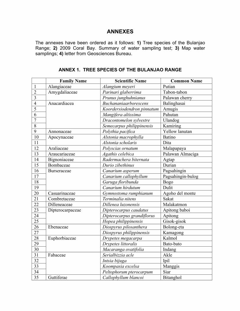
ANNEXES
The annexes have been ordered as it follows: 1) Tree species of the Bulanjao Range; 2) 2009 Coral Bay. Summary of water sampling test; 3) Map water samplings; 4) letter from Geosciences Bureau.
ANNEX 1. TREE SPECIES OF THE BULANJAO RANGE
Family Name Scientific Name Common Name 1 Alangiaceae Alangium meyeri Putian 2 Parinari glaberrima Tabon-tabon 3
Amygdaliaceae Prunus junghuhnianus Palawan cherry
4 Buchananiaarborescens Balinghasai 5 Koordersiodendron pinnatum Amugis 6 Mangifera altissima Pahutan 7 Dracontomelon sylvestre Ulandog 8
Anacardiacea
Semecarpus philippinensis Kamiring 9 Annonaceae Polythia pacifica Yellow lanutan 10 Alstonia macrophylla Batino 11
Apocynaceae Alstonia scholaris Dita
12 Araliaceae Polyscias ornatum Malapapaya 13 Araucariaceae Agathis celebica Palawan Almaciga 14 Bignoniaceae Radermachera biternata Agtap 15 Bombaceae Durio zibethinus Durian 16 Canarium asperum Pagsahingin 17 Canarium callophyllum Pagsahingin-bulog 18 Garuga floribunda Bogo 19
Burseraceae
Canarium hirdutum Dulit 20 Casuarinaceae Gymnostoma rumphianum Agoho del monte 21 Combretaceae Terminalia nitens Sakat 22 Dilleneaceae Dillenea luzonensis Malakatmon 23 Dipterocarpus caudatus Apitong baboi 24 Dipterocarpus grandiflorus Apitong 25
Dipterocarpaceae
Hopea philippinensis Gisok-gisok 26 Diospyrus pilosanthera Bolong-eta 27
Ebenaceae Diospyrus philippinensis Kamagong
28 Drypetes megacarpa Kalmol 29 Drypetes littoralis Bato-bato 30
Euphorbiaceae
Macaranga ovatifolia Indang 31 Serialbizzia acle Akle 32 Intsia bijuga Ipil 33 Koompasia excelsa Manggis 34
Fabaceae
Peltophorum pterocarpum Siar 35 Guttiferae Callophyllum blancoi Bitanghol
36 Gancinia benthani Bunog 37
Garcinia venulosa Gatasan
38 Cinnamomum mercadoi Kalingag 39 Iteadaphne philippinensis Boga 40
Lauraceae
Litsea segregata Katiel 41 Dysoxylum arborescens Kalimutain 42
Meliaceae Aglia cumingiana Alauihao
Continuation:
43 Ficus variegata Tangisang bayauak 44 Ficus balete Balete 45 Artocarpus blancoi Antipolo 46 Azadirachta excelsa Marango 47
Moraceae
Artocarpus nitida Kubi 48 Ardisia squamulosa Tagpo 49
Myristicaceae Myristica nivea Kanon
50 Xanthosthemon verdugonianus
Mangkono
51 Syzygium nitidum Makaasim 52 Syzygium rigidifolium Kamandak 53
Myrtaceae
Syzygium claviforum Kurasam 54 Polygalaceae Xanthophylum excelsum Bokbok 55 Rubiaceae Gardenia morindaefolia Lanigai 56 Pometia pinnata Malugai 57
Sapindaceae Otophora fruticosa Balinaunau
58 Pouteria macrantha White nato 59 Palaquium luzonense Nato 60
Sapotaceae
Pouteria dolichosperma Red Nato 61 Sterculiaceae Pterocymbium tinctorium Taluto 62 Vitex parviflora Molave 63
Verbenaceae Premna odorata Alagau
Other non-identified species found in the Bulanjao watersheds Local Name Scientific Name Family Name
Alugok Amalit Andadarag Andalog Anuan Apad kulit Arimuchukan Arisurang
Arit-arit Balanswit Balinad dagat Banglas Barabidan Barangan Baro Bintaus Bitwas Bunal Burirawan Burngaw Buwag Diklay Disok Dulay Gengas Gino Ilas Kabinbin Kalasa Kamunyo Karud Katemas Kaulay Kurayan Launa Limbutan Magapugan Magbabangan Magbugabuga Magimpa Magina Maginbalum Magkarani Magkubalan Maglabuyo Maglamong Maglandak Magparay Magrerong Magulmod Maimas Maimit Malabangan
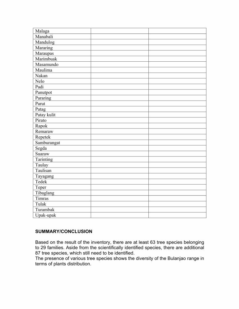
Malaga Manabali Mandulog Mararing Maraupas Marimbuak Masamundo Maulima Nakan Nelo Padi Panutpot Pararing Parut Patag Patay kulit Pirato Rapok Remaraw Repetek Samburangat Segda Suaraw Tarinting Taulay Taulisan Tayagang Tedek Teper Tibaglang Timras Tulak Turambak Upak-upak SUMMARY/CONCLUSION Based on the result of the inventory, there are at least 63 tree species belonging to 29 families. Aside from the scientifically identified species, there are additional 87 tree species, which still need to be identified. The presence of various tree species shows the diversity of the Bulanjao range in terms of plants distribution.
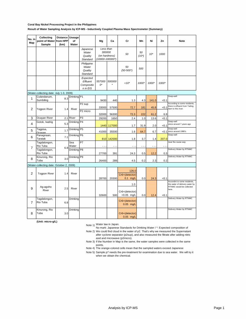
No. in Map
Collecting point of Water
Sample
Distance from HPP
(km)
Useage of
WaterMg Ca Cr Mn Ni Zn Note
Japanese Water Quality
Standard
50 50
(10*)10* 1000
Philippine Water Quality
Standard
50 (50-500*)
500
Expected Effluent
Composition in EIS
5570000*
500000*
<10* 1000* 1000* 1000*
1Culandanum, Sumbiling
8.3Drinking P1
9430 440 1.3 4.3 141.0 <0.1
Deep-well
P2 sup33000 57500 72.7 181 45.8 <0.1
P2 micro32000 56300 72.3 222 61.2 6.9
3 Ocayan River 2.1 River P3 29200 1650 2.4 1.0 13.6 <0.1
4Gotok, Iwahig
5.3Drinking P4
1440 117000 1.7 31.9 2.0 <0.1
Deep-wellsince around 7 years ago
5 Tagpisa, Ocayan
1.7 Drinking P541000 35500 1.6 64.7 6.7 <0.1
Deep-wellsince around 1980's
6Panagnaan, Taratak
7.1Drinking P6
810 142000 1.8 3.7 1.4 207.0
Deep-well
Tagdalongon, Rio Tuba
Sea Water
P7 - - - - - - - - - - - - - - - - - -
near the cause way
Tagdalongon, Rio Tuba
Drinking P827700 391 24.3 0.5 12.2 0.3
Delivery Water by RTNMC
8Kinurong, Rio Tuba
3.0Drinking P9
26400 289 4.5 0.2 2.3 0.2
Delivery Water by RTNMC
126.0
Cr6+(detector)0.1 mg/L
1.0
Cr6+(detector)<0.05 mg/L
7Tagdalongon, Rio Tuba 6.8
DrinkingCr6+(detector)
0.05 mg/L
Delivery Water by RTNMC
8Kinurong, Rio Tuba 3.0
DrinkingCr6+(detector)
0.05 mg/L
Delivery Water by RTNMC
Note 1)
Note 2)
Note 3)
Note 4)
Note 5)
Less than 300000
(on hardness)(10000-100000*)
Water law in Japan.No mark: Japanese Standards for Drinking Water / *: Expected composition of We could find cloud in the water of p2. That's why we measured the Supernatant after cyclone separator (p2sup), and also measured the filtrate after adding nitric asid and microwave (p2micro).
Togpon River River
According to some residents, there is effluent from Tailing dam to this river.
River
1.4
6.8
1.4
(Unit: micro-g/L)
<0.1
Accordint to some residents, the water of delivery water by RTNMC would be collected here.
28700 20300 0.0
2.5
Togpon River River
Ag-agoho River
24.3 <0.1
32600 500 0.0
Sample p7 needs the pre-treatment for examination due to sea water. We will try it when we obtain the chemical.
The orange-colored cells mean that the sampled waters exceed Japanese Standard.
If the Number in Map is the same, the water samples were collected in the same points.
Coral Bay Nickel Processing Project in the Philippines
Result of Water Sampling Analysis by ICP-MS - Inductively Coupled Plasma Mass Spectrometer (Summary)
(Water-collecting date: July 1-3, 2009)
(Water-collecting date: October 2, 2009)
2
2
9
7
12.4
Analysis by ICP-MS Page 1
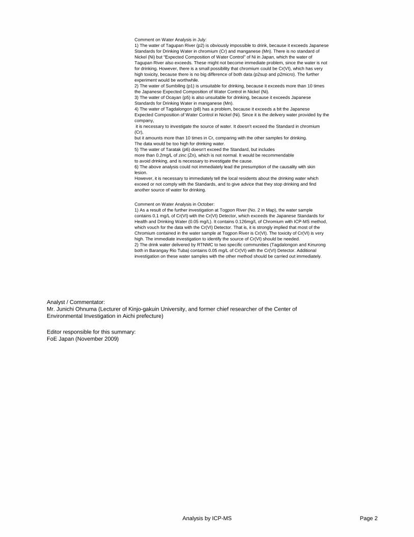
Editor responsible for this summary:FoE Japan (November 2009)
Analyst / Commentator:Mr. Junichi Ohnuma (Lecturer of Kinjo-gakuin University, and former chief researcher of the Center of Environmental Investigation in Aichi prefecture)
Comment on Water Analysis in July:1) The water of Tagupan River (p2) is obviously impossible to drink, because it exceeds Japanese Standards for Drinking Water in chromium (Cr) and manganese (Mn). There is no standard of Nickel (Ni) but “Expected Composition of Water Control” of Ni in Japan, which the water of Tagupan River also exceeds. These might not become immediate problem, since the water is not for drinking. However, there is a small possibility that chromium could be Cr(VI), which has very high toxicity, because there is no big difference of both data (p2sup and p2micro). The further experiment would be worthwhile.2) The water of Sumbiling (p1) is unsuitable for drinking, because it exceeds more than 10 times the Japanese Expected Composition of Water Control in Nickel (Ni).3) The water of Ocayan (p5) is also unsuitable for drinking, because it exceeds Japanese Standards for Drinking Water in manganese (Mn).4) The water of Tagdalongon (p8) has a problem, because it exceeds a bit the Japanese Expected Composition of Water Control in Nickel (Ni). Since it is the delivery water provided by the company, it is necessary to investigate the source of water. It doesn't exceed the Standard in chromium (Cr), but it amounts more than 10 times in Cr, comparing with the other samples for drinking. The data would be too high for drinking water.5) The water of Taratak (p6) doesn't exceed the Standard, but includes more than 0.2mg/L of zinc (Zn), which is not normal. It would be recommendable to avoid drinking, and is necessary to investigate the cause.6) The above analysis could not immediately lead the presumption of the causality with skin lesion. However, it is necessary to immediately tell the local residents about the drinking water which exceed or not comply with the Standards, and to give advice that they stop drinking and find another source of water for drinking.
Comment on Water Analysis in October:1) As a result of the further investigation at Togpon River (No. 2 in Map), the water sample contains 0.1 mg/L of Cr(VI) with the Cr(VI) Detector, which exceeds the Japanese Standards for Health and Drinking Water (0.05 mg/L). It contains 0.126mg/L of Chromium with ICP-MS method, which vouch for the data with the Cr(VI) Detector. That is, it is strongly implied that most of the Chromium contained in the water sample at Togpon River is Cr(VI). The toxicity of Cr(VI) is very high. The immediate investigation to identify the source of Cr(VI) should be needed.2) The drink water delivered by RTNMC to two specific communities (Tagdalongon and Kinurong both in Barangay Rio Tuba) contains 0.05 mg/L of Cr(VI) with the Cr(VI) Detector. Additional investigation on these water samples with the other method should be carried out immediately.
Analysis by ICP-MS Page 2
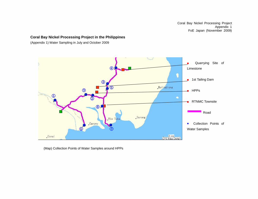
Coral Bay Nickel Processing ProjectAppendix 1
FoE Japan (November 2009)
Coral Bay Nickel Processing Project in the Philippines
(Appendix 1) Water Sampling in July and October 2009
■ Quarrying Site of
Limestone
■ 1st Tailing Dam
■ HPPs
■ RTNMC Townsite
Road
● Collection Points of
Water Samples
②
③
④
⑧
⑥
①
⑦
⑤⑨
(Map) Collection Points of Water Samples around HPPs