analytical study of ground water contamination in …...analytical study of ground water...
TRANSCRIPT
Analytical study of ground water contamination
in Ankleshwar Taluka of Gujarat
Abstract: Groundwater is considered as most valuable natural resource to human lives. In the recent era fresh ground water is a topic to think. To access clean portable drinking water is challenge to people; as groundwater quality is affected by public activity and utility. The area having high contamination of ground water is selected named as Ankleshwar located in Bharuch district of Gujarat. The study area became center of attraction due to urbanization as well as many chemical refineries and pharmaceutical companies are located around. The objective of study to access water quality parameter in 22 numbers of selected wells. Most effected pollutant like TDS, Alkalinity, Nitrogen and fluoride analyzed during study. Spatial distribution analysis of these all parameter is done with help of Arc GIS. Graphs are also plotted to show ground water quality index with reference of dirking water quality standard IS 10500-2012. Study revels high constrictions of alkalinity and TDS in Ground water of study area due to industrial effluents. Also higher magnitude of nitrogen is because of excessive use of fertilizer and pesticide.
Index Terms — Nitrogen, TDS, Alkalinity, Groundwater,
IDW.
I. INTRODUCTION
Groundwater resources are affected by enlargement of
irrigation activities, industrialization and urbanization.
Monitoring and conserving this essential useful resource is
essential. The exceptional of water is described in phrases
of its physical, chemical and biological parameters.
Ascertaining the satisfactory of groundwater is
indispensable earlier than its use for a number of functions
such as drinking, agricultural, leisure and industrial
activities.
The movement of groundwater is very slow as compare to
surface water, the rate of movement of ground water is
depending upon the parameters like transmissivity,
permeability, aquifer storage capacity etc. Ground water
helpful in most of agricultural and industrial utilization, for
the development of arid and semi arid region ground water
takes part vital role. A large number of ground water
reservoirs are still uninvestigated and undeveloped although
the ground water is distributed among the world.
II. LITERATURE REVIEW:
Groundwater Quality is an issue of great importance and
concern. With continuous utilization of surface water
sources, utilization of ground has increased in last few
decades which have raised new challenges and issues.
Amongst these issues related to quality are significant.
Many scholars and researchers have worked on study and
analysis of ground water quality worldwide. They have
used many approaches and methods. Amongst most widely
used tools use of GIS and Statistical Models are very
popular. Some of the studies related to India and nearby
region are as follows.
S.Krishnaraj et al carried out spatial analysis of
groundwater quality using GIS for Karur district of Tamil
Nadu, India. They analyzed number of water samples for
physico-chemical parameters like TDS, TH, TA Chloride,
and Fluoride. They also did geographic information system-
based groundwater quality mapping and contour map.
Finally they developed an integrated map showing three
priority classes such as Excellent, Good and Poor
groundwater quality zones of the study are.
The urban groundwater quality assessment of their
physiological characteristics have done by P.Satyanarayana
et al of Greater Visakhapatnam Municipal Corporation
Area of Andhra Pradesh, India. The water quality standards
of WHO, BIS and CPHEEO are taken as reference and final
results were compared with that.
Mukesh A Modi, Assistant Professor, Civil Engg. Dept., Faculty of Tech. and Engg., M. S. University of Baroda.
Hettal M. Tokle, Assistant Professor, Sal Institute of Tech. and Engineering Research-Ahmedabad
Dr. N J Shrimali, Associate Professor, Civil Engg. Dept., Faculty of Tech. and Engg., M. S. University of Baroda.
International Journal of Applied Engineering Research ISSN 0973-4562 Vol. 14, No.1, 2019 (Spl.) pp. 16-21© Research India Publications. http://www.ripublication.com
16
Spatial Distribution of Ground water Quality is done by
S.Tikle et al; the domain area is selected in Pune city-
Maharashtra. The study bore well sample of data collected
are 29 numbers and the study is done with using Arc GIS
software. The prescription from APHA is taken as a
reference and the physicochemical parameters are analyzed
that are finally compared with WHO (2006, 2008) water
quality standards for drinking. Also, maps were prepared
using IDW (Inverse Distance Weighting) technique in GIS.
Gursimran Singh et al studied effect of polluter surface
water on ground water for BudhaNullah near Ludhiana and
Machhiwara region of India. They collected number of
samples and analyzed all the quality parameters using
standard methods prescribed in “Standard methods for
examination of water and wastewater”. The total study
covers so many samples of data within range of study area,
the data sample then analyzed and compared with ISO
10500 drinking water quality standards; in the result found
that the sample of water collected found to be unfit for
drinking. Optimum value for soil is found in Sodium
adsorption ratio (SAR) test shows results within the ranges
from 3.78 to 6.98 mg/kg; the soil having SAR value less
than 10 are generally considered as a good soil for leaching
and water percolation. The presence of impurities and
heavy metals are found in other forms in the ground water.
Akhtar and Z.Tang carried out study related to
contamination sources-identification and concentration of
TDS in urban area of Pakistan. They collected data and
analyzed graphically. In the conclusion; contaminated river
water and drain systems, poor unregulated landfills are
found as major sources of pollution.
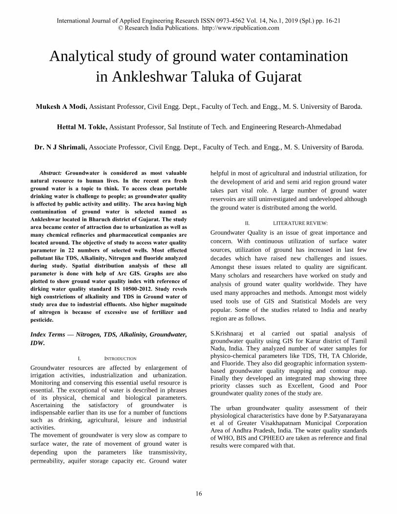
III. STUDY AREA AND DATA COLLECTION:
The study area Ankleshwar is located in Bhruch district of
Gujarat. It lies between 21.6264° N (latitude), 73.0152° E
(longitude). Akleshwar taluka is located around 14Km from
Bharuch District. The beautiful Bharuch district is situated
on bank of Narmada river, which also known as lifeline of
Gujarat. The river banks of Bharuch district are covered by
greenery.
Ankleshwar town and Bharuch also have remarkable
peculiarities in ancient time. Many pharmaceutical
companies are located in Ankleshwar taluka. There are
around 2000 industries located in this area.
Ankleshwar industrial association is the largest association
of industry in Gujarat Industrial Development Corporation
(GIDC). In 2011 Ankleshwar had population around
140839. Major predominant geological formation found in
study area is Deccan Trap, Sandstone, and Alluvium.
Figure1. MAP OF ANKLESHWAR
GUJARAT
INDIA
Figure: 1 Study area map of Ankleswar
2012-13
District: Bharuch Water sample: Tube well Lab: Ankleswar TDS
Sr No
Village Name Location Testing Date Testing result
1 ALANJ Vav of Vill. Aalunj 06/12/2012 2680.00 mg/l 2 GADKHOL Nr. Tank 22/12/2012 3880.00 mg/l 3 KARMALI Near Panchayat 26/02/2013 2200.00 mg/l 4 KARMALI Nr. Samshan 19/06/2012 2356.00 mg/l 5 KHAROD Near Tank 26/02/2013 2250.00 mg/l 6 MOTALI Sarpanch's house 19/06/2012 3848.00 mg/l 7 PUNGAM Rajput Faliya 11/10/2012 3240.00 mg/l 8 SAMOR Nr Amravati Wadi 22/12/2012 2300.00 mg/l 9 SANJALI Bore Water 26/02/2013 3650.00 mg/l 10 SANJALI Mazid 02/03/2013 3500.00 mg/l 11 SARANGPOR Near Navi Nagri 26/02/2013 2120.00 mg/l 12 SARANGPOR Nr. Gram Panchayat 11/10/2012 2360.00 mg/l 13 UMARWADA Bore Water 26/02/2013 2300.00 mg/l 14 UMARWADA Talav 19/06/2012 2264.00 mg/l
NITRATE
1 MOTALI Sarpanch's House 19/06/2012 253.81 mg/l 2 SANJALI Bore Water 26/02/2013 115.18 mg/l 3 SANJALI Mazid 02/03/2013 115.18 mg/l 4 SANJALI Tank 19/06/2012 176.30 mg/l 5 SARANGPOR Nr.Panchayt ofiice 11/10/2012 121.09 mg/l 6 UMARWADA Bore Water 26/02/2013 115.18 mg/l
ALKALINITY
1 KHAROD Near Tank 26/02/2013 780.00 mg/l 2 UMARWADA Bore Water 26/02/2013 680.00 mg/l
2017-18
District: Bharuch Water sample: Tube well Lab: Ankleswar
TDS Sr
No VillageName Location Testing Date Testing result
1 DIVA Bore Near Tank 20/11/2017 2262.00 mg/l 2 DIVA Near Pond 20/11/2017 2276.00 mg/l 3 DIVA Near panchayat 20/11/2017 7688.00 mg/l 4 DIVI Primary school 20/11/2017 2344.00 mg/l 5 DIVI Nr Aganvadi 20/11/2017 2444.00 mg/l 6 KARMALI Nr School 06/04/2017 3600.00 mg/l 7 KOSAMADI kosamadi 03/05/2017 2600.00 mg/l 8 SARFUDDIN Nr Tank 20/11/2017 2594.00 mg/l 9 SARFUDDIN Nr aganvadi, 20/11/2017 3052.00 mg/l 10 SURWADI Primary school 20/11/2017 2312.00 mg/l
NITRATE
1 DIVA Near panchayat 20/11/2017 47.38 mg/l
2 DIVA Plot Vibhag-01, 20/11/2017 129.55 mg/l
3 DIVA Plot vibhag-02, 20/11/2017 141.47 mg/l
4 KARMALI Near Tank 31/08/2017 72.57 mg/l
5 KARMALI At Nea School 06/04/2017 273.00 mg/l
6 KOSAMADI Name: kosamadi 03/05/2017 60.28 mg/l
7 SARFUDDIN Nr aganvadi 20/11/2017 54.86 mg/l
8 UMARWADA Nr panchayat 06/04/2017 120.30 mg/l
ALKALINITY
1 HARIPURA At office Faliya 07/04/2017 760.00 mg/l
2 SARFUDDIN Nr Tank 20/11/2017 644.00 mg/l
FLOURIDE
1 SARFUDDIN Primary school 20/11/2017 3.04 mg/l
International Journal of Applied Engineering Research ISSN 0973-4562 Vol. 14, No.1, 2019 (Spl.) pp. 16-21© Research India Publications. http://www.ripublication.com
17
However some data are out of Ankleswar but having lot of
contamination and instructed topic to highlight in research.
For analysis data used are secondary/ancillary data
collected from NRDWP and other internet sources, as well
as some data are found from GPCB website and software
like goggle earth pro so as to identify ground position.
IV. METHODOLOGY:
The groundwater samples were analyzed with help of
analytical and graphical method. Ground water parameters
are then compared with IS 10500 (2012): Drinking water.
The samples collected were analyzed for important
chemical parameters such as Total Dissolved Solids,
Alkalinity, fluorides, and NO3.
The expression of all these chemical constituents is in mg/L
(milligrams/liter). The sample is divided with reference of
the parameter which having higher contaminations are
taken account. Spatial distribution of these parameters is
done with the help of arc GIS 10 software.
Inverse distance weighting IDW approach of GIS is an
advantageous device for preliminary decision making of
groundwater contaminant extent. This tool is interpolation
technique for creating spatial distribution maps and has
been used for parameters which are greater than its
permissible limit as per standard.
IDW Uses the measured values surrounding the prediction
location to predict a value for any unsampled location,
based on the assumption that things that are close to one
another are more alike than those that are farther apart
(ESRI Arc gis).
V. RESULT AND DISCUSSION:
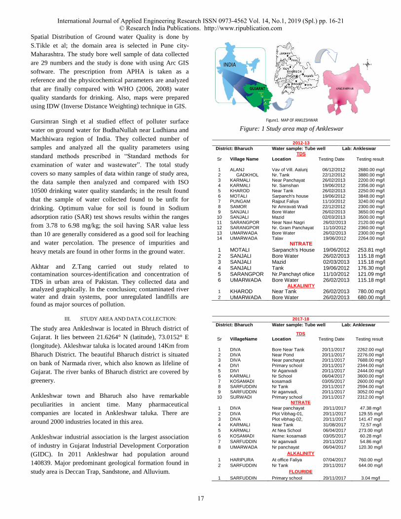
A TDS(Total Dissolved Solid ):
The study area of Ankleswar is the leading industrial zone
of southern Gujarat. The industries which are having boiler
and cooling tower blow down and processing waste water
stream containing alkalinity and hardness are the result of
higher magnitude of TDS in surface as well as ground water
of the area.
Due to dissolved impurities come from rocks and mineral
matters the amount of TDS also increased in groundwater.
Figure:2 TDS concentration in 2012-13 at Ankleswar
Figure:3 TDS concentration in 2017-18 at Ankleswar
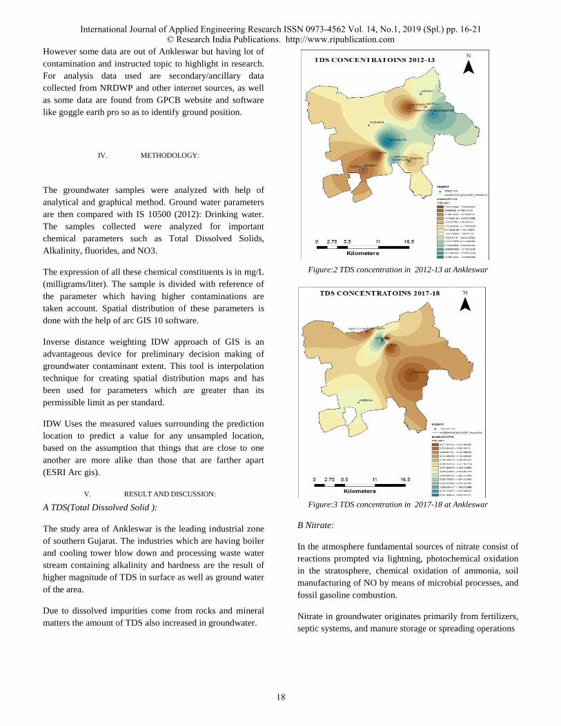
B Nitrate:
In the atmosphere fundamental sources of nitrate consist of
reactions prompted via lightning, photochemical oxidation
in the stratosphere, chemical oxidation of ammonia, soil
manufacturing of NO by means of microbial processes, and
fossil gasoline combustion.
Nitrate in groundwater originates primarily from fertilizers,
septic systems, and manure storage or spreading operations
International Journal of Applied Engineering Research ISSN 0973-4562 Vol. 14, No.1, 2019 (Spl.) pp. 16-21© Research India Publications. http://www.ripublication.com
18
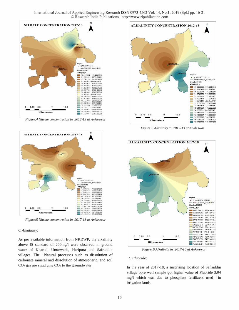
Figure:4 Nitrate concentration in 2012-13 at Ankleswar
Figure:5 Nitrate concentration in 2017-18 at Ankleswar
C Alkalinity:
As per available information from NRDWP, the alkalinity
above IS standard of 200mg/l were observed in ground
water of Kharod, Umarwada, Haripura and Safruddin
villages. The Natural processes such as dissolution of
carbonate mineral and dissolution of atmospheric, and soil
CO2 gas are supplying CO3 to the groundwater.
Figure:6 Alkalinity in 2012-13 at Ankleswar
Figure:6 Alkalinity in 2017-18 at Ankleswar
C Fluoride:
In the year of 2017-18, a surprising location of Safruddin
village bore well sample got higher value of Fluoride 3.04
mg/l which was due to phosphate fertilizers used in
irrigation lands.
International Journal of Applied Engineering Research ISSN 0973-4562 Vol. 14, No.1, 2019 (Spl.) pp. 16-21© Research India Publications. http://www.ripublication.com
19
VI. CONCLUSION:
From this study it is found that the utility of GIS combined
with analytical data to assess and mapping of groundwater
quality. The spatial distribution map of Total Dissolved
Solids, Total Alkalinity, Total Hardness, Chloride and
Fluoride shows that, these parameters were not within the
permissible limit throughout the study area uniformly.
Spatial distribution maps of a number of quality parameters
are used to demarcate the locational distribution of water
quality in a complete manner and assist in suggesting
groundwater appropriate for domestic usage purposes.
The study region and its nearby locations are going through
a quantity of groundwater issues, such as water shortages,
locally excessive pollution, and low recharge and over
exploitation of the resource. The important sources of
pollution in the study area are negative unregulated
landfills, contaminated river water and drain systems. All of
these issues will intensify with passage of time unless steps
are taken in the.
It is felt that we have no strong approach to guard the
groundwater gadget from pollutant, which are continually
infiltrating into the aquifer.
A groundwater monitoring gadget is most essential for
stopping these. There are some considerable guidelines for
preventing in addition groundwater satisfactory
deterioration
1) A massive waste water extent from domestic sewage that
enters into the quite a number water bodies positioned in
the city. Effective treatment plants must be set up to deal
with municipal waste water before thru into river or other
water bodies. Fractured and ancient sewage traces ought to
be exchange to make it insure fix leaking problem.
2) Landfills must be maintained precise and generated
leachate collection mechanism need to be established.
Groundwater recharge places and buildings are protected
from surface pollution. Agricultural activities, specifically
those the use of large quantities of fertilizer and pesticide,
need to be excluded from the recharge sites.
3) Enforce current environmental safety laws and boost
additional guidelines and policies as necessary.
4) There is a crucial need of continuously monitoring
groundwater levels and high-quality so that issues can be
identified and dealt quickly.
The outcomes obtained in this study with the spatial
database mounted in GIS will be beneficial for monitoring
and managing ground water quality and its pollution in the
study area.
REFERENCES
[1] Akhtar M. M. and Tang Zhonghua “Identification of
Contamination Sources and TDS Concentration in
ground water of Second Biggest City of Pakistan”
International Journal of Environmental Science and
Development, Vol. 4, No. 3, June 2013
[2] R. Ghazavi and Z. Ebrahimi, “Assessing groundwater
vulnerability to contamination in an arid environment
using DRASTIC and GOD models” Int. J. Environ.
Sci. Technol. (2015) 12:2909–2918
[3] S. Krishnaraj, Sanjiv Kumar and K.P. Elango
1Department of Petrochemical Engg., R.V.S College
“Spatial Analysis of Groundwater Quality Using
Geographic Information System – A Case Study”
IOSR Journal of Environmental Science, Toxicology
and Food Technology (IOSR-JESTFT, Volume 9,
Issue 2 Ver. III (Feb 2015), PP 01-06
[4] Satyanarayana P., N.Appala Raju, K.Harikrishna and
K.Viswanath “Urban Groundwater Quality
Assessment: A Case Study of Greater Visakhapatnam
Municipal Corporation Area (Gvmc), Andhra Pradesh,
India” International Journal of Engineering Science
Invention Volume 2 Issue 5, May. 2013, PP.20-31
[5] Tikle Suvarna, Saboori Mohammad Jawid and
Sankpal Rushikesh, “Spatial Distribution Of Ground
Water Quality In Some Selected Parts Of Pune City,
Maharashtra, India Using GIS” Current World
Environment Vol. 7(2), 281-286 (2012)
V. AUTHORS DETAILS:
Mukesh A. Modi received the B.E.degree from S.V.N.I.T.,
Surat and M.E. degree from L.D. College of Engineering,
Ahmedabad and pursuing PhD in Civil Engineering from The
M.S. University of Baroda. He obtained his Master degree with
specialization in Water Resources Management in 2004. He
served L.E. College, Morbi for a short period and then joined
Faculty of Technology & Engineering, The M.S. University of
Baroda in 2004. He has written several research papers and
delivered many technical expert talks as well as lectures. He
has been guiding many scholars for their Masters in the field of
water resources engineering which includes Ground water
Modeling, Irrigation water management, Water pollution and
contamination studies and ground water vulnerabilities.
International Journal of Applied Engineering Research ISSN 0973-4562 Vol. 14, No.1, 2019 (Spl.) pp. 16-21© Research India Publications. http://www.ripublication.com
20
Ms. Hettal M. Tokle received the degree from Shantilal Shah
Engineering College- Bhavnagar and M. E. degree from L. E.
College- Morbi in specialization subject of Water Resources
Engineering and Management. She has one year industrial
Experience as Drafts men Designer cum site engineer. She
served as Asst. Prof. in Arunmuchhala Engineering College-
Dhari for two years and Atmiya Institute of Engineering and
Technology for two years. She also served as Laboratory
Engineer at S.V.N.I.T.-Surat under TQP-2 cell on river
morphological project. Currently she is serving at Sal Institute
of Engineering and Research-Ahmedabad. She has published
several research papers on different areas. Interested research
area and study area is Ground water hydrology, River water,
Ground water contamination, river morphology, Ground water
recharge, modeling with help of software like Arc GIS, Surfer,
ANN, Sewer Gems, Water Gems.
Dr.Narendra J. Shrimalireceived the B.E. and M.E. degree
in Civil Engineering from The M.S. University of Baroda. He
obtained his Ph.D. degree from the same university in Civil
Engineering in 2010. He served B. & B. Polytechnic college,
VallabhVidya Nagar for a short period and then joined
Faculty of Technology & Engineering, The M.S. University of
Baroda in 1996. He has written several research papers and
delivered many technical expert talks as well as lectures. He
has been guiding many scholars for their Masters and Ph.D.
His area of interest and specialization includes Ground water
Modeling, Surface water Hydrology, Water pollution and
contamination studies and water resources management.
Acknowledgement
The Author/s are grateful to the Department of
Chemical Engineering, Sal College of Engineering,
Ahmedabad for giving us an opportunity to present
our work in the National Seminar “Pollution control,
Cleaner Production and Chemical Security Program-
Issues & Concerns” Sept 19-20, 2018 jointly organized
by Department of Chemical Engineering – SAL
College of Engineering, Gujarat pollution Control
Board, Indian Institute of Chemical Engineers-ARC &
Institution of Engineers India)- Gujarat Centre. We are
pleased to know that the Department of Chemical
Engineering, SAL College of Engineering is helping us
to publish our research paper in the journal “IJAER”.
We also extend our gratitude to the Department for the
same.
Declaration:
We also declare that the presented work is done
by us. Any of the staff members/ faculty
members of the above mentioned organizers and
that of SAL Education campus is not responsible
for data or work presented in the paper. We
publish our paper “Analytical study of ground
water contamination in Ankleshwar Taluka of
Gujarat” in the above said journal at our sole
responsibility and resolve the issues if raised any
time at ourselves.
International Journal of Applied Engineering Research ISSN 0973-4562 Vol. 14, No.1, 2019 (Spl.) pp. 16-21© Research India Publications. http://www.ripublication.com
21