analysis of continuity of sub-himalayan tectonic … · pakistan into northwest india assumes...
TRANSCRIPT
*1Geologist. Himalayan Foothills Block, Frontier Basin, ONGC, Dehradun-248195 2 Sr. Geologist. Himalayan Foothills Block, Frontier Basin, ONGC, Dehradun-248195
3GM-Block Manager, Himalayan Foothills Block, Frontier Basin, ONGC, Dehradun-248195 4GM-Basin Manager, Frontier Basin, ONGC, Dehradun-248195
*E-mail:[email protected]
10th Biennial International Conference & Exposition
P 377
Analysis of Continuity of Sub-Himalayan Tectonic Elements and
Lithofacies from Eastern Pakistan into India Based on Some Geological
and Geophysical Leads: Insights into the Hydrocarbon Prospectivity
of Jammu and Kashmir Sector
Tusar Dutta1*, Manoj Kumar Baruah2, Arun Kumar Arya3 and Devendra Narain Singh4
Summary
The continuation of sub-Himalayan tectonic elements and lithological units of Himalayan fold-thrust belt from eastern
Pakistan into Northwest India assumes importance as the major oil and gas fields of eastern Pakistan are mainly confined
within the subHimalayan zone. This zone is bounded by Himalayan Frontal Thrust (HFT) towards South and Main Boundary
Thrust (MBT) towards the North in both sectors. In the Kohat-Potwar province of eastern Pakistan, the main petroleum system
is confined within the Mesozoic and Palaeozoic rocks having vast surface and subsurface exposures. On the contrary, there is
neither surface nor subsurface evidence for the existence of Palaeozoic-Mesozoic units in the Indian part of the subcontinent
in particular Northwest India. Although majority of workers believe that the Tertiary rocks here are directly overlying the
Proterozoics in the Sub-Himalayan belt, the minority opinion that Palaeozoic-Mesozoic may yet be present beneath the
Tertiaries in the subsurface should not be altogether dismissed without strong refuting evidences. In fact from the exploration
perspective, the presence of Palaeozoic-Mesozoic sequences in the Jammu and Kashmir sector would be more than welcome
and it should therefore be the endeavour of explorationists to optimistically and objectively assess the issue of whether or not
these sequences are present in the area. It is the endeavour of the present work to initiate the same by integrating a few of the
geological and geophysical leads obtained by analyzing the tectonic and lithological elements that persist in both of these
areas. While doing so, the hydrocarbon perspective has been consciously kept in mind.
Keywords: Sub-Himalaya, Palaeozoic-Mesozoic, Himalayan Fold Thrust Belt, Kohat-Potwar plateau
Introduction
The depression that gave rise to the present day sub-
Himalaya belongs to the category of extra-continental
downward basins (analogous basins which account for
48% of the world’s known petroleum resources (Riva,
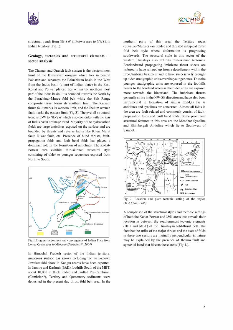
1983)).This tectonic depression formed as a result of
continent-continent collision (Fig 2). Intensity of the
thrusting decreases from North to South which is evident
from the elevation of the mountain ranges and
metamorphic grade that decreases towards South. Thus a
thick column of unmetamorphosed sedimentary rocks are
present in the sub-Himalayan belt South of MBT. These
are a result of continuous rise of the higher Himalayan
ranges and concomitant deposition of ‘molassic’ sediment
throughout the Tertiary period along the northern margin
of the Indian plate within a southward migrating foredeep.
While trying to comprehend the tectonic evolution of
Northwest part of Indian plate it is necessary to understand
the ancient position of Indian plate and its evolution
through time. Prior to collision with the Eurasian plate, the
Indian continent was a part of supercontinent Pangaea
during the late Paleozoic and early Mesozoic eras that is
evident from similar fossil evidences of South Africa and
India and from palaeomagnetic studies. The Indo-Eurasian
collision affected more intensively at the North-western
part at the early phase of the collision compared to the
eastern part due to northward convex structure of the
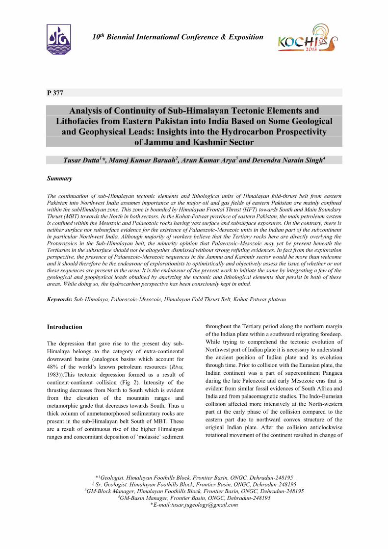
original Indian plate. After the collision anticlockwise
rotational movement of the continent resulted in change of
2
structural trends from NE-SW in Potwar area to NWSE in
Indian territory (Fig 1).
Geology, tectonics and structural elements –
sector analysis
The Chaman and Oranch fault system is the western most
limit of the Himalayan orogeny which lies in central
Pakistan and separates the Baluchistan basin in the West
from the Indus basin (a part of Indian plate) in the East.
Kohat and Potwar plateau lies within the northern most
part of the Indus basin. It is bounded towards the North by
the Parachinar-Muree fold belt while the Salt Range
composite thrust forms its southern limit. The Kurram
thrust fault marks its western limit, and the Jhelum wrench
fault marks the eastern limit (Fig 3). The overall structural
trend is E-W to NE-SW which also coincides with the axis
of Indus basin drainage trend. Majority of the hydrocarbon
fields are large anticlines exposed on the surface and are
bounded by thrusts and reverse faults like Kheri Murat
fault, Riwat fault, etc. Presence of blind thrusts, fault-
propagation folds and fault bend folds has played a
dominant role in the formation of anticlines. The Kohat-
Potwar area exhibits thin-skinned structural style
consisting of older to younger sequences exposed from
North to South.
Fig 1.Progressive journey and convergence of Indian Plate from
Lower Cretaceous to Miocene (Paracha.W, 2004)
In Himachal Pradesh sector of the Indian territory,
numerous surface gas shows including the well-known
Jawalamukhi show in Kangra recess have been reported.
In Jammu and Kashmir (J&K) foothills South of the MBT,
about 10,000 m thick folded and faulted Pre-Cambrian,
(Cambrian?), Tertiary and Quaternary sediments were
deposited in the present day thrust fold belt area. In the
northern parts of this area, the Tertiary rocks
(Siwaliks/Murrees) are folded and thrusted in typical thrust
fold belt style where deformation is progressing
southwards. The structural style in this sector of the
western Himalaya also exhibits thin-skinned tectonics.
Forelandward propagating imbricate thrust sheets are
inferred to have ramped up from a decollement within the
Pre-Cambrian basement and to have successively brought
up older stratigraphic units over the younger ones. Thus the
younger stratigraphic units are exposed in the foothills
nearer to the foreland whereas the older units are exposed
more towards the hinterland. The imbricate thrusts
generally strike in the NW-SE direction and have also been
instrumental in formation of similar trend,as far as
anticlines and synclines are concerned. Almost all folds in
the area are fault related and commonly consist of fault-
propagation folds and fault bend folds. Some prominent
structural features in this area are the Mendhar Syncline
and Bhimbergali Anticline which lie to Southwest of
Samhot.
Fig 2. Location and plate tectonic setting of the region
(M.A.Khan, 1986)
A comparison of the structural styles and tectonic settings
of both the Kohat-Potwar and J&K areas thus reveals their
location in between the southernmost tectonic elements
(HFT and MBT) of the Himalayan fold-thrust belt. The
fact that the strike of the major thrusts and the axes of folds
in these two sectors are mutually perpendicular in nature
may be explained by the presence of Jhelum fault and
syntaxial bend that bisects these areas (Fig 4.).
3
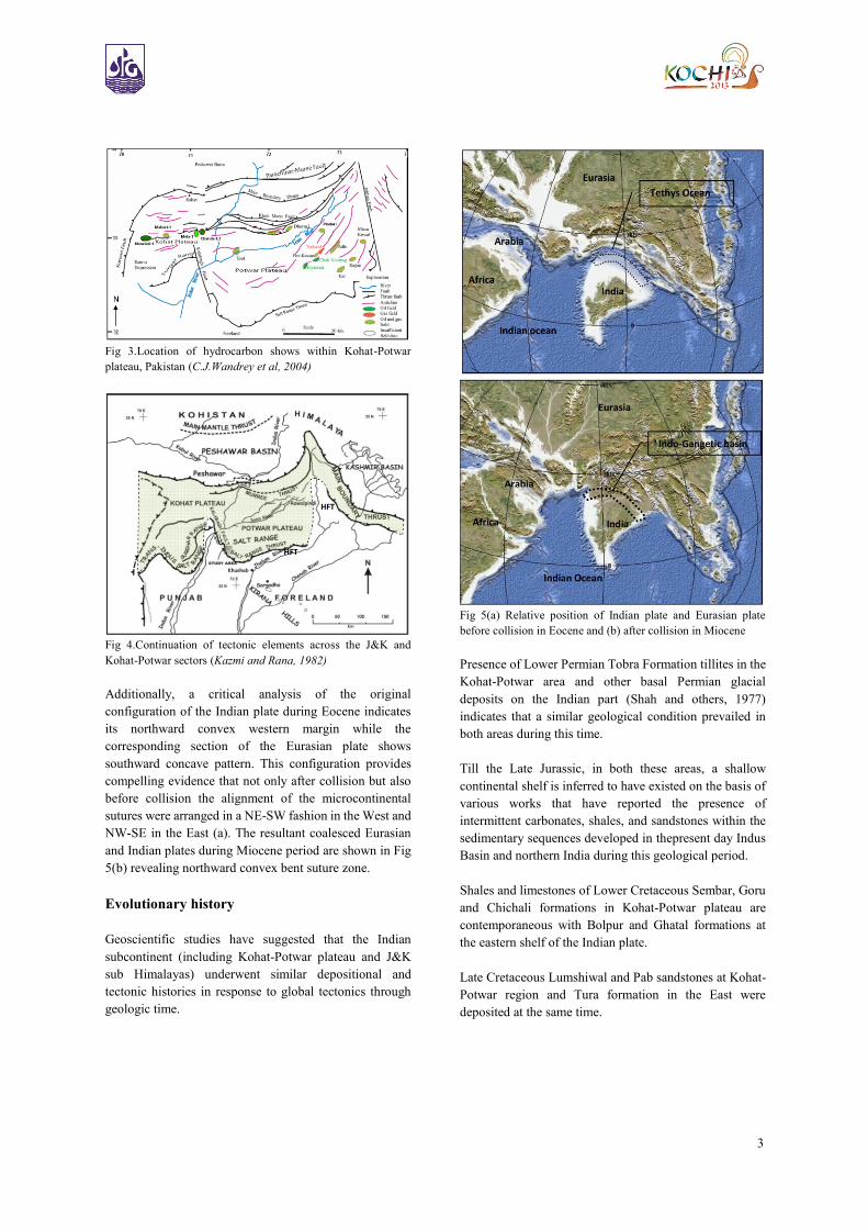
Fig 3.Location of hydrocarbon shows within Kohat-Potwar
plateau, Pakistan (C.J.Wandrey et al, 2004)
Fig 4.Continuation of tectonic elements across the J&K and
Kohat-Potwar sectors (Kazmi and Rana, 1982)
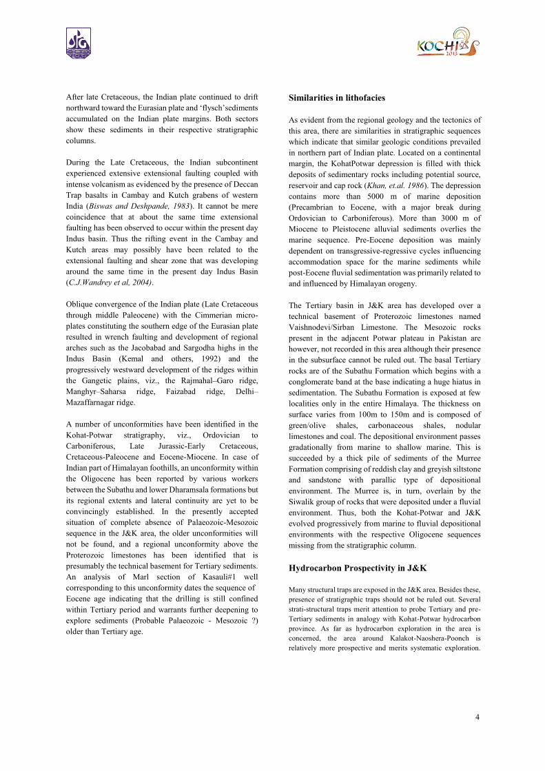
Additionally, a critical analysis of the original
configuration of the Indian plate during Eocene indicates
its northward convex western margin while the
corresponding section of the Eurasian plate shows
southward concave pattern. This configuration provides
compelling evidence that not only after collision but also
before collision the alignment of the microcontinental
sutures were arranged in a NE-SW fashion in the West and
NW-SE in the East (a). The resultant coalesced Eurasian
and Indian plates during Miocene period are shown in Fig
5(b) revealing northward convex bent suture zone.
Evolutionary history
Geoscientific studies have suggested that the Indian
subcontinent (including Kohat-Potwar plateau and J&K
sub Himalayas) underwent similar depositional and
tectonic histories in response to global tectonics through
geologic time.
Fig 5(a) Relative position of Indian plate and Eurasian plate
before collision in Eocene and (b) after collision in Miocene
Presence of Lower Permian Tobra Formation tillites in the
Kohat-Potwar area and other basal Permian glacial
deposits on the Indian part (Shah and others, 1977)
indicates that a similar geological condition prevailed in
both areas during this time.
Till the Late Jurassic, in both these areas, a shallow
continental shelf is inferred to have existed on the basis of
various works that have reported the presence of
intermittent carbonates, shales, and sandstones within the
sedimentary sequences developed in thepresent day Indus
Basin and northern India during this geological period.
Shales and limestones of Lower Cretaceous Sembar, Goru
and Chichali formations in Kohat-Potwar plateau are
contemporaneous with Bolpur and Ghatal formations at
the eastern shelf of the Indian plate.
Late Cretaceous Lumshiwal and Pab sandstones at Kohat-
Potwar region and Tura formation in the East were
deposited at the same time.
4
After late Cretaceous, the Indian plate continued to drift
northward toward the Eurasian plate and ‘flysch’sediments
accumulated on the Indian plate margins. Both sectors
show these sediments in their respective stratigraphic
columns.
During the Late Cretaceous, the Indian subcontinent
experienced extensive extensional faulting coupled with
intense volcanism as evidenced by the presence of Deccan
Trap basalts in Cambay and Kutch grabens of western
India (Biswas and Deshpande, 1983). It cannot be mere
coincidence that at about the same time extensional
faulting has been observed to occur within the present day
Indus basin. Thus the rifting event in the Cambay and
Kutch areas may possibly have been related to the
extensional faulting and shear zone that was developing
around the same time in the present day Indus Basin
(C.J.Wandrey et al, 2004).
Oblique convergence of the Indian plate (Late Cretaceous
through middle Paleocene) with the Cimmerian micro-
plates constituting the southern edge of the Eurasian plate
resulted in wrench faulting and development of regional
arches such as the Jacobabad and Sargodha highs in the
Indus Basin (Kemal and others, 1992) and the
progressively westward development of the ridges within
the Gangetic plains, viz., the Rajmahal–Garo ridge,
Manghyr–Saharsa ridge, Faizabad ridge, Delhi–
Mazaffarnagar ridge.
A number of unconformities have been identified in the
Kohat-Potwar stratigraphy, viz., Ordovician to
Carboniferous, Late Jurassic-Early Cretaceous,
Cretaceous-Paleocene and Eocene-Miocene. In case of
Indian part of Himalayan foothills, an unconformity within
the Oligocene has been reported by various workers
between the Subathu and lower Dharamsala formations but
its regional extents and lateral continuity are yet to be
convincingly established. In the presently accepted
situation of complete absence of Palaeozoic-Mesozoic
sequence in the J&K area, the older unconformities will
not be found, and a regional unconformity above the
Proterozoic limestones has been identified that is
presumably the technical basement for Tertiary sediments.
An analysis of Marl section of Kasauli#1 well
corresponding to this unconformity dates the sequence of
Eocene age indicating that the drilling is still confined
within Tertiary period and warrants further deepening to
explore sediments (Probable Palaeozoic - Mesozoic ?)
older than Tertiary age.
Similarities in lithofacies
As evident from the regional geology and the tectonics of
this area, there are similarities in stratigraphic sequences
which indicate that similar geologic conditions prevailed
in northern part of Indian plate. Located on a continental
margin, the KohatPotwar depression is filled with thick
deposits of sedimentary rocks including potential source,
reservoir and cap rock (Khan, et.al. 1986). The depression
contains more than 5000 m of marine deposition
(Precambrian to Eocene, with a major break during
Ordovician to Carboniferous). More than 3000 m of
Miocene to Pleistocene alluvial sediments overlies the
marine sequence. Pre-Eocene deposition was mainly
dependent on transgressive-regressive cycles influencing
accommodation space for the marine sediments while
post-Eocene fluvial sedimentation was primarily related to
and influenced by Himalayan orogeny.
The Tertiary basin in J&K area has developed over a
technical basement of Proterozoic limestones named
Vaishnodevi/Sirban Limestone. The Mesozoic rocks
present in the adjacent Potwar plateau in Pakistan are
however, not recorded in this area although their presence
in the subsurface cannot be ruled out. The basal Tertiary
rocks are of the Subathu Formation which begins with a
conglomerate band at the base indicating a huge hiatus in
sedimentation. The Subathu Formation is exposed at few
localities only in the entire Himalaya. The thickness on
surface varies from 100m to 150m and is composed of
green/olive shales, carbonaceous shales, nodular
limestones and coal. The depositional environment passes
gradationally from marine to shallow marine. This is
succeeded by a thick pile of sediments of the Murree
Formation comprising of reddish clay and greyish siltstone
and sandstone with parallic type of depositional
environment. The Murree is, in turn, overlain by the
Siwalik group of rocks that were deposited under a fluvial
environment. Thus, both the Kohat-Potwar and J&K
evolved progressively from marine to fluvial depositional
environments with the respective Oligocene sequences
missing from the stratigraphic column.
Hydrocarbon Prospectivity in J&K
Many structural traps are exposed in the J&K area. Besides these,
presence of stratigraphic traps should not be ruled out. Several
strati-structural traps merit attention to probe Tertiary and pre-
Tertiary sediments in analogy with Kohat-Potwar hydrocarbon
province. As far as hydrocarbon exploration in the area is
concerned, the area around Kalakot-Naoshera-Poonch is
relatively more prospective and merits systematic exploration.
5
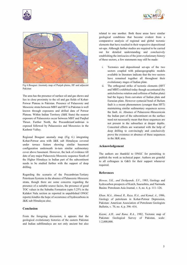
Fig 6.Bouguer Anomaly map of Punjab plains, HF and adjacent
Pakistan
The area has the presence of surface oil and gas shows and
lies in close proximity to the oil and gas fields of Kohat-
Potwar Plateau in Pakistan. Presence of Palaeozoic and
Mesozoic strata between MBT and HFT in Pakistan is well
known through exposures and drilled data of Potwar
Plateau. Within Indian Territory (J&K State) the nearest
exposure of Palaeozoics occur between MBT and Panjhal
Thrust. Further North, the PrecambrianCambrian is
exposed followed by Palaeozoics and Mesozoics in the
Kashmir Valley.
Regional Bouguer anomaly map (Fig 6.) integrating
Kohat-Potwar area with J&K sub Himalayas covered
under terrace feature showing similar basement
configuration underneath in-turn similar sedimentary
cover above basement. However, the lack of evidence till
date of any major Palaeozoic-Mesozoic sequence South of
the Higher Himalaya in Indian part of the subcontinent
needs to be studied further with the support of deep
drilling.
Regarding the scenario of the Precambrian-Tertiary
Petroleum Systems in the absence of Palaeozoic-Mesozoic
strata, though there are some concerns regarding the
presence of a suitable source facies, the presence of good
TOC values in the Subathu Formation (upto 5.25% in the
Kalakot Nala section as reported in unpublished ONGC
reports) kindles the hope of occurrence of hydrocarbons in
J&K sub Himalayas also.
Conclusion
From the foregoing discussion, it appears that the
geological evolutionary histories of the eastern Pakistan
and Indian subHimalaya are not only ancient but also
related to one another. Both these areas have similar
geological conditions that become evident from a
comparative analysis of regional and global tectonic
elements that have resulted in their respective depositional
set-ups. Although further studies are required to be carried
out for detailed understanding and conclusively
establishing the intricacies of the joint evolutionary history
of these sectors, a few statements may still be made:
i. Tectonics and depositional set-ups of the two
sectors coupled with palaeogeographic models
available in literature indicate that the two sectors
have remained together all throughout their
evolutionary stages of Indian plate.
ii. The orthogonal strike of tectonic elements (HFT
and MBT) exhibited today though accentuated (by
anticlockwise rotation and collision of Indian plate)
had the legacy from curvature of Indian plate and
Eurasian plate. However syntaxial bend of Jhelum
fault is a recent phenomenon (younger than HFT)
maintaining similar sedimentary sequences across
the fault. iii. Absence of Palaeozoic-Mesozoicsin
the Indian part of the subcontinent on the surface
need not necessarily mean that these sequences are
not present in the subsurface at deeper depths.
Concerted efforts are warranted with the help of
deep drilling to convincingly and conclusively
prove the existence or absence of these sequences
in the J&K area.
Acknowledgement
The authors are thankful to ONGC for permitting to
publish the work as technical paper. Authors are grateful
to all colleagues in G&G for their support whenever
required.
References
Biswas, S.K., and Deshpande, S.V., 1983, Geology and
hydrocarbon prospects of Kutch, Saurashtra, and Narmada
Basins: Petroleum Asia Journal, v. 6, no. 4, p. 111–126.
Khan, M.A., Ahmed, R., Raza, H.A., and Kemal, A., 1986,
Geology of petroleum in Kohat-Potwar Depression,
Pakistan: American Association of Petroleum Geologists
Bulletin, v. 70, no. 4, p. 396–414.
Kazmi, A.H., and Rana, R.A., 1982, Tectonic map of
Pakistan: Geological Survey of Pakistan, scale:
1:2,000,000.
6
Kemal, A., Balkwill, H.R., and Stoakes, F.A., 1992, Indus
Basin hydrocarbon plays, in Ahmed, G., Kemal, A.,
Zaman, A.S.H., and Humayon, M., eds., New directions
and strategies for accelerating petroleum exploration and
production in Pakistan: Proceedings,international
petroleum seminar, November, 22–24, 1991: Islamabad,
Pakistan, Ministry of Petroleum and Natural Resources,p.
76–105.
Paracha, W.,2004, Kohat Plateau with Reference to
Himalayan Tectonic General Study, CSEG RECORDER
April 2004
Riva, J. P. Jr., 1983: World petroleum resources and
reserves. Boulder, Colorado, Westview Press, 355p.
Shah, S.M.I., Ahmed, R., Cheema, M.R., Fatmi, A.N.,
Iqbal, M.W.A., Raza, H.A., and Raza, S.M., 1977,
Stratigraphy of Pakistan: Geological Survey of Pakistan,
Memoirs, v. 12, 137 p.
Wandrey, C.J., and Law, B.E.,Shah,H.A., 2004, Patala-
Nammal Composite Total Petroleum System,Kohat-
Potwar Geologic Province, Pakistan: U.S. Geological
Survey Bulletin 2208-B