analysis for remedial alternatives of unregulated municipal solid waste landfills...
TRANSCRIPT
RESEARCH ARTICLE
Analysis for remedial alternatives of unregulated municipalsolid waste landfills leachate-contaminated groundwater
Da AN1,2, Yonghai JIANG2, Beidou XI (✉)2, Zhifei MA2, Yu YANG2, Queping YANG2, Mingxiao LI2,Jinbao ZHANG2, Shunguo BAI2, Lei JIANG2
1 School of Environment, Beijing Normal University, Beijing 100875, China2 State Key Laboratory of Environmental Criteria and Risk Assessment, Chinese Research Academy of Environmental Sciences,
Beijing 100012, China
© Higher Education Press and Springer-Verlag Berlin Heidelberg 2013
Abstract A groundwater flow and solute transport modelwas developed using Visual Modflow for forecastingcontaminant transport and assessing effects of remedialalternatives based on a case study of an unregulated landfillleachate-contaminated groundwater in eastern China. Theresults showed that arsenic plume was to reach thepumping well in the downstream farmland after eightyears, and the longest lateral and longitudinal distance ofarsenic plume was to reach 200 m and 260 m, respectively.But the area of high concentration region of arsenic plumewas not to obviously increase from eight years to ten yearsand the plume was to spread to the downstream river andthe farmland region after 20 years; while the landfill’sground was hardened, the plume was not to reach thedownstream farmland region after eight years; when thepumping well was installed in the plume downstream anddischarge rate was 200 m3/d, the plume was to beeffectively restrained; for leakage-proof barriers, it mighteffectively protect the groundwater of sensitive objectswithin an extent time range. But for the continuous pointsource, the plume was still to circle the leakage-proofbarrier; when discharge rate of drainage ditches was170.26 m3/d, the plume was effectively controlled; thecomprehensive method combining ground-harden withdrainage ditches could get the best effect in controllingcontaminant diffusion, and the discharge rate was to bereduced to 111.43 m3/d. Therefore, the comprehensiveremedial alternative combining ground-harden with drai-nage ditch will be recommended for preventing ground-
water contamination when leachate leakage has happenedin unregulated landfills.
Keywords unregulated landfill, groundwater, numericalsimulation, contaminant transport, arsenic, remedial alter-native
1 Introduction
There are thousands of unregulated municipal solid wastelandfills in China that pose significant risk of groundwaterto human health (Zhang and Fang, 2006; Han et al., 2011).Unregulated municipal solid waste landfills have hardlyany leakage-proof countermeasure, which resulted in theentry of leachate into aquifers (Kjeldsen, 1993; Wang andZhao, 2002; Guo et al., 2009). Therefore, it is important forgroundwater contamination risk management of unregu-lated municipal solid waste landfills that contaminantstransport and fate in groundwater and effects of ground-water remedial alternatives are clearly known (Zhang et al.,2010a; Ma et al., 2012).Generally, selection of a suitable groundwater remedial
alternative for a landfill should firstly be based on thecharacterization of solid waste and the surrounding naturalenvironment, and then the alternatives should be screenedby indoor or field experiments (Guo et al., 2009).However, this procedure often takes a long period andhigh cost. With the development of numerical model andapplication of computer simulation technique in ground-water contamination (Zheng et al., 1991; Foose et al.,2001; Wang and McTernan, 2002; Li et al., 2004; Tsanis,2006; Zheng and Bennett, 2009; Shi et al., 2010), theeffects of groundwater remedial alternatives in landfills can
Received January 4, 2013; accepted March 14, 2013
E-mail: [email protected]
Front. Earth Sci. 2013, 7(3): 310–319DOI 10.1007/s11707-013-0374-y
be achieved by numerical simulation. It can greatly reducethe time and cost.Presently, Visual Modflow has been widely applied in
simulation of contaminants transport and fate. Gurunadhaet al. (2001) developed groundwater flow and masstransport models using Visual Modflow software forassessing the extent of migration of contaminants ofchemical and pharmaceutical industries in groundwater.Zhang et al. (2007) built up two-dimensional unconfinedflow and nitrate transport models for a long period of 42years by using Visual Modflow for forecasting theconcentration change of nitrate. Rajamanickam andNagan (2010) established a model using Visual Modflowfor simulation of the groundwater quality change for next15 years under five difference scenarios of Textile dyeingeffluent discharge. Ma et al. (2012) developed ground-water flow and Cr6+ transport models by applying VisualModflow software for simulating Cr6+ transport in ground-water and assessing the effects of controlling contamina-tion. However, the previous studies that have been reportedabout contaminants transport in aquifers by numericalsimulation are seldom focused on arsenic ion and fewstudies are focused on unregulated landfills. Furthermore,groundwater contamination control is still in the early stagein China and many efforts are urgently needed to improvegroundwater contamination control techniques.In this research, an unregulated municipal solid waste
landfill in eastern China was selected to assess theefficiency of several groundwater remedial alternatives.Arsenic was detected to be the main target contaminant inthe study site. A groundwater flow and solute transportmodel was established for simulating the transport and fateof arsenic in groundwater, and the effects of five kinds ofgroundwater remedial alternatives were assessed based onthe simulation results. The alternatives included hardeningground, pumping wells, leakage-proof barriers, drainageditches and a comprehensive method. The assessmentresults will assist in drafting a control plan for unregulatedlandfill leachate-contaminated groundwater.
2 Materials and method
2.1 Site description
2.1.1 Scope of the study site
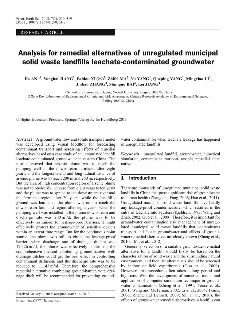
The unregulated municipal solid waste landfill is situatedin the east of Zhejiang Province, China. The study area isapproximately 30 hectares and the study scope contains theunregulated municipal solid waste landfill and itssurrounding reservoirs, rivers and farmland, where thereare coastal lands in the north, a mutual lake in the west, andrivers and farmland in the east and the south, as shown inFig. 1. The landfill has been operated for about ten years
for accepting solid waste from the urban area as well as itssurrounding villages.
2.1.2 Hydrogeologic characteristics
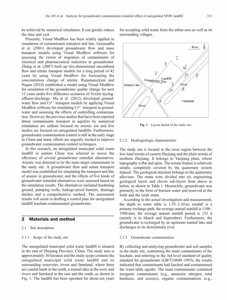
The study site is located in the cross region between thelow-land terrain of eastern Zhejiang and the plain terrain ofnorthern Zhejiang. It belongs to Yaojiang plain, whosetopography is flat and open. The terrain feature is relativelysimple, completely covered by the quaternary systemdeposit. The geological structure belongs to the quaternaryalluvium. The strata were divided into six engineeringgeological layers and eleven sub-layers from above tobelow, as shown in Table 1. Meanwhile, groundwater wasprimarily in the form of fracture water and reserved in theforth and the sixth strata.According to the actual investigation and measurement,
the depth to water table is 1.55–2.10 m; rainfall is aprimary recharge path; the average annual rainfall is 1100–1900 mm; the average annual rainfall period is 152 d(mainly is in March and September). Furthermore, thegroundwater is recharged by an upstream mutual lake anddischarges to its downstream river.
2.1.3 Groundwater contamination
By collecting and analyzing groundwater and soil samplesin the study site, contrasting the main contaminants of theleachate, and referring to the 3rd level standard of qualitystandard for groundwater (GB/T14848-1993), the resultsindicated that contaminants had leached and contaminatedthe water-table aquifer. The main contaminants containedinorganic contaminants (e.g., ammonia nitrogen, totalhardness, and arsenic), organic contaminations (e.g.,
Fig. 1 Layout sketch of the study site.
Da AN et al. Analysis for groundwater contamination remedial effect of unregulated MSW landfill 311
aniline, 4-chloroaniline and Phenol), coli bacillus, and totalbacterial count. Meanwhile, it was found that arsenic wasthe most important contaminant which has exceeded thestandard by about thirty times.
2.2 Conceptual model development
2.2.1 Hydrogeological conceptual model
2.2.1.1 Generalization of the aquifer structure
In the vertical direction, the established model wasconceptualized as three layers, representing respectively:the water-table aquifer, the average thickness was about 22m, mainly composed of silt; the upper aquitard, the averagethickness was about 14 m, mainly composed of clay; andthe confined aquifer, the average thickness was about 66 m,mainly composed of silty sand. In the simulation process ofcontaminants transport, each aquifer was assumed to behomogeneous and isotropic. The hydraulic gradient wasbrought from water head between the mutual lake and thesurrounding water-table aquifer. Meanwhile, the aquiferswere closely related to the surrounding surface waters,which were mainly decided by vertical permeabilitycoefficient. Permeability coefficients were higher than1.0�10–7cm/s.
2.2.1.2 Generalization of the aquifer boundary
The groundwater of the site had not been largely extractedso far, and there was no obviously natural naked waterhead. Farmland was a primary land type in the south of thelandfill, and its irrigation partly depended on the ground-water. However, considering that the farmland mainlybelonged to dry farming, the recharge rate for groundwaterwas relatively low. Therefore, for simplifying the simula-tion, the recharge from the rainfall and the mutual lakewere mainly considered. Meanwhile, since the study scope
was relatively smaller, which couldn’t reach naturalboundary and a constant flow boundary was determined;the surrounding surface rivers, located in the west and thesouth of landfill, their boundaries were conceptualized asriver boundaries; due to the mutual lake’s water level washigher than the groundwater level, then there was arecharge relationship from the mutual lake to groundwaterof the site, so the eastern boundary was conceptualized as aconstant water-head boundary; the uppermost boundarywas conceptualized as water table, which was mainlyrecharged by rainfall; the lowermost boundary in thebottom of fracture aquifer was conceptualized as non-flowboundary. The lateral flow rate of boundary could beacquired by applying Darcy Law (Lu, 2003; Shen andJiang, 2008; Ezekwe et al., 2012).
2.2.2 Flow and solute transport model
A groundwater flow and solute transport model wasestablished using Visual Modflow 4.1. Finite differencediscretization method was adopted to divide a simulationarea of 100 m2, with 60 � 50 grids generated. Meanwhile,in order to simplify the impacts of flow change tocontaminants transport, the groundwater flow was assumedto be steady-state.The scope and boundary of the solute transport model
were in accordance with that of the groundwater flowmodel. The boundary’s characteristics were handled by aknown arsenic concentration range. In the simulationprocess, the impacts of temperature and water density onthe hydrodynamic and concentration fields were neglected.The model parameters were completely defined asconservative type. Moreover, the simulation process wasbased on the assumption that the pollutant source was seenas continuous point source and the source scope was thewhole landfill. According to the multi-station monitoringdata of the leachate in the landfill, the source intensity wasdetermined as 1.5 mg/L. The arsenic transport was
Table 1 Primary geological layers distribution of the study site
Soil series Strata name Depth/m Thickness/m
1 Silt 0.50–1.90 0.50–1.90
2 Mucky silty clay and silt cross layer 1.40–6.30 0.50–5.40
3–1 Silt 3.10–5.70 1.20–3.40
3–2 Silt 5.20–7.00 1.40–4.10
3–3 Silt 15.90–16.70 10.90–12.10
3–4 Silt and mucky silty clay cross layer 14.80–16.20 7.80–13.10
3–5 Silt 14.80–18.60 2.50–5.40
4 Mucky silty clay 40.80–40.80 2.50–5.40
5–1 Silt mixed silty sand 43.00–43.00 2.20–2.20
5–2 Silty sand 51.80–51.80 8.80–8.80
6 Silty clay – –
312 Front. Earth Sci. 2013, 7(3): 310–319
simulated using the MT3DMS module of Visual Modflow.The observed data from January 1st 2010 and December
31st 2010 (365 d) were input to the simulation model foridentifying the hydrogeological parameters; the observeddata from January 1st, 2011 to May 31st, 2011(151 d) wereused for verifying modeling parameters, boundary char-acteristics, and the recharge and discharge rate.
2.3 Model calibration and verification
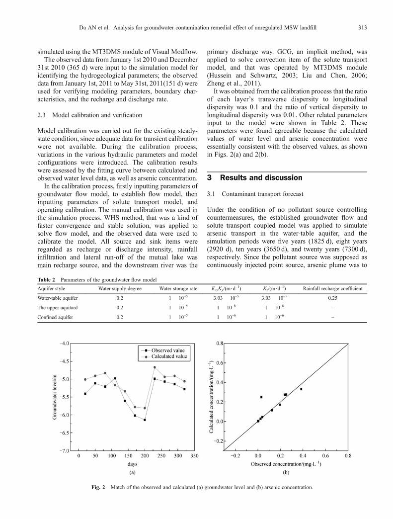
Model calibration was carried out for the existing steady-state condition, since adequate data for transient calibrationwere not available. During the calibration process,variations in the various hydraulic parameters and modelconfigurations were introduced. The calibration resultswere assessed by the fitting curve between calculated andobserved water level data, as well as arsenic concentration.In the calibration process, firstly inputting parameters of
groundwater flow model, to establish flow model, theninputting parameters of solute transport model, andoperating calibration. The manual calibration was used inthe simulation process. WHS method, that was a kind offaster convergence and stable solution, was applied tosolve flow model, and the observed data were used tocalibrate the model. All source and sink items wereregarded as recharge or discharge intensity, rainfallinfiltration and lateral run-off of the mutual lake wasmain recharge source, and the downstream river was the
primary discharge way. GCG, an implicit method, wasapplied to solve convection item of the solute transportmodel, and that was operated by MT3DMS module(Hussein and Schwartz, 2003; Liu and Chen, 2006;Zheng et al., 2011).It was obtained from the calibration process that the ratio
of each layer’s transverse dispersity to longitudinaldispersity was 0.1 and the ratio of vertical dispersity tolongitudinal dispersity was 0.01. Other related parametersinput to the model were shown in Table 2. Theseparameters were found agreeable because the calculatedvalues of water level and arsenic concentration wereessentially consistent with the observed values, as shownin Figs. 2(a) and 2(b).
3 Results and discussion
3.1 Contaminant transport forecast
Under the condition of no pollutant source controllingcountermeasures, the established groundwater flow andsolute transport coupled model was applied to simulatearsenic transport in the water-table aquifer, and thesimulation periods were five years (1825 d), eight years(2920 d), ten years (3650 d), and twenty years (7300 d),respectively. Since the pollutant source was supposed ascontinuously injected point source, arsenic plume was to
Table 2 Parameters of the groundwater flow model
Aquifer style Water supply degree Water storage rate Kx,Ky/(m$d–1) Kz/(m$d–1) Rainfall recharge coefficient
Water-table aquifer 0.2 1 � 10–5 3.03 � 10–5 3.03 � 10–5 0.25
The upper aquitard 0.2 1 � 10–5 1 � 10–8 1 � 10–8 –
Confined aquifer 0.2 1 � 10–5 1 � 10–6 1 � 10–6 –
Fig. 2 Match of the observed and calculated (a) groundwater level and (b) arsenic concentration.
Da AN et al. Analysis for groundwater contamination remedial effect of unregulated MSW landfill 313
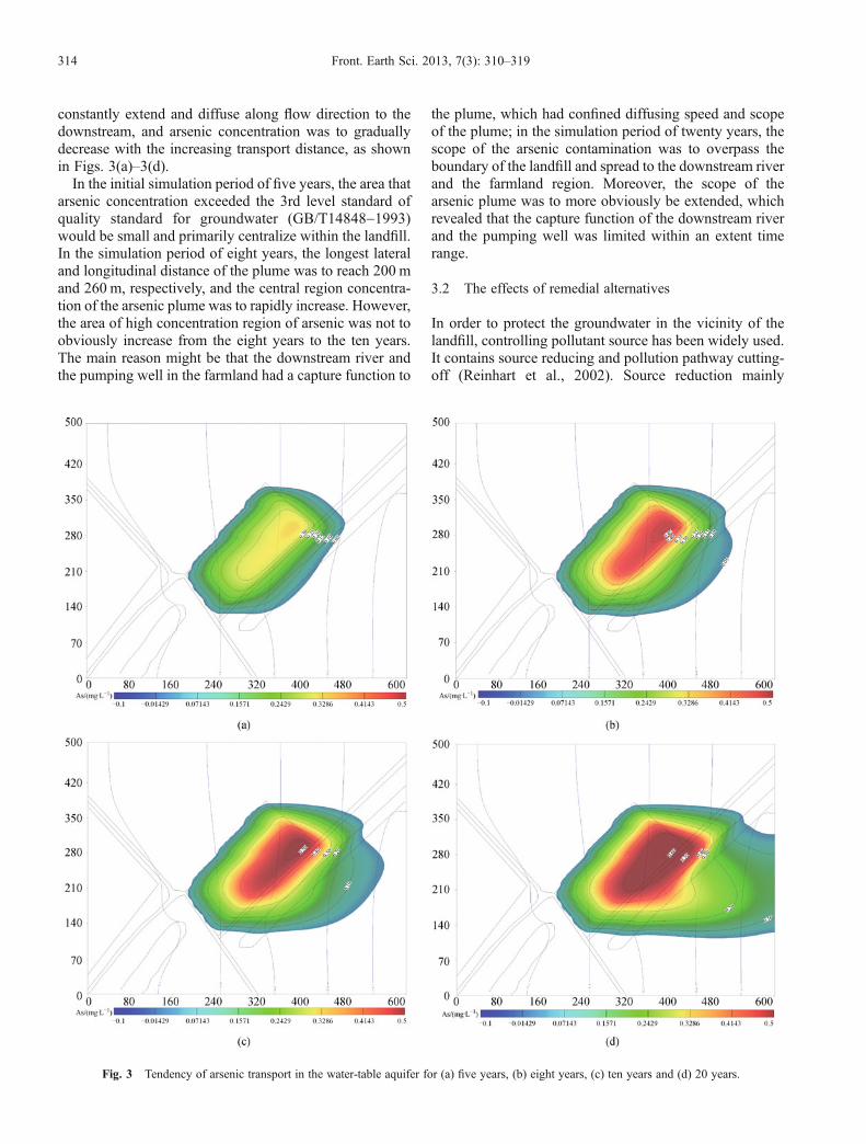
constantly extend and diffuse along flow direction to thedownstream, and arsenic concentration was to graduallydecrease with the increasing transport distance, as shownin Figs. 3(a)–3(d).In the initial simulation period of five years, the area that
arsenic concentration exceeded the 3rd level standard ofquality standard for groundwater (GB/T14848-1993)would be small and primarily centralize within the landfill.In the simulation period of eight years, the longest lateraland longitudinal distance of the plume was to reach 200 mand 260 m, respectively, and the central region concentra-tion of the arsenic plume was to rapidly increase. However,the area of high concentration region of arsenic was not toobviously increase from the eight years to the ten years.The main reason might be that the downstream river andthe pumping well in the farmland had a capture function to
the plume, which had confined diffusing speed and scopeof the plume; in the simulation period of twenty years, thescope of the arsenic contamination was to overpass theboundary of the landfill and spread to the downstream riverand the farmland region. Moreover, the scope of thearsenic plume was to more obviously be extended, whichrevealed that the capture function of the downstream riverand the pumping well was limited within an extent timerange.
3.2 The effects of remedial alternatives
In order to protect the groundwater in the vicinity of thelandfill, controlling pollutant source has been widely used.It contains source reducing and pollution pathway cutting-off (Reinhart et al., 2002). Source reduction mainly
Fig. 3 Tendency of arsenic transport in the water-table aquifer for (a) five years, (b) eight years, (c) ten years and (d) 20 years.
314 Front. Earth Sci. 2013, 7(3): 310–319
contains removing source and hardening ground. Forpollution pathway cutting-off, there are several alterna-tives. For example, leaking-proof barriers, pumping wellsand drainage ditches, etc. (Zheng et al., 1991; Dai and Yu,2003; Zheng and Bennett, 2009; Zhang et al., 2010b).However, as far as unregulated landfills are concerned,adopting source reducing is to spend a heavy workload anda large cost. So, in the study pollution pathway cutting-offwas selected as the primary remedial method. Based on theabove established groundwater flow and solute coupledmodel, five groundwater remedial alternatives wereconducted to restrict the plume diffusion.
3.2.1 Hardening ground
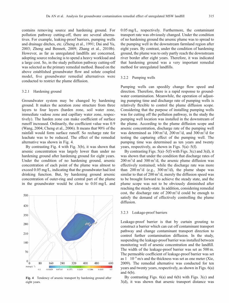
Groundwater system may be changed by hardeningground. It makes the aeration zone structure from threelayers to four layers (harden zone, soil water zone,immediate vadose zone and capillary water zone, respec-tively). The harden zone can make coefficient of surfacerunoff increased. Ordinarily, the coefficient value was 0.9(Wang, 2004; Cheng et al., 2006). It means that 90% of therainfall would form surface runoff. So recharge rate forleachate was to be reduced. The effect of the remedialalternative was shown in Fig. 4.By contrasting Fig. 4 with Fig. 3(b), it was shown that
arsenic concentration was largely lower than under nohardening ground after hardening ground for eight years.Under the condition of no hardening ground, arsenicconcentration of each point of the plume was almost toexceed 0.05 mg/L, indicating that the groundwater had lostdrinking function. But, by hardening ground arsenicconcentration of outer-ring and central part of the plumein the groundwater would be close to 0.01 mg/L and
0.05 mg/L, respectively. Furthermore, the contaminanttransport rate was obviously changed. Under the conditionof no hardening ground the arsenic plume was to spread tothe pumping well in the downstream farmland region aftereight years. By contrast, under the condition of hardeningground, the plume was to only partly reach the downstreamriver border after eight years. Therefore, it was indicatedthat hardening ground was a very important remedialmethod for unregulated landfills.
3.2.2 Pumping wells
Pumping wells can speedily change flow speed anddirection. Therefore, there is a rapid response to ground-water contamination. Meanwhile, the operation of adjust-ing pumping time and discharge rate of pumping wells isrelatively flexible to control the plume diffusion scope.Considering that the purpose of installing pumping wellswas for cutting off the pollution pathway, in the study thepumping well location was installed in the downstream ofthe plume. According to the plume diffusion scope andarsenic concentration, discharge rate of the pumping wellwas determined as 100 m3/d, 200 m3/d, and 300 m3/d fortesting the capturing effect of the pumping well. Thepumping time was determined as ten years and twentyyears, respectively, as shown in Figs. 5(a)–5(f).By contrasting Figs. 5(a)–5(f) with Figs. 3(c) and 3(d), it
was shown that under the condition that discharge rates of200 m3/d and 300 m3/d, the arsenic plume diffusion waseffectively restrained; while the discharge rate was morethan 200 m3/d (e.g., 300 m3/d), the plume shape wassimilar to that of 200 m3/d, merely the diffusion speed wasto be brought forward to achieve the steady state, and theplume scope was not to be obviously diminished afterreaching the steady-state. In addition, considering remedialcost, the discharge rate of 200 m3/d could be enough tosatisfy the demand of effectively controlling the plumediffusion.
3.2.3 Leakage-proof barriers
Leakage-proof barrier is that by curtain grouting toconstruct a barrier which can cut off contaminant transportpathway and change contaminant transport direction tocontrol further contamination diffusion. In the study,suspending the leakage-proof barrier was installed betweenmonitoring well of arsenic concentration and the landfill.The width of the leakage-proof barrier was set as 500 m.The permeable coefficient of leakage-proof barrier was setas 1�10–9 m/s and the thickness was set as one meter (Xie,2009). The remedial alternative was conducted for tenyears and twenty years, respectively, as shown in Figs. 6(a)and 6(b).By contrasting Figs. 6(a) and 6(b) with Figs. 3(c) and
3(d), it was shown that arsenic transport distance wasFig. 4 Tendency of arsenic transport by hardening ground aftereight years.
Da AN et al. Analysis for groundwater contamination remedial effect of unregulated MSW landfill 315
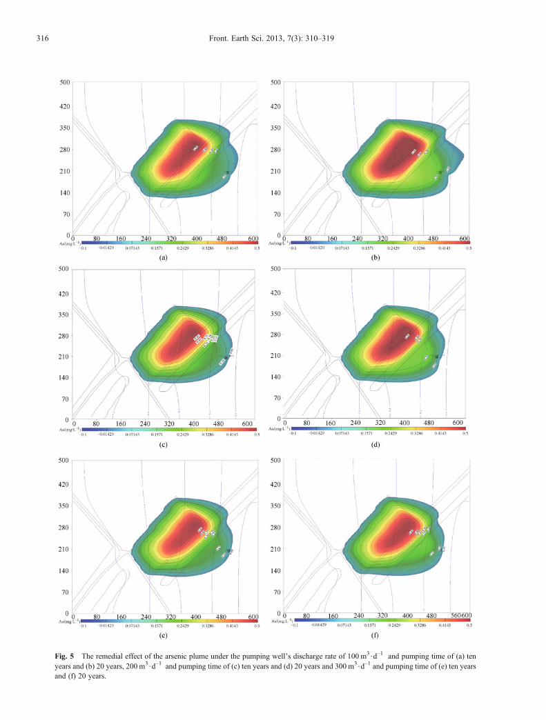
Fig. 5 The remedial effect of the arsenic plume under the pumping well’s discharge rate of 100 m3$d–1 and pumping time of (a) tenyears and (b) 20 years, 200 m3$d–1 and pumping time of (c) ten years and (d) 20 years and 300 m3$d–1 and pumping time of (e) ten yearsand (f) 20 years.
316 Front. Earth Sci. 2013, 7(3): 310–319

shorter than under no leakage-proof barrier. However, theplume was to circle the leakage-proof barrier and further tocontaminate the groundwater of the sensitive object aftertwenty years. Therefore, within an extent time rangeleakage-proof barriers might effectively protect thegroundwater of sensitive objects. But for the continuouspoint source, with time increasing the remedial effect of theleakage-proof barrier was not satisfying.
3.2.4 Drainage ditches
Drainage ditches is that by draining the contaminatedgroundwater to achieve reducing the total quantity ofcontaminants and controlling the plume. The drainedgroundwater after treatment may be recharged into aquifersor be used in other ways. In the study, the drainage ditcheswere installed between the landfill and the farmland. Thelength was 80m, the depth was 3 m and the water depth ofdrainage was kept at 0.5 m. By applying the DRN programpackage of Visual Modflow, the impact of contaminanttransport was simulated after installing the drainageditches’ twenty years, as shown in Fig. 7.By contrasting Fig. 7 with Fig. 3(d), it was shown that
arsenic diffusion scope was to largely shrink afterinstalling the drainage ditches. But the plume was tooverpass the drainage ditches after 20 years. It indicatedthat installing drainage ditches had a better effect to controlgroundwater contamination of the landfill within an extenttime range.
3.2.5 Combining ground-harden with drainage ditches
Analysis of the above four remedial alternatives indicatedthat each of them had its limitations. Hardening ground
could reduce contaminants levels in the groundwater bycontrolling rainfall permeation, but long-term rainfallpermeation was still a main recharge way for groundwatercontamination, so the remedial method was not a long andfar plan; leakage-proof barrier could change the directionof contaminant transport by cutting off the plume to protectdownstream sensitive objects, but total amount ofcontaminant could not still be reduced; pumping wellsand drainage ditches could reduce the contaminant amountby discharging, but the cost for treating contaminatedgroundwater in the later period was to be largely increased.Considering the above issues, the alternative combininghardening ground with drainage ditches was designed as acomprehensive remedial method to control the landfill-
Fig. 6 Tendency of the arsenic transport by installing leakage-proof barrier for (a) ten years and (b) 20 years.
Fig. 7 Tendency of the arsenic plume transport by installing the80m length drainage ditch after 20 years.
Da AN et al. Analysis for groundwater contamination remedial effect of unregulated MSW landfill 317
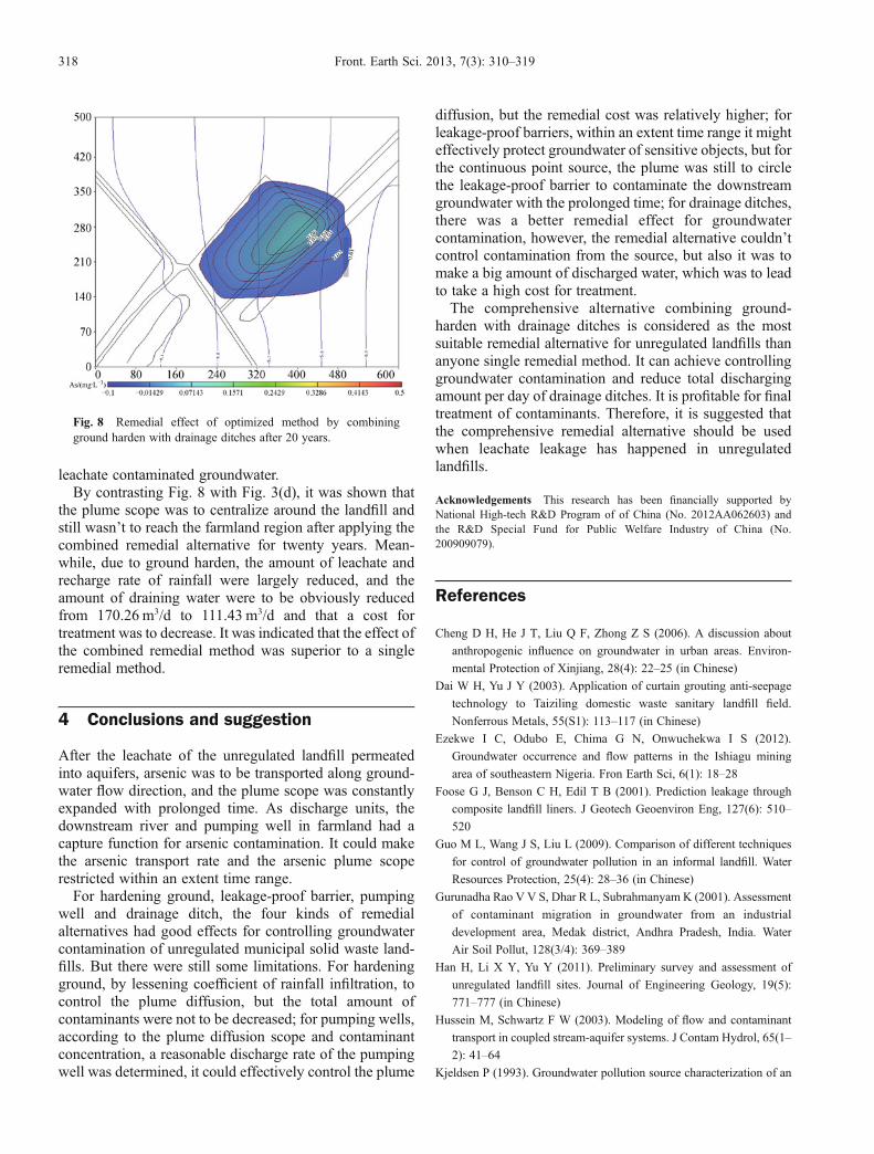
leachate contaminated groundwater.By contrasting Fig. 8 with Fig. 3(d), it was shown that
the plume scope was to centralize around the landfill andstill wasn’t to reach the farmland region after applying thecombined remedial alternative for twenty years. Mean-while, due to ground harden, the amount of leachate andrecharge rate of rainfall were largely reduced, and theamount of draining water were to be obviously reducedfrom 170.26 m3/d to 111.43 m3/d and that a cost fortreatment was to decrease. It was indicated that the effect ofthe combined remedial method was superior to a singleremedial method.
4 Conclusions and suggestion
After the leachate of the unregulated landfill permeatedinto aquifers, arsenic was to be transported along ground-water flow direction, and the plume scope was constantlyexpanded with prolonged time. As discharge units, thedownstream river and pumping well in farmland had acapture function for arsenic contamination. It could makethe arsenic transport rate and the arsenic plume scoperestricted within an extent time range.For hardening ground, leakage-proof barrier, pumping
well and drainage ditch, the four kinds of remedialalternatives had good effects for controlling groundwatercontamination of unregulated municipal solid waste land-fills. But there were still some limitations. For hardeningground, by lessening coefficient of rainfall infiltration, tocontrol the plume diffusion, but the total amount ofcontaminants were not to be decreased; for pumping wells,according to the plume diffusion scope and contaminantconcentration, a reasonable discharge rate of the pumpingwell was determined, it could effectively control the plume
diffusion, but the remedial cost was relatively higher; forleakage-proof barriers, within an extent time range it mighteffectively protect groundwater of sensitive objects, but forthe continuous point source, the plume was still to circlethe leakage-proof barrier to contaminate the downstreamgroundwater with the prolonged time; for drainage ditches,there was a better remedial effect for groundwatercontamination, however, the remedial alternative couldn’tcontrol contamination from the source, but also it was tomake a big amount of discharged water, which was to leadto take a high cost for treatment.The comprehensive alternative combining ground-
harden with drainage ditches is considered as the mostsuitable remedial alternative for unregulated landfills thananyone single remedial method. It can achieve controllinggroundwater contamination and reduce total dischargingamount per day of drainage ditches. It is profitable for finaltreatment of contaminants. Therefore, it is suggested thatthe comprehensive remedial alternative should be usedwhen leachate leakage has happened in unregulatedlandfills.
Acknowledgements This research has been financially supported byNational High-tech R&D Program of of China (No. 2012AA062603) andthe R&D Special Fund for Public Welfare Industry of China (No.200909079).
References
Cheng D H, He J T, Liu Q F, Zhong Z S (2006). A discussion about
anthropogenic influence on groundwater in urban areas. Environ-
mental Protection of Xinjiang, 28(4): 22–25 (in Chinese)
Dai W H, Yu J Y (2003). Application of curtain grouting anti-seepage
technology to Taiziling domestic waste sanitary landfill field.
Nonferrous Metals, 55(S1): 113–117 (in Chinese)
Ezekwe I C, Odubo E, Chima G N, Onwuchekwa I S (2012).
Groundwater occurrence and flow patterns in the Ishiagu mining
area of southeastern Nigeria. Fron Earth Sci, 6(1): 18–28
Foose G J, Benson C H, Edil T B (2001). Prediction leakage through
composite landfill liners. J Geotech Geoenviron Eng, 127(6): 510–
520
Guo M L, Wang J S, Liu L (2009). Comparison of different techniques
for control of groundwater pollution in an informal landfill. Water
Resources Protection, 25(4): 28–36 (in Chinese)
Gurunadha Rao V V S, Dhar R L, Subrahmanyam K (2001). Assessment
of contaminant migration in groundwater from an industrial
development area, Medak district, Andhra Pradesh, India. Water
Air Soil Pollut, 128(3/4): 369–389
Han H, Li X Y, Yu Y (2011). Preliminary survey and assessment of
unregulated landfill sites. Journal of Engineering Geology, 19(5):
771–777 (in Chinese)
Hussein M, Schwartz F W (2003). Modeling of flow and contaminant
transport in coupled stream-aquifer systems. J Contam Hydrol, 65(1–
2): 41–64
Kjeldsen P (1993). Groundwater pollution source characterization of an
Fig. 8 Remedial effect of optimized method by combiningground harden with drainage ditches after 20 years.
318 Front. Earth Sci. 2013, 7(3): 310–319
old landfill. J Hydrol (Amst), 142(1–4): 349–371
Li J P, Li X Q, Wang C Z, Jiang H Z, Shen Z L (2004). Simulative study
on landfill site pollution to groundwater. Techniques and Equipment
for Environmental Pollution Control, 5(11): 60–64 (in Chinese)
Liu M Z, Chen H H (2006). Modeling of transformation and
transportation of PCE and TCE by biodegradation in shallow
groundwater. Earth Sci Front, 1(13): 155–159 (in Chinese)
Lu W X (2003). Approach on boundary condition in numerical
simulation of groundwater flows. Journal of Hydraulic, 3: 33–36
(in Chinese)
Ma Z F, An D, Jiang Y H, Xi B D, Li D L, Zhang J B, Yang Y (2012).
Simulation on contamination forecast and control of groundwater in a
certain hazardous waste landfill. Environmental Science, 33(1): 64–
70 (in Chinese)
Rajamanickam R, Nagan S (2010). Groundwater quality modeling of
Amaravathi River Basin of Karur district, Tamil Nadu, using Visual
Modflow. International Journal of Environmental Sciences, 1(1): 91–
108
Reinhart D R, McCreanor P T, Townsend T (2002). The bioreactor
landfill: its status and future. Waste Manag Res, 20(2): 172–186
Shen Y Y, Jiang Y Z (2008). Research on disposal method of artificial
boundary condition in numerical simulation of groundwater flow.
Hydrogeology and Engineering Geology, 6(134): 12–15 (in Chinese)
Shi W F, Zeng W H, Chen B (2010). Application of Visual MODFLOW
to assess the Sewage Plant accident pool leakage impact on
groundwater in the Guanting Reservoir area of Beijing. Front Earth
Sci China, 4(3): 320–325
Tsanis I K (2006). Modeling leachate contamination and remediation of
groundwater at a landfill site. Water Resour Manage, 20(1): 109–132
Wang J J (2004). A discussion on compensation for breaking down
facilities of water and soil conservation and the methods of
preventing erosion. Shandong Hydraulic, 1: 12–13 (in Chinese)
Wang T A, McTernan W F (2002). The development and application of a
multilevel decision analysis model for the remediation of contami-
nated groundwater under uncertainty. J Environ Manage, 64(3): 221–
235
Wang Y H, Zhao Y S (2002). Pollution of municipal landfill to
groundwater in Beitiantang of Beijing. Hydrogeology and Engineer-
ing Geology, 29(6): 45–47 (in Chinese)
Xie X N (2009). Influence on seepage field in foundation excavation
dewatering of underground water blocking structure. Construction
Technology, 6(38): 208–210 (in Chinese)
Zhang C Y, Ma L N, Zhang S, Li Z H, Yin M Y, Zang Y Z (2007). The
application of Visual Modflow to the simulation of groundwater
nitrate contamination in Shijiazhuang. Acta Geoscientica Sinica, 28
(6): 561–566 (in Chinese)
Zhang W J, Lin X Y, Su X S (2010a). Transport and fate modeling of
nitrobenzene in groundwater after the Songhua River pollution
accident. J Environ Manage, 91(11): 2378–2384
Zhang X X, Fang J M (2006). Engineering application of leachate
recirculation technology in closure of dumping-type waste landfill
site in China. Environmental Sanitation Engineering, 14(6): 17–19
(in Chinese)
Zhang Y, He J T, Li P, Wang J J (2010b). Contaminant transport
simulation and control of a landfill in Kaifeng City. GroundWater, 32
(3): 15–27 (in Chinese)
Zheng C, Bennett G D, Andrews C B (1991). Analysis of ground water
remedial alternatives at a superfund site. Ground Water, 29(6): 838–
848
Zheng C M, Bennett G D (2009). Applied Contaminant Transport
Modeling. 2nd ed. Beijing: Wiley-Interscience Press (in Chinese)
Zheng C M, Bianchi M, Gorelick S M (2011). Lessons learned from 25
years of research at the MADE site. Ground Water, 49(5): 649–
662
AUTHOR BIOGRAPHIES
Da An received her M.S. degree in environmental sciences fromBeijing University of Chemical Technology in China in June 2005,and she is a Ph.D. candidate in environmental sciences from BeijingNormal University in China since September 2009. She has been aResearch Assistant in Chinese Research Academy of EnvironmentalSciences since 2007. Her current research interests focus on the fieldof groundwater contamination risk assessment and contaminationsource ranking management. Da An has participated a number ofnational major scientific research programs and published severalvaluable papers about the area of groundwater contamination controlon domestic and overseas journals in recent years.
Beidou Xi received his Ph.D degree in radiation and environmentalprotection from Tsinghua University in China in 2002. He had apostdoctoral study in University of Regina in Canada during 2002–2003. He has served as an Academic Leader of Groundwater andEnvironment System Engineering Innovation Base in ChineseResearch Academy of Environmental Sciences (CRAES) since2008 and a Director of Chief Engineer Office in CRAES since 2010.His current research interests focus on the field of groundwatercontamination control technology. Prof. Xi has taken charge of anumber of national major scientific research programs andrepeatedly received the first and second prizes for State/Provincescience and technology progress awards. He has served as aneditorial board member and a reviewer for several influentialdomestic and overseas journals and published more than 200valuable papers about the field of groundwater protection andcontamination control technology in recent years.
Da AN et al. Analysis for groundwater contamination remedial effect of unregulated MSW landfill 319