an outline of soil surveys conducted in brunei darussalam · an outline of soil surveys conducted...
TRANSCRIPT
~;J<Hf.l:lilflilf¥R Bull. For. & For. Prod. Res. Inst. No. 366, 1gg4 8g-105
An Outline of Soil Surveys Conducted in Brunei Darussalam
By
MARUMA Y A, Akio(t)
Summary : An outline of soil surveys and maps of Brunei Darussalam are described in order to provide basic information for afforestation. Four soil survey reports have been made and are available in this country. The soil Survey of Brunei, British Borneo, conducted in 1958, covers 2 areas in the north-east of Bandar Seri Begawan and in the lower Tutong Valley. A map was drawn for the former area on a scale of 1 :50 000. Unfortunately, this survey is of almost no use now, except for analytical data, as nearly all the areas have been converted into artificial land. The survey for the Land Capability Study (1969) includes 3 maps on a scale of 1 : 100 000, which cover nearly all the country. They are now useful as these is no substitute covering the whole country. The one on Brunei Agricultural and Forestry Development Study (1982) includes several soil maps on scales of 1 : 12 500, 1:25 000 or 1 : 50 000 for some parts of the Labi area and the Inter-Riverine Zone. These are the largest scale soil maps to have been published for public use in the country. The one of the Proposed Plantation Area (1989) includes a map on a scale of 1 : 2 000, which covers about 13ha. This map has almost no practical meaning due to its very limited area, but provides an example of a large-scale map for forestry management.
Advantages and disadvantages of the above maps are compared to clarify their uses. In addition, soil classification systems employed in these surveys are briefly discussed.
Contents
Introduction························································································ ·8g
2 The Soil Survey of Brunei, British Borneo (1g58) ..................................... go
3 Land Capability Study (1g6g) ................................................................. go
4 Brunei Agricultural and Forestry Development Study (1g82) ..................... g3
5 Soil Survey and Soil Classification in Proposed Plantation Area(1g88) ...... 101
6 A Comment on the Classification System of Soils ................................... 103 References ....................... ······· ....... ········ ................................................. 104
1 Introduction
The Forestry Department of Brunei Darussalam has recently proposed a plan for an
afforestation project of 50 000 ha in the Inter-Riverine Zone (IRZ.) in order to improve stand
structure and productivity in logged-over natural forests. Before this plan is put into
practice, it is necessary to classify the site conditions using basic data such as topography,
soils and vegetation. Since such information is limited in Brunei Darussalam, the best
possible use must be made of the available data. Here, the author will provide an outline
of soil survey data and maps up to the present.
Received December 2, 1992 ~~- 19 Forest Environment-19
(1) Forest Environment Division
- 90 -
2 The Soil Survey of Brunei, British Borneo (1958)
In 1955 the Division of Soils, Commonwealth Scientific and Industrial Research Organization,
was asked through the Commonwealth Department of External Affairs to conduct a soil survey in
Brunei, which was then a State under British protection. At that time, the Brunei Government
proposed a re-settlement plan near Brunei Town and in the lower Tutong Valley. In order to obtain
basic data for this plan, about 30 000 acres ( = 12 OOOha) were inspected in each area and one soil
survey map was drawn of the area near Brunei Town on a scale of 1 : 50 000. It covered the areas
along ]alan Gadong, ]alan Berakas and ]alan Muara. Perhaps this was the first attempt to survey
the distribution of soils systematically in this country, although it covered only a limited area
(BLACKBURN, 1958).
In this survey, soil profiles were described according to local classification systems, which had
been in use, possibly for hundreds of years, by the Kedayan people. Soils were classified into 5
classes based on features of surface soil and subsoil, such as colour, and content of sand and clay.
The nature of the vegetation was also taken into account. Indeed, this system may have been
primitive, but features of each soil class were described precisely and each class may be now
identified as a soil type in a modern classification system.
Unfortunately, the soil map of this survey is of little use nowadays, as nearly all the areas
covered by it have been converted into corr.mercial areas, an airport and residential areas, etc. But
the data of the profile description and analysis of soils at 48 points and water at 22 points are still
very useful, as the collecting points are shown precisely on the maps.
3 Land Capability Study (1969)
This study was carried out by Hunting Technical Services in England on commission from the
Brunei Government in 1968. The survey covered the entire State, and involved the study of land
forms from aerial photographs, a soil survey in the field and the collection of data relevant to the
development of natural resources. The report published in 1969 was composed of 3 volumes and
including 3 soil maps on a scale of 1 : 100 000, which covered all of the land of Brunei except about
8 500ha of the most interior part of the Temburong District.
In this soil survey, the 1966 Sarawak System was adopted for soil classification. This scheme
employed Great Soil Groups for the highest taxonomic criteria and Soil Families as a mapping unit.
According to these soil maps, 8 Great Soil Groups, namely Red- Yellow Podzolic Soils, Podzols,
Recent Alluvial Soils*, Gley Soils, Saline Gley Soils, Regosols, Skeletal Soils* and Organic Soils
were found. (The meaning of • will be explained in the next chapter.) These were subdivided into
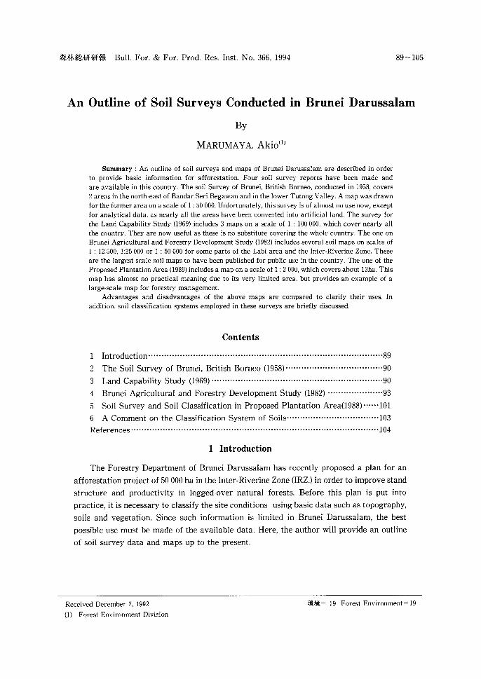
25 Soil Families in total. A definition of each Soil Family is given briefly in Table 1.
These Soil Families are too large to be used as the mapping unit for several areas where a few
Soil Families are intricately distributed. For such areas, Soil Family Association is used as a
mapping unit by combining 2 or 3 Soil Families. (for instance, as ME/BK or ME/NY /MA. A
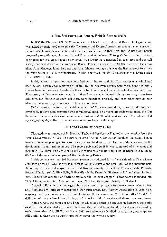
definition of these abbreviations is given in Table 1.) In Fig. I, sections of these maps are shown.
In this survey, the names of Soil Families which had hitherto been used in Sarawak, were still
used for those distributed in Brunei. Therefore, they should be replaced by local names according
to the correlation table (ULG Consultants, 1982) to enable more detailed surveys. But these maps are
still useful as there are no substitutes whi.ch cover the whole country.
An Outline of Soil Surveys Conducted in Brunei Darussalam (MARUYAMA) - 91 -
Table 1. Soil Families in Brunei Darussalam from the Soil Map of the Land Capability Survey (1969)
Great Soil Soil Abb. on
Group Family the map
Red-Yellow Merit ME Podzolic Soils
Bekenu BK
Nyalau NY
Malang MA
Semilajau SM
Lupar LU
Sabangang SB
Podzols Miri MR
Buso BU
Recent Kay an KY Alluvial Soils
Regosols Regosol RL
Skeletal Soils Meluan ML
Kapit KP
Gley Soils Bijat BJ
Sebandi SD
Plan PL
Tatau TA
Matu MT
Saline Rajang RG Gley Soils
Pen dam PD
Bel at BE
Organic Soils Anderson AN
Mukah MU
lgan IG
Lim bang LB
Note : * One of the series of Alluvial Soils
* * One Series
Parent Physical Equivalent Material Property in Brunei
Residual heavy Bukit
If medium Benutan
If light Sukang
Young heavy Asam* Riverine (Alluvial)
If light Kukup* (Alluvial)
Old Alluvial heavy Rambai**
II light Banggarang* *
Old Alluvial cemented Telisai**
II uncemented Mapol**
Young light Merangking Riverine
Old Alluvial Tungku or Takalit
Residual AIR Puan
II A/C Andulau
Young heavy Tutong** Riverine (non-peaty)
II heavy Singap** (peaty)
II light Rampayoh** (non-peaty)
Young Marine light Buaya** & Estuarine (non-peaty)
If light Pantai** (peaty)
Young Marine heavy( strongly not named as & Estuarine saline) yet
II heavy(weakly not named as saline) yet
II light(strongly not named as saline) yet
deep Anduki
shallow Keduan heavy shallow Sibut light saline not named as
yet
- 92 -
Scale 1 : I 00 000
0 2 4 6 8 lOkm
Fig.l. Part of soil map in Land Capability Study (1969)
An Outline of Soil Surveys Conducted in Brunei Darussalam (MARUYAMA) - 93 -
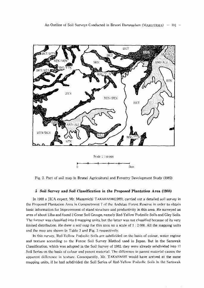
4 Brunei Agricultural and Forestry Development Study (1982)
The final report of the Brunei Agricultural and Forestry Development Study contains soil
survey data and soil maps which, although they do not cover the whole of Brunei Darusalam, cover
a fairly wide area(ULG Consultants, 1982). In 1981 the Brunei Government commissioned ULG
Consultants Ltd. to carry out land use, forestry, agricultural, economic and social investigations in
the Labi area and the IRZ. The report of these investigations published in 1982 and 1983 consisted
of 12 volumes and 3 boxes of maps. They include 2 soil maps on a scale of 1 : 12 500 for the Labi
area, 2 soil maps on a scale of 1 : 50 000, 4 soil maps on a scale of 1 : 25 000 for the IRZ., and 4 volumes
of soil survey data. They are the soil maps on the largest scale that have been published for public
use in this country.
In order to implement these soil surveys, the 1979 version of the Sarawak Classification was
basically adopted. This scheme employed Great Soil Groups for the highest taxonomic criteria, as
in the soil survey on the Land Capability Study (1969). Soil Series which were identified by
subdividing Soil Families,were used as a mapping unit. In addition, the names of Soil Families and
Soil Series were replaced by local equivalents in Brunei.
In this soil survey, 8 Great Soil Groups, namely Red-Yellow Podzolic Soils, Grey-White Podzolic
Soils, Podzols, Alluvial Soils, Gley Soils, Regosols, Lithosols and Organic Soils were found. The 2
names in the soil survey on the Land Capability Study (indicated by * in the last chapter.) were
replaced by Alluvial Soils and Lithosols respectively, and Saline Gley Soils were included in Gley
Soils. On the other hand, Grey-White Podzolic Soils were newly identified as a result of a more
detailed survey.
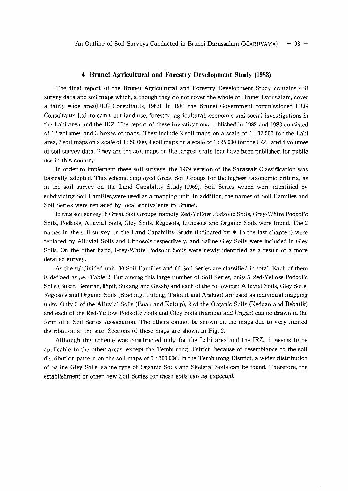
As the subdivided unit, 30 Soil Families and 66 Soil Series are classified in total. Each of them
is defined as per Table 2. But among this large number of Soil Series, only 5 Red-Yellow Podzolic
Soils (Bukit, Benutan, Pipit, Sukang and Gesah) and each of the following: Alluvial Soils, Gley Soils,
Regosols and Organic Soils (Biadong, Tutong, Takalit and Anduki) are used as individual mapping
units. Only 2 of the Alluvial Soils (Buau and Kukup), 2 of the Organic Soils (Keduan and Bebatik)
and each of the Red-Yellow Podzolic Soils and Gley Soils (Rambai and Ungar) can be drawn in the
form of a Soil Series Association. The others cannot be shown on the maps due to very limited
distribution at the site. Sections of these maps are shown in Fig. 2.
Although this scheme was constructed only for the Labi area and the IRZ., it seems to be
applicable to the other areas, except the Temburong District, because of resemblance to the soil
distribution pattern on the soil maps of 1 : 100 000. In the Temburong District, a wider distribution
of Saline Gley Soils, saline type of Organic Soils and Skeletal Soils can be found. Therefore, the
establishment of other new Soil Series for these soils can be expected.
Table 2. Soil Series in Brunei Darussalam from the Soil Map for the Brunei Agricultural and Forestry Development Study (1982)
Family Series Colour Parent Landform Texture AI A2 B Mapping Remarks material em em em unit
Red-Yellow Podzolic Soils
Bukit Bukit yel. Br. Shale Undulating CL!C <10 10< <30 10< <60 BKT /br. Y. Mudstone to steep BKT-BTN
Siltstone terrain BKT-PPT Rambai yel. Br. Old High CL/C <10 10< <30 10< <60 RMB-PPT Limited
/br. Y. riverine riverine distriribution in IRZ. allvium terraces
As in str. Br. Argillaceous CL/C <10 10< <30 10< <60 Less extensive /red. Y. High in iron than Bukit Ser.
content
Benutan Benutan yel. Br. Mixed Shales Undulating SCL <10 20< <50 20< <25 BTN /br. Y. & sandstones to steep BKT-BTN
BTN-SKN Pipit yel. Br. Old riverine High level SCL <10 20< <50 20< <25 PPT Higher exchangeable
/br. Y. alluvium terraces BKT-PPT base. RMB-PPT Rarely recorded.
Dungun str. Br. Mixed Shales Upland sites SCL <10 20< <50 20< <25 Sporadically /red. Y. & sandstones recorded in IRZ.
High in iron content
Sukang Sukang yel. Br. Sandstone Undulating SL I SCL <10 20< <50 50< <100 SKN /br. Y. to hilly BTN-SKN
terrain Banggarang yel. Br. Old riverine Terrace SL I SCL <10 20< <50 50< <100 Rarely recorded.
/br. Y. alluvium remnant Ukong str. Br. Sandstone SL I SCL <10 20< <50 50< <100 Very rarely recorded.
/red. Y. Gesah yel. Br. Sandstone Steeper SL <10 20< <50 50< < 100 GSH Rarely recorded.
/br. Y. s1ope>20"
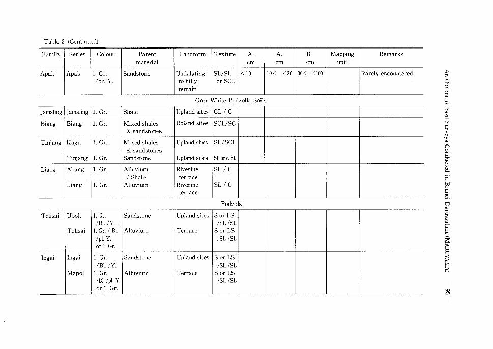
Table 2. (Continued)
Family Series Colour Parent Landform Texture At A2 B Mapping Remarks material em em em unit
Apak Apak 1. Gr. Sandstone Undulating SL/SL <10 10< <30 30< <100 Rarely encountered. lbr. Y. to hilly or SCL
terrain
Grey-White Podzolic Soils
Jamaling Jamaling 1. Gr. Shale Upland sites CLI C
Biang Biang 1. Gr. Mixed shales Upland sites SCL/SC & sandstones
Tinjang Kagu 1. Gr. Mixed shales Upland sites SL/SCL & sandstones
Tinjang 1. Gr. Sandstone Upland sites SL or c. SL
Liang A bang 1. Gr. Alluvium Riverine SL I C I Shale terrace
Liang 1. Gr. Alluvium Riverine SL I C terrace
Podzols
Telisai Ubok 1. Gr. Sandstone Upland sites Sor LS /Bl. /Y. /SL /SL
Telisai 1. Gr. I Bl. Alluvium Terrace S or LS /pl. Y. /SL /SL or 1. Gr.
lngai lngai 1. Gr. Sandstone Upland sites S or LS IB!. IY. /SL /SL
Mapol 1. Gr. Alluvium Terrace S or LS /Bl. /pl. Y. /SL /SL or 1. Gr.
Table 2. (Continued)
Family Series Colour Parent Landform Texture A, A, B Mapping Remarks material em em em unit
Sew at Sew at l. Gr. Sandstone Flat to S or LS <10 20< <30 20< <60 /d. red. Br. undulating I SL I SL /Y. or yel. Br. upland
Pur au l.br.Gr. Sandstone Upland sites LSI SL <10 20< <30 20< <60 Only at one point in IRZ. or v. pl. Br. I SL /d. red. Br. /Y.or yei.Br.
Alluvial Soils
Biadong Biadong yel. Br. Argillaceous Riverbank c <10 ... 50< <100 BDG (mottled) alluvium Levee BDG-BUU
Bottomland BDG-TTN Asam red. Y. Argillaceous Riverbank c <10 ... 50< <100
(mottled) alluvium Levee Bottomland
Buau Buau yel. Br. Riverine Riverbank SCL I SC BDG-BUU Less extensive alluvium Levee BUU-KKP than Biadong Ser.
Bottomland Mendaram yel. Br. Riverine Riverbank SL/SCL Less extensive
alluvium Levee than Biadong Ser. Bottomland
Kukup yel. Br. Riverine Riverbank SL BUU-KKP Less extensive alluvium Levee than Biadong Ser.
Bottomland
Merangking Merangking yel. Br. Riverine Riverbank s Very Very minor soils. alluvium Levee thin
Bottomland
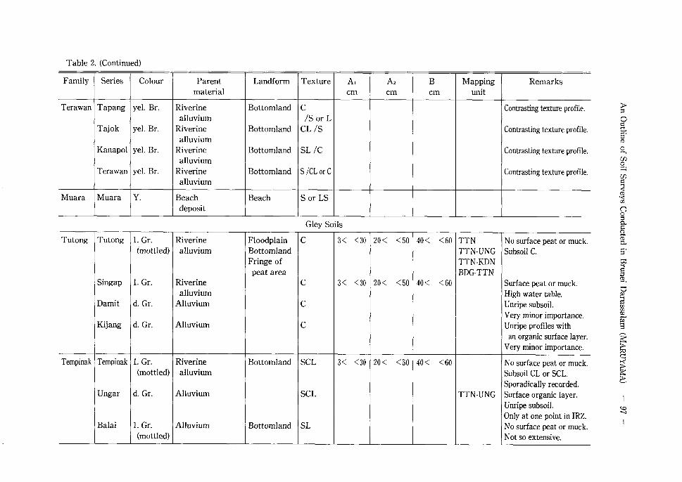
Table 2. (Continued)
Family Series Colour Parent Landform Texture AI A2 B Mapping Remarks material em em em unit
Terawan Tapang yel. Br. Riverine Bottomland c Contrasting texture profile. alluvium /S or L
Tajok yel. Br. Riverine Bottomland CL /S Contrasting texture profile. alluvium
Kana pol yel. Br. Riverine Bottomland SL /C Contrasting texture profile. alluvium
Terawan yel. Br. Riverine Bottomland S /CL or C Contrasting texture profile. alluvium
Muara Muara Y. Beach Beach S or LS deposit
Gley Soils
Tutong Tutong 1. Gr. Riverine Floodplain c 3< <30 20< <50 40< <60 TTN No surface peat or muck. (mottled) alluvium Bottomland TTN-UNG Subsoil C.
Fringe of TTN-KDN peat area BDG-TTN
Singap 1. Gr. Riverine c 3< <30 20< <50 40< <60 Surface peat or muck. alluvium High water table.
Damit d. Gr. Alluvium c Unripe subsoil. Very minor importance.
Kijang d. Gr. Alluvium c Unripe profiles with an organic surface layer.
Very minor importance.
Tempinak Tempinak 1. Gr. Riverine Bottomland SCL 3< <30 20< <50 40< <60 No surface peat or muck. (mottled) alluvium Subsoil CL or SCL.
Sporadically recorded. Ungar d. Gr. Alluvium SCL TTN-UNG Surface organic layer.
Unripe subsoil. Only at one point in IRZ.
Balai 1. Gr. Alluvium Bottomland SL No surface peat or muck. (mottled) Not so extensive.
Table 2. (Continued)
Family Series Colour Parent Landform Texture A, A2 B Mapping Remarks material em em em unit
Rampayoh Rampayoh 1. Gr. Riverine Small valley S or LS No surface peat or muck. alluvium Gully Not so extensive.
Merimbun 1. Gr. Riverine Small valley S or LS Surface peat or muck ( < 25cm) alluvium Gully Not so extensive.
Gatas Tesilin 1. Gr. Riverine Bottomland CIS Contrasting texture profile. alluvium Peat or muck in lower layer.
Locally important in Labi. Kandol 1. Gr. Riverine Bottomland CL IS Contrasting texture profile.
alluvium Peat or muck in lower layer. Locally important in Labi.
Luagan 1. Gr. Riverine Bottomland SL I C Contrasting texture profile. alluvium Peat or muck in lower layer.
Locally important in Labi. Gatas 1. Gr. Riverine Bottomland S I CL or C Contrasting texture profile.
alluvium Peat or muck in lower layer. Locally important in Labi.
Ratan Rat an 1. Gr. Riverine Bottomland c Clay horizon 25 < <100 Contrasting texture profile. (mottled) alluvium Swamp margin Subsurface peat layer Important in Labi.
& organic at least lm.
Buaya Buaya Gr. Depression s No surface peat or muck. to 1. Gr. in coast
Pantai Gr. Depression s Surface peat or muck. to 1. Gr. in coast
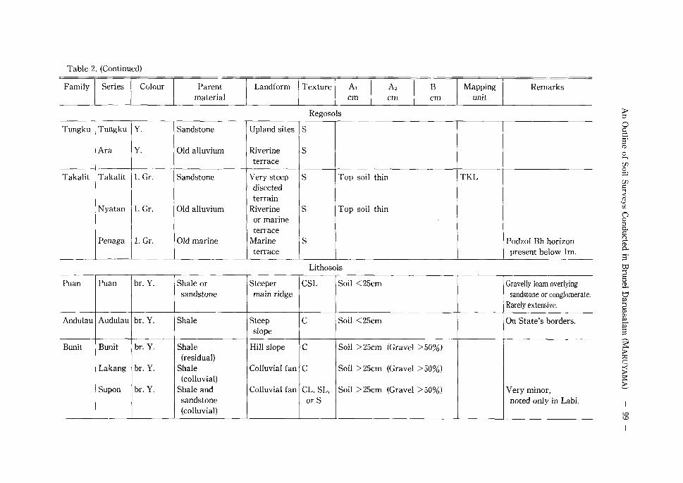
Table 2. (Continued)
Family Series Colour Parent Landform Texture A, A2 B Mapping Remarks material em em em unit
Regosols
Tungku Tungku Y. Sandstone Upland sites s
Ara Y. Old alluvium Riverine s terrace
Takalit Takalit 1. Gr. Sandstone Very steep s Top soil thin TKL disected terrain
Nyatan 1. Gr. Old alluvium Riverine s Top soil thin or marine terrace
Penaga 1. Gr. Old marine Marine s Podzol Bh horizon terrace present below lm.
Lithosols
Puan Puan br. Y. Shale or Steeper CSL Soil <25cm Gravelly loam overlying sandstone main ridge sandstone or conglomerate.
Rarely extensive.
Andulau Audulau br. Y. Shale Steep c Soil <25cm On State's borders. slope
Bunit Bun it br. Y. Shale Hill slope c Soil >25cm (Gravel >50%) (residual)
Lakang br. Y. Shale Colluvial fan c Soil >25cm (Gravel >50%) (colluvial)
Supan br. Y. Shale and Colluvial fan CL, SL, Soil >25cm (Gravel >50%) Very minor, sandstone or S noted only in Labi. (colluvial)
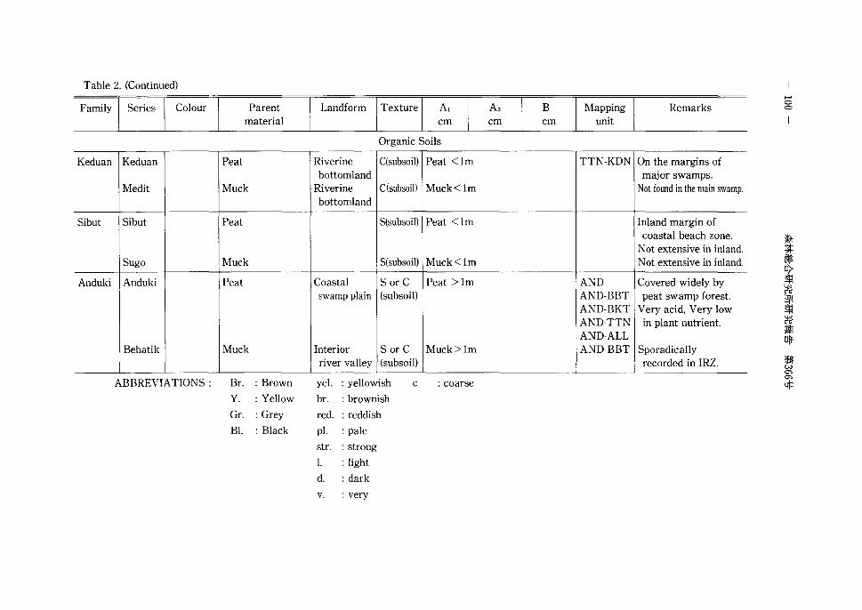
Table 2. (Continued)
Family Series Colour Parent material
Keduan Keduan Peat
Medit Muck
Sibut Sibut Peat
Sugo Muck
Anduki Anduki Peat
Bebatik Muck
ABBREVIATIONS : Br. :Brown
Y. :Yellow
Gr. :Grey
Bl. : Black
Landform Texture A, em
Organic Soils
Riverine C(subsoil) Peat <lm bottomland
Riverine C(subsoi]) Muck<lm bottomland
S(subsoil) Peat <lm
S(subsoil) Muck<lm
Coastal S or C Peat >lm swamp plain (subsoil)
Interior S or C Muck> 1m river valley (subsoil)
yel. :yellowish c :coarse
br. :brownish
red. :reddish
pl. :pale
str. :strong
I. : light
d. :dark
v. :very
Az B Mapping em em unit
TTN-KDN
AND AND-BBT AND-BKT AND-TTN AND-ALL AND-BBT
Remarks
On the margins of major swamps.
Not found in the main swamp.
Inland margin of coastal beach zone.
Not extensive in inland. Not extensive in inland.
Covered widely by peat swamp forest.
Very acid, Very low in plant nutrient.
Sporadically recorded in IRZ.
...... 0 0
An Outline of Soil Surveys Conducted in Brunei Darussalam (MARUYAMA) - 101 -
Scale 1 : 50 000
0 Skm
Fig. 2. Part of soil map in Brunei Agricultural and Forestry Development Study (1982)
5 Soil Survey and Soil Classification in the Proposed Plantation Area (1988)
In 1988 a JICA expert, Mr. Masamichi T AKAHASHI(1989), carried out a detailed soil survey in
the Proposed Plantation Area in Compartment 7 of the Andulau Forest Reserve in order to obtain
basic information for improvement of stand structure and productivity in this area. He surveyed an
area of about 13ha and found 2 Great Soil Groups, namely Red-Yellow Podzolic Soils and Gley Soils.
The former was classified into 8 mapping units, but the latter was not classified because of its very
limited distribution. He drew a soil map for this area on a scale of 1 : 2 000. All the mapping units
and the map are shown in Table 3 and Fig. 3 respectively.
In this survey, Red-Yellow Podzolic Soils are subdivided on the basis of colour, water regime
and texture according to the Forest Soil Survey Method used in Japan. But in the Sarawak
Classification, which was adopted in the Soil Survey of 1982, they were already subdivided into 11
Soil Series on the basis of colour and parent material. The difference in parent material causes the
apparent difference in texture. Consequently, Mr. TAKAHASHI would have arrived at the same
mapping units, if he had subdivided the Soil Series of Red· Yell ow Podzolic Soils in the Sarawak
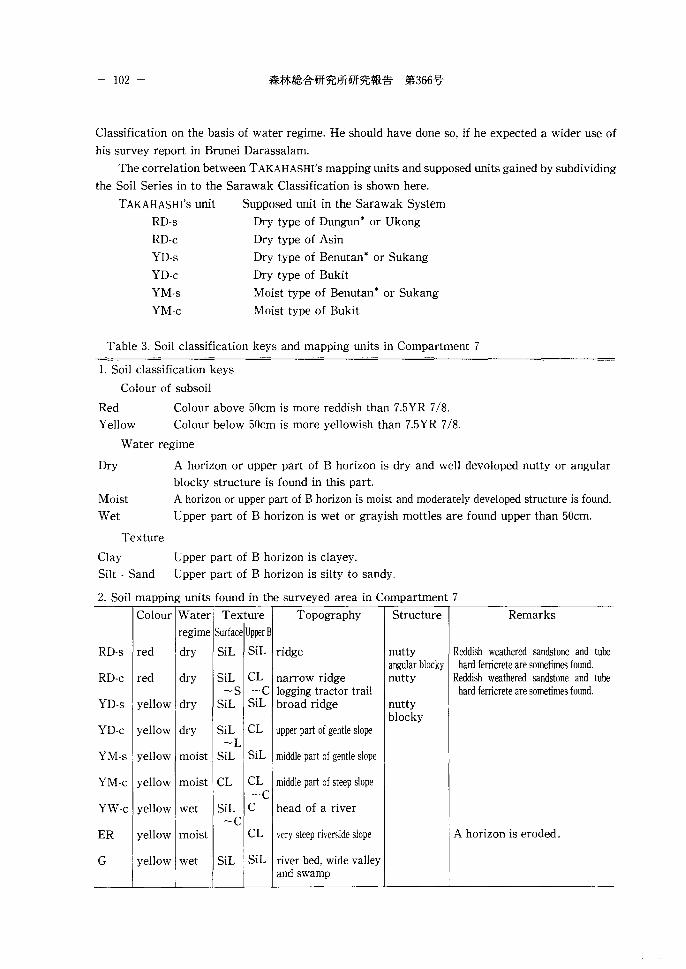
- 102 -
Classification on the basis of water regime. He should have done so, if he expected a wider use of
his survey report in Brunei Darassalam.
The correlation between TAKAHASHI's mapping units and supposed units gained by subdividing
the Soil Series in to the Sarawak Classification is shown here.
TAKAHASHI's unit
RD-s
RD-c
YD-s
YD-c
YM-s
YM-c
Supposed unit in the Sarawak System
Dry type of Dungun* or Ukong
Dry type of Asin
Dry type of Benutan • or Sukang
Dry type of Bukit
Moist type of Benutan* or Sukang
Moist type of Bukit
Table 3. Soil classification keys and mapping units in Compartment 7
1. Soil classification keys
Colour of subsoil
Red
Yellow
Colour above 50cm is more reddish than 7.5YR 7/8.
Colour below 50cm is more yellowish than 7.5YR 7/8.
Water regime
Dry
Moist
Wet
Texture
A horizon or upper part of B horizon is dry and well devoloped nutty or angular
blocky structure is found in this part.
A horizon or upper part of B horizon is moist and moderately developed structure is found.
Upper part of B horizon is wet or grayish mottles are found upper than 50cm.
Clay Upper part of B horizon is clayey.
Silt · Sand Upper part of B horizon is silty to sandy.
2. Soil mapping units found in the surveyed area in Compartment 7
Colour Water Texture Topography Structure Remarks
regime Surface Upper B
RD-s red dry SiL SiL ridge nutty Reddish weathered sandstone and tube angular blocky hard ferricrete are sometimes found.
RD-c red dry SiL CL narrow ridge nutty Reddish weathered sandstone and tube -s -c logging tractor trail hard ferricrete are sometimes found.
YD-s yellow dry SiL SiL broad ridge nutty blocky
YD-c yellow dry SiL CL upper part of gentle slope -L
YM-s yellow moist SiL SiL middle part of gentle slope
YM-c yellow moist CL CL middle part of steep slope -c
YW-c yellow wet SiL c head of a river -c
ER yellow moist CL very steep riverside slope A horizon is eroded.
G yellow wet SiL SiL river bed, wide valley and swamp
An Outline of Soil Surveys Conducted in Brunei Darussalam (MARUYAMA) - 103 -
~ ~ '\ \.\ ,.-r----- ~'- ~~ ,'\" r--...: F0,"-..
h 11"\. ' ,__ ,\ \ '\\1 IJ\\ \\ S\ \ ,\' 1-\-+ ' rr"'~"' ,'\" "'-.. " "'" ~"- "I
t--.1 I I \ . I I I ~ :"- '"" \"- I i l\ ....::r::::: "' "'-.. " ~" ,\_ \_ I\ ~ (
_l_\ . _/ L l '/ ~ '"' 1'\\ \\\ -~+~\ \ r!t~'~ ~ ~ .\ "'- ~t'G ~ I : I II ri _/" ,J-..'1 1&.' ~ ,\ \\\ ' ~" ~ ~ ,\ . J.._ f -IH~ _l 'Tit L 'rfl ) I I (/ "'if:::-~ \\ 1\\ \ ~ ----¥ •l't-
{{ I I' I II W, rt ~~~W ,\\ ,\ \' , ''II/ C:-- :'SI; ~ \' \'- I I LIML~ z ~ IV\" ~~u , , \ _ i • \ i , - _ /f'.. :\,' , I a ~ ."'-.: ,'\. -"---\ ILW I "7, ~~'\'\\\\.'\. ,\\:Y< I 1\1 ~ \\ ~~\ \\ G Er'/ •/ ' ~ ~~\ \ "v \\\ \'1 Iff
1 (( ir'- =- YW1y tY-'f
~~_\) j \1 \'_ ~!?~ -~"-' ,\'-' Er 1 ~ ~ Er 1\ ~ f-:::;:: -='· ~~- '\ '(,
YYW-c1_g.)- -~ ~~~[(-A5{ -~ -- J' ' -~~ .. \\\ . --?\::;_;YM-c/_1/
\'N .\7f7~:-'Yb~[)-}) ~!1,2-~ -\~- ~ ~~~~¥1f~-c-~:: YM-:~~ -p- , YD-c ~\w-c'f~V \tr'V//'/A 17 1"~1~-2,_ YW-c ,\' ,\ ,\lbi~i~=-
j '!--"' '::::::------- / ./ ----
';" ~;ot, lf.li~~ ~ ~~ o-~ :1'\f\~~~~'c '= 'r \X " :_~ - ~ ~ "-'~"' \ \N
~ v / ~ ___; L L\A YW-c"- 'D' . - - i\ - ~~ "'~ltf YW-c_t - - I' :-----.,r--...\ 'Y /0 ~\. 1 i\." ~ ~I \ l l""'f'-- / / I--- YD-c \ "\. 'I Y.V/1, /-I ~ 11// II / 'LRD-
~-'"' -[------..._ '--..1'-...1\ YM-c '-~ "AI ,\X\~\'\\~"'- l\\YW-c YW-~.! ~~ v S}M-s :--,"- '\ \ ~ ,----~ ""'- '\ ~ ~~IL~/ .,¥) \\\ --..:::::~it~/": //YW-c ./-'---"', \ I -(- JlJ ~~7 ~-yuo~~~~~~~Y;~ ~~ T- 'i: G 1\.. 'Hu~ ""'~ t-- "/ _./_, //// / YW c ,'{ -/. / w ~"/' (XJ'/1 r I( 1 ---= =--- 1 .& ~ L J /A7! ,rff ~..-----::: ll/lfl/
0 lOOm 02040608
Fig. 3. Soil map of trial plantation site in the Proposed Plantation Area. Soils are classified into nine
types. RD-s, RD-c, YD-s, YD-c, YM-s, YM-c, YW-c, Er and G soil types. (after TAKA HASH! et al. 1989)
Yw-c
ER
Wet type of Bukit
Eroded moist type of Bukit
G Tempinak
*indicates higher probability.
6 A Comment on the Classification System of Soils
A good many civilized countries in the world have their own soil classification system because
the soils are influenced by climatic, geological and vegetational factors unique to that country. But
such a situation is inconvenient for world-wide interest and correlation. Therefore, 2 world-wide
classification systems, namely, the USDA Soil Taxonomy (1975) and the FAO-UNESCO Soil Map
Legend (1974) were proposed in the 1970's.
The USDA Soil Taxonomy was originally proposed to classify soils in U.S.A., and may not
necessarily be suitable in finer respects for other regions. Many problems exist in the recognition
of diagnostic horizons for Soil Order placement. For instance, Red-Yellow Podzolic Soils in Brunei
may be classified into 3 Soil Orders, namely, lnceptisol, Ultisol and Oxisol, by this system, although
most of them are expected to be classified into Ultisol. In addition, it is necessary to use unfamiliar
technical terms in order to classify soils according to this system.
The FAO-UNESCO Soil Map Legend provides less problems for soil classification in Brunei,
- 104 -
because it aims essentially at world-wide classification. As for Red-Yellow Podzolic Soils, a similar
problem arises as with the USDA Soil Taxonomy. Most may not be classified into Acrisol but into
Cambisol. On the other hand, Alluvial Soils, Gley Soils and Lithosols in Brunei coincide broadly with
Gleysols, Fluvisols and Lithosols, respectively, in the F AO-UNESCO system. But in this system there
are only taxonomic units of higher levels, namely, Unit and Sub-unit. We can find no taxonomic
units suitable for the description of soil distribution on such a regional scale as in Brunei.
In the Sarawak System which was adopted in the 2 soil surveys mentioned above, Soil Series
were used as the basic taxonomic unit. They were used at first in soil surveys conducted by the
United States Department of Agriculture in the 1930's and later in England, Australia, etc.
According to private information obtained from a soil scientist in Malaysia, an almost identical
system is used for soil surveys on the Malay Peninsula. First of all, we should aim to correlate the
soils in Brunei with those of the neighbouring countries. In this respect, it seems wise to have
adopted the Sarawak System in the 2 soil surveys carried out in Brunei. In the Brunei Agricultural
and Forestry Development Study some tables are provided to enable world-wide correlation of the
soils in Brunei classifications with the USDA Soil Taxonomy and the FAO-UNESCO World Soil
Map Legend. These will be useful when considering the soils of Brunei from a world-wide viewpoint.
References
BLACKBURN, G. and BAKER, R. M. :A Soil Survey of Brunei, British Borneo. Soils and Land Use
Series No. 25. Division of Soils, Commonwealth Scientific and Industrial Research
Organization, Melbourne, Australia,(l958)
Hunting Technical Services Ltd. : Land Capability Study. Hunting Technical Services LTD.,
Herts, England,(1969)
TAKAHASHI, M. : Forest Soil Survey Report in Brunei Darussalam. Forest Research Note in
Brunei Darussalam No.4. Forestry Department of Brunei Darussalam and JICA Forestry
Research Project, Bandar Seri Begawan, Brunei Darussalam,(l989)
ULG Consultants Ltd. : Brunei Agricultural and Forestry Development Study. ULG Consultants
Ltd. through Brunei Shell Petroleum Co. Ltd., Bandar Seri Begawan, Brunei Darussalam,
(1982)
An Outline of Soil Surveys Conducted in Brunei Darussalam (MARUYAMA) 一 105
総説ーブルネイ夕、ルサラームの土壌調査一
丸山明雄(1)
摘要
造林事業を実行するためには,基礎資料として土壌調査報告,土壌図が必要である。ブルネイダルサ
ラール国では,このために現在 4 種類の土壌調査報告が利用できる。『英領ボルネオ,ブルネイの土壌調
査 (1958) J はノ fンダル・スリ・ブガワンの北東部と卜ゥトン河下流との 2 地域を対象とし,前者につい
て 5 万分の 1 土壌図が描かれた。残念ながらこの図の対象地域はほぼすべてが人口改変地であり,今で
は分析データ以外はほとんど意味がない。『土地利用可能性調査 (1969)J には 3 枚の土壌国が含まれ,縮
尺10万分の l でほぼ全国土を覆っている。このように全国土を覆う土壌図は他にないので,役に立つ存
在である。『ブルネイ農林業開発調査 (1982)J には,ラビ地域と河問地域とを対象に 12500分の 1 ・ 25000
分の 1 ・ 50000分の 1 土壌図が含まれ,全国土の約10分の l の調査が宏了している。これらはこの国で公
刊きれた最大の縮尺の土壌国である。 rproposed Plantation Areatこおける土壌調査 (1989)J は, 13haを
対象とした2000分の l の土壌国を含んでいる。この図は対象面積が狭いため実用的な価値はあまりない
が,林業経営のための大縮尺土壌図の例として意味がある。これら 4 種の土壌図についてそれぞれの長
所・短所を述べ,あわせてこれらの土壌調査に採用された土壌分類体系の利害得失についても言及した。
1992年12月 2 日受理
(1)森林環境部