amazonian-aged fluvial system and associated ice-related ... etal 2016-accepted version.pdf ·...
TRANSCRIPT
Accepted Manuscript
Amazonian-aged fluvial system and associated ice-related features inTerra Cimmeria, Mars
Solmaz Adeli , Ernst Hauber , Maarten Kleinhans ,Laetitia Le Deit , Thomas Platz , Peter Fawdon , Ralf Jaumann
PII: S0019-1035(16)30178-6DOI: 10.1016/j.icarus.2016.05.020Reference: YICAR 12068
To appear in: Icarus
Received date: 25 February 2016Revised date: 22 April 2016Accepted date: 10 May 2016
Please cite this article as: Solmaz Adeli , Ernst Hauber , Maarten Kleinhans , Laetitia Le Deit ,Thomas Platz , Peter Fawdon , Ralf Jaumann , Amazonian-aged fluvial system and associated ice-related features in Terra Cimmeria, Mars, Icarus (2016), doi: 10.1016/j.icarus.2016.05.020
This is a PDF file of an unedited manuscript that has been accepted for publication. As a serviceto our customers we are providing this early version of the manuscript. The manuscript will undergocopyediting, typesetting, and review of the resulting proof before it is published in its final form. Pleasenote that during the production process errors may be discovered which could affect the content, andall legal disclaimers that apply to the journal pertain.

ACCEPTED MANUSCRIPT
ACCEPTED MANUSCRIP
T
Highlights
Study of the morphological characteristics of an Amazonian-aged fluvial system.
Hydraulic modelling based on high resolution topographic data.
Evidence of high energy and short term event(s).
Morphological evidence of surface run-off of snow/ice melt.
Results imply recent climate changes during the Amazonian period.
ACCEPTED MANUSCRIPT
ACCEPTED MANUSCRIP
T
Amazonian-aged fluvial system and associated ice-related features in Terra Cimmeria, Mars
Solmaz Adeli1, Ernst Hauber
1, Maarten Kleinhans
2, Laetitia Le Deit
3,Thomas Platz
4,5,
Peter Fawdon6, Ralf Jaumann
1,7
1 Institut fuer Planetenforschung, Deutsches Zentrum fuer Luft- und Raumfahrt (DLR),
Rutherfordstr. 2, 12489 Berlin, Germany (corresponding author: [email protected]).
2 Faculty of Geosciences, Universiteit Utrecht, PO box 80115, 3508, Utrecht, The
Netherlands.
3 Laboratoire de Planétologie et Géodynamique, LPG Nantes, CNRS UMR 6112, Université
de Nantes, Nantes, France.
4 Max Planck Institut für Sonnensystemforschung, Justus-von-Liebig-Weg 3, 37077
Göttingen, Germany.
5 Planetary Science Institute, 1700 E Fort Lowell, Tucson, AZ 85719-2395.
6 Department of Physical Sciences, The Open University, Milton Keynes MK7 6AA, UK
7 Freie Universität Berlin, Institute of Geological Sciences, Malteserstr. 74-100, 12249 Berlin,
Germany.
Manuscript submitted to Icarus.
ACCEPTED MANUSCRIPT
ACCEPTED MANUSCRIP
T
Abstract
The Martian climate throughout the Amazonian is widely believed to have been cold and
hyper-arid, very similar to the current conditions. However, ubiquitous evidence of aqueous
and glacial activity has been recently reported, including channels that can be tens to hundreds
of kilometers long, alluvial and fluvial deposits, ice-rich mantles, and glacial and periglacial
landforms. Here we study a ~340 km-long fluvial system located in the Terra Cimmeria
region, in the southern mid-latitudes of Mars. The fluvial system is composed of an upstream
catchment system with narrow glaciofluvial valleys and remnants of ice-rich deposits. We
observe depositional features including fan-shaped deposits, and erosional features such as
scour marks and streamlined islands. At the downstream section of this fluvial system is an
outflow channel named Kārūn Valles, which displays a unique braided alluvial fan and
terminates on the floor of the Ariadnes Colles basin. Our observations point to surface runoff
of ice/snow melt as the water source for this fluvial activity. According to our crater size–
frequency distribution analysis the entire fluvial system formed during early to middle
Amazonian, between Ga to
Ma. Hydraulic modelling indicates that the
Kārūn Valles and consequently the alluvial fan formation took place in geologically short-
term event(s). We conclude that liquid water was present in Terra Cimmeria during the early
to middle Amazonian, and that Mars during that time may have undergone several episodic
glacial-related events.
Keywords:
Mars, climate; Amazonian period; Terra Cimmeria; fluvial activity; glacial history
ACCEPTED MANUSCRIPT
ACCEPTED MANUSCRIP
T
1. Introduction
There is extensive geomorphological and mineralogical evidence for the presence of
liquid water on the Martian surface during the late Noachian and early Hesperian epochs. This
includes widespread fluvial features [e.g., Carr, 1995; Hynek et al., 2010], crater lakes [e.g.,
Fassett and Head, 2008], and abundant phyllosilicates in Noachian terrains [e.g., Bibring et
al., 2006; Murchie et al., 2007]. These features point to a different climate, most probably to a
warmer and wetter environment, during early Mars as compared to the current environmental
conditions. It is debated, however, how much warmer and wetter early Mars really was, and
whether it was characterized by “warm and wet” [e.g., Craddock and Howard, 2002] or “cold
and icy” [e.g., Wordsworth et al., 2015] conditions. The Amazonian climate, on the other
hand, is globally considered as cold and hyperarid [e.g., Marchant and Head, 2007]. The
nature and the time frame of the transitional phase(s) into the relatively cold and dry
Amazonian period remain uncertain. Morphological evidence of Amazonian liquid water,
however, has been recently identified in high-resolution images of the Martian surface
returned by the Mars Odyssey (MO), Mars Express (MEX), and Mars Reconnaissance Orbiter
(MRO) missions. These observations revealed the presence of Amazonian-aged fluvial
channels [Howard and Moore, 2011; Hobley et al., 2014; Salese et al., 2016], alluvial fans
and fan deltas [Hauber et al., 2013], and very recent features including gullies [Malin and
Edgett, 2000], and recurring slope lineae (RSL) [McEwen et al., 2011; Ojha et al., 2014]. The
remnants of Amazonian-aged tropical mountain glaciers [Head and Marchant, 2003], mid-
latitude glacial deposits [Gallagher and Balme, 2015], and latitude-dependent mantle
[Mustard et al., 2001; Kreslavsky and Head, 2002; Head et al., 2003] point to potential recent
ice ages [Head et al., 2003]. Variation in spin-axis/orbital parameters [Laskar et al., 2004]
during the late Amazonian may have caused the mobilization of ice from high-latitudes and
its re-deposition at mid-latitudes. Local melting of these ice-rich deposits may have led to the
incision of the Martian surface with channels and fluvial valley systems which would offer
unique insights into the Amazonian climate, which would increase our understanding of the
climatic evolution of Mars and the transition from early Mars to the recent Amazonian period.
Here we study the morphology, context, likely formative processes and duration of
activity of an Amazonian-aged fluvial system, including the Kārūn Valles located in the
downstream section of this system. The fluvial system is located in the Terra Cimmeria region
and terminates on the floor of the Ariadnes Colles basin. We conduct the first
geomorphological analysis of this fluvial system based on the analysis of MO, MEx and
ACCEPTED MANUSCRIPT
ACCEPTED MANUSCRIP
T
MRO images. Our analyses revealed the existence of very well–preserved erosional features
such as incised channel beds and streamlined islands, as well as depositional features
including alluvial fans and fan deltas. In order to infer potential sources of water, and the
formative time frame and mechanism, we investigated the geomorphology and calculated the
hydraulic parameters of this fluvial system. This will help to understand the climate at the
time of formation and thus the subsequent climate development towards the current
conditions.
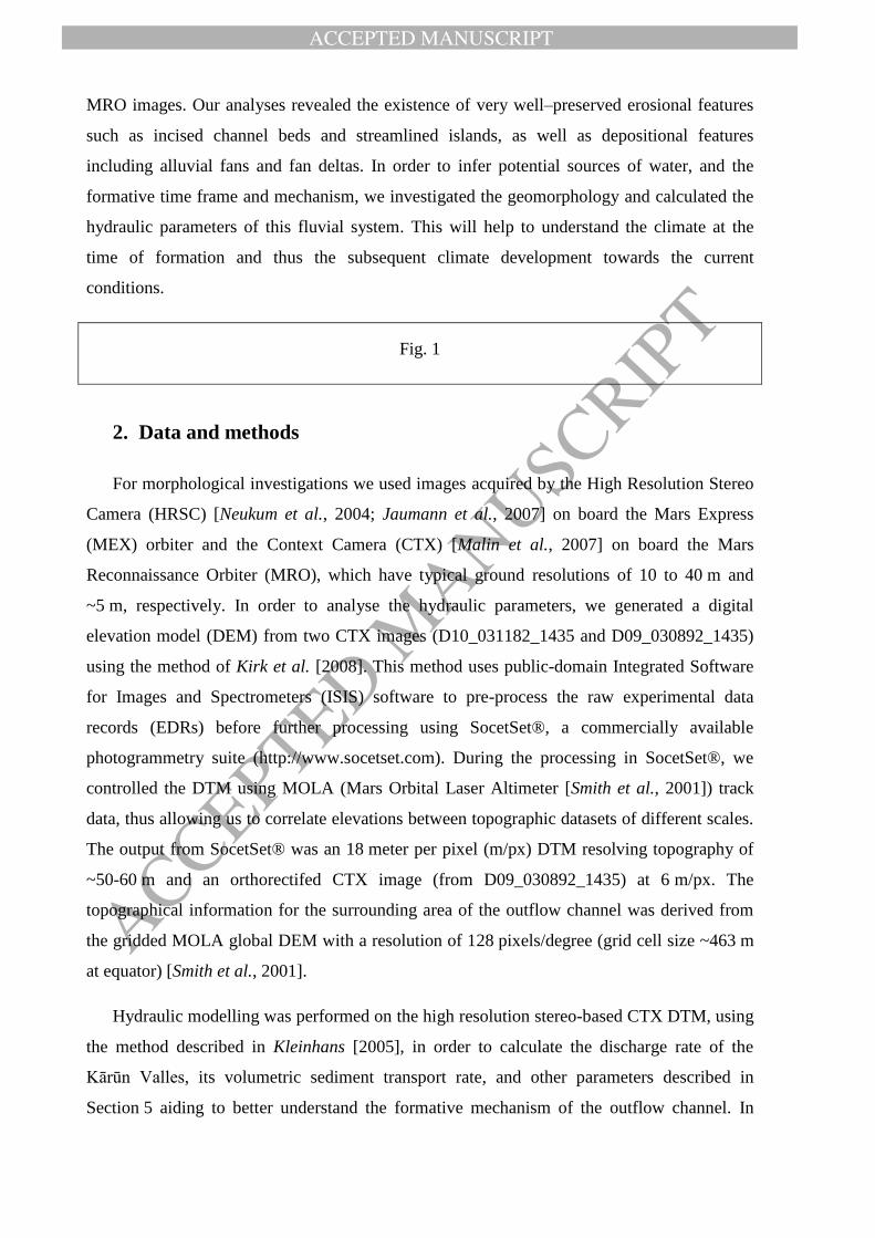
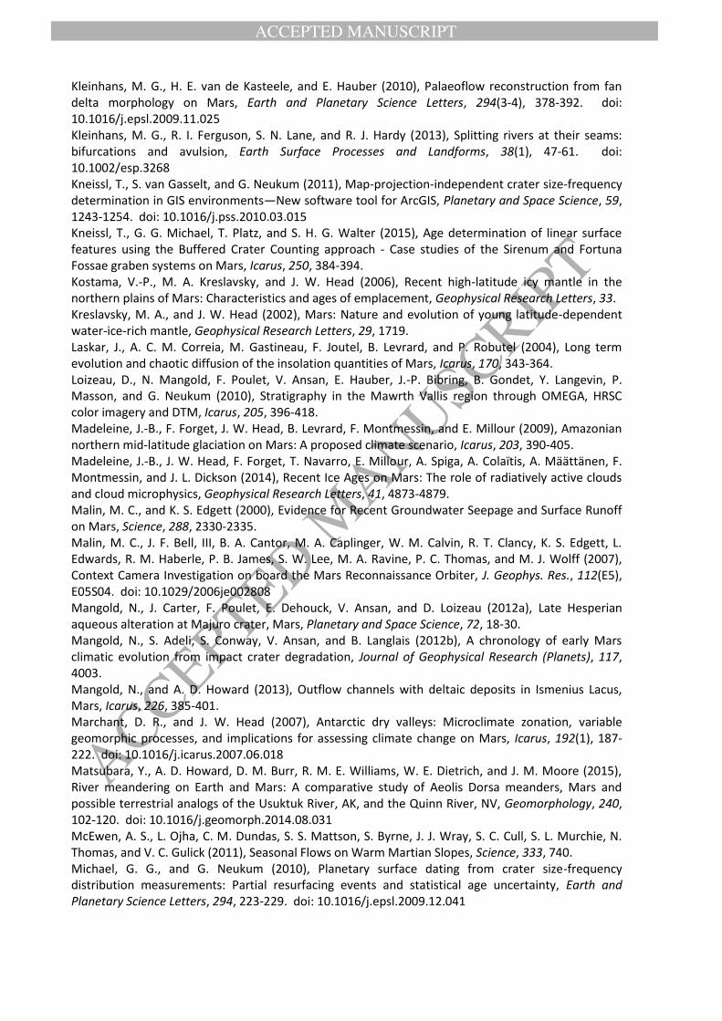
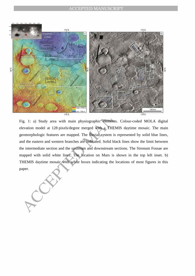
Fig. 1
2. Data and methods
For morphological investigations we used images acquired by the High Resolution Stereo
Camera (HRSC) [Neukum et al., 2004; Jaumann et al., 2007] on board the Mars Express
(MEX) orbiter and the Context Camera (CTX) [Malin et al., 2007] on board the Mars
Reconnaissance Orbiter (MRO), which have typical ground resolutions of 10 to 40 m and
~5 m, respectively. In order to analyse the hydraulic parameters, we generated a digital
elevation model (DEM) from two CTX images (D10_031182_1435 and D09_030892_1435)
using the method of Kirk et al. [2008]. This method uses public-domain Integrated Software
for Images and Spectrometers (ISIS) software to pre-process the raw experimental data
records (EDRs) before further processing using SocetSet®, a commercially available
photogrammetry suite (http://www.socetset.com). During the processing in SocetSet®, we
controlled the DTM using MOLA (Mars Orbital Laser Altimeter [Smith et al., 2001]) track
data, thus allowing us to correlate elevations between topographic datasets of different scales.
The output from SocetSet® was an 18 meter per pixel (m/px) DTM resolving topography of
~50-60 m and an orthorectifed CTX image (from D09_030892_1435) at 6 m/px. The
topographical information for the surrounding area of the outflow channel was derived from
the gridded MOLA global DEM with a resolution of 128 pixels/degree (grid cell size ~463 m
at equator) [Smith et al., 2001].
Hydraulic modelling was performed on the high resolution stereo-based CTX DTM, using
the method described in Kleinhans [2005], in order to calculate the discharge rate of the
Kārūn Valles, its volumetric sediment transport rate, and other parameters described in
Section 5 aiding to better understand the formative mechanism of the outflow channel. In
ACCEPTED MANUSCRIPT
ACCEPTED MANUSCRIP
T
order to estimate the absolute model age of the fluvial activity, we analysed crater size–
frequency distributions (CSFD) on CTX images at a scale of 1:24,000 in ESRI’s ArcGIS.
Craters were mapped using the CraterTools [Kneissl et al., 2011] extension for the ArcGIS
software. The Craterstats 2 software [Michael and Neukum, 2010] was used to model crater-
based ages based on the chronology function of Hartmann and Neukum [2001] and the
production function of Ivanov [2001]. Measured crater populations have been tested for
randomness using the method of Michael et al. [2012]. The data are plotted as a cumulative
presentation of the crater size-frequency distribution. As counting areas, we chose the largest
possible zones, however none of the counting areas are large enough to meet the area size of
larger than 1000-10,000 km2 as suggested by Warner et al. [2015]. The epoch boundaries are
based on Neukum system [Hartmann and Neukum, 2001] as explained in Michael [2013].
3. Regional setting
The fluvial system is located in the mid-latitude highlands of the Terra Cimmeria region
between 35° and 37° south. It terminates on the floor of the 200 km diameter Ariadnes Colles
basin (Fig. 1). This basin, as well as others in the region, presumably hosted a relative small
lake during the Hesperian [Adeli et al., 2015], which was a remnant of the late Noachian-
early Hesperian large Eridania paleolake [Irwin et al., 2002]. This area shows not only a rich
aqueous history, but also Amazonian-aged water/ice-related features (as shown in this study).
In fact, ice-related features have been widely reported in the mid-latitude regions of Mars
[e.g., Mustard et al., 2001; Kreslavsky and Head, 2002; Head and Marchant, 2003; Hauber et
al., 2011; Conway and Balme, 2014]. Latitude Dependent Mantle (LDM) is an example of
these ice-related landscapes. LDM is a young (formation in the last tens of millions of years
[Kostama et al., 2006; Willmes et al., 2012]) and ice-rich mantle located at ~30°-60°latitude
in both hemispheres [Mustard et al., 2001]. The mobilization of polar ice and its re-deposition
due to spin-axis/orbital perturbations has been suggested as LDM formation mechanism at
mid-latitudes [e.g., Madeleine et al., 2009]. It has been suggested that the post-Noachian
valleys in mid-latitudes may be related to the melting of snow and/or ice and subsequent
runoff [Fassett and Head, 2007; Howard and Moore, 2011]. However, localized events such
as melting of ground ice by emplacement of impact ejecta or a transient climate episode
[Mangold et al., 2012a] have also been proposed as potential source of water.
In the study area, the Sirenum Fossae graben system extends from east to west over a
distance of approximately 2600 km [Wilson and Head, 2002]. We can clearly see two main
ACCEPTED MANUSCRIPT
ACCEPTED MANUSCRIP
T
segments of it (Fig. 1-a) that are named “northern” and “southern” segments in this study.
Kneissl et al. [2015] estimated the main formation time frame for Sirenum Fossae at around
Ga to
Ga, and a minimum activity age at Ma. The Sirenum
Fossae start in the Tharsis region and terminate at ~200 km to the south of the Ariadnes
Colles center. Its age shows that tectonism in Terra Cimmeria was still active during the
middle Amazonian.
4. Geomorphological investigation
We divided the fluvial system under study into three sections, i.e. the upstream,
intermediate and downstream sections, based on their different morphological characteristics
(Fig. 1-a). The upstream section includes the catchment system, crater lakes, alluvial fans, and
fan deltas and is composed of two main branches, i.e. an eastern and a western branch. The
downstream section includes a valley system that is named Kārūn Valles, which displays a
wide alluvial fan, and terminates on the floor of the Ariadnes Colles basin. These two sections
are separated by the intermediate section, which is characterized by a flat surface which is cut
by the northern segment of the Sirenum Fossae.
4.1. Upstream section
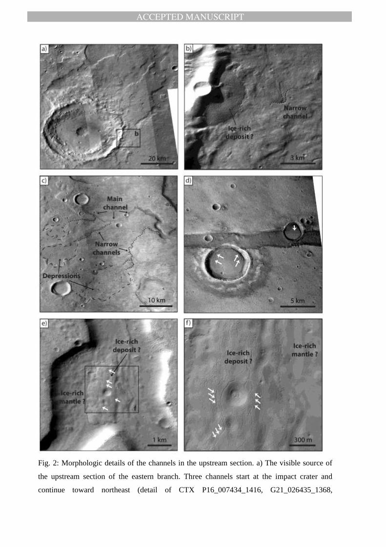
The upstream section of the fluvial system represents the catchment system and hosts
two main unnamed channels, which form the eastern and the western branches of the fluvial
system. The eastern branch is ~340 km long, has a sinuous plan-view pattern, and is located
between impact craters. The western branch is ~220 km in length, appears straight and does
not seem to be diverted by pre-existing impact craters. The first observable traces of the
fluvial activity appear at an elevation of ~1700 m north and northeast of an impact crater
(Fig. 2-a). The impact crater has a sharp rim and does not display traces of fluvial activity on
its inner rim. The ejecta blanket of this crater is, however, partly eroded. Channels
representing the head of the fluvial system appear on the outer wall and ejecta of this crater
(Fig. 2-a), and therefore they postdate the impact event. A ~5 km-wide deposit is preserved
adjacent to a high crater wall (~2000 m height) (Fig. 2-b). A narrow channel is most likely
originated from this deposit. This channel is linked to the wider channel traceable to the
visible heads of the fluvial system. Small channels originating at high elevations join the main
eastern and western branches of the fluvial system (Fig. 2-c). They have a simple morphology
and have no tributaries. They typically start at a local depression and end at the main channel.
ACCEPTED MANUSCRIPT
ACCEPTED MANUSCRIP
T
We have not observed any depositional features such as alluvial fans that are related to these
narrow channels. The mentioned depressions are a few kilometres wide (Fig. 2-c) and have
shallow and irregular shapes, and therefore do not represent old impact craters (Fig. 2-c).
Fig. 2
On the floor of the western channel, we observe deposits with convex upward surfaces
that are partly covered by a smooth mantle that also covers the channel floor area (Fig. 2-e).
The surface of these deposits is longitudinally fractured (Fig. 2-f). These fractures are very
common in glacial deposits on Earth, and are called crevasses. They are formed by tensile
stresses as response to the ice flow [Benn and Evans, 1998]. Next to the northern segment of
Sirenum Fossae, two impact craters are filled with smooth-textured materials. The craters rim
at the fossae’s side is degraded. The filling material is similarly fractured (Fig. 2-d). However,
these fractures are concentric, running parallel to the crater rim. Additionally, there are
longitudinal cracks on the surface of this material, oriented perpendicular to Sirenum Fossae.
They may show the creep of this material toward the lower elevation of the fossae.
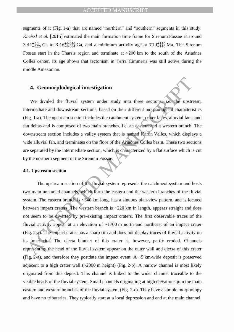
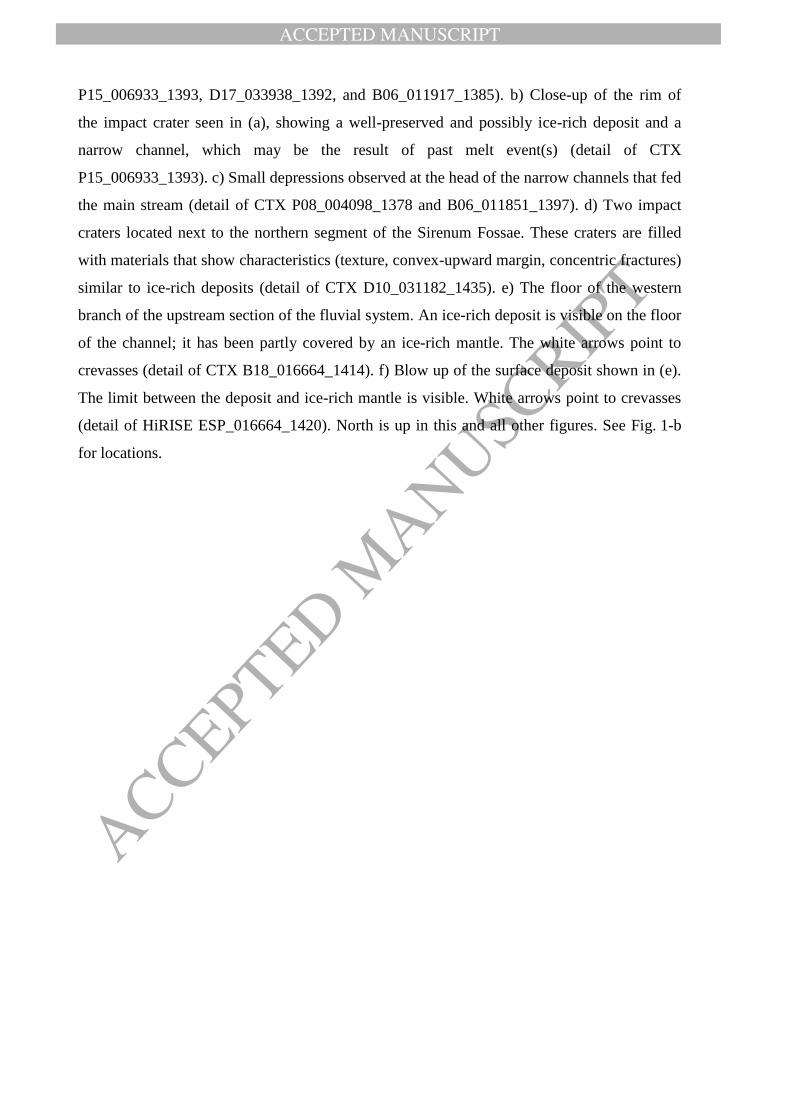
The floors of the channels in both the western and eastern branches are partly incised
by scour marks. Close to the terminus of the eastern branch, where the streamlined islands are
well preserved (Fig. 3), we observed a ~2km-wide area with a flat surface that does not
display any signs of visible erosion (e.g., fluvial incision). The area is limited downstream by
a distinct topographic scarp (Fig. 3). This area may represent a layer of erosion-resistant
materials which covers softer materials beneath, a situation which is typical at terrestrial
cataracts. Downstream of the scarp we can again follow the channel bed which is
characterized by incised erosional features. Another similar feature has also been observed at
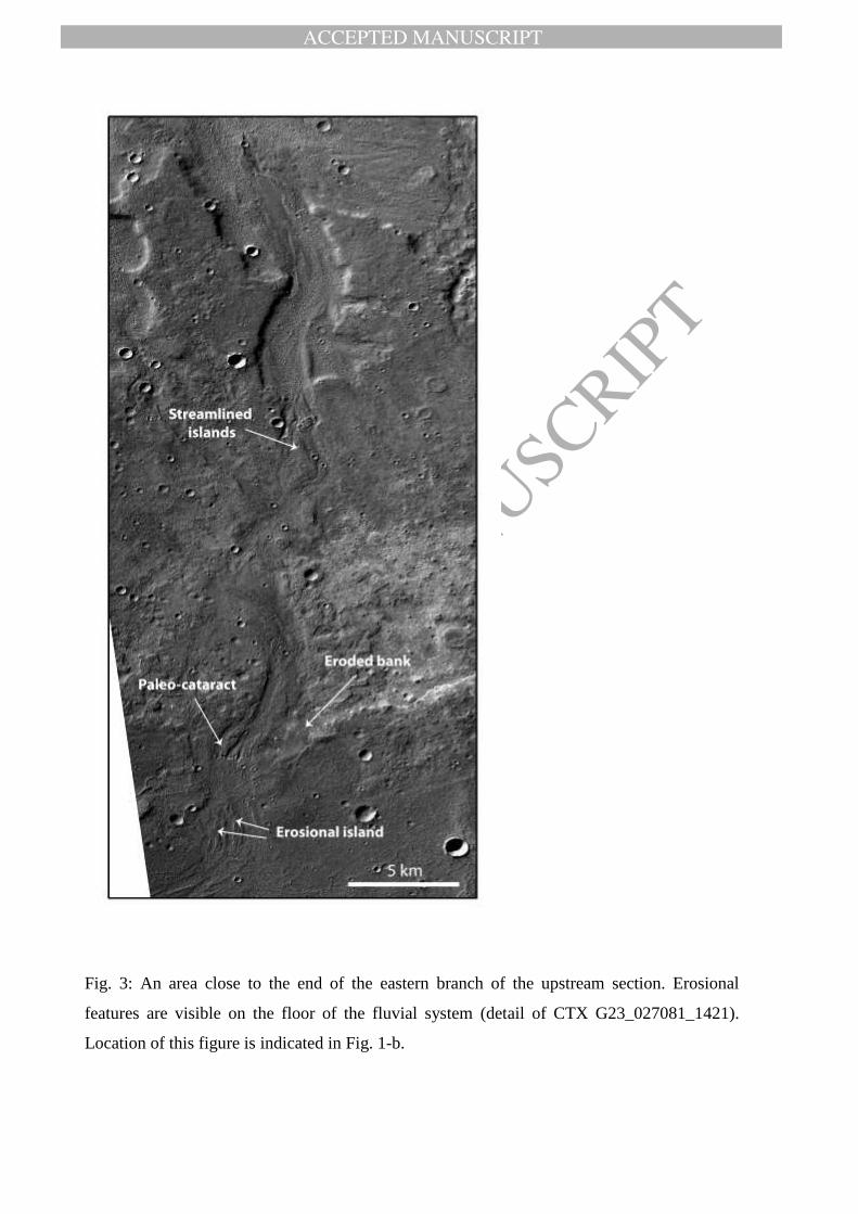
the north of Sirenum Fossae (Fig. 4-a) which is as well distinguished by a flat surface, and a
topographic scarp next to which the channel floor is carved by erosion. We infer that these
features are paleo-cataracts and represent former waterfalls. At some places we observe
eroded banks and erosional islands in the middle of the channel (Fig. 3). About 30 km south
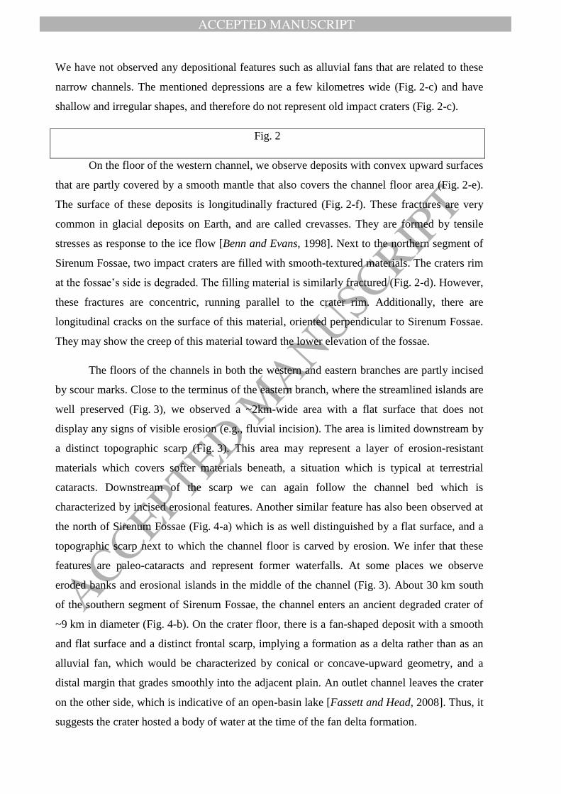
of the southern segment of Sirenum Fossae, the channel enters an ancient degraded crater of
~9 km in diameter (Fig. 4-b). On the crater floor, there is a fan-shaped deposit with a smooth
and flat surface and a distinct frontal scarp, implying a formation as a delta rather than as an
alluvial fan, which would be characterized by conical or concave-upward geometry, and a
distal margin that grades smoothly into the adjacent plain. An outlet channel leaves the crater
on the other side, which is indicative of an open-basin lake [Fassett and Head, 2008]. Thus, it
suggests the crater hosted a body of water at the time of the fan delta formation.
ACCEPTED MANUSCRIPT
ACCEPTED MANUSCRIP
T
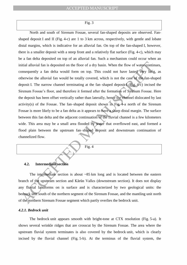
Fig. 3
North and south of Sirenum Fossae, several fan-shaped deposits are observed. Fan-
shaped deposit I and II (Fig. 4-c) are 1 to 3 km across, respectively, with gentle and lobate
distal margins, which is indicative for an alluvial fan. On top of the fan-shaped I, however,
there is a smaller deposit with a steep front and a relatively flat surface (Fig. 4-c), which may
be a fan delta deposited on top of an alluvial fan. Such a mechanism could occur when an
initial alluvial fan is deposited on the floor of a dry basin. When the flow of water continues,
consequently a fan delta would form on top. This could not have lasted very long, as
otherwise the alluvial fan would be totally covered, which is not the case of the fan-shaped
deposit I. The narrow channel terminating at the fan–shaped deposit I (Fig. 4-c) incised the
Sirenum Fossae’s floor, and therefore it formed after the formation of Sirenum Fossae. Here
the deposit has been offset vertically rather than laterally, hence the channel dislocated by last
activity(s) of the Fossae. The fan–shaped deposit shown in Fig. 4-a north of the Sirenum
Fossae is more likely to be a fan delta as it appears to have a sharp distal margin. The surface
between this fan delta and the adjacent continuation of the fluvial channel is a few kilometers
wide. This area may be a small area flooded by water that overflowed east, and formed a
flood plain between the upstream fan–shaped deposit and downstream continuation of
channelized flow.
Fig. 4
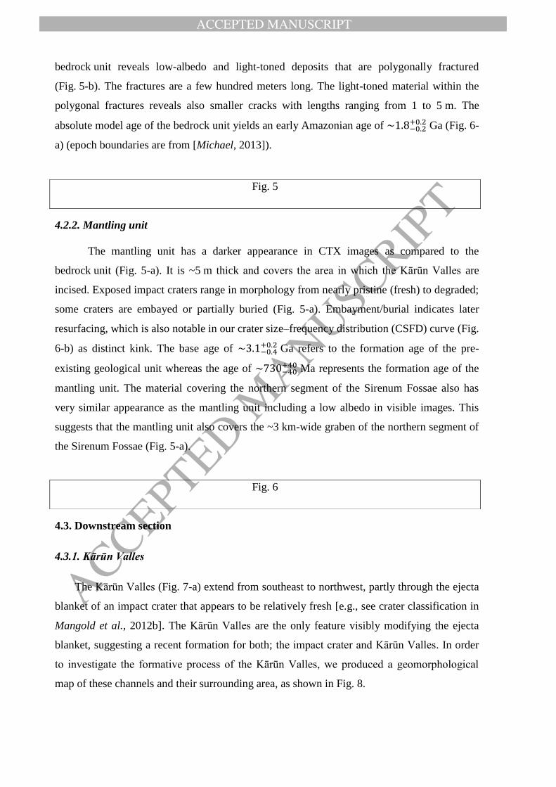
4.2. Intermediate section
The intermediate section is about ~85 km long and is located between the eastern
branch of the upstream section and Kārūn Valles (downstream section). It does not display
any fluvial landforms on is surface and is characterized by two geological units: the
bedrock unit south of the northern segment of the Sirenum Fossae, and the mantling unit north
of the northern Sirenum Fossae segment which partly overlies the bedrock unit.
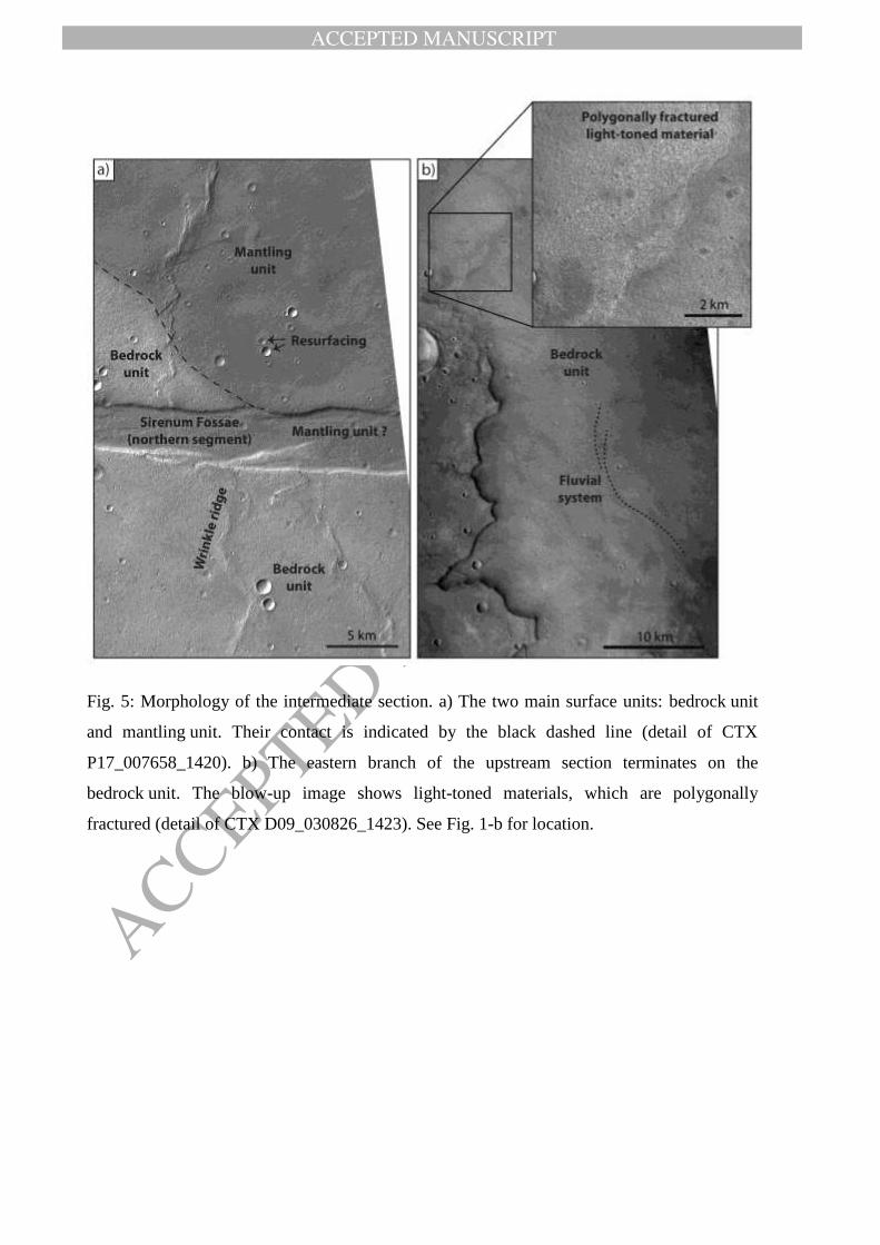
4.2.1. Bedrock unit
The bedrock unit appears smooth with bright-tone at CTX resolution (Fig. 5-a). It
shows several wrinkle ridges that are crosscut by the Sirenum Fossae. The area where the
upstream fluvial system terminates is also covered by the bedrock unit, which is clearly
incised by the fluvial channel (Fig. 5-b). At the terminus of the fluvial system, the
ACCEPTED MANUSCRIPT
ACCEPTED MANUSCRIP
T
bedrock unit reveals low-albedo and light-toned deposits that are polygonally fractured
(Fig. 5-b). The fractures are a few hundred meters long. The light-toned material within the
polygonal fractures reveals also smaller cracks with lengths ranging from 1 to 5 m. The
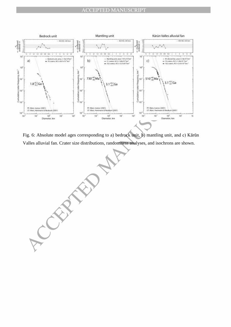
absolute model age of the bedrock unit yields an early Amazonian age of Ga (Fig. 6-
a) (epoch boundaries are from [Michael, 2013]).
4.2.2. Mantling unit
The mantling unit has a darker appearance in CTX images as compared to the
bedrock unit (Fig. 5-a). It is ~5 m thick and covers the area in which the Kārūn Valles are
incised. Exposed impact craters range in morphology from nearly pristine (fresh) to degraded;
some craters are embayed or partially buried (Fig. 5-a). Embayment/burial indicates later
resurfacing, which is also notable in our crater size–frequency distribution (CSFD) curve (Fig.
6-b) as distinct kink. The base age of Ga refers to the formation age of the pre-
existing geological unit whereas the age of Ma represents the formation age of the
mantling unit. The material covering the northern segment of the Sirenum Fossae also has
very similar appearance as the mantling unit including a low albedo in visible images. This
suggests that the mantling unit also covers the ~3 km-wide graben of the northern segment of
the Sirenum Fossae (Fig. 5-a).
4.3. Downstream section
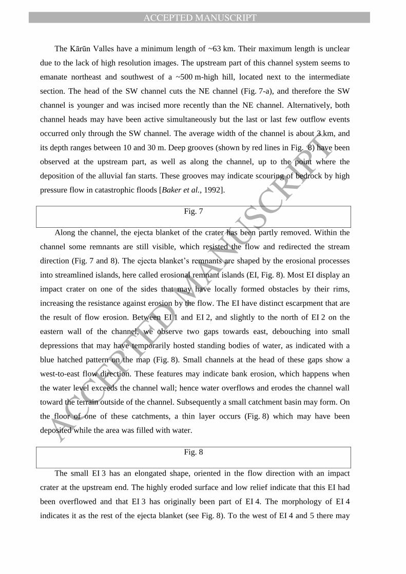
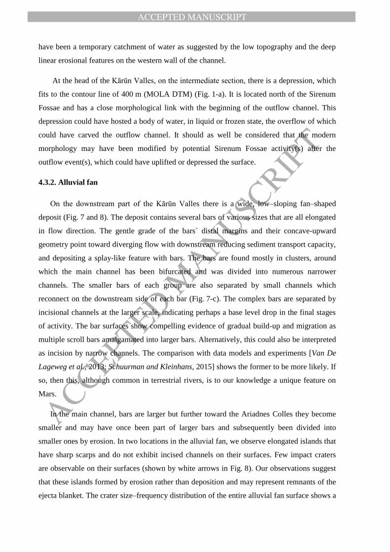
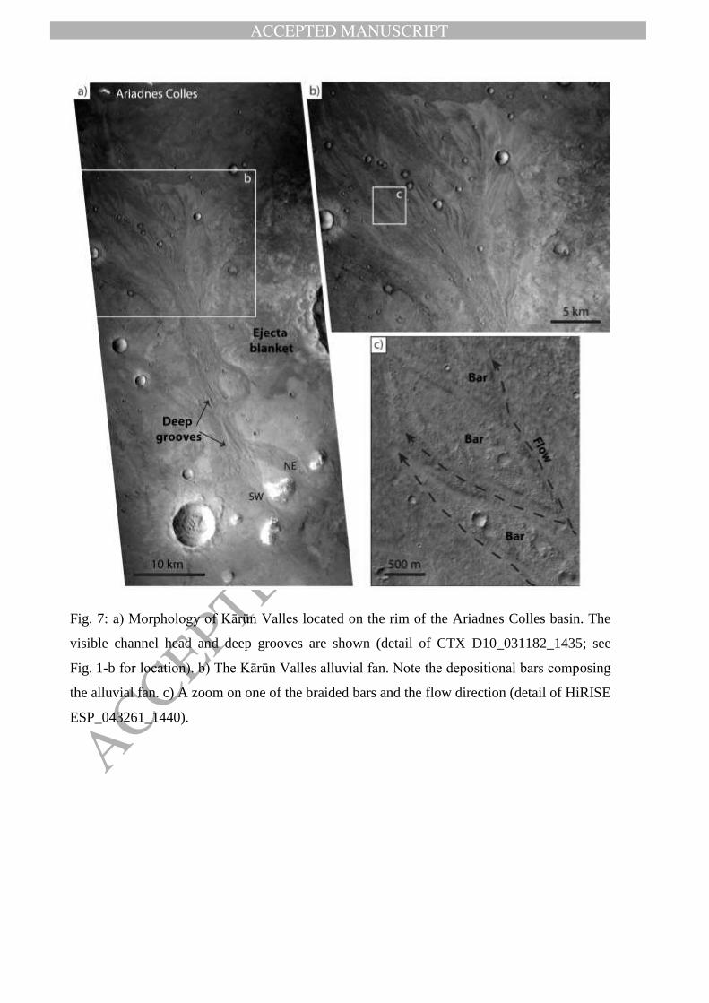
4.3.1. Kārūn Valles
The Kārūn Valles (Fig. 7-a) extend from southeast to northwest, partly through the ejecta
blanket of an impact crater that appears to be relatively fresh [e.g., see crater classification in
Mangold et al., 2012b]. The Kārūn Valles are the only feature visibly modifying the ejecta
blanket, suggesting a recent formation for both; the impact crater and Kārūn Valles. In order
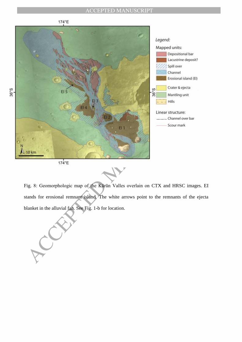
to investigate the formative process of the Kārūn Valles, we produced a geomorphological
map of these channels and their surrounding area, as shown in Fig. 8.
Fig. 5
Fig. 6
ACCEPTED MANUSCRIPT
ACCEPTED MANUSCRIP
T
The Kārūn Valles have a minimum length of ~63 km. Their maximum length is unclear
due to the lack of high resolution images. The upstream part of this channel system seems to
emanate northeast and southwest of a ~500 m-high hill, located next to the intermediate
section. The head of the SW channel cuts the NE channel (Fig. 7-a), and therefore the SW
channel is younger and was incised more recently than the NE channel. Alternatively, both
channel heads may have been active simultaneously but the last or last few outflow events
occurred only through the SW channel. The average width of the channel is about 3 km, and
its depth ranges between 10 and 30 m. Deep grooves (shown by red lines in Fig. 8) have been
observed at the upstream part, as well as along the channel, up to the point where the
deposition of the alluvial fan starts. These grooves may indicate scouring of bedrock by high
pressure flow in catastrophic floods [Baker et al., 1992].
Fig. 7
Along the channel, the ejecta blanket of the crater has been partly removed. Within the
channel some remnants are still visible, which resisted the flow and redirected the stream
direction (Fig. 7 and 8). The ejecta blanket’s remnants are shaped by the erosional processes
into streamlined islands, here called erosional remnant islands (EI, Fig. 8). Most EI display an
impact crater on one of the sides that may have locally formed obstacles by their rims,
increasing the resistance against erosion by the flow. The EI have distinct escarpment that are
the result of flow erosion. Between EI 1 and EI 2, and slightly to the north of EI 2 on the
eastern wall of the channel, we observe two gaps towards east, debouching into small
depressions that may have temporarily hosted standing bodies of water, as indicated with a
blue hatched pattern on the map (Fig. 8). Small channels at the head of these gaps show a
west-to-east flow direction. These features may indicate bank erosion, which happens when
the water level exceeds the channel wall; hence water overflows and erodes the channel wall
toward the terrain outside of the channel. Subsequently a small catchment basin may form. On
the floor of one of these catchments, a thin layer occurs (Fig. 8) which may have been
deposited while the area was filled with water.
The small EI 3 has an elongated shape, oriented in the flow direction with an impact
crater at the upstream end. The highly eroded surface and low relief indicate that this EI had
been overflowed and that EI 3 has originally been part of EI 4. The morphology of EI 4
indicates it as the rest of the ejecta blanket (see Fig. 8). To the west of EI 4 and 5 there may
Fig. 8
ACCEPTED MANUSCRIPT
ACCEPTED MANUSCRIP
T
have been a temporary catchment of water as suggested by the low topography and the deep
linear erosional features on the western wall of the channel.
At the head of the Kārūn Valles, on the intermediate section, there is a depression, which
fits to the contour line of 400 m (MOLA DTM) (Fig. 1-a). It is located north of the Sirenum
Fossae and has a close morphological link with the beginning of the outflow channel. This
depression could have hosted a body of water, in liquid or frozen state, the overflow of which
could have carved the outflow channel. It should as well be considered that the modern
morphology may have been modified by potential Sirenum Fossae activity(s) after the
outflow event(s), which could have uplifted or depressed the surface.
4.3.2. Alluvial fan
On the downstream part of the Kārūn Valles there is a wide, low–sloping fan–shaped
deposit (Fig. 7 and 8). The deposit contains several bars of various sizes that are all elongated
in flow direction. The gentle grade of the bars` distal margins and their concave-upward
geometry point toward diverging flow with downstream reducing sediment transport capacity,
and depositing a splay-like feature with bars. The bars are found mostly in clusters, around
which the main channel has been bifurcated and was divided into numerous narrower
channels. The smaller bars of each group are also separated by small channels which
reconnect on the downstream side of each bar (Fig. 7-c). The complex bars are separated by
incisional channels at the larger scale, indicating perhaps a base level drop in the final stages
of activity. The bar surfaces show compelling evidence of gradual build-up and migration as
multiple scroll bars amalgamated into larger bars. Alternatively, this could also be interpreted
as incision by narrow channels. The comparison with data models and experiments [Van De
Lageweg et al., 2013; Schuurman and Kleinhans, 2015] shows the former to be more likely. If
so, then this, although common in terrestrial rivers, is to our knowledge a unique feature on
Mars.
In the main channel, bars are larger but further toward the Ariadnes Colles they become
smaller and may have once been part of larger bars and subsequently been divided into
smaller ones by erosion. In two locations in the alluvial fan, we observe elongated islands that
have sharp scarps and do not exhibit incised channels on their surfaces. Few impact craters
are observable on their surfaces (shown by white arrows in Fig. 8). Our observations suggest
that these islands formed by erosion rather than deposition and may represent remnants of the
ejecta blanket. The crater size–frequency distribution of the entire alluvial fan surface shows a
ACCEPTED MANUSCRIPT
ACCEPTED MANUSCRIP
T
middle Amazonian age of about Ma (Fig. 6-c) for the alluvial fan. The model age
likely refers to the latest stage of fan formation since previous floods and any pre-existing
crater populations would have erased, either by erosion or deposition.
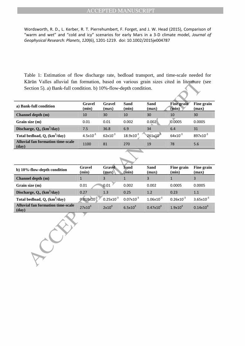
5. Hydraulic analysis
5.1. Flow discharge
The hydraulic analysis is essential in order to better understand the channel formation
mechanism and potentially the duration and/or periodicity of the flooding, which in turn
increases our knowledge about the source of water. On Mars, however, using orbital data for
hydraulic modelling is restricted due to the data resolution constraints. In order to calculate
the flow discharge rate, we used the method described extensively in Kleinhans [2005] and
used in Kleinhans et al. [2010] to calculate the flow discharge and sediment flux under
Martian conditions. The flow discharge is given as
where h is the depth of the channel, which means the thickness of the water column, W is the
channel width, and u is flow velocity averaged over the depth and width of the channel. The
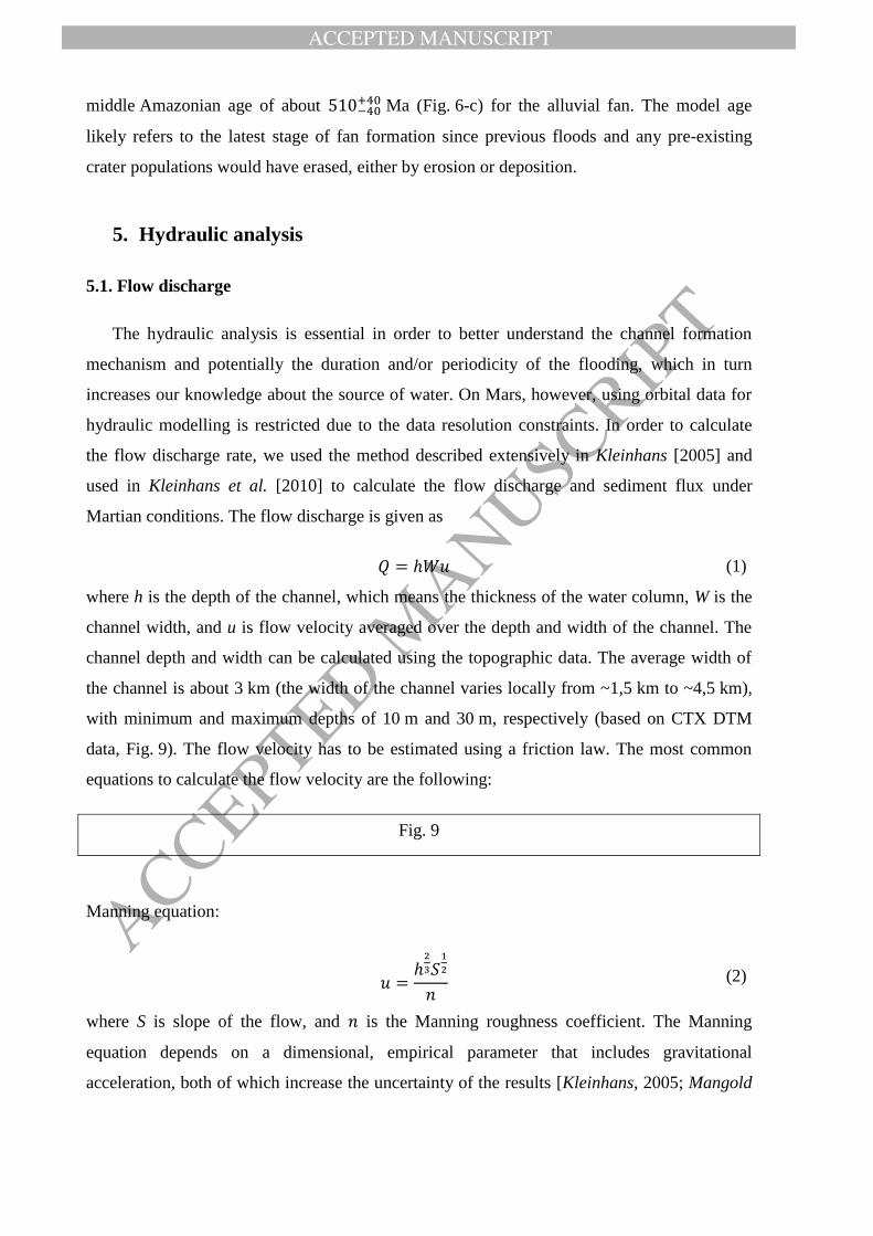
channel depth and width can be calculated using the topographic data. The average width of
the channel is about 3 km (the width of the channel varies locally from ~1,5 km to ~4,5 km),
with minimum and maximum depths of 10 m and 30 m, respectively (based on CTX DTM
data, Fig. 9). The flow velocity has to be estimated using a friction law. The most common
equations to calculate the flow velocity are the following:
Fig. 9
Manning equation:
where S is slope of the flow, and is the Manning roughness coefficient. The Manning
equation depends on a dimensional, empirical parameter that includes gravitational
acceleration, both of which increase the uncertainty of the results [Kleinhans, 2005; Mangold
(1)
(2)
ACCEPTED MANUSCRIPT
ACCEPTED MANUSCRIP
T
and Howard, 2013]. Therefore, the Darcy-Weisbach equation [Kleinhans, 2005] (Eq. 3) has
been used more often in the recent literature. It has also been used in this study:
where g is acceleration due to gravity (3.71 ms-2
on Mars), and f is a friction factor that
depends on channel bed particle size and bed form.
The friction factor can be calculated from a relation that includes the physics-based boundary
layer description, and is here calculated for gravel-bed rivers [Wilson et al., 2004] as:
where is the size at which 50% of clasts are of that size or smaller and is the geometric
standard deviation of the sediment grain size distribution, approximated for logarithmic
distributions as:
The grain size is an important parameter for the hydraulic analysis, but it cannot be
determined based on orbital data. Ground-based rover data acquired on the Martian surface,
on the other hand, indicate a variety of grain sizes from gravel (~0.01 m) to sand (~0.002 m)
down to clay-sized particles (>60-70-µm resolution limit of MAHLI, the microscopic imager
on the Curiosity rover [Grotzinger et al., 2015]). It is, however, difficult to find a comparable
geological setting among the sites visited by rovers. The grain size distribution in our study
area relates to ejected material, which had been later eroded by fluvial activity and deposited
in an alluvial fan. We, therefore, used the average grain size of the fluvial sandstone at the
Yellowknife Bay formation as measured by the Curiosity rover [Grotzinger et al., 2015] and
assumed a median grain size (D50) of 2 mm. In order to constrain the discharge rate with
conservative error margins, we have, in addition, calculated the flow discharge and sediment
transport volume for three different average grain sizes which are shown in Table 1.Based on
the above channel dimensions, equations, and grain size, we obtained values for the discharge
rate of for a channel depth of 10 m and for a channel
depth of 30 m. It must be noted that these values are order of magnitude estimates given the
uncertainty of the friction relation and the chosen particle size. In addition, these values imply
bank-full conditions, however, we cannot rule out the possibility of much lower flow depth, at
√
(3)
(4)
(5)
ACCEPTED MANUSCRIPT
ACCEPTED MANUSCRIP
T
least for a limited time. In order to take this assumption into account, we calculated the
discharge rate and other parameters for a case of a 10%–flow–depth, i.e. a flow depth of 1 and
3 m. The results are presented in Table 1-b.
Table 1
5.2. Sediment transport
Estimating the sediment transport rates would give an insight into the channel formation
mechanism and event(s) duration. It is essential to compare the removed sediment volume
with the deposited sediment value of the alluvial fan, in order to understand whether any
sediment was washed out of the system or was added into the system from the source area,
which could consequently increase our understanding about the source of water. We again
note that the values are order of magnitude estimates.
Sediment transport can occur as bedload, suspended bedload, and wash load. The
suspended load transport regime is most likely dominant in the larger Martian channels
whereas the bedload transport becomes more important in smaller channels [Kleinhans et al.,
2010]. In order to assess the sediment transport, we used the method described in Kleinhans
[2005], and calculated the bedload transport, the suspended load transport, and the total load
transport. We used the same values as for flow discharge calculation (see Section 5.1.),
including channel width, depth, slope, and grain size. The total bedload is calculated using the
Engelund and Hansen (EH) predictor, as follows:
where is nondimentional suspended load transport and f is Darcy-Weisbach coefficient
related total roughness. The estimated total bedload for 10 m of channel depth is
and for 30 m of channel depth is . These
results are summarized in the Table 1-a. We have also calculated the sediment transport rate
for a 10%–flow–depth condition as shown in the Table 1-b.
5.3. Time scale
When we have an estimate of the amount of eroded material, deposited material, and the
flow discharge rate, we can roughly assess a time window in which the channel had been
developed or the alluvial fan had been formed. It can be estimated as [Kleinhans, 2005]:
(6)
ACCEPTED MANUSCRIPT
ACCEPTED MANUSCRIP
T
where is the volume of deposited sediment (in the alluvial fan), is the porosity of the
sediment that is here assumed to be 0.2. This estimate is based on particle measurements in
lander images (see Kleinhans [2005] and Kleinhans et al. [2010] for discussion). This
timescale represents the required time to deposit the Kārūn Valles alluvial fan, which has a
volume of ~5.04 km3. Assuming that the fluvial event took place continuously in a given
period of time and a bank–full condition, the alluvial fan would need 19 to 270 days to form,
via a channel with 30 m or 10 m of depth, respectively (Table 1-a). In case of a 10%–flow–
depth condition, the alluvial fan would form in 4700 to 65000 days, via flow depth of 3 m or
1 m, respectively (Table 1-b). However, we cannot rule out the possibility of several short and
repetitive events.
6. Discussion
6.1. The catchment system formation
The fluvial system in Terra Cimmeria is composed of three sections: upstream section
forming the catchment system, intermediate section, and downstream section including Kārūn
Valles. The fluvial system in Terra Cimmeria reveals a hydraulic mechanism of different
erosional and depositional processes. The model absolute age of the bedrock unit in the
intermediate section shows an age of Ga, which corresponds to the
middle Amazonian, and indicates the maximum age of the fluvial activity. Therefore, the
fluvial activity took place at the middle Amazonian or at more recent time. Along the main
channel path, we observe narrow valleys, which originate from local depressions (Fig. 2-c).
The narrow valleys, in our study area, are morphologically very similar (simple morphology,
narrow width, few kilometers length, lack of fan deposits) to Amazonian-aged glaciofluvial
valleys described by Fassett et al. [2010], which are interpreted to be related to ice-rich
deposits in mid-latitude regions. These valleys are also observed at the eastern channel head,
where a ~5 km-wide deposit appears to be linked with a narrow valley to a wider valley (Fig.
2-b). The link between deposit, narrow channel, and wider channel may suggest that the
deposit is a remnant of a wider ice-rich deposit, which partly melted in the past and incised
the narrow valleys, which in turn joined and fed the main fluvial system. This ~5 km-deposit
is then remained on a crater rim of ~2000 m of elevation. Alternatively, this deposit’s current
(7)
ACCEPTED MANUSCRIPT
ACCEPTED MANUSCRIP
T
presence may reveal a potentially long history of re-deposition and disappearance of glacial
deposits in the past, in which ice accumulation may have occurred several times at the same
location. Nevertheless we suggest that the local depressions, which are located at the head of
the narrow channels, have hosted ice or snow deposits, which entirely melted and carved the
narrow valleys toward the main water stream.
Next to the northern segment of the Sirenum Fossae, there are two craters, which are
filled by smooth and concentric crater fill material. Concentric crater fill material elsewhere
on Mars has also been previously interpreted as ice-rich [e.g., Squyres and Carr, 1986; Head
et al., 2005; Fassett et al., 2010]. This fill material seems to creep toward the topographically
lower areas of Sirenum Fossae, similar to the downslope-creeping behavior of viscous ice-rich
deposits in other mid-latitude areas on Mars (e.g., an hourglass-shaped deposit on the eastern
Hellas basin rim [Head et al., 2005]). Therefore, we infer that the crater filling is remnant of
glacial or ice-related material. On the floor of the western fluvial system, there are several
deposits with convex-upward cross-sectional profiles that display crevasses on their surfaces
(Fig. 2-e and f). These deposits are partly covered by a mantle that may be ice-rich and most
likely represent the latitude dependent mantle (LDM [e.g., Mustard et al., 2001; Conway and
Balme, 2014]). We assume that these deposits are ice-rich, too, due to their prominent
morphology, smooth surface and the close link to LDM (Fig. 2-e and f). All these well-
preserved ice-rich deposits reinforce the possibility of a prolonged glacial history, including
the periodic presence and reappearance of surface water, in particular, snow or ice melt, in
Terra Cimmeria, during the early to middle Amazonian.
On the intermediate section’s surface we have not observed any direct traces of fluvial
activities (i.e. channel incision and/or fan-shaped deposits). The morphology of the
intermediate section could have been modified by Amazonian tectonic activity related to the
Sirenum Fossae. Kneissl et al. [2015] reported that the last tectonic activity of Sirenum Fossae
corresponds to Ma, which is almost the age of the mantling unit. Therefore, the
intermediate section may have had a different morphology (i.e. surface slope and azimuth) at
the time of fluvial activity in Terra Cimmeria, and therefore, it may have been a depression to
collect surface runoff. In addition, if the area was glaciated, the Sirenum Fossae-related
activity could have been a trigger for collapse and melt of ice, and consequently a catastrophic
overflow.
ACCEPTED MANUSCRIPT
ACCEPTED MANUSCRIP
T
The surface of the bedrock unit is locally polygonally fractured (Fig. 5-b). These
polygonal fractures, which are found in bright material of the bedrock unit, may indicate a
resurfacing mechanism in which liquid water was involved. They are similar to fractures
interpreted as desiccation cracks in Mawrth Vallis [e.g., Loizeau et al., 2010], in Terra
Sirenum [Adeli et al., 2015], and in former lacustrine settings [e.g., El-Maarry et al., 2013].
Therefore, the polygonal cracks in bedrock unit suggest liquid water activity similar to
lacustrine environment which may be related to the observed fluvial system or to an earlier
water activity in the area. The spatial distribution of the mantling unit is more concentrated in
the western and northern part of the intermediate section (Fig. 1-b). It is partly covering the
bedrock unit at the northern segment of Sirenum Fossae. The Kārūn Valles are incised
through the mantling unit and therefore their maximum age is constrained by the age of this
unit, which is estimated as Ma, corresponding to the middle Amazonian. The
morphological characteristics, distribution, and the Amazonian age suggest that the mantling
unit may be a drape of frozen dust. This material has most likely deposited during a middle
Amazonian ice age, and reveals one or several recent Amazonian glacial history.
6.2. Kārūn Valles formation
The Kārūn Valles are incised through the ejecta blanket of an impact crater (Fig. 7-a).
The material removed from the ejecta blanket has been remobilized by the water and was
deposited as an alluvial fan. Although the main channel has a straight course (in plan view),
there are few islands (EI 1, 2, and 3 in Fig. 8) that redirected the flow. These islands are
remnants of the erosion of the adjacent terrace. We do not observe any depositional material
around those islands, which implies a high erosion rate in the main channel that did not allow
deposition to take place. A high erosion rate is also supported by the deep scour marks on the
channel floor (visible in the cross-section of Fig. 9-b). This indicates a high sediment
transport capacity and sufficient flow strength and sediment load to abrade the bed rock.
Most of alluvial fans on Mars show a lobate shape in plan view [e.g., Moore and
Howard, 2005; di Achille et al., 2012]. However, on the Kārūn Valles alluvial fan, we observe
a bifurcating system rather than a continuously deposited alluvial fan. On Earth, bifurcation
occurs in various geological contexts including meandering, anastomosing, and braided rivers,
as well as on river deltas with the aforementioned river patterns [Schumm, 1977; Kleinhans et
al., 2013]. A braided pattern occurs in alleviated conditions when the bars are depositional
and shaped inside the river channel by the flow. In such systems, channel migration and
ACCEPTED MANUSCRIPT
ACCEPTED MANUSCRIP
T
instability of channel bifurcations leads to perpetual dynamics with bar growth, bar
amalgamation and bar splitting. The Kārūn Valles alluvial fan shows well preserved
depositional features, and bars that have been clearly shaped by the flow. The fan is composed
of elongated bars and multiple channels that divided and re-joined around the bars. At some
places (Fig. 7-b and c) bars are connected with each other laterally, suggesting their
migration. A few obstacles, most probably remnants of the ejecta blanket, resisted erosion,
and sediment was deposited on their lee side. It is clearly observable that the elongation of
these obstacles has a different orientation as compared to that of the bars (Fig. 8). The Kārūn
Valles alluvial fan is a fan-shaped feature built up from a braided system. Such braiding on
Mars has been rarely observed [Matsubara et al., 2015] and points to a unique formation
mechanism.
The formation time frame for Kārūn Valles can be constrained by the age of the
mantling unit where the Kārūn Valles have been incised into, and the age of the alluvial fan
itself. Therefore we infer that the Kārūn Valles formation took place between ~ Ma
and Ma, which are the absolute model age estimates of the mantling unit and the
alluvial fan, respectively. These ages correspond to the middle Amazonian. The climatic
condition (e.g., atmospheric temperature and pressure) during the Amazonian [Madeleine et
al., 2009] most probably would not allow liquid water to last or to flow for a long period of
time. This fits with our notion that one or several climate changes took place in the recent past
and that the appearance of liquid water on the surface may have occurred as a sudden and
short event, and water release happened catastrophically.
6.3. Source of water
The erosional features of incised channel floors such as groove marks, cataracts, and
streamlined islands; and eroded channel banks in eastern and western branches of the
upstream section, as well as in Kārūn Valles, point to highly energetic fluvial activity. The
morphology of the depositional features of fan deltas and alluvial fans suggests high energetic
and short term events. Similar valleys and landforms of Amazonian age have been reported in
other areas in mid-latitudes and been interpreted as being formed by a single and short fluvial
episode [Hobley et al., 2014; Salese et al., 2016]. The experimental and numerical modelling
of de Villiers et al. [2013] demonstrates that deltas with simple morphology and no obvious
incisions on their surface form most likely during one short-term aqueous event. Our
observations of the small deltas, alluvial fans, and fan-shaped deposits in the upstream section
ACCEPTED MANUSCRIPT
ACCEPTED MANUSCRIP
T
(see Fig. 4) have not shown any incision into their surfaces. The hydraulic modelling of Kārūn
Valles also supports a short term event as suggested by our morphological observations and
the model of de Villiers et al. [2013]. Our calculations point to an event that lasted at least 19
to 270 days in case of bank-full flow condition in the channel. Although our morphological
observations point to energetic flow events which would be more plausible in case of a bank-
full or almost bank-full condition, water level variations in the channel are likely, and the flow
could have dropped to a fraction of bank-full flow between peaks of high-energy flow events.
This would lead to longer flow durations required to carry the sediment, and less dramatic
events. In the latter condition the fluvial event could have lasted for tens of thousands of days,
e.g., in case of 10% water depth the formative mechanism (in case of a continuous flow)
would take only 4,700 to 65,000 days, which is still a geologically short period of time. We
do not rule out the possibility of a sequence of multiple episodic short term events.
Considering the short duration and catastrophic release of water in combination with our
morphological observation of ice-related features, we suggest surface runoff of ice/snow melt
as the most likely water source. Obviously, ice and/or snow accumulation and melting would
have happened clearly under different climatic conditions than today. Such climate change(s)
may have been triggered by obliquity or orbital variations [Laskar et al., 2004] which
mobilised polar ice towards the mid-latitude regions of Mars [Head et al., 2003; Madeleine et
al., 2014]. An extended ice layer could have covered mid-latitude areas including our study
area. This mobilisation and re-deposition of ice could have occurred several times and
periodically in the past history of Mars [Madeleine et al., 2014].
The depression at the head of Kārūn Valles (see section 4.3.1. and Fig. 1-a) could have
hosted an ice-covered lake or a subglacial lake, which collapsed and initiated a catastrophic
outflow. Although we have not observed morphological traces of shore line, erosional or
depositional features concerning lake or glacial deposit presence, this assumption cannot be
ruled out, considering a lake or a glacial deposit, which lasted over a geologically short time.
The liquid water collected by the upstream catchment system may have fed the depression at
the head of Kārūn Valles, and formed an ice-covered lake under the middle Amazonian
atmospheric condition. Alternatively, the depression may have hosted a glacial deposit, which
catastrophically collapsed and melted. Catastrophic outburst of large amounts of water in
glacier systems has been widely observed on Earth. These are generally referred to by the
Icelandic term Jökulhlaups. Jökulhlaups may originate from subglacial sources of water
melted by atmospheric processes, geothermal heat or volcanic eruptions [Benn and Evans,
ACCEPTED MANUSCRIPT
ACCEPTED MANUSCRIP
T
1998; Björnsson, 2009]. On Earth, Jökulhlaups generally occur in intervals of weeks to years,
and a slightly larger periodicity (e.g., over centuries [Carling et al., 2009]) would also be
expected under Martian conditions during the Amazonian. An alternative source of water
would be rise of ground water. We have not observed any fissure, opening, or collapse zones,
but the Sirenum Fossae could have facilitated the process. Groundwater, however, would not
explain the distribution of small depressions and ice-rich deposits on various locations and
elevations.
7. Conclusions and implications
The morphology of a complex channel system in Terra Cimmeria and the presence of ice-
rich deposits on the channel floor strongly suggest that the valleys and channels were incised
by liquid water during early to middle Amazonian. The narrow valleys originating at small
depressions and remnants of ice-rich material indicate ice/snow melt as water source. The
evidence of short term and high energetic event(s), such as deep groove marks, streamlined
islands, and morphology of the fan-shaped deposits, enforce the assumption of surface runoff
as source of water. Our geologic map and observations of the morphology of the depositional
bars in Kārūn Valles alluvial fan show a unique braided depositional pattern typical for
terrestrial braided rivers. Our hydraulic and sediment transport modelling is consistent with
our morphological observation and suggests that the Kārūn Valles had most likely been
carved in one continuous event, which lasted a minimum of few days to few tens of thousands
of days, however the possibility of a sequence of several short-term events occurring over a
few centuries cannot be ruled out. Kārūn Valles may have been formed by a catastrophic melt
of a glacial deposit (i.e., Jökulhlaups) or collapse of an ice-coved lake, which was fed by the
upstream catchment and was hosted in the depression that exists at the Kārūn Valles head.
The Amazonian climate is, generally, considered to be globally “cold and dry” [Head et
al., 2003] and may have been perturbed by outbursts of water and gas. Observations of
significant numbers of Amazonian-aged fluvial channels in the Martian mid-latitudes [e.g.,
Howard and Moore, 2011; Hobley et al., 2014; Salese et al., 2016] reveal the possibility of
the presence of liquid water on the Martian surface during the last 3 Ga. Our observations of
glacial-like deposits point to past accumulation(s) of ice/snow on the surface, and the narrow
valleys confirms the presence of surface water during early and middle Amazonian. Our study
shows a maximum age of Ga, corresponding to the early Amazonian and a minimum
age of Ma, corresponding to the middle Amazonian, for the fluvial activity in
ACCEPTED MANUSCRIPT
ACCEPTED MANUSCRIP
T
Terra Cimmeria. Based on our results, we conclude that fluvial activity, perhaps episodic,
existed throughout the Amazonian. Liquid water was present in Terra Cimmeria in the
Amazonian, and it was abundant enough, although during a short period, to carve over
340 km of fluvial channel, transport sediments and deposit them in alluvial fans and fan
deltas. Therefore, the existence of liquid water and fluvial activity on the Martian surface did
not completely stop at a specific time, and the transition from a warmer and wetter past
climate to today´s cold and hyperarid conditions may have been less dramatic than previously
thought.
ACCEPTED MANUSCRIPT
ACCEPTED MANUSCRIP
T
Acknowledgements
This research was supported by the Deutsches Zentrum für Luft- und Raumfahrt
(DLR-Berlin). We thank S. Clifford and M.A. de Pablo for their detailed and constructive
reviews, which greatly helped to improve the manuscript.
Reference:
Adeli, S., E. Hauber, L. Le Deit, and R. Jaumann (2015), Geologic evolution of the eastern Eridania basin: Implications for aqueous processes in the southern highlands of Mars, Journal of Geophysical Research: Planets, 2015JE004898. doi: 10.1002/2015je004898 Baker, V. R., M. H. Carr, V. C. Gulick, C. R. Williams, and M. S. Marley (1992), Channels and valley networks, in Mars, edited by M. George, pp. 493-522. Benn, D. I., and D. J. A. Evans (1998), Glaciers and Glaciation, Arnold, London, Great Britain. Bibring, J.-P., Y. Langevin, J. F. Mustard, F. Poulet, R. Arvidson, A. Gendrin, B. Gondet, N. Mangold, P. Pinet, F. Forget, O. Team, M. Berthé, C. Gomez, D. Jouglet, A. Soufflot, M. Vincendon, M. Combes, P. Drossart, T. Encrenaz, T. Fouchet, R. Merchiorri, G. Belluci, F. Altieri, V. Formisano, F. Capaccioni, P. Cerroni, A. Coradini, S. Fonti, O. Korablev, V. Kottsov, N. Ignatiev, V. Moroz, D. Titov, L. Zasova, D. Loiseau, P. Pinet, S. Doute, B. Schmitt, C. Sotin, E. Hauber, H. Hoffmann, R. Jaumann, U. Keller, R. Arvidson, T. Duxbury, and G. Neukum (2006), Global Mineralogical and Aqueous Mars History Derived from OMEGA/Mars Express Data, Science, 312, 400-404. Björnsson, H. (2009), Jökulhlaups in Iceland: sourcces, release and drainage, In Burr, D.M. et al., eds. Megaflooding on Earth and Mars: Cambridge, 50-65. Carling, P. A., D. M. Burr, T. F. Johnsen, and T. A. Brennand (2009), A review of open-channel megaflood depositional landforms on Earth and Mars in Megaflooding on Earth and Mars, Cambridge University Press. Carr, M. H. (1995), The Martain drainage system and the origin of valley networks and fretted channels, Journal of Geophysical Research, 100, 7479-7507. Conway, S. J., and M. R. Balme (2014), Decameter thick remnant glacial ice deposits on Mars, Geophysical Research Letters, 41(15), 5402-5409. doi: 10.1002/2014gl060314 Craddock, R. A., and A. D. Howard (2002), The case for rainfall on a warm, wet early Mars, Journal of Geophysical Research (Planets), 107, 5111. de Villiers, G., M. G. Kleinhans, and G. Postma (2013), Experimental delta formation in crater lakes and implications for interpretation of Martian deltas, Journal of Geophysical Research (Planets), 118, 651-670. di Achille, G., M. R. T. Hoke, A. P. Rossi, B. M. Hynek, F. Esposito, E. W. H. Hutton, and A. J. Kettner (2012), Process-Response Sedimentary Modeling of Ancient Martian Deltas 1: Introduction and Case Studies, in Lunar and Planetary Science Conference, edited. El-Maarry, M. R., A. Pommerol, and N. Thomas (2013), Analysis of polygonal cracking patterns in chloride-bearing terrains on Mars: Indicators of ancient playa settings, Journal of Geophysical Research: Planets, 118(11), 2263-2278. doi: 10.1002/2013je004463 Fassett, C. I., and J. W. Head (2007), Valley formation on martian volcanoes in the Hesperian: Evidence for melting of summit snowpack, caldera lake formation, drainage and erosion on Ceraunius Tholus, Icarus, 189, 118-135. Fassett, C. I., and J. W. Head (2008), Valley network-fed, open-basin lakes on Mars: Distribution and implications for Noachian surface and subsurface hydrology, Icarus, 198, 37-56. Fassett, C. I., J. L. Dickson, J. W. Head, J. S. Levy, and D. R. Marchant (2010), Supraglacial and proglacial valleys on Amazonian Mars, Icarus, 208(1), 86-100. doi: 10.1016/j.icarus.2010.02.021
ACCEPTED MANUSCRIPT
ACCEPTED MANUSCRIP
T
Gallagher, C., and M. Balme (2015), Eskers in a complete, wet-based glacial system in the Phlegra Montes region, Mars, Earth and Planetary Science Letters, 431, 96-109. Grotzinger, J. P., S. Gupta, M. C. Malin, D. M. Rubin, J. Schieber, K. Siebach, D. Y. Sumner, K. M. Stack, A. R. Vasavada, R. E. Arvidson, F. Calef, L. Edgar, W. F. Fischer, J. A. Grant, J. Griffes, L. C. Kah, M. P. Lamb, K. W. Lewis, N. Mangold, M. E. Minitti, M. Palucis, M. Rice, R. M. E. Williams, R. A. Yingst, D. Blake, D. Blaney, P. Conrad, J. Crisp, W. E. Dietrich, G. Dromart, K. S. Edgett, R. C. Ewing, R. Gellert, J. A. Hurowitz, G. Kocurek, P. Mahaffy, M. J. McBride, S. M. McLennan, M. Mischna, D. Ming, R. Milliken, H. Newsom, D. Oehler, T. J. Parker, D. Vaniman, R. C. Wiens, and S. A. Wilson (2015), Deposition, exhumation, and paleoclimate of an ancient lake deposit, Gale crater, Mars, Science, 350. Hartmann, W. K., and G. Neukum (2001), Cratering Chronology and the Evolution of Mars, Space Science Reviews, 96, 165-194. Hauber, E., D. Reiss, M. Ulrich, F. Preusker, and F. Trauthan (2011), Landscape evolution in Martian mid-latitude regions: insights from analogous periglacial landforms in Svalbard, Geological Society of London Special Publications, 356, 111-131. Hauber, E., T. Platz, D. Reiss, L. Le Deit, M. G. Kleinhans, W. A. Marra, T. Haas, and P. Carbonneau (2013), Asynchronous formation of Hesperian and Amazonian-aged deltas on Mars and implications for climate, Journal of Geophysical Research (Planets), 118, 1529-1544. Head, J. W., and D. R. Marchant (2003), Cold-based mountain glaciers on Mars: Western Arsia Mons, Geology, 31, 641. Head, J. W., J. F. Mustard, M. A. Kreslavsky, R. E. Milliken, and D. R. Marchant (2003), Recent ice ages on Mars, Nature, 426, 797-802. Head, J. W., G. Neukum, R. Jaumann, H. Hiesinger, E. Hauber, M. Carr, P. Masson, B. Foing, H. Hoffmann, M. Kreslavsky, S. Werner, S. Milkovich, S. van Gasselt, and H. C.-I. Team (2005), Tropical to mid-latitude snow and ice accumulation, flow and glaciation on Mars, Nature, 434, 346-351. Hobley, D. E. J., A. D. Howard, and J. M. Moore (2014), Fresh shallow valleys in the Martian midlatitudes as features formed by meltwater flow beneath ice, Journal of Geophysical Research (Planets), 119, 128-153. Howard, A. D., and J. M. Moore (2011), Late Hesperian to early Amazonian midlatitude Martian valleys: Evidence from Newton and Gorgonum basins, Journal of Geophysical Research (Planets), 116, 5003. Hynek, B. M., M. Beach, and M. R. T. Hoke (2010), Updated global map of Martian valley networks and implications for climate and hydrologic processes, Journal of Geophysical Research (Planets), 115, 9008. Irwin, R. P., T. A. Maxwell, A. D. Howard, R. A. Craddock, and D. W. Leverington (2002), A Large Paleolake Basin at the Head of Ma'adim Vallis, Mars, Science, 296, 2209-2212. Ivanov, B. A. (2001), Mars/Moon Cratering Rate Ratio Estimates, Space Science Reviews, 96, 87-104. Jaumann, R., G. Neukum, T. Behnke, T. C. Duxbury, K. Eichentopf, J. Flohrer, S. v. Gasselt, B. Giese, K. Gwinner, E. Hauber, H. Hoffmann, A. Hoffmeister, U. Köhler, K.-D. Matz, T. B. McCord, V. Mertens, J. Oberst, R. Pischel, D. Reiss, E. Ress, T. Roatsch, P. Saiger, F. Scholten, G. Schwarz, K. Stephan, M. Wählisch, and t. H. C.-I. Team (2007), The high-resolution stereo camera (HRSC) experiment on Mars Express: Instrument aspects and experiment conduct from interplanetary cruise through the nominal mission, Planetary and Space Science, 55, 928-952. doi: 10.1016/j.pss.2006.12.003 Kirk, R. L., E. Howington-Kraus, M. R. Rosiek, J. A. Anderson, B. A. Archinal, K. J. Becker, D. A. Cook, D. M. Galuszka, P. E. Geissler, T. M. Hare, I. M. Holmberg, L. P. Keszthelyi, B. L. Redding, W. A. Delamere, D. Gallagher, J. D. Chapel, E. M. Eliason, R. King, and A. S. McEwen (2008), Ultrahigh resolution topographic mapping of Mars with MRO HiRISE stereo images: Meter-scale slopes of candidate Phoenix landing sites, Journal of Geophysical Research (Planets), 113. Kleinhans, M. G. (2005), Flow discharge and sediment transport models for estimating a minimum timescale of hydrological activity and channel and delta formation on Mars, Journal of Geophysical Research (Planets), 110, 12003.
ACCEPTED MANUSCRIPT
ACCEPTED MANUSCRIP
T
Kleinhans, M. G., H. E. van de Kasteele, and E. Hauber (2010), Palaeoflow reconstruction from fan delta morphology on Mars, Earth and Planetary Science Letters, 294(3-4), 378-392. doi: 10.1016/j.epsl.2009.11.025 Kleinhans, M. G., R. I. Ferguson, S. N. Lane, and R. J. Hardy (2013), Splitting rivers at their seams: bifurcations and avulsion, Earth Surface Processes and Landforms, 38(1), 47-61. doi: 10.1002/esp.3268 Kneissl, T., S. van Gasselt, and G. Neukum (2011), Map-projection-independent crater size-frequency determination in GIS environments—New software tool for ArcGIS, Planetary and Space Science, 59, 1243-1254. doi: 10.1016/j.pss.2010.03.015 Kneissl, T., G. G. Michael, T. Platz, and S. H. G. Walter (2015), Age determination of linear surface features using the Buffered Crater Counting approach - Case studies of the Sirenum and Fortuna Fossae graben systems on Mars, Icarus, 250, 384-394. Kostama, V.-P., M. A. Kreslavsky, and J. W. Head (2006), Recent high-latitude icy mantle in the northern plains of Mars: Characteristics and ages of emplacement, Geophysical Research Letters, 33. Kreslavsky, M. A., and J. W. Head (2002), Mars: Nature and evolution of young latitude-dependent water-ice-rich mantle, Geophysical Research Letters, 29, 1719. Laskar, J., A. C. M. Correia, M. Gastineau, F. Joutel, B. Levrard, and P. Robutel (2004), Long term evolution and chaotic diffusion of the insolation quantities of Mars, Icarus, 170, 343-364. Loizeau, D., N. Mangold, F. Poulet, V. Ansan, E. Hauber, J.-P. Bibring, B. Gondet, Y. Langevin, P. Masson, and G. Neukum (2010), Stratigraphy in the Mawrth Vallis region through OMEGA, HRSC color imagery and DTM, Icarus, 205, 396-418. Madeleine, J.-B., F. Forget, J. W. Head, B. Levrard, F. Montmessin, and E. Millour (2009), Amazonian northern mid-latitude glaciation on Mars: A proposed climate scenario, Icarus, 203, 390-405. Madeleine, J.-B., J. W. Head, F. Forget, T. Navarro, E. Millour, A. Spiga, A. Colaïtis, A. Määttänen, F. Montmessin, and J. L. Dickson (2014), Recent Ice Ages on Mars: The role of radiatively active clouds and cloud microphysics, Geophysical Research Letters, 41, 4873-4879. Malin, M. C., and K. S. Edgett (2000), Evidence for Recent Groundwater Seepage and Surface Runoff on Mars, Science, 288, 2330-2335. Malin, M. C., J. F. Bell, III, B. A. Cantor, M. A. Caplinger, W. M. Calvin, R. T. Clancy, K. S. Edgett, L. Edwards, R. M. Haberle, P. B. James, S. W. Lee, M. A. Ravine, P. C. Thomas, and M. J. Wolff (2007), Context Camera Investigation on board the Mars Reconnaissance Orbiter, J. Geophys. Res., 112(E5), E05S04. doi: 10.1029/2006je002808 Mangold, N., J. Carter, F. Poulet, E. Dehouck, V. Ansan, and D. Loizeau (2012a), Late Hesperian aqueous alteration at Majuro crater, Mars, Planetary and Space Science, 72, 18-30. Mangold, N., S. Adeli, S. Conway, V. Ansan, and B. Langlais (2012b), A chronology of early Mars climatic evolution from impact crater degradation, Journal of Geophysical Research (Planets), 117, 4003. Mangold, N., and A. D. Howard (2013), Outflow channels with deltaic deposits in Ismenius Lacus, Mars, Icarus, 226, 385-401. Marchant, D. R., and J. W. Head (2007), Antarctic dry valleys: Microclimate zonation, variable geomorphic processes, and implications for assessing climate change on Mars, Icarus, 192(1), 187-222. doi: 10.1016/j.icarus.2007.06.018 Matsubara, Y., A. D. Howard, D. M. Burr, R. M. E. Williams, W. E. Dietrich, and J. M. Moore (2015), River meandering on Earth and Mars: A comparative study of Aeolis Dorsa meanders, Mars and possible terrestrial analogs of the Usuktuk River, AK, and the Quinn River, NV, Geomorphology, 240, 102-120. doi: 10.1016/j.geomorph.2014.08.031 McEwen, A. S., L. Ojha, C. M. Dundas, S. S. Mattson, S. Byrne, J. J. Wray, S. C. Cull, S. L. Murchie, N. Thomas, and V. C. Gulick (2011), Seasonal Flows on Warm Martian Slopes, Science, 333, 740. Michael, G. G., and G. Neukum (2010), Planetary surface dating from crater size-frequency distribution measurements: Partial resurfacing events and statistical age uncertainty, Earth and Planetary Science Letters, 294, 223-229. doi: 10.1016/j.epsl.2009.12.041
ACCEPTED MANUSCRIPT
ACCEPTED MANUSCRIP
T
Michael, G. G., T. Platz, T. Kneissl, and N. Schmedemann (2012), Planetary surface dating from crater size–frequency distribution measurements: Spatial randomness and clustering, Icarus, 218(1), 169-177. doi: 10.1016/j.icarus.2011.11.033 Michael, G. G. (2013), Planetary surface dating from crater size–frequency distribution measurements: Multiple resurfacing episodes and differential isochron fitting, Icarus, 226(1), 885-890. doi: 10.1016/j.icarus.2013.07.004 Moore, J. M., and A. D. Howard (2005), Large alluvial fans on Mars, Journal of Geophysical Research: Planets, 110(E4), n/a-n/a. doi: 10.1029/2004je002352 Murchie, S., R. Arvidson, P. Bedini, K. Beisser, J. P. Bibring, J. Bishop, J. Boldt, P. Cavender, T. Choo, R. T. Clancy, E. H. Darlington, D. Des Marais, R. Espiritu, D. Fort, R. Green, E. Guinness, J. Hayes, C. Hash, K. Heffernan, J. Hemmler, G. Heyler, D. Humm, J. Hutcheson, N. Izenberg, R. Lee, J. Lees, D. Lohr, E. Malaret, T. Martin, J. A. McGovern, P. McGuire, R. Morris, J. Mustard, S. Pelkey, E. Rhodes, M. Robinson, T. Roush, E. Schaefer, G. Seagrave, F. Seelos, P. Silverglate, S. Slavney, M. Smith, W. J. Shyong, K. Strohbehn, H. Taylor, P. Thompson, B. Tossman, M. Wirzburger, and M. Wolff (2007), Compact Reconnaissance Imaging Spectrometer for Mars (CRISM) on Mars Reconnaissance Orbiter (MRO), Journal of Geophysical Research, 112(E5). doi: 10.1029/2006je002682 Mustard, J. F., C. D. Cooper, and M. K. Rifkin (2001), Evidence for recent climate change on Mars from the identification of youthful near-surface ground ice, Nature, 412, 411-414. Neukum, G., R. Jaumann, and The HRSC Science and Experiment Team (2004), The High Resolution Stereo Camera of Mars Express, ESA Special Publication, 1240, 17-35. Ojha, L., A. McEwen, C. Dundas, S. Byrne, S. Mattson, J. Wray, M. Masse, and E. Schaefer (2014), HiRISE observations of Recurring Slope Lineae (RSL) during southern summer on Mars, Icarus, 231, 365-376. Salese, F., G. Di Achille, A. Neesemann, G. G. Ori, and E. Hauber (2016), Hydrological and sedimentary analyses of well-preserved paleofluvial-paleolacustrine systems at Moa Valles, Mars, Journal of Geophysical Research (Planets), 121, 194-232. Schumm, S. A. (1977), The fluvial system, The Blackburn Press. Schuurman, F., and M. G. Kleinhans (2015), Bar dynamics and bifurcation evolution in a modelled braided sand-bed river, Earth Surface Processes and Landforms, 40(10), 1318-1333. doi: 10.1002/esp.3722 Smith, D. E., M. T. Zuber, H. V. Frey, J. B. Garvin, J. W. Head, D. O. Muhleman, G. H. Pettengill, R. J. Phillips, S. C. Solomon, H. J. Zwally, W. B. Banerdt, T. C. Duxbury, M. P. Golombek, F. G. Lemoine, G. A. Neumann, D. D. Rowlands, O. Aharonson, P. G. Ford, A. B. Ivanov, C. L. Johnson, P. J. McGovern, J. B. Abshire, R. S. Afzal, and X. Sun (2001), Mars Orbiter Laser Altimeter: Experiment summary after the first year of global mapping of Mars, Journal of Geophysical Research, 106, 23689-23722. Squyres, S. W., and M. H. Carr (1986), Geomorphic evidence for the distribution of ground ice on Mars, Science, 231, 249-252. Van De Lageweg, W. I., W. M. Van Dijk, and M. G. Kleinhans (2013), Morphological and Stratigraphical Signature of Floods In A Braided Gravel-Bed River Revealed From Flume Experiments, Journal of Sedimentary Research, 83(11), 1032-1045. doi: 10.2110/jsr.2013.70 Warner, N. H., S. Gupta, F. Calef, P. Grindrod, N. Boll, and K. Goddard (2015), Minimum effective area for high resolution crater counting of martian terrains, Icarus, 245, 198-240. Willmes, M., D. Reiss, H. Hiesinger, and M. Zanetti (2012), Surface age of the ice-dust mantle deposit in Malea Planum, Mars, Planetary and Space Science, 60, 199-206. Wilson, L., and J. W. Head (2002), Tharsis-radial graben systems as the surface manifestation of plume-related dike intrusion complexes: Models and implications, Journal of Geophysical Research, 107(E8). doi: 10.1029/2001je001593 Wilson, L., G. J. Ghatan, J. W. Head, and K. L. Mitchell (2004), Mars outflow channels: A reappraisal of the estimation of water flow velocities from water depths, regional slopes, and channel floor properties, Journal of Geophysical Research (Planets), 109.
ACCEPTED MANUSCRIPT
ACCEPTED MANUSCRIP
T
Wordsworth, R. D., L. Kerber, R. T. Pierrehumbert, F. Forget, and J. W. Head (2015), Comparison of “warm and wet” and “cold and icy” scenarios for early Mars in a 3-D climate model, Journal of Geophysical Research: Planets, 120(6), 1201-1219. doi: 10.1002/2015je004787
Table 1: Estimation of flow discharge rate, bedload transport, and time-scale needed for
Kārūn Valles alluvial fan formation, based on various grain sizes cited in literature (see
Section 5). a) Bank-full condition. b) 10%-flow-depth condition.
a) Bank-full condition Gravel
(min) Gravel
(max) Sand
(min) Sand
(max)
Fine grain
(min) Fine grain
(max)
Channel depth (m) 10 30 10 30 10 30
Grain size (m) 0.01 0.01 0.002 0.002 0.0005 0.0005
Discharge, Qw (km3/day) 7.5 36.8 6.9 34 6.4 31
Total bedload, Qs (km3/day) 4.5x10
-3 62x10
-3 18.9x10
-3 261x10
-3 64x10
-3 897x10
-3
Alluvial fan formation time-scale
(day) 1100 81 270 19 78 5.6
b) 10%-flow-depth condition Gravel
(min) Gravel
(max) Sand
(min) Sand
(max)
Fine grain
(min) Fine grain
(max)
Channel depth (m) 1 3 1 3 1 3
Grain size (m) 0.01 0.01 0.002 0.002 0.0005 0.0005
Discharge, Qw (km3/day) 0.27 1.3 0.25 1.2 0.23 1.1
Total bedload, Qs (km3/day) 0.018x10
-3 0.25x10
-3 0.07x10
-3 1.06x10
-3 0.26x10
-3 3.65x10
-3
Alluvial fan formation time-scale
(day) 27x10
4 2x10
4 6.5x10
4 0.47x10
4 1.9x10
4 0.14x10
4
ACCEPTED MANUSCRIPT
ACCEPTED MANUSCRIP
T
Fig. 1: a) Study area with main physiographic elements. Colour-coded MOLA digital
elevation model at 128 pixels/degree merged with a THEMIS daytime mosaic. The main
geomorphologic features are mapped. The fluvial system is represented by solid blue lines,
and the eastern and western branches are indicated. Solid black lines show the limit between
the intermediate section and the upstream and downstream sections. The Sirenum Fossae are
mapped with solid white lines. The location on Mars is shown in the top left inset. b)
THEMIS daytime mosaic with white boxes indicating the locations of most figures in this
paper.
ACCEPTED MANUSCRIPT
ACCEPTED MANUSCRIP
T
Fig. 2: Morphologic details of the channels in the upstream section. a) The visible source of
the upstream section of the eastern branch. Three channels start at the impact crater and
continue toward northeast (detail of CTX P16_007434_1416, G21_026435_1368,
ACCEPTED MANUSCRIPT
ACCEPTED MANUSCRIP
T
P15_006933_1393, D17_033938_1392, and B06_011917_1385). b) Close-up of the rim of
the impact crater seen in (a), showing a well-preserved and possibly ice-rich deposit and a
narrow channel, which may be the result of past melt event(s) (detail of CTX
P15_006933_1393). c) Small depressions observed at the head of the narrow channels that fed
the main stream (detail of CTX P08_004098_1378 and B06_011851_1397). d) Two impact
craters located next to the northern segment of the Sirenum Fossae. These craters are filled
with materials that show characteristics (texture, convex-upward margin, concentric fractures)
similar to ice-rich deposits (detail of CTX D10_031182_1435). e) The floor of the western
branch of the upstream section of the fluvial system. An ice-rich deposit is visible on the floor
of the channel; it has been partly covered by an ice-rich mantle. The white arrows point to
crevasses (detail of CTX B18_016664_1414). f) Blow up of the surface deposit shown in (e).
The limit between the deposit and ice-rich mantle is visible. White arrows point to crevasses
(detail of HiRISE ESP_016664_1420). North is up in this and all other figures. See Fig. 1-b
for locations.
ACCEPTED MANUSCRIPT
ACCEPTED MANUSCRIP
T
Fig. 3: An area close to the end of the eastern branch of the upstream section. Erosional
features are visible on the floor of the fluvial system (detail of CTX G23_027081_1421).
Location of this figure is indicated in Fig. 1-b.
ACCEPTED MANUSCRIPT
ACCEPTED MANUSCRIP
T
Fig. 4: Fan-shaped deposits in the eastern branch of the upstream section. a) A part of the
eastern fluvial channel that displays a fan-shaped deposit. Note the similarity of the paleo-
cataract to the Dry Falls in Channeled Scabland (Washington State, US). A possible flood
plain is also shown (detail of CTX F01_036351_1403 and P16_007368_1407). b) Paleo-
crater lake within the eastern branch of the fluvial system, displaying an inlet channel with a
fan delta and an outlet channel (detail of CTX P17_007869_1399). c) Two fan-shaped
deposits within the eastern branch (detail of CTX P16_007368_1407). See Fig. 1-b for
locations.
ACCEPTED MANUSCRIPT
ACCEPTED MANUSCRIP
T
Fig. 5: Morphology of the intermediate section. a) The two main surface units: bedrock unit
and mantling unit. Their contact is indicated by the black dashed line (detail of CTX
P17_007658_1420). b) The eastern branch of the upstream section terminates on the
bedrock unit. The blow-up image shows light-toned materials, which are polygonally
fractured (detail of CTX D09_030826_1423). See Fig. 1-b for location.
ACCEPTED MANUSCRIPT
ACCEPTED MANUSCRIP
T
Fig. 6: Absolute model ages corresponding to a) bedrock unit, b) mantling unit, and c) Kārūn
Valles alluvial fan. Crater size distributions, randomness analyses, and isochrons are shown.
ACCEPTED MANUSCRIPT
ACCEPTED MANUSCRIP
T
Fig. 7: a) Morphology of Kārūn Valles located on the rim of the Ariadnes Colles basin. The
visible channel head and deep grooves are shown (detail of CTX D10_031182_1435; see
Fig. 1-b for location). b) The Kārūn Valles alluvial fan. Note the depositional bars composing
the alluvial fan. c) A zoom on one of the braided bars and the flow direction (detail of HiRISE
ESP_043261_1440).
ACCEPTED MANUSCRIPT
ACCEPTED MANUSCRIP
T
Fig. 8: Geomorphologic map of the Kārūn Valles overlain on CTX and HRSC images. EI
stands for erosional remnant island. The white arrows point to the remnants of the ejecta
blanket in the alluvial fan. See Fig. 1-b for location.
ACCEPTED MANUSCRIPT
ACCEPTED MANUSCRIP
T
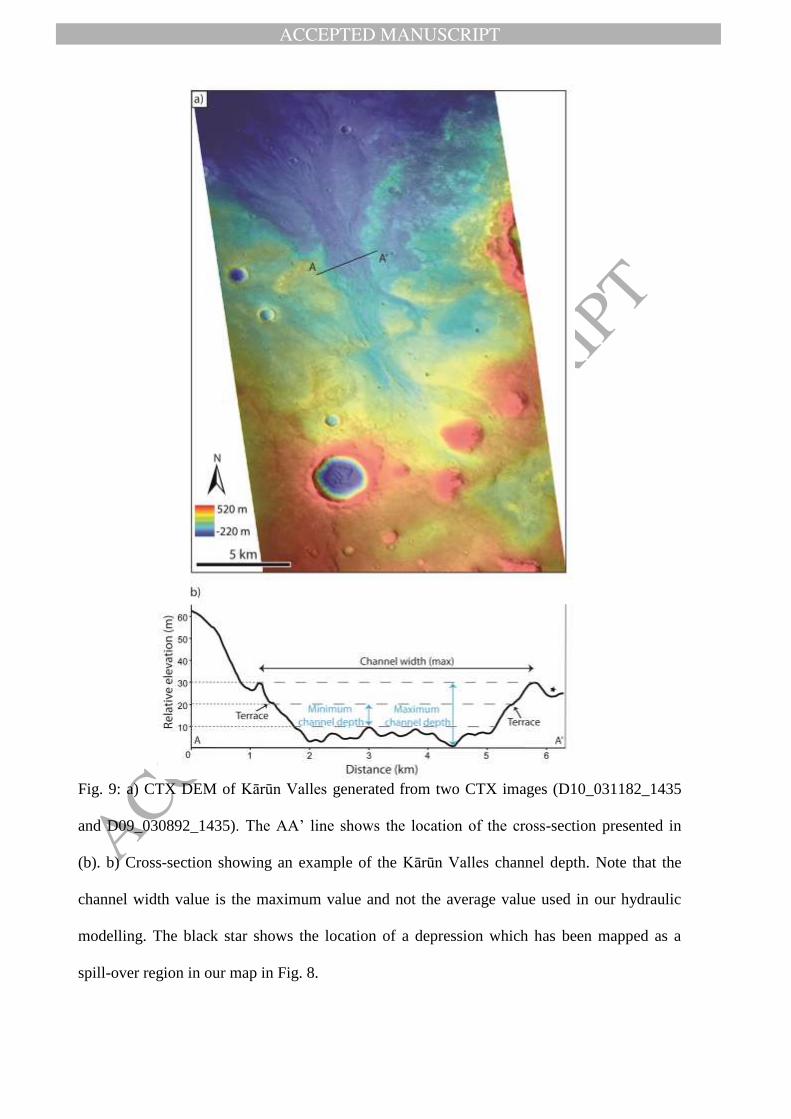
Fig. 9: a) CTX DEM of Kārūn Valles generated from two CTX images (D10_031182_1435
and D09_030892_1435). The AA’ line shows the location of the cross-section presented in
(b). b) Cross-section showing an example of the Kārūn Valles channel depth. Note that the
channel width value is the maximum value and not the average value used in our hydraulic
modelling. The black star shows the location of a depression which has been mapped as a
spill-over region in our map in Fig. 8.