alexandra | cromwell tracks brochure · cromwell, bannockburn, and in the manuherikia. stone...
TRANSCRIPT

Published by Department of ConservationKā Moana Haehae/Alexandra Office PO Box 176Alexandra 9340New ZealandJune 2015
Editing and design:Publishing Team, DOC National Office
Check, Clean, DryStop the spread of didymo and other freshwater pests. Remember to Check, Clean, Dry all items before entering, and when moving between, waterways.
For more information Contact the nearest DOC visitor centre for the latest information about facilities and conditions.
Alexandra i-Site 21 Centennial Ave, Alexandra Phone: 03 448 9515 [email protected]
Alexandra |Cromwell tracksCENTRAL OTAGO
All photos, unless otherwise credited, are copyright DOC.
Cover: Bannockburn Loop Track, Bannockburn Sluicings Historic Reserve
Cromwell i-Site2d The Mall, Cromwell Phone: (03) 445 0212 [email protected]
www.doc.govt.nz
Remember, your safety is your responsibility. Leave your intentions with a trusted contact. For more information, visit www.adventuresmart.co.nz.
Grade 3: Intermediate
Grade 4: Advanced
Grade 5: ExpertWalking tracks Short walk Walking track Tramping track Route
4WD
Historic site
Horse riding
Swimming
Hunting
New Zealand Cycle Trail
Managed by Department of Conservation
Managed by Central Otago District Council
Managed by Cromwell Promotions
Welcome to Central OtagoNau mai Haere maiAlexandra and Cromwell townships are good bases from which to explore Central Otago, a popular outdoor destination for mountain biking, walking, four-wheel driving, fishing and sharing picnics. The vast ‘big sky’ landscape offers a variety of adventures and places to explore.
Mountain bike tracksGrade 1: Easiest
Grade 2: Easy
Please note:• The maps in this brochure are a guide only and
should not be used for navigation purposes.• Track times are for walking one way unless otherwise
stated.• Where horse riding is allowed, an access key or lock
combination may be required. Please check with the local DOC office.
• Many tracks in this brochure cross private land. Please respect the landowners’ property and livestock.
Key
Motorcycling
Ski touring
Picnic
Fishing
Dog walking
Lookout

Cycling There are a number of cycling and mountain biking options in this region:• Short trips: Millennium Track (Alexandra to Clyde),
Cromwell to Pisa Moorings and Manuherikia River Track. • Pedal-grinding a-plenty: Prospect – Omeo loop,
Thomsons Gorge Rd, Hawksburn Road (Pylon Track), Cairnmuir Hill Track or cycle along the tops of Kopuwai Conservation Area.
• Longer or multi-day trips for beginners: Otago Central Rail Trail, Clutha Gold Trail or Roxburgh Gorge Trail.
Mountain bike track gradesGrade 2: Mostly flat, some gentle climbs on smooth track with easily avoidable obstacles such as rocks and
potholes. Grade 3: Steep slopes and/or avoidable obstacles, possibly on narrow track and/or with poor traction. There
may be exposure at the track’s outside edge. Grade 4: A mixture of long, steep climbs, narrow track, poor traction and difficult obstacles to avoid or jump
over. Generally exposed at the track’s outside edge. Most riders will find some sections easier to walk.
Otago Central Rail TrailNew Zealand’s original great ride, this easy gradient 150 km trail follows the former railway line from Clyde to Middlemarch. • Visit the Golden Progress Poppet Head near Oturehua.• Travel through the schist bluffs, tunnels and viaduct of
the Poolburn gorge.• Stop and enjoy a coffee or beer in the cafés and country
pubs in trailside towns.•
On the rail trail. Photo: Tourism Central OtagoBlue Lake Loop Track. Photo: T Bunny
Stewart Town, Bannockburn.Photo: T Bunny
Some quick recreation ideasChoosing a picnic spotGreat picnic spots can be found at Lanes Dam, Alexandra (Aronui) Dam, Mitchells Cottage and Bendigo/Logantown. For picnic spots with swimming opportunities, visit Blue Lake, St Bathans and Lower Manorburn Dam. For the more adventurous, explore Hyde Rock or the Come in Time Battery.
Choosing a trackTrack gradesShort walk: Easy walking for up to an hour.Walking track: Easy to moderate walking from a few minutes to a day. Track is mostly well formed; some sections may be steep, rough or muddy. Walking shoes required.Tramping track: Challenging day or multi-day tramping/hiking. May have steep grades. Suitable for fit, experienced and adequately equipped people. Tramping boots required.How long do you want to walk?1–2 hr: Bannockburn Sluicings, Blue Lake, Earnscleugh Tailings, Alexandra town clock, Flat Top Hill (Butchers Dam), Aurora Track or Shek Harn.3 hr +: Flat Top Hill, Lake Roxburgh Walkway or Kanuka Loop Track.
HistoryMāori Although there were never large numbers of Māori living in this area, there are strong connections between tāngata whenua and Central Otago. Moa hunters lived at sites near Hawksburn, Cromwell, Bannockburn, and in the Manuherikia. Stone shelters along the Clutha River/Mata-Au were used by moa hunters, and, later, by Māori who were travelling from kāika/villages in coastal Otago. They went inland to hunt weka and to source stone for tools, especially the prized pounamu/greenstone found on the West Coast. Later these same shelters were used by European and Chinese gold miners.
Gold mining Gold was discovered in Otago in 1850 but the first rush did not occur until 1861. Miners endured arduous conditions in their search for wealth. Central Otago’s climate can be unforgiving, and bitterly cold winters and swollen rivers claimed many lives. Gold mining has left fascinating relics on our landscape and there are many sites to explore.
Paddle found at Bendigo. Photo: Otago Museum, Dunedin, New Zealand
Our local natureCentral Otago is characterised by hot, dry summers and freezing winters. It has many unique species that have adaptations that help them survive in what can be a challenging environment. The distinctive blocky mountains, with their rock tors and sweeping tussocks are inhabited by the Otago skink, the mountain stone wētā, and the New Zealand eastern falcon/kārearea. Alpine flowers display their fragile beauty in spring, occasionally carpeting the tops in subtle colour.The valleys and river terraces have poor, fragile and often salty soils, where threatened cushion plants and rare invertebrates like the Cromwell chafer beetle live. Central Otago’s reservoirs and rivers are also home to rare galaxiid species (small native fish).
Mountain stone wētā. Photo: Nicola Vallance
Adventurous experiences Explore and experience the high country tussocklands. Four-wheel driving and mountain biking are popular in Central Otago, with tracks providing access to many backcountry places (these tracks can be done in either direction).
Above 1,000 m, temperatures can drop quickly, even in midsummer. Please take warm and windproof clothing. It is recommended that 4WD vehicles travel in pairs with recovery gear.
!
Gentian. Photo: Brian Rance
Cromwell chafer beetle. Photo: Bruce McKinlay
Kārearea. Photo: Florence Gaud
Pastoralism The first big stations were started in Central Otago in the 1850s, with run-holders driving their stock inland over untracked and difficult terrain. It could take over a year to get the sheep from the coast to inland stations. There was little timber available, so stone and sods were the main building materials for the earliest run-holders. There are many examples of old farm buildings dotted around the area, some built with such skill that they are largely intact today.
Railways The Central Otago railway was built between 1879 and 1920, with the section between Middlemarch and Clyde taking 16 years. Riding the trail gives you a chance to appreciate the engineering effort involved in linking Central Otago with the coast.
Mitchells Cottage. Photo: T Bunny
Poolburn Viaduct.
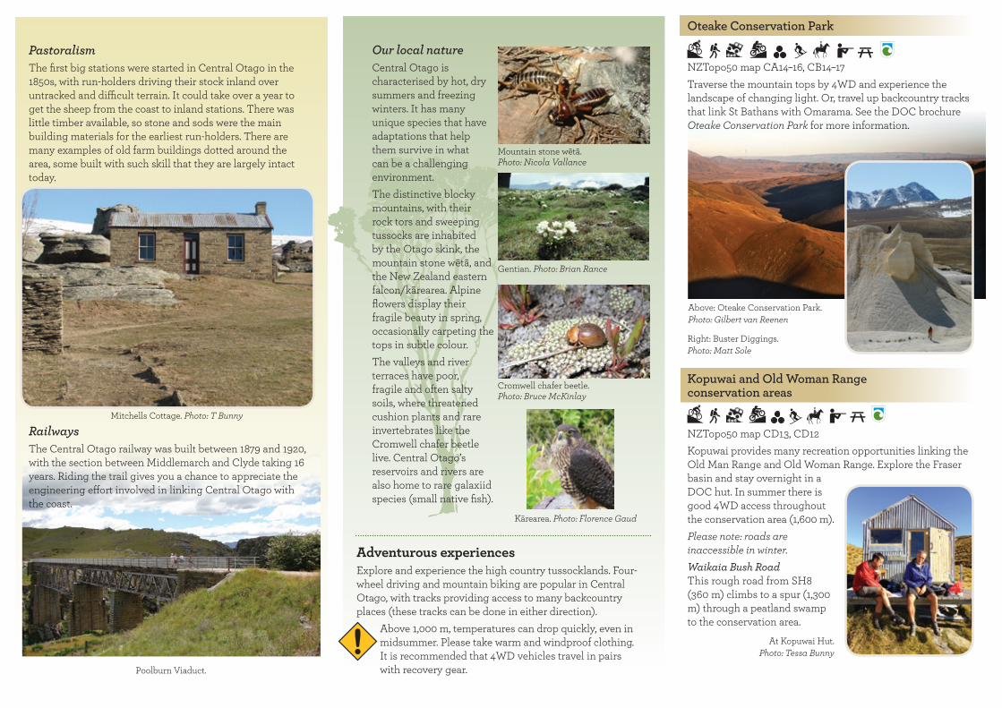
Oteake Conservation Park
NZTopo50 map CA14–16, CB14–17Traverse the mountain tops by 4WD and experience the landscape of changing light. Or, travel up backcountry tracks that link St Bathans with Omarama. See the DOC brochure Oteake Conservation Park for more information.
Kopuwai and Old Woman Range conservation areas
NZTopo50 map CD13, CD12Kopuwai provides many recreation opportunities linking the Old Man Range and Old Woman Range. Explore the Fraser basin and stay overnight in a DOC hut. In summer there is good 4WD access throughout the conservation area (1,600 m).Please note: roads are inaccessible in winter.Waikaia Bush Road This rough road from SH8 (360 m) climbs to a spur (1,300 m) through a peatland swamp to the conservation area.
Above: Oteake Conservation Park. Photo: Gilbert van Reenen
Right: Buster Diggings.Photo: Matt Sole
At Kopuwai Hut. Photo: Tessa Bunny

Thomsons Gorge Road
Tarras to Omakau, 30 kmNZTopo50 map CB13, CB14 The road bisects the Dunstan Range from Lake Dunstan to the Manuherikia Valley. The gravel road is windy and narrow, and is exposed to strong winds. From Ardgour Road, the road travels along the flat before climbing steeply up the Dunstan Mountains and levelling out at Thomsons Saddle (900 m), before descending to Racecourse Road near Omakau. During this trip you will see evidence of historical gold mining and pastoral farming. Please leave gates as you find them.
Poolburn Reservoir This scenic dam sited amongst rock tors is a popular fishing spot, and was a filming location for the Lord of the Rings.
Serpentine Scenic Reserve
16 km from Poolburn reservoir; closed in winterNZTopo50 map CD14, CD 15A NZTopo map and navigation skills are necessary as many farm tracks lead from the road. For experienced four-wheel drivers only. Note: Closed from 15 June to 15 September.View the picturesque historical relics in this isolated environment. Explore the church, stone huts, battery and waterwheel that were used by gold miners from 1882 to 1891. Access from Old Dunstan Road and turn into Long Valley Ridge Road. If you do not have a 4WD, you can walk or bike from Poolburn Dam.
Poolburn Dam to Serpentine 16 km (mountain bike 2–3 hr, tramping 5 hr)
Hawksburn Road to ‘The Pylon Road’ Clyde to Bannockburn: 29 km, 4WD onlyThe road climbs steeply past the Clyde Lookout to Hawksburn Station (800 m). From the gate it is 14 km through a winding gully to Bannockburn.
Lauder Basin Conservation Area
Sailors Creek Tramping Track: 30 min, 2 km4WD enthusiasts can travel from either the Manuherikia or Lindis valleys through the Lauder Basin Conservation Area during the summer months, 1 December to 30 April. Contact the local DOC office for more information. Closed for lambing: 20 September to the Thursday prior to Labour Weekend (4th weekend in October).
Pisa Conservation Area Many recreational opportunities are available (see the DOC brochure Wanaka outdoor pursuits).
St Bathans Blue Lake Loop Track: 50 min return, 2 km Around Blue Lake Track: 1 hr 30 min return, 3 kmSt Bathans to Domain: 30 min return, 1.5 kmExplore the picturesque Blue Lake and St Bathans. Established in 1863 to service the gold rush, the town has a charming streetscape. In the 1860s Blue Lake was the deepest mine in the Southern Hemisphere. Extensive hydraulic mining in the 1930s filled the mine with the mineral-rich water that gives the lake its distinctive colour. The Around Blue Lake Track offers views overlooking the lake.
There is a basic DOC campsite with limited facilities at St Bathans Domain (no charge).
Symes Road This road is often used to access Kopuwai (6 km from SH8 to Kopuwai boundary). Fraser Dam Road via Omeo or Prospect The Prospect Hill and Omeo Gully tracks provide foot or mountain bike access only. Duffers Saddle (1,173 m) From Nevis Road, turn left at Duffers Saddle. See the DOC brochure Rambling around Kopuwai for more information.
Nevis Road to Nevis valley Bannockburn to Garston, 65 km NZTopo50 map CC12, CD 11The road climbs steeply to Duffers Saddle then descends to the Nevis River. The Nevis is a hidden valley of pastoral landscapes, with good fishing and a vast array of gold mining heritage. From the Nevis valley there are a number of side trips to explore. The 4WD gravel road is in variable condition and has 30 stream crossings. Part of the Nevis Road is closed in winter (from Commissioners Creek to the Southland District boundary).
Serpentine Scenic Reserve battery and waterwheel.

TRACKS AND SIGHTS AROUND CROMWELL AND ALEXANDRA5. Omeo Gully Track
9 km, 6 hr return Characteristically Central Otago, this track starts dry and barren and moves into tussock and shrubland as it climbs up the hill. Thrill-seeking mountain bikers will enjoy the downhill track. Closed for lambing: 15 October – 15 November.
6. Prospect Hill Track
6–8 hr return , 9 kmThe track climbs to tussock and herb fields on the top of the Old Man Range. For fit, adventurous mountain bikers, a good loop is up Prospect Hill and down Omeo Gully. Closed for lambing: 15 October – 15 November.
7. Obelisk Loop Track
3 hr 30 min return, 9 km A pleasant loop starting at Obelisk (known to Māori as Kopuwai), that connects Omeo and Prospect Hill along the tops of the Obelisk/Kopuwai Range.
8. Shek Harn Historic Reserve
2 hr return, 13 km Access via Fraser Dam Road and a winding gravel road to the DOC sign. From here walk or bike to the dam. A walking track follows the Fraser River to impressive Chinese dwellings and remains of other gold workings. Shek Harn is Cantonese for ‘big stone ditch’.
9. Millennium Track ‘The River Track’
Alexandra to Clyde, 3 hr, 11.5 kmA popular walking and cycling track that follows the Clutha River/Mata-Au. The track is undulating and provides an alternative route for those cycling the Otago Central Rail Trail.
10. Earnscleugh Tailings Historic Reserve
1 hr 30 min loop, 5 km Walk through an internationally important site of historic dredge tailings. Gold mining occurred on the site from 1863 to 1963; the walk features dredge ponds, buckets and other mining relics. Take a side trip to view the modern gold mine operating adjacent to the reserve. The very rare grasshopper, Sigaus childi, is found at this reserve.
11. Lanes Dam and Alexandra (Aronui) Dam
A pleasant short walk in Alexandra around the Lanes dam on Aronui Road, with another short walk around the Aronui dam nearby.
12. Lake Roxburgh Walkway
7 hr return, 10 kmGraveyard Gully to Butchers Point: 1 hr, 4 kmButchers Point to Doctors Point: 2 hr 30 min, 6 kmFrom Graveyard Gully this trail follows an old bridal path that transported coal to the gold mining dredges from 1890 to the 1930s. Historic tailings and Chinese miners’ shelters include Mary Lee’s three-room dwelling. You can bike to Butchers Point, but please note that beyond Leaky Lodge the track becomes rough, less defined and exposed in some places.
13. Manuherikia River Track
15 min, 1 kmThe track along the Manuherikia River provides access to popular swimming and fishing spots and links to the Rail Trail, Shaky Bridge and other informal recreation trails.
14. The Alexandra town clock
20 min return, about 500 mFollow the Manuherikia River Track and cross the river over Shaky Bridge. An uneven rocky path leads up to the 11-m clock built in 1968.
15. Otago Central Rail Trail
153 km, 3–4 days by bike New Zealand’s original great ride, this very popular cycle trail follows the old railway line through small rural towns from Middlemarch to Clyde. If you are short on time, popular sections for day visits include the Poolburn Gorge (Lauder to Auripo) and Tiroiti to Hyde.
Wedderburn Station
Please note: times given are for walking one way unless otherwise stated
1. Mitchells Cottage
This cottage is one of the best examples of stone masonry in New Zealand. A popular picnic spot with great views, situated on Symes Road.
2. Roxburgh Gorge Trail
34 km, 1 day by bikeAlexandra to Roxburgh Dam. A spectacular trail that travels alongside the Clutha River/Mata-Au. The trail winds through a gorge with 350 m-high bluffs. This trail is undulating with a few steep sections. The 13 km section between Doctors Point and Shingle Creek is travelled by boat. There is access to SH8 via a steep track through Flat Top Hill Conservation Area. This trail is managed by the Roxburgh Gorge Trail Charitable Trust.
2a. Clutha Gold Trail
73 km, 2 daysStarting in Roxburgh, this trail follows the Clutha River/Mata-Au through the beautiful Beaumont Gorge to Lawrence. Parts of the trail follow the old Roxburgh Branch railway line, and include the 440 m Bill Hill Tunnel. This trail links with the Roxburgh Gorge Trail and is managed by the Clutha Gold Trail Charitable Trust.
3. Flat Top Hill Conservation Area
Butchers Dam Loop Track: 1 hr return, 2.5 kmBasin View Track: 3 hr return, 7 kmFlat Top Hill Track: 4 hr, 10 kmThe track climbs steadily to a plateau overlooking the Clutha River/Mata-Au. The area features regenerating native plant species that once covered much of the lowland valleys of Central Otago.
4. Aldinga Conservation Area
1 hr 30 min loop, 4 kmWander at will, explore the historical relics and admire the views through this tussock reserve. There is a well preserved rock shelter 30 minutes from the start of the track. Conroys Dam is a popular picnic and swimming spot. Access is from Conroys Dam Road

23. Bannockburn Sluicings Historic Reserve
1 hr 30 min loop, 3.5 kmThe popular walking track has great views over Cromwell and the Clutha River/Mata-Au. The loop track travels through spectacular sluicings and water races to the remains of Stewart Town and Menzies Dam.
23a. Long Gully Bluff Track
2 hr, 4 kmThis track offers views of the Remarkables and Hector mountains. From the Bannockburn Sluicings there is a rough route to Long Gully Bluff Conservation Area. Public access to Long Gully is restricted to Sundays and Mondays only. Closed for lambing from 1 October – 30 November.
24. Kawarau Trail
1 hr, 4 kmThe undulating track starts at Bannockburn bridge and travels up the true left of the Kawarau River, through gold mining tailings to the Goldfields Mining Centre in Kawarau Gorge. Parking is available at the Bannockburn Bridge.
25. Old Cromwell Town to Bannockburn Bridge
3 hr, 11 km This trail follows the shore of Lake Dunstan. It is easy until the oxidation ponds, then becomes narrower with some steep grades and soft sections. It passes gold workings and ends at the Bannockburn bridge.
26. Cromwell to Pisa Moorings
5 hr, 19 kmAn easy track along the shore of Lake Dunstan that links Pisa Moorings to Cromwell. Points of interest include Lowburn (where the original church and hall were located before Lake Dunstan was formed), the 45th Parallel monument and the Lowburn Collie Club. This area can be very windy.
Bannockburn. Photo: Tessa Bunny
Photo: Sharleen Briden
27. Cromwell Old Reservoir
1 hr return, 2.5 kmThe track starts at the Bruce Jackson Memorial Lookout on SH8. It then climbs 120 m to the old reservoir and water race that were built after a typhoid outbreak caused by Cromwell’s previously open water race. The track then descends steeply to SH8 and a short walk along the road back to the car park.
28. Quartz Reef Point Track
40 min return, 1 km The best-preserved herringbone tailings in the region are a hidden gem, well worth the short climb from the road.
29. Bendigo
Welshtown Matilda Battery Track: 20 min, 1 kmAurora Track: 1 hr 30 min, 4 kmRidge Dray Track: 15 min, 600 m Kanuka Loop Track: 5 hr, 10 kmExplore the remains of townships and hard-rock gold mining sites, including the Bendigo bakehouse (below). Beware of unfenced mine shafts.
30. Dry Creek Track
3 hr, 8.5 km A relatively flat tramp or bike along the dry creek bed, through shrublands to the Neinei i Kura Conservation Area. Closed for lambing: 10 October – 21 November.
31. Cloudy Peak Track
3 hr, 7.5 km Walk along Dry Creek Track to the start of Cloudy Peak Track, which travels through Dry Creek Conservation Area to join a 4WD track. This climbs along the ridge to Neinei i kura Conservation Area. An unmarked 4WD track leads to the summit of Cloudy Peak and Thomsons Saddle.
16. Lower Manorburn
A popular and scenic picnic and swimming spot.
17. Clyde viewing platform
30 min, 500 m A short walk that starts from Hazlett St in Clyde, offering a rewarding view of Clyde and the Clutha River/Mata-Au.
18. Clyde Lookout
45 min, 1.5 kmThe track starts from Hawksburn Road and leads up to a lookout with views across Lake Dunstan.
19. Along the Tops/Cairnmuir Track
6–8 hr, 25.5 km, 3–5 hr by bikeBannockburn inlet to Clyde: From Cornish Point Road (200 m) the track climbs steadily to a restored musterering hut. Traversing the tussock tops (1,114 m) of the Cairnmuir Mountains offers views of the Remarkables and Lake Dunstan before a steep descent to Clyde. This is exposed, isolated alpine environment.Closed for lambing: 15 October – 15 November.
20. Waikerikeri Conservation Area
3 hr, 5 kmLilico Spur is on an easement over private land and climbs to the start of the conservation area. You will need the landowner’s permission to continue to Leaning Rock.
21. Young Australian Waterwheel
1 hr from Duffers Saddle, 4.5 kmView the impressive 14 m-high waterwheel that sits in vast tussocklands. A popular mountain bike loop is to ride up the Nevis Road to Duffers Saddle, along the ridge to the waterwheel and then down to Carricktown.Can be accessed from Duffers Saddle or Carricktown.
22. Carricktown
From Bannockburn: 1 hr, 3 km The track climbs steadily 400 m up the spur to Carricktown, then another 350 m to the Carrick Water Race and Young Australian Waterwheel.Access is from Bannockburn: Turn right into School House Road in Bannockburn, then right into Quartzville Road. Can also be accessed from Duffers Saddle via the Young Australian Waterwheel.

6
8
8
8
8
8B
85
See Alexandraenlargement
Deep Creek Hut
Meg Hut
Nicholsons Hut
Boundary Hut
Old Woman Hut
Kirtle Burn Hut
PisaConservation Area
KopuwaiConservation
Area
AldingaConservation
Area
Neinei i kuraConservation
Area
BendigoConservation
Area
Mahaka KatiaScientific Reserve
SpringvaleScientificReserve
CromwellChafer Beetle
Reserve
SWANN
THOMSONS GORGE RD
ARDGOUR
BENDIGO
LOOP
RD
ROAD
RD
RD
QUARTZVILLE
GULLY ROAD
FELTON
HAWKSBURN
NEVISROAD
FRASER
EARN
SCLEU
GH
WI
RE
KIR
EKI
AVA
LLEY
ROAD
RO
AD
DAMROAD
CO
NR
OYS
R
D
SYMESROAD
BLACKMANSROAD
ROAD
GULLY
ROAD
DUNSTAN ROAD
SPRINGVALE
LETTS
ROAD
PisaMoorings
Bendigo
KawarauMiningCentre
Bannockburn
Lowburn
Galloway
Clyde Rail Head
LakeDunstan
FraserDam
ConroysDam
ButchersDam
River
/
Mat
a Au
Lake
Lake
Clu
tha
Riv
er /
Mat
au A
u
Clut
ha
River
Dunstan
Dunstan
River
Manuh
erikia
Riv
er
Lindis
Creek
Kawarau
River
Thomsons
Fraser
Leaning Rock / Haehaeata
Dunstan
Mt Dottrel
Mt Michael
Mt Pisa
Cloudy Peak
Mt Horn
Cairnmuir Hill
Prospect Hill
Obelisk
Cairnhill
Hyde Rock
Duffers Saddle
Thomsons Saddle
1647m
1667m
1701m
1163m
1964m
1526m
1136m
1114m
930m
1695m
656m
1673m
D U N S TA N
PI S
A
CA
RR
I CK C
AI R
NM
UI R
OL
DW
OM
AN
RA
NG
E
RA
NG
E
MT
NS
RA
NG
E
M O U N TA I NS
This area is accessedfrom Cardrona Valley.
Snow Farmaccess
Roaring Megaccess
Locharburn access
Mt Pisaaccess
to AorakiMt Cook
to Wanaka
to Roxburgh andClutha Gold Trail
to Queenstown
to Omakau
Come in TimeBattery
AlpineBattery
28
27
26
25
24
2323a
22
21
20
19
18
17
16
15
15
1413
10
11
9
8
7
6
5
4
3
2
1
12
29
30
31
) (
) (
85
8
8
12
2
15
13
14
10
9
11
<
<EARNSCLEUGH
CHAPMANS ROAD
DUNSTAN ROAD
RD
GULLY
GR
AVEY
ARD
ROAD
LITTLE VALLEYMAR
SHAL
LR
OAD
ROAD/ Matau Au
River
Clutha
AronuiDam
River
Manuh
eriki
a
Swimming PoolIce Skating Rink
Skate ParkBike Park
1
<
<Central Stories MuseumShaky Bridge
1
N
N
0 1kilometre
Alexandra0 5
kilometres
Public conservation land
Walking/mountain bike track
4WD road/track
Unmarked route
Hut
Parking
Lookout
Fishing
Historic site
July 2014 - Base map image supplied by Geographx (NZ) Ltd 2a

6
8
8
8
8
8B
85
See Alexandraenlargement
Deep Creek Hut
Meg Hut
Nicholsons Hut
Boundary Hut
Old Woman Hut
Kirtle Burn Hut
PisaConservation Area
KopuwaiConservation
Area
AldingaConservation
Area
Neinei i kuraConservation
Area
BendigoConservation
Area
Mahaka KatiaScientific Reserve
SpringvaleScientificReserve
CromwellChafer Beetle
Reserve
SWANN
THOMSONS GORGE RD
ARDGOUR
BENDIGO
LOOP
RD
ROAD
RD
RD
QUARTZVILLE
GULLY ROAD
FELTON
HAWKSBURN
NEVISROAD
FRASER
EARN
SCLEU
GH
WI
RE
KIR
EKI
AVA
LLEY
ROAD
RO
AD
DAMROAD
CO
NR
OYS
R
DSYMES
ROAD
BLACKMANSROAD
ROAD
GULLY
ROAD
DUNSTAN ROAD
SPRINGVALE
LETTS
ROAD
PisaMoorings
Bendigo
KawarauMiningCentre
Bannockburn
Lowburn
Galloway
Clyde Rail Head
LakeDunstan
FraserDam
ConroysDam
ButchersDam
River
/
Mat
a Au
Lake
Lake
Clu
tha
Riv
er /
Mat
au A
u
Clut
ha
River
Dunstan
Dunstan
River
Manuh
erikia
Riv
er
Lindis
Creek
Kawarau
River
Thomsons
Fraser
Leaning Rock / Haehaeata
Dunstan
Mt Dottrel
Mt Michael
Mt Pisa
Cloudy Peak
Mt Horn
Cairnmuir Hill
Prospect Hill
Obelisk
Cairnhill
Hyde Rock
Duffers Saddle
Thomsons Saddle
1647m
1667m
1701m
1163m
1964m
1526m
1136m
1114m
930m
1695m
656m
1673m
D U N S TA N
PI S
A
CA
RR
I CK C
AI R
NM
UI R
OL
DW
OM
AN
RA
NG
E
RA
NG
E
MT
NS
RA
NG
E
M O U N TA I NS
This area is accessedfrom Cardrona Valley.
Snow Farmaccess
Roaring Megaccess
Locharburn access
Mt Pisaaccess
to AorakiMt Cook
to Wanaka
to Roxburgh andClutha Gold Trail
to Queenstown
to Omakau
Come in TimeBattery
AlpineBattery
28
27
26
25
24
2323a
22
21
20
19
18
17
16
15
15
1413
10
11
9
8
7
6
5
4
3
2
1
12
29
30
31
) (
) (
85
8
8
12
2
15
13
14
10
9
11
<
<EARNSCLEUGH
CHAPMANS ROAD
DUNSTAN ROAD
RD
GULLY
GR
AVEY
ARD
ROAD
LITTLE VALLEYMAR
SHAL
LR
OAD
ROAD/ Matau Au
River
Clutha
AronuiDam
River
Manuh
eriki
a
Swimming PoolIce Skating Rink
Skate ParkBike Park
1
<
<Central Stories MuseumShaky Bridge
1
N
N
0 1kilometre
Alexandra0 5
kilometres
Public conservation land
Walking/mountain bike track
4WD road/track
Unmarked route
Hut
Parking
Lookout
Fishing
Historic site
July 2014 - Base map image supplied by Geographx (NZ) Ltd 2a