albany waterfront ecological risk assessment: potential ... · albany waterfront ecological risk...
TRANSCRIPT
Albany Waterfront
Ecological Risk Assessment: Potential for on-site contamination to adversely affect adjacent marine environment
June 2006

p:\landcorp\382_albanywaterfrontdevel\reports\era land to water_kh_june06.doc
Albany Waterfront
Ecological Risk Assessment: Potential for on-site contamination to adversely affect adjacent
marine environment
Prepared for:
Landcorp
Prepared by:
Oceanica Consulting Pty Ltd
June 2006
Report No. 382/2

Client: Landcorp Revisions history
DISTRIBUTION REVIEW
Version Author Recipients No. Copies &
Format Date Reviewer Date
1 K. Hillman OTEK, ERM, Strategen
Electronic - pdf 05/05/06 OTEK 12/05/05
2 K. Hillman OTEK, ERM, Strategen
Electronic - pdf 12/06/06
3 K. Hillman Strategen Electronic - pdf 27/04/07 Status This report is “Draft” until the author and director have signed it off for final release. A “Draft” report should not be used for any purpose other than to be reviewed with the intention of generating a “Final” version. Approved for final release:
Author
Director
Disclaimer This report has been prepared on behalf of and for the exclusive use of Landcorp, and is subject to and issued in accordance with the agreed terms and scope between ERM and Oceanica Consulting Pty Ltd. Oceanica Consulting Pty Ltd accepts no liability or responsibility whatsoever for it in respect of any use of or reliance upon this report by any third party. Copying this report without the permission of Landcorp or Oceanica Consulting Pty Ltd is not permitted. Cover Main image: Coastline Cape Naturaliste (Oceanica); Minor images: Seagrass meadow (Oceanica); Woodman Point shoreline (Oceanica) © Copyright 2006 Oceanica Consulting Pty Ltd


Oceanica: Landcorp: ERA of site to PRH i
Contents Summary ...................................................................................................................iii
1. Introduction .......................................................................................................1 1.1 Background ........................................................................................................................1
2. Level 1 Assessment (Screening) .....................................................................3
3. Level 2 Assessment..........................................................................................5 3.1 Problem Identification .......................................................................................................5 3.2 Receptor Identification ......................................................................................................5
3.2.1 Potential toxic contaminants ...................................................................................5 3.2.2 Nutrients ..................................................................................................................6
3.3 Exposure Assessment ......................................................................................................6 3.3.1 Dilution and dispersion of contaminants in groundwater ........................................6 3.3.2 Dilution and dispersion of contaminants in stormwater ..........................................9 3.3.3 Partitioning of contaminants to sediments ........................................................... 10 3.3.4 Transit times of water-borne marine organisms through nearshore waters
of the project site.................................................................................................. 11 3.4 Toxicity assessment....................................................................................................... 11
3.4.1 Potentially toxic contaminants.............................................................................. 11 3.4.2 Nutrient enrichment.............................................................................................. 13
3.5 Risk Characterisation ..................................................................................................... 13 3.5.1 Risks to marine biota due to contaminants in marine waters .............................. 13 3.5.2 Risks to marine biota due to accumulation of contaminants in marine
sediments............................................................................................................. 15 3.5.3 Risks to marine biota due to nutrient enrichment ................................................ 15
3.6 Uncertainty ...................................................................................................................... 15
4. Conclusions.....................................................................................................16
5. References.......................................................................................................16
ii Oceanica: Landcorp: ERA of site to PRH
List of Tables Table 3.1 Risk analysis for groundwater and stormwater discharge to the
marine environment adjacent to the Albany Waterfront project area....13
List of Appendices Appendix A Sediment contaminant data obtained in February 2004 .......................16
Oceanica: Landcorp: ERA of site to PRH iii
Summary The proposed Albany Waterfront Project involves development of both land (foreshore redevelopment) and the adjacent marine waters (a marina). The land component and marine component are undergoing separate environmental approval processes. A Detailed Site Investigation (DSI) of soil and groundwater contamination issues of the land component of the project has been completed by Environmental Resources Management Australia Pty Ltd (ERM). The DSI included Level 1 (Screening) and Level 2 ecological risk assessment (ERA) of the potential impacts of on-site contaminants on terrestrial biota, and Leve1 1 ERA of potential impacts of on-site contaminants on marine biota. Level 2 ERA of potential impacts of on-site contaminants on marine biota has been carried out by Oceanica Consulting Pty Ltd (Oceanica), and is provided in this report. ERM’s Level 1 ERA established migration of contaminants in groundwater down hydraulic gradient, or migration along preferential pathways (backfill to underground services/entering stormwater drains) as potential pathways for on-site contaminants to the marine environment. Contaminants of concern (CoCs) identified were as follows: • zinc as a widespread CoC in groundwater across the entire site; • copper, total PAH, as localised CoCs in groundwater in western half of the site; • dieldrin and total PAH as localised CoCs in groundwater in the area eastern half of the
site; • copper and zinc as CoCs in all stormwater discharges; and • nitrate-plus-nitrite, total nitrogen and total phosphorus as widespread contaminants in
all stormwater and groundwater samples. Level 2 ERA involved consideration of the magnitude, frequency, extent and duration of exposure of marine organisms to contaminants in groundwater and stormwater. The potential for water-borne contaminants to partition to sediments, and ecotoxicological information on copper and zinc, were also examined. It was concluded that the land component of the project site presents a low risk of adverse effects to the marine biota of Princess Royal Harbour for the following reasons: • The site is not a major source of contaminants to groundwater or stormwater. Elevated
zinc and nutrient levels were found in all bores up-gradient of the site, indicating background contamination rather than site-specific contamination. Furthermore, stormwater characteristics would be largely determined by the adjacent catchment, of which the project site only comprises a small proportion.
• Groundwater and stormwater discharging into waters adjacent to the project site would rapidly undergo considerable dilution within a very short distance (10 m) of the shoreline.
• Only zinc in groundwater bores near the shoreline, and copper and zinc in stormwater, exceeded relevant environmental guidelines, which are for chronic effects on marine biota. The level of exceedance was not large, and nearshore dilution of these waters would be sufficient to ensure that guidelines are rapidly met under most conditions. Nor are concentrations of copper and zinc at levels likely to cause acute toxicity effects during any occasional periods of low dilution (i.e. heavy stormwater runoff).
• The level of groundwater dilution is sufficient to ensure that relevant guidelines are met even if the extreme case is taken that localised contamination up-gradient of shoreline bores represent groundwater quality that might discharge to the marine environment at some time (these areas involve lesser volumes of groundwater discharge, and so the potential for dilution is also greater).
iv Oceanica: Landcorp: ERA of site to PRH
• The levels of copper and zinc in surface sediments adjacent to the project site are well below environmental guidelines, indicating little risk due to partitioning of these metals from groundwater/stormwater to marine sediments.
• Nutrient-based measures of marine water quality (chlorophyll ‘a’) indicated a low risk of adverse effects due to nutrient enrichment.
With respect to potential impacts of the land component of the project on marine biota, it was concluded that no further site assessment, management or remediation of the site is required. This conclusion is based on the assumptions that: i) potential acid sulphate soils will be appropriately managed during construction activities; and ii) construction will not involve dewatering of the site.
-o0o-
Oceanica: Landcorp: ERA of site to PRH 1
1. Introduction
1.1 Background The proposed Albany Waterfront Project involves development of both land (foreshore redevelopment) and the adjacent marine waters (a marina). The land component and marine component have been, or are subject to, separate environmental approvals, as follows: • Land component. The Albany Foreshore Redevelopment Project received
environmental approval in 1996 but has recently been amended in accordance with the revised Albany Waterfront Structure Plan. These changes are in the process of receiving environmental approval pursuant to s45c of the Environmental Protection Act 1986 (EP Act).
• Marine component. The proposed works are not covered by the environmental approval for the Albany Foreshore Redevelopment Project, and so will be separately referred under s38 of the EP Act to the Environmental Protection Authority (EPA) for consideration.
The land component of the project is located between Princess Royal Drive and the high water mark of Princess Royal Harbour, and the investigation and management of soil and groundwater contamination issues of this site have been addressed in a Detailed Site Investigation (DSI) by Environmental Resources Management Australia Pty Ltd (ERM 2006). ERM’s investigations (ERM 2005; 2006) addressed ecological risk assessment (ERA) for terrestrial biota, Leve1 1 (Screening) ERA of potential impacts of on-site contaminants on marine biota. Level 2 ERA of potential for contamination of the land component of the project to adversely affect the marine biota of Princess Royal Harbour have been addressed by Oceanica Consulting Pty Ltd (Oceanica), and are the subject of this document. Oceanica’s report has been carried out according to national and State guidelines for ecological risk assessment (NEPC 1999; DoE 2003, 2005a, 2005b), and is intended as a supplement to ERM’s DSI report (ERM 2006): it refers to data or diagrams provided by ERM (2005, 2006), but does not replicate them.

Oceanica: Landcorp: ERA of site to PRH 3
2. Level 1 Assessment (Screening) Following a preliminary site investigation (PSI) of the project site, ERM (2005) developed a preliminary conceptual site model which established the main exposure pathway to the marine environment as “migration of contaminants in groundwater down hydraulic gradient, or migration along preferential pathways (backfill to underground services/entering stormwater drains)”, with uptake by marine organisms. Potential source areas and contaminants identified were: • A former waste landfill adjacent to the site (various contaminants, including
organochlorine pesticides [OCPs], petroleum hydrocarbons [PH], polycyclic aromatic hydrocarbons [PAHs], asbestos containing material [ACM] and methane gas).
• Potentially contaminated fill used in historical reclamation work (various contaminants, including metals, OCPs, PHs, PAHs and ACM).
• Area of former railway use (various contaminants, including metals, OCPs, PHs, PAHs, Benzene toluene ethylbenzene and xylene [BTEX], ACM, sulphur, semi-volatile organic compounds [SVOC]).
• Port/jetty loading/offloading areas (PHs, PAHs, metals, sulphur, tributyltin [TBT]).
• Stormwater drainage lines (PHs, PAHs, metals, sewerage [nutrients and coliforms]).
• Former ‘mercury disposal area’ (mercury). • Sewage systems (nutrients and coliforms). ERM’s subsequent DSI (ERM 2006) included analysis of contaminants in groundwater and stormwater as follows: • Groundwater. Samples were taken from:
• Six bores within 25 m of the project site shoreline, comprising three bores (MW28, MW31 and MW32) in the project area west of the Albany Town Jetty (ATJ), and three bores (MW22, MW23 and MW26) east of the ATJ (i.e. adjacent to the proposed marina).
• 11 bores on the project site hydrologically up-gradient of the shoreline bores.
• Seven bores hydrologically up-gradient of the project site. • Stormwater. Stormwater enters the marine environment adjacent to the
Waterfront project area in three areas: (i) large drainage outlets opposite York Street; (ii) a small outlet just west of the Albany Town Jetty (ATJ); and (iii) a small outlet within the propose marina area. Opportunistic sampling of stormwater was undertaken by ERM at these three locations.
ERM (2006) undertook Level 1 ERA of groundwater and stormwater to the marine environment by comparison of groundwater and stormwater data to Department of Environment (DoE) marine water quality guidelines (DoE 2003). This screening established the following: • Groundwater - shoreline bores. Zinc was the only contaminant that
exceeded guidelines. Zinc levels in all bores exceeded the guideline, as follows: • West of Albany Town Jetty - 49 µg/L at MW28, 39 µg/L at MW31, 58
µg/L at MW32; and
4 Oceanica: Landcorp: ERA of site to PRH
• East of Albany Town Jetty - 30 µg/L at MW22, 37 µg/L at MW23, 57 µg/L at MW26.
• Groundwater – bores on the project site up-gradient of shoreline bores. All bores exceeded the zinc guideline, with values ranging from 35 µg/L (MW21) to 599 µg/L (MW00). In addition: • West of Albany Town Jetty. Copper levels at bore MW00 (1.6 µg/L)
exceeded the guideline of 1.3 µg/L, and total PAH levels at MW 33 (3.61 µg/L) and MW34 (16.08 µg/L) exceeded the guideline of 3.0 µg/L.
• East of Albany Town Jetty. Dieldrin levels at MW27 (0.078 µg/L) and MW27A (0.064µg/L) exceeded the guideline of 0.002 µg/L, and total PAH levels at MW 27A (3.72 µg/L) exceeded the guideline of 3.0 µg/L.
• Groundwater – bores up-gradient of the project site. All bores exceeded the zinc guideline, with values ranging from 28 µg/L (MW43) to 457 µg/L (MW03, depth 9.8 m). In addition, bore MW04 (depth 9.8 m) had nickel levels (8.5 µg/L) above the guideline of 7.0 µg/L, bore MW41 had lead levels (5.1 µg/L) above the guideline of 4.4 µg/L, and bore MW11 had arsenic levels (71.9 µg/L) above the guideline of 50 µg/L.
• Stormwater. The only contaminants for which guidelines were exceeded were copper (guideline 1.3 µg/L) and zinc (guideline 15 µg/L), as follows: • York St drains, copper 6.3–6.4 µg/L and zinc 112–116 µg/L; • Drainage outlet west of ATJ, copper 10.8 µg/L and zinc 26 µg/L; and • Drainage outlet within marina, copper 4.8 µg/L and zinc 50 µg/L.
Screening level assessment also identified nitrite-plus-nitrate, total nitrogen and total phosphorus as above guidelines in all groundwater and stormwater samples: • Groundwater had nitrite-plus-nitrate levels ranging from 110 µg/L to
13,000 µg/L, total nitrogen levels of 1,200 µg/L to 23,000 µg/L, and total phosphorus levels of 27 µg/L to 7,500 µg/L. High concentrations of nutrients occurred hydrologically up-gradient of the site as well as on-site.
• Stormwater discharging west of the ATJ had nitrite-plus-nitrate levels of 820–1,400 µg/L, total nitrogen levels of 1,400–2100 µg/L and total phosphorus levels of 38–230 µg/L. The higher values were associated with discharge from the York Street drains. Stormwater discharging east of the ATJ had nitrite-plus-nitrate levels of 500 µg/L, total nitrogen levels of 1,100 µg/L and total phosphorus levels of 88 µg/L.
Oceanica: Landcorp: ERA of site to PRH 5
3. Level 2 Assessment
3.1 Problem Identification ERM’s Level 1 assessment established contaminants of concern (CoCs) as follows: • zinc as a widespread CoC in groundwater across the entire site1; • copper (bore MW00) and total PAH (bore MW33 and MW34) as localised
CoCs in groundwater in the area west of the ATJ; • dieldrin and total PAH (bore MW27/27A) as localised CoCs in groundwater in
the area east of the ATJ; • copper and zinc as CoCs in all stormwater discharges2; and • nitrate-plus-nitrite, total nitrogen and total phosphorus as widespread
contaminants in all stormwater and groundwater samples.
3.2 Receptor Identification Princes Royal Harbour has extensive areas of seagrass and macroalgae, particularly at its southern and western ends. These macrophyte stands are important food, shelter and breeding grounds for fish and other marine animals (EPA 1990). There are dense seagrass meadows 50–100 m offshore of the western part of the project area (i.e. west of the Albany Town Jetty). There is also one small isolated patch of seagrass in the area of the marina, but this will be removed with the proposed dredging of the site. There are no rare or endangered species of marine fauna known to inhabit the waters of Princess Royal Harbour. Humpback and Southern Right whales are commonly observed in King George Sound, as are bottlenose dolphin, common dolphin, Australian sea lion and New Zealand fur seal. Whales do not enter Princess Royal Harbour, but dolphin and sea lions are occasional visitors (CALM 1994). The marine waters immediately adjacent to the project site are not used for commercial or recreational fishing: the area is used by passengers embarking/disembarking from charter boats; by fishing boats to offload catches; as a temporary mooring area; and as a tug boat harbour for the Port of Albany. Recreational fishing is popular further afield, within the broader waters of Princess Royal Harbour, targeting black bream, King George whiting and trevally. Commercial fishing is centred on waters outside of Princess Royal Harbour (in King George Sound and beyond). There is no aquaculture in Princess Royal Harbour. The current approach of the EPA and DoE for the protection and management of coastal waters is encapsulated within the State Environmental Policy (SEP) for Cockburn Sound, which is viewed as a template for other areas in WA. The approach involves the use of national water quality guidelines for various levels of aquatic ecosystem protection (ANZECC/ARMCANZ 2000), designated high, moderate and low.
3.2.1 Potential toxic contaminants For high protection zones, national (ANZECC/ARMCANZ 2000) guidelines for 95% species protection apply, unless the contaminant has the potential to
1 It is not clear whether this is due to background conditions or human activities on another site. 2 As for footnote no. 2.
6 Oceanica: Landcorp: ERA of site to PRH
bioaccumulate, in which case the 99% species protection guidelines apply. The national guidelines have also been adopted as the assessment levels for marine waters listed in the DoE’s Contaminated Sites Management Series: Assessment Levels for Soil, Sediment and Water, Department of Environment, November 2003 (DoE 20033) used in the screening level assessment in Section 2. For moderate protection zones, ANZECC/ARMCANZ (2000) guidelines for 90% species protection apply. For low protection zones, ANZECC/ARMCANZ (2000) guidelines for 80% species protection apply. Based on the Cockburn Sound SEP, it has been assumed that the majority of Princess Royal Harbour (including waters within the project area that are west of the marina) will be considered a high protection zone, and the waters of the proposed marina will be considered a moderate protection zone.
3.2.2 Nutrients The screening guidelines for nitrite-plus-nitrate, total nitrogen and total phosphorus do not indicate the potential for toxicity effects, but rather the potential for nutrient enrichment effects. Adverse effects due to nutrient enrichment may occur when nutrient-rich groundwater and/or stormwater discharges into poorly flushed areas. Concentrations of chlorophyll ‘a’ in marine waters are used to gauge whether there is a risk due to nutrient enrichment, with present guidelines of 0.8 µg/L for high protection areas and 1.0 µg/L for moderate protection areas.
3.3 Exposure Assessment The magnitude, frequency, extent and duration of exposure of marine organisms are considered in this section, according to: • degree of dispersion and dilution that groundwater and stormwater discharging
into the marine environment is likely to undergo, and the time frame in which this would occur;
• partitioning of contaminants of concern between water and sediments; and • the likely transit time of marine organisms through the waters of the project
area.
3.3.1 Dilution and dispersion of contaminants in groundwater
Dilution of groundwater The project area has a defined width of 470 m, with the area discharging into the proposed marina having a width of ~250 m. ERM (2006, Annex K) characterised the volume of groundwater discharging into marine waters adjacent to the site as follows: • Discharge A (most likely scenario, hydraulic conductivity of 6 m/day):
153 m3/day, with ~72 m3/day entering waters west of Albany Town Jetty (ATJ), and ~81 m3/day entering the marina.
3 Additional guidelines in DoE (2003) have been obtained from (unspecified) sources other than the national guidelines, for example the total PAH guideline of 3 µg/L, which is at variance with the guideline of 50 µg/L for the individual PAH naphthalene.
Oceanica: Landcorp: ERA of site to PRH 7
• Discharge B (best case scenario hydraulic conductivity of 1 m/day): 25 m3/day, with ~12 m3/day entering waters west of ATJ, and ~13 m3/day entering the marina.
• Discharge C (worst case scenario, hydraulic conductivity of 18 m/day): 393 m3/day, with ~184 m3/day entering waters west of ATJ, and~209 m3/day entering the marina.
These estimates are of a similar magnitude to those of ERM Mitchell McCotter (1995, cited ERM 2005), who estimated groundwater flow over a 1 km length of the harbour front in the general vicinity of the project area to be ~10–100 m3/day, or 3,650–36,500 m3/year (i.e. about 1–10% of the volume of annual rainfall that percolates into the soil of the catchment). The above hydraulic conductivity estimates indicate groundwater entering the landward side of the project site (maximum width ~100 m) would exit the site in 5.6–100 days, with 16.7 days the most likely scenario. These estimates indicate the groundwater moving beneath the project site would probably be replenished over 20 times a year, and therefore any contaminants leaching from project site soils into the groundwater would be constantly diluted and flushed out (i.e. discharged to the marine environment). ERM’s PSI report (2005) also indicates that no major changes in land use have occurred in the project area and adjacent catchment within the last 30 years, apart from the realignment of Princess Royal Drive in 1992.
Required dilution to meet relevant guidelines for contaminants Due to the high degree of groundwater ‘flushing’ of the site and absence of landuse change described above, the results for groundwater bores within 25 m of the shoreline have been taken as representative of typical groundwater quality discharging to the marine environment. It has also been assumed that there is little seasonal variation in groundwater discharge to Princess Royal Harbour from the project area, given the site characteristics and nature of Albany’s climate (see Section 3.3.2). According to ERM’s (2006) data, zinc was the only contaminant in groundwater from the shoreline bores that exceeded the guidelines. The relevant guidelines are 15 µg/L for high protection zones (waters west of the ATJ), and 23 µg/L for moderate protection zones (waters in the proposed marina). Based on the range of concentrations measured in groundwater and assumed concentrations in background water of the nearshore marine environment4, to achieve compliance with relevant guidelines: • 2.7 to 4.0-fold dilution would be required for groundwater discharging into
waters west of the ATJ; and • 1.4 to 2.6-fold dilution for groundwater discharging into the marina. ERM (2006; Appendix K) has also examined the case of CoCs in bores up-gradient of the shoreline bores discharging to the marine environment at some time. The volumes of discharge from these bores have been very conservatively estimated by ERM (2006) by assuming the width of the discharge zone was to the nearest cross-gradient bore where the contaminant in question was below detectable limits. These localised areas of discharge would require the following dilution to meet relevant guidelines:
4 Based on data in DoE (2005c)
8 Oceanica: Landcorp: ERA of site to PRH
• Groundwater discharging into waters west of the ATJ.
• 1.3-fold dilution for the copper levels in bore MW00 (most likely discharge 22 m3/day).
• 1.3 to 5.5-fold dilution for the total PAH levels5 in bores MW33 and MW34 (most likely discharge 87 m3/day).
• 41-fold dilution for the zinc levels in bore MW00 (most likely discharge 38 m3/day).
• Groundwater discharging into the marina. • 1.3-fold dilution for the total PAH level in bore MW27A (most likely
discharge 25 m3/day). • 39-fold dilution for the dieldrin level6 in bore MW27/27A (most likely
discharge 25 m3/day).
Estimated dilution of groundwater discharging into waters west of the of Albany Town Jetty Groundwater discharge into Princess Royal Harbour will occur within a zone that is determined by aquifer thickness, groundwater discharge rates, the saline wedge intruding into the aquifer, the saline wedge/groundwater mixing zone, and tidal fluctuations. The exact dimensions of this zone are unknown, but for the purpose of this exercise, groundwater discharge has been conservatively estimated to take place over a 10 m wide front at the water’s edge. Along the 220 m of shoreline west of the Albany Town Jetty, there is at least 1,250 m3 of water (at low water mark) out to a distance ~10 m offshore. Thus, groundwater contaminants discharging into this zone each day would undergo ~7-fold (worst case discharge scenario) to 17-fold (most likely discharge scenario), if the marine waters in this area were replaced once a day. Current speeds within Princess Royal Harbour are largely wind-driven, rarely drop below 3 cm/second and are higher under most conditions (EPA 1990). At a current speed of 3 cm/second, waters along the 220 m shoreline west of the Albany Town Jetty would be replaced about every 2 hours (i.e. more than 10 times a day). Thus the contaminants presently discharged in groundwater west of the Albany Town Jetty are diluted at least 70 to 170-fold within 10 m of the shoreline each day.
Estimated dilution of groundwater discharging into the proposed marina Within the proposed marina there is presently a volume of at least 2,500 m3 of water (at low water mark) out to a distance ~10 m offshore and this will more than double when the marina is dredged. Thus, groundwater contaminants would be diluted more than 30-fold (most likely scenario) within 10 m of the shore at present, and will be diluted more that 60-fold when the marina is dredged. Current speeds within the marina will be low, but the volume of the marina itself will exceed 200,000 m3 (exact volume to be confirmed), and even a 20-day flushing time would ensure ~47.8-fold (worst case) to ~123-fold (most likely case) dilution of groundwater discharge each day. It is noted that the EPA (1990) estimate the flushing time for the whole of
5 There are no ANZECC/ARMCANZ (2000) guidelines for total PAHs, and so the DoE (2003) guideline was used. 6 There are no ANZECC/ARMCANZ (2000) guidelines for dieldrin, and so the DoE (2003) guideline was used.
Oceanica: Landcorp: ERA of site to PRH 9
Princess Royal Harbour as ~10–20 days, and even when the breakwater is in place the marina will flush more rapidly than this.
3.3.2 Dilution and dispersion of contaminants in stormwater
Stormwater discharge characteristics ERM (2006) estimated stormwater discharge from the project site on the day of sampling as follows: • York St drains, >100 litres/minute, i.e. >144 m3/day; • Drainage outlet west of ATJ, 2 litres/minute, i.e. ~29 m3/day; and • Drainage outlet within marina, several tens of litres/minute, i.e. ~29 m3/day. Stormwater runoff potentially entering this area has also been calculated by Wood and Grieve (1991) as ~35% of rainfall falling on the catchment, that is, ~370,000 m3/year (which averages out at ~1,000 m3/day), and which concurs well with estimates provided in WRC (1992). These earlier estimates suggest that ERM (2006) undertook sampling during a period of low to moderate runoff rather than heavy runoff. Albany records rainfall on 178 days annually, on average, (i.e. almost one day in every two), and so there is unlikely to be a significant build-up of contaminants that might otherwise characterise a ‘first flush’ contaminant load. For this reason, the analyses of contaminants in stormwater samples taken by ERM have been assumed to be reasonably representative of typical stormwater quality. It is noted that during periods of heavy rainfall there may be higher loads of sediments and their associated contaminants in stormwater runoff, but also greater dilution of some dissolved contaminants.
Required dilution to meet relevant guidelines Copper and zinc values in all stormwater samples exceeded guideline values. The relevant guidelines are 1.3 µg/L for copper and 15 µg/L for zinc in high protection zones (waters west of the ATJ), and 3.0 µg/L for copper and 23 µg/L for zinc in moderate protection zones (waters in the proposed marina). As two guidelines were exceeded, the required dilution to meet guidelines was modelled using the mixture toxicity equation provided by ANZECC/ARMCANZ (2000). Accordingly: • 12 to 14.5-fold dilution would be required for stormwater discharging into
waters west of the marina; and • 4-fold dilution for stormwater discharging into the marina. These dilution factors assume that the total amounts of copper and zinc present in stormwater are in bioavailable forms.
Estimated dilution of stormwater discharging into waters west of the of Albany Town Jetty The estimates of marine water exchange within 10 m of the shore that were presented in Section 3.3.1 indicate that, under the discharge rates measured by ERM (>173 m3/day), mixing with nearshore marine waters should also—under most conditions—rapidly ensure sufficient dilution of stormwater to meet relevant guidelines.
10 Oceanica: Landcorp: ERA of site to PRH
Stormwater discharge is a point source and so is less readily diluted than groundwater inputs (which discharge over a broad front). Therefore there is some risk that, under conditions of heavy runoff during an extended period (several days) of very calm conditions, there may be a highly localised area where guidelines might not be met over the time frames required for chronic effects. Such a combination of conditions (several days of heavy rain and calm conditions) would be rare. During periods of heavy runoff (eg 10–20 times heavier than reported by ERM 2005), a heavy sediment load can be expected in the stormwater, but the dissolved contaminant concentrations (which would better approximate the bioavailable fraction of contaminants) are likely to be more dilute. During periods of high stormwater discharge the stormwater is likely to move rapidly out into Princess Royal Harbour as a surface plume (as it is freshwater and therefore lighter than seawater), and would rapidly mix back into the water column under the stormy conditions likely to accompany heavy runoff.
Estimated dilution of stormwater discharging into the proposed marina The volume of stormwater discharging into the marina would be very small (29 m3/day or less) under most circumstances, and rapidly diluted by the water within the marina (see Section 3.3.1). Less dilution of contaminants is required for stormwater discharging into the marina, and this, coupled with the relatively small volumes discharged (compared to volumes discharged west of the ATJ) should readily ensure guidelines are met, even under conditions of heavy runoff. However, as noted above, under conditions of heavy runoff the stormwater is likely to move out of the marina as a surface plume, and then rapidly mix back into the waters of Princess Royal Harbour under the stormy conditions likely to accompany heavy runoff.
3.3.3 Partitioning of contaminants to sediments The data for metals in groundwater obtained by ERM (2006) were for water samples filtered through a 0.45 micron filter, and so present in dissolved forms. Stormwater samples for metals were unfiltered, and therefore comprised both particulate and soluble forms. Although the zinc present in groundwater bores near the shoreline is present in soluble form, there is some potential for it to adsorb to sediments as it enters the nearshore marine environment. With respect to the copper and zinc in stormwater, the proportion of these metals in particulate versus soluble form is unknown, but there is potential for the particulate forms to settle out onto the sediments of the nearshore marine environment, and for flocculation and settling out of dissolved forms as the fresh groundwater mixes with marine water. Within the area of the proposed marina, preliminary sediment analysis undertaken for this project in February 2004 provides contaminant data for seven sites, in water depths of 0.7 m, 1.2 m and 1.5 m (relative to chart datum) at equally spaced locations along the project site shoreline (west, middle and east). These cores were taken to depths of up to 0.5–1.25 m, with the deeper cores separated into the surface 0.5 m layer and bottom layer and analysed separately: data are provided in Appendix A. Data obtained for concentrations of copper and zinc in the surface 0.5 m layer (approximating the biologically active zone) were examined to assess potential risks to marine biota due to partitioning of zinc in groundwater and copper and zinc in stormwater to marine sediments, resulting in accumulation of these metals. The sediment data were as follows:
Oceanica: Landcorp: ERA of site to PRH 11
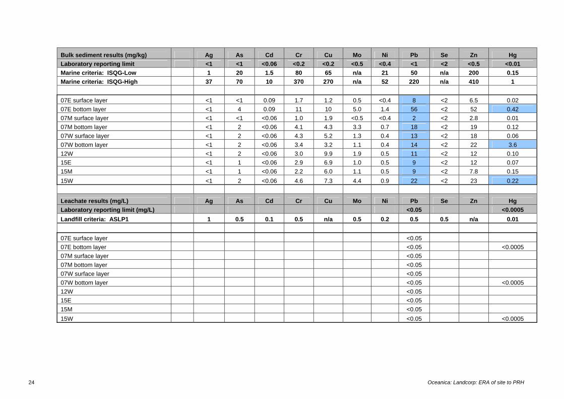
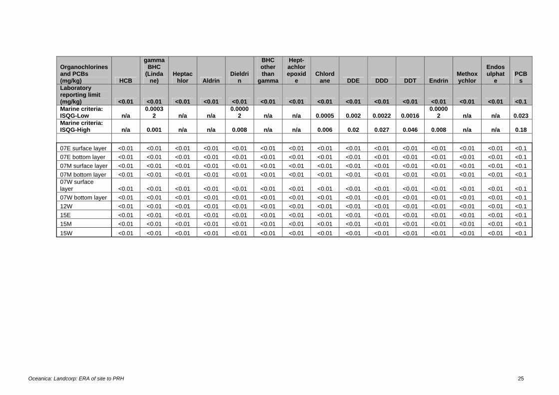
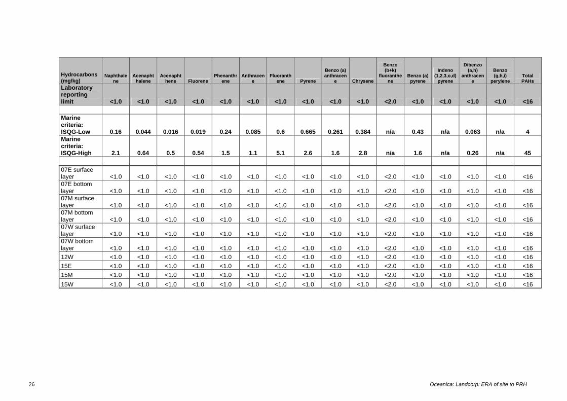
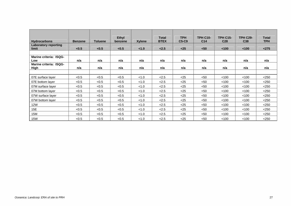
• Copper concentrations 1.2–10 mg/kg dry weight of sediment. • Zinc concentrations 2.8–22 mg/kg dry weight of sediment. These values are well below ANZECC/ARMCANZ (2000) guidelines for marine sediments of 65 mg/kg for copper and 200 mg/kg for zinc. Hydrocarbon, PAH, organochlorine pesticide and PCB levels in February 2004 samples were all below national guidelines (ANZECC/ARMCANZ 2000) for marine sediments—or below laboratory reporting limits where analytical methods did not allow compliance with the guideline to be confirmed. There is some historical evidence of mild PAH contamination in marine sediments adjacent to the York Street drains, possibly indicating stormwater contamination (WRC 1997, cited ERM 2005 Appendix I). The levels of total PAH in sediments that were reported (0.01–0.95 mg/kg) were, however, still well below the ANZECC/ARMCANZ (2000) guideline (4 mg/kg). Nor is it certain that stormwater is responsible for the PAH contamination, as the site history (ERM 2006) indicates that other sources of contamination cannot be ruled out (eg dumping of waste). Data for metals obtained in the February 2004 survey indicated no spatial pattern of contamination, and marine sediment guidelines were met for all metals except lead (slight exceedance of guideline in the bottom layer of sediments at the eastern site in 0.7 m of water), and mercury (slight exceedance of guideline in the bottom layer of sediments at the eastern site in 0.7 m of water and the western site in 1.5 m of water, and large exceedance bottom layer of sediments at the western site in 0.7 m of water). ERM’s DSI report indicates the project site presents no present risk of lead or mercury contamination to the marine environment: this suggests that the contamination may be the result of past activities, including the possibility of material dumped directly in the marine environment. It is noted that subsequent leachate testing of the sediments established that the lead and mercury were in biological unavailable forms (Appendix A). Further assessment is presently underway of contamination levels in the sediments that will be dredged for the marina. The potential risks to the marine environment due to dredging of marina sediments is an issue that will be separately addressed in the s38 assessment referred to in Section 1.
3.3.4 Transit times of water-borne marine organisms through nearshore waters of the project site Marine biota passing through the nearshore waters of the project site would either be motile (fish, large crustacean), or biota with movements largely determined by current speeds (eg plankton, larvae). As noted in Section 3.3.1, current speeds in waters west of the ATJ are such that passively borne biota would transit the nearshore waters of the project site is less than 2 hours under most conditions. Within the marina current speeds will be lower (~1 cm/sec) and passively borne biota may take 6 hours to transit waters within 10 m of the shoreline.
3.4 Toxicity assessment
3.4.1 Potentially toxic contaminants The ANZECC/ARMCANZ (2000) guidelines are based on the level of a contaminant that is bioavailable. The data for metals in groundwater obtained by ERM (2006) were for water samples filtered through a 0.45 micron filter, and provide a better approximation of the bioavailable fraction of metals than unfiltered samples, but
12 Oceanica: Landcorp: ERA of site to PRH
would still overestimate the true bioavailable fraction (ANZECC/ARMCANZ, 2000). Stormwater samples for metals were unfiltered, and so would overestimate the bioavailable fraction to a greater—although unknown—degree. The ANZECC/ARMCANZ (2000) guidelines are protective of chronic (i.e. long-term) effects. Consistent with ANZECC/ARMCANZ (2000), the potential for zinc in groundwater and copper and zinc in stormwater to cause short-term effects toxicity on marine biota before dilution of groundwater and stormwater was considered using the acute toxicity data provided by ANZECC/ARMCANZ (2000). The ANZECC/ARMCANZ (2000) database returned 193 records for acute toxicity effects on marine biota due to copper and 335 records for zinc. Test endpoints were NoECs, LC50 or EC50, and test durations of 24 to 96 hours (most 48–96 hours). The data may be summarised as follows: • Copper
• Crustaceans, 10–109,000. The single low value of 10 µg/L is an EC50 for a copepod derived from a 48 hour test. Values for the remaining 78 data points for crustaceans were 20 µg/L or more).
• Molluscs, 8.2–16,000 µg/L. The single low value of 8.2 µg/L is an LC50 derived from a 96 hour test for green mussel. Values for the remaining 25 data points for molluscs 50 µg/L or more, including another LC50 for green mussels of 1,250 µg/L.
• Echinoderms, 30–413 µg/L. • Annelids, 77–300 µg/L. • Algae, 8.8–99.1 µg/L. These data were all NOECs for giant kelp derived
from 48 hour test. It is noted that kelps are found on reefs in open ocean environments, whereas Princess Royal Harbour is a sheltered, semi-enclosed embayment with a soft-bottom habitat.
• Fish, 24–19,000 µg/L. • Zinc
• Crustaceans, 14–300,200 µg/L. The lowest values were for one species of copepod, with LC50 values derived from 48 hour test (same test and same species) ranging from 14–90 µg/L. Mysids were the next most sensitive organism, with NOECs for growth derived from a 48 hour test ranging from 175–320 µg/L.
• Molluscs, 200–2,100,000 µg/L. • Echinoderms, 39,000–390,000 µg/L. • Annelids, 900–42,000 µg/L. • Algae, 500–8,000 µg/L. • Fish, 30–275,000 µg/L. The single low value of 30 µg/L was an EC50 for
inland silverside derived from a 96 hour test. Values for the remaining 55 data points for fish were 170 µg/L or more.
Based on the above data, the zinc concentrations in groundwater from shoreline bores (30–58 µg/L) and copper and zinc concentrations in stormwater (copper 4.8–10.8 µg/L, zinc 26–116 µg/L) are unlikely to cause acute toxicity effects on the marine biota of Princess Royal Harbour, even under the extremely unlikely scenario of little or no dilution occurring for 1–2 days.
Oceanica: Landcorp: ERA of site to PRH 13
3.4.2 Nutrient enrichment High levels of nutrients were present in all groundwater samples, including those up-gradient of the site. ERM’s (2006) data suggest there is widespread background nutrient contamination in groundwater, and that the project site does not represent an additional significant source of nutrients. Similarly, only a small proportion of the stormwater discharging to marine waters adjacent to the project site is runoff from the project site itself, and nutrient concentrations will be largely determined by the characteristics of the greater catchment rather than the project site. Monthly monitoring of chlorophyll levels at five sites in Princess Royal Harbour (including one adjacent to the project area) has been underway since August 2005 as part of the Albany Waterfront Project. Chlorophyll concentrations for all sites have been in the range 0.3–0.8 µg/L, indicating a low risk of nutrient enrichment under present conditions. The increased risk of nutrient enrichment from stormwater and groundwater discharge due to reduced flushing of the waters east of the Albany Town Jetty due to construction of the proposed marina is an issue that will be separately addressed in the s38 assessment referred to in Section 1.
3.5 Risk Characterisation
3.5.1 Risks to marine biota due to contaminants in marine waters Groundwater discharging to marine waters adjacent to the project site, as characterised by bores within 25 m of the shoreline, only exceeds environmental guidelines for zinc—and requires little dilution (see Table 3.1) to meet guidelines. Data provided by ERM (2006) furthermore indicate zinc is present as a widespread background contaminant in groundwater, and that the project site itself does not represent an additional source of zinc, except in one localised area (bore MW00).
Table 3.1 Risk analysis for groundwater and stormwater discharge to the marine environment adjacent to the Albany Waterfront project area
Waters west of ATJ Waters within marina
Ground water
Stormwater Ground water
Stormwater
Area / discharge
Zn Cu Zn Zn Cu Zn
Relevant marine guideline (chronic effects)
15 1.3 15 23 3.0 23
Concentrations measured* (μg/L)
39–58 6.3–10.8 26–116 30–57 4.8 50
Dilution required to meet chronic guideline
2.7 to 4-fold
12 to 14.5 fold 1.4 to 2.6-fold
4-fold
Daily dilution achieved - most likely discharge scenario**
170-fold, #
72-fold 123-fold##
345-fold##
Daily dilution achieved– worst case scenario**
70-fold 3.5-fold 47.8-fold##
17-fold##
* for groundwater – as per ERM data for shoreline bores, for stormwater - as per ERM stormwater data and assuming contaminants are largely present informs that are not bioavailable **for volume of groundwater discharge, or volume of stormwater discharge # into waters within 10 m of the shoreline ## into waters of the marina
14 Oceanica: Landcorp: ERA of site to PRH
The level of dilution of groundwater discharging into the nearshore waters of the project area (Table 3.1) is more than sufficient to ensure zinc concentrations in shoreline bores meet relevant guidelines. The level of groundwater dilution is also sufficient to ensure that relevant guidelines are met even if the extreme case is taken that localised contamination in bores up-gradient of the shoreline bores represent groundwater quality that might discharge to the marine environment at some time, as follows: • Groundwater discharging into waters west of the ATJ.
• 1.3-fold dilution required for the copper levels in bore MW00. • 1.3 to 5.5-fold dilution required for the total PAH levels7 in bores MW33
and MW34. • 41-fold dilution required for the zinc levels in bore MW00.
• Groundwater discharging into the marina. • 1.3-fold dilution required for the total PAH level in bore MW27A. • 39-fold dilution required for the dieldrin level8 in bore MW27/27A.
These localised areas involve lesser volumes of groundwater discharge than the site-wide contamination of groundwater, and so the potential for dilution is also greater. Stormwater discharging to marine waters adjacent to the project site exceeded guideline values for copper and zinc—and also required little dilution to meet relevant guidelines (see Table 3.1). It is further noted that only a small proportion of the stormwater discharging to marine waters adjacent to the project site is runoff from the project site itself (ERM 2005, Figure 4). As such, stormwater quality will be largely determined by the characteristics of the greater catchment rather than the project site. The level of dilution of stormwater discharging into the nearshore waters of the project area (Table 3.1) is sufficient to ensure copper and zinc concentrations meet relevant guidelines under most conditions. Under conditions of heavy rain, copper and zinc concentrations in stormwater discharging into waters west of the ATJ may exceed ANZECC/ARMCANZ (2000) guidelines within localised areas, but such episodes will be temporary and concentrations are unlikely to be at levels that cause acute toxicity effects (see Section 3.4.1). The above assessment is considered conservative for the following reasons: • It assumes all contaminants present are bioavailable; • It is based on dilution of groundwater and stormwater discharge according to
the volume of nearshore waters at low water mark; • It is based on dilution of groundwater and stormwater discharge during
conditions of low current velocities; • It assumes no dilution of contaminants in groundwater as it transits the
underground mixing zone and salt water wedge before reaching the waters of Princess Royal Harbour; and
• It assumes that groundwater from localised areas of CoCs upgradient of the shoreline bores undergoes no reduction in contaminant concentration (due to dilution and/or attenuation) as it transits the site.
7 There are no ANZECC/ARMCANZ (2000) guidelines for total PAHs, and so the DoE (2003) guideline was used. 8 There are no ANZECC/ARMCANZ (2000) guidelines for dieldrin, and so the DoE (2003) guideline was used.
Oceanica: Landcorp: ERA of site to PRH 15
3.5.2 Risks to marine biota due to accumulation of contaminants in marine sediments Contaminant data for surface sediments in the nearshore environment of the project site were well below ANZECC/ARMCANZ (2000) guidelines, and did not indicate that partitioning of copper or zinc in groundwater/stormwater to sediments was a significant pathway. The potential for contaminants in marine sediment to cause adverse effects on marine biota during the proposed dredging that will occur with the Albany Waterfront Project’s marina is an issue that will be addressed in the s38 assessment referred to in Section 1.
3.5.3 Risks to marine biota due to nutrient enrichment ERM’s (2006) data suggest there is widespread background nutrient contamination in groundwater, and that the project site does not represent an additional significant source of nutrients. Furthermore, chlorophyll ‘a’ concentrations in marine waters adjacent to the project site did not exceed guidelines indicative of potential nutrient enrichment. The potential for nutrient enrichment due to the reduced flushing of marine waters that will occur with the Albany Waterfront Project’s marina is an issue that will be addressed in the s38 assessment referred to in Section 1.
3.6 Uncertainty The principal uncertainty involved in this risk assessment was due to the lack of data for background contaminant levels in the marine waters of Princes Royal Harbour. Assumed background concentrations were therefore used to calculate the dilutions required to achieve compliance with environmental guidelines. There are few data for background water quality in temperate nearshore waters of WA, due to the specialised techniques required for the collection and accurate analysis of low contaminant concentrations in marine waters. The DoE has collected data for Cockburn Sound and Jurien Bay (DoE 2005c, 2005d), and for the purpose of the risk assessment in this report, values based on Cockburn Sound data (DoE 2005c) were used for the waters of Princess Royal Harbour. For metals, a copper concentration 0.14 µg/L and a zinc concentration of 0.30 µg/L were used. DoE (2005c) results for organic contaminants were below limits of reporting: 0.1 µg/L for PAHs and 0.01 µg/L for dieldrin. A value of half the reporting limit (0.05 µg/L) was used for PAH. For dieldrin a value of half the detection limit would still have been above the guideline (DoE 2003), so it was assumed background concentrations were effectively zero. The approach adopted was considered conservative, as the background water quality of Princess Royal Harbour is probably between that of Cockburn Sound and Jurien Bay (for example, the latter has copper and zinc concentrations at least half that of Cockburn Sound; DoE 2005d). Compared to Princess Royal Harbour, Cockburn Sound is less well flushed (average flushing time one month), as well as being adjacent to a much larger urban area, and the site of a major industrial precinct, port and strategic naval base.

Oceanica: Landcorp: ERA of site to PRH 17
4. Conclusions Based on available data, it is concluded that the land component of the project site presents a low risk of adverse effects to the marine biota of Princess Royal Harbour. This conclusion is drawn for the following reasons: • The site is not a major source of contaminants to groundwater or stormwater. • Groundwater and stormwater discharging into waters adjacent to the project
site undergo considerable dilution within a very short distance (10 m) of the shoreline.
• Based on data for bores within 25 m of the shoreline and opportunistic sampling of stormwater drains during a period of low to moderate runoff, only zinc in groundwater and copper and zinc in stormwater exceed relevant environmental guidelines, which are for chronic effects. The level of nearshore dilution of these discharges is sufficient to ensure that those guidelines are rapidly met under most conditions. Nor are concentrations of zinc in groundwater and copper and zinc in stormwater at levels likely to cause acute toxicity effects during any occasional periods of low dilution (i.e. heavy stormwater runoff).
• The level of groundwater dilution is sufficient to ensure that relevant guidelines protective of marine biota are met even if the extreme case is taken that localised contamination in bores up-gradient of the shoreline bores represent groundwater quality that might discharge to the marine environment at some time (these areas involve lesser volumes of groundwater discharge, and so the potential for dilution is also greater).
• The levels of copper and zinc in surface sediments adjacent to the project site are well below ANZECC/ARMCANZ (2000) guidelines, indicating little risk due to partitioning of these metals from groundwater/stormwater to marine sediments.
As such, no further site assessment, management or remediation of site is required. This conclusion is based on the assumptions that: i) potential acid sulphate soils will be appropriately managed during construction activities; and ii) construction will not involve dewatering of the site.

Oceanica: Landcorp: ERA of site to PRH 19
5. References ANZECC/ARMCANZ. 2000, Australian and New Zealand Guidelines for Fresh and Marine Water Quality, Australian and New Zealand Environment and Conservation Council & Agriculture and Resource Management Council of Australia and New Zealand, National Water Quality Management Strategy No. 4. CALM. 1994, A Representative Marine Reserve System for Western Australia, Report of the Marine Parks and Reserves Selection Working Group, published by the Department of Conservation and Land Management, Perth Western Australia. DoE. 2003, Contaminated Sites Management Series: Assessment Levels for Soil, Sediment and Water, Department of Environment, November 2003. Department of Environment, Perth, Western Australia. DoE. 2005a, Stormwater Management Manual for Western Australia. Section 2.5.1 Risk assessments and environmental management systems. Department of Environment, Perth, Western Australia, May 2005. DoE. 2005b, Contaminated Sites Management Series - The Use of Risk Assessment in Contaminated Site Assessment. Guidance on the overall approach. Draft for public comment. Department of Environment Government of Western Australia. DoE. 2005c, Background quality for coastal marine waters of Perth, Western Australia, Technical Series 117, Department of Environment, Perth, Western Australia. DoE. 2005d, Background concentrations of selected toxicants in the coastal waters of the Jurien Bay Marine Park, Technical Series 119, Department of Environment, Perth, Western Australia. EPA. 1990, Albany Harbours Environmental Study 1988–1989, Bulletin 412, Environmental Protection Authority, Perth, Western Australia. ERM. 2005, Albany Waterfront Preliminary Site Investigation, Draft PSI Report, prepared by Environmental Resources management Australia Pty Ltd for LandCorp. Reference 0033126 Draft PSI. ERM. 2006, Albany Waterfront Detailed Site Investigation, Draft DSI Report, prepared by Environmental Resources management Australia Pty Ltd for LandCorp. Reference 0033126 Draft DSI. NEPC. 1999, Schedule B(5) Ecological Risk Assessment., National Environmental Protection (Assessment of Site Contamination) Measure, National Environmental Protection Council, http://www.ephc.gov.au/pdf/cs/cs_05_era.pdf.

Oceanica: Landcorp: ERA of site to PRH 21
Appendix A
Sediment contaminant data obtained in February 2004

Oceanica: Landcorp: ERA of site to PRH 23
Appendix A Sediment contaminant data obtained in February 2004
24 Oceanica: Landcorp: ERA of site to PRH
Bulk sediment results (mg/kg) Ag As Cd Cr Cu Mo Ni Pb Se Zn Hg Laboratory reporting limit <1 <1 <0.06 <0.2 <0.2 <0.5 <0.4 <1 <2 <0.5 <0.01 Marine criteria: ISQG-Low 1 20 1.5 80 65 n/a 21 50 n/a 200 0.15 Marine criteria: ISQG-High 37 70 10 370 270 n/a 52 220 n/a 410 1 07E surface layer <1 <1 0.09 1.7 1.2 0.5 <0.4 8 <2 6.5 0.02 07E bottom layer <1 4 0.09 11 10 5.0 1.4 56 <2 52 0.42 07M surface layer <1 <1 <0.06 1.0 1.9 <0.5 <0.4 2 <2 2.8 0.01 07M bottom layer <1 2 <0.06 4.1 4.3 3.3 0.7 18 <2 19 0.12 07W surface layer <1 2 <0.06 4.3 5.2 1.3 0.4 13 <2 18 0.06 07W bottom layer <1 2 <0.06 3.4 3.2 1.1 0.4 14 <2 22 3.6 12W <1 2 <0.06 3.0 9.9 1.9 0.5 11 <2 12 0.10 15E <1 1 <0.06 2.9 6.9 1.0 0.5 9 <2 12 0.07 15M <1 1 <0.06 2.2 6.0 1.1 0.5 9 <2 7.8 0.15 15W <1 2 <0.06 4.6 7.3 4.4 0.9 22 <2 23 0.22
Leachate results (mg/L) Ag As Cd Cr Cu Mo Ni Pb Se Zn Hg Laboratory reporting limit (mg/L) <0.05 <0.0005 Landfill criteria: ASLP1 1 0.5 0.1 0.5 n/a 0.5 0.2 0.5 0.5 n/a 0.01 07E surface layer <0.05 07E bottom layer <0.05 <0.0005 07M surface layer <0.05 07M bottom layer <0.05 07W surface layer <0.05 07W bottom layer <0.05 <0.0005 12W <0.05 15E <0.05 15M <0.05 15W <0.05 <0.0005
Oceanica: Landcorp: ERA of site to PRH 25
Organochlorines and PCBs (mg/kg) HCB
gamma BHC
(Lindane)
Heptachlor Aldrin
Dieldrin
BHC other than
gamma
Hept-achlor epoxid
e Chlord
ane DDE DDD DDT Endrin Methoxychlor
Endosulphat
e PCB
s Laboratory reporting limit (mg/kg) <0.01 <0.01 <0.01 <0.01 <0.01 <0.01 <0.01 <0.01 <0.01 <0.01 <0.01 <0.01 <0.01 <0.01 <0.1 Marine criteria: ISQG-Low n/a
0.00032 n/a n/a
0.00002 n/a n/a 0.0005 0.002 0.0022 0.0016
0.00002 n/a n/a 0.023
Marine criteria: ISQG-High n/a 0.001 n/a n/a 0.008 n/a n/a 0.006 0.02 0.027 0.046 0.008 n/a n/a 0.18 07E surface layer <0.01 <0.01 <0.01 <0.01 <0.01 <0.01 <0.01 <0.01 <0.01 <0.01 <0.01 <0.01 <0.01 <0.01 <0.1 07E bottom layer <0.01 <0.01 <0.01 <0.01 <0.01 <0.01 <0.01 <0.01 <0.01 <0.01 <0.01 <0.01 <0.01 <0.01 <0.1 07M surface layer <0.01 <0.01 <0.01 <0.01 <0.01 <0.01 <0.01 <0.01 <0.01 <0.01 <0.01 <0.01 <0.01 <0.01 <0.1 07M bottom layer <0.01 <0.01 <0.01 <0.01 <0.01 <0.01 <0.01 <0.01 <0.01 <0.01 <0.01 <0.01 <0.01 <0.01 <0.1 07W surface layer <0.01 <0.01 <0.01 <0.01 <0.01 <0.01 <0.01 <0.01 <0.01 <0.01 <0.01 <0.01 <0.01 <0.01 <0.1 07W bottom layer <0.01 <0.01 <0.01 <0.01 <0.01 <0.01 <0.01 <0.01 <0.01 <0.01 <0.01 <0.01 <0.01 <0.01 <0.1 12W <0.01 <0.01 <0.01 <0.01 <0.01 <0.01 <0.01 <0.01 <0.01 <0.01 <0.01 <0.01 <0.01 <0.01 <0.1 15E <0.01 <0.01 <0.01 <0.01 <0.01 <0.01 <0.01 <0.01 <0.01 <0.01 <0.01 <0.01 <0.01 <0.01 <0.1 15M <0.01 <0.01 <0.01 <0.01 <0.01 <0.01 <0.01 <0.01 <0.01 <0.01 <0.01 <0.01 <0.01 <0.01 <0.1 15W <0.01 <0.01 <0.01 <0.01 <0.01 <0.01 <0.01 <0.01 <0.01 <0.01 <0.01 <0.01 <0.01 <0.01 <0.1
26 Oceanica: Landcorp: ERA of site to PRH
Hydrocarbons (mg/kg)
Naphthalene
Acenaphthalene
Acenaphthene Fluorene
Phenanthrene
Anthracene
Fluoranthene Pyrene
Benzo (a) anthracen
e Chrysene
Benzo (b+k)
fluoranthene
Benzo (a) pyrene
Indeno (1,2,3,o,d)
pyrene
Dibenzo (a,h)
anthracene
Benzo (g,h,i)
perylene Total PAHs
Laboratory reporting limit <1.0 <1.0 <1.0 <1.0 <1.0 <1.0 <1.0 <1.0 <1.0 <1.0 <2.0 <1.0 <1.0 <1.0 <1.0 <16 Marine criteria: ISQG-Low 0.16 0.044 0.016 0.019 0.24 0.085 0.6 0.665 0.261 0.384 n/a 0.43 n/a 0.063 n/a 4 Marine criteria: ISQG-High 2.1 0.64 0.5 0.54 1.5 1.1 5.1 2.6 1.6 2.8 n/a 1.6 n/a 0.26 n/a 45 07E surface layer <1.0 <1.0 <1.0 <1.0 <1.0 <1.0 <1.0 <1.0 <1.0 <1.0 <2.0 <1.0 <1.0 <1.0 <1.0 <16 07E bottom layer <1.0 <1.0 <1.0 <1.0 <1.0 <1.0 <1.0 <1.0 <1.0 <1.0 <2.0 <1.0 <1.0 <1.0 <1.0 <16 07M surface layer <1.0 <1.0 <1.0 <1.0 <1.0 <1.0 <1.0 <1.0 <1.0 <1.0 <2.0 <1.0 <1.0 <1.0 <1.0 <16 07M bottom layer <1.0 <1.0 <1.0 <1.0 <1.0 <1.0 <1.0 <1.0 <1.0 <1.0 <2.0 <1.0 <1.0 <1.0 <1.0 <16 07W surface layer <1.0 <1.0 <1.0 <1.0 <1.0 <1.0 <1.0 <1.0 <1.0 <1.0 <2.0 <1.0 <1.0 <1.0 <1.0 <16 07W bottom layer <1.0 <1.0 <1.0 <1.0 <1.0 <1.0 <1.0 <1.0 <1.0 <1.0 <2.0 <1.0 <1.0 <1.0 <1.0 <16 12W <1.0 <1.0 <1.0 <1.0 <1.0 <1.0 <1.0 <1.0 <1.0 <1.0 <2.0 <1.0 <1.0 <1.0 <1.0 <16 15E <1.0 <1.0 <1.0 <1.0 <1.0 <1.0 <1.0 <1.0 <1.0 <1.0 <2.0 <1.0 <1.0 <1.0 <1.0 <16 15M <1.0 <1.0 <1.0 <1.0 <1.0 <1.0 <1.0 <1.0 <1.0 <1.0 <2.0 <1.0 <1.0 <1.0 <1.0 <16 15W <1.0 <1.0 <1.0 <1.0 <1.0 <1.0 <1.0 <1.0 <1.0 <1.0 <2.0 <1.0 <1.0 <1.0 <1.0 <16
Oceanica: Landcorp: ERA of site to PRH 27
Hydrocarbons Benzene Toluene Ethyl
benzene Xylene Total BTEX
TPH C5-C9
TPH C10-C14
TPH C15-C28
TPH C29-C38
Total TPH
Laboratory reporting limit <0.5 <0.5 <0.5 <1.0 <2.5 <25 <50 <100 <100 <275 Marine criteria: ISQG-Low n/a n/a n/a n/a n/a n/a n/a n/a n/a n/a Marine criteria: ISQG-High n/a n/a n/a n/a n/a n/a n/a n/a n/a n/a 07E surface layer <0.5 <0.5 <0.5 <1.0 <2.5 <25 <50 <100 <100 <250 07E bottom layer <0.5 <0.5 <0.5 <1.0 <2.5 <25 <50 <100 <100 <250 07M surface layer <0.5 <0.5 <0.5 <1.0 <2.5 <25 <50 <100 <100 <250 07M bottom layer <0.5 <0.5 <0.5 <1.0 <2.5 <25 <50 <100 <100 <250 07W surface layer <0.5 <0.5 <0.5 <1.0 <2.5 <25 <50 <100 <100 <250 07W bottom layer <0.5 <0.5 <0.5 <1.0 <2.5 <25 <50 <100 <100 <250 12W <0.5 <0.5 <0.5 <1.0 <2.5 <25 <50 <100 <100 <250 15E <0.5 <0.5 <0.5 <1.0 <2.5 <25 <50 <100 <100 <250 15M <0.5 <0.5 <0.5 <1.0 <2.5 <25 <50 <100 <100 <250 15W <0.5 <0.5 <0.5 <1.0 <2.5 <25 <50 <100 <100 <250