airfield facilities - airport...
TRANSCRIPT
AIRPORT MASTER PLAN - Monterey Regional Airport
INVENTORY 1-18 DRAFT – APRIL 2014
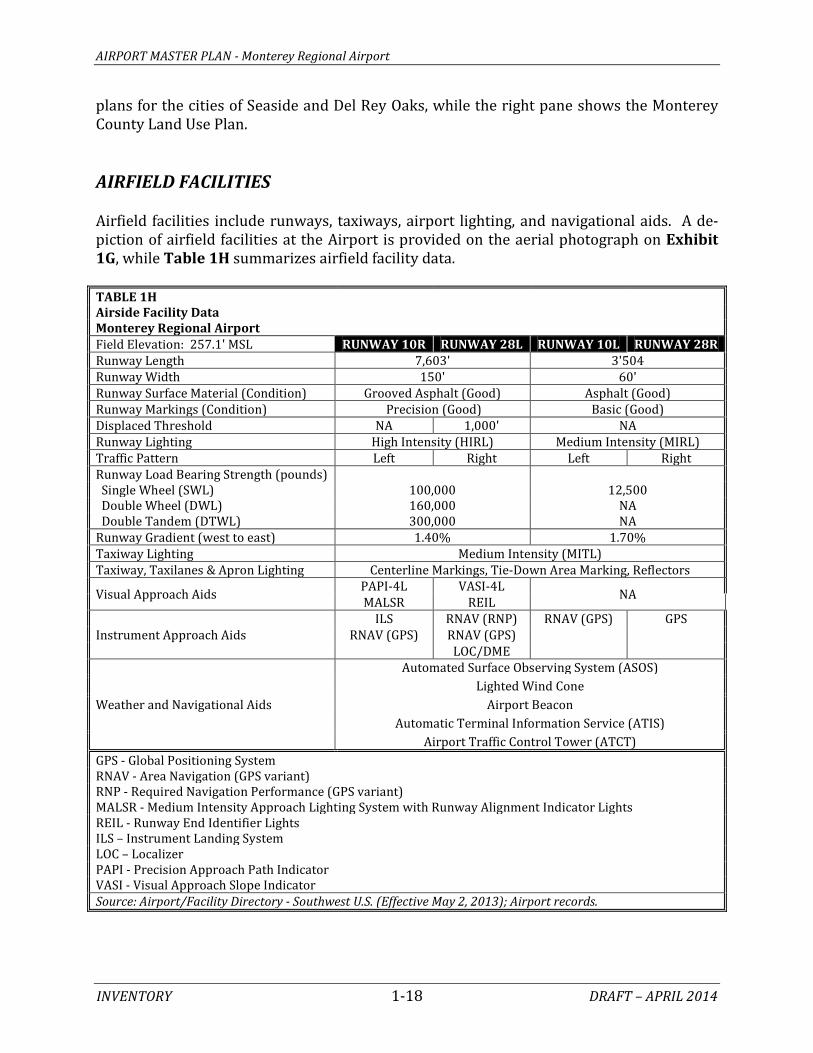
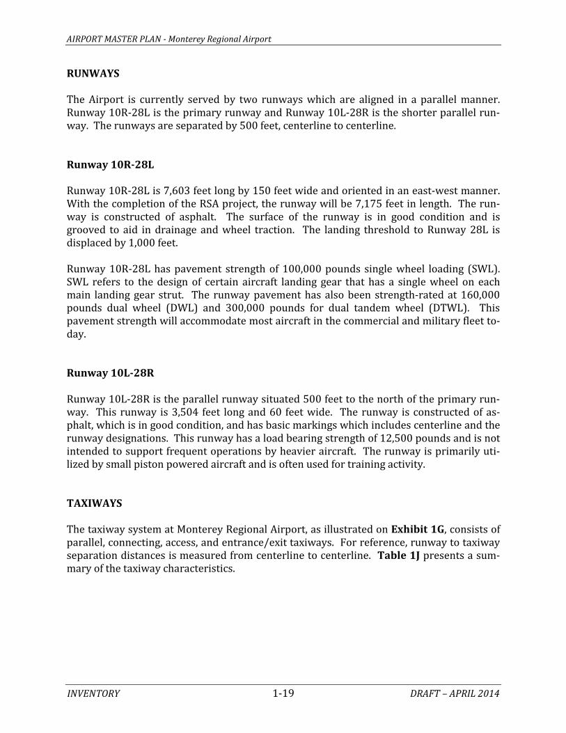
plans for the cities of Seaside and Del Rey Oaks, while the right pane shows the Monterey County Land Use Plan. AIRFIELD FACILITIES Airfield facilities include runways, taxiways, airport lighting, and navigational aids. A de-piction of airfield facilities at the Airport is provided on the aerial photograph on Exhibit 1G, while Table 1H summarizes airfield facility data. TABLE 1H Airside Facility Data
Monterey Regional Airport Field Elevation: 257.1' MSL RUNWAY 10R RUNWAY 28L RUNWAY 10L RUNWAY 28R Runway Length 7,603' 3'504 Runway Width 150' 60' Runway Surface Material (Condition) Grooved Asphalt (Good) Asphalt (Good) Runway Markings (Condition) Precision (Good) Basic (Good) Displaced Threshold NA 1,000' NA Runway Lighting High Intensity (HIRL) Medium Intensity (MIRL) Traffic Pattern Left Right Left Right Runway Load Bearing Strength (pounds)
Single Wheel (SWL) 100,000 12,500 Double Wheel (DWL) 160,000 NA Double Tandem (DTWL) 300,000 NA Runway Gradient (west to east) 1.40% 1.70% Taxiway Lighting Medium Intensity (MITL) Taxiway, Taxilanes & Apron Lighting Centerline Markings, Tie-Down Area Marking, Reflectors
Visual Approach Aids PAPI-4L VASI-4L NA MALSR REIL
Instrument Approach Aids ILS RNAV (RNP) RNAV (GPS) GPS
RNAV (GPS) RNAV (GPS) LOC/DME
Weather and Navigational Aids
Automated Surface Observing System (ASOS) Lighted Wind Cone
Airport Beacon Automatic Terminal Information Service (ATIS)
Airport Traffic Control Tower (ATCT) GPS - Global Positioning System RNAV - Area Navigation (GPS variant) RNP - Required Navigation Performance (GPS variant)
MALSR - Medium Intensity Approach Lighting System with Runway Alignment Indicator Lights REIL - Runway End Identifier Lights ILS – Instrument Landing System LOC – Localizer PAPI - Precision Approach Path Indicator
VASI - Visual Approach Slope Indicator Source: Airport/Facility Directory - Southwest U.S. (Effective May 2, 2013); Airport records.

LEGEND
KEY
Airport Property Line
ASOS - Automated Surface Observing System
ATCT - Airport Traffic Control Tower
MALSR - Medium Intensity Approach Lighting System
PAPI - Precision Approach Path Indicator
REIL - Runway End Identification Lighting
VASI - Visual Approach Slope Indicator
68
Monterey Salinas HighwayMonterey Salinas Highway
Canyon Del Rey Blvd.
Canyon Del Rey Blvd.
Olm
sted Rd.
Olm
sted Rd.
Skypark Dr.
Skypark Dr.
Skypark Dr.
Skypark Dr.
Airport Rd.
Airport Rd.Euclid
Ave.
Garden Rd.
Garden Rd.
Fred Kane Dr.Fred Kane Dr.
68
N. Fremont St.
N. Fremont St.
Runway 10R - 28L 7,603’ X 150’
Runway 10L - 28R 3,504’ X 60’150’
200’500’
327.5’327’
300’
275’
218
Airport Rd.
Airport Rd.
D
E
E
B
C
A
D
K
KJGF
G
JH K
L
L
L
M N
N
Hold Apron
Hold ApronFAA Antenna
Weather StationWind Sock
Hold Apron
MALSR
Localizer Antenna
LocalizerAntenna
ILS Glide SlopeAntenna
ASOS
PAPI-4L
K
Segmented CircleWind Cone
Wind Sock
ATCT Beacon
Terminal Building
REIL
FAA AnteVASI-4L
NORTH
0 800 1600
SCALE IN FEET
Photo Source: Google Earth 5-6-2012
Exhibit 1GEXISTING AIRSIDE FACILITIES
AIRPORT MASTER PLAN - Monterey Regional Airport
INVENTORY 1-19 DRAFT – APRIL 2014
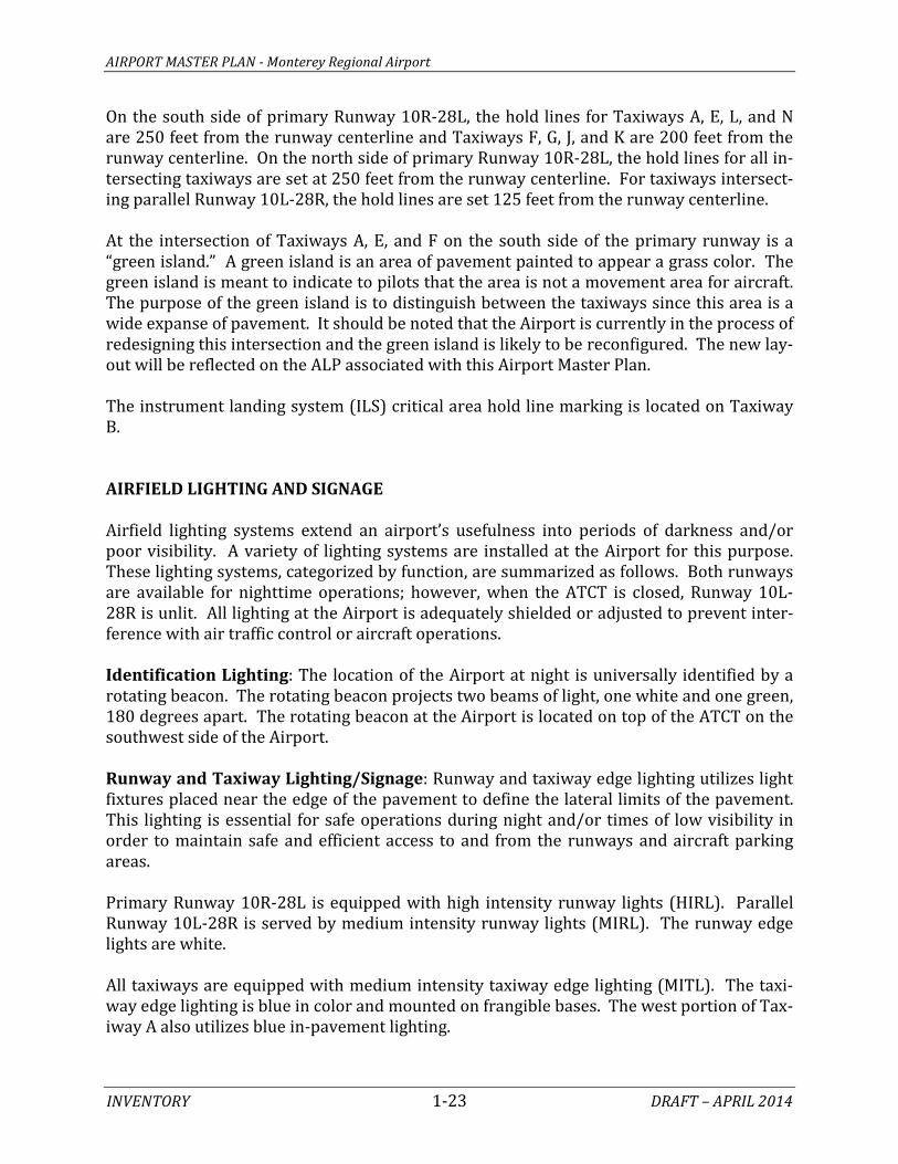
RUNWAYS The Airport is currently served by two runways which are aligned in a parallel manner. Runway 10R-28L is the primary runway and Runway 10L-28R is the shorter parallel run-way. The runways are separated by 500 feet, centerline to centerline. Runway 10R-28L Runway 10R-28L is 7,603 feet long by 150 feet wide and oriented in an east-west manner. With the completion of the RSA project, the runway will be 7,175 feet in length. The run-way is constructed of asphalt. The surface of the runway is in good condition and is grooved to aid in drainage and wheel traction. The landing threshold to Runway 28L is displaced by 1,000 feet. Runway 10R-28L has pavement strength of 100,000 pounds single wheel loading (SWL). SWL refers to the design of certain aircraft landing gear that has a single wheel on each main landing gear strut. The runway pavement has also been strength-rated at 160,000 pounds dual wheel (DWL) and 300,000 pounds for dual tandem wheel (DTWL). This pavement strength will accommodate most aircraft in the commercial and military fleet to-day. Runway 10L-28R Runway 10L-28R is the parallel runway situated 500 feet to the north of the primary run-way. This runway is 3,504 feet long and 60 feet wide. The runway is constructed of as-phalt, which is in good condition, and has basic markings which includes centerline and the runway designations. This runway has a load bearing strength of 12,500 pounds and is not intended to support frequent operations by heavier aircraft. The runway is primarily uti-lized by small piston powered aircraft and is often used for training activity. TAXIWAYS The taxiway system at Monterey Regional Airport, as illustrated on Exhibit 1G, consists of parallel, connecting, access, and entrance/exit taxiways. For reference, runway to taxiway separation distances is measured from centerline to centerline. Table 1J presents a sum-mary of the taxiway characteristics.
AIRPORT MASTER PLAN - Monterey Regional Airport
INVENTORY 1-20 DRAFT – APRIL 2014
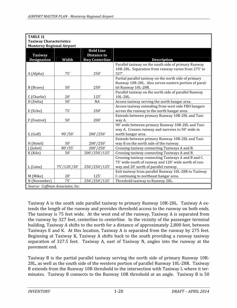
TABLE 1J Taxiway Characteristics
Monterey Regional Airport
Taxiway Designation Width
Hold Line Distance to
Rwy Centerline Description
A (Alpha) 75' 250'
Parallel taxiway on the south side of primary Runway 10R-28L. Separation from runway varies from 275' to 327’.
B (Bravo) 50' 250'
Partial parallel taxiway on the north side of primary Runway 10R-28L. Also serves eastern portion of paral-lel Runway 10L-28R.
C (Charlie) 20' 125' Parallel taxiway on the north side of parallel Runway 10L-28L.
D (Delta) 50' NA Access taxiway serving the north hangar area.
E (Echo) 75' 250' Access taxiway extending from west side FBO hangars across the runway to the north hangar area.
F (Foxtrot) 50' 200' Extends between primary Runway 10R-28L and Taxi-way A.
G (Golf) 90'/50' 200'/250'
90' wide between primary Runway 10R-28L and Taxi-way A. Crosses runway and narrows to 50' wide in north hangar area.
H (Hotel) 50' 200'/250' Extends between primary Runway 10R-28L and Taxi-way B on the north side of the runway.
J (Juliet) 80'/55' 200'/250' Crossing taxiway connecting Taxiways A and B. K (Kilo) 50' 200'/250'/125' Crossing taxiway connecting Taxiways A and B.
L (Lima) 75'/120'/20' 250'/250'/125'
Crossing taxiway connecting Taxiways A and B and C. 75' wide south of runway and 120' wide north of run-way and 20' north of parallel runway.
M (Mike) 20' 125' Exit taxiway from parallel Runway 10L-28R to Taxiway C continuing to northeast hangar area.
N (November) 75' 250'/250’/125’ Threshold taxiway to Runway 28L. Source: Coffman Associates, Inc. Taxiway A is the south side parallel taxiway to primary Runway 10R-28L. Taxiway A ex-tends the length of the runway and provides threshold access to the runway on both ends. The taxiway is 75 feet wide. At the west end of the runway, Taxiway A is separated from the runway by 327 feet, centerline to centerline. In the vicinity of the passenger terminal building, Taxiway A shifts to the north for a distance of approximately 2,800 feet, between Taxiways E and K. At this location, Taxiway A is separated from the runway by 275 feet. Beginning at Taxiway K, Taxiway A shifts back to the south providing a runway taxiway separation of 327.5 feet. Taxiway A, east of Taxiway N, angles into the runway at the pavement end. Taxiway B is the partial parallel taxiway serving the north side of primary Runway 10R-28L, as well as the south side of the western portion of parallel Runway 10L-28R. Taxiway B extends from the Runway 10R threshold to the intersection with Taxiway L where it ter-minates. Taxiway B connects to the Runway 10R threshold at an angle. Taxiway B is 50
AIRPORT MASTER PLAN - Monterey Regional Airport
INVENTORY 1-21 DRAFT – APRIL 2014
feet wide for its length, except on the east end where it expands to create wider pavement fillet which allows for aircraft movements. Taxiway B is 300 feet from primary Runway 10L-28R and 200 feet from the parallel runway. Taxiway C is a 20-foot wide parallel taxiway serving the north side of parallel Runway 10L-28R. This taxiway provides access to both thresholds of the parallel runway and access to the northeast hangar area. Taxiway C is 150 feet from the parallel runway centerline. Taxiway D extends from its intersection with Taxiway B to the north, providing access to the northwest hangar development area. Taxiway E extends from the southwest corporate hangar area to the north, crossing Taxi-way A, Runway 10R-28L, and Taxiway B before extending on to provide access to the northwest hangar area. Taxiway E is 75 feet wide and crosses the runway at an angle. Taxiway F is a short taxiway providing a connection between the primary runway and Tax-iway A. Taxiway F and Taxiway E converge at the intersection with the runway. Taxiway G extends from Taxiway A, just west of the passenger terminal building, north across the runway, where it then angles to the northwest, providing access to the north-west hangar area. Taxiway G is 90 feet wide on both sides of the primary runway. It is 50 feet wide north of the intersection with Taxiway E. Taxiway J is a runway-crossing-taxiway connecting Taxiways A and B. Taxiway K is also a runway-crossing-taxiway connecting Taxiways A and B, but Taxiway K continues north be-yond Taxiway B to provide an angled threshold taxiway entrance to Runway 10L. Taxiway L also crosses the primary runway connecting from Taxiway A to Taxiway B, then across the parallel runway and terminating at Taxiway C. The south portion of Taxiway L between Taxiway A and the primary runway is perpendicular to the runway and is 75 feet wide. The portion of Taxiway L north of the primary runway is angled and 120 feet wide. From Taxiway B to Taxiway C, Taxiway L is 20 feet wide. Taxiway M is a short 20-foot wide taxiway that provides access from the parallel runway to Taxiway C and north to the northeast hangar area. Taxiway N is the threshold taxiway to Runway 28L, where it is 75 feet wide. Taxiway N continues north of the runway threshold where is crosses the parallel runway and then terminates at the intersection with Taxiway C. HOLD APRONS Hold aprons are designated areas on the airfield typically located at the end of taxiways near the runway end thresholds. The ATCT will instruct pilots to stop their aircraft on the

AIRPORT MASTER PLAN - Monterey Regional Airport
INVENTORY 1-22 DRAFT – APRIL 2014
hold apron until it is safe for the aircraft to proceed to the runway for take-off. Pilots may also utilize hold aprons, with authorization from the ATCT, for final pre-flight checks. There are three hold aprons on the airfield. At the Runway 28L threshold, immediately south of Taxiway A is the largest hold apron. This hold apron is large enough to accommo-date several smaller general aviation aircraft at one time. This hold apron is not visible from the ATCT and pilots must have authorization to use the hold apron. There is an area marked on the south side of the Runway 10R threshold where aircraft will hold prior to take-off. This hold apron is part of a much wider expanse of pavement that includes Taxiway A and the corporate hangar area aircraft parking space. The marking on the pavement is what distinguishes the hold apron. The third hold apron is located at the eastern end of Taxiway C near the Runway 28R threshold. PAVEMENT MARKINGS Pavement markings aid in the movement of aircraft along airport surfaces and identify closed or hazardous areas on an airport. The precision runway markings on Runway 10R-28L identify the runway centerline, runway edge, threshold, designation, touchdown point, aiming points, and aircraft holding positions. The landing threshold to Runway 28L is marked with a displaced threshold with arrows leading from the physical pavement end to the threshold. Parallel Runway 10L-28R is marked with basic markings that include the runway centerline and end designations. Taxiway centerline markings are provided to assist pilots in maintaining proper clearance from pavement edges and objects near the taxiway/taxilane edges. Taxiway markings also include aircraft holding positions. All taxiways providing access to the primary runway have enhanced taxiway centerline markings. The enhanced markings are wider dashed black and yellow markings on both sides of the taxiway centerline marking. These markings are intended to alert pilots that the taxiway is approaching a runway intersection. The edge limits of the taxiways are marked with a dashed yellow line. This marking is im-portant because there are areas where wide pavement expanses serve multiple uses. For example, Taxiway A and the terminal apron are one continuous pavement area. It is the pavement marking that segments the pavement for safe usage as both a taxiway and an air-craft parking apron. Hold lines are marked on those taxiways leading to the runway. The hold lines are com-prised of two solid yellow lines followed by two dashed yellow lines. The hold lines on tax-iways leading to an intersection with a runway are preceded by runway designation mark-ings consisting of white lettering on a red background.
AIRPORT MASTER PLAN - Monterey Regional Airport
INVENTORY 1-23 DRAFT – APRIL 2014
On the south side of primary Runway 10R-28L, the hold lines for Taxiways A, E, L, and N are 250 feet from the runway centerline and Taxiways F, G, J, and K are 200 feet from the runway centerline. On the north side of primary Runway 10R-28L, the hold lines for all in-tersecting taxiways are set at 250 feet from the runway centerline. For taxiways intersect-ing parallel Runway 10L-28R, the hold lines are set 125 feet from the runway centerline. At the intersection of Taxiways A, E, and F on the south side of the primary runway is a “green island.” A green island is an area of pavement painted to appear a grass color. The green island is meant to indicate to pilots that the area is not a movement area for aircraft. The purpose of the green island is to distinguish between the taxiways since this area is a wide expanse of pavement. It should be noted that the Airport is currently in the process of redesigning this intersection and the green island is likely to be reconfigured. The new lay-out will be reflected on the ALP associated with this Airport Master Plan. The instrument landing system (ILS) critical area hold line marking is located on Taxiway B. AIRFIELD LIGHTING AND SIGNAGE Airfield lighting systems extend an airport’s usefulness into periods of darkness and/or poor visibility. A variety of lighting systems are installed at the Airport for this purpose. These lighting systems, categorized by function, are summarized as follows. Both runways are available for nighttime operations; however, when the ATCT is closed, Runway 10L-28R is unlit. All lighting at the Airport is adequately shielded or adjusted to prevent inter-ference with air traffic control or aircraft operations. Identification Lighting: The location of the Airport at night is universally identified by a rotating beacon. The rotating beacon projects two beams of light, one white and one green, 180 degrees apart. The rotating beacon at the Airport is located on top of the ATCT on the southwest side of the Airport. Runway and Taxiway Lighting/Signage: Runway and taxiway edge lighting utilizes light fixtures placed near the edge of the pavement to define the lateral limits of the pavement. This lighting is essential for safe operations during night and/or times of low visibility in order to maintain safe and efficient access to and from the runways and aircraft parking areas. Primary Runway 10R-28L is equipped with high intensity runway lights (HIRL). Parallel Runway 10L-28R is served by medium intensity runway lights (MIRL). The runway edge lights are white. All taxiways are equipped with medium intensity taxiway edge lighting (MITL). The taxi-way edge lighting is blue in color and mounted on frangible bases. The west portion of Tax-iway A also utilizes blue in-pavement lighting.

AIRPORT MASTER PLAN - Monterey Regional Airport
INVENTORY 1-24 DRAFT – APRIL 2014
The Airport also has a runway/taxiway signage system. The presence of runway/taxiway signage is an essential component of a surface movement guidance control system neces-sary for the safe and efficient operation of the Airport. The signage system installed at the Airport includes runway and taxiway designations, holding positions, instrument landing system (ILS) critical areas, routing/directional, runway end and exits, and runway distance remaining signs (north side of primary runway). The commercial apron is served by lighting from light stands. Apron edge taxilanes have no edge lighting. Visual Approach Lighting: A four-light visual approach slope indicator (VASI) is located on the left side of Runway 28L. The VASI consists of two forward and two rear lighting units that alert approaching pilots of their position relative to the desired 3.5-degree glide slope. This VASI is planned to be replaced in conjunction with the RSA project currently under construction. Runway 10R is served by the more advanced precision approach path indicator (PAPI) sys-tem, located on the left side of the approach end of the runway. These four-box units pro-vide for a 3-degree glide slope. When the system of red and green lights is interpreted by the pilot, they are given an indication of being above, below, or on the designated descent path to the runway threshold. A PAPI system has a range of five miles during the day and up to twenty miles at night. Both the VASI and PAPI systems are owned and maintained by the FAA. Runway End Identification Lighting: Runway end identification lights (REILs) provide rapid and positive identification of the approach ends of a runway. A REIL system has been installed on the end of Runway 28L. The REIL consists of two synchronized flashing lights, located laterally on each side of the runway end, facing the approaching aircraft. The REIL system is owned and maintained by the FAA. Approach Lighting Systems: Approach lighting systems (ALS) are used in the approaches to runways as adjuncts to electronic navigational aids for the final portion of instrument flight rule (IFR) approaches and visual guides for nighttime approaches under visual flight rule (VFR) conditions. The approach lighting system provides the pilot with visual cues concerning aircraft alignment, roll, height, and position relative to the threshold. The ILS approaches to Runway 10R are enhanced with the medium intensity approach lighting sys-tem with runway end alignment lights (MALSR). The MALSR, localizer antenna, and glide slope antenna are all owned and maintained by the FAA. After-Hours Lighting: When the ATCT is closed, the airfield lights are turned off except for the Runway 28L VASI, which operates continuously. Utilizing their radio transmitter,

AIRPORT MASTER PLAN - Monterey Regional Airport
INVENTORY 1-25 DRAFT – APRIL 2014
pilots can activate Runway 10R-28L lights, MALSR, PAPI, and REIL, through a series of clicks. Parallel Runway 10L-28R lights are turned off when the tower is closed. Obstruction Lighting: Objects that penetrate the FAR Part 77 imaginary surfaces associ-ated with an airport are considered obstructions. At Monterey Regional Airport, buildings and structures that could be obstructions are clearly identified with red obstruction lights as required by the FAA. Exhibit 1H shows the location of the obstruction lights at the Air-port. WEATHER AND COMMUNICATION AIDS The Airport is equipped with three lighted wind socks. The wind socks provide infor-mation to pilots regarding wind conditions, such as direction and intensity. The primary lighted wind sock is located within the segmented circle, north of the primary runway. There are two supplemental lighted wind socks on the north side of the primary runway near the runway ends. There is a small unlit wind sock located at the Airport fuel farm. The Airport is served by an ATCT. The ATCT is FAA owned and operated. It is located southwest of the Airport terminal building on ground overlooking the runway system. The tower operates from 6:00 a.m. to 9:00 p.m. daily. Tower ground control can be reached on 120.87 MHz, and clearance delivery is available via frequency 135.45 MHz. The Airport is equipped with an Automated Terminal Information Service (ATIS). ATIS broadcasts are updated hourly and provide arriving and departing pilots the current sur-face weather conditions, communication frequencies, and other important Airport-specific information. The ATIS frequency at Monterey Regional Airport is 119.25 MHz, or it can be reached by published telephone number. The Airport has access to the common advisory traffic frequency (CTAF). This radio fre-quency (118.4 MHz) is used by pilots in the vicinity of the Airport to communicate with each other about approaches to or departures from the Airport when the Airport traffic control tower is closed. In addition, a UNICOM frequency is also available (122.95 MHz) where a pilot can obtain information pertaining to the Airport. Pilots can contact the Oakland Center – Air Route Traffic Control Center, if needed, usually when the tower is closed at the Airport. The primary responsibility of Oakland Center is sequencing and separation of over-flights, arrivals, and departures, in order to provide safe, orderly, and expeditious flow of aircraft filed under instrument flight rules. The Airport is equipped with an automated surface observing system (ASOS). An ASOS will automatically record weather conditions such as temperature, dew point, wind speed, al-timeter setting, visibility, sky condition, and precipitation. The ASOS updates observations each minute, 24 hours a day, and this information is available by phone or it is also availa-ble via the ATIS frequency. Table 1K summarizes the various weather and navigational aid frequencies and phone numbers available at Monterey Regional Airport.

P ONDDE T E NT ION
LIN
E
T E R MINA L B UIL DING
R U N W A Y 1 0 L - 2 8 R
A IR P OR T P R OP E R T Y L INE
A IR P OR T P R OP E R T YL INE
P R OP E R T Y
A IR P OR T
A IR P OR T P R OP E R T Y L INE
A .T .C .BL DG
V A UL T
R U N W A Y 1 0 R - 2 8 L
NAV
Y
G
OL
F
C
OU
RS
E
TA X IWAY C - NORT H TA X IWAY
T A X IW A Y AT A X IW A Y A
T A X ILA NE E
T A X ILA NE E
T A X IW A Y A
T A X IWA Y D
P IC N IC
A R E A
T A X IW A Y B
T A X IW A Y C
T A X IW A Y B
T A X IW A Y A
HE
ND
ER
SO
NW
AY
R D
A IR P OR T
RD
OL
MS
TE
D
R D
GA R DE N ( R OUT E 6 8 )HIGHWA YS A L INA SMONT E R E Y
S K Y P A R K DR
SK
YP
AR
K W
AY
A IR P OR T
R D
TWY
KTW
Y K
TWY
K
TWY K
TWY
JTW
Y J
TWY
H
TWY
G
TWY G
TWY G
TWY L
TWY L
TWY
L
TWY
NTW
Y N
TWY
N
TWY
M
DEL MONTE
MONTEREY JET
CENTER
MONTEREY JET
CENTER
MONTEREY JET
CENTER
MONTEREY JET
CENTER
506510
514
2
34
8
29
9
25
1
5
7
12
13
16
21
1415
1720
23
28
#
#
27
31
24
6
1819
26
30
11
10
32
34
33
LEGENDObstruction Light
Airport Owned
FAA Owned
NORTH
Photo Source: Google Earth 5-6-2012
Exhibit 1HOBSTRUCTION LIGHTING

AIRPORT MASTER PLAN - Monterey Regional Airport
INVENTORY 1-26 DRAFT – APRIL 2014
TABLE 1K Airport Communications and Weather Aids Monterey Regional Airport
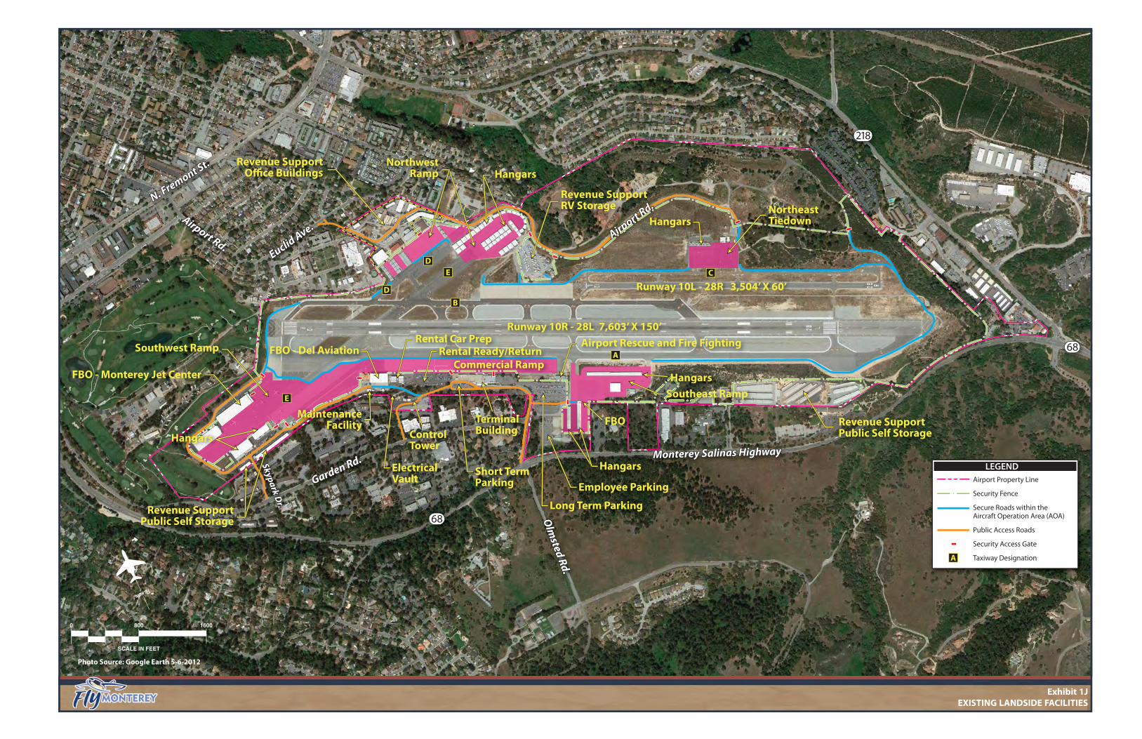
Communication Type Frequency UNICOM: Universal Communication 122.95 MHz ATIS: Automated Terminal Information Service 119.25 MHZ or 831-375-7433 ATCT: Airport Traffic Control Tower 118.4 MHz CTAF: Common Traffic Advisory Frequency 118.4 MHz MRY Ground Control 120.87 MHz MRY Clearance Delivery 135.45 MHz NORCAL Approach/Departure 127.15 MHz (151-359) or 133.0 MHz (360-150) Emergency 121.5 MHz ASOS: Automated Surface Observing System 831-642-0241 ARTCC-Oakland Center 128.7 MHz NORCAL: Northern California TRACON (Terminal Radar Approach Control) ARTCC: Air Route Traffic Control Center Source: Airport/Facility Directory - Southwest U.S. (Effective Feb. 6, 2014); Airport records. LANDSIDE FACILITIES Landside facilities are those that support the aircraft and pilot/passenger handling func-tions as well as other non-aviation facilities typically providing a revenue stream to the air-port. These facilities include the passenger terminal complex, cargo facilities, general avia-tion facilities, and support facilities such as fuel storage, automobile parking, roadway ac-cess, and aircraft rescue and firefighting. The primary landside facilities at the Airport are identified on Exhibit 1J. AIRCRAFT APRONS/RAMPS Aircraft aprons/ramps are pavement areas that are sufficiently removed from aircraft tax-iways and movement areas that facilitate the safe and efficient transition of passengers from the airside element (runway and taxiways) to the landside element. Aprons provide access to hangars and provide for short term and long term aircraft parking. There are four general aviation aprons and one commercial service apron at the Airport. The usable portion of an apron consists of those pavement areas where aircraft can park. This typically does not include taxilanes or access pavement immediately fronting a hangar. Commercial Apron The commercial apron is located immediately to the north of the passenger terminal build-ing. The apron encompasses approximately 245,000 square yards of pavement and is con-structed of concrete. The commercial apron can best be described as long and narrow as it is over 1,400 feet long but it is only 160 feet wide.
LEGENDAirport Property Line
Security Fence
Secure Roads within the Aircraft Operation Area (AOA)
Public Access Roads
Security Access Gate
Taxiway Designation
68
Monterey Salinas HighwayMonterey Salinas Highway
Olm
sted Rd.
Skypark Dr.
Skypark Dr.
Airport Rd.Euclid
Ave.
Euclid Ave.
Garden Rd.
Garden Rd.
68
N. Fremont St.
N. Fremont St.Hangars
NorthwestRamp
Hangars
Revenue SupportRV Storage
Revenue SupportOffice Buildings
Revenue SupportPublic Self Storage
Revenue SupportPublic Self Storage
Runway 10R - 28L 7,603’ X 150’
Runway 10L - 28R 3,504’ X 60’
Northeast Tiedown
ControlTower
FBO - Del Aviation
FBO
FBO - Monterey Jet Center
218
Terminal Building
HanH
e Supportage
Airport Rd.
Airport Rd.
Airport Rescue and Fire Fighting
DE
B
C
A
A
D
Employee Parking
OO
Long Term Parking
Short TermParking
ElectricalVault
Rental Car Prep
Commercial Ramp
tal Car Prep
Commerciial RampRental Ready/Return
E
Hangars
HangarsgSoutheast Ramp
Southwest Ramp
MaintenanceFacility
Hangars
NORTH
0 800 1600
SCALE IN FEET
Photo Source: Google Earth 5-6-2012
Exhibit 1JEXISTING LANDSIDE FACILITIES
AIRPORT MASTER PLAN - Monterey Regional Airport
INVENTORY 1-27 DRAFT – APRIL 2014
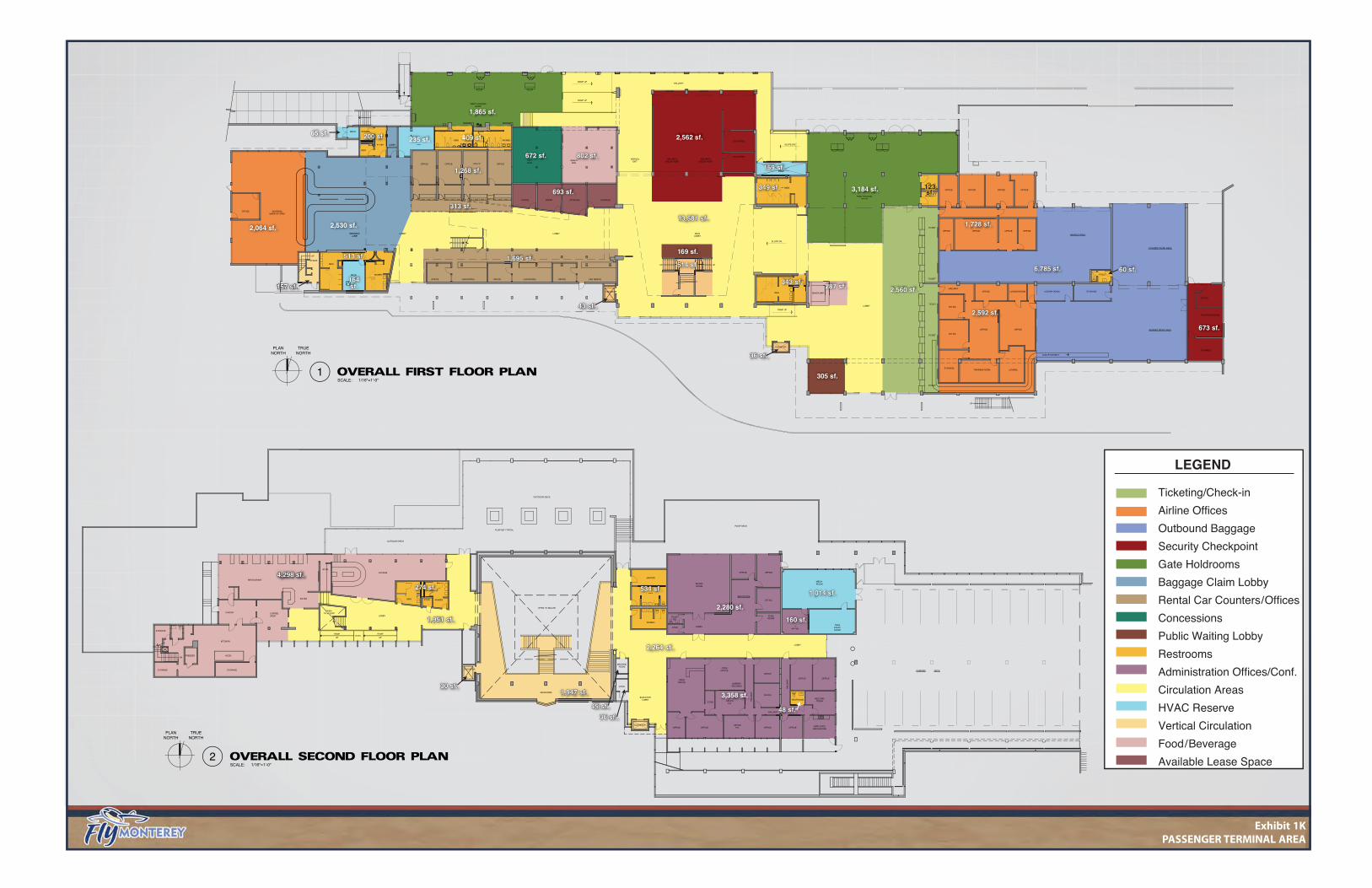
The width of the existing commercial apron at the Airport necessarily places some opera-tional constraints on aircraft using Taxiway A under certain circumstances. Specifically, in order to ensure continued safe operations at the Airport, the Airport closely monitors and issues a notice stating that if an MD-80 or B757 aircraft is parked on the commercial apron, other aircraft with wingspans greater than 95 feet cannot use Taxiway A because of the current width limitations of the commercial apron. A formal agreement is also in place with the tower to restrict use of Taxiway A when these larger aircraft are parked on the apron adjacent to Taxiway A. The commercial apron is marked with angular aircraft parking lines, passenger walkways, and service vehicle roadways. General Aviation Aprons There are four general aviation aprons that are best described by their location on the Air-port. The northwest ramp would include the entire area identified on Exhibit 1J; however, the available apron area is estimated at approximately 10,000 square yards of concrete. This apron has a capacity of 28 aircraft tie-down positions. This apron is leased to one of the airport fixed base operators (FBO). Those desiring to use this apron area must obtain permission through the FBO. Currently none of the aircraft tie-down positions on this apron area are utilized for aircraft tie-down parking. The northeast ramp is approximately 7,400 square yards in size. There are 31 marked air-craft tie-down positions. The Southeast Ramp encompasses approximately 15,000 square yards of pavement. There are 32 aircraft tie-down positions marked. The Airport currently has two FBOs: Monterey Jet Center and Del Monte Aviation. The southwest ramp encompasses leaseholds by both of these primary Airport FBOs. The ramp serving Monterey Jet Center is approximately 42,300 square yards. All aircraft parking po-sitions are intended for transient parking. The transient ramp controlled by Del Monte Aviation is approximately 53,100 square yards. PASSENGER TERMINAL BUILDING The Airport has a commercial passenger terminal building that was originally constructed in 1950. Since then, numerous additions and reconfigurations have taken place in order to address changes in aviation demand and passenger preference for terminal facilities. A major renovation was completed in 1973 which tripled the size of the facility. The most recent renovations were focused on the space beyond the security area, with a redesign of the holding rooms, gift shop, and restrooms. Today, the facility is comprised of a two-story structure with primary passenger functions taking place on the ground level (including loading and unloading of aircraft), and administrative and restaurant functions taking place on the second floor. Exhibit 1K presents the functional makeup of the Airport passenger terminal building.
PARKING DECK
SEC OFFICE
SHOPCOFFEEPANTRY
RESTAURANT
FOYER
UP
RAMPLEVEL
MEN
LOUNGE
WOMEN
OFFICE
LIBRARY/RECORDS
KITCHEN
STORAGE
FREEZER
STORAGE
DN
STORAGE
ROOF DECK
LOBBY
OPENTO BELOW
STOR.
STOR.
HOOD
OUTDOOR DECK
PLANTER TYPICAL
OUTDOOR DECK
OPEN TO BELOW
MEZZANINE
OFFICEOFFICE
P.D. OFFICE OFFICEEMPLOYEE
BREAKROOM
MEETINGROOM
RESTROOM
HA
LLW
AY
OFFICE
HA
LLW
AY
HALLWAY
OFFICEP.D.
STOR.
OPENOFFICE
OPENOFFICE
OFFICE OFFICE
OFFICE
MECH.ROOM
TELEEQUIPROOM
ITROOM
PLANROOM
OFFICEOFFICE
BOARDROOM
LOBBY
TOILETRM.
STOR.
WOMEN
MEN
JANITOR
LOBBY
ELEVATORLOBBY
STOR.
MACHINEROOM
ELEVATOR
ELEVATOR
UP
RAMP
OFFICE
COVERED WORK AREA
UP
UP UP
WOMEN
MEN
MECH.
MEN
WOMEN
WOMEN
MEN
OFFICE
OFFICE
OFFICE
LOCKER ROOMLOCKER ROOM STORAGEOFFICEHALLWAY
OFFICE
TRAINING ROOM LOUNGESTORAGE
STORAGE
TSA BREAK ROOM
UP
CONVEYOR BELT
UP
STAIRS
OFFICE
BAGGED WORK AREA
TOILET
BAGGED AREA
RAMP UP
RAMP UP
SNACK BAR
OFFICE OFFICE OFFICE OFFICE
OFFICEOFFICEOFFICEOFFICE
TSA OFFICE
TSA OFFICE
OFFICE OFFICE OFFICE OFFICE
FOYER LOBBYBAGGAGE
FAN
MEN WOMEN
GIFTSHOP
SNACKBAR
OFFICE CAR RENTAL OFFICE CAR RENTAL OFFICE CAR RENTAL
WOMENMECH.
MEN
LOBBY
OFFICE BAGGAGEMAKE-UP AREA
LOBBY
OFFICE OFFICE STORAGE STORAGE
ARRIVALEXIT
SECURITYCHECK POINT
SECURITYCHECK POINT
EAST HOLDINGROOM
TICKET
TICKET
TICKET
TICKET
TICKET
LOBBY
MAINLOBBY
HALLWAY
WEST HOLDINGROOM
ELEVATOR
ELEVATOR
SLOPE DN.
SLOPE DN.
RAMP UP
SCALE:1
1/16"=1'-0"
TRUENORTH
PLANNORTH
SCALE:2
1/16"=1'-0"
TRUENORTH
PLANNORTH
2,064 sf. 2,530 sf.
WOMENMEN
FOYER
200 sf.200 sf.FAFAN
235 sf.
ROOM
1,865 sf.
409 sf.409 sf.
343 sf.343 sf.
MENMEN
534 sf.534 sf.274 sf.274 sf.
2,280 sf.
HA
LLW
AY
OFFICEOFFICEP.D.
3,358 sf.
ITITROOM
160 sf.160 sf.
1,014 sf.1,014 sf.
1,951 sf.1,951 sf.1,951 sf.
2,264 sf.2,264 sf.
1,947 sf.1,947 sf.1,947 sf.30 sf.30 sf.30 sf.
AYY48 sf.48 sf.45 sf.45 sf.45 sf.
36 sf.36 sf.36 sf.
R
287 sf.287 sf.
WOW349 sf.349 sf.
159 sf.159 sf.
EAST HOLDINGROOM
3,184 sf. 123 sf.123 sf.123 sf.
6,785 sf.6,785 sf.
OFFICE
1,728 sf.1,728 sf.
2,592 sf.2,592 sf.
60 sf.60 sf.
673 sf.673 sf.
2,560 sf.2,560 sf.
OFFICE
1,268 sf.1,268 sf.
1,695 sf.1,695 sf.
4,298 sf.4,298 sf.4,298 sf.
13,581 sf.13,581 sf.13,581 sf.13,581 sf.
2,562 sf.
169 sf.
305 sf.
514 sf.514 sf.
43 sf.43 sf.43 sf.
36 sf.36 sf.36 sf.
157 sf.157 sf.157 sf.
513 sf.513 sf.
MECH.MECH.
164sf.164sf.
313 sf.313 sf.
CKKR
802 sf.802 sf.GIFTGIFTSHOP
672 sf.672 sf.
CE STORAG
693 sf.693 sf.
65 sf.65 sf.65 sf.
LEGEND
Ticketing/Check-in
Airline Offices
Outbound Baggage
Security Checkpoint
Gate Holdrooms
Baggage Claim Lobby
Rental Car Counters/Offices
Concessions
Public Waiting Lobby
Restrooms
Administration Offices/Conf.
Circulation Areas
HVAC Reserve
Vertical Circulation
Food/Beverage
Available Lease Space
Exhibit 1KPASSENGER TERMINAL AREA
AIRPORT MASTER PLAN - Monterey Regional Airport
INVENTORY 1-28 DRAFT – APRIL 2014
All primary passenger departure functions are located on the east end of the ground floor. Upon entering the facility, passengers can utilize the airline ticket counters to purchase tickets, obtain boarding passes, and check luggage. The current airlines are United Express, US Airways, American Eagle, Alaska Airlines, and Allegiant Air. Passengers can then pro-ceed west to the security checkpoint, which is located in the central atrium of the terminal building. Flight information monitors near the entrance and lobby areas of the terminal building display flight information to all travelers. Once passengers are through the security checkpoint, they can then access the secure hold rooms. The secure hold areas stretch the length of the terminal building facing the com-mercial apron. Within the secure area are a gift shop and a snack bar, as well as several vending machines. Arriving passengers emerge from the west side of the central atrium area and proceed west to the rental car counters and the baggage claim carousel, located at the far west end of the building. Rental car companies currently serving the Airport include: Alamo, Avis, Budget, Enterprise, Hertz, and National. Located at the center of the terminal facility in the atrium area is a set of stairs which allow access to the second level of the terminal building. A set of elevators located behind the stairs is available for handicapped travelers. The second floor has a restaurant and a more casual bar available for visitors. An outdoor viewing area is also accessible from the second floor. The second floor also has Airport administrative offices including the MPAD offices and boardroom. The terminal building is accessible via Fred Kane Drive, which provides one-way traffic flow immediately in front of the terminal building. The south lane of the roadway provides access to the lower short term surface parking lot. The rental car ready/return parking lot is located on the west side of the terminal building. Drivers can then circle back around the lower short term parking lot to exit via Olmsted Road, or they can proceed west to Hender-son Way and exit the Airport via Garden Road. Passenger Convenience With the passage of the FAA Modernization and Reform Act of 2012 (Section 131 of Public Law 112-95), Congress has mandated that airport master plan studies include analysis of passenger convenience related to the terminal complex. Passenger convenience will be perceived differently by every passenger at every phase of travel. It is a function of a pas-senger’s trip purpose, demographic characteristics, place of residence, and travel habits. Guidance on the implementation of the Act is included in Change 2 of Advisory Circular (AC) 150/5060-6B, Airport Master Plans. According to the AC, “Planners should consider the services provided to travelers at vari-ous points within the terminal building, the degree of congestion, and waiting and pro-cessing times. Shorter wait times, intuitive signage, shorter walking distances, Airport
AIRPORT MASTER PLAN - Monterey Regional Airport
INVENTORY 1-29 DRAFT – APRIL 2014
amenities and ambiance, and reliable flight information will all contribute to passengers feeling as if they have had a successful travel experience. Providing resources to make pas-senger wait time more productive or more entertaining will improve passenger perception of their journeys. Examples include dedicated work areas, power connections, Wi-Fi, full-service concessions, exhibits, and entertainment.” Access to airport facilities is defined by the convenience of the airport layout for passen-gers, especially those with mobility and sensory impairments, the elderly, families with small children, and non-English speaking passengers. Passengers should be able to access the airport, the landside area, terminal building, and connections between each in a seam-less flow. The evaluation of the terminal building complex will include analysis of the pas-senger convenience experience. The terminal at the airport offers many of these passenger conveniences. Free Wi-Fi is available throughout the terminal building. In seat power sources are available in the east hold room. Numerous rotating museum-quality exhibits are displayed throughout the ter-minal building. Concessions are available in both the secure hold areas as well as the pub-lic terminal space. Generally, the layout of the building appropriately separates arriving and departing passengers. TERMINAL CURB The terminal curb is an important feature of any terminal building. This is the location where passengers are typically dropped off and where they are picked up. The terminal curb for the Airport is segmented into three functional areas. Progressing from east to west, the departure curb is approximately 200 feet long and is marked with eight parallel parking spaces. Signage indicates this area is for unloading passengers and parking should be limited to three minutes. The center portion of the terminal curb is reserved for taxi cabs and is approximately 100 feet long. Up to five taxis can queue in this line. Other taxis are permitted to wait on the south side of the long term parking lot for space to open up at the terminal curb. The taxi parking lot has 27 spaces. The Airport employs a person to assist passengers in obtaining a taxi. The east portion of the terminal curb is designated for passenger pickup. The arrival ter-minal curb is approximately 150 feet long and has seven parallel parking spaces marked. Dwell time is limited by signage to three minutes at the arrival terminal curb. AUTOMOBILE PARKING Exhibit 1L presents a more detailed aerial view of the terminal area at the Airport. There are several designated parking lots to serve the Airport.

NORTH
0 200 400
SCALE IN FEET
Photo Source: Google Earth 5-6-2012
Exhibit 1LTERMINAL AREA
LEGENDAirport Property Line
Aircraft Ramp Area
68 Monterey Salinas HighwayMonterey Salinas Highway
Olm
sted
Rd.
Olm
sted
Rd.
Garden Rd.Garden Rd.
Henderson W
ay
Henderson W
ay
Fred Kane Dr.Fred Kane Dr.
Runway 10R - 28L 7,603’ X 150’
E KJGF
Terminal Building
Commercial Ramp
Airport Rescueand Fire Fighting
Southwest RampFBO - Del Monte
Aviation
Southeast Ramp
AirportMaintenance
Facility
Electrical Vault
Rental CarPrep Facility
Rental CarReady/Return(181 spaces)
Upper ShortTerm Parking
(85 spaces)Lower Short
Term Parking(34 spaces) Long Term Parking
(257 spaces)
Overflow Parking(62 spaces)
Taxi Parking(27 spaces)
EmployeeParking
(111 spaces)
MPADEmployee Parking
(26 spaces)Airport TrafficControl Tower
AIRPORT MASTER PLAN - Monterey Regional Airport
INVENTORY 1-30 DRAFT – APRIL 2014
The lower short term parking lot is in front of the terminal building. It provides 34 parking spaces. The terminal curb is between this parking lot and the terminal building. The upper short term parking lot is located on the east side of the terminal building. There are 85 vehicle parking spaces available. Those utilizing this parking lot can enter the ter-minal building on the second floor or they can continue to the main Airport entrance. Im-mediately south of the upper short term lot (south of Fred Kane Drive) is the Airport ad-ministrative staff parking lot which has 26 spaces. Farther to the east is the long term parking lot which provides a total of 257 parking spac-es. South of the long term parking lot is the taxi parking lot which has 27 spaces, and then the Airport employee parking lot with111 spaces. Rental Cars: Monterey Regional Airport is served by several rental car businesses. The ready/return parking lot is immediately west of the terminal building. A total of 181 rental car ready/return spaces are available in this area. Farther to the west is the rental car preparation facility. Those returning vehicles are directed to park in the appropriate line in this area. Approximately 50 return spaces are available. Table 1L summarizes available parking at the Airport. TABLE 1L Terminal Area Airport Parking
Monterey Regional Airport Parking Lot Handicap Spaces Regular Spaces Total Spaces
Lower-Short Term 2 32 34 Upper Short Term 6 79 85 District Staff 2 24 26 Long Term 2 255 257 Long Term Overflow 0 62 62 Taxi Parking 0 27 27 Airport Employees 0 111 111 TOTAL 12 590 602 Rental Car Parking Ready/Return Lot 0 181 181 Prep. Lot 0 50 50 TOTAL 0 231 231 Source: Coffman Associates analysis FIXED BASE OPERATOR (FBO) AND SPECIALTY OPERATORS Monterey Regional Airport currently has two fixed base operators: Monterey Jet Center and Del Monte Aviation. Both FBOs provide fuel (AvGas and Jet A), line services, pilot services, aircraft storage, transient aircraft parking, and minor maintenance. Monterey Jet Center has four large aircraft hangars located on the southwest apron. The hangars encompass more than 200,000 square feet of aircraft storage area. They also have 10 acres of available ramp space for aircraft parking.
AIRPORT MASTER PLAN - Monterey Regional Airport
INVENTORY 1-31 DRAFT – APRIL 2014
Del Monte Aviation occupies a large conventional hangar and adjacent office building on the south side of the runway system near the intersection of the primary runway and Tax-iway E. Del Monte Aviation has expansive apron leasehold to accommodate transient air-craft parking. The Monterey Navy Flying Club is located on the northeast side of the airfield. This facili-ty offers AvGas fuel, flight training, and aircraft tie-down and storage for club members. The Monterey Navy Flying Club is an organization dedicated primarily to promoting recre-ational flying. Traditionally, membership has been limited those with direct military asso-ciation, such as active duty, reservists, and retired military and their families. The club is also open to employees of the Federal government, Department of Defense contractors, and members of the armed forces of foreign countries when on orders in the U.S. Civilians are also eligible for membership through affiliation with the Civil Air Patrol. The flying club maintains a fleet of four aircraft including a Cessna 152, 172, Piper Warrior (PA-28-161), and a Beech Monitor (T-34B). The Navy Flying Club maintains a small maintenance hangar and office on the northeast apron. They occupy and lease aircraft tie-down positions on the apron as well. Global Executive – Jet Maintenance (GEM) is a full service aircraft maintenance business operating from the conventional hangar located on the southeast ramp. GEM provides both routine and non-routine aircraft maintenance. They primarily service Hawker Beechcraft, Cessna, Bombardier, and Falcon lines of aircraft. AIRPORT BUILDINGS/FACILITIES While designated a commercial service airport, Monterey Regional Airport remains a vital link to general aviation in the region. There are general aviation facilities located on each of the apron areas at the Airport except the commercial apron. Exhibit 1M identifies Air-port buildings, hangars, and other facilities. The availability of leasable aircraft hangar space is important if the Airport is to satisfy fu-ture demand for such space. The Airport offers a wide variety of general aviation hangar types. The ownership and management (leasing) of the hangars varies as well. Aviation interests can vary greatly; therefore, it is important for an airport to offer a variety of aircraft storage options. Typically an airport will offer some mix of T-hangars, box hang-ars, and conventional hangars. T-hangars are T-shaped structures intended to accommo-date a single smaller aircraft. A Port-a-Port is a mobile T-hangar structure. Box hangars are clear-span hangars, typically no larger than 60 feet by 60 feet (3,600 square feet). These hangars are primarily utilized by individuals for storage of their aircraft; however, some aviation businesses may operate from a box hangar. Conventional hangars are the large clear-span hangars which typically house aviation businesses, such as an FBO or maintenance operation. Conventional hangars are also utilized for bulk aircraft storage,
68
Monterey Salinas HighwayMonterey Salinas Highway
Canyon Del Rey Blvd.
Canyon Del Rey Blvd.
Olm
sted Rd.
Olm
sted Rd.
Skypark Dr.
Skypark Dr.
Skypark Dr.
Airport Rd.
Airport Rd.Euclid
Ave.
Euclid Ave.
Garden Rd.Garden Rd.
Fred Kane Dr.Fred Kane Dr.
68
N. Fremont St.
N. Fremont St.
Runway 10R - 28L 7,603’ X 150’
Non-AviationTenant Buildings
Non-AviationRV Storage
Non-AviationTenant Buildings(Self Storage)
218
Airport Rd.
Airport Rd.
DE
E
B
C
A
K
KJGF
G
JH K
L
L
L
M N
N
270
300
202
194
100
104514105
1198
P7,P8
1202
1204
P1-P61600
110120
124
130140
150200
2475
99
100 FBO Del Monte Aviation 2475 Airport Traffic Control Tower300 - FBO Monterey Jet Center270 - FBO Monterey Jet Center 202, 194 - FBO Monterey Jet Center 99 Maintenance Buildings
150 - Airport Rescue and Fire Fighting Station
140 - T-Hangar 130 - T-Hangar 120 - FBO Maintenance Hangar 124 - T-Hangars200 - Terminal Building
Non-AviationTenant Buildings(Self Storage)
LEGENDAirport Property Line
NORTH
0 800 1600
SCALE IN FEET
Photo Source: Google Earth 5-6-2012
Exhibit 1MBUILDING INVENTORY

1600 - Monterey Navy Flying Club Hangar
P1-P6 -Port-A-Port T-Hangars 1202 & 1204 - Hangars
104, P7, & P8 - Hangars 105 - Hangar
514 - FBO Hangar 1198 - T-Hangar
110 - MPAD Maintenance Facility
Exhibit 1M (continued)BUILDING INVENTORY

AIRPORT MASTER PLAN - Monterey Regional Airport
INVENTORY 1-32 DRAFT – APRIL 2014
whether itinerant or long term. Conventional hangars are typically larger than 3,600 square feet. Del Monte Aviation is an FBO that owns and leases a variety of hangar spaces. They have a large conventional hangar (#100 on Exhibit 1M) attached to their primary office building. This hangar is used for itinerant and long term aircraft storage. Del Monte also owns and leases the box hangars (#124 on Exhibit 1M) located on the southeast general aviation ramp. The Monterey Jet Center is an FBO that owns four large conventional hangars (#194, 202, 270, and 300 on Exhibit 1M) located on the southwest ramp. They use the hangar space for both itinerant and long term aircraft storage. NSSI, a hangar investment group, owns 42 box hangars (#1204 and 1202 on Exhibit 1M)) located on the northwest ramp. These hangars are primarily centered on Taxiway E. NSSI will sell the hangars or directly leases the hangars to aviation customers. MPAD owns and leases the hangars located on the west portion of the northwest ramp. These hangars include 24 box hangars (#1198, 104, and 105 on Exhibit 1M) and two Port-a-Port T-hangars (#P7, and P8 on Exhibit 1M). MPAD also owns and leases the six Port-a-Port T-hangars (#P1-P6) located on the northeast ramp. Table 1M provides detail on the available general aviation hangars at the Airport. It is es-timated that the Airport provides approximately 414,800 square feet of aircraft storage space. Approximately 181,400 square feet of this space is contained in conventional hang-ars. Individual box hangars represent approximately 161,500 square feet and the T-hangars represent the remaining 71,900 square feet. Presented in the table is an estimate of the total number of aircraft storage positions avail-able at the Airport. T-hangar positions are easier to estimate because of the limited space available; typically only one aircraft can be stored in each T-hangar. Conventional and box hangar storage space has been estimated at 2,500 square feet per potential aircraft. It should be noted that the use of conventional and box hangar space is much more fluid. While one hangar may have more aircraft, another may have fewer aircraft. In addition, some space within box or conventional hangars may not be intended for long term aircraft storage, instead being utilized for itinerant aircraft storage.

AIRPORT MASTER PLAN - Monterey Regional Airport
INVENTORY 1-33 DRAFT – APRIL 2014
TABLE 1M Airport Building Inventory
Monterey Regional Airport
Airport Building
ID Building Type Use/Occupant
Estimate of Total
Aircraft Positions*
Maintenance/ Office Space
(sf.)
Aircraft Storage
Space (sf.) 100 Conventional Hangar FBO Del Monte Aviation 9 0 23,100 100 Office Building FBO Del Monte Aviation 0 15,000 0 194 Conventional Hangar FBO Monterey Jet Center 7 0 17,200 202 Conventional Hangar FBO Monterey Jet Center 11 5,500 28,600 270 Conventional Hangar FBO Monterey Jet Center 18 6,000 45,500 300 Conventional Hangar FBO Monterey Jet Center 23 3,300 58,500
1198 Individual Box Hangars MPAD Tenant Lease 20 0 31,900 514 Conventional Hangar Northside Partners 3 5,000 8,500
104/105 Individual Box Hangars MPAD Tenant Lease 4 0 6,400 P7-P8 Port-a-Port T-Hangars MPAD Tenant Lease 2 0 2,800 1202 Individual Box Hangars NSSI Tenant Lease 37 0 93,600 1204 Individual Box Hangars NSSI Tenant Lease 11 0 28,400 P1-P6 Port-a-Port T-Hangars MPAD Tenant Lease 6 0 8,400 1600 Individual Box Hangar Navy Flying Club 1 1,200 1,200 1600 Office Building Navy Flying Club 0 1,400 0 124 T-Hangars FBO Del Monte - Tenant Lease 10 0 19,300 124 T-Hangars FBO Del Monte - Tenant Lease 6 0 13,800 110 Individual Box Hangar MPAD 0 3,300 0 120 Conventional Hangar FBO Maintenance 0 13,100 0 130 T-Hangars MPAD 14 1,600 16,800 140 T-Hangars MPAD 12 0 10,800 150 ARFF MPAD 0 0 0
TOTALS 194 55,400 414,800 AVIATION BUILDING SPACE BY TYPE TOTAL T-HANGAR 50 1,600 71,900 TOTAL BOX HANGAR 73 1,200 161,500 TOTAL CONVENTIONAL HANGAR 71 52,600 181,400 * Based on 2,500 square feet per aircraft for box and conventional hangars. Source: Airport records/interviews
SUPPORT FACILITIES Several support facilities serve as critical links in providing the necessary efficiency to air-craft ground operations, such as aircraft rescue and firefighting (ARFF), airport mainte-nance, and fuel storage. Aircraft Rescue and Firefighting Facilities (ARFF) Part 139 airports are required to provide ARFF services during air carrier operations. Each certificated airport maintains equipment and personnel based on an ARFF index estab-lished according to the length of aircraft and scheduled daily flight frequency. There are five indices, A through E, with A applicable to the smallest aircraft and E the largest (based on wingspan). Monterey Regional Airport falls within ARFF index B. As such, the Airport is

AIRPORT MASTER PLAN - Monterey Regional Airport
INVENTORY 1-34 DRAFT – APRIL 2014
required to maintain a fleet of equipment and properly trained personnel consistent with this standard. The Monterey Regional Airport ARFF facility is centrally located on the airfield at the east end of the commercial aircraft apron facing Taxiway A at the intersection with Taxiway K. This facility is owned by MPAD; staffing was transferred to the City of Monterey in 2013. The ARFF facility houses the following equipment: • Engine 6356 – 2005 Rosenbauer Panther 4x4 with:
• 1,500 gallons of water • 200 gallons of aqueous firefighting foam • 500 pounds of Dry Chemical
• Engine 6352 – 1989 Amertek with:
• 1,500 gallons of water • 180 gallons of aqueous firefighting foam • 27 pounds of Dry Chemical • 500 pounds of Halon
• Engine 6316 (Type 1) – Structural/EMS Vehicle:
• 750 gallons of water • 60 gallons of aqueous firefighting foam
Both Engines 6356 and 6352 are in good to excellent operational condition and have radio or telephone communications capability. Engine 6316 is a Type 1 structural vehicle that is utilized for all non-ARFF responses. This vehicle supports the commercial airline terminal and other district-owned buildings that are not sprinkler-protected. It also serves as an EMS rescue vehicle. There is also a command vehicle. All vehicles are painted in a bright yellowish-green color in order to provide optimum visi-bility. The fire station has five bays which permits all ARFF vehicles to be removed from the elements when not in use. The fire station is staffed with firefighters, who are City of Monterey employees, 24 hours per day. At least three firefighters are on duty for any given shift. All ARFF personnel are equipped with proper protective clothing and gear, including a self-contained breathing apparatus, small rescue tools, and personal distress alarm. ARFF personnel are provided initial training, recurrent annual training, as well as annual live-fire training at a designated ARFF Training Center. The Airport has an Airport Emergency Plan (AEP) in place to comply with CFR 14 Part 139.325 as administered by the FAA. The AEP presents the overall sequence and scope of the planned emergency response.
AIRPORT MASTER PLAN - Monterey Regional Airport
INVENTORY 1-35 DRAFT – APRIL 2014
Airport Maintenance Facilities The Airport has a small airport maintenance facility comprised of several out-buildings, which are located on the south side of Sky Park Drive, immediately south of the Del Monte Aviation hangar. Equipment, such as mowers and runway sweepers, are located at this fa-cility. The Airport also utilizes a small former hangar located on the southeast apron for maintenance activities. Fuel Storage Each FBO has fuel storage and delivery capability. The Monterey Jet Center has a static fuel farm located on the southwest side of Taxiway E. The fuel farm has capacities of 20,000 gallons of Jet A and 12,000 gallons of AvGas. There is also a 1,000-gallon tank for unleaded fuel. The Del Monte Aviation fuel farm is located in the southwest portion of the apron leasehold and has capacities of 50,000 gallons for Jet-A and 12,000 gallons for AvGas. The Navy Flying Club has a 12,000-gallon Avgas tank located on the northwest aircraft apron. The Monterey Jet Center and Del Monte Aviation have created a joint fuel consortium to de-liver fuel to aircraft, including commercial aircraft. The fuel consortium maintains an 8,000-gallon self-serve AvGas fuel tank on the southwest apron. The consortium also main-tains the fuel delivery trucks. There are four Jet A fuel trucks with a total of 18,000-gallon capacity. Two AvGas trucks can store a total of 1,750 gallons of fuel. There is also a 1,200-gallon truck that carries diesel fuel exclusively. In total, including the trucks, the Airport currently has the capacity for 88,000 gallons for Jet A and 37,750 gallons for AvGas. Vehicle Airfield Access and Perimeter Fencing Ground vehicles authorized by the Airport to operate on movement and safety areas are limited to those vehicles necessary for airport operations. These include airport mainte-nance vehicles, police patrols, fire and rescue vehicles, aircraft fuel and service vehicles, and others authorized by the airport such as airline/FBO vehicles, construction vehicles, FAA, and airport staff. Access is limited in use to airport maintenance vehicles, police patrols, fire/rescue and au-tomatic aid equipment and personnel, and fuel and aircraft service vehicles. Fencing, automated gates, and signs control apron access to the Airport. Access through perimeter gates is controlled by the Airport’s computer-based access control and alarm monitoring system (ACAMS). Authorized persons are issued a personalized ID badge with access privileges programmed to designated areas. Security access gates and the Airport roadway system were previously shown on Exhibit 1J.
AIRPORT MASTER PLAN - Monterey Regional Airport
INVENTORY 1-36 DRAFT – APRIL 2014
The entire perimeter of the Monterey Regional Airport is fenced with six-foot, six-gauge chain-link fencing with three strands of barbed-wire at the top. “No Trespassing – Restrict-ed Access Area” signs are posted approximately every 150 feet on the perimeter fence. The Airport fencing complies with TSA security requirements in TSR Part 1542. UTILITIES The availability and capacity of the utilities serving the Airport are factors in determining the development potential of the airport property, as well as the land immediately adjacent to the facility. Of primary concern in the inventory investigation is the availability of water, gas, sewer, and power sources. Exhibit 1N presents the existing primary utility lines. Electricity and natural gas are provided to the Airport by Pacific Gas and Electric (PG&E). California American Water Company (CalAm) provides water service to most of the Air-port. A couple of tenants have their own water wells. Sanitary sewer service is provided by the City of Monterey, which participates in a regional waste water treatment plant. Telephone and data lines to the terminal building are owned by AT&T. TOTLCOM provides MPAD with maintenance of the internal phone lines and the handsets. Through TOTLCOM, MPAD pays Pacific Telemanagement for phone service in the terminal, except for some specific lines that remain with AT&T (such as MPAD Police). MPAD contracts with Verizon Business for long distance. MPAD uses COMCAST for data and for TV (TVs in the passenger waiting areas). TV is provided to the AARF station by cable. All tenants acquire their own telephone and data providers. AREA AIRSPACE AND AIR TRAFFIC CONTROL The Federal Aviation Administration (FAA) Act of 1958 established the FAA as the responsi-ble agency for the control and use of navigable airspace within the United States. The FAA has established the National Airspace System (NAS) to protect persons and property on the ground and to establish a safe and efficient airspace environment for civil, commercial, and military aviation. The NAS covers the common network of U.S. airspace, including: air nav-igation facilities; airports and landing areas; aeronautical charts; associated rules, regula-tions, and procedures; technical information; and personnel and material. The system also includes components shared jointly with the military. AIRSPACE STRUCTURE Airspace within the United States is broadly classified as either controlled or uncontrolled. The difference between controlled and uncontrolled airspace relates primarily to require-ments for pilot qualifications, ground-to-air communications, navigation and air traffic ser-vices, and weather conditions. Six classes of airspace have been designated in the United States, as shown on Exhibit 1P. Airspace designated as Class A, B, C, D, or E is considered