air quality forecasting1.2 air quality forecasting techniques a wide variety of techniques, ranging...
TRANSCRIPT
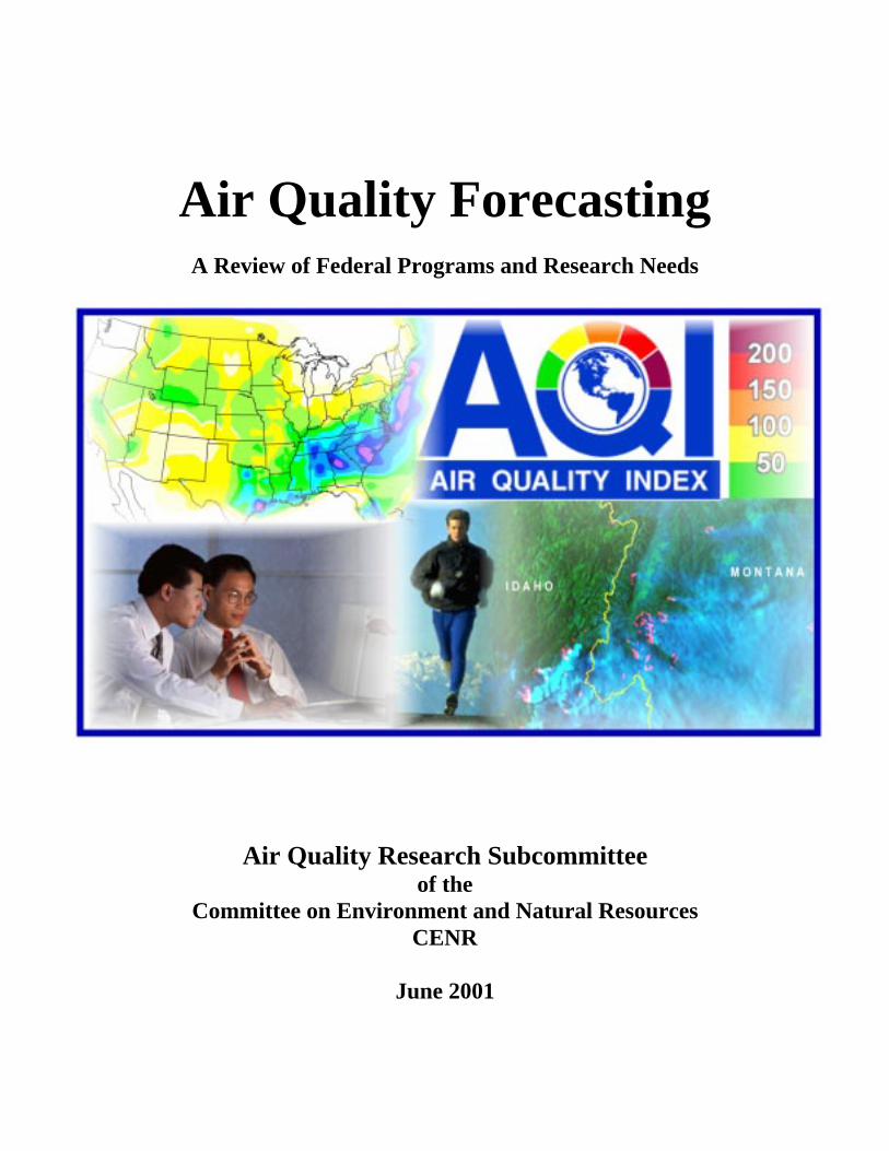
Air Quality ForecastingA Review of Federal Programs and Research Needs
Air Quality Research Subcommitteeof the
Committee on Environment and Natural ResourcesCENR
June 2001
Air Quality ForecastingA Review of Federal Programs and Research Needs
June 2001
The September and October 2000 meetings of the Air Quality Research Subcommittee ofthe Committee on the Environment and Natural Resources (CENR) focused on adiscussion of federal programs related to air quality forecasting. This report provides abrief summary of the current state of science as discussed at these meetings, with someadditional material that was not presented at the meetings due to time constraints. Acomplete and comprehensive review of the science related to air quality forecasting isclearly beyond the scope of this report. Rather, the report provides a brief overview ofthe science, identifying key knowledge and capability gaps, and is intended as aninformation piece to guide the development of future federal research programs relativeto air quality forecasting. This report is a scientific and programmatic document, as thepreceding Subcommittee reports have been, and it is not intended to representgovernmental policy.
Copies of this report are available from:NOAA Aeronomy LaboratoryOffice of the Director, R/AL325 Broadway, Boulder Colorado 80305-3328E-mail: [email protected]: 303-497-3134Fax: 303-497-5340
Air Quality ForecastingA Review of Federal Programs and Research Needs
Air Quality Research Subcommitteeof the
Committee on Environment and Natural ResourcesCENR
June 2001
Table of Contents
1.0 Introduction 11.1 The Need for Air Quality Forecasts 11.2 Air Quality Forecasting Techniques 21.3 Elements of an Air Quality Forecasting System 51.4 Air Quality Forecasting as a Way to Improve Understanding 6
2.0 Existing Federal Programs to Forecast Air Quality 72.1 Environmental Protection Agency (EPA) 72.2 National Oceanic and Atmospheric Administration (NOAA) 92.3 National Park Service (NPS) 11
3.0 Research Needs to Support Air Quality Forecasting 133.1 Defining Customer Needs 133.2 Understanding Processes 143.3 Evaluating / Improving Models 153.4 Observing Systems 16
4.0 Conclusions and Next Steps 19
5.0 References 21
Introduction
June 2001 1
1.0 Introduction
Air quality in the United States has improved dramatically in the three decades since theClean Air Act was first promulgated. It is a measure of the Nation's commitment to cleanair that these gains came during a period of considerable growth (the populationincreased by more than a third and the Nation's Gross Domestic Product increased byalmost a factor of ten) when air pollution would be expected to increase. However, thereis more work to be done. Air pollution is still a widespread problem in the United States,with over 100 million individuals in 114 different areas exposed to levels of air pollutionthat exceed one or more health-based ambient standards [U.S. EPA, 2000].
A recent study sponsored by the Health Effects Institute [Kaiser, 2000] estimates thatexposure to high levels of particulate matter alone is responsible for more than 60,000deaths each year in the United States. Haze from car and truck emissions, industrialpollution, and wildfires obscures some of the most dramatic vistas in the country and canpose a substantial hazard1.
Air pollution places a very real economic burden on the country. The American LungAssociation estimated [Cannon, 1990] that air pollution related illness costsapproximately $100 billion dollars (1988 dollars) each year in the United States. Highlevels of ozone can reduce the yields of economically important agricultural crops. Theselosses have been estimated [Adams et al., 1989] to be $1.7 billion dollars (1980 dollars)each year.
1.1 The Need for Air Quality Forecasts
A system for forecasting future air quality cannot, by itself, solve the problems describedabove. Forecasts, if they are reliable and sufficiently accurate, can however play animportant role as part of an air quality management system working in concert with moretraditional emissions-based approaches. The applications of air quality forecasts fall intothe following broad areas:
• Health Alerts – Many cities currently provide warnings to the public when airpollution levels exceed specified levels. The more reliable the forecast is themore effective it is. These warnings are directed at specific populations thatare particularly sensitive to air pollution (e.g., asthmatics). Interest in findinginnovative ways to protect these individuals has heightened in recognition of
1 In 1997, thick smoke from regional forest fires in Southeast Asia were blamed for the Garuda AirlinesAirbus crash near Sumatra, and the collision of two ships in the Strait of Malacca. A total of 263 werekilled.
Introduction
June 2001 2
lack of a discernable health threshold for exposure to ozone or fine particles,which implies that no level of emissions reduction will protect all individuals.
• Supplementing Existing Emission Control Programs – In many parts of thecountry, the air quality standards are exceeded only infrequently, a few daysout of the year. The availability of reliable air pollution forecasts affords localenvironmental regulators the option of “on demand” or intermittent emissionreductions on those days, thus avoiding the high cost of continuous emissioncontrol. This approach is currently being successfully employed in severalareas of the country and could be expanded were reliable forecasts available.Many cities also offer free access to public transportation on “ozone alert”days to reduce automobile emissions. The accuracy of these forecasts iscritical due to the high cost associated with these programs.
• Operational planning – Regional haze can impair and even endanger activitiessuch as private and commercial aviation. Aerial photography and visits tomany National Parks are significantly impacted by the presence of haze. Areliable visibility forecast could improve safety and efficiency by permittingthe scheduling of these activities during the most favorable periods. The U.S.Forest Service (U.S.F.S.) is planning a 10-fold increase in prescribed burns.Since these activities are regulated under the Clean Air Act, the U.S.F.S. willhave to demonstrate to local regulators that they can schedule these burns sothat no National Ambient Air Quality Standards will be violated, requiringsome form of air quality forecast.
• Emergency response – Wildfires consumed more than 4 million acres of forestin the United States during 2000. The vast amount of smoke generated bythese burning forests affects the visibility in the area that can cause accidents,increase traffic congestion and even jeopardize aviation safety. Theavailability of reliable smoke forecasts offers rerouting options forautomobiles and air traffic to reduce the possibility of accidents. Theinformation provided by these forecasts can also provide an initial assessmentof the impact of these wildfires.
1.2 Air Quality Forecasting Techniques
A wide variety of techniques, ranging from the simple to the complex, have been used toproduce air quality forecasts. To date, most of these efforts have focused on producing 1-to 3-day ozone forecasts. The techniques that have been used to produce these forecastsare described in a recent report [U.S. EPA, 1999]. The techniques used to forecast ozoneconcentrations are representative of those that can, or could, be used for other pollutants.They fall into three broad categories:
Climatology – The use of climatology to predict air quality is based on the assumption
Introduction
June 2001 3
that the past is a good predictor of the future. This approach relies on the association ofelevated pollution levels with specific meteorological conditions. The application can beas simple as assuming persistence (i.e., if pollution levels are high today they will also behigh tomorrow) or can involve the development of complex weather typing schemes (i.e.,identifying recurring weather patterns that are accompanied by high pollution levels) toforecast air quality. These approaches are usually used to predict exceedances of specificthresholds not ambient concentrations. These approaches do, however, have theadvantage of being reasonably simple and inexpensive to implement and operate.
Statistical Methods – The association between specific meteorological parameters and airquality can be quantified using a variety of statistical techniques. In fact, these areprobably the most common techniques in use for ozone forecasting. In their survey,EPA, 1999 has identified three statistical approaches that are in use:
• Classification and Regression Tree (CART) – This technique uses specializedsoftware to identify those variables (meteorological or air quality) that are moststrongly correlated with ambient pollution levels. These variables are then usedto predict future pollution levels based on current air quality and forecastedmeteorology.
• Regression analysis – The association between pollutant levels andmeteorological and aerometric variables can be quantified by analyzing historicaldata sets using standard statistical analysis packages. The resultant multi-variantlinear regression equation can be used to forecast future pollution levels.
• Artificial Neural Networks – Another way of analyzing historical data is toidentify atmospheric parameters that influence air quality and quantify thatassociation through the application of adaptive learning and pattern recognitiontechniques, such as neural networks. Neural networks are intended to mimic theway the human brain recognizes recurring patterns. Networks have beendeveloped that identify weather patterns that are associated with elevated ozonelevels (see U. S. EPA, 1999 and references therein). Presumably, the sametechnique could be applied to other pollutants.
These approaches, while more complex than the ones discussed in the previous group, arereasonably simple to develop and use, requiring only modest computing resources andspecialized knowledge.
Three Dimensional (3-D) Models – Although the techniques described above have manystrong points, they have a common weakness. They assume a certain amount of stabilityin terms of the processes that affect air quality. Any change in emissions or climate(short and long-term) will serve to diminish the skill of these techniques. One wayaround this problem is to employ a more deterministic approach to the prediction of airquality. Deterministic 3-D air quality models seek to mathematically represent all of the
Introduction
June 2001 4
important processes that affect ambient pollution levels. These models are actuallycomprised of several submodels that work together to simulate the emission, transport,and transformation of air pollution. Examples of submodels include:
• Emissions models – These models simulate the time-dependent, spatially-distributed emissions of the pollutant in question, and/or (in the case of secondarypollutants such as O3) its precursors, from both anthropogenic and naturalsources.
• Meteorological models – These models forecast meteorological conditions thatdetermine transport and mixing and influence chemistry (solar intensity,temperature, humidity, etc.), emissions (e.g. temperature), and deposition.Trajectory models use the 3-D meteorology from these models in consort withemissions data to forecast ambient levels of reasonably unreactive pollutants likedust and smoke.
• Chemical models – These models use fundamental chemical kinetic rateparameters, spectroscopic properties, and thermodynamic relationships tosimulate the transformation of primary (emitted) pollution into secondarypollution, including the composition and morphology (size distribution andoptical properties) of aerosols.
Three-dimensional air quality models are classified as being either Lagrangian orEulerian depending on the method used to simulate the time-dependent distribution ofpollution concentrations. Lagrangian models follow individual air parcels over timeusing the meteorological field to advect and disperse the pollutants. This approachresults in a computationally efficient system. However, it is difficult to properlycharacterize the interaction of a large number of individual sources when nonlinearchemistry is involved. Eulerian models use fixed grids (vertically and horizontally) andsolve the appropriate chemical equations simultaneously in all cells, including exchangeof pollutants between cells. Typically the computational requirements are reducedthrough the use of nested grids, with a coarse grid used over rural areas (whereconcentrations tend to be reasonably homogenous) and a finer grid used over urban areas(where concentration gradients tend to be more pronounced). These models can alsoaccommodate a plume-in-grid treatment by performing a semi-Lagrangian calculation forlarge point sources (e.g., power plants) during the early stages of plume dilution. Thesemodels can produce three-dimensional concentration fields for several pollutants butrequire significant computational power and expertise.
Virtually all of the techniques described above start with a meteorological forecast.Therefore, the reliability of the air quality forecast is dependent on the reliability of theweather forecast. Weather forecasters use a number of tools to predict tomorrow'sweather. Local forecasters will typically use the output from several different models incombination with local knowledge and experience to produce an accurate forecast. Thesame must be true for an air pollution forecast. A skilled forecaster will combine severalof the techniques described above to ensure that the prediction is as accurate as possible.
Introduction
June 2001 5
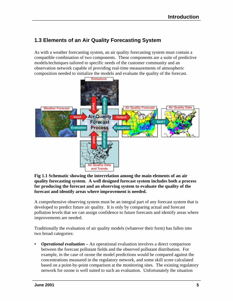
1.3 Elements of an Air Quality Forecasting System
As with a weather forecasting system, an air quality forecasting system must contain acompatible combination of two components. These components are a suite of predictivemodels/techniques tailored to specific needs of the customer community and anobservation network capable of providing real-time measurements of atmosphericcomposition needed to initialize the models and evaluate the quality of the forecast.
Fig 1.1 Schematic showing the interrelation among the main elements of an airquality forecasting system. A well designed forecast system includes both a processfor producing the forecast and an observing system to evaluate the quality of theforecast and identify areas where improvement is needed.
A comprehensive observing system must be an integral part of any forecast system that isdeveloped to predict future air quality. It is only by comparing actual and forecastpollution levels that we can assign confidence to future forecasts and identify areas whereimprovements are needed.
Traditionally the evaluation of air quality models (whatever their form) has fallen intotwo broad categories:
• Operational evaluation – An operational evaluation involves a direct comparisonbetween the forecast pollutant fields and the observed pollutant distribution. Forexample, in the case of ozone the model predictions would be compared against theconcentrations measured in the regulatory network, and some skill score calculatedbased on a point-by-point comparison at the monitoring sites. The existing regulatorynetwork for ozone is well suited to such an evaluation. Unfortunately the situation
Introduction
June 2001 6
for other pollutants (e.g., fine particles) is not as good since those monitoringnetworks are less dense and the instruments not as sensitive, or in some cases asselective, as is desired.
• Diagnostic evaluation – An operational evaluation will tell you how close the modelcame to the correct answer; a diagnostic evaluation will tell you if you got the rightanswer for the right reason. As the name implies, a diagnostic evaluation requires themeasurement of parameters (both meteorological and chemical) that control pollutantformation and distribution, not just the concentration of the pollutant that is beingforecasted. To perform a diagnostic evaluation, concentrations of pollutantprecursors and key intermediates need to be tracked to evaluate the performance ofthe emissions model and the chemical processor (if one is used), while meteorologicalparameters such as mixing height and winds aloft will aid in the evaluation of themeteorological processor.
1.4 Air Quality Forecasting as a Way to Improve Understanding
As techniques for forecasting air quality improve and their use expands, we should notoverlook the opportunity to use this process to improve our understanding of theprocesses that control the formation and distribution of air pollution. The meteorologicalresearch community has benefited enormously from the experience gained through anoperational forecasting enterprise. The ongoing evaluation of the daily weather forecastsis used to identify areas of insufficient understanding and guide research.
The same opportunity exists for advancing the understanding of atmospheric processesthat control ambient pollution levels. By evaluating the success of forecasts produced bydifferent techniques we have the opportunity not only to evaluate the relative merits ofthese techniques but also to test our knowledge of key processes and identify areas wheremore information is needed.
Existing Programs
June 2001 7
2.0 Existing Federal Programs to Forecast
Air Quality
The large number of organizations throughout the United States that currently performoperational forecasting of air quality is testimony to the interest in and need for thisinformation. The great majority of these programs focus on providing ozone forecasts,primarily for urban areas during the summer months. The organizations performing theforecasts include federal agencies, state agencies, universities, industry, and consultingcompanies. The methods cover the range of complexity and sophistication from simplestatistical approaches to full-blown photochemical grid models. Several federal programsto conduct, support, and disseminate these forecasts are described briefly below.
2.1 Environmental Protection Agency (EPA)
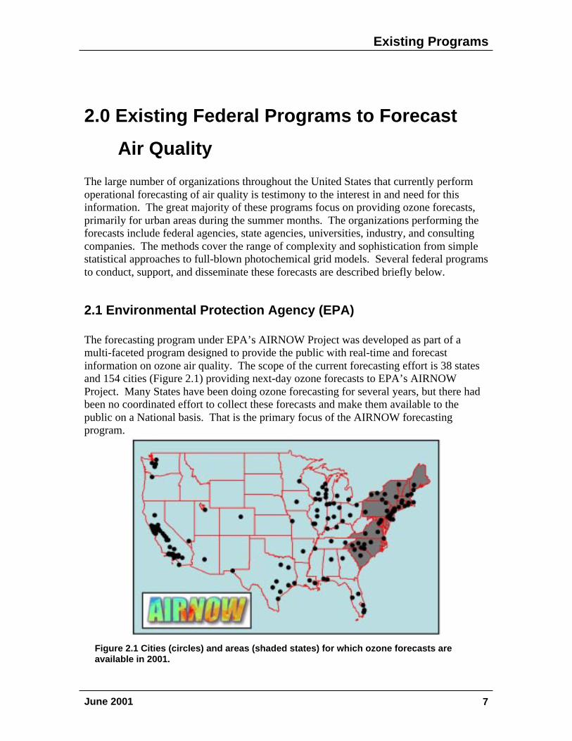
The forecasting program under EPA’s AIRNOW Project was developed as part of amulti-faceted program designed to provide the public with real-time and forecastinformation on ozone air quality. The scope of the current forecasting effort is 38 statesand 154 cities (Figure 2.1) providing next-day ozone forecasts to EPA’s AIRNOWProject. Many States have been doing ozone forecasting for several years, but there hadbeen no coordinated effort to collect these forecasts and make them available to thepublic on a National basis. That is the primary focus of the AIRNOW forecastingprogram.
Figure 2.1 Cities (circles) and areas (shaded states) for which ozone forecasts areavailable in 2001.
Existing Programs
June 2001 8
In the process of developing this coordinated effort, EPA has established excellentpartnerships with the national media such as USA Today, The Weather Channel, and thenational Weather Service Providers (Weather Central, Weather Services International,Kavouris, AccuWeather). It is through the partnerships with the State and Local AirAgencies along with these media partnerships that EPA has been able to facilitate thewide distribution of the air quality forecasts across the United States. The technicalaspects of the forecast program are relatively simple.
All of the forecasts are provided to EPA from State or Local air quality forecasters usinga variety of forecasting techniques. In some areas, these forecasts are made forindependent cities, while in other areas, the forecasts are a result of a regionalcollaborative effort. Also, for the New England States, EPA receives city-specificforecasts as well as a monitor-specific forecast that is interpolated and mapped. The keyrole for EPA in this process is to acquire and compile the forecasts.
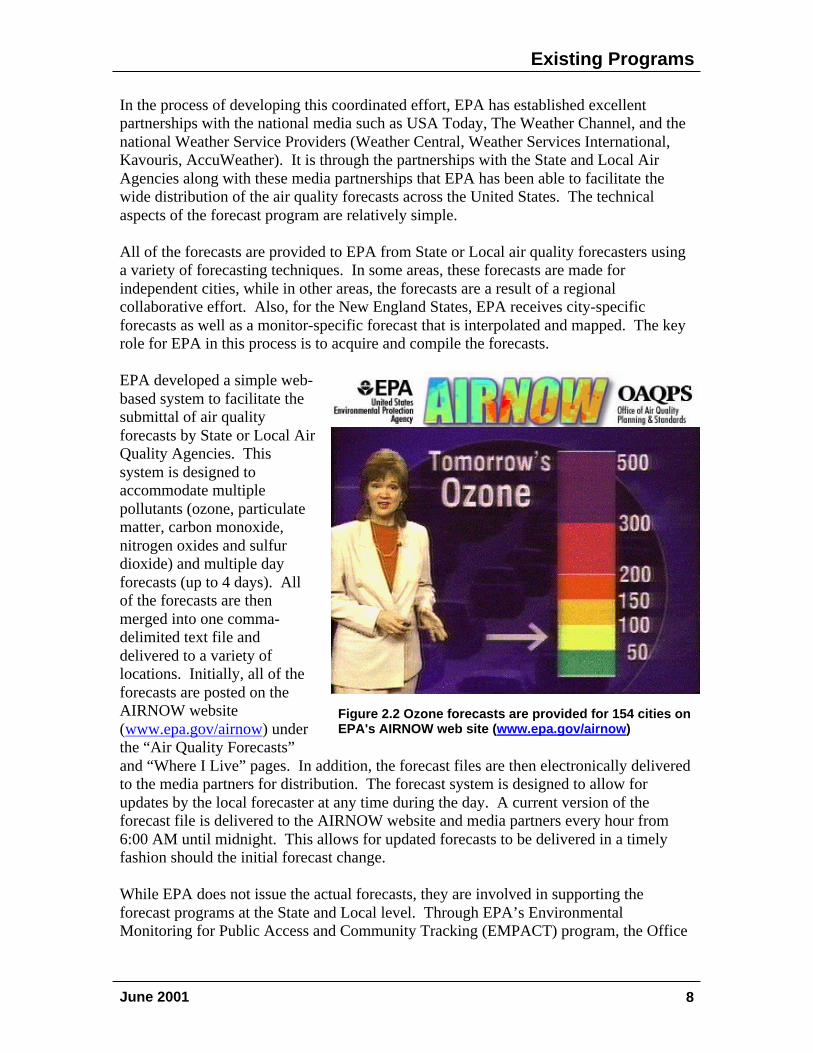
EPA developed a simple web-based system to facilitate thesubmittal of air qualityforecasts by State or Local AirQuality Agencies. Thissystem is designed toaccommodate multiplepollutants (ozone, particulatematter, carbon monoxide,nitrogen oxides and sulfurdioxide) and multiple dayforecasts (up to 4 days). Allof the forecasts are thenmerged into one comma-delimited text file anddelivered to a variety oflocations. Initially, all of theforecasts are posted on theAIRNOW website(www.epa.gov/airnow) underthe “Air Quality Forecasts”and “Where I Live” pages. In addition, the forecast files are then electronically deliveredto the media partners for distribution. The forecast system is designed to allow forupdates by the local forecaster at any time during the day. A current version of theforecast file is delivered to the AIRNOW website and media partners every hour from6:00 AM until midnight. This allows for updated forecasts to be delivered in a timelyfashion should the initial forecast change.
While EPA does not issue the actual forecasts, they are involved in supporting theforecast programs at the State and Local level. Through EPA’s EnvironmentalMonitoring for Public Access and Community Tracking (EMPACT) program, the Office
Figure 2.2 Ozone forecasts are provided for 154 cities onEPA's AIRNOW web site (www.epa.gov/airnow)
Existing Programs
June 2001 9
of Air Quality Planning and Standards has provided resources to support the forecastingefforts in several areas of the United States. EPA developed the guidance for developingan ozone forecasting program and provided that guidance to the State and Local AirAgencies. EPA will be developing similar guidance for forecasting particulate matterduring fiscal year 2001. Finally, EPA has supported the distribution of the forecasts tothe public and media through website development and partnerships with externalweather groups. It is this national “top-down” support that has increased the number offorecast areas in the United States.
Now that the forecasting program is operational, it would be useful to suggest someenhancements that could improve the quality and coverage of the forecasts. While thefinal word on any air quality forecast will always reside with the State or Local AirAgency, it would be very helpful to have some type of national forecast model that couldassist areas that do not have the capability to generate their own forecasts. Even areaswith experienced forecasters would benefit from a forecast model. Air qualityforecasting is similar to weather forecasting. The models make a prediction and the localforecasters adjust that prediction based on local knowledge and information. An airquality forecast model would be utilized in a similar manner.
Overall, the forecasting approach developed under AIRNOW has been very successful.It has succeeded because it continues to give the authority for the forecast to the State orLocal agency. A Federal forecast tool will be beneficial, but we cannot overlook theimportance of having the local agency have the final word with regards to the actualforecast. Local conditions (thunderstorms, topography, etc) can have a significant impacton air quality conditions and we must always make sure that component is covered. Inaddition, the credibility of a forecast made at the local level will always be greater thanone made at the national or Federal level.
2.2 National Oceanic and Atmospheric Administration (NOAA)
NOAA has a goal under its forecasting mandate to extend, over the next decade, thecurrent weather forecasting capability to include predictions of future air quality. Duringthe past several years, as the first steps in this process, NOAA has developed severalexperimental air quality forecast products and made them available on the World WideWeb (http://www.arl.noaa.gov/ready.html). The air quality forecasts are generated usinghigh-resolution meteorological forecast models coupled with a sophisticated air-masstrajectory analysis (HY-SPLIT) and, in the case of ozone, complex, photochemical gridmodels. These forecasts are being used primarily as a learning tool to evaluate currentcapability and identify areas where improvements are needed. Some of these forecastsare provided on a routine basis (e.g., ozone forecasts during the summer months), someare provided in response to specific events (e.g., natural disasters), and some are providedto support air quality research (e.g., intensive field campaigns).
Existing Programs
June 2001 10
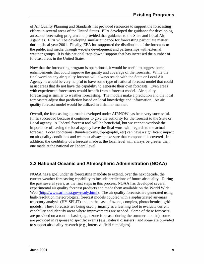
Ozone Forecasts
In a cooperative effort, scientists fromNOAA and the Pennsylvania StateUniversity (PSU) have developed theHybrid Single-Particle LagrangianIntegrated Trajectories with ageneralized non-linear ChemistryModule (HY-SPLIT CheM) model tocalculate the spatial and temporaldistribution of different chemicalspecies in the troposphere over aregional scale [Stein et al., 2000]. Thesimulation accounts for the advection,dispersion, chemical transformation,and deposition of the differentpollutants. The model uses the 1995-1996 Ozone Transport AssessmentGroup (OTAG) emissions inventory[EPA, 1999] and Carbon Bond IV gas-phase chemistry coupled with aLagrangian transport scheme to forecastambient ozone concentrations. Ozoneforecasts are provided on a gridresolution of 0.5o x 0.5o for theNortheastern US (Figure 2.3).
NOAA is also performing ozone forecasts on an experimental basis using a high-resolution coupled meteorology/chemistry model [Grell et al., 2000]. This Eulerian gridmodel uses the PSU / NCAR nonhydrostatic mesoscale meteorological model MM5coupled with the RADM-2 gas-phase chemical reaction scheme. To date, the model hasbeen used primarily to support flight planning during intensive field campaigns designedto study atmospheric processes related to air quality.
The comprehensive data sets acquired in intensive field campaigns, which includemeasurements from ground based instrumentation, remote sensing technology, andhighly instrumented aircraft, are being used to evaluate the meteorological and chemicalcomponents of the NOAA forecast models.
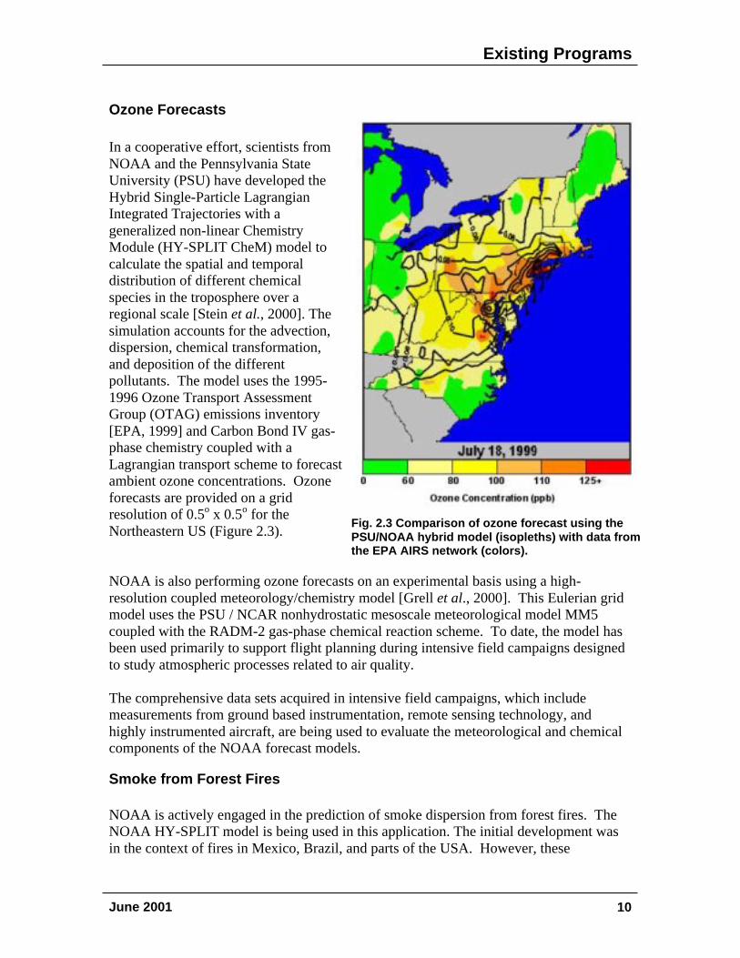
Smoke from Forest Fires
NOAA is actively engaged in the prediction of smoke dispersion from forest fires. TheNOAA HY-SPLIT model is being used in this application. The initial development wasin the context of fires in Mexico, Brazil, and parts of the USA. However, these
Fig. 2.3 Comparison of ozone forecast using thePSU/NOAA hybrid model (isopleths) with data fromthe EPA AIRS network (colors).
Existing Programs
June 2001 11
applications have recently been extended to the recurring fires in Indonesia, with plans toinclude Singapore in FY 2001. NOAA also provides a quasi-operational smoke forecastsystem that is used by the Idaho National Engineering and Environmental Laboratory inits fire-fighting and control-burn programs. A comparison of a smoke transport forecastfor a forest fire in eastern Idaho during August of 2000 with a satellite image is providedin Figure 2.4.
Volcanic AshNOAA also conducts research and development on volcanic ash transport and dispersionmodeling. Since 1992, the National Weather Service (NWS) has used the Volcanic AshForecast Transport And Dispersion (VAFTAD) model to protect aircraft from hazardsassociated with volcanic emissions. NWS has provided volcanic ash forecasts usingVAFTAD output about 150 times in each of the past three years.
2.3 National Park Service (NPS)
As a Federal Land Manager and steward of some of the Nation's most pristine areas, theNPS works to ensure that the lands under their jurisdiction are protected from the impactsof pollution. To quantify levels of air pollution within the many National Parks and
Figure 2.4 Comparison of smoke forecast using NOAA's HYSPLIT model (black dots) withaerosol column measurements from NASA's TOMS satellite (colored grids – hotter colorsrepresent higher aerosol loadings) for 18Z on August 10, 2000 for a fire in eastern Idaho.
Existing Programs
June 2001 12
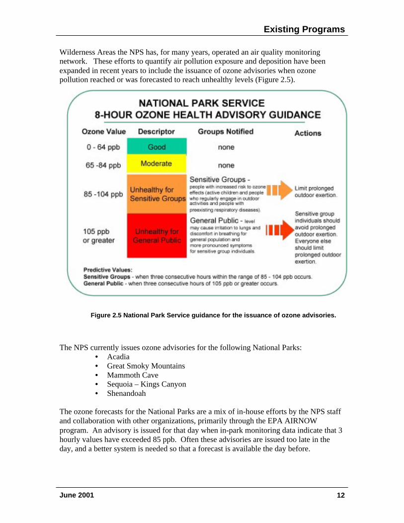
Wilderness Areas the NPS has, for many years, operated an air quality monitoringnetwork. These efforts to quantify air pollution exposure and deposition have beenexpanded in recent years to include the issuance of ozone advisories when ozonepollution reached or was forecasted to reach unhealthy levels (Figure 2.5).
The NPS currently issues ozone advisories for the following National Parks:• Acadia• Great Smoky Mountains• Mammoth Cave• Sequoia – Kings Canyon• Shenandoah
The ozone forecasts for the National Parks are a mix of in-house efforts by the NPS staffand collaboration with other organizations, primarily through the EPA AIRNOWprogram. An advisory is issued for that day when in-park monitoring data indicate that 3hourly values have exceeded 85 ppb. Often these advisories are issued too late in theday, and a better system is needed so that a forecast is available the day before.
Figure 2.5 NPS guidance for the issuance of ozone advisories.
Figure 2.5 National Park Service guidance for the issuance of ozone advisories.
Research Needs
June 2001 13
3.0 Research Needs to Support Air Quality
Forecasting
The interest in and need for a robust capability to predict future air quality is clear. Awide variety of techniques are currently being used with mixed results. The majority ofcurrent efforts focus on ozone. A number of the approaches have been carefullyevaluated and some have demonstrated impressive skill, while others have been lessrigorously evaluated and the quality of the predictions is essentially unquantified. Thecurrent ozone forecasts are largely a collection of disparate efforts, primarily the work ofState and Local air regulatory programs, with very little consistency in approach ormethods used to perform evaluations of forecast skill. The work to date, whileencouraging, would clearly benefit from a better coordinated national effort, including aprogram of focused research and development, that would facilitate and augment work atthe local level. This support is particularly important as interest grows in forecastingpollutants other than ozone (e.g. particulate matter, visibility, carbon monoxide, etc.) andextending the forecasts to rural and remote areas (e.g. National Parks and WildernessAreas).
3.1 Defining Customer Needs
In designing an air quality forecasting program and identifying the research that is neededto support the effort it is essential that the needs of the user community be understood andconsidered. A number of potential applications of air quality forecasts have beendiscussed earlier in this report. In order to determine the relative importance of each andmaximize the usefulness of the forecasts and provide focus for any supporting researchwe must look to the user community for answers to several basic questions related toforecast needs/requirements, including:
• For what pollutants are forecasts needed? What are their relative priorities?ozone, particulate matter, carbon monoxide, visibility, sulfur dioxide,air toxics, others?
• What is the time scale for the desired forecast?How far in advance?For what period; hours, days, weeks?
• How accurate does the forecast need to be and what form should it take?Probability of exceeding a standard level.Predicted concentration range.Ambient concentration with estimated uncertainty.
• What is the spatial scale?city, region, other
Research Needs
June 2001 14
The applications of air quality forecasts are rapidly evolving. As the reliability andcoverage (number of pollutants for which forecasts are produced and the temporal, andspatial extent) grows, new uses will be identified that we cannot now foresee. Therefore,a close and effective relationship among the user community, operational forecasters, andthose involved in evaluating and improving forecasting methodologies must bemaintained. Thus, the process of defining customer needs and requirements must beongoing with effective communication between developers and users.
3.2 Understanding Processes
The coupling of emissions to ambient pollution levels is controlled by a number of keyatmospheric processes (mixing, transport, chemical transformation, deposition, etc.). Theprediction of ambient pollution levels relies on an understanding of how these processesinfluence the formation and distribution regardless of whether the approach to forecastinginvolves a parametric or deterministic approach. Therefore, efforts to improve thereliability of air pollution forecasts will benefit from an improved understanding of theseatmospheric processes. Areas where improved understanding would benefit efforts todevelop and/or improve air quality forecasting systems include:
Linkages between weather and air quality: Ambient levels of pollution (e.g., ozoneand fine particles) are clearly dependent on the emissions of precursor pollutants likeNOx, VOCs, and SO2. Meteorological parameters like solar intensity, temperature, windspeed, and mixing height greatly influence the day-to-day and seasonal-to-interannualvariations in atmospheric concentrations. These associations form the basis of many ofthe statistical models used to forecast air quality. A better understanding of the couplingsbetween meteorology and air quality can point to approaches that will improve thequality of these techniques.
Nighttime transport and chemistry: Because of the important role that photochemistryplays in the formation of ozone and other secondary air pollutants, the vast majority ofthe intensive atmospheric process studies conducted to date have focused on the daylighthours. Analysis of data from intensive field studies [e.g., Banta et al., 1998] has shownthat nighttime mixing and transport plays a significant role in the redistribution of urbanpollution throughout the region. During the day, under the stagnant conditions associatedwith most pollution episodes, only limited horizontal transport of the pollution plumes isexpected. However, at sunset a shallow nocturnal inversion layer may form that canisolate the boundary layer pollution from the surface, reducing the loss of ozone, PM andtheir precursors via deposition. The formation of this layer also reduces the frictionalresistance for the air masses above the nocturnal layer, allowing this pollution to be moreeffectively transported over larger distances. Moreover, the emissions from smokestacksof major point sources, such as power plants, may enter the atmosphere at night above thenocturnal inversion directly into the nighttime residual mixed layer.
Research Needs
June 2001 15
Nitrogen oxide and VOC emissions continue to react with ozone at night, leading toadditional reactions involving the nitrate radical. These processes can significantly affectthe reactivity and concentration of the pollutant mix that populates the atmosphere duringthe next diurnal cycle. Thus, the accurate prediction of tomorrow's air quality requires abetter understanding the chemistry and transport in the nighttime atmosphere.
Heterogeneous processes: Aerosols participate in a variety of chemical and physicalprocesses in the troposphere. On a regional scale, these processes are associated withregional air quality as related to visibility and the effects of fine particles on humanhealth. In this regard, there is a natural synergism between pollutants like ozone andsulfur dioxide and fine particles. A basic scientific understanding of the chemistry andphysics of the atmosphere is prerequisite for an effective predictive capability and thatthe concentrations of pollutants in the atmosphere are often co-dependent because ofinteracting chemical reactions.
With this in mind, new research is needed to elucidate:• how chemical processing on aerosols influences ozone formation• how the atmospheric oxidation leading to ozone formation leads to aerosol formation• how atmospheric chemistry influences the growth and chemical composition of
aerosols.
Emissions: Day-to-day changes in emission rates need to be taken into account toaccurately forecast air quality. The potential effects of changes in temperature includeincreased biogenic emissions of VOC, increased VOC emissions from motor vehicles,and increased nitrogen oxides emissions due to increased power demands. Variations inactivity levels at major industrial facilities will also impact air quality. Research is neededto develop methods to adjust seasonal emission inventories to reflect the probableemission levels during the forecast period.
3.3 Evaluating / Improving Models
The models used for forecasting air quality can be divided into two broad categories, 1)parametric models and 2) deterministic models. Regardless of the form of the model it isimportant to evaluate model performance so that there is some way to quantify forecastreliability and identify areas for improvement. The wide variety of approaches and theform of the forecast produced in current forecast models make it very difficult toobjectively and quantitatively compare different techniques. Also, the factors that controlpollution levels vary from one region to another and mean that a model/technique thatworks well in one region may not perform well in another.
In the case of statistical models, a systematic evaluation of the various techniques andtheir relative performance would provide a useful guide for areas that are consideringdeveloping a forecast capability.
Research Needs
June 2001 16
In the case of deterministic models (e.g., photochemical grid models), there is a need toevaluate model performance in a number of key areas, including:
Meteorology: Many of the most severe air quality episodes occur during air massstagnations when there is very little synoptic forcing. There is a need to evaluate modelperformance under these conditions. There is also a need to evaluate the models forspecific geographic areas where there are terrain-induced effects on air quality (e.g.,coastal areas where land/sea-breeze recirculation can play a role, and mountainous areaswhere the mixing and transport is very complex).
Chemistry: Many of the newest photochemical grid models include modules to simulateparticle emission, production, transport and deposition. The development of fastresponse instrumentation for the characterization of particle composition and morphologyaffords the opportunity to evaluate the performance of these models for a variety ofemission mixes and meteorology.
Emissions: Most air quality modeling efforts conducted to date have relied on emissioninventories developed by state regulatory agencies. In most cases, these inventories havenot been rigorously evaluated. Also, there has not been a comprehensive study toexamine the coupling between emissions and meteorology. The quality of the predictionsfrom emissions-based air quality models is directly proportional to the quality of theemissions used in the model. There is also a need to evaluate the day-to-day variabilityin biogenic and anthropogenic emissions and their dependence on meteorologicalvariables, and to determine the sensitivity of air quality models to this variability.
The greatest uncertainty in forecasting air quality impacts from natural disasters such asvolcanic eruptions and wildfires is associated with the source term. A betterquantification of emission rates could dramatically improve the reliability and thereforethe usefulness of such forecasts.
There are a number of data sets that have been accumulated as part of comprehensivefield campaigns in which both the physical and chemical condition of the atmosphere hasbeen characterized in some detail for the study period. Several of the NARSTO data sets(e.g., Southern Oxidants Study – SOS campaigns in Nashville and Texas, NARSTO-NE,and Southern California Ozone Study - SCOS) provide a rich resource for modelevaluations such as those described above.
3.4 Observing Systems
A well-designed observing system is essential to the success of any air quality forecastingsystem. The need for information on the chemical constituents of the atmosphere isanalogous to the meteorological observing system that supports the current weatherforecasting system. Information on atmospheric pollution is needed to both initialize andevaluate the forecast. For example, today's ozone levels will have a strong influence ontomorrow's levels. Specific research needs include the following:
Research Needs
June 2001 17
Data to initialize models and perform operational evaluation: Most air qualityforecast models use some form of dynamic initialization, assimilating observed chemicaldata in a manner akin to the way weather forecast models are initialized usingmeteorological observations. This process requires near real-time access to air qualitydata. The United States has a reasonably dense network of ozone monitors that areoperated for both regulatory and other purposes. With this network it is possible toquantify both urban and rural levels in most parts of the country. However there areareas of interest, most notably National Parks and Wilderness Areas, where there are nomonitors and therefore no way to evaluate forecast skill. The situation for otherpollutants is not nearly as good. If short-term (1-3 day) forecasts of these pollutants areneeded, fast-response (1-hr or less) near real time data will be needed for modelinitialization and evaluation. For some pollutants (e.g., particulate matter) there arecurrently no reliable fast-response measurements, while for others (e.g. carbon monoxideand sulfur dioxide) reliable data are available only for urban or industrial areas. Newmonitoring systems will have to be developed if forecasts for these pollutants are needed.In some cases satellite data may be able to fill in some of the gaps through integrationdata from sparse surface networks. In other instances useful surrogates may be foundthat can substitute for the desired data. For example, visibility data from the 900+ airportmeteorology network (ASOS) may serve as a surrogate for fine particle mass [Richards etal, 1996].
Data for diagnostic evaluation of complex grid models: A diagnostic evaluation ofmodel performance requires information on the fundamental physical and chemicalprocesses responsible for the formation and distribution of air pollution. While much ofthis information is available at research sites located throughout the United States, thesestations are few and far between and access to the data is difficult. An integrated networkof research monitoring stations that are capable of characterizing the atmosphere both interms of meteorologically and chemically important parameters (including chemicalprecursors and key intermediates) is needed to support a national forecasting effort. Sucha network could build on the existing efforts by augmenting measurements at existingsites and adding stations in key areas where such data are currently not available.
Information on the vertical distribution of pollution: The formation and collapse ofdaytime and nocturnal inversion layers serves to isolate the surface from the residualmixed layer and the free troposphere. Transport of pollution above the daytime mixedlayer and the stable nocturnal layer can have a strong influence on next day pollutionlevels. Current monitoring networks are blind to this pollution, and vertical pollutiondistributions are made only infrequently and usually only during intensive fieldcampaigns. New remote sensing instruments (i.e., DIAL lidars) and advances in sondetechnology offer the opportunity to characterize the vertical pollution distribution on amore frequent basis and over a wider area of the country. The development of reliable airquality forecasts will require access to such data. By way of comparison, imagine thedifficulty of performing weather forecasts while denied access to the daily soundings andprofiler data.
Research Needs
June 2001 18
Access to data in a timely manner: Most of the air quality data in the United States arecollected for regulatory purposes. In most cases, these data are not available for severalmonths after they are collected. Access to this data in near real-time would facilitate andimprove the air quality forecasting process. Some states and the EPA's AIRNOWprogram are providing limited access to data from part of the ozone network in real time.This capability needs to be extended to other pollutants for which forecast information isneeded.
Draft Do Not Quote or Cite Conclusions and Next Steps
June 2001 19
4.0 Conclusions and Next Steps
The need for air quality forecasts is clear. A growing number of State and Local AirAgencies (currently 35 states and 135 cities) are using summertime ozone forecasts toalert sensitive populations and reduce precursor emissions through reduced vehiculartraffic on "ozone action days". A similar approach is being used to reduce carbonmonoxide levels in Denver. Plans are being developed to extend these forecasts toinclude other pollutants (e.g. particulate matter). The National Park Service uses ozoneforecasts to protect their workforce and inform park visitors. Air quality forecasts arealso an important part of the Federal process for dealing with natural disasters (wildfiresand volcanic eruptions). All indications are that uses for air quality forecasts willcontinue to grow as reliability and coverage improves and new applications areidentified.
Federal activities related to air quality forecasting are currently limited to 1) EPA effortsto facilitate the collection and dissemination of real time data and the posting of locally-produced ozone forecasts and 2) efforts by NOAA to develop and evaluate a number ofexperimental forecasting techniques and 3) the National Park Service's program to useozone forecasting as a proactive approach to resource management. To date, these effortsare largely uncoordinated with only model resources available to improve and extend airquality forecasting methodologies and supporting infrastructure (i.e., observing systems,data ingest, etc.). The Subcommittee has identified a number of activities to improve airquality forecasts:
Improved coordination – A number of Federal agencies are currently engaged in someaspect of air quality forecasting; others have related activities that could contribute to anational effort. A more formal process for coordinating Federal activities would ensurethat limited resources are used to maximum advantage. The Air Quality ResearchSubcommittee could facilitate such coordination and NARSTO, the tri-national (Mexico,United States, and Canada) research consortium focused on ozone and fine particles,could serve as a connection to the private sector.
Identification of customer needs – This is a rapidly evolving area with a need forongoing communication between the user and research communities. EPA has closecontact with the State and Local Air Programs that are the core of the AIRNOWprogram; NOAA has conducted a number of workshops to identify current and futureneeds. These efforts need to continue and be integrated to improve communication. Acoordinated Federal program must be responsive to the needs of the user community.
Evaluate existing technology – Current approaches to air quality forecasting vary fromthe simple to the complex. Some have been carefully evaluated, while others have not.There is a lot to be learned from the work that has already been done. A systematic andobjective evaluation of the methods that are currently in place is the first step inidentifying areas for improvement and opportunities for extension to other pollutants.
Draft Do Not Quote or Cite Conclusions and Next Steps
June 2001 20
Program development – A forecasting system (Section 1.3) is needed to supportoperational air quality forecasting. The system must include a method to continuouslyevaluate and improve the forecast consistent with the needs of the users. A program planshould be put in place that identifies operational, research, and developmental needs and,where possible, agency resources that can be used to address these needs. Theinformation provided in Section 3 of this report is intended as a first step at identifyingthe key elements of the research portion of such a program.
References
June 2001 21
5.0 References
Adams, R.M., J.D. Glyer, S.L. Johnson, and B.A. McCarl, A reassessment of theeconomic effects of ozone on U.S. agriculture, J. Air Pollution Control Assoc. 39,960-968, 1989.
Banta, R.M., C.J. Senff, A.B. White, M. Trainer, R.T. McNider, R.J. Valente, S.D.Mayor, R.J. Alvarez II, R.M. Hardesty, D. Parrish, and F.C. Fehsenfeld, Daytimebuildup and nighttime transport of urban ozone in the boundary layer during astagnation episode, J. Geophys. Res., 103, 22519-22544, 1998.
Cannon, J.S., The Health Costs of Air Pollution: A Survey of Studies Published 1984-1989, American Lung Association, 1990.
Grell, G.A., S. Emeis, W.R. Stockwell, T. Schoenemeyer, R. Forkel, J. Michalakes, R.Knoche, and W. Seidl, Application of a multiscale, coupled MM5/chemistrymodel to the complex terrain of the VOTALP valley campaign, Atmos. Environ.,34, 1435-1453, 2000.
Kaiser, J., Evidence Mounts That Tiny Particles Can Kill, Science, 289, 22-23, 2000.
Richards, L.W., T.S. Dye, M. Arthur, and M.S. Byers, Analysis of ASOS data forvisibility purposes, Sonoma Technology, Inc., Report No. STI-996231-1610-FR,September, 1996.
Stein, A.F., D. Lamb, and R.R. Draxler, Incorporation of detailed chemistry into a three-dimensional Lagrangian-Eulerian hybrid model: Application to regionaltropospheric ozone, Atmos. Environ., 34. 4361-4372, 2000.
U. S. Environmental Protection Agency (EPA) Green Book – Nonattainment Areas forCriteria Pollutants (http://www.epa.gov/air/oaqps/greenbk/index.html) Data as ofJuly 31, 2000.
U. S. Environmental Protection Agency (EPA), Guidelines for Developing an OzoneForecasting Program, U.S. EPA, Office of Air Quality Planning and Standards,Report No. EPA-454/R-99-009, Research Triangle Park, NC, July 1999.(available on the web at http://www.epa.gov/ttn/oarpg/t1/memoranda/foreguid.pdf
U. S. Environmental Protection Agency (EPA), 1999.ftp:/www.epa.gov/pub/scram001/modelingcenter/NOxSIPcall/emissions
Committee on Environment and Natural Resources (CENR)Subcommittee on Air Quality Research
The CENR is charged with improving coordination among Federal agencies involved inenvironmental and natural resources research and development, establishing a strong information-transfer link between science and policy, and developing a Federal environmental and naturalresources research and development strategy that responds to national and international issues.There are five research subcommittees under the CENR:
• Air Quality• Ecological Systems• Global Change• Natural Disaster Reduction• Toxics and Risk
The Air Quality Research Subcommittee has articulated two major goals in its Strategic Plan:• to enhance the effectiveness and productivity of U.S. air quality research, and• to improve information exchange between research and policy on air quality issues,
including the scientific knowledge base for air quality standards and assessingcompliance
Dan Albritton of NOAA chairs the Subcommittee, which includes representatives from the followingdepartments and agencies:
Department of Agriculture - Agricultural Research ServiceDepartment of Agriculture - Cooperative State Research, Education, and Extension ServiceDepartment of Agriculture - Natural Resources Conservation ServiceDepartment of Agriculture - U.S. Forest ServiceDepartment of Commerce - National Institutes of Science and TechnologyDepartment of Commerce - National Oceanic and Atmospheric AdministrationDepartment of DefenseDepartment of EnergyDepartment of Health and Human Services - Center for Disease Control and PreventionDepartment of Health and Human Services - National Institutes of HealthDepartment of Housing and Urban DevelopmentDepartment of StateDepartment of the Interior - National Park ServiceDepartment of the Interior - U.S. Geological SurveyDepartment of Transportation - Federal Aviation AdministrationDepartment of Transportation - Federal Highway AdministrationEnvironmental Protection AgencyNational Aeronautics and Space AdministrationNational Science FoundationOffice of Management and BudgetOffice of Science and Technology PolicyTennessee Valley Authority