advances in hydrologic engineering, hec newsletter, summer ...€¦ · in hydrologic engineering...
TRANSCRIPT
in Hydrologic Engineering Summer 2003
IN THIS ISSUE:Director’s Comments
ADVANCESADVANCESADVANCES FY 2003 has been an interesting year. The Federal budget was late (end of February) causing scheduling and funding problems. We concluded deploying the maiden version of the Corps Water Management System (CWMS), released important new versions of our bread and butter hydrologic engineering software programs, completed a few technical assistance projects, and launched some new ones and by the time this goes to press, will have released our new reservoir system simulation program HEC-ResSim. The following paragraphs summarize these activities.
NexGen Software: A new version of HEC-HMS (Version 2.2.2) was released and the companion HEC-GeoHMS is due soon. We are hard at work developing the next major release, Version 3.0, expected late this fall. One item that users will note immediately is that the user interface has been redone in response to feedback, and it now features a state-of-the-art navigation panel - you’ll just have to use it to understand the advance in navigation it provides. HEC-RAS (Version 3.1.1) is now available, with sediment transport features actively being added. Watch for it later in fiscal year 2004. The companion GIS utility package (HEC-GeoRAS) has also undergone some improvements. The new reservoir system program, HEC-ResSim, will be released to the public as Version 2.0. The versioning was chosen to reflect that the program has been
in use as a component of TRAINING PROGRAM CWMS for the past two-years FY2004 TRAINING PROGRAM .....................2
PUBLICATIONSand has thus undergone ORDERING HEC PUBLICATIONS ..................3extensive testing and feature WEBSITEenhancements. Work is UPDATED HEC WEBSITE .............................3underway for the next follow-on PROJECT NEWS version that will include system RESSIM RESERVOIR SYSTEMS MODLES OF
hydropower, powerful if-then- THE SACRAMENTO AND SAN JOAQUIN .......4 else rule construction as well as HYDRAULIC ANALYSIS OF THE ANACOSTIA custom script-based rule RIVER USING HEC-RAS .............................5 capabilities. Expect that release in summer 2004. Work is underway on developing a watershed study implementation of CWMS that will feature the integrated suite of models
SUSQUEHANNA RIVER FLOOD WARNING AND RESPONSE SYSTEM ..............................6 INVESTIGATIONS ON NON-STRUCTURAL AL-TERNATIVES FOR VASSAR, MI WITH HEC-FDA……………………………………….7 HEC-GEOHMS TRANSITION TO ARCGIS….8
structured to study watershed-scaled planning and operation alternatives. A prototype will be undergoing testing late in 2004. A fledgling new software package, HEC-EFM (Ecosystem Functions Model) is beginning to take shape. The model has emerged from development for the Sacramento - San Joaquin Comprehensive study and is available for trial applications elsewhere. It takes the view that an indication of ecologic change can be determined from hydrologic and hydraulic data coupled with expert-developed ecologic response functions. We would hope sufficient progress is made that a general release might occur in the next year or so.
CWMS: The Corps Water Management System project that I have reported for several years is now in place in all 43 Corps field offices. CWMS is the new generation decision-support system for real-time water control management. Work is now underway by Corps field offices to
transition from legacy systems and fully implement CWMS. At the same time, CWMS geographic coverage is being extended to encompass more of the office’s areas of responsibility. Since concluding initial deployment in December 2002, two updates have been installed: Version 1.1 and 1.2, the latter required for mandated security upgrades. A major new release is planned for early 2004 that will feature substantial new capability additions as well as completing the implementation of security features and providing capability for a national COOP operation. Deployment/update information, betterments plans, and on-going support activities and resources involving CWMS are available on HEC Web site: (http://www.hec. usace.army.mil) by clicking on the CWMS link on the left hand panel. Access from within the Corps will take users to the full information on CWMS whereas access from
(Continued on page 9)
ADVANCES in Hydrologic Engineering
Training Program FY 2004 P ROSPECT Training Program by Dunn
The PROSPECT training program for FY 2004 is right around the corner. Along with the program, HEC has a new classroom. We have been remodeling HEC since early 2003 and have just recently completed the new classroom. It includes new lighting, sound system, climate controls, and Internet access for every individual who brings a laptop.
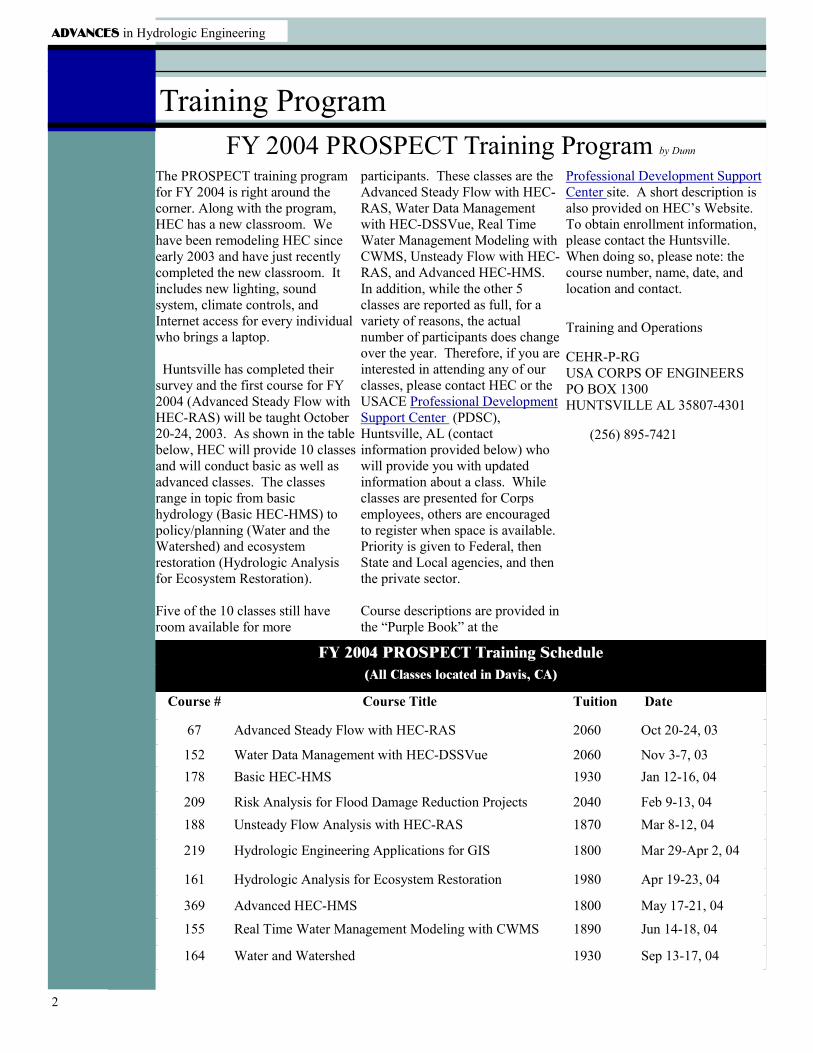
Huntsville has completed their survey and the first course for FY 2004 (Advanced Steady Flow with HEC-RAS) will be taught October 20-24, 2003. As shown in the table below, HEC will provide 10 classes and will conduct basic as well as advanced classes. The classes range in topic from basic hydrology (Basic HEC-HMS) to policy/planning (Water and the Watershed) and ecosystem restoration (Hydrologic Analysis for Ecosystem Restoration).
Five of the 10 classes still have room available for more
participants. These classes are the Advanced Steady Flow with HEC-RAS, Water Data Management with HEC-DSSVue, Real Time Water Management Modeling with CWMS, Unsteady Flow with HEC-RAS, and Advanced HEC-HMS. In addition, while the other 5 classes are reported as full, for a variety of reasons, the actual number of participants does change over the year. Therefore, if you are interested in attending any of our classes, please contact HEC or the USACE Professional Development Support Center (PDSC), Huntsville, AL (contact information provided below) who will provide you with updated information about a class. While classes are presented for Corps employees, others are encouraged to register when space is available. Priority is given to Federal, then State and Local agencies, and then the private sector.
Course descriptions are provided in the “Purple Book” at the
Professional Development Support Center site. A short description is also provided on HEC’s Website. To obtain enrollment information, please contact the Huntsville. When doing so, please note: the course number, name, date, and location and contact.
Training and Operations
CEHR-P-RG USA CORPS OF ENGINEERS PO BOX 1300 HUNTSVILLE AL 35807-4301
(256) 895-7421
FY 2004 PROSPECT Training Schedule (All Classes located in Davis, CA)
Course # Course Title Tuition Date
67 Advanced Steady Flow with HEC-RAS 2060 Oct 20-24, 03
152 Water Data Management with HEC-DSSVue 2060 Nov 3-7, 03 178 Basic HEC-HMS 1930 Jan 12-16, 04
209 Risk Analysis for Flood Damage Reduction Projects 2040 Feb 9-13, 04 188 Unsteady Flow Analysis with HEC-RAS 1870 Mar 8-12, 04
219 Hydrologic Engineering Applications for GIS 1800 Mar 29-Apr 2, 04
161 Hydrologic Analysis for Ecosystem Restoration 1980 Apr 19-23, 04
369 Advanced HEC-HMS 1800 May 17-21, 04
155 Real Time Water Management Modeling with CWMS 1890 Jun 14-18, 04
164 Water and Watershed 1930 Sep 13-17, 04
2
Summer 2003
Publications Obtaining HEC Publications by Negrete
Documents should be requested by their web site at: www.ntis.gov.Corps offices may request their HEC number/document name. publications via correspondence, Some documents are available
e-mail, fax or telephone. Our All others may order from NTIS by online and may be retrieved from contact information is located on writing to the National Technical our web site at: www.hec.usace.the last page of this newsletter. The Information Service (NTIS) at army.mil. These documents are request must include the recipient’s 5285 Port Royal Road, Springfield, available in portable document name, office symbol, mailing VA 22161, calling their sales desk format (PDF). address and telephone number. at (703) 605-6000 or by accessing
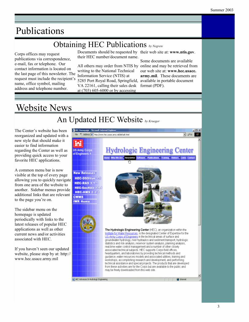
Website News An Updated HEC Website by Krueger
The Center’s website has been reorganized and updated with a new style that should make it easier to find information regarding the Center as well as providing quick access to your favorite HEC applications.
A common menu bar is now visible at the top of every page allowing you to quickly navigate from one area of the website to another. Sidebar menus provide additional links that are relevant to the page you’re on.
The sidebar menu on the homepage is updated periodically with links to the latest releases of popular HEC applications as well as other current news and/or activities associated with HEC.
If you haven’t seen our updated website, please stop by at: http:// www.hec.usace.army.mil
3
Summer 2003
Project News HEC-ResSim Reservoir Systems Models of the Sacra-
mento and San Joaquin Basins by Rosenberg
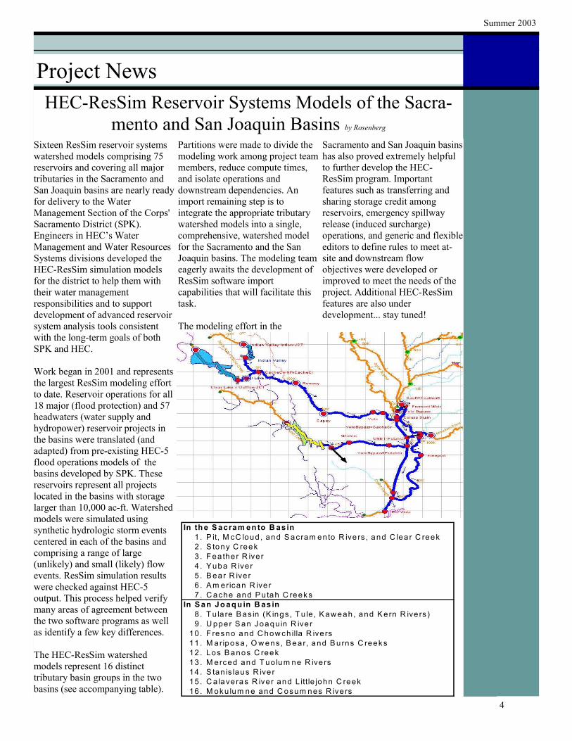
Sixteen ResSim reservoir systems watershed models comprising 75 reservoirs and covering all major tributaries in the Sacramento and San Joaquin basins are nearly ready for delivery to the Water Management Section of the Corps' Sacramento District (SPK). Engineers in HEC’s Water Management and Water Resources Systems divisions developed the HEC-ResSim simulation models for the district to help them with their water management responsibilities and to support development of advanced reservoir system analysis tools consistent with the long-term goals of both SPK and HEC.
Work began in 2001 and represents the largest ResSim modeling effort to date. Reservoir operations for all 18 major (flood protection) and 57 headwaters (water supply and hydropower) reservoir projects in the basins were translated (and adapted) from pre-existing HEC-5 flood operations models of the basins developed by SPK. These reservoirs represent all projects located in the basins with storage larger than 10,000 ac-ft. Watershed models were simulated using synthetic hydrologic storm events centered in each of the basins and comprising a range of large (unlikely) and small (likely) flow events. ResSim simulation results were checked against HEC-5 output. This process helped verify many areas of agreement between the two software programs as well as identify a few key differences.
The HEC-ResSim watershed models represent 16 distinct tributary basin groups in the two basins (see accompanying table).
Partitions were made to divide the modeling work among project team members, reduce compute times, and isolate operations and downstream dependencies. An import remaining step is to integrate the appropriate tributary watershed models into a single, comprehensive, watershed model for the Sacramento and the San Joaquin basins. The modeling team eagerly awaits the development of ResSim software import capabilities that will facilitate this task.
The modeling effort in the
Sacramento and San Joaquin basins has also proved extremely helpful to further develop the HEC-ResSim program. Important features such as transferring and sharing storage credit among reservoirs, emergency spillway release (induced surcharge) operations, and generic and flexible editors to define rules to meet at-site and downstream flow objectives were developed or improved to meet the needs of the project. Additional HEC-ResSim features are also under development... stay tuned!
In th e S acram en to B asin 1 . P it, M cC loud , and S acram en to R ive rs , and C lea r C reek 2 . S tony C reek 3 . F ea the r R iver 4 . Yuba R iver 5 . B ear R iver 6 . A m erican R ive r 7 . C ache and P utah C reek s
In S an Jo aq u in B as in 8 . T u la re B as in (K ings , T u le , K aw eah , and K ern R ive rs ) 9 . U pper S an Joaqu in R iver
10 . F resno and C how ch illa R ivers 11 . M ariposa , O w ens , B ear, and B urns C reeks 12 . Los B anos C reek 13 . M erced and T uo lum ne R ive rs 14 . S tan is laus R ive r 15 . C a lave ras R iver and L ittle john C reek 16 . M oku lum ne and C osum nes R ive rs
4
ADVANCES in Hydrologic Engineering
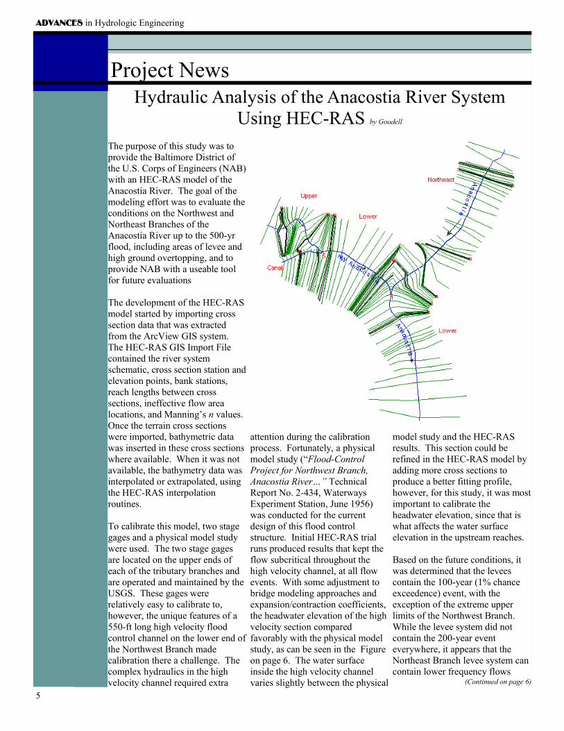
Project News Hydraulic Analysis of the Anacostia River System
Using HEC-RAS by Goodell
The purpose of this study was to provide the Baltimore District of the U.S. Corps of Engineers (NAB) with an HEC-RAS model of the Anacostia River. The goal of the modeling effort was to evaluate the conditions on the Northwest and Northeast Branches of the Anacostia River up to the 500-yr flood, including areas of levee and high ground overtopping, and to provide NAB with a useable tool for future evaluations
The development of the HEC-RAS model started by importing cross section data that was extracted from the ArcView GIS system. The HEC-RAS GIS Import File contained the river system schematic, cross section station and elevation points, bank stations, reach lengths between cross sections, ineffective flow area locations, and Manning’s n values. Once the terrain cross sections were imported, bathymetric data was inserted in these cross sections where available. When it was not available, the bathymetry data was interpolated or extrapolated, using the HEC-RAS interpolation routines.
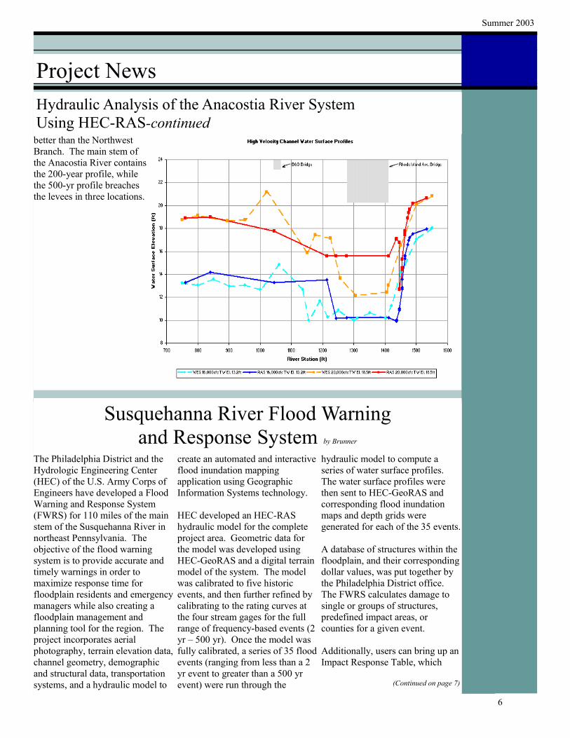
To calibrate this model, two stage gages and a physical model study were used. The two stage gages are located on the upper ends of each of the tributary branches and are operated and maintained by the USGS. These gages were relatively easy to calibrate to, however, the unique features of a 550-ft long high velocity flood control channel on the lower end of the Northwest Branch made calibration there a challenge. The complex hydraulics in the high velocity channel required extra
attention during the calibration process. Fortunately, a physical model study (“Flood-Control Project for Northwest Branch, Anacostia River…” Technical Report No. 2-434, Waterways Experiment Station, June 1956) was conducted for the current design of this flood control structure. Initial HEC-RAS trial runs produced results that kept the flow subcritical throughout the high velocity channel, at all flow events. With some adjustment to bridge modeling approaches and expansion/contraction coefficients, the headwater elevation of the high velocity section compared favorably with the physical model study, as can be seen in the Figure on page 6. The water surface inside the high velocity channel varies slightly between the physical
model study and the HEC-RAS results. This section could be refined in the HEC-RAS model by adding more cross sections to produce a better fitting profile, however, for this study, it was most important to calibrate the headwater elevation, since that is what affects the water surface elevation in the upstream reaches.
Based on the future conditions, it was determined that the levees contain the 100-year (1% chance exceedence) event, with the exception of the extreme upper limits of the Northwest Branch. While the levee system did not contain the 200-year event everywhere, it appears that the Northeast Branch levee system can contain lower frequency flows
(Continued on page 6)
5
Summer 2003
Project News Hydraulic Analysis of the Anacostia River System Using HEC-RAS-continued
better than the Northwest Branch. The main stem of the Anacostia River contains the 200-year profile, while the 500-yr profile breaches the levees in three locations.
Susquehanna River Flood Warning and Response System by Brunner
The Philadelphia District and the create an automated and interactive hydraulic model to compute a Hydrologic Engineering Center flood inundation mapping series of water surface profiles. (HEC) of the U.S. Army Corps of application using Geographic The water surface profiles were Engineers have developed a Flood Information Systems technology. then sent to HEC-GeoRAS and Warning and Response System corresponding flood inundation (FWRS) for 110 miles of the main HEC developed an HEC-RAS maps and depth grids were stem of the Susquehanna River in hydraulic model for the complete generated for each of the 35 events. northeast Pennsylvania. The project area. Geometric data for objective of the flood warning the model was developed using A database of structures within the system is to provide accurate and HEC-GeoRAS and a digital terrain floodplain, and their corresponding timely warnings in order to model of the system. The model dollar values, was put together by maximize response time for was calibrated to five historic the Philadelphia District office. floodplain residents and emergency events, and then further refined by The FWRS calculates damage to managers while also creating a calibrating to the rating curves at single or groups of structures, floodplain management and the four stream gages for the full predefined impact areas, or planning tool for the region. The range of frequency-based events (2 counties for a given event. project incorporates aerial yr – 500 yr). Once the model was photography, terrain elevation data, fully calibrated, a series of 35 flood Additionally, users can bring up an channel geometry, demographic events (ranging from less than a 2 Impact Response Table, which and structural data, transportation yr event to greater than a 500 yr systems, and a hydraulic model to event) were run through the (Continued on page 7)
6
ADVANCES in Hydrologic Engineering
Project News Susquehanna River Flood Warning And Response System -continued
contains a listing of people to contact and actions to be taken given the forecasted water surface elevations.
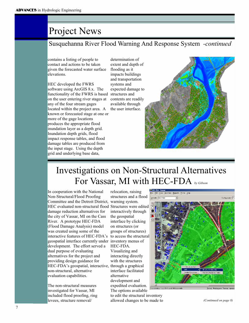
HEC developed the FWRS software using ArcGIS 8.x. The functionality of the FWRS is based on the user entering river stages at any of the four stream gages located within the project area. A known or forecasted stage at one or more of the gage locations produces the appropriate flood inundation layer as a depth grid. Inundation depth grids, flood impact response tables, and flood damage tables are produced from the input stage. Using the depth grid and underlying base data,
determination of extent and depth of flooding as it impacts buildings and transportation systems and expected damage to structures and contents are readily available through the user interface.
Investigations on Non-Structural Alternatives For Vassar, MI with HEC-FDA by Gibson
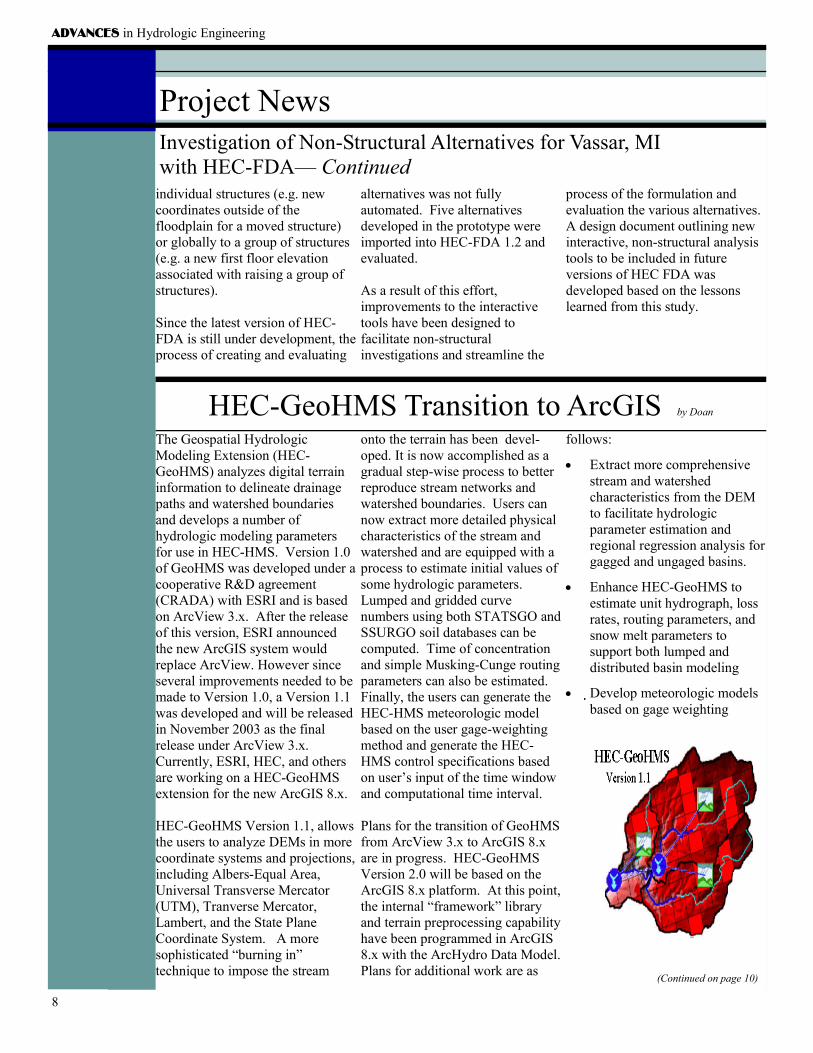
In cooperation with the National relocation, raising Non-Structural/Flood Proofing structures and a flood Committee and the Detroit District, warning system. HEC evaluated non-structural flood Structures were edited damage reduction alternatives for interactively through the city of Vassar, MI on the Cass the geospatial River. A prototype HEC-FDA interface by clicking (Flood Damage Analysis) model on structures (or was created using some of the groups of structures) interactive features of HEC-FDA’s to access the structural geospatial interface currently under inventory menus of development. The effort served a HEC-FDA. dual purpose of evaluating Visualizing and alternatives for the project and interacting directly providing design guidance for with the structures HEC-FDA’s geospatial, interactive, through a graphical non-structural, alternative interface facilitated evaluation capabilities. alternative
development and The non-structural measures expedited evaluation. investigated for Vassar, MI The options available included flood proofing, ring to edit the structural inventory levees, structure removal/ allowed changes to be made to (Continued on page 8)
7
ADVANCES in Hydrologic Engineering
Project News Investigation of Non-Structural Alternatives for Vassar, MI with HEC-FDA— Continued
individual structures (e.g. new alternatives was not fully process of the formulation and coordinates outside of the automated. Five alternatives evaluation the various alternatives. floodplain for a moved structure) developed in the prototype were A design document outlining new or globally to a group of structures imported into HEC-FDA 1.2 and interactive, non-structural analysis (e.g. a new first floor elevation evaluated. tools to be included in future associated with raising a group of versions of HEC FDA was structures). As a result of this effort, developed based on the lessons
improvements to the interactive learned from this study. Since the latest version of HEC- tools have been designed to FDA is still under development, the facilitate non-structural process of creating and evaluating investigations and streamline the
HEC-GeoHMS Transition to ArcGIS by Doan
The Geospatial Hydrologic Modeling Extension (HEC-GeoHMS) analyzes digital terrain information to delineate drainage paths and watershed boundaries and develops a number of hydrologic modeling parameters for use in HEC-HMS. Version 1.0 of GeoHMS was developed under a cooperative R&D agreement (CRADA) with ESRI and is based on ArcView 3.x. After the release of this version, ESRI announced the new ArcGIS system would replace ArcView. However since several improvements needed to be made to Version 1.0, a Version 1.1 was developed and will be released in November 2003 as the final release under ArcView 3.x. Currently, ESRI, HEC, and others are working on a HEC-GeoHMS extension for the new ArcGIS 8.x.
HEC-GeoHMS Version 1.1, allows the users to analyze DEMs in more coordinate systems and projections, including Albers-Equal Area, Universal Transverse Mercator (UTM), Tranverse Mercator, Lambert, and the State Plane Coordinate System. A more sophisticated “burning in” technique to impose the stream
onto the terrain has been devel-oped. It is now accomplished as a gradual step-wise process to better reproduce stream networks and watershed boundaries. Users can now extract more detailed physical characteristics of the stream and watershed and are equipped with a process to estimate initial values of some hydrologic parameters. Lumped and gridded curve numbers using both STATSGO and SSURGO soil databases can be computed. Time of concentration and simple Musking-Cunge routing parameters can also be estimated. Finally, the users can generate the HEC-HMS meteorologic model based on the user gage-weighting method and generate the HEC-HMS control specifications based on user’s input of the time window and computational time interval.
Plans for the transition of GeoHMS from ArcView 3.x to ArcGIS 8.x are in progress. HEC-GeoHMS Version 2.0 will be based on the ArcGIS 8.x platform. At this point, the internal “framework” library and terrain preprocessing capability have been programmed in ArcGIS 8.x with the ArcHydro Data Model. Plans for additional work are as
follows:
• Extract more comprehensive stream and watershed characteristics from the DEM to facilitate hydrologic parameter estimation and regional regression analysis for gagged and ungaged basins.
• Enhance HEC-GeoHMS to estimate unit hydrograph, loss rates, routing parameters, and snow melt parameters to support both lumped and distributed basin modeling
• Develop meteorologic models based on gage weighting
(Continued on page 10)
8
The Geospatial Hydrologic Modeling Extension (HEC-GeoHMS) analyzes digital terrain information to delineate drainage paths and watershed boundaries and develops a number of hydrologic modelingparameters for use in HEC-HMS. Version 1.0 of GeoHMS was developed under a cooperative R&D
ADVANCES in Hydrologic Engineering Summer 2003
Project News HEC-GeoHMS -continued methods supported in HEC-HMS, such as Thiessen polygon and in-verse distance. In addition HEC-GeoHMS will implement precipita-tion weighting techniques that ac-count for orographic affects.
• Users will be able to connect to HEC-DSSVue and access DSS and grid-based HEC-DSS files from GeoHMS to visualize hydrographs at gages and grid-based precipita-tion in a GIS environment. Users will be able to track both the spatial and temporal variation of precipita-tion.
• A new Digital Dozer software package, complementary to HEC-GeoHMS,
for editing grid data was devel- terrain data to better reflect the oped in ArcGIS 8.x and is cur- field conditions. Digital Dozer rently in beta testing. This exten- Will greatly facilitate development sion allows the user to edit the of the desired DEM for use by
GeoHMS.
Published Quarterly by INSTITUTE FOR WATER RESOURCES
Hydrologic Engineering Center 609 Second Street
Davis, CA 95616-4687
(530) 756-1104—Voice US Army Corps (530) 756-8250—FAX of Engineers
[email protected]—E-mail Http://www.hec.usace.army.mil—WWW
ADVANCES in Hydrologic Engineering is published quarterly as a service to the Corps of Engineers and others interested in recent accomplishments of the Center. This bulletin is published in accordance
Director’s Comments — Continued
outside the Corps will take users to a one page information summary.
Training: Training continues to rebound, with eleven PROSPECT courses and eight workshops presented in FY 2003 and ten PROSPECT courses scheduled for FY 2004. The 2004 schedule can be viewed in this Newsletter and on the HEC Website.
Technical Assistance/ Reimbursable Projects: Several reimbursable projects are featured in this newsletter. They involve the Sacramento - San Joaquin Basins (reservoir model conversions), Anacostia River System (river hydraulics), Susquehanna Basin (flood forecasting and warning), and Vassar, Michigan on the Cass River (non-structural alternatives).
Work has also begun to assist in reconstruction activities in Iraq, including development of a HEC-ResSim model of the Tigris and Euphrates Basins.
As we close out FY 2003 and begin the next year, we are looking to a similar year in terms of a challenging funding situation, growing CWMS utilization, complex project studies, and new software releases. We welcome any and all comments and views on our work and products - past and planned.
DARRYL W. DAVIS, P.E. Director
9