adjustment and transformation strategies of italpos ... · adjustment and transformation strategies...
TRANSCRIPT
181
ANNALS OF GEOPHYSICS, VOL. 52, N. 2, April 2009
Key words GNSS Permanent Network – GlobkAdjustment Strategies – Boucher-Altamimi trans-formation
1. Introduction
Nowadays a GNSS (Global NavigationSatellite Systems) permanent network is astrong instrument for people working on geo-
desy, surveying and mapping because it canprovide a significant facility for reduction interms of time and costs during a survey. In ad-dition it provides very important support forstudies and researches on crustal deformationor subsidence monitoring, etc.
Recently a new private GNSS permanentnetwork named ItalPoS (Italian Positioning Ser-vice) was set up in Italy by Leica GeosystemsItalian Division. The network is the first GNSSpermanent network at a national scale coveringthe whole territory. With more than 133 perma-nent stations uniformly distributed over the Ital-ian peninsula to date, the network, is processedand adjusted in the IGS05 reference frame bythe scientific software Gamit/Globk 10.3. Toprovide users with a complete positioning serv-
Adjustment and transformation strategies of ItalPoS Permanent
GNSS Network
Cristina Castagnetti (1), Giuseppe Casula (2), Marco Dubbini (1), Alessandro Capra (1)(1) DIMeC - Dipartimento di Ingegneria Meccanica e Civile,
Università degli Studi di Modena e Reggio Emilia, Modena, Italy(2) INGV, Istituto Nazionale di Geofisica e Vulcanologia, Bologna, Italy
AbstractA private network of 133 Global Navigation Satellite Systems (GNSS) permanent sites, named ItalPoS (ItalianPositioning Service) and uniformly covering the entire Italian territory, was established in April 2006 by the Ital-ian Division of Leica Geosystems S.p.A. This network also involves several GPS stations of the INGV (ItalianNational Institute of Geophysics and Volcanology) RING (Real-time Integrated National Gps) network and GPSstations from other public and private bodies. Indeed Leica Geosystems contributed with its experience and itsproducts to these networks which currently fulfil the national coverage where there are no ItalPoS stations. Forinstance, the purpose of the ItalPoS network is mainly GNSS data distribution in terms of real time correctionsand RINEX files for the post-processing.In order to compute and distribute to private and scientific users a set of adjusted coordinates of the ItalPoS net-work in the IGS05 and ETRF89-2000 reference frames, a dataset of RINEX of about 120 GPS permanent siteswas created and processed, using the distributed sessions approach, by means of Gamit/Globk 10.3 GPS dataprocessor, also using some SOPAC (Scripps Orbits and Permanent Array Center) and EUREF (European Per-manent Network) solutions to improve the reference frame definition and the internal constraints.This paper describes all the strategies adopted to estimate coordinates and velocities of the ItalPoS Network inIGS05 and in ETRF89-2000 reference frames in the whole Italian territory.
Mailing address: Dr. Cristina Castagnetti, DIMeC -Dipartimento di Ingegneria Meccanica e Civile, Universitàdegli Studi di Modena e Reggio Emilia, Via Vignolese 905,41125 Modena; e-mail: [email protected]
Vol52,2,2009 12-06-2009 9:44 Pagina 181
182
C. Castagnetti, G. Casula, M. Dubbini and A. Capra
ice, transformation parameters from the net-work reference frame, IGS05, to the Italian ref-erence frame, IGM95-ETRF89, were estimat-ed. This task is requested by users that need tohave results in the official reference frameIGM95 that is the Italian realization of the Eu-ropean ETRF89.
Due to Italian morphology and its differen-tial deformations, and in consideration of errorpropagation of IGM95 solution, the whole ter-ritory was intentionally divided into threemacro areas to optimize the transformation es-timation. Both processing, adjustment networkstrategies and transformation parameters esti-mation will be described below, focusing on thedifferent approaches tested for transformationand on the final choice reasons.
2. Structure of the ItalPoS permanent network
About a year ago the Italian division of Le-ica Geosystems S.p.A built the first privateGNSS permanent network at a national scale inItaly. This GNSS Network, named ItalPoS (Ital-ian Positioning Service), consists of a privatepermanent network uniformly covering thewhole Italian territory. The purpose of this net-work is GNSS data distribution in terms of realtime corrections (RTK by means of RTCM 2and 3 protocols) and RINEX files and META-DATA for post-processing. The project was de-veloped in collaboration with many Universi-ties and Research Institutes, which contributedand are still contributing to the network devel-opment, improvement and publication. The net-work structure is made of several high qualityGNSS reference stations. Some of them werematerialized some years ago and are still man-aged by the INGV, responsible for the RINGpermanent network. RING is the largest GNSSmonitoring network in terms of extension at na-tional scale (Selvaggi and RING WorkingGroup, 2006). Its purpose is purely scientificand geodetic considering that it does not pro-vide any services for customers. Many stationshave Leica Geosystems instruments. MoreoverItalPoS also involves several GPS stations fromother public networks such as Puglia, Tuscany
and Veneto Regions, Province of Cagliari, Au-tonomous Province of Bolzano Catasto fondi-ario e urbano, Autonomous Province of TrentoServizio Catasto, Province of Perugia CollegioGeometri. Indeed Leica Geosystems con-tributed with its experience and its products tothese networks which nowadays fulfil the na-tional coverage where there are no ItalPoS sta-tions.
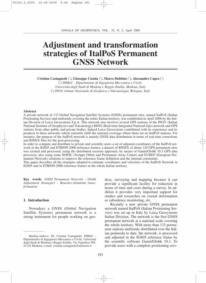
ItalPoS network, currently composed ofmore than 133 permanent stations distributedthroughout the Italian peninsula (fig. 1), aimsto provide customers with a service both in re-al time and in post-processing. GNSS data areavailable without charge concerning the realtime corrections provided by the nearest sta-tion. In addition, ItalPoS provides a servicewith fee distributing RINEX data for post-pro-cessing and real time area corrections. More-over, more precise and stable results are al-lowed because the real time corrections can betransmitted not only from the nearest stationbut from several stations in the clusters the net-work is suitably split off. The real time serviceis based on the approach called MAX, Master-Auxiliary (Leica Geosystems, 2005): the datacentre provides user with both coordinates andcorrections from the nearest station (master)and coordinates and corrections from the otherstations (auxiliary) making part of the clusterthe user is included in. Thanks to this informa-tion, the user receiver develops a spatial errorsmodel, builds the double differences with themaster station, makes a correction by means ofthe errors model and performs a position esti-mation. In the near future, the user receiverwill be able to build a multi-base double differ-ences system for each station in the cluster(without distinction between master and auxil-iary stations) and to provide errors and positionmulti-base estimation.
Thanks to ItalPoS, a user with a single re-ceiver, rover, can access services supplied by asimple GSM (Global System for Mobile Com-munications) or GPRS (General Packet RadioService) connection. As a consequence the usercan reduce the time and costs of the work andgain satisfaction with every kind of surveywithout any further difficulties caused by coor-dinates transformation and geo-referring. At the
Vol52,2,2009 12-06-2009 9:44 Pagina 182
183
Adjustment and transformation strategies of ItalPoS Permanent GNSS Network
adjustment and transformation estimation time,the Italian official reference frame was IGM95,the Italian realization of the European referenceframe, ETRF89 (Boucher and Altamimi, 1992).As a consequence, ItalPos distributes coordi-nates in IGM95 reference frame. Currently, anew official reference frame has been intro-duced by the Istituto Geografico Militare Ital-iano (IGMI), the ETRF2000. However, a transi-
tion period is necessary, so that the results pro-vided in this paper both for stations coordinatesand transformation parameters still refer toIGM95-ETRF89.
The network was processed and adjusted inthe IGS05 reference frame (Biagi et al., 2008).Transformation parameters were subsequentlyprovided to users to have results in the officialItalian reference frame, IGM95-ETRF89.
Fig. 1. ItalPoS permanent network: a general map of the network with all the stations involved (both ItalPoSand RING ones).
Vol52,2,2009 12-06-2009 9:44 Pagina 183
184
C. Castagnetti, G. Casula, M. Dubbini and A. Capra
3. GPS data processing and adjustment strategies
In order to compute a set of coordinates ofthe described ItalPoS network in the IGS05 ref-erence frame, an array of about 120 GPS PSsmaintained by different institutions (INGV, EU-REF, ASI, LEICA GEOSYSTEMS and so on)
was processed by means of the softwareGamit/Globk version 10.3 (Herring et al.,2006a,b) developed at the CfA (Harvard Smit-sonian Center of Astrophysics) of MIT (Massa-chusetts Institute of Technology) and at the SIO(Scripps Institution of Oceanography), Univer-sity of California (San Diego).
Data were archived on electronic magnetic
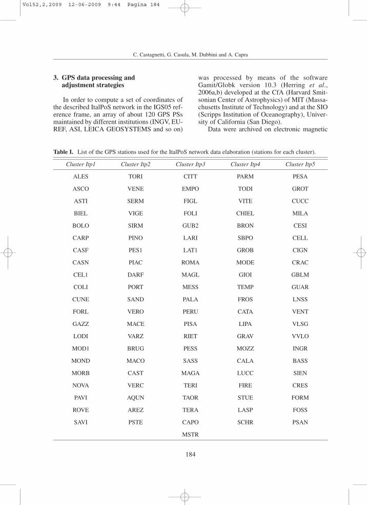
Table I. List of the GPS stations used for the ItalPoS network data elaboration (stations for each cluster).
Cluster Itp1 Cluster Itp2 Cluster Itp3 Cluster Itp4 Cluster Itp5
ALES TORI CITT PARM PESA
ASCO VENE EMPO TODI GROT
ASTI SERM FIGL VITE CUCC
BIEL VIGE FOLI CHIEL MILA
BOLO SIRM GUB2 BRON CESI
CARP PINO LARI SBPO CELL
CASF PES1 LAT1 GROB CIGN
CASN PIAC ROMA MODE CRAC
CEL1 DARF MAGL GIOI GBLM
COLI PORT MESS TEMP GUAR
CUNE SAND PALA FROS LNSS
FORL VERO PERU CATA VENT
GAZZ MACE PISA LIPA VLSG
LODI VARZ RIET GRAV VVLO
MOD1 BRUG PESS MOZZ INGR
MOND MACO SASS CALA BASS
MORB CAST MAGA LUCC SIEN
NOVA VERC TERI FIRE CRES
PAVI AQUN TAOR STUE FORM
ROVE AREZ TERA LASP FOSS
SAVI PSTE CAPO SCHR PSAN
MSTR
Vol52,2,2009 12-06-2009 9:44 Pagina 184
185
Adjustment and transformation strategies of ItalPoS Permanent GNSS Network
supports by means of an automatic procedurewith the aid of scripts of the Unix bourne shelland FORTRAN appropriately implemented andrunning on a Intel Quad-Core Workstation, suit-ably projected and assembled for this task, un-der Linux OpenSuse 11 Operative System (OS).
A multistep procedure was applied based onthe distributed sessions approach (Dong et al.,1998; Serpelloni et al., 2006; Casula et al.,2007): the network was divided into five clus-ters (see table I); then in the first step the GPSdata over one month time span (October-No-vember 2007) were processed by means ofGamit software to obtain five daily observationsolutions (Gamit h-files). For the sake of com-patibility with the SOPAC clustering we ap-plied the same processing setup used bySOPAC: we used precise IGS orbits and EarthOrientation Parameters (EOP) tightly con-strained as indicated in the sestbl. processingfile suggested by SOPAC for Gamit 10.3 solu-tion of regional clusters. The ambiguity resolu-tion was performed with the aid of theLC_AUTCLN procedure which uses the Mel-bourne-Wübbena wide lane (WL) linear combi-nation to resolve double difference ambiguities.In the second step the solutions of the ItalPoSnetwork clusters were format converted andcombined with some of the h-files of theScripps Orbit and Permanent Array Center(SOPAC 2008, http://www.sopac.edu) regionalclusters. A set of unified combined h-files wascreated by means of the glred processor of theGlobk package using the robust combinationcriteria described in Dong et al., 1998; Herringet al., 2006a,b.
At this stage of the analysis a referenceframe of the solution had to be defined (stabili-sation) by means of the Glorg module of theGlobk package simply by minimising the devi-ations between horizontal positions and veloci-ties of our solutions and those given in an a-pri-ori reference station file (Herring et al., 2006b).
The final step consisted of the stabilisationof the ItalPoS network sites by geo-referringthem in the IGS05 reference frame and in theETRF89-2000 one by means of the known po-sitions and velocities data of a set of referencestations, statistically stable, (called fiducial sta-tions): BOR1, BRUS, CAGL, GLSV, GRAS,
HOFN, JOZE, MATE, METS, NICO, NOT1,NYA1, NYAL, ONSA, POLV, POTS, RABT,RAMO, REYK, SFER, TRAB TRO1 VILLWSRT WTZR ZIMM; as indicated by EUREFfor the definition of IGS05 reference frame fordata processed after November 2006. The posi-tions and velocities of these fiducial stationswhich were included in the computation are ex-tracted from EUREF facility combined solu-tions (Bruyninx, 2004; Kenyeres and Bruyninx2004).
To account for the consistency of the refer-ence frame definition and stability of our solu-tion we computed by means of the Tform pro-gram of the Globk package, for about 30 refer-ence sites, the residuals between the coordi-nates and velocities estimated in our solutionsand the ones computed by EUREF at the sameepoch; the results of this operation are shown intable II.
Then a set of adjusted coordinates in theERTF2000 reference frame at epoch 1989.0were computed for a time span of one month bymeans of the Glorg program of Globk and theETRF2000 values of the fiducial sites coordi-nates and velocities made available by EUREFfacility (see also table VIII).
4. Reference frame transformation parameters
To provide users with a complete position-ing service, transformation parameters from thenetwork reference frame, IGS05, to the Italianreference frame, IGM95-ETRF89, were esti-mated. This is requested by those users whoneed to have results in the official referenceframe IGM95.
Thinking about Italian morphology and itsdifferential deformations, and in considerationof error propagation of IGM95 solution, thewhole territory was intentionally divided intothree macro areas to optimize the transforma-tion estimation. A IGS05-IGM95 transforma-tion was estimated and a parameters set provid-ed to customers for each area. First of all, sev-eral sets of parameters were estimated bymeans of different strategies to test multiple re-sults and make comparisons to find the best so-
Vol52,2,2009 12-06-2009 9:44 Pagina 185
186
C. Castagnetti, G. Casula, M. Dubbini and A. Capra
lution. This aims to optimize the transformationand choose a unique set of parameters for eacharea. The following section compares differentapproaches and discusses parameters results foreach specific area.
The first step was to find the best methodol-ogy to estimate the parameters. Two approach-es were investigated.
The first is a regional adaptation of the in-ternational transformations between ITRF05(Altamimi et al., 2007) and ETRF89 (Boucherand Altamimi, 2007). In detail the well-estab-lished Boucher-Altamimi transformation (in thefollowing BA), that is a rigid combination ofrotation and translation where the rotation is as-signed for Europe and the translation dependson the geodynamic velocity of the site. Theadaptation at the interest area (parts of Italy) re-quires some approximations (IGS05�ITRF05and IGM95�ETRF89) and the estimation of amean velocity unique for the area. The Bouch-er-Altamimi transformation equation at thegeneric time are reported below:
(4.1)
where X represents the coordinates vector, T thetranslation vector and R the rotation matrix, re-spectively.
The second is well known Helmert transfor-mation (Watson, 2006; Capra and Costantino,2007) characterised by 7 parameters (three ro-tations, three translations and one scale factor)which are estimated by means of a least squaresprocess based on a series of points with coordi-nates known both in IGS05 and IGM95. It is
;
.
.
.
;
.
.
.
.
.
.
X
X
Y
Z
T
T
T
T
m
R R
R
R
R
R
R
masy
0 056
0 048
0 037
0
0
0
0
0 781
0 518
0781
0
0 054
0 518
0 054
0
sdr
x
y
z
z
y
z
x
y
x
= = =-
=-
-- =
= --
-
o o
o
o
o
o
o
R
T
SSSS
> > >
>
V
X
WWWW
H H H
H
1989.0 1989.0
1989.0
X T X
R X X
89 05
05 89
E I
I E$ $ $
$τ τ
τ τ
= + + -
+ -o o
] ] ]
] ]
g g g
g g
very important that these points are distributedas homogeneously as possible in the area of in-terest. The TRASFO v. 1.0 software (Calderaand Visconti, 2006) was used to adjust in theleast square sense the 7 parameters from thedouble sets of coordinates. Below we representthe IGS05-ETRF89 Helmert transformationequation with seven parameters:
(4.2)
where X represents the coordinates vector, T thetranslation vector, k the scale factor and R therotation matrix, respectively.
Taking into account the data availability thetransformation was implemented starting fromthe Northern Italian area. In this case bothmethodologies were taken into account andtested. As shown in Section 4.1, of the adoptedmethods the BA transformation one providesthe best results, for this reason we chose this ap-proach. According to this assumption and in theconsistency point of view, only the BA type oftransformation was tested for the Central andthe Southern Italian areas.
With respect to the Boucher-Altamimi ap-proach, two main options are investigated depend-ing on the mean velocity assigned to the area.
In the first a mean velocity is obtained bymeans of the weighted average of the ETRS89velocities published for the IGS permanent sta-tions (PSs) located all around the area of interest.We adopted as weight for the velocity the inverseof the distance of each IGS PS chosen for the es-timation with respect to their barycentre.
In the second, the velocity is obtained thanksto the weighted average of the ETRS89 veloci-ties (Boucher and Altamimi, 1992) published forthe IGS permanent stations (PSs) located allaround the area of interest. The weight for veloc-ities depends on the inverse of the distance foreach IGS PS with respect to the barycentre of theItalPoS PSs distributed in the area of interest.
The parameters were chosen by taking intoaccount the most effective residuals minimiza-tion, following this philosophy: for each area, all
; ; ; ;X
X
Y
Z
T
T
T
T
k R R
R
R
R
R
R
1
1
1
sdr
x
y
z
z
y
z
x
y
x= = = --
-R
T
SSSS
> >
V
X
WWWW
H H
1X T k R X89 05E I$ $= + +] g
Vol52,2,2009 12-06-2009 9:44 Pagina 186
187
Adjustment and transformation strategies of ItalPoS Permanent GNSS Network
the estimated parameters sets were applied to aseries of test surveys carried out almost in all theItalian Regions. The purpose was to check theparameters reliability and to suggest the bestones for the final transformation, to transformsite coordinates from the IGS05 reference frameto the national one (the IGM95-ETRF89). Thetest surveys, carried out by means of severalGPS receivers, had to simulate the customer’sbehaviour during his work, like for example thepositioning of any unknown point. At the sametime two more GPS receivers were tracking be-ing placed on two benchmarks belonging to theIGM95 Italian geodetic network. These bench-marks are fixed points, with known coordinatesboth in horizontal position and height. At the
end of the survey, the first step was the post-pro-cessing of the unknown point with respect to theIGM95 benchmarks constrained using the val-ues of the coordinates provided by Istituto Ge-ografico Militare Italiano (IGMI). At this stagethe IGM95-ETRF89 coordinates of the point ofinterest were estimated; these were used as ref-erence values to test the quality of the transfor-mation parameters. In a second step, the post-processing of the unknown point was performedwith respect to some ItalPoS PSs (no more thantwo or three) located near the point and con-strained by means of their coordinates, providedby the adjustment with Gamit/Globk (see Sec-tion 3). At this stage the IGS05 coordinates ofthe point of interest were estimated. All the pa-
Table II. Results of the comparison between the IGS05 coordinates of reference sites computed by the EUREFanalysis centres with the Bernese 5.0 sw (epoch 2007.795) and those estimated in our solution by means of theGlobk sw (epoch 2007.860). Rows in bold type underline residuals of the Italian GNSS sites.
PS ∆X[cm] ∆Y[cm] ∆Z[cm] PS ∆X[cm] ∆Y[cm] ∆Z[cm]
VILL 0.60 0.00 0.50 ZOUF -0.20 0.10 0.20
SFER 0.30 0.00 0.30 WTZR -0.30 0.10 -0.20
RABT 0.30 0.10 0.40 ONSA -0.40 0.10 -0.10
HOFN -0.10 -0.20 -0.10 NYA1 -0.10 -0.20 0.40
REYK 0.00 -0.30 0.50 PRAT -0.10 0.10 0.20
TRAB -0.70 -0.10 -0.10 ELBA -0.10 0.20 0.00
RAMO -0.70 -0.30 -0.30 COMO -0.20 0.00 0.10
GLSV -0.60 -0.30 -0.30 CAGL -0.10 0.00 -0.10
METS -0.40 -0.10 -0.30 ZIMM -0.30 0.00 -0.10
JOZE -0.10 0.00 0.30 GRAS -0.10 0.00 0.20
TRO1 0.80 0.20 2.90 WSRT -0.30 0.10 0.10
BOR1 -0.10 0.20 0.20 BRUS -0.10 0.10 0.20
MATE -0.50 0.00 -0.30 M0SE -0.10 0.20 0.00
GRAZ -0.30 0.00 -0.10 MOPS 0.00 0.10 0.00
NOT1 -0.10 0.10 0.00 ROVE -0.20 0.10 0.00
POTS -0.40 0.00 -0.20 TORI -0.20 0.10 -0.10
Vol52,2,2009 12-06-2009 9:44 Pagina 187
188
C. Castagnetti, G. Casula, M. Dubbini and A. Capra
rameters of transformation estimated were ap-plied to the IGS05 coordinates to obtain theIGM95-ETRF89 transformed coordinates. Thelast step was the comparison between theIGM95-ETRF89 reference coordinates and theIGM95-ETRF89 coordinates transformed fromthe IGS05.
The differences in the comparison have tobe as small as possible; the purpose is to haveresiduals lower than the IGM95 network nomi-nal accuracy that is 5 cm in horizontal positionand 10 cm in height.
4.1. Estimation of ItalPoS Network Transfor-mation parameters
Taking into account the data availability, thetransformation estimation started from the
Northern cluster (including all the Regions inthe North of Italy: Val D’Aosta, Piedmont, Lig-uria, Lombardy, Veneto, Trentino Alto Adige,Friuli Venezia Giulia, Emilia Romagna). In thiscase six parameter sets were calculated, appliedto the IGS05 coordinates and finally comparedwith the IGM95-ETRF89 reference coordinatesto reach the best final solution. Both themethodologies, the BA and the Helmert trans-formation, were investigated.
Concerning the Helmert transformation,many points with coordinates known both inthe IGS05 and in the IGM95-ETRF89 wereavailable. Some of them come from the Politec-nico of Torino GNSS permanent network andothers were provided by Leica Geosystems (fig.2). At first sight the North area seemed verylarge so it was divided into two: the North-Eastwhere the Leica Geosystems points were used
Fig. 2. Northern Italy cluster: points known both in the IGS05 and in the IGM95-ETRF89, used for the trans-formation tests. Circular icons: points for the North-East transformation. Triangle-shaped icons: points for theNorth-West transformation.
Vol52,2,2009 12-06-2009 9:44 Pagina 188
189
Adjustment and transformation strategies of ItalPoS Permanent GNSS Network
for the transformation estimation (there were 15points available for this area: 8 were used tofind out transformation parameters while theother 7 as control points) and the North-Westwhere the Politecnico of Torino points wereused (in this case only 7 points were availableso that 4 were used to estimate parameters and3 to check results). At this step two parametersets were available with the Helmert approach,according to the area dimension and the pointsdistribution: the North-East and the North-Westones respectively.
Concerning the BA type of transformation,a further four sets were calculated depending onthe mean velocity attributed to the area:
- ETRS89 velocity published for the IGS PSof Padua (PADO);
- ETRS89 velocity published for the IGS PSof Turin (IENG);
- Velocity calculated by a weighted averageof the ETRS89 velocities published for a set ofIGS PSs distributed in the Northern area (PA-DO, GRAS, GRAZ, ZIMJ, GENO, IENG,HFLK). Each of these velocities was weightedusing the inverse distance of the specific IGSPS with respect to their barycentre.
- Velocity calculated by a weighted averageof the ETRS89 velocities published for the IGSPSs distributed in the Northern area (PADO,GRAS, GRAZ, ZIMJ, GENO, IENG, HFLK).Each of these velocities was weighted by the in-verse distance of the specific IGS PS with re-spect to the barycentre of all the ItalPoS PSs in-cluded in the Northern Italian area (the PSs tak-en into account were only those operating at thetime of the first adjustment, September 2007).
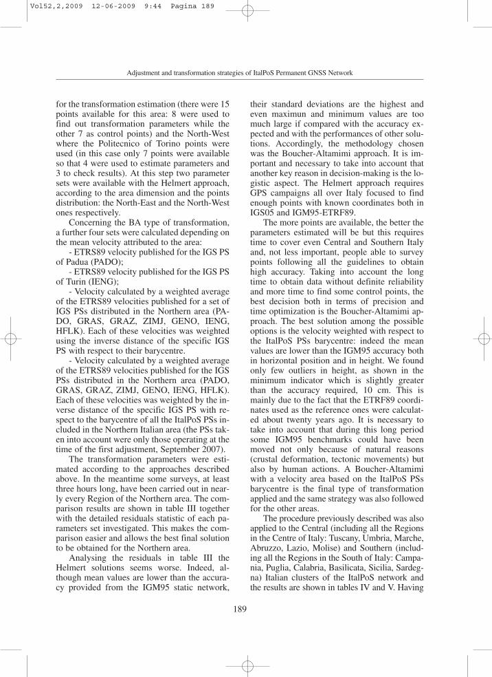
The transformation parameters were esti-mated according to the approaches describedabove. In the meantime some surveys, at leastthree hours long, have been carried out in near-ly every Region of the Northern area. The com-parison results are shown in table III togetherwith the detailed residuals statistic of each pa-rameters set investigated. This makes the com-parison easier and allows the best final solutionto be obtained for the Northern area.
Analysing the residuals in table III theHelmert solutions seems worse. Indeed, al-though mean values are lower than the accura-cy provided from the IGM95 static network,
their standard deviations are the highest andeven maximun and minimum values are toomuch large if compared with the accuracy ex-pected and with the performances of other solu-tions. Accordingly, the methodology chosenwas the Boucher-Altamimi approach. It is im-portant and necessary to take into account thatanother key reason in decision-making is the lo-gistic aspect. The Helmert approach requiresGPS campaigns all over Italy focused to findenough points with known coordinates both inIGS05 and IGM95-ETRF89.
The more points are available, the better theparameters estimated will be but this requirestime to cover even Central and Southern Italyand, not less important, people able to surveypoints following all the guidelines to obtainhigh accuracy. Taking into account the longtime to obtain data without definite reliabilityand more time to find some control points, thebest decision both in terms of precision andtime optimization is the Boucher-Altamimi ap-proach. The best solution among the possibleoptions is the velocity weighted with respect tothe ItalPoS PSs barycentre: indeed the meanvalues are lower than the IGM95 accuracy bothin horizontal position and in height. We foundonly few outliers in height, as shown in theminimum indicator which is slightly greaterthan the accuracy required, 10 cm. This ismainly due to the fact that the ETRF89 coordi-nates used as the reference ones were calculat-ed about twenty years ago. It is necessary totake into account that during this long periodsome IGM95 benchmarks could have beenmoved not only because of natural reasons(crustal deformation, tectonic movements) butalso by human actions. A Boucher-Altamimiwith a velocity area based on the ItalPoS PSsbarycentre is the final type of transformationapplied and the same strategy was also followedfor the other areas.
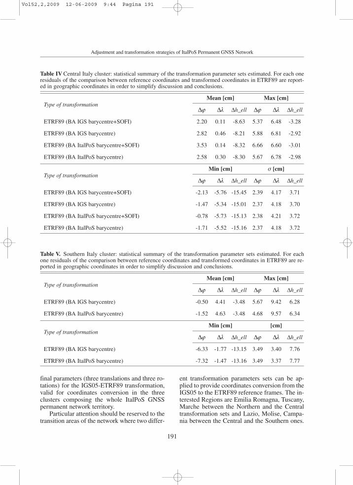
The procedure previously described was alsoapplied to the Central (including all the Regionsin the Centre of Italy: Tuscany, Umbria, Marche,Abruzzo, Lazio, Molise) and Southern (includ-ing all the Regions in the South of Italy: Campa-nia, Puglia, Calabria, Basilicata, Sicilia, Sardeg-na) Italian clusters of the ItalPoS network andthe results are shown in tables IV and V. Having
Vol52,2,2009 12-06-2009 9:44 Pagina 189
190
C. Castagnetti, G. Casula, M. Dubbini and A. Capra
fixed the Boucher-Altamimi type of transforma-tion, several velocity options were taken into ac-count, just to be sure that the ItalPoS barycentresolution was the best one. Central and SouthernItaly have a very low number of IGS sites, so thechoice is very limited. Nevertheless the best andmost uniform distribution all around the clusterwas chosen also depending on the data availabil-ity. Concerning the Central cluster, there are twoconfigurations for the IGS PSs taken into ac-count to find the mean velocity for the area:GENO, CAGL, MATE and SOFI or GENO,CAGL and MATE. In the North direction MEDIwas not working so that GENO was chosen. Theuse of SOFI for the East direction was investigat-ed. Both the weighting strategy with respect tothe IGS PSs barycentre or the ItalPoS PSs were
tested. Residual statistic indicators are shown intable IV.
Concerning the Southern cluster, the IGSPSs taken into account to find the mean veloci-ty for the area are: GENO, CAGL, MATE,NOT1 and LAMP. Also in this case MEDI rinexdata were not available. Both the weightingstrategies with respect to the IGS PSs barycen-tre or the ItalPoS PSs were tested and the resid-ual statistic indicators are shown in table V.
Even in Central and Southern areas the bestsolution was the Boucher-Altamimi transforma-tion with the velocities weighted adopting theItalPoS PSs barycentre strategy previously de-scribed. The mean residuals were always lowerthan the IGM95 accuracy so that transformationparameters are successful. Table VI reports the
Table III. Northern Italy cluster: statistical summary of the transformation parameter sets estimated. For eachone residuals of the comparison between reference coordinates and transformed coordinates in ETRF8 frame arereported in geographic coordinates in order to simplify discussion and conclusions.
Type of transformationMean [cm] Max [cm]
∆ϕ ∆λ ∆h_ell ∆ϕ ∆λ ∆h_ell
ETRF89 (BA PADO) 0.32 0.04 1.64 4.50 4.40 11.90
ETRF89 (BA IENG) 4.56 -0.42 -4.48 8.60 3.40 5.90
ETRF89 (BA IGS barycentre) 2.62 -0.54 -1.96 6.80 3.50 8.30
ETRF89 (BA ItalPoS barycentre) 2.90 -0.54 -1.98 7.00 3.40 8.30
ETRF89 (North-West) -1.36 -4.30 -7.62 2.20 6.70 2.10
ETRF89 (North-East) -0.02 1.68 0.86 3.00 10.40 13.80
Type of transformationMin [cm] σ [cm]
∆ϕ ∆λ ∆h_ell ∆ϕ ∆λ ∆h_ell
ETRF89 (BA PADO) -2.10 -3.40 -9.90 2.45 2.88 8.93
ETRF89 (BA IENG) 2.30 -3.90 -16.00 2.37 2.80 8.96
ETRF89 (BA IGS barycentre) 0.30 -4.00 -13.50 2.43 2.83 8.96
ETRF89 (BA ItalPoS barycentre) 0.50 -3.90 -13.50 2.40 2.75 8.95
ETRF89 (North-West) -7.00 -12.30 -19.90 3.24 6.35 9.28
ETRF89 (North-East) -3.60 -2.90 -11.10 2.34 4.67 8.76
Vol52,2,2009 12-06-2009 9:44 Pagina 190
191
Adjustment and transformation strategies of ItalPoS Permanent GNSS Network
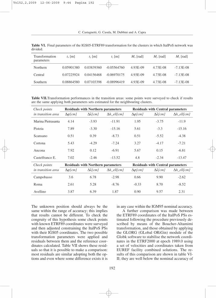
final parameters (three translations and three ro-tations) for the IGS05-ETRF89 transformation,valid for coordinates conversion in the threeclusters composing the whole ItalPoS GNSSpermanent network territory.
Particular attention should be reserved to thetransition areas of the network where two differ-
ent transformation parameters sets can be ap-plied to provide coordinates conversion from theIGS05 to the ETRF89 reference frames. The in-terested Regions are Emilia Romagna, Tuscany,Marche between the Northern and the Centraltransformation sets and Lazio, Molise, Campa-nia between the Central and the Southern ones.
Table IV Central Italy cluster: statistical summary of the transformation parameter sets estimated. For each oneresiduals of the comparison between reference coordinates and transformed coordinates in ETRF89 are report-ed in geographic coordinates in order to simplify discussion and conclusions.
Type of transformationMean [cm] Max [cm]
∆ϕ ∆λ ∆h_ell ∆ϕ ∆λ ∆h_ell
ETRF89 (BA IGS barycentre+SOFI) 2.20 0.11 -8.63 5.37 6.48 -3.28
ETRF89 (BA IGS barycentre) 2.82 0.46 -8.21 5.88 6.81 -2.92
ETRF89 (BA ItalPoS barycentre+SOFI) 3.53 0.14 -8.32 6.66 6.60 -3.01
ETRF89 (BA ItalPoS barycentre) 2.58 0.30 -8.30 5.67 6.78 -2.98
Type of transformationMin [cm] σ [cm]
∆ϕ ∆λ ∆h_ell ∆ϕ ∆λ ∆h_ell
ETRF89 (BA IGS barycentre+SOFI) -2.13 -5.76 -15.45 2.39 4.17 3.71
ETRF89 (BA IGS barycentre) -1.47 -5.34 -15.01 2.37 4.18 3.70
ETRF89 (BA ItalPoS barycentre+SOFI) -0.78 -5.73 -15.13 2.38 4.21 3.72
ETRF89 (BA ItalPoS barycentre) -1.71 -5.52 -15.16 2.37 4.18 3.72
Table V. Southern Italy cluster: statistical summary of the transformation parameter sets estimated. For eachone residuals of the comparison between reference coordinates and transformed coordinates in ETRF89 are re-ported in geographic coordinates in order to simplify discussion and conclusions.
Type of transformationMean [cm] Max [cm]
∆ϕ ∆λ ∆h_ell ∆ϕ ∆λ ∆h_ell
ETRF89 (BA IGS barycentre) -0.50 4.41 -3.48 5.67 9.42 6.28
ETRF89 (BA ItalPoS barycentre) -1.52 4.63 -3.48 4.68 9.57 6.34
Type of transformationMin [cm] [cm]
∆ϕ ∆λ ∆h_ell ∆ϕ ∆λ ∆h_ell
ETRF89 (BA IGS barycentre) -6.33 -1.77 -13.15 3.49 3.40 7.76
ETRF89 (BA ItalPoS barycentre) -7.32 -1.47 -13.16 3.49 3.37 7.77
Vol52,2,2009 12-06-2009 9:44 Pagina 191
192
C. Castagnetti, G. Casula, M. Dubbini and A. Capra
The unknown position should always be thesame within the range of accuracy; this impliesthat results cannot be different. To check thecongruity of this hypothesis some check pointswith known ETRF89 coordinates were surveyedand then adjusted constraining the ItalPoS PSswith their IGS05 coordinates. The two possibletransformation parameters were applied andresiduals between them and the reference coor-dinates calculated. Table VII shows these resid-uals so that it is possible to make a comparison:most residuals are similar adopting both the op-tions and even where some difference exists it is
in any case within the IGM95 nominal accuracy.A further comparison was made between
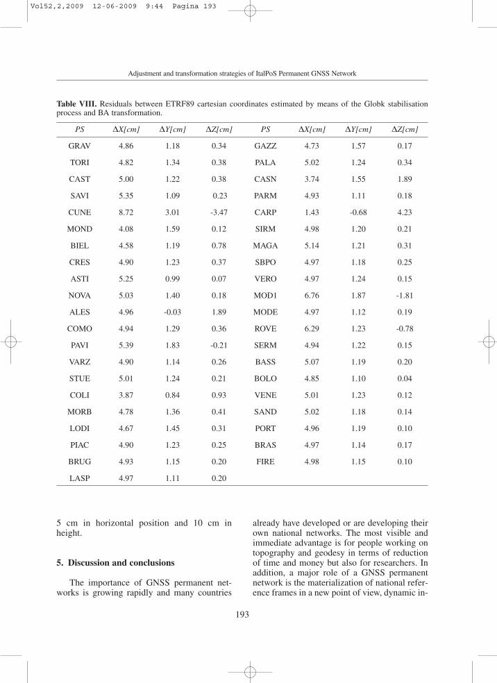
the ETRF89 coordinates of the ItalPoS PSs es-timated following the procedure previously de-scribed by means of the Boucher-Altamimitransformation, and those obtained by applyingthe GLORG (GLobal ORiGin) module of theGlobk software to stabilise the network coordi-nates in the ETRF2000 at epoch 1989.0 usinga set of velocities and coordinates taken fromEUREF facility combined solutions. The re-sults of this comparison are shown in table VI-II; they are well below the nominal accuracy of
Table VI. Final parameters of the IGS05-ETRF89 transformation for the clusters in which ItalPoS network wasdivided.
Transformation tx [m] ty [m] tz [m] Mx [rad] My [rad] Mz [rad]parameters
Northern 0.05901380 0.03839360 -0.05564760 4.93E-09 4.73E-08 -7.13E-08
Central 0.07225924 0.04156468 -0.06970175 4.93E-09 4.73E-08 -7.13E-08
Southern 0.08864580 0.07103398 -0.08996419 4.93E-09 4.73E-08 -7.13E-08
Table VII.Transformation performances in the transition areas: some points were surveyed to check if resultsare the same applying both parameters sets estimated for the neighbouring clusters.
Check points Residuals with Northern parameters Residuals with Central parametersin transition area ∆ϕ[cm] ∆λ[cm] ∆h_ell[cm] ∆ϕ[cm] ∆λ[cm] ∆h_ell[cm]
Marina Pietrasanta 4.14 -3.93 -11.91 1.95 -3.75 -11.9
Pistoia 7.89 -3.30 -15.16 5.61 -3.3 -15.16
Scansano 0.51 0.39 -8.73 0.51 -5.52 -4.38
Cortona 5.43 -4.29 -7.24 3.27 -4.17 -7.21
Ancona 7.92 0.12 -6.91 5.67 0.15 -6.81
Castelfranco E. 7.02 -2.46 -13.52 4.8 -2.34 -13.47
Check points Residuals with Northern parameters Residuals with Central parametersin transition area ∆ϕ[cm] ∆λ[cm] ∆h_ell[cm] ∆ϕ[cm] ∆λ[cm] ∆h_ell[cm]
Campobasso 3.6 6.78 -2.98 0.66 9.90 -2.62
Roma 2.61 5.28 -8.76 -0.33 8.70 -8.52
Avellino 3.87 6.39 1.87 0.90 9.57 2.31
Vol52,2,2009 12-06-2009 9:44 Pagina 192
193
Adjustment and transformation strategies of ItalPoS Permanent GNSS Network
5 cm in horizontal position and 10 cm inheight.
5. Discussion and conclusions
The importance of GNSS permanent net-works is growing rapidly and many countries
already have developed or are developing theirown national networks. The most visible andimmediate advantage is for people working ontopography and geodesy in terms of reductionof time and money but also for researchers. Inaddition, a major role of a GNSS permanentnetwork is the materialization of national refer-ence frames in a new point of view, dynamic in-
Table VIII. Residuals between ETRF89 cartesian coordinates estimated by means of the Globk stabilisationprocess and BA transformation.
PS ∆X[cm] ∆Y[cm] ∆Z[cm] PS ∆X[cm] ∆Y[cm] ∆Z[cm]
GRAV 4.86 1.18 0.34 GAZZ 4.73 1.57 0.17
TORI 4.82 1.34 0.38 PALA 5.02 1.24 0.34
CAST 5.00 1.22 0.38 CASN 3.74 1.55 1.89
SAVI 5.35 1.09 0.23 PARM 4.93 1.11 0.18
CUNE 8.72 3.01 -3.47 CARP 1.43 -0.68 4.23
MOND 4.08 1.59 0.12 SIRM 4.98 1.20 0.21
BIEL 4.58 1.19 0.78 MAGA 5.14 1.21 0.31
CRES 4.90 1.23 0.37 SBPO 4.97 1.18 0.25
ASTI 5.25 0.99 0.07 VERO 4.97 1.24 0.15
NOVA 5.03 1.40 0.18 MOD1 6.76 1.87 -1.81
ALES 4.96 -0.03 1.89 MODE 4.97 1.12 0.19
COMO 4.94 1.29 0.36 ROVE 6.29 1.23 -0.78
PAVI 5.39 1.83 -0.21 SERM 4.94 1.22 0.15
VARZ 4.90 1.14 0.26 BASS 5.07 1.19 0.20
STUE 5.01 1.24 0.21 BOLO 4.85 1.10 0.04
COLI 3.87 0.84 0.93 VENE 5.01 1.23 0.12
MORB 4.78 1.36 0.41 SAND 5.02 1.18 0.14
LODI 4.67 1.45 0.31 PORT 4.96 1.19 0.10
PIAC 4.90 1.23 0.25 BRAS 4.97 1.14 0.17
BRUG 4.93 1.15 0.20 FIRE 4.98 1.15 0.10
LASP 4.97 1.11 0.20
Vol52,2,2009 12-06-2009 9:44 Pagina 193
194
C. Castagnetti, G. Casula, M. Dubbini and A. Capra
stead of static by means of continuous data pro-cessing. ItalPoS, Italian Positioning Service byLeica Geosystems Italian Division, is a new pri-vate GNSS permanent network uniformly cov-ering the whole Italian peninsula.
Thanks to more than 130 permanent sta-tions, ItalPoS provides users both with RINEXdata for post-processing and real-time area cor-rections.
The entire network has been constrained tosome EUREF permanent stations, processedand adjusted in the IGS05 reference frame bymeans of software Gamit/Globk. To provideusers with coordinates in the official Italian ref-erence frame, IGM95-ETRF89, transformationparameters sets have been estimated for threeclusters composing the ItalPoS network to per-form the coordinates conversion. Several pa-rameters were estimated by means of two mainapproaches: the Helmert with seven parametersand the Boucher-Altamimi transformations.Comparisons highlight the best results for theBoucher-Altamimi strategy whose residuals arelower than the IGM95 nominal accuracy. Thecongruity in transition areas was thoroughlyverified and a further comparison was made be-tween the parameters estimated and those fromthe Glorg (GLobal ORiGin) module of theGlobk software; also in this case residuals arelower than the accuracy target. As a conse-quence, due to the procedure accuracy, the finalsolutions and all transformation parametershere presented could be available for privateusers and the scientific community.
Acknowledgements
We are grateful to all the operators main-taining the permanent stations belonging to theInstitutions involved on ItalPoS permanentservice in particular: IGS, INGV, ASI, EUREFand Leica Geosystems GPS division.
We are grateful to Leica Geosystems GPSdivision for the data availability. We thank Prof.P. Baldi whose review improved the manu-script.
The figures of this paper were produced bymeans of Generic Mapping Tools (GMT)graphic package (Wessel and Smith, 1998).
REFERENCES
ALTAMIMI, Z., X. COLLILIEUX, J. LEGRAND, B. GARAYT
and C. BOUCHER (2007): ITRF2005: A new release ofthe International Terrestrial Reference Frame basedon time series of station positions and Earth Orienta-tion Parameters, J. Geophys. Res., 112, B09401,doi:10.1029/2007JB004949.
BIAGI, L., S. CALDERA, A. CAPRA, C. CASTAGNETTI and F.SANSÒ (2008): Densification of IGS/EPN by local per-manent networks: sensitivity of results with respect tothe adjustment choices, Bulletin of Geodesy and Geo-matics, peer review completed and paper accepted byreviewers.
BOUCHER, C. and Z. ALTAMIMI (1992): The EUREF Terres-trial Reference System and its first realizations, (EU-REF Meeting, Bern, Switzerland March 4-6, 1992).
BOUCHER, C. and Z. ALTAMIMI (2007): Memo: Specifica-tions for reference frame fixing in the analysis of aEUREF GPS campaign, (available on line athttp:/ /users.auth.gr/~kvek/20070327-MEMO-ver6.pdf).
BRUYNINX, C. (2004): The EUREF Permanent Network: amulti-disciplinary network serving surveyors as well asscientists, GeoInformatics, 7, 32-35.
CALDERA, S. and M.G. VISCONTI (2006): Manua-le_TRASFO v 1.0, (available on line at http://geomati-ca.como.polimi.it/software/prin2004.php).
CAPRA, A. and D. COSTANTINO (2007): GEOMATICA percorsi di laurea e di laurea specialistica (magistrale),(Mandese Editore, Taranto, Italy), chapters 4 and 8.
CASULA, G., M. DUBBINI and A. GALEANDRO (2007): Mod-eling environmental bias and computing velocity fieldfrom data of Terra Nova Bay network in Antartica bymeans of a quasi-observation processing approach,U.S. Geological Survey and the National Academies,(Short research paper), USGS OF-2007-1041,doi:10.3133/of2007-1047.srp054.
DONG, D., T.A. HERRING and R.W. KING (1998): Estimatingregional deformation from a combination of space andterrestrial geodetic data, J Geodesy, 72, 200-214.
KENYERES, A. and C. BRUYNINX (2004): Monitoring of theEPN Coordinate Time Series for Improved ReferenceFrame Maintenance, GPS solutions, 8 (4), pp. 200-209.
HERRING, T.A., R.W. KING and S.C. MCCLUSKY (2006a):GPS Analysis at MIT, GAMIT Reference Manual, Re-lease 10.3, (Department of Earth, Atmospheric, andPlanetary Sciences Massachusetts Institute of Technol-ogy, Cambridge MA, available on line at http://chan-dler.mit.edu/~simon/gtgk/GAMIT_Ref_10.3.pdf, ac-cessed 14 May 2008).
HERRING, T.A., R.W. KING and S.C. MCCLUSKY (2006b):Global Kalman filter VLBI and GPS analysis program,GLOBK Reference Manual, Release 10.3, (Departmentof Earth, Atmospheric, and Planetary Sciences Massa-chusetts Institute of Technology, Cambridge MA,available on line at http://chandler.mit.edu/~simon/gt-gk/GLOBK_Ref_10.3.pdf, accessed 23 May 2008).
LEICA GEOSYSTEMS (2005): White Paper: GPS Spider-NET - Take it to the MAX, (available on line athttp://www.leica-geosystems.com/corporate/en/down-loads/lgs_page_catalog.htm?cid=3159, accessed 18February 2009).
Vol52,2,2009 12-06-2009 9:44 Pagina 194

195
Adjustment and transformation strategies of ItalPoS Permanent GNSS Network
SELVAGGI, G. and RING WORKING GROUP (2006): LaRete Integrata Nazionale GPS (RING) dell’ INGV: unainfrastruttura aperta per la ricerca scientifica, INGVTechnical Report, p. 1-6.
SERPELLONI, E., G. CASULA, A. GALVANI, M. ANZIDEI and P.BALDI (2006): Data analysis of permanent GPS net-works in Italy and surrounding regions: application ofa distributed processing approach, Ann Geophys, 49(4/5), 897-928.
SOPAC (2008): SOPAC Facilities site, (available on line athttp://sopac.ucsd.edu/other/facilities.html, accessed 20May 2008).
WATSON, G.A. (2006): Computing Helmert transforma-tions, Journal of Computational and Applied Mathe-matics, 197, 387-395.
WESSEL, P. and W.H.F. SMITH (1998): New improved ver-sion of Generic Mapping Tools Released, EOS Trans.AGU, 79 (47), 579.
(received March 23, 2009; accepted April 29, 2009)
Vol52,2,2009 12-06-2009 9:44 Pagina 195

Vol52,2,2009 12-06-2009 9:44 Pagina 196