adasa - early warning systems
TRANSCRIPT
MITIG
ATION PREPARED
NESS
RECOVERY R
ESPON
SE
ADASAWATER AND ENVIRONMENTTECHNOLOGY
Early Warning Platform (EWAP)ICT solutions for Early Warning Systems
FUNCTIONAL AND OPERATIONAL BENEFITS
EWAP is a modular and scalable, multi-risk, multi-site and multi-scale solution, which enables progressive implementation strategies and adaptation to existing organizational structures:
• Allows the assimilation of information from national or international Early Warning Systems by downscaling the data, and simplifying decision-making decision-making at regional levels and local emergency actions at local levels.
• Enables an effective organization of all the involved parties by sharing the same information.
• Provides continuous experience-based improvement by analyzing past events and adapting alert levels and emergency procedures to reality.
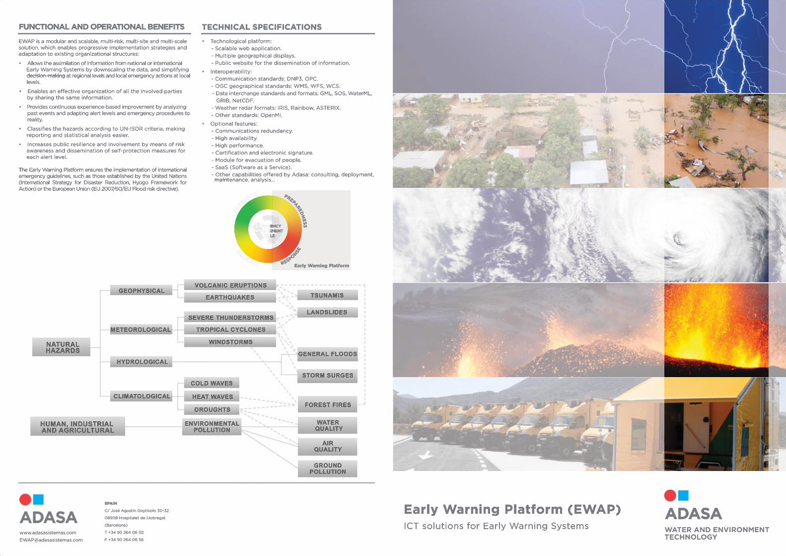
•• Classifies the hazards according to UN-ISDR criteria, making reporting and statistical analysis easier.
• Increases public resilience and involvement by means of risk awareness and dissemination of self-protection measures for each alert level.
TThe Early Warning Platform ensures the implementation of international emergency guidelines, such as those established by the United Nations (International Strategy for Disaster Reduction, Hyogo Framework for Action) or the European Union (EU 2007/60/EU Flood risk directive).
TECHNICAL SPECIFICATIONS
• Technological platform: - Scalable web application. - Multiple geographical displays. - Public website for the dissemination of information.
• Interoperability: - - Communication standards: DNP3, OPC. - OGC geographical standards: WMS, WFS, WCS. - Data interchange standards and formats: GML, SOS, WaterML, GRIB, NetCDF. - Weather radar formats: IRIS, Rainbow, ASTERIX. - Other standards: OpenMI.
• Optional features: - - Communications redundancy. - High availability. - High performance. - Certification and electronic signature. - Module for evacuation of people. - SaaS (Software as a Service). - Other capabilities offered by Adasa: consulting, deployment, main maintenance, analysis…
NATURALHAZARDS
GEOPHYSICALVOLCANIC ERUPTIONS
EARTHQUAKES TSUNAMIS
LANDSLIDES
GENERAL FLOODS
STORM SURGES
FOREST FIRES
WATER QUALITY
AIRQUALITY
GROUNDPOLLUTION
ENVIRONMENTALPOLLUTION
SEVERE THUNDERSTORMS
TROPICAL CYCLONES
WINDSTORMS
COLD WAVES
HEAT WAVES
DROUGHTS
METEOROLOGICAL
HYDROLOGICAL
CLIMATOLOGICAL
HUMAN, INDUSTRIAL AND AGRICULTURAL
SPAIN
C/ José Agustín Goytisolo 30-32
08908 Hospitalet de Llobregat
(Barcelona)
T +34 93 264 06 02
F +34 93 264 06 56
www.adasasistemas.com
EMERGENCY MANAGEMENT
CYCLE
MITIG
ATION PREPARED
NESS
RECOVERY R
ESPON
SE
EMERGENCY MANAGEMENT
CYCLE
Early Warning Platform
LEVEL 0
LEVEL 1
LEVEL 2
LEVEL 3
DATA ACQUISITIONThe data acquisition module integrates heterogeneous data sources, either from different typologies or in different time or spatial scales:
• Geospatial information: satellite imagery, weather radar, etc.
• Point data from real-time measurement networks: rain gauges, hydrological and meteorological stations, seismometers…
•• Quantitative and qualitative information from observer networks.
• Hydrological and meteorological model forecasts.
• GPS location of emergency teams and vehicles.
• Location of incoming calls to the emergency centre.
The acquired information is automatically processed and stored in a geospatial database, in homogeneous formats accessible to other EWAP modules.
GEOGRAPHICAL VIEWER AND CONFIGURATOR
The geographical viewer, in the Intranet area, shows the different data sources and the generated products, allowing geographical layer and visualization configuration:
• Trend plots: rainfall, hydrograms or others.• Historical event playback.• Thematic cartography integration, including flood risk maps, evacuation routes or meeting points. meeting points.• Visualization of geolocated information from other systems, such as fleet management or emergency call centres.• Maps of geographic alerts for specific hazards, regional warning maps…• Access to the alert level declaration module.
PUBLIC PORTALEWAP includes a web portal infrastructure for public dissemination of current data, warning levels, emergency protocols and good practices for self-protection.
• Geographical information about public risk maps and current warnings and trends.• News, events, training calendar, planned emergency drills, forums, etc.• Dissemination and risk awareness section.•• Specific information area for registered users.
PRODUCT GENERATION
EWAP integrates heterogeneous information from different data sources and produces new added-value information, which is required for decision-making. The product generation module enables the calculation of geo-processes, either temporal or spatial aggregations, or merging several data types with different spatial or temporal resolutions:
•• Temporal aggregation products: accumulated rainfall, average temperature…• Spatial aggregation products: by surface (basin, municipality) or point of interest.• Combination from different sources: rain gauge and weather radar combined rain field.• Forecasting products: hydrological modelling, flood forecasting, nowcasting, etc.• Geographical alerts according to established emergency levels for any of the data sources or generated products.
GeneGenerated products are stored in the geospatial database and can be visualized in the same way as the original data sources.
OPERATIONS MANAGEMENT AND PUBLIC WARNING MODULES
The operations management module provides guidance for the workflow of actions to be executed in normality situations or in each alert level:
• Routine inspection tasks, such as periodic surveillance of the evolution of phenomena or verification of escape routes.•• Warning actions: official communication to involved parties, warning messages, telephone calls, siren activation…• Specific actions linked to current hazards.• Training and simulation modes, as well as full traceability of the performed actions.
The operations management module enables the coordination of available resources:
• Address book and human and material resources required for each operational level.
• Links to reference documentation: schematics, procedures, etc.
TThe module includes automatic interfaces with communication devices and public warning systems:
• Delivery of warning messages by fax, email, telephone, SMS and mobile apps.
• Activation of public warning systems: sirens, information display panels, etc.
ADASA
DECISION
EWAP (Early WArning Platform) is an ICT platform for the development and operation of Early Warning Systems (EWS). It provides heterogeneous data source integration (forecast models, point data observations, etc.) as well as efficient emergency operations management, encompassing from the preparedness to the
emergency response stages.
OBSERVATION AND FORECAST
EMERGENCY OPERATIONS
EMERGENCY MANAGEMENT PROCESS
ALERT
GEOSPATIAL DBANALYSIS AND REPORTS
EWAP implements the emergency management process in three stages: observation, decision and operations. The decision-maker (operations manager, crisis committee) assesses the emergency situation according to observations, forecasts and the alert level suggested by EWAP, and decides which alert level to declare. Once it has been activated, EWAP guides the operators through the workflow of tasks to be performed, while the decision-maker keeps on watching the evolution of phenomena and operations.