abstracts of the eighth international symposium on land...
TRANSCRIPT
�
Eighth International Symposium on Land Subsidence
ABSTRACTS OF THEEIGHTH INTERNATIONAL SYMPOSIUM
ON LAND SUBSIDENCE 2010
Land subsidence, associated hazards and the role of natural resources development
�
Eighth International Symposium on Land Subsidence
Elaborated in: Unidad de Apoyo Editorial, Centro de Geociencias, Universidad Nacional Autónoma de México. Design and technical edition: J. Jesús Silva Corona
October �0�0Juriquilla, Querétaro, Mexico
ORGANIZING COMMITTEE
UNESCO Working Group on Land SubsidenceAlice Aureli, International Hydrological Programme (IHP), UNESCO, Paris, FranceA. Ivan Johnson, Consultant, Arvada, Colorado, USA. Honorary ChairmanLaura Carbognin, Consiglio Nazionale delle Ricerche, CNR-ISMAR, Venezia, Italy. ChairmanKeith R. Prince, US Geological Survey, Menlo Park, California, USA. Vice-ChairmanGiuseppe Gambolati, Universitá degli Studi di Padova, ItalyFrans B. Barends, Deltares–GeoDelft, Delft, The NetherlandsDora Carreón Freyre, Universidad Nacional Autónoma de México (UNAM), MéxicoDevin L. Galloway, US Geological Survey, Sacramento, California, USAJane Frankenfield Zanin, Consiglio Nazionale delle Ricerche, Italy. Technical Secretary
LOCAL ORGANIZING COMMITTEEDora Carreón Freyre, UNAM Universidad Nacional Autónoma de México, PresidentMariano Cerca Martínez, UNAM General academic coordinationAlfredo Zepeda Garrido, UAQ Academic coordinación and cultural activities in Querétaro CityDionisio León Salas, UNAM General administration UNAMJ. Jesús Silva Corona, UNAM Technical edition UNAMLiliana Cabrera Gómez, UNAM Logistic and coordination of the GeoEXPO UNAMCarlos Hernández Cabrera, UNAM Incoming managementGil Ochoa González, ITESO Database management
HONORARY COMMITTEEJosé Narro Robles, UNAM Rector of the Universidad Nacional Autónoma de MéxicoCarlos Arámburo de la Hoz, UNAM Coordinador de la Investigación CientíficaGerardo Carrasco Núñez, UNAM Director of the Centro de GeocienciasRafael Alexandri Rionda, SGM President of the Sociedad Geológica MexicanaWalter Paniagua Zavala, SMIG President of the Sociedad Mexicana de Ingenieria GeotécnicaJosé Manuel Romo Jones, UGM President of the Unión Geofísica MexicanaÁngel Ramírez Vázquez, CONCyTEQ Director of Consejo de Ciencia y Tecnología del Estado de Querétaro
SCIENTIFIC ADVISORY BOARD (SAB)Devin L. Galloway, USGS, Sacramento, California, USAGiuseppe Gambolati, Universitá degli Studi di Padova, ItalyFrans B. Barends, Deltares–GeoDelft, Delft, The NetherlandsThomas J. Burbey, Virginia Tech, Blacksburg, Virginia, USAEnrique Cabral Cano, Instituto de Geofísica, UNAM, MexicoGerman Figueroa V. Scientific Consultant, MexicoThomas L. Holzer, USGS, Menlo Park, California, USALuca Ferrari Pedraglio, Centro de Geociencias, UNAMStanley A. Leake, USGS, Tucson, Arizona, USAPietro Teatini, DMMMSA, Universitá degli Studi di Padova, ItalyFabio Rocca, Politecnico di Milano, Milan, ItalyGabriel Auvinet, Instituto de Ingeniería, UNAM, MexicoEfraín Ovando Shelley, Instituto de Ingeniería, UNAM, MéxicoGer de Lange, TNO, Geological Survey of the Netherlands, Utrecht, The NetherlandsAlfonso Rivera, Natural Resources Canada, Québec, CanadaKlaudia Oleschko Lutkova, Centro de Geociencias, UNAM, MexicoToni Settari, Schulich School of Engineering, University of Calgary, CanadaLuigi Terzi, ENI E & P, Milano, ItalyLuigi Tosi, CNR, ISMAR, Venecia, ItalyXue Yu-Qun, Earth Science Department of Nanjing University, Nanjing, China
�
Eighth International Symposium on Land Subsidence
EISOLSEighth International
Symposium On LandSubsidence
Edited by:DORA CARREÓN-FREYRE
Centro de Geociencias, Universidad Nacional Autónoma de México (UNAM)Querétaro, México
MARIANO CERCACentro de Geociencias, UNAM, Querétaro, México
DEVIN L. GALLOWAYUS Geological Survey, Sacramento, California, USA

�
Eighth International Symposium on Land Subsidence
�
Eighth International Symposium on Land Subsidence
ABSTRACTS OF THEEIGHTH INTERNATIONAL SYMpOSIUM ON LAND SUBSIDENCE 2010
Land subsidence, associated hazards and the role of natural resources development
TABLE OF CONTENTS
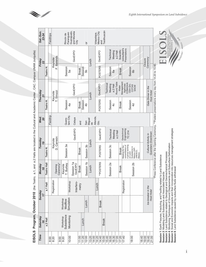
General infromationProgrammes and maps ............................................................................................................... i
Introduction ................................................................................................................................. 1
Session �Earth fissures, fracturing and faulting related to land subsidence ...................................... 3
Session �Modelling land subsidence and associated hazards ............................................................. 11
Session �Land Subsidence related to geological and geomechanical Processeses ............................ 23
Session �Monitoring techniques of ground displacements and subsurface deformation ............... 43
Session �Social and economic impacts and their incorporation intoResource management strategies .............................................................................................. 63
Session 6Land subsidence caused by subsurface fluid withdrawal .................................................... 73
Mid symposium field trip guideQuerétaro, Celaya and San Miguel de Allende cities ............................................................ 81
Author index .............................................................................................................................................. 83

6
Eighth International Symposium on Land Subsidence
i
Eighth International Symposium on Land Subsidence
EISO
LS P
rogr
am, O
ctob
er 2
010
(the
Teat
ro,
a.1,
and
a.2
Hal
ls a
re lo
cate
d in
the
Cul
tura
l and
Aca
dem
ic C
ente
r , C
AC
. Cam
pus
UN
AM
Jur
iqui
lla)
Tim
eSa
turd
ay
16
Sund
ay
17M
onda
y 18
Tu
esda
y19
W
ed.
20
Thur
sday
21
Fr
iday
22
Sa
t.-Su
n.
23-2
4 a.
2 H
all
a.1
Hal
l Te
atro
Hal
l Te
atro
H.
Teat
ro H
. Te
atro
H.
8:0
0
Fi
eldt
rip
Fiel
dtrip
s 8
:20
Reg
istra
tion
Key
note
D
. Car
reón
Ke
ynot
eT.
Stro
zzi
Key
note
F.
Bar
ends
9
:00
Ope
ning
C
erem
ony*
9:2
0 Ke
ynot
eT.
Bur
bey
10:0
0
Ses
sion
1a
Geo
EXP
O
Ses
sion
3a
Ses
sion
4a
Ses
sion
5a
11:0
0
Wor
ksho
pS
ubsi
denc
e M
onito
ring
Brea
k B
reak
Br
eak
Bre
ak
11:2
0 Lu
nch
Wor
ksho
p M
odflo
w
Sim
ulat
ion
12:0
0 Lu
nch
Ses
sion
1b
Ses
sion
3b
Geo
EXP
O
Ses
sion
4b
Geo
EXP
O
Ses
sion
5b
Geo
EX
PO
13:2
0 14
:00
Wor
ksho
p
Inte
rfero
-m
etry
Lunc
h Lu
nch
Lunc
h Lu
nch
14:2
0 Lu
nch
14:4
0 B
reak
15
:00
Bre
ak
**P
OS
TER
SP
OS
TER
S
Geo
EXP
O
PO
STE
RS
Geo
EXP
O
PO
STE
RS
Geo
EX
PO
15:4
0 16
:00
16:3
0 17
:00
Ses
sion
2a
Ses
sion
3c
Ses
sion
4c
S
essi
on
6a
17:2
0
Brea
k B
reak
Br
eak
Bre
ak
17:4
0
Reg
istra
tion
Tech
nica
l M
eetin
g a.
2 H
all
Sci
entif
ic
cons
ulta
nt's
Pr
esen
tatio
ns
18:0
0
Mee
ting
for t
he
cons
olid
atio
n of
a
grou
p w
orki
ng
on L
and
Subs
iden
ce in
M
exic
o (IH
P-U
NES
CO
, M
exic
o
Tech
nica
l M
eetin
g a.
2 H
all
Geo
tech
nica
l En
gine
erin
g
TC 2
14S
essi
on
4d
Tech
nica
l M
eetin
g a.
2 H
all
Rou
nd T
able
W
ater
M
anag
emen
t Ag
enci
es
CO
NA
GU
A C
EA
Qro
. C
OTA
S S
ACM
Ses
sion
6b
18:4
0
19
:00
19:4
0
Ses
sion
2b
Que
re-
taro
City
,
Cel
aya
and
San
Mig
uel
de
Alle
nde,
G
to.
Clo
sure
C
erem
ony
21:0
0 Ic
e-br
eake
r in
the
H
ost H
otel
Cul
tura
l Act
ivity
in
Que
reta
ro D
ownt
own
Gal
a D
inne
r in
the
Hos
t Hot
el
Rin
cón
de
Par
angu
eo
Gua
naju
ato,
an
d M
orel
ia
City
or Izta
pala
pa,
Mex
ico
City
an
d Te
otih
uacá
n
*P
ress
Con
fere
nce
afte
r the
Ope
ning
Cer
emon
y, *
*Pos
ters
pre
sent
atio
ns e
very
day
from
14:
20 to
15:
40.
Sess
ion
1: E
arth
Fis
sure
s, F
ract
urin
g, a
nd F
aulti
ng re
late
d to
Lan
d S
ubsi
denc
e Se
ssio
n 2:
Mod
elin
g La
nd S
ubsi
denc
e an
d A
ssoc
iate
d H
azar
dsSe
ssio
n 3:
Lan
d Su
bsid
ence
rela
ted
to G
eolo
gica
l and
Geo
mec
hani
cal P
roce
sses
Se
ssio
n 4:
Mon
itorin
g Te
chni
ques
of G
roun
d D
ispl
acem
ents
and
Sub
surfa
ce D
efor
mat
ion
Sess
ion
5: S
ocia
l and
Eco
nom
ic im
pact
s an
d th
eir i
ncor
pora
tion
into
reso
urce
s m
anag
emen
t stra
tegi
es
Sess
ion
6: L
and
Sub
side
nce
caus
ed b
y su
bsur
face
flui
ds w
ithdr
awal
EISO
LSEi
gh
th I
nte
rnat
ion
alSy
mpo
siu
m O
n L
and
Subs
iden
ce

ii
Eighth International Symposium on Land Subsidence
iii
Eighth International Symposium on Land Subsidence
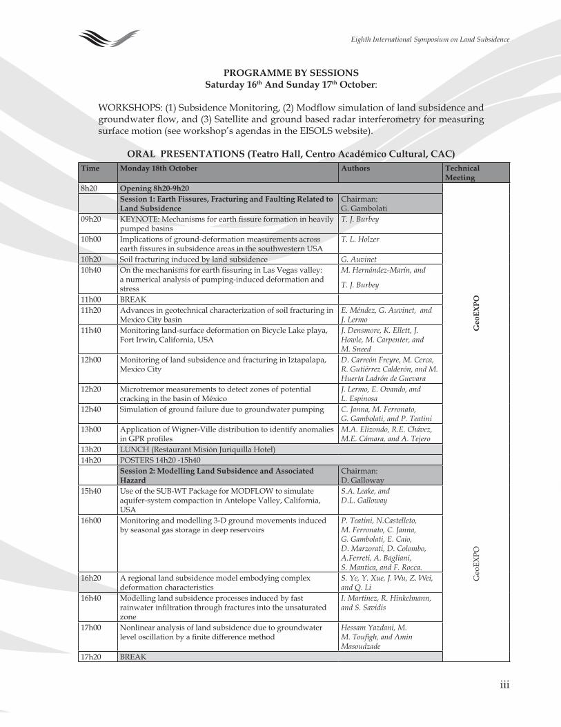
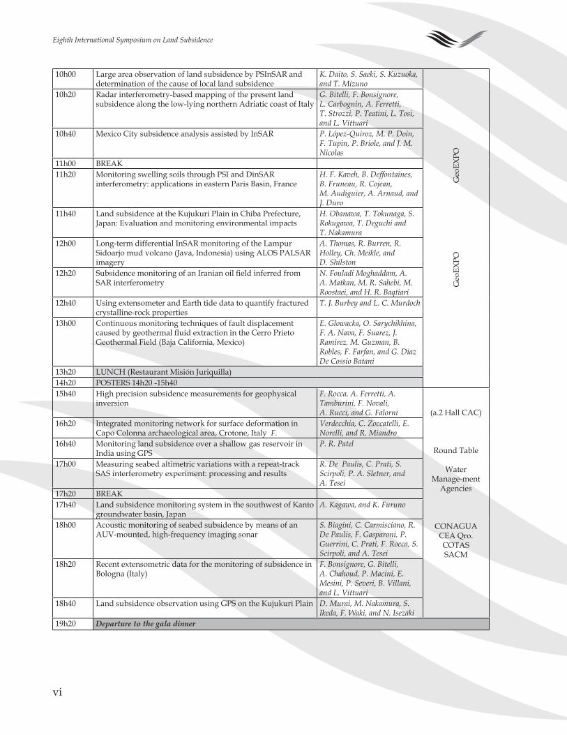
Time Monday 18th October Authors Technical Meeting
8h�0 Opening 8h20-9h20
Geo
EXpO
Session 1: Earth Fissures, Fracturing and Faulting Related to Land Subsidence
Chairman: G. Gambolati
09h�0 KEYNOTE: Mechanisms for earth fissure formation in heavily pumped basins
T. J. Burbey
�0h00 Implications of ground-deformation measurements across earth fissures in subsidence areas in the southwestern USA
T. L. Holzer
�0h�0 Soil fracturing induced by land subsidence G. Auvinet�0h�0 On the mechanisms for earth fissuring in Las Vegas valley:
a numerical analysis of pumping-induced deformation and stress
M. Hernández-Marín, and
T. J. Burbey
��h00 BREAK��h�0 Advances in geotechnical characterization of soil fracturing in
Mexico City basinE. Méndez, G. Auvinet, and J. Lermo
��h�0 Monitoring land-surface deformation on Bicycle Lake playa, Fort Irwin, California, USA
J. Densmore, K. Ellett, J. Howle, M. Carpenter, and M. Sneed
��h00 Monitoring of land subsidence and fracturing in Iztapalapa, Mexico City
D. Carreón Freyre, M. Cerca, R. Gutiérrez Calderón, and M. Huerta Ladrón de Guevara
��h�0 Microtremor measurements to detect zones of potential cracking in the basin of México
J. Lermo, E. Ovando, and L. Espinosa
��h�0 Simulation of ground failure due to groundwater pumping C. Janna, M. Ferronato, G. Gambolati, and P. Teatini
��h00 Application of Wigner-Ville distribution to identify anomalies in GPR profiles
M.A. Elizondo, R.E. Chávez, M.E. Cámara, and A. Tejero
��h�0 LUNCH (Restaurant Misión Juriquilla Hotel)��h�0 POSTERS ��h�0 -��h�0
Session 2: Modelling Land Subsidence and Associated Hazard
Chairman: D. Galloway
Geo
EXPO
��h�0 Use of the SUB-WT Package for MODFLOW to simulate aquifer-system compaction in Antelope Valley, California, USA
S.A. Leake, and D.L. Galloway
�6h00 Monitoring and modelling �-D ground movements induced by seasonal gas storage in deep reservoirs
P. Teatini, N.Castelleto, M. Ferronato, C. Janna, G. Gambolati, E. Caio, D. Marzorati, D. Colombo, A.Ferreti, A. Bagliani, S. Mantica, and F. Rocca.
�6h�0 A regional land subsidence model embodying complex deformation characteristics
S. Ye, Y. Xue, J. Wu, Z. Wei, and Q. Li
�6h�0 Modelling land subsidence processes induced by fast rainwater infiltration through fractures into the unsaturated zone
I. Martinez, R. Hinkelmann, and S. Savidis
�7h00 Nonlinear analysis of land subsidence due to groundwater level oscillation by a finite difference method
Hessam Yazdani, M. M. Toufigh, and Amin Masoudzade
�7h�0 BREAK
pROGRAMME BY SESSIONS Saturday 16th And Sunday 17th October:
WORKSHOPS: (1) Subsidence Monitoring, (2) Modflow simulation of land subsidence and groundwater flow, and (3) Satellite and ground based radar interferometry for measuring surface motion (see workshop’s agendas in the EISOLS website).
ORAL pRESENTATIONS (Teatro Hall, Centro Académico Cultural, CAC)
iv
Eighth International Symposium on Land Subsidence
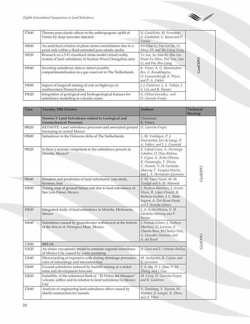
�7h�0 Thermo-poro-elastic effects in the anthropogenic uplift of Venice by deep seawater injection
N. Castelletto, M. Ferronato, G. Gambolati, C. Janna and P. Teatini
Geo
EXpO
�8h00 An analytical solution of plane strain consolidation due to a point sink within a fluid-saturated poro-elastic media
Pei-Chao Li, Yue-Lei He, Yi-Ming Mi, and Shi-Liang Gong
�8h�0 Research on a �-D visualized strata model virtual reality system of land subsidence in Suzhou-Wuxi-Changzhou area
Yu Jun, Su Xiao-Si, Zhu Lin, Duan Fu-Zhou, Pan Yun, Gao Li, and Wu Shu-Liang
�8h�0 Inverting subsidence data to detect possible compartmentalization in a gas reservoir in The Netherlands
K. Visser, A. G. Muntendam-Bos, G. Kunakbayeva, O. Leeuwenburgh, E. Peters, and P. A. Fokker
�9h00 Impact of longwall mining of coal on highways in southwestern Pennsylvania
J. J. Gutiérrez, L. E. Vallejo, J. S. Lin, and R. Painter
�9h�0 Integration of geological and hydrogeological features for subsidence modelling in volcanic zones
G. Ochoa-González, and D. Carreón-Freyre
Time Tuesday 19th October Authors Technical
MeetingSession 3: Land Subsidence related to Geological and Geomechanical processes
Chairman:K. Prince
Geo
EXPO
Geo
EXPO
08h�0 KEYNOTE: Land subsidence processes and associated ground fracturing in central Mexico
D. Carreón-Freyre
09h00 Subsidence in the Holocene delta of The Netherlands L. M. Vonhögen, P. J. Doornenbal, Ger de Lange, P. A. Fokker, and J. L. Gunnink
09h�0 Is there a tectonic component to the subsidence process in Morelia, Mexico?
E. Cabral-Cano, A. Arciniega-Ceballos, O. Díaz-Molina, F. Cigna, A. Ávila-Olivera, B. Osmanoglu, T. Dixon, C. Demets, V. H. Garduño-Monroy, F. Vergara-Huerta, and J., E. Hernández-Quintero
09h�0 Zonation and prediction of land subsidence: case study, Kerman, Iran
S. M. Vaezi Nejad, M. M. Toufigh and S. M. Marandi
�0h00 Zoning map of ground failure risk due to land subsidence of San Luis Potosí, Mexico
J. Pacheco-Martínez, J. Arzate-Flores, R. López-Doncel, R. Barboza-Gudiño, J. L. Mata-Segura, A. Del-Rosal-Pardo, and J. Aranda-Gómez
�0h�0 Integrated study of land subsidence in Morelia, Michoacán, Mexico
J. A. Ávila-Olivera, V. H. Garduño-Monroy and P. Farina
�0h�0 Subsidence caused by groundwater withdrawal at the bottom of the Rincón de Parangueo Maar, Mexico
J. Aranda-Gómez, J. Pacheco-Martínez, G. Levresse, E. Chacón-Baca, M.Charles-Polo, G. González-Naranjo, and A. del Rosal
��h00 BREAK��h�0 An elasto-viscoplastic model to estimate regional subsidence
of Mexico City caused by water pumpingA. Ossa and E. Ovando-Shelley
��h�0 Microcracking of expansive soils during shrinkage processes: roles of mineralogy and microstructure
M. Audiguier, R. Cojean, and Z. Geremew
��h00 Ground subsidence induced by backfill-mining of a nickel mine and development forecasts
F. S. Ma, H. J. Zhao, Y. M. Zhang, and J. Guo
��h�0 Instability of the urbanized flank of “El Peñón del Marques” volcanic edifice and its relation to land subsidence in Mexico City
M. Cerca, D. Carreón-Freyre, and R. Gutiérrez
��h�0 Analysis of engineering land subsidence effect caused by shield construction for tunnels
Y. Tianliang, Y. Xuexin, W. Hanmei, Z. Longxi, X. Zhun, and Z. Yibin
v
Eighth International Symposium on Land Subsidence
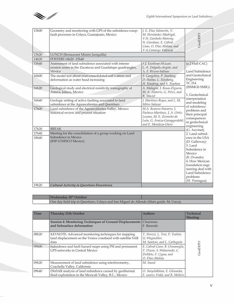
��h00 Geometry and monitoring with GPS of the subsidence-creep-fault processes in Celaya, Guanajuato, Mexico
J. E. Díaz Salmerón, V. M. Hernández Madrigal, V.H. Garduño Monroy, N. Giordano, E. Cabral Cano, O. Díaz Molina, and V.A.Camargo Valencia
Geo
EXPO
��h�0 LUNCH (Restaurant Misión Juriquilla)��h�0 POSTERS ��h�0 -��h�0��h�0 Assessment of land subsidence associated with intense
erosion zones in the Zacatecas and Guadalupe quadrangles, Mexico
F.J. Escalona-Alcazar, L. A. Delgado-Argote, and A. F. Rivera-Salinas
(a.� Hall CAC)
Land Subsidence and GeotechnicalEngineeringTC ��� (ISSMGE-SMIG)
�. Geotechnical interpretation and modeling of subsidence problems and their principal consequences in geotechnical engineering (G. Auvinet)�. Land subsid-ence in the USA (D. Galloway)�. Land Subsidence in Mexico (E. Ovando) �. How Mexican foundation engi-neering deal with Land Subsidence problems (W. Paniagua)
�6h00 The model test about over-consolidated soil´s stress and deformation as water head increasing
S. Gangchen, P. Jianbing, D. Haitao, L. Xinsheng, H. Xiaofeng, and S. Xiaohan
�6h�0 Geological study and electrical resistivity tomography of Ameca, Jalisco, Mexico
A. Malagón, J. Rosas-Elguera, M. A. Alatorre, G. Pérez, and R. Maciel
�6h�0 Geologic setting of active faulting associated to land subsidence at the Aguascalientes and Querétaro
J. Martínez-Reyes, and L. M. Mitre-Salazar
�7h00 Land subsidence of the Aguascalientes Valley, México: historical review and present situation
M.A. Romero-Navarro, J. Pacheco-Martínez, J. A. Ortiz-Lozano, M. E. Zermeño-de León, G. Araiza-Garaygordobil, and E. Mendoza-Otero
�7h�0 BREAK�7h�0 Meeting for the consolidation of a group working on Land
Subsidence in Mexico(IHP-UNESCO Mexico)
�8h�0
�9h�0 Cultural Activity in Querétaro Downtown
Wednesday 20th October:One day field trip in Querétaro, Celaya and San Miguel de Allende (Main guide: M. Cerca).
Time Thursday 21th October Authors Technical Meeting
Session 4: Monitoring Techniques of Ground Displacements and Subsurface deformation
Chairman: F. Barends
Geo
EXPO
08h�0 KEYNOTE: Advanced monitoring techniques for mapping land displacement on the Venice coastland with satellite SAR data
T. Strozzi, L. Tosi, P. Teatini, U. Wegmüller, M. Santoro, and L. Carbognin
09h00 Subsidence and fault hazard maps using PSI and permanent GPS networks in Central Mexico
E. Cabral-Cano, B. Osmanoglu, T. Dixon, S. Wdowinski, C. DeMets, F. Cigna, and O. Díaz-Molina
09h�0 Measurement of land subsidence using interferometry, Coachella Valley, California
M. Sneed
09h�0 DInSAR analysis of land subsidence caused by geothermal fluid exploitation in the Mexicali Valley, B.C., Mexico
O. Sarychikhina, E. Glowacka, F. suarez-Vidal, and R. Mellors
vi
Eighth International Symposium on Land Subsidence
�0h00 Large area observation of land subsidence by PSInSAR and determination of the cause of local land subsidence
K. Daito, S. Saeki, S. Kuzuoka, and T. Mizuno
Geo
EXPO
G
eoEX
PO
�0h�0 Radar interferometry-based mapping of the present land subsidence along the low-lying northern Adriatic coast of Italy
G. Bitelli, F. Bonsignore, L. Carbognin, A. Ferretti, T. Strozzi, P. Teatini, L. Tosi, and L. Vittuari
�0h�0 Mexico City subsidence analysis assisted by InSAR P. López-Quiroz, M. P. Doin, F. Tupin, P. Briole, and J. M. Nicolas
��h00 BREAK��h�0 Monitoring swelling soils through PSI and DinSAR
interferometry: applications in eastern Paris Basin, France H. F. Kaveh, B. Deffontaines, B. Fruneau, R. Cojean, M. Audiguier, A. Arnaud, and J. Duro
��h�0 Land subsidence at the Kujukuri Plain in Chiba Prefecture, Japan: Evaluation and monitoring environmental impacts
H. Obanawa, T. Tokunaga, S. Rokugawa, T. Deguchi and T. Nakamura
��h00 Long-term differential InSAR monitoring of the Lampur Sidoarjo mud volcano (Java, Indonesia) using ALOS PALSAR imagery
A. Thomas, R. Burren, R. Holley, Ch. Meikle, and D. Shilston
��h�0 Subsidence monitoring of an Iranian oil field inferred from SAR interferometry
N. Fouladi Moghaddam, A. A. Matkan, M. R. Sahebi, M. Roostaei, and H. R. Baqtiari
��h�0 Using extensometer and Earth tide data to quantify fractured crystalline-rock properties
T. J. Burbey and L. C. Murdoch
��h00 Continuous monitoring techniques of fault displacement caused by geothermal fluid extraction in the Cerro Prieto Geothermal Field (Baja California, Mexico)
E. Glowacka, O. Sarychikhina, F. A. Nava, F. Suarez, J. Ramirez, M. Guzman, B. Robles, F. Farfan, and G. Diaz De Cossio Batani
��h�0 LUNCH (Restaurant Misión Juriquilla)��h�0 POSTERS ��h�0 -��h�0��h�0 High precision subsidence measurements for geophysical
inversionF. Rocca, A. Ferretti, A. Tamburini, F. Novali, A. Rucci, and G. Falorni (a.� Hall CAC)
Round Table
WaterManage-ment
Agencies
CONAGUACEA Qro.COTASSACM
�6h�0 Integrated monitoring network for surface deformation in Capo Colonna archaeological area, Crotone, Italy F.
Verdecchia, C. Zoccatelli, E. Norelli, and R. Miandro
�6h�0 Monitoring land subsidence over a shallow gas reservoir in India using GPS
P. R. Patel
�7h00 Measuring seabed altimetric variations with a repeat-track SAS interferometry experiment: processing and results
R. De Paulis, C. Prati, S. Scirpoli, P. A. Sletner, and A. Tesei
�7h�0 BREAK�7h�0 Land subsidence monitoring system in the southwest of Kanto
groundwater basin, JapanA. Kagawa, and K. Furuno
�8h00 Acoustic monitoring of seabed subsidence by means of an AUV-mounted, high-frequency imaging sonar
S. Biagini, C. Carmisciano, R. De Paulis, F. Gasparoni, P. Guerrini, C. Prati, F. Rocca, S. Scirpoli, and A. Tesei
�8h�0 Recent extensometric data for the monitoring of subsidence in Bologna (Italy)
F. Bonsignore, G. Bitelli, A. Chahoud, P. Macini, E. Mesini, P. Severi, B. Villani, and L. Vittuari
�8h�0 Land subsidence observation using GPS on the Kujukuri Plain D. Murai, M. Nakamura, S. Ikeda, F. Waki, and N. Isezaki
�9h�0 Departure to the gala dinner
vii
Eighth International Symposium on Land Subsidence
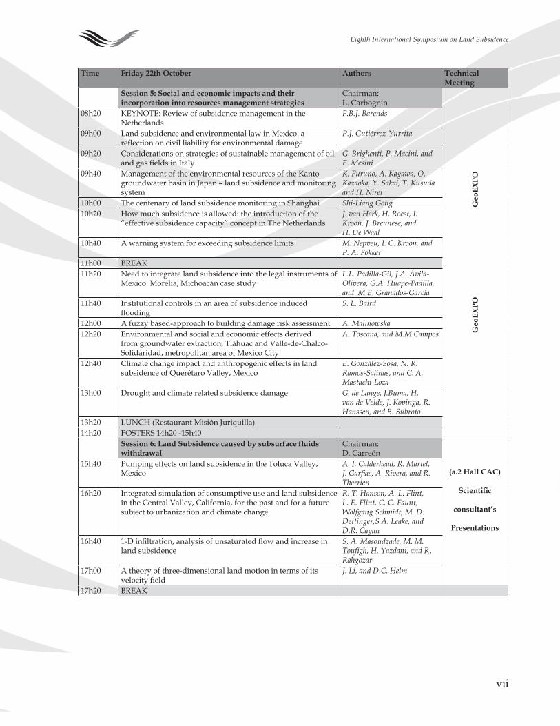
Time Friday 22th October Authors Technical Meeting
Session 5: Social and economic impacts and their incorporation into resources management strategies
Chairman:L. Carbognin
Geo
EXpO
G
eoEX
pO
08h�0 KEYNOTE: Review of subsidence management in the Netherlands
F.B.J. Barends
09h00 Land subsidence and environmental law in Mexico: a reflection on civil liability for environmental damage
P.J. Gutiérrez-Yurrita
09h�0 Considerations on strategies of sustainable management of oil and gas fields in Italy
G. Brighenti, P. Macini, and E. Mesini
09h�0 Management of the environmental resources of the Kanto groundwater basin in Japan – land subsidence and monitoring system
K. Furuno, A. Kagawa, O. Kazaoka, Y. Sakai, T. Kusuda and H. Nirei
�0h00 The centenary of land subsidence monitoring in Shanghai Shi-Liang Gong�0h�0 How much subsidence is allowed: the introduction of the
“effective subsidence capacity” concept in The NetherlandsJ. van Herk, H. Roest, I. Kroon, J. Breunese, and H. De Waal
�0h�0 A warning system for exceeding subsidence limits M. Nepveu, I. C. Kroon, and P. A. Fokker
��h00 BREAK��h�0 Need to integrate land subsidence into the legal instruments of
Mexico: Morelia, Michoacán case study L.L. Padilla-Gil, J.A. Ávila-Olivera, G.A. Huape-Padilla, and M.E. Granados-García
��h�0 Institutional controls in an area of subsidence induced flooding
S. L. Baird
��h00 A fuzzy based-approach to building damage risk assessment A. Malinowska��h�0 Environmental and social and economic effects derived
from groundwater extraction, Tláhuac and Valle-de-Chalco-Solidaridad, metropolitan area of Mexico City
A. Toscana, and M.M Campos
��h�0 Climate change impact and anthropogenic effects in land subsidence of Querétaro Valley, Mexico
E. González-Sosa, N. R. Ramos-Salinas, and C. A. Mastachi-Loza
��h00 Drought and climate related subsidence damage G. de Lange, J.Buma, H. van de Velde, J. Kopinga, R. Hanssen, and B. Subroto
��h�0 LUNCH (Restaurant Misión Juriquilla)��h�0 POSTERS ��h�0 -��h�0
Session 6: Land Subsidence caused by subsurface fluids withdrawal
Chairman:D. Carreón
(a.2 Hall CAC)
Scientific
consultant’s
presentations
��h�0 Pumping effects on land subsidence in the Toluca Valley, Mexico
A. I. Calderhead, R. Martel, J. Garfias, A. Rivera, and R. Therrien
�6h�0 Integrated simulation of consumptive use and land subsidence in the Central Valley, California, for the past and for a future subject to urbanization and climate change
R. T. Hanson, A. L. Flint, L. E. Flint, C. C. Faunt, Wolfgang Schmidt, M. D. Dettinger,S A. Leake, and D.R. Cayan
�6h�0 1-D infiltration, analysis of unsaturated flow and increase in land subsidence
S. A. Masoudzade, M. M. Toufigh, H. Yazdani, and R. Rahgozar
�7h00 A theory of three-dimensional land motion in terms of its velocity field
J. Li, and D.C. Helm
�7h�0 BREAK
viii
Eighth International Symposium on Land Subsidence
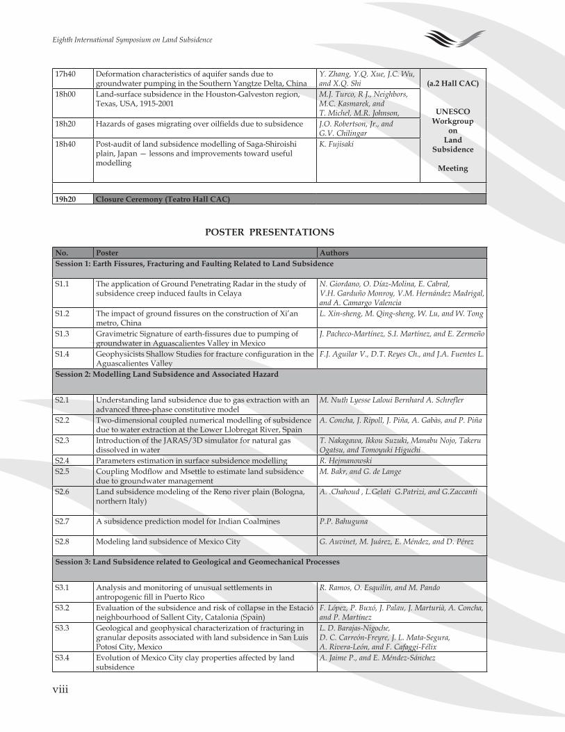
�7h�0 Deformation characteristics of aquifer sands due to groundwater pumping in the Southern Yangtze Delta, China
Y. Zhang, Y.Q. Xue, J.C. Wu, and X.Q. Shi (a.2 Hall CAC)
UNESCOWorkgroup
on Land
Subsidence
Meeting
�8h00 Land-surface subsidence in the Houston-Galveston region, Texas, USA, �9��-�00�
M.J. Turco, R J., Neighbors, M.C. Kasmarek, and T. Michel, M.R. Johnson,
�8h�0 Hazards of gases migrating over oilfields due to subsidence J.O. Robertson, Jr., and G.V. Chilingar
�8h�0 Post-audit of land subsidence modelling of Saga-Shiroishi plain, Japan — lessons and improvements toward useful modelling
K. Fujisaki
19h20 Closure Ceremony (Teatro Hall CAC)
No. poster AuthorsSession 1: Earth Fissures, Fracturing and Faulting Related to Land Subsidence
S�.� The application of Ground Penetrating Radar in the study of subsidence creep induced faults in Celaya
N. Giordano, O. Díaz-Molina, E. Cabral, V.H. Garduño Monroy, V.M. Hernández Madrigal, and A. Camargo Valencia
S�.� The impact of ground fissures on the construction of Xi’an metro, China
L. Xin-sheng, M. Qing-sheng, W. Lu, and W. Tong
S�.� Gravimetric Signature of earth-fissures due to pumping of groundwater in Aguascalientes Valley in Mexico
J. Pacheco-Martínez, S.I. Martínez, and E. Zermeño
S�.� Geophysicists Shallow Studies for fracture configuration in the Aguascalientes Valley
F.J. Aguilar V., D.T. Reyes Ch., and J.A. Fuentes L.
Session 2: Modelling Land Subsidence and Associated Hazard
S�.� Understanding land subsidence due to gas extraction with an advanced three-phase constitutive model
M. Nuth Lyesse Laloui Bernhard A. Schrefler
S�.� Two-dimensional coupled numerical modelling of subsidence due to water extraction at the Lower Llobregat River, Spain
A. Concha, J. Ripoll, J. Piña, A. Gabàs, and P. Piña
S�.� Introduction of the JARAS/�D simulator for natural gas dissolved in water
T. Nakagawa, Ikkou Suzuki, Manabu Nojo, Takeru Ogatsu, and Tomoyuki Higuchi
S�.� Parameters estimation in surface subsidence modelling R. HejmanowskiS�.� Coupling Modflow and Msettle to estimate land subsidence
due to groundwater management M. Bakr, and G. de Lange
S�.6 Land subsidence modeling of the Reno river plain (Bologna, northern Italy)
A. .Chahoud , L.Gelati G.Patrizi, and G.Zaccanti
S�.7 A subsidence prediction model for Indian Coalmines P.P. Bahuguna
S�.8 Modeling land subsidence of Mexico City G. Auvinet, M. Juárez, E. Méndez, and D. Pérez
Session 3: Land Subsidence related to Geological and Geomechanical processes
S�.� Analysis and monitoring of unusual settlements in antropogenic fill in Puerto Rico
R. Ramos, O. Esquilín, and M. Pando
S�.� Evaluation of the subsidence and risk of collapse in the Estació neighbourhood of Sallent City, Catalonia (Spain)
F. López, P. Buxó, J. Palau, J. Marturià, A. Concha, and P. Martínez
S�.� Geological and geophysical characterization of fracturing in granular deposits associated with land subsidence in San Luis Potosí City, Mexico
L. D. Barajas-Nigoche, D. C. Carreón-Freyre, J. L. Mata-Segura, A. Rivera-León, and F. Cafaggi-Félix
S�.� Evolution of Mexico City clay properties affected by land subsidence
A. Jaime P., and E. Méndez-Sánchez
pOSTER pRESENTATIONS
ix
Eighth International Symposium on Land Subsidence
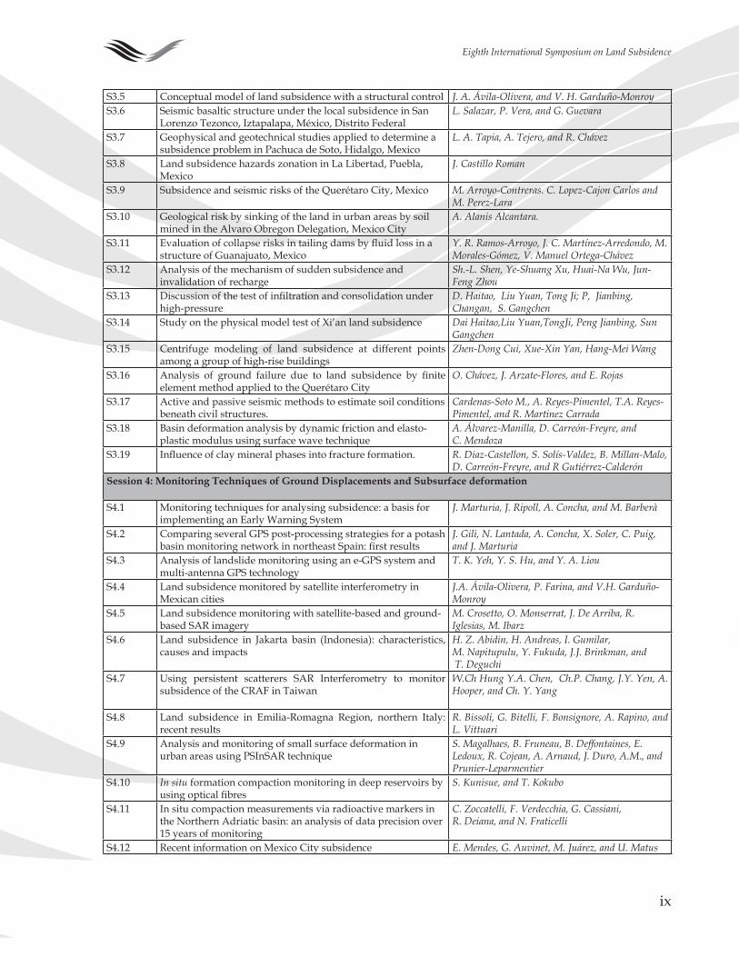
S�.� Conceptual model of land subsidence with a structural control J. A. Ávila-Olivera, and V. H. Garduño-MonroyS�.6 Seismic basaltic structure under the local subsidence in San
Lorenzo Tezonco, Iztapalapa, México, Distrito Federal L. Salazar, P. Vera, and G. Guevara
S�.7 Geophysical and geotechnical studies applied to determine a subsidence problem in Pachuca de Soto, Hidalgo, Mexico
L. A. Tapia, A. Tejero, and R. Chávez
S�.8 Land subsidence hazards zonation in La Libertad, Puebla, Mexico
J. Castillo Roman
S�.9 Subsidence and seismic risks of the Querétaro City, Mexico M. Arroyo-Contreras. C. Lopez-Cajon Carlos and M. Perez-Lara
S�.�0 Geological risk by sinking of the land in urban areas by soil mined in the Alvaro Obregon Delegation, Mexico City
A. Alanis Alcantara.
S�.�� Evaluation of collapse risks in tailing dams by fluid loss in a structure of Guanajuato, Mexico
Y. R. Ramos-Arroyo, J. C. Martínez-Arredondo, M. Morales-Gómez, V. Manuel Ortega-Chávez
S�.�� Analysis of the mechanism of sudden subsidence and invalidation of recharge
Sh.-L. Shen, Ye-Shuang Xu, Huai-Na Wu, Jun-Feng Zhou
S�.�� Discussion of the test of infiltration and consolidation under high-pressure
D. Haitao, Liu Yuan, Tong Ji; P, Jianbing, Changan, S. Gangchen
S�.�� Study on the physical model test of Xi’an land subsidence Dai Haitao,Liu Yuan,TongJi, Peng Jianbing, Sun Gangchen
S�.�� Centrifuge modeling of land subsidence at different points among a group of high-rise buildings
Zhen-Dong Cui, Xue-Xin Yan, Hang-Mei Wang
S�.�6 Analysis of ground failure due to land subsidence by finite element method applied to the Querétaro City
O. Chávez, J. Arzate-Flores, and E. Rojas
S�.�7 Active and passive seismic methods to estimate soil conditions beneath civil structures.
Cardenas-Soto M., A. Reyes-Pimentel, T.A. Reyes-Pimentel, and R. Martinez Carrada
S�.�8 Basin deformation analysis by dynamic friction and elasto-plastic modulus using surface wave technique
A. Álvarez-Manilla, D. Carreón-Freyre, and C. Mendoza
S�.�9 Influence of clay mineral phases into fracture formation. R. Diaz-Castellon, S. Solís-Valdez, B. Millan-Malo, D. Carreón-Freyre, and R Gutiérrez-Calderón
Session 4: Monitoring Techniques of Ground Displacements and Subsurface deformation
S�.� Monitoring techniques for analysing subsidence: a basis for implementing an Early Warning System
J. Marturia, J. Ripoll, A. Concha, and M. Barberà
S�.� Comparing several GPS post-processing strategies for a potash basin monitoring network in northeast Spain: first results
J. Gili, N. Lantada, A. Concha, X. Soler, C. Puig, and J. Marturia
S�.� Analysis of landslide monitoring using an e-GPS system and multi-antenna GPS technology
T. K. Yeh, Y. S. Hu, and Y. A. Liou
S�.� Land subsidence monitored by satellite interferometry in Mexican cities
J.A. Ávila-Olivera, P. Farina, and V.H. Garduño-Monroy
S�.� Land subsidence monitoring with satellite-based and ground-based SAR imagery
M. Crosetto, O. Monserrat, J. De Arriba, R. Iglesias, M. Ibarz
S�.6 Land subsidence in Jakarta basin (Indonesia): characteristics, causes and impacts
H. Z. Abidin, H. Andreas, I. Gumilar, M. Napitupulu, Y. Fukuda, J.J. Brinkman, and T. Deguchi
S�.7 Using persistent scatterers SAR Interferometry to monitor subsidence of the CRAF in Taiwan
W.Ch Hung Y.A. Chen, Ch.P. Chang, J.Y. Yen, A. Hooper, and Ch. Y. Yang
S�.8 Land subsidence in Emilia-Romagna Region, northern Italy: recent results
R. Bissoli, G. Bitelli, F. Bonsignore, A. Rapino, and L. Vittuari
S�.9 Analysis and monitoring of small surface deformation in urban areas using PSInSAR technique
S. Magalhaes, B. Fruneau, B. Deffontaines, E. Ledoux, R. Cojean, A. Arnaud, J. Duro, A.M., and Prunier-Leparmentier
S�.�0 In situ formation compaction monitoring in deep reservoirs by using optical fibres
S. Kunisue, and T. Kokubo
S�.�� In situ compaction measurements via radioactive markers in the Northern Adriatic basin: an analysis of data precision over �� years of monitoring
C. Zoccatelli, F. Verdecchia, G. Cassiani, R. Deiana, and N. Fraticelli
S�.�� Recent information on Mexico City subsidence E. Mendes, G. Auvinet, M. Juárez, and U. Matus
x
Eighth International Symposium on Land Subsidence
Session 5: Social and economic impacts and their incorporation into resources management strategies
S�.� Assessment of the state and condition of damaged buildings and structures affected by land subsidence
J.A. Ortiz, F. A. Alonso, J. Pacheco, M.E. Zermeño, G. Araiza, and E. Mendoza
S�.� Guidelines for the design of a unit of urban risk prevention for subsurface fracturing in the Municipality of Iztapalapa in Mexico City
H.C. Carreón-Freyre, and J.C. Rodríguez-Quiroz
S�.� Shanghai land subsidence and its negative impact on urban flood prevention
Shi-Liang Gong
S�.� Remedial and mitigation measures after surface mining operations
C. Palencia, and D. Goetz
Session 6: Land Subsidence caused by subsurface fluids withdrawal
S6.� Subsidence faulting and aquifer vulnerability – their relation in Irapuato, Mexico
A. Schroeder, and R. Rodríguez
S6.� Axisymmetric motion of a confined leaky aquifer due to pumping groundwater from a partially penetrating well
J. Li
S6.� Subsidence in Celaya, Guanajuato: morphologic evolution and relations with aquifer’s dynamic
N. Giordano, J. E. Díaz-Salmerón, V.M. Hernandez-Madrigal, V. H. Garduño-Monroy, and A. Camargo-Valencia
S6.� Subsidence due to tunnel erosion (piping) in the recent Rio Mendoza alluvial fan, Argentina
M.C. Regairaz, and M.A. González
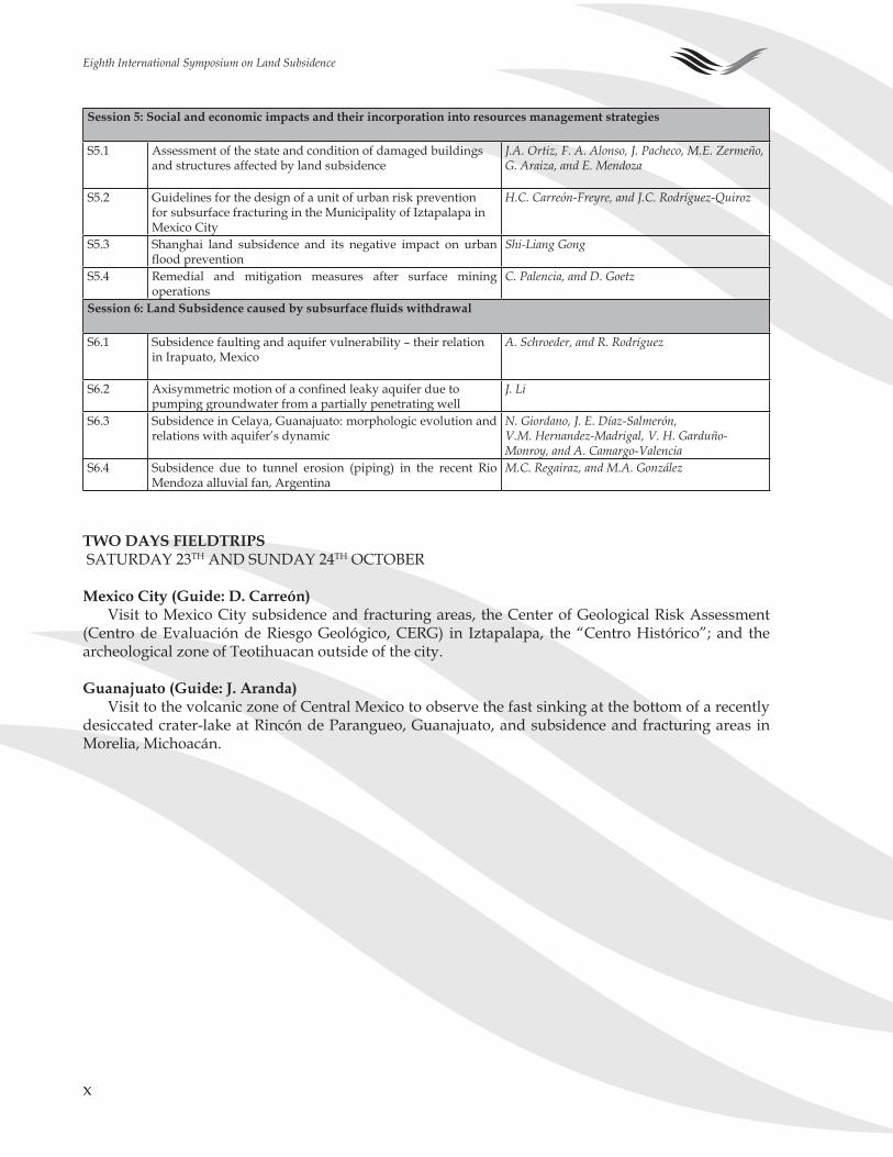
TWO DAYS FIELDTRIpS SATURDAY ��TH AND SUNDAY ��TH OCTOBER
Mexico City (Guide: D. Carreón)Visit to Mexico City subsidence and fracturing areas, the Center of Geological Risk Assessment
(Centro de Evaluación de Riesgo Geológico, CERG) in Iztapalapa, the “Centro Histórico”; and the archeological zone of Teotihuacan outside of the city.
Guanajuato (Guide: J. Aranda)Visit to the volcanic zone of Central Mexico to observe the fast sinking at the bottom of a recently
desiccated crater-lake at Rincón de Parangueo, Guanajuato, and subsidence and fracturing areas in Morelia, Michoacán.
xi
Eighth International Symposium on Land Subsidence
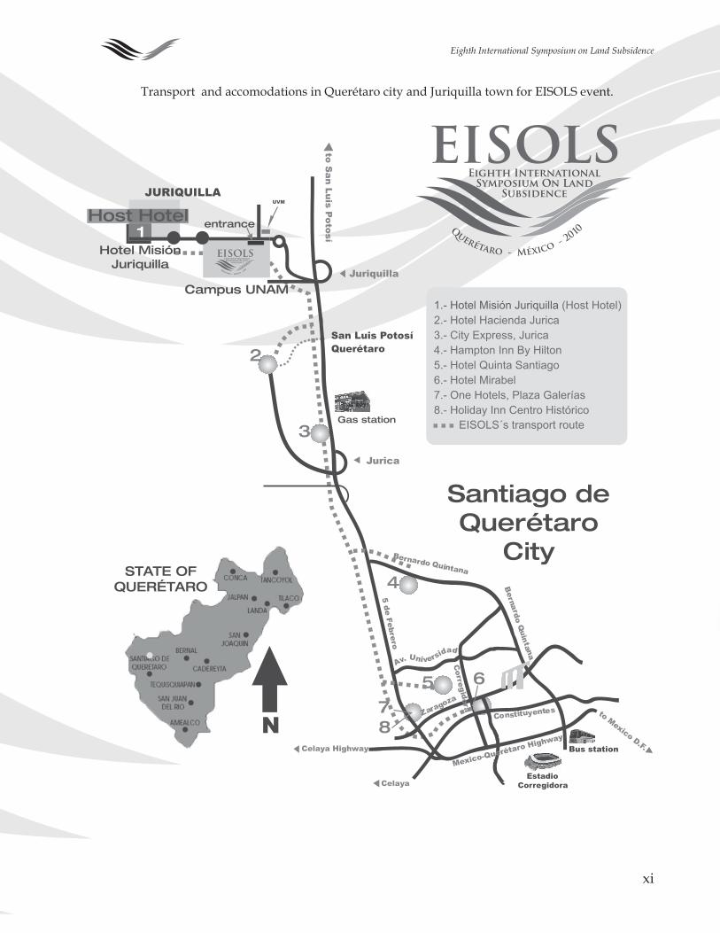
Transport and accomodations in Querétaro city and Juriquilla town for EISOLS event.

xii
Eighth International Symposium on Land Subsidence
xiii
Eighth International Symposium on Land Subsidence
EMERGENCY pHONES:
EmergenciasEmergencys
Secretaría de Relaciones Exteriores en QuerétaroMinistry of Foreign Affairs, Querétaro
(���) ��6-6���
procuraduría General de JusticiaJustice Department
(���) ���-���� / ���-���0 / ���-�097
Secretaría de Turismo Estado de QuerétaroMinistry of Tourism, Querétaro
(���) ��8-�000, ext. �067 y ����
Locatel(���) ����-���
BomberosFire Department
Centro: (���) ���-06�7 / ���-�9�9Jurica: (���) ��8-��00 / ��8-0�00
Cruz Roja MexicanaMexican Red Cross
ambulancias: (���) ��9-0�0� / ��9-0669hospital: ��9-0��� / ��9-066�
Seguridad públicaPublic Security
(���) ��0-8�8� / ��0-8�6�
Comisión Estatal de Derechos HumanosHuman Rights State Commission
0� 800 �00 6800
066
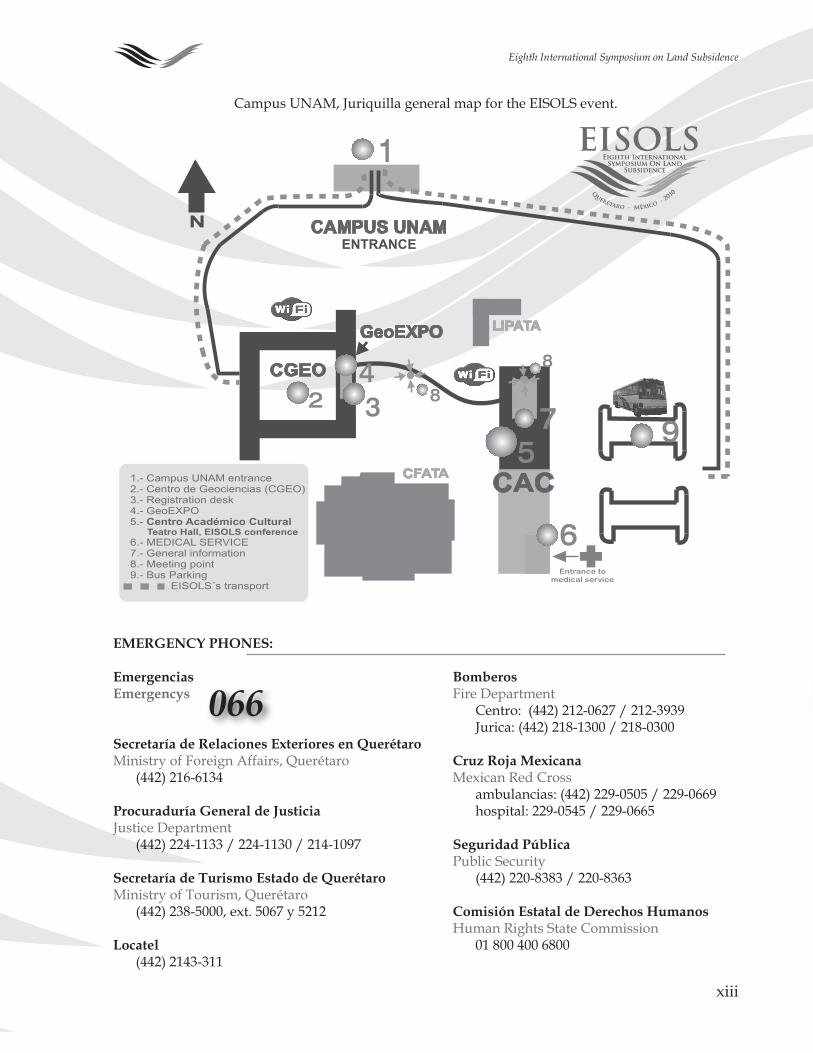
Campus UNAM, Juriquilla general map for the EISOLS event.

xiv
Eighth International Symposium on Land Subsidence
�
Eighth International Symposium on Land Subsidence
INTRODUCTION:LAND SUBSIDENCE, ASSOCIATED HAZARDS AND
THE ROLE OF NATURAL RESOURCES DEVELOpMENT
An awareness of problems related to land subsidence and its anthropogenic causes has been grow-ing worldwide since the second half of the Twentieth century. The problem of land subsidence was first included by the UNESCO projects in the International Hydrological Decade (HD) in �96�, and later in the International Hydrological Program (IHP). UNESCO organized the �st International Symposium on Land Subsidence in Tokyo in �969. In �97� land subsidence was retained under the framework of the International Hydrological Programme (IHP) as subproject 8.4 “Investigation of Land Subsidence due to Groundwater Exploitation”, and UNESCO formed the associated Working Group on Land Subsidence. This resulted in the organization of the following six International Symposia on Land Subsidence sponsored by the UNESCO that were held in Anaheim (�976), Venice (�98�), Houston (�99�), The Hague (�99�), Ravenna (�000), and in Shanghai (�00�).
Subsidence is a global phenomenon but the consequences and their remediation generally are lo-cal. Land subsidence has become an important area of research in Mexico, and globally. The EISOLS (Querétaro, 2010) conference presents a high standard of scientific and technical information to scien-tists, engineers, and end users of the studies on land subsidence and associate hazards. The abstracts presented in this volume cover international science and social issues related to land subsidence and the role of natural resources development.
The main topics developed during the EISOLS includes Land Subsidence processes related to (�) earth fissures and fracturing, (2) modeling, (3) geological and geomechanical aspects, (4) monitoring techniques of ground displacements and subsurface deformation, (�) social, cultural and economic impacts and their incorporation into resource management strategies and (6) subsidence caused by subsurface fluid withdrawal (water, gas, oil). Delegates participated in the symposium describing the development of new techniques for monitoring, analysis, interpretation and prediction of subsidence and (or) related fracturing processes—an emphasis of EISOLS.
This symposium is of particular interest for Mexico because of the close relation between land sub-sidence, ground fracturing and groundwater management. These phenomena provoke widespread problems in the rapidly growing urbanized areas of central Mexico. The analysis of these phenom-ena requires a multidisciplinary approach to improve understanding of the triggering factors, failure modes, and propagation processes of fracturing. Resolving the relationship between society and natu-ral resources management is an inevitable condition for the sustainable development in urban areas. To face this challenge in Mexico we urgently need to improve our comprehension of Land Subsidence processes. An effort was made in EISOLS to integrate the entire involved community; three peripheral technical meetings were convened to focus on Mexican subsidence-related issues: (�) Workshop on Land Subsidence and Geotechnical Engineering, (�) Water Management Agencies Round Table, and (3) Scientific Consultant’s Presentation.
On behalf of the Centro de Geociencias, National University of Mexico (UNAM), and the UNESCO Working Group on Land Subsidence we are pleased to welcome you to Querétaro and sincerely hope that you profit and enjoy the EISOLS 2010 Symposium.
Dora Carreón Freyre, Mariano Cerca
and Devin L. Galloway

�
Eighth International Symposium on Land Subsidence

�
Eighth International Symposium on Land Subsidence
SESSION 1EARTH FISSURES, FRACTURING AND FAULTING
RELATED TO LAND SUBSIDENCE♦
MECHANISMS FOR EARTH FISSURE FORMATION IN HEAVILY pUMpED BASINS♦
T.J. BurbeyDepartment of GeosciencesVirginia Tech.Virginia, United States of America.
Earth fissures are perhaps the most deleterious byproduct of excessive groundwater exploitation in many subsidence-prone arid-zone sedimentary basins. These features have long been associated with differential land subsidence caused by changes in the thickness of compacting sediments, abrupt changes in stratigraphy, or by large changes in vertical effective stress resulting from large drawdown gradients. However, it is recognized that pumping-induced earth fissures can and do form in areas far from the center of pumping where drawdowns are small and the changes in drawdown are even smaller. The key to understanding where and why fissures form is to first recognize that subsidence is a three-dimensional phenomenon; horizontal strain can play a vital, if not a dominant, role in invoking fissure formation, yet this important component is often ignored or considered irrelevant. The second key is the shape and properties of the boundary conditions. Boundary conditions here refer to any fea-ture that affects the transmission of stress and strain in three dimensions. Thus, boundaries can be rep-resented as faults, bedrock knobs, basin edges, or other heterogeneities causing stratigraphic changes. It’s clear that such boundaries would cause abrupt changes in physical parameters such as bulk modu-lus and hydraulic conductivity. However, the shape of the boundary is also important relative to the stress regime imposed by pumping. Subvertical faults, thinning aquifers, and bedrock knobs can cause an unequal vertical distribution of horizontal strain that results in rotation of the adjacent sediments that can cause zones of localized compression and zones of localized extension. These zones of exten-sion can migrate upward and exceed the failure criterion in the weak vadose zone resulting in a fissure that can originate anywhere between the saturated zone and land surface.
Key words: Earth fissures, land subsidence, aquifer mechanics, faults, sedimentary basins.
IMpLICATIONS OF GROUND-DEFORMATION MEASUREMENTS ACROSS EARTH FISSURES IN SUBSIDENCE AREAS IN THE SOUTHWESTERN UNITED STATES♦
T.L. HolzerUnited States Geological Survey, 345 Middlefield Road, MS977,
Menlo Park, CA 9�0��, United States of [email protected]
Ground deformation was monitored at earth fissures in areas of land subsidence induced by groundwater extraction in the southwestern United States. The ground deformation is consistent with the mechanism that fissures are caused by horizontal strains generated by bending of overburden in response to localized differential compaction. Subsidence profiles indicated that localized differential subsidence occurred across the fissures and that maximum convex-upward curvature was at the fis-sure. The overall shape of the profile stayed similar with time, and maximum curvature remained stationary at the fissure. Horizontal displacements were largest near the fissure, and generally were small to negligible away from the fissure. Maximum tensile horizontal strains were at the fissure and coincided with maximum curvature in the subsidence profiles. Horizontal tensile strain continued to
�
Eighth International Symposium on Land Subsidence
accumulate at fissures after they formed with rates of opening ranging from 30 to 120 microstrain/yr at fissures in Arizona.
Key words: subsidence; earth fissure; ground deformation; geodesy; monitoring; creep; groundwa-ter; United States.
SOIL FRACTURING INDUCED BY LAND SUBSIDENCE♦
G. Auvinet, and E. MéndezInstituto de Ingeniería, Universidad Nacional Autónoma de México,
Ciudad Universitaria,Apdo. Postal 70-�7�, Coyoacán, 0���0, México, D.F.
[email protected]; [email protected]
Soil fracturing occurs due to the development of shear and tension stresses within the soil mass. Fracture mechanics constitutes a useful theoretical framework for this problem. Different types of cracks have been observed in the Mexico City basin and other parts of the Mexican Republic. Several fracturing mechanisms have been identified. Some of them are a clear consequence of land subsidence due to pumping in deep aquifers. The paper illustrates this type of fractures with actual field observa-tions and presents a brief review of the attempts that have been made at modeling this phenomenon.
Key words: fracturing; soil; land subsidence; fracture mechanics; numerical modelling
ON THE MECHANISMS FOR EARTH FISSURING IN LAS VEGAS VALLEY, A NUMERICAL ANALYSIS OF pUMpING-INDUCED DEFORMATION AND STRESS♦
M. Hernández-Marín1,2, and T. J. Burbey1
� Dept. of Geosciences, Virginia Tech, �0�� Derring Hall, Blacksburg, VA ��06�[email protected]
� Instituto Tecnológico de Estudios Superiores de Occidente, Periférico Sur Manuel Gómez Morín 8�8�. Tlaquepaque, Jalisco, México. ��60�.
The arid Las Vegas Valley comprises a highly complex relationship amongst land subsidence, earth fissuring, and Quaternary faulting. The basin fill contains highly variable stratigraphy, including a thick semi-rigid vadose zone, and non-linear pumping patterns complicate the stress-strain regime. The Eglington fault, located at the northwest part of the valley has been selected as a prototype for this numerical analysis. Our Simulation results suggest that this particular Quaternary fault has a wide zone of influence (fault-zone) whose infill is hydromechanically similar to sand. In addition, one of the most important mechanisms that cause the stress concentration in the vicinity of the fault is the tendency of the entire fault to rotate with enhanced motion through the vadose zone. A combination of accumulated tensile and shear stress in the vadose zone portion of the fault-zone and in its vicin-ity, creates favorable conditions for the initiation of fissures in the lower vadose zone or at the land surface.
Key words: Numerical simulation; Earth fissuring; Eglington fault; Las Vegas valley; ABAQUS.
�
Eighth International Symposium on Land Subsidence
ADVANCES IN GEOTECHNICAL CHARACTERIZATION OF SOIL FRACTURING IN MEXICO CITY BASIN♦
E. Méndez1, *, G. Auvinet1, J. Lermo2
� Geocomputing Laboratory, Instituto de Ingeniería, Universidad Nacional Autónoma de México, Coyoacán 0���0, Mexico D.F..
� Seismological Engineering Group, Instituto de Ingeniería, Universidad Nacional Autónoma de México, Coyoacán 0���0, Mexico D.F.
Soil fracturing in the lacustrine area of the Basin of Mexico has become a common occurrence that causes alarm among the population and ends up causing significant damage to buildings and public services. For that reason, the Geocomputing Laboratory with the participation of the Seismological Engineering Group of Instituto de Ingeniería, Universidad Nacional Autónoma de México (II, UNAM) has undertaken in recent years, a systematic study of the phenomenon focused on descriptive aspects as well as on their theoretical interpretation.
Key words: fracturing; soil; earthquakes; geotechnical characterization; Mexico City.
MONITORING LAND-SURFACE DEFORMATION ON BICYCLE LAKE pLAYA, FORT IRWIN, CALIFORNIA, USA♦
J. Densmore�, *, K. Ellett�, J. Howle�, M. Carpenter�, and M. Sneed�
� U.S. Geological Survey, 6000 J Street, Placer Hall, Sacramento, CA 95819 USA; 916-278-3000.� U.S. Geological Survey, P.O. Box ��60, Carnelian Bay, CA 96��0 USA.
� U.S. Geological Survey, 520 N. Park Ave., Tucson, AZ 95719 USA.* [email protected]
Groundwater pumping in the Bicycle Basin in the northern Mojave Desert, one of the major sourc-es of water supply at Fort Irwin National Training Center (NTC), California, has increased since the �990s. The increased pumping has resulted in as much as �� m of water-level declines from �990-�009 and as much as �70 mm of subsidence has occurred during �99�-06. Land-surface deformation, con-sisting of an earth fissure and sink-like depressions, occurred in 2005 on the Bicycle Lake (dry) playa in the southern part of the basin. Earth fissures are a major concern to the NTC because aircraft runways constructed on the playa are used for transporting troops and supplies. Giant desiccation cracks or macropolygons also have been observed on the playa indicating that soil desiccation may play a role in the fissure formation. A monitoring system was developed to evaluate the driving mechanisms of fis-suring and to provide an on-going assessment of the ground-failure hazard. Land-surface deformation and movement across the fissure is being monitored using (1) repeated geodetic leveling surveys, (2) electronic distance measurement (EDM) surveys, (�) high-resolution ground-based, tripod-mounted Light Detection and Ranging surveys for measurement of three-dimensional (�D) changes across the fissure and adjacent areas, and (4) tape extensometer (tapex) measurements for horizontal changes across the fissure. The desiccation mechanism is being assessed using heat-dissipation sensors (HDPs) coupled with laboratory-scale experiments of soil desiccation. Preliminary results from repeat EDM surveys were inconclusive but repeat tapex measurements show that the fissure appears to be open-ing at a rate of ~�-� mm/yr which may be in response to ~� m measured water-level decline during �008-09. Combining automated measurements from tiltmeters and HDPs may help provide a tool for real-time monitoring of fissure hazards.
Key words: land-surface deformation, fissure, macropolygons; geodetic leveling, EDM, tape exten-someter, LiDAR, subsidence.
6
Eighth International Symposium on Land Subsidence
MONITORING OF LAND SUBSIDENCE AND FRACTURING IN IZTApALApA, MEXICO CITY♦
D. Carreón-Freyre1, *, M. Cerca1, R. Gutiérrez-Calderón2, andM. Huerta-Ladrón de Guevara2
� Universidad Nacional Autónoma de México, , Centro de Geociencias, Laboratorio de Mecánica Multiescalar de Geosistemas (LAMMG), Querétaro, Qro. Mexico.
� Centro de Evaluación de Riesgo Geológico (CERG), Delegación Iztapalapa del Distrito Federal, Mexico.
The metropolitan area of Mexico City is one of the most populated in the world and the Iztapalapa Municipality, situated in the eastern border, presents the highest population density of the city. This area is located over the geological contact between the “Sierra de Santa Catarina” volcanic range and a lacustrine basin. Inherently, the geological materials of the subsoil are horizontally and vertically heterogeneous and deform differentially under applied loads (natural and anthropogenic). As a con-sequence Iztapalapa urban infrastructure is extremely affected by fracturing and land subsidence and it is possibly one of the places with the highest social related vulnerability in Mexico. Since localization of fracturing and deformation during land subsidence are highly dependent on local geologic, geome-chanical, and hydraulic conditions of the subsoil, a multidisciplinary approach for a better understating of the fracturing triggering and propagation mechanisms was established. The methodology includes: (�) detailed geological survey, (�) high resolution geophysical prospecting, (�) stratigraphic correla-tion of lithological logs from water extraction wells, (�) geotechnical characterization of near surface sequences, and (�) hydrogeological analysis, including the monitoring of groundwater piezometric levels. All the obtained information is referenced and analysed using a Geographical Information System (GIS), which is directly related to a main Digital Information System (SID) available via inter-net to the Iztapalapa authorities for the support of decision making. As a result of a solid academic-government collaboration the former Monitoring Centre of Ground Fracturing was transformed in the Centre of Geological Risk Evaluation (Centro de Evaluación de Riesgo Geológico, CERG) that belongs to the Coordination of Civil Protection of the Iztapalapa Municipality. The physical vulnerability of the Iztapalapa area to land subsidence, ground fracturing, and other geological hazards is evaluated through the analysis of the generated information based on thematic maps that should allow a bet-ter planning of mitigation strategies, urban development, land use management, and groundwater exploitation.
Key words: Database management, monitoring, ground fracturing, vulnerability, geological hazards, Iztapalapa.
MICROTREMORS MEASUREMENTS TO DETECT ZONES OF pOTENTIAL CRACKING IN THE BASIN OF MÉXICO♦
J. Lermo*, E. Ovando, and L. EspinosaInstituto de Ingeniería, Universidad Nacional Autónoma de México,
Cd. Universitaria, Coyoacán, 0���0, México, D.F., Tel.: (0�-��) �6.��.��.00 ext: ��6�,* [email protected]
Fissures and cracks in the clayey masses of the Basin of Mexico have recently increased in number and have produced damages of consideration to low price popular dwellings, as in San Lorenzo, a location in the Ixtapalapa hilly area in Mexico City and in San Martin Cuautlalpan, in Chalco, close to the city. Cracks in these two cases are difficult to control and are caused by regional subsidence which, in turn, originates in the extraction of water from deep strata. Cracking and fissuring usually turn up
7
Eighth International Symposium on Land Subsidence
in abrupt transition zones in which the thickness of compressible clay layers changes sharply over short distances and in places where one finds buried geological structures within the basin. Many of these cracks and fissures have been located and even mapped but there are ample zones in the basin where the zones of potential cracking are yet to be defined. In this paper we show analyses of micro-tremors records to study three zones where cracks and fissures have appeared in and around Mexico City. Our results show that Nakamura´s ambient vibration method can be used adavantageously to study cracks and potential cracking, including some of its features: length, depth, etc. It can also be used to derive hypotheses regarding the possible origin of cracking phenomena and to define zones of potential cracking in certain areas of the basin. Results of exploratory geotechnical soundings are used to validate our method.
Key words: Subsidence, cracks, fissures, Nakamura’s method.
SIMULATION OF GROUND FAILURE DUE TO GROUNDWATER pUMpING♦
C. Janna*, M. Ferronato, G. Gambolati, and p. TeatiniDept. of Mathematical Methods and Models for Scientific Applications (DMMMSA),
University of Padova, via Trieste 6�, ����� Padova, Italy* [email protected]
Numerical modeling of failure generation due to groundwater pumping and prediction of fissure location, distribution, and geometry is a difficult task. To this aim we use a geomechanical model based on the structural equations of poroelasticity solved in a three-dimensional setting by the Finite Element (FE) - Interface Element (IE) approach. While standard FE are used to represent a continuum, IE prove especially suited to address the relative displacements of adjacent elements such as the open-ing and slippage of pre-existing faults or the generation of new fractures. The IE allow for the model-ling of fissure/fault mechanics using an elasto-plastic constitutive law based on the Mohr–Coulomb failure criterion. The corresponding FE-IE code is used for the prediction of localized differential sub-sidence and earth fissure activation/generation with some representative examples discussed in the literature.
Key words: ground fissures; groundwater pumping; finite elements; interface elements.
AppLICATION OF WIGNER-VILLE TRANSFORM TO IDENTIFY FRACTURING GpR pROFILES♦
M.A. Elizondo1, *, R.E. Chávez2, M.E. Cámara3, and A. Tejero4
� Posgrado en Ciencias de la Tierra, Universidad Nacional Autónoma de México, Mexico, D. F., Mexico.
� Instituto de Geofísica, Universidad Nacional Autónoma de México, Mexico, D. F. , Mexico.� Escuela de Ingeniería Industrial, Universidad Politécnica de Madrid, Madrid, Spain.
� Facultad de Ingeniería, Universidad Nacional Autónoma de México, Mexico, D. F., Mexico. * [email protected]
An analysis in time and frequency, based on signal decomposition spectral analysis is performed through the Wigner-Ville distribution (WVD) for GPR data. It calculates a cross correlation between the original signal and the time-frequency components, for structural anomalias avaibles in the infor-mation provided by the GPR related to geology available. We describe the application in a theoretical example representing a tunnel. Corresponding signatures are obtained in time-frequency domain. A
8
Eighth International Symposium on Land Subsidence
real application is presented in an area of the Cathedral of Morelia, Michoacan, Mexico, to detect a tunnel and tested methodology. The results are interesting regarding the possibility of locating such structures.
Key words: Ground Penetration Radar (GPR), time-frequency analysis, Wigner-Ville distribution, signal processing.
THE ApLICATION OF GROUND pENETRATING RADAR IN THE STUDY OF SUBSIDENCE-CREEp INDUCED FAULTS IN CELAYA
Poster S�.�
N. Giordano, O. Díaz-Molina, E. Cabral-Cano, V.H. Garduño-Monroy, V.M. Hernández-Madrigal,
and A. Camargo-Valencia Universidad Michoacana de San Nicolás de Hidalgo,
Morelia, Michoacán, MexicoUniversidad Nacional Autónoma de México,
Mexico, D.F., Mexico [email protected]
The city of Celaya has experienced in the last � decades rapid subsidence and development of several fault systems as a result of over-exploitation of its underground water resources. This situ-ation is common to several other cities in central Mexico, which are also located on fluvio-lacustrine basins such as Morelia, Querétaro, Salamanca, Irapuato, Aguascalientes, and Mexico City. Celaya is enduring ground subsidence of up to �0 cm-year-� over the last two decades, causing severe dam-age to its urban infrastructure. In order to better understand this phenomenon we have initiated a comprehensive surface reconnaissance and shallow geophysical exploration program to characterize the geometry of fault planes, define synthetic and antithetic fault systems and the lateral extent for each fault zone. The cartographic update of six surface faults and the analysis of the geological and hydrogeological information provided by the Junta Municipal de Agua Potable y Alcantarillado de Celaya (JUMAPA), suggested several targets for detailed geophysical studies. The first stage included a Ground Penetrating Radar survey, using a GSSI SIR-�000 with �0, 70 and �00 MHz antennas, which allowed different target resolutions up to ��m deep. �� GPR sections have been surveyed perpendicu-larly to the Oriente, Poniente and Universidad Pedagogica faults. Radargrams from the Oriente fault, reveal that the lateral extent of the fault extends up to �0-�� m on each side of the fault, but major de-formation is concentrated along both sub-vertical fault and a synthetic faults systems with inclinations of �0-�� eastward. These results indicate that current city land-use and construction regulations on fault-affected areas are severely underestimated; thus future damage to adjacent structures is likely to occur on a ~60-70m wide swath along the main surface trace of these major faults. These results can be used to improve urban development and land use programs and for mitigation of damage to private property and public services
Key words: subsidence, Celaya, faults.
9
Eighth International Symposium on Land Subsidence
THE IMpACT OF GROUND FISSURES ON THE CONSTRUCTION OF XI’AN METRO,CHINA
Poster S�.�
X.S. Li, Q.S. Meng, L. Wang, T. Wan Chang’an University,China
First,this paper describes the distribution and activity characteristics of ground fissures in Xi’an, then analyzed the influence of ground fractures on metro construction from aspects of model of action,activity rate,physical mechanical property of deformation zone, and the influence of ground water and so on. Finally put forward respective prevention and treatment messurements for the Xi’an metro, according to the results of the analysis.
Key words: Xi’an metro, ground fracture, impact.
GRAVIMETRIC SIGNATURE OF EARTH FISSURES DUE TO pUMpING OF GROUNDWATER IN AGUASCALIENTES VALLEY, MEX.
Poster S�.�
J. pacheco-Martínez, S.I. Martínez-Martínez, M.E. Zermeño de León Departamento de Construccion y Estructuras del Centro de Ciencias del Diseño y
de la construccion de la Universidad Autonoma de Aguascalientes [email protected]
The Aguascalientes Valley was formed by a sequence of granular fills which were deposited into a graben defined by two NS normal faults. It is located in Central Mexico, and it covers all the middle part of the Aguascalientes State. A land subsidence process has been observed in this region since the early 1980´s. It has become a serious problem because surface fissures and faults associated with dif-ferential subsidence have been damaging structures. In this work we present an analysis of a series of gravimetric measurements carried out to identify the shape of the gravimetric anomaly that is associ-ated to the specific zones in which the terrain fissures have been appearing. We describe the observed characteristics of the gravimetric anomaly curve in the crossings of profiles measurements with earth fissures (amplitude, longitude and its gradient). We performed an estimation of the optimal separation of gravimetric stations in order to obtain a curve of gravimetric anomaly in which it could be possible to identify changes associated with earth fissures. The relationship between fissures and gravimetric anomalies is a sort of “gravimetric signature of the earth fissures” which can be used to characterize the sites where fissures occurs. In a granular aquifer that is laying above a bedrock, like the aquifer of Aguascalientes Valley, this gravimetric anomaly can be interpreted like a change in the topography of the bedrock; this change is one of the factors that is controlling the earth fissures generation in this val-ley. We consider that the gravimetric signature of fissures may be used to investigate zones in which fissures does not occur yet, and where it is necessary to make a zoning of the probability that earth rup-tures occurs. In order to illustrate this, we present the case of study of an area of �00 hectares located in the western side of Aguascalientes City. In some places within this area several fissures were directly observed before of the study. However, in other sites there were no indicators which could show us that earth fissures could be present in the future. The study results allowed us to identify zones where the bedrock has an irregular topography. It is believed that these zones are more likely to present fis-sures in the future, particularly, if other contributing factors become present.
Key words: Fissures, zoning, gravimetric, Aguascalientes.
�0
Eighth International Symposium on Land Subsidence
GEOpHYSICISTS SHALLOW STUDIES FOR FRACTURE CONFIGURATION IN THE AGUASCALIENTES VALLEY
Poster S�.�
F.J. Aguilar V.1, *, D.T. Reyes Ch.1, and J.A. Fuentes L.2
� Universidad Panamericana Campus Bonaterra, Aguascalientes, Ags, Mexico� Geofísica Aplicada a la Geotécnia S.A. de C.V.
* [email protected] During the past �0 years the phenomenon of subsidence has been occurring more drastic way in
the Aguascalientes Valley , with more than �60 discontinuities and over �000 affected buildings. The regulations of the municipal code requires a geological geophysical studies in order to authorizer construction license, in projects with an area of �000 m� or greater. In this work we show the results of different geophysical techniques applied to detection and configuration of geological discontinui-ties in order to minimize the risk of impact in the future due to this phenomenon. The results suggest that there are various types of discontinuities, the first one with more than 20 m affected zone on each side of the failure impact and located mainly at the ends of the Aguascalientes Graben, in fact they delimited structure on both sides, the East and the West. A second type focuses partly defined between endpoints and the first third of the distance towards the Centre of the Valley, characterized by breaks of less than 0.5 m drop and with less than 20 m and over 5 m for each flank affectation areas. Finally are located in the central part and without showing displacement vertically has horizontal movement with less than � m affectation areas in fact has virtually zero affectation in the block that remains relatively stable. We shows evidence of the faults occur in pre-existing failures and discontinuities in the sense NNE orientation is controlled by the most recent faulting system. Within the different geophysical techniques applied for detection and configuration of these structures in Aguascalientes, geoelectri-cal tomography is in generally which resolves more quantitative way the presence of discontinuities. Currently geological and geophysical studies are directed towards prediction about the possibilities of occurrence of discontinuities in the land proposed for infrastructure developments and this work proposed routing more towards the mitigation of the effects, this due to the uncertainty that variables time and space have in the prediction and difficult to its application in the civil context.
Key words: discontinuities, Aguascalientes Valley, normativity.
Note: ♦ Paper available at IAHS Red Book Series No. 339, 2010
��
Eighth International Symposium on Land Subsidence
SESSION 2 MODELING LAND SUBSIDENCE AND ASSOCIATED HAZARDS
USE OF THE SUB-WT pACKAGE FOR MODFLOW TO SIMULATE AQUIFER-SYSTEM COMpACTION IN ANTELOpE VALLEY, CALIFORNIA♦
S.A. Leake1, *,and D. L. Galloway2
� US Geological Survey, ��0 N. Park Ave, Suite ���, Tucson, Arizona 8�7�9, USA� US Geological Survey, �0�0 State University Drive East, Suite �00�, Sacramento, California 9�8�9, USA
The Antelope Valley of southern California, USA, includes a basin-fill aquifer system with an up-per unconfined aquifer and middle and lower confined aquifers. Groundwater pumping has caused nearly � m (�9�0–�99�) of subsidence near the city of Lancaster. A previous model simulated region-al groundwater flow, aquifer-system compaction and subsidence in Antelope Valley using the US Geological Survey modular groundwater flow model MODFLOW with the Interbed Storage Package, version 1 (IBS1). That approach used the assumptions of constant geostatic stress and skeletal specific storage. The newer Subsidence and Aquifer-System Compaction Package (SUB-WT) for water-table aquifers for MODFLOW allows geostatic stress to vary as a function of the position of the water table, and uses stress-dependent skeletal storage coefficients. For this study, the previous model was con-verted to use SUB-WT to assess the importance of accounting for variable geostatic stress and stress-dependent storage on subsidence simulations in Antelope Valley.
Key words: subsidence; aquifer-system compaction; groundwater model; Antelope Valley, California, USA
MONITORING AND MODELLING 3D GROUND MOVEMENTS INDUCED BY SEASONAL GAS STORAGE IN DEEp RESERVOIRS♦
p. Teatini1, *, G. Gambolati1, N. Castelletto1, M. Ferronato1, C. Janna1, E. Cairo2, D. Marzorati2, D. Colombo3, A. Ferretti3, A. Bagliani4, S. Mantica4, and F. Rocca5
� Dept. of Mathematical Methods and Models for Scientific Applications (DMMMSA), University of Padova, via Trieste 6�, ����� Padova, Italy.
� Stogit S.p.A., Via dell’Unione Europea �, San Donato Milanese (MI), Italy.� Tele-Rilevamento Europa S.r.l. (TRE), Via V. Colonna 7, I-�0��9 Milano, Italy.
� Eni S.p.A. - Divisione E&P, Via Emilia �, �0097 San Donato Milanese, Italy.� Dip. di Elettronica ed Informazione,Politecnico di Milano, piazza Leonardo da Vinci ��, �0���
Milano, Italy.*[email protected]
Underground gas storage (UGS) in depleted hydrocarbon fields is a strategic practice to cope with the growing energy demand and occurs in many places in Europe and North America. In response to summer gas injection and winter gas withdrawal the reservoir expands and contracts almost elastical-ly, namely it “breathes”, as a major consequence of the fluid pore pressure fluctuations. Depending on a number of factors including the field burial depth, the difference between the largest and the smallest gas pore pressure, and the geomechanical properties of the injected formation and the overburden, the porous medium overlying the reservoir is subject to a three-dimensional deformation with the related cyclic motion of the land surface being both vertical and horizontal. We present a multidisciplinary
��
Eighth International Symposium on Land Subsidence
methodology to evaluate the environmental impact of UGS from a geomechanical point of view in connection with the ground surface displacement that may rise some concern for the integrity of the existing engineered structures and infra-structures. Long-time records of injected/removed gas vol-ume and fluid pore pressure together with multi-year detection of vertical and horizontal West-East displacement of the land surface above the field by an advanced PSInSARTM analysis have allowed to calibrate a 3D fluid-dynamic model and develop a 3D transversally isotropic geomechanical model. The latter has been successfully implemented and used to reproduce the vertical and horizontal cyclic displacements, on the range of 8-�0 mm and 6-8 mm, respectively, measured between �00� and �007 above the “Lombardia” gas reservoir, Northern Italy, where a UGS program is under way by Stogit S.p.A. (Eni) since 1986 following an initial 5-year field production life.
Key words: Underground gas storage; 3D geomechanical model; PSInSAR.
REGIONAL LAND SUBSIDENCE MODEL EMBODYING COMpLEX DEFORMATION CHARACTERISTICS♦
S. Ye1*, Y. Xue1, J. Wu1, Z. Wei2, and Q. Li2 � State Key Laboratory of Pollution Control and Resource Reuse, Department of Hydrosciences,
Nanjing University, Nanjing ��009�, China� Shanghai Institute of Geology Survey, Shanghai, �0007�, China.
Large land subsidence regions usually present very complicated deformation characteristics of sedimentary layers in the history, such as the elastic , visco-elastic, and elastic-plastic and visco-elastic-plastic deformation characteristics of sedimentary layers in the Yangtze Delta, China. It is necessary to develop a regional land subsidence model which is able to describe different deformation charac-teristics. Firstly, the modified Merchant model is proposed to model the visco-elastic-plastic defor-mation with only three parameters. Then a regional land subsidence models based on the modified Merchant model is developed. Regional land subsidence models for the sedimentary layers with the elastic, visco-elastic, and elastic-plastic deformations can be derived from the one based on the modi-fied Merchant model by setting proper values for the three parameters involved. So the four kinds of land subsidence models can be embodied in the one developed from the modified Merchant model. The new regional land subsidence model has another advangtage of only four parameters involved. Land subsidence in Shanghai city is simulated as a case study for the regional land subsidence model proposed in this paper. The results show that the regional land subsidence model is suitable for de-scribing the land subsidence with complex deformation characteristics, and can represent the mecha-nism of land subsidence caused by excessive ground water withdrawal relatively well.
Key words: Regional land subsidence model; Modified Merchant model; Complex deformation
��
Eighth International Symposium on Land Subsidence
MODELING LAND SUBSIDENCE pROCESSES INDUCED BY FAST RAINWATER INFILTRATION THROUGH FRACTURES INTO UNSATURATED ZONE♦
I. Martinez1,*, R. Hinkelmann1, and S. Savidis2
� Chair of Water Resources Management and Modeling of Hydrosystems, Technische Universität Berlin, Sekr., TIB I-B��, Gustav-Meyer-Allee ��, ����� Berlin, Germany
� Chair of Soil Mechanics and Geotechnical Engineering, Technische Universität Berlin, Sekr., TIB �-B7, Gustav-Meyer-Allee ��, ����� Berlin, Germany
The aim of this work is to better understand rainfall-induced fast infiltration of water through fractures into the subsurface as well as to estimate its influence on mechanical deformation, i. e. land subsidence. Flow in the partially saturated soil (matrix, fracture) is described with the model concept of two-phase flow in porous media and the stress-strain analysis is carried out with the hardening soil model (elasto-plastic model) using a double stiffness concept for elasticity in combination with isotropic strain hardening. Flow and deformations are weakly coupled.
In this research several numerical studies are presented. An analysis about the influence of frac-ture and surface inclination on flow and deformation is carried out. The results of the numerical study show that infiltration into a system with a horizontal surface and without fracture only leads to vertical deformations. Infiltration into a system with a vertical fracture has nearly no influence on the defor-mation because the water mainly propagates in the vertical direction due to gravity. Infiltration into a system with a horizontal surface and an inclined fracture result in considerable horizontal and vertical deformations. Such deformations are further increased when the surface is inclined.
Key words: Subsidence; fracture; rainwater infiltration; numerical modeling; unsaturated zone.
NONLINEAR ANALYSIS OF LAND SUBSIDENCE DUE TO GROUNDWATER LEVEL OSCILLATION BY FINITE DIFFERENCE METHOD♦
H. Yazdani1, 2, *, M. M. Toufigh2, and A. Masoudzade2
� Civil Engineering Department, Javid-e Jiroft Institute of Technology, Azadi Ave., Jiroft, Iran.� Civil Engineering Department, University of Kerman, �� Bahman Blvd.,
Kerman, Iran. P.O.Box ���, 76�7�.*[email protected], *[email protected]
Groundwater level oscillation leads to successive variation of effective stresses through a clay layer resulting in consecutive settlement. Different elements of the layer may be normally consolidated (NC) or over consolidated (OC) under such a cyclic loading depending on some parameters such as load-ing intensity, layer thickness and distance from drainages, nonlinearity of the soil and pre-consolida-tion pressure. Then, deriving a new equation considering cyclic loading and also compressibility and permeability changes of soil is inevitable. Two nonlinear partial differential equations are derived to analyze the clay consolidation in this paper using void ratio-effective stress and void ratio-permeabil-ity diagrams. By the finite difference method, the PDE’s are utilized to analyze the land subsidence problem. It is shown that the ratios between slopes of the diagrams in the NC and OC conditions play a major role in the consolidation process. The effect of each of these parameters is shown.
Key words: Nonlinear Consolidation, Land Subsidence; Cyclic Loading; Finite Difference Method; Variable Permeability; Variable Compressibility.
��
Eighth International Symposium on Land Subsidence
THERMO-pORO-ELASTIC EFFECTS IN THE ANTHROpOGENIC UpLIFT OF VENICE BY DEEp SEAWATER INJECTION♦
N. Castelletto*, M. Ferronato, G. Gambolati, C. Janna, and p. TeatiniDept. of Mathematical Methods and Models for Scientific Applications (DMMMSA), University of Padova,
via Trieste 6�, ����� Padova, Italy.*castelletto, ferronat, gambo, janna, teatini)@dmsa.unipd.it
To mitigate flooding that periodically plagues Venice a project of anthropogenic uplift of the city by deep seawater injection has been recently advanced. A pilot program has been designed to test the feasibility of the proposal, improve the knowledge of the subsurface below the Venice Lagoon and help the calibration of the full-scale prediction models. The present communication aims at supple-menting the proposal with the investigation of the role played by a temperature variation should the injection take place in non-isothermal conditions. A three-dimensional (�D) non-linear hydro-thermo-mechanical model is developed making use of lowest order Mixed Hybrid Finite Elements (MHFEs) and shock capturing Finite Volumes (FVs) for the coupled subsurface fluid flow and heat transfer, and Finite Elements (FEs) for the structural equilibrium. A set of computer simulations is performed using realistic information on the hydrogeological, geothermal, and geomechanical properties of the Northern Adriatic basin. A representative 7�0 m deep brackish aquifer is selected with the seawater injection programme planned with an overpressure of � MPa over a �-year time. Different scenarios are simulated depending on the temperature difference ∆T between formation water and injected sea-water that is assumed to be taken from the Adriatic. Basically a ∆T according to season is addressed. The numerical results show that the ∆T impact on the pressure field is negligibly small relative to the isothermal case, while some influence is exerted by thermal gradient on the predicted uplift which can vary at the most by nearly �0% for an injection in ambient conditions.
Key words: Anthropogenic uplift; hydro-thermo-mechanical modelling; Venice.
AN ANALYTICAL SOLUTION OF pLANE STRAIN CONSOLIDATION DUE TO A pOINT SINK WITHIN A FLUID-SATURATED pOROELASTIC MEDIA♦
p.C. Li1, *, Y.L. He1, Y.M. Mi1, and S.L. Gong2
� Shanghai University of Engineering Science, Shanghai �0�6�0, China.� Center for Land Subsidence of China Geological Survey, Shanghai �0007�, China.
*[email protected]; *[email protected]
An analytical solution was derived for the general Biot’s consolidation theory within a finite two-dimensional (�D) poroelastic media due to a point sink/source when the pore pressure is prescribed on the boundary. Appropriate Fourier and Laplace transforms and the corresponding inversions were implemented to obtain the exact solution. In particular, the steady-state analytical solution due to a point sink of constant production rate was presented and validated by the exact solution available in the literature. The proposed analytical solution in this paper is highly applicable for testing the accu-racy of numerical schemes, and meanwhile can be of great use to further investigate the behavior of flow and deformation coupling in a finite 2D domain.
Key words: Finite 2D poroelastic media; plane strain consolidation; finite sine and cosine transforms; analytical solution.
��
Eighth International Symposium on Land Subsidence
RESEARCH ON 3D VISUALIZED STRATA MODEL VIRTUAL REALITY SYSTEM OF LAND SUBSIDENCE IN SUZHOU-WUXI-CHANGZHOU AREA♦
J. Yu1, 2, *, X.S. Su3, L. Zhu4, F.Z. Duan4, Y. pan4,L. Gao3, and S.L. Wu1
� Postdoctoral Fellowship of Geological Survey of Jiangsu Province, Nanjing 210018;� Postdoctoral Program of Jilin University, Changchun 130026;
� College of Environment and Resource, Jilin University, Changchun 130026;;� The Key Lab of Three-Dimensional Analysis and Application,
Capital Normal University, Beijing �000�7*[email protected]
Due to the requirements of land subsidence research in Suzhou-Wuxi- Changzhou area, a three dimensional land subsidence virtual reality system was developed based on the virtual reality technol-ogy. This paper gives a general introduction on the framework, method and functions of the �D land subsidence virtual reality system. This system can simulated the �D geological structure, the ground-water flow field, the dynamic process of land subsidence, and the sequent induced by the occurrence of land subsidence. The basic metadata for simulation is derived from the land subsidence numerical model, field data and literature data. It can be concluded that this virtual system is the effectively visual platform for studying the mechanism, process and forecasting of land subsidence in Suzhou-Wuxi-Changzhou area.
Key words: land subsidence; virtual reality; geological structure; Suzhou-Wuxi-Changzhou area.
INVERTING SUBSIDENCE DATA TO DETECT pOSSIBLE COMpARTMENTALIZATION IN A GAS RESERVOIR IN THE NETHERLANDS♦
K. Visser*, A.G. Muntendam-Bos, G. Kunakbayeva, O. Leeuwenburgh, E. peters, and p.A. Fokker**
TNO Built Environment and Geosciences, Princetonlaan 6, Postbox 800��, ��08 TA Utrecht, The Netherlands.
[email protected], [email protected]
Subsidence can be induced by hydrocarbon production, due to the decrease in pore pressure in the reservoir which causes the reservoir to compact. The subsidence at any point on the surface is a result of the compaction over a large area of the reservoir. The properties of the reservoir and thus the com-paction are uncertain. Therefore, an inversion is needed to constrain the knowledge about compaction in the reservoir with the use of subsidence data.
We applied a previously developed linearized subsidence inversion method to the Roswinkel gas field. This field is situated in the northeastern part of the Netherlands. The Roswinkel field has been in production between �980 and �00�. It is a complicated anticlinal structure with many faults in two major directions, dividing the reservoir in up to �0 reservoir compartments. Prior geomechanical modeling of the Roswinkel field revealed deviations in the measured subsidence from the predicted ideal elliptical shape of the subsidence bowl, possibly indicating partly undepleted compartments in this reservoir.
The prior knowledge of the reservoir was quantified using Monte Carlo simulations. The degree of compartmentalization was varied by perturbing the fault transmissibilities. The prior knowledge, contained in the simulation models, includes the expected compaction field, the standard deviations, and the spatial and temporal correlations between the model elements
Our inversion study on Roswinkel demonstrates our ability to constrain the prior uncertainty of the reservoir model. The inversion exercise gave a clear adaptation of the prior compaction field from
�6
Eighth International Symposium on Land Subsidence
a smooth, extended field to a sharply bounded field with internal structure. This means that identifica-tion of gas compartments and fault properties by inversion of subsidence measurements is feasible. The prior knowledge is the critical part in the inversion exercise; the most critical steps seem to be the geological and the geodetic analysis. For the latter, new data like space-geodetic observations might help improve the analysis. However, we expect the largest improvement to come from integrating inversion steps, implying that all the different data are taken into account simultaneously.
Key words: subsidence, inversion, Bayes, reservoir compartmentalization.
IMpACT OF LONGWALL MINING OF COAL ON HIGHWAYS IN SOUTHWESTERN pENNSYLVANIA♦
J.J. Gutiérrez1, L.E. Vallejo1, *, J.S. Lin1, and R. painter2 � Department of Civil and Environmental Engineering, University of Pittsburgh,
Pittsburgh, Pennsylvania, USA.� Pennsylvania Department of Transportation, Uniontown, Pennsylvania, USA.
Underground Longwall mining is a widely used coal extraction method in southwestern Pennsylvania, USA. The extracted coal takes the form of rectangular panels whose length and width can reach up to 4000 m and 450 m, respectively, with a thickness of roughly 2.0 m; mine depths range from �80 m to �80 m. A number of longwall panels have been mined underneath interstate highway I-79 in Greene County, Pennsylvania, inducing subsidence that raises concern for traffic safety. The Pennsylvania Department of Transportation monitored the impact of mining on the highway and collected the data that formed the basis for this study. Field data obtained from eight longwall panels included time series of surveying measurements collected as each mine advanced underneath the highway. With the aid of a genetic algorithm, a three dimensional subsidence model was developed that described the data well. The model gives the spatial distribution of surface subsidence in terms of the depth of the coal, the width of panels, the thickness of extraction, and the location relative to the face of an advancing panel. Surface deformation features were analytically derived from the model.
Key words: Underground coal mining; longwall mining; mine subsidence; genetic algorithm, high-way embankment.
INTEGRATION OF GEOLOGICAL AND HYDROGEOLOGIC FEATURES FOR SUBSIDENCE MODELING IN VOLCANIC ZONES♦
G. Ochoa-González1, and D. Carreón-Freyre2
� Dept. del Habitat y Desarrollo Urbano, Instituto Tecnologico y de Estudios Superiores de Occidente, Periferico Sur Manual Gomez Morin 8�8�, ��60�, Tlaquepaque, Jalisco, Mexico
� Centro de Geociencias, Universidad Nacional Autónoma de México, Querétaro, Qro., Mexico.
Land subsidence is related to the increment of effective stresses of geological media. This work is aimed to propose a numerical model to simulate land subsidence and related fissuring caused by the reduction of the piezometric levels due to pumping. The proposed model includes different geologi-cal features that affect the groundwater flow patterns, such as faults as well as hydraulic and geome-chanical anisotropy related to stratigraphic variations. The methodology consists in establishing a �-D hydraulic model used for interpreting pumping tests in geological setting with the features described
�7
Eighth International Symposium on Land Subsidence
above. Then, using the Finite Element Aster Code, integrate variations of transmisivities caused by local stratigraphy and incorporate elasto-plastic behaviour in a �-D simulation of deformation. Our results suggest that when subsidence occurs not only the superficial compressible geological deposits should be considered but the sum of the whole sequence affected by piezometric level variations. We demon-strate that the local and regional faulting control the pattern of piezometric variations.
Key words: numerical modelling, subsidence, Querétaro, Finite Element Aster Code.
UNDERSTANDING LAND SUBSIDENCE DUE TO GAS EXTRACTION WITH AN ADVANCED THREE-pHASE CONSTITUTIVE MODEL
Poster S�.�
M. Nuth* , L. Laloui, B.A. Schrefler Soil Mechanics Laboratory, Swiss Federal Institute of Technology Lausanne,
EPFL, Station �8, �0�� Lausanne, Switzerland *[email protected]
The industrial withdrawal of underground fluids in urban and coastal regions is known to be at the origin of land subsidence. According to the published in situ surveys, the compaction of soils is due either to water or gas extraction from underground layers. Recent simulations carried out at the scale of a sample in laboratory show that it is possible to reproduce the sediment compaction by changing the pressures of interstitial gas and liquid. Practically, the extraction of gas can be simulated by inject-ing water in an initially dry sediment sample under a constant external load, which results in a plastic compression, also called wetting collapse. The paper proposes a new attempt to model the observed collapse of samples, as well as the apparent stiffness changes during the process of wetting. Provided that the host media are three-phase materials with solid grains, liquid water and gas, the conceptual approach relies on the mechanics of unsaturated soils. The water retention capability of the sediments is featured in the constitutive model so that the capillary effects can be quantified. The variables used to characterize the water retention features are suction and degree of saturation. The constitutive model includes a direct dependency of the mechanical stress-strain behaviour on the capillary effects. Hence, the elasto-plastic volumetric changes within the porous medium incorporate the effects of saturation and suction. Using the generalized effective stress, the model predicts a stiffer behaviour for dryer soils, which provides a straightforward explanation for subsidence during gas withdrawal. The model shows consistent understanding of changes of compressibility with the quantity of retained water. The successive phases of isotropic compression and uniaxial mechanical compaction are used for the model calibration. Interestingly, the phases of plastic compression during injection are captured with accuracy, which evidence the direct applicability of the proposed model to boundary value problems such as large scale cases of land subsidence.
Key words: Land subsidence, fluid withdrawal, unsaturated soils, constitutive modelling, wetting collapse.
�8
Eighth International Symposium on Land Subsidence
TWO-DIMENSIONAL COUpLED NUMERICAL MODELLING OF SUBSIDENCE DUE TO WATER EXTRACTION AT THE LOWER LLOBREGAT RIVER, SpAIN♦
Poster S�.�
A. Concha1, *, J. Ripoll1, J. piña1, A. Gabàs2, and p. piña2
� Institut Geològic de Catalunya, Àrea d’Enginyeria Geològica, Balmes �09-���, Barcelona 08006, Spain.
� Institut Geològic de Catalunya, Unitat de Tècniques Geofísiques, Balmes �09-���, Barcelona 08006, Spain.
A Differential Interferometry of Satellite Radar (DinSAR) analysis has detected relative strong sub-sidence at the St Feliu del Llobregat municipality west of Barcelona City (average max. velocity of 0.7 cm/year for the period �99�-�006). Compilation of geological information and geotechnical logs, well piezometric measurements, and performing of two electrical resistivity tomography (ERT) surveys allowed to establish a geological-hydrogeological model of the site. A shallow saturated compressible clay layer (thicker where the most intense terrain deformation occurs) overlays sandy-silty gravels. Both units contain the unconfined Llobregat river upper aquifer.
A simplified numerical coupled 2D-FLAC model, with the existing conditions at the site,permitted to simulate the surface deformation measured by DinSAR. Though, refinements of the model, by changes in the clay layer geometry and water volume extraction rates are still needed, the calibration of the numerical model allows to foreseeing deformation under one specific water extraction rate.
Key words: SAR Differential Interferometry, subsidence, Lower Llobregat River, water flow and strain-stress coupled models, FLAC-�D.
INTRODUCTION OF THE JARAS/3D SIMULATOR FOR NATURAL GAS DISSOLVED IN WATER♦
Poster S�.�
T. Nakagawa1, I. Suzuki2, M. Nojo3, T. Ogatsu1, and T. Higuchi1 � Kanto Natural Gas Development Co., Ltd., Mobara Field Office 661 Mobara,
Mobara City, Chiba Prefecture �97-8��0 Japan� Inpex Corporation, Exploration & Exploitation Unit, Domestic Project Division �-�-� Higashi Odori, Chuo-ku, Niigata City, Niigata Prefecture 9�0-8���, Japan
� Godo Shigen Sangyo Co., Ltd. Chiba Office 1365 Nanaido Chosei-mura, Chiba Prefecture �99-���� Japan.*[email protected]
For four years from �996 to �999, the former Japan National Oil Corporation and eight companies developed the JARAS/�D simulator. This simulator is characterized by its ability to express two types of gas production performance in Southern Kanto Natural Gas Field, and evaluate amounts of land subsidence associated with gas production. This simulator is already used about several studies of Environment Committee. This paper introduces this simulator.
Key words: simulator, natural gas deposit of dissolved-in-water type, Mobara type production performance.
�9
Eighth International Symposium on Land Subsidence
pARAMETERS ESTIMATION IN THE SURFACE SUBSIDENCE MODELING♦
Poster S�.�
R. HejmanowskiDept. of Mining Areas Protection, Geoinformatics and Mine Surveying,
AGH University of Science and Technology, al. Mickiewicza �0, �00�9 Krakow, Poland.
The aim of the surface subsidence is efficient protection of the communities living on the mining induced areas. Furthermore the more accurate estimated are the parameters of the prediction model the more reliable the prognosis are. The parameters not only should have physical sense but also they should be established in the local condition of the minerals exploitation. The model, which based on the influence function, of surface deformation prognosis caused by water, gas or oil exploitation is presented in the paper. The method of the parameters estimation in the local mining and geological condition where shown.
Key words: modelling, parameters estimation, subsidence prediction, oil, gas, water drainage.
COUpLING MODFLOW AND MSETTLE TO ESTIMATE LAND SUBSIDENCE DUE TO GROUNDWATER MANAGEMENT
Poster S�.�
M. Bakr*, G. De Lange** Deltares; TNO / Geological Survey of the Netherlands.
[email protected]*, [email protected]** The USGS groundwater flow package, MODFLOW, is coupled with a 1-D settlement package,
MSettle, developed by Deltares to calculate land subsidence due to groundwater management. MSettle provides several methods to calculate settlement in soil. The NEN-Bjerrum is among three models pro-vided by MSettle. It supports the common compression index Cc, swelling/recompression index Cr and coeddicient of secondary compression C. The model and its parameters are based on a small strain assumption. The advanced creep formulation yields realistic settlement predictions, even during un-/re-loading. The Isotache method is an extension to the NEN-Bjerrum method. The method uses natural strain formulation to improve predictions in case of large strains. Finally, the Koppejan method, which is the traditional Dutch analytical method for settlement prediction, is also supported. Moreover, subsidence due to oxidation of organic soil is supported in the coupled version of MSettle. In this study, a different vertical discretization for MSettle from the one used by MODFLOW is used. Generally, compaction models require a finer description of lithology than a hydrogeological model. For each vertical MSettle, head is assigned using the corresponding MODFLOW layer at equivalent depth. For each flow time step, effective stresses are calculated for each finite difference cell of the MODFLOW grid. According to the changes in effective stresses between flow time steps, primary and secondary settlements are calculated and accumulated in time. For those MSettle cells containing interbeds that hold water, flow released by those cells is estimated according to the amount of com-paction and they are added to the groundwater flow system. A longer time beyond the MODFLOW designated time can be assigned to MSettle to estimate the effects of changes in effective stresses due to change in groundwater management on estimated secondary settlements. The coupled model is applied to a Dutch case study to demonstrate effects of groundwater management on land subsidence due to primary and secondary settlement and oxidation-based settlement.
�0
Eighth International Symposium on Land Subsidence
LAND SUBSIDENCE MODELLING OF THE RENO RIVER pLAIN (BOLOGNA, NORTHERN ITALY)
Poster S�.6
A. Chahoud1,* , L.Gelati1,G. patrizi2, and G. Zaccanti1 � ARPA Regional Agency for Environmental Prevention in Emilia-Romagna, Bologna, Italy.
� Servin ScpA, Ravenna, Italy.* [email protected]
This paper presents the land subsidence mathematical model of the Reno River plain (Bologna, Northern Italy). This alluvial plain is affected by land subsidence rates of about 6-8 cm/year (maxi-mum average value observed in the period �98�-�987), corresponding to �-�.� meters of total land subsidence for the extended period �98�-�006. Average groundwater withdrawals are about �7 mil-lion m3/year. The work has been carried out to simulate the groundwater flow and the resulting soil compaction process in the whole Reno alluvial fan over a surface of 400 km2. The water flow has been simulated with a transient 3d finite difference application of Modflow-2000 over a 24 year long period (1983-2006), while the compaction equation has been applied as a 1d finite difference transient scheme, as suggested by Verruijit (�00�), to each column of the hydraulic solution. Both models have been accurately calibrated against a large set of observed values in order to get the most heterogene-ous representative solution for the control variables (hydraulic conductivity, storage, soil compress-ibility). Regional Groundwater Monitoring Network data with about �0 water wells time-series, Land Subsidence Monitoring Network data (� maps at different time steps: �987-9�-99-�006) and four years recording from two vertical extensometers (�00 and �00 meters deep) have been used. This paper describes the subsidence modelling approach and the groundwater flow model configuration that has been necessary to set to comply with. Then, the calibration process of the whole Reno alluvial fan compaction is described, relating with the lack of observed data in the deepest part of the basin; main encountered problems are described as well, depending from the adopted method and the need to let the procedure exportable in other land contexts. Acquired results have been in the form of accurate estimates of water budgets along all the simulated time period and accurate evaluations of the con-tributes of each aquifer both to the water budgets, and to the consolidation process; moreover, several water resources planning scenarios have been simulated, to give a contribution to the regional water resources planning system.
Key words: land subsidence, numerical modelling, groundwater flow, soil compaction, calibration process
A SUBSIDENCE pREDICTION MODEL FOR INDIAN COALMINESPoster S�.7
p.p. Bahuguna Department of Mining Engineering, Indian School of Mines,
Dhanbad- [email protected]
The empirical methods of subsidence prediction need a large database to establish norms. In Indian
coalmines there is not enough data in order to establish such norms. Therefore a hybrid approach of supplementing the field data with those generated from numerical modeling for varying situations was adopted. Though numerical modeling methods have their own limitations in representing the non-linear and complex behaviour of overburden rockmass, they prove to be giving the qualitative results quite satisfactory in studying the effect of each subsidence contributing factor. In the present paper the results of study of the effects of various subsidence contributing parameters by a theoretical
��
Eighth International Symposium on Land Subsidence
approach are given. The results of this study have been used to develop a practical and comprehensive subsidence prediction model with reference to Indian Coalfields. The results of predictions based on the developed model have been compared with the actual field data from an Indian Coalmine and also with the predictions by other researchers and it was found that the results from the present model agreed very well with the field data.
MODELING LAND SUBSIDENCE OF MEXICO CITYPoster S�.8
G. Auvinet, M. Juárez, E. Méndez, and D. pérez Instituto de Ingenieria, Universidad Nacional Autónoma de México
The subsoil of Mexico City, one of the largest metropolises in the world, is known for its unusual properties. The lacustrine clays found in most of the urban area present very high water content, high compressibility and low shear strength. Furthermore, the area is affected by a general subsid-ence associated to deep pumping of potable water and frequent seismic events. This constitutes a huge challenge for geotechnical engineers. Since the �98� earthquakes, the geotechnical community of the Mexican capital has significantly improved its knowledge of Mexico City basin subsoil, mainly through the many geotechnical surveys performed for different projects in the area. The results of these surveys are scattered in the archives of many institutions and companies; however, important efforts have been made to collect, process and synthesize a large amount of these data. To attain this objective, spatial modeling using Geographical Information Systems and Geostatistical methods have proven to be useful. A large data base and a Geographic Information System (GIS-GB) including more than 10,000 borings were developed. Geostatistical techniques were used to define 2D and 3D models of the subsoil. Contours of layers thickness, as well as index and mechanical properties in the area were also obtained. This paper provides updated information about the aquitard configuration and piezometric conditions in Mexico valley subsoil. The aquitard thickness is determined from a geotech-nical database using geostatistical techniques. The water pressure drawdown due to deep pumping within and below the aquitard is evaluated from available piezometric measurements. The informa-tion presented is considered to be useful for improving Mexico City subsoil subsidence models. In this paper, statistical correlations are presented between the observed settlements and the expected values obtained from a simple theoretical consolidation model in order to identify the main controlling pa-rameters. Finally, from the available information and in the results obtained with the proposed model some conclusions and general commentaries are elaborated.
Key words: Geographic Information System, Geostatistics, consolidation.
Note: ♦ Paper available at IAHS Red Book Series No. 339, 2010

��
Eighth International Symposium on Land Subsidence
��
Eighth International Symposium on Land Subsidence
SESSION �LAND SUBSIDENCE RELATED TO GEOLOGICAL AND GEOMECHANICAL pROCESSES
LAND SUBSIDENCE pROCESSES AND ASSOCIATED GROUND FRACTURING IN CENTRAL MEXICO♦
D. Carreón-FreyreCentro de Geociencias, Universidad Nacional Autónoma de México, Querétaro, Qro., Mexico.
Land subsidence has become a generalized problem in metropolitan areas of central Mexico. Differential compaction of sediments related to the increasing urbanization over compressible mate-rials and groundwater withdrawals have caused the associated phenomena of subsidence and frac-turing in most populated cities of the country. All these cities had a rapid development in the last twenty years that rely on subsurface resources for more than the 70% of water supply, and represent a great challenge that needs to be faced for the natural resources management, such as use of land and groundwater. Different mechanisms of land subsidence and fracturing can be identified in each case depending on their local geological setting: in areas with regional geological faults (such as Morelia, Aguascalientes and Querétaro cities) the structural control generates deformation and fracturing in the base of covering shallow sequences that propagates to the surface; in recent lacustrine basins (such as some areas of Mexico City) differential deformation of clayey and silty compressible materials that have been stressed over its bearing capacity generate fracturing in the near-surface sequences; in volcanic valleys (such as Toluca) stratigraphic contacts of granular materials interbedded with lava flows are weak planes that localize tensile stresses; toward the west part of the country, such as in Guadalajara City, the emplacement of huge quantities of fine grained pyroclastic materials are related to a collapsible behavior and hydraulic fracturing because of groundwater withdrawal. An accurate evaluation of the physical vulnerability of each study case certainly requires the implementation of an interdisciplinary methodology including geological characterization, detailed monitoring of land subsidence, groundwater flow, and ground displacements.
Key words: Differential deformation, vulnerability, faulting, fracturing, Mexico.
SUBSIDENCE IN THE HOLOCENE DELTA OF THE NETHERLANDS♦
L.M. Vonhögen1,2., *, p.J. Doornenbal1,2, Ger De Lange1,2, p.A. Fokker2, And J.L. Gunnink2,1, **
� Deltares, PO box 8��67, ��08, AL, Utrecht, the Netherlands� TNO-Geological survey of the Netherlands, PO box 800��, ��08, TA, Utrecht, the Netherlands
*[email protected]; **[email protected]
The low-lying part of the Netherlands is very vulnerable in terms of surface subsidence due to peat oxidation and peat/clay compaction. To gain knowledge about this kind of subsidence and the factors driving it, a study was performed in which as much surface elevation data were collected as possible and processed to obtain a subsidence map. Quality control was an important step in this study, as it controlled the decision to use measurements for the final map. Subsidence rates were derived by fit-ting a linear trend line through the altitude measurements in time. The result is a map of the historic subsidence rates, with the main focus on the Holocene area. This map points out areas that are vulner-able for (future) subsidence and will be a valuable tool for regional policy makers like water boards.
Key words: Holocene subsidence, subsurface composition, peat oxidation.
��
Eighth International Symposium on Land Subsidence
IS THERE A TECTONIC COMpONENT ON THE SUBSIDENCE pROCESS IN MORELIA, MEXICO?♦
E. Cabral-Cano1, *, A. Arciniega-Ceballos1, O. Díaz-Molina1, F. Cigna2, A. Ávila-Olivera5, B. Osmanoglu3, T. Dixon3, C. Demets4, V.H. Garduño-Monroy5,
F. Vergara-Huerta1, and J.E. Hernández-Quintero1
� Departamento de Geomagnetismo y Expiración, Instituto de Geofísica, Universidad Nacional Autónoma de México, Ciudad Universitaria, México D.F., 0���0. México.
� Earth Sciences Department, University of Firenze, Via La Pira �, �0���, Firenze, Italy.� Rosenstiel School of Marine and Atmospheric Science, University of Miami,
�600 Rickenbacker Cswy, Miami, FL ����9, USA.� Department of Geoscience, University of Wisconsin-Madison, ����
Dayton, Madison, Wisconsin ��706, USA.� Universidad Michoacana de San Nicolás de Hidalgo, Morelia, Michoacán, México.
Subsidence has been a common occurrence in several cities in central Mexico for the past � decades. This process has caused substantial damage to the urban infrastructure and housing in several cit-ies. Given the observed rates of subsidence and reported damages, it has become a major factor to be considered when planning urban development, land use zoning and hazard mitigation strategies for the XXI century. In the case of Morelia there is evidence that subsidence is a complex phenomenon, where both soil consolidation and tectonic factors come into play. We present a satellite geodesy anal-ysis of surface deformation in Morelia complemented with Ground Penetrating Radar and Seismic Tomography surveys of the La Colina fault, the most active feature within the urban area. These data provide insight into the tectonic component, which overlaps the groundwater extraction, and soil con-solidation processes observed in key areas of the city.
Key words: InSAR, fault, subsidence, tectonics, Morelia, Mexico.
ZONATION AND pREDICTION OF LAND SUBSIDENCE (CASE STUDY-KERMAN, IRAN)♦
S.M. Vaezi Nejad*, M.M. Toufigh, and S.M. Marandi Department of Civil Engineering, Bahonar University, �� Bahman Blvd, Kerman, Iran
Drought and Immethodical ground water withdrawal in recent years has caused numerous prob-lems such as subsidence due to falling of subsurface water table, the reduction of water quality, etc. in cities across the world. This research as a case study deals with harmful effects of subsurface water withdrawal in the city of Kerman and practical monitoring of the subsidence and makes prediction of land subsidence. The artificial neural network has been used for modeling the monitored results and prediction of future subsidence. A surveying network with more than �00 installed benchmarks in an area of ��� square kilometer has been used to measure the subsidence of the city area. Benchmarks were installed in the beginning of �00� and were monitored at the end of �00�, �006, and �007. For modeling, extra data were obtained from Iranian Surveying Organization for the years before �00�. The resulting model showed that, the subsidence varies between zero and ��cm per year in different parts of the City, which depends on the subsurface-layered soils, their compressibility, and the manner of subsurface water withdrawal.
Key words: Land subsidence Zonation; subsurface water withdrawal; artificial neural network; sub-sidence prediction.
��
Eighth International Symposium on Land Subsidence
ZONING MAp OF GROUND FAILURE RISK DUE TO LAND SUBSIDENCE OF SAN LUIS pOTOSÍ (MÉXICO)♦
J. pacheco-Martínez1, *, J. Arzate-Flores2, R. López-Doncel3, R. Barboza-Gudiño3, J. L. Mata-Segura3, A. Del Rosal-pardo1 and J.J. Aranda-Gómez2
� Centro de Ciencias del Diseño y de la Construcción de la Universidad Autónoma de Aguacalientes. Av. Universidad # 9�0, Ciudad Universitaria. C.P. �0���. Aguascalientes, Ags. Mexico.
� Centro de Geociencias, Universidad Nacional Autónoma de México.� Instituto de Geología, Universidad Autónoma de San Luis Potosí.
We present and analyze geologic, hydrogeologic, topographic and geophysical evidence which ties the formation of the active, aseismic faults in the valley fill with: 1) land subsidence triggered by groundwater withdrawal, and �) buried topographic features, probably controlled by the geological structures under the valley fill deposits that contain the aquifers.
Based on the collected data and the geologic interpretation of geophysical data, we propose a ground failure risk map where we show zones with different probabilities of ground failure. The risk map and attached recommendations are intended to be integrated to local building regulations in the municipalities of San Luis Potosi (SLP) and neighboring Soledad de Graciano Sánchez (SGS).
Key words: San Luís Potosí, zoning risk, earth fissure, surface fault, subsidence.
INTEGRAL STUDY OF LAND SUBSIDENCE IN MORELIA, MICHOACÁN, MEXICO ♦
J.A. Ávila-Olivera1,*, V.H. Garduño-Monroy2, and p. Farina3
� Instituto de Investigaciones Sobre los Recursos Naturales (INIRENA), Universidad Michoacana de San Nicolás de Hidalgo, Av. San Juanito Itzicuaro s/n,
Col. Nueva Esperanza, C.P. �8��0, Morelia, Michoacán, Mexico.� Instituto de Investigaciones Metalúrgicas, Universidad Michoacana de San Nicolás de Hidalgo,
Ciudad Universitaria, Morelia, Michoacán, Mexico.� Formerly at Dipartimento di Scienze della Terra, Universitá degli Studi di Firenze,
Via G. La Pira �, �0���, Florence, Italy.* [email protected]
Morelia is being affected by land subsidence problems with a structural control, which had caused differential sinkings, fissures, fracturing and ground rupturing since 1983. In order to study the phe-nomenon it was proposed a methodology that involves geological, geotechnical, stratigraphic, hydro-logical, hydrogeological, geophysical, and geodetic analyses. The methodology allows having a bet-ter understanding of the process. The integral study allowed explaining, among others aspects, why maximum land subsidence rates were developed in a zone that was considered without possibility of develop ground settlements. Also, it allowed to realize a preliminary zonification which consisted into divide the city in three zones, stable, the medium stability and unstable. These areas have well-defined borders, which are surface faults.
Key words: Land subsidence; integral study; conceptualization; Morelia.
�6
Eighth International Symposium on Land Subsidence
SUBSIDENCE CAUSED BY GROUNDWATER WITHDRAWAL AT THE BOTTOM OF THE RINCÓN DE pARANGUEO MAAR, MEXICO
J. J. Aranda-Gómez1, *, J. pacheco-Martínez2, G. Levresse1, E. Chacón-Baca3, M. Charles-polo3, G. A. González-Naranjo1, and A. Del Rosal-pardo1
� Universidad Nacional Autónoma de México, � Universidad Autónoma de Aguascalientes, � Universidad Autónoma de Nuevo León
Rincón de Parangueo maar is located at the northern end of the Michoacán – Guanajuato volcanic field. The maar crater rim has WNW- and NNE-trending axes, which are 2200 and 1700 m long. The highest point on the crater’s rim is ~�0�0 masl. The crater’s bottom (~�7�0 masl) used to have a per-ennial, highly saline, shallow lake that was gradually desiccated in the past 25 years; the lake surface marked the height of the water table at that time. Air photos taken in 0�/�98� – during the dry season – show a lake that occupied the whole bottom of the crater; the lake shape was roughly circular with a diameter of ~��00 m. Air photos taken in 0�/�999 and ��/�00� clearly show the gradual desiccation. A remarkable topographic feature at the crater’s bottom is a segmented ring-fault system, located a short distance from the former lake shore, inferred from a ring of stromatolite mounds. Height differ-ence between the crater depocenter, respect to the stromatolite “datum” is 15 m. The ring fault scarp is �0 m high. If subsidence began with the desiccation of the lake, and fault scarp height equals subsid-ence, then subsidence rate in the past �0 years is ~�0 cm/year. Cumulative displacement in the ring fault, which has normal movement towards the lake’s depocenter, is accomplished through a series of � or � concentric, listric, step faults. All around the fault scarp, discrete rotational landslides are clearly exposed. The region around Rincón de Parangueo (El Bajío) is characterized by intensive agriculture. A large proportion of irrigation is done with groundwater from a regional aquifer. Drawdown has occurred at an accelerated rate in the past three decades (�-� m/year in Salamanca, �� km north of the Rincón maar). Land subsidence, evidenced by aseismic active faults in the valley-fill sediments, has been identified in most large towns and cities at El Bajío. We view the maar desiccation as a conse-quence of drawdown in the aquifer; subsidence of the crater could also be associated to drawdown. A comparison between the subsidence rates in the Salamanca fault (6 cm/year) and faults inside the crater (�0 cm/year) suggests an additional process operating in the maar. We believe that the remark-able collapse features at the bottom of the crater are in part being formed by rain freshwater, which dissolves evaporites (trona and halite) in the lake sediments. Underground water flow is now moving solutes into the regional aquifer.
Key words: maar crater, soda lake, trona, evaporite dissolution.
AN ELASTO-VISCOpLASTIC MODEL TO ESTIMATE REGIONAL SUBSIDENCE OF MEXICO CITY CAUSED BY WATER pUMpING
A. Ossa*, and E. Ovando-Shelley Instituto de Ingenieria, Universidad Nacional Autónoma de México
* [email protected]; [email protected]
Regional subsidence in Mexico City is the result of water pumping from the aquifers that under-lie clayey soil strata in what used to be the bed of an ancient lake system that has now disappeared. Subsidence became important as population increased in the city and, correspondingly, the rates of water extraction and regional subsidence. Nowadays, the aquifers provide about two thirds of the city`s water supply .Water pumping reduces pore pressures within the soft compressible clay masses and the resulting increase in effective stress acting on the subsoil results in the consolidation of soft soil strata. Settlements in Mexico City’s Historical centre caused by pumping were estimated using a con-
�7
Eighth International Symposium on Land Subsidence
solidation model which assumes the soil as an elasto-viscoplastic material. In applying the model a set of equations was solved using the finite difference method. This model allows the relevant properties for modelling the consolidation process (compressibilities and permeabilities as well as thicknesses of each substratum) to be updated after each time interval. The model was calibrated using piezometric and leveling data recorded during a ten year period in the central part of the city. Settlements in the future were estimated using the model to construct one of the possible scenarios that may be faced at the city in terms of the detrimental effects of land subsidence on buildings and urban infrastructure, making special reference to the city’s architectural heritage.
Key words: Regional subsidence, Mexico City, pumping.
MICROCRACKING OF EXpANSIVE SOILS DURING SHRINKAGE pROCESSES. ROLES OF MINERALOGY AND MICROSTRUCTURE♦
M. Audiguier, R. Cojean*, and Z. GeremewMines ParisTech – Centre de Géosciences, Fontainebleau, France.
Cyclic expansion and shrinkage of clays and associated movements of foundations may result in damage to structures. The roles of mineralogy and microstructure are analysed through laboratory experiments so that to address the matter of microcraking of clayey soils during shrinkage, with the corresponding consequences on settlement of argillaceous soils. Two clayey soils from the Paris basin (France) are analysed. The first one is a stiff clayey soil: the “Argile verte de Romainville”. The second one is a marly soil: the “Marne bleue d’Argenteuil”. The study of their microstructures by means of the scanning electron microscope and the Hg porosimeter allows investigating the natural porous media and microstructure characteristics that play a role on the rigidity of the soils, as well as on the micro-cracking phenomena during shrinkage processes. Comparisons between the intact soils and remolded ones bring additional arguments to discuss about the role of microstructures on microcracking and the general behaviour of expansive soils, either during swelling or shrinkage processes.
Key words: Expansive soils; Mineralogy; Microstructures; Microcracking.
GROUND SUBSIDENCE AND DEVELOpMENT FORECAST INDUCED BY BACKFILL MINING METAL MINE♦
F.S. Ma, H.J. Zhao, Y.M. Zhang, and J. GuoKey Laboratory of Engineering Geomechanics, Institute of Geology and Geophysics,
Chinese Academy of Sciences, P.O. Box 98��, Beijing �000�9, PR [email protected]
Based on geology investigation and GPS monitoring data, this paper presents the ground move-ment phenomena and characteristics in Jinchuan Nickel mine of China. The results showed that ground subsidence was formed with the mining depth increasing. At present, the largest accumulated sub-sidence reached to 1287.5mm from 2001 to 2008, and 37 considerable fissures founded on the ground surface. By means of establishing mining-geological model, and application of numerical computation method, a short-term forecast of rockmass movement is proposed. The results showed that the rate of ground subsidence and deformation will be further intensified, the distribution and destroyed degree of the mine roadway and shaft induced by ground subsidence and deformation will be extended too in the following several years.Key words: Ground subsidence; Rockmass movement; Backfill mining; Metal mine; Forecast.
�8
Eighth International Symposium on Land Subsidence
INSTABILITY OF THE URBANIZED FLANKS OF THE pEÑON DEL MARQUES VOLCANIC EDIFICE AND ITS RELATION TO LAND SUBSIDENCE
L.M. Cerca1, *, D. Carreón-Freyre1, R. Gutiérrez2, andJ. Ocaranza-Maldonado2
� Laboratorio de Mecánica Multiescalar de Geosistemas, Centro de Geociencias, Universidad Nacional Autónoma de México, Querétaro, Qro. Mexico.
� Centro de Monitoreo del Fracturamiento del Subsuelo de la Delegación Iztapalapa,Mexico, D.F., Mexico.
Fractures and slow but continuous landslides affect the flanks of the urbanized Peñon del Marques in Mexico City. The Peñon del Marques is a volcanic edifice, a cinder cone, located in the middle of a subsiding plain formerly occupied by the ancient Texcoco lake. The fractures apparently began to appear in the late �960’s decade when nine groundwater extraction wells were installed around the volcanic edifice for the supply of water to Mexico City. Since then, groundwater withdrawal has been intensive and more wells have been drilled up to �00 m depth. The zone is highly populated and the urban infrastructure affected by fractures impedes direct observation of the geology below the insta-ble flanks. We have integrated available information, field cartography, measurement of physical at-tributes of materials, Ground Penetrating Radar (GPR) profiles, and analysis of shallow seismic waves to obtain a high definition 3D image of the sliding flanks of the volcanic edifice, fractures, and plain subsidence. In particular, multi-frequency GPR profiles (using antennae of 100, 200, 400 MHz) allowed an accurate interpretation of the fracture geometry and the affectation to civil infrastructure in the up-per 15 m. The morphology of the instable flanks is characterized from the upper to the lower part by two or three concentric major fracture zones, a steeped fractured flank, a concave up depression em-baying locally the volcanic edifice, and a frontal bench that reflects uplift and displacement along small thrusting faults at the base of the edifice. The combined effects of slope failure in blocks, land subsid-ence, the presence of a compressible clay material and a collapsible tuff, and lateral flank displace-ment, can have generated the outer bench morphology observed along the perimeter of the Peñon del Marques. The presence of loose landslide debris composed of tuffaceous material at the base of the sliding flank leads to the growth of the frontal overthrusting bench. The structures obtained using GPR and seismic analysis demonstrate the importance of the dynamic interplay between landsliding in the volcanic flank and land subsidence in the clayey plain. Gravitational relaxation of the edifice was triggered by land subsidence and this deformation is accommodated by outward flank displacement along a low-angle decollement near the base of the edifice, and thrust faults that are observed in GPR profiles at the distal edge of the volcanic edifice. Understanding the deformational processes around the Peñon del Marques is crucial to improve the maps of vulnerability to fracturing in Mexico City.
Key words: subsidence, fracture, GPR, sliding, volcanic flank.
ANALYSIS OF ENGINEERING LAND SUBSIDENCE EFFECT CAUSED BY SHIELD CONSTRUCTION♦
T.L. Yang1,2, *, X. Yan1, H. Wang1, L. Zhan1,Z. Xu1, and Y. Zhuang1
� Shanghai Institute of Geological Survey, Shanghai �0007� P.R.China� Department of Geotechnical engineering, Tongji University, Shanghai �0009� P.R.China.
Based on analysis of the mechanism of engineering land subsidence induced by the shield construction, the regularities and relationships of shield depth, formation loss rate, shield radius, soil properties and impact scope of land subsidence, the largest settlement amount, were individually
�9
Eighth International Symposium on Land Subsidence
and deeply studied with the numerical analysis and mathematical fitting method. Moreover the quantitative relations among them were given. Finally case study of shield construction was analyzed and verified.
Key words: engineering land subsidence, shield depth, shield radius, formation loss rate, soil proper-ties, width coefficient.
GEOMETRY AND MONITORING WITH GpS OF THE SUBSIDENCE-CREEp-FAULT pROCESSES IN
CELAYA, GUANAJUATO, MEXICO
J.E. Díaz-Salmerón*, V.M. Hernández-Madrigal, V.H. Garduño-Monroy, N. Giordano,
E. Cabral-Cano, O. Díaz-Molina, and V.A. Camargo-Valencia
Maestria en geociencias, Universidad Michoacana de San Nicolás de Hidalgo,Morelia, Michoacán, Mexico.
In Mexico, the problems caused by so-called Subsidence”Creep”Fault Processes (SCFP), become visible from the early 80’s in some cities in the center of the country as Aguascalientes, Morelia, Querétaro, Salamanca, Celaya, amongst others, all of them located on fluvio-lacustrine basins. Celaya city is a particular case where subsidence has has been its maximum expression. There have been sinking rates of between 9 and �0 cm/year with unevenness development of up to �m in �7 years. Based on the updated map of the line of the 6 surface flaws present in the city of Celaya, Guanajuato, and in order to monitor the subsidence, were placed �� points of control in the affected urban area, and a reference point (fixed base) located on basaltic lava flows that make up the skirts of the volcano “La Gavia”, about 8 km southwest of Celaya. Four measurements were performed with geodetic GPS type, brand LEICA SR�00 model under the static technique. The differential correction post-processing was accomplished by SKI-Pro program, using as references “La Gavia” and UGTO bases, the latter of INEGI. The comparison of the groundwater level depression reported by JUMAPA, with the results of the measurement of subsidence, revealed that currently, the city of Celaya has differential subsidence maximum rates of �0 to �� cm/year associated with the continued extraction of groundwater. Mainly north and south of the study area, coinciding with the greatest depression, decreasing toward the center and east of the urban area of Celaya. Moreover, in monitoring were found anomalous points with ascents of up to 3.5 cm, which could indicate an oscillating vertical coordinate in the field of urban area of Celaya. The subsidence in the city of Celaya is without doubt a particular behavior, it is consid-ered necessary to carry out other monitoring that allows us to define their behavior with certainty, and greater measurement history in the fixed base of “La Gavia”, with order to obtain the possible error of stability of this base.
Key words: Subsidence”Creep” Fault Processes (SCFP), fluvio-lacustrine, sinking rates, differential subsidence, oscillating vertical coordinate.
�0
Eighth International Symposium on Land Subsidence
ASSESSMENT OF LAND SUBSIDENCE ASSOCIATED WITH INTENSE EROSION ZONES IN THE ZACATECAS AND GUADALUpE QUADRANGLES, MEXICO♦
F.J. Escalona-Alcazar�,�, L.A. Delgado-Argote�, and A.F. Rivera-Salinas�
� Instituto de Ecología y Medio Ambiente de Zacatecas, Av. Mexico 151, Col. La Florida, 98600 Guadalupe, Zacatecas, Mexico.
� Departamentode Geologia, CICESE, Carretera Ensenada-Tijuana No. 3918, Zonas Playitas, 22860, Ensenada, Baja California, Mexico.
We performed a geologic and geomorphologic analysis in the Zacatecas and Guadalupe quadran-gles. The objectives are the assessment the role of the erosion in the land subsidence and its association with the lithology and the geologic structures.
The stratigraphic sequence of the study area is composed from bottom to top for the dominantly sedimentary Zacatecas Fm. (ZF) of Early Cretaceous. It is covered in transitional contact for the Las Pilas Volcanosedimentary Complex (LPC) of Early Cretaceous too. The LPC is composed of laccolithic intrusions and basaltic lava flows interlayered with fine grained sedimentary rocks. The LPC is in con-tact by unconformity with the Paleocene-Eocene Zacatecas Red Conglomerate (ZRC). The ZRC is a po-limictic conglomerate composed of clasts of the ZF and LPC. Strata in the ZRC vary from well to barely consolidated. At the top there is an Eocene-Oligocene volcanic sequence composed of ignimbrites and tuffs that varies from welded to moderately welded. Theses rocks have been subject to compression during the Late Cretaceous and at least five extension stages during the Cenozoic.
Geomorphologic analysis was performed with the dissection density, general dissection density, maximum dissection depth and relief energy maps. Field mapping was focused on paleolandslides and talus deposits. Based on the field mapping we defined that where dissection density > 10 km/km�, general dissection density > 25 km/km�, maximum dissection depth > 130 m and relief energy > 160 are analyzed together they locate intense erosion zones. In these zones the land subsidence is devel-oped if the rocks are moderately to poorly consolidated, in loose talus deposits or in poorly compacted sediments. The erosion is higher if there are faults and/or fractures.
The identification of the high erosion zones associated with land subsidence is a tool to identify hazardous zones that could be applicable in urban planning projects.
Key words: Erosion zones; Geomorphology; Zacatecas and Guadalupe.
THE MODEL TEST ABOUT OVER-CONSOLIDATED SOIL´S STRESS AND DEFORMATION AS WATER HEAD INCREASING
G. Sun1,*, J. peng1, H. Dai2, X. Li, X. He, and X. Sun � College of Geology Engineering and Geomantic of Chang’an University, Xi’an,China.
� Engineering Company Limited of China Guangdong Nuclear Power Group, Shenzhen, China.* [email protected]
The main compression layer of Xi’an is over-consolidated. Based on the property, the physical model is designed as a steel cylinder which is 2.5m diameter、3m high. The soil layers are in-ter-bedded with silty clay and medium-fine sand. The water head is about 295Kpa which was used to complete the consolidation of soil. We simulate the process of the water recovering by increasing the head in the medium-fine sand layer. The data shows that the deformation of the medium-fine sand layer and the silty clay layer is piecewise consequent,the consolidation will stop only the water head surpass a certain threshold value; In the range of pressure diversification during this test, the deformation have the consistency with the variation of stresses in the medium-fine sand ,but the deformation of the silty clay layer lagged to the variation of stresses. Raising confined water head can
��
Eighth International Symposium on Land Subsidence
increase compression pressure of adjacent aquifer group through stress transfer. This phenomenon explained the ground subsidence of xi’an well.
Key words: model test over-consolidated soil layer water head increasing.
GEOLOGICAL STUDY AND ELECTRICAL RESISTIVITY TOMOGRApHY OF AMECA, JALISCO, MEXICO♦
A. Malagón-Montalvo1, J. Rosas-Elguera2, M.A. Alatorre-Zamora1, G. pérez-Rodríguez1, and R. Maciel3
� Instituto de Ingeniería Sísmica, CUCEI, Universidad de Guadalajara, Av. Revolución No. ��70, Zona Olímpica, C.P. 44840, Guadalajara, Jalisco, México.
� División de Ingenierías, CUCEI, Universidad de Guadalajara, Blvd. General Marcelino García B.� Centro Universitario de Ciencia Biológica y Agropecuarias, Las Agujas, Zapopan, Jalisco, Mexico
There are several areas in Central Mexico with subsidence troubles as Aguascalientes, Celaya, Querétaro, and Morelia. For twenty years Ameca town located in the Jalisco state, Mexico, has been affected by slow subsidence. Plio-Quaternary tectonic framework for western-central Mexico suggests a NW fault system associated with NE-extension. The Ameca region is in this environment. When the damages (e.g cracked houses) are located in a map they show a W-NW trend similar to the regional faulting. Geological studies show that the main normal fault is � km long with 7 m of vertical offset. The electrical resistivity tomography study shows that recent sediments are affected by fractures with the same trend as the main normal fault.
Key words: Subsidence, faulting.
GEOLOGICAL SETTING OF ACTIVE FAULTING ASSOCIATED TO LAND SUBSIDENCE AT THE AGUASCALIENTES AND QUERÉTARO VALLEYS, MEXICO♦
J. Martínez-Reyes*, and L. M. Mitre-SalazarCentro de Geociencias, Universidad Nacional Autónoma de México,
Campus Juriquilla, Querétaro, Mexico.* [email protected]
The Aguascalientes and Querétaro valleys occupy mid- to late-Tertiary N-S trending graben structures in central México. Both valleys are similar in geological terms. In the past decades both valleys have shown the development of open fissures and active faults in the graben-fill deposits. These phenomena have been interpreted as related to land subsidence caused by groundwater drawdown. The trend of open fissures and active faults is parallel to master faults of the grabens. We have studied the geology around the tectonic basins and interpreted the geology underneath the graben-fill deposits. This study reveals an intricate geologic structure, product of several periods of deformation during the Cenozoic. The knowledge of the bedrock structural patterns and the graben-fill stratigraphy are important to understand the active deformation associated with land subsidence in the Aguascalientes and Querétaro valleys. The land subsidence and active faulting are caused by drawdown, we believe that active tectonic deformation in the region can not be ruled out.
Key words: Aguascalientes and Querétaro valleys, groundwater drawdown, subsidence and active faulting.
��
Eighth International Symposium on Land Subsidence
LAND SUBSIDENCE OF THE AGUASCALIENTES VALLEY, MÉXICO. HISTORICAL REVIEW AND pRESENT SITUATION♦
M.A. Romero-Navarro1, J. pacheco-Martínez2,*, J.A. Ortiz-Lozano2, M. E. Zermeño de León2, G. Araiza-Garaygordobil2 , and E. Mendoza-Otero2
� MARN Servicios en Geotecnia.� Centro de Ciencias del Diseño y de la Construcción de la Universidad Autónoma de
Aguascalientes, Av. Universidad # 9�0, Cd. Universitaria. C.P. �0���. Aguascalientes, Ags. México.* [email protected]
Earth fissures and surface faults related to land subsidence have been observed in Aguascalientes City (AGSC) since early eighties, Nowadays, the superficial cracking became widespread throughout the valley of Aguascalientes (AGSV). In this work we present a brief description of land subsidence and soil cracking in AGSV and its evolution and economic implications as well as the implemented measures by the local government in order to prevent damage in new buildings.Key words: Aguascalientes, triggering factors, implemented actions.
ANALYSIS AND MONITORING OF UNUSUAL SETTLEMENTS IN ANTROpOGENIC FILL IN pUERTO RICO
Poster S�.�
R. Ramos, O. Esquilín, and M. pando* University of Puerto Rico
This paper presents results of a comprehensive investigation into the unusual settlements and de-formations of a thick anthropogenic fill composed of crushed limestone aggregate which has unusual porosity, and mineralogy. The fill has been moving for over 15 years and has affected several govern-ment buildings that have large cracks and differential settlements. The paper will present results of a comprehensive field and laboratory study and the associated computational analysis carried out to explain the deformations. The interesting aspect of this case history is the creep type deformation as-sociated with this anthropogenic fill material under unsaturated state. Creep of soils has traditionally been studied for saturated clayey materials and not materials such as crushed limestone. The crushed limestone used at this case history degraded to a high plastic clayey soil during placement and com-paction and surprisingly includes minerals such as vermiculite and montmorillonite together with the expected calcium carbonate. Key words: Creep, settlements, crushed limestone, anthropogenic fill.
EVALUATION OF THE SUBSIDENCE AND RISK OF COLLApSE IN THE ESTACIÓ NEIGHBOURHOOD OF SALLENT CITY, CATALONIA (SpAIN)
Poster S�.�
F. López1,*, p. Buxó1, J. palau1, J. Marturià2, A.Concha2, and p, Martínez2 � Geocat Gestió de Projectes S.A., Tarradellas ��-�6, 080�9 Barcelona, Spain.
� Institut Geològic de Catalunya, Balmes �09-���, 08006 Barcelona, Spain. *[email protected]
The effects of underground evaporitic potassium salt mining, along with evolution of natural large karsts cavities below the Estació neighbourhood at the city of Sallent (Barcelona), were theoretically
��
Eighth International Symposium on Land Subsidence
evaluated. The vertical movement response, at the ground surface and at depth, was evaluated by fi-nite element modelling. The numerical model considered the simple constitutive Mohr-Coulomb plas-ticity law, the different existing geological layers and different calculation stages for different depths of the natural cavity roof. Comparisons were made between theoretical calculated deformations and those resulting from topographic surveying and extensometer-monitoring at depth. It was found that the cavity void can potentially reach to the surface through collapse
Key words Subsidence; monitoring; extensometer; Midas GTS
GEOLOGIC AND GEOpHYSICAL CHARACTERIZATION OF FRACTURING IN GRANULAR DEpOSITS ASSOCIATED TO LAND SUBSIDENCE
IN SAN LUIS pOTOSÍ CITY, MEXICO♦
Poster S�.�
L.D. Barajas-Nigoche�,*, D. Carreón-Freyre�, J.L. Mata-Segura�, A. Rivera-León�, and F. Cafaggi-Félix�
� Servicio Geológico Mexicano, (SGM), Blvd. Felípe Ángeles Km. �.� Pachuca, Hgo, Mexico.� Centro de Geociencias (CGEO)Universidad Nacional Autónoma de México, Juriquilla, Qro, Mexico.
� Instituto de Geología, Universidad Autónoma de San Luis Potosí, San Luis Potosí, SLP, Mexico.* [email protected]
In San Luis Potosí (SLP) City, fractures associated to land subsidence affect the urban structure and, in some cases historical value buildings. Early studies documented ground fracturing in this city and related groundwater withdrawal from the beginning of the last decade. Most of these studies were focused to detect fractures using geophysical gravimetric studies that detect major discontinui-ties in the subsoil. In this study we report mapping of near surface sequences and the interpretation of available lithological records of water wells, trenches, quarries, and drilling. Our results show that fine grain units are concentrated in two zones located at the North and East of the main SLP urban area. The sand deposits are predominantly distributed in the central part of the city and conglomer-atic deposits are distributed near their fluvial sources. A new map of ground fracturing was achieved by integrating fractures related to the distribution of soils and sediments by the use of high precision geophysical tools such as Ground Penetrating Radar (GPR) and surface wave seismicity. The map suggests that most of fractures are localized at the Central-East part of SLP City, ranging from some meters to 7 kilometers in longitude. We noticed that the fractures with N-S strike, that in some cases present lateral displacement, are related to the distribution of Tertiary continental deposits (Halcones Conglomerate). The longest fracture, named Aeropuerto Fault, has the same orientation N-S such as fractures that present right lateral displacement whit echelon structures and folding related located in the southern of the City and affects a church with structural torsion evidences. Finally, a correlation between groundwater piezometric levels and stratigraphic variations in SLP City suggest that ground fracturing in granular media is close related to high hydraulic gradients, mainly in the border zone of the Halcones Conglomerate. It is important to note that in semi-desert areas from Central-North Mexico, the piezometric levels vary from ��0 to �70 m depth. According with our interpretation, the generation of fractures in SLP City can be related to major regional discontinuities in the sedimentary basin but their propagation depends on the stratigraphy variations and hydraulic behavior of the near surface sequences.
Key words: Land subsidence, near surface sequences, ground fracturing, regional faults, San Luis Potosí, Mexico.

��
Eighth International Symposium on Land Subsidence
EVOLUTION OF MEXICO CITY CLAY pROpERTIES AFFECTED BY LAND SUBSIDENCE♦
Poster S�.�
A. Jaime p., and E. Méndez-SánchezInstituto de Ingeniería, Universidad Nacional Autónoma de México,
Coyoacán 0���0, Mexico D.F.
The effects of Mexico City aquifer exploitation on the evolution of some index and mechanical properties of Mexico City clays are discussed. The study was carried out in two sites located in the old lake zone of Mexico City. It is based on laboratory and field tests, as well as on piezometric measure-ments taken at two different times �� years apart.
Key words: Regional subsidence, evolution of clay properties, Mexico City clay.
CONCEpTUAL MODEL OF LAND SUBSIDENCE WITH A STRUCTURAL CONTROL♦
Poster S�.�
J.A. Ávila-Olivera1, *, and V.H. Garduño-Monroy2
� Instituto de Investigaciones Sobre los Recursos Naturales, Universidad Michoacana de San Nicolás de Hidalgo, Av. San Juanito Itzicuaro s/n, Col. Nueva Esperanza, C.P. �8��0, Morelia, Mich., Mexico.
� Instituto de Investigaciones Metalúrgicas, Universidad Michoacana de San Nicolás de Hidalgo, C.U., Morelia, Mich., Mexico.
Sometimes land subsidence caused by ground water withdrawal is guided by a structural con-trol which is generally exercised by synsedimentary faults. This generates differential sinkings which, through a convergence of factors (sedimentary basins, groundwater withdrawal by pumping wells, synsedimentary faults), may evolve gradually to earth fissures, fracturing and ground rupturing. This work proposes a conceptual model that explains the evolution trough four stages: initial, differential land subsidence, cracking and faulting.
Key words: Land subsidence; structural control; synsedimentary fault.
SEISMIC BASALTIC STRUCTURE UNDER THE LOCAL SUBSIDENCE IN SAN LORENZO TEZONCO, IZTApALApA, MÉXICO,
DISTRITO FEDERAL♦
Poster S�.6
L. Salazar-peña, p. Vera-Sánchez, and G. Guevara-González Instituto Politécnico Nacional, ESIA Unidad Ticomán, México
[email protected] , [email protected]
The purpose of this work is the structural determination of basaltic flows under the fractures pre-sented in San Lorenzo Tezonco, Iztapalapa. A collapse event occurred in July 7 �007. The geologic characteristics of the zone are: clay, volcanic ash and basaltic rocks of the Yuhualixqui volcano. The seismic technique is a combination of both the seismic refraction method and the vertical reflections of the P wave on basaltic rocks. The results of refraction are: velocities values of �90 – ��0 m/s for clay, and 680 – 8�0 m/s for volcanic ash. With the information of an old well: Santa Catarina �� and the refraction results, we executed a computational modeling. We obtained synthetic seismograms of
��
Eighth International Symposium on Land Subsidence
vertical reflection of the P wave to distinguish the real times reflections. Then we calculate the depths of basaltic rock in each site of data acquisition. The result is the 3D image of basaltic flows and their implications in the phenomenon are working as a takeoff surface.
Key words: Basaltic flows, refraction method, vertical reflection, seismic modeling.
GEOpHYSICAL AND GEOTECHNICAL STUDIES AppLIED TO DETERMINE A SUBSIDENCE pROBLEM IN pACHUCA DE SOTO, HIDALGO, MEXICO♦ pOSTER S3.5
Poster S�.7
L.A. Tapia-Crespo1,*, A. Tejero-Andrade1, and R. Chávez-Segura2
� Facultad de Ingeniería, Universidad Nacional Autónoma de México.� Instituto de Geofísica, Universidad Nacional Autónoma de México.
In �00�, a subsidence was produced at the �0� Peñuñuri alleys in the neighborhood of El Arbolito. It produces a cavity of �� m. deep and �� m. in diameter. In �006, a geophysical and geotechnical study was carried out with the purpose of determining the cause of the subsidence and the detection of prob-able abandoned tunnels close to it which might be a hazard. The study was carried out by an electrical tomography which explored at a depth of �0 m. in average, such survey consisted of � lines (sections) shown in Figure �.The conclusions were that there was no evidence of cavities, however, a layer saturated with water was observed and it seems to flow in the direction of the topography. Water takes away the ground in depth forming a cavity and collapse when the resistance of the ground is vanquished the subsoil by the weight of the material in the surface.
Recommendations were: �. To extend the study of the electric tomography towards the N, W and E; 2. To repeat the lines in dry seasons; 3. To complement the research with a geotechnical study of the materials of the subsoil and the houses around to quantify its damage, and �. To carry out exploratory drilled holes on the high resistivity anomalies. Local authorities decided to perform recommendations � and �. The studies concluded the regeneration of the sinking in the neighborhood El Arbolito in Pachuca.
Key words: Geophysical and geotechnical studies; cavity collapse; regeneration.
LAND SUBSIDENCE HAZARDS ZONATION IN LA LIBERTAD, pUEBLA, MEXICOPoster S�.8
J. Castillo-Román Centro Universitario Para la Prevención de Desastres
Benemérita Universidad Autónoma de Puebla. [email protected]
The city of Puebla is located about �00 km southeast of Mexico City. In this town, on September �6th, 2005, occurred a land collapse in the Colonia La Libertad. Three houses were totally affected; another six houses were less affected. The Civil Protection authorities evacuated people and blocked vehicular and pedestrian traffic in a radius of 250 meters. After five years, causes that generated the land collapse are still unknown. Hence, we proposed a research program that consisted in: geophysi-cal survey, soils mechanic studies, for subsidence hazard zonation and risk mitigation in the zone. Geophysical results showed a saturated layer with sulfurous water under five meter deep. In the first ten meter depth, sand and clay materials are predominant with fractures, travertine lenses, and altered
�6
Eighth International Symposium on Land Subsidence
by hydrochemical processes (karst). At depth (> 20 meter) the materials are more clayey, resting on a layer of high resistivity, which may be associate with fractured limestone rocks or basaltic rocks. We conclude that differential subsidence and land collapses will continue in the zone. Hence, we made a hazards map for land subsidence with six level of susceptibility. The causes that generated the land collapse in the zone are: a) Interaction of clayey material with fracture travertine and superficial water circulation. b) The urbanization processes in the zone. These are factors accelerating the subsidence processes.
Key words: geophysic, soils mechanics, hazards zonation.
SUBSIDENCE AND SEISMIC RISKS OF THE QUERÉTARO CITY, MEXICOPoster S�.9
G.M. Arroyo-Contreras*, C.S. López-Cajón, and M. pérez-Lara
Universidad Autonoma de Querétaro, Querétaro, Qro. Mexico.*[email protected]
The results shown in this paper form part of the studies made in order to characterize and establish preventive measures of the risks at which are exposed the infrastructure and inhabitants of the Valley of Querétaro, mainly ground differential settlements due to over exploitation of aquifers and seismic hazards. In the case of ground differential settlement, the tasks achieved were: identification of the zones at risk, determination of settlement rates and their impact on infrastructure and structures, a forecast of failure development, and finally the application of methods of analytic modeling. Some of the data, tools and parameters used were: surveying and geo-positioning of relative settlements in order to estimate settlement rates; well profiles, geology and geophysical methods for determining the soil profile and the bedrock relief; for analytical modeling are needed the soil stratum heights, drop of the aquifer and consolidation of the compressible materials. For seismic hazard, it was obtained an isoperiods chart of the natural vibration of the soil, through a micro-zoning of Querétaro City by means of indirect methods of ambient vibration, geology and well profiles. Also were obtained seismic records of earthquakes from San Fandila (�999) and Oaxaca (�00�). Recently a seismic network has been implemented linking Querétaro and San Juan del Rio cities in sites located in the University of Querétaro campus. Finally, a revision of the seismic coefficients is in the making through an analysis of three different seismic scenarios, as required by the Building Code of Querétaro City.
Key words: Subsidence and seismic risks.
GEOLOGICAL RISK BY SINKING OF THE LAND IN URBAN AREAS BY SOIL MINED IN THE ÁLVARO OBREGÓN DELEGATION, MEXICO CITY
Poster S�.�0
A. Alanis-AlcantaraDelegación Álvaro Obregón, Gobierno de Distrito Federal
Mexico, D.F. [email protected], [email protected]
The west of Mexico City in specific on the delegation Álvaro Obregón, due to its morphological and topographic, geological Constitution this prone to events as the subsidence due to the collapse of Caverns where stone materials for the construction industry were extracted which constitutes a special danger to the inhabitants of the urban area that inhabit these areas, making them vulnerable and com-
�7
Eighth International Symposium on Land Subsidence
bine these factors can lead to a disaster. The present paper of will describe the problem, the analysis and identification of risks by mined soils and tools to distinguish different types of subsidence.
Key words: mined soils, risks, disaster, caverns.
EVALUATION OF COLLApSE RISKS IN TAILING DAMS BY FLUID LOSS IN A STRUCTURE OF GUANAJUATO, MEXICO
Poster S�.��
Y.R. Ramos-Arroyo, J.C. Martínez-Arredondo, M. Morales-Gómez, and V.M. Ortega-Chávez Universidad de Guanajuato [email protected]
Guanajuato city is located in a mining region which was exploited since ���0, this activity was produced more than ��0 million tons of tailings. Hydrologic characterization of a tailings deposit, shows a system with a very high spatial variability in grain size and hydraulic conductivity, which controls water flux over and inside the structure. A complex of two deposits of tailings (Valenciana) was constructed at north of Guanajuato city. Accord to location, upside of Guanajuato, represents a risk in a extreme case of a catastrophic event of structure collapse. A conceptual model of factors which increase the collapse risks is presented with the objective to define options to prevent a trigger risk condition. Valenciana complex constitute an area of 6 has and a volume of �.� million of cubic meters. The hydrological regime of the structure changes recently and is necessary to evaluate potential af-fectations in stability. Valenciana stream was filled by tailings in two periods: a first plain was con-structed between �97� to �976 and another between �99� to �998. After construction of tailing dams, the structure acquires an equilibrium condition in the balance between water that�s infiltrate and the volume of drainage of structure. In 2007 surface dams was adapted as sport fields and infiltration ca-pacity diminished. Flux quantification in the drainage represents 24,000 to 28,000 m3 of leacheates by year. An estimation was make of 7�,000 m� of leachates in the last three years. The effect of change in infiltration capacity can reduce the saturation condition of pore tailings. The conceptual model is sup-ported by a hydrological and climatological analysis. In Guanajuato mean annual precipitation is 800 mm, can occur periods of excessive rain (more than �00 mm in three days) and occasionally can fall in july or august, �000 mm. Daily maxims intensities can be of 70 mm/h. This conditions can generate high runoffs with a very risky consequence of structure collapse.
Key words: Guanajuato, tailings, collapse risk, rain intensity.
ANALYSIS OF THE MECHANISM OF SUDDEN SUBSIDENCE AND INVALIDATION OF RECHARGE
Poster S�.��
S.L. Shen, Y.S. Xu, H.N. Wu, and J.F. Zhou Department of Civil Engineering, School of Naval Architecture, Ocean, and Civil Engineering,
Shanghai Jiao Tong University [email protected]
Prediction of land subsidence caused by the withdrawal of fluid resources from underground has being an interesting research subject all over the world recently. Although there are many prediction models on the land subsidence induced by the withdrawal of fluid resources from underground, there still exist large discrepancies between the predicted and measured values due to the complicated for-mation of sedimentary environment. It is also difficult to select calculation model and to determine
�8
Eighth International Symposium on Land Subsidence
the parameters of natural sediment. The existing prediction models can not explain the phenomena such as sudden subsidence within a short period and invalidation of recharge. The occurrence of these phenomena is related to the structural loss of natural sedimentary. Excessive withdrawal volume will make effective stress exceed yield stress and large recharge pressure may make soil fracturing. These two phenomena maybe lead the structural loss of natural sediment during the extraction of fluid resources from underground. Ariake clay on Saga plain around Ariake Bay in the western part of Kyusyu Island in Japan is a typical structured clay. The basic characteristics of Ariake clays are very soft and sensitive. In this study, the consolidation mechanism and deformation law of Ariake clay before and after structural loss due to extraction and recharge are investigated. By analysising the relationship between compression characteristics of Ariake clay and land subsidence around Ariake Bay, the mechanisms of the aforementioned two phenomena (sudden subsidence and invalidation of recharge) can be explained.
Key words: Fluid withdrawal, Subsidence, Structure of sediment, Sudden settlement, invalidation of recharge
DISCUSSION OF THE TEST OF INFILTRATION AND CONSOLIDATION UNDER HIGH-pRESSURE
Poster S�.��
H. Dai1,*, Y. Liu2, J. peng3, and G. Sun3
� Engineering Company Limited of China Guangdong Nuclear Power Group, Shenzhen, China, � College of Civil Engineering, TongJi University, Shanghai, China
� Chang‘an University;Xi‘an, China* [email protected]
Land subsidence is an environmental geological phenomena of regional ground elevation reduced caused by the soil of surface crust compression under natural and man-made factors and it is a per-manent loss of environment and resources which is non-compensation. This paper introduces the research Status at home and abroad, the main model, disaster-cause of land subsidence and especially introduces the test of infiltration and consolidation under high-pressure. Discussing the land subsid-ence mechanism through the test can obtain the following conclusions: 1) Through the test of infiltra-tion and consolidation under high-pressure, we get the relationship curves at different depth (axial compression) between time and sand deformation which caused by pumping (pressure reducing) and the permeability coefficients at different void ratio(e-k curve), that quantifies sand sample permeabil-ity characteristics at different densities, provide the basis for the calculation of soil strata deformation with variable parameters. 2) Through the test of infiltration and consolidation under high-pressure, we found the permeability coefficient of the sample mutate (reduce suddenly) when the axial compres-sion increase from �MPa to �MPa. Through the particle analysis, we found that the grade of the sand sample has changes, binocular microscope and scanning electron microscopy photographs revealed the reason of the change of permeability coefficient pictures and grade is that part of particle be crush-ing or fracturing. It shows that sand sample deformation obtained under the conditions of high stress is considerable.
Key words: Water pumping, land subsidence, the test of infiltration and consolidation under high-pressure
�9
Eighth International Symposium on Land Subsidence
STUDY ON THE pHYSICAL MODEL TEST OF XI’AN LAND SUBSIDENCEPoster S�.��
H. Dai1, *, Y. Liu2, J. peng3, and G. Sun3
� Engineering Company Limited of China Guangdong Nuclear Power Group, Shenzhen, China.� College of Civil Enigineering,TongJi University, Shanghai,China.
� College of Geology Engineering and Geomantic of Chang’an University; Xi’an,[email protected]
Land subsidence is an environmental geological phenomena of regional ground elevation reduced caused by the soil of surface crust compression under natural and man-made factors and it is a per-manent loss of environment and resources which is non-compensation. Since the seventies of the last century, direct economic losses due to the fissures and land subsidence in Xi’an area reached four bil-lion yuan. So the study of the causes and the disaster-causing mechanism of land subsidence in Xi’an has an important meaning. This paper introduces the research Status at home and abroad, the main model, disaster-cause of land subsidence and land subsidence overview in Xi’an, especially the Xi’an land subsidence mechanism test, that is the test of Xi’an land subsidence physical model. Discussing the land subsidence mechanism through the test can obtain the following conclusions: �) The result of the Physical model test showed that the stress and deformation of the soil has a good relationship. In the periods of groundwater table ascending, the sand strata exhibit elastic behavior. Whereas, in the period of descending the sand strata exhibits elasto-plastic or elastic behavior. Through the test, we found that when silty clay layer release water and compact along with water pressure reduce, the deformation has a significant lag effect and the lag time extend with the degree of consolidation in-creasing. �) Through the physical model test, we found that during silty clay layer release water and compact, when increase the water pressure of the aquifer, the deformation obviously slowed down and become stable, that is , it is feasible in theory to control land subsidence in Xi’an by reducing the groundwater exploitation to recover the water level.
Key words: Water pumping, land subsidence, physical model test
CENTRIFUGE MODELING OF LAND SUBSIDENCE AT DIFFERENT pOINTS AMONG A GROUp OF HIGH-RISE BUILDINGS
Poster S�.��
Z.D. Cui*, X.X. Yan, and H.M. Wang Shanghai Institute of Geological Survey, Shanghai �0007�, P. R. China
With the withdrawal of groundwater controlled strictly, the engineering-environmental effects of the dense high-rise building groups become the main course of land subsidence in the soft soil area. Based on the typical geological conditions in Shanghai, the characteristics of land subsidence at differ-ent points among the area of a high-rise building group were investigated using a centrifugal model test, whose results were compared with those of a general model test. The test results indicate that the obvious stress superposition effect exists among the group of buildings and the central area of the group of buildings experiences the maximum subsidence. Due to the superposition effect, the settle-ment induced by the dense high-rise building groups may be so large that it exceeds the allowable settlement and results in subsidence hazard for the area. This paper demonstrates that a centrifugal model test is effective in investigating the land subsidence problem. The test results may provide some bases to mitigate the subsidence hazard in the population dense mega-cities such as Shanghai.
Key words: Land subsidence, Centrifuge modeling, Superposition effect, High-rise building group.
�0
Eighth International Symposium on Land Subsidence
ANALYSIS OF GROUND FAILURE DUE TO LAND SUBSIDENCE BY FINITE ELEMENT METHOD AppLIED TO THE QUERÉTARO CITY
Poster S�.�6
O. Chávez1, J. Arzate-Flores2, and E. Rojas-González1 � Facultdad de Ingeniería, Universidad Autónoma de Querétaro.
� Centro de Geociencias, Universidad Nacional Autónoma de Mé[email protected]
Land subsidence occurs when large amounts of ground water are withdrawn from certain types of soils, such as fine-grained soils-forming aquifers. The soil matrix deforms because the water is part-ly responsible for its structural stability. In addition, when the geometry of the aquifer system var-ies abruptly it induces differential compaction and consequently tensional and shear stresses on the ground mass, leading eventually to localized ground failure. In this work we present the results of the analysis of subsidence of a laboratory experiment using a semi-compact fine-grained material simulat-ing an unconfined granular aquifer of varying thickness. The laboratory experiment was done in a 1.10 x 0.50 x 0.30 m tank filled with the saturated material and consisted in inducing disequilibrium trough the extraction of water until it was totally depleted. The results indicate that surface deformation is emphasized when the “bedrock” of the aquifer, simulated by solid bricks, is irregular. The change in effective stress as a function of time produces differential compaction, and hence uneven vertical displacements above the bedrock discontinuity leading to failure of the drained material. Two weeks after the tank was completely drained the vertical displacements were still been measured indicating an inertial compaction process occurring after total depletion is reached. The model can be used for predict the tension zones and the compression zones where the maximum principal stresses are ob-served and to analyze how is the behavior during this process. The experiment was used to simulate the subsidence process presently occurring in the valley of Querétaro and the results are scaled and compared with known subsidence zones of the valley.
Key words: subsidence; differential compaction; ground failure; effective stress.ACTIVE AND pASSIVE SEISMIC METHODS TO ESTIMATE
SOIL CONDITIONS BENEATH CIVIL STRUCTURESPoster S�.�7
M. Cárdenas-Soto*, A. Reyes-pimentel, T.A. Reyes-pimentel, and R. Martínez-CarradaFacultad de Ingeniería, Universidad Nacional Autónoma de México.
The soil conditions beneath civil structures have been a recurrent research topic in subsidence studies. Part of the problem is present in the urban zones where it is not possible to apply direct and indirect methods which provide realistic measures. In this study we explore the soil structure beneath a block of houses applying three seismic methods: seismic refraction, surface wave dispersion and seismic interferometry. P and S wave profiles along parallel streets were compared to the tomography S wave image beneath civil structures obtained from an interferometry technique. We observe a good agreement of S wave velocity structure in-with depths less than �� m. The estimations of elastic modu-lus show stable soil conditions almost in all the subsurface; however, the tomography image shows low S wave velocity zones that could be associated with underground mines.
Key words: seismic interferometry, tomography, underground mines.
��
Eighth International Symposium on Land Subsidence
BASIN DEFORMATION ANALYSES BY DYNAMIC FRICTION AND ELASTO-pLASTIC MODULUS USING SURFACE WAVE TECHNIQUE
Poster S�.�8
A. Álvarez-Manilla1,2, D. Carreón-Freyre2, and C. Mendoza2 � Posgrado en Ciencias de la Tierra, Universidad Nacional Autónoma de México
� Centro de Geociencias, Universidad Nacional Autónoma de Mé[email protected]
The most important parameter used to evaluate the subsidence in a basin related to water draw-down is the storage capacity of materials. Porosity and compressibility properties of the geological material and ground water terms in the expression are intrinsically associated to the bulk modulus of deformation. That modulus can be evaluated using surface methods of spectral or micro-tremor analyses of surface waves instead of well tests. The seismic data are processed using the Buckingham and Alvarez-Manilla elasto-plastic wave equation as well as the dynamic friction analysis, in order to relate the modulus of deformation to elasto-plastic coefficients. The geological structure of the subsur-face was depicted by �D compressional velocity images and, the distribution of the strength can be accessed from �D shear velocity images. The correlation of these images with the geomechanical char-acterization of the subsurface allows the evaluation of mechanical processes in the subsurface during subsidence phenomena, finally with the application of the finite element method the subsidence was simulated.
Key words: surface waves. elasto-plastic modulus, velocity images, storage parameter
INFLUENCE OF CLAY MINERAL pHASES INTO FRACTURE FORMATION
Poster S�.�9
R. Díaz-Castellón1,*, S. Solís-Valdez1, B. Millán-Malo2, D. Carreón-Freyre1, and R. Gutiérrez-Calderón3
� Centro de Geociencias, Universidad Nacional Autónoma de México.� Centro de Física Aplicada y Tecnología Avanzada, Universidad Nacional Autónoma de México.� Centro de Evaluación de Riesgo Geológico (CERG), Del. Iztapalapa del Distrito Federal, Mexico.
Main scope of this work is to study the formation and propagation of surface tension fractures because of basement (underground) deformation, associated to claysize mineral content. For our case study we used Iztapalapa; which is located inside the (former) lake surface of Mexico City, where several problems caused by deformation of the surface have occurred. We believe clay mineral phase to be associated to fracture appearance, however in order to establish a relationship it is necessary to compare fracture formation, at several locations and then relate stratigraphical conditions with the appearance of surface fractures. We gathered several samples at various locations and depths (al-though mostly superficial) afterwards we separated them according to grainsize and organic matter was eliminated from all samples using hydrogen peroxide. (deposit environment and particle size have a strong relationship, rendering clues in regard depositation processes and consequently to clay genesis). After separation of large clasts (larger than 0.06��mm) we separated the small fraction (about 0.00�mm) using distilled water sedimentation allowing it to dry at laboratory temperature. Clay sized particles were analyzed using x-ray diffraction to determine mineral phases using random powders and oriented mountings. Analyzed samples are interpreted and results are placed on a map along with location of fractured zones. Stratigraphical sequences can be integrated afterwards, and compare for mineral composition similarities where fracture formation has occurred, allowing us to relate mineral
��
Eighth International Symposium on Land Subsidence
content and fracture formation. The work does not considers fracture mechanics formation, neverthe-less it renders a relationship between fracture formation mechanisms and mineral content; resulting into a relation between mineral content and fracture formation which can become a valuable tool when elaborating hazard zonation maps.
Note: ♦ Paper available at IAHS Red Book Series No. 339, 2010
��
Eighth International Symposium on Land Subsidence
SESSION �MONITORING TECHNIQUES OF GROUND DISpLACEMENTS AND SUBSURFACE
DEFORMATION
ADVANCED MONITORING TECHNIQUES FOR MAppING LAND DISpLACEMENT IN THE VENICE COASTLAND
WITH SATELLITE SAR DATA♦
T. Strozzi1,*, L. Tosi2, p. Teatini2,3, U. Wegmüller1, M. Santoro1, and L. Carbognin2
� Gamma Remote Sensing, Worbstrasse ���, �07� Gümligen (Bern), Switzerland.� Inst. of Marine Sciences, National Research Council, Castello ��6�/a, �0��� Venezia, Italy.
� Dept. of Mathematical Methods and Models for Scientific Applications, University of Padova, via Trieste 6�, ����� Padova, Italy.
In this contribution we review the monitoring techniques applied during the last �0 years in the Venice coastland for the control of land subsidence, with particular emphasis to satellite Synthetic Aperture Radar (SAR) interferometry using images acquired by the ERS-�/�, ENVISAT and TerraSAR-X sensors.
Key words: Monitoring, SAR interferometry, land subsidence, lagoon environment, Venice.
SUBSIDENCE AND FAULT HAZARD pSI AND pERMANENT GpS NETWORKS IN CENTRAL MEXICO♦
E. Cabral-Cano1, B. Osmanoglu2, T. Dixon2, S. Wdowinski2, C. DeMets3, F. Cigna4, O. Díaz-Molina1
� Departamento de Geomagnetismo y Exploración, Instituto de Geofísica, Universidad Nacional Autónoma de México. Ciudad Universitaria, México D.F., 0���0. México.
� Rosenstiel School of Marine and Atmospheric Science, University of Miami, �600 Rickenbacker Cswy,Miami, FL ����9, USA.
� Department of Geoscience, University of Wisconsin-Madison, ���� Dayton, Madison, Wisconsin ��706, USA.
� Earth Sciences Department, University of Firenze, Via La Pira �, �0���, Firenze, Italy.
We present an example of an integrated displacement and horizontal subsidence gradient anal-ysis derived from an ENVISAT-ASAR Persistent Scatterer interferometric analysis. The study area is the southeastern sector of the Mexico City Metropolitan Area that includes Iztapalapa, Ciudad Nezahualcoyotl and Chalco. Correlation of surface faulting gathered from direct field evidence, and spatial distribution of subsidence show that the principal factor for constraining hazardous areas is best determined not by solely using the subsidence magnitude rates but rather by using a horizontal subsidence gradient analysis. This analysis can then be used as the base for subsidence and fault haz-ard mapping.
Key words: InSAR, subsidence, fault, Chalco, Iztapalapa, Mexico.
��
Eighth International Symposium on Land Subsidence
MEASUREMENT OF LAND SUBSIDENCE USING INTERFEROMETRY, COACHELLA VALLEY, CALIFORNIA♦
M. Sneed U.S. Geological Survey, �0�0 State University Drive East, Suite �00�,
Sacramento, CA 95819 USA; [email protected]
Interferometry of satellite radar data collected from �00�–09 was used to determine the location, extent, and magnitude of land subsidence associated with groundwater-level declines in the Coachella Valley, California. Groundwater has been a major source of agricultural, municipal, and domestic sup-ply in the valley since the early �9�0s, resulting in water-level declines of as much as �0 meters by �009. Differential subsidence has damaged buildings, roads, water conveyance canals, and other infrastruc-ture near La Quinta, in the southwestern part of the valley.
Comparison of interferometry data for �00�–09 to previously reported data for �996–�000 indicates that subsidence rates have increased by at least a factor of two since �00� in the urban areas of Palm Desert, Indian Wells, and La Quinta. Water levels in most wells in these areas declined to their lowest recorded levels on an annual basis during �00�–09. The correlation between the deformation time-series derived from interferometry and water levels in nearby wells indicates that the preconsolidation stress may have been exceeded and the subsidence likely is mostly permanent. Water-level recoveries during �009 have reduced the subsidence rates in Indian Wells and La Quinta.
The subsidence measured using interferometry is limited to the western margin of the valley al-though water levels have reached historic lows throughout most of the valley, suggesting that fine-grained compressible sediments have been preferentially deposited in this part of the valley. Subsidence terminates abruptly to the northeast of Palm Desert, suggesting an abrupt change in lithology or dif-fering effective thicknesses of compressible deposits, possibly caused by faulting, that controls the occurrence and extent of subsidence. Co-located continuous-GPS and groundwater-level timeseries, additional interferograms, and detailed geological and water-level information may provide further insight into the physical controls on subsidence processes in the Coachella Valley.
Key words: land subsidence; differential aquifer-system compaction; InSAR; geologic controls.
DINSAR ANALYSIS OF LAND SUBSIDENCE CAUSED BY GEOTHERMAL FLUID EXpLOITATION IN THE MEXICALI VALLEY, B.C., MEXICO♦
O. Sarychikhina1, E. Glowacka1, F. Suárez1, and R. Mellors2 � División de Ciencias de la Tierras, Centro de Investigación Científica y
Educación Superior de Ensenada, Ensenada, B.C., Mexico.� Dept. of Geological Sciences, San Diego State University, San Diego, CA, USA.
The Mexicali Valley is located in the northeastern Baja California, Mexico, in the southern part of Salton Trough and at the tectonic boundary between the Pacific and North American Plates. This zone is characterized by high tectonic seismicity, heat flow and surface deformation, related with the tectonic regime of the zone. Besides the tectonic deformation, extraction of fluids in the Cerro Prieto Geothermal Field produces deformation of large magnitude (Glowacka et al., 1999). Significant ground deformation (mainly subsidence) and related ground fissures cause severe damages to infrastructure like roads, irrigation canals and other facilities.
In this paper, the technique of Differential Synthetic Aperture Radar Interferometry (DInSAR) is applied for C-band ENVISAR ASAR data acquired between �00� and �006 in order to determine the extent and amount of land subsidence information in Mexicali Valley. The DInSAR results are com-
��
Eighth International Symposium on Land Subsidence
pared with historical precise leveling data (�99�-�997 and �997-�006) and detailed geological infor-mation to define the extension, limits and rate of land subsidence in the study area. The analysis of changes in the spatial pattern and in the rate of subsidence was also performed. These changes allow relating the subsidence dynamic with fluid extraction in the Cerro Prieto Geothermal Field.
Key words: DInSAR, land subsidence, Mexicali Valley, Cerro Prieto Geothermal Field, geothermal fluid extraction.
LARGE AREA OBSERVATION OF LAND SUBSIDENCE BY pSINSAR AND FACTOR pRESUMpTION OF LOCAL LAND SUBSIDENCE♦
K. Daito1, *, S. Saeki2, S. Kuzuoka3, and T. Mizuno4 � Dept. of Civil Engineering and Environmental Design, Daido University,��7-8���, Nagoya, Japan.
� Nakanihon Engineering Consultants Co.. Ltd, �60-000�, Nagoya, Japan. � NEC Corporation, �8�-8�0�, Tokyo, Japan.
� OYO Corporation, ���-8688, Saitama, Japan. *[email protected]
PSInSAR is a technology that measures the change of ground level by the reflection characteristic of the micro wave irradiated from the space satellite. In this research, the observation of the change of ground level of the Nobi Plain was done by using PSInSAR. And, the observation accuracy of PSInSAR was confirmed by comparing the observation result of PSInSAR and the leveling result. Moreover, the presumption of the factor of the change of ground level was tried. As a result, PSInSAR had the high observation density, and showed almost the same ground deformation tendency as the leveling. It has been understood to be able to presume the factor of the change of ground level by arranging the geological structure, the pumping discharge, the land use, etc. with GIS.
Key words: Land subsidence; Satellite; GIS; PSInSAR.
RADAR INTERFEROMETRY-BASED MAppING OF THE pRESENT LAND SUBSIDENCE IN THE LOWLYING NORTHERN ADRIATIC COASTLAND, ITALY♦
G. Bitelli1,*, F. Bonsignore2, L. Carbognin3, A. Ferretti4, T. Strozzi5, p. Teatini3,6, L. Tosi3, and L. Vittuari1
� Dept. of Civil, Environmental and Materials Engineering, University of Bologna, Bologna, Italy.� ARPA Emilia-Romagna, Largo Caduti del Lavoro 6, �0��� Bologna, Italy.
� Institute of Marine Sciences, National Research Council, Castello ��6�/a, �0��� Venezia, Italy.� Tele-Rilevamento Europa S.r.l. (TRE), Via V. Colonna 7, I-�0��9 Milano, Italy.
� Gamma Remote Sensing AG, Worbstrasse ���, �07� Gümligen (Bern), Switzerland.6 Dept. of Mathematical Methods and Models for Scientific Applications, University of Padova, Italy.
The northern Adriatic coastland, Italy, from the Veneto region northward to the Romagna region to the south, is characterized by low-lying environments like lagoons, i.e. those of Venice and of the Valli di Comacchio, wetlands and deltas, such as that of the Po River delta, and reclaimed farmlands and beaches subjected to a marked anthropogenic pressure. The coastland is characterized by an el-evation generally well below the mean sea level (down to -� m above m.s.l.) and never exceeds � m above m.s.l. Man-induced land subsidence has greatly affected the whole coastal area over the XX century, and especially from the 1950s and the 1970s, when over-exploitation of subsurface fluids was responsible for the occurred general lowering. Even if the sinking rates have significantly decreased
�6
Eighth International Symposium on Land Subsidence
over the last decades, land subsidence is still a process threatening the entire coastal environment. In this study we report a recent investigation aimed at mapping the vertical displacements recorded in the period �99�- �000 on the �0-�0 km wide and ��0 km long coastal area from the Tagliamento River northward and the town of Rimini to the south. Measurements have been carried out by Persistent Scatterer Interferometry (PSI) using levelling and GPS records to reference the interferometric solu-tion. The results point out the variability of the ground movements that are presently occurring along the northern Adriatic coastline. Substantially stable areas, the most important of which are the cities of Venice and Ravenna and their surroundings, contrast with subsidence rates of more than �0 mm/yr recorder is some portions of the Po River delta and to the south. The observed land displacements have been associated to the geological features of the study region, i.e. tectonics and differential consolida-tion of the Middle–Upper Pleistocene and Holocene deposits, and to anthropogenic activities, mainly groundwater withdrawal from the Upper Pleistocene-Holocene alluvial deposits and more locally peatland oxidation in reclaimed areas and gas exploitation from Plio-Pleistocene reservoirs.
Key words: land subsidence; PSI; northern Adriatic coastland; geological features; anthropogenic activities.
MEXICO CITY SUBSIDENCE ANALYSIS ASSISTED BY INSAR♦
p. López-Quiroz1, M.p. Doin2, F. Tupin3, p. Briole2, and J. M. Nicolas3 � Centro de Investigación en Geografía y Geomática “Ing. Jorge L. Tamayo”, A.C.,
Contoy ��7, Lomas de Padierna, C.P. ����0, México DF, Mexico. � Laboratoire de Geologie, École Normale Supérieure,
CNRS UMR 8��8, Paris, France� Institut TELECOM, TELECOM ParisTech,
LTCI CNRS UMR ����, 7�0��, Paris, France. *[email protected]
In Mexico city, subsidence rates reach up to �0 cm/yr mainly due to soil compaction led by the over exploitation of the Mexico Basin aquifer. In this work we map the spatial and temporal patterns of the Mexico city subsidence by differential radar interferometry, using �8 ENVISAT images acquired between end of �00� and beginning of �007. We present the severe interferogram unwrapping prob-lems partly due to the coherence loss but mostly due to the high fringe rates. These difficulties are overcomed by designing a new methodology that helps the unwrapping step. The unwrapping proce-dure is applied in three iterative steps. The 7� small baseline unwrapped interferograms are inverted to obtain increments of radar propagation delays between the �8 acquisition dates. Moreover, we present a new algorithm for time series analysis that differs from classical SVD decomposition and is best suited to the present data base. Accurate deformation time series are then derived over the metro-politan area of the city with a spatial resolution of �0 x �0 m. The nonlinear components of the defor-mation are modelized and analyzed taking into account underground water levels on extraction wells and soil properties of the area. Finally a comparison of the calculated InSAR subsidence measures with leveling measures performed by Sistema de Aguas de la Ciudad de Mexico is presented.
Key words: InSAR, time series, land subsidence, Mexico city.
�7
Eighth International Symposium on Land Subsidence
SWELLING SOILS MONITORING THROUGH pSI AND DINSAR INTERFEROMETRY, AppLICATIONS ON EASTERN pARIS CITY♦
H.F. Kaveh1, *, B. Deffontaines1,2,5, B. Fruneau1, **, R. Cojean3, M. Audiguier3, A. Arnaud4, and J. Duro1,4
� Université Paris-Est, Laboratoire de Géomatériaux et de Géologie de l’Ingénieur (G�I), � Bd Descartes, 77��� Marne-La-Vallée, Cedex �, France.
� Université Pierre et Marie Curie, CNRS-INSU (UMR 7�9�), Institut des Sciences de la Terre de Paris, �, Place Jussieu, 7���� Paris Cedex 0�, France.
� Centre de Géoscience, Ecole des Mines de Paris. Fontainebleau, France. � Altamira-Information, Parc Technologique du Canal, �0, avenue de
l’Europe - F-����0 Ramonville Saint-Agne,France. � Ecole Nationale des Sciences Géographiques, Laboratoire de Géomatique, 6, et 8 avenue Blaise
Pascal, Cité Descartes - 77��� Marne-la-Vallée Cedex �, France.*[email protected], **[email protected]
Swelling soils may induce small surface displacements under various climatic conditions, that may
affect individual buildings. The aim of this work, funded by MAIF foundation (Insurance foundation), is to monitor those small seasonal-dependant displacements through DINSAR and persistent scatterer interferometric methods. The eastern Paris basin is locally composed of outcropping Marne de Pantin and Argiles Vertes particularily sensible to swelling phenomena observed during for instance the last dryness event of �00�. Radar differential interferometry (DINSAR) method which enables one to map surface displacements from different radar images acquired on a specific area gives rather poor results and is not that efficient in the eastern Paris Basin highly due to the temporal decorrelation. On the contrary, interesting results are obtained with Persistent Scatterer Interferometry (PSI) which reveal precisely the surface displacements, which appear continuous in time. We combine this approach with the area of trees influences within a GIS which explain quite well the observed displacements. Deformation detailed mapping is done in the fields that enable us to confirm any displacements in the fields. This new application of interferometry presents high potential to better understand the swell-ing soil natural hazards and the induced geologic processes and appear of great help for insurance companies.
Key words: Geotechnic drought, swelling clays, Interferometry, DINSAR, PSI, GIS, Villiers-Sur-Marne, Gournay-Sur-Marne, East Paris basin.
LAND SUBSIDENCE AT THE KUJUKURI pLAIN IN CHIBA pREFECTURE, JApAN: EVALUATION AND MONITORING ENVIRONMENTAL IMpACTS♦
H. Obanawa�,*, T. Tokunaga�, S. Rokugawa�, T. Deguchi�, and T. Nakamura�
� Graduate School of Frontier Sciences, The University of Tokyo, �-�-� Kashiwanoha, Kashiwa-shi, Chiba, �77-8�6�, Japan.
� Graduate School of Engineering, The University of Tokyo, 7-�-� Hongo, Bunkyo-ku, Tokyo, ���-86�6, Japan.
� Nittetsu Mining Consultants Co., Ltd., �-�-� Shiba, Minato-ku, Tokyo, �08-00��, Japan.
The impacts of land subsidence on surface environmental changes were analyzed at the Kujukuri Plain, Japan, where subsurface brine has been abstracted more than �0 years. Reconstruction of past landforms using airborne laser scanning and existing leveling data showed that geomorphologic set-ting of the whole region such as beach ridges and backmarshes has been retained during the recent
�8
Eighth International Symposium on Land Subsidence
�0 years. Apparent and simple relationships between shoreline retreat and land subsidence were not recognized, and the spatio-temporal distribution of shoreline change seems to be mainly controlled by coastal constructions. In addition, a method to measure long-term deformation by combining InSAR and time series analysis was proposed to improve our ability for monitoring land subsidence. The local uplifts and subsidences detected by the proposed method were quite consistent with those ob-tained from leveling data, suggesting that our method was applicable to the detailed monitoring. By combining and integrating the approaches presented in this paper with numerical modeling of defor-mation/fluid flow processes, scientifically sound recommendation for the sustainable development of the subsurface resources can be proposed for the society.
Key words: land subsidence; environmental impact; monitoring; InSAR; GIS; Kujukuri Plain; Japan.
LONG-TERM DIFFERENTIAL INSAR MONITORING OF THE LAMpUR SIDOARJO MUD VOLCANO (JAVA, INDONESIA) USING ALOS pALSAR IMAGERY♦
A. Thomas1,*, R. Holley1, R. Burren1, D. Shilston2, D. Waring2, and C. Meikle3
� Fugro NPA Limited, Crockham Park, Edenbridge, Kent TN8 6SR, United Kingdom� Atkins Limited, Woodcote Grove, Ashley Road, Epsom, Surrey, KT�8 �BW, United Kingdom
� (Formerly of Atkins Limited) Golder Associates Pty Ltd., 124 Pacific Highway, St. Leonards, New South Wales �06�, Australia.
TThe Lampur Sidoarjo mud volcano (Java, Indonesia), colloquially called LUSI, first appeared in May �006. Its cause, whether the result of natural or anthropogenic activities (or a combination of both), is still being debated within the academic, engineering and political communities. The mud volcano expels up to ��0,000 m� of mud per day; and over time, this large volume of mud has had a major environmental and economic impact on the region. As of October 2009 the mud flow from LUSI had covered ~6 km2 to depths some tens of metres, displacing approximately 30,000 residents; and continues to threaten local communities, businesses and industry. With such a large volume of mud being expelled each day it is inevitable (as with onshore oil and gas production fields) that there will be some ground surface movement and ground surface instability issues at the mud source (the main vent), and in the vicinity of the mud volcano footprint. Due to the dynamic ground surface conditions, engineers and academics alike have found it difficult to reliably monitor ground surface movements within the effected region using conventional surveying techniques. Consequently, the engineering geologists and geotechnical engineers responsible for the risk assessment of ground surface instabili-ties within the proximity of LUSI have called upon the use of satellite interferometry to continually monitor the hazard. The Advanced Land Observing Satellite (ALOS), launched on ��th January �006, carries onboard an L-band Synthetic Aperture Radar (SAR) instrument called PALSAR (Phased Array type L-band Synthetic Aperture Radar). In contrast to established C-band (�.6cm wavelength) SAR instruments onboard ERS-� & -�, Envisat, Radarsat-�, and the recently launched Radarsat-� satellite, PALSAR´s (L-band / ��.8cm wavelength) instrument presents a number of advantages, including the ability to map larger-scale ground motions, over relatively short timeframes, in tropical environ-ments, without suffering as significantly from signal decorrelation associated with C-band imagery. This paper presents the results of a long-term ALOS PALSAR Differential Interferometric (DifSAR) monitoring campaign across the LUSI mud volcano. DifSAR processing was applied to a sequence of images acquired on a � to 6-month basis since May �006. The results highlight the capability of ALOS PALSAR in detecting decimetres of coherent ground subsidence to assist engineers in their analysis of the structure, dynamics and overall stability of the mud volcano and its surrounding region.n.
Key words: Differential Interferometry, ALOS PALSAR, Java, Mud Volcano.
�9
Eighth International Symposium on Land Subsidence
SUBSIDENCE MONITORING OF AN IRANIAN OIL FIELD INFERRED FROM SAR INTERFEROMETRY♦
N. Fouladi Moghaddam1, A.A. Matkan1, M.R. Sahebi2, M. Roostaei3, and H.R. Baqtiari4
� Dept. of Remote Sensing and GIS, University of Shahid Beheshti, Evin �����-��� Tehran, Iran.� Dept.of Geodesy and Geomatics Eng., Khajeh Nasir University of Technology, Tehran,Iran.
� Remote Sensing Group,Geological Survey of Iran(G.S.I), Azadi, Tehran,Iran.� United Nations Educational,Scientific and Cultural(UNESCO)Office,Saadabad,Tehran,Iran.
Land Subsidence is one of the most hazardous phenomena that its gradual occurrence due to natu-ral deposits compaction is so excessive. Human activities like hydrocarbon fluid withdrawal could also cause local subsidence and damage the industrial structures. Traditional ground surveying can detect the change amount, but the limitations of benchmarks and operational costs cause to apply a modern technique for change detection.Nowadays, SAR Interferometry as an improved geodetic tool used for reservoir surface changes surveillance in centimeter scale. The main purpose of this research is to study one of the hydrocarbon extraction sites in Iran which has a noticeable subsidence to deter-mine its main causes. The observed deformation is highly compatible with the production data. This result indicates that the use of InSAR under normal conditions opens up wide application both in research and industrial prospects.
Key words: Land subsidence; Fluid withdrawal; Production rate; InSAR.
USING EXTENSOMETER AND EARTH TIDE DATA TO QUANTIFY FRACTURED CRYSTALLINE-ROCK pROpERTIES♦
T.J. Burbey1, and L.C. Murdoch2;� Virginia Tech.
� Clemson [email protected], [email protected]
A high-precision borehole extensometer was used during pumping to monitor fracture axial strain at the fractured rock research site in Floyd County Virginia, USA. Strain data were used with results obtained from earth tide analyses and borehole logs to quantify a number of hydromechanical proper-ties including fracture volumetric specific storage, fracture porosity, Poisson’s ratio and the drained formation modulus. Tiltmeter data were used to estimate “subsidence” caused by three separate four-hour pumping tests performed in well EX-�. During these three tests the extensometer, located in W-0� and �7.7 m from the pumping well, was anchored over �.� meter long sections of (�) a fracture in hydraulic communication with EX-�, (�) a fracture that is not hydraulically connected with EX-�, and (�) an unfractured portion of bedrock directly below the hydraulically connected fracture. Results from the pumping tests yielded a fracture compression expressed as compliance ranging from 0.�-.�6 µm/m. The total vertical strain associated with fractures in W-3 can be evaluated because flowmeter data suggest the extensometer captured both hydraulically active fractures. When coupled with areal strain calculated from Earth tide analyses a volumetric specific storage of 4.52x10⁻⁷ /m is calculated along with a Poisson’s ratio of .28. Using this with a calculated barometric efficiency of .63 allows for an overall fracture porosity of .07 at well W-0�.
Key words: Borehole extensometer, hydromechanics, fractured rocks, land subsidence, field tests.
�0
Eighth International Symposium on Land Subsidence
CONTINUOUS MONITORING TECHNIQUES OF FAULT DISpLACEMENT CAUSED BY GEOTHERMAL FLUID EXTRACTION IN THE CERRO pRIETO GEOTHERMAL FIELD
(BAJA CALIFORNIA, MEXICO)♦
E. Glowacka1,*, O. Sarychikhina1, F. A. Nava1, F. Suárez1, J. Ramirez2, M. Guzman2, B. Robles3, F. Farfán1, G. Díaz de Cossio Batani1
� Centro de Investigación Científica y Educación Superior de Ensenada, Ensenada, B.C., México. � Escuela de Ingeniería, Universidad Autónoma de Baja California, Mexicali, Mexico.
� Instituto Mexicano de Tecnología del Agua, Juitepec, Estado de Morelos, Mexico.*[email protected]
Since 1973, fluid extraction, from the depth range of 1500-3000 meters, at the Cerro Prieto Geothermal Field (CPGF), has influenced deformation in the Mexicali Valley (northwestern Mexico) area, acceler-ating the subsidence and causing slip along the traces of tectonic faults. Subsidence and fault rupture are causing damage to infrastructure, like roads, railroad tracks, irrigation channels, and agricultural fields.
The CPGF is situated in the Mexicali valley, an area with high tectonic deformation, recent volca-nism, and active seismicity. The subsidence area is bounded by tectonic faults, as evidenced from field mapping along the Cerro Prieto and Morelia faults to the NW and the Imperial and Saltillo faults to the SE, which limit the Cerro Prieto pull-apart basin.
Since �996, geotechnical instruments installed by CICESE have operated in the Mexicali Valley, for continuous recording of deformation phenomena. To date, the network includes three crackmeters and eight tiltmeters; all instruments have sampling intervals in the 1 to 20 minutes range.
Data from a �D witness, installed by the Cerro Prieto fault, in the area of CPGF since �00�, show vertical displacement of �.� cm/year, in the form of continuous creep, along the � meters span of the instrument. The crackmeter, installed in a vertical position in �007, � kilometers South from the wit-ness, shows vertical displacement ~�.� cm/year, and the presence of small episodic slip events.
Vertical slip on the Saltillo fault, � km outside the CPGF, measured by the crackmeter since �996, and by � tiltmeters, corresponds to about half of the total subsidence, and occurs as continuous creep and episodic slip events, with ~�0% of the slip being released during the episodic events. The vertical slip rate on the fault increased from �.� cm/year to 7.� cm/year around the second half of �00�. The distance and time relation between extraction changes in the CPGF and displacement rate changes on the Saltillo fault suggests that extraction affects the fault through diffusive transmission of pore pres-sure changes with a characteristic hydraulic diffusivity.
The aim of this presentation is to show how the applied fault displacement monitoring techniques can be used to monitor subsidence changes and to model subsidence mechanisms.
Key words: Cerro Prieto, Geothermal field, subsidence monitoring, subsidence modeling, Mexico.
HIGH pRECISION SUBSIDENCE MEASUREMENTS FOR GEOpHYSICAL INVERSION
F. Rocca1, A. Ferretti2, A. Tamburini2, F. Novali2, A. Rucci1, and G. Falorni3
� Dipartimento di Elettronica e Informazione, Politecnico di Milano � Tele-Rilevamento Europa T.R.E. srl.
� TRE Canada Inc. [email protected]
Surface deformation monitoring provides unique data for observing and measuring the perfor-mance of water and hydrocarbon reservoirs, Enhanced Oil Recovery (EOR) and for Carbon Dioxide Capture and Storage (CCS). To this aim, radar interferometry (InSAR) and, in particular, multi-inter-ferogram Permanent Scatterer (PS) techniques have already proven to be valuable and cost-effective
��
Eighth International Symposium on Land Subsidence
tools. For water management, PS measurements, together with detailed water-level change data, al-lows one to examine the temporal and spatial pattern of seasonal and long-term aquifer-system re-sponse to pumping and artificial recharge highlighting possible inelastic aquifer-system compaction affecting the area surrounding the aquifer and generating potential damages to local infrastructures. Apart from the environmental impact of subsidence and uplift phenomena induced by reservoir ex-ploitation, recent optimisation techniques ask for timely information about many geophysical param-eters, both downhole and on the surface. In fact, depending on reservoir characteristics and depth, water, oil or gas production can induce surface subsidence or, in the cases of EOR and CCS, ground heave, potentially triggering fault reactivation and in some cases threatening well integrity. Mapping the surface effects of fault reactivation, due to either fluid extraction or injection, usually requires the availability of hundreds of measurement points per square km with millimeter-level precision, which is time consuming and expensive to obtain using traditional monitoring techniques, but can be readily obtained with InSAR data. Moreover, more advanced InSAR techniques developed in the last decade are capable of providing millimeter precision, comparable to optical leveling, and a high spatial den-sity of displacement measurements, over long periods of time without need of installing equipment or otherwise accessing the study area. Until recently, a limitation to the application of InSAR was the relatively long revisiting time (�� or �� days) of the previous generation of C-band satellites (ERS�-�, Envisat, Radarsat). However, a new generation of X-band radar satellites (TerraSAR-X and the COSMO-SkyMed constellation), which have been operational since 2008, are providing significant im-provements. TerraSAR-X has a repeat cycle of �� days while the two sensors of the COSMO-SkyMed constellation have an effective repeat cycle of just 8 days (the third sensor has already been success-fully launched and is presently in the calibration phase). With the launch of the fourth satellite of the constellation, COSMO-SkyMed will have a revisiting time of just 4 days, allowing “near real-time” applications. Additional advantages of the new X-band satellites are: a higher sensitivity to target dis-placement and a higher spatial resolution. In this paper we present examples of applications to reser-voir monitoring with the aim of highlighting the technical features of the new sensors, the importance of continuous data acquisition and standardized acquisition policies for all InSAR applications.
Key words: SAR interferometry; subsidence monitoring; Space geodesy
INTEGRATED MONITORING NETWORK FOR SURFACE DEFORMATION IN CApO COLONNA ARCHEOLOGICAL AREA, CROTONE, ITALY♦
F. Verdecchia, C. Zoccatelli, E. Norelli, and R. Miandro
ENI E&P Division, GEOD, San Donato Milanese, Italy.
An integrated geodetic and geophysics permanent network for surface deformation monitoring was implemented in the Capo Colonna promontory area, where a very important archaeological area of Hellenic inheritance (Hera-Lacinia temple Vth century B.C.) is present, nearby a gas producing area. The monitoring network was designed to ensure hydrocarbon extraction sustainability in the promon-tory area, whose possible effects would increase the evident natural morphological instability.
The monitoring network includes: clinometric and accelerometer survey on the Doric column of Hera Lacinia Temple, inclinometer and extensometer surveys of the shallow geological layers, free wa-ter table piezometric monitoring; continuous GPS (Global Position System) surveys. The permanent monitoring station is integrated with geodetic levelling campaigns; satellite SAR (Synthetics Aperture Radar) monitoring, aerophotogrammetric surveys; sea bed bathymetry and altimetry by LADS (Laser Airborne Dual Scanner), and terrestrial interpherometric radar surveys. A micro seismic network is also present to collect and solve any seismo-genetic event occurring in the area. Moreover, to increase the accuracy of satellite and terrestrial surveys a weather station is present to measures parameters like temperature, atmospheric pressure, moisture unit, precipitation intensity, winds direction and
��
Eighth International Symposium on Land Subsidence
velocity.All the permanent instruments send data to an acquisition switchboard installed in the process-
ing data centre located inside the Capo Colonna Archaeological Museum, for real-time display on demand.
The other parameters constantly monitored are the geological–geomorphological and hydrogeo-logical main features in addition to the coastal dynamics variations.
The monitoring network is powered by a photovoltaic panel system (�� Kw peak) installed on the Capo Colonna Museum roof.
Processing and integration of all different and complementary data allow to keep under control whatever phenomenon that could modify morphology and ground stability of the Capo Colonna promontory, by realizing �D vector ground displacement deformation maps with millimetric preci-sion of the z-component.
Key words: monitoring network, archaeological area, ground displacements.
MONITORING LAND SUBSIDENCE OVER SHALLOW GAS RESERVOIR IN INDIA USING GpS♦
p.R. patelSenior Associate Professor, Institute of Technology, Nirma University, Gujarat, India.
Subsidence is one of the most significant results of reservoir compaction due to extraction of gas/oil. It is difficult to predict the subsidence as it takes place well below the ground. Therefore, the pre-diction of subsidence is a challenging task. Subsidence measuring techniques should be such that, they must be capable of detecting even an mm level change in elevation. With the advancement of space technology, subsidence measurement is being carried out using Global Positioning System (GPS). Subsidence studies have been carried out over the shallow gas reservoir in Gujarat, India. A precise GPS network was established in �00�. Dual-frequency GPS receivers were used to collect the data and data. Significant amount of subsidence of 86 mm was observed along with the horizontal displacement. Subsidence is correlated with the parameters responsible for subsidence. The coefficient of compaction is estimated from the subsidence. Subsidence is predicted over this area using empirical methods.
Key words: GPS, land subsidence, prediction.
MEASURING SEABED ALTIMETRIC VARIATIONS WITH A REpEAT-TRACK SAS INTERFEROMETRY EXpERIMENT: pROCESSING AND RESULTS♦
R. De paulis1, C. prati2, S. Scirpoli2,*, p.A. Sletner3, and A. Tesei3
� ENI E&P Division GEOLAB Dept �0097 S. Donato Milanese (Italy).� Politecnico di Milano, Dipartimento di Elettronica e Informazione, Milano, Italy.
� NURC, viale San Bartolomeo �00, �9��6 La Spezia, Italy.*[email protected]
Synthetic Aperture Sonar (SAS) is an acoustic imaging system that provides high resolution im-ages combining the data collected along a virtual array of receivers. The virtual array is synthesized by the platform motion (an Underwater Autonomous Vehicle). Repeat-track interferometry is a well known technique used in Synthetic Aperture Radar (SAR) to obtain precise measurements of altimet-ric variations. In principle, the same technique can be exploited with Synthetic Aperture Sonar (SAS) for seabed deformations. This paper presents the results of a � year study led by ENI gathering data
��
Eighth International Symposium on Land Subsidence
in several sea campaigns in the Tyrrhenian Sea near La Spezia (Italy). The experimental set up is de-scribed in the companion paper given by the same authors (De Paulis et al., �0�0).
Key words: SAS focusing, SAS interferometry.
LAND SUBSIDENCE MONITORING SYSTEM IN THE SOUTHEAST pART OF KANTO GROUNDWATER BASIN, JApAN♦
A. Kagawa*, and K. FurunoResearch Institute of Environmental Geology, Chiba (RIEGC),
�-�-� Inagekaigan, Mihama, Chiba city, Japan*[email protected]
The Kanto Plain is underlain by the Kanto Groundwater Basin. The basin is composed of Plio-Pleistocene marine sediments. Chiba Prefecture is located in southeast part of the Kanto groundwater basin; and as of 2009 land subsidence has been monitored by 148 observation wells and 1159 bench-marks. Based on continuous monitoring, the mechanism of land subsidence is now reasonably well understood. Monitoring system is important for the sustainable use of groundwater.
Key words: Land subsidence; Leveling; Monitoring well; Groundwater pumpage.
ACOUSTIC MONITORING OF SEABED SUBSIDENCE BY MEANS OF AN AUV-MOUNTED, HIGH-FREQUENCY IMAGING SONAR
S. Biagini2, C. Carmisciano4, R. De paulis1, F. Gasparoni3, p. Guerrini2, C. prati5 , F. Rocca5 S. Scirpoli5, and A. Tesei2
� GEOLAB Dept. - ENI E&P Division - S. Donato Milanese, Italy. � NURC - Italy.
� Tecnomare - Italy.� INGV - Roma� - Italy.
� POLIMI - [email protected]
The work describes a two-year project lead by ENI aimed at monitoring the seabed surface and its possible subsidence along time by means of a sophisticated high-frequency (HF) imaging sonar mounted on NURC’s MUSCLE Autonomous Underwater Vehicle (AUV). The AUV sonar is a wide-beam, wideband (60 kHz) sonar working at �00 kHz, and designed in such a way to achieve very high spatial-resolution sonar images by the application of Synthetic Aperture Sonar (SAS) processing techniques to the acoustic data. In the context of the project, series of AUV missions were conducted in an area close to the Cinque Terre coast in Italy, with time intervals of few months in order to compare sonar images of the same seabed patch during relatively long periods. A set of man-made objects were distributed on the area of the seabed to be monitored. They played the role of high-intensity acoustic reflectors; hence their use allowed one to add bright, point-like features on the images as significant markers of the seabed itself. The results of a preliminary study aimed to optimize the shape and struc-ture of the reflectors from an acoustic point of view are reported. Particular attention was paid in order to make the reflectors as close as possible to bright point scatterers in order to optimally exploit the achievable spatial resolution of the sonar images and enhance the accuracy in target positioning. Monitoring along time the position of these markers is expected to allow one to evaluate possible de-formations of the seabed surface or, if the markers are attached to man-made structures deployed on the seabed such as pipelines, possible movements and deformations of the structures themselves. The
��
Eighth International Symposium on Land Subsidence
companion paper “Measuring seabed subsidence with a repeat-track SAS interferometry experiment: processing and results” will provide details on the interferometric SAS approaches that will be applied to the sonar data in order to measure the changes in depth of the markers position.
Key words: seabed subsidence; sonar; interferometry.
RECENT EXTENSOMETRIC DATA FOR THE MONITORING OF SUBSIDENCE IN BOLOGNA (ITALY)♦
F. Bonsignore1, G. Bitelli2, A. Chahoud1, p. Macini2,*, E. Mesini2,p. Severi3, B. Villani1, and L. Vittuari2
� Regional Agency for Environmental Prevention in Emilia-Romagna, Bologna, Italy� University of Bologna, Dept. of Civil, Environmental and Materials Engineering, Bologna, Italy
� Geological, Seismic and Soil Survey, Regione Emilia-Romagna, Bologna, Italy*[email protected]
During the last decades underground fluids withdrawals have induced severe cases of land sub-sidence in Northern Italy, which resulted in severe damages and impairments to historical buildings, industrial facilities and the environment. Cases of subsidence of more than � meters over �9��-�96� period occurred in the middle area of the Po Delta, due to the exploitation of shallow aquifers contain-ing dissolved gas. In the late �970s, subsidence was detected in Venice, Ravenna, Bologna and other coastal and inland areas of the Po Plain. Most of the above cases are largely due to massive ground-water withdrawals. In the Bologna area levelling measurements showed a maximum subsidence rate of more than �� cm/y in the period �97�-�98�. Systematic subsidence monitoring was carried out by Bologna Municipality using a new levelling network surveyed in �98�, �987 and �99�. The geological context of Bologna area is well known after maps and studies done by Geological Survey of the Emilia-Romagna Region. It corresponds to recent deposits (middle Pleistocene – Holocene) of an alluvial plain, more than �00 meters in thickness, constituted by alternations of gravel and clays in different portions. In �999 the Regional Agency for Environmental Prevention of Emilia-Romagna surveyed a regional land subsidence monitoring network that included the Bologna network. In �00� the Bologna area was monitored by another high precision levelling campaign and an interferometric analysis. In the same year an extensive hydrogeological study of the area led to the installation of two new bar extensometers were installed in the Northern outskirt of Bologna area. The coupled extensometers are set at �00 and �00 meters depth, respectively, and have a sampling rate of � measurements per day. In �007, near the extensometers, was drilled a couple of piezometers with continuous monitoring of groundwater level. This area is well known for the high subsidence rates recorded in the last �0 years (up to �0 mm per year and more), ranking the area as one of the most subsiding ones in Italy. The sub-sidence rate is currently reduced; however, the continuous monitoring performed by means of the two above extensometers shows that the land subsidence rate is not constant, but features a sort of cyclical behaviour over the years, with seasonal peaks. The paper reports the discussion of extensometric data (�00�-�009) that are compared with the results of a repetition of high precision levelling measurements performed for the same area in �009, and with the trend of groundwater level.
Key words: Subsidence monitoring; vertical extensometer; leveling; interferometric analysis.
��
Eighth International Symposium on Land Subsidence
LAND SUBSIDENCE OBSERVATION USING GpS ON THE KUJUKURI pLAIN♦
D. Murai1, *, M. Nakamura2, S. Ikeda1, F. Waki3, and N. Isezaki4 � Kanto Natural Gas Development Co., Ltd. 66� Mobara, Mobara City,
Chiba Prefecture �97-8��0 Japan.� ISE Chemicals Corporation, �0��0-��, Ichinomiya, Ichinomiya-machi,
Chosei-gun, Chiba Prefecture, �99-��0�, Japan.� Nihon Tennen Gas Co., Ltd., Minamihinata, Shirako-machi,
Chosei-gun, Chiba Prefecture, �99-��0�, Japan.� Earth Science Group, Graduate School of Science, Chiba University,
�-�� Yayoi-cho, Inage-ku, Chiba-shi �6�-8���, Japan.* [email protected]
Land subsidence on the Kujukuri Plain in Chiba Prefecture where several companies develop nat-ural gas and iodine is likely caused by the pumping of brine. Therefore, the companies engaged in resource development have been involved in monitoring land subsidence using GPS in collaboration with Chiba University. The monitoring revealed that (a) relatively significant subsidence is observed at GPS stations located in regions where natural gas and iodine developing activities are carried out, and that (b) GPS monitoring results indicate mostly the same trends as in leveling. We intend to continue monitoring land subsidence as a means to realize the voluntary management of land subsidence.
Key words: Chiba Prefecture, Kujukuri Plain, natural gas dissolved in water, iodine, GPS, Southern Kanto Natural Gas Field, brine, land subsidence, levelling.
MONITORING TECHNIQUES FOR ANALYZING SUBSIDENCE: A BASE FOR IMpLEMENTING AN EARLY WARNING SYSTEM♦
Poster S�.�
J. Marturià1,*, J. Ripoll1, A. Concha1, and M. Barberà2 � Institut Geològic de Catalunya, Unitat de Enginyeria Geològica i Riscos,
Balmes �09-���, 08006 Barcelona, Spain� GeoCAT Gestió de Projectes. S.A.. Av. Josep Tarradelles ��-�6, �ª Barcelona 08006, Spain.
jmarturia*@igc.cat
L’Estació neighborhood located in Sallent (town near Barcelona, Spain) is affected by large ground subsidence phenomena that extend within the former exploitation limits of an old underground potash mine. In the �990’s several damages in different buildings were reported. Since then, different monitoring techniques have been implemented. This paper compares and analyzes these techniques that identify, measure and monitor subsidence phenomena. On the one hand, high precision topographic surveying are used to investigate the subsidence phenomena extent on the terrain and its effects on buildings. On the other hand, in-place extensometers, inclinometers, and piezometers are used to investigate the underground conditions and infer the mechanisms that control the subsidence motion in depth.
The parameters obtained from the land surface deformation (measured with the authomatic to-tal station) and the underground deformation measurements (extensometers network) have been in-tegrated in a real-time monitoring system as a base for an early warning system developed by the IGC. The use of these techniques, as well threshold values to activate civil protection alarm and com-munication procedures, are done in base of the experience obtained during the investigation of the phenomena..
Key words: mining subsidence, emergency plan, monitoring network, Catalonian Potash Basin.
�6
Eighth International Symposium on Land Subsidence
COMpARING SEVERAL GpS pOST-pROCESSING STRATEGIES FOR A pOTASH BASIN MONITORING NETWORK IN THE NORTH-EAST OF SpAIN: FIRST RESULTS♦
Poster S�.�
J. Gili1, N. Lantada1, A. Concha2, *, X. Soler3, C. puig1, and J. Marturià2
� Technical University of Catalonia, UPC. Dpt. of Geotechnical Engineering and Geosciences, c/ Jordi Girona, �-� (D�), 080�� Barcelona, Spain
� Institut Geològic de Catalunya. c/ Balmes, �09-���, 08006 Barcelona, Spain� GPS Global. c/ Àncora, �8, 08800 Vilanova i la Geltrú, Spain
In central Catalonia territory (North-East of Spain) underground salt mining activities have in-creased during the �0th century. As a consequence, subsidence reached the surface in several urban areas underlayed by Eocene evaporitic deposits of the Conca Potàssica (CK). The Institut Geològic de Catalunya built a monitoring network covering the western part of the basin with �6 vertexes for pre-cise GPS measurements (�007 and �008 campaigns) to investigate if general subsidence is regionally occurring within the area. With the objective to define differences in post-processing, five different procedures were tested, ranging from highly specialized and specific geodetical programs to simpler commercial ones. The results show that the different calculations are compatible to each other, and coherent with the final “map of displacements”. The standard deviation for the vertical displacements is around one centimetre. This value corresponds fairly well with the expected one for the equipment and methods in use.
Key words: GPS; GNSS; monitoring; subsidence; potash mining.
ANALYSIS ON LANDSLIDE MONITORING USING E-GpS SYSTEM AND MULTI-ANTENNA GpS TECHNOLOGY♦
Poster S�.�
T. K. Yeh1, *, Y. S. Hu2, and Y. A. Liou2
� Institute of Geomatics and Disaster Prevention Technology, Ching Yun University, Taiwan.
� Center for Space and Remote Sensing Research, National Central University, Taiwan.
Based on GPS technology, this study monitored the movement of the landslide that impacted Taiwan’s Formosa Freeway. Two monitoring systems and two data-processing software programs were employed. Auxiliary data were obtained from the GPS, rain gauges, inclinometers, and water table meters for landslide analysis. The goal of multi-sensor monitoring was to construct an automatic early warning system for driver safety. Analytical results indicate that the landslide moved on average 1 cm/month in the southeast direction; that is, it moved slowly toward the Formosa Freeway, thereby posing a potential safety hazard for drivers. The positioning precision of the multi-antenna GPS (0.�8, 0.��, and 0.�7 cm in the north, east and vertical directions, respectively) was better than that of static relative positioning (0.�9, 0.�� and �.0� cm) and that of e-GPS technology (�.69, �.�� and �.�� cm).
Key words: GPS; multi-antenna GPS; landslide; Taiwan.
�7
Eighth International Symposium on Land Subsidence
LAND SUBSIDENCE MONITORED BY SATELLITE INTERFEROMETRY IN MEXICAN CITIES♦
Poster S�.�
J.A. Ávila-Olivera1, *, p. Farina2, and V.H. Garduño-Monroy3
� Instituto de Investigaciones Sobre los Recursos Naturales, Universidad Michoacana de San Nicolás de Hidalgo, Av. San Juanito Itzicuaro s/n, Col. Nueva Esperanza, C.P. �8��0,
Morelia, Michoacán, Mexico.� “Formerly at” Dipartimento di Scienze della Terra, Universitá degli Studi di Firenze,
Via G. La Pira �, �0���, Florence, Italy.� Instituto de Investigaciones Metalúrgicas, Universidad Michoacana de San Nicolás de Hidalgo,
Ciudad Universitaria, Morelia, Michoacán, Mexico.*[email protected]
Land subsidence has been observed in Mexico since �980s. The urban centers located in the central part of the Mexican Volcanic Belt (MVB) were the first affected by such a problem. In order to monitor the phenomenon and to retrieve land subsidence rates, a satellite interferometric analysis was carried out for the main cities locates within the MVB, namely Morelia, Celaya and Querétaro. Differential interferograms of these cities display phase signals related to ground displacements. Deformations of ground surface are concentrated along the main surface faults. Through phase unwrapping land subsidence rates of up to -��, -�00 and -68 mm/year for Morelia, Celaya and Querétaro, respectively have been recorded.
Key words: Land subsidence; satellite interferometry; Morelia; Celaya; Querétaro.
LAND SUBSIDENCE MONITORING WITH SATELLITE-BASED AND GROUND-BASED SAR IMAGERY
Poster S�.�
M. Crosetto, O. Monserrat, J. De Arriba, R. Iglesias, and M. Ibarz Institute of Geomatics [email protected]
The paper will be focused on the subsidence monitoring applications of Persistent Scatterer Interferometry (PSI). PSI is a powerful satellite-based remote sensing technique used to measure and monitor surface deformation. The paper will be mainly focused on C-band applications based on ERS and Envisat (low-resolution) SAR data and on (high-resolution) X-band data coming from the TerraSAR-X sensor. In addition to these satellite-based data, the paper will describe the experience of the Institute of Geomatics with ground-based (i.e. terrestrial) SAR techniques. The paper will address the following issues: - description of the main characteristics of PSI deformation monitoring: outline of the main PSI products, and a concise review of the principal PSI approaches proposed in the litera-ture. - major advantages and the open technical issues of PSI, which have to be considered in order to correctly assess the capabilities and limitations of this technique. It will include the discussion of the performances of PSI techniques in terms of deformation velocity, deformation time series, geocod-ing of the PSI results, etc. - discussion of the most relevant results of PSI validation, a key aspect that drives the applicability and acceptability of this new technique. - review of key subsidence monitoring applications, covering in particular the results achieved by the Institute of Geomatics in the last years. - comparison of satellite-based and ground-based results over study areas.
Key words: SAR, satellite-based, ground-based, performances
�8
Eighth International Symposium on Land Subsidence
LAND SUBSIDENCE IN JAKARTA BASIN (INDONESIA): CHARACTERISTICS, CAUSES AND IMpACTS
Poster S�.6
H.Z. Abidin, H. Andreas, I. Gumilar, M. Napitupulu, Y. Fukuda, J.J. Brinkman, and T. Deguchi Institute of Technology Bandung, Indonesia
Jakarta is the capital city of Indonesia with a population of about 9 people, inhabiting an area of about 660 square-km. It has been reported for many years that several places in Jakarta are subsiding at different rates. Over the period of �98�-�997, subsidence ranging from �0 to �00 cm is evident in sev-eral places in Jakarta. There are four different types of land subsidence that can be expected to occur in the Jakarta basin, namely: subsidence due to groundwater extraction, subsidence induced by the load of constructions (i.e., settlement of high compressibility soil), subsidence caused by natural consolida-tion of alluvial soil and tectonic subsidence. In addition to the Leveling surveys, GPS survey methods and InSAR technique have been used to study land subsidence in Jakarta. This paper describes the characteristics of subsidence in the Jakarta over the period of �98� to �008 as observed by the three methods. In general land subsidence in Jakarta exhibits spatial and temporal variations, with the rates of about � to �� cm/year. A few locations can have the subsidence rates up to about �0-�� cm/year. It was found that the spatial and temporal variations of land subsidence depend on the correspond-ing variations of groundwater extraction, coupled with the characteristics of sedimentary layers and building loads above it. The observed subsidence rates in several locations show a positive correlation with known volumes of groundwater extraction. However, the relative magnitude and spatial vari-ability of the effect of groundwater extraction on land subsidence in the whole Jakarta basin is not yet fully understood. In the coastal areas of Jakarta, the combined effects of land subsidence and sea level rise also introduce other collateral hazards, namely the tidal flooding phenomena.
Key words: Jakarta, Subsidence, Leveling, GPS, InSAR, Groundwater, Sea Level Rise.
USING pERSISTENT SCATTERERS SAR INTERFEROMETRY TO MONITOR SUBSIDENCE OF THE CRAF IN TAIWAN
Poster S�.7
W.C. Hung, Y.A. Chen, C.p. Chang, J.Y. Yen, A. Hooper, C.Y. Yang [email protected]
During �99�-�007, the over-pumping of groundwater had caused large-scale land subsidence in the Choushui River Alluvial Fan (CRAF). How to effectively monitor large-scale land subsidence has become a crucial issue especially since Taiwan High Speed Rail (THSR) passes through the major subsidence area. In the past, when applying DINSAR in the CRAF, we can only receive �-� cm verti-cal displacement accuracy due to the atmospheric delay error from the water vapor effect and the low coherence caused by the lack of proper reflectors. The proposed analysis is based on the 20 SAR images acquired by the Envisat sensors during the �006-�008 time interval, and demonstrates the capability of the Persistent Scatterers Interferometry (PSI) to identify and analyze displacement patterns at different spatial scales in the CRAF. The study results show that the PSI has overcome the above limitations. A comparison between the PSI and leveling measurements demonstrates that the PSI subsidence pattern matches with the subsidence maps constructed from the leveling data. The vertical displacements from PSI and leveling agree to within � cm. Based on the result, two subsidence centers have been detected along the THSR route in the CRAF. In addition, the data fusion has also been adopted in combining the results from INSAR and leveling to achieve better accuracy.
Key words: Subsidence, InSAR, Leveling, Data fusion.
�9
Eighth International Symposium on Land Subsidence
LAND SUBSIDENCE IN EMILIA-ROMAGNA REGION, NORTHERN ITALY: RECENT RESULTS♦
Poster S�.8
R. Bissoli1, *, G. Bitelli2, F. Bonsignore3, A. Rapino1, L. Vittuari2
� Regione Emilia-Romagna, Servizio Tutela e Risanamento Risorsa Acqua, �� via dei Mille, �0��� Bologna, Italy.
� University of Bologna, DICAM - Dept. of Civil, Environmental and Materials Engineering, � Viale del Risorgimento, �0��6 Bologna.
� ARPA-Emilia-Romagna - Regional Agency for Environmental Prevention in Emilia-Romagna, 6 Largo Caduti del Lavoro, �0��� Bologna, Italy.
* [email protected], [email protected], [email protected]
The area of the Po River Valley that includes the Emilia-Romagna Region is affected by a phenom-enon of natural subsidence at a rate of a few mm/year, depending on the areas. This phenomenon is due to tectonic causes and to natural sediment compaction, and is accompanied, in most of the area, by higher than natural subsidence due anthropic causes, such as the extraction of fluids. Since the 50’s of the �0th century, different agencies have set up and managed subsidence monitoring networks in the areas in which the phenomenon had become particularly evident. The results of these local surveys showed maximum values of subsidence rate larger than �0 cm/year in the Po delta for the period �9��-�97�, �� cm/year in surrounding areas of Bologna for the period �97�-8�, � cm/year in Ravenna for the period �9�0-77. Subsequently, the phenomenon has been decreasing but still remained very present in some areas. In �999 ARPA-Emilia-Romagna (Regional Agency for Environmental Prevention in Emilia-Romagna), on behalf of Emilia-Romagna Region and in collaboration with DISTART Dept. of Bologna University, started the monitoring of the subsidence at a regional scale: a leveling network consisting of more than ��00 benchmarks and a GPS network consisting of about 60 vertices were designed and surveyed, covering the whole plane regional area. The GPS network stations were linked to the clos-est levelling benchmarks. The GPS measurements were repeated in �00�. In �00�-�007 has been per-formed the update of the regional study, using satellite radar interferometric analysis by PSInSARTM technique, supported by a high precision levelling campaign regarding a subset of the levelling lines. The use of the radar interferometric analysis made it possible to acquire subsidence information in a much more widespread and extensive way with respect to the traditional terrestrial surveys, obtain-ing a number of points two orders of magnitude higher than the number of benchmarks surveyed in 1999. On the other hand, the high precision geometric leveling has confirmed a fundamental tool in order to provide an independent frame to validate and to constrain the data coming from interfero-metric analysis. From the results of the activity, two maps of subsidence rate at a regional scale have been realized. For the first, referred to the period 1992-2000, ERS1 and ERS2 data (European Space Agency) were used, while for the second the processing has been performed on ENVISAT (ESA) and RADARSAT (Canadian Space Agency) images.
Key words: Subsidence, Leveling, Po Valley, GPS, SAR.
60
Eighth International Symposium on Land Subsidence
ANALYSIS AND MONITORING SMALL SURFACE DEFORMATION IN URBAN AREAS USING pSINSAR TECHNIQUE
Poster S�.9
S. Magalhaes, B. Fruneau, B. Deffontaines, E. Ledoux, R. Cojean, A. Arnaud, J. Duro, and A.M. prunier-Leparmentier
Université Paris-Est, France. [email protected]
Urban sites, particularly those with a differentiated relief characterized by more or less strong slopes, present usually ground deformations phenomena which might cause disorders and distur-bances on constructions. This is the case of Butte Montmartre where Inspection Generale des Carrieres of Ville de Paris register numerous small deformations affecting buildings specially in its southeastern part. It might be due to several geological, geotechnical, and hydrogeological processes such as land-slides, compaction of manmade grounds and buried openpits, gypsum dissolution, technical quality of constructions, phreatic nappes variations. We applied herein radar differential and Persistent Scatterer interferometry to objectify, locate, characterize, quantify, and monitor those small movements. To do so, we processed and analyzed numerous images of European radar satellites (ERS � & �, ENVISAT) available since �99� up to present. At the same time, we analyzed and modeled the geological, geo-morphological and hydrogeological contexts, and the consequences of past activities that changed the natural environment: water springs, sources catchment, gypsum extraction, urban development, drainage works and strengthening of sub-soil injections, etc. This multidisciplinary approach allow us to highlight and explain some of geological, hydrogeological and geotechnical factors causing these centimetric movements affecting Butte Montmartre buildings. Furthermore, our results will lead us to establish several geotechnical conceptual models defining more precisely the technical measures adapted to the Butte Montmartre mitigation.
Key words: Persistent Scatterer Interferometry, Deformation, multidisciplinary approach, Paris (France).
IN-SITU FORMATION COMpACTION MONITORING IN DEEp RESERVOIRS BY USING OpTICAL FIBERS♦
Poster S�.�0
S. Kunisue1, *, T. Kokubo 2 � Kanto Natural Gas Development Co., Ltd. 66� Mobara,
Mobara City, Chiba Prefecture, �97-8��0 Japan.� Kanto Natural � Taisei Kiso Sekkei Co., Ltd, 8���-�9 Uenohara,
Uenohara City, Yamanashi Prefecture, �09-0��� Japan.*[email protected]
The southern Kanto gas field is one of the biggest gas fields in Japan. In the Kujukuri district, a part of the southern Kanto gas filed, natural gas dissolved in brine has been developed for about 80 years. A large part of gases are used for city gas. On the other hand, brine contains a lot of iodine. Japan is one of the main iodine suppliers in the world. In kujukuri district, subsidence problem have occurred since late �960’s. Brine production could be one of many causes of land subsidence. (e.g. water production from shallow aquifer, tectonic movement, natural compaction) Unfortunately nobody knows reality of the situation in the deep gas reservoirs. But natural gas companies have been making an effort to prevent subsidence. Recently, subsidence has been mitigated. In-situ formation compaction monitor-ing is an important method of subsidence issues. In this presentation, we would like to introduce our challenging about formation compaction monitoring by use of fiber optics sensor. This method is new
6�
Eighth International Symposium on Land Subsidence
approach to find out in-situ formation compaction. Which formations compacted are? How much volume of compaction are they? You can evaluate that what does it occur underground. We have de-veloped this system since �007. And prototype system will set in the observation well �0�0. But this trial has just started. We are still on the way to our final goal.Key words: Formation compaction; Optical fibers; Southern Kanto Natural Gas Field; Natural gas dissolved in water; Brine; Kazusa Group.
IN SITU COMpACTION MEASUREMENTS VIA RADIOACTIVE MARKERS IN THE NORTHERN ADRIATIC BASIN: AN ANALYSIS OF
DATA pRECISION OVER 15 YEARS OF MONITORING♦
Poster S�.��
C. Zoccatelli�, F. Verdecchia�, G. Cassiani�, R. Deiana2, and N. Fraticelli2
� ENI E&P Division, GEOD, San Donato Milanese, Italy.� Geoscience Department, Padova University, Padova, Italy.
Deep compaction of sediments caused by natural gas extraction has been monitored in the Northern Adriatic basin since �99� using downhole radioactive markers and both Schlumberger and Baker Atlas technologies for acquisition and processing. While laboratory techniques have been proposed to mea-sure deep sediment compressibility (e.g. Hueckel et al., �00�), marker measurements are still the key approach to this end. Nowaday six wells are equipped with makers and data are acquired on a yearly basis on five wells. In this paper we analyze the accuracy of such data starting from the raw count data. The analysis shows that accuracy of single peak determination depends on the signal/noise ratio, i.e. on the amplitude of the marker count peak with respect to the ambient background. This ratio in turn is an inverse function of marker bullet penetration into the well wall. We also analyse the propaga-tion of this peak determination error into the data processing leading to the estimation of the marker interval length, and ultimately to estimates of compaction. The results show that while in some cases the nominal precision of � mm/ �0.� m marker interval is achieved, for other wells the actual precision is substantially lower. These results shall be used to derive estimates of in situ compressibility having narrower confidence intervals.Key words: deep compaction, radioactive marker, gas extraction.
RECENT INFORMATION ON MEXICO CITY SUBSIDENCE♦
Poster S�.��
E. Méndez1, G. Auvinet1, M. Juárez1, M. Flores2, D. pérez2, and U. Matus2
� Geocomputing Laboratory, Instituto de Ingeniería, Universidad Nacional Autónoma de México, Ciudad Universitaria, Del. Coyoacán, 0���0, Mexico D.F., Mexico.
� Graduate students, Instituto de Ingeniería, Universidad Nacional Autónoma de México, Ciudad Universitaria, Del. Coyoacán, 0���0, Mexico D.F. Mexico.
In the present paper, updated information concerning the regional subsidence due to consolida-tion of the lake deposits of Mexico basin is presented through the punctual description and spatial distribution of �06� benchmarks (SACM, GDF) and other references located in former Lake of Texcoco. The newest geocomputing tools were used to show the configuration of subsidence with a shady re-lief digital model of the lakes bottom, in which the mountain relief could also be added. The geodesic and topography works realized on the middle of XIX century to evaluate the subsidence history are revised, providing data which allow making a better interpretation. Three relatively new methods,

6�
Eighth International Symposium on Land Subsidence
to evaluate the subsidence are examined as well: one direct method (GPS) and two indirect methods (Laser Imaging Detection and Ranging system LIDAR and Radar Interferometry) which are employed to determine the movements of large material masses as in the case of the subsidence phenomenon. Some physical evidences of the land subsidence (former well casings, others) are shown. The need to protect these evidences is emphasized.
Key words: evaluation; subsidence; leveling; Mexico City.
Note: ♦ Paper available at IAHS Red Book Series No. 339, 2010
6�
Eighth International Symposium on Land Subsidence
SESSION �SOCIAL AND ECONOMIC IMpACTS AND THEIR INCORpORATION INTO
RESOURCE MANAGEMENT STRATEGIES
REVIEW OF SUBSIDENCE MANAGEMENT IN THE NETHERLANDS♦
F. Barends1,2
� Deltares, PO Box �77, �600 MH Delft, The Netherlands.� TU Delft, CITG, PO Box �0�8, �600 GA Delft, The Netherlands.
The Dutch Ministry of Economic Affairs who deals with concessions directs the supervision of oil-and gas induced land subsidence and of its impact on the environment. The Mining Law dictates that the subsidence process has to be monitored during production and to be compared to the prediction provided in an exploitation plan, the base of a concession. The accuracy of monitoring and its inter-pretation is essential for the production stated in the plan. The Dutch Technical Committee on Land Movement TCBB is advisor of the Ministry in matters of concessions and damage claims related to subsidence and induced vibrations. Recently, the Committee has reviewed the different methods of prediction and validation, since various methods may produce different answers, which gives rise to speculation, dispute and suspicion. The outcome of the review is considered to fit the existing law and results in an outline for a practitioners guide to be created by the industry. This paper describes the Dutch supervision system and explains the different issues and the chosen way to proceed.
Key words: subsidence, monitoring, interpretation, guideline, jurisprudence, policy.
LAND SUBSIDENCE AND ENVIRONMENTAL LAW IN MEXICO: A REFLECTION ON CIVIL LIABILITY FOR ENVIRONMENTAL DAMAGE♦
p.J. Gutiérrez-YurritaCentro Interdisciplinario de Investigaciones y Estudios sobre Medio Ambiente y Desarrollo
Instituto Politécnico Nacional. Calle �0 de Junio de ���0, Barrio La Laguna Ticomán, C.P. 07��0, México DF.
The land subsidence problems in Mexico are increasing in recent years owing to excessive with-drawal of fluids especially water and petroleum products. The main problem in the extraction of fluids from the ground surface is often the heavily populated cities like Mexico City is affected very much and there is an urgent need to identify news ways to identify and control the land subsidence related processes. Mexico country as a whole is dominated by long chain of mountainous terrain which is cut off by regional and trans-regional faults which runs for long distances and is often located along the major cities. The extraction of large volumes of fluids from the subsoil reduces pore pressure in particular zones, and causes surface subsidence. The combined human and geological conditions can be related on a smaller scale, as this often happens locally in certain regions, especially in Mexico City. However, despite these weighty considerations to justify a Federal Regulation and the inclusion in Criminal and Civil Codes of the definition of environmental crime by subsidence and civil damages for the same phenomenon, as well as special rules to repair the damage from this cause, they are non-existent. A review of case law in Mexico (jurisprudence) either constitutional disputes or any other
6�
Eighth International Symposium on Land Subsidence
cause related to subsidence problems did not show any thesis or sentence. In this paper a review of liability for environmental damage in Mexico and its relationship to the phenomena of subsidence induced by human activities is made.
Key words: management of nonrenewable natural resources, mining, water and gas withdrawal, ecology.
CONSIDERATIONS ON STRATEGIES OF SUSTAINABLE MANAGEMENT OF OIL AND GAS FIELDS IN ITALY♦
G. Brighenti*, p. Macini, E. MesiniUniversity of Bologna, Dept. of Civil, Environmental and Materials Engineering,
� Viale del Risorgimento, �0��� Bologna, [email protected]
Many Italian hydrocarbons reservoirs are located in environmentally sensitive areas or close to urban sites, and thus production often poses technical and social problems. In the last decades, hydro-carbons production induced environmental concerns, so that nowadays the general set of rules point towards enhancing strategies for environmental protection that might foster a sustainable manage-ment of these resources. The oil and gas industry is requested to report consistently on its sustainabil-ity due to the environmental awareness that has grown in recent years, with particular reference to potential subsidence problems.
Key words: Energy; Environment; Hydrocarbons; Natural gas; Gas storage.
MANAGEMENT OF THE ENVIRONMENTAL RESOURCES OF THE KANTO GROUNDWATER BASIN IN JApAN
-LAND SUBSIDENCE AND MONITORING SYSTEM-♦
K. Furuno1,*, A. Kagawa1, O. Kazaoka1, Y. Sakai1, T. Kusuda1, and H. Nirei2
� Research Institute of Environmental Geology, Chiba (RIEGC), �-�-�, Inagekaigan, Mihama-ku Chiba, �6�-000� Japan.
� (NPO)The Society of Geo-pollution Control, Japan, �-��-� Makuharihongoh, Hanamigawa-ku,Chiba �6�-00��, Japan.
Kanto plain is called Kanto groundwater basin. Groundwater level and land subsidence is moni-tored by about �00 monitoring wells and almost �000 bench marks. The groundwater level fell to its lowest in the early �970s. Then regulations were strictly adhered to in the southern Kanto in the �970s. Consequently, the recovery of the groundwater level was recognized according to the control of the pumping. The groundwater resources can be used while the health condition of the groundwater ba-sin is examined by periodical health checks. Monitoring system is important for the sustainable use of groundwater.
Key words: land subsidence; Kanto groundwater basin; monitoring system; leveling; monitoring well.
6�
Eighth International Symposium on Land Subsidence
THE CENTENARY OF LAND SUBSIDENCE IN SHANGHAI♦
S. L. GongCenter for Land Subsidence of China Geological Survey, Shanghai �0007�, P.R.China
[email protected],[email protected]
According to a hundred-years consecutive monitoring datums since �9�0, this paper analyzes the characteristic and regular pattern of land subsidence development in Shanghai of China, and advances the direction and countermeasures for deepened research and control of land subsidence because of the status quo situation and development trend. Shanghai land subsidence mainly derived from the consolidation compression of the Quaternary strata due to the largely extraction undergroundwater, now urban engineering construction has become an important factor to land subsidence. Under the impact of periodic groundwater level by long-term extracting and intaking the undergroundwater, the compaction trend of confined aquifers with sand becomes obvious day by day, deformation amounts are over �0% of total land subsidence.The shallow saturated soft soil layers show the apparent rheo-logical phenomena by engineering removing water and building loads, and their deformation amounts are nearly �0% of total land subsidence. Both the depth of �70~�00m deep aquifers and the depth of �~7�m soft clay layer layers are the two major layers for land subsidence in Shanghai. In the last �00 years, the largest accumulated land subsidence amount surpassed the �m, the average accumulated land subsidence amount was nearly �m. A permanent loss of ground elevation caused by land sub-sidence brings the serious threats for city flood-control safety pose, just as the flood-defence walls in Huangpu River in Shanghai Bund has been increasing the height and reconstruction four times. The economic losses by land subsidence in Shanghai are nearly �� billion dollars so far. Land subsidence is not only an important geological disasters to affect economic and social sustainable development but also an important link of urban disaster system. It is helpful to restrain the land subsidence develop-ment for adopting the implementation of joint scheduling of undergroungwater resources utilization in Yangtze River Delta city group, optimalizing the undergroundwater mining pattern, reinforcing the prevention engineering land subsidence, strengthening the supervision and management of the projects construction.
Key words: land subsidence, geological disasters, undergroundwater mining, engineering construc-tion, soil deformation, management strategies, systemetic control, Shanghai of China.
HOW MUCH SUBSIDENCE IS ALLOWED: THE INTRODUCTION OF THE “EFFECTIVE SUBSIDENCE CApACITY” CONCEpT IN THE NETHERLANDS♦
J. Van Herk1, H. Roest2, I. Kroon3, J. Breunese4, and H. De Waal2
� State Supervision of Mines, P.O. Box ��0�7 AA The Hague, Netherlands. � State Supervision of Mines.
� TNO Built Environment and Geosciences, Geological Survey of the Netherlands, P.O. Box 800��, ��08 TA Utrecht.
� TNO Built Environment and [email protected]
Subsidence caused by the extraction of hydrocarbons or salt mining is a sensitive environmental and socio-economic issue in the Netherlands. Every company involved in such activities has to submit a Production Plan. The Production Plan fully considers potential land subsidence issues for approval to the authorities. The plan provides contour maps of the subsidence to be expected. It also details the measures that will be undertaken to limit the subsidence and the damage from subsidence as much as possible. The Production Plan is made available to the public as part of a legal consultation process.
66
Eighth International Symposium on Land Subsidence
The legal frame makes it possible for the authorities or the judiciary not to approve the plan when the risk of damage from subsidence is considered too large. A key question for the companies involved is therefore: How much subsidence is allowed? The legal framework itself does not provide detailed answers. To address the issue, the concept of “effective subsidence capacity” has been developed to-gether with an operational procedure based on expectation values of subsidence rate. This has enabled extraction of natural gas from the environmentally very sensitive Wadden Sea area. The approach is supported by environmental experts and provides clarity to mining companies. To determine the effec-tive subsidence capacity for an estuary like the Waddenzee, the maximum volume rate of subsidence (or relative sea level rise) that can be accommodated in the long term, without environmental harm, is established first. The volume of sediment that can be naturally transported and settled into the tidal basin where the subsidence is expected determines this volume rate or “natural subsidence limit”. The capability of the tidal basins to “capture” sediment over longer time periods (ca. 20 years) is the overall rate-determining step. Effective subsidence capacity is the maximum average subsidence rate available for planning of human activities. It is obtained by subtracting the subsidence “consumed” by natural subsidence in the area (sea level rise, shallow compaction) from the total long-term natural subsidence limit. In the operational procedure for mining companies, six-years-average expectation values of subsidence rates are used to calculate maximum allowed production rates. This is done un-der the provision that production will be reduced or halted if the expected or actual subsidence rate (natural + man induced) is likely to exceed the natural subsidence limit. Monitoring and management schemes are in place to measure and analyse actual subsidence, to ensure that predicted (6-year aver-age) and actual (19-year average) subsidence stay within the natural subsidence limit and to confirm that no damage is caused to the environment. Regular communication keeps the public and others informed on use of the effective subsidence capacity to demonstrate that the actual average subsidence stays strictly within the defined bounds. The concept of effective-space is generic. It can be customised to manage other subsidence limits if more appropriate.
Key words: Subsidence management, effective subsidence capacity, natural subsidence limit, Wadden Sea, gas production.
A WARNING SYSTEM FOR EXCEEDING SUBSIDENCE LIMITS♦
M. Nepveu, I.C. Kroon and p.A. FokkerTNO Built Environment and Geosciences, Princetonlaan 6,
Postbox 800��, ��08 TA Utrecht, The [email protected]
In some cases hydrocarbon production is legally restricted to a maximum amount of subsidence that it generates. To support the field management in such circumstances we developed a general framework that enables decision-making when a threshold in a process is about to be exceeded (“an event”). Measurements are combined with prior information to update the probability of such an event. This prior information is derived from the results of an ensemble of model realisations that span the uncertainty present in the model before any measurements are collected; only probability updates need to be calculated, which makes the procedure very fast once the basic ensemble of realisations has been set up. The procedure is demonstrated with an example of a synthetic gas field. Starting with 100 realisations spanning the prior uncertainty of the process, the measurements collected during moni-toring bolster some of the realisations while refuting others. In this procedure, more data will mean a sharper determination of the posterior probability. We show the use of two different types of limits: a maximum allowed value of subsidence and a maximum allowed value of subsidence rate for all mea-surement points at all times. These limits have been applied in real world cases. The framework is gen-eral and is able to deal with other types of limits in just the same way. It can also be used to optimise
67
Eighth International Symposium on Land Subsidence
monitoring strategies by assessing the effect of the number, position and timing of the measurement points. Furthermore, in such a synthetic study, the prior realisations do not need to be updated; span-ning the range of uncertainty with appropriate prior models is sufficient.
Key words: monitoring strategy, decision support, event probability, Bayes, ensemble, subsidence.
NEED TO INTEGRATE LAND SUBSIDENCE ON LEGAL INSTRUMENTS OF MEXICO, CASE: MORELIA, MICHOACÁN♦
L.L. padilla-Gil, J.A. Ávila-Olivera*, G.A. Huape-padilla, and M.E. Granados-GarcíaInstituto de Investigaciones Sobre los Recursos Naturales,
Universidad Michoacana de San Nicolás de Hidalgo, C.P. �8��0, Morelia, Michoacán, Mexico*[email protected]
The exploitation of an aquifer system causes the water table decline when withdrawals exceed the recharge, which in turn activates the process of land subsidence. When sinkings are guided by a structural control, land subsidence is differential and generally is accompanied by earth fissures, fracturing and ground rupturing. All of these effects of use groundwater generate damages to infra-structure cities. In the case of Morelia, damages have been observed since �98�, causing economic and social implications. Reviewing the Mexican legislation it was not found a legal instrument which contemplates the phenomenon of land subsidence and its associate problems. Therefore both society and government do not have legal elements to invoke or claim. And the other hand, the proliferation of constructions located in zones identified by scientific studies as risky continues. Accordingly is nec-essary the incorporation of land subsidence in legal instruments in order to establish the regulation criteria and its inclusion in the urban development plans. These instruments could be the General Law of Ecological Equilibrium and Environmental Protection, the National Water Law, and the Territorial Ecological Zoning.
Key words: Land subsidence; legislation; environmental planning; Morelia.
INSTITUTIONAL CONTROLS IN AN AREA OF SUBSIDENCE INDUCED FLOODING♦
S.L. BairdConsulting geologist, Board Director of the Harris Galveston Subsidence District.
This work is a summary of the institutional controls enacted after a catastrophic flood in a major metropolitan area. The percentage of property inundated by Tropical Storm Allison (�00�) in Harris County, Texas, United Sates of America was much greater than anticipated. Two thirds of the ar-eas flooded were outside of the 1% (100 year) floodplain. Excessive insurance and property damage claims caused the Federal Emergency Management Agency (FEMA) to underwrite a LiDAR survey of the county to develop a better topographic base for floodplain mapping. New floodplain maps were created and presented at public forums. Areas not thought to be seriously affected by subsidence were better mapped, showing greater areal subsidence and flooding potential.
Additional flood insurance, certificates of elevation, and property construction standards were required for lending loan applications. Structures in the areas now realized as prone to flooding were purchased by the government to reduce the economic impact of future floods.
Key words: Banking, construction, emergency preparedness, FEMA, flooding, floodplain, hurricane, insurance, LiDAR, monitoring, subsidence.
68
Eighth International Symposium on Land Subsidence
FUZZY BASED-AppROACH OF THE BUILDING DAMAGE RISK ASSESSMENT♦
A. MalinowskaAGH University of Science and Technology, Faculty of Mine Surveying and Environmental
Engineering al. Mickiewicza �0, �00�9 Kraków, [email protected]
Exploitation of the mineral deposits or water is commonly done under intense build-up areas. Due to that fact a need of reliable risk assessment on mining induced areas significantly increases. The aim of the paper was to indicate the most problematic issues concerning proper objects risk assessment on the mining areas. Furthermore the new method of the building damage risk assessment is shown. The uncertainty and ambiguity elements in the decision process are accounted for by using fuzzy inference system in the risk assessment model. This tool employed together with GIS enabled one to integrate diverse factors affecting damage risk as surface deformations and resistance of building objects, taking into account uncertainty of data and subjectivity of evaluation of experts making the assessment.
Key words: Subsidence; mining exploitation; building damage risk assessment; fuzzy logic; GIS; decision making; Poland.
ENVIRONMENTAL AND SOCIAL EFFECTS DERIVED FROM GROUNDWATER EXTRACTION, TLÁHUAC AND VALLE-DE-CHALCO-SOLIDARIDAD,
METROpOLITAN AREA OF MEXICO CITY♦
A. Toscana1, *, and M.M Campos2, **
� Departamento de Política y Cultura, Universidad Autónoma Metropolitana- Xochimilco, México, D.F. C. P. 0�960.
� Facultad de Geografía, Universidad Autónoma del Estado de México, Toluca, Estado de México, C.P. �0��0.
*[email protected], **[email protected]
The Metropolitan Area of Mexico City (ZMCM) is one of the largest concentrations of population to worldwide, which implies strong pressure on natural resources. Its more than �0 million people consume large amounts of drinkable water, that results from 60 % approximately subsoil thereof. Extraction of groundwater, which exceeds that which is recharge, has served to give of drinkable wa-ter to the population of ZMCM, but has also generated dangers, including the subsidence and floods, phenomena resulting in damage in urban infrastructure and heritage and health of the population. Tlahuac, delegation of the Federal District and Chalco Valley, municipality of the State of Mexico are entities that have been very affected by subsurface water extraction since the Decade of age 60, and more seriously since the �980s, being currently areas with greater propensity to dangers arising from this process: subsidence and floods. In addition, the collapse in this area that has reached already several meters deep, is generating since �988 the re-emergence of old Lake Chalco, which represents a radical transformation to the landscape and risk for settled people in their vicinity. The objective of this research is to analyze the social perception of the environmental, social and economic effects of these processes, as well as the actions of the authorities to manage the constant state of risk faced by the population. The methodology consists on the analysis of thematic cartography, aerial photographs and satellite images to detect changes in environmental and land use in the study area since the Decade of the �970s to date. Analyse of the socio-economic and cultural characteristics of the population in order to detect their vulnerability level. By means of surveys and interviews with various social actors, is detected the perception of the population and the authorities on the risk of the subsidence and floods. And through the analysis of urban development, risk mitigation and disasters prevention plans, diag-nose the institutional role. So far the preliminary results indicate that the population is worried about
69
Eighth International Symposium on Land Subsidence
the risks they constantly face; there is a low capacity of delegate and municipal authorities to manage the risk, as well as discrepancies between governed and rulers. This research may allow us to come up with a proposal that enables a more sustainable use of water.
Key words: Subsidence, flood, Tláhuac, Valle de Chalco Solidaridad, community organization.
CLIMATE CHANGE IMpACT AND ANTHROpOGENIC EFFECTS IN LAND SUBSIDENCE OF QUERÉTARO VALLEY♦
E. González-Sosa1, N.R. Ramos-Salinas2, and C.A. Mastachi-Loza1
� Universidad Autonoma de Querétaro, Facultad de Ingeniería, Graduate Program in Environmental and Water Resources Engineering, C. U. Cerro de las Campanas, 760�0, Querétaro, Mexico
� Tecnológico Regional de Querétaro. Av. Tecnológico S/N. Esq. M. Escobedo. Col. Centro. CP 76000. Querétaro. Qro. México.
Recently, long droughts periods and the requirements of large water amounts for urban and ag-ricultural uses have occasioned a high groundwater overexploitation, that are closed related to land subsidence in the Querétaro Metropolitan Zone (QMZ). The urbanized areas around QMZ have ex-perienced a rapid growing period. In this paper is showed the study result of the spatial precipitation distribution in the QMZ and its potential influence in the processes of land subsidence. Some possible areas were identified where large rainfalls are concentrated. The spatial distribution analysis of pre-cipitation showed that the highest rainfall is localized in the Norwest zone of QMZ. The results shows the importance that climate changes can play and the role of anthropogenic conditions in highly ur-banized zones for a better understanding of the land subsidence phenomena at the scale of hydrologi-cal basins and micro-basins.
Key words: Climate change, precipitation, water withdrawal.
DROUGHT AND CLIMATE RELATED SUBSIDENCE DAMAGE
G. De Lange*, J.Buma, H. van de Velde, J. Kopinga, R. Hanssen, B. SubrotoDeltares; TNO / Geological Survey of the Netherlands.
In the dry summer of �006 several cases of damage from settlement of houses were reported in the town of Zevenaar, The Netherlands. Because this phenomenon was also reported in the record dry summer of �997, the municipality wanted to know the risk of future occurences and the extent of the problem. The cases were limited to houses with shallow foundations on a clay layer. About �000 hous-es have similar foundations and are potentially at risk. Although shrinkage of the clay layer was the most likely cause of the settlements, the cause of the desiccation was less clear. Possible culprits were a low piezometric level of the underlying aquifer, evapo-transpiration by trees and shrubs or excess drainage through fill or sewers in the streets. In addition the the question was, whether the settlements were more widespread than the reported cases and whether the settlements were events in a long term subsidinging area. To solve the questions a multidisciplinary investigation was set up. On site the soil profiles, geomechanical parameters, foundation situation and vegetation were recorded. Water levels and soil moisture were monitored year long. Compression and shrinkage tests in the laboratory provided insight in the settlement potential of the clay layer. In order to verify that the climatic and hydrogeologic situation could lead to critical moisture levels detailed groundwater modelling was car-ried out, which indicated that this was indeed the case. It was also shown that a regional lowering of
70
Eighth International Symposium on Land Subsidence
the groudwater table between �96� and �97� plays a major role in making the system more vulnarable to drought. The long term behaviour of the houses in Zevenaar was investigated with the PSInSAR method. A comparison of the scatterers revealed that the subsidence velocities of the houses at risk did not significantly differ from the houses founded on piles, which were considered stable and in general could be considered zero over the observed time interval of �99�-�007. Only few isolated cases of sig-nificantly subsiding and even rising objects were observed. It was concluded that the drought causes isolated cases of shrinkage. Due to the complexity of interaction between soil, groundwater, vegeta-tion and foundation local causes for most cases could not be pinpointed. It is expected that the climate change, i.e. more frequent dry summers, will cause more damage cases in the future. At which house exactly remains unpredictable, however. A solution would be to install local measures to keep the clay layer moist, which was shown by the hydrogeological model to be the most effective.
Key words: Drought, shrinkage, climate change, damage, PSinSAR.
ASSESSMENT OF THE STATE OF CONDITION OF DAMAGED BUILDINGS AND STRUCTURES AFFECTED BY LAND SUBSIDENCE♦
Poster S�.�
J.A. Ortiz-Lozano1,*, F.A. Alonso-Farrera2, J. pacheco-Martínez1, M.E. Zermeño de León1, G. Araiza-Garaygordobil 1, and E. Mendoza-Otero1
� Departamento de Construcción y Estructurs, Universidad Autónoma de Aguascalientes, Av. Universidad 9�0 (módulo �08), �0�00 Aguascalientes, Ags., Mexico
� Facultad de Ingeniería, Universidad Autónoma de Chiapas, Blvd. Belisario Domínguez Km. �08�, �9000 Tuxtla Gutiérrez, Chis., Mexico.
The soil fracturing due to land subsidence is a frequent problem in many countries when the water extraction exceeds the natural recharge of aquifers. The effect of soil fracturing due to subsidence may provoke severe damages and commit the structural stability of buildings. The objective of this paper is to present the development of a methodology of inspection and evaluation, in order to estimate the state of condition of damaged structures with the purpose of establish a diagnosis of its structural state. This methodology allows normalizing the criteria for the inspection and evaluation tasks, reason why the diagnosis issued by inspectors will be more regular. In this way, more reliable and more supported recommendations will be emitted regarding the structural safety of houses and the necessary tasks to be done, in order to reinforcing, rehabilitating, repairing, dislodging or demolition of the structures.
Key words: Land subsidence; structural pathology; evaluation.
GUIDELINES FOR THE DESIGN OF A UNIT OF URBAN RISK pREVENTION FOR SUBSURFACE FRACTURING IN THE MUNICIpALITY OF IZTApALApA IN MEXICO CITY♦
Poster S�.�
H.C. Carreón-Freyre, and J.C. Rodríguez-Quiroz [email protected]
The aim of the work is to propose the creation of a unit of prevention of urban risks caused by land subsidence (UPUR-LS) in some areas of Mexico City. The unit of prevention is based on the iden-tification of risks and factors of risk related to the land subsidence phenomenon, the analysis of the probability of occurrence and the quantification of its impact in the urban infrastructure. The applied methodology is a combination of two powerful tools: the systems approach and the risk management
7�
Eighth International Symposium on Land Subsidence
model. The former one assumes that a system is a group of elements related by a common objective. This approach considers the whole system, its parts (subsystems) and the interactions between them, with the system, and from the system and the environment. The analysis should be addressed to improve the system itself. On the other side, the risk management model is a tool used to identify, evaluate, and classify a group of risks that can modify the capacity of achievement of specific goals from institutions and organizations. With the integration of both methodologies we created a concep-tual model that permits the evaluation of hazards caused by land subsidence and fracturing and their social-economic affection. The analysis of several study cases in the Delegación Iztapalapa of Mexico City permitted the identification of factors of risk and the quantification of their impact in the society. The results obtained lead to the design of the UPUR-LS that consider the administrative structure of a governmental agency as a “system” to be improved, and the technical results generated by a Center of Monitoring of the Fracturing of the Subsurface, already created in the Delegación Iztapalapa. Using this method the technical results of monitoring can be managed to optimize the human and economic resources of the governmental agency, elaborate a guide of procedures and facilitate the decision mak-ing for the creation of mitigation strategies.
Key words: Risk management, strategy, social affectation.
SHANGHAI LAND SUBSIDENCE AND ITS NEGATIVE IMpACY ON URBAN FLOOD pREVENTION
Poster S�.�
S.L. Gong Center for Land Subsidence of China Geological Survey, Shanghai �0007�, P.R. China.
The land subsidence directly threatens the safety of city flood defence by decressing the land al-titude. According to the monitoring results of the land subsidence and the yearly highest tide height of Huangpu River and all previous heighten and subsidence condition of the flood defence wall in the Bund, it shows that the amount of land subsidence in Shanghai is �.988m from �9�0 to �009 and the land altitude of center town is about �.0��m for the present, and the land altitude of center town almost lower the highest tide height of Huangpu River and brings about the long-term flood defence pressure. The yearly highest tide height average value of Huangpu River is about �.�9m, and the highest tide height gradually raises and the appear frequency augmentation. The conditions of flood and inundate are intrinsicly link with the development of land subsidence. The land subsidence is play a important role in the four times heightens of the flood defence wall in the Bund, and the land subsidence amount occupied the heighten breadth of the flood defence wall with 98.0%、62.6%、30.1%、7.8% respectively. Now the existing flood defence installations have been endangered by the land subsidence, the region land subsidence amount from �99� to �006 is the 7�.9% of total subsidence of the flood defence wall in the Bund. The land subsidence is an importment factor of endangering the urban flood prevention safety and a king link of urban calamity system, and to give rise to our highly precautions for its long-term harmful effects. The prevent and control of the land subsidence have to be the crucial contents of the urban fight natural calamities and mitigate natural calamities and prevent natural calamities.
Key words: Land subsidence, geological environment, urban flood prevention, calamity control, Shanghai.
7�
Eighth International Symposium on Land Subsidence
REMEDIAL AND MITIGATION MEASURES AFTER SURFACE MINING OpERATIONSPoster S�.�
C. palencia, D. Goetz Ecole des Mines de Paris [email protected]
Land in mining operations has a temporary use, once the exploitation of the material is done; it
is possible to develop other land uses. The purpose of this research is to find integrated land uses at “Guasca” -a Municipality in Colombia- parallel to mining (primarily of sedimentary rocks) and their regeneration to productive land towards Sustainable Development. In order to determine the pos-sible applications, it is necessary to involve Geostatistics and Multicriteria techniques. The former is used after resistivity analysis of the studied zone. The latter introduces Water Balance and Soil char-acteristics as well as Evapotranspiration analysis by the use of different algorithms in satellite images from ASTER, SPOT and MODIS over time. The possible applications and pilot projects include: FISH PRODUCTION, FORESTRY and AGRICULTURE, all of which required: �. Combination of geographic information systems with meteorological parameters, soil, field observations, satellite images, hydrol-ogy, geomorphology, models and simulations to understand the actual scenario and to determinate the possible application �. Creation of prototypes and analysis of results over time �. Integration of data and selection of zones by multicriteria technique. STEPS DEVELOPED TO ATTAIN OBJECTIVES: ▪ Ground Control points and meteorological stations placement. ▪ DEM generation with PCI software package. ▪ Geostatistics by Ordinary Kriging and Cokriging techniques to determine the areas where applications could take place after mining operations. Geoelectric tomography and point drillings (executed over time), were used to validate models. Softwares such as PC Raster and gstatw were introduced for fittings. ▪ Surface Energy balance algorithms such as SEBS and SEBAL were used to de-termine the evapotranspiration of the studied zone. HANTS algorithm was introduced to analyze the temporary effects. ▪ Lumped models such as DEM-HYDRO processing, SCS model, Infiltration rate, time-varying recharge of groundwater and Stella models were analyzed for water balance forecast.
Key words: Mitigation Multicriteria Surface Mining.
Note: ♦ Paper available at IAHS Red Book Series No. 339, 2010
7�
Eighth International Symposium on Land Subsidence
SESSION 6LAND SUBSIDENCE CAUSED BY SUBSURFACE FLUID WITHDRAWAL
pUMpING EFFECTS ON LAND SUBSIDENCE IN THE TOLUCA VALLEY, MEXICO♦
A.I. Calderhead1, 5, *, R. Martel1, J. Garfias2, A. Rivera3, and R. Therrien4
� Institut National de la Recherche Scientifique, University of Quebec, Québec, Québec, Canada.� Centro Interamericano de Recursos del Agua, Universidad Autónoma del Estado de México,
Toluca, Estado de México, Mexico.� Geological Survey of Canada, Natural Resources Canada, �90 de la Couronne, Quebec, QC Canada.
� Département de géologie et de génie géologique, Université Laval, Québec, QC G�K 7P�, Canada.� Jet Propulsion Laboratory, California Institute of Technology, �800 Oak Grove, Pasadena, CA, USA,
In the Toluca Valley, Mexico, urban and industrial growth has resulted in groundwater pumping exceeding recharge. The stresses on the aquifer have caused significant changes on the water flow patterns, the disappearance of artesian springs and wetlands and noticeable land subsidence within the basin. The focus of this study is the investigation of water resources and land subsidence with the use of a recharge model, pumping estimates, Differential Synthetic Aperture Radar Interferometry (D-InSAR), field data, and numerical modeling. The study is divided into three parts: 1) investiga-tion of the groundwater budget in the Toluca Valley; and 2) modeling land subsidence in the Toluca Valley, and �) predictions of future land subsidence. Currently there is a net loss (recharge - pumping) of over ��0 million cubic meters per year of groundwater within the Toluca Basin aquifers. This has led to regional land subsidence. of the Toluca Valley is observed with the use of SAR images obtained from the ERS-�, ERS-�, ENVISAT and RADARSAT-� satellites. Data from years �996 to �008 are used to locate and quantify the subsidence; with subsidence rates reaching more than 15 cm/year. Results from the different sensors are also compared. The findings are verified with in-situ extensometers installed around the city of Toluca and the industrial corridor, where the most significant subsidence and decline in groundwater levels are found. Based on expected recharge, pumping estimates, a �D geological model, and InSAR and field land subsidence measurements, compaction occurrences are reproduced and predicted with a coupled finite element 3D flow and 1D instantaneous compaction model. It is apparent that continuing at the current rates of water consumption will lead to more sub-sidence. In the best case scenario, maximum subsidence occurrences over a �0 year period (�0�0-�0�0) will reach �.� m, and up to �.� m in a worst case scenario.
Key words: Land subsidence; 1D geomechanical model; InSAR, Toluca Mexico.
7�
Eighth International Symposium on Land Subsidence
INTEGRATED SIMULATION OF CONSUMpTIVE USE AND LAND SUBSIDENCE IN THE CENTRAL VALLEY, CALIFORNIA, FOR THE pAST AND FOR A FUTURE SUBJECT TO
URBANIZATION AND CLIMATE CHANGE♦
9W, ORAL �, �0098�0�9
R.T. Hanson1, *, A.L. Flint2, L.E. Flint2, C.C. Faunt1, Wolfgang Schmid3, M.D. Dettinger4, S.A. Leake5, and D.R. Cayan4
� USGS, ��6� Spruance Rd., Suite �00, San Diego, CA, USA 9��0�.� USGS, 6000 J St, Placer Hall, Bldg �6, Sacramento CA, USA 9�6�9.
� Dept. Hydrology and Water Resources, University of Arizona, 1133 E James E. Rogers Way, Tucson, AZ, USA 85721.
� USGS/SIO, �0� Nierenberg Hall, La Jolla, CA, USA 9�09�.� USGS, ��0 North Park Avenue, Tucson, Arizona, USA 8�7�9.
Competition for water resources is growing throughout California, particularly in the Central Valley where about �0% of all groundwater used in the United States is consumed for agriculture and urban water supply. Continued agricultural use coupled with urban growth and potential climate change would result in continued depletion of groundwater storage and associated land subsidence throughout the Central Valley. For �96�-�00�, an estimated �,��0 hectare meters (hm�) of water was withdrawn from fine-grained beds, resulting in more than three meters (m) of additional land sub-sidence locally. Linked physically-based, supply-constrained and demand-driven hydrologic models were used to simulate future hydrologic conditions under the A� climate projection scenario that as-sumes continued “business as usual” greenhouse gas emissions. Results indicate an increased subsid-ence in the second half of the twenty-first century. Potential simulated land subsidence extends into urban areas and the eastern side of the valley where future surface-water deliveries may be depleted.
Key words: Groundwater; climate change; hydrologic model; land subsidence.
1-D INFILTRATION, ANALYSIS OF UNSATURATED FLOW AND INCREASE IN LAND SUBSIDENCE♦
S.A. Masoudzade*, M.M. Toufigh, and H. YazdaniCivil Engineering Department, University of Kerman, 22 Bahman Blvd., Kerman, Iran. P.O.Box 133, 76175.
Artificial groundwater recharge has several applications including preventing the subsidence that takes place due to pumping. The investigations show that whenever the average of recharge in a year is more than pumping, we wouldn´t have any lowering of the groundwater level. But if it is less than the pumping and if the characteristics of the soil are suitable, we will have land subsidence. Investigations in the central regions of Kerman, a city in southern Iran, shows that though we observe the groundwater level is rising, we unexpectedly have settlement. Ordinarily, the rise of groundwater level will increase the pore water pressure and decrease the effective stress, so in that case we wouldn´t have any subsidence. Possible explanation for the subsidence that occurs when groundwater level are rising is the seepage forces generated by downward flowing water in the unsaturated zone. As we will show the vertical movement of water and the infiltration of water through unsaturated soil imparts forces to the soil and when the flow direction is downward, the forces should add to effective stresses. Inclusion of unsaturated zone processes makes the problem more complicated, and taking them into account involves a coupled problem that is not amenable to analytical solutions. In this paper, with some simplifications, we will show that the coupled problem should be considered in evaluating the
7�
Eighth International Symposium on Land Subsidence
effect of recharge on subsidence and that for artificial recharge, the rate of recharge should be consid-ered. The resulting effective stresses can sometimes be more than what be expected.
Key words: Unsaturated flow, effective stress, infiltration, groundwater level.
A THEORY OF THREE-DIMENSIONAL LAND MOTION IN TERMS OF ITS VELOCITY FIELD♦
J. Li*, and D.C. Helm Dept. of Civil Engineering, Morgan State University,
��00 Perring Parkway, Baltimore, MD �����, USA*[email protected]
The present paper develops a new theory for the velocity field of land movement that may be driven by various forces such as hydraulic, seismic and gravitational forces caused respectively by depressurizing aquifers, earthquakes, and loading the overburden perhaps by accumulation of sedi-mentary deposits or by adding man-made structures. The new theory is derived from the first prin-ciples of physics (conservation of mass and linear momentum), secondary laws of physics (the viscous and drag force relation for relative flow, the constitutive law of poroelasticity and an equation of state of constituent materials), and two relations of bulk flux. Similar to Biot’s theory, the new theory can model three-dimensional deformation of saturated sedimentary material, including both volume and shear deformation. However, unlike Biot’s theory, the new model expresses itself entirely in terms of the velocity field of the skeletal frame and does not require as part of its solution scheme the coupling of motion with another physical field, such as pore-water pressure (or hydraulic head).
Key words: Land movement, displacement field, velocity field, land subsidence, ground water, aquifer.
DEFORMATION CHARACTERISTICS OF AQUIFER SANDS DUE TO GROUNDWATER pUMpING IN THE SOUTHERN YANGTSE DELTA, CHINA♦
Y. Zhang, Y.Q. Xue, J.C. Wu, , and X.Q. ShiSchool of Earth Sciences and Engineering, Nanjing University, Nanjing ��009�, China
Excessive groundwater withdrawal has caused severe land subsidence in many areas in the world. Previous studies attribute land subsidence primarily to the compaction of aquitard units, which con-sist mainly of clay and silty clay. However, the field data in recent decades in the Southern Yangtse Delta, China, a typical land subsidence area due to groundwater pumping in China or even in the world, have proven that the main compaction may occur in aquifer units that consist of sands. The purpose of this paper is to investigate the deformation characteristics of the aquifer units under chang-ing groundwater level. By collecting long-term field data, the deformation characteristics of sands were recognized and the relationship of deformation, effective stress and time was specified. It was found that, besides elastic deformation, sands exhibit plastic and creep deformation. It is the creep behavior of sands that make the compaction of aquifer units lag behind the change in groundwater level in the unit. Consequently, both aquifer and aquitard units should be taken into account in model-ing land subsidence. Based on analyzing the field data, a new mechanical model of deforming aquifer units was constructed to simulate land subsidence in the Southern Yangtse Delta.
Key words: Land subsidence; Deformation characteristics; Groundwater pumping; Lagging defor-mation; Visco-elasto-plasticity.
76
Eighth International Symposium on Land Subsidence
LAND-SURFACE SUBSIDENCE IN THE HOUSTON-GALVESTON REGION, TEXAS, USA, 1915 - 2001
M.J. Turco, R.J. Neighbors, M.C. Kasmarek, T. Michel, M.R. Johnson United States Geological Survey
The development of the Houston-Galveston region began in the latter part of the �9th Century. The City of Galveston and the City of Houston began drilling wells for public supply around �900. Rice farming began in the region in the �880s. The opening of the Houston Ship Channel in �9�� resulted in large-scale industry development in the decades that followed, including oil refineries, and paper mills. In the early �9�0s, major military industries supporting the US effort in World War II were lo-cated in the region. Following World War II, most public supply, irrigation, and industrial needs were met by production of ground water from the artesian Gulf Coast aquifer system. The withdrawal of ground water during this time caused regional declines in the potentiometric surface centered along the Houston Ship Channel east of the City of Houston. In Harris and adjacent Counties, Texas, ground-water withdrawals over the last century have caused appreciably large water-level declines and land-surface subsidence. The U.S. Geological Survey, in cooperation with Harris-Galveston Subsidence District (HGSD), have measured water-level and land surface elevation change in the area for over �0 years. The USGS prepared a digital elevation model depicting a recent (�00�) spatial distribution of land-surface subsidence in Harris County, Texas. To compute an estimate of the historical subsidence in the area, the digital elevation data from �00� were compared with land survey elevation data from �9��-�7. The computed spatial subsidence data covers about �,700 square miles of Harris County. The prepared digital elevation models (DEMs) from both time intervals were subtracted to derive total subsidence from �9��-�7 to �00� in Harris County. Based on this comparison the estimated subsidence in Harris County ranged from 0 to 20 feet. In an area extending about five miles northeast of Pasadena, Texas, and encompassing the Houston Ship Channel and surrounding areas, the estimated subsidence ranged from about �0 ft to �� feet, with isolated small areas of subsidence ranging from about �� ft to �0 feet. A comparison of the estimated subsidence with previously published �906-�000 subsidence, based on spirt-leveling, shows similar subsidence patterns throughout Harris County. Extensometer, water-level, GPS derived elevation change, and GIS data will be discussed.
Key words: Subsidence, groundwater, water-level.
HAZARDS OF MIGRATING GASES OVER OILFIELDS DUE TO SUBSIDENCE♦
J.O. Robertson Jr.1, and G.V. Chilingar2,*
� Earth Engineering, Inc. and ITT. – Adjutant Professor, ITT - Tech (Vista, CA).� Department of Civil and Environmental Engineering, University of Southern California,
Los Angeles, California, USA.*[email protected]
Subsidence due to fluid(s) withdrawal from oil/gas reservoirs can give rise to faults and frac-tures in the overlying strata above the reservoir, through which gas and fluids can migrate from the reservoir to the surface. Prevention/mitigation of this hazard is also discussed.
Key words: Fracturing, hazard, oil fields, Los Angeles basin, sediments compaction.
77
Eighth International Symposium on Land Subsidence
pOSTAUDIT OF LAND SUBSIDENCE MODELLING OF SAGA-SHIROISHI pLAIN, JApAN — LESSONS AND IMpROVEMENTS TOWARD USEFUL MODELLING♦
K. Fujisaki Geo-environmental Consultant, 7-60-�-��7,
Rokkodai, Matsudo, Chiba �70-��0�, [email protected]
In Japan, land subsidence caused by excessive groundwater withdrawal had been a serious prob-lem from the �960s to the 80s. Groundwater modeling had been used for prevention of land subsid-ence and groundwater resources management. In the groundwater modeling, land subsidence and piezometric head change were predicted. It is important to check the accuracy of the modeling by comparing the prediction and the observed data. This process is called post-audit. Prediction of the land subsidence modeling in the Saga-Shiroishi Plain was examined. A quasi-three dimensional model was used to calculate piezometric heads and a one-dimentional consolidation model was used to cal-culate land subsidenct at observation wells. The period of the model calibration was five years from �976 to �980, and prediction was made for �0 years from �98� to �990. During the prediction period, the measured groundwater withdrawal in the Shiroishi area had been kept at the level of �98� mostly. The predicted piezometric heads nearly agreed with observed data. However, the predicted land sub-sidence considerably differed from observed data. The accuracy of model calibration was estimated by means of coefficient of correlation. The coefficient of correlation between the heads monthly observed and the heads calculated showed their good agreement. The coefficient of correlation of observed land subsidence (accumulated) and calculated land subsidence (accumulated) also showed good agree-ment. However, agreement got worse when monthly land subsidence data was used for recalculation. If we compare predicted results and observed data, the difference between the accuracy of piezometric head and land subsidence may be attributed to calibration accuracy of both. According to the results of post-audits, accuracies of predictions are not necessarily high. The cause of prediction errors is partly in the parameter estimations, and partly in incorrect conceptual mode. It is difficult to guarantee the accuracy of prediction when the prediction is done just once. To improve the accuracy of prediction, it is necessary to improve the model based on the observed results, and to make predictions iteratively.
Key words: Groundwater modelling; land subsidence; postaudit; prediction.
SUBSIDENCE FAULTING AND AQUIFER VULNERABILITY–THEIR RELATION IN IRApUATO MEXICO♦
Poster S6.�
A. Schroeder1, *, and R. Rodríguez2, **
� Programa de posgrado en Ciencias de la Tierra Universidad Nacional Autónoma de México, Cd. Universitaria, Del. Coyoacán, 0���0, México, D.F., Mexico.
� Instituto de Geofísica, Universidad Nacional Autónoma de México, Cd. Universitaria, Del. Coyoacán, 0���0, México, D.F., Mexico.
*[email protected], **[email protected]
In areas affected by subsidence the occurrence of fractures and faults alter aquifer vulnerabili-ty. Faults act as preferential channels for infiltration, fluid flow and solute transport. In urban areas faults break water-supply and wastewater pipelines. Chlorination transformation by-products can be found in the groundwater. Methods like SINTACS allow the incorporation of faults in aquifer vulner-ability assessment through permeability values. The vulnerability assessment method, SINTACS was applied in Irapuato, Guanajuato state, central Mexico. Faults were mapped in Irapuato; 15 systems
78
Eighth International Symposium on Land Subsidence
were detected. The intense groundwater abstraction of more than �600 wells has induced subsidence. Hydrocarbons were detected in groundwater in wells near faults and gas stations. Aquifer pollution affected water supply.
Key words: Subsidence; abstraction; groundwater.
AXISYMMETRIC MOTION OF A CONFINED LEAKY AQUIFER DUE TO pUMpING GROUNDWATER FROM A pARTIALLY pENETRATING WELL♦
Poster S6.�
J. LiDept. of Civil Engineering, Morgan State University, ��00 Perring Parkway,
Baltimore, MD �����, [email protected]
This paper presents a new analytic solution for aquifer axisymmetric movement driven by the hydraulic force that is induced by groundwater withdrawal from a partially penetrating well installed in an infinite confined-leaky aquifer. In contrast to the traditional approach, the present investigation emphasizes velocity and displacement fields through the flow relation rather than stress and strain fields. Development of a new governing equation is based on bulk linear momentum and conserva-tion of bulk mass, the Darcy-Gersevanov law, and the Hantush hydraulic drawdown for large times. The solution indicates that aquifer movement is significantly affected by various factors including leaky flow, well penetrating depth, aquifer depth and radial distance from the center of a pumping well. Analysis results also indicate that aquifer movement in the radial direction behaves similarly to the one-dimensional radial movement researched previously. Particularly when the pumping well fully penetrates the confined aquifer, the analytic solution for aquifer axisymmetric movement re-duces to that for aquifer radial transient movement.
Key words: Transient flow, aquifer transient movement, leaky flow, aquifer axisymmetric movement.
SUBSIDENCE IN CELAYA, GUANAJUATO: MORpHOLOGIC EVOLUTION AND RELATIONS WITH AQUIFER’S DYNAMIC
Poster S6.�
N. Giordano*, J.E. Díaz-Salmerón, V.M. Hernández-Madrigal, V.H. Garduño-Monroy, and A. Camargo-Valencia
Universidad Michoacana de San Nicolás de Hidalgo, Morelia, Michoacán, Mexico. *[email protected]
The over-exploitation of underground water in agricultural and urban zones located on lacus-trine areas originates Subsidencia-Creep-Faults Process (PSCF) with repercussions in civil structures along definite lineaments that reflect the regional faulting system. In Mexico this problem started to be registered in the decade of the 80`s, with affectations in several cities of the center of Mexico such as Querétaro, Salamanca, Morelia and Aguascalientes. In Celaya, the lithologic correlation obtained by the deep well perforations, groundwater level variations monitored in the last �0 years, as well as the cartographic update of his six geological faults, reveal the following circumstances: a horst struc-ture basement lengthened N-S, which lodged limes and clays deposits of 300m of thick; the geologic faults strike NNO-SSE and they control the superficial faults features that show the same direction; three basaltic lava-flows intercalated with fluvio-lacustrine sediments possibly will alter the form of subsidence in the city. The piezometric level abatement continues to increase, principally in zones of
79
Eighth International Symposium on Land Subsidence
recent growing urbanization as the new industrial area located to the north of Celaya, with �0 m of abatement in the last six years. The previous analysis indicates that a direct relation exists between the morphologic evolution of the subsidence in Celaya and the dynamics of the aquifer. Without a suitable control of the exploitation of the groundwater, the water table abatement will increase the length and the fault’s scarp. If the piezometric level exceeded lava-flows, it could increase the subsidence rate due to a major deformation of the underlying level, increased by the basaltic lithostatic load. Finally, there is the possibility of the development of new coincidental faults with lava-flow flanks, which would provoke a major number of affected urban structures
Key words: Celaya, subsidence, aquifer.
SUBSIDENCE DUE TO TUNNEL EROSION (pIpING) IN THE RECENT RIO MENDOZA ALLUVIAL FAN, ARGENTINA
Poster S6.�
M.C. Regairaz*, and M.A. González**
CRICYT, Mendoza, Argentina. SEGEMAR, Buenos Aires, Argentina
*[email protected], **[email protected]
Piping is a type of subsurface water erosion in which the subsoil is removed leaving sinkholes and connected tunnels. The surface soil collapses due to chemical (solution) and/or physical processes. This subsidence process is typical of drylands where salt-enriched horizons are a widespread soil feature. In the aridic (MAP: �00 mm/year, MAT: ��oC) study area (Guaymallan district, Mendoza province) pip-ing is strongly related to geomorphology and groundwater dynamic. At the lower edge of the recent (upper Pleistocene?) Rio Mendoza alluvial fan the water table is shallow (0-� m minimum depth) giv-ing rise to a marshy area. The local name (Guaymallan) has an indigenous origin: “guay” means place and “mallan” means marsh. Piping occurs in soils with a highly fractured and mostly indurated salty pan (called “caliche” or “tosca”) composed mainly by gypsum (SO4Ca2.2 H2O) and minor amounts of calcium carbonate (CO�Ca). Intense fracturing makes this soil very prone to water erosion due to physical slumping. Dissolution processes are restricted to some irregular calcium carbonate-plugged voids. The cemented crust displays mollusks (Planorbis sp.) and aquatic plants remains. Disruption of the saline crust could be ascribed to long-term variations in groundwater levels. Inter-annual fluctua-tions are due to ENSO (“El Nio” Southern Oscillation) events. In fact, groundwater outcropping at the surface is related to the “El Niño” phase which increased snowfalls in the Aconcagua region whereas “La Niña” phase are related to drought periods. Besides, large-scale changes were related to paleocli-mate: the marshy area was reduced during cold periods such as the Little Ice Age (�.��0-�.660 years BC according to Spanish reports) and greatly increased following warmer temperatures. Tectonic activity also plays an important role in piping. The study area is located in the most active seismic Mendoza region, with IX earthquake intensity (Modified Mercalli scale). The most destructives earthquakes in Argentina have recorded VII (MM) or higher values. Due to shallow water tables liquefaction occurred in the marshy study area. Short-term (annual) fluctuations of the water table seem to be the driving force of piping. In fact, subsidence occurs mainly in summer, in correspondence with the water-table fall. Sinkholes, locally known as “resumideros” or “sumideros”, cause subsurface irrigation losses and damage in nearby buildings.
Key words: Piping- tunnel erosion - alluvial fan - fractured hardpan- paleoclimate - ENSO events.
Note: ♦ Paper available at IAHS Red Book Series No. 339, 2010

80
Eighth International Symposium on Land Subsidence
8�
Eighth International Symposium on Land Subsidence
MID SYMpOSIUM FIELD TRIp GUIDEQUERÉTARO, CELAYA AND SAN MIGUEL DE ALLENDE CITIES
Main Guide: M. Cerca
Start at 8:00 am after breakfast at the Mission Juriquilla Hotel (Host Hotel).
8:�0 a.m. Stop �. Panoramic view, local geology, and related engineering geology aspects of the Valley of Querétaro.
The Valley of Querétaro is a basin bounded by volcanoes and faults, located within the north and central part of the Trans Mexican Volcanic Belt. The composite stratigraphic column of the Querétaro area consists of a Cretaceous regional basement covered by a Tertiary sequence of alternating layers of sedimentary and volcanic rocks. In the Stop �, three lava horizons of Micoene age are interbeded with pyroclastic deposits and pumicitic tuffs. The Valley of Querétaro is a horizontal plain located between �800 and �8�0 m.a.s.l. The city of Querétaro is located on the eastern side of the valley and its urban in-frastructure is affected by a north-south trending fracture-fault system known as Falla Central (FC).
In the northern part of the Querétaro Valley the FC is a major structure with N-S orientation and is the border of the sedimentary fill. The fault is exposed in the site and has an observed displacement of aproximatelly 150 m, measured between the top of basaltic lava flows of Miocene age in the footwall and the surface of the hanging wall. There are numerous faults and fractures parallel to the trace of the FC. The lithological records of log drilled in the neraby valley indicate that the first basaltic lavas are located 80 m below the sedimentary cover and suggest a ��0 m displacement for the FC after the Miocene.
9:�0 a.m. Stop �. Colonia Ensueño.
Fracturing and land subsidence is a major problem for many urbanized zones of central Mexico. Compaction of sediments related to groundwater withdrawal and other geological factors has caused subsidence in areas with rapidly increasing population (i.e. Mexico City, Querétaro, Celaya, and Salamanca). Thus, the integration in GIS of engineering geology studies including the shallow stratig-raphy and structural discontinuities of soil sequences in areas affected by fractures or subsidence is necessary for the planning of urban infrastructure.
The near surface stratigraphy below many cities in central Mexico consist of fluvial or lacustrine sediments with particle sizes varying from gravel, sand, and silt to clays, with interbedded layers of pyroclastic rocks and lava flows. In particular, clay size particles are composed of different kinds of clay materials (crystallized and amorphous minerals).
The phenomenon of ground fissuring has been recognized in the Querétaro valley since the 1970s and the first faults had developed by the beginning of the 1980s. Differences in thickness of the an-thropogenic refill on both sides of the FC are evidence that in some places a fault scarp existed prior to urban development. Furthermore, a profile obtained on a plane surface where the trace of the FC disappears showed that the sedimentary structure is perturbed.
The correlation between the stratigraphy and the piezometric level configurations allow to propose a multilayer model for the Valley of Querétaro aquifer-system, with a flow between local and regional. The groundwater flow is influenced by the contrast hydraulic properties of the different geological materials and the structural discontinuities. Differences in the piezometric behavior observed in hid-rographs and analyzed in both sides of the FC suggest that this structure acts as a frontier determining different flow patterns.
8�
Eighth International Symposium on Land Subsidence
11:00 a.m. Stop 3. If the weather allows the stop.An active hydrothermal system in the western flank of the Valley of Querétaro.
Regional faulting affecting the area is characterized by two nearly orthogonal systems active since the Miocene, NNW-SSE and ENE-WSW. Several sites with hydrothermal activity are aligned with the N-S oriented fault at the western flank of the Valley of Querétaro. In the southern part of the San Bartolome fault the Antiguo Hospital de Baños Termales is an ancient building dating from the late XVI century that was built for hydrotheraphy and cures. In the northern part of the fault, hot water reaches the surface through artesian springs producing an impressive view of mud volcanoes and water vapor.
12:30 p.m. Stop 4.Fractures affecting the urban infrastructure in Celaya, visit to a XIX century monastery affected by near surface deformation.
Several NNW-SSE oriented fractures affect the Celaya City. Deformation in this area is, however, more intense than in the Querétaro City and normal displacements reach up to �.� m. The fractures affect the historical downtown. We will visit the San Fancisco church and monastery where the engi-neering solution to fracturing has been to divide the building in two parts.
15:00 p.m. Stop 5. Meal at the El Trapío Restaurant in Celaya City.
18:00 p.m. Stop 6. Visit to San Miguel de Allende City.
The city of San Miguel de Allende is located mainly on the hanging wall block of an N-S trending fault widely known as San Miguel de Allende fault.
Colonial architecture, handcraft, and restaurants. The entire city of San Miguel de Allende (SMA) is a national historical monument. The city has
been able to modernize itself, while keeping its original character. The antique cobblestone streets are lined with majestic doors, behind which lie patios and gardens of incomparable beauty. The city is filled with warm and charming people and lovely restaurants. SMA is also a center of cultural and artistic life in Mexico and it is located on the semi-arid high plain of Central Mexico, near the area known as the Bajío. This location gives it what many authors call “a year-round spring-like climate”, which translates into cool mornings gently easing into warm sun-filled afternoons which then gradu-ally taper into cooler, sometimes chilly, evenings.
Finish at 22:00 p.m. in Querétaro City, Host Hotel.
8�
Eighth International Symposium on Land Subsidence
AAbidin �8.Aguilar �0.Alanis-Alcantara �6.Alatorre-Zamora ��.Alonso-Farrera 70.Álvarez-Manilla ��.Andreas �8.Araiza-Garaygordobil ��, 70.Aranda-Gómez ��, �6.Arciniega-Ceballos ��.Arnaud �7, 60.Arriba De �7.Arzate-Flores ��, �0.Audiguier �7, �7.Auvinet �, �, ��, 6�.Ávila-Olivera ��, ��, ��, �7, 67.
BBagliani ��.Bahuguna �0.Baird 67.Bakr �9.Baqtiari �9.Barajas-Nigoche ��.Barberà ��.Barboza-Gudiño ��.Barends 6�.Biagini ��.Bissoli �9.Bitelli ��, ��, �9.Bonsignore ��, ��, �9.Breunese 6�.Brighenti 6�.Brinkman �8.Briole �6.Buma 69.Burbey �, �, �9.Burren �8.Buxó ��.
CCabral-Cano 8, ��, �9, ��.Cafaggi-Félix ��.Cairo ��.Calderhead 7�.Cámara 7.
Camargo-Valencia 8, �9, 78.Campos 68.Carbognin ��, ��.Cárdenas-Soto �0.Carmisciano ��.Carpenter �.Carreón-Freyre 6, �6, ��, �8, ��, ��, 70.Cassiani 6�.Castelletto ��, ��.Castillo-Román ��.Cayan 7�.Cerca 6, �8, 8�.Chacón-Baca �6.Chahoud �0, ��.Chang �8.Charles-Polo �6.Chávez 7, �0.Chávez-Segura ��.Chen �8.Chilingar 76.Cigna ��, ��.Cojean �7, �7, 60.Colombo ��.Concha �8, ��, �6.Crosetto �7.Cui �9.
DDai �0, �8, �9.Daito ��.Deffontaines �7, 60.Deguchi �7, �8.Deiana 6�.Delgado-Argote �0.Del Rosal-Pardo ��, �6.DeMets ��.Demets ��.Densmore �.De Paulis ��, ��.Dettinger 7�.De Waal 6�.Díaz-Castellón ��.Díaz-Molina 8, ��, �9, ��.Díaz-Salmerón �9, 78.Díaz de Cossio Batani �0.Dixon ��, ��.Doin �6.
Doornenbal ��.Duan ��.Duro �7, 60.
EElizondo 7.Ellett �.Escalona-Alcazar �0.Espinosa 6.Esquilín ��.
FFalorni �0.Farfán �0.Farina ��, �7.Faunt 7�.Ferretti ��, ��, �0.Ferronato 7, ��, ��.Flint 7�.Flores 6�.Fokker ��, 66.Fouladi Moghaddam �9.Fraticelli 6�.Fruneau �7, 60.Fuentes �0.Fujisaki 77.Fukuda �8.Furuno ��, 6�.
GGabàs �8.Galloway ��.Gambolati 7, ��, ��.Gao ��.Garduño-Monroy 8, ��, ��, �9, ��, �7, 78.Garfias 7�.Gasparoni ��.Geremew �7.Gili �6.Giordano 8, �9, 78.Glowacka ��, �0.Goetz 7�.Gong ��, 6�, 7�.González 79.González-Naranjo �6.
AUTHOR INDEX
8�
Eighth International Symposium on Land Subsidence
González-Sosa 69.Granados-García 67.Guerrini ��.Guevara-González ��.Gumilar �8.Guo �7.Gutiérrez �6, �8.Gutiérrez-Calderón 6, ��.Gutiérrez-Yurrita 6�.Guzman �0.
HHanson 7�.Hanssen 69.He ��, �0.Hejmanowski �9.Helm 7�.Hernández-Madrigal 8, �9, 78.Hernández-Marín �.Hernández-Quintero ��.Higuchi �8.Hinkelmann ��.Holley �8.Holzer �.Hooper �8.Howle �.Hu �6.Huape-Padilla 67.Huerta-Ladrón de Guevara 6.Hung �8.
IIbarz �7.Iglesias �7.Ikeda ��.Isezaki ��.
JJaime P. ��.Janna 7, ��, ��.Johnson 76.Juárez ��, 6�.
KKagawa ��, 6�.Kasmarek 76.Kaveh �7.Kazaoka 6�.
Kokubo 60.Kopinga 69.Kroon 6�, 66.Kunakbayeva ��.Kunisue 60.Kuzuoka ��.
LL.Gelati �0.Laloui �7.Lange De �9, ��, 69.Lantada �6.Leake ��, 7�.Ledoux 60.Leeuwenburgh ��.Lermo �, 6.Levresse �6.Li 9, ��, ��, �0, 7�, 78.Lin �6.Liou �6.Liu �8, �9.López ��.López-Doncel ��.López-Quiroz �6.
MMa �7.Maciel ��.Macini ��, 6�.Magalhaes 60.Malagón-Montalvo ��.Malinowska 68.Mantica ��.Marandi ��.Martel 7�.Martinez ��.Martínez ��.Martínez-Arredondo �7.Martínez-Carrada �0.Martínez-Martínez 9.Martínez-Reyes ��.Marturià ��, ��, �6.Marzorati ��.Masoudzade ��, 7�.Mastachi-Loza 69.Mata-Segura ��, ��.Matkan �9.Matus 6�.Meikle �8.Mellors ��.
Méndez �, �, ��, 6�.Méndez-Sánchez ��.Mendoza ��.Mendoza-Otero ��, 70.Meng 9.Mesini ��, 6�.Mi ��.Miandro ��.Michel 76.Millán-Malo ��.Mitre-Salazar ��.Mizuno ��.Monserrat �7.Morales-Gómez �7.Muntendam-Bos ��.Murai ��.Murdoch �9.
NNakagawa �8.Nakamura �7, ��.Napitupulu �8.Nava �0.Neighbors 76.Nepveu 66.Nicolas �6.Nojo �8.Norelli ��.Novali �0.Nuth �7.
OObanawa �7.Ocaranza-Maldonado �8.Ochoa-González �6.Ogatsu �8.Ortega-Chávez �7.Ortiz-Lozano ��, 70.Osmanoglu ��, ��.Ossa �6.Ovando 6.Ovando-Shelley �6.
pPacheco-Martínez 9, ��, �6, ��, 70.Padilla-Gil 67.Painter �6.Palau ��.Palencia 7�.
8�
Eighth International Symposium on Land Subsidence
Pan ��.Pando ��.Patel ��.Patrizi �0.Peng �0, �8, �9.Pérez ��, 6�.Pérez-Rodríguez ��.Peters ��.Piña �8.Prati ��, ��.Prunier-Leparmentier 60.Puig �6.
RRamirez �0.Ramos ��.Ramos-Arroyo �7.Ramos-Salinas 69.Rapino �9.Regairaz 79.Reyes �0.Reyes-Pimentel �0.Ripoll �8, ��.Rivera 7�.Rivera-León ��.Rivera-Salinas �0.Robertson 76.Robles �0.Rocca ��, �0, ��.Rodríguez 77.Rodríguez-Quiroz 70.Roest 6�.Rojas-González �0.Rokugawa �7.Romero-Navarro ��.Roostaei �9.Rosas-Elguera ��.Rucci �0.
SSaeki ��.Sahebi �9.Sakai 6�.Salazar-Peña ��.Santoro ��.Sarychikhina ��, �0.Savidis ��.Schmid 7�.Schrefler �7.Schroeder 77.
Scirpoli ��, ��.Severi ��.Shen �7.Shi 7�.Shilston �8.Sletner ��.Sneed �, ��.Soler �6.Solís-Valdez ��.Strozzi ��, ��.Su ��.Suárez ��, �0.Subroto 69.Sun �0, �8, �9.Suzuki �8.
TTamburini �0.Tapia-Crespo ��.Teatini 7, ��, ��, ��, ��.Tejero 7.Tejero-Andrade ��.Tesei ��, ��.Therrien 7�.Thomas �8.Tokunaga �7.Toscana 68.Tosi ��, ��.Toufigh ��, ��, 7�.Tupin �6.Turco 76.
VVaezi Nejad ��.Vallejo �6.van de Velde 69.Van Herk 6�.Vera-Sánchez ��.Verdecchia ��, 6�.Vergara-Huerta ��.Villani ��.Visser ��.Vittuari ��, ��, �9.Vonhögen ��.
WWaki ��.Wan 9.Wang 9, �8, �9.
Waring �8.Wdowinski ��.Wegmüller ��.Wei ��.Wu ��, ��, �7, 7�.
XXu �8, �7.Xue ��, 7�.
YYan �8, �9.Yang �8, �8.Yazdani ��, 7�.Ye ��.Yeh �6.Yen �8.Yu ��.
ZZaccanti �0.Zermeño de León 9, ��, 70.Zhan �8.Zhang �7, 7�.Zhao �7.Zhou �7.Zhu ��.Zhuang �8.Zoccatelli ��, 6�.

86
Eighth International Symposium on Land Subsidence

87
Eighth International Symposium on Land Subsidence
This book was printed in:
DIRECCÓN DEL TALLER DE IMPRESION
�00 copies, october �0�0.
88
Eighth International Symposium on Land Subsidence
.
ENDORSING ORGANIZATIONS:
UNESCO, United Nations Educational, Scientific and Cultural OrganizationUNAM, Universidad Nacional Autónoma de MexicoCGEO, Centro de Geociencias, UNAMUAQ, Universidad Autónoma de QuerétaroPEEQ, Poder Ejecutivo del Estado de QuerétaroSSC Secretaria de Seguridad Ciudadana, God, del Estado de QuerétaroCONCyTEQ, Consejo de Ciencia y Tecnología del Estado de QuerétaroCONACyT, Consejo Nacional de Ciencia y TecnologíaCEA, Comisión Estatal del Agua de QuerétaroCOTAS, Comité Técnico de Aguas Subterráneas del Acuífero de AmazcalaCONAGUA, Comisión Nacional del AguaSGM, Servicio Geológico MexicanoUSGS, United States Geological SurveyIAHS, International Association of Hydrological SciencesSMIG, Sociedad Mexicana de Ingeniería GeotécnicaSGM, Sociedad Geológica MexicanaUGM, Unión Geofísica MexicanaAGHM, Asociación Geohidrológica MexicanaAIMMG, Asociación de Ingenieros de Minas, Metalurgistas y Geólogos de México A.C.DI,GDF, Delegación Iztapalapa del Gobierno del Distrito Federal