aberdeen city conservation area character …...aberdeen city conservation area character appraisal...
TRANSCRIPT
To be read in conjunction with Section 1: Strategic Overview and Section 2: Management Plan
10 December 2015
Aberdeen City Conservation Area Character Appraisals and Management Plan
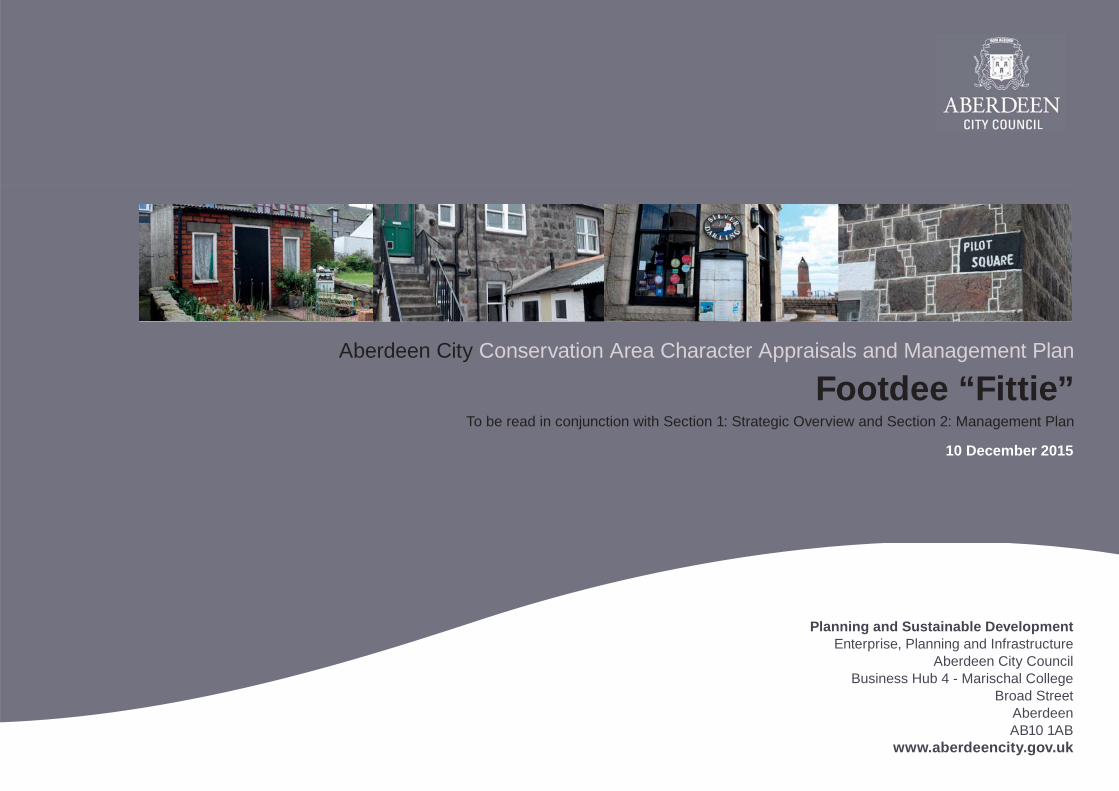
Footdee “Fittie”
Planning and Sustainable DevelopmentEnterprise, Planning and Infrastructure
Aberdeen City CouncilBusiness Hub 4 - Marischal College
Broad StreetAberdeen AB10 1AB
www.aberdeencity.gov.uk
2 Aberdeen City Conservation Area Character Appraisal | Footdee “Fittie” | 10 December 2015
Contents
1 Introduction 3Profi le 3Summary of Signifi cance 3
2 Location, History and Development 4Location 4Development History 5
3 Character 9Setting 9Built Environment 11Public Realm 19Natural Environment 23
4 Management 26SWOT Analysis 26Conservation Area Proposed Extension 28
5 Appendix 29List of Street Names 29
3Aberdeen City Conservation Area Character Appraisal | Footdee “Fittie” | 10 December 2015
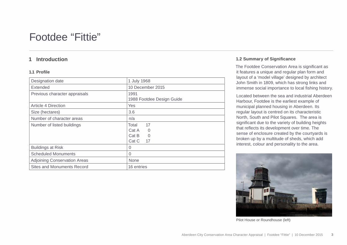
Pilot House or Roundhouse (left)
Footdee “Fittie”
1 Introduction
1.1 Profi le
Designation date 1 July 1968Extended 10 December 2015Previous character appraisals 1991
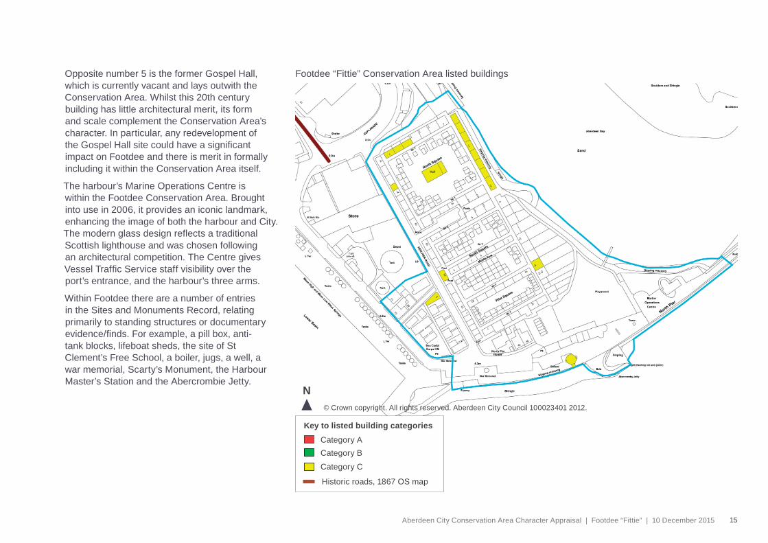
1988 Footdee Design GuideArticle 4 Direction YesSize (hectares) 3.6 Number of character areas n/aNumber of listed buildings Total 17
Cat A 0Cat B 0Cat C 17
Buildings at Risk 0Scheduled Monuments 0Adjoining Conservation Areas NoneSites and Monuments Record 16 entries
1.2 Summary of Signifi cance
The Footdee Conservation Area is signifi cant as it features a unique and regular plan form and layout of a ‘model village’ designed by architect John Smith in 1809, which has strong links and immense social importance to local fi shing history.
Located between the sea and industrial Aberdeen Harbour, Footdee is the earliest example of municipal planned housing in Aberdeen. Its regular layout is centred on its characteristic North, South and Pilot Squares. The area is signifi cant due to the variety of building heights that refl ects its development over time. The sense of enclosure created by the courtyards is broken up by a multitude of sheds, which add interest, colour and personality to the area.
4 Aberdeen City Conservation Area Character Appraisal | Footdee “Fittie” | 10 December 2015
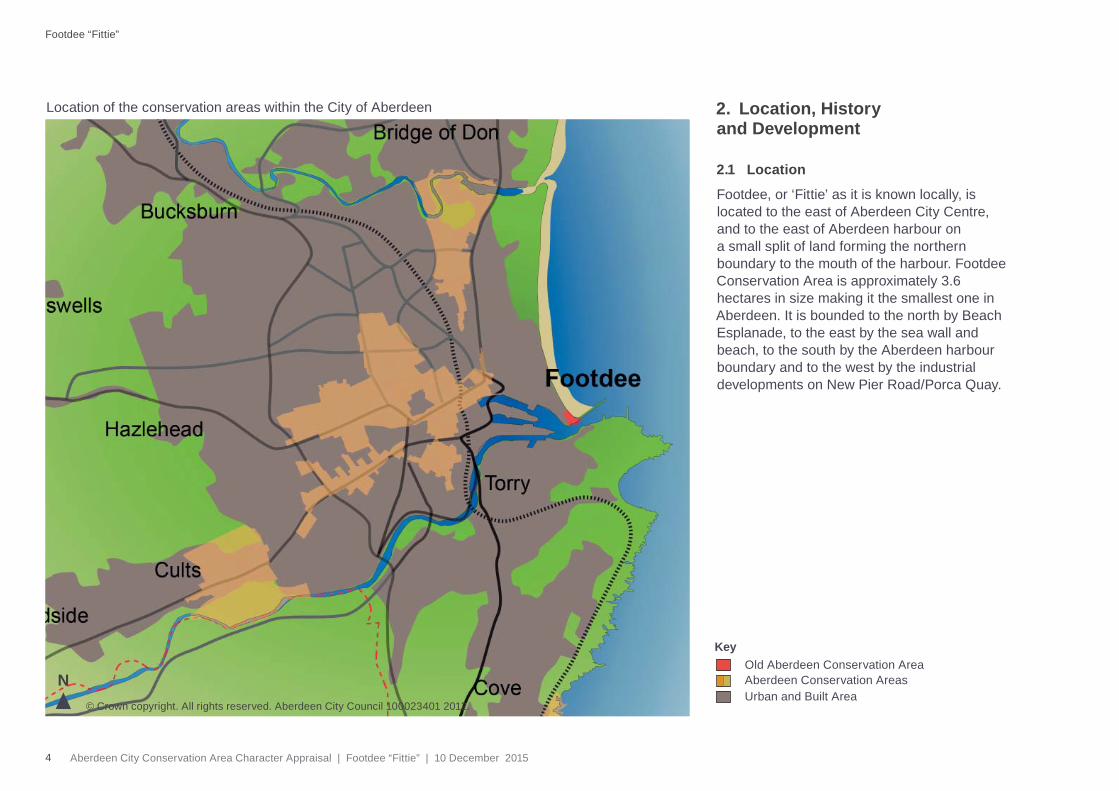
Location of the conservation areas within the City of Aberdeen
© Crown copyright. All rights reserved. Aberdeen City Council 100023401 2012.
NOld Aberdeen Conservation AreaAberdeen Conservation Areas
Key
Urban and Built Area
Footdee “Fittie”
2. Location, History and Development
2.1 Location
Footdee, or ‘Fittie’ as it is known locally, is located to the east of Aberdeen City Centre, and to the east of Aberdeen harbour on a small split of land forming the northern boundary to the mouth of the harbour. Footdee Conservation Area is approximately 3.6 hectares in size making it the smallest one in Aberdeen. It is bounded to the north by Beach Esplanade, to the east by the sea wall and beach, to the south by the Aberdeen harbour boundary and to the west by the industrial developments on New Pier Road/Porca Quay.
5Aberdeen City Conservation Area Character Appraisal | Footdee “Fittie” | 10 December 2015
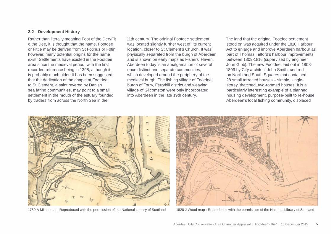
Rather than literally meaning Foot of the Dee/Fit o the Dee, it is thought that the name, Footdee or Fittie may be derived from St Fotinus or Fotin; however, many potential origins for the name exist. Settlements have existed in the Footdee area since the medieval period, with the fi rst recorded reference being in 1398, although it is probably much older. It has been suggested that the dedication of the chapel at Footdee to St Clement, a saint revered by Danish sea faring communities, may point to a small settlement in the mouth of the estuary founded by traders from across the North Sea in the
11th century. The original Footdee settlement was located slightly further west of its current location, closer to St Clement’s Church. It was physically separated from the burgh of Aberdeen and is shown on early maps as Fishers’ Haven. Aberdeen today is an amalgamation of several once distinct and separate communities, which developed around the periphery of the medieval burgh. The fi shing village of Footdee, burgh of Torry, Ferryhill district and weaving village of Gilcomston were only incorporated into Aberdeen in the late 19th century.
The land that the original Footdee settlement stood on was acquired under the 1810 Harbour Act to enlarge and improve Aberdeen harbour as part of Thomas Telford’s harbour improvements between 1809-1816 (supervised by engineer John Gibb). The new Footdee, laid out in 1808-1809 by City architect John Smith, centred on North and South Squares that contained 28 small terraced houses – simple, single-storey, thatched, two-roomed houses. It is a particularly interesting example of a planned housing development, purpose-built to re-house Aberdeen’s local fi shing community, displaced
2.2 Development History
1789 A Milne map : Reproduced with the permission of the National Library of Scotland 1828 J Wood map : Reproduced with the permission of the National Library of Scotland
6 Aberdeen City Conservation Area Character Appraisal | Footdee “Fittie” | 10 December 2015
Footdee “Fittie”
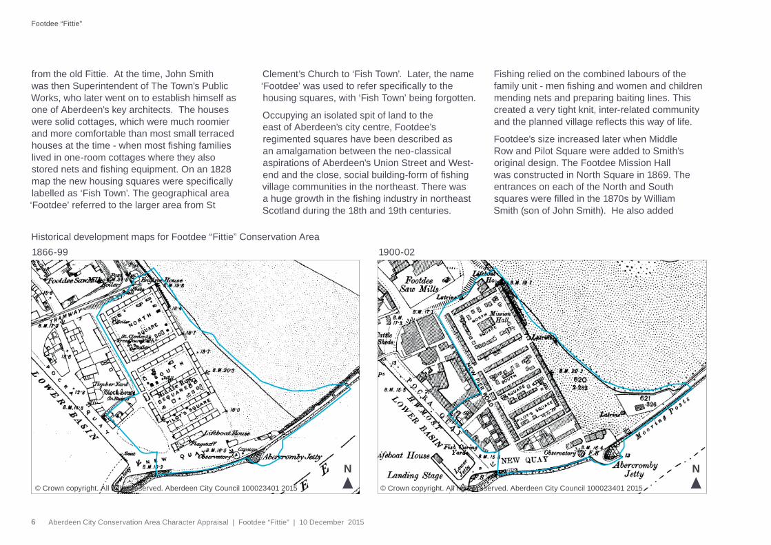
from the old Fittie. At the time, John Smith was then Superintendent of The Town’s Public Works, who later went on to establish himself as one of Aberdeen’s key architects. The houses were solid cottages, which were much roomier and more comfortable than most small terraced houses at the time - when most fi shing families lived in one-room cottages where they also stored nets and fi shing equipment. On an 1828 map the new housing squares were specifi cally labelled as ‘Fish Town’. The geographical area ‘Footdee’ referred to the larger area from St
Clement’s Church to ‘Fish Town’. Later, the name ‘Footdee’ was used to refer specifi cally to the housing squares, with ‘Fish Town’ being forgotten.
Occupying an isolated spit of land to the east of Aberdeen’s city centre, Footdee’s regimented squares have been described as an amalgamation between the neo-classical aspirations of Aberdeen’s Union Street and West-end and the close, social building-form of fi shing village communities in the northeast. There was a huge growth in the fi shing industry in northeast Scotland during the 18th and 19th centuries.
Fishing relied on the combined labours of the family unit - men fi shing and women and children mending nets and preparing baiting lines. This created a very tight knit, inter-related community and the planned village refl ects this way of life.
Footdee’s size increased later when Middle Row and Pilot Square were added to Smith’s original design. The Footdee Mission Hall was constructed in North Square in 1869. The entrances on each of the North and South squares were fi lled in the 1870s by William Smith (son of John Smith). He also added
1900-021866-99Historical development maps for Footdee “Fittie” Conservation Area
© Crown copyright. All rights reserved. Aberdeen City Council 100023401 2015© Crown copyright. All rights reserved. Aberdeen City Council 100023401 2015
N N
7Aberdeen City Conservation Area Character Appraisal | Footdee “Fittie” | 10 December 2015
1959-68 2015
© Crown copyright. All rights reserved. Aberdeen City Council 100023401 2015 © Crown copyright. All rights reserved. Aberdeen City Council 100023401 2015.
N N
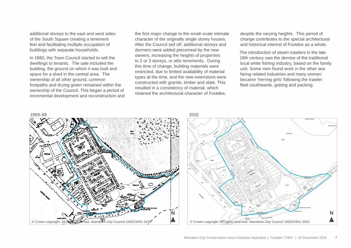
additional storeys to the east and west sides of the South Square creating a tenement feel and facilitating multiple occupation of buildings with separate households.
In 1880, the Town Council started to sell the dwellings to tenants. The sale included the building, the ground on which it was built and space for a shed in the central area. The ownership of all other ground, common footpaths and drying green remained within the ownership of the Council. This began a period of incremental development and reconstruction and
the fi rst major change to the small-scale intimate character of the originally single storey houses. After the Council sell off, additional storeys and dormers were added piecemeal by the new owners, increasing the heights of properties to 2 or 3 storeys, or attic tenements. During this time of change, building materials were restricted, due to limited availability of material types at the time, and the new extensions were constructed with granite, timber and slate. This resulted in a consistency of material, which retained the architectural character of Footdee,
despite the varying heights. This period of change contributes to the special architectural and historical interest of Footdee as a whole.
The introduction of steam trawlers in the late 19th century saw the demise of the traditional local white fi shing industry, based on the family unit. Some men found work in the other sea faring related industries and many women became ‘herring girls’ following the trawler fl eet southwards, gutting and packing.
8 Aberdeen City Conservation Area Character Appraisal | Footdee “Fittie” | 10 December 2015
Footdee “Fittie”
Recognising the importance of this fi shing village locally, and its contribution to Scotland’s heritage nationally, in 1967 the Secretary of State included all the buildings in the squares (except 21 South Square, which had been inappropriately altered) and 1-5 New Pier Road, in the list of buildings of architectural or historic interest. Following the Civic Amenities Act 1967, Footdee was amongst the fi rst conservation areas designated by Aberdeen Town Council in 1968 . At the same time it was recognised that most of the houses were small and often lacked basic amenities. As a result of the Housing Improvement Acts, over the years the Council actively encouraged the upgrading of household amenities through a policy of approving extensions and other alterations, such as internal WCs/bathrooms. However, due to increased availability of aluminium and uPVC materials, not all alterations have been in keeping with the area’s traditional characteristics.
In 2006 Historic Scotland resurveyed the area, with each individual building being assessed. Buildings that demonstrated both individual architectural interest and those which represented the history and development of the village as a whole were selected for listing. The remainder were de-listed.
Throughout the 19th century, sheds and storage buildings were added to the communal land within the squares opposite each dwelling and now almost every dwelling has its own shed type structure. The original purpose of the sheds was to store fi shing equipment, which
would have previously been kept inside the houses, therefore relieving some pressure on the housing and reducing overcrowding. Sheds were constructed from drift wood and other found materials and many were rebuilt in an ad-hoc manner over the years in a variety of materials, predominately rendered brick/block work. Some timber built sheds remain, mostly on the north side of North Square.
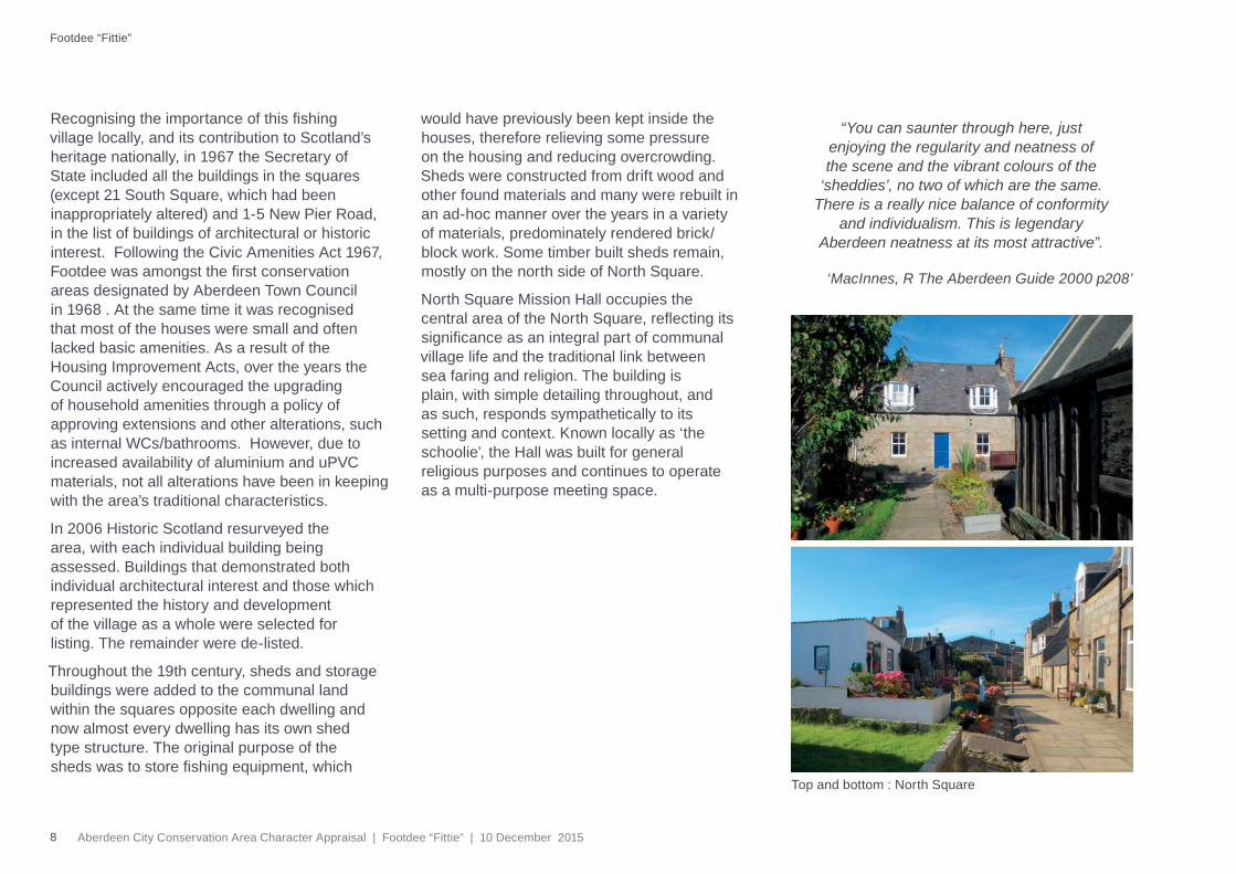
North Square Mission Hall occupies the central area of the North Square, refl ecting its signifi cance as an integral part of communal village life and the traditional link between sea faring and religion. The building is plain, with simple detailing throughout, and as such, responds sympathetically to its setting and context. Known locally as ‘the schoolie’, the Hall was built for general religious purposes and continues to operate as a multi-purpose meeting space.
“You can saunter through here, just enjoying the regularity and neatness of the scene and the vibrant colours of the
‘sheddies’, no two of which are the same. There is a really nice balance of conformity
and individualism. This is legendary Aberdeen neatness at its most attractive”.
Top and bottom : North Square
‘MacInnes, R The Aberdeen Guide 2000 p208’
9Aberdeen City Conservation Area Character Appraisal | Footdee “Fittie” | 10 December 2015
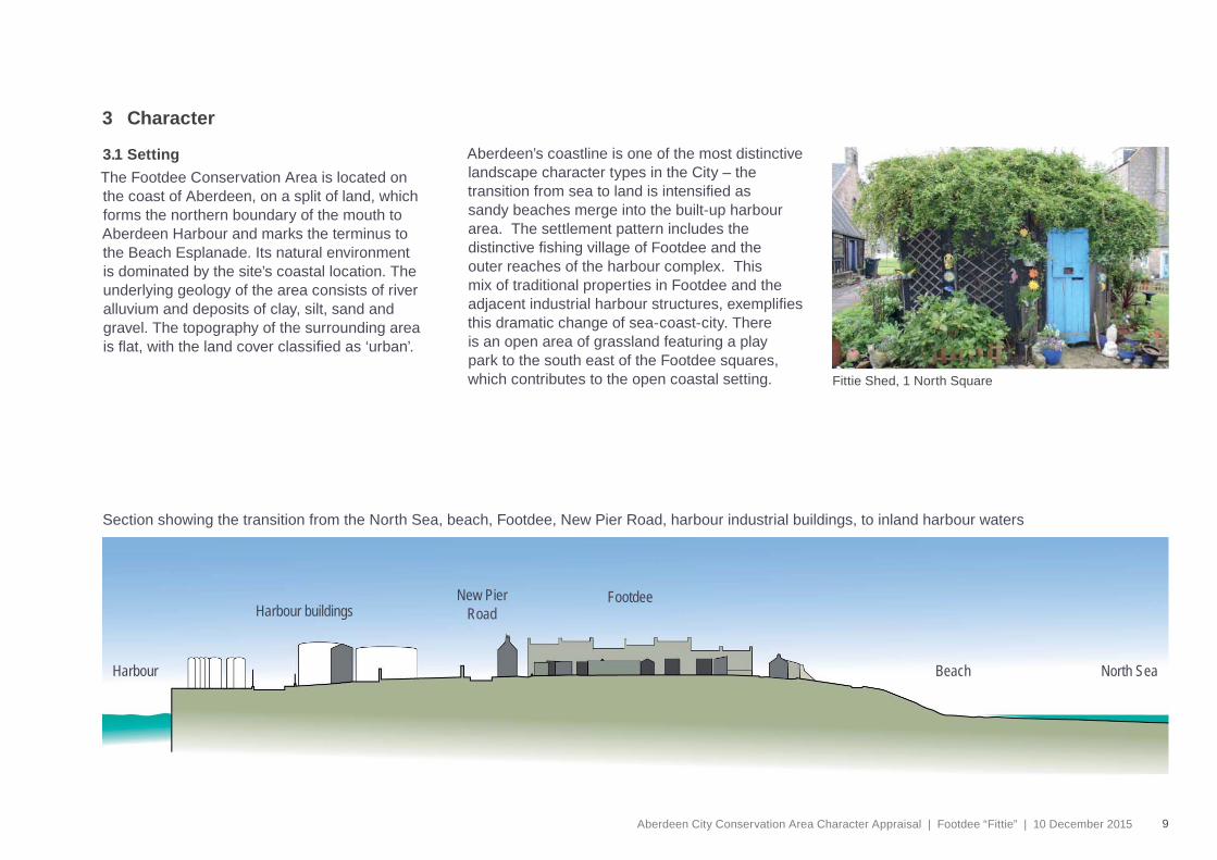
Section showing the transition from the North Sea, beach, Footdee, New Pier Road, harbour industrial buildings, to inland harbour waters
Harbour Beach
New PierRoad
FootdeeHarbour buildings
North Sea
3 Character
3.1 Setting The Footdee Conservation Area is located on the coast of Aberdeen, on a split of land, which forms the northern boundary of the mouth to Aberdeen Harbour and marks the terminus to the Beach Esplanade. Its natural environment is dominated by the site’s coastal location. The underlying geology of the area consists of river alluvium and deposits of clay, silt, sand and gravel. The topography of the surrounding area is fl at, with the land cover classifi ed as ‘urban’.
Aberdeen’s coastline is one of the most distinctive landscape character types in the City – the transition from sea to land is intensifi ed as sandy beaches merge into the built-up harbour area. The settlement pattern includes the distinctive fi shing village of Footdee and the outer reaches of the harbour complex. This mix of traditional properties in Footdee and the adjacent industrial harbour structures, exemplifi es this dramatic change of sea-coast-city. There is an open area of grassland featuring a play park to the south east of the Footdee squares, which contributes to the open coastal setting. Fittie Shed, 1 North Square
10 Aberdeen City Conservation Area Character Appraisal | Footdee “Fittie” | 10 December 2015
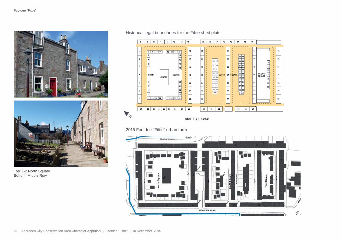
2015 Footdee “Fittie” urban form
Historical legal boundaries for the Fittie shed plots
N
Footdee “Fittie”
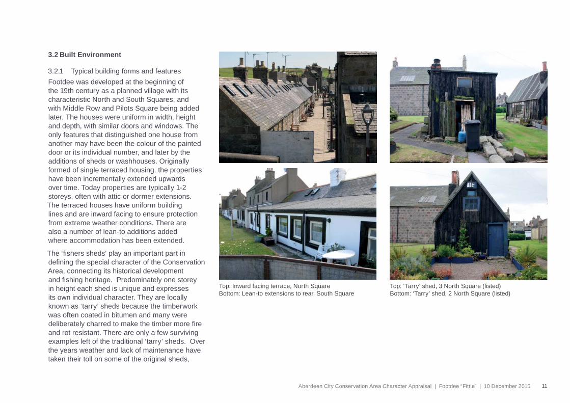
Top: 1-2 North Square Bottom: Middle Row
11Aberdeen City Conservation Area Character Appraisal | Footdee “Fittie” | 10 December 2015
3.2 Built Environment
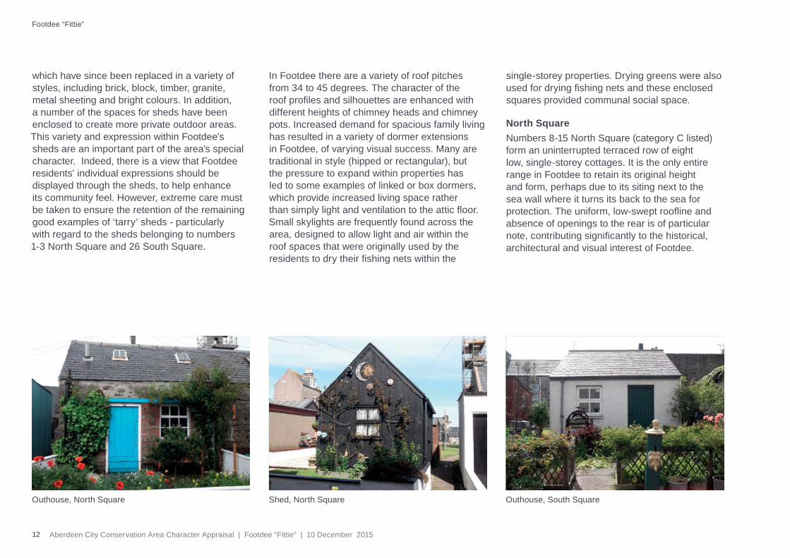
3.2.1 Typical building forms and featuresFootdee was developed at the beginning of the 19th century as a planned village with its characteristic North and South Squares, and with Middle Row and Pilots Square being added later. The houses were uniform in width, height and depth, with similar doors and windows. The only features that distinguished one house from another may have been the colour of the painted door or its individual number, and later by the additions of sheds or washhouses. Originally formed of single terraced housing, the properties have been incrementally extended upwards over time. Today properties are typically 1-2 storeys, often with attic or dormer extensions. The terraced houses have uniform building lines and are inward facing to ensure protection from extreme weather conditions. There are also a number of lean-to additions added where accommodation has been extended.
The ‘fi shers sheds’ play an important part in defi ning the special character of the Conservation Area, connecting its historical development and fi shing heritage. Predominately one storey in height each shed is unique and expresses its own individual character. They are locally known as ‘tarry’ sheds because the timberwork was often coated in bitumen and many were deliberately charred to make the timber more fi re and rot resistant. There are only a few surviving examples left of the traditional ‘tarry’ sheds. Over the years weather and lack of maintenance have taken their toll on some of the original sheds,
Top: Inward facing terrace, North Square Bottom: Lean-to extensions to rear, South Square
Top: ‘Tarry’ shed, 3 North Square (listed)Bottom: ‘Tarry’ shed, 2 North Square (listed)
12 Aberdeen City Conservation Area Character Appraisal | Footdee “Fittie” | 10 December 2015
Footdee “Fittie”
which have since been replaced in a variety of styles, including brick, block, timber, granite, metal sheeting and bright colours. In addition, a number of the spaces for sheds have been enclosed to create more private outdoor areas. This variety and expression within Footdee’s sheds are an important part of the area’s special character. Indeed, there is a view that Footdee residents’ individual expressions should be displayed through the sheds, to help enhance its community feel. However, extreme care must be taken to ensure the retention of the remaining good examples of ‘tarry’ sheds - particularly with regard to the sheds belonging to numbers 1-3 North Square and 26 South Square.
In Footdee there are a variety of roof pitches from 34 to 45 degrees. The character of the roof profi les and silhouettes are enhanced with different heights of chimney heads and chimney pots. Increased demand for spacious family living has resulted in a variety of dormer extensions in Footdee, of varying visual success. Many are traditional in style (hipped or rectangular), but the pressure to expand within properties has led to some examples of linked or box dormers, which provide increased living space rather than simply light and ventilation to the attic fl oor. Small skylights are frequently found across the area, designed to allow light and air within the roof spaces that were originally used by the residents to dry their fi shing nets within the
single-storey properties. Drying greens were also used for drying fi shing nets and these enclosed squares provided communal social space.
North Square Numbers 8-15 North Square (category C listed) form an uninterrupted terraced row of eight low, single-storey cottages. It is the only entire range in Footdee to retain its original height and form, perhaps due to its siting next to the sea wall where it turns its back to the sea for protection. The uniform, low-swept roofl ine and absence of openings to the rear is of particular note, contributing signifi cantly to the historical, architectural and visual interest of Footdee.
Outhouse, North Square Outhouse, South SquareShed, North Square
13Aberdeen City Conservation Area Character Appraisal | Footdee “Fittie” | 10 December 2015
26 South Square
The wall height to the rear is reduced to half that of the front elevation with the slate roof slightly splayed for weather protection. A narrow walkway and bulwark (embankment/breakwater) to the rear was constructed in the early 20th century.
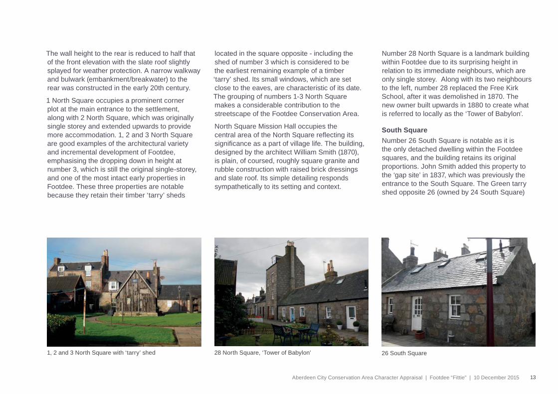
1 North Square occupies a prominent corner plot at the main entrance to the settlement, along with 2 North Square, which was originally single storey and extended upwards to provide more accommodation. 1, 2 and 3 North Square are good examples of the architectural variety and incremental development of Footdee, emphasising the dropping down in height at number 3, which is still the original single-storey, and one of the most intact early properties in Footdee. These three properties are notable because they retain their timber ‘tarry’ sheds
located in the square opposite - including the shed of number 3 which is considered to be the earliest remaining example of a timber ‘tarry’ shed. Its small windows, which are set close to the eaves, are characteristic of its date. The grouping of numbers 1-3 North Square makes a considerable contribution to the streetscape of the Footdee Conservation Area.
North Square Mission Hall occupies the central area of the North Square refl ecting its signifi cance as a part of village life. The building, designed by the architect William Smith (1870), is plain, of coursed, roughly square granite and rubble construction with raised brick dressings and slate roof. Its simple detailing responds sympathetically to its setting and context.
Number 28 North Square is a landmark building within Footdee due to its surprising height in relation to its immediate neighbours, which are only single storey. Along with its two neighbours to the left, number 28 replaced the Free Kirk School, after it was demolished in 1870. The new owner built upwards in 1880 to create what is referred to locally as the ‘Tower of Babylon’.
South SquareNumber 26 South Square is notable as it is the only detached dwelling within the Footdee squares, and the building retains its original proportions. John Smith added this property to the ‘gap site’ in 1837, which was previously the entrance to the South Square. The Green tarry shed opposite 26 (owned by 24 South Square)
28 North Square, ‘Tower of Babylon’1, 2 and 3 North Square with ‘tarry’ shed
14 Aberdeen City Conservation Area Character Appraisal | Footdee “Fittie” | 10 December 2015
44-45 Pocra QuayPilot House (listed Category.C)
Footdee “Fittie”
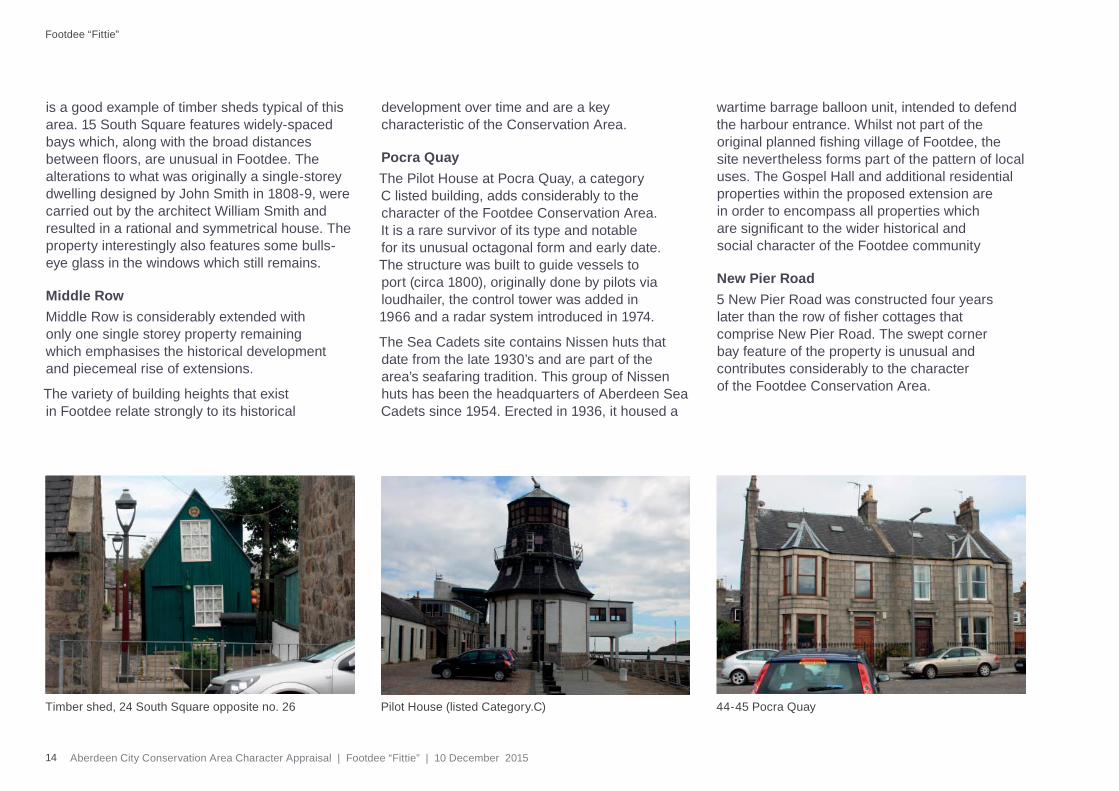
is a good example of timber sheds typical of this area. 15 South Square features widely-spaced bays which, along with the broad distances between fl oors, are unusual in Footdee. The alterations to what was originally a single-storey dwelling designed by John Smith in 1808-9, were carried out by the architect William Smith and resulted in a rational and symmetrical house. The property interestingly also features some bulls-eye glass in the windows which still remains.
Middle Row Middle Row is considerably extended with only one single storey property remaining which emphasises the historical development and piecemeal rise of extensions.
The variety of building heights that exist in Footdee relate strongly to its historical
development over time and are a key characteristic of the Conservation Area.
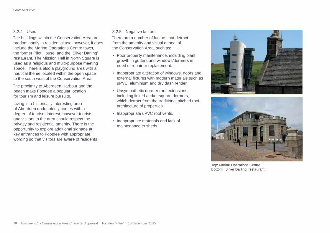
Pocra Quay The Pilot House at Pocra Quay, a category C listed building, adds considerably to the character of the Footdee Conservation Area. It is a rare survivor of its type and notable for its unusual octagonal form and early date. The structure was built to guide vessels to port (circa 1800), originally done by pilots via loudhailer, the control tower was added in 1966 and a radar system introduced in 1974.
The Sea Cadets site contains Nissen huts that date from the late 1930’s and are part of the area’s seafaring tradition. This group of Nissen huts has been the headquarters of Aberdeen Sea Cadets since 1954. Erected in 1936, it housed a
wartime barrage balloon unit, intended to defend the harbour entrance. Whilst not part of the original planned fi shing village of Footdee, the site nevertheless forms part of the pattern of local uses. The Gospel Hall and additional residential properties within the proposed extension are in order to encompass all properties which are signifi cant to the wider historical and social character of the Footdee community
New Pier Road5 New Pier Road was constructed four years later than the row of fi sher cottages that comprise New Pier Road. The swept corner bay feature of the property is unusual and contributes considerably to the character of the Footdee Conservation Area.
Timber shed, 24 South Square opposite no. 26
15Aberdeen City Conservation Area Character Appraisal | Footdee “Fittie” | 10 December 2015
Opposite number 5 is the former Gospel Hall, which is currently vacant and lays outwith the Conservation Area. Whilst this 20th century building has little architectural merit, its form and scale complement the Conservation Area’s character. In particular, any redevelopment of the Gospel Hall site could have a signifi cant impact on Footdee and there is merit in formally including it within the Conservation Area itself.
The harbour’s Marine Operations Centre is within the Footdee Conservation Area. Brought into use in 2006, it provides an iconic landmark, enhancing the image of both the harbour and City. The modern glass design refl ects a traditional Scottish lighthouse and was chosen following an architectural competition. The Centre gives Vessel Traffi c Service staff visibility over the port’s entrance, and the harbour’s three arms.
Within Footdee there are a number of entries in the Sites and Monuments Record, relating primarily to standing structures or documentary evidence/fi nds. For example, a pill box, anti-tank blocks, lifeboat sheds, the site of St Clement’s Free School, a boiler, jugs, a well, a war memorial, Scarty’s Monument, the Harbour Master’s Station and the Abercrombie Jetty.
© Crown copyright. All rights reserved. Aberdeen City Council 100023401 2012.
Footdee “Fittie” Conservation Area listed buildings
N
Category ACategory B
Category C
Key to listed building categories
Historic roads, 1867 OS map
16 Aberdeen City Conservation Area Character Appraisal | Footdee “Fittie” | 10 December 2015
Footdee “Fittie”
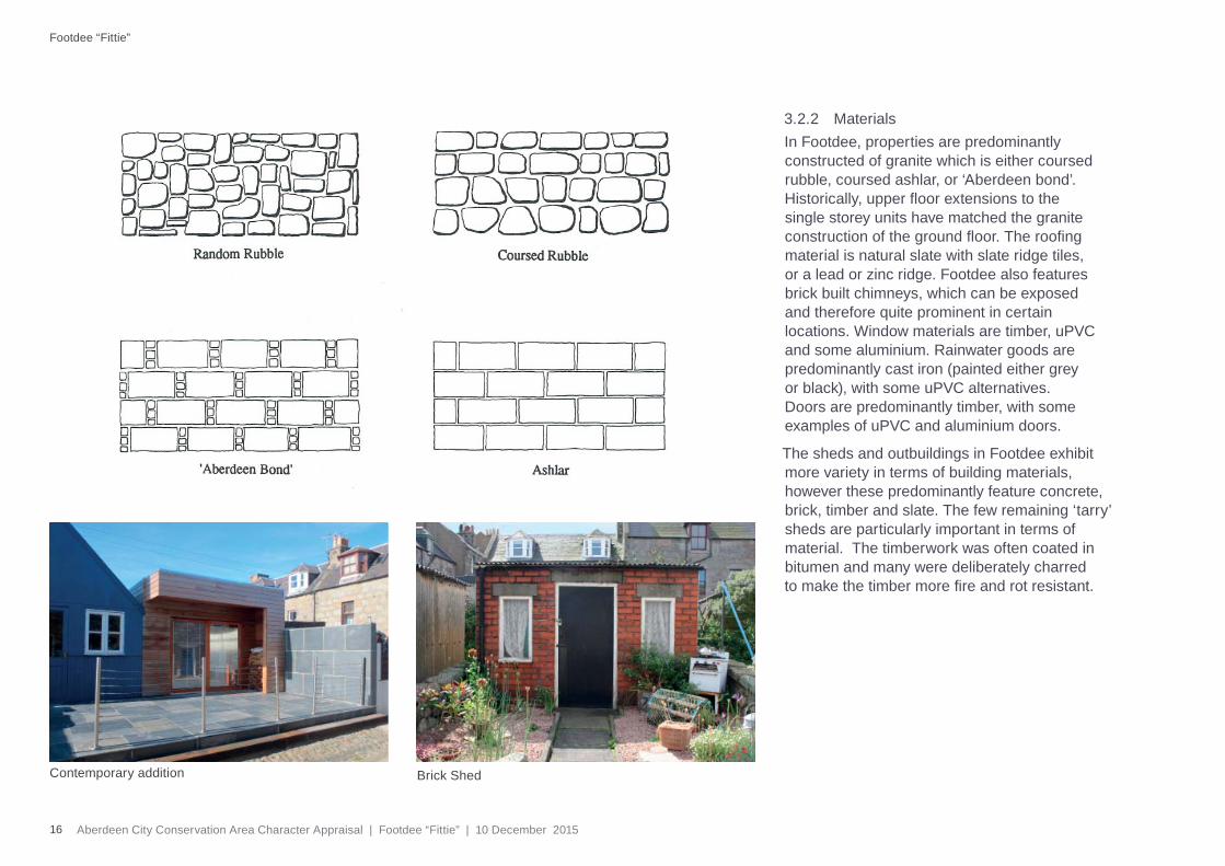
3.2.2 MaterialsIn Footdee, properties are predominantly constructed of granite which is either coursed rubble, coursed ashlar, or ‘Aberdeen bond’. Historically, upper fl oor extensions to the single storey units have matched the granite construction of the ground fl oor. The roofi ng material is natural slate with slate ridge tiles, or a lead or zinc ridge. Footdee also features brick built chimneys, which can be exposed and therefore quite prominent in certain locations. Window materials are timber, uPVC and some aluminium. Rainwater goods are predominantly cast iron (painted either grey or black), with some uPVC alternatives. Doors are predominantly timber, with some examples of uPVC and aluminium doors.
The sheds and outbuildings in Footdee exhibit more variety in terms of building materials, however these predominantly feature concrete, brick, timber and slate. The few remaining ‘tarry’ sheds are particularly important in terms of material. The timberwork was often coated in bitumen and many were deliberately charred to make the timber more fi re and rot resistant.
Brick ShedContemporary addition
17Aberdeen City Conservation Area Character Appraisal | Footdee “Fittie” | 10 December 2015
Footdee “Fittie” Conservation Area urban form
N© Crown copyright. All rights reserved. Aberdeen City Council 100023401 2015.
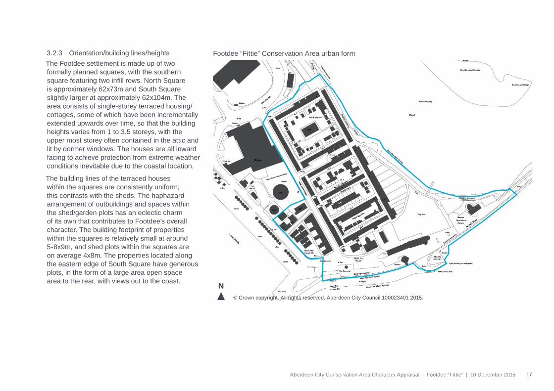
3.2.3 Orientation/building lines/heightsThe Footdee settlement is made up of two formally planned squares, with the southern square featuring two infi ll rows. North Square is approximately 62x73m and South Square slightly larger at approximately 62x104m. The area consists of single-storey terraced housing/cottages, some of which have been incrementally extended upwards over time, so that the building heights varies from 1 to 3.5 storeys, with the upper most storey often contained in the attic and lit by dormer windows. The houses are all inward facing to achieve protection from extreme weather conditions inevitable due to the coastal location.
The building lines of the terraced houses within the squares are consistently uniform; this contrasts with the sheds. The haphazard arrangement of outbuildings and spaces within the shed/garden plots has an eclectic charm of its own that contributes to Footdee’s overall character. The building footprint of properties within the squares is relatively small at around 5-8x9m, and shed plots within the squares are on average 4x8m. The properties located along the eastern edge of South Square have generous plots, in the form of a large area open space area to the rear, with views out to the coast.
18 Aberdeen City Conservation Area Character Appraisal | Footdee “Fittie” | 10 December 2015
3.2.4 Uses The buildings within the Conservation Area are predominantly in residential use; however, it does include the Marine Operations Centre tower, the former Pilot House, and the ‘Silver Darling’ restaurant. The Mission Hall in North Square is used as a religious and multi-purpose meeting space. There is also a playground area with a nautical theme located within the open space to the south west of the Conservation Area.
The proximity to Aberdeen Harbour and the beach make Footdee a popular location for tourism and leisure pursuits.
Living in a historically interesting area of Aberdeen undoubtedly comes with a degree of tourism interest; however tourists and visitors to the area should respect the privacy and residential amenity. There is the opportunity to explore additional signage at key entrances to Footdee with appropriate wording so that visitors are aware of residents
3.2.5 Negative factorsThere are a number of factors that detract from the amenity and visual appeal of the Conservation Area, such as:
• Poor property maintenance, including plant growth in gutters and windows/dormers in need of repair or replacement.
• Inappropriate alteration of windows, doors and external fi xtures with modern materials such as uPVC, aluminium and dry dash render.
• Unsympathetic dormer roof extensions, including linked and/or square dormers, which detract from the traditional pitched roof architecture of properties.
• Inappropriate uPVC roof vents.
• Inappropriate materials and lack of maintenance to sheds.
Footdee “Fittie”
Top: Marine Operations Centre Bottom: ‘Silver Darling’ restaurant
19Aberdeen City Conservation Area Character Appraisal | Footdee “Fittie” | 10 December 2015
3.3 Public Realm
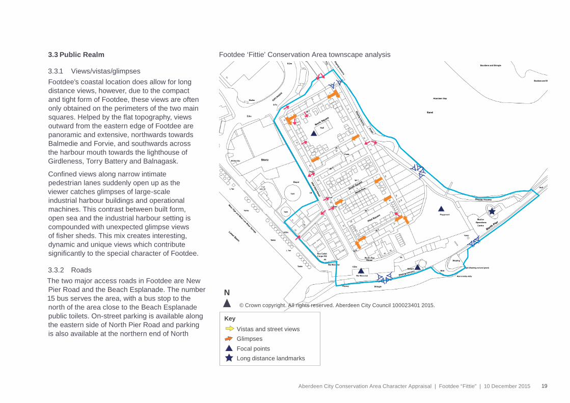
3.3.1 Views/vistas/glimpsesFootdee’s coastal location does allow for long distance views, however, due to the compact and tight form of Footdee, these views are often only obtained on the perimeters of the two main squares. Helped by the fl at topography, views outward from the eastern edge of Footdee are panoramic and extensive, northwards towards Balmedie and Forvie, and southwards across the harbour mouth towards the lighthouse of Girdleness, Torry Battery and Balnagask.
Confi ned views along narrow intimate pedestrian lanes suddenly open up as the viewer catches glimpses of large-scale industrial harbour buildings and operational machines. This contrast between built form, open sea and the industrial harbour setting is compounded with unexpected glimpse views of fi sher sheds. This mix creates interesting, dynamic and unique views which contribute signifi cantly to the special character of Footdee.
3.3.2 RoadsThe two major access roads in Footdee are New Pier Road and the Beach Esplanade. The number 15 bus serves the area, with a bus stop to the north of the area close to the Beach Esplanade public toilets. On-street parking is available along the eastern side of North Pier Road and parking is also available at the northern end of North
Footdee ‘Fittie’ Conservation Area townscape analysis
© Crown copyright. All rights reserved. Aberdeen City Council 100023401 2015.
N
Vistas and street views
Key
GlimpsesFocal pointsLong distance landmarks
20 Aberdeen City Conservation Area Character Appraisal | Footdee “Fittie” | 10 December 2015
Square (to rear) and within the small courtyard gap between North Square and South Square.
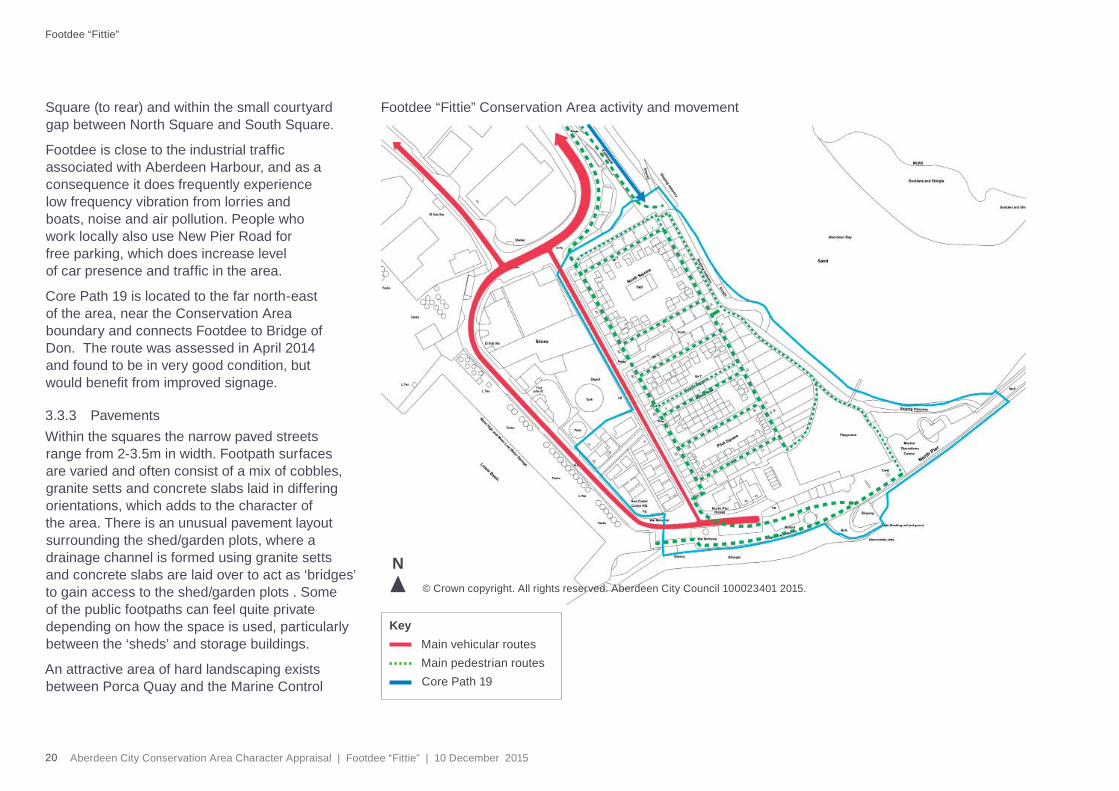
Footdee is close to the industrial traffi c associated with Aberdeen Harbour, and as a consequence it does frequently experience low frequency vibration from lorries and boats, noise and air pollution. People who work locally also use New Pier Road for free parking, which does increase level of car presence and traffi c in the area.
Core Path 19 is located to the far north-east of the area, near the Conservation Area boundary and connects Footdee to Bridge of Don. The route was assessed in April 2014 and found to be in very good condition, but would benefi t from improved signage.
3.3.3 PavementsWithin the squares the narrow paved streets range from 2-3.5m in width. Footpath surfaces are varied and often consist of a mix of cobbles, granite setts and concrete slabs laid in differing orientations, which adds to the character of the area. There is an unusual pavement layout surrounding the shed/garden plots, where a drainage channel is formed using granite setts and concrete slabs are laid over to act as ‘bridges’ to gain access to the shed/garden plots . Some of the public footpaths can feel quite private depending on how the space is used, particularly between the ‘sheds’ and storage buildings.
An attractive area of hard landscaping exists between Porca Quay and the Marine Control
Footdee “Fittie” Conservation Area activity and movement
N
Main vehicular routesKey
Main pedestrian routesCore Path 19
© Crown copyright. All rights reserved. Aberdeen City Council 100023401 2015.
Footdee “Fittie”
21Aberdeen City Conservation Area Character Appraisal | Footdee “Fittie” | 10 December 2015
Centre, surrounding the former Pilot House. This was funded by Aberdeen Harbour Board as part of the landscaping undertaken with the development of the new Marine Operations Centre and has some interesting public realm/streetscape fi nishes, which offer a considerable positive benefi t to the Conservation Area, including accessibility to the Fog Bell.
3.3.4 Street treesStreet trees were never part of the concept or form for the design of the Footdee settlement, so the absence of them in this location is not unusual. See section 3.4.2.
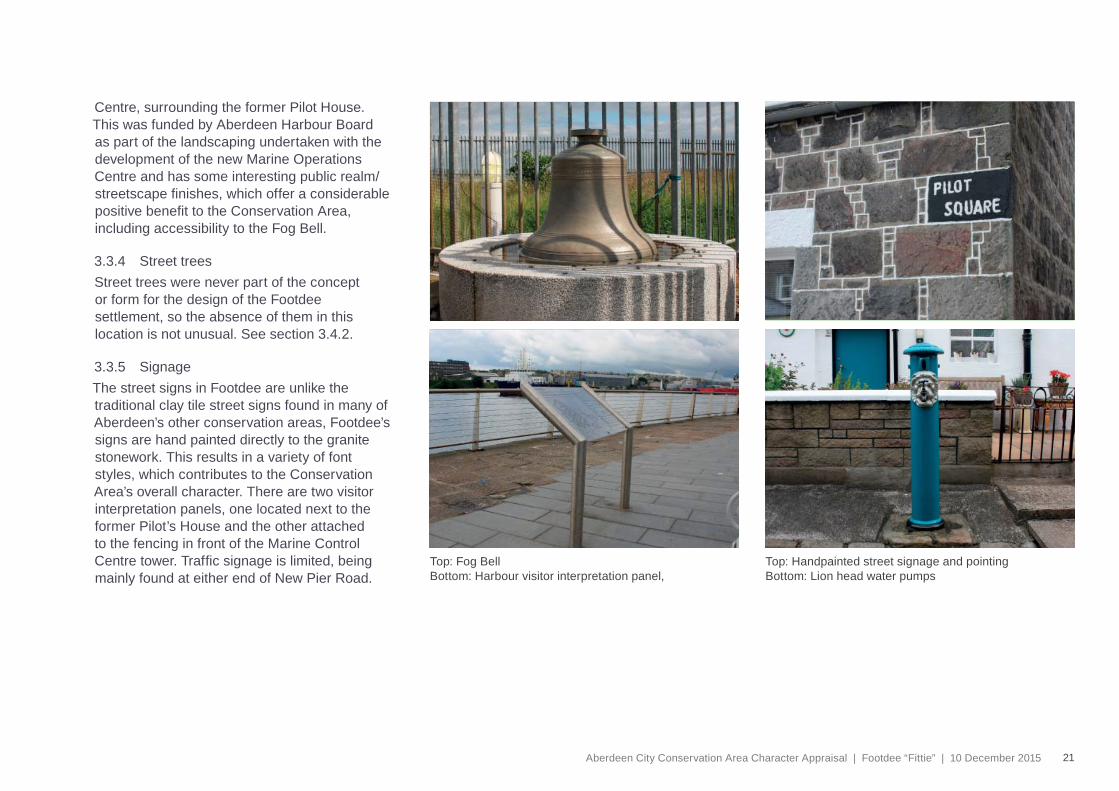
3.3.5 SignageThe street signs in Footdee are unlike the traditional clay tile street signs found in many of Aberdeen’s other conservation areas, Footdee’s signs are hand painted directly to the granite stonework. This results in a variety of font styles, which contributes to the Conservation Area’s overall character. There are two visitor interpretation panels, one located next to the former Pilot’s House and the other attached to the fencing in front of the Marine Control Centre tower. Traffi c signage is limited, being mainly found at either end of New Pier Road.
Top: Handpainted street signage and pointing Bottom: Lion head water pumps
Top: Fog BellBottom: Harbour visitor interpretation panel,
22 Aberdeen City Conservation Area Character Appraisal | Footdee “Fittie” | 10 December 2015
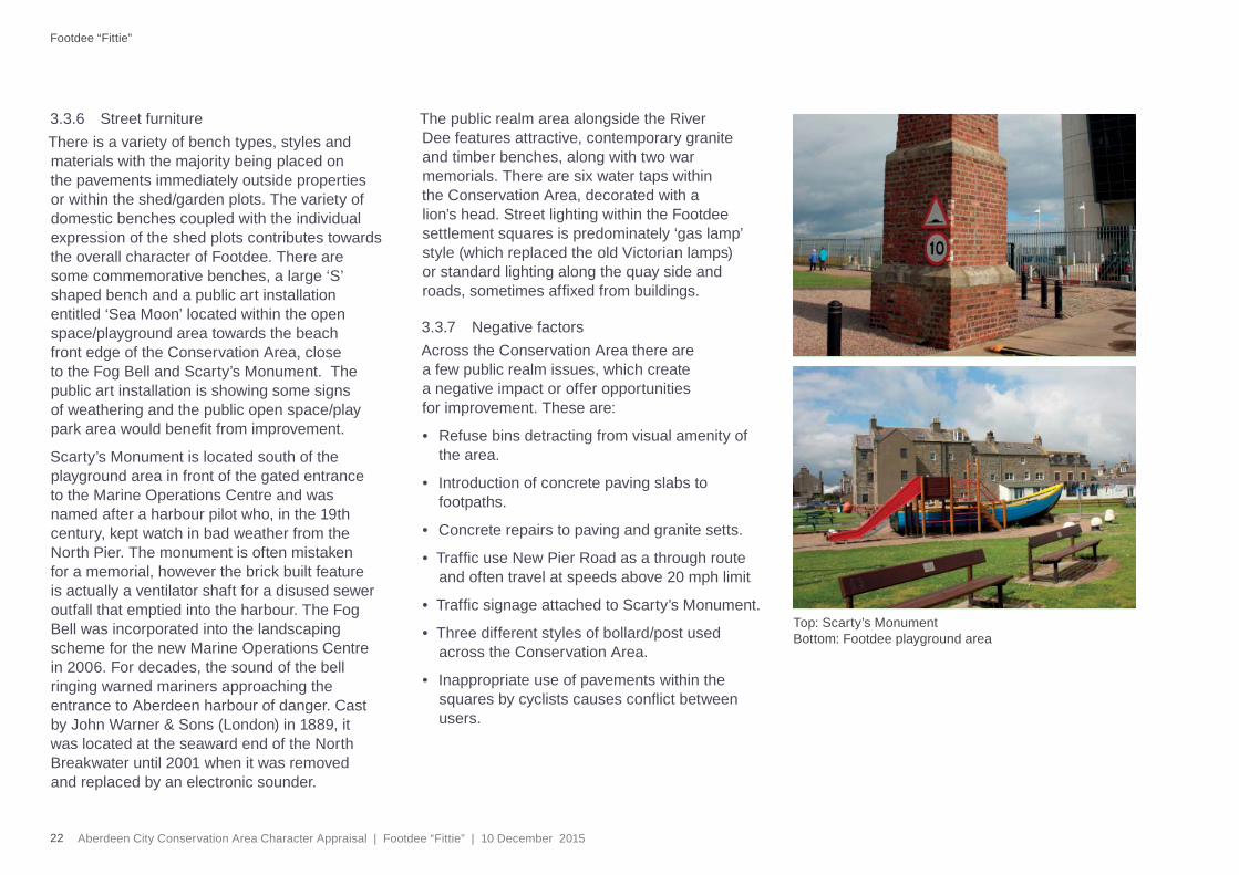
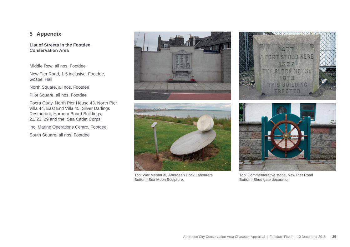
3.3.6 Street furnitureThere is a variety of bench types, styles and materials with the majority being placed on the pavements immediately outside properties or within the shed/garden plots. The variety of domestic benches coupled with the individual expression of the shed plots contributes towards the overall character of Footdee. There are some commemorative benches, a large ‘S’ shaped bench and a public art installation entitled ‘Sea Moon’ located within the open space/playground area towards the beach front edge of the Conservation Area, close to the Fog Bell and Scarty’s Monument. The public art installation is showing some signs of weathering and the public open space/play park area would benefi t from improvement.
Scarty’s Monument is located south of the playground area in front of the gated entrance to the Marine Operations Centre and was named after a harbour pilot who, in the 19th century, kept watch in bad weather from the North Pier. The monument is often mistaken for a memorial, however the brick built feature is actually a ventilator shaft for a disused sewer outfall that emptied into the harbour. The Fog Bell was incorporated into the landscaping scheme for the new Marine Operations Centre in 2006. For decades, the sound of the bell ringing warned mariners approaching the entrance to Aberdeen harbour of danger. Cast by John Warner & Sons (London) in 1889, it was located at the seaward end of the North Breakwater until 2001 when it was removed and replaced by an electronic sounder.
The public realm area alongside the River Dee features attractive, contemporary granite and timber benches, along with two war memorials. There are six water taps within the Conservation Area, decorated with a lion’s head. Street lighting within the Footdee settlement squares is predominately ‘gas lamp’ style (which replaced the old Victorian lamps) or standard lighting along the quay side and roads, sometimes affi xed from buildings.
3.3.7 Negative factorsAcross the Conservation Area there are a few public realm issues, which create a negative impact or offer opportunities for improvement. These are:
• Refuse bins detracting from visual amenity of the area.
• Introduction of concrete paving slabs to footpaths.
• Concrete repairs to paving and granite setts.
• Traffi c use New Pier Road as a through route and often travel at speeds above 20 mph limit
• Traffi c signage attached to Scarty’s Monument.
• Three different styles of bollard/post used across the Conservation Area.
• Inappropriate use of pavements within the squares by cyclists causes confl ict between users.
Top: Scarty’s MonumentBottom: Footdee playground area
Footdee “Fittie”
23Aberdeen City Conservation Area Character Appraisal | Footdee “Fittie” | 10 December 2015
3.4 Natural Environment
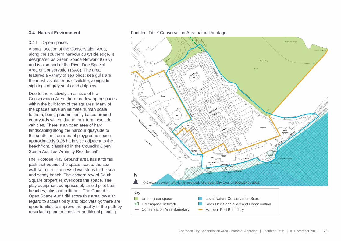
3.4.1 Open spacesA small section of the Conservation Area, along the southern harbour quayside edge, is designated as Green Space Network (GSN) and is also part of the River Dee Special Area of Conservation (SAC). The area features a variety of sea birds; sea gulls are the most visible forms of wildlife, alongside sightings of grey seals and dolphins.
Due to the relatively small size of the Conservation Area, there are few open spaces within the built form of the squares. Many of the spaces have an intimate human scale to them, being predominantly based around courtyards which, due to their form, exclude vehicles. There is an open area of hard landscaping along the harbour quayside to the south, and an area of playground space approximately 0.26 ha in size adjacent to the beachfront, classifi ed in the Council’s Open Space Audit as ‘Amenity Residential’.
The ‘Footdee Play Ground’ area has a formal path that bounds the space next to the sea wall, with direct access down steps to the sea and sandy beach. The eastern row of South Square properties overlooks the space. The play equipment comprises of, an old pilot boat, benches, bins and a lifebelt. The Council’s Open Space Audit did score this area low with regard to accessibility and biodiversity; there are opportunities to improve the quality of the path by resurfacing and to consider additional planting.
Footdee ‘Fittie’ Conservation Area natural heritage
© Crown copyright. All rights reserved. Aberdeen City Council 100023401 2015.
N
Urban greenspaceKey
Local Nature Conservation SitesRiver Dee Special Area of ConservationGreenspace network
Conservation Area Boundary Harbour Port Boundary
24 Aberdeen City Conservation Area Character Appraisal | Footdee “Fittie” | 10 December 2015
Top: Harbour view from the RoundhouseBottom: Eastern sea wall and beach
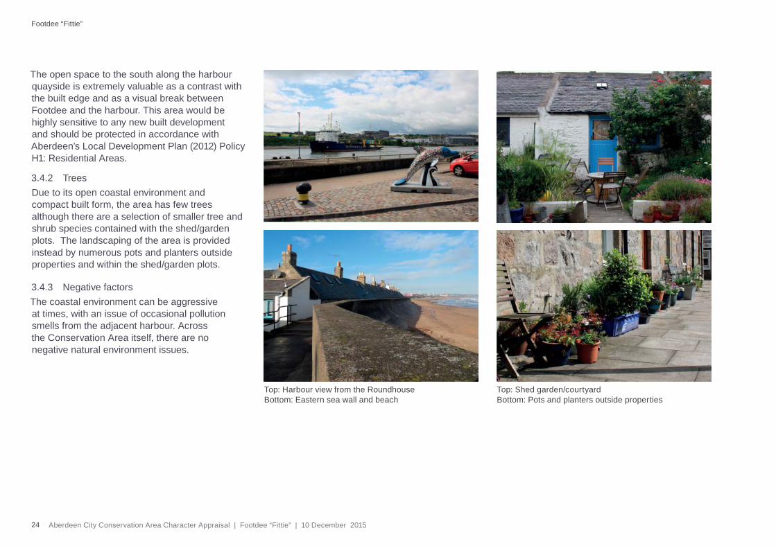
The open space to the south along the harbour quayside is extremely valuable as a contrast with the built edge and as a visual break between Footdee and the harbour. This area would be highly sensitive to any new built development and should be protected in accordance with Aberdeen’s Local Development Plan (2012) Policy H1: Residential Areas.
3.4.2 TreesDue to its open coastal environment and compact built form, the area has few trees although there are a selection of smaller tree and shrub species contained with the shed/garden plots. The landscaping of the area is provided instead by numerous pots and planters outside properties and within the shed/garden plots.
3.4.3 Negative factorsThe coastal environment can be aggressive at times, with an issue of occasional pollution smells from the adjacent harbour. Across the Conservation Area itself, there are no negative natural environment issues.
Top: Shed garden/courtyard Bottom: Pots and planters outside properties
Footdee “Fittie”
25Aberdeen City Conservation Area Character Appraisal | Footdee “Fittie” | 10 December 2015
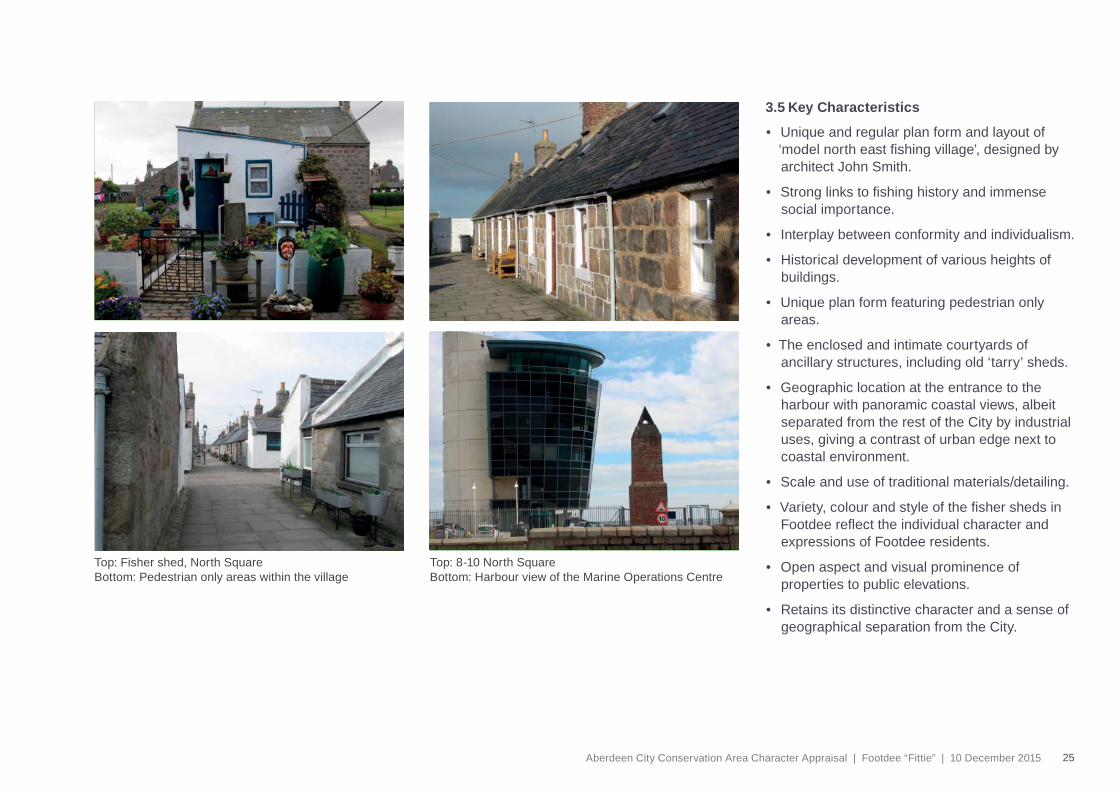
3.5 Key Characteristics
• Unique and regular plan form and layout of ‘model north east fi shing village’, designed by architect John Smith.
• Strong links to fi shing history and immense social importance.
• Interplay between conformity and individualism.
• Historical development of various heights of buildings.
• Unique plan form featuring pedestrian only areas.
• The enclosed and intimate courtyards of ancillary structures, including old ‘tarry’ sheds.
• Geographic location at the entrance to the harbour with panoramic coastal views, albeit separated from the rest of the City by industrial uses, giving a contrast of urban edge next to coastal environment.
• Scale and use of traditional materials/detailing.
• Variety, colour and style of the fi sher sheds in Footdee refl ect the individual character and expressions of Footdee residents.
• Open aspect and visual prominence of properties to public elevations.
• Retains its distinctive character and a sense of geographical separation from the City.
Top: Fisher shed, North SquareBottom: Pedestrian only areas within the village
Top: 8-10 North SquareBottom: Harbour view of the Marine Operations Centre
26 Aberdeen City Conservation Area Character Appraisal | Footdee “Fittie” | 10 December 2015
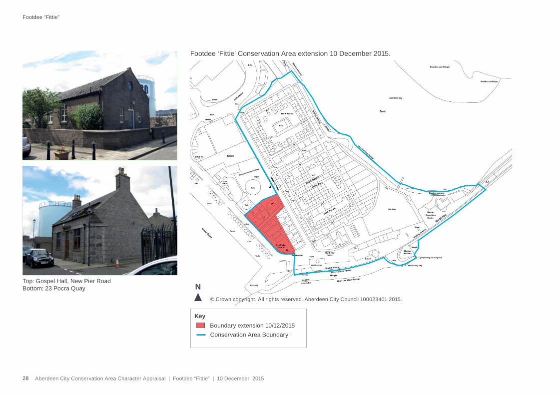
Please see Section 2: Conservation Areas Management Plan for all guidance relating to the management of Footdee Conservation Area.
On 10 December 2015, Aberdeen City Council extended the Conservation Area boundary to include 21, 23, 29 and the Sea Cadet Corps, Porca Quay and the Gospel Hall, New Pier Road.
This was because 21, 23 and 29 Porca Quay were the only residential buildings in the vicinity that were not previously part of the Conservation Area and they are of historic and architectural interest. Any future redevelopment of the Gospel Hall or the Sea Cadet Corps site could have a signifi cant impact on the character of Footdee.
In 1988 the Council approved the ‘Footdee Design Guide’ due to the increasing number of applications from residents to extend or improve their houses. The guide supported careful design and the use of traditional materials to enhance and improve the area’s character. This character appraisal replaces the Footdee Design Guide.
4 Management
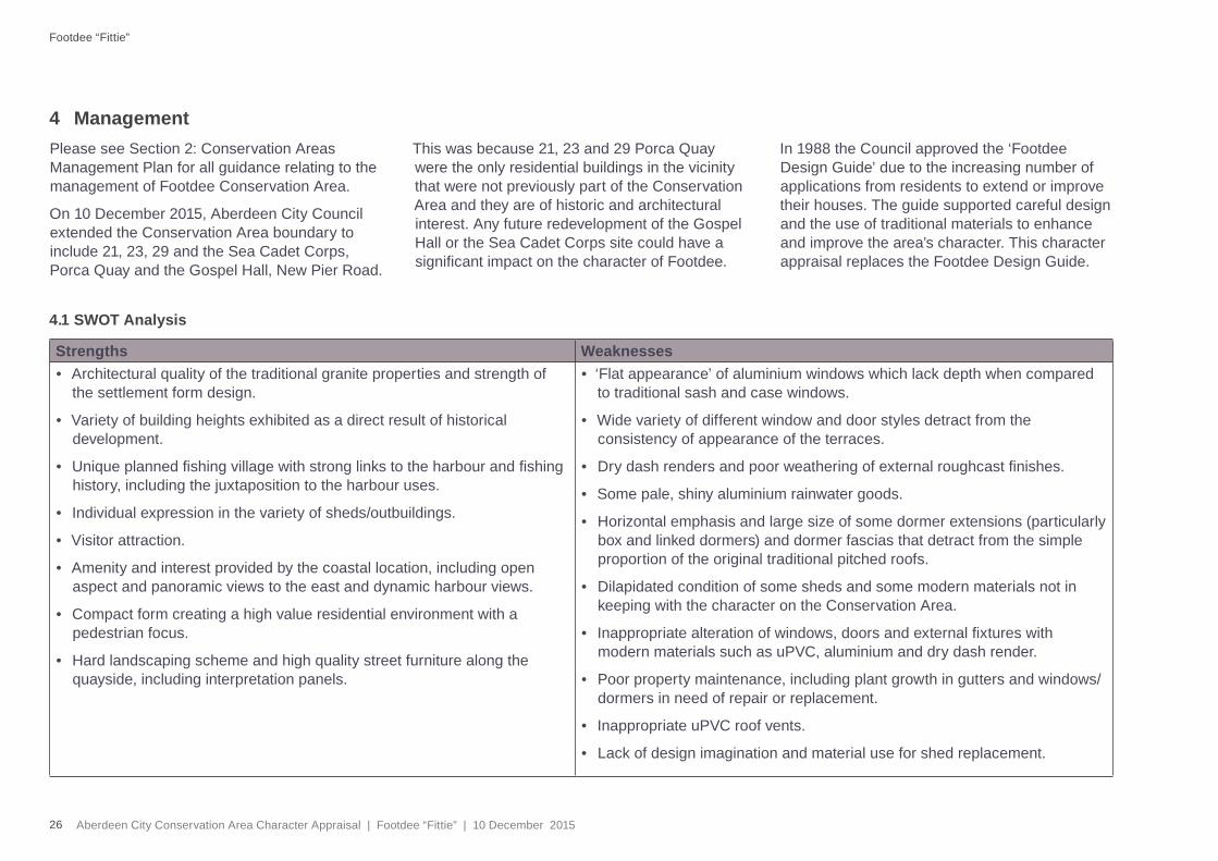
4.1 SWOT Analysis
Strengths Weaknesses• Architectural quality of the traditional granite properties and strength of
the settlement form design.
• Variety of building heights exhibited as a direct result of historical development.
• Unique planned fi shing village with strong links to the harbour and fi shing history, including the juxtaposition to the harbour uses.
• Individual expression in the variety of sheds/outbuildings.
• Visitor attraction.
• Amenity and interest provided by the coastal location, including open aspect and panoramic views to the east and dynamic harbour views.
• Compact form creating a high value residential environment with a pedestrian focus.
• Hard landscaping scheme and high quality street furniture along the quayside, including interpretation panels.
• ‘Flat appearance’ of aluminium windows which lack depth when compared to traditional sash and case windows.
• Wide variety of different window and door styles detract from the consistency of appearance of the terraces.
• Dry dash renders and poor weathering of external roughcast fi nishes.
• Some pale, shiny aluminium rainwater goods.
• Horizontal emphasis and large size of some dormer extensions (particularly box and linked dormers) and dormer fascias that detract from the simple proportion of the original traditional pitched roofs.
• Dilapidated condition of some sheds and some modern materials not in keeping with the character on the Conservation Area.
• Inappropriate alteration of windows, doors and external fi xtures with modern materials such as uPVC, aluminium and dry dash render.
• Poor property maintenance, including plant growth in gutters and windows/dormers in need of repair or replacement.
• Inappropriate uPVC roof vents.
• Lack of design imagination and material use for shed replacement.
Footdee “Fittie”
27Aberdeen City Conservation Area Character Appraisal | Footdee “Fittie” | 10 December 2015
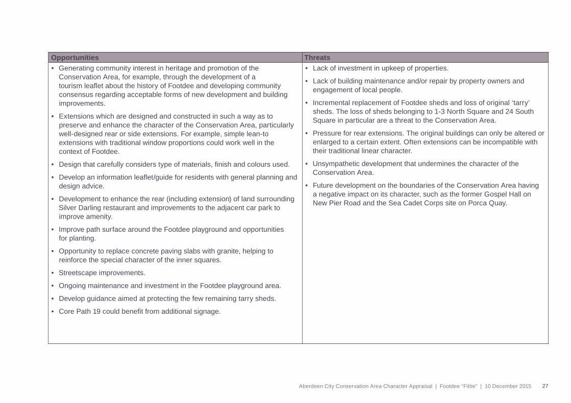
Opportunities Threats• Generating community interest in heritage and promotion of the
Conservation Area, for example, through the development of a tourism leafl et about the history of Footdee and developing community consensus regarding acceptable forms of new development and building improvements.
• Extensions which are designed and constructed in such a way as to preserve and enhance the character of the Conservation Area, particularly well-designed rear or side extensions. For example, simple lean-to extensions with traditional window proportions could work well in the context of Footdee.
• Design that carefully considers type of materials, fi nish and colours used.
• Develop an information leafl et/guide for residents with general planning and design advice.
• Development to enhance the rear (including extension) of land surrounding Silver Darling restaurant and improvements to the adjacent car park to improve amenity.
• Improve path surface around the Footdee playground and opportunities for planting.
• Opportunity to replace concrete paving slabs with granite, helping to reinforce the special character of the inner squares.
• Streetscape improvements.
• Ongoing maintenance and investment in the Footdee playground area.
• Develop guidance aimed at protecting the few remaining tarry sheds.
• Core Path 19 could benefi t from additional signage.
• Lack of investment in upkeep of properties.
• Lack of building maintenance and/or repair by property owners and engagement of local people.
• Incremental replacement of Footdee sheds and loss of original ‘tarry’ sheds. The loss of sheds belonging to 1-3 North Square and 24 South Square in particular are a threat to the Conservation Area.
• Pressure for rear extensions. The original buildings can only be altered or enlarged to a certain extent. Often extensions can be incompatible with their traditional linear character.
• Unsympathetic development that undermines the character of the Conservation Area.
• Future development on the boundaries of the Conservation Area having a negative impact on its character, such as the former Gospel Hall on New Pier Road and the Sea Cadet Corps site on Porca Quay.
28 Aberdeen City Conservation Area Character Appraisal | Footdee “Fittie” | 10 December 2015
Footdee ‘Fittie’ Conservation Area extension 10 December 2015.
© Crown copyright. All rights reserved. Aberdeen City Council 100023401 2015.
N
Boundary extension 10/12/2015Key
Conservation Area Boundary
Top: Gospel Hall, New Pier RoadBottom: 23 Pocra Quay
Footdee “Fittie”
29Aberdeen City Conservation Area Character Appraisal | Footdee “Fittie” | 10 December 2015
List of Streets in the Footdee Conservation Area
Middle Row, all nos, Footdee
New Pier Road, 1-5 inclusive, Footdee,Gospel Hall
North Square, all nos, Footdee
Pilot Square, all nos, Footdee
Pocra Quay, North Pier House 43, North Pier Villa 44, East End Villa 45, Silver Darlings Restaurant, Harbour Board Buildings,21, 23, 29 and the Sea Cadet Corps
inc. Marine Operations Centre, Footdee
South Square, all nos, Footdee
5 Appendix
Top: Commemorative stone, New Pier RoadBottom: Shed gate decoration
Top: War Memorial, Aberdeen Dock Labourers Bottom: Sea Moon Sculpture,