abbey-chesterton bridge on the chisholm trail · briefing note 2015/01 cambridge cycling campaign 1...
TRANSCRIPT

Briefing Note 2015/01 Cambridge Cycling Campaign 1
Abbey-Chesterton Bridge on the Chisholm Trail
IntroductionCambridge Cycling Campaign has been developing proposals forthe Chisholm Trail, a cycling and walking route linking northCambridge and the Science Park to Addenbrooke's Hospital andsouth Cambridge, since 1998 (see…www.camcycle.org.uk/newsletters/17/article15.html ). Thiswould more or less follow the line of the railway but also usesections of the cycle path along The Busway, with a new bridgeover the river Cam between East Chesterton and Barnwell (inAbbey ward). The route would enable many trips to be made onfoot or by bike that are currently difficult unless they are madeby car. Cycle trips from new developments at Trumpington tothe Science Park would take around 30 minutes even at a gentlepace, as would trips from Orchard Park to Addenbrooke's.Shorter trips, on foot or bike, to open space, local shops orschools would also benefit from the route.
Both the existing and the draft Cambridge Local Plan (summer2013) propose to protect much of the land required for theChisholm Trail alongside the rail corridor through Cambridge,and the Chisholm Trail is included in the Transport Strategy forCambridge and South Cambridgeshire. A feasibility study hasalready been carried out by Atkins, in September 2009, as partof the Cycle Cambridge scheme.
At the City Deal's board meeting on 28 January 2015 theChisholm Trail was included for prioritisation in the first fiveyears of Greater Cambridge City Deal projects, with £8.4 millionfor the project approved unanimously.
Cyclists riding across Ditton Meadows east of the site of the proposed bridge. [Reach Ride 2014]
The route (see also map on next page)
Although details of the precise route are still being developed,the central part of the Chisholm Trail would connect the twocycleways which run alongside the Busway track. Near theScience Park it would start at the end of the Busway, crossingMilton Road to link to the railway station under constructionat Chesterton sidings. It would then run close to the railway,where possible on both sides of the track through Abbey andPetersfield, to rejoin the cycleway along the Busway nearCambridge station.
There is scope to create a ‘linear park’ in some sections, addinggreenery to the area, and providing opportunities for leisure aswell as utility trips both on foot and by bike.
The north and south sections of the route already exist, as thecycleway alongside the The Busway currently connectsNorthstowe and Orchard Park to the Science Park area, andfrom Trumpington Meadows, Clay Farm and Addenbrooke'sHospital and the Biomedical Campus to the Railway Stationarea.
The proposed bridge over the river between Chesterton andBarnwell is an integral - and essential - part of the route. TheAtkins feasibility study says "it is considered that theconstruction of any other discrete sections of the proposedroutes would yield few benefits for cyclists and pedestrianswithout a new crossing of the river Cam. These sections wouldprovide routes with a higher proportion of off-road cycleway,but with only slight reductions in journey lengths."
2 Cambridge Cycling Campaign Briefing Note 2015/01
N
Riverside Br.
Green Dragon Br.
Abbey
Background map © OpenStreetMap contributors
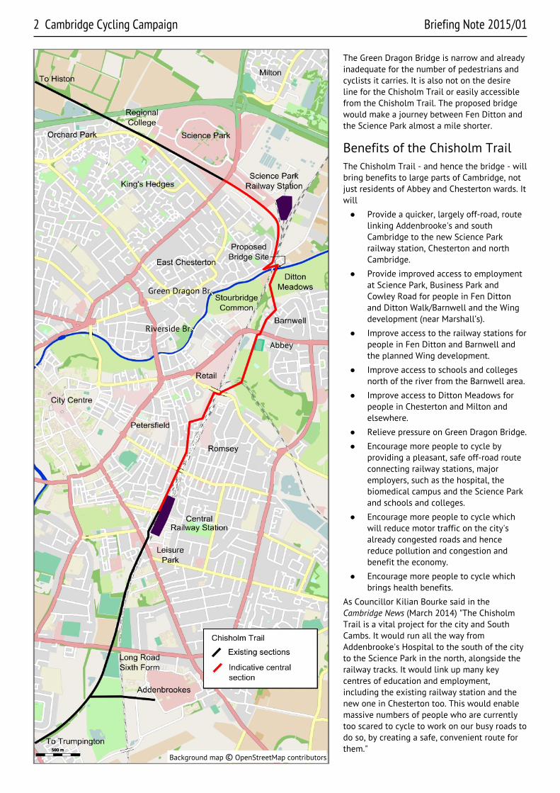
The Green Dragon Bridge is narrow and alreadyinadequate for the number of pedestrians andcyclists it carries. It is also not on the desireline for the Chisholm Trail or easily accessiblefrom the Chisholm Trail. The proposed bridgewould make a journey between Fen Ditton andthe Science Park almost a mile shorter.
Benefits of the Chisholm TrailThe Chisholm Trail - and hence the bridge - willbring benefits to large parts of Cambridge, notjust residents of Abbey and Chesterton wards. Itwill
● Provide a quicker, largely off-road, routelinking Addenbrooke's and southCambridge to the new Science Parkrailway station, Chesterton and northCambridge.
● Provide improved access to employmentat Science Park, Business Park andCowley Road for people in Fen Dittonand Ditton Walk/Barnwell and the Wingdevelopment (near Marshall’s).
● Improve access to the railway stations forpeople in Fen Ditton and Barnwell andthe planned Wing development.
● Improve access to schools and collegesnorth of the river from the Barnwell area.
● Improve access to Ditton Meadows forpeople in Chesterton and Milton andelsewhere.
● Relieve pressure on Green Dragon Bridge.
● Encourage more people to cycle byproviding a pleasant, safe off-road routeconnecting railway stations, majoremployers, such as the hospital, thebiomedical campus and the Science Parkand schools and colleges.
● Encourage more people to cycle whichwill reduce motor traffic on the city'salready congested roads and hencereduce pollution and congestion andbenefit the economy.
● Encourage more people to cycle whichbrings health benefits.
As Councillor Kilian Bourke said in theCambridge News (March 2014) "The ChisholmTrail is a vital project for the city and SouthCambs. It would run all the way fromAddenbrooke's Hospital to the south of the cityto the Science Park in the north, alongside therailway tracks. It would link up many keycentres of education and employment,including the existing railway station and thenew one in Chesterton too. This would enablemassive numbers of people who are currentlytoo scared to cycle to work on our busy roads todo so, by creating a safe, convenient route forthem."
Briefing Note 2015/01 Cambridge Cycling Campaign 3
The proposed bridgeThe proposal is for a bridge at the obvious crossing pointalong the Chisholm Trail, near where the railway line crossesthe river.
A consultation exercise in summer 2014 suggested variousoptions for the location and appearance of the bridge but didnot go into much detail regarding the connections betweenthe bridge, access cycle routes and the wider cycle (andpedestrian) network.
Following this consultation the County Council is proposing abridge close to the existing railway bridge, 30-60 metres away,and on the eastern, out-of-town, downstream side. A bridge onthe western side was ruled out because of lack of space on theChesterton bank for the access ramps. The ramps need to be80 to 100 metres long, as they should not be steeper than 1 in20, and because there are houses and less space on Fen Roadto the west of the railway bridge.
The details of the bridge design are not known, nor have thealignment of the access ramps or the routes to and from thebridge yet been seriously considered or consulted upon.
Environmental aspectsDitton Meadows is a historic area of unspoiled land alongsidethe river, managed for grazing, with lovely views and rich inwildlife. There is no question that this area must not be spoiltor developed, and that it needs to be preserved for futuregenerations. While Fen Ditton itself is a conservation area, the
Meadows are not included as much of the meadow area is inCambridge city.
Cambridge Natural History Society surveyed Ditton Meadowsmonthly during 2008 and over 370 plant species were noted,as well as over 50 invertebrates and 40 birds. The mostinteresting was the sighting of a water vole near Fen Ditton. Afull report is under ‘field studies’ at www.cnhs.org.uk . At thisstage, an environmental impact assessment has not yet beendone, but one will be necessary as part of the planningprocess. This will identify areas and wildlife that needparticular protection and measures to ensure that they are notharmed.
The bridge itself, being close to the existing railway bridge,will not affect the views significantly and should have littleimpact on the Meadows. Indeed it can be argued that it willenable more people to enjoy views of the Meadows and accessto them for recreation.
However, the access routes - the cycle and pedestrian pathsleading to and from the bridge - must be carefully designedand constructed to avoid disturbing existing wildlife habitatsand their inhabitants. In particular, lighting can have a majorimpact.
More seriously, construction could damage ground and anddestroy habitats, though they would recover. However, ifcarefully done, the impact can be minimised, as was the casewhen works were carried out on the Sheep's Green bridge inspring 2014. The construction compound shown on somedrawings looks unnecessarily and unacceptably large and aless intrusive location should be found. Because of the
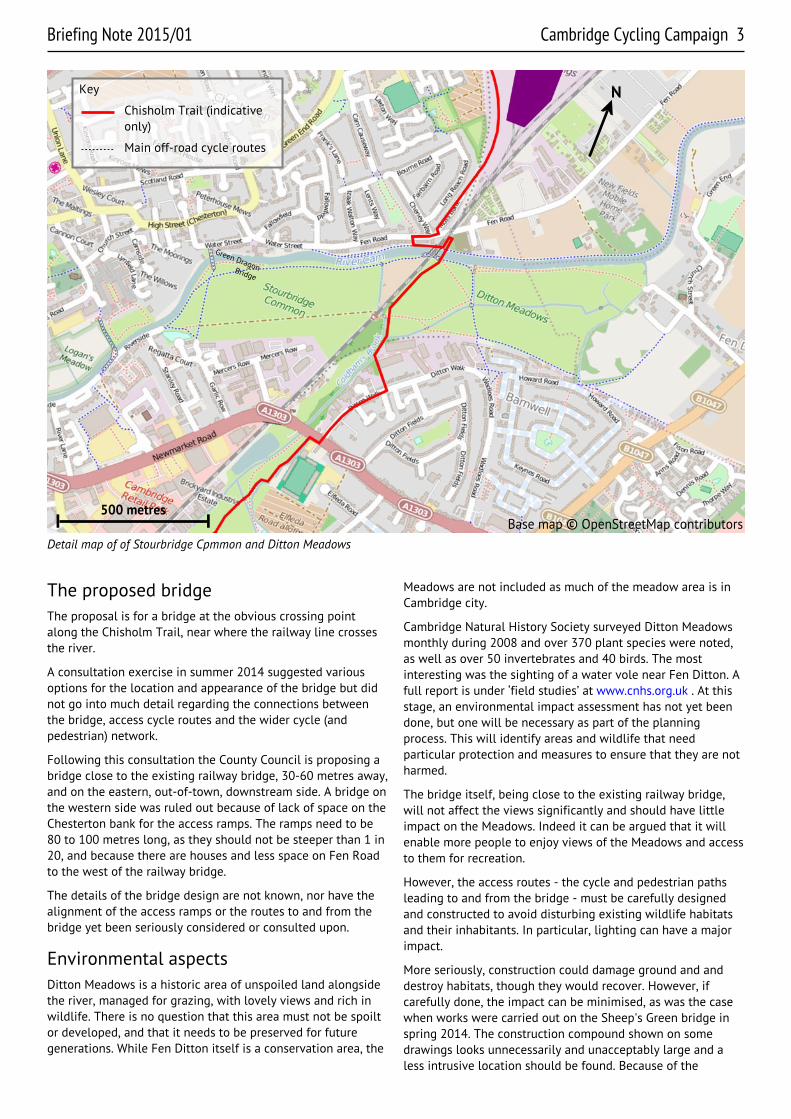
Detail map of of Stourbridge Cpmmon and Ditton Meadows
Key
Chisholm Trail (indicativeonly)
Main off-road cycle routes
Base map © OpenStreetMap contributors
Green Dragon
Bridge
N
500 metres
4 Cambridge Cycling Campaign Briefing Note 2015/01
Further information/references● Cambridge City Council draft local plan
● Transport Strategy for Cambridge and SouthCambridgeshire
● The reports of the feasibility study carried out byAtkins are available on the Campaign's website atwww.camcycle.org.uk/campaigning/cycleroutes/chisholmtrail/
● Cycling Vision 2016, published by Cambridge CyclingCampaign to highlight key projects that could bedelivered, that would make a significant differenceto cycling in the region.
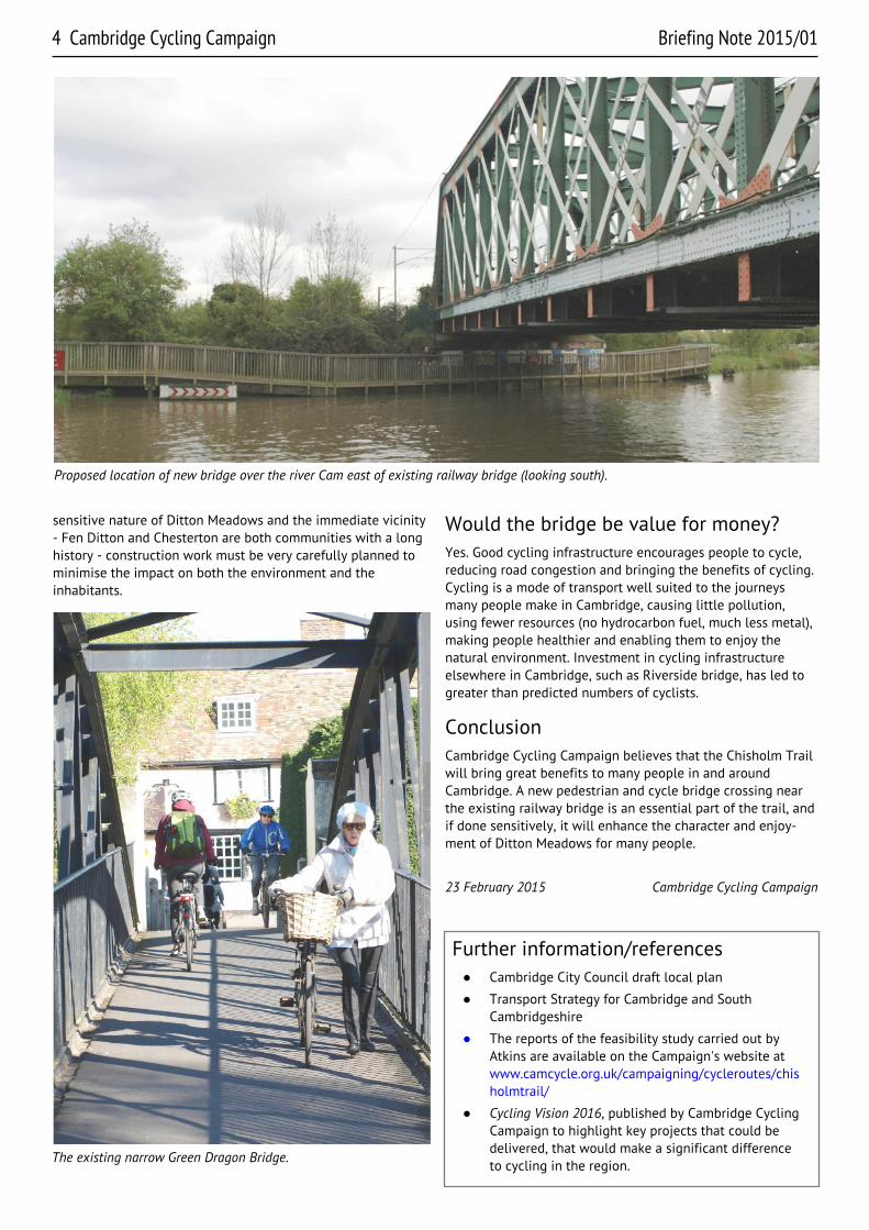
Proposed location of new bridge over the river Cam east of existing railway bridge (looking south).
sensitive nature of Ditton Meadows and the immediate vicinity- Fen Ditton and Chesterton are both communities with a longhistory - construction work must be very carefully planned tominimise the impact on both the environment and theinhabitants.
Would the bridge be value for money?Yes. Good cycling infrastructure encourages people to cycle,reducing road congestion and bringing the benefits of cycling.Cycling is a mode of transport well suited to the journeysmany people make in Cambridge, causing little pollution,using fewer resources (no hydrocarbon fuel, much less metal),making people healthier and enabling them to enjoy thenatural environment. Investment in cycling infrastructureelsewhere in Cambridge, such as Riverside bridge, has led togreater than predicted numbers of cyclists.
ConclusionCambridge Cycling Campaign believes that the Chisholm Trailwill bring great benefits to many people in and aroundCambridge. A new pedestrian and cycle bridge crossing nearthe existing railway bridge is an essential part of the trail, andif done sensitively, it will enhance the character and enjoy-ment of Ditton Meadows for many people.
23 February 2015 Cambridge Cycling Campaign
The existing narrow Green Dragon Bridge.