a preliminary strategic environmental impact · pdf fileenvironmental impact assesment ... a...
TRANSCRIPT
National Environmental Research InstituteUniversity of Aarhus . Denmark
NERI Technical Report No. 652, 2008
A preliminary strategic environmental impact assesment of mineral and hydrocarbon acti-vities on the Nuussuaq peninsula, West Greenland

[Blank page]
National Environmental Research InstituteUniversity of Aarhus . Denmark
NERI Technical Report No. 652, 2008
A preliminary strategic environmental impact assesment of mineral and hydrocarbon acti-vities on the Nuussuaq peninsula, West Greenland
David BoertmannGert AsmundChristian GlahderMikkel Tamstorf
Data sheet
Series title and no.: NERI Technical Report No. 652
Title: A preliminary strategic environmental impact assessment of mineral and hydrocarbon activities on the Nuussuaq peninsula, West Greenland
Authors: David Boertmann, Gert Asmund, Christian Glahder & Mikkel Tamstorf Department: Department of Arctic Environment Publisher: National Environmental Research Institute ©
University of Aarhus - Denmark URL: http://www.neri.dk
Year of publication: January 2008 Editing completed: November 2007 Referee: Anders Mosbech
Financial support: Bureau of Minerals and Petroleum, Greenland Government
Please cite as: Boertmann, D., Asmund, G., Glahder, C. & Tamstorf, M. 2008. A preliminary strategic environ-mental impact assessment of mineral and hydrocarbon activities on the Nuussuaq peninsula, West Greenland. National Environmental Research Institute, University of Aarhus, Denmark. 66 pp. – NERI Technical Report No. 652. http://www.dmu.dk/Pub/FR652.pdf.
Reproduction permitted provided the source is explicitly acknowledged
Abstract: There is an increasing interest for mineral and hydrocarbon exploration in Greenland and in both regards the Nuussuaq peninsula is in focus. This preliminary strategic environmental im-pact assessment describes the status of the biological knowledge from the area and designates potential conflicts between activities and the biological environment. Furthermore biological knowledge gaps are identified. These should be filled before specific environmental impacts as-sessments can be carried out and relevant studies to fill these data gaps are proposed.
Keywords: Strategic environmental impact assessment, mineral exploration, mining, hydrocarbon explora-tion, petroleum exploitation, Greenland, Nuussuaq peninsula
Layout: NERI Graphics Group, Silkeborg
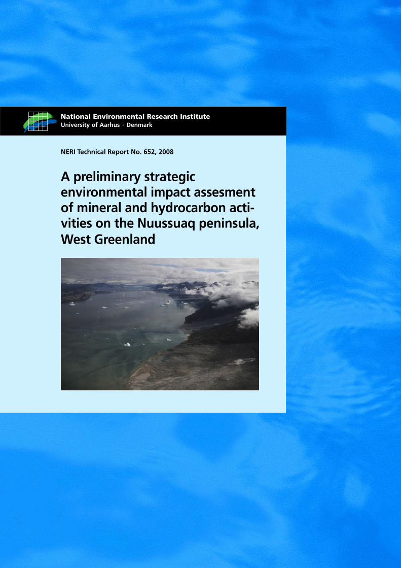
Cover photo: The north coast of Nuussuaq seen from a helicopter, August 2007
ISBN: 978-87-7073-024-2 ISSN (electronic): 1600-0048
Number of pages: 66
Internet version: The report is available in electronic format (pdf) at NERI's website http://www.dmu.dk/Pub/FR652.pdf
Contents
Preface 5
Summary 6
Dansk resumé 8
Naalisagaq kalaallisut 11
1 Introduction 14 1.1 The assessment area 15
2 Potential hydrocarbon and mineral activities in the area 16
3 The physical environment 18 3.1 Topography 18 3.2 Climate 18
4 The biological environment 19 4.1 Birds 19 4.2 Mammals 23 4.3 Fish 24 4.4 Vegetation 24 4.5 Protected areas and conservation 31
5 Local use 33 5.1 Fisheries 33 5.2 Hunting 34 5.3 Tourism 35
6 Sensitive areas and species 36 6.1 Species and their habitats 36 6.2 Flora 37 6.3 Vegetation 37 6.4 Terrain 37
7 Coastal sensitivity to oil spills 39
8 Status of pollution with mineral and hydrocarbon related substances 40 8.1 The chemistry of the Nuussuaq peninsula 40 8.2 Animals and plants 40 8.3 Samples in the DMU sample bank 40 8.4 Hydrocarbons 41 8.5 New samples 41
9 Preliminary assessment of potential environmental impacts of mineral and hydrocarbon activities 43 9.1 Issues common to minerals and hydrocarbons 43 9.2 Impacts related to the mineral activities 53
9.3 Impacts related to hydrocarbon activities 56 9.4 Summary of impact assessment 57
10 Assessment of information status for the area, where are the data gaps? 58 10.1 Geese 58 10.2 Other birds 58 10.3 Mammals 58 10.4 Other fauna 59 10.5 Vegetation 59 10.6 Proposed studies to fill data gaps 59
11 Conclusions 61
12 References 62
National Environmental Research Institute
NERI technical reports

5
Preface
There is an increasing interest in mineral as well as hydrocarbon explora-tion in Greenland and the Nuussuaq peninsula is in focus with regard to both activities. The Bureau of Minerals and Petroleum, Greenland Home Rule, therefore requested a preliminary strategic environmental impact assessment of mineral and hydrocarbon activities in this area from the National Environmental Research Institute, Denmark.
6
Summary
There is an increasing interest in mineral and hydrocarbon exploration in Greenland and the Nuussuaq peninsula is in focus with regard to both activities. In 1996, an oil exploration well was drilled, and a company is currently engaged in exploration for nickel. However, before more ac-tivities are initiated, the Bureau of Minerals and Petroleum (BMP), Greenland Home Rule, has requested a strategic environmental impact assessment with regard both to mineral and petroleum activities in the area.
Impacts from mineral and hydrocarbon activities mainly include:
Common to mineral and hydrocarbon activities • disturbance of wildlife • visual impacts • damage to vegetation and terrain • waste water release • release of drilling substances • emissions to air.
Impacts from mineral activities
• deposition of waste rock and tailings • risk of dust contamination
Impacts from hydrocarbon activities
• seismic surveys • release of produced water • chronic oil contamination • risk of acute oil spill.
There is a high risk of conflict between activities and environmental is-sues on the Nuussuaq peninsula, because the lowlands are restricted mainly to narrow coastal fringes and a few long and wide valleys. In the-se lowlands most of the mammals, birds and continuous vegetation are found, and the lowlands will most likely be used at least as transport corridors and probably also for exploration activities.
Valued ecosystem components (VECs) of the Nuussuaq peninsula in-clude: • the caribou population (small, isolated and red-listed as ‘Vulnerable’) • the Greenland white-fronted goose (declining and small population,
red-listed as ‘Endangered’) • other birds: gyr falcon, great northern diver (common loon), common
eider, harlequin duck, kittiwake and Arctic tern • important habitats for these species • seabird breeding colonies along the coasts • Arctic char and the rivers where they spawn and winter • rare plants and their habitats • areas with particularly vigorous/luxuriant vegetation.
7
There is, however, a lack of biological information from the area, and the missing data should be obtained before specific EIAs are carried out.
A preliminary impact assessment of mineral and hydrocarbon activities in the area points to the risk of: • negative effects on populations of caribou and the Greenland white-
fronted goose • negative effects on seabird breeding colonies • negative effects on rare plants • large-scale visual impacts on landscapes • chemical pollution particularly from tailings and waste rock • oil pollution from produced water • oil spills • large emissions of greenhouse gasses.
Modern technical solutions, including Best Available technology (BAT) and Best Environmental Practice (BEP), combined with strict regulation in order to avoid activities in sensitive areas and sensitive periods can in most cases mitigate and minimise impacts to acceptable levels.
Activities carried out by the local population, such as fishing and hunt-ing, take place mainly in the coastal areas. Resources occurring here, such as capelin and Arctic char, are at risk of being be impacted by oil spills, and spawning stocks of Arctic char may be impacted if their passways are obstructed. Inland activities mainly include caribou hunt-ing, which may be reduced or even stopped if the caribou population is reduced as a consequence of mineral or hydrocarbon activities.
Pollution from activities on land will usually be of a local or regional ex-tent. Even an oil spill will be rather limited in distribution as long as it occurs on land. If an oil spill reaches the marine environment, e.g. trans-ported by rivers, there is a risk of more extensive and widespread im-pacts.
Emission to the atmosphere may in the case of greenhouse gasses have global impacts and particularly a large oil field will have the potential to double the current Greenland contribution of carbondioxide. Arctic haze is also an issue to be aware of in case of large scale activities, particularly in the valleys of the peninsula.
Studies to be carried out as soon as possible: • an aerial survey of Greenland white-fronted geese in July • mapping of calving grounds and migration routes of the caribou
population • ground truthing of existing satellite images of vegetation types • a general survey of fauna and flora in combination with the other
studies.
Other studies to be carried out before extensive activities are initiated: • background mapping of chemicals in the environment • a survey of bathymetry and benthos of the surrounding waters in case
of marine deposition of tailings • a survey of seabird breeding colonies • mapping of rare plants and their habitats.
8
Dansk resumé
Nuussuaqhalvøen i Vestgrønland er interessant både for mineral- og olieefterforskning. En olieboring blev gennemført i 1996 og et selskab le-der efter nikkel i disse år. Inden der kommer flere aktiviteter i området har Råstofdirektoratet under Grønlands Hjemmestyre ønsket en strate-gisk miljøvurdering af de aktiviteter både eftersøgning og udnyttelse medfører.
Råstofaktiviteter medfører:
• operationer i terrænet (kørsel, helikopterflyvning, etc.), • placering af infrastruktur (bygninger, veje, deponier, etc.), • udledninger til vand og luft, • risiko for uheld (især oliespild).
Disse aktiviteter medfører en lang række mulige påvirkninger, hvoraf de vigtigste er:
Fælles for mineral- og olieaktiviteter:
• forstyrrelser af dyreliv, • visuelle påvirkninger af landskaber, • skader på vegetation og terræn, • spildevand, • udledninger fra boreoperationer, • udledninger til luften.
Særligt for mineralaktiviteter:
• deponering af mineaffald som ”tailings” og gråbjerg med risiko for forurening,
• risiko for støvforurening fra transport af knuste mi-neraler.
Særligt for olieaktiviteter:
• seismiske undersøgelser, • dannelse af produktionsvand, • kronisk olieforurening, • risiko for akutte oliespild.
Konfliktpotentialet mellem råstofaktiviteter og miljøet er stort på Nuus-suaqhalvøen, fordi lavlandsområderne er meget begrænsede. De udgør smalle bræmmer langs kysten og nogle få brede dale, der går langt ind i indlandet. Det er primært her at dyr og sammenhængende vegetationen findes. Det er også her at det er lettest at komme til at arbejde med rå-stofefterforskning, og ved aktiviteter i højlandet vil dalene fungere som adgangsveje ud til kysten.
Særligt værdifulde økologiske elementer (en oversættelse af det canadi-ske begreb Valued Ecological Components) i området omfatter:
9
• den lille isolerede bestand af rensdyr, • bestanden af grønlandsk blisgås, • fuglearterne: jagtfalk, islom, ederfugl, strømand, ride og havterne, • de vigtigste levesteder for disse arter, • ynglekolonierne af havfugle langs kysterne, særligt Naajaat ved Qe-
qertaq, • fjeldørred og deres opgangselve, • sjældne planter og deres voksesteder, • særligt frodige områder.
Der er dog væsentlige mangler i den foreliggende biologiske viden; mangler der bør udbedres for at der kan foretages egentlige miljøvurde-ringer af specifikke aktiviteter.
En foreløbig miljøvurdering af råstofaktiviteter i området angiver at der er risiko for:
• effekter på bestandene af rensdyr og grønlandsk blisgås, • effekter på havfuglekolonierne, • store visuelle skader på landskaber – visse områder er allerede påvir-
ket, • påvirkninger af bestande af sjældne planter, • kemisk forurening, særligt fra deponier af ”tailings” og gråbjerg, • olieforurening m.m. fra produktionsvand, • oliespild.
Desuden forventes det, at der ved etablering af et stort oliefelt vil blive udledt store mængder af drivhusgasser, som bidrager til drivhuseffekten og som også kan give lokale og regionale påvirkninger f.eks. i form af arktisk dis.
Moderne tekniske løsninger (BAT = Best Available Technology, BEP = Best Environmental Practice) i kombination med regulering med ud-gangspunkt i udpegning af særligt følsomme områder og perioder, vil i mange tilfælde kunne begrænse miljøpåvirkningerne.
Fangst og fiskeri foregår generelt langs kysterne, og kun rensdyr jages i indlandet. De kystnære fiskeressourcer så som lodde og fjeldørred kan påvirkes af oliespild, der når herud via vandløb, og ørredbestandene kan påvirkes, hvis deres gyde og vinteropholdssteder i elvene afspærres. Rensdyrjagten kan blive påvirket, hvis bestanden reduceres som følge af aktiviteter. For eksempel kan jagten blive begrænset eller stoppet for at fremme vækst i en reduceret bestand.
Generelt vil forurening fra aktiviteter på land blive af lokalt og regionalt omfang. Selv et oliespild vil, hvis det ikke kommer ud i det marine miljø, blive begrænset i udbredelse. En undtagelse er luftforureningen, hvor især udstødningen fra maskineri kan blive af meget stort omfang afhæn-gigt af aktiviteternes størrelse. Store marine oliefelter i Norge udleder dobbelt så meget CO2 som Grønlands samlede bidrag i dag.
Det foreslås at følgende undersøgelser bliver gennemført snarest:
• Grønlandsk blisgås: optælling fra fly af fældende fugle i hele områ-det, inkl. den østlige del, som ikke er blevet undersøgt før.
10
• Rensdyr: Kortlægning af kælveområder, andre vigtige områder og migrationsruter ved hjælp af satellitsporing.
• Vegetation: Verifikation i felten af vegetationstyper identificeret med satellit.
• Fauna og flora: Generel eftersøgning i kombination med ovenstående.
Undersøgelser der bør gøres inden større aktiviteter indledes:
• Baggrundsundersøgelser af kemiske forhold. • Optælling og kortlægning af havfuglekolonier langs kysterne. • En mere præcis kortlægning af sjældne planters og dyrs forekomst. • Undersøgelse af dybde- og bundforhold, i tilfælde af at der påtænkes
marin deponering af ”tailings”.
11
Naalisagaq kalaallisut
Kitaani Nuussuaq aatsitassarsiornikkut uuliasiornikkullu soqutiginar-tuuvoq. 1996-imi ulliasiorluni qillerisoqarpoq ingerlatsivimmillu ukiuni tamakkunani nikkilisiortoqarluni. Ingerlatanik taamaattunik amerlane-rusunik pisoqalersinnagu Namminersornerullutik Oqartussat ataanniit-toq Aatsitassarsiornermut Ikummatissarsiornermullu Pisortaqarfiup in-gerlatsinerit taamaattut ujarlernerillu nassatarisinnaasaannik siumut isi-gisumik avatangiisinik tunngatillugu misissuisoqarnissaa kissaatigisi-mavaa.
Aatsitassarsiornerup nassatarisarpai:
• Nunami sulianik assigiinngitsunik ingerlatsineq (qamutinik motori-linnik angallanneq, helikopterimik timminerit il.il.),
• Angallannermut atortulersuineq (illut, aqqusernit katersukkanik toq-qortuiffiit, il.il.),
• Imermik kuutitsineq silaannarmillu aniatitsineq, • Ajutoornissamik aarlerinartorsiortitsineq (pingaartumik uuliamik
maangaannaq kuuttitsisoorneq).
Ingerlatat tamakkua assigiinngitsorpassuarnik sunniuteqarfeqarsin-naapput, makkuali pingaarnerusut tassaapput:
Aatsitassarsiornermut ulliasiornermullu ataatsimut tunnga-tillugu makkuupput:
• Uumasunik akornusersuineq, • Nunap pissusiinik takussaasunik sunniuteqarneq, • Naasunik nunamillu ajoqusiinerit, • Imikoorneq, • Qillerinermut atatillugu kuutitsinerit, • Silaannarmut aniatitsinerit.
Pinmgaartumik aatsitassarsiornermut tunngatinnerullugu:
• Piiaanerup perlukuinik katersukkat,”tailings”-itut it-tut ujaqqallu sequnnerit qaleriissaakkat mingutitsi-lersinnaasut,
• Mineralinik sequtsikkanik assartuinermi pujoralatit-sinikkut mingutitsinissap aarlerinaataa.
Pingaartumik uuliasiornermut tunngatinnerullugu:
• Nunamik sajuppillatitsisarluni misissuinerit, • Imermik tunisassiornermut atugassamik pilersitsi-
neq, • Uuliakoorluni mingutitsiualerneq, • Uuliamik aniasoortitseriataarnissap aalerinartua.
Aatsitassarsionikkut ingerlatsinerup tamaanilu avatangiisit imminnut aoortuutilersinnaanerat aaralerinartorujussuuvoq, tassami tamaani toq-
12
qinnersat pukitsumiittut killeqaqimmata. Ilaatigut tamakkua sinerissa-miipput ippikillutik ilaatigullu qooqquni silittuni tnunap timaanut pa-vungarsuaq atasuni illutik. Tassaluuna uumasut naasoqarfiillu ataqati-giit annertunerusumik tamaani naapitassaasut. Amerlanertigullumiuna aamma tamakkunani aatsitassarsiorluni sulinissaq ajornannginnerusar-toq, aammalumi qatsinnerusumi arlaannik ingerlatsissagaanni qooqqut tassaallutik sinerissap tungaanut aqquteqarfiusariaqartut.
Uumasoqarnikkut immikkut pingaarutillit (canadamiut oqariartaasiat Valued Ecological Components nutsiinnarlugu) taaneqarsinnaasut ta-maaniittut makkuupput:
• Tuttoqatigiit ikittunnguit immikkuuillutik tamaani uumasuusut • Kalaallit nerlernaat tamaani uumasuusut, • Timmissat: kiisaviarsuit, tuulliit, mitit, toornaviarsuit, taateraat
imeqqutaallallut, • Taagorneqartut taagorneqartut najortagaasa pingaarnersaat, • Sinerissami timmissat imarmiut piaqqiorfii, pingaartumik Naajaani
Qeqertamilu, • Eqaluit kuuillu taakkua majortagaat, • Naasut qaqutigoortut tamakkualu naasarfii, • Nunap ilai naggorilluinnartut.
Biologimulli tunngatillugu ilisimasat pigineqartut pingaarutilinnik ami-gaateqarput; amigaatit ingerlatanut aalajangersunut tunngatillugu ava-tangiisinik nalilersuinivimmik ingerlatsisoqarsinnaassappat pit-saanngorsarneqartariaqartut.
Aatsitassarsiorluni tamaani ingerlatanik utaqqiisaagallartumik avatan-giisinut tunngatillugu naliliinerup aarlerigisariaqarsorai:
• Ingerlatat tamakkua tuttoqatigiinnut kalaallillu nerlernaannut tamaaniittunut sunniutissaat,
• Timmissat imarmiut erniorfiinut sunniutissaat, • Tamaani nunap ilusaanik takussaasunik annertuumik aseruinissaq –
ilaatigummi tamatuma ilaa sunnerneqareersimavoq, • Naasunik qaqutigoortunik tamakkualu naasarfiinik sunniinissaq, • Kemisk-imik mingutitsineq, pingaartumik ”tailings”-inik ujaqqanillu
piiarnerlukunik katersuiffinniit, • Uuliakoorluni il.il., soorlu imeq tunisassiornermik atorneqartoq
aqqutigalugu, mingutitsineq, • Uuliamik aniasoorluni mingutitsineq.
Ilimagineqaraportaaq uuliasiorferujussuarmik pilersitsisoqarneratigut annertoorujussuarmik kissattoornerup gassiinik aniatitsineqalerumaar-toq kissattornermut ilapittuutaasumik aammalu tamaanga nunallu ilaa-nut sunniuteqartumik, soorlu issittup iserianneranik pilersitsineratigut.
Nutaaliamik teknikikkut aaqqiissutit (BAT = Best Available Technology, BEP = Best Environmental Practice) nunap ilaanik ukiullu ilaanik eqqor-nerlukkuminartunik toqqaalluni killilersuinermik peqatilerlugit amer-lasuutigut avatangiisinik sunniinernik killilersimaarisinnaapput.
Piniarneq aalisarnerlu nalinginnaasunik sineriaq atuarlugu ingerlan-neqartarput, taamaallaat tuttut nunap timaani piniarneqartarlutik. Siner-
13
issap qanittuani aalisakka isumalluutit, soorlu ammassat eqaluillu uuliaarluernermit, tamaanga kuuit aqqutigalugit annguttumit, eqaluil-lumi aamma sunnerneqarsinnaapput, suffisarfitik ukiisarfitillu assern-eqarpata. Tuttunniarneq sunnerneqarsinnaavoq ingerlatat pissutaallutik tamatuma tuttui ikilisinneqassagaluarpata. Tuttunniartarnemi killiler-sorneqalersinnaavoqunitsivinneqarsinnaalluniluunniit tuttut ikilisimasut amerliartoqqilernissaat siunertaralugu.
Ataatsimut isigalugit nunami ingerlatsinikkut mingutitsineq tamaanga nunallu ilaanut tamaanga tunnganerussaaq. Tamaanimi uuliaarluerner-luunneq, immamut avalanngikkuni killilersimaarneqarsinnaassaaq. Si-laannakkulli minguitsineq taamaanngilaq, pingaartumimmi maskinat ingerlaneratigut aniatinneqartuuguni, ingerlatat annertussusiat apeqqu-taalluni annertoorujussuusinnaagami. Norge-p imaannarmi uuliasiorfis-sui CO2 -mik Kalaallit Nunaata tamarmiusumik ullumikkut aniatitaa marloriaataanik aniatitsipput.
Misissuinerit makkua piaarnerpaamik ingerlanneqarnissaat siunner-suutigineqarpoq:
• Kalaallit nerlernaat: isanerini timmisartumiit tamanna tamakkerlugu, kangisinnerusortaa siornatigut misissorneqarnikuunngitsoq, ilanngullugu kisitsineqassassoq.
• Tuttut: norrisarfii allallu pingaarutillit ingerlaartarfiilu nalunaarsorn-eqassasut qaammataasanut aallakaatitsissusersuinikkut malittarinnit-tarneq atorlu.
• Nunap naasoqarnera: Tamaani naasartut assigiinngitsut suuneri paasiniarlugillu aalajangersorneqassasut qaammataasat atorlugit.
• Uumasut naasullu: Nalinginnaasumik qulaani taagorneqartunut ata-tilluugu ujarlerneqassasoq.
Annertuunik ingerlatsisoqalersinnagu misissuinerit naammassineqarsi-masariaqartut:
• Kemiskinut tunngatillugu pissutsinik tamakkua tamaani qanoq akuutigereernerinik misissuinerit.
• Sinerissami timmissanik ineqarfimminniittunik ineqarfiinillu kisitsi-neq nalunaarsuinerlu.
• Naasut uumasullu qaqutigoornerusut qanoq amerlatiginerinik su-minnerinillu eeqqornerusumik nalunaarsuineq.
• ”Tailings”-inik immamut pikoornissaamik eqqarsaateqartoqarpat immap itissutsiinik imallu naqqata qanoq innerinik misissuineq.
14
1 Introduction
This report is a preliminary strategic environmental impact assessment (SEA) of mineral and petroleum activities on the Nuussuaq peninsula in West Greenland. The area has both a hydrocarbon and a mineral poten-tial, and exploration activities for these resources are expected to increase in the coming years.
The assessment is preliminary, because it is based solely on existing in-formation. One of the main objectives has been to identify important da-ta gaps which should be filled in order to prepare a more elaborate stra-tegic impact assessment or future environmental impact assessments of specific activities. However, a new analysis of remotely sensed data on vegetation is presented.
The impact assessment encompasses only biological resources, chemical background measurements and local use of the area. Socioeconomics, ar-chaeology and cultural history are not included.
The preparation of this assessment was supported financially by Bureau of Minerals and Petroleum, Greenland Home Rule.
It is important to stress that an SEA does not replace the need for site- and activity-specific Environmental Impact Assessments (EIAs). The SEA provides an overview of the environment in the licence area as well as in adjacent areas which can be impacted by the activities. It identifies major potential environmental effects associated with expected offshore oil and gas activities. The SEA will also identify knowledge and data gaps, highlight issues of concern, and make recommendations for miti-gation and planning. An SEA is included in the background for the deci-sions made by the relevant authorities, and may identify general regula-tory or mitigative measures and monitoring requirements that must be dealt with by the companies applying for concessions.
Abbreviations used AMAP = Arctic Monitoring and Assessment Programme a.s.l. = above sea limit BAT = Best Available Technology BEP = Best Environmental Practice EIA = Environmental Impact Assessment NERI = National Environmental Research Institute, Denmark GEUS = Geological Survey of Denmark and Greenland GINR = Greenland Institute of Natural Resources PAH = Polycyclic Aromatic Hydrocarbons SEA = Strategic Environmental Impact Assessment VEC = Valued Ecosystem Components VOC = Volatile Organic Components).
15
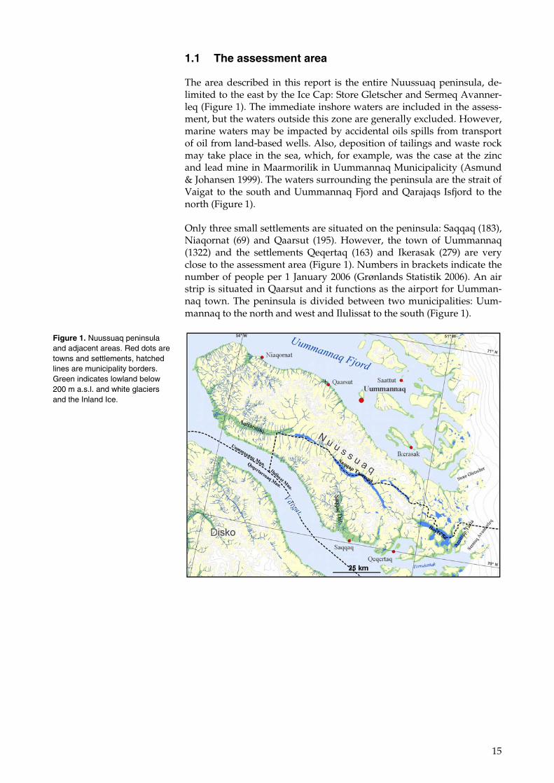
1.1 The assessment area
The area described in this report is the entire Nuussuaq peninsula, de-limited to the east by the Ice Cap: Store Gletscher and Sermeq Avanner-leq (Figure 1). The immediate inshore waters are included in the assess-ment, but the waters outside this zone are generally excluded. However, marine waters may be impacted by accidental oils spills from transport of oil from land-based wells. Also, deposition of tailings and waste rock may take place in the sea, which, for example, was the case at the zinc and lead mine in Maarmorilik in Uummannaq Municipalicity (Asmund & Johansen 1999). The waters surrounding the peninsula are the strait of Vaigat to the south and Uummannaq Fjord and Qarajaqs Isfjord to the north (Figure 1).
Only three small settlements are situated on the peninsula: Saqqaq (183), Niaqornat (69) and Qaarsut (195). However, the town of Uummannaq (1322) and the settlements Qeqertaq (163) and Ikerasak (279) are very close to the assessment area (Figure 1). Numbers in brackets indicate the number of people per 1 January 2006 (Grønlands Statistik 2006). An air strip is situated in Qaarsut and it functions as the airport for Uumman-naq town. The peninsula is divided between two municipalities: Uum-mannaq to the north and west and Ilulissat to the south (Figure 1).
Figure 1. Nuussuaq peninsula and adjacent areas. Red dots are towns and settlements, hatched lines are municipality borders. Green indicates lowland below 200 m a.s.l. and white glaciers and the Inland Ice.
16
2 Potential hydrocarbon and mineral ac-tivities in the area
The Nuussuaq peninsula has potential in relation both to hydrocarbon and mineral activities. Oil seeps are known from the coastal areas of the western part. A Canadian company carried out several slim core drill-ings and one full-scale oil exploration drilling in the early 1990s. Another Canadian company is currently searching for nickel in the central part of the peninsula.
Activities common to exploration and exploitation for both hydrocar-bons and minerals include establishment of infrastructure, vehicle and helicopter traffic, drilling operations, release of combustion gases from heavy machinery (greenhouse gasses), etc. As most transport of heavy equipment will take place by ship, sailing is also a common activity. En-vironmental impacts related to these activities are visual (infrastructure placed within the landscape, ruts and tracks in terrain and vegetation). They also involve disturbance to wildlife, including destruction of habi-tats by placement of infrastructure in the landscape (‘footprint’), as well as climate change, and the release of chemicals and cuttings from drilling operations, in addition to release of waste from camps, etc.
Specific mineral activities include transportation of ore, deposition of tai-lings and waste rock. These activities may impact the environment by heavy metal pollution both in the aquatic and terrestrial environments (via dust). Other substances, e.g. from the production of concentrate (e.g. cyanide, flocculants), may also pollute the environment. And tailings and waste rock depots may occupy large areas. Open-pit mining creates scars in the landscape.
Specific hydrocarbon activities include seismic surveys and discharge of production water as well as the flaring of gas. Environmental impacts re-lated to these activities can be disturbance to wildlife, pollution with heavy metals and other chemical substances, release of greenhouse gas-ses, etc, as well as chronic oil pollution. However, the most serious po-tential impacts are related to accidental oil spills, either from the well (blow-outs) or from wrecks during transport. Particularly oils spills in coastal waters have the potential to cause far-ranging environmental im-pacts. See Table 1 and Table 2.
17
Table 1. Overview of geographical extent and biological level of environmental impacts (nature) of mineral and hydrocarbon activities. L = local impacts (only measurable in the near surroundings), R = regional impacts (can be traced in more extensive areas such as a countywide, fjord/valley systems, etc., I = individual level, P = population level, E = eco-system level.
Mining activities
Impacts Terrain and vegetation Disturbance of wildlife Visual
Prospecting L L – I L/R*
Exploration L L/R** - I/P** L
Exploitation L L/R** - I/P** L
Decommissioning L L - I L
* regional in case of extensive driving ** regional in case of long transport corridors.
Hydrocarbon activities
Disturbance of wildlife Impacts Terrain and vegetation
on land at sea
Visual
Prospecting L L – I - L
Seismic surveys L/R L/R – I/P** L/R – I L/R
Exploration drilling L L – I L/R – I/P L
Exploitation L/R* L/R* - I/P** L/R – I/P L/R*
Decommissioning L L – I L – I L
Oil spill L L – I R – P/E -
* regional in case of long transport corridors ** under certain circumstances at population level.
Table 2. Overview of geographical extent and biological level of environmental impacts of mineral and hydrocarbon activities (discharges to different compartments of the environ-ment). L = local impacts (only measurable in the near surroundings), R = regional impacts (can be traced in more extensive areas such as county level, fjord systems, etc., G = global impacts, I = individual level, P = population level, E = ecosystem level.
Mining activities
Impacts Chemical pollution Physical Discharges to the air
Prospecting L negligible negligible
Exploration L negligible negligible
Exploitation L/R L/R G/R**
Decommissioning L L negligible
* global in case of greenhouse gasses and regional in case of NOx, if fossil fuels are used for energy production.
Hydrocarbon activities
Impacts Chemical pollution Physical Discharges to the air
Prospecting L negligible negligible
Exploration drilling L negligible negligible
Exploitation L/R L/R G/R**
Decommissioning L L negligible
Oil spill R -
* deposition of cuttings, mud, tailings etc. ** global in case of greenhouse gasses and regional in case of NOx, if fossil fuels are used for energy production
18
3 The physical environment
3.1 Topography
The Nuussuaq peninsula is about 175 km long and 50 km wide. It is do-minated by alpine areas with the highest mountain tops reaching 2,144 m a.s.l. Lowlands are found in the coastal forelands and in the valleys. The most prominent valleys are the central Aaffarsuaq valley, the Saqqaq valley and the Boyes Lake valley. Many coastlines are steep with only narrow forelands, but wider, gently sloping forelands are found espe-cially at the tip of the peninsula. Lakes are few in number, and large lakes are found only in the central valley and in the eastern part of the peninsula. The coasts are generally rocky or with narrow sediment beaches. Only in the mouth of the Aaffarsuaq valley is a small salt marsh found, behind a boulder beach. Extensive glaciers cover the highest parts of the area and turbid meltwater flows from these to the rivers and lakes of the central Aaffarsuaq valley, while the water in lakes in the eastern area appears to be clear. A special landscape feature – linked to the per-mafrost – is represented by the small distinct hills in the floor of the main valleys, the pingos (or mud vulcanoes).
3.2 Climate
The climate of the peninsula is Arctic with average July (the warmest month) temperatures below 5°C, indicating that it is within the High Arctic climate zone. The surrounding seas are usually ice-covered in the period December-May, although in recent years the extent of this period has been shorter and the ice conditions less heavy.
Currently, the information available on the snow cover and length of the growing season on Nuussuaq is limited. However, this will change within few month since the Danish Meteorological Institute is finishing a project that models climate in the entire of Greenland from 1950 to 2090 (http://klimagroenland.dmi.dk). This will enable a study of the length of the growing season and precipitation patterns for Nuussuaq not only during the present time, but also projected changes for the coming dec-ades. The study has a resolution of 25 km by 25 km, which provides the possibility of looking at differences between the most western, coastal parts and the inland, eastern parts of the peninsula.

19
4 The biological environment
4.1 Birds
This section describes the birds occurring on the Nuussuaq peninsula; both those living inland (including birds in freshwater habitats) and tho-se along the coasts, dependent on the marine environment.
Very few published sources deal specifically with the breeding birds of the area. The landbirds were described by Bertelsen (1921) and by Fencker in 1950, and finally Joensen & Preuss (1972) carried out system-atic breeding bird surveys in 1965 in the Saqqaq valley. However, infor-mation on landbirds is also found in more general and synoptic works (Salomonsen 1960, 1967, Boertmann 1994).
The marine birds of the area also were described by Bertelsen (1921). He meticulously described and mapped all the seabird breeding colonies of the Uummannaq District (= Uummannaq Municipality), which includes the major part of the peninsula. In 1990, Burnham et al. (2005) revisited all these sites and described the population changes. The NERI seabird colony database holds information on all known seabird breeding colo-nies on the peninsula (Boertmann et al. 1996). The data in this database is of recent date (from the past 10 years) for many of the colonies.
The winter situation (in a mild winter) was described by Fencker (1947) and some aerial winter seabird surveys have in recent years included the westernmost parts of the peninsula (NERI, unpublished, Boertmann et al. 2004).
4.1.1 Landbirds (incl. birds in freshwater habitats)
The landbird fauna of West Greenland is relatively poor compared to other Arctic areas, and the Nuussuaq peninsula is no exception to this. The most important birds of the peninsula are the geese, and particularly the Greenland white-fronted goose (Anser albifrons flavirsotris). The geese arrive from wintering grounds in northwest Europe in early May and leave again in September. Breeding pairs occur scattered in the moist lowlands and seek to some degree to the same sites as the moulting birds after the eggs have hatched. A large segment of the population com-prises non-breeding birds, which assemble in large flocks in marshes at lakes. Here they perform feather moult and become flightless for a three-week period in July. These birds are very sensitive to disturbance when flightless (Glahder & Walsh 2007, Madsen 2004).
Moulting geese in the Nuussuaq peninsula were surveyed from aircraft in July 1992, 1995 and 2003 (Glahder 1999, Glahder et al. 2002, Madsen 2004). Results are listed in Table 3.
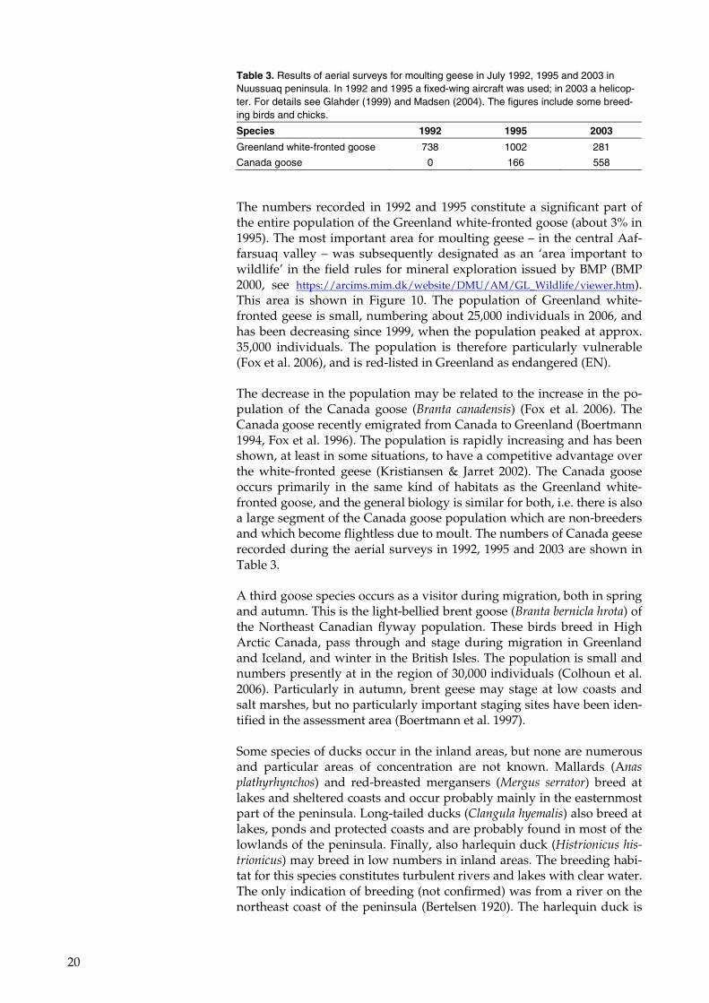
20
The numbers recorded in 1992 and 1995 constitute a significant part of the entire population of the Greenland white-fronted goose (about 3% in 1995). The most important area for moulting geese – in the central Aaf-farsuaq valley – was subsequently designated as an ‘area important to wildlife’ in the field rules for mineral exploration issued by BMP (BMP 2000, see https://arcims.mim.dk/website/DMU/AM/GL_Wildlife/viewer.htm). This area is shown in Figure 10. The population of Greenland white-fronted geese is small, numbering about 25,000 individuals in 2006, and has been decreasing since 1999, when the population peaked at approx. 35,000 individuals. The population is therefore particularly vulnerable (Fox et al. 2006), and is red-listed in Greenland as endangered (EN).
The decrease in the population may be related to the increase in the po-pulation of the Canada goose (Branta canadensis) (Fox et al. 2006). The Canada goose recently emigrated from Canada to Greenland (Boertmann 1994, Fox et al. 1996). The population is rapidly increasing and has been shown, at least in some situations, to have a competitive advantage over the white-fronted geese (Kristiansen & Jarret 2002). The Canada goose occurs primarily in the same kind of habitats as the Greenland white-fronted goose, and the general biology is similar for both, i.e. there is also a large segment of the Canada goose population which are non-breeders and which become flightless due to moult. The numbers of Canada geese recorded during the aerial surveys in 1992, 1995 and 2003 are shown in Table 3.
A third goose species occurs as a visitor during migration, both in spring and autumn. This is the light-bellied brent goose (Branta bernicla hrota) of the Northeast Canadian flyway population. These birds breed in High Arctic Canada, pass through and stage during migration in Greenland and Iceland, and winter in the British Isles. The population is small and numbers presently at in the region of 30,000 individuals (Colhoun et al. 2006). Particularly in autumn, brent geese may stage at low coasts and salt marshes, but no particularly important staging sites have been iden-tified in the assessment area (Boertmann et al. 1997).
Some species of ducks occur in the inland areas, but none are numerous and particular areas of concentration are not known. Mallards (Anas plathyrhynchos) and red-breasted mergansers (Mergus serrator) breed at lakes and sheltered coasts and occur probably mainly in the easternmost part of the peninsula. Long-tailed ducks (Clangula hyemalis) also breed at lakes, ponds and protected coasts and are probably found in most of the lowlands of the peninsula. Finally, also harlequin duck (Histrionicus his-trionicus) may breed in low numbers in inland areas. The breeding habi-tat for this species constitutes turbulent rivers and lakes with clear water. The only indication of breeding (not confirmed) was from a river on the northeast coast of the peninsula (Bertelsen 1920). The harlequin duck is
Table 3. Results of aerial surveys for moulting geese in July 1992, 1995 and 2003 in Nuussuaq peninsula. In 1992 and 1995 a fixed-wing aircraft was used; in 2003 a helicop-ter. For details see Glahder (1999) and Madsen (2004). The figures include some breed-ing birds and chicks.
Species 1992 1995 2003
Greenland white-fronted goose 738 1002 281
Canada goose 0 166 558
21
redlisted as near threatened (NT) in Greenland due to the low number of breeding birds.
Two divers/loons breed in the area: the red-throated diver (Gavia stel-lata) breeds mainly at small ponds near the coast (Joensen & Preuss 1972). This species forages mainly in the marine environment, bringing food back to the chicks in the ponds. They are rather common where the habitat is present. The other species, the great northern diver/common loon (Gavia immer), breeds at large, deep lakes with clear water. Bertelsen (1920) considered it as a rare bird occurring in very small numbers in Uummannaq District. The large lake Boyes Sø and adjacent lakes may hold some pairs. The great northern diver is redlisted in Greenland as near threatened (NT) due to the low number of breeding birds.
Shorebirds are represented by purple sandpiber (Calidris maritima) and red-necked phalarope (Phalaropus lobatus). They occur in marshes with ponds and moist lowlands (Joensen & Preuss 1972). Great ringed plover (Charadrius hiaticula) may also breed in low numbers in the area.
Only two species of birds of prey breed in the area: Gyr falcon (Falco rus-ticoulus) and peregrine falcon (Falco peregrinus). Bertelsen (1920) de-scribed six breeding sites for gyr falcons in the Uummannaq part of the peninsula. These were however not used simultaneously and repre-sented probably a small number of pairs. In 2000 Burnham et al. (2005) found only three of Bertelsen’s 28 sites (in the entire Uummannaq dis-trict) occupied, but located an additional four. Joensen & Preuss (1972) reported a single pair from the Saqqaq Valley in 1965. With regard to pe-regrine falcons no information available for the area. However, the east-ernmost part of the peninsula resembles the preferred peregrine habitat in other parts of West Greenland and peregrines may potentially occur in this part of the assessment area. The gyr falcon is redlisted in Greenland as near threatened (NT) due to the low number of breeding birds.
In September 2007 a pair of white-tailed eagles (Haliaeetus albicilla) was observed at the Marrat area in the westernmost part of the peninsula. They were subadult birds, but apparently territorial, and may settle in this area.
Ptarmigan (Lagopus mutus) is common throughout the peninsula, avoid-ing only the highest alpine areas (Joensen & Preuss 1972).
Finally, five species of passerines commonly breed in the area (Joensen & Preuss 1972): raven (Corvus corax), northern weathear (Oenanthe oenan-the), redpoll (Carduelis flammea), lapland bunting (Calcarius lapponicus) and snow bunting (Plectrophenax nivalis).
4.1.2 Coastal birds
The breeding bird fauna along the coasts is dominated by the colonial species. These comprise: great cormorant (Phalacrocorax carbo), common eider (Somateria mollissima), glaucous gull (Larus hyperboreus), Iceland gull (Larus glaucoides), kittiwake (Rissa tridactyla), Arctic tern (Sterna para-disaea), razorbill (Alca torda) and black guillemot (Cepphus grylle). In total, 47 sites can be termed as seabird breeding colonies, i.e. sites (usually a steep cliff or a small, low island) holding at least five breeding pairs of
22
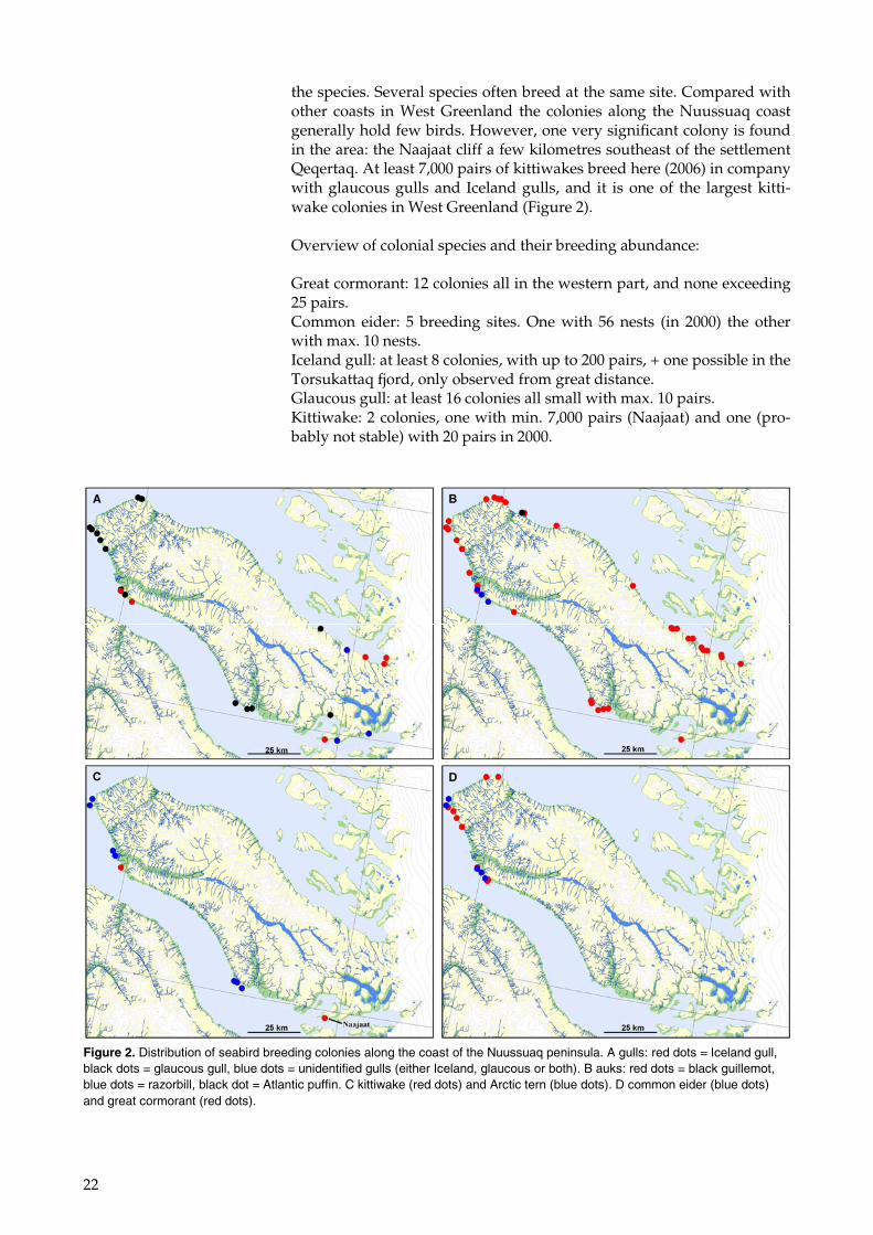
the species. Several species often breed at the same site. Compared with other coasts in West Greenland the colonies along the Nuussuaq coast generally hold few birds. However, one very significant colony is found in the area: the Naajaat cliff a few kilometres southeast of the settlement Qeqertaq. At least 7,000 pairs of kittiwakes breed here (2006) in company with glaucous gulls and Iceland gulls, and it is one of the largest kitti-wake colonies in West Greenland (Figure 2).
Overview of colonial species and their breeding abundance:
Great cormorant: 12 colonies all in the western part, and none exceeding 25 pairs. Common eider: 5 breeding sites. One with 56 nests (in 2000) the other with max. 10 nests. Iceland gull: at least 8 colonies, with up to 200 pairs, + one possible in the Torsukattaq fjord, only observed from great distance. Glaucous gull: at least 16 colonies all small with max. 10 pairs. Kittiwake: 2 colonies, one with min. 7,000 pairs (Naajaat) and one (pro-bably not stable) with 20 pairs in 2000.
Figure 2. Distribution of seabird breeding colonies along the coast of the Nuussuaq peninsula. A gulls: red dots = Iceland gull, black dots = glaucous gull, blue dots = unidentified gulls (either Iceland, glaucous or both). B auks: red dots = black guillemot, blue dots = razorbill, black dot = Atlantic puffin. C kittiwake (red dots) and Arctic tern (blue dots). D common eider (blue dots) and great cormorant (red dots).
23
Arctic tern: 7 colonies, most on small islands, and with max. 200 pairs. Razorbill: two colonies with max. 10 pairs in each, and an additional col-ony which has not been visited since 1920. Black guillemot: at least 38 colonies, which each may hold up to 500 in-dividuals. Atlantic puffin (Fratercula arctica): only known from one site, where the species has not been recorded in many years.
Besides the colonial species, also solitary pairs of other seabird species breed along the coast. These are mainly great black-backed gulls (Larus marinus), Arctic skuas (Stercorarius parasiticus) and some of the ducks also breeding at lakes and ponds inland (red-breasted merganser and long-tailed duck).
Non-breeding individuals of some duck species assemble in flocks along the coasts to perform feather moult. These include common eider, king eider (Somateria spectabilis), long-tailed duck, red-breasted merganser and perhaps also harlequin ducks. In other parts of West Greenland signifi-cant non-breeding concentrations of these species occur. The coasts of Nuussuaq were surveyed in the years 1993, 1994 and 1995, mainly in search for moulting king eiders, and no significant concentrations (of any of the species) were located. Only in the archipelagos at the western tip of the peninsula were some flocks of common eider recorded.
Redlisted seabirds breeding on the Nuussuaq coasts include: common eider (vulnerable (VU) due to a decreasing population), kittiwake (vul-nerable (VU), due to a decreasing population) and Arctic tern (near threatned (NT) due to a decreasing population).
4.1.3 Non-breeding season
There are very few landbirds present on the Nuussuaq peninsula in win-ter (December-February). Ptarmigans, gyr falcons, ravens and Arctic redpolls (Carduelis hornemanni) are the only species occurring, and they are present in low numbers and very dispersed.
Coastal birds may be present in the late winter in some concentrations at the western part of the peninsula when open waters occur, and these in-clude mainly common and king eiders and gulls.
4.2 Mammals
The land mammal fauna of Nuussuaq peninsula is poor. Only Arctic fox (Alopex lagopus), Arctic hare (Lepus arcticus) and caribou (Rangifer taran-dus) occur. The fox and the hare are common and widespread. The cari-bou population is small and isolated from the other populations in West Greenland. Feral reindeer was introduced in 1967 to strengthen the po-pulation. But the two kinds of caribou/reindeer are apparently separate and have different habits, with the feral population occupying mainly the eastern third of the peninsula and the native population mainly the middle third (Cuyler 2004). A survey in April 2002 resulted in approx. 1,200 observed animals, of which 1/3 were of the original population. Very few were observed in the western third of the peninsula in April
24
2002. Due to the small size of the original population it is included on the Greenland redlist as vulnerable (VU).
Marine mammals occurring in the waters near Nuussuaq peninsula in-clude four species of seals, walrus (Odobenus rosmarus) as well as several species of whales. Polar bear (Ursus maritimus) is a rather rare winter visitor. In summer, the fin (Balaenoptera physalus), minke (Balaenoptera acutorostrata) and humpback (Megaptera novaeangliae) whales and the harp (Phoca groenlandica) and hooded (Cystophora cristata) seals are fre-quent and, in winter, walrus, narwhal (Monodon monoceros), white whale (Delphinaptera leucas) and bowhead whales (Balaena mysticetus) occur in the waters close to the Nuussuaq peninsula. However they are mainly found in offshore waters, and probably will not be impacted from land-based activities on the peninsula.
4.3 Fish
Only two fish species occur in the freshwaters of the area: Arctic char (Salvelinus alpinus) and three-spined stickleback (Gasterosteus aculeatus).
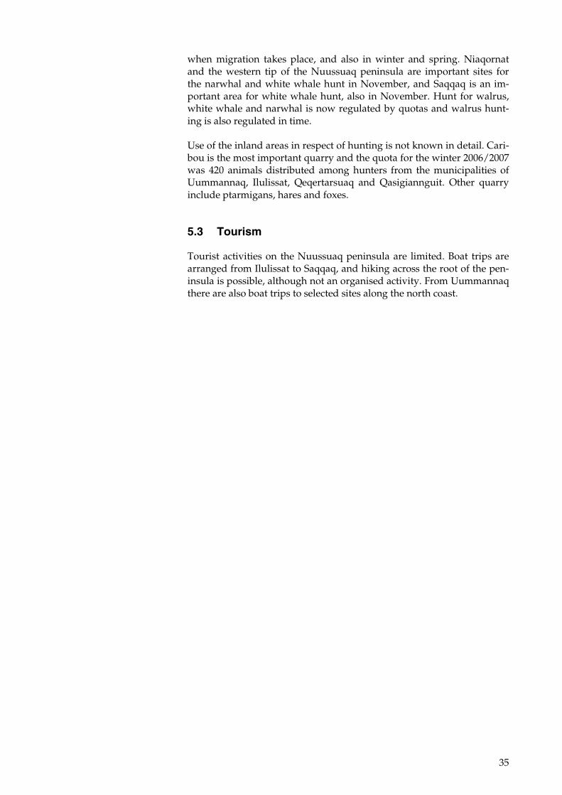
According to an interview study of local fishermen, Arctic char are found in five or six rivers of the peninsula, including the large river in central Nuussuaq (Olsvig & Mosbech 2003). The large lakes Boyes Sø and Amitsup Tasia are presumed to hold stationary stocks of Arctic char, but no information is available (Figure 12).
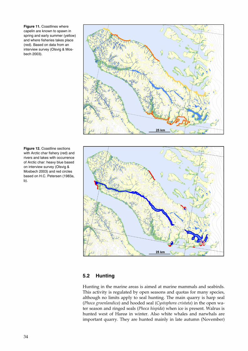
Two marine fish species use the subtidal zone for spawning in the springtime. This is the capelin (Mallotus villosus) and the lumpsucker (Cyclopterus lumpus). The spawning and fishing sites for these species were also mapped during the interview study (Olsvig & Mosbech 2003). No fishery for lumpsucker takes place in the coastal waters of Nuussuaq; therefore, knowledge on the spatial distribution of spawning sites is lim-ited. Capelin is fished by local people and spawning takes place along several coastlines of the peninsula – mainly in the southeast and along the northern coast (Figure 11).
4.4 Vegetation
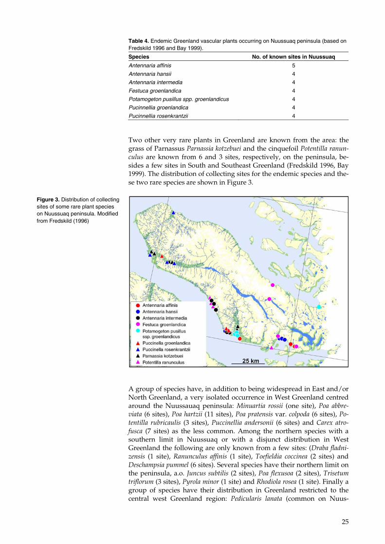
There is a rich flora on the Nuussuaq peninsula with more than 150 spe-cies of vascular plants. Many species have their northern or southern dis-tribution limit on the peninsula and the variable geology – basalts, sedi-ments or gneiss – creates a wide variation in edaphic conditions. About 35 localities have been studied thoroughly for vascular plants and as many as 141 species have been recorded in a single locality (Fredskild 1996). The following account is based on Fredskild (1996). An endemic species, the grass Puccinellia rosencrantzii, has its only known occurrence on the north coast of the peninsula and in the western part of the large central valley. Six other Greenlandic endemics are known from Nuus-suaq (Table 4).
25
Two other very rare plants in Greenland are known from the area: the grass of Parnassus Parnassia kotzebuei and the cinquefoil Potentilla ranun-culus are known from 6 and 3 sites, respectively, on the peninsula, be-sides a few sites in South and Southeast Greenland (Fredskild 1996, Bay 1999). The distribution of collecting sites for the endemic species and the-se two rare species are shown in Figure 3.
A group of species have, in addition to being widespread in East and/or North Greenland, a very isolated occurrence in West Greenland centred around the Nuussauaq peninsula: Minuartia rossii (one site), Poa abbre-viata (6 sites), Poa hartzii (11 sites), Poa pratensis var. colpoda (6 sites), Po-tentilla rubricaulis (3 sites), Puccinellia andersonii (6 sites) and Carex atro-fusca (7 sites) as the less common. Among the northern species with a southern limit in Nuussuaq or with a disjunct distribution in West Greenland the following are only known from a few sites: (Draba fladni-zensis (1 site), Ranunculus affinis (1 site), Toefieldia coccinea (2 sites) and Deschampsia pummel (6 sites). Several species have their northern limit on the peninsula, a.o. Juncus subtilis (2 sites), Poa flexusoa (2 sites), Trisetum triflorum (3 sites), Pyrola minor (1 site) and Rhodiola rosea (1 site). Finally a group of species have their distribution in Greenland restricted to the central west Greenland region: Pedicularis lanata (common on Nuus-
Table 4. Endemic Greenland vascular plants occurring on Nuussuaq peninsula (based on Fredskild 1996 and Bay 1999).
Species No. of known sites in Nuussuaq
Antennaria affinis 5
Antennaria hansii 4
Antennaria intermedia 4
Festuca groenlandica 4
Potamogeton pusillus spp. groenlandicus 4
Pucinnellia groenlandica 4
Pucinnellia rosenkrantzii 4
Figure 3. Distribution of collecting sites of some rare plant species on Nuussuaq peninsula. Modified from Fredskild (1996)
26
sauaq), Braya liniaris (2 sites), Draba cana (4 sites), Luzula groenlandica (2 sites) and Primula stricta (2 sites).
The vegetation in the moist lowland areas (mainly in the valley floors and the coastal slopes) is dominated by fens and grasslands. These are very wet just after snowmelt in May and June and during the summer at least the grasslands may more or less dry up. The moisture is to a large degree supplied from snow patches and the active layer above the per-mafrost melting. Salt marshes are extremely limited in extent and, as far as is known, occur only in the delta off the Affarsuaq valley. In the drier areas the vegetation is dominated by dwarf scrub heaths dominated by Salix arctic, Dryas or the heather Cassiope tetragona, depending on snow cover in winter. However, there are also extensive dry gravel plains al-most without vegetation. Tall (> 0.5 m) Salix scrub occurs only very pat-chily in the southern part of the peninsula, e.g. the Saqqaq valley (Joen-sen & Preuss 1972), but may occur more abundantly further east.
A vegetation map has been produced from satellite images from 7 July 2001 and 12 July 2001 as well as from some field observations from 1996 and 2003 (NERI unpublished). The images were obtained within a 5-day period and have therefore been treated as one, after georegistration and atmospheric correction. Atmospheric and topographic correction was made using the ATCOR3 software (Richter 1997).
A normalised difference vegetation index (NDVI) is an index developed as an indicator of the level of greenness of the vegetation and is widely used for monitoring vegetation characteristics and differences. The NDVI is calculated as the difference in reflection between the near-infrared and the red spectral bands using the following equation (Rouse et al. 1973):
REDNIR
REDNIR
σσσσ
+−
where σNIR is the reflection at the near-infrared wavelength (Landsat band 4) and σRED is the reflection at the red wavelength (Landsat band 3).
The images were analysed for greenness (NDVI) and surface moisture using a moisture index, II (the II, infrared index, is similar to the NDVI but uses band 5 and 4 from the Landsat ETM+ sensor to enhance areas with higher surface moisture (Jensen 2000)). Based on the analysis with information from the field observations it was possible to distinguish be-tween six vegetation classes. The six classes were grouped after surface moisture from dry over moist to wet and after greenness from low greenness over medium to high greenness. The six classes are: ‘Wet – High Greenness’, ‘Wet – Low Greenness’, ‘Moist – Medium Greenness’, ‘Dry – Medium Greenness’, ‘Dry – Low Greenness’ and ‘Sparsely Vege-tated’. Areas with a NDVI below 0.1 were assumed to be non-vegetated.
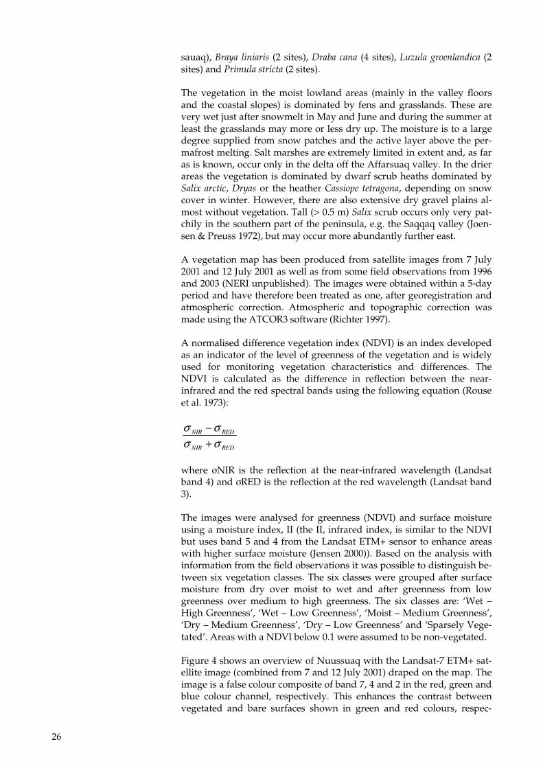
Figure 4 shows an overview of Nuussuaq with the Landsat-7 ETM+ sat-ellite image (combined from 7 and 12 July 2001) draped on the map. The image is a false colour composite of band 7, 4 and 2 in the red, green and blue colour channel, respectively. This enhances the contrast between vegetated and bare surfaces shown in green and red colours, respec-
27
tively. Nuussuaq is dominated by the high mountain ranges north and south of the east-west oriented Aaffarsuaq Valley. The main part of the vegetation is located in the lowlands below 600 m. a.s.l., with the large forelands near the delta, the north slopes in the Aaffarsuaq Valley and the lower slopes of the Saqqaq Valley being the most densely vegetated. In the Aaffarsuaq Valley below 600 m the vegetation covers approxi-mately 55% of the area. The eastern part of Nuussuaq (east of Saqqaq valley) is less vegetated than the western part (abundant red colours).
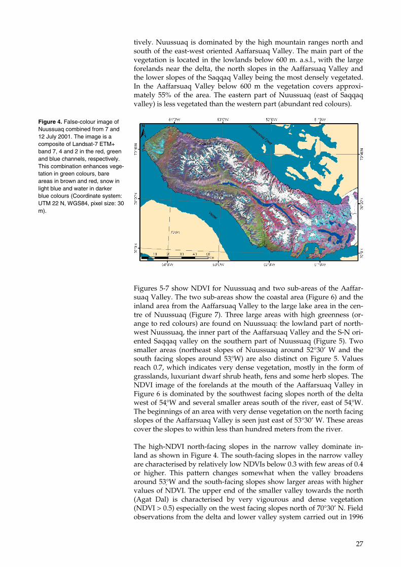
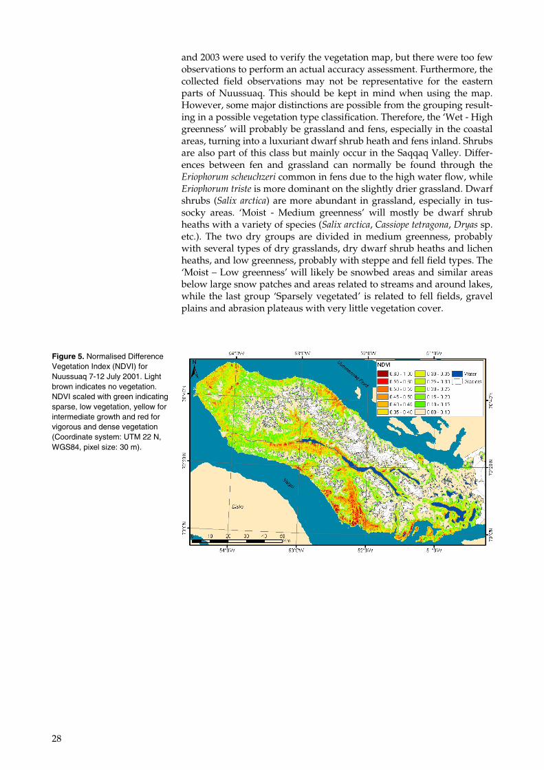
Figures 5-7 show NDVI for Nuussuaq and two sub-areas of the Aaffar-suaq Valley. The two sub-areas show the coastal area (Figure 6) and the inland area from the Aaffarsuaq Valley to the large lake area in the cen-tre of Nuussuaq (Figure 7). Three large areas with high greenness (or-ange to red colours) are found on Nuussuaq: the lowland part of north-west Nuussuaq, the inner part of the Aaffarsuaq Valley and the S-N ori-ented Saqqaq valley on the southern part of Nuussuaq (Figure 5). Two smaller areas (northeast slopes of Nuussuaq around 52°30’ W and the south facing slopes around 53°W) are also distinct on Figure 5. Values reach 0.7, which indicates very dense vegetation, mostly in the form of grasslands, luxuriant dwarf shrub heath, fens and some herb slopes. The NDVI image of the forelands at the mouth of the Aaffarsuaq Valley in Figure 6 is dominated by the southwest facing slopes north of the delta west of 54°W and several smaller areas south of the river, east of 54°W. The beginnings of an area with very dense vegetation on the north facing slopes of the Aaffarsuaq Valley is seen just east of 53°30’ W. These areas cover the slopes to within less than hundred meters from the river.
The high-NDVI north-facing slopes in the narrow valley dominate in-land as shown in Figure 4. The south-facing slopes in the narrow valley are characterised by relatively low NDVIs below 0.3 with few areas of 0.4 or higher. This pattern changes somewhat when the valley broadens around 53°W and the south-facing slopes show larger areas with higher values of NDVI. The upper end of the smaller valley towards the north (Agat Dal) is characterised by very vigourous and dense vegetation (NDVI > 0.5) especially on the west facing slopes north of 70°30’ N. Field observations from the delta and lower valley system carried out in 1996
Figure 4. False-colour image of Nuussuaq combined from 7 and 12 July 2001. The image is a composite of Landsat-7 ETM+ band 7, 4 and 2 in the red, green and blue channels, respectively. This combination enhances vege-tation in green colours, bare areas in brown and red, snow in light blue and water in darker blue colours (Coordinate system: UTM 22 N, WGS84, pixel size: 30 m).
28
and 2003 were used to verify the vegetation map, but there were too few observations to perform an actual accuracy assessment. Furthermore, the collected field observations may not be representative for the eastern parts of Nuussuaq. This should be kept in mind when using the map. However, some major distinctions are possible from the grouping result-ing in a possible vegetation type classification. Therefore, the ‘Wet - High greenness’ will probably be grassland and fens, especially in the coastal areas, turning into a luxuriant dwarf shrub heath and fens inland. Shrubs are also part of this class but mainly occur in the Saqqaq Valley. Differ-ences between fen and grassland can normally be found through the Eriophorum scheuchzeri common in fens due to the high water flow, while Eriophorum triste is more dominant on the slightly drier grassland. Dwarf shrubs (Salix arctica) are more abundant in grassland, especially in tus-socky areas. ‘Moist - Medium greenness’ will mostly be dwarf shrub heaths with a variety of species (Salix arctica, Cassiope tetragona, Dryas sp. etc.). The two dry groups are divided in medium greenness, probably with several types of dry grasslands, dry dwarf shrub heaths and lichen heaths, and low greenness, probably with steppe and fell field types. The ‘Moist – Low greenness’ will likely be snowbed areas and similar areas below large snow patches and areas related to streams and around lakes, while the last group ‘Sparsely vegetated’ is related to fell fields, gravel plains and abrasion plateaus with very little vegetation cover.
Figure 5. Normalised Difference Vegetation Index (NDVI) for Nuussuaq 7-12 July 2001. Light brown indicates no vegetation. NDVI scaled with green indicating sparse, low vegetation, yellow for intermediate growth and red for vigorous and dense vegetation (Coordinate system: UTM 22 N, WGS84, pixel size: 30 m).
29
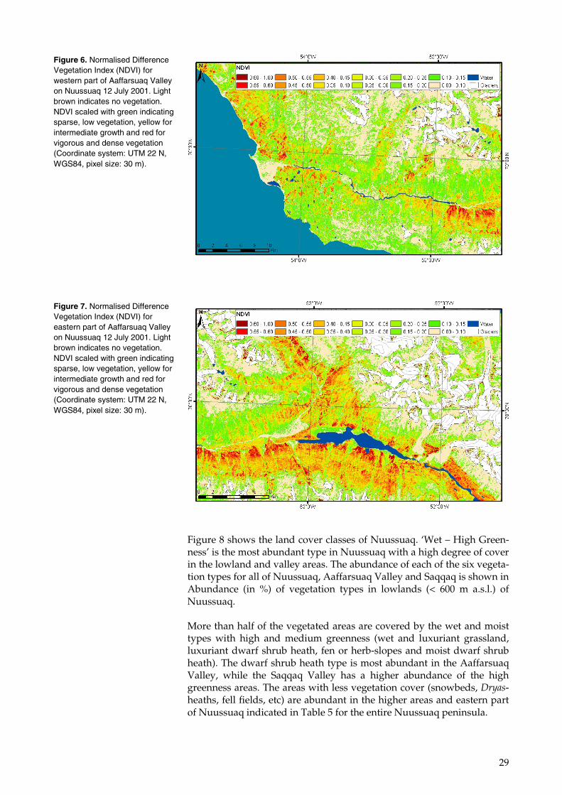
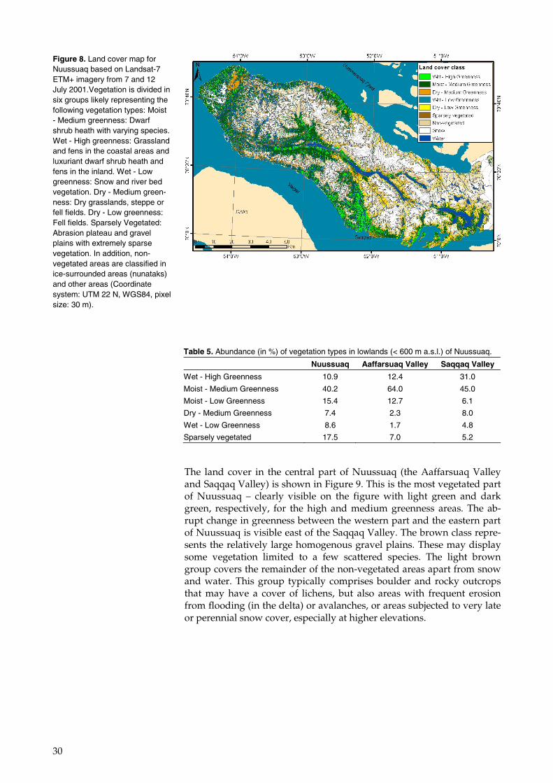
Figure 8 shows the land cover classes of Nuussuaq. ‘Wet – High Green-ness’ is the most abundant type in Nuussuaq with a high degree of cover in the lowland and valley areas. The abundance of each of the six vegeta-tion types for all of Nuussuaq, Aaffarsuaq Valley and Saqqaq is shown in Abundance (in %) of vegetation types in lowlands (< 600 m a.s.l.) of Nuussuaq.
More than half of the vegetated areas are covered by the wet and moist types with high and medium greenness (wet and luxuriant grassland, luxuriant dwarf shrub heath, fen or herb-slopes and moist dwarf shrub heath). The dwarf shrub heath type is most abundant in the Aaffarsuaq Valley, while the Saqqaq Valley has a higher abundance of the high greenness areas. The areas with less vegetation cover (snowbeds, Dryas-heaths, fell fields, etc) are abundant in the higher areas and eastern part of Nuussuaq indicated in Table 5 for the entire Nuussuaq peninsula.
Figure 6. Normalised Difference Vegetation Index (NDVI) for western part of Aaffarsuaq Valley on Nuussuaq 12 July 2001. Light brown indicates no vegetation. NDVI scaled with green indicating sparse, low vegetation, yellow for intermediate growth and red for vigorous and dense vegetation (Coordinate system: UTM 22 N, WGS84, pixel size: 30 m).
Figure 7. Normalised Difference Vegetation Index (NDVI) for eastern part of Aaffarsuaq Valley on Nuussuaq 12 July 2001. Light brown indicates no vegetation. NDVI scaled with green indicating sparse, low vegetation, yellow for intermediate growth and red for vigorous and dense vegetation (Coordinate system: UTM 22 N, WGS84, pixel size: 30 m).
30
The land cover in the central part of Nuussuaq (the Aaffarsuaq Valley and Saqqaq Valley) is shown in Figure 9. This is the most vegetated part of Nuussuaq – clearly visible on the figure with light green and dark green, respectively, for the high and medium greenness areas. The ab-rupt change in greenness between the western part and the eastern part of Nuussuaq is visible east of the Saqqaq Valley. The brown class repre-sents the relatively large homogenous gravel plains. These may display some vegetation limited to a few scattered species. The light brown group covers the remainder of the non-vegetated areas apart from snow and water. This group typically comprises boulder and rocky outcrops that may have a cover of lichens, but also areas with frequent erosion from flooding (in the delta) or avalanches, or areas subjected to very late or perennial snow cover, especially at higher elevations.
Figure 8. Land cover map for Nuussuaq based on Landsat-7 ETM+ imagery from 7 and 12 July 2001.Vegetation is divided in six groups likely representing the following vegetation types: Moist - Medium greenness: Dwarf shrub heath with varying species. Wet - High greenness: Grassland and fens in the coastal areas and luxuriant dwarf shrub heath and fens in the inland. Wet - Low greenness: Snow and river bed vegetation. Dry - Medium green-ness: Dry grasslands, steppe or fell fields. Dry - Low greenness: Fell fields. Sparsely Vegetated: Abrasion plateau and gravel plains with extremely sparse vegetation. In addition, non-vegetated areas are classified in ice-surrounded areas (nunataks) and other areas (Coordinate system: UTM 22 N, WGS84, pixel size: 30 m).
Table 5. Abundance (in %) of vegetation types in lowlands (< 600 m a.s.l.) of Nuussuaq.
Nuussuaq Aaffarsuaq Valley Saqqaq Valley
Wet - High Greenness 10.9 12.4 31.0
Moist - Medium Greenness 40.2 64.0 45.0
Moist - Low Greenness 15.4 12.7 6.1
Dry - Medium Greenness 7.4 2.3 8.0
Wet - Low Greenness 8.6 1.7 4.8
Sparsely vegetated 17.5 7.0 5.2
31
4.5 Protected areas and conservation
No areas of the Nuussuaq peninsula are protected according to the Na-ture Conservation Act or are designated as bird protection areas (gov-ernment regulation no. 1 of 21 January 2004 regarding protection of birds). No areas are designated according to international agreements such as the Ramsar Convention or UNESCO. But according to the Green-land bird conservation regulation, activities are regulated near seabird breeding colonies.
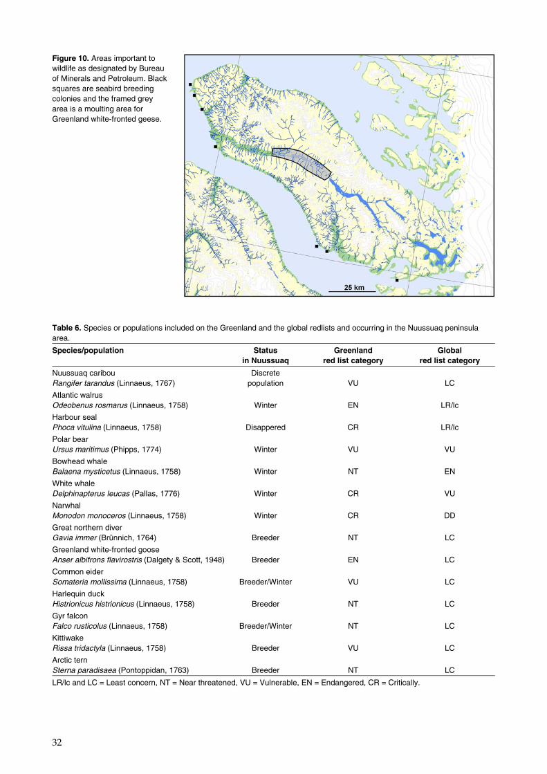
Furthermore the Bureau of Minerals and Petroleum has designated ‘ar-eas important to wildlife’. One of these is situated in the Nuussuaq inte-rior, in the central valley, in order to protect moulting concentrations of Greenland white-fronted geese. Exploration activities are regulated here. Furthermore, some of the seabird breeding colonies along the south coast are also included as ‘areas important to wildlife’ (Figure 10).
The international bird protection society, BirdLife International, has des-ignated Important Bird Areas (IBA) in Greenland, but none are located on the Nuussuaq peninsula.
Table 6 lists species occurring on the Nuussuaq peninsula and included in the Greenland and the global redlists (IUCN 2007, Boertmann 2007).
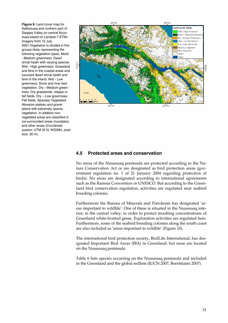
Figure 9. Land cover map for Aaffarsuaq and northern part of Saqqaq Valley on central Nuus-suaq based on Landsat-7 ETM+ imagery from 12 July 2001.Vegetation is divided in five groups likely representing the following vegetation types: Moist - Medium greenness: Dwarf shrub heath with varying species. Wet - High greenness: Grassland and fens in the coastal areas and luxuriant dwarf shrub heath and fens in the inland. Wet - Low greenness: Snow and river bed vegetation. Dry - Medium green-ness: Dry grasslands, steppe or fell fields. Dry – Low greenness: Fell fields. Sparsely Vegetated: Abrasion plateau and gravel plains with extremely sparse vegetation. In addition non-vegetated areas are classified in ice-surrounded areas (nunataks) and other areas (Coordinate system: UTM 22 N, WGS84, pixel size: 30 m).
32
Figure 10. Areas important to wildlife as designated by Bureau of Minerals and Petroleum. Black squares are seabird breeding colonies and the framed grey area is a moulting area for Greenland white-fronted geese.
Table 6. Species or populations included on the Greenland and the global redlists and occurring in the Nuussuaq peninsula area.
Species/population Status in Nuussuaq
Greenland red list category
Global red list category
Nuussuaq caribou Rangifer tarandus (Linnaeus, 1767)
Discrete population
VU
LC
Atlantic walrus Odeobenus rosmarus (Linnaeus, 1758)
Winter
EN
LR/lc
Harbour seal Phoca vitulina (Linnaeus, 1758)
Disappered
CR
LR/lc
Polar bear Ursus maritimus (Phipps, 1774)
Winter
VU
VU
Bowhead whale Balaena mysticetus (Linnaeus, 1758)
Winter
NT
EN
White whale Delphinapterus leucas (Pallas, 1776)
Winter
CR
VU
Narwhal Monodon monoceros (Linnaeus, 1758)
Winter
CR
DD
Great northern diver Gavia immer (Brünnich, 1764)
Breeder
NT
LC
Greenland white-fronted goose Anser albifrons flavirostris (Dalgety & Scott, 1948)
Breeder
EN
LC
Common eider Somateria mollissima (Linnaeus, 1758)
Breeder/Winter
VU
LC
Harlequin duck Histrionicus histrionicus (Linnaeus, 1758)
Breeder
NT
LC
Gyr falcon Falco rusticolus (Linnaeus, 1758)
Breeder/Winter
NT
LC
Kittiwake Rissa tridactyla (Linnaeus, 1758)
Breeder
VU
LC
Arctic tern Sterna paradisaea (Pontoppidan, 1763)
Breeder
NT
LC
LR/lc and LC = Least concern, NT = Near threatened, VU = Vulnerable, EN = Endangered, CR = Critically.
33
5 Local use
Local use of the coastal regions of Nuussuaq peninsula is described in the oil spill sensitivity atlas issued by NERI (Mosbech et al. 2004). The fisheries for specific species (Arctic char, lumpsucker and capelin) were investigated as a contribution to this atlas (Olsvig & Mosbech 2003). Pri-or to these studies, H.C. Petersen (1993a, b) described human use of local resources in two reports covering the Ilulissat and Uummannaq munici-palities.
5.1 Fisheries
Fisheries in deeper marine waters include mainly northern shrimp (Pan-dalus borealis) and Greenland halibut (Reinhardtius hippoglossoides). The shrimp fisheries take place in the outer parts of the Vaigat and around Hareø. The Greenland halibut fisheries take place in the deep waters of the Torsukattak strait and off the north coast of the Nuussuaq peninsula. It is not likely that these fisheries will be affected by activities in the Nu-ussuaq area, although oil spilled from a blow-out and transported to the coast by a river or other water course could be an exception (cf. the stra-tegic EIA of the Disko West area, Mosbech et al. 2007a).
Many other species of fish are caught in offshore waters and used locally or sold to local processing plants. They include: spotted wolffish (Ana-chias minor), redfish (Sebastes spp.), Atlantic halibut (Hippoglossus hippo-glossus), Greenland shark (Somniosus microcephalus) and rough-headed grenadier (Macrourus berglax).
In the coastal waters of the Nuussuaq peninsula two species are impor-tant for the fisheries. Capelin (Malotus villosus) is fished mainly for pri-vate consumption in spring when they spawn in dense schools in the subtidal waters. Arctic char (Salvelinus alpinus) is fished both for private consumption and for sale at local markets (Figure 12). They are caught mainly with gill nets near the outlets of the rivers where they spawn. It is not possible to provide figures for the amounts of any of the species caught in the region. But the distribution of the fishing areas for capelin as recorded during the interviews in 2002 is presented in Figure 11.
34
5.2 Hunting
Hunting in the marine areas is aimed at marine mammals and seabirds. This activity is regulated by open seasons and quotas for many species, although no limits apply to seal hunting. The main quarry is harp seal (Phoca groenlandica) and hooded seal (Cystophora cristata) in the open wa-ter season and ringed seals (Phoca hispida) when ice is present. Walrus is hunted west of Hareø in winter. Also white whales and narwhals are important quarry. They are hunted mainly in late autumn (November)
Figure 11. Coastlines where capelin are known to spawn in spring and early summer (yellow) and where fisheries takes place (red). Based on data from an interview survey (Olsvig & Mos-bech 2003).
Figure 12. Coastline sections with Arctic char fishery (red) and rivers and lakes with occurrence of Arctic char: heavy blue based on interview survey (Olsvig & Mosbech 2003) and red circles based on H.C. Petersen (1983a, b).
35
when migration takes place, and also in winter and spring. Niaqornat and the western tip of the Nuussuaq peninsula are important sites for the narwhal and white whale hunt in November, and Saqqaq is an im-portant area for white whale hunt, also in November. Hunt for walrus, white whale and narwhal is now regulated by quotas and walrus hunt-ing is also regulated in time.
Use of the inland areas in respect of hunting is not known in detail. Cari-bou is the most important quarry and the quota for the winter 2006/2007 was 420 animals distributed among hunters from the municipalities of Uummannaq, Ilulissat, Qeqertarsuaq and Qasigiannguit. Other quarry include ptarmigans, hares and foxes.
5.3 Tourism
Tourist activities on the Nuussuaq peninsula are limited. Boat trips are arranged from Ilulissat to Saqqaq, and hiking across the root of the pen-insula is possible, although not an organised activity. From Uummannaq there are also boat trips to selected sites along the north coast.
36
6 Sensitive areas and species
A convenient way to apply sensitive elements in an analysis of conflicts with human activities is to designate Valued Ecological Components (VECs) as some kind of indicator of the sensitive environment of the area. These can be any part of the environment that is considered impor-tant by the proponent(s) of the activities in question, members of the public, scientists and government involved in the assessment process. Importance may be determined on the basis of cultural values or scien-tific concerns (definition from Natural Resources Canada). VECs can for example be species, habitats, local ecosystems etc., and they can be im-portant in national and international nature conservation context, impor-tant to the local people in economic and cultural context, etc.
6.1 Species and their habitats
Mammals VECs include only caribou. The population is small and the native population is redlisted as vulnerable (VU). There is no knowledge on particularly sensitive habitats for this population, and information on habitat use, calving areas and winter foraging areas should be obtained.
Bird VECs include primarily the Greenland white-fronted goose. The population is small, it is decreasing and it is redlisted as endangered (EN). Particularly sensitive areas for this species in Greenland are spring staging habitats (late April to early May) and moulting areas (late June to early August), where large segments of the total population may occur in very restricted areas. Studies based on remote sensing of snow cover concluded that there are no important spring staging areas in the Nuus-suaq peninsula (Glahder 1999, Glahder et al. 2002), but this conclusion may be re-assessed with climate change in mind. Moulting white-fronted geese were surveyed in 1992, 1995 and 2003 and the middle part of the central Valley Affarsuaq was identified as a very important moulting habitat for the species, with about 3% of the total population present in 1995 (Glahder 1999, Glahder et al. 2002). It was then among the five most important moulting habitats for the species in Greenland (Boertmann & Glahder 1999). The eastern part of the peninsula was only surveyed for moulting geese in 1992 and only superficially. This area should be sur-veyed more thoroughly. New data from the post-moulting period was collected in August 2007, but was not available for this assessment.
Other bird VECs includes gyr falcon, great northern diver, common ei-der, harlequin duck, kittiwake and Arctic tern. These species are all in-cluded in the Greenland redlist due to very small and/or decreasing populations.
The important habitats described above for Greenland white-fronted goose are VECs.
The seabird breeding colonies are also VECs. The majority of the colonies on the coasts of Nuussuaq are small and dominated by gulls. The most important colony is the large colony of kittiwakes at Naajaat southeast of
37
Qeqertaq (Figure 2). This is the largest kittiwake colony in the Disko Bay area and it is among the largest in Greenland. The seabird breeding colonies are occupied only in the breeding season usually from late may to early September.
Arctic char is a VEC because it is important to the subsistence and leisure fishery of local people. The rivers with spawning and wintering Arctic char are habitat VECs and are sensitive to activities redirecting or ob-structing the water flow. These may obstruct the char as they move up-stream to important spawning or wintering areas and may, under very unlucky circumstances, wipe out the entire population of a watercourse. Migratory char move from the freshwaters to the sea in early summer and back again to spawn and winter in late summer.
6.2 Flora
Several rare plants have been found on the Nuussuaq peninsula (cf. sec-tion 4.4 Vegetation). Their precise location cannot be established from the literature, as most have been reported as dots on a rather coarse map (cf. Figure 3). The precise locations, however, may be retrieved from the specimens in the herbarium of Botanical Museum in Copenhagen. At least the plant species mentioned in Table 4 are VECs and many more of the species mentioned in section 4.4 may potentially be VECs.
6.3 Vegetation
Vigorous and sensitive vegetation is found mainly in the wet terrain. Al-though wet terrain is sensitive, the vegetation in marshes and fens is usually able to regenerate rather quickly after being disturbed. Vegeta-tion damage in dry terrain (dwarf scrub heaths such as Cassiope-heath) recovers usually much slower than in wet terrain and in some cases tracks may be visible in dry areas for decades or more.
The distribution of wet and dry vegetation types is known from the ana-lysis of the satellite images (Figure 8 and 9), but knowledge of vegetation type is insufficient and should be improved by fieldwork.
6.4 Terrain
In general, Arctic wet terrain is very sensitive to human activities when the soil is not frozen. Impacts mainly stem from driving with heavy ve-hicles, which creates ruts and tracks in the soft terrain. The damage is mainly visual, but in some cases, particularly if the permafrost layer is disturbed, is widespread and progressive erosion and degradation of the permafrost layer may occur (thermokarst). A special feature of the per-mafrost in the Nuussuaq peninsula is the occurrence of pingos or mud volcanoes on the floor of the large valleys. Pingos are rare formations and they are particularly sensitive to damage from vehicles because they are without vegetation.
Wet terrain is mainly located on level or gently sloping areas along the coasts and in the valleys (Figure 8). The company Green Mining Ltd. in

38
the Summer of 2007 experienced that the terrain was extremely difficult to evaluate with regard to moisture and capacity to carry heavy vehicles, as many areas had solifluctious soils and permafrost in some areas was close to the surface.
Coastal salt marshes represent a particularly sensitive habitat, which is found, according to information available for this assessment, only in the Affarsuaq River delta.
Dry terrain with loose sediments such as sand is sensitive to being dri-ven on because tracks and ruts may initiate wind erosion.
39
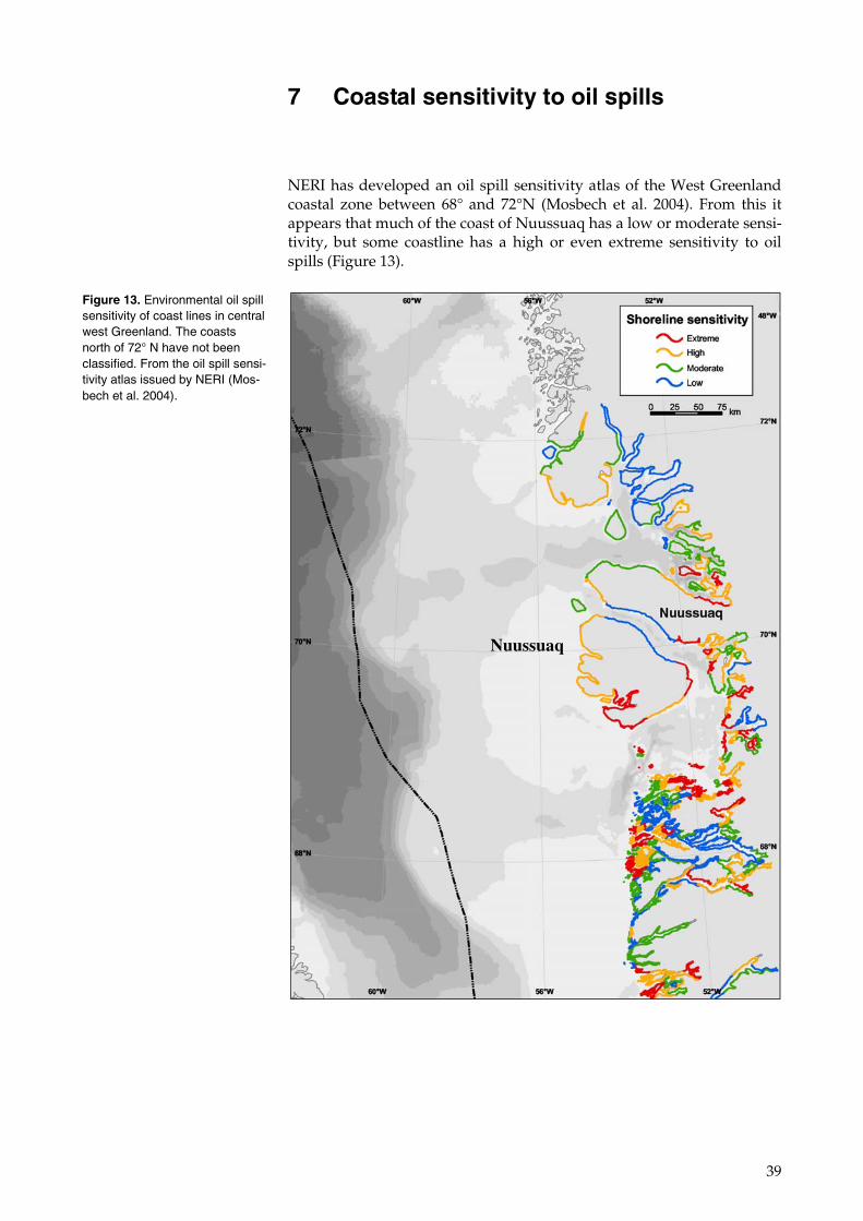
7 Coastal sensitivity to oil spills
NERI has developed an oil spill sensitivity atlas of the West Greenland coastal zone between 68° and 72°N (Mosbech et al. 2004). From this it appears that much of the coast of Nuussuaq has a low or moderate sensi-tivity, but some coastline has a high or even extreme sensitivity to oil spills (Figure 13).
Figure 13. Environmental oil spill sensitivity of coast lines in central west Greenland. The coasts north of 72° N have not been classified. From the oil spill sensi-tivity atlas issued by NERI (Mos-bech et al. 2004).
Nuussuaq
40
8 Status of pollution with mineral and hydrocarbon related substances
Apart from geological studies, the Nuussuaq peninsula has been very sparsely investigated for levels of trace elements and oil components.
8.1 The chemistry of the Nuussuaq peninsula
Sediments have been collected, analysed and reported by Loring and Asmund (1996).
Silty sediments adjacent to tertiary volcanic rocks contain higher concen-trations of Cr, Ni, Cu and V than natural sediments from all other places in Greenland.
In the process of determining the natural levels of trace elements in ma-rine sediments, it is important to delimitate the area where the sediments are composed of crushed tertiary volcanic rocks. Such an area is sup-posed to cover the entire Vaigat sound west of 52°W. There can further-more be expected to be a correlation between these elements and oil components.
8.2 Animals and plants
There will probably be higher concentrations of Cr, Ni, Cu, V and oil components in animals and plants from the Nuussuaq peninsula com-pared to other non-basaltic areas in Greenland. But there are no docu-mented investigations to prove this.
8.3 Samples in the DMU sample bank
Few studies of trace element and hydrocarbon levels in ecological com-ponents of the area (flora, fauna, sediments and water) have been pub-lished, but there are further relevant samples in the NERI Arctic sample bank. Table 7 lists the samples registered in the bank. Biological samples are mostly frozen, and sediment samples are dried.
Of these samples, only the 17 sediment samples close to Marraat have been collected in the area covered by this strategic environmental impact assessment. The other samples have been collected close to the area. They can be used only to estimate the environmental situation in general.
41
8.4 Hydrocarbons
In relation to the strategic environmental impact assessment of the Disko West area, samples for TPH (Total Petroleum Hydrocarbons) and PAH (Polycyclic Aromatic Hydrocarbons) analysis were collected off the coast of the Maarraat area in the western part of the Nuussuaq peninsula (Mosbech et al. 2007b). These were analysed and compared with previ-ous samples from Greenland. The conclusion was that sediments close to Nuussuaq (and Disko) have higher concentrations of PAH expressed in relation to organic matter content than sediments from the deep water along the West Greenland coast. But the study did not trace the oil seeps in the Marrat area. Observed levels of TPH and PAH were comparable to other Greenland and Arctic areas without oil seeps, and were lower than would be expected in an area with active oil seeps. The PAHs indicated that the source of the oil was fuel oil spills.
8.5 New samples
It is important to establish thorough baseline knowledge on metals and hydrocarbons before any future activities are initiated. New samples are therefore required, and a plan for sampling activities (particularly the sampling sites) should be prepared when the SEA is updated.
In particular the following samples are required: From land habitats: • Lichens from the area
Table 7. Background samples from Nuussuaq and adjacent areas (between 69°N and 71°N of the Greenland west coast, ex-cluding samples collected for the Maarmorilik mine project) kept in the DMU sample bank. The samples in the list covers all samples collected since 1980. Some may have been discarded or used up, but most of the samples still exist.
Species No. of samples Year of collection Place
Molluscs
Blue mussel 42 1994-2000 Kornprinsen Ejlande
Clam 24 1999-2000 Close to Kronprinsen Ejlande
Crustaceans
Snow crab 23 1999 Between Godhavn and Kronprinsen Ejlande
Northern shrimp 11 1999 Uummannaq
Euphausiacean 14 1987 Godhavn, Disko
Fish
Spotted wolffish 2 1999 Uummannaq
Greenland halibut 6 1999 Uummannaq
Long rough dab 20 1982 Mudderbugten, Disko
Shorthorn sculpin 75 1999-2000 Kronprinsen Ejlande
Marine mammals
Minke whale 22 1998 West of Disko
Ringed seal 84 2001 Diskofjord and Mellemfjord
Algae
Seaweed 2 1999 Kronprinsen Ejlande
Sediments
Seabed sediment 17 2005 Close to Marraat, Nuussuaq
Seabed sediment 9 1987 and 1999 Disko Bay
Seabed sediment 34 1994 Kronprinsen Ejlande
42
From freshwater habitats: • Sediments (GEUS are likely to have collected and analysed additional
samples) From marine habitats: • Sediment samples covering the entire area and depths • Seaweed and blue mussels from coastal stations • Fish:
• shorthorn sculpin from coastal stations • Greenland halibut, Atlantic cod, Greenland cod and
spotted wolfish from deeper waters • Northern shrimp, crabs, clams
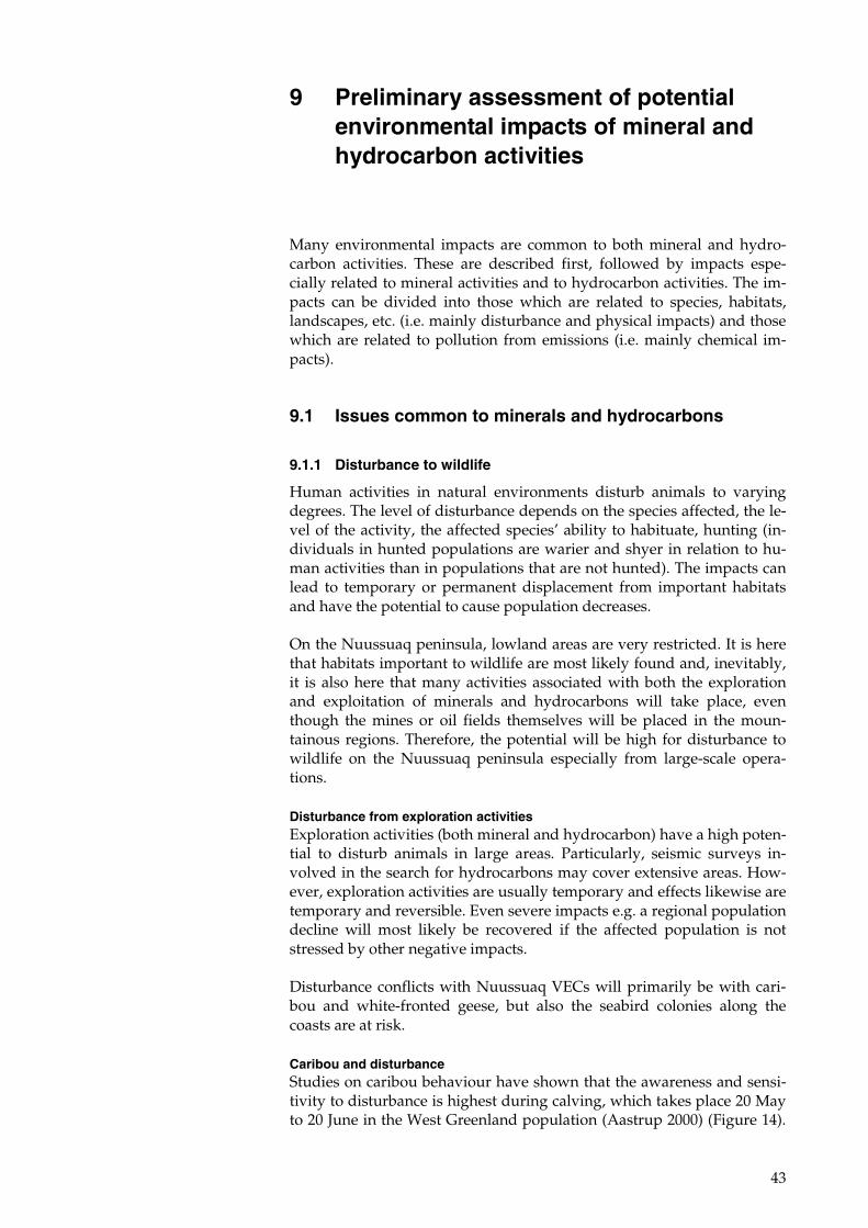
43
9 Preliminary assessment of potential environmental impacts of mineral and hydrocarbon activities
Many environmental impacts are common to both mineral and hydro-carbon activities. These are described first, followed by impacts espe-cially related to mineral activities and to hydrocarbon activities. The im-pacts can be divided into those which are related to species, habitats, landscapes, etc. (i.e. mainly disturbance and physical impacts) and those which are related to pollution from emissions (i.e. mainly chemical im-pacts).
9.1 Issues common to minerals and hydrocarbons
9.1.1 Disturbance to wildlife
Human activities in natural environments disturb animals to varying degrees. The level of disturbance depends on the species affected, the le-vel of the activity, the affected species’ ability to habituate, hunting (in-dividuals in hunted populations are warier and shyer in relation to hu-man activities than in populations that are not hunted). The impacts can lead to temporary or permanent displacement from important habitats and have the potential to cause population decreases.
On the Nuussuaq peninsula, lowland areas are very restricted. It is here that habitats important to wildlife are most likely found and, inevitably, it is also here that many activities associated with both the exploration and exploitation of minerals and hydrocarbons will take place, even though the mines or oil fields themselves will be placed in the moun-tainous regions. Therefore, the potential will be high for disturbance to wildlife on the Nuussuaq peninsula especially from large-scale opera-tions.
Disturbance from exploration activities Exploration activities (both mineral and hydrocarbon) have a high poten-tial to disturb animals in large areas. Particularly, seismic surveys in-volved in the search for hydrocarbons may cover extensive areas. How-ever, exploration activities are usually temporary and effects likewise are temporary and reversible. Even severe impacts e.g. a regional population decline will most likely be recovered if the affected population is not stressed by other negative impacts.
Disturbance conflicts with Nuussuaq VECs will primarily be with cari-bou and white-fronted geese, but also the seabird colonies along the coasts are at risk.
Caribou and disturbance Studies on caribou behaviour have shown that the awareness and sensi-tivity to disturbance is highest during calving, which takes place 20 May to 20 June in the West Greenland population (Aastrup 2000) (Figure 14).
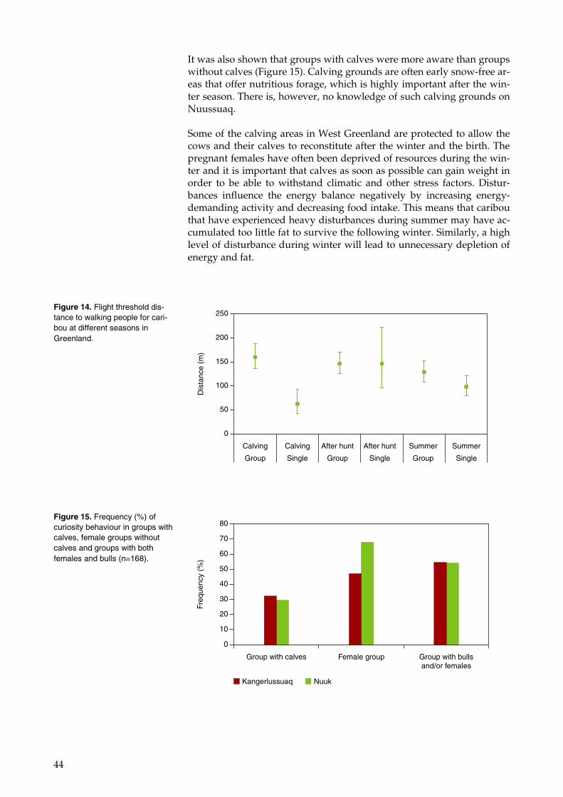
44
It was also shown that groups with calves were more aware than groups without calves (Figure 15). Calving grounds are often early snow-free ar-eas that offer nutritious forage, which is highly important after the win-ter season. There is, however, no knowledge of such calving grounds on Nuussuaq.
Some of the calving areas in West Greenland are protected to allow the cows and their calves to reconstitute after the winter and the birth. The pregnant females have often been deprived of resources during the win-ter and it is important that calves as soon as possible can gain weight in order to be able to withstand climatic and other stress factors. Distur-bances influence the energy balance negatively by increasing energy-demanding activity and decreasing food intake. This means that caribou that have experienced heavy disturbances during summer may have ac-cumulated too little fat to survive the following winter. Similarly, a high level of disturbance during winter will lead to unnecessary depletion of energy and fat.
Figure 14. Flight threshold dis-tance to walking people for cari-bou at different seasons in Greenland.
Calving
Group
Calving
Single
After hunt
Group
After hunt
Single
Summer
Group
Summer
Single
0
50
100
150
200
250
Dis
tanc
e (m
)
Figure 15. Frequency (%) of curiosity behaviour in groups with calves, female groups without calves and groups with both females and bulls (n=168).
Freq
uenc
y (%
)
0
10
20
30
40
50
60
70
80
Group with calves Female group Group with bullsand/or females
Kangerlussuaq Nuuk
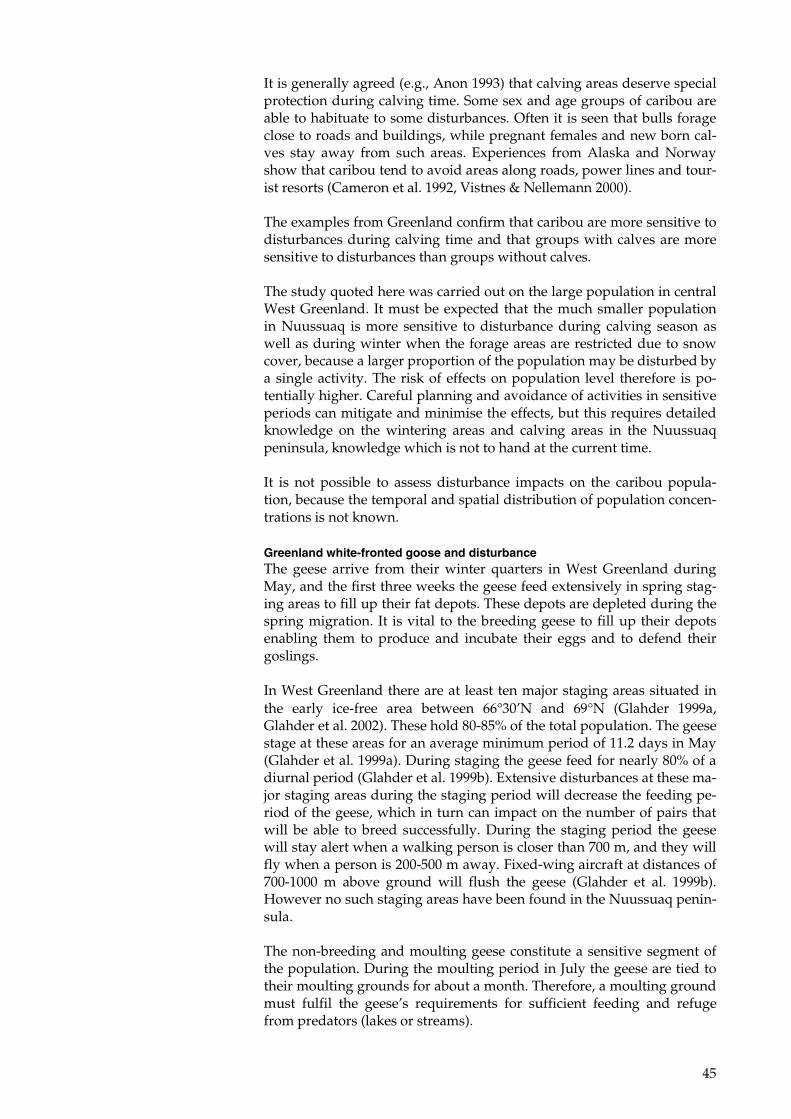
45
It is generally agreed (e.g., Anon 1993) that calving areas deserve special protection during calving time. Some sex and age groups of caribou are able to habituate to some disturbances. Often it is seen that bulls forage close to roads and buildings, while pregnant females and new born cal-ves stay away from such areas. Experiences from Alaska and Norway show that caribou tend to avoid areas along roads, power lines and tour-ist resorts (Cameron et al. 1992, Vistnes & Nellemann 2000).
The examples from Greenland confirm that caribou are more sensitive to disturbances during calving time and that groups with calves are more sensitive to disturbances than groups without calves.
The study quoted here was carried out on the large population in central West Greenland. It must be expected that the much smaller population in Nuussuaq is more sensitive to disturbance during calving season as well as during winter when the forage areas are restricted due to snow cover, because a larger proportion of the population may be disturbed by a single activity. The risk of effects on population level therefore is po-tentially higher. Careful planning and avoidance of activities in sensitive periods can mitigate and minimise the effects, but this requires detailed knowledge on the wintering areas and calving areas in the Nuussuaq peninsula, knowledge which is not to hand at the current time.
It is not possible to assess disturbance impacts on the caribou popula-tion, because the temporal and spatial distribution of population concen-trations is not known.
Greenland white-fronted goose and disturbance The geese arrive from their winter quarters in West Greenland during May, and the first three weeks the geese feed extensively in spring stag-ing areas to fill up their fat depots. These depots are depleted during the spring migration. It is vital to the breeding geese to fill up their depots enabling them to produce and incubate their eggs and to defend their goslings.
In West Greenland there are at least ten major staging areas situated in the early ice-free area between 66°30’N and 69°N (Glahder 1999a, Glahder et al. 2002). These hold 80-85% of the total population. The geese stage at these areas for an average minimum period of 11.2 days in May (Glahder et al. 1999a). During staging the geese feed for nearly 80% of a diurnal period (Glahder et al. 1999b). Extensive disturbances at these ma-jor staging areas during the staging period will decrease the feeding pe-riod of the geese, which in turn can impact on the number of pairs that will be able to breed successfully. During the staging period the geese will stay alert when a walking person is closer than 700 m, and they will fly when a person is 200-500 m away. Fixed-wing aircraft at distances of 700-1000 m above ground will flush the geese (Glahder et al. 1999b). However no such staging areas have been found in the Nuussuaq penin-sula.
The non-breeding and moulting geese constitute a sensitive segment of the population. During the moulting period in July the geese are tied to their moulting grounds for about a month. Therefore, a moulting ground must fulfil the geese’s requirements for sufficient feeding and refuge from predators (lakes or streams).
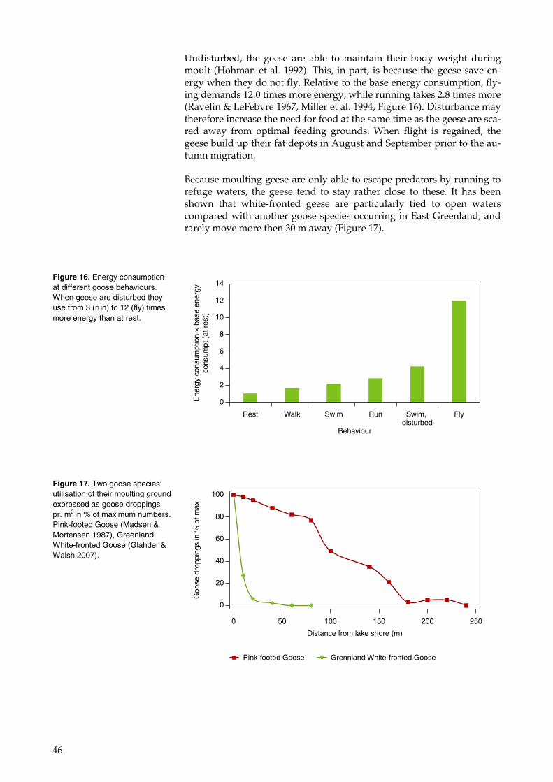
46
Undisturbed, the geese are able to maintain their body weight during moult (Hohman et al. 1992). This, in part, is because the geese save en-ergy when they do not fly. Relative to the base energy consumption, fly-ing demands 12.0 times more energy, while running takes 2.8 times more (Ravelin & LeFebvre 1967, Miller et al. 1994, Figure 16). Disturbance may therefore increase the need for food at the same time as the geese are sca-red away from optimal feeding grounds. When flight is regained, the geese build up their fat depots in August and September prior to the au-tumn migration.
Because moulting geese are only able to escape predators by running to refuge waters, the geese tend to stay rather close to these. It has been shown that white-fronted geese are particularly tied to open waters compared with another goose species occurring in East Greenland, and rarely move more then 30 m away (Figure 17).
Figure 16. Energy consumption at different goose behaviours. When geese are disturbed they use from 3 (run) to 12 (fly) times more energy than at rest.
Ene
rgy
cons
umpt
ion
× b
ase
ener
gyco
nsum
pt (
at r
est)
Behaviour
0
2
4
6
8
10
12
14
Rest Walk Swim Run Swim, disturbed
Fly
Figure 17. Two goose species’ utilisation of their moulting ground expressed as goose droppings pr. m2 in % of maximum numbers. Pink-footed Goose (Madsen & Mortensen 1987), Greenland White-fronted Goose (Glahder & Walsh 2007).
0
20
40
60
80
100
0 50 100 150 200 250
Distance from lake shore (m)
Goo
se d
ropp
ings
in %
of m
ax
Grennland White-fronted GoosePink-footed Goose
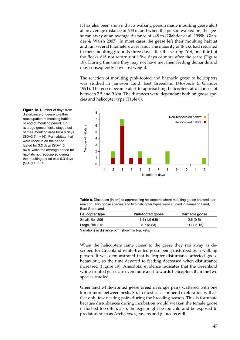
47
It has also been shown that a walking person made moulting geese alert at an average distance of 653 m and when the person walked on, the gee-se ran away at an average distance of 448 m (Glahder et al. 1999b, Glah-der & Walsh 2007). In most cases the geese left their moulting habitat and ran several kilometers over land. The majority of flocks had returned to their moulting grounds three days after the scaring. Yet, one third of the flocks did not return until five days or more after the scare (Figure 18). During this time they may not have met their feeding demands and may consequently have lost weight.
The reaction of moulting pink-footed and barnacle geese to helicopters was studied in Jameson Land, East Greenland (Mosbech & Glahder 1991). The geese became alert to approaching helicopters at distances of between 2.5 and 9 km. The distances were dependant both on goose spe-cies and helicopter type (Table 8).
When the helicopters came closer to the geese they ran away as de-scribed for Greenland white-fronted geese being disturbed by a walking person. It was demonstrated that helicopter disturbance affected goose behaviour, so the time devoted to feeding decreased when disturbance increased (Figure 19). Anecdotal evidence indicates that the Greenland white-fronted geese are even more alert towards helicopters than the two species studied.
Greenland white-fronted geese breed in single pairs scattered with one km or more between nests. So, in most cases mineral exploration will af-fect only few nesting pairs during the breeding season. This is fortunate because disturbances during incubation would weaken the female goose if flushed too often; also, the eggs might be too cold and be exposed to predators such as Arctic foxes, ravens and glaucous gull.
Figure 18. Number of days from disturbance of geese to either reoccupation of moulting habitat or end of moulting period. On average goose flocks stayed out of their moulting area for 4.6 days (SD=2.7, n=16). For habitats that were reoccupied the period lasted for 3.2 days (SD=1.0, n=9), while the average period for habitats not reoccupied during the moulting period was 6.3 days (SD=3.4, n=7). 0
1
2
3
4
5
6
7
8
1 2 3 4 5 6 7 8 9 10 11 12
Number of days
Num
ber
of h
abita
ts
Non-reoccupied habitat
Reoccupied habitat
Table 8. Distances (in km) to approaching helicopters where moulting geese showed alert reaction. Two goose species and two helicopter types were studied in Jameson Land, East Greenland.
Helicopter type Pink-footed goose Barnacle goose
Small, Bell 206 4.4 (1.0-6.5) 2.6 (0-5)
Large, Bell 212 8.7 (3-23) 9.1 (7.5-15)
Variations in distance (km) shown in brackets.
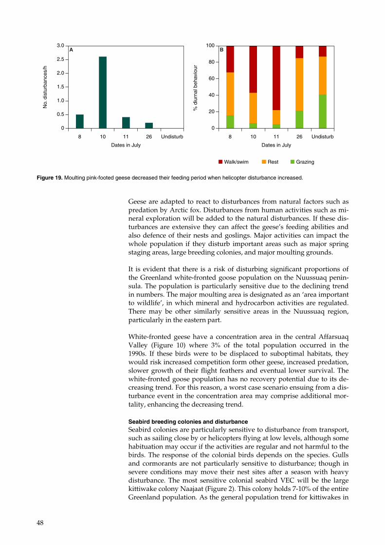
48
Geese are adapted to react to disturbances from natural factors such as predation by Arctic fox. Disturbances from human activities such as mi-neral exploration will be added to the natural disturbances. If these dis-turbances are extensive they can affect the geese’s feeding abilities and also defence of their nests and goslings. Major activities can impact the whole population if they disturb important areas such as major spring staging areas, large breeding colonies, and major moulting grounds.
It is evident that there is a risk of disturbing significant proportions of the Greenland white-fronted goose population on the Nuussuaq penin-sula. The population is particularly sensitive due to the declining trend in numbers. The major moulting area is designated as an ‘area important to wildlife’, in which mineral and hydrocarbon activities are regulated. There may be other similarly sensitive areas in the Nuussuaq region, particularly in the eastern part.
White-fronted geese have a concentration area in the central Affarsuaq Valley (Figure 10) where 3% of the total population occurred in the 1990s. If these birds were to be displaced to suboptimal habitats, they would risk increased competition form other geese, increased predation, slower growth of their flight feathers and eventual lower survival. The white-fronted goose population has no recovery potential due to its de-creasing trend. For this reason, a worst case scenario ensuing from a dis-turbance event in the concentration area may comprise additional mor-tality, enhancing the decreasing trend.
Seabird breeding colonies and disturbance Seabird colonies are particularly sensitive to disturbance from transport, such as sailing close by or helicopters flying at low levels, although some habituation may occur if the activities are regular and not harmful to the birds. The response of the colonial birds depends on the species. Gulls and cormorants are not particularly sensitive to disturbance; though in severe conditions may move their nest sites after a season with heavy disturbance. The most sensitive colonial seabird VEC will be the large kittiwake colony Naajaat (Figure 2). This colony holds 7-10% of the entire Greenland population. As the general population trend for kittiwakes in
0
0.5
1.0
1.5
2.0
2.5
3.0N
o. d
istu
rban
ces/
h
0
20
40
60
80
100
8 10 11 26 Undisturb8 10 11 26 Undisturb
Dates in JulyDates in July
% d
iurn
al b
ehav
iour
Walk/swim Rest Grazing
A B
Figure 19. Moulting pink-footed geese decreased their feeding period when helicopter disturbance increased.
49
Greenland is negative, the recovery potential is low and a worst case scenario for a disturbance event of this colony may be enforced decline of the total population.
Other birds and disturbance Other bird VECs include gyr falcon, harlequin duck and great northern diver. However, it is not possible to assess potential impacts on these species as their distribution and density in the area is unknown.
Finally some of the coastal birds are VECs: Arctic tern and common ei-der. They breed on a number of the islands in the western part of the pe-ninsula (Figure 2), and will not be impacted by activities on the main-land. But sailing, construction of terminals or other coastal facilities may affect the islands where they breed.
Disturbance from production activities When exploration activities develop into production, the disturbance impacts will be less extensive in geographical extent, but will on the other hand be of long endurance. The impact will be limited to the sur-roundings of the infrastructure and the transport corridors, and be par-ticularly heavy during construction and decommissioning.
Both Greenland white-fronted geese and caribou will be displaced from important habitats by disturbance from infrastructure placed in the near surroundings.
Placement of infrastructure and other footprints Placement of structures, such as buildings, tank farms, machinery, gravel pads, deposits, roads, helipads, etc. including pits for extraction of gravel etc., eliminates habitats and kills vegetation. The main concern in this re-spect is the occurrence of rare plants with very limited distribution in the region (Figure 3). A large facility may completely cover a habitat for such species. Plants such as those listed in Table 4 are very vulnerable, and some of the endemics have so few known localities that more than 50% of them may be impacted by a single facility and the roads connecting the site to the coast.
Structures may also create barriers to migrating species. Caribou are sen-sitive to establishment of barriers in the terrain which may prevent ac-cess to important areas, and thereby potentially reduce the fitness of af-fected populations. Barriers can be pipelines, roads, transmission lines or even a large oil field/mining area covering the entire width of a valley etc. However, it is not possible to assess impacts from such as there is no knowledge available on seasonal migration routes. But a pipeline for ex-ample, crossing the central valley of the peninsula could potentially pre-sent a serious obstacle to migrating caribou, preventing them from reach-ing important habitats.
Arctic char migrate from the sea to rivers for spawning and wintering. The rivers they use are easily obstructed by constructions such as roads and dams, and the entire population may be hindered from reaching the wintering and spawning areas, and may eventually be wiped out. Re-covery is probably very slow, because Arctic char are very faithful to the rivers they frequent.
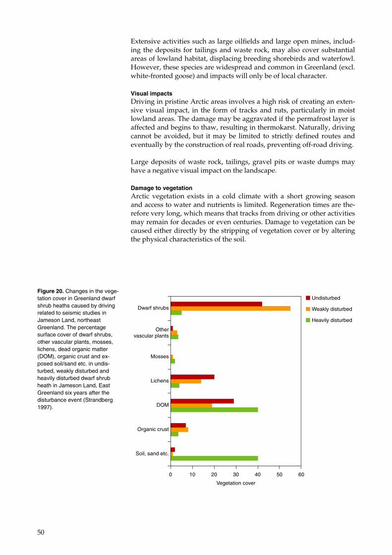
50
Extensive activities such as large oilfields and large open mines, includ-ing the deposits for tailings and waste rock, may also cover substantial areas of lowland habitat, displacing breeding shorebirds and waterfowl. However, these species are widespread and common in Greenland (excl. white-fronted goose) and impacts will only be of local character.
Visual impacts Driving in pristine Arctic areas involves a high risk of creating an exten-sive visual impact, in the form of tracks and ruts, particularly in moist lowland areas. The damage may be aggravated if the permafrost layer is affected and begins to thaw, resulting in thermokarst. Naturally, driving cannot be avoided, but it may be limited to strictly defined routes and eventually by the construction of real roads, preventing off-road driving.
Large deposits of waste rock, tailings, gravel pits or waste dumps may have a negative visual impact on the landscape.
Damage to vegetation Arctic vegetation exists in a cold climate with a short growing season and access to water and nutrients is limited. Regeneration times are the-refore very long, which means that tracks from driving or other activities may remain for decades or even centuries. Damage to vegetation can be caused either directly by the stripping of vegetation cover or by altering the physical characteristics of the soil.
Figure 20. Changes in the vege-tation cover in Greenland dwarf shrub heaths caused by driving related to seismic studies in Jameson Land, northeast Greenland. The percentage surface cover of dwarf shrubs, other vascular plants, mosses, lichens, dead organic matter (DOM), organic crust and ex-posed soil/sand etc. in undis-turbed, weakly disturbed and heavily disturbed dwarf shrub heath in Jameson Land, East Greenland six years after the disturbance event (Strandberg 1997).
Vegetation cover
0 10 20 30 40 50 60
Dwarf shrubs
Othervascular plants
Mosses
Lichens
DOM
Organic crust
Soil, sand etc.
Undisturbed
Weakly disturbed
Heavily disturbed
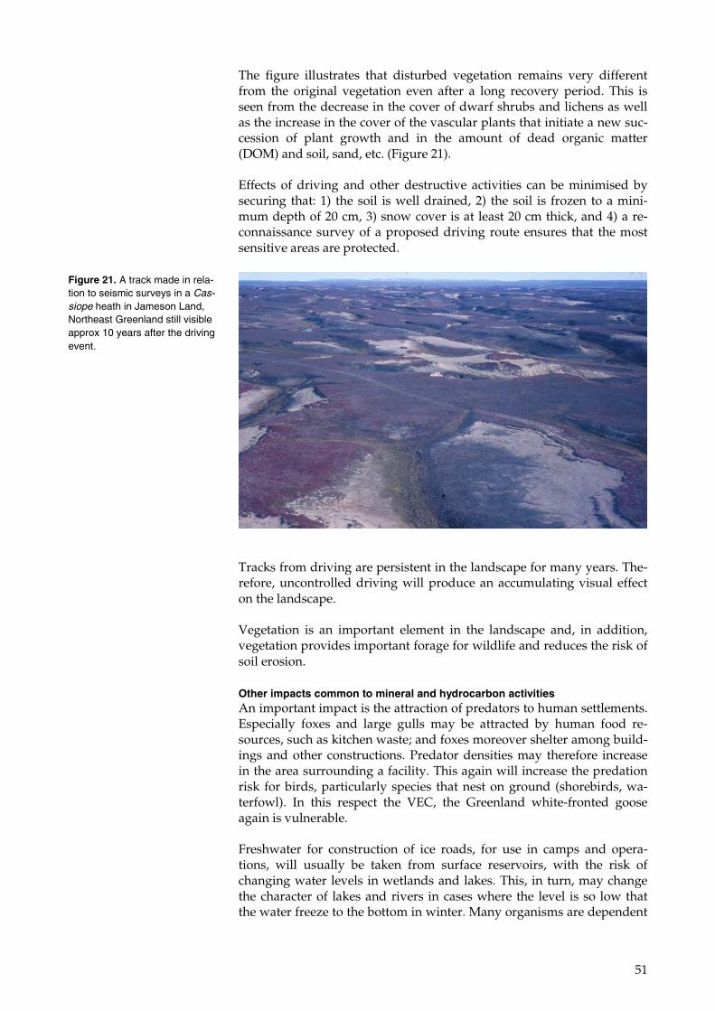
51
The figure illustrates that disturbed vegetation remains very different from the original vegetation even after a long recovery period. This is seen from the decrease in the cover of dwarf shrubs and lichens as well as the increase in the cover of the vascular plants that initiate a new suc-cession of plant growth and in the amount of dead organic matter (DOM) and soil, sand, etc. (Figure 21).
Effects of driving and other destructive activities can be minimised by securing that: 1) the soil is well drained, 2) the soil is frozen to a mini-mum depth of 20 cm, 3) snow cover is at least 20 cm thick, and 4) a re-connaissance survey of a proposed driving route ensures that the most sensitive areas are protected.
Tracks from driving are persistent in the landscape for many years. The-refore, uncontrolled driving will produce an accumulating visual effect on the landscape.
Vegetation is an important element in the landscape and, in addition, vegetation provides important forage for wildlife and reduces the risk of soil erosion.
Other impacts common to mineral and hydrocarbon activities An important impact is the attraction of predators to human settlements. Especially foxes and large gulls may be attracted by human food re-sources, such as kitchen waste; and foxes moreover shelter among build-ings and other constructions. Predator densities may therefore increase in the area surrounding a facility. This again will increase the predation risk for birds, particularly species that nest on ground (shorebirds, wa-terfowl). In this respect the VEC, the Greenland white-fronted goose again is vulnerable.
Freshwater for construction of ice roads, for use in camps and opera-tions, will usually be taken from surface reservoirs, with the risk of changing water levels in wetlands and lakes. This, in turn, may change the character of lakes and rivers in cases where the level is so low that the water freeze to the bottom in winter. Many organisms are dependent
Figure 21. A track made in rela-tion to seismic surveys in a Cas-siope heath in Jameson Land, Northeast Greenland still visible approx 10 years after the driving event.
52
on water in deep lakes and rivers for surviving the winter, e.g. Arctic char.
Wastewater Wastewater from camps and buildings (grey- and blackwater) released to the environment may cause eutrophication if released untreated. The volume of wastewater from a large facility with a large number people has the potential to pollute extensive freshwater systems in the area.
Generally, impacts from wastewater can be mitigated by using the avail-able technology and, if such technology is applied, impacts on the Nuus-suaq peninsula can be minimised.
Drilling substances Drilling takes place during exploration for minerals (diamond drilling) and during exploration for hydrocarbons. Many of the chemicals used during drilling are toxic to the environment; although the industry has gradually exchanged many of the toxic substances with less harmful substitutes. Effects from drilling components released from drilling pro-cesses will be local unless large amounts are released into freshwater sys-tems where toxic substances can be transported widely. In general, it is possible to handle all the substances from drillings without any or with only minor effects on the environment.
Deposition of drilling mud and drill cuttings may be problematic to the environment, due to oil or chemical residues. When the oil drilling in Nuussuaq in 2006 was terminated, the drilling mud was deposited in the flaring pit and levelled. However, two years later it had subsided and this proceeded for at least eight more years, creating distinct hollows in the otherwise level surface.
Generally, impacts from drilling substances can be mitigated, and im-pacts are not expected in the Nuussuaq peninsula area.
Air emissions Air pollution common to mineral and hydrocarbon activities relates to energy generation and the subsequent emission of combustion gasses. Unless an activity uses alternative energy sources, such as hydropower, combustion of fuel oil represents the main fuel source. Greenhouse gas-ses, e.g. NOx, SO2 and VOC (volatile organic components) are released to the air, and the impacts are well known. Besides the greenhouse effect, NOx and SO2 contribute to acidification which may impact the nutrient-poor habitats that have no neutralising capacity. This capacity has not been investigated in the region, but is expected to vary between areas where basalts are dominant and areas with sedimentary and gneissic overburden and bedrock. NOx moreover has a nutrient effect which may impact the vegetation, cf. AMAP (2006) for more information.
The impacts of acidification from mining activities are well known from e.g. the smelters in the Kola Peninsula of Russia, where extensive areas are impacted by air pollution, including large areas where the vegetation has been completely destroyed (AMAP 2006).
Arctic haze is also a result of air pollution from combustion gasses (AMAP 2006). An area such as the Nuussuaq peninsula is prone to prob-
53
lems with Arctic haze, because of the valleys surrounded by very high mountains.
In this respect it should be stressed that Denmark (including Greenland) has ratified the UNECE LRTAB Protocol to Abate Acidification, Eutro-phication and Ground-level Ozone (The Gothenburg protocol), an inter-national agreement which aims at minimising and reducing air pollu-tion.
9.2 Impacts related to the mineral activities
There are naturally high concentrations of chromium, nickel, copper and vanadium in the tertiary volcanic rocks of the Nuussuaq area. These elements and perhaps further elements could become the target for min-eral prospecting end exploitation, and as recently as 2007 a company has been carrying out drillings in search of nickel.
The economically interesting elements will be present in characteristic minerals that will constitute only a minor fraction of the rocks in which they are present. It will probably be necessary to process the minerals on location to form one or more metal concentrates. The mineral concen-trates can be exported or further treated (smelted) to obtain the metal. The following will not consider the activity of smelting, only the effects on nature and environment of mining, mineral dressing, and shipping of a mineral concentrate.
9.2.1 Waste rock
When mining occurs in an open quarry or in a closed underground mine some useless rock has to be mined in order to create space for the mining of the commercial ore. This rock, called waste rock, has to be deposited at some location, in an environmentally safe way.
Worldwide experience has shown that waste rock from metal mining of-ten creates environmental problems due to acid drainage (see literature reference: ARD). This occurs when the waste rock contains pyrite or si-milar sulphur-containing minerals. These minerals will oxidise when they are wet and when they come into contact with air. Oxidation pro-duces sulphuric acid, which in itself is an unwanted substance in the en-vironment. But worse still, the sulphuric acid can dissolve many ele-ments from the waste rock, thereby giving rise to heavy metal pollution. Elements like lead, zinc, copper, nickel, chromium, cadmium, and mer-cury can dissolve in sulphuric acid and spread to the environment and create unwanted pollution.
Sulphuric acid acting on the tertiary volcanic rocks of Nuussuaq will probably result in pollution from copper, chromium and nickel, as these elements are naturally enriched in marine sediments of the area (Loring and Asmund 1996)
Also acid-neutral waste rock can create environmental problems and the waste has to be disposed of in a safe way, so that it can be controlled and seepage water collected and, if necessary, treated.
54
The alpine terrain of Nuussuaq can make it difficult to find locations sui-table for deposition of waste rock.
9.2.2 Tailings
Rarely, ore can be mined and exported directly. This, however, is the ex-ception. Usually the mined ore has to be treated in some way in order to concentrate the economically interesting minerals. Today, flotation is the most common way to concentrate minerals, but also other techniques such as density separation or magnetic separation are used. They all re-sult in a waste product, called tailings, composed of economically unin-teresting fine crushed minerals. Tailings will often contain minerals or other compounds that are dangerous for the environment. Flotation re-quires the use of various chemicals, which may be toxic and which may be released with the tailings.
It is important to investigate the environmental properties of the tailings and use the investigations to design the best way of disposing of the tail-ings in a safe and environmentally acceptable way.
Unreactive tailings If tailings have been shown to be chemically unreactive by means of tho-rough measurement and testing, it can be assumed that they are envi-ronmentally safe. From an environmental viewpoint, the tailings can then be disposed of in several ways, if the technical properties of the tail-ings are acceptable, e.g. as landfill.
Reactive tailings However, in most cases tailings will contain one or more components that are harmful to the environment. In that case tailings have to be dis-posed of in a safe way, making it possible to control and treat the seep-age, and in a way so that the tailings are permanently immobilised in all cases of weather and natural phenomena.
Lime is one of the most commonly used ingredients to be added to tail-ings or tailings seepage in order to neutralise acid and prevent spreading of dissolved heavy metals. A sedimentation pond is necessary in order to allow precipitation of the elements by the lime. All this requires a loca-tion suitable for construction of tailings dams, sedimentation pond(s), and controlled drainage. The alpine topography means that this might be the major problem for a new mine on the Nuussuaq peninsula.
Deposition of marine tailings Marine deposition of tailings is a way to overcome problems associated with the construction of tailings facilities. The method will be economi-cally attractive in most places in Greenland, and also in the Nuussuaq area. But the risk is always present that the tailings may have environ-mentally unwanted properties that were not discovered during the tests. Thus, the disposal of tailings will be particularly risky in a place such as Nuussuaq, where the marine topography does not have enclosed areas immediately suitable for marine disposal of tailings, and where possible disposal areas will always be connected directly with important fishing grounds, such as in the outer parts of Vaigat. An overview of the advan-tages and disadvantages of marine tailings disposal is provided by Ellis et al. (1982) and Ellis and Poling (1995). Impacts will, however, not be re-
55
stricted to the disposal site, as the process creates a plume of suspended fine particles that will stay in the water column for several days and which may drift to a wide area.
Marine tailings disposal was used at the zinc and lead mine at Maar-morilik in the Uummannaq district in Greenland. This created unex-pected and extensive environmental problems in the fjord at the mining site (Loring and Asmund 1987, Asmund and Johansen 1999).
For a strategic environmental impact assessment it is important to know the topography of the sea floor, the composition of the sediments and the currents, mainly in order to assess changes in composition of the sedi-ment at the disposal site and the potential dispersal of harmful sub-stances. As mentioned earlier, the sediment in Vaigat is naturally en-riched in several elements including copper, chromium, vanadium and nickel.
The chemical problems with tailings are the same as those expected for waste rock. The most commonly observed environmental problem is that tailings that contain pyrite and other similar sulphur compounds oxi-dise, resulting in seepage of sulphuric acid.
9.2.3 Chemical impacts on flora and fauna
Mineral prospecting and extraction on the Nuussuaq peninsula will most probably be directed towards copper, chromium and nickel, which are the elements known to be enriched in the area. Even if this is not the ca-se, the potential environmental problems are still likely to originate from one of these elements. It is therefore important to know the level of these elements in the different components of the Nuussuaq environment, a knowledge which to date is very limited.
After a mining operation has started, the levels of copper, chromium, nickel and other possible elements must be monitored in the environ-ment around the mine. Suitable organisms are lichen (Cetraria nivalis), blue mussel, seaweed and shorthorn sculpin. Also commercially impor-tant species for the area must be monitored. Among these are shrimp, Greenland halibut, scallop and snow crab.
9.2.4 Auxiliary chemicals
Several different chemicals are used in mining and mineral dressing . For example, flotation might use a frother, an activator, a depressor and a collector, with e.g. cyanide often being used as a depressor. Cyanide is acutely toxic, but does not accumulate in the food web. Moreover, the explosives used in mining often contain ammonium nitrate, which can give rise to eutrofication of marine and fresh waters.
The Nuussuaq area is neither more nor less sensitive to auxiliary chemi-cals and nutrient enrichment than other areas in Greenland. Important fishing grounds primarily found in Vaigat must be protected against the negative effect of auxiliary chemicals. At the Titania mine in Norway where marine tailings disposal was used, a certain flotation chemical was adsorbed by fish living in the area, resulting in tainting (an unpleas-
56
ant smell and taste from fish caught close to the tailings disposal area) (Miljøverndepartementet 1985).
9.3 Impacts related to hydrocarbon activities
‘Produced water’ is water from the oil bearing formation which is brought to the surface with the oil and gas. Water injected for increasing the oil or gas extraction may also form part of produced water. Produced water is usually saline, and includes oil residues and many other sub-stances in small amounts, such as heavy metals and radionuclides. The amounts of produced water are large and in many offshore oil fields it is released into the sea. However zero-discharge solutions, which are now becoming standard in many oil fields, include re-injection of produced water back into the wells. This would probably also be the solution in a Nuussuaq oil field, because release into a nearby river would not be en-vironmentally feasible.
9.3.1 Oil spills, chronic and accidental
Besides the oil in produced water, oil can also be released to the envi-ronment from many other chronic but small sources, such as runoff from deck and platforms, small operational spills, etc. From land-based facili-ties, these will contaminate the local area, but will not be spread to a wi-der area, unless oil is released into a river or lake.
Accidental oil spills These may occur from blow-outs or from accidents during transportation and storage. Crude oil and fuel oil of different types may be spilled, and also spills of produced water containing salt may impact vegetation.
Impacts from an inland well blow-out will usually be limited to the local area around the site, because the tundra acts as a sponge. Impacts on ve-getation will therefore occur in a relatively limited area compared to the impact areas of marine oil spills. The largest recorded impact area from an inland oil spill in Alaska covered 1700 m2 (National Research Council 2003). However, if oil is spilled in freshwater systems much wider areas, including marine areas, may be affected by the oil. The large spills in Russia in 1994 affected approx. 70 km2 in this way (National Research Council 2003).
Vegetation will be killed in affected areas and in freshwater systems; fauna, including stocks of Arctic char, are at risk of being wiped out. Ve-getation recovery may take 10 years and even longer after spills of saline produced water, because the salt is not degradable.
Impacts from marine oil spills in the marine environment are described and assessed in the EIA covering the Disko West area (Mosbech et al. 2007a), and among the vulnerable species will be capelin and Arctic char (both VECs), as well as their habitats.
Hunting and fishing will be affected if coastal fish populations are re-duced or if areas are closed as a consequence of an oil spill or pollution from tailings. If the caribou population is reduced, quotas will be simi-
57
larly reduced or hunting will eventually be prohibited in order to resti-tute the population.
9.4 Summary of impact assessment
Exploration and exploitation activities have the potential to disturb two vulnerable populations (geese and caribou) at levels which may cause population decline. Some seabird breeding colonies may also be dis-turbed at levels which may cause temporary declines.
Extensive activities may cause visual impacts in landscapes, and impacts which may accumulate through time because of the persistence of terrain and vegetation damage. Activities in 1996, 2003 and 2007 have already created extensive visual impacts in the area in the form of tracks from different kinds of vehicles.
Large infrastructures, constructions and their transportation corridors have the potential to displace caribou and white-fronted geese from criti-cal habitats, with the risk of causing population decline. They moreover may cover critical habitats for rare plants.
The main pollution risk from mines includes acid drainage from tailings and waste rock, and dust from open pits and transportation.
The main pollution risks from hydrocarbon activities are from the release of produced water, chronic oil spills and accidental oil spills.
Common to both mines and oil fields is extensive energy combustion re-sulting in release of greenhouse gasses, some of which also may impact the local environment by acidification, nutrient additions and arctic ha-ze.
Hunting and fishery may be affected where accidents lead to pollution of the coastal environment, or if the caribou population is reduced.
58
10 Assessment of information status for the area, where are the data gaps?
10.1 Geese
In 1995, 1997 and 2000, spring staging habitats were surveyed in central West Greenland, and none were located on the Nuussuaq peninsula (Glahder 1999, Glahder et al. 2002). The spring staging habitats are cru-cial for the white-fronted geese, because the snow cover in early May, when the geese arrive from the winter quarters, is still extensive and lim-its feeding. Climate change may have altered the situation, making spring feeding areas available in the Nuussuaq area.
The most recent surveys of moulting geese (see above) indicated a de-creasing trend in numbers of the white-fronted goose and an increase in numbers of Canada geese. The most recent survey was carried out in 2003, and the apparent trends should be studied further with a new sur-vey, which also should include the easternmost valleys of the Nuussuaq peninsula, as these have never been surveyed for moulting geese. In Au-gust 2007 after the moulting season, a survey was carried out, but the da-ta from this study have not been analysed and were not available for the present SEA. However, only parts of the goose habitats were surveyed and a full survey in the moulting season is still required.
10.2 Other birds
The information status on the birdlife of the Nuussuaq peninsula is gen-erally good for the coasts and the western half of the inland. But there is no information available for the eastern area, especially the region in-cluding the large lakes Boyes Sø and Amitsup Tasia. Information can be collected on an ad hoc basis when other biological studies are carried out, but potentially impacted areas should be searched, particularly in relation to the VEC species, before any activities are initiated.
10.3 Mammals
The caribou survey in 2002 (Cuyler 2004) was not adequate for estimat-ing the total population in the area. There is a need for more comprehen-sive studies including aerial surveys to map the habitat preferences and to estimate the population size.
Satellite tracking of a number of individuals will moreover give valuable information on annual movements and habitat use.
59
10.4 Other fauna
Invertebrates are not included in this account. Information, if needed, can possibly be retrieved from collections in the Zoological Museum, Copenhagen and from the scientific literature.
10.5 Vegetation
Overall knowledge on the flora is adequate, but more precise knowledge of habitats of species which require protection is lacking. This data gap should be filled before specific activities are initiated, and sites for activi-ties should be searched for rare species.
Regarding vegetation, ground truthing is essential to verify the remote studies presented in this report. Moreover, a detailed ground truthing is essential in order to validate and improve the land cover maps. Cur-rently, only the western part of the area is covered, and by too few ob-servations, and there are no observations from the inland areas of the eastern part of the area.
Other flora/funga such as mosses, fungi and lichens are not treated in this account, but some information, if required, may be retrieved from comprehensive works covering the whole or parts of Greenland or from museum collections in for example the Botanical Museum, Copenhagen.
The most important data gaps to be filled as soon as possible are as-sessed to relate to:
• the occurrence of Greenland white-fronted geese: is the main moult-ing area in central Affarsuaq valley still as important as previously; are there other important moulting areas, particularly in the eastern part of the peninsula; are there important spring staging habitats; and distribution and numbers of breeding birds
• occurrence of caribou, population segregation, population numbers, annual movements, habitat use, identification of calving areas and important winter habitats
• gound truthing of satellite based vegetation maps • general knowledge on flora and fauna, particularly in the lowlands.
10.6 Proposed studies to fill data gaps
10.6.1 Studies to be performed before opening the area for potential activities
The most immediate studies to be carried out will be the caribou and goose studies. A representative number of caribou, both the native and the introduced animals, should be equipped with satellite transmitters, and their movements tracked at least for one year, but if possible for lon-ger. Another important task is to obtain an estimate of the numbers of caribou present in the area, and a survey – possibly aerial – should be carried out. These studies need at least two years to be completed.
60
An aerial survey for Greenland white-fronted geese should be carried out in July, when many birds are flightless and the breeding pairs have chicks. All lowland areas shall be covered. One year would be required for this study.
Ground truthing of satellite images will also be important. This shall be conducted in summer, and by a team of biologists who are moved be-tween sites by helicopter. One year would be required for this study.
In combination with this ground truthing project a general survey for flora and fauna should be conducted. One year would be required for this study.
10.6.2 Studies to carry out before exploitation activities are initiated
Less immediate, but still important, will be the chemical baseline studies. A sample plan is required to be developed. Some of the samples can be collected on an ad hoc basis when other surveys are carried out. But a dedicated ship-based survey should be preformed along the coasts, per-haps supplemented by inland sampling from helicopter. Fieldwork can be performed during one summer.
Seabird breeding colonies on the shores of Nuussuaq peninsula and ad-jacent coasts should be surveyed before extensive activities are initiated. This can be carried out during one summer.
10.6.3 Studies to be carried out as part of specific EIAs
Information on rare plants and their habitats is not an immediate re-quirement, but should be collected before specific activities requiring placement of large structures are initiated.
In the same way rare inland fauna should also be searched for before ac-tivities are initiated.
Marine coastal fauna should be studied before large-scale oil exploitation activities are initiated and in case of marine deposition of tailings.
Bathymetric data from the surrounding waters will be needed in order to assess the possibilities for marine disposal of tailings in the case where a mine is established in the area.
61
11 Conclusions
Potential conflicts between mineral/hydrocarbon activities and biologi-cally vulnerable elements of the Nuussuaq peninsula will mainly be re-stricted to the lowlands and the coasts.
There is a potential for impacting the caribou and Greenland white-fronted goose populations of the Nuussuaq peninsula by large-scale op-erations. Local stocks of Arctic char are sensitive to activities blocking their migration routes through rivers and creeks. Rare flora is moreover sensitive to placement of structures and oil spills.
There is a risk of increasing and accumulating visual impacts from driv-ing operations in the area. Driving will be concentrated in the accessible areas, mainly in the valleys where vulnerable vegetation and terrain are found.
Mining and oil exploitation also impose a risk of pollution from waste rock, tailings, dust, produced water and added chemicals. However the emissions can be minimised and mitigated, and the risk for impacts is generally low but not excluded.
Emissions to the air from mining and oil production are generally con-siderable, and a large-scale oil production facility may increase the Greenland contribution to global levels significantly.
Many impacts can be mitigated by applying Best Available Technology (BAT) and Best Environmental Practices (BEP) in combination with strict regulation which limits activities in vulnerable areas and in vulnerable periods.
There is a general lack of biological knowledge concerning both strategic as well as specific environmental impact assessment in the area.
62
12 References
Aastrup, P. 2000. Responses of West Greenland caribou to the approach of humans on foot. – Polar Research 19, 83-90.
AMAP 2006. Acidifying Pollutants, Arctic Haze and Acidification in the Arctic. – Arctic Monitoring and Assessment Programme, Oslo, Norway. Link
Anon. 1993. Sensitive habitats of the Porcupine caribou herd. – Report accepted by the International Porcupine caribou board from the Porcu-pine Caribou technical committee. 28 pp.
ARD. Comprehensive literature lists on Acid rock drainage: http://technology.infomine.com/enviromine/ard/home.htm
Asmund, G. & Johansen, P. 1999. Short and long term environmental ef-fects of marine tailings and waste rock disposal from a lead/zinc mine in Greenland. Pp. 177-181 in Rubio, R.F. (ed.) Proceedings: International Mine Water Association ”Mine, Water & Environment”. – International congress September 13-17 Sevilla Spain.
Bay, C. 1999. Diversiteten af karplanter (Tracheophyta). Pp. 58-72 in Jen-sen, D.B. (ed.) Grønlands Biodiversitet – et landestudie. – Teknisk Rap-port nr. 27, Pinngortitaleriffik, Grønlands Naturinstitut.
Bertelsen, A. 1921. Fuglene i Umánaq distrikt. – Meddr Grønland 62, 2: 139-214.
BMP 2000: Rules for field work and reporting regarding mineral re-sources (excluding hydrocarbons) in Greenland. – Government of Greenland.
Boertmann, D. 1994. An annotated checklist to the birds of Greenland. – Meddr Grønland, Bioscience 38: 1-63.
Boertmann, D.M. 2005. Råstofaktiviteter og natur- og miljøhensyn i Grønland. – National Environmental Research Institute, Technical Re-port No. 524.
Boertmann, D. 2007. Grønlands Rødliste, 2007. – Direktoratet for Miljø og Natur, Grønlands Hjemmestyre.
Boertmann, D. & Glahder, C. 1999. Grønlandske gåsebestande – en over-sigt. (Greenland goose populations – a review. In Danish with English summary) – Faglig rapport fra DMU, nr. 276.
Boertmann, D., Mosbech, A., Falk, K. & Kampp, K. 1996. Seabird colonies in western Greenland. – National Environmental Research Institute, Technical Report No. 170.
63
Boertmann, D., Mosbech, A. & Frimer, O. 1997. Autumn migration of light-bellied Brent geese Branta bernicla hrota through North-west Green-land. – Wildfowl 48: 98-107.
Boertmann, D., Lyngs, P., Merkel, F. & Mosbech A. 2004: The significance of Southwest Greenland as winter quarters for seabirds. – Bird Conserva-tion International 14: 87-112.
Burnham, W., Burnham, K.K & Cade, T.J. 2005. Past and present assess-ment of birdlife in Uummnaaq District, West Greenland. – Dansk Orni-tologisk Forenings Tidsskrift 99: 196-208.
Cameron R.D., Reed, D.J., Dau, J.R. & Smith, W.T. 1992: Redistribution of calving caribou in response to oil field development on the arctic slope of Alaska. – Arctic 45: 338-342.
Colhoun, K. Mackie, K. & Gudmundsson, G.A. 2006. International cen-sus of East Canadian High Arctic Light-bellied Brent Goose 2005/06. – GooseNews 5: 14.
Cuyler, C. 2004. Caribou (Rangifer tarandus) in Nuussuaq. Pp. 49-52 in Boertmann, D. (ed.) Background studies in Nuussuaq and Disko, West Greenland. – National Environmental Research Institute, Technical Re-port No. 482.
Ellis, D.V. 1982. Marine Tailings Disposal. – Ann Arbor Science Puplica-tion, 368 pp.
Ellis, D.V. & Poling, G.W. 1995. Submarine Tailings Disposal. – Special Issue of Marine Georesources & Geotechnology Vol 13 No. 1-2.
Fencker, H. 1947. Fuglelivet i Saqqaq, Nordgrønland i Vinteren 146-47. – Dansk Ornithologisk Forenings Tidsskrift 41: 161-168.
Fencker, H. 1950. The Greenland White-fronted Goose (Anser albifrons flavirostris Scott & Dalgety) and its breeding-biology. – Dansk Ornitholo-gisk Forenings Tidsskrift 44: 61-65.
Fox, A.D., Glahder, C., Mitchell, C.R., Stroud, D.A., Boyd, H. & Frikke, J. 1996. North American Canada Geese (Branta canadensis) in West Green-land. - Auk 113 (1): 231-233.
Fox, D.T., Stroud, D., Walsh, A., Wilson, J., Norriss, D. & Francis, I. 2006. The rise and fall of the Greenland White-fronted Goose: A case study in international conservation. – British Birds 99: 242-261.
Fox, T. 2007. Latest Greenland White-fronted Goose census results. – GooseNews 6: 15.
Fredskild, B. 1996. A phytogeographical study of the vascular plants of West Greenland (62°20’-74°00’N). – Meddelelser om Grønland, Biosci-ence 45. 157 s.
64
Glahder, C.M. 1999a. Spring staging areas of the Greenland White-fronted Goose Anser albifrons flavirostris in West Greenland. – Arctic 52: 244-256.
Glahder, C.M. 1999b. Moulting Greenland White-fronted Geese: Distri-bution and concentrations in West Greenland: 118-142. In Glahder, C. M. Sensitive areas and periods of the Greenland White-fronted Goose in West Greenland. – Ph.D. thesis. National Environmental Research Insti-tute, Denmark, 142 pp.
Glahder, C.M. & Walsh, A.W. 2007. Experimental disturbance of moult-ing Greenland White fronted Geese Anser albifrons flavirostris. In: Boe-re, G.C., Galbraith, C.A. & Stroud, D.A. (Eds): Waterbirds around the world. A global overview of the conservation, management and research of the world's waterbird flyway. – Edinburgh Stationary Office.
Glahder, C.M., Fox, A.D. & Walsh, A.J. 1999a. Satellite tracking of Greenland White-fronted Geese. – Dansk Orn. Foren. Tidsskr. 93: 271-276.
Glahder, C.M., Nymand, J. & Petersen, M.K. 1999b. Feeding behaviour and habitat use of Greenland White-fronted Goose at a specific spring staging area: 67-94. In Glahder, C. M. Sensitive areas and periods of the Greenland White-fronted Goose in West Greenland. – Ph.D. thesis. Na-tional Environmental Research Institute, Denmark, 142 pp.
Glahder, C.M., Fox, A.D. & Walsh, A.J. 2002. Spring staging areas of White-fronted Geese in West Greenland; results from aerial survey and satellite telemetry. – Wildfowl 53: 35-52.
Grønlands Statistik 2006. Grønland 2006. Statistisk årbog. – Forlaget Atuagkat, Nuuk.
Hohman, W.L., Ankney, C.D. & Gordon, D.H. 1992. Ecology and man-agement of postbreeding waterfowl: 128-189. In Batt, B.D.J., Afton, A.D. Anderson, M.G., Ankney, C.D, Johnson, D.H., Kadlec, J.A. & Krapu, G.L. (eds), Ecology and management of breeding waterfowl. – University of Minnesota Press, USA.
IUCN 2006. 2006 IUCN Red List of Threatened Species. <www.iucnredlist.org>. Downloaded on 14 March 2007.
Jensen, J.R. 2000. Remote Sensing of the Environment: An Earth Resource Perspective. – Prentice Hall.
Joensen, A.H. & Preuss N.O. 1972. Report on the ornithological expedi-tion to Northwest Greenland 1965. – Meddr Grønland 191, 5: 58 pp.
Kristiansen, J.N. & Jarrett, N.S. 2002. Inter-specific competition between White-fronted and Canada Geese moulting in West Greenland; mecha-nisms and consequenses. - Ardea 90: 1-13.
Fredskild, B. 1996. A phytogeographical study of the vascular plants of West Greenland (62°20’-74°00’N). – Meddelelser om Grønland, Biosci-ence 45: 157 pp.
65
Loring, D.H. & Asmund, G. 1987. Heavy Metal Contamination of a Greenland Fjord System by Mine Wastes. – Environ. Geol. Water Sci. 14: 61-71.
Loring, D.H. & Asmund, G. 1996. Geochemical factors controlling accu-mulation of major and trace elements in Greenland coastal fjord sedi-ments. – Environmental Geology 28 (1): 2-11.
Madsen, J. 2004. Survey of moulting and breeding geese in Nuussuaq and north Disko. Pp. 15-18 in Boertmann D. (ed.) Background studies in Nuussuaq and Disko, West Greenland. – National Environmental Re-search Institute, Technical Report No. 482.
Madsen, J. & Mortensen, C.E. 1987. Habitat exploitation and interspecific competition of moulting geese in East Greenland. – Ibis 129: 25-44.
Miljøverndepartementet 1986 ”Innstilling fra embetsmannsgruppen for å vurdere utslippene fra gruvebedriften Titania A/S, Sokndal i Rogaland”. – Rapport T- 654. Oslo.
Miller, M.W., Jensen, K.C., Grant, W.E. & Weller, M.W. 1994. A simula-tion model of helicopter disturbance of moulting Pacific black brant. – Ecological modelling 73: 293-309.
Mosbech, A. & Glahder, C. 1991. Assessment of the impact of helicopter disturbance on moulting Pink-footed Geese (Anser brachyrhynchus) and Barnacle Geese (Branta leucopsis) in Jameson Land, Greenland. – Ardea 79: 233-238.
Mosbech, A., Boertmann, D., Olsen, B.Ø., Olsvig, S., Platen, F. v., Buch, E., Hansen, K.Q., Rasch, M., Nielsen, N., Møller, H.S., Potter, S., An-dreasen, C., Berglund, J. & Myrup, M. 2004. Environmental oil spill sen-sitivity atlas for the West Greenland (68°-72°) coastal zone. – National Environmental Research Institute, Technical Report No. 494, 442 pp.
Mosbech, A., Boertmann, D. & Jespersen, M. 2007a. Strategic Environ-mental Impact Assessment of hydrocarbon activities in the Disko West area. – National Environmental Research Institute, Technical Report No. 618.
Mosbech, A., Hansen, A.B., Asmund, G., Dahllöf, I., Petersen, D.G. & Strand, J. 2007b. A chemical and biological study of the impact of a sus-pected oil seep at the coast of Marraat, Nuussuaq, Greenland. With a summary of other environmental studies of hydrocarbons in Greenland. – National Environmental Research Institute, Technical Report No. 629, 56 s.
National Research Council 2003. Cumulative environmental effects of oil and gas activities on Alaska’s North Slope. – The National Academies Press, Washington D.C.
Olsvig, S. & Mosbech A. 2003. Fiskeriressourcer på det lave vand i det nordlige Vestgrønland. – En interviewundersøgelse om forekomsten og udnyttelsen af lodde, stenbider og ørred. – Arbejdsrapport fra DMU, nr. 180.
66
Overrein, Ø. 2002. Virkninger af motorferdsel på fauna og vegetation. Kunnskabsstatus med relevans for Svalbard. – Norsk Polarinstitutt, Rapportserie nr. 119.
Petersen, H.C. 1993a. Ilulissat Kommune. Registrering af levende natur-værdier i Grønland rapport nr. 11. – Grønlands Hjemmestyre, Direktora-tet for Miljø.
Petersen, H.C. 1993b. Uummannaq Kommune. Registrering af levende naturværdier i Grønland rapport nr. 13. – Grønlands Hjemmestyre, Di-rektoratet for Miljø.
Raveling, D.G. & LeFebvre, E.A. 1967. Energy metabolism and theoreti-cal flight range of birds. – Bird banding 38: 97-113.
Research Systems Inc. 2003. ENVI On-line Help. Vers. 4.0. – Research Sy-stems Inc. Boulder, Colorado.
Richter, R. 1997. Atmospheric and Topographic Correction: MODEL ATCOR3 (Version 1.1, May1997). – DLR-German Aerospace Center, In-stitute of Optoelectronics, Wessling, Germany.
Rouse, J.W., Haas, R.H., Schell, J.A., Deering, D.W. 1973. Monitoring vegetation systems in the great plains with ERTS. – Third ERTS Sympo-sium, NASA SP-351, vol. 1, pp. 309-317.
Salomonsen, F. 1950. Grønlands Fugle/The Birds of Greenland. – Munksgaard, København: 609 pp.
Salomonsen, F. 1967. Fuglene på Grønland. – Rhodos, København: 341 pp.
Strandberg, B. 1997. Vegetation recovery following anthropogenic disturbances in Greenland. Pp 381-390 In: Crawford, R.M.M. (ed): Disturbance and recovery in Arctic lands. – Kluwer Academic Publi-shers.
Vistnes, I & Nellemann, C. 2000. Tap av kalvingsland som følge av for-styrrelse fra hyttefelt og kraftlinjer. – Reindriftsnytt 2/3: 50-54.
National Environmental Research Institute, NERI, is a part of
University of Aarhus.
NERI’s tasks are primarily to conduct research, collect data, and give advice
on problems related to the environment and nature.
At NERI’s website www.neri.dk you’ll fi nd information regarding ongoing research and development projects.
Furthermore the website contains a database of publications including scientifi c articles, reports, conference contributions etc. produced by NERI staff members.
National Environmental Research InstituteDanmarks Miljøundersøgelser
NERIDMU
Further information: www.neri.dk
National Environmental Research Institute Management Frederiksborgvej 399 Personnel and Economy Secretariat PO Box 358 Monitoring, Advice and Research Secretariat DK-4000 Roskilde Department of Policy Analysis Denmark Department of Atmospheric Environ ment Tel: +45 4630 1200 Department of Marine Ecology Fax: +45 4630 1114 Department of Environmental Chemistry and Microbiology Department of Arctic Environment
National Environmental Research Institute Monitoring, Advice and Research Secretariat Vejlsøvej 25 Department of Marine Ecology PO Box 314 Department of Terrestrial Ecology DK-8600 Silkeborg Department of Freshwater Ecology Denmark Tel: +45 8920 1400 Fax: +45 8920 1414
National Environmental Research Institute Department of Wildlife Ecology and Biodiversity Grenåvej 14, Kalø DK-8410 Rønde Denmark Tel: +45 8920 1700 Fax: +45 8920 1514
NERI Technical Reports
NERI’s website www.neri.dk contains a list of all published technical reports along with other NERI publications. All recent reports can be downloaded in electronic format (pdf) without charge. Some of the Danish reports include an English summary.
Nr./No. 2007
635 Håndbog om dyrearter på habitatdirektivets bilag IV – til brug i administration og planlægning. Af Søgaard, B. et al. 226 s.
634 Skovenes naturtilstand. Beregningsmetoder for Habitatdirektivets skovtyper. Af Fredshavn, J.R. et al. 52 s.
633 OML Highway. Phase 1: Specifi cations for a Danish Highway Air Pollution Model. By Berkowicz, R. et al. 58 pp.
632 Denmark’s National Inventory Report 2007. Emission Inventories – Submitted under the United Nations Framework Convention on Climate Change, 1990-2005. By Illerup, J.B. et al. 638 pp.
631 Biologisk vurdering og effektundersøgelser af faunapassager langs motorvejsstrækninger i Vendsyssel. Af Christensen, E. et al. 169 s.
630 Control of Pesticides 2005. Chemical Substances and Chemical Preparations. By Krongaard, T., Petersen, K.K. & Christoffersen, C. 24 pp.
629 A chemical and biological study of the impact of a suspected oil seep at the coast of Marraat, Nuussuaq, Greenland. With a summary of other environmental studies of hydrocarbons in Greenland. By Mosbech, A. et al. 55 pp.
628 Danish Emission Inventories for Stationary Combustion Plants. Inventories until year 2004. By Nielsen, O.-K., Nielsen, M. & Illerup, J.B. 176 pp.
627 Verifi cation of the Danish emission inventory data by national and international data comparisons. By Fauser, P. et al. 51 pp.
626 Trafi kdræbte større dyr i Danmark – kortlægning og analyse af påkørselsforhold. Af Andersen, P.N. & Madsen, A.B. 58 s.
625 Virkemidler til realisering af målene i EU’s Vandrammedirektiv. Udredning for udvalg nedsat af Finansministeriet og Miljøministeriet: Langsigtet indsats for bedre vandmiljø. Af Schou, J.S. et al. 128 s.
624 Økologisk Risikovurdering af Genmodifi cerede Planter i 2006. Rapport over behandlede forsøgsudsætninger og markedsføringssager. Af Kjellsson, G. et al. 24 s.
623 The Danish Air Quality Monitoring Programme. Annual Summary for 2006. By Kemp, K. et al. 41 pp.
622 Interkalibrering af marine målemetoder 2006. Hjorth, M. et al. 65 s.
621 Evaluering af langtransportmodeller i NOVANA. Af Frohn, L.M. et al. 30 s.
620 Vurdering af anvendelse af SCR-katalysatorer på tunge køretøjer som virkemiddel til nedbringelse af NO2 forureningen i de største danske byer. Af Palmgren, F., Berkowicz, R., Ketzel, M. & Winther, M. 39 s.
619 DEVANO. Decentral Vand- og Naturovervågning. Af Bijl, L. van der, Boutrup, S. & Jensen, P.N. 35 s.
618 Strategic Environmental Impact Assessment of hydrocarbon activities in the Disko West area. By Mosbech, A., Boertmann, D. & Jespersen, M. 187 pp.
617 Elg i Danmark. Af Sunde, P. & Olesen, C.R. 49 s.
616 Kvælstofreduktionen fra rodzonen til kyst for Danmark. Fagligt grundlag for et nationalt kort. Af Blicher-Mathiesen, G. et al. 66 s.
615 NOVANA. Det nationale program for overvågning af vandmiljøet og naturen. Programbeskrivelse 2007-09. Del 2. Af Bijl, L. van der, Boutrup, S. & Jensen, P.N. 119 s.
614 Environmental monitoring at the Nalunaq Gold Mine, South Greenland 2006. By Glahder, C.M. & Asmund, G. 26 pp.
613 PAH i muslinger fra indre danske farvande, 1998-2005. Niveauer, udvikling over tid og vurdering af mulige kilder. Af Hansen, A.B. 70 s.
612 Recipientundersøgelse ved grønlandske lossepladser. Af Asmun, G. 110 s.
611 Projection of Greenhouse Gas Emissions – 2005-2030. By Illerup, J.B. et al. 187 pp.
610 Modellering af fordampning af pesticider fra jord og planter efter sprøjtning. Af Sørensen, P.B. et al. 41 s.
609 OML : Review of a model formulation. By Rørdam, H., Berkowicz, R. & Løfstrøm, P. 128 pp.

[Blank page]
National Environmental Research Institute ISBN 978-87-7073-024-2University of Aarhus . Denmark ISSN 1600-0048
There is an increasing interest for mineral and hydrocarbon exploration in Greenland and in both regards the Nuussuaq peninsula is in focus. This preliminary strategic environmental impact assessment describes the status of the biological knowledge from the area and designates potential confl icts between activities and the biological environment. Furthermore are biological knowledge gaps identifi ed. These should be fi lled before specifi c environmental impacts assessments can be carried out and relevant studies to fi ll these data gaps are proposed.
652 A
prelim
inary strateg
ic enviro
nm
ental im
pact assesm
ent o
f min
eral and
h
ydro
carbo
n activities o
n th
e Nu
ussu
aq p
enin
sula, W
est Green
land