a preliminary historical assessment -...
TRANSCRIPT
A PRELIMINARY HISTORICAL ASSESSMENT
OF THE AREA PROPOSED FOR DEVELOPMENT AS
CHATHAM PARK Chatham County, North Carolina
Presented by
THE CHATHAM COUNTY HISTORICAL ASSOCIATION, INC.
Barbara Pugh Jane Pyle
Beverly Wiggins
4 November 2008
Preliminary Historical Assessment, Page 1
A PRELIMINARY HISTORICAL ASSESSMENT OF THE
AREA PROPOSED FOR DEVELOPMENT AS
CHATHAM PARK, CHATHAM COUNTY, NORTH CAROLINA
Introduction
The purpose of this report is to provide an overview of the historical background of an area (referred to herein as the study area) south of US Hwy 64 roughly bounded by Roberson Creek, the Providence Church-Gum Springs Road, the Moncure-Pittsboro Road, and Stinking Creek. Scant attention is given to that part of the proposed development north of US Hwy 64, though it, too, promises to be a rich source of local history. The report is intended to sketch the natural environment and evidence of former Native American activity, early settlers and later inhabitants who have left traces on the landscape, and the changing patterns of economic and social activity within the study area. To the extent possible, we use specific examples based on the historical record rather than general descriptions. To this end we have examined a number of sources, which we list at the end of the report rather than burden the reader with footnote citations. This list should point to sources for future research; complete citations are available upon request. At the conclusion of the report is a short set of recommendations for further professional research.
Natural Setting and Native American Activity
A mild climate and gently rolling terrain characterize the study area. The original natural vegetation of hickory, oak, and other native hardwoods is now a mixed pine-oak forest typical of the southeastern United States. It is drained by permanent and ephemeral small creeks and streams such as Stinking Creek, Roberson Creek, Long Branch, and Rice Patch Branch in the southern part, Cane Island Branch in the smaller northern part, Prince’s Branch bridging the two, and any number of Spring Branches. Moderately level land is found on hilltops and ridges rising up to two hundred feet above narrow, brush-lined creeks. Small animals, nuts, seeds, and fruits were plentiful, and there is little doubt that Native Americans were present in the area for hundreds of years. The State Office of Archaeology suggests that two kinds of prehistoric sites are likely to be found in the study area– winter camps and rock outcrops where projectile points were manufactured – and cautions that if federal permitting, licensing, or funding will be required, the office should be consulted before such a site is disturbed.
Early Settlement
Irregular settlement in the north-central part of Chatham County began about 1750 despite the problems of legally obtaining titles in then-colonial Orange County, part of land granted to the English proprietor Lord Granville. About 1760 nine men received grants ranging in size from 275 acres to 700 acres on Roberson or Stinking Creek, with three of them identifying William Petty as an adjoining landowner, indicating an earlier grant. Stephen Poe, whose home was where the newly formed Chatham County government first met in 1771, received a Granville grant on the Haw River, probably within the study area. After Independence, unclaimed land became state property and state land grants were issued through the counties. Some 64 of these grants, comprising 13,000 acres, are described as being “on the waters of” Roberson Creek or Stinking Creek, but the descriptions of location are vague. Some of the family names from the study area associated with state land grants are Copeland, Neal, Sanders, Riddle, Petty, and Womble. Other family names in the area gleaned
Preliminary Historical Assessment, Page 2
from censuses and deeds are Hatch, Farrell, Thomas, Clegg, Bright, Gunter, Boon, White, and Poe. Our research has attempted to compare various records – census, tax listing, deeds, and maps – to sort out the families living in the study area. One of the complications that arose is that some farms were owned by families living in nearby Pittsboro; another is that Roberson Creek rises west of Pittsboro and land “on the waters of Roberson Creek” could be well outside the study area. Continued research should reveal more details about the families who used the chimneys still standing in the study area, and exploring these family histories in depth will give renewed color to a now-forgotten picture of life in the area.
Population Growth, Transportation, and Economic Activity
The first federal census of Chatham County in 1790 reported a total population of 9,221, which included a slave population of 1,632. Of 310 slave owners, only George Lucas owned as many as 68 slaves, and the great majority owned fewer than ten slaves. By 1850 the population had doubled, to 18,449 with a reported slave population of 5,985. In 1880 the total population of the county was 23,453 and hovered near that number for 100 years; by 2000 it had increased to 45,391 and continues to grow rapidly. The spiderweb of roads compiled and mapped from as early as 1808 (Price-Strother) to as late as 1870 (Ramsey) gives a false impression of the ease of communication in the county. Roads were often little more than trails, few wide enough to accommodate a wagon. County officials were busy appointing juries to lay out new roads and road crews to maintain them. The road to Raleigh as we know it today did not exist until the 1930s, as the Haw and New Hope Rivers posed formidable barriers. A major regional north-south route was today’s Moncure-Pittsboro Road, part of the road linking Guilford Court House with Crosscreek (Fayetteville) and Wilmington. Passing through the study area, this was the route taken by the British general, Lord Cornwallis, in his retreat from the battle of Guilford Court House in 1781. Much could be learned about early road patterns from old maps, county court minutes, deeds, and by mapping traces of them left today. Knowledge about these routes could add to our understanding of the social and economic ties of families in the study area. Chatham through most of its history has been predominantly agricultural, kept that way by distance to markets and lack of transportation, and while a few owners had large tracts of land, most holdings were more modest. One of the larger plantations belonged to the George Lucas mentioned above, who accumulated holdings from Pittsboro to the Haw River. In an 1815 county tax listing, his widow Mary was listed with 21 black polls (at this time, slaves between 12 and 50) and 737 acres on Roberson Creek valued at $2,000. By 1850, now married to John Taylor, she reported to the census taker 1,000 acres of unimproved land and 800 improved acres on which production included five bales of cotton and 1,250 bushels of Indian corn. In contrast was the Bright family. In the 1815 tax list, Isaac Bright reported only himself for poll tax and 158 acres on Roberson Creek, worth $300. In the 1850 census Elizabeth Bright reported 200 unimproved acres and 40 improved acres of land, producing 250 bushels of corn and 40 bushels of sweet potatoes, and nine hogs. Three examples of farms in the study area illustrate agriculture in the late 19th century.
• Joseph Bridges, 21, and his wife Louiza, 37, were living in Moncure in 1880. In 1886 she bought 131 acres of land at auction, and two years later borrowed $40, pledging crops as collateral. At harvest time she borrowed $250 from Pittsboro merchant W. L. London, mortgaging the land. In 1889 the Bridges are living in Durham, and mortgage the farm again for $1000, acknowledging the money still owed to London. The next year, the property is pledged to the Singer
Preliminary Historical Assessment, Page 3
Manufacturing Co. of New Jersey as bond for Bridges’ appointment as agent in Durham. By 1900 the Bridges are living in Charlotte and have lost their land.
• Norman Melton, 40, physician, first appears in the 1850 census, lodging with Luther Clegg near Pittsboro on the Moncure Road. In 1854, he begins buying land in small tracts in the Stinking Creek and Roberson Creek watersheds, and by 1860 he has a wife, Ann S., and three children. In the 1870 census he is identified as a farmer and reports 60 acres under cultivation, 100 acres in woodland, and 140 other unimproved acres. By 1880, Melton has died and his wife reports only 60 acres left of the farm, with subsistence-level production of crops and animals. The last deed recorded by Ann Melton, now living in Guilford County, is dated 1909; in it she sells the land to lumberman Bennet Nooe.
• William Freeman, identified in the 1880 census as a 55-year-old mulatto, farms 43! acres of rented land with his wife, three children, and father. He has one horse, one mule, one milk cow, two other cattle, and 7 swine. His eight poultry produced 25 dozen eggs in the previous year, and in addition to 40 bushels of wheat, 300 bushels of Indian corn, and 75 bushels of oats, he produced half a bale of cotton on one acre. Five bushels of sweet potatoes and 30 gallons of molasses complete his reported farm production. By 1900, at 75, Freeman is listed in the census with his wife of fifty years, still farming renting land.
An important service for farmers was the grist mill. Such mills were widely scattered in Chatham County along rivers and streams, some lasting only a season or two before being washed out. Hatch’s was one such mill, located on Roberson Creek south of Hanks Chapel. Probably owned by several of Henry Hatch’s children, it was built about 1850 and was still in operation in 1902 when his eldest and last-surviving son, John W. Hatch, died. The mill’s overshot wheel powered two runs of stone and in 1880 produced 500 barrels of wheat flour, 115,000 pounds of corn meal, and 86,000 pounds of feed. While commercial agriculture was rising in other parts of Chatham County after the First World War, the trend apparently did not extend into the study area. A soils map made in 1933 shows only one farm road into the area, leading to Ben Harper’s farm. Another road crossing Roberson Creek from Hanks Chapel leads to “the old Hatch place.” A 1946 survey of over 500 acres for the Halifax Paper Company of Roanoke Rapids surrounds a 220-acre tract on Stinking Creek surveyed in 1937 for a different owner. Air photos taken in 1955 show the study area almost entirely covered with forest. One successful commercial venture in the study area was the Gould flower farm, south of Roberson Creek near Mt. Zion Church. Specializing in peonies that were sold in New York, the farm was acquired by Leo Gould in 1945 and sold in 1955 with rights reserved to harvest flowers and dig bulbs until 1962.
Social Organization
Before the Second World War, social life in Chatham County centered largely around churches and schools, a focus that to some extent is still present. No churches are found in the study area and only two churches near the southern part are still active: Hanks Chapel Church and Gum Springs Church, both on the roads carrying their names. Mt. Zion Church, recently closed, is just off the Moncure-Pittsboro Road, and Providence Church, dismantled in 1973 after repeated vandalism, was on what is today the Gum Springs Road. The congregation of an African-American church named Gunter’s Chapel, not far from Providence Church, moved to the Russell’s Chapel area. In the northern part of the study area, the original location of Rock Springs Church, on the Haw River, may be nearby, but has not been pinpointed.
Preliminary Historical Assessment, Page 4
In addition to Sunday services, social events at the church were frequent and the annual homecoming included dinner on the grounds, singing, and preaching, and in the early days was occasion to tidy the cemetery. Similarly, small family cemeteries were maintained at annual reunions. For most of Chatham County, with a dispersed rural population, the small family cemetery was the most common place of burial. While we have not yet visited any of the cemetery sites on the property, we are aware that some exist, and undoubtedly others will be discovered. Inscribed stones in these cemeteries may provide information on the families who inhabited the area. More likely, graves marked by uninscribed or illegible fieldstones will simply mark the final resting places of these former inhabitants. Whenever possible, we would like to see these sites preserved and avoided rather than moved. Four former schools were also just outside the study area, the land and buildings sold after county schools were consolidated. In 1924 a truck carried pupils from the white Gum Springs School to Pittsboro, followed five years later by pupils from Hanks Chapel School. Soon after, both school buildings were sold. In 1940 two African-American schools were still open, with Beulah Clegg teaching at Gum Springs and Cassie Ridley teaching at Hanks Chapel. The Hanks Chapel School building was sold in 1947. The Gum Springs School, built with Rosenwald Fund support, still stands on the Gum Springs Road, where it was remodeled for a private residence after being sold in 1948. A school symbol on the 1933 soils map appears to be just outside the northern part of the study area. The proximity of the study area to the town of Pittsboro affected social activity in the study area. Early on, Court Week – the first week in February, May, August, and November when the Inferior Court of Pleas and Quarter Sessions met – attracted people to the county seat, not only to conduct court and county business but also to shop, visit with friends and relatives, and enjoy entertainment such as patent medicine barkers, itinerant actors and musicians. After the 1868 state constitution separated county government from the court system, activities continued at the monthly meetings of the county commissioners, slowly to be replaced by weekly Saturday shopping and entertainment.
Conclusion
After using a wide variety of readily available documents, talking with older people, and visiting the study area, we conclude that a rich and varied cultural heritage can be retrieved and documented for the proposed development known as Chatham Park in Chatham County. Its history is not the story of battles and big cities, the rich and famous, but rather the day-to-day life of ordinary people. Much more information can be gleaned on the individual families who have lived in the study area in different time periods; we have not looked into military service at all, for example. Some of this can be obtained only from documents, but the memories of older people can be mined for more recent events and experiences, especially in social and economic spheres. Little remains on the ground, but what there is can be studied in greater depth and, if deemed worthy, preserved for visual impact. Meriting professional attention are Hatch’s mill, chimneys and building foundations, excavations (such as wells, privies, and pits), and roads. Also, more may be present than what first meets the eye, and we hope that such traces of human occupation as family cemeteries and old roads will be recognized and added to the study list. Our preliminary exploration points to areas for further study and recommendations for future action.
Preliminary Historical Assessment, Page 5
Recommendations
We believe that future inhabitants of the area would be pleased to learn something of the history of their new home, and that all citizens of the county would benefit from the preservation of this local history. To develop a local history of the Chatham Park development area, we recommend:
1. performing a Phase I archaeological survey, or cultural resource assessment survey,
of the entire project area to identify features of potential interest. The specific goal of this level of investigation would be to locate all historic features within the project area, including prehistoric sites, cemeteries, structural remains, old roads and trails, etc.
2. evaluating all identified historical sites to determine their potential contributions to
the construction of a local history of the area. This kind of assessment, often called a Phase II level investigation, or a "site evaluation," usually includes performing limited excavation in order to determine whether the site is likely to yield additional information. This excavation can often help to date the period of occupancy of the feature and provide other valuable historical data. During this phase of testing, archaeologists evaluate whether an archaeological site contains information that would significantly contribute to a better understanding of the past. Site evaluations are most often undertaken with the goal of determining the potential of various site features for eligibility for National Historic Register listing. That is not at all what we have in mind here. Rather, the goal of this assessment would be to provide data on the project area to address the questions of who the former inhabitants of the land were, how the land was used, and what the lives and livelihoods of former inhabitants were like. This is the essence of local history.
3. recovering additional archaeological data from the most promising of historical
features evaluated, with further excavation as needed to retrieve artifacts. 4. guiding and supplementing all archaeological studies of the site with extensive
historical research. Censuses of population, agriculture, and manufacturing; old maps and plats; wills and probate inventories; deeds and other land records; tax listings and court records; military records; family histories; newspapers; photographs; and other documents are rich sources of information. Deeds, for example, might mention the existence of plantation houses, mills, stores, or other structures on particular parcels, suggesting likely locations to search for their remains. And once family names have been identified as being associated with the various parcels and features, historical documents and photographs may be located to flesh out the record of the history of the area.
5. protecting the most significant sites and inventorying the artifacts recovered during
the archaeological research. It is not our goal that every last brick or pottery shard on the project property be collected, or that every chimney or foundation be preserved intact. Rather, the historic value of many structural features of the property can probably be preserved quite adequately through photographs and documentation of the archaeological work. However, some sites may warrant preservation by avoidance.
6. producing a professional, comprehensive technical report that records all of the
available information about the project area from which easily-readable reports for
the general public would be generated. Additional products might include articles for local publications, museum displays, and on-site historical markers to interpret particularly significant or interesting features.
Preliminary Historical Assessment, Page 6
Sources Consulted
Books
Bailey, Elizabeth S., Land Grant Records of North
Carolina, Vol. II, Chatham County, 1778-1928
(Graham, NC: Pic by Pat Publications, 1991)
Bennett, William D., ed., Orange County Records:
Granville Proprietary Land Office Deeds and
Surveys, Vol. V, 1752-1760, Vol. VI, 1761-1763,
(Raleigh: author, 1989)
Clauser, John W., Jr., "The Southern Folk Cemetery in
Piedmont North Carolina," North Carolina Historic
Preservation Office Newsletter, Fall 1994. Hadley, Wade, “Water-powered Grist Mills in Chatham
County, North Carolina, as of 1880,” Chatham
Historical Journal, Vol. 4, No. 1, 1991.
Hadley, Wade H., Doris G. Horton, and Nell C. Strowd,
Chatham County 1771-1971, 2nd Ed., (Durham:
Moore Publishing Co., 1976)
Hall, Stephen P. and Marjorie Boyer, Inventory of the
Natural Areas and Wildlife Habitats of Chatham
County, North Carolina (Triangle Land Conservancy
and County of Chatham, June 1992)
Heiser, Will and Audrey, Gravesites of Chatham County,
North Carolina, 2nd Ed. (Pittsboro: Chatham County
Historical Association, Inc., 2002)
Hoffman, Margaret M., The Granville District of North
Carolina, 1748-1763: Abstracts of Land Grants, Vol.
II (Weldon, NC: Roanoke News Co., 1987)
Johnson, William P., comp., 1815 Tax List of Chatham
Co., N.C. (Raleigh: author, 1975)
Laird, Marilyn Poe and Vivian Poe Jackson, comp.,
Chatham County North Carolina Court Minutes,
[Abstracts of Minutes of the Chatham County Court
of Pleas and Quarter Sessions, 3 vol., 1774-1792]
(Cape Girardeau, MO: Poe Publishers, nd) Lefler, Hugh Talmage and Albert Ray Newsome, North
Carolina: The History of a Southern State, Third
Edition (Chapel Hill: University of North Carolina
Press, 1973).
Osborn, Rachel and Ruth Selden-Sturgill, The
Architectural Heritage of Chatham County, North
Carolina, (Pittsboro, NC: Chatham County Historic
Architecture Survey Committee, 1991)
Poole, Herbert, “Bygone Mills on the Haw River in
Chatham County,” Chatham Historical Journal, Vol.
8, No. 3, 1995. Based on G. F. Swain, J. A. Holmes, and E. W. Myers, Papers on the Waterpower in North
Carolina, A Preliminary Report, North Carolina
Geological Survey Bulletin No. 8 (Raleigh: Barnes,
1899), p. 146-151 [also published in 1880 U.S.
Census of Manufacturing, apparently verbatim]
Ward, H. Trawick and R. P. Stephen Davis, Jr., Time
before History, (Chapel Hill: University of North
Carolina Press, 1999)
-------, 1800-1850 U.S. Census: Chatham County, North
Carolina (Wichita: S-K Publications, nd) [photocopy
of microfilmed censuses, indexed; also
www.heritagequestonline.com ]
Maps
1808 Price-Strother: in Cumming, William P., North
Carolina in Maps (Raleigh: North Carolina Division of
Archives and History, 1992)
1870 Ramsey: “Map of Chatham County, N. C., by Capt.
Nathan A. Ramsey, 1870” (New York: Snyder, Black
& Sturm)
Chatham County GIS: www.chathamgis.com [especially
cemetery, soils, aerial photographs, USGS
topographic maps)
Soil Survey of Chatham County, North Carolina, Series 1933, No. 7 (Washington, DC: U.S. Department of
Agriculture, 1937)
United States Geological Survey, North Carolina—
Chatham Co. 7.5 minute series (topographic):
Bynum, 1968; Merry Oaks, 1969; Pittsboro, 1970
Documents
Chatham County Clerk of Court [wills]
Chatham County Register of Deeds [also
www.chathamncrod.org]: deeds [cited as deed book
and page number, e.g., CB/232] and plats [cited as plat book and page number, e.g. 2-94]
Chatham County Soil and Water Conservation District
(especially 1955, 1966, 1974 air photos)
NC Archives [especially estate records, wills, 1938 air
photos]
NC State Library, Genealogy section [especially special
schedules of agriculture and industry from 1850,
1860, 1870, 1880]
State Historical Preservation Office [especially records of
architectural surveys]
State Office of Archaeology
Interview/Personal Communication
Catherine Deininger, Haw River Assembly, Pittsboro
Van Finch, surveyor, Pittsboro
Dolores Hall, archaeologist, Raleigh
E. B. Hatch, Raleigh
Bill Oesterreich, Preston Development
Barbara Pugh, Pittsboro, 28 Jul 2008
Ralph Riddle, Pittsboro, 6 Aug 2008
Preliminary Historical Assessment, Page 7
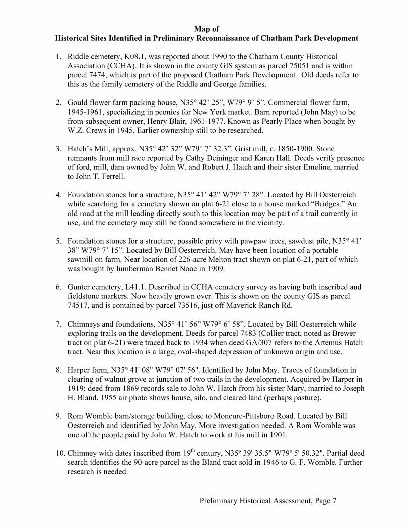
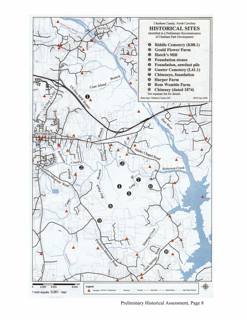
Map of
Historical Sites Identified in Preliminary Reconnaissance of Chatham Park Development
1. Riddle cemetery, K08.1, was reported about 1990 to the Chatham County Historical
Association (CCHA). It is shown in the county GIS system as parcel 75051 and is within parcel 7474, which is part of the proposed Chatham Park Development. Old deeds refer to this as the family cemetery of the Riddle and George families.
2. Gould flower farm packing house, N35° 42’ 25”, W79° 9’ 5”. Commercial flower farm,
1945-1961, specializing in peonies for New York market. Barn reported (John May) to be from subsequent owner, Henry Blair, 1961-1977. Known as Pearly Place when bought by W.Z. Crews in 1945. Earlier ownership still to be researched.
3. Hatch’s Mill, approx. N35° 42’ 32” W79° 7’ 32.3”. Grist mill, c. 1850-1900. Stone
remnants from mill race reported by Cathy Deininger and Karen Hall. Deeds verify presence of ford, mill, dam owned by John W. and Robert J. Hatch and their sister Emeline, married to John T. Ferrell.
4. Foundation stones for a structure, N35° 41’ 42” W79° 7’ 28”. Located by Bill Oesterreich
while searching for a cemetery shown on plat 6-21 close to a house marked “Bridges.” An old road at the mill leading directly south to this location may be part of a trail currently in use, and the cemetery may still be found somewhere in the vicinity.
5. Foundation stones for a structure, possible privy with pawpaw trees, sawdust pile, N35° 41’
38” W79° 7’ 15”. Located by Bill Oesterreich. May have been location of a portable sawmill on farm. Near location of 226-acre Melton tract shown on plat 6-21, part of which was bought by lumberman Bennet Nooe in 1909.
6. Gunter cemetery, L41.1. Described in CCHA cemetery survey as having both inscribed and
fieldstone markers. Now heavily grown over. This is shown on the county GIS as parcel 74517, and is contained by parcel 73516, just off Maverick Ranch Rd.
7. Chimneys and foundations, N35° 41’ 56” W79° 6’ 58”. Located by Bill Oesterreich while
exploring trails on the development. Deeds for parcel 7483 (Collier tract, noted as Brewer tract on plat 6-21) were traced back to 1934 when deed GA/307 refers to the Artemus Hatch tract. Near this location is a large, oval-shaped depression of unknown origin and use.
8. Harper farm, N35° 41' 08" W79° 07' 56". Identified by John May. Traces of foundation in
clearing of walnut grove at junction of two trails in the development. Acquired by Harper in 1919; deed from 1869 records sale to John W. Hatch from his sister Mary, married to Joseph H. Bland. 1955 air photo shows house, silo, and cleared land (perhaps pasture).
9. Rom Womble barn/storage building, close to Moncure-Pittsboro Road. Located by Bill
Oesterreich and identified by John May. More investigation needed. A Rom Womble was one of the people paid by John W. Hatch to work at his mill in 1901.
10. Chimney with dates inscribed from 19th century, N35º 39' 35.5" W79º 5' 50.32". Partial deed
search identifies the 90-acre parcel as the Bland tract sold in 1946 to G. F. Womble. Further research is needed.
Preliminary Historical Assessment, Page 8