a geologic study of the pontatoc mine...
TRANSCRIPT

A geologic study of the Pontatocmine area, Pima County, Arizona
Item Type text; Thesis-Reproduction (electronic)
Authors Medhi, Purnendu Kumar, 1936-
Publisher The University of Arizona.
Rights Copyright © is held by the author. Digital access to this materialis made possible by the University Libraries, University of Arizona.Further transmission, reproduction or presentation (such aspublic display or performance) of protected items is prohibitedexcept with permission of the author.
Download date 17/07/2018 03:20:38
Link to Item http://hdl.handle.net/10150/553996
A GEOLOGIC STUDY OF THE PONTATOC MINE AREA,
PIMA COUNTY, ARIZONA
by
Purnendu K, Medhi
A Thesis Submitted to the Faculty of the
DEPARTMENT OF GEOLOGY
In Partial Fulfillment of the Requirements For the Degree of
MASTER OF SCIENCE
In the Graduate College
THE UNIVERSITY OF ARIZONA
1964
STATEMENT BY AUTHOR
This thesis has been submitted in partial fulfillment of requirements for an advanced degree at The University of Arizona and is deposited in the University Library to be made available to borrowers under rules of the Library.
Brief quotations from this thesis are allowable without special permission, provided that accurate acknowledgment of source is made. Requests for permission for extended quotation from or reproduction of this manuscript in whole or in part may be granted by the head of the major department or the Dean of the Graduate College when in his judgment the proposed use of the material is in the interests of scholarship. In all other instances, however, permission must be obtained from the author.
SIGNED:
APPROVAL BY THESIS DIRECTOR
This thesis has been approved on the date shown below:
W. C. LACY Professor of Geology
C. LACY Date
ACKNOWLEDGMENTS
The author acknowledges his gratitude to Dr. Willard C.
Lacy, for his encouragement and constant help throughout his graduate
study, for the suggestion of this problem, and for his constructive crit
icism s during the preparation of this thesis.
The Alumni Association of the University of Arizona aided in
this project with a special research grant for which the author is very
grateful.
The author extends thanks to Mr. Fred Pashley of the U. S,
Geological Survey, D r .. Eldred D. Wilson and Mr. Wesley Peirce of
the Arizona Bureau of Mines, and Dr. S. P. Bag of the Chemistry
Department of the University of Arizona for helpful discussions regard
ing different problems encountered in preparation of this thesis.
Finally, the author wishes to express his thanks to his wife,
Mrs. Sarah Jane Medhi, for her constant help and encouragement dur
ing the writing of this thesis.
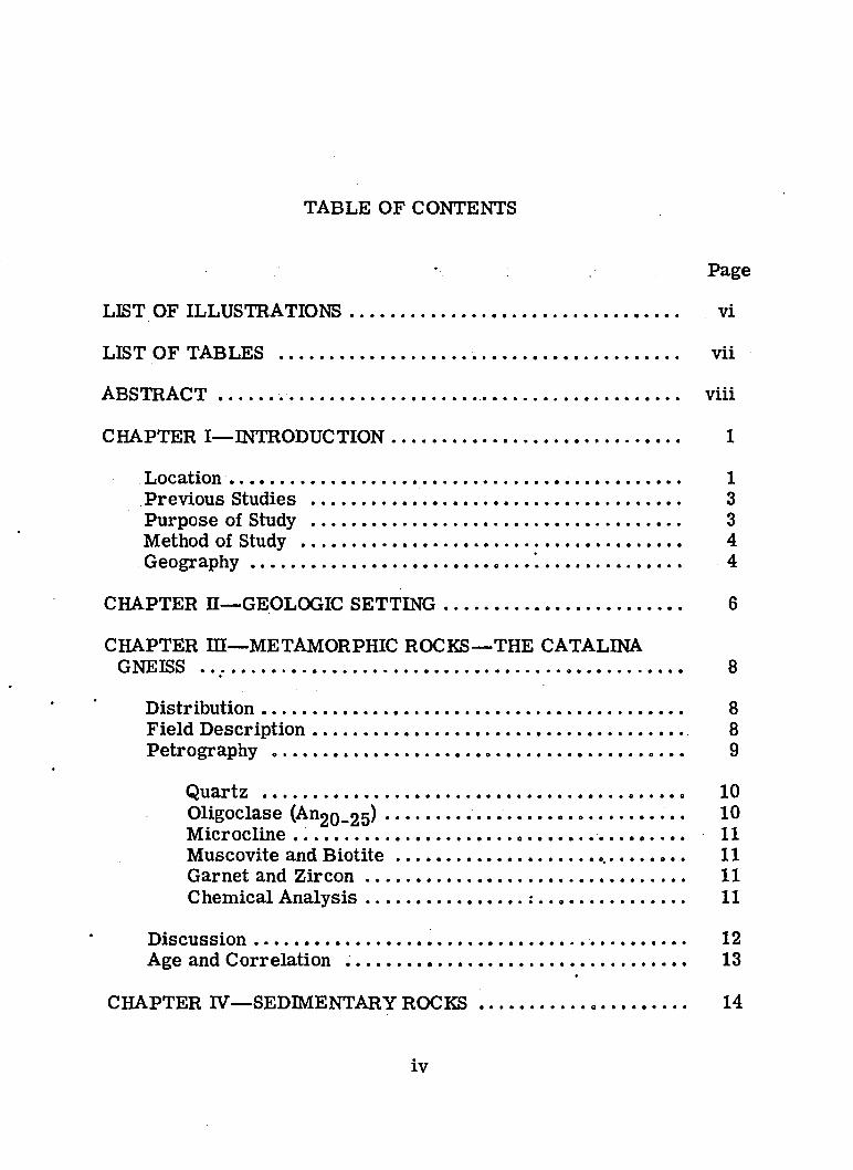
TABLE OF CONTENTS
Page
LIST OF ILLUSTRATIONS ........................ ..................................... .. vi
LIST OF TABLES ................................................................................... vii
ABSTRACT........... ............................ ............ .......................................... viii
CHAPTER I— INTRODUCTION............................................................. 1
Location .................................................................... 1Previous Studies .................................................................. 3Purpose of Study .................................................................................. 3Method of Study .................................................................................... 4Geography........................................................ "............................... 4
CHAPTER H— GEOLOGIC SETTING......................................... 6
CHAPTER HI— METAMORPHIC ROCKS— THE CATALINA GNEISS ......................................................................................................... 8
Distribution............................................................................................. 8Field D escription.................................................................................. 8Petrography .......................................................................................... 9
Quartz ........................................................................................ 10Oligoclase (A n g t^ s ) ................... 10Microcline ....................................................... 11Muscovite and B io t it e ....................................................... 11Garnet and Z ir c o n ..................................................... 11Chemical A n a ly sis ................................ : ................................ 11
D iscu ssion .................................................................................... 12Age and Correlation ........................................................................... 13
CHAPTER IV— SEDIMENTARY ROCKS ..................................... 14
iv
V
TABLE OF CONTENTS— Continued
Page
Cenozoic D ep osits............................. 14Distribution ....................................................................................... 14
• General Character and Petrography........................................... 16Age and C orrelation .................................... 17
CHAPTER V— STRUCTURAL GEOLOGY ......................................... 19
Santa Catalina Foothill Fault ................ 19Cross F aults................................................... 26F o ld s .................................................................................................... 27Joints ............................................................................................. 27Foliation and Lineation .......... 29
CHAPTER VI—ECONOMIC GEOLOGY ........................... 31
Mining History ........................... 31M ineralization.......................................................................... 33A lteration ............... .*....................... .................................................. 35Ore Control ... . .......................................................................... 37Par a g e n e s is ........................................................................ 38
CHAPTER VH— CONCLUSION .......................................... 41
CHAPTER VHI— LITERATURE C IT E D ............... .................. ; ____ 43
LIST OF ILLUSTRATIONS
Figure . Page•» *
1. Location m a p ................................................................ ............ .. 2
2. Composition of the Cenozoic deposits .................................... 15
3. Deformation of the Catalina Gneiss at the north endof Campbell Avenue ............................................. .. 21
4. Structure and deformation of the lower .Pantano Beds . . . . 22* - $ •
5. Diagram showing foliation in the Catalina G n e is s ............... 23
60 Paragenetic sequence of the ore minerals ............................ 39
Plate Page
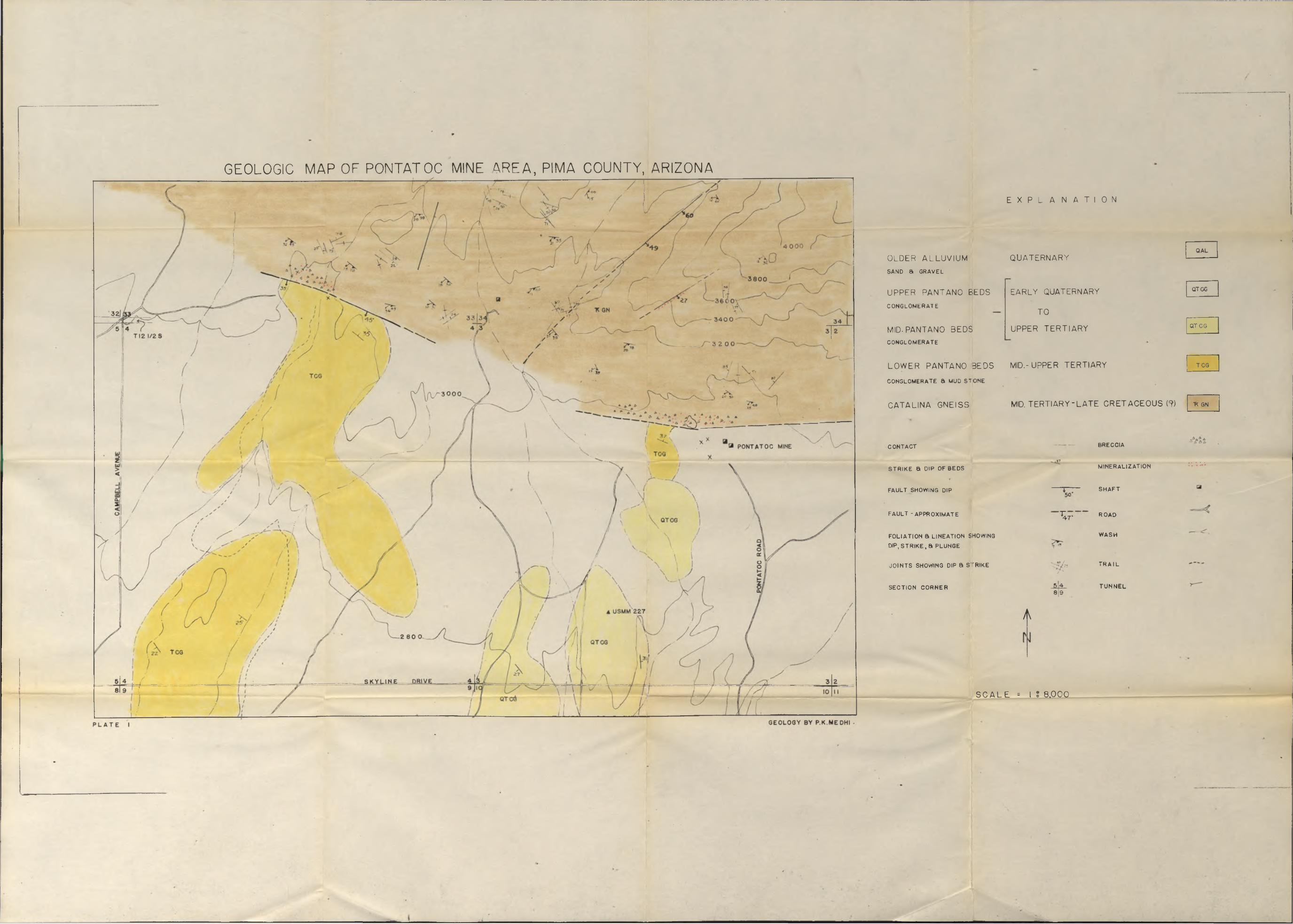
1. Geologic map of the Pontatoc mine a r e a ................................ in pocket
20 Structural map of the Catalina Gneiss, Pontatocmine area ................................................................................... 20
vi
LIST OF TABLES
Table Page
1. Spectrographic analyses, of the ore of the Pontatoc .m in e .............* .............................................................................. 34
vii
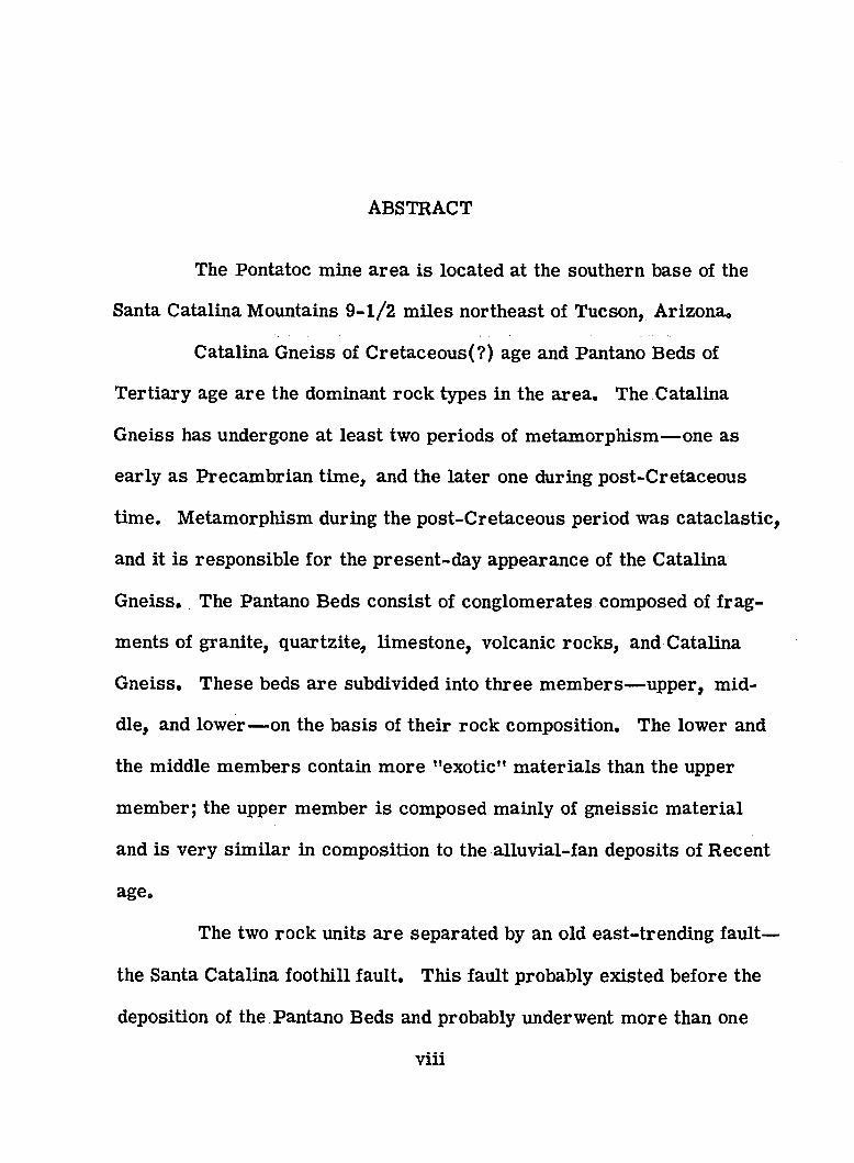
ABSTRACT
The Pontatoc mine area is located at the southern base of the
Santa Catalina Mountains 9-1 /2 m iles northeast of Tucson, Arizona.
Catalina Gneiss of Cretaceous(?) age and Pantano Beds of
Tertiary age are the dominant rock types in the area. The Catalina
Gneiss has undergone at least two periods of metamorphism— one as
early as Precambrian time, and the later one during post-Cretaceous
time. Metamorphism during the post-Cretaceous period was cataclastic,
and it is responsible for the present-day appearance of the Catalina
Gneiss. The Pantano Beds consist of conglomerates composed of frag
ments of granite, quartzite, limestone, volcanic rocks, and Catalina
Gneiss. These beds are subdivided into three members— upper, mid
dle, and lower— on the basis of their rock composition. The lower and
the middle members contain more ’’exotic” materials than the upper
member; the upper member is composed mainly of gneissic material
and is very sim ilar in composition to the alluvial-fan deposits of Recent
age.
The two rock units are separated by an old east-trending fault—
the Santa Catalina foothill fault. This fault probably existed before the
deposition of the Pantano Beds and probably underwent more than one
viii
ix
period of movement. Field evidence suggests that the final movement
was reverse movement. The Pantano Beds were deposited against this
fault at or near their present position. There is no evidence in the
Pontatoc mine area to assume the Pantano Beds as a thrust block.
Copper metallization of the Pontatoc mine area is of m eso-
thermal intensity, and the paragenetic sequence of minerals is quartz,
pyrite, chalcopyrite, molybdenite(?), bornite, chalcocite, and covellite;
the latter two minerals are of super gene origin. Wall-rock alteration
in the Pontatoc mine is very well defined but restricted to a small zone.
It is closely associated with copper metallization. Silicification and
propylitization are the two main alteration types observed along with
sporadic dolomitization. Ore localization is controlled by the struc
tural features of the Santa Catalina foothill fault, which served as a
channel for the metallizing solutions. The Catalina Gneiss did not play
any important role as a host rock. There is no metallization in the
Pantano Beds.
CHAPTER I INTRODUCTION
The area of this study is a sm all portion of the Santa Catalina
Mountains immediately north of Tucson, Arizona.
Many pioneer workers in the field of geology have examined
the area since the early part of this century, and systematic studies
have been made. The copper mineralization in the southern foothills
of the Santa Catalina Mountains has been known since 1906 but has not
received much detailed geologic attention. In this study the origin and
the control of this metallization are given consideration.
Location
The Pontatoc mine area is located on the south slope of the
Santa Catalina Mountains, Pima County, Arizona, 9 -1 /2 m iles north
east from the city of Tucson. Campbell Avenue and Skyline Drive lead
from Tucson to the base of the area, but most of the area has to be
covered by foot. The area includes secs . 3 and 4, R. 14 E ., T. 13 S.
(G. & S. R. base); the S - l /2 sec . 33 and the S - l /3 sec. 34, R. 13 E .,
T. 12 S . ; and the eastern portion of the wedged township, R. 14 E ,, T.
12-1/2 S.
1
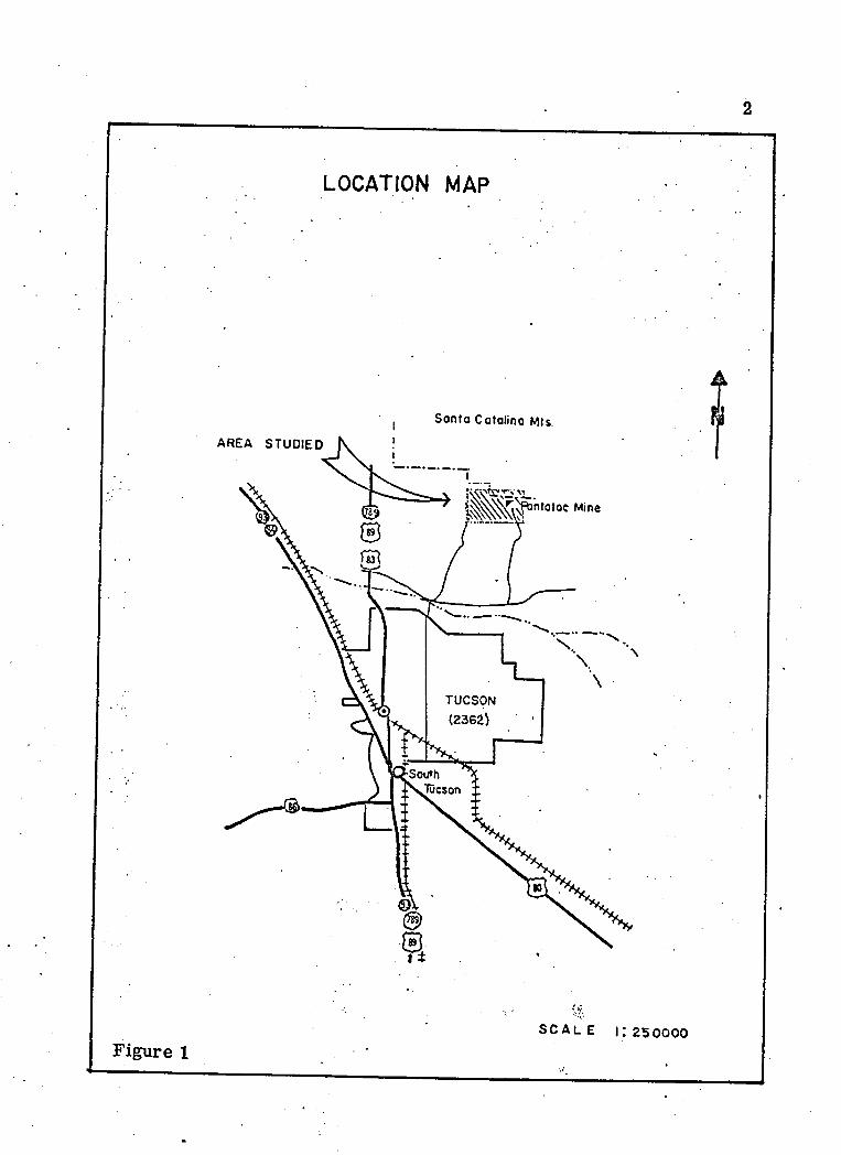
LOCATION MAP
Sonfo Catalina Mts.
AREA STUDIED
South
%SCALE 1:250000
Figure 1
3
Previous Studies
No detailed geologic study has been previously made of the
Pontatoc area. A general geologic study of the Tucson quadrangle was
conducted by Moore and others during 1941. Wilson and Moore (1959)
included this area in their structural studies on the Basin and Range
province of southern Arizona. In 1959, DuBois described the petrology
and structure of the Santa Catalina Mountains. Fair and Jinks studied
the nature of the Santa Catalina foothill fault in 1961. In addition, there
have been numerous studies in the Santa Catalina Mountains submitted
as m asters’ theses and doctoral dissertations at the University of
Arizona.
Purpose of Study
The geologic study of the Pontatoc area was made to partially
fulfill requirements for the degree of Master of Science in Geology at
the University of Arizona. The problem was to interpret the structural
history and determine controls of copper metallization. Geologic
mapping was confined to an area of approximately 2 .5 square m iles
astride the fault contact between the gneiss of the Santa Catalina Moun
tains and the Pantano lake-bed deposits of the foothills.
4
Method of Study
An enlargement of a U.S. Geological Survey 1957 topographic
map (North Tucson quadrangle, scale 1:24,000) to a scale of 1:8,000
with a contour interval of 40 feet was used as a base map for geologic
mapping.
The fieldwork was done during July and August of 1962, and
almost the entire 2 months were spent in the field. Mapping was done
using pace and Brunton compass ground control. Enlarged aerial
photographs of the area aided in determining location. Underground
mapping of the Pontatoc mine was not possible due to its inaccessibility.
Several rock samples (both oriented and unoriented) were col
lected from the area. These samples were studied megascopically.
Thin and polished sections of selected specimens were made, and these
were studied using a petrographic microscope. A binocular microscope
was used to examine the sedimentary rocks.
Geography
The Pontatoc mine area lie s on the southern slope of the Santa
Catalina Mountains. The maximum elevation in the mapped area is
about 3,400 feet. The Pantano Beds are encountered below an eleva
tion of approximately 2,800 feet.

Drainage in the area is accomplished by a series of intermit
tent stream s, which generally follow zones of structural weakness and
flow southward over a pediment surface to the Rillito Wash,
The climate and vegetation are typical of southern Arizona.
5
CHAPTER H GEOLOGIC SETTING
The State of Arizona can be structurally grouped into two large
units— the Plateau province and the Basin and Range province. The
northeastern half of the State constitutes the Plateau province, and the
Basin and Range province includes the remainder of the State.
In southern Arizona the Basin and Range province is charac
terized by isolated north-northwest-trending mountain ranges rising
above the great desert plain.
A wide diversity in rock types of different ages has been re
ported in the Basin and Range province of Arizona. These rock types
range from Precambrian schist and gneiss to sedimentary units of
Cenozoic age.
The Pontatoc area is within the Basin and Range province and
lies along the southern flanks of the Santa Catalina Mountains. The
rock encountered in this portion of the Santa Catalina Mountains is dom
inantly gneiss. DuBois reported that these rocks have gone through at
least two periods of metamorphism. He thinks that the earlier period
metamorphosed sedimentary and volcanic rocks into Pinal Schist during
Precambrian time. The later one, which occurred in the
6
7
post-Cretaceous, caused the development of the Catalina Gneiss and
schist in their present form in the Santa Catalina Mountains.
The bajada south of the Santa Catalina Mountains in the Pontatoc
area is occupied by recent alluvial fan deposits capping a pediment sur
face. Fragments in these fan deposits are dominantly gneiss derived
from the Santa Catalina Mountains.
A few isolated outcrops of Cenozoic rocks have been exposed
under these alluvial fan deposits. These are mainly conglomerate beds
composed of pebbles derived from diversified rock types. The name
"Pantano Beds'* has been applied to these beds in literature (Moore and
others, 1941); these same beds have been called the Rillito Formation
by Voelger (1953).
The younger Cenozoic rocks and the older gneissic rocks of
the Pontatoc area are separated by a fault—the Santa Catalina foothill
fault. This fault was mapped as a thrust by Moore and others (1941)
extending along the foot of the Santa Catalina, Tanque Verde, and Rincon
Mountains. It lim its the extent of the Catalina Gneiss to the south.
CHAPTER mMETAMORPHIC ROCKS— THE CATALINA GNEISS
Distribution
In the Pontatoc area, the Catalina Gneiss is exposed along the
southern slope of the Santa Catalina Mountains, The gneissic rocks are
bounded on the south by the Santa Catalina foothill fault, which separates
them from the younger Cenozoic deposits.
The Catalina Gneiss of the Pontatoc area is a part of the Santa
Catalina granitic complex, which forms the core of the mountain m ass.
According to Moore and others (1941), this core consists of a batholith,
which together with its envelope of altered gneissic rocks may be re
ferred to as the Santa Catalina granitic complex.
Field Description
The gneiss exposed in the Pontatoc area has uniform granitic
composition. The Catalina Gneiss is white to cream colored on a fresh
surface but has a slightly brownish tint on weathered surfaces. At
places it is silvery gray due to bands of fine muscovite mica. The rock
is foliated with feldspar and quartz augen alternating with bands rich in
mica.
8
9
At the fault contact adjacent to the Pontatoc mine shaft and at
the end of the North Campbell Avenue, the Catalina Gneiss has de
veloped a well-defined brecciated zone. This zone, in which gneissic
rocks have been sheared, altered, and mineralized, is 200 to 300 feet
wide.
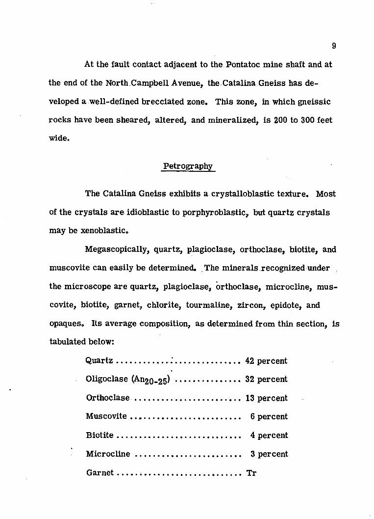
Petrography
The Catalina Gneiss exhibits a crystalloblastic texture. Most
of the crystals are idioblastic to porphyroblastic, but quartz crystals
may be xenoblastic.
Megascopically, quartz, plagioclase, orthoclase, biotite, and
muscovite can easily be determined. The minerals recognized under
the microscope are quartz, plagioclase, orthoclase, microcline, mus
covite, biotite, garnet, chlorite, tourmaline, zircon, epidote, and
opaques. Its average composition, as determined from thin section, is
tabulated below:
Quartz ........................ ..................................42 percent
Oligoclase (An2 Q-2 5 ) .............................. 32 percent
O rthoclase................................................. 13 percent
Muscovite .................................................... 6 percent
B io tite .......................................................... 4 percent
M icro c lin e ................................................. 3 percent
G arnet......... ...................................................Tr
10
C hlorite.................................................................Tr
Epidote.............. Tr
Opaques ....................... Tr
Quartz
Porphyroblastic to xenoblastic turbid quartz is the dominant
mineral in the Catalina Gneiss. Quartz grains show undulating extinc
tion. Occasionally quartz grains are seen as inclusions in feldspar and
within quartz grains them selves.
Oligoclase (An2o„25)
Porphyroblastic plagioclase grains have a cloudy appearance.
In some plagioclase grains inclusions of muscovite and quartz are seen.
The plagioclase porphyroblasts are sometimes severely crushed.
Orthoclase
Cloudy grains of orthoclase showing carlsbad twinning occur
as idioblastic crystals. Some of the larger crystals have corroded out
lines, which may be due to alteration. Occasionally it has been kaolin-
IZed. r f * v
11
Microcline
Microcline occurs with the plagioclase and shows character
istic cross-hatch twinning,
Muscovite and Biotite
Muscovite and biotite grains are arranged in a planar pattern,
the major foliation direction of the gneiss. These two minerals are
seen as inclusions in feldspar grains without preferred orientation,
Biotite is very strongly pleochoric and ranges from dark brown to yel
low, Muscovite and biotite grains are wrapped around the porphyro-
blasts of feldspar and quartz. Occasionally biotite is altered to chlo
rite.
Garnet and Zircon
Tiny euhedral crystals of garnet occur in the gneiss. Garnet
is generally pink to red in color and has been fractured. Zircon occurs
in small xenomorphic crystals, and chlorite is seen as an alteration
product of biotite.
Chemical Analysis
Results of a chemical analysis made by the writer of the
Catalina Gneiss were:
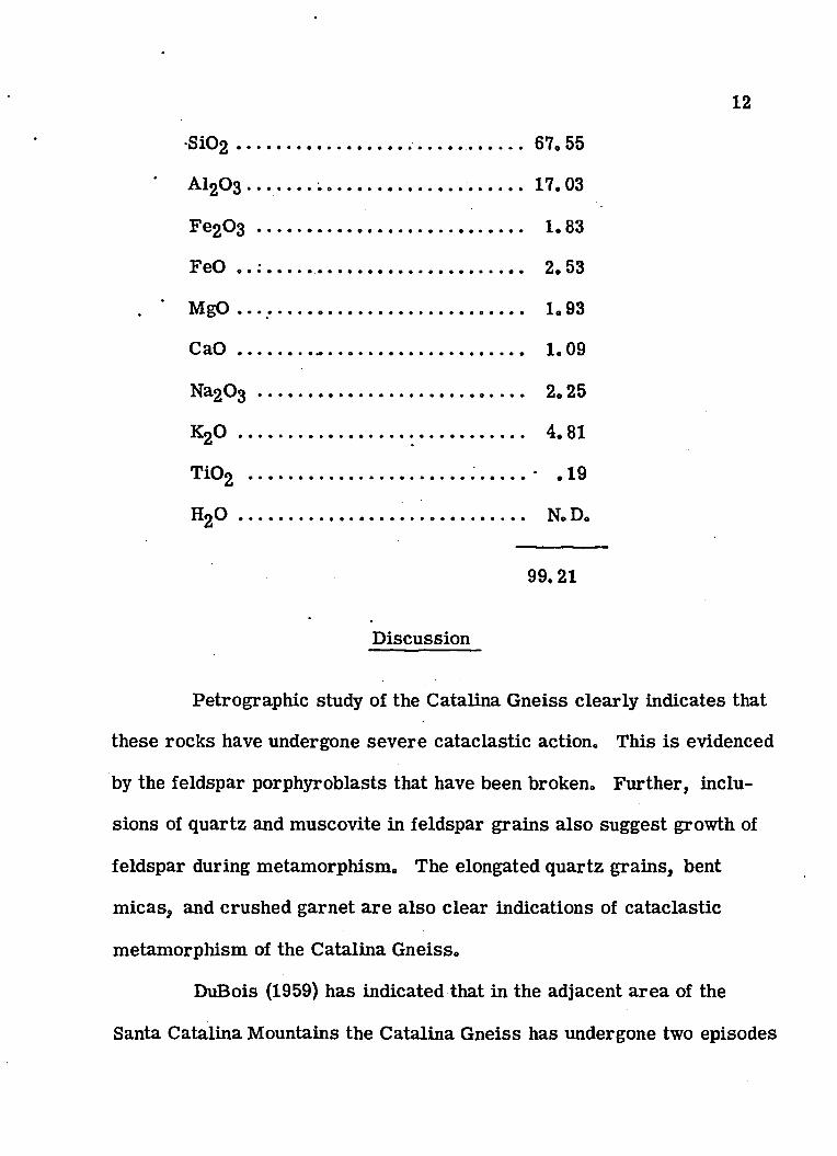
8102 .................................... .......... ............ 67.55
' Al203 ............................................. ............ 17.03
Fe203 ............... ........................................ 1.83
FeO ......... ............................................ 2.53
. ’ MgO ............................................................ 1.93
C a O ............... - .......................................... 1.09
Na203 ........................................................ 2.25
K20 .................................... 4.81
T102 ............................................. ............ • .19
H20 .................................. N.D.
12
99.21
Discussion
Petrographic study of the Catalina Gneiss clearly indicates that
these rocks have undergone severe cataclastic action. This is evidenced
by the feldspar porphyroblasts that have been broken. Further, inclu
sions of quartz and muscovite in feldspar grains also suggest growth of
feldspar during metamorphism. The elongated quartz grains, bent
m icas, and crushed garnet are also clear indications of cataclastic
metamorphism of the Catalina Gneiss.
DuBois (1959) has indicated that in the adjacent area of the
Santa Catalina Mountains the Catalina Gneiss has undergone two episodes
13
of metamorphism— the earlier one is dated as early as Precambrian,
and the later one may be post-Cretaceous* Similarly, the rocks of the
Pontatoc area have probably also undergone polymetamorphism, but the
late severe cataclastic metamorphism has not left many relicts of the
earlier metamorphism, . . .
Age and Correlation
The Santa Catalina granitic complex has been subdivided into
two groups (Moore and others, 1941)— a dominantly granitic part and a
dominantly gneissic part. One is a coarse-grained rock resembling a
sheared granite and the other an augen gneiss with porphyroblasts of
feldspar. The gneiss of the Pontatoc area belongs to the later group.
Hernon (1932) pointed out that this large granitic complex of meta
morphosed sediments and igneous rocks has been produced by extensive
intrusion in post or Late Cretaceous time. DuBois (1959) has assigned
a Precambrian age for the earlier phase of metamorphism of igneous
and sedimentary materials to form the Catalina Gneiss and post-Cre
taceous metamorphism with related cataclastic deformation forming
the Catalina Gneiss seen at the present time.
Recent Potassium-Argon dating of the Catalina Gneiss (Damon
and others, 1962) indicates a 26.8+1.7 million year age. This places
latest metamorphism of the Catalina Gneiss in Miocene time.

CHAPTER IV SEDIMENTARY ROCKS
Cenozoic Deposits
The Cenozoic deposits in the Pontatoc mine area are repre
sented by Pantano lake beds and Recent alluvial-fan deposits* The com
position and the distinctive color of the Pantano Beds are the main
features that distinguish them from the Recent alluvial-fan deposits.
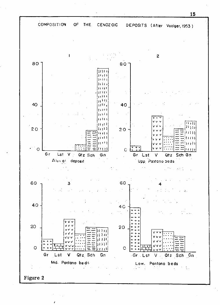
The writer followed the same technique as Voelger (1953) and used
histograms to subdivide the Pantano Beds of the area (fig. 2).
The Pantano Beds were subdivided by Voelger (1953) into three
divisions— upper, middle, and lower. These divisions have been fol
lowed in this study.; The basis of this division is the peculiar compo
sitional features and the presence of "exotic" and "no exotic" m aterials.
Exotic refers to those rock fragments, such as granite, quartzite,
limestone, and volcanic rocks, that are not known to occur in situ in
the present drainage system . .
Distribution
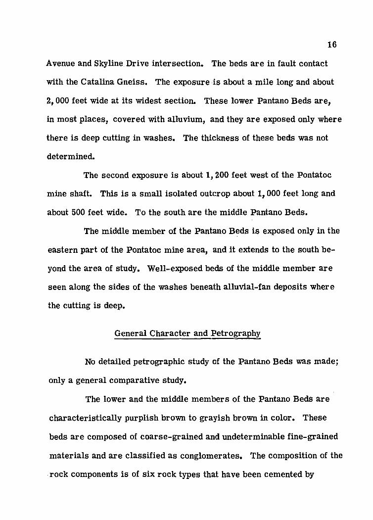
The lower Pantano Beds are exposed in two places in the area.
The first exposure is encountered between the north end of Campbell
14
15
COMPOSITION OF THE CENOZOlC DEPOSITS (After Voelger, 1953 )
40 _
2 0 -
— .
tm >H > I >> i ) D
)) )l t> m >
),)!)M>,.>nU ,l l ( M i i ' ' i 1111 > iiii)l u l lii 111 tt i i »i i i > l
f M >1Gr Lst V Qfz Sch
Aiuvo! deposit
Figure 2
/
16
Avenue and Skyline Drive intersection. The beds are in fault contact
with the Catalina Gneiss. The exposure is about a mile long and about
2,000 feet wide at its widest section. These lower Pantano Beds are,
in most places, covered with alluvium, and they are exposed only where
there is deep cutting in washes. The thickness of these beds was not
determined.
The second exposure is about 1,200 feet west of the Pontatoc
mine shaft. This is a sm all isolated outcrop about 1,000 feet long and
about 500 feet wide. To the south are the middle Pantano Beds.
The middle member of the Pantano Beds is exposed only in the
eastern part of the Pontatoc mine area, and it extends to the south be
yond the area of study. W ell-exposed beds of the middle member are
seen along the sides of the washes beneath alluvial-fan deposits where
the cutting is deep.
General Character and Petrography
No detailed petrographic study of the Pantano Beds was made;
only a general comparative study.
The lower and the middle members of the Pantano Beds are
characteristically purplish brown to grayish brown in color. These
beds are composed of coarse-grained and undeterminable fine-grained
materials and are classified as conglomerates. The composition of the
rock components is of six rock types that have been cemented by
17
calcareous materials. The different rock types are granite, gneiss,
schist, phyllite, limestone, quartzite, and volcanic rocks. It has been
observed that there is a gradual change in composition from the lower
to the upper member of the Pantano Beds. The granite, limestone,
quartzite, and vole antes are dominant, while gneiss is absent in the
lower member. In the middle and the upper members the granite,
limestone, quartzite, and volcanics gradually decrease, and the gneissic
material dominates. The Recent alluvium is largely composed of
gneissic materials.
Materials.comprising the conglomerate consist of semirounded
to rounded pebbles ranging to a maximum diameter of 2 feet near the
mountain front. The degree of roundness of the pebbles was not deter
mined. There is well-defined regular stratification in the Pantano Beds
averaging about a foot in thickness.
Age and Correlation
Due to the absence of fo ssils or any other definite criteria, the
age of the Pantano Beds cannot be determined with certainty. However,
comparison of these beds with other Cenozoic formations and correlation
with geologic events in the region may permit a general age assignment.
The middle member of the Pantano Beds is much le ss deformed,
and its composition resem bles the alluvial deposits of Recent age. It
can be surmised that they have not gone through the mid-Tertiary
18
diastrophism that was very widespread in southern Arizona. On this
basis, the middle member .can be placed in the range of late Tertiary
to early Quaternary in age.
The lower member of the Pantano beds is more deformed than
the two upper members. Probably, it has been subjected to at least
some of the effects of the mid-Tertiary deformation and might be placed
in the middle Tertiary range.
Voelger (1953) stated that the lowest member of the Pantano
Beds may be older than late mid-Tertiary diastrophism, although an
age close to the lowest part of the Gila Conglomerate is not impossible.
The middle member, according to Voelger, is considered equivalent to
the Gila Conglomerate (upper Pliocene and Pleistocene) of southern
Arizona.
Recent geochemical dating has been done on the lower Pantano
Beds from the Pantano ash flow, collected just east of Davidson Canyon
on the Benson Highway, by Potassium-Argon methods (Damon and others,
1962). The age determined is 36.7+2.1 million years. This places the
lower Pantano Beds as Oligocene in age. .
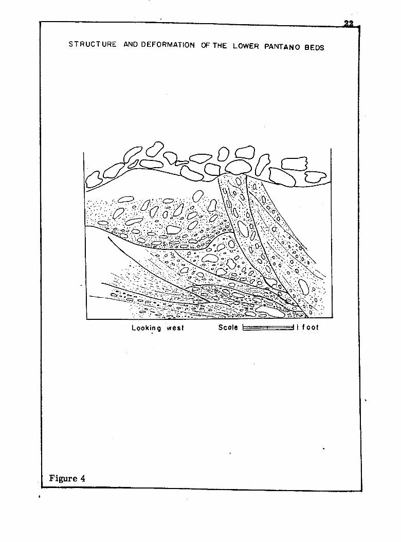
CHAPTER VSTRUCTURAL GEOLOGY
The structural features of the Pontatoc mine area were exam
ined. Most of the features, such as faults, folds, joints, lineation,
and foliation are restricted to the Catalina Gneiss, which has been dis
cussed in the preceding paragraphs. The Pantano Beds are relatively
undeformed, except for the lower member. No detailed structural
study was made of the Pantano Beds. The structural elements mapped
in the Pontatoc area are plotted on plate 2 and figures 3, 4, and 5.
: Santa Catalina Foothill Fault
In the Pontatoc mine area, the Santa Catalina Foothill fault is
the most significant structural feature. This fault has been mapped as
a thrust along the southern foothills of the Santa Catalina, Rincon, and
Tanque Verde Mountains (Moore and others, 1941). To the north the
Catalina Gneiss is exposed, and to the south the younger Pantano Beds
are exposed.
There are only two good exposures of the Santa Catalina Foot
hill fault in the area. The first exposure is near the Pontatoc mine
shaft, and it can be traced for about 1, 800 feet in a westerly direction.
19
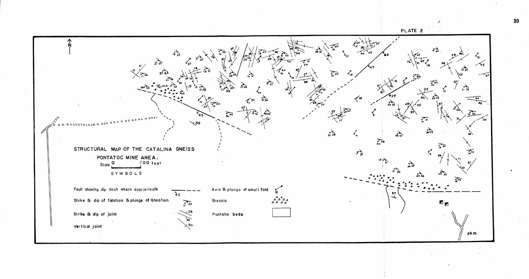
/
PLATE 2
\ W
STRUCTURAL MAP OF THE CATALINA GNEISS
PONTATOC MINE AREA.Srziio 0 7 00 feet
S Y MB O L S
Fault showing dip dash where approximate Axis B plunge of small fold
Strike B dip of foliation B plunge of lineation Breccia
Strike 5 dip of joint Pan taho beds
Vertical joint
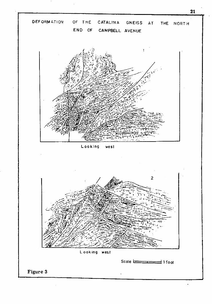
21
DEFORM AT I ON OF THE CATALINA GNEISS AT
END OF CAMPBELL AVENUE
THE NORTH
m m #
L o o k i n g west
-iflp”L o o k in g west
Scale k 1 foot
Figure 3
2 1
STRUCTURE AND DEFORMATION OF THE LOWER PANTAN0 BEDS
Looking w es t Scole h ^ I f o o t
Figure 4
23
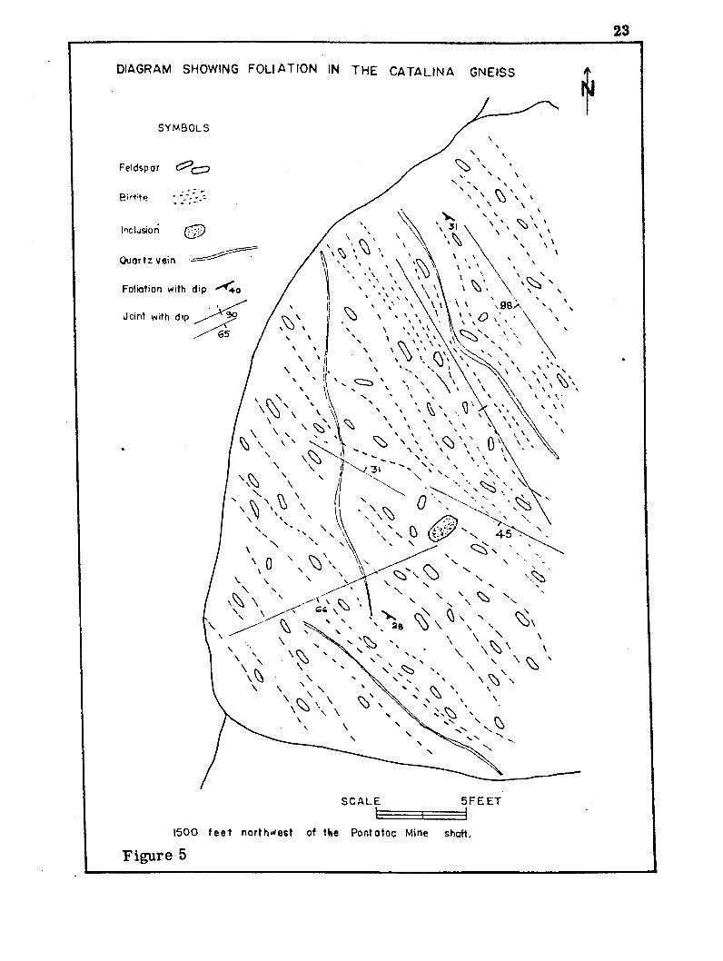
DIAGRAM SHOWING FOLIATION IN THE CATALINA GNEISS
SYMBOLS
Feldspar
Inclusion
Foliation with dip
Joint with dip
^ x\ \
5FEETSCALE
1500 f e e t northwest of the Pontotoc Mine shaft.
Figure 5
24
The second c lo s u r e is in the northwest corner of the mapped area at
the north end of Campbell Avenue* In this exposure the fault has a
northwest strike. The dip of the fault ranges from 45° to 60° to the
south.
Along the fault there is a brecciated zone 200 to 300 feet wide
with shearing, alteration, and mineralization. These features are only
seen in the older competent gneiss and are not observed in the incom
petent Pantano Beds.
Earlier workers have reported this fault variously as a normal
fault (Fair and Jinks, 1961) or as a thrust fault (Moore and others, 1941
Moore and Wilson, 1959). Therefore, the writer very carefully exam
ined both possibilities, and his findings at the Pontatoc mine area are
summarized below.
From general observation, it is suggestive that there has been
more than one period and direction of movement along this fault. After
careful examination of the Pantano Beds at the fault contact, it appears
that the Pantano Beds have not been subjected to all the stages of defor
mation during the history of this fault. This is indicated by a compara
tive study made of the nature of deformation at the fault contact between
the Catalina Gneiss and the Pantano Beds. The competent Catalina
Gneiss at the fault contact has been subjected to intense deformation,
as evinced by the large brecciated zone with shearing and alteration.
On the other hand, incompetent Pantano Beds do not show as extensive
25
deformation even at the fault contact. From this comparative study, it
can be concluded that there has been stronger movement along the Santa
Catalina foothill fault prior to Pantano Beds, or perhaps there was some
movement during the time of deposition. Penecontemporaneous deforma
tion of the Pantano Beds cannot be ruled out, as contorted beds, faults,
and even interformational breccia have been observed in these beds
(Shrock, 1948).
The idea of the Pantano Beds being an over thrust block in the
Pontatoc mine area is not very well substantiated. It seem s more likely
that the Pantano Beds were deposited near their present position against
the Catalina Gneiss. It is difficult for the writer to believe that the
Pantano Beds have been brought to their present position by a fault d is
placement of several thousand feet.
The nature of the Santa Catalina foothill fault is yet unsolved,
and there is not enough evidence to definitely establish its actual move
ment at the area of present study. However, field evidence noted by the
writer suggests an early normal faulting followed by reverse movement
along the fault during its final stage.
The Pantano Beds south of the fault dip at an angle of 30° to 40°
to the north, while a few hundred feet farther south these beds dip to
the south with a gentle dip of 20° to 25°, The Pantano Beds in the hang
ing wall, thus, dip toward the fault and appear to have been dragged;
This suggests reverse movement.
The foot wall Catalina Gneiss exhibits a thin drag zone, in
dicating reverse movement at the fault contact; a study of the slicken-
sides and minor faults of the Catalina Gneiss at the fault zone also
suggests a reverse movement. Earlier normal movement is suggested
by the foliation in the gneiss adjacent to the fault zone.
Cross Faults
Three important cross faults have been observed in the Catalina
Gneiss around the Pontatoc mine area. These faults generally strike
northeasterly and dip to the southeast.
The easternmost cross fault is exposed about 2,600 feet north
west of the Pontatoc mine shaft. The fault strikes N. 60° E. and dips
27° to the southeast. Minor copper metallization is seen in a small
prospect pit along the fault plane. Copper in the form of silicate and
carbonate minerals is associated with a quartz vein 3 to 4 inches in
thickness.
The second cross fault is exposed about 1,000 feet west of the
former one. The strike of this fault is N. 50° E. with a moderate dip
ranging from 49° to 60° to the southeast. No metallization was observed
along this fault.
The third fault is farther west, about a mile from the north
end of Campbell Avenue. The fault strikes N. 70° E. with an average
dip of 64° to the southeast.
26
27
These cross faults cut the foliation direction of the Catalina
Gneiss and appear to be late in the structural history; they appear to
have offset the Santa Catalina foothill fault with right-hand displace
ment of at least 500 to 700 feet in the northwest section of the Pontatoc
area. The actual displacement was not observed, as the area is covered
with thick alluvium.
Folds
No large folds have been recognized in the area, but the writer
believes that the area lie s on the southern limb of a large elongate
dome. The major axis of this dome runs in an easterly direction
(McCullough, 1963). Along this limb the writer has noted well-defined
corrugations or warpings. The axes of these corrugations generally
run in a northeast direction and plunge to the southeast at angles of 5°
to 20°. The high values were observed at the northeast corner of the
area near the north end of Campbell Avenue.
Joints
There is a wide variety of joints developed in the Santa Catalina
Gneiss. The major joints have been grouped in three system s: (1)
north-northwest, (2) east, and (3) northeast.
The most common joint sets in the gneiss belong to the first
system . These joints range in strike from north-northwest to almost
northwest and are generally vertical or have a very steep dip to the
south; however, dips to the north are not uncommon.
The next most important joint set is the east-trending system .
These joints generally strike in an easterly direction, but in places they
are seen to range from east to almost northeast. The angle of dip
ranges from 11° to 45° to the south with a few exceptional northerly
dips. Locally, these joints are vertical or have very steep angles of
dip.
The third set of joints strike northeast and dip either to the
south or to the north with values ranging from 18° to vertical, but they
average between 20° to 45°.
Careful observations were made in an attempt to correlate
these joint system s with cross joints, diagonal joints, and longitudinal
joints (Balk, 1936). It has been noted that northwest-trending joints of
the Catalina Gneiss seem to strike perpendicular to the lineation direc
tion and might represent Q-joints or cross joints. The east-trending
system might be considered as diagonal joints, as the joints are almost
at an angle of 45° to the lineation of the gneiss. . Lastly, the northeast
trending system may represent longitudinal joints, as the joints are
parallel to the lineation of the Catalina Gneiss. Thus, it appears from
the observations that these three joint system s of the Catalina Gneiss
might be classified as cross joint, diagonal joint, and longitudinal joint.
However, the writer questions the validity of the correlation, since
28
29
Balk considered these joint sets to be characteristic of intrusive
igneous rocks. These joints are in a gneiss-Catalina Gneiss, although
they may have resulted from mobilization of the gneissic m ass.
No fillings have been noted in these joints in.the Catalina Gneiss
except for minor reddish-brown iron oxide staining, which probably is
supergene in origin.
Foliation and Lineation
The foliation of the Catalina Gneiss strikes generally N. 70° W,
to N. 50° W. with a minor variation; locally, foliation strikes almost
easterly. The average dip ranges from 20° to 45° to the south. The
foliation in the Catalina Gneiss is revealed by the orientation and align
ment of feldspar, quartz, and mica crystals, and planes of foliation are
occasionally followed by aplite(?) and quartz veins.
Locally, there are marked changes in the orientation of the
foliation in the Catalina Gneiss. The reason for these deviations is un
certain, but along with these deviations contorted quartz veins, tightly
folded schistosity in the gneiss, and ptygmatic folds have been observed.
These features might indicate a plastic movement of material or may
even be due to magmatic activity.
The foliation of the Catalina Gneiss has obscured any older re
lict structures of these rocks. Only in a few places were unoriented
"ghost inclusions" of undeterminable origin noted.
30
The lineation in the Catalina Gneiss is expressed by elongated
biotite, feldspar, and quartz grains or m asses and has a very consist
ent trend in the Pontatoc area. The lineation strikes generally from N.
15° E. to N. 50° E. and plunges to the southwest at angles ranging from
7° to 35°. Locally, however, there are variations, and in places the
strike may swing to N. 70° E. The lineation of the Catalina Gneiss of
the Pontatoc mine area is significant in its uniformity.
CHAPTER VI ECONOMIC GEOLOGY
Mining History
The Pontatoc mine was located in the year 1906 and developed
with a 20-foot winze. The same year the claim s were sold for $10,000.
The original locator remarked, concerning this find: "It is a great
copper mine" (Texas-Arizona Copper Co. Report, 1917).
The Pontatoc Copper Co. acquired the claim s, and during the
period 1907-10 they sunk a shaft of 105 feet. Ore assaying up to 10.3
percent copper with an average of about 5 percent copper was extracted.
Unofficial reports reveal that gold and silver values almost paid the
operating costs.
The Pontatoc Copper Co. had 28 claim s and 4 m ill-site claim s.
The ore was upgraded by hand sorting at the mine dump before it was
shipped for milling and smelting. The production during the year 1907
was approximately 1,000 tons valued at $18,000 (Copper Handbook, 1912-
13). Production figures for the rest of the years are not available. Fol
lowing dissolution of the Pontatoc Copper C o., the mine was idle for
several years.
31
In 1927 the Texas-Arizona Co. was formed, a successor of
the Pontatoc Co. The Texas-Arizona Co. had 27 claim s, of which 13
were patented.
Most of the mining was done from the two old shafts and one
new 125-foot shaft. Underground workings totaled 1,000 feet, including
drifts, winzes, and several slopes. The mine was equipped with hoist
and com pressors. During the year 1918, the same management spent
about $25,000 in exploration work. However, most of this was spent in
drilling 19 diamond-drill holes, ranging from 56 feet to 446 feet, and 3
churn-drill holes, ranging from 80 feet to 284 feet in depth. Most of
the drilling was confined to the brecciated zone adjacent to the Catalina
Gneiss. This drilling was reported to have indicated a total potential
reserve of 75,000 tons of copper ore (The Mine Handbook, 1926).
The total ore mined out in the Pontatoc mine was approximate
ly 2, 000 tons of 2 to 5 percent copper grade.
The mine has been idle since 1918, except for annual a sse ss
ment work. At present, the Pontatoc mine and the surrounding area
are owned by Mr. George Wilson, and the mine shaft is being used as a
water reservoir. During the last 10 years, Mr. Wilson has driUed
three water wells and has reported passing through additional ore-
bearing zones in virgin areas.
32
33
Mineralization
There is no known intrusive body in the vicinity of the Pontatoc
mine area. The source of metallizing solutions is unknown. Due to
the absence of such an intrusive body and from the mode of occurrence
of metallization along the fault zone, it appears that metallizing solu
tions came up along the fault from some source at unknown depth. This
fault acted as a channel for the solutions.
Most of the primary copper minerals have been mined from
the accessible areas of the Pontatoc mine. At the present time, only
oxidized copper minerals and rare sulfide can be observed. The old
mine dump has some remnants of the ore that was mined and gives evi
dence regarding the nature of metallization,
Pyrite, chalcopyrite, bornite, and traces of molybdenite occur
as hypogene sulfide minerals, Chalcocite and covellite have been ob
served as super gene copper minerals. Oxidized bright-colored copper
minerals in the form of malachite, azurite, and chrysocolla have been
noted in the mine dump and in underground workings. Quartz, sericite,' •> - ■ r , '
epidote, ankerite, hematite, and limonite have been noted as gangue
minerals.
Four rock samples of the ore were spectr©graphically analyzed,
and the results have been tabulated in table 1,
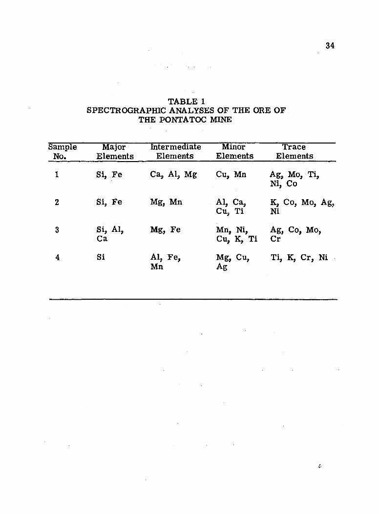
34
TABLE 1SPECTROGRAPHIC ANALYSES OF THE ORE OF
THE PONTATOC MINE
SampleNo.
MajorElements
IntermediateElements
MinorElements
TraceElements
1 Si, Fe Ca, Al, Mg Cu, Mn Ag, Mo, Ti, Ni, Co
2 Si, Fe Mg, Mn Al, Ca, Cu, Ti
K, Co, Mo, Ag, Ni
3 Si, Al, Ca
Mg, Fe Mn, Ni, Cu, K, Ti
Ag, Co, Mo, Cr
4 Si Al, Fe, Mn
Mg, Cu, Ag
Ti, K, Cr, Ni
£■
35
As already mentioned above, there is strong silicification
along the fault zone at the Pontatoc mine, which suggests hydrothermal
activity effecting rock alteration and subsequent metallization along the
fault zone. There is no direct evidence as to the thermal intensity of
this metallization, but from the mineral associations and alteration
mineral assemblages it appears that metallization is probably of shal
low mesothermal intensity.
Alteration
The alteration of wall rocks at the Pontatoc mine can be clas
sified as silicification, propylitization, and sporadic dolomitization.
The alteration and metallization of the Pontatoc mine are intimately
associated and represent a continuous process without a time break,
Silicification is the dominant process in the wall-rock altera
tion of the Pontatoc mine and is intense in the fault zone of the Santa
Catalina foothill fault at the Pontatoc mine. The study of polished sec
tions of the ore minerals under the microscope revealed that sulfide
minerals and quartz have mutual relationship and exhibit inter growth
relations indicating coprecipitation. It has also been noted in the mine
workings that along the small faults and fractures in the main fault
zone copper minerals and silicification occur together and appear to
have come in at the same time.
36
Formation of chlorite, epidote, and clay minerals in the alter
ation zone can be considered as propylitization. In the alteration zone
of the Pontatoc mine chlorite occurs in the outer fringe and probably
occurred contemporaneously with silicification. Development of chlorite
is due to hydrothermal metamorphism (Turner and Verhoogen, 1951).
There may be two distinct occurrences of hydrothermal chlorite. The
first type results from the breakdown of ferromagnesian minerals of
the host rock— the Catalina Gneiss. This variety has been observed in
thin sections where biotite has been replaced by chlorite. The second
forms during hydrothermal activity with addition of magnesia (Barker,
1939). By breaking down ferromagnesian minerals and addition of
magnesia in the rock, a "magnesia front" was built up, which moved
ahead under the influence of a local gradient in chemical potential.
Chlorite was thus formed away from the zone of intense activity.
Epidote is not a major mineral in the alteration zone. From
the petrographic study, it was revealed that epidote is commonly as
sociated with quartz and occasionally fills cracks and crevices of quartz
grains. The minerals occur as fine-grained m asses in which some well-
developed crystals have been observed. Copper minerals may locally
be closely related to epidote. Minor sericite is also observed and is
generally an alteration product of biotite.
Dolomitization in the Pontatoc mine occurs in the alteration of
limestone blocks within the fault zone. Spotty occurrences of these
37
limestone and quartzite fragments of Paleozoic (?) age have been noted
in the Santa Catalina foothill fault zone. The source of these fragments
is a subject for conjecture, and their relationship to the Catalina Gneiss
is not clear. These limestone fragments appear to have been altered
to dolomite during hydrothermal activity. There may be a question
whether this dolomite could be of primary origin, but it has been ob
served that away from the mine area there is fresh limestone fragments
without any dolomite. From this, the writer concludes that dolomite of
the Pontatoc mine is a hydrothermal alteration product of limestone.
Ore Control
The metallization in the Pontatoc mine area is controlled by
structural features and physical-chemical environment. The metalliza
tion has been localized along the fault zone wherever rock alteration is
intense; both result from hydrothermal activity.
Examination of the metalliferous deposits of the Pontatoc mine
area reveals that metallization is associated with the faults and frac
tures cutting the Catalina Gneiss. The principal fault control is the
east-trending Santa Catalina foothill fault. Commercial values have
always been immediately adjacent to the fault zone. Subsidiary faults
and tensional breaks intersecting the main fault zone are favorable lo
calities of ore localization. As a host rock, the Catalina Gneiss has
38
not played any important role. The schistosity of the gneiss does not
have any influence over the ore control.
Observations were made on the surface rock exposures and on
the mine dump. Only a very small portion of the underground workings
of the mine can be seen at the present time. Detailed underground
study was not possible due to lack of accessibility.
Par agenesis
Several polished sections were prepared from the ore samples
collected from the mine dump and from underground workings. These
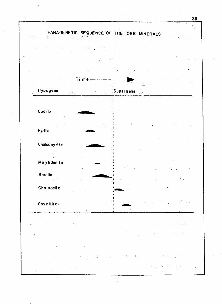
polished sections were studied under the m icroscope, and a general
paragenetic sequence was established (fig. 6).
The Santa Catalina foothill fault is an old, structurally weak
zone that has undergone several periods of movement. It formed a
permeable zone that permitted access of the metallizing fluid. Quartz
was deposited generally earlier than the sulfides, with the exception of
pyrite. In polished sections it has been observed that quartz has a
corroded appearance and shows evidence of being replaced by later
sulfide minerals, although there does not appear to have been any break
in depositional process.
Pyrite is earlier than ore sulfides and is veined by all copper
minerals. Pyrite is seen as euhedral crystals as well as highly frac
tured m asses exhibiting * ’exploded-bomb’1 textures. Occasionally,
39
PARAGENETIC SEQUENCE OF THE ORE MINERALS
Hypogene
Ti m e
S u p e rg en e
Quartz
Pyrrte
Chalcopyrite
Molybdenite
Bornite
Cholcocite
Cov el l i te-
• i.
40
pyrite crystals have been altered to limonite pseudomorphs, which are
associated with oxidized copper minerals, Pyrite crystals are usually
localized along small fractures, and these fractures are later filled
with other sulfides,
Hypogene sulfide minerals of the Pontatoc mine are represented
by chalcopyrite and bornite. C haleopyrite and bornite generally show
mutual replacement texture; however, chalcopyrite is more abundant
than bornite.
Besides chalcopyrite and bornite, traces of molybdenite were
noted in the polished sections and in the mineralized veins. The rela
tionship between the copper minerals and molybdenite is not clearly
understood. It appears that molybdenite may have been precipitated
along with copper metallization or might have been introduced later.
Chalcocite and covellite are the only super gene copper sulfide
minerals; they replace chalcopyrite and bornite. Chalcocite is more
abundant than covellite.
Brightly colored blue and green copper silicate and carbonate
minerals are disseminated throughout the oxide zone.
CHAPTER VH CONCLUSION
The writerls field and laboratory studies and the work of pre
vious workers in the area seem to justify the following conclusions:
The gneissic rocks exposed in the Pontatoc mine area have
undergone polymetamorphism like the other gneissic rocks of the ad
jacent areas in the Santa Catalina Mountains, and the final form of
metamorphism was produced by cataclastic action in post-Cretaceous
time.
The Santa Catalina foothill fault seem s to be a pre-existing
weak zone in the Catalina Gneiss, along which more than one period of
movement took place before deposition of the Pantano lake beds. The
present field evidence suggests reverse movement as the last move
ment, and an earlier normal movement is indicated.
The Pantano Beds do not appear to be an overthrust block in
the Pontatoc mine area. It appears that these beds were deposited
against the Santa Catalina foothill fault near their present position.
The Santa Catalina foothill fault acted as a channel for the
copper metallizing solutions, and sm all faults and fractures along this
fault helped to localize the copper values. The schistosity of the Cata
lina Gneiss did not play any part in ore control.41
The spotty occurrence of copper metallization and the limited
extent of rock alteration suggest that it is unlikely that any large ore
body exists in the near vicinity of the Pontatoc mine area*
42
CHAPTER YHI LITERATURE CITED
Balk, Robert, 1936, Structural behavior of igneous rocks: Geol, Soc. America.Mem. 5.
Blissenbach, Erich, 1951, Geology of the alluvial fans in Arizona: unpublished m a sters thesis, Univ. Arizona, Tucson.
Copper handbook, 1912-13, The copper handbook: Walter Harvey Weed, Houghton, Michigan.
Davis, W. M ., 1931, Santa Catalina Mountains, Arizona: Am. Jour.S c i., v. 22, no. 130, p. 289-317.
Damon, P. E ., and others, 1962, Correlation and chronology of oredeposits and volcanic rocks: Geochemistry and Geochronology Laboratory, Univ. Arizona.
DuBois, R. L ., 1959, Geology of the Santa Catalina Mountains: Arizona Geol. Soc., Southern Arizona Guidebook H, p. 107-116.
________' 1959, Petrography and structure of a part of the gneissiccomplex of the Santa Catalina Mountains, Arizona: Arizona Geol. Soc., Southern Arizona Guidebook H, p. 117-126.
Edwards, A. B ., 1947, Texture of the ore minerals: Australian Inst. Mining and Metallurgy, Inc.
Fair, C. L ,, and Jinks, J. E ., 1961, Santa Catalina foothills fault in the Pontatoc area: Arizona Geol. Soc. Digest, v. IV.
Barker, A ., 1939, Metamorphism: Methuen and C o., London.
Hernon, R. M ., 1932, Pegmatitic rocks of the Catalina-Rincon Mountains, Arizona: unpublished master’s thesis, Univ. Arizona, Tucson.
Lahee, F. H ., 1941, Field geology: McGraw-Hill Book C o., New York.
43
44
McCullough, E. J ., J r ., 1963, A structural study of the PuschRidge- Romero Canyon area, Santa Catalina Mountains, Arizona: unpublished doctoral thesis, Univ. Arizona, Tucson.
Mine handbook, 1926, The mine handbook: The Mine Handbook C o., Inc., 8 W. 40th S t., New York.
Moore, B. N ., Tolman, C. F . , Butler, B. S ., and Hernon, R. M .,1941, Geology of the Tucson quadrangle, Arizona: U. S. Geol. Survey open-file report.
Pettijohn, F. J . , 1949, Sedimentary rocks: Harper Brothers, New York.
Shrock, R. R ., 1948, Sequence of layered rocks: McGraw-Hill Book C o., New York.
Turner, F. J. , and Verhoogen, J . , 1951, Igneous and metamorphic geology: McGraw-Hill Book C o., New York.
Voelger, Klaus, 1953, Cenozoic deposits in the southern foothills of the Santa Catalina Mountains, Arizona: unpublished m aster's thesis, Univ. Arizona, Tucson.
Wilson, E. D ., and Moore, R. T ., 1959, Structure of .Basin and Range province in Arizona: Arizona Geol. Soc., Southern Arizona Guidebook H, p. 89-105.
L
GEOLOGIC MAP OF PONTATOC MINE AREA, PIMA COUNTY, ARIZONA
E X P L A N A T I O N
OLDER ALLUVIUM
SAND a GRAVEL
UPPER PANTANO BEDS
CONGLOMERATE
MID. PANTANO BEDSCONGLOMERATE
QUATERNARY
EARLY QUATERNARY
TO
UPPER TERTIARY
QAL
QTGG
QTCG
LOWER PANTANO BEDS MID.- UPPER TERTIARY
c o n g l o m e r a t e a mud s t o n e
TOG
CATALINA GNEISS MID. TERTIARY-LATE CRETACEOUS (?) TK GN
CONTACT
STRIKE a DIP OF BEDS
FAULT SHOWING DIP
FAULT - APPROXIMATE
FOLIATION a LINEATION SHOWING
DIP, STRIKE, a PLUNGE
JOINTS SHOWING DIP 8 S TRIKE
SECTION CORNER
A
Lr
£'V rs
5, 4
CD 9
BRECCIA
MINERALIZATION
SHAFT
ROAD
WASH
TRAIL
TUNNEL
SCALE = I o 8 ,0 0 0