8 evaluation of agroforestry potential in sloping areas8 evaluation of agroforestry potential in...
TRANSCRIPT

8 Evaluation of agroforestry potential in sloping areas
Anthony Young
International Council for Research in Agroforestry, P.O. Box 30677, Nairobi, Kenya.
Acknowledgements
Being in the nature of a synthesis, this paper owes much to the work of the colleagues in ICRAF, to whom thanks are extended. In particular, I have drawn heavily on data gathered by the ICRAF agroforestry systems inventory, and would like to thank its Director, Dr. P.K.R. Nair, the regional coordinators and field collaborators, and Mr. E. Fernandes for his help in selecting appropriate examples and for discussion of meth- ods for agroforestry system description. Where the present paper departs in detail from terms used in the system inventory, the responsibility is my own.
Abstract
Eight examples of agroforestry systems in sloping areas are described with two exam- ples of economic analysis of agroforestry systems. The ICRAF diagnosis and design methodology is outlined, exemplified and compared with land evaluation procedures. Distinctive features in land evaluation for agroforestry are that surveys commence with a phase of diagnosis; that the performance of systems, and hence the land-use requirements, cannot be precisely specified at present; and that as a consequence, the output from agroforestry surveys is frequently a research programme. The ICRAF/ FAO project, Land Evaluation for Agroforestry, is outlined. Classification of an agro- forestry land utilization type as highly suitable for a given area is not related to environ- ment alone but depends on existing land-use systems and problems. The major benefit that agroforestry can bring to sloping areas lies in its capacity to combine soil conserva- tion with productive functions. Agroforestry may often be the preferred form of land use in sloping lands which have problems of soil erosion, soil fertility decline and shortages of fuelwood or fodder. Sloping areas should be a priority environment for the application of research and development in agroforestry.
8.1 Questions
The title of this paper covers three entities: land evaluation, agroforestry and sloping areas. Since relations between two of these, land evaluation and sloping areas, is the subject of this symposium, this leaves two other sets of relationships as the primary questions, namely: 1 . How can land evaluation be applied to agroforestry? 2. What benefits can agroforestry offer as a kind of land use in sloping areas? Anticipating that the answers to these are broadly positive, that is, that agroforestry
does have a potential in sloping areas and that this potential can be evaluated,
106

then two further and more specific questions can be asked:
kinds of land use in sloping areas?
opment effort in agroforestry?
3. Under what circumstances, and in what respects, is agroforestry superior to other . 4. Are sloping areas a priority environment for the application of research and devel-
t
8.2 Agroforestry
8.2.1 Agroforestry as a major kind of land use
Agroforestry refers to land-use systems in which trees are grown on the same land as agricultural crops and/or animals, either in a spatial arrangement or a time se- quence, and in which there are both ecological and economic interactions between the tree and non-tree components (Lundgren, 1982, modified). Note that ‘tree’ is here used as an abbreviation for woody plants, comprising trees, shrubs and bamboos.
The second part of this definition, the need for interactions, is an essential feature of agroforestry land-use systems. Economic interactions can mean simply that the tree and the crop (and/or animal) each supply part of the farmers’ needs; or could involve, for example, the tree harvest providing capital which is put into improvements to crop production. Ecological interactions are numerous; examples are fertilization with litter from nitrogenfixing trees, feeding of high-protein leaf litter to cattle, the manure from which is then applied to crops, or the soil conservation functions of trees.
Is agroforestry more closely related to agriculture or forestry? Neither. Most agro- +forestry, probably over 90%, is carried out on agricultural land, and by farmers; as will be illustrated below, the commonest starting point for agroforestry developments is farmland that has problems. Yet it is the distinctive features and functions of trees which are the essence of agroforestry. Given that the concept of a major kind of land use is in any case loosely defined, agroforestry can usefully be regarded as such.
I 8.2.2 Terminology
Agroforestry components refer to the three elements of a land-use system, the tree (= woody perennial), herb (agricultural crop or pasture plants) and animal. The first two are always present, the last sometimes. This leads to a simple classification of agroforestry systems: Agrosilvicultural systems: crops and trees Silvopastoral systems: Agrosilvopastoral systems: Other systems:
pastures, animals and trees crops, animals and trees (with or without pastures) e.g. mangrove with fishing, apiculture in trees.
The tree component is almost always a multipurpose tree. After extensive considera- tion of both concepts and examples it has been found that the land-use system within which a tree is grown is an essential part of this definition. Hence multipurpose trees (MPTs) are those which are grown, or kept and managed, for more than one major
107

purpose (product or service), economically and/or ecologically motivated, in an agro- forestry or other multipurpose land-use system (von Carlowitz, 1984, modified). Ex- pressed more simply, multipurpose trees are those which provide more than one signifi- cant contribution to the production and/or service functions of the land-use systems they occupy (Huxley, 1984). The main functions of multipurpose trees are listed in Table 8.1'.
Table 8. I Functions of multipurpose trees. Adapted from the ICRAF multipurpose tree data sheet (von Carlowitz, 1984).
Wood
Fodder
Food
fuelwood (inc. charcoal) timber (sawnwood) poles (domestic timber) other (e.g. carvings) browse cut-and-carry 1 (inc. leaves, seeds, shoots)
fruit, nuts oils beverages other edible products oils, gums, waxes, dyes, tannin fibres, thatching latex medicinal uses
shelter (from wind) soil conservation (inc. reclamation) soil improvement fencing (= barrier function) moisture conservation
Other products
Services shade (from sun)
Thus the same tree species can be monopurpose where it is managed to optimize one output only, as in a forest plantation managed for timber products; or multipur- pose where management is intentionally directed towards two or more outputs, e.g. fuelwood, fodder, shelter, conservation. ,
Agroforestry practices are the more common arrangements of components in space and time, coupled with the major functions of the tree component. This is more easily illustrated than defined, as in Table 8.2.
An agroforestry system is a set of agroforestry practices within a specified physical, economic and social setting; the land-use system itself may be based on agroforestry, or the agroforestry system may fulfil certain functions within the broader context of the land-use system as a whole. Agroforestry systems are described in terms of their biological, technical, economic and social aspects.
This term, widely employed in agroforestry literature, is so nearly equivalent to the standard definition of a land utilization type that agroforestry system and agrofor- estry land utilization type may be taken as synonymous. As with land utilization types, existing agroforestry systems are frequently specific to a local region but are potentially extendable to other areas with similar environmental, economic and social conditions.
108

Table 8.2 Agroforestry practices. Adapted from the ICRAF agroforestry systems inventory (ICRAF, 1983d; Nair, 1984).
Improved tree fallow Taungya Alley cropping (hedgerow intercropping) Boundary planting Live fences Multipurpose trees on: - cropland - rangeland - pastures - homesteads Woodlots (with multipurpose management) Trees as shelter for: - crops (windbreaks, shelterbelts) - animals - homesteads Trees for soil conservation: - on bunds, terraces - strips - hedges Agricultural tree/shrub crops - lower-storey tree/shrub crops - herbaceous crop - upper storey trees - pastures and livestock Aquaforestry (mangrove) Apiculture with forestry
8.3 Sloping areas and their environments
Sloping areas are here assumed to refer to slope classes c and bc on the FAO/UNESCO Soil Map of the World, that is, areas with dominant slopes over 17"/30% or a combina- tion of this with areas of 5" - 17"/8 - 30%. This paper is largely concerned with sloping areas in tropical and subtropical latitudes. . It may be remarked in passing that the slope classes on the world soil map are not the outcome ofa primary inventory of landforms, but are supplementary to classes and map units determined primarily on the basis of soil type. Since there are now also satisfactory world or continental maps of geology, climate and vegetation, the lack of a treatment of landforms at comparable intensity and coverage is deficiency in the inventory of land resources, which could lead to substantial errors in world-scale land evaluation or other estimates of production.
Within the tropics, sloping areas may be grouped on the basis of temperature and altitude into lowland and upland, separated at 1,200 m altitude. These correspond approximately to the division between Köppen A (hot) and B(warm) climates, and between the 'warm tropics' and 'cool tropics' of the FAO agro-ecological zones inven- tory. On the basis of amount and duration of rainfall, these lands may be further subdivided into humid climates (Köppen Af, Am and Ca, growing period > 270 days), and subhumid climates (Köppen Aw and Cw, growing period 120-270 days). Sloping lands with semi-arid climates are mainly of very low potential and will not be consid-
109

ered. This gives the following classes of sloping land in the tropics and subtropics.
I . Lowland humid tropics Hot, humid for all or most of the year, vegetation evergreen or semi-evergreen rain forest. Relief commonly either V-shaped valleys with narrow interfluves or convex interfluves, steepening downslope until they pass abruptly.into flat valley floors (‘demi- orange relief). Soils are normally ferralsols or acrisols, with nitic properties if on basic rocks.
This is by far the most extensivé tropical sloping-land environment, found in all continents but particularly in Central America, at lower altitudes in the Andean states of South America, in the West and East Indies, the south-east Asia mainland, Pacific islands and eastern tropical Australia. Common land-use systems in this environment are: - extractive forestry; - perennial, non-food crop plantations; - shifting cultivation of annual food crops, cereals or roots;
often with shortened fallow and consequent soil degradation; - terraced cultivation, including swamp rice (especially in Asia); - ranching (especially in South America). The principal environmental hazard is the very reserve rainfall erosivity. Others in- clude rapid oxidation of soil organic matter, high soil acidity with associated P fixation and aluminium toxicity (the last especially, for reasons not well understood, in South America), and rapid leaching. Besides soil erosion, there may be a hazard of accelerated landsliding.
The most common land-use problems are the cutting of rain forest faster than natu- ral or managed regeneration, and shortening of fallows with consequent soil degrada- tion and over-grazing, the two latter sometimes leading to soil erosion. Shortening of fallows is particularly likely in areas which lack the flat valley-floor land that permits swamp rice cultivation.
2. Highland humid tropics This is a less widespread environment, since most high-altitude regions have a dry season of sufficient length to fall into the subhumid zone. It occurs in parts of the Andes, and the highlands of Malaysia and the East Indies. A high proportion of relief is sloping. Soil become humic ferralsols and humic acrisols at higher altitudes.
Land-use systems are similar to those of the lowland humid zone except that com- mercial forestry is less common. Land-use problems include shortening of fallows with soil degradation; overgrazing and pasture degradation; and over-cutting for domestic fuelwood and timber leading to reduction in area and species depletion of remaining forests.
3. Lowland subhumid tropics ,
This is the savanna zone of Africa and the cerrado of South America, with one or two wet seasons (Köppen Aw or Aw’ respectively) and at least one long dry season. A high proportion of this climatic region is not sloping, other that on isolated insel- bergs. Areas of sloping lands occur, however, particularly in escarpment zones separat- ing erosion surfaces.
110

Common land-use systems include: .- cultivation of annual crops, often more or less without soil rest periods; - certain perennial crops, mainly towards the more humid margins; - extensive grazing (ranging or nomadic); - afforestation. Although rainfall erosivity is less than in the humid zone, the soil erosion hazard is almost as high, owing to the slower growth and less complete cover of the vegetation. Drought becomes a hazard in the drier parts of the zone (mean annual rainfall < 800 mm). The most widespread land-use problems are first, decline in soil fertility brought about by over-cultivation; secondly, degradation of natural deciduous woodlands through over-cutting with consequent fuelwood shortage; and thirdly, erosion, which is particularly common on grazing land.
4. Highland subhumid tropics This distinctive environment, sometimes loosely called the ‘highland tropics’, is exten- sive in East Africa (especially Kenya and Ethiopia), the Andes and the Himalayas, in the last of which it occurs under a climate of monsoonal origin and regime. Much of this climatic zone is not sloping, being either upland plateau or intermontane basins, but sloping land occurs at the borders of these. Notable examples are the extensive, steeply-sloping and deeply dissected lands of Ethiopia, and the so-called ‘foothills’ of the Himalayas.
Land-use systems include annual crops, perennial crops in the wetter parts of the zone, grazing and commercial afforestation. Terraced cultivation is common in the Himalayas.
Loss or degradation of natural forests is often considerable, and soil fertility decline and soil erosion are both common. The Ethiopian highlands combine severe soil ero- sion with almost complete destruction of natural forests. Systems of terraced cultiva- tion have become poorly maintained or abandoned in some areas.
8.4 Agroforestry in sloping areas
8.4.1 Examples
To illustrate the range of agroforestry practices and their potential in sloping areas, eight cases will be described. The first five are existing systems, ‘traditional’ in the sense of being evolved largely by the farmers of the area concerned, although incorpor- ating some relatively recently introduced crops. The sixth case is a development pro- ject, the seventh an example of experimental trials, while the last gives systems sug- gested in one of the ICRAF collaborative design projects. Two of these examples are drawn from Africa, three from south-east Asia, one from south Asia and two from South America. In these accounts, some added descriptors for land utilization types are employed, explained in Section 6.1 and Table 8.5 below.
1. Terraced hill farming, west Nepal The first case has been set out as a formal description of a land utilization type (Table 8.3). The Tinau watershed of west Nepal has a lowland subhumid climate, with
111

Table 8.3 Description of an agroforestry land utilization type: terraced hill farming, Nepal. - Title Environment
Socio-economic setting
Summary description
LUT descriptors outputs
Market
Capital intensity
Labour intensity
Technical knowledge
Land holdings
Tenure
Land improvements
Infrastructure requirements
Power
Mechanization
Input level
Cropping
Cultivation
Conservation practices
Irrigation Livestock '
Yields
Economics
Agroforesrry descriptors. Type Main interactions
Time
Space AF practices
Functions of trees
Terraced hill farming, western Nepal. Lowland subhumid climate (Köppen Aw) of monsoonal origin, 7-8 dry month; slopes steep, 20"-35" (36-70%)
Dense population, severe land shortage, average farm size 1 ha, low income, poor infrastructure
Slopes ('bari' land) are terraced, with maize and other rainfed crops on slop- ing treads, MPTs on risers (contour strips) and farm boundaries (vertical strips) (Figure 8.1).
Products: maize and other rainfed annual crops, cattle products, fuelwood Services: soil conservation.
Dominantly subsistence, plus local marketing.
Low
High
Of modern agricultural methods, low; moderately amenable to innovations.
Small, average 1 ha; some have separate lowland irrigated rice holding.
Owner-cultivated.
Terracing; unlike some other parts of Nepal, terrace treads are initially slop- ing, older ones becoming level.
Low; family processing of products; need for road access to local markets
Ox-ploughing, plus much manual power.
None.
Low; no artificial fertilizers, mainly local seed.
Maize, with subsidiary wheat, finger millet, mustard and legumes. Numerous vegetables and fruit in home gardens. MPTs on terrace risers, over 30 spp.
Ox ploughing, hand weeding. Trees pruned for fodder, cut for fuelwood.
Achieved through contour terraces, stabilized by trees.
Only on separate lowland fields, for rice. Cattle, buffalos, goats, poultry; for food, cash, draught, manure. Partly stall- fed, partly grazed. Contour tree strips may supply 40-60% of fodder.
Low; sample survey, maize 930 kg/ha, wheat 580 kg/ha.
No data.
Agrosilvopastoral (crops, trees, livestock)
Space, including off-site.
Static, interpolated.
Zonal, row. Main: MPTs for soil conservation, on terraces. other: boundary planting, MPTs around homesteads, live fence.
Soil conservation, fodder, fuelwood food, fencing.
112

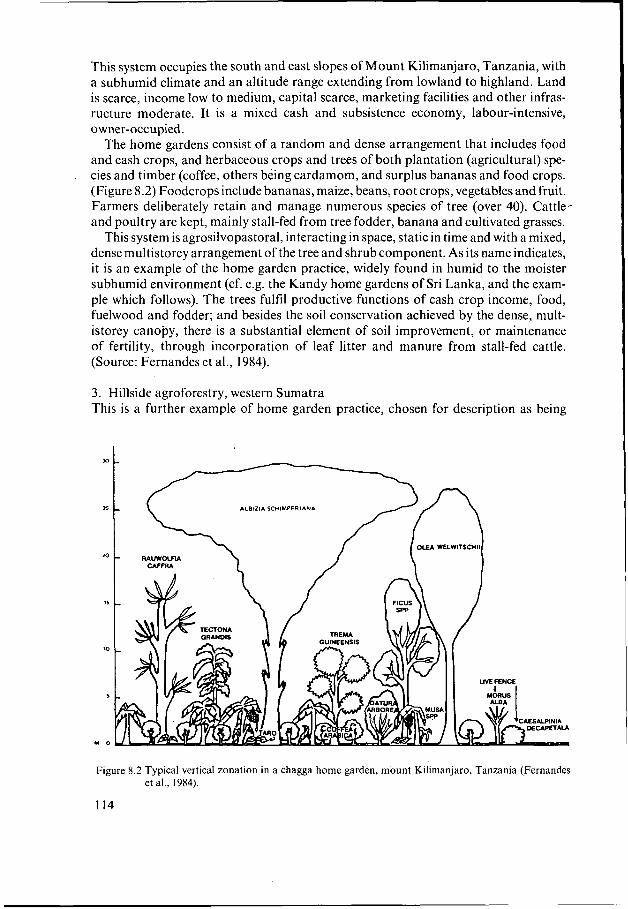
This system occupies the south and east slopes of Mount Kilimanjaro, Tanzania, with a subhumid climate and an altitude range extending from lowland to highland. Land is scarce, income low to medium, capital scarce, marketing facilities and other infras- ructure moderate. It is a mixed cash and subsistence economy, labour-intensive, owner-occupied.
The home gardens consist of a random and dense arrangement that includes food and cash crops, and herbaceous crops and trees of both plantation (agricultural) spe- cies and timber (coffee, others being cardamom, and surplus bananas and food crops. (Figure 8.2) Foodcrops include bananas, maize, beans, root crops, vegetables and fruit. Farmers deliberately retain and manage numerous species of tree (over 40). Cattle- and poultry are kept, mainly stall-fed from tree fodder, banana and cultivated grasses.
This system is agrosilvopastoral, interacting in space, static in time and with a mixed, dense multistorey arrangement of the tree and shrub component. As its name indicates, it is an example of the home garden practice, widely found in humid to the moister subhumid environment (cf. e.g. the Kandy home gardens of Sri Lanka, and the exam- ple which follows). The trees fulfil productive functions of cash crop income, food, fuelwood and fodder; and besides the soil conservation achieved by the dense, mult- istorey canopy, there is a substantial element of soil improvement, or maintenance of fertility, through incorporation of leaf litter and manure from stall-fed cattle. (Source: Fernandes et al., 1984).
3. Hillside agroforestry, western Sumatra. This is a further example of home garden practice, chosen for description as being
Figure 8.2 Typical vertical zonation in a chagga home garden, mount Kilimanjaro, Tanzania (Fernandes
114
et al., 1984).

in a different continent, a more humid climate and with differences of function. The area around Lake Maninjau, in the central part of west Sumatra, has a lowland humid climate (Köppen Af), with rainfall >3,000 mm and no dry months. AS the slopes are very steep, reaching to over 40".(84%), it need hardly be said that the erosion hazard is severe; there is also a serious hazard of accelerated landsliding if the slopes are cleared. The forests which remain have been taken over by the State. The farmers grow swamp rice where possible, in conjunction with the tree gardens of the hillsides.
The gardens are largely multi-storey tree arrangements, with herbaceous crops being only subsidiary. Among the commonest species is the beloved durian, cinnamon, cof- fee, nutmeg, and many timber species. These are farmed in various combinations, at least partly planned, e.g. durian + cinnamon + timber species. It is an agrosilvicul- tural system, interacting mainly in space, although gardens are sometimes abandoned or new ones established, giving an element of long-term fallowing. As in all home gardens, the spatial arrangement is mixed and dense. The trees fulfil functions of food and cash crop production, fuelwood and timber production, and erosion and landslide control. (Source: Michon et al., 1984).
4. Coffee-Erythrina-Cordia systems, Costa Rica Systems of coffee with an upper storey of trees, especially Erythrina poeppigiana and/ or Cordia alliodora, are widespread in Central and South America, sometimes on gently4oping land but often on sloping areas, in part because these provide some of the best sites for coffee. The same two species are also grown with cacao. Such. systems are found in humid to the moister subhumid lowland and highland environ- ments. They are exemplified in the vicinity of Turrialba, Costa Rica. The typical socio- economic environment differs from the preceding examples. Land is only moderately scarce, income levels at a low-intermediate level and infrastructure moderate.
The farming system is based on cash-cropping of coffee. Erythrina and/or Cordia are planted in the cropland, in some areas as rows, in others on a mixed, random, open to moderately dense arrangement. Erythrina are pruned several times a year, keeping them as a low stubby life form, and the prunings laid as mulch. Cordia are allowed to grow into tall trees. Erythrina is a nitrogen-fixing tree, and its use for soil fertility maintenance is intentional.
This is an agrosilvicultural system, interacting in space, with the components either in a mixed arrangement or as rows. The functions of the trees are:
Erythrina poeppigiana Cordia alliodora Coffee
Shade Soil improvement Mulch Soil conservation
Shade Cash crop Timber Fuelwood Soil conservation
(Sources: Budowski, 1983; Escalante, in press).
5 . Improved tree fallow, Philippines In Cebu Province, Philippines, a system of improved tree fallow using Leucaena leuco- cephala (leuco) is found. Although lowland subhumid, it is wet enough (1,620 mm) for rapid growth of leuco. Part of the farm is under crops, part planted to leuco for about three years. The leaf production restores soil fertility. When the trees are cleared,
115

the wood serves two purposes: fuelwood, and to make pegs used in check-barriers to control erosion. The farmers recognize both the fertility maintenance and the soil conservation functions of the trees. .
This example is included as a case in which the dominant interaction between the trees and non-tree components takes place in time, as a rotation. (Source: Eslava, 1984.)
6. Alley cropping with soil conservation, Rwanda The project Agro-Pastoral is a development project in Nyabisindu, Rwanda. The envi- ronment is highland subhumid and described as ‘mountainous’. Land is very scarce, income very low and infrastructure poor. There are problems ofsoil erosion, soil fertili- ty decline and deforestation. The efforts to combat these problems by the project in- clude a wide range of methods, only some of which involve trees namely: 1. Afforestation of denuded hilltops and badly degraded farmland. 2. Planting of fruit trees. 3. Planting of fuelwood species along roadside and boundaries. 4. Alley cropping with soil conservation. In this last practice, trees are planted in field as rows, with 10 m between rows and 3.5-4.5 m between trees, giving a canopy of approximately 10%. They are planned to be felled for fuelwood and replanted on an 8-year rotation. Using Grevillea robusta, 300 trees/ha cut after 8 years are estimated to produce 6 m3 ha-’ per year of fuelwood, enough for one family. Early results from trials of Grevillea have given results that it is hard to believe will be maintained, namely three times the growth rate when planted as tree rows than that from classical afforestation on similar soils. The cropping com- ponent is mainly mixed cropping and includes fodder crops, livestock being part of the farming system as a whole. Tree leaves, particularly from the boundary planting where there is a greater variety of species, are cut as fodder.
Thus the farming system as a whole is agrosilvopastoral, with three agroforestry practices and at least six functions of trees. The alley cropping practice has the main functions of soil conservation and fuelwood. (Source: Behmel and Neumann, 1982.)
7. Soil conservation hedges, Philippines Distinct in appearance from the previous example of alley cropping, although fulfilling the same functions on sloping land, is the practice of leuco conservation hedges tested under experimental conditions in the Philippines. The environment is lowland humid, and the socio-economic context one of moderate levels of land shortage, income and infrastructure. Leuco is planted as narrow hedges, sown very close; in the experimental example described, spacings of 10, 15 and 20 trees per metre were tried. They are pruned several times a year, keeping the form of a low but dense hedge, 30 - 50 cm high; prunings are laid on the soil around intervening crops. As has commonly been found desirable with leuco fertilization, low levels of artificial fertilizer should be added for best results. In one rather extreme experimental trial, leucaena hedges 1.5 m apart were planted alternately with single rows of maize, with a control plot of maize only. The yield per plant was 70 g with leuco as against 49 g with maize only, but owing to the larger number of plants in the control there was no significant difference between total yields (in the short term), at 2.5 t ha-’. The ICRAF collaborative project with Philippines recommended a similar system, with its dual functions of soil conservation
116

and fertility improvement. Designing a research programme to test the system, it is recommended first, that trials should be conducted with 1.5, 3, 4,5 and 6 m spacings between hedges, and 1 - 5 intervening rows of maize; and secondly, that studies should be made to see if cash crops could be included in the hedgerows, namely black pepper, ginger and pineapples, thereby increasing the number of functions. (Sources: de la Rosa, n.d., and Torres et al., 1984.)
8. Design of agroforestry practices for Pucallpa, Peru The final example to be given consists of the recommendations of the ICRAF collabor- ative project with Peru. Since this illustrates also the ICRAF diagnostic and design methodology, it will be described in the following section. It is listed as a case study also, partly so as to include the only example of sylvopastoral practices reported.
8.4.2 Summary
Table 8.4 is a summary of the eight examples described. It has no statistical value, but illustrates first, the range of agroforestry practices commonly found in sloping areas, and secondly, the most common functions fulfilled by the tree component.
Eight practices are represented, with three variants of trees for soil conservation. Of these, tree fallows, plantation crop combinations, boundary planting, live fences and MPTs on pastures might equally be found on non-sloping lands, the last-named more commonly so. Alley cropping systems can be designed for non-sloping areas, where they would be directed towards soil improvement, fuelwood and/or fodder; but where found on sloping lands, they are intentionally designed with soil conserva- tion as a major function. The various conservation practices are clearly of greatest applicability in sloping areas, whilst tree gardens are one way of creating a sustainable and productive system on land which would otherwise have a severe erosion hazard.
Of the various functions of the tree component, only that of soil conservation is specific to sloping lands. The other functions are those inherent in multipurpose trees and thus agroforestry systems. The fact that fuelwood provision and soil improvement appear so frequently reflects the problem-solving aspect of agroforestry: both are problems typical of sloping areas in which the initially high soil fertility, perhaps cou- pled with socio-political factors, has led to high population with consequent problems of over-cultivation and forest clearance.
8.5 Related methods
8.5.1 General
The preceding descriptive accounts give a qualitative indication of the benefits that agroforestry can bring, or in some cases that it is hoped it can bring, to problems of land use in sloping areas. They do not answer two of the key questions in land evaluation, namely which are the best sites for any specified land utilization type, and which is the best kind of land use on any given site?
It should be said once that ICRAF is not yet able to offer firmly based answers
117
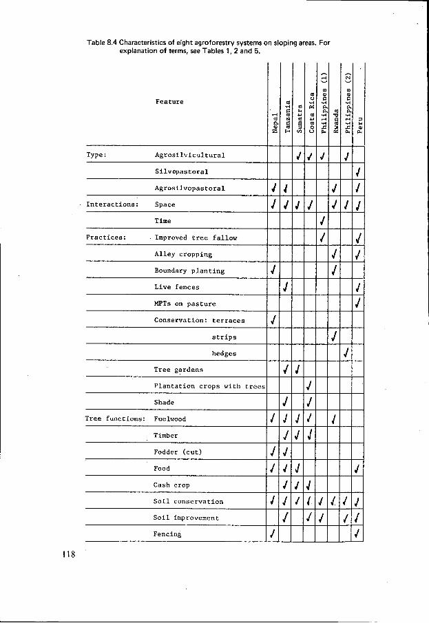
Table 8.4 Characteristics of eight agroforestry systems on sloping areas. For explanation of terms, see Tables 1 ,2 and 5.
Feature
c 9 c d
Type : Agrosilvicultural I Silvopastoral
Agrosilvopastoral J Interactions: Space
Time
Practices: Improved tree fallow I Alley cropping
Boundary planting J Live fences
MF'Ts on pasture
Conservation: terraces I J strips
hedges
Tree gardens I Plantation crops with trees
Shade
Tree functions: Fuelwood i Timber
Fodder (cut) IJ Food J Cash crop
Soil conservation I J Soil improvement
Fencing
118

to either of these questions. Perhaps surprisingly, to the present audience, it has not so far applied the standard procedures of land evaluation to its field projects. Instead, these have been based on a set of procedures known as the diagnosis and design metho- dology. This latter has many points of contact with land evaluation; indeed, it is thought possible that the two sets of procedures may prove to be convergent when applied in similar circumstances. A brief outline of the diagnosis and design approach is therefore a necessary preliminary to considering how land evaluation can be applied to agroforestry.
One aspect of evaluation, namely analysis in economic terms, has been applied to agroforestry systems, and some examples of this are also given.
8.5.2 Agroforestry diagnosis and design
The diagnosis and design methodology is one of a family of ‘farmers first’ approaches to rural land development. Its ultimate purpose is to design agroforestry land-use sys- tems which will help to solve the problems of rural land use. However, since the tech- nology of agroforestry is in many cases not fully proven, the proximate objective is usually to design a research programme that will test systems which are believed to have this problem-solving potential.
Diagnosis and design is a methodology of some complexity, to which the present very brief summary cannot do justice. Those who are interested are urged to discover more about it, from the following: - Guidelines for agroforestry diagnosis and design (ICRAF, 1983a). A 25-page sum-
mary of the approach, including an outline of procedures as 12 steps. This might be compared with the Framework for land evaluation (FAO, 1976).
- Resources for agroforestry diagnosis and design (ICRAF, 1983b). A 383 page vade- mecum of procedures, including proformas. Comparable with the Guidelines on land evaluation for rainfed agriculture (FAO, 1983).
- Technology and research considerations in ICRAF’s ‘diagnosis and design’ proce- dures (Huxley and Wood, 1984). Amplifies the technology design stage of proce- dures.
- One or more examples of application of the methodology. Comparable with reports on land evaluation studies. Those at present most accessible are based on Kenya (Raintree, 1983; Hoekstra, 1984a) and the Philippines (Torres et al., 1984).
In barest outline, the phases in a diagnosis and design study are: 1. Diagnose the land-use problems of an area. 2. Formulate agroforestry land-use systems that have the potential to ameliorate those
3. Design a research program which will test and optimize these systems. These phases lead potentially to a fourth, in which the improved and tested systems are implemented in the area through a programme of extension and development. Set out in slightly more detail (but still simplified) the steps become: 1. Identify and describe the land-use systems with the study area. A land- use system
has the same meaning as in land evaluation terminology, namely a combination of a land unit with a kind of land use. This is an initial stratification of the study area, the remaining phases being applied potentially to each of the land-use systems
119
problems and which are sustainable and adoptable.

but in practice, to those which have the most serious problems and/or the greatest apparent scope for agroforestry assistance.
2. Conduct a diagnostic survey of the problems faced by farmers, or other land users, in the area. These may be supply problems, that is, shortfalls in the farmers’ needs for food, fuel, shelter, cash, capital and social needs; or sustainability problems, e.g. soil erosion, pasture degradation, reduction in area of forests. Although the farmers are the focus, the land itself may also be regarded as having problems.
3. Analyze the causes of these problems. This is done by a causal network in which some of the initiating factors are socio-economic whilst others derive partly or mainly from the physical environment. Examples of causal chains taken from such networks arei
Land scarce + reduction in length of fallows + decline in soil fertility -P low crop yields -P food shortage Land scarce --t cultivation of steep slopes --t soil erosion + low crop yields Seasonal decline in feed quality + low animal productivity + low cash income Rainfall variability -+ recurrent crop failure + recurrent food shortage Population growth + destruction of forests + fuelwood shortage
More complex relationships, including branching or Y-shaped chains and feed- back loops, are also examined.
4. Derive specifications for systems suited to the area. These must: 1. have the capaci- ty to ameliorate some of the identified problems, through interventions in the causal networks; 2. be sustainable; 3. be adoptable, that is, within the financial and technical capabilities of the farmers, implementable within the available (or a modified) infrastructure, and acceptable to them (i.e. ‘if ... would you try this?’).
5. Based on the system specifications identify technologies which appear to have potential to make a contribution. These may include both agroforestry and non- agroforestry technologies; the report on the study draws attention to the latter, but does not proceed further with them.
6. Analyze the candidate agroforestry technologies and select the most promising from among them. Based on these, design a land-use system which, if it works, will help to solve the problems.
7. Make a preliminary ex ante evaluation of this land-use system, including environ- mental, economic and social aspects.
8. Decide what is known with confidence about the functioning of the proposed system, and what needs to be tested through research. Those elements, if any, about which there is reliable information can immediately be recommended for adoption.
9. For the remaining elements, design a research programme which will test the func- tioning of the proposed systems, and so lead to their improvement. This usually consists of a combination of on-farm research and on-station research.
10. Make the necessary institutional arrangements for implementing the research pro- gramme.
Stages 8 and 9 incorporate a three-way switch, between implementation, on-farm research and on-station research. Immediate implementation can be embarked upon where technological elements which make up a proposed system are adequately prov-
120

en. On-farm research is appropriate where the technology is less firmly proven, but the consequences to the farmer if it goes wrong are not too serious (e.g. boundary planting of fruit trees); it should also be adopted where there remains an element of doubt about the capacity or willingness of the farmers to put the system into practice. On-station research has numerous functions, for example, the testing of unproven technologies, species and provenance trials of multipurpose trees, or specialized studies of particular elements, such as pruning practices on soil moisture competition.
8.5.3 Diagnosis and design: an example
The diagnosis and design procedure may be illustrated from one of the two areas, the most steeply sloping, in the ICRAF collaborative programme in Peru. The follow- ing account is necessarily highly simplified.
The Pucallpa region lies in the Peruvian section of the Amazon Basin, latitude 8"30'S, altitude 250 m. It has a lowland humid tropical climate (Köppen Am) and rain forest vegetation; strongly acid acrisols are the dominant soil type, and slopes are moderate to steep. The main land-use systems are fallow-based cultivation of up- land rice and cattle ranching.
The main problem of the upland rice system is low crop yields brought about by a combination of low inputs with progressive shortening of the fallow period. On those farms for which land area was limited, the cattle ranching system suffered from low productivity of the natural pastures. A further problem common to both systems was shortage of capital for investment in improvements. Constraints to the design of interventions were that they should have low capital requirements; not make use of inputs inaccessible to farmers; and be consistent, in the case of cash crops, with marketing potentials of the area. The constraint of capital shortage prevents adoption of the high-input systems developed for annual cropping at the Yurimaguas Research Station (e.g. Valverde and Bandy, 1982).
For the cattle system, one improvement which meets all the specifications is not agroforestry, namely pasture improvement and development of productive and persis- tent legume-grass associations. Possible agroforestry improvements are: - improved tree fallows, based on N-fixing trees; - as an alternative to this, alley cropping with N-fixing trees, using a design which
- an increase in the number and variety of fruit trees, for extra cash income; - substitution of a herbaceous shrub in legume-grass pastures, as a way of trying
to avoid competitive exclusion problems common to such mixtures; - live fences on pastures, permitting some degree of pasture rotation. Of these possibilities, that of forest trees requires first, assessment of environmental suitabilities and secondly, study of marketing potential. If these can be completed, implementation can begin quite soon. The remaining practices are not well tested for this environment, and a substantial programme of on-station research is recommend- ed. (Source: Torres and Raintree, 1984.)
combines soil conservation;
121

8.5.4 Economic analysis of agroforestry systems
As with the treatment of social aspects, economic analysis of agroforestry systems may be said to have reached a more advanced stage than evaluation in relation to environment. A recent bibliography lists 90 such economic analyses (Hoekstra and van Gelder, 1983). A computer software package has been developed, MULBUD, which enables the user to model and analyze agroforestry systems (Etherington and Matthews, 1982). It should be made clear that as the package stands at present, all data on crop and tree performance, yields, etc., is input by the user; there is no element of biophysical modelling.
Two examples may be given. A recent collaborative project between ICRAF and Malaysian institutions led to a design for an agroforestry system for moderately-slop- ing dissected lowland, with a humid climate, on dissected lowlands north-east of Kuala Lumpur. This differs from the examples previously described in that it was designed for land presently in, and intended to remain as, forest reserve. In part because the main aim was to produce fast-growing softwoods, and in part owing to a constraint set by the Forestry Department, that perennial agricultural crops could not be planted, the design was directed towards modications of the taungya system. Two variants were produced, both based on combinations of the planting of fastgrowing timber trees with annual crops during the first year, sheep grazed beneath the trees for a further period, then trees only when their crown cover becomes dense. The farmers move to a new area each year, felling the secondary jungle, planting annuals plus trees, and tending the latter. Unlike most taungya systems, in which the dominant interaction takes place in time, this design involves substantial spatial interaction as well. (There are reservations concerning these designs, but these need not be discussed here.)
Two variants of this system were analyzed on the MULBUD package: a mixed system in which the trees were regularly spaced, and a zonal system in which the trees were planted as broad belts along the contour. These were compared with a straightfor- ward timber plantation, using existing methods of the Forestry Department. The re- sults are expressed in two ways: returns per unit area of land, as net present value in Malaysian dollars per hectare over a 15-year cycle; and as costs per unit volume of timber produced, in Malaysian dollars per cubic metre. The first is relevant from the national aspect of maximizing land productivity, the second from the point of view of the Forestry Department for which costs, and not land, is the primary limiting factor.
Land-use system NPV, M$ ha-' Timber cost M$ m3
Timber plantation 7960 9 15 Agroforestry, mixed system 11030
of which forestry component 8470 1.33 Agroforestry, zonal system 7130
of which forestry component 4000 9.00
The differences between agroforestry and forestry are not dramatic. in economic terms; but given that there are strong social pressures to allow farmers to have a stake in this area, the economics are sufficiently promising, even from the partial point of
122

view of the forestry component alone. The major saving to forest operations lies in lower establishment costs. In the mixed model there is no loss of timber and a gain from the crop and livestock elements; in the zonal model, the latter compensates for a lower timber yield and revenue. (Source: Hoekstra, 1984b.)
The second example is unusual among economic analyses in that it includes an ele- ment of environmental differentiation, based on different tree growth rates for rainfall regions. It is taken from a study by the Beijer Institute of the fuelwood supply and demand projections for Kenya (Openshaw, 1981). The agroforestry model is based on achievement of a 15% crown on farmland, without loss of crop production, yielding 4.5 m3 ha-’ per year in the high rainfall area and 2.6 m3 ha-’ per year with medium rainfall. There is a sensitivity analysis of different assumptions for labour rates and fuelwood prices, but taking the same set of assumptions for each case, the internal rates of return are as follows:
Land-use system Ranfall region IRR %
Fuelwood plantation High-medium 9,5 Taungya system plantation High-medium 14,5 Trees on farmland (agroforestry) High 29 Trees on farmland (agroforestry) Medium 17,5
Industrial timber plantation Hig 13,5 Industrial timber plantation Medium (low alt.) 8
Peri-urban plantation Medium-low 4,5
Fuelwood from natural forests High 54
Agroforestry comes out as markedly superior to various forest plantation systems. This is just as well, for it makes an economic virtue out of a practical necessity: Kenya’s semi-arid lands do not possess the growth potential to satisfy its projected fuelwood demands, whilst its humid lands (many of which are sloping) are fully occupied by farniers. The highest return, as would be expected, comes from using natural forests, but the incremental growth from these falls considerably short of fulfilling even pre- sent-day fuelwood demands.
8.6 Land evaluation for agroforestry
8.6.1 Modifications t o procedures
With the above account of diagnosis and design methods as a background, coupled with field experience of agroforestry projects, let us review the procedures of land evaluation, pointing out to what extent they appear to need special treatment when applied to agroforestry. The diagram of procedures in Land evaluation for forestry (FAO, 1984) will be taken as a basis (Figure 8.3). As compared with that in the rainfed agriculture volume this has an added box, ‘Economic and social data: collection, analy- sis’. Note should also be take? of the three points for input of economic and social data given in the forestry volume (Page 94), namely at the stages of determination of objectives, formulation and refinement of land utilization types, and economic and social analysis in the comparison of land use with land.
123

Planning the evaluation: objectives’ Right at the beginning of land evaluation procedures comes the first major point of difference. The Framework and its successor volumes.basically assume that the objec- tives of the survey are known before fieldwork starts, and can be established by preli- minary discussion, ‘between ... agriculturalists, engineers, economists, sociologists, planners, government officials’ (oh, and also) ‘representatives of the local population likely to be affected’ says the Framework airily.
The first feature of agroforestry is that the objective is often problem-solving: that is, advice on the potential of agroforestry is called upon for an area which has land-use problems. Most commonly, these are soil fertility decline, soil erosion, fuelwood short- age (actual or projected) or pasture degradation.
Secondly, a fundamental principle is that diagnosis must precede treatment. That is, given that an area is known to have land use problems, a substantial period of field survey is necessary in order to find out in detail the nature of these problems and analyze their causes. There is no such principle in the Framework.
‘Land utilization types: formulation and description’ A feature of agroforestry land utilization types is that they are often conceived and formulated as interventions into the existing land use, usually agriculture. Thus the approach is predominantly that of improvement rather than transformation. Closely related is the fact that practicability and acceptability is built into the proposals at an early stage. This avoids the subsequent problem of ‘We’ve done the research: now how are we going to get the farmers to accept the system?’ Based on the diagnosis of the present land-use system and the constraints under which the farmers are operat- ing, acceptability is built into the design of the proposed agroforestry systems. There is no reason, of course, why this should not be done for non-agroforestry land utiliza- tion types.
.
‘Land utilization types: description’ The standard list of descriptors for land utilization types (outputs, market orientation, capital intensity, etc.) are almost identical in the guidelines on rainfed agriculture and on forestry, apart from minor changes in wording, e.g. cultivation practices/silvicultur- al practices. The same list appears in the guidelines on irrigation with the addition of headings specific to water management. All of these descriptors are relevant to agroforestry systems, as has been illustrated in Table 8.3. In the current world invento- ry of agroforestry systems being conducted by ICRAF, care was taken to include each of them in the computerized summary of characteristics.
There are, however, additional features that are of particular significance in the description of agroforestry land utilization types. These could indeed be included under the standard headings, Outputs, Cropping characteristics and Cultivation/Silvi- cultural practices, but as they define the essential distinguishing features of agrofor- estry, namely the tree/non-tree interactions and the roles of the tree component in the land- use system as a whole, it is better to isolate them as a separate set of descrip- tors, as in Table 8.5.
I 124

-PLANNING THE EVALUATION - Objective - Constraints - Data & assumptions - Programme of work
LAND UNITS
- Identification & description
LAND UTILIZATION ECONOMIC & TYPES SOCIAL DATA - Identification + - Collection - Description - Analysis
c LAND USE REQUIREMENTS For specified purp purposes as required by land utilization types
LAND QUALITIES & CHAR ACTE R IST ICs - Selection - Surveys and
sDecialised studies
I
COMPARISON OF LAND USE WITH LAND
- Matching - Environmental impact - Economic & social
analysis - Land suitability
classification
Jr PRESENTATION OF RESULTS
- Descriptions of land utilization types (LUTs) - Land suitability classification - Managemn Management specifications for LUTs on land units - Environmental impact - Economic and social analysis of alternatives - Data from basic surveys and specialized studies
Figure 8.3 Procedures in land evaluation. After FAO (1984, p. 27). As compared with the source, an aro arrow has been added showing the use of economic and social data in the formulation of land utilization types.
‘Economic and social data’ No special features for data collection. Data are incorporated into objectives and de- sign of land utilization types as well as during comparison of land use.with land.
‘Land units’ No special features.
125

Table 8.5 Descriptors for agroforestry land utilization types. Based on Torres (1983), Huxley (1983) and the ICRAF agroforestry systems inventory.
Type of system Agrosilvicultural, hopastoral agrosilvopastoral, other (see Section 2.2)
~~~~~
Dominant interaction (between tree and non-tree components), spatial.arrangement. ’‘ ’
Space: trees and other components are grown simultaneously, in a
Time: trees follow crops or pasture in a rotation. Both: the system includes substantial interactions in both space and
time.
Arrangement in space
Arrangement in time
Mixed, dense (e.g. home gardens) Mixed, sparse (e.g. most systems of trees in pastures) Row (single line of trees) Strip (belt more than one tree in width) Boundary (trees on edges of fields roads, etc.) Block (as in tree plantations)
Coincident Concomitant Overlapping Separate Interpolated (Time-dominant systems are necessarily separate; space-dominant systems with annual crops are usually interpolated; with perennial crops may be in various time arrangements).
Agroforestry practices See Table 8.1
Functions of the trees See Table 8.2
‘Land-use requirements’ Performance of agroforestry utilization types is often not known, hence neither are precise land-use requirements. To meet this situation, there is need for a period of research, and hence design of a research programme.
‘Land qualities and characteristics’ No qualities or characteristics additional to those applicable to agriculture and forestry have been found necessary. This applies to qualities for management and conservation as well as those for plant growth.
‘Comparison of land use with land’ Physical requirements Environmental impact
Social analysis Economic analysis
Land suitability classifica- tion
126
Not precisely known, see above. Important in agroforestry sytems; information avail- able. Important in agroforestry systems; methods available. Methods available; has been done many times, on an ex ante basis. Has not yet been attempted.

In summary, the main differences between land evaluation methods as set out in the FAO guidelines for rainfed agriculture and forestry, and those practised in, or appro- priate to, the evaluation of agroforestry systems are: 1. The objective is often problem-solving. 2. Surveys commence with a stage of diagnosis of problems and their causes. 3 . To describe agroforestry land utilization types, a set of additional descriptors is
needed. 4. The performance of agroforestry systems, in relation to land qualities, is frequently
not firmly established, and thus the land-use requirements cannot be precisely speci- fied.
5. In part due to the uncertainties over performance, the output from agroforestry studies is frequently a design for a research programme, incorporating on-station and on-farm research, together with a variable element of immediate implementa- tion.
6. In agroforestry surveys to date, there has been a relatively greater emphasis on social features and less on environmental features, as compared with most land evaluation studies.
'
,
8.6.2 The ICRAF/FAO Project, Land Evaluation for Agroforestry
Recognizing that there is a need to apply methods of land evaluation to agroforestry, and that simple adaptation of existing methods will not be sufficient, ICRAF has embarked upon a project in land evaluation for agroforestry (with the serendipitous acronym of LEAF). It has been fortunate to secure the technical cooperation of FAO in this activity. The rationale for the project as a whole has been set out in a Working Paper, Land Evaluation for Agroforestry: the tasks ahead (Young, 1984). The neces- sary stages in the development of such a methodology are as follows: 1. An environmental data base. 2 . The formulation of appropriate land utilization types, as a basis for suitability anal-
ysis. 3 . Land-use requirements, for agroforestry components (trees, crops, livestock) and
technologies. 4. Biophysical models of interactions between trees and other components of agrofor-
estry systems. 5. An assessment of the environmental impact, and hence sustainability, of agrofor-
estry systems. 6. A methodology for comparison between agroforestry and other land-use systems,
on a given site. 7. Case studies to test the above. 8. The holding of an international workshop. No specific research needs are included for economic analysis nor for the examination of social impact, since satisfactory procedures for these aspects already exist.
127

8.6.3 The ICRAF environmental data base
Since it is the particular interest of land evaluation, brief details may be given of the environmental data base of information on agroforestry. Further details, with exam- ples of computer outputs, are given in Young (1983 and 1984).
There are two main files to the data base, a sites file and a requirements file. The sites file contains records of the complete range of environmental conditions to be found as sites associated with agroforestry. These include locations of ICRA’s colla- borative research programme, sites of existing agroforestry systems and sites of agro- 4
forestry experimental work. The fourth kind of site that can be entered is any area of interest to a user. By storing all such data in a standardized form, it will be possible to identify and compare sites with similar environments.
The requirements file is intended to store the environmental requirements of agro- forestry components and land utilization types. At present it contains only require- ments of multipurpose trees. Crop requirements will be added by assembling data from FAO and other surveys. In course of time it is hoped to include the environmental requirements of agroforestry land utilization types, but that achievement is some way in the future.
A diagram showing the structure of the environmental data base, together with an explanation of the structure of the requirements file and examples of outputs, is given in Young (1 984, Figure 3 and Tables 1 and 2).
i
8.7 Discussion and conclusions
The four questions posed at the outset can now be reviewed in the light of the informa- tion presented.
8.7.1 How can land evaluation be applied to agroforestry?
.-The first question is the adequacy and appropriateness of existing procedures of land evaluation when applied to agroforestry. The standard descriptors for land utilization t,ypes,are all applicable, but need to be supplemented by aspects distinctive to agrofor- estry systems; the origin of these aspects lies in two features of such systems, the interac- tion between the tree and non-tree components and the multipurpose role of the trees. Comparison between land and use can already be achieved satisfactorily in terms of environmental impact, social aspects and economic analysis. It can only be carried out for physical requirements on a generalized basis, owing to lack of sufficient perfor- mance data for agroforestry systems in relation to environmental conditions. This situation means that in many cases, the output from an agroforestry study is a combi- nation of a research programme combined with a variable amount of direct implemen- tation.
There is a further aspect. It seems likely that the classification ofa particular agrofor- estrydand utilization type as highly suitable for a given area is not related to the envi- ronmental conditions of that area alone; it depends to a substantial extent on the existing land-use systems in the area and their problems. For example, an agroforestry
128
I
I .
. . . . .
:
. . . .

practice that combines soil conservation with fuelwood production is highly suitable for a certain area not only because its land has a high erosion hazard but also because of a fuelwood shortage among its people.
A consequence is that, in the author’s present perception, the ‘Guidelines on land evaluation for agroforestry’ will not be simply an adaptation, following the same out- line, of the guidelines for rainfed agriculture, forestry and irrigated agriculture. There are likely to be some substantial modifications in principles and procedures, possibly including some element of integration with the diagnosis and design methodology. This question is further discussed in Young (1984).
8.7.2 What benefits can agroforestry bring to sloping areas?
Generalizing from the examples in Section 4, there are a range of benefits, provided that the agroforestry practices and systems are based on sound design and their perfor- mance is proven by trials. The major element is that sloping areas invariably have a substantial hazard of soil erosion, and well-designed agroforestry has the capacity to combine conservation with productive functions. Since fuelwood production is the most commonly called-for output from multipurpose trees, then insofar as sloping areas have an inherent tendency towards a situation of fuelwood shortage, then agro- forestry has a further rolein this respect. More generally, whereas crops present serious problems for cultivation on slopes, trees do not, leading to potential benefits from making use of interacti0ns:between the two.
8.7.3 Under what circumstances is agroforestry likely to be the preferred form of land use in sloping areas?
Converted to the approach of land evaluation, the third question could be expressed as follows: if for a sloping area, a land evaluation were conducted which included one or more systems of agriculture, agroforestry and forestry, under what circum- stances would agroforestry.be classified as more highly suitable?
Suppose that a watershed fulfilled an important role as a water catchment, that it was presently uninhabited, and that there was no strong land pressure in the area; then clearly, the preferrediuse would be to retain that watershed under protective for- estry. It is harder to conceive of a set of circumstances in which agroforestry should be equally clearly excluded in favour of agriculture, but perhaps a well-maintained system of terraced rice fields, their fuelwood and fodder needs adequately provided from other nearby land, would qualify - if such a case exists.
The circumstances in which agroforestry appears to have the potential to make a considerable contribution to the welfare of the people is in those sloping lands of the humid and subhumid tropics which suffer from one or more of the problems of soil erosion, over-cultivation and soil fertility decline, or shortage of fuelwood or fod- der. These are land-use problems which agroforestry, with its particular capacity to combine productivity with sustainability, has special potential to ameliorate.
129

8.7.4 Should sloping areas be a priority environment for application of agroforestry research and development effort?
From the two preceding subsections, it is apparent that the answer to this final question is a clear 'Yes'. Sloping areas frequently have problems of land use of the kinds that agroforestry can assist. Clearly, therefore, this should be an environment towards which effort is particularly directed. It would go beyond the scope of this paper to carry out a comparative review of other environments, but it appears possible that there are none in which the combination of need with potential for improvement is so clearly present.
There is some more or less independent confirmation'of this situation. The ICRAF collaborative programme is one in which agroforestry research is carried out by institu- tions in a network of countries, with ICRAF playing a role in design and coordination. The programme is based on the diagnosis and design methodology, applied to selected target areas. These areas have not been chosen by means of land evaluation surveys. They are selected primarily by the collaborating countries, on grounds which vary in detail but which are broadly that they possess land-use problems which it is thought that agroforestry could assist. To date there have been eight such study areas. Of these, only one is classed as gently sloping; two are moderately sloping whilst four include areas of both moderate and steep slopes. The most recent, the Bhaintam water- shed for the Himalayas is Uttar Pradesh, India, has been covered by a survey of slope class; 92% of the watershed has slopes over 19" (3479, i.e. steep, whilst 56% has slopes over 27" (50%) and 6% at over 45" (loo%)!
There is no doubt an element of chance in this concentration of requests for collabor- ative assistance on sloping lands, but it is strongly indicative. Among requests to the recently-formed ICRAF Advisory Unit, those from sloping areas again appear, for example areas in Rwanda and Indonesia.
8.8 Design, research and implementation
It is well to end on a note of caution. Great as the potential benefits of agroforestry to sloping lands may appear to be, it would be unwise in most cases to proceed with immediate large-scale implementation. Whilst some traditional agroforestry systems have been functioning successfully for many years, most modern designs for introduc- tions have been subject to only a limited degree of testing - and still less to testing under specific local environmental conditions. Hence the way ahead that is normally to be recommended at the present state of technology is a well-designed research pro- gramme, tailored to the needs of the area and incorporating both on-station and on- farm research, coupled with a limited amount of immediate implementation.
If an introduced agroforestry technology system is to be successful, it is necessary to ensure: I . That the trees selected will grow well in the area. This is a fundamental requirement,
without which all other functions of agroforestry will fail. 2. That the system is well designed. The attitude 'trees are wonderful, plant them' is
not enough. Trees alone do not even achieve soil conservation: it is the design which they are planted and the subsequent management that matters (Wiersum, 1984).
130

Every aspect of proposed agroforestry technologies need to be subject to careful analysis, to minimize adverse interactions and to obtain the desired balance of bene- ficial functions.
3. That the system has been tested: The design must be tested under controlled field conditions; if it has been found satisfactory in other regions, trials are necessary under local environmental conditions (and with locally realistic inputs and manage- ment practices). This imposes a delay of some 5 years, but implementation of an unproven technology which fails can cause an equal delay, at considerably greater cost.
4. Finally, that the system meets the needs of the people. That is, the research pro- gramme itself should be designed such that its output is a set of technologies, or one or more agroforestry systems, that is adapted to the environment of the area, helps to ameliorate its land-use problems, and can be implemented by, and is accept- able to, its people.
References
Behmel, F and I . Neuman 1982. An example of agroforestry for tropical mountain areas. In: Agroforestry in the African humid tropics (ed. L.H. Macdonald), 92-98.
Budowski, G . 1983. An attempt to quantify some current agroforestry practices in Costa Rica. In: Plant research and agroforestry (ed. P.A. Huxley), 43-62.
Carlowitz, P.G. von 1984. Multipurpose trees and shrubs: opportunities and limitations. I C M F Working Paper 17. Nairobi.
Escalante, E. (in press) Prominent agroforestry systems in Venezuela. Agroforestry Systems Descriptions Series No. 9. Agroforestry Systems.
Eslava, F.M. 1984. The Naaland style of upland farming in Naga, Cebu, Philippines: a case study of an indigenous agroforestry scheme. Paper presented to ICRAF Training Course on Agroforestry, Malaysia, October 1984, manuscript.
Etherington, D. and P.J. Matthews 1982. MULBUD user’s manual. Australian National University, Can- berra.
FAO, 1976. A Framework for land evaluation. FAO Soils Bulletin 32, Rome. FAO, 1983. Guidelines: land evaluation for rainfed agriculture. FAO Soils bulletin 52, Rome. FAO 1984. Land evaluation for forestry. FAO Forestry Paper 48, Rome. Fernandes, E., A. Oktingati and V. Maghembe 1984. The Chagga homegardens: a multistoried agroforestry
cropping system on Mount Kilimanjaro (northern Tanzania). Agroforestry Systems Description Series No. I Agroforestry Systems 2,7346.
Fonzen, P. and E. Oberholzer 1984. Use of multipurpose trees in hill-farming systems in western Nepal. Agroforestry systems description series, No. 4. Agroforesry Systems (in press).
Hoekstra, D.A. 1984a. Agroforestry systems for the semi-arid areas of Machakos District, Kenya. ICRAF Working Paper 19, Nairobi.
Hoekstra, D.A. 1984b. An ex ante economic analysis of proposed mixed and zonal agroforestry systems for Batu Arang Forest Reserve, Malaysia. ICRAF Working Paper 16, Nairobi.
Hoekstra, D.A. and A. van Elder. 1983. An annotated bibliography of economic analysis of agroforestry systems/technologies. ICRAF Working Paper IO, Nairobi.
Huxley, P.A. 1983 Comments on agroforestry classifications: with special reference to plant aspects. In: Plant research and agroforestry (ed. P.A. Huxley, ICRAF, Nairobi), 161-171. Reprinted as ICRAF Re- print 9, 1984.
Huxley, P.A. 1984. The basis of selection, management and evaluation of multipurpose trees - an overview. In: Trees as crop plants (ed. M.C.R. Cannel1 et al., Institute of Terrestrial Ecology, Edinburgh), in press.
Huxley, P.A. and P.J. Wood. 1984. Technology and research considerations in ICRAF’s ‘diagnosis and design’ procedures. ICRAF Working Paper 26, Nairobi.
ICRAF 1983a. Guidelines for agroforestry diagnosis and design.
131

ICRAF Working Paper 6, Nairobi. ICRAF 1983b. Resources for agroforestry diagnosis and design. ICRAF Working Paper 7, Nairobi. ICRAF 1983~. Research project on developing agroforestry systems for the upper basin of the Peruvian
Amazon. Report prepared in conjunction with collaborating Peruvian institutions, mimeo, ICRAF, Nair- obi.
ICRAF 1983d. A global inventory of agroforestry systems: a project announcement. Agroforestry Systems
ICRAF 1984. Draft report of the joint ICAR/ICRAF diagnostic and design exercise a t the Bhaintan water-
Lundgren, B. 1982. In: Editorial. What is agroforestry? Agroforestry Systems 1,7-12. Michon, G. et al., 1984. Hillside agroforests in west Sumatra. Report to ICRAF Agroforestry Systems
Inventory, manuscript. Nair, P.K.R. 1984. Tropical Agroforestry systems and practices. In: Tropical resource ecology and develop-
ment (ed. V.I. Furtado and K. Ruddle, Wiley, New York), in press. Openshaw, K. 1981. Costs and benefits of proposed tree planting programmes for satisfying Kenya's wood
energy requirements. Report to Kenyan Woodfuel Development Project, Beijer Institute. Stockholm, mimeo.
Raintree, J.B. 1983. Preliminary diagnosis of land-use problems and agroforestry potentials in northern Mbere Division, Embu District, Kenya. ICRAF Working Paper I , Nairobi.
De la Rosa, J.M. n.d. A study on the growth and yield of corn intercropped with varying population of giant ipil-ipil (Leucaena leucocephala) on a hillside. Thesis manuscript, Visayas State College of Agricul- ture, Philippines.
Torres, F. 1983. Agroforestry: concepts and practices. In: Agroforestry systems for small-scale farmers (ed. D.A. Hoekstra and F.M. Kuguru). ICRAF, Nairobi, 27-42.
Torres, F. and J.B. Raintree. 1984. Agroforestry systems for smallholder upland farmers in a land reform area of the Philippines: the Tabango case study. ICRAF Working Paper 18, Nairobi.
Valverde S., C. and D.E. Bandy. 1982. Production of annual food crops in the Amazon. In: Amazonia: agriculture and land use research; proceedings (ed. S.B. Hecht, CIAT, Cali, Colombia), 243-280.
Wiersum, K.F. 1984. Surface erosion under VdnOUS tropical agroforestry systems. Paper presented to Sym- posium o n Effect of Forest Land Use on Erosion and Slope Stability, Hawaii, May 1984, mimeo.
Young, A. 1983. An environmental data base for agroforestry. ICRAF Working Paper 5 , Nairobi. Young, A. 1984. Land evaluation for agroforestry: the tasks ahead. ICRAF Working Paper 24, Nairobi.
'
I , 269-273.
shed in the outer Himalaya of Uttar Pradesh. Mimeo. ICRAF, Nairobi.
132


