(8-89) department of energy bonneville power ... · united states government department of energy...
TRANSCRIPT

United States Government Department of Energy Bonneville Power Administration
DATE: July 9,2002
REPLY TO ATTN OF:
KEPR-4
SUBJECT:
Supplement Analysis for the Transmission System Vegetation Management Program FEIS (DOE/EIS-0285/SA-81)
Randy Melzer Redmond Deputy Regional Manager – TFR/REDMOND Proposed Action: Vegetation Management for fifteen Substations in The Dalles District. (See list of facilities under planning step 1). Proposed by: Bonneville Power Administration (BPA).
Description of the Proposal: BPA proposes total vegetation management (bare ground) in the electrical substations, and, noxious weed management and maintenance of landscaping within the property boundaries of the listed facilities. These facilities are all located within The Dalles District of the Redmond Region.
Analysis: The attached checklist shows the resources that were found during this analysis and what mitigation measures are required to protect those resources. In addition, each facility is supported by a file containing drawings, aerial photographs, topographic maps, and the mitigation measures to be applied (copies will be maintained at the district office, with the regional environmental contact and at the Pollution Prevention and Abatement office, Portland, OR). Applicable findings are discussed below.
Planning Steps: 1. Identify facility and the vegetation management need. Bald Mountain Klickitat County, WA
Buckley Sherman County, OR
Chenoweth Wasco County, OR
De Moss Sherman County, OR
Fossil Wheeler County, OR
Goldendale Klickitat County, WA
Harvalum Klickitat County, WA
Hood River Hood River County, OR
John Day Sherman County, OR
John Day Station Service Sherman County, OR
Maupin Wasco County, OR
Parkdale Hood River County, OR
Pine Hollow Wasco County, OR
The Dalles Wasco County, OR
Tygh Valley Wasco County, OR
BPA proposes to manage vegetation inside and around electrical substations and associated facilities. Vegetation management within the substations will include bare ground management by herbicides of all areas within the fenced perimeter of the facility including a bare ground zone of up to 3 meters (10 feet) outside of the fenced area. The management of vegetation outside the substation and associated facilities will include: 1) bare ground management of perimeter roads and parking areas; 2) control of noxious weeds throughout property boundaries; 3) mowing, fertilizing, and weed control of landscaped lawn and mulched areas; 4) weed control in ornamental shrub areas; and 5) areas requiring only mechanical control to manage unwanted/danger trees, grasses, and shrubs.
DOE F 1325.8e Electronic Form Approved by CILR – 09/26/2001 (8-89)
memorandum
TO:
22. Identify surrounding land use and landowners/managers and any mitigation. Land use surrounding the facilities includes but is not limited to pasture/grazing, and agriculture/farming activities (see checklists for a more detailed description). Surrounding Landowners include private farmers/ranchers and local utilities, (see checklists for a more detailed description). No mitigation necessary.
3. Identify natural resources and any mitigation. T&E species (fish), wetlands, drinking water resources and water resources have been identified near some of the facilities as shown in Table 3.1 of the attached checklist. Mitigation measures, consistent with the FEIS, are listed for these sites in Section 3 of the attached checklist.
4. Determine vegetation control and debris disposal methods. There will be no debris disposal and re-vegetation associated with the bare ground management. For other areas debris disposal will take place on site. Facilities requiring landscaping are designed to be low maintenance and are consistent with Integrated Pest Management procedures, such as native, low-growing, types, mulches, rock covers, etc. All of the vegetation management techniques are designed to be permanent.
5. Determine re-vegetation methods, if necessary. Renegotiation will be consistent with the permanent nature of the facilities but will incorporate native species where practical. 6. Determine monitoring needs. Monitoring is two-fold. Monitoring for evaluation of BPA/contractor treatment practices to ensure vegetation management practices will be handled through contract specifications. Environmental monitoring to ensure environmentally sound application practices will be determined in the future as outlined in the BPA/NMFS/USFWS Biological Assessment.

3
7. Prepare appropriate environmental documentation. Findings: This Supplement Analysis finds that 1) the proposed actions are substantially consistent with the Transmission System Vegetation Management Program FEIS (DOE/EIS-0285) and ROD, and; 2) there are no new circumstances or information relevant to environmental concerns and bearing on the proposed actions or their impacts. Therefore, no further NEPA documentation is required. /s/ John Howington John Howington Physical Scientist (Environment) KEPR-4 CONCUR:/s/ Thomas C. McKinney DATE:07/19/2002 Thomas C. McKinney
NEPA Compliance Officer
cc: L. Croff – KEC-4 T. McKinney – KEC-4 M. Hermeston – KEP-4 J. Meyer – KEP-4 F. Walasavage – KEP/Celilo J. Sharpe – KEPR-4 M. Johnson – TF/DOB-1 P. Key – LC-7 R. Fouse-TFR/Redmond G. Parks-TFR/Redmond E. Johnson– TFR/The Dalles A.Campbell – TFRL/The Dalles R. Melzer – TFR/Redmond G. McMullen – TFRV/Redmond Environment File – KEC-4 Official File – KEP (EQ-14) Jhowington:jh:4722:7/15/02 (KEP-KEPR-4-W:\EP\2002 FILES\EQ\EQ-14\FEIS-0285-SA-81-Redmond.doc)
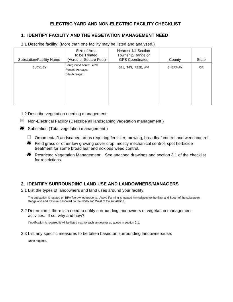
ELECTRIC YARD AND NON-ELECTRIC FACILITY CHECKLIST
1. IDENTIFY FACILITY AND THE VEGETATION MANAGEMENT NEED
1.1 Describe facility: (More than one facility may be listed and analyzed.)
1.2 Describe vegetation needing management:
Substation/Facility Name
Size of Area to be Treated
(Acres or Square Feet)
Nearest 1/4 SectionTownship/Range orGPS Coordinates County State
BUCKLEY ORSHERMANS11, T4S, R15E, WMFenced Acreage:Site Acreage:
Bareground Acres: 4.20
Substation (Total vegetation management.)
Non-Electrical Facility (Describe all landscaping vegetation management.)
Ornamental/Landscaped areas requiring fertilizer, mowing, broadleaf control and weed control.Field grass or other low growing cover crop, mostly mechanical control, spot herbicide treatment for some broad leaf and noxious weed control.Restricted Vegetation Management: See attached drawings and section 3.1 of the checklist for restrictions.
2. IDENTIFY SURROUNDING LAND USE AND LANDOWNERS/MANAGERS2.1 List the types of landowners and land uses around your facility.
2.2 Determine if there is a need to notify surrounding landowners of vegetation management activities. If so, why and how?
2.3 List any specific measures to be taken based on surrounding landowners/use.
The substation is located on BPA fee-owned property. Active Farming is located immediatley to the East and South of the substation. Rangeland and Pasture is located to the North and West of the substation.
If notification is required it will be listed next to each landowner up above in section 2.1.
None required.
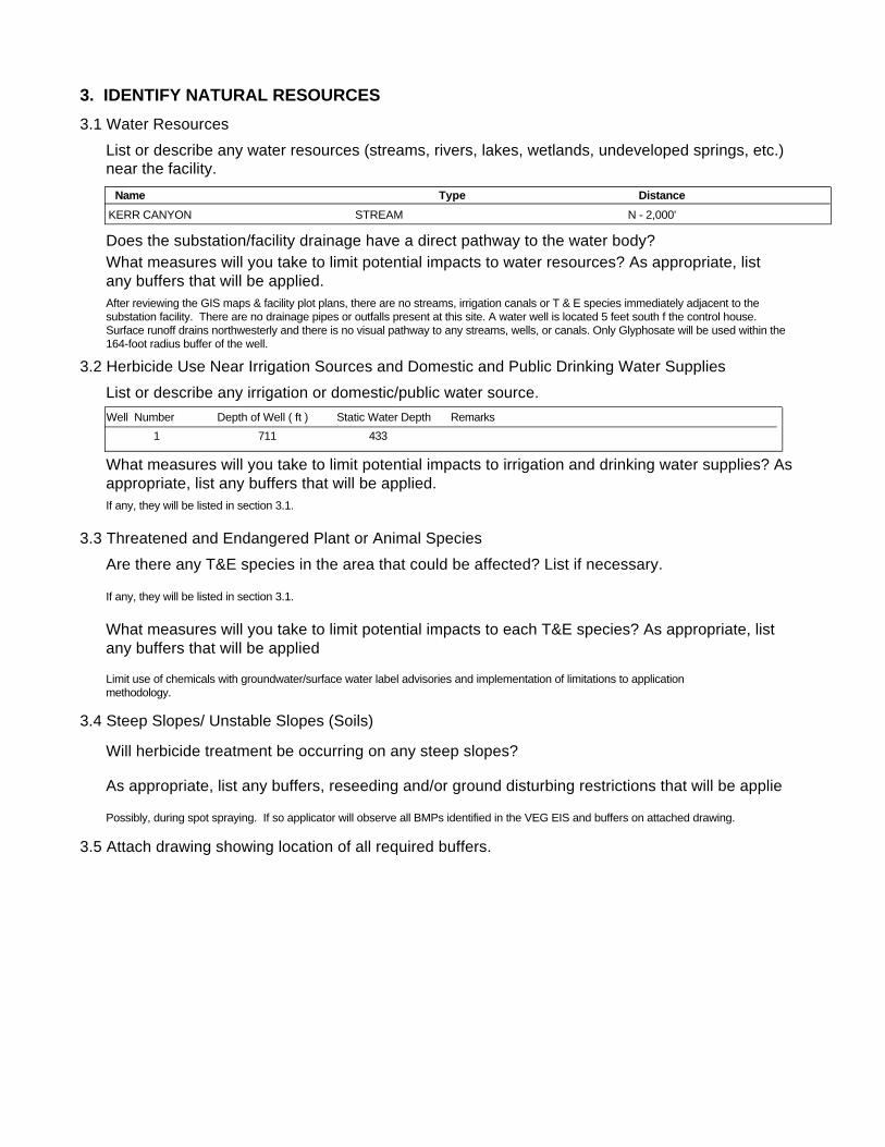
3. IDENTIFY NATURAL RESOURCES3.1 Water Resources
3.2 Herbicide Use Near Irrigation Sources and Domestic and Public Drinking Water Supplies
List or describe any water resources (streams, rivers, lakes, wetlands, undeveloped springs, etc.) near the facility.
Does the substation/facility drainage have a direct pathway to the water body?What measures will you take to limit potential impacts to water resources? As appropriate, list any buffers that will be applied.
List or describe any irrigation or domestic/public water source.
What measures will you take to limit potential impacts to irrigation and drinking water supplies? Asappropriate, list any buffers that will be applied.
3.3 Threatened and Endangered Plant or Animal Species Are there any T&E species in the area that could be affected? List if necessary.
What measures will you take to limit potential impacts to each T&E species? As appropriate, list any buffers that will be applied
3.4 Steep Slopes/ Unstable Slopes (Soils)
Will herbicide treatment be occurring on any steep slopes?
As appropriate, list any buffers, reseeding and/or ground disturbing restrictions that will be applie
3.5 Attach drawing showing location of all required buffers.
After reviewing the GIS maps & facility plot plans, there are no streams, irrigation canals or T & E species immediately adjacent to the substation facility. There are no drainage pipes or outfalls present at this site. A water well is located 5 feet south f the control house. Surface runoff drains northwesterly and there is no visual pathway to any streams, wells, or canals. Only Glyphosate will be used within the 164-foot radius buffer of the well.
Limit use of chemicals with groundwater/surface water label advisories and implementation of limitations to application methodology.
If any, they will be listed in section 3.1.
Possibly, during spot spraying. If so applicator will observe all BMPs identified in the VEG EIS and buffers on attached drawing.
If any, they will be listed in section 3.1.
Name Type DistanceKERR CANYON N - 2,000'STREAM
Well Number Depth of Well ( ft ) Static Water Depth Remarks1 711 433

4. DETERMINE VEGETATION CONTROL METHODSDescribe overall vegetation management scheme and schedule: Bareground managed areas will primarily use herbicides with supplemental usage of mechanical methods. Other areas will be managed as described in section 1.2. Only herbicides from BPA's approved herbicide list will be used. All areas will be managed consistently with the Vegetation EIS. Initial:
Describe debris disposal and revegetation , if any.
For electrical substations the goal is Total Vegetation Management. A licensed contractor sprays the substations annually. BPA's substation herbicide application contracts contain specific language to ensure herbicides are applied consistent with the VEG EIS. Facilities requiring landscaping are designed to be low maintenance and are consistent with Integrated Pest Management procedures, such as using native, low growing plant types and mulches etc…
Subsequent:Herbicides will be applied on an annual or as needed. Active ingredients shall be rotated to ensure plants do not build a tolerance. Mechanical methods shall be performed on an as needed basis. Landscaping (ornamental plants/lawns) may be maintained via contractor or performed by BPA employees.
Future:Future control will be consistent with the methods described above.
5. DETERMINE DEBRIS DISPOSAL AND REVEGETATION
There will be no debris disposal and revegetion with bareground management. For other areas green debris will be recycled on-site to the extent practical.
6. DETERMINE MONITORING NEEDS
Describe debris disposal and revegetation , if any.
6.1 Describe evaluation of BPA/contractor treatment practices to ensure vegetation management measures are working.
Monitoring will occur through herbicide contract management and the observations of BPA Personnel during on site visits.
6.2 Is there a need to monitor adjacent areas for potential herbicide movement/contamination? If so, describe monitoring plan. (Unless monitoring for other reasons, this section should be consistent with BPA-systemwide herbicide monitoring plan not yet finalized.)
There will be no debris disposal and revegetion with bareground management. Debris disposal will take place on-site and will be recycled to the extent practical. Revegetation will be consistent with the existing vegetation of the facility and will incorporate native species where practical.
7. PREPARE APPROPRIATE ENVIRONMENTAL DOCUMENTATION7.1 Describe any potential project impacts or project work that are different than those disclosed in the Transmission System Vegetation Management Program EIS. Describe how those differences impact natural resources and if the differences are "substantial".
7.2 Is there a need for additional NEPA documentation (i.e. Forest Service requirement, Record of Decision, supplemental EIS)? If so, attach.
None
None
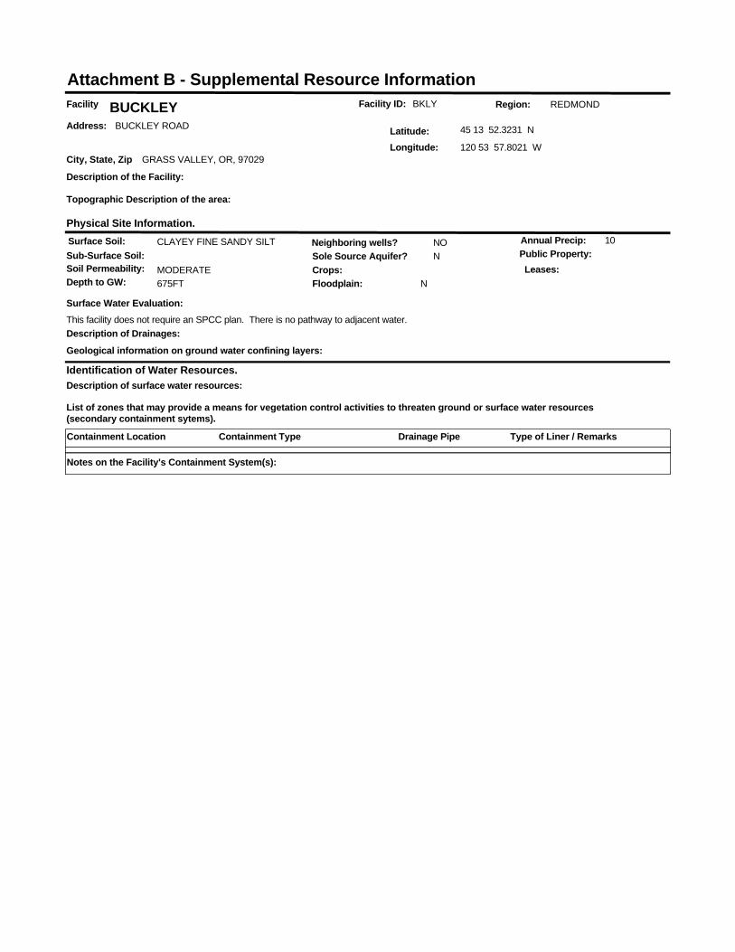
Facility ID: BKLYFacility BUCKLEYAddress: BUCKLEY ROAD
City, State, Zip GRASS VALLEY, OR, 97029
Latitude: 45 13 52.3231 N
Longitude: 120 53 57.8021 W
Identification of Water Resources.
List of zones that may provide a means for vegetation control activities to threaten ground or surface water resources (secondary containment sytems).
Region: REDMOND
Surface Soil: CLAYEY FINE SANDY SILTSub-Surface Soil:Soil Permeability: MODERATE
Sole Source Aquifer? N
Depth to GW: 675FT
Neighboring wells? NO
Floodplain: N
Annual Precip: 10
Crops:Public Property:
Physical Site Information.
Surface Water Evaluation:This facility does not require an SPCC plan. There is no pathway to adjacent water.
Geological information on ground water confining layers:
Description of the Facility:
Topographic Description of the area:
Leases:
Description of surface water resources:
Description of Drainages:
Attachment B - Supplemental Resource Information
Containment Location Containment Type Type of Liner / RemarksDrainage Pipe
Notes on the Facility's Containment System(s):
ELECTRIC YARD AND NON-ELECTRIC FACILITY CHECKLIST
1. IDENTIFY FACILITY AND THE VEGETATION MANAGEMENT NEED
1.1 Describe facility: (More than one facility may be listed and analyzed.)
1.2 Describe vegetation needing management:
Substation/Facility Name
Size of Area to be Treated
(Acres or Square Feet)
Nearest 1/4 SectionTownship/Range orGPS Coordinates County State
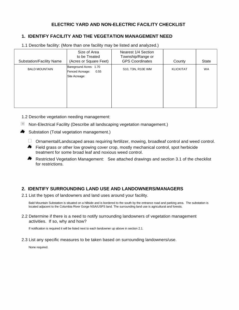
BALD MOUNTAIN WAKLICKITATS10, T3N, R10E WMFenced Acreage: 0.55Site Acreage:
Bareground Acres: 1.70
Substation (Total vegetation management.)
Non-Electrical Facility (Describe all landscaping vegetation management.)
Ornamental/Landscaped areas requiring fertilizer, mowing, broadleaf control and weed control.Field grass or other low growing cover crop, mostly mechanical control, spot herbicide treatment for some broad leaf and noxious weed control.Restricted Vegetation Management: See attached drawings and section 3.1 of the checklist for restrictions.
2. IDENTIFY SURROUNDING LAND USE AND LANDOWNERS/MANAGERS2.1 List the types of landowners and land uses around your facility.
2.2 Determine if there is a need to notify surrounding landowners of vegetation management activities. If so, why and how?
2.3 List any specific measures to be taken based on surrounding landowners/use.
Bald Mountain Substation is situated on a hillside and is bordered to the south by the entrance road and parking area. The substation is located adjacent to the Columbia River Gorge NSA/USFS land. The surrounding land use is agricultural and forests.
If notification is required it will be listed next to each landowner up above in section 2.1.
None required.
3. IDENTIFY NATURAL RESOURCES3.1 Water Resources
3.2 Herbicide Use Near Irrigation Sources and Domestic and Public Drinking Water Supplies
List or describe any water resources (streams, rivers, lakes, wetlands, undeveloped springs, etc.) near the facility.
Does the substation/facility drainage have a direct pathway to the water body?What measures will you take to limit potential impacts to water resources? As appropriate, list any buffers that will be applied.
List or describe any irrigation or domestic/public water source.
What measures will you take to limit potential impacts to irrigation and drinking water supplies? Asappropriate, list any buffers that will be applied.
3.3 Threatened and Endangered Plant or Animal Species Are there any T&E species in the area that could be affected? List if necessary.
What measures will you take to limit potential impacts to each T&E species? As appropriate, list any buffers that will be applied
3.4 Steep Slopes/ Unstable Slopes (Soils)
Will herbicide treatment be occurring on any steep slopes?
As appropriate, list any buffers, reseeding and/or ground disturbing restrictions that will be applie
3.5 Attach drawing showing location of all required buffers.
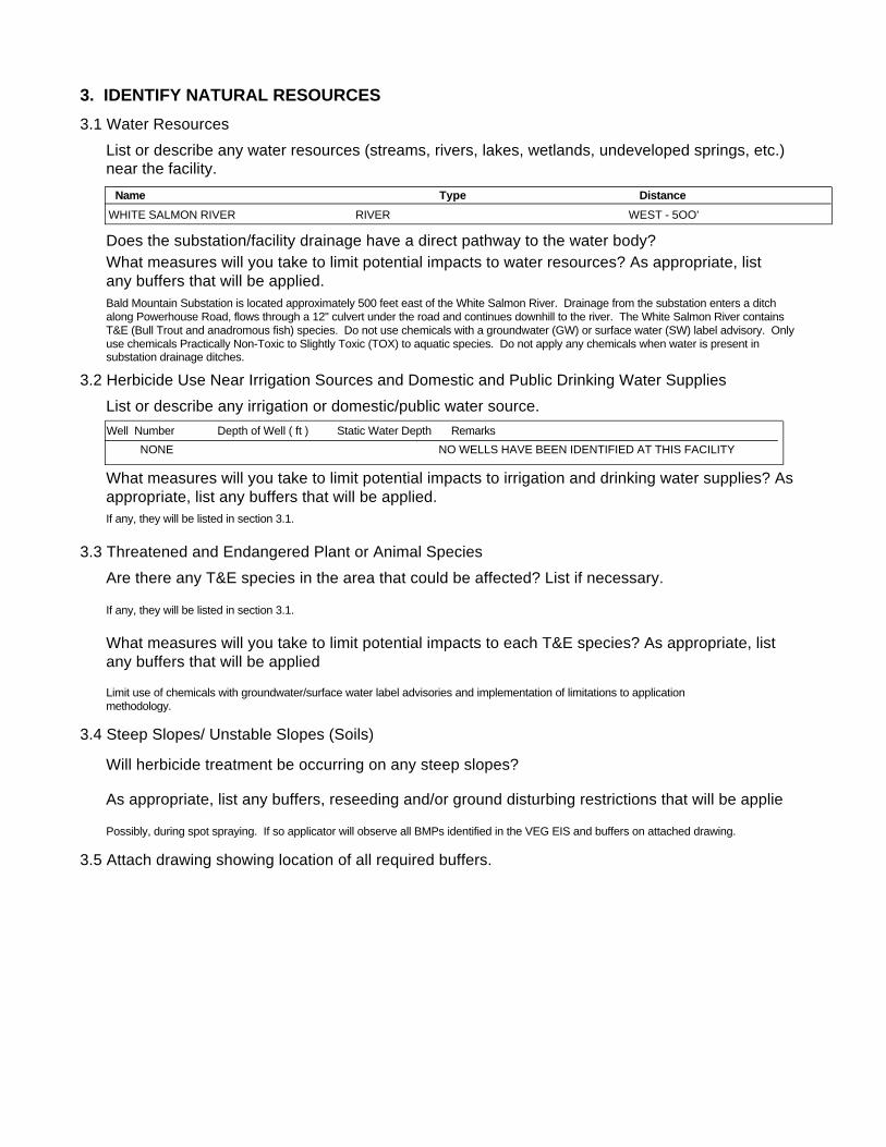
Bald Mountain Substation is located approximately 500 feet east of the White Salmon River. Drainage from the substation enters a ditch along Powerhouse Road, flows through a 12" culvert under the road and continues downhill to the river. The White Salmon River contains T&E (Bull Trout and anadromous fish) species. Do not use chemicals with a groundwater (GW) or surface water (SW) label advisory. Only use chemicals Practically Non-Toxic to Slightly Toxic (TOX) to aquatic species. Do not apply any chemicals when water is present in substation drainage ditches.
Limit use of chemicals with groundwater/surface water label advisories and implementation of limitations to application methodology.
If any, they will be listed in section 3.1.
Possibly, during spot spraying. If so applicator will observe all BMPs identified in the VEG EIS and buffers on attached drawing.
If any, they will be listed in section 3.1.
Name Type DistanceWHITE SALMON RIVER WEST - 5OO'RIVER
Well Number Depth of Well ( ft ) Static Water Depth RemarksNONE NO WELLS HAVE BEEN IDENTIFIED AT THIS FACILITY

4. DETERMINE VEGETATION CONTROL METHODSDescribe overall vegetation management scheme and schedule: Bareground managed areas will primarily use herbicides with supplemental usage of mechanical methods. Other areas will be managed as described in section 1.2. Only herbicides from BPA's approved herbicide list will be used. All areas will be managed consistently with the Vegetation EIS. Initial:
Describe debris disposal and revegetation , if any.
For electrical substations the goal is Total Vegetation Management. A licensed contractor sprays the substations annually. BPA's substation herbicide application contracts contain specific language to ensure herbicides are applied consistent with the VEG EIS. Facilities requiring landscaping are designed to be low maintenance and are consistent with Integrated Pest Management procedures, such as using native, low growing plant types and mulches etc…
Subsequent:Herbicides will be applied on an annual or as needed. Active ingredients shall be rotated to ensure plants do not build a tolerance. Mechanical methods shall be performed on an as needed basis. Landscaping (ornamental plants/lawns) may be maintained via contractor or performed by BPA employees.
Future:Future control will be consistent with the methods described above.
5. DETERMINE DEBRIS DISPOSAL AND REVEGETATION
There will be no debris disposal and revegetion with bareground management. For other areas green debris will be recycled on-site to the extent practical.
6. DETERMINE MONITORING NEEDS
Describe debris disposal and revegetation , if any.
6.1 Describe evaluation of BPA/contractor treatment practices to ensure vegetation management measures are working.
Monitoring will occur through herbicide contract management and the observations of BPA Personnel during on site visits.
6.2 Is there a need to monitor adjacent areas for potential herbicide movement/contamination? If so, describe monitoring plan. (Unless monitoring for other reasons, this section should be consistent with BPA-systemwide herbicide monitoring plan not yet finalized.)
There will be no debris disposal and revegetion with bareground management. Debris disposal will take place on-site and will be recycled to the extent practical. Revegetation will be consistent with the existing vegetation of the facility and will incorporate native species where practical.
7. PREPARE APPROPRIATE ENVIRONMENTAL DOCUMENTATION7.1 Describe any potential project impacts or project work that are different than those disclosed in the Transmission System Vegetation Management Program EIS. Describe how those differences impact natural resources and if the differences are "substantial".
7.2 Is there a need for additional NEPA documentation (i.e. Forest Service requirement, Record of Decision, supplemental EIS)? If so, attach.
None
None
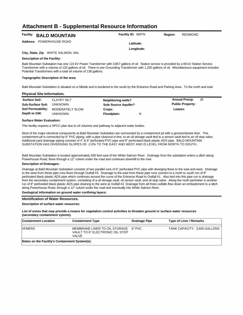
Facility ID: BMTNFacility BALD MOUNTAINAddress: POWERHOUSE ROAD
City, State, Zip WHITE SALMON, WA,
Latitude:Longitude:
Identification of Water Resources.
List of zones that may provide a means for vegetation control activities to threaten ground or surface water resources (secondary containment sytems).
Region: REDMOND
Surface Soil: CLAYEY SILTSub-Surface Soil: UNKNOWNSoil Permeability: MODERATELY SLOW
Sole Source Aquifer?
Depth to GW: UNKNOWN
Neighboring wells?
Floodplain: N
Annual Precip: 26
Crops:Public Property:
Physical Site Information.
Surface Water Evaluation:This facility requires a SPCC plan due to oil volumes and pathway to adjacent water bodies.
Most of the major electrical components at Bald Mountain Substation are surrounded by a containment pit with a geomembrane liner. This containment pit is connected by 6" PVC piping, with a pipe cleanout in-line, to an oil storage vault tied to a sensor vault tied to an oil stop valve. Additional yard drainage piping consists of 4" & 6" perforated PVC pipe and 8" perforated black plastic ADS pipe. BALD MOUNTAIN SUBSTATION HAS DIVERGING SLOPES OF -2.0% TO THE EAST AND WEST AND IS LEVEL FROM NORTH TO SOUTH.
Bald Mountain Substation is located approximately 500 feet east of the White Salmon River. Drainage from the substation enters a ditch along Powerhouse Road, flows through a 12" culvert under the road and continues downhill to the river.
Geological information on ground water confining layers:
Description of the Facility:Bald Mountain Substation has one 115 kV Power Transformer with 3,857 gallons of oil. Station service is provided by a 69 kV Station Service Transformer with a volume of 120 gallons of oil. There is one Grounding Transformer with 1,250 gallons of oil. Miscellaneous equipment includes Potential Transformers with a total oil volume of 138 gallons.
Topographic Description of the area:
Bald Mountain Substation is situated on a hillside and is bordered to the south by the Entrance Road and Parking Area. To the north and east
Leases:
Description of surface water resources:
Description of Drainages:Drainage at Bald Mountain Substation consists of two parallel runs of 6" perforated PVC pipe with diverging flows to the east and west. Drainage to the west from these pipe runs flows through Outfall #3. Drainage to the east from these pipe runs connect to a north to south run of 8" perforated black plastic ADS pipe which continues around the curve of the Entrance Road to Outfall #1. Also tied into this pipe run is drainage from the secondary containment system, consisting of a oil storage vault, oil sensor vault, and oil stop valve. Along the north perimeter is another run of 8" perforated black plastic ADS pipe draining to the west at Outfall #2. Drainage from all three outfalls flow down an embankment to a ditch along Powerhouse Road, through a 12" culvert under the road and eventually into White Salmon River.
Attachment B - Supplemental Resource Information
Containment Location Containment Type Type of Liner / RemarksDrainage Pipe
MEMBRANE LINER TO OIL STORAGE VAULT TO 6" ELECTRONIC OIL STOP VALVE
TANK CAPACITY: 3,600 GALLONSXFMERS 6" PVC
Notes on the Facility's Containment System(s):

ELECTRIC YARD AND NON-ELECTRIC FACILITY CHECKLIST
1. IDENTIFY FACILITY AND THE VEGETATION MANAGEMENT NEED
1.1 Describe facility: (More than one facility may be listed and analyzed.)
1.2 Describe vegetation needing management:
Substation/Facility Name
Size of Area to be Treated
(Acres or Square Feet)
Nearest 1/4 SectionTownship/Range orGPS Coordinates County State
CHENOWETH ORWASCOS21, T2N, R13E, WMFenced Acreage: 4.8Site Acreage: 10.51
Bareground Acres: 1.69
Substation (Total vegetation management.)
Non-Electrical Facility (Describe all landscaping vegetation management.)
Ornamental/Landscaped areas requiring fertilizer, mowing, broadleaf control and weed control.Field grass or other low growing cover crop, mostly mechanical control, spot herbicide treatment for some broad leaf and noxious weed control.Restricted Vegetation Management: See attached drawings and section 3.1 of the checklist for restrictions.
2. IDENTIFY SURROUNDING LAND USE AND LANDOWNERS/MANAGERS2.1 List the types of landowners and land uses around your facility.
2.2 Determine if there is a need to notify surrounding landowners of vegetation management activities. If so, why and how?
2.3 List any specific measures to be taken based on surrounding landowners/use.
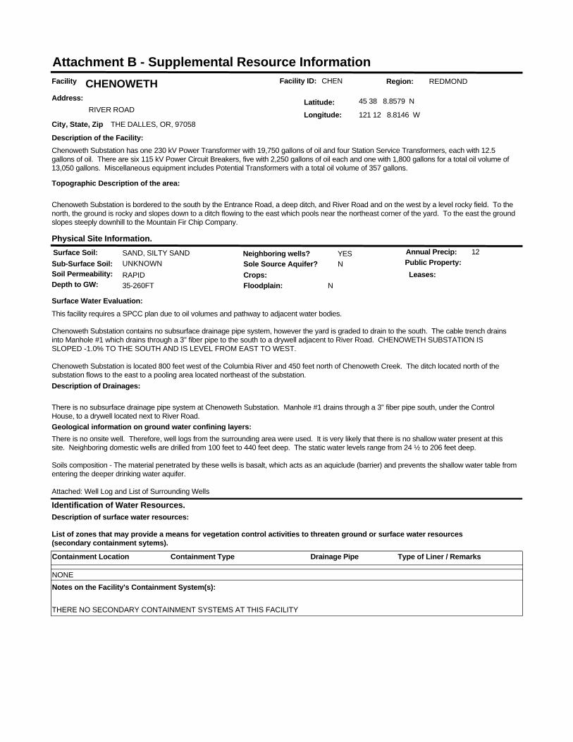
Chenoweth Substation is bordered to the south by the Entrance Road, a deep ditch, and River Road and on the west by a level rocky field. To the north, the ground is rocky and slopes down to a ditch flowing to the east which pools near the northeast corner of the yard. To the east the ground slopes steeply downhill to the Mountain Fir Chip Company.
If notification is required it will be listed next to each landowner up above in section 2.1.
None required.
3. IDENTIFY NATURAL RESOURCES3.1 Water Resources
3.2 Herbicide Use Near Irrigation Sources and Domestic and Public Drinking Water Supplies
List or describe any water resources (streams, rivers, lakes, wetlands, undeveloped springs, etc.) near the facility.
Does the substation/facility drainage have a direct pathway to the water body?What measures will you take to limit potential impacts to water resources? As appropriate, list any buffers that will be applied.
List or describe any irrigation or domestic/public water source.
What measures will you take to limit potential impacts to irrigation and drinking water supplies? Asappropriate, list any buffers that will be applied.
3.3 Threatened and Endangered Plant or Animal Species Are there any T&E species in the area that could be affected? List if necessary.
What measures will you take to limit potential impacts to each T&E species? As appropriate, list any buffers that will be applied
3.4 Steep Slopes/ Unstable Slopes (Soils)
Will herbicide treatment be occurring on any steep slopes?
As appropriate, list any buffers, reseeding and/or ground disturbing restrictions that will be applie
3.5 Attach drawing showing location of all required buffers.
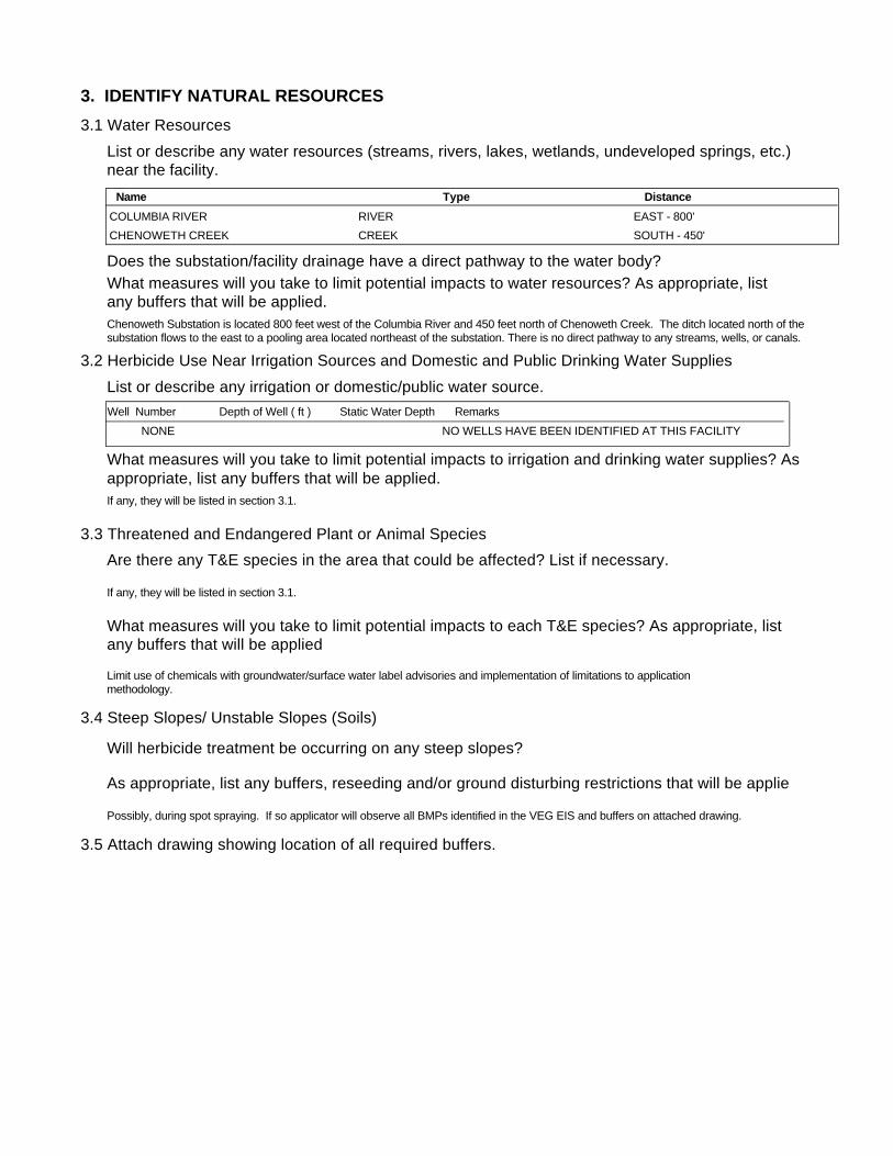
Chenoweth Substation is located 800 feet west of the Columbia River and 450 feet north of Chenoweth Creek. The ditch located north of the substation flows to the east to a pooling area located northeast of the substation. There is no direct pathway to any streams, wells, or canals.
Limit use of chemicals with groundwater/surface water label advisories and implementation of limitations to application methodology.
If any, they will be listed in section 3.1.
Possibly, during spot spraying. If so applicator will observe all BMPs identified in the VEG EIS and buffers on attached drawing.
If any, they will be listed in section 3.1.
Name Type DistanceCOLUMBIA RIVER EAST - 800'RIVERCHENOWETH CREEK SOUTH - 450'CREEK
Well Number Depth of Well ( ft ) Static Water Depth RemarksNONE NO WELLS HAVE BEEN IDENTIFIED AT THIS FACILITY

4. DETERMINE VEGETATION CONTROL METHODSDescribe overall vegetation management scheme and schedule: Bareground managed areas will primarily use herbicides with supplemental usage of mechanical methods. Other areas will be managed as described in section 1.2. Only herbicides from BPA's approved herbicide list will be used. All areas will be managed consistently with the Vegetation EIS. Initial:
Describe debris disposal and revegetation , if any.
For electrical substations the goal is Total Vegetation Management. A licensed contractor sprays the substations annually. BPA's substation herbicide application contracts contain specific language to ensure herbicides are applied consistent with the VEG EIS. Facilities requiring landscaping are designed to be low maintenance and are consistent with Integrated Pest Management procedures, such as using native, low growing plant types and mulches etc…
Subsequent:Herbicides will be applied on an annual or as needed. Active ingredients shall be rotated to ensure plants do not build a tolerance. Mechanical methods shall be performed on an as needed basis. Landscaping (ornamental plants/lawns) may be maintained via contractor or performed by BPA employees.
Future:Future control will be consistent with the methods described above.
5. DETERMINE DEBRIS DISPOSAL AND REVEGETATION
There will be no debris disposal and revegetion with bareground management. For other areas green debris will be recycled on-site to the extent practical.
6. DETERMINE MONITORING NEEDS
Describe debris disposal and revegetation , if any.
6.1 Describe evaluation of BPA/contractor treatment practices to ensure vegetation management measures are working.
Monitoring will occur through herbicide contract management and the observations of BPA Personnel during on site visits.
6.2 Is there a need to monitor adjacent areas for potential herbicide movement/contamination? If so, describe monitoring plan. (Unless monitoring for other reasons, this section should be consistent with BPA-systemwide herbicide monitoring plan not yet finalized.)
There will be no debris disposal and revegetion with bareground management. Debris disposal will take place on-site and will be recycled to the extent practical. Revegetation will be consistent with the existing vegetation of the facility and will incorporate native species where practical.
7. PREPARE APPROPRIATE ENVIRONMENTAL DOCUMENTATION7.1 Describe any potential project impacts or project work that are different than those disclosed in the Transmission System Vegetation Management Program EIS. Describe how those differences impact natural resources and if the differences are "substantial".
7.2 Is there a need for additional NEPA documentation (i.e. Forest Service requirement, Record of Decision, supplemental EIS)? If so, attach.
None
None
Facility ID: CHENFacility CHENOWETHAddress:
RIVER ROAD
City, State, Zip THE DALLES, OR, 97058
Latitude: 45 38 8.8579 N
Longitude: 121 12 8.8146 W
Identification of Water Resources.
List of zones that may provide a means for vegetation control activities to threaten ground or surface water resources (secondary containment sytems).
Region: REDMOND
Surface Soil: SAND, SILTY SANDSub-Surface Soil: UNKNOWNSoil Permeability: RAPID
Sole Source Aquifer? N
Depth to GW: 35-260FT
Neighboring wells? YES
Floodplain: N
Annual Precip: 12
Crops:Public Property:
Physical Site Information.
Surface Water Evaluation:This facility requires a SPCC plan due to oil volumes and pathway to adjacent water bodies.
Chenoweth Substation contains no subsurface drainage pipe system, however the yard is graded to drain to the south. The cable trench drains into Manhole #1 which drains through a 3" fiber pipe to the south to a drywell adjacent to River Road. CHENOWETH SUBSTATION IS SLOPED -1.0% TO THE SOUTH AND IS LEVEL FROM EAST TO WEST.
Chenoweth Substation is located 800 feet west of the Columbia River and 450 feet north of Chenoweth Creek. The ditch located north of the substation flows to the east to a pooling area located northeast of the substation.
Geological information on ground water confining layers:There is no onsite well. Therefore, well logs from the surrounding area were used. It is very likely that there is no shallow water present at this site. Neighboring domestic wells are drilled from 100 feet to 440 feet deep. The static water levels range from 24 ½ to 206 feet deep.
Soils composition - The material penetrated by these wells is basalt, which acts as an aquiclude (barrier) and prevents the shallow water table from entering the deeper drinking water aquifer.
Attached: Well Log and List of Surrounding Wells
Description of the Facility:Chenoweth Substation has one 230 kV Power Transformer with 19,750 gallons of oil and four Station Service Transformers, each with 12.5 gallons of oil. There are six 115 kV Power Circuit Breakers, five with 2,250 gallons of oil each and one with 1,800 gallons for a total oil volume of 13,050 gallons. Miscellaneous equipment includes Potential Transformers with a total oil volume of 357 gallons.
Topographic Description of the area:
Chenoweth Substation is bordered to the south by the Entrance Road, a deep ditch, and River Road and on the west by a level rocky field. To the north, the ground is rocky and slopes down to a ditch flowing to the east which pools near the northeast corner of the yard. To the east the ground slopes steeply downhill to the Mountain Fir Chip Company.
Leases:
Description of surface water resources:
Description of Drainages:
There is no subsurface drainage pipe system at Chenoweth Substation. Manhole #1 drains through a 3" fiber pipe south, under the Control House, to a drywell located next to River Road.
Attachment B - Supplemental Resource Information
Containment Location Containment Type Type of Liner / RemarksDrainage Pipe
NONENotes on the Facility's Containment System(s):
THERE NO SECONDARY CONTAINMENT SYSTEMS AT THIS FACILITY
ELECTRIC YARD AND NON-ELECTRIC FACILITY CHECKLIST
1. IDENTIFY FACILITY AND THE VEGETATION MANAGEMENT NEED
1.1 Describe facility: (More than one facility may be listed and analyzed.)
1.2 Describe vegetation needing management:
Substation/Facility Name
Size of Area to be Treated
(Acres or Square Feet)
Nearest 1/4 SectionTownship/Range orGPS Coordinates County State
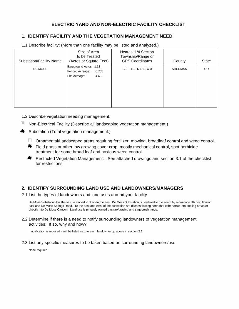
DE MOSS ORSHERMANS3, T1S, R17E, WMFenced Acreage: 0.765Site Acreage: 4.48
Bareground Acres: 1.13
Substation (Total vegetation management.)
Non-Electrical Facility (Describe all landscaping vegetation management.)
Ornamental/Landscaped areas requiring fertilizer, mowing, broadleaf control and weed control.Field grass or other low growing cover crop, mostly mechanical control, spot herbicide treatment for some broad leaf and noxious weed control.Restricted Vegetation Management: See attached drawings and section 3.1 of the checklist for restrictions.
2. IDENTIFY SURROUNDING LAND USE AND LANDOWNERS/MANAGERS2.1 List the types of landowners and land uses around your facility.
2.2 Determine if there is a need to notify surrounding landowners of vegetation management activities. If so, why and how?
2.3 List any specific measures to be taken based on surrounding landowners/use.
De Moss Substation but the yard is sloped to drain to the east. De Moss Substation is bordered to the south by a drainage ditching flowing east and De Moss Springs Road. To the east and west of the substation are ditches flowing north that either drain into pooling areas or directly into De Moss Canyon. Land use is privately owned pasture/grazing and sagebrush lands.
If notification is required it will be listed next to each landowner up above in section 2.1.
None required.
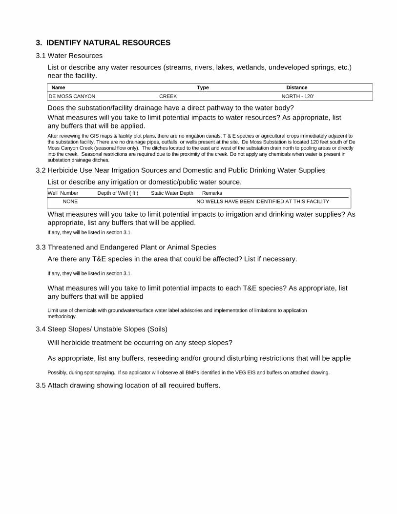
3. IDENTIFY NATURAL RESOURCES3.1 Water Resources
3.2 Herbicide Use Near Irrigation Sources and Domestic and Public Drinking Water Supplies
List or describe any water resources (streams, rivers, lakes, wetlands, undeveloped springs, etc.) near the facility.
Does the substation/facility drainage have a direct pathway to the water body?What measures will you take to limit potential impacts to water resources? As appropriate, list any buffers that will be applied.
List or describe any irrigation or domestic/public water source.
What measures will you take to limit potential impacts to irrigation and drinking water supplies? Asappropriate, list any buffers that will be applied.
3.3 Threatened and Endangered Plant or Animal Species Are there any T&E species in the area that could be affected? List if necessary.
What measures will you take to limit potential impacts to each T&E species? As appropriate, list any buffers that will be applied
3.4 Steep Slopes/ Unstable Slopes (Soils)
Will herbicide treatment be occurring on any steep slopes?
As appropriate, list any buffers, reseeding and/or ground disturbing restrictions that will be applie
3.5 Attach drawing showing location of all required buffers.
After reviewing the GIS maps & facility plot plans, there are no irrigation canals, T & E species or agricultural crops immediately adjacent to the substation facility. There are no drainage pipes, outfalls, or wells present at the site. De Moss Substation is located 120 feet south of De Moss Canyon Creek (seasonal flow only). The ditches located to the east and west of the substation drain north to pooling areas or directly into the creek. Seasonal restrictions are required due to the proximity of the creek. Do not apply any chemicals when water is present in substation drainage ditches.
Limit use of chemicals with groundwater/surface water label advisories and implementation of limitations to application methodology.
If any, they will be listed in section 3.1.
Possibly, during spot spraying. If so applicator will observe all BMPs identified in the VEG EIS and buffers on attached drawing.
If any, they will be listed in section 3.1.
Name Type DistanceDE MOSS CANYON NORTH - 120'CREEK
Well Number Depth of Well ( ft ) Static Water Depth RemarksNONE NO WELLS HAVE BEEN IDENTIFIED AT THIS FACILITY

4. DETERMINE VEGETATION CONTROL METHODSDescribe overall vegetation management scheme and schedule: Bareground managed areas will primarily use herbicides with supplemental usage of mechanical methods. Other areas will be managed as described in section 1.2. Only herbicides from BPA's approved herbicide list will be used. All areas will be managed consistently with the Vegetation EIS. Initial:
Describe debris disposal and revegetation , if any.
For electrical substations the goal is Total Vegetation Management. A licensed contractor sprays the substations annually. BPA's substation herbicide application contracts contain specific language to ensure herbicides are applied consistent with the VEG EIS. Facilities requiring landscaping are designed to be low maintenance and are consistent with Integrated Pest Management procedures, such as using native, low growing plant types and mulches etc…
Subsequent:Herbicides will be applied on an annual or as needed. Active ingredients shall be rotated to ensure plants do not build a tolerance. Mechanical methods shall be performed on an as needed basis. Landscaping (ornamental plants/lawns) may be maintained via contractor or performed by BPA employees.
Future:Future control will be consistent with the methods described above.
5. DETERMINE DEBRIS DISPOSAL AND REVEGETATION
There will be no debris disposal and revegetion with bareground management. For other areas green debris will be recycled on-site to the extent practical.
6. DETERMINE MONITORING NEEDS
Describe debris disposal and revegetation , if any.
6.1 Describe evaluation of BPA/contractor treatment practices to ensure vegetation management measures are working.
Monitoring will occur through herbicide contract management and the observations of BPA Personnel during on site visits.
6.2 Is there a need to monitor adjacent areas for potential herbicide movement/contamination? If so, describe monitoring plan. (Unless monitoring for other reasons, this section should be consistent with BPA-systemwide herbicide monitoring plan not yet finalized.)
There will be no debris disposal and revegetion with bareground management. Debris disposal will take place on-site and will be recycled to the extent practical. Revegetation will be consistent with the existing vegetation of the facility and will incorporate native species where practical.
7. PREPARE APPROPRIATE ENVIRONMENTAL DOCUMENTATION7.1 Describe any potential project impacts or project work that are different than those disclosed in the Transmission System Vegetation Management Program EIS. Describe how those differences impact natural resources and if the differences are "substantial".
7.2 Is there a need for additional NEPA documentation (i.e. Forest Service requirement, Record of Decision, supplemental EIS)? If so, attach.
None
None
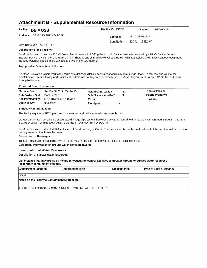
Facility ID: DEMOFacility DE MOSSAddress: DE MOSS SPRING ROAD
City, State, Zip MORO, OR,
Latitude: 45 30 55.5224 N
Longitude: 120 41 4.8322 W
Identification of Water Resources.
List of zones that may provide a means for vegetation control activities to threaten ground or surface water resources (secondary containment sytems).
Region: REDMOND
Surface Soil: SANDY SILT, SILTY SANDSub-Surface Soil: SANDY SILTSoil Permeability: MODERATE-MOD RAPID
Sole Source Aquifer? N
Depth to GW: 30-280FT
Neighboring wells? NO
Floodplain: N
Annual Precip: 10
Crops:Public Property:
Physical Site Information.
Surface Water Evaluation:This facility requires a SPCC plan due to oil volumes and pathway to adjacent water bodies.
De Moss Substation contains no subsurface drainage pipe system, however the yard is graded to drain to the east. DE MOSS SUBSTATION IS SLOPED -2.0% TO THE EAST AND IS LEVEL FROM NORTH TO SOUTH.
De Moss Substation is located 120 feet south of De Moss Canyon Creek. The ditches located to the east and west of the substation drain north to pooling areas or directly into the creek.
Geological information on ground water confining layers:
Description of the Facility:De Moss Substation has one 115 kV Power Transformer with 7,600 gallons of oil. Station service is provided by a 67 kV Station Service Transformer with a volume of 142 gallons of oil. There is one oil-filled Power Circuit Breaker with 372 gallons of oil. Miscellaneous equipment includes Potential Transformers with a total oil volume of 173 gallons.
Topographic Description of the area:
De Moss Substation is bordered to the south by a drainage ditching flowing east and De Moss Springs Road. To the east and west of the substation are ditches flowing north which either drain into pooling areas or directly into De Moss Canyon Creek, located 120' to the north and flowing to the east.
Leases:
Description of surface water resources:
Description of Drainages:There is no surface drainage pipe system at De Moss Substation but the yard is sloped to drain to the east.
Attachment B - Supplemental Resource Information
Containment Location Containment Type Type of Liner / RemarksDrainage Pipe
NONENotes on the Facility's Containment System(s):
THERE NO SECONDARY CONTAINMENT SYSTEMS AT THIS FACILITY

ELECTRIC YARD AND NON-ELECTRIC FACILITY CHECKLIST
1. IDENTIFY FACILITY AND THE VEGETATION MANAGEMENT NEED
1.1 Describe facility: (More than one facility may be listed and analyzed.)
1.2 Describe vegetation needing management:
Substation/Facility Name
Size of Area to be Treated
(Acres or Square Feet)
Nearest 1/4 SectionTownship/Range orGPS Coordinates County State
FOSSIL ORWHEELERS33, T6S, R21E, WMFenced Acreage: 0.88Site Acreage: 3.6
Bareground Acres: 1.13
Substation (Total vegetation management.)
Non-Electrical Facility (Describe all landscaping vegetation management.)
Ornamental/Landscaped areas requiring fertilizer, mowing, broadleaf control and weed control.Field grass or other low growing cover crop, mostly mechanical control, spot herbicide treatment for some broad leaf and noxious weed control.Restricted Vegetation Management: See attached drawings and section 3.1 of the checklist for restrictions.
2. IDENTIFY SURROUNDING LAND USE AND LANDOWNERS/MANAGERS2.1 List the types of landowners and land uses around your facility.
2.2 Determine if there is a need to notify surrounding landowners of vegetation management activities. If so, why and how?
2.3 List any specific measures to be taken based on surrounding landowners/use.
Fossil substation is located on Fee owned land. Private agricultural and pasture/grazing land surrounds the site.
If notification is required it will be listed next to each landowner up above in section 2.1.
None required.
3. IDENTIFY NATURAL RESOURCES3.1 Water Resources
3.2 Herbicide Use Near Irrigation Sources and Domestic and Public Drinking Water Supplies
List or describe any water resources (streams, rivers, lakes, wetlands, undeveloped springs, etc.) near the facility.
Does the substation/facility drainage have a direct pathway to the water body?What measures will you take to limit potential impacts to water resources? As appropriate, list any buffers that will be applied.
List or describe any irrigation or domestic/public water source.
What measures will you take to limit potential impacts to irrigation and drinking water supplies? Asappropriate, list any buffers that will be applied.
3.3 Threatened and Endangered Plant or Animal Species Are there any T&E species in the area that could be affected? List if necessary.
What measures will you take to limit potential impacts to each T&E species? As appropriate, list any buffers that will be applied
3.4 Steep Slopes/ Unstable Slopes (Soils)
Will herbicide treatment be occurring on any steep slopes?
As appropriate, list any buffers, reseeding and/or ground disturbing restrictions that will be applie
3.5 Attach drawing showing location of all required buffers.
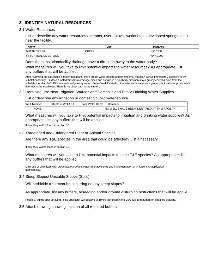
After reviewing the GIS maps & facility plot plans, there are no wells present and no streams, irrigation canals immediately adjacent to the substation facility. Surface runoff drains from drainage pipes and outfalls in a southerly direction into a grassy covered ditch from the substation under HWY 19 into a series of pooling areas. Butte Creek located on the adjacent farm/pasture property is located approximately 500 feet to the southwest. There is no direct path to the stream.
Limit use of chemicals with groundwater/surface water label advisories and implementation of limitations to application methodology.
If any, they will be listed in section 3.1.
Possibly, during spot spraying. If so applicator will observe all BMPs identified in the VEG EIS and buffers on attached drawing.
If any, they will be listed in section 3.1.
Name Type DistanceBUTTE CREEK 1,718.832CREEKIRRIGATION, LIVESTOCK W/IN 1000'
Well Number Depth of Well ( ft ) Static Water Depth RemarksNONE NO WELLS HAVE BEEN IDENTIFIED AT THIS FACILITY

4. DETERMINE VEGETATION CONTROL METHODSDescribe overall vegetation management scheme and schedule: Bareground managed areas will primarily use herbicides with supplemental usage of mechanical methods. Other areas will be managed as described in section 1.2. Only herbicides from BPA's approved herbicide list will be used. All areas will be managed consistently with the Vegetation EIS. Initial:
Describe debris disposal and revegetation , if any.
For electrical substations the goal is Total Vegetation Management. A licensed contractor sprays the substations annually. BPA's substation herbicide application contracts contain specific language to ensure herbicides are applied consistent with the VEG EIS. Facilities requiring landscaping are designed to be low maintenance and are consistent with Integrated Pest Management procedures, such as using native, low growing plant types and mulches etc…
Subsequent:Herbicides will be applied on an annual or as needed. Active ingredients shall be rotated to ensure plants do not build a tolerance. Mechanical methods shall be performed on an as needed basis. Landscaping (ornamental plants/lawns) may be maintained via contractor or performed by BPA employees.
Future:Future control will be consistent with the methods described above.
5. DETERMINE DEBRIS DISPOSAL AND REVEGETATION
There will be no debris disposal and revegetion with bareground management. For other areas green debris will be recycled on-site to the extent practical.
6. DETERMINE MONITORING NEEDS
Describe debris disposal and revegetation , if any.
6.1 Describe evaluation of BPA/contractor treatment practices to ensure vegetation management measures are working.
Monitoring will occur through herbicide contract management and the observations of BPA Personnel during on site visits.
6.2 Is there a need to monitor adjacent areas for potential herbicide movement/contamination? If so, describe monitoring plan. (Unless monitoring for other reasons, this section should be consistent with BPA-systemwide herbicide monitoring plan not yet finalized.)
There will be no debris disposal and revegetion with bareground management. Debris disposal will take place on-site and will be recycled to the extent practical. Revegetation will be consistent with the existing vegetation of the facility and will incorporate native species where practical.
7. PREPARE APPROPRIATE ENVIRONMENTAL DOCUMENTATION7.1 Describe any potential project impacts or project work that are different than those disclosed in the Transmission System Vegetation Management Program EIS. Describe how those differences impact natural resources and if the differences are "substantial".
7.2 Is there a need for additional NEPA documentation (i.e. Forest Service requirement, Record of Decision, supplemental EIS)? If so, attach.
None
None

Facility ID: FOSSFacility FOSSILAddress:
City, State, Zip FOSSIL, OR,
Latitude: 44 59 41.6957 N
Longitude: 120 12 9.8313 W
Identification of Water Resources.
List of zones that may provide a means for vegetation control activities to threaten ground or surface water resources (secondary containment sytems).
Region: REDMOND
Surface Soil: COBBLY SILTY SANDSub-Surface Soil: CLAYSoil Permeability: SLOW
Sole Source Aquifer? N
Depth to GW: 5-80FT
Neighboring wells? YES
Floodplain: N
Annual Precip: 13
Crops:Public Property:
Physical Site Information.
Surface Water Evaluation:This facility does not require an SPCC plan. Oil volumes do not meet the regulatory limits and there is no pathway to adjacent water.
Field verified 08/97. Fossil Substation: Not enough oil and no pathway. No plan required.
Geological information on ground water confining layers:
Description of the Facility:Fossil Substation has two Circuit Breakers, each with 340 gallons of oil. Miscellaneous equipment includes Current and Potential Transformers with a total oil volume of ???gallons of oil. Capacitor Group #1, Sections #1 & #2 contain120 Non-PCB caps, with 1.6 gallons each.
Topographic Description of the area:
Leases:
Description of surface water resources:
Description of Drainages:Fossil Substation has no subsurface drainage pipe system. The yard is graded -1.0% to the west.
Attachment B - Supplemental Resource Information
Containment Location Containment Type Type of Liner / RemarksDrainage Pipe
Notes on the Facility's Containment System(s):
ELECTRIC YARD AND NON-ELECTRIC FACILITY CHECKLIST
1. IDENTIFY FACILITY AND THE VEGETATION MANAGEMENT NEED
1.1 Describe facility: (More than one facility may be listed and analyzed.)
1.2 Describe vegetation needing management:
Substation/Facility Name
Size of Area to be Treated
(Acres or Square Feet)
Nearest 1/4 SectionTownship/Range orGPS Coordinates County State
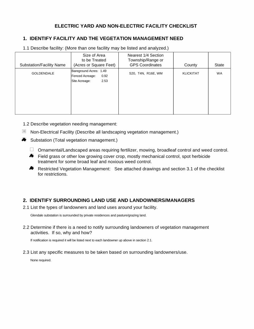
GOLDENDALE WAKLICKITATS20, T4N, R16E, WMFenced Acreage: 0.92Site Acreage: 2.53
Bareground Acres: 1.49
Substation (Total vegetation management.)
Non-Electrical Facility (Describe all landscaping vegetation management.)
Ornamental/Landscaped areas requiring fertilizer, mowing, broadleaf control and weed control.Field grass or other low growing cover crop, mostly mechanical control, spot herbicide treatment for some broad leaf and noxious weed control.Restricted Vegetation Management: See attached drawings and section 3.1 of the checklist for restrictions.
2. IDENTIFY SURROUNDING LAND USE AND LANDOWNERS/MANAGERS2.1 List the types of landowners and land uses around your facility.
2.2 Determine if there is a need to notify surrounding landowners of vegetation management activities. If so, why and how?
2.3 List any specific measures to be taken based on surrounding landowners/use.
Glendale substation is surrounded by private residences and pasture/grazing land.
If notification is required it will be listed next to each landowner up above in section 2.1.
None required.
3. IDENTIFY NATURAL RESOURCES3.1 Water Resources
3.2 Herbicide Use Near Irrigation Sources and Domestic and Public Drinking Water Supplies
List or describe any water resources (streams, rivers, lakes, wetlands, undeveloped springs, etc.) near the facility.
Does the substation/facility drainage have a direct pathway to the water body?What measures will you take to limit potential impacts to water resources? As appropriate, list any buffers that will be applied.
List or describe any irrigation or domestic/public water source.
What measures will you take to limit potential impacts to irrigation and drinking water supplies? Asappropriate, list any buffers that will be applied.
3.3 Threatened and Endangered Plant or Animal Species Are there any T&E species in the area that could be affected? List if necessary.
What measures will you take to limit potential impacts to each T&E species? As appropriate, list any buffers that will be applied
3.4 Steep Slopes/ Unstable Slopes (Soils)
Will herbicide treatment be occurring on any steep slopes?
As appropriate, list any buffers, reseeding and/or ground disturbing restrictions that will be applie
3.5 Attach drawing showing location of all required buffers.
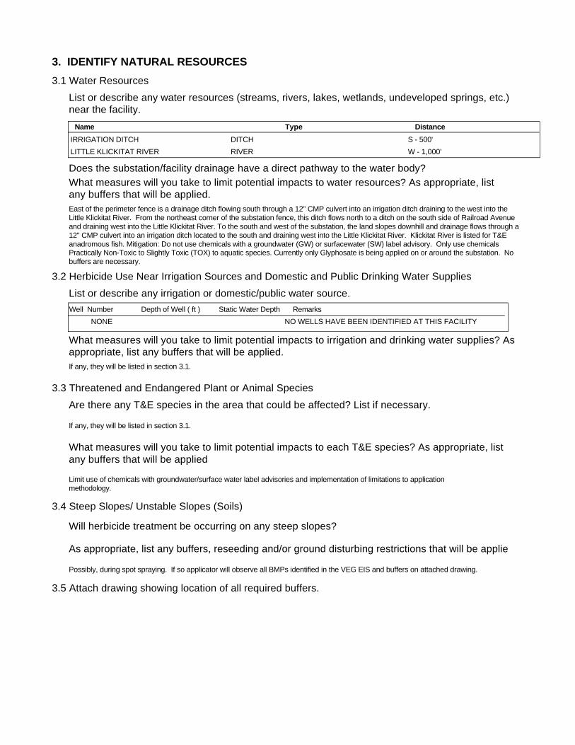
East of the perimeter fence is a drainage ditch flowing south through a 12" CMP culvert into an irrigation ditch draining to the west into the Little Klickitat River. From the northeast corner of the substation fence, this ditch flows north to a ditch on the south side of Railroad Avenue and draining west into the Little Klickitat River. To the south and west of the substation, the land slopes downhill and drainage flows through a 12" CMP culvert into an irrigation ditch located to the south and draining west into the Little Klickitat River. Klickitat River is listed for T&E anadromous fish. Mitigation: Do not use chemicals with a groundwater (GW) or surfacewater (SW) label advisory. Only use chemicals Practically Non-Toxic to Slightly Toxic (TOX) to aquatic species. Currently only Glyphosate is being applied on or around the substation. No buffers are necessary.
Limit use of chemicals with groundwater/surface water label advisories and implementation of limitations to application methodology.
If any, they will be listed in section 3.1.
Possibly, during spot spraying. If so applicator will observe all BMPs identified in the VEG EIS and buffers on attached drawing.
If any, they will be listed in section 3.1.
Name Type DistanceIRRIGATION DITCH S - 500'DITCHLITTLE KLICKITAT RIVER W - 1,000'RIVER
Well Number Depth of Well ( ft ) Static Water Depth RemarksNONE NO WELLS HAVE BEEN IDENTIFIED AT THIS FACILITY

4. DETERMINE VEGETATION CONTROL METHODSDescribe overall vegetation management scheme and schedule: Bareground managed areas will primarily use herbicides with supplemental usage of mechanical methods. Other areas will be managed as described in section 1.2. Only herbicides from BPA's approved herbicide list will be used. All areas will be managed consistently with the Vegetation EIS. Initial:
Describe debris disposal and revegetation , if any.
For electrical substations the goal is Total Vegetation Management. A licensed contractor sprays the substations annually. BPA's substation herbicide application contracts contain specific language to ensure herbicides are applied consistent with the VEG EIS. Facilities requiring landscaping are designed to be low maintenance and are consistent with Integrated Pest Management procedures, such as using native, low growing plant types and mulches etc…
Subsequent:Herbicides will be applied on an annual or as needed. Active ingredients shall be rotated to ensure plants do not build a tolerance. Mechanical methods shall be performed on an as needed basis. Landscaping (ornamental plants/lawns) may be maintained via contractor or performed by BPA employees.
Future:Future control will be consistent with the methods described above.
5. DETERMINE DEBRIS DISPOSAL AND REVEGETATION
There will be no debris disposal and revegetion with bareground management. For other areas green debris will be recycled on-site to the extent practical.
6. DETERMINE MONITORING NEEDS
Describe debris disposal and revegetation , if any.
6.1 Describe evaluation of BPA/contractor treatment practices to ensure vegetation management measures are working.
Monitoring will occur through herbicide contract management and the observations of BPA Personnel during on site visits.
6.2 Is there a need to monitor adjacent areas for potential herbicide movement/contamination? If so, describe monitoring plan. (Unless monitoring for other reasons, this section should be consistent with BPA-systemwide herbicide monitoring plan not yet finalized.)
There will be no debris disposal and revegetion with bareground management. Debris disposal will take place on-site and will be recycled to the extent practical. Revegetation will be consistent with the existing vegetation of the facility and will incorporate native species where practical.
7. PREPARE APPROPRIATE ENVIRONMENTAL DOCUMENTATION7.1 Describe any potential project impacts or project work that are different than those disclosed in the Transmission System Vegetation Management Program EIS. Describe how those differences impact natural resources and if the differences are "substantial".
7.2 Is there a need for additional NEPA documentation (i.e. Forest Service requirement, Record of Decision, supplemental EIS)? If so, attach.
None
None

Facility ID: GOLDFacility GOLDENDALEAddress:
RAILROAD AVENUE
City, State, Zip GOLDENDALE, WA,
Latitude: 45 48 56.0260 N
Longitude: 120 50 17.4809 W
Identification of Water Resources.
List of zones that may provide a means for vegetation control activities to threaten ground or surface water resources (secondary containment sytems).
Region: REDMOND
Surface Soil: SANDY SILTSub-Surface Soil: SANDY SILTSoil Permeability: MODERATELY RAPID
Sole Source Aquifer? N
Depth to GW: UNKNOWN
Neighboring wells? YES
Floodplain: N
Annual Precip: 15
Crops:Public Property:
Physical Site Information.
Surface Water Evaluation:This facility requires a SPCC plan due to oil volumes and pathway to adjacent water bodies.
Goldendale Substation contains two short 6" open jointed drainage pipe runs in the northeast corner of the yard and the yard is graded to drain to the south. GOLDENDALE SUBSTATION IS SLOPED -1.0% TO THE SOUTH AND IS LEVEL FROM EAST TO WEST.
Goldendale Substation is located 500 feet north of an irrigation ditch draining into the Little Klickitat River located 1,000 feet west of the substation.
Geological information on ground water confining layers:
Description of the Facility:Goldendale Substation has four 115 kV Power Transformer each with 5,000 gallons of oil for a total of 20,000 gallons. Station service is provided by a 69 kV Station Service Transformer with a volume of 197 gallons of oil. There is one Grounding Transformer with 1,410 gallons of oil. Miscellaneous equipment includes Potential Transformers with a total oil volume of 327 gallons.
Topographic Description of the area:
Goldendale Substation is bordered to the north by the Entrance Road and gravel parking area. East of the perimeter fence is a drainage ditch flowing south through a 12" CMP culvert into an irrigation ditch draining to the west into the Little Klickitat River. From the northeast corner of the substation fence, this ditch flows north to a ditch on the south side of Railroad Avenue and draining west into the Little Klickitat River. To the south and west of the substation, the land slopes downhill and drainage flows through a 12" CMP culvert into an irrigation ditch located to the south and draining west into the Little Klickitat River.
Leases:
Description of surface water resources:
Description of Drainages:Yard drainage consists of two short south to north runs of 6" open jointed concrete piping located in the northeast corner of the yard and Parking Area. Drainage outfalls into a ditch flowing northwest into a field.
Attachment B - Supplemental Resource Information
Containment Location Containment Type Type of Liner / RemarksDrainage Pipe
NONENotes on the Facility's Containment System(s):
THERE NO SECONDARY CONTAINMENT SYSTEMS AT THIS FACILITY
ELECTRIC YARD AND NON-ELECTRIC FACILITY CHECKLIST
1. IDENTIFY FACILITY AND THE VEGETATION MANAGEMENT NEED
1.1 Describe facility: (More than one facility may be listed and analyzed.)
1.2 Describe vegetation needing management:
Substation/Facility Name
Size of Area to be Treated
(Acres or Square Feet)
Nearest 1/4 SectionTownship/Range orGPS Coordinates County State
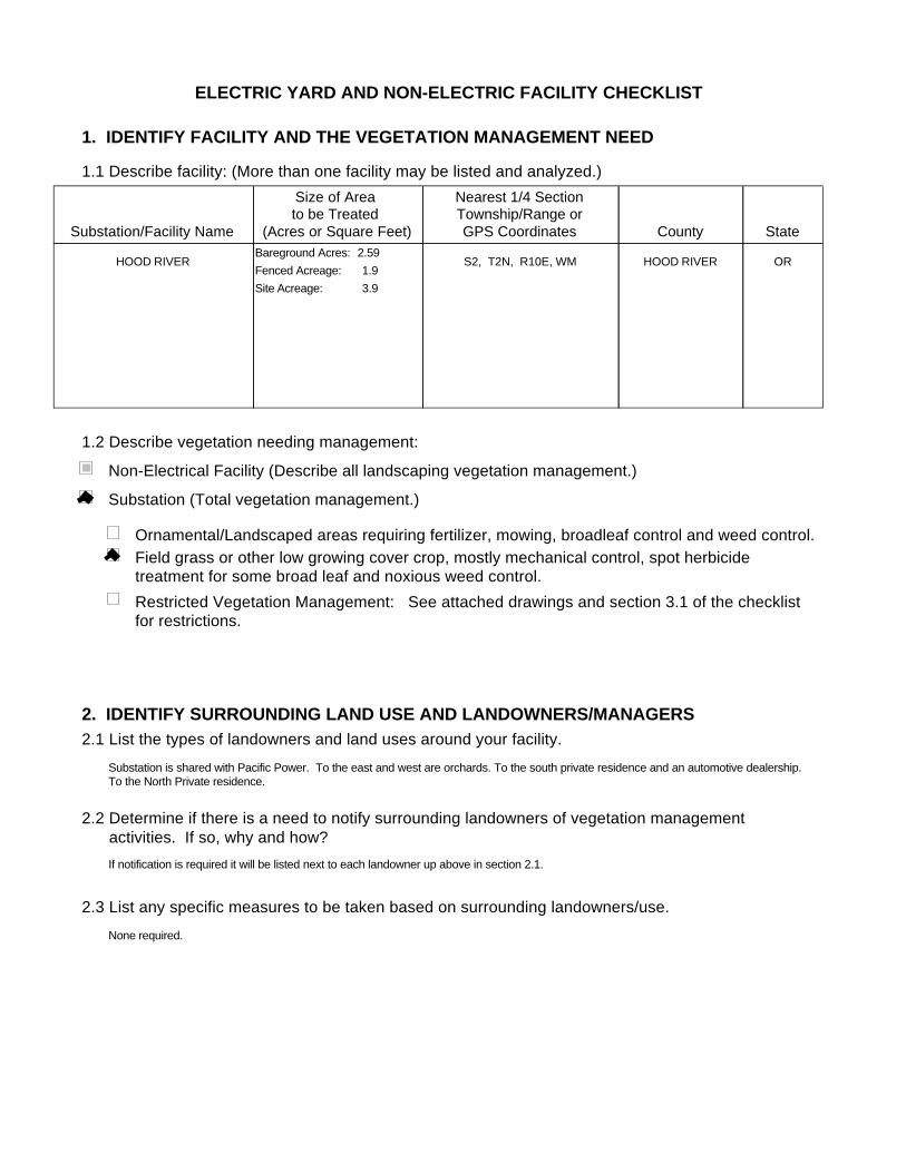
HOOD RIVER ORHOOD RIVERS2, T2N, R10E, WMFenced Acreage: 1.9Site Acreage: 3.9
Bareground Acres: 2.59
Substation (Total vegetation management.)
Non-Electrical Facility (Describe all landscaping vegetation management.)
Ornamental/Landscaped areas requiring fertilizer, mowing, broadleaf control and weed control.Field grass or other low growing cover crop, mostly mechanical control, spot herbicide treatment for some broad leaf and noxious weed control.Restricted Vegetation Management: See attached drawings and section 3.1 of the checklist for restrictions.
2. IDENTIFY SURROUNDING LAND USE AND LANDOWNERS/MANAGERS2.1 List the types of landowners and land uses around your facility.
2.2 Determine if there is a need to notify surrounding landowners of vegetation management activities. If so, why and how?
2.3 List any specific measures to be taken based on surrounding landowners/use.
Substation is shared with Pacific Power. To the east and west are orchards. To the south private residence and an automotive dealership. To the North Private residence.
If notification is required it will be listed next to each landowner up above in section 2.1.
None required.
3. IDENTIFY NATURAL RESOURCES3.1 Water Resources
3.2 Herbicide Use Near Irrigation Sources and Domestic and Public Drinking Water Supplies
List or describe any water resources (streams, rivers, lakes, wetlands, undeveloped springs, etc.) near the facility.
Does the substation/facility drainage have a direct pathway to the water body?What measures will you take to limit potential impacts to water resources? As appropriate, list any buffers that will be applied.
List or describe any irrigation or domestic/public water source.
What measures will you take to limit potential impacts to irrigation and drinking water supplies? Asappropriate, list any buffers that will be applied.
3.3 Threatened and Endangered Plant or Animal Species Are there any T&E species in the area that could be affected? List if necessary.
What measures will you take to limit potential impacts to each T&E species? As appropriate, list any buffers that will be applied
3.4 Steep Slopes/ Unstable Slopes (Soils)
Will herbicide treatment be occurring on any steep slopes?
As appropriate, list any buffers, reseeding and/or ground disturbing restrictions that will be applie
3.5 Attach drawing showing location of all required buffers.
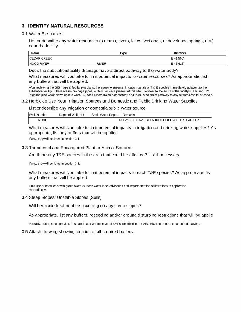
After reviewing the GIS maps & facility plot plans, there are no streams, irrigation canals or T & E species immediately adjacent to the substation facility. There are no drainage pipes, outfalls, or wells present at this site. Ten feet to the south of the facility is a buried 12" irrigation pipe which flows east to west. Surface runoff drains notheasterly and there is no direct pathway to any streams, wells, or canals.
Limit use of chemicals with groundwater/surface water label advisories and implementation of limitations to application methodology.
If any, they will be listed in section 3.1.
Possibly, during spot spraying. If so applicator will observe all BMPs identified in the VEG EIS and buffers on attached drawing.
If any, they will be listed in section 3.1.
Name Type DistanceCEDAR CREEK E - 1,500'HOOD RIVER E - 3,413'RIVER
Well Number Depth of Well ( ft ) Static Water Depth RemarksNONE NO WELLS HAVE BEEN IDENTIFIED AT THIS FACILITY

4. DETERMINE VEGETATION CONTROL METHODSDescribe overall vegetation management scheme and schedule: Bareground managed areas will primarily use herbicides with supplemental usage of mechanical methods. Other areas will be managed as described in section 1.2. Only herbicides from BPA's approved herbicide list will be used. All areas will be managed consistently with the Vegetation EIS. Initial:
Describe debris disposal and revegetation , if any.
For electrical substations the goal is Total Vegetation Management. A licensed contractor sprays the substations annually. BPA's substation herbicide application contracts contain specific language to ensure herbicides are applied consistent with the VEG EIS. Facilities requiring landscaping are designed to be low maintenance and are consistent with Integrated Pest Management procedures, such as using native, low growing plant types and mulches etc…
Subsequent:Herbicides will be applied on an annual or as needed. Active ingredients shall be rotated to ensure plants do not build a tolerance. Mechanical methods shall be performed on an as needed basis. Landscaping (ornamental plants/lawns) may be maintained via contractor or performed by BPA employees.
Future:Future control will be consistent with the methods described above.
5. DETERMINE DEBRIS DISPOSAL AND REVEGETATION
There will be no debris disposal and revegetion with bareground management. For other areas green debris will be recycled on-site to the extent practical.
6. DETERMINE MONITORING NEEDS
Describe debris disposal and revegetation , if any.
6.1 Describe evaluation of BPA/contractor treatment practices to ensure vegetation management measures are working.
Monitoring will occur through herbicide contract management and the observations of BPA Personnel during on site visits.
6.2 Is there a need to monitor adjacent areas for potential herbicide movement/contamination? If so, describe monitoring plan. (Unless monitoring for other reasons, this section should be consistent with BPA-systemwide herbicide monitoring plan not yet finalized.)
There will be no debris disposal and revegetion with bareground management. Debris disposal will take place on-site and will be recycled to the extent practical. Revegetation will be consistent with the existing vegetation of the facility and will incorporate native species where practical.
7. PREPARE APPROPRIATE ENVIRONMENTAL DOCUMENTATION7.1 Describe any potential project impacts or project work that are different than those disclosed in the Transmission System Vegetation Management Program EIS. Describe how those differences impact natural resources and if the differences are "substantial".
7.2 Is there a need for additional NEPA documentation (i.e. Forest Service requirement, Record of Decision, supplemental EIS)? If so, attach.
None
None

Facility ID: HORVFacility HOOD RIVERAddress: 1060 TUCKER ROAD
City, State, Zip HOOD RIVER, OR, 97031
Latitude: 45 41 18.3754 N
Longitude: 121 31 32.2544 W
Identification of Water Resources.
List of zones that may provide a means for vegetation control activities to threaten ground or surface water resources (secondary containment sytems).
Region: REDMOND
Surface Soil: SILTY SANDSub-Surface Soil: SILTY SANDSoil Permeability: MODERATELY RAPID
Sole Source Aquifer? N
Depth to GW: 5-30 FT
Neighboring wells? NO
Floodplain: N
Annual Precip: 26
Crops:Public Property:
Physical Site Information.
Surface Water Evaluation:This facility does not require an SPCC plan. There is no pathway to adjacent water.
There are no oil containment or stormwater drainage systems at Hood River Substation.
Hood River Substation is located approximately 3,500 feet west of Hood River. Indian Creek lies 0.7 mile to the north, while Cedar Creek is 0.3 mile to the southeast. The gradient of the land would preclude an oil release from reaching Cedar Creek in most events. Both of these creeks feed into Hood River and then to the Columbia River 3 miles distant.
Geological information on ground water confining layers:
Description of the Facility:Hood River Substation has one 115 kV Transformer, containing 4,920 gallons of oil and one Station Service Transformer containing 21 gallons. There are three oil circuit breakers, ranging in oil volume from 36 gallons to 3,200 gallons for a total oil volume of 5,886 gallons. Miscellaneous equipment include three Potential Transformers and three Current Transformers with a total oil volume of 180 gallons.
PP&L equipment at Hood River includes two Power Transformers with a total oil volume of 15,190 gallons and two Power Circuit breakers with a total oil volume of 1,205 gallons. There are also two Station Service Transformers, each with 11 gallons of oil and six Potential Transformers, three with 20 gallons each and three with 14 gallons each.
Topographic Description of the area:Hood River Substation slopes -0.6% to the north and -0.3% to the east. It is underlain by the Wind River fine sandy loam which has a moderately rapid permeability. Any bedrock is at a depth greater than 5 feet.
Hood River Substation is bordered to the north by a steep embankment down to Bonneville Drive, an asphalt roadway. Drainage from the substation down this slope tends to pool in low areas. The facility is bordered to the east by a level grassy area and Tucker Road. To the west is a drainage ditch running south, with a pear orchard approximately 100 feet beyond. To the south is a drainage ditch flowing east. Beyond this ditch, is a slight embankment sloping up to a residential area.
Leases:
Description of surface water resources:Hood River Substation is located approximately 3,500 feet west of Hood River. Indian Creek lies 0.7 mile to the north, while Cedar Creek is 0.3 mile to the southeast. The gradient of the land would preclude oil from reaching Cedar Creek in most events. Both of these creeks feed into Hood River and then to the Columbia River, 3 miles distant. Ten feet to the south of the facility is a buried 12" irrigation pipe which flows east to west.
Description of Drainages:Hood River Substation has no subsurface drainage piping system.
Attachment B - Supplemental Resource Information
Containment Location Containment Type Type of Liner / RemarksDrainage Pipe
NONENotes on the Facility's Containment System(s):
THERE IS NO SECONDARY OIL CONTAINMENT SYSTEM AT THIS FACILITY.
ELECTRIC YARD AND NON-ELECTRIC FACILITY CHECKLIST
1. IDENTIFY FACILITY AND THE VEGETATION MANAGEMENT NEED
1.1 Describe facility: (More than one facility may be listed and analyzed.)
1.2 Describe vegetation needing management:
Substation/Facility Name
Size of Area to be Treated
(Acres or Square Feet)
Nearest 1/4 SectionTownship/Range orGPS Coordinates County State
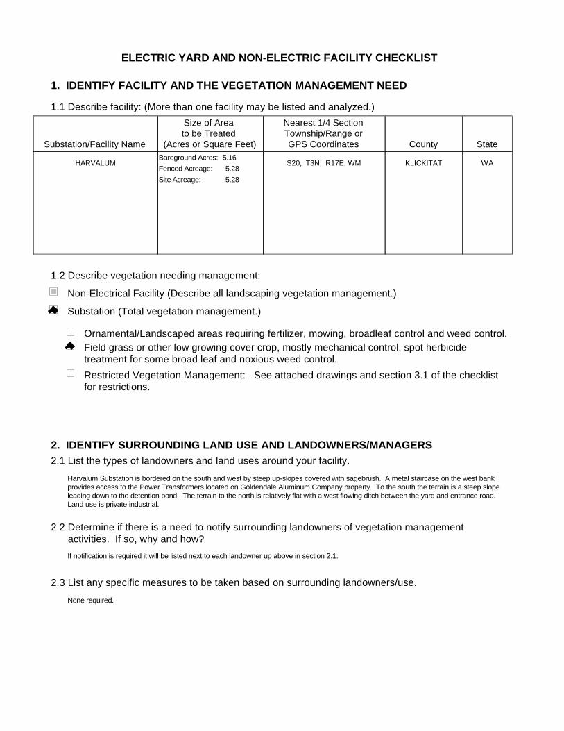
HARVALUM WAKLICKITATS20, T3N, R17E, WMFenced Acreage: 5.28Site Acreage: 5.28
Bareground Acres: 5.16
Substation (Total vegetation management.)
Non-Electrical Facility (Describe all landscaping vegetation management.)
Ornamental/Landscaped areas requiring fertilizer, mowing, broadleaf control and weed control.Field grass or other low growing cover crop, mostly mechanical control, spot herbicide treatment for some broad leaf and noxious weed control.Restricted Vegetation Management: See attached drawings and section 3.1 of the checklist for restrictions.
2. IDENTIFY SURROUNDING LAND USE AND LANDOWNERS/MANAGERS2.1 List the types of landowners and land uses around your facility.
2.2 Determine if there is a need to notify surrounding landowners of vegetation management activities. If so, why and how?
2.3 List any specific measures to be taken based on surrounding landowners/use.
Harvalum Substation is bordered on the south and west by steep up-slopes covered with sagebrush. A metal staircase on the west bank provides access to the Power Transformers located on Goldendale Aluminum Company property. To the south the terrain is a steep slope leading down to the detention pond. The terrain to the north is relatively flat with a west flowing ditch between the yard and entrance road. Land use is private industrial.
If notification is required it will be listed next to each landowner up above in section 2.1.
None required.
3. IDENTIFY NATURAL RESOURCES3.1 Water Resources
3.2 Herbicide Use Near Irrigation Sources and Domestic and Public Drinking Water Supplies
List or describe any water resources (streams, rivers, lakes, wetlands, undeveloped springs, etc.) near the facility.
Does the substation/facility drainage have a direct pathway to the water body?What measures will you take to limit potential impacts to water resources? As appropriate, list any buffers that will be applied.
List or describe any irrigation or domestic/public water source.
What measures will you take to limit potential impacts to irrigation and drinking water supplies? Asappropriate, list any buffers that will be applied.
3.3 Threatened and Endangered Plant or Animal Species Are there any T&E species in the area that could be affected? List if necessary.
What measures will you take to limit potential impacts to each T&E species? As appropriate, list any buffers that will be applied
3.4 Steep Slopes/ Unstable Slopes (Soils)
Will herbicide treatment be occurring on any steep slopes?
As appropriate, list any buffers, reseeding and/or ground disturbing restrictions that will be applie
3.5 Attach drawing showing location of all required buffers.
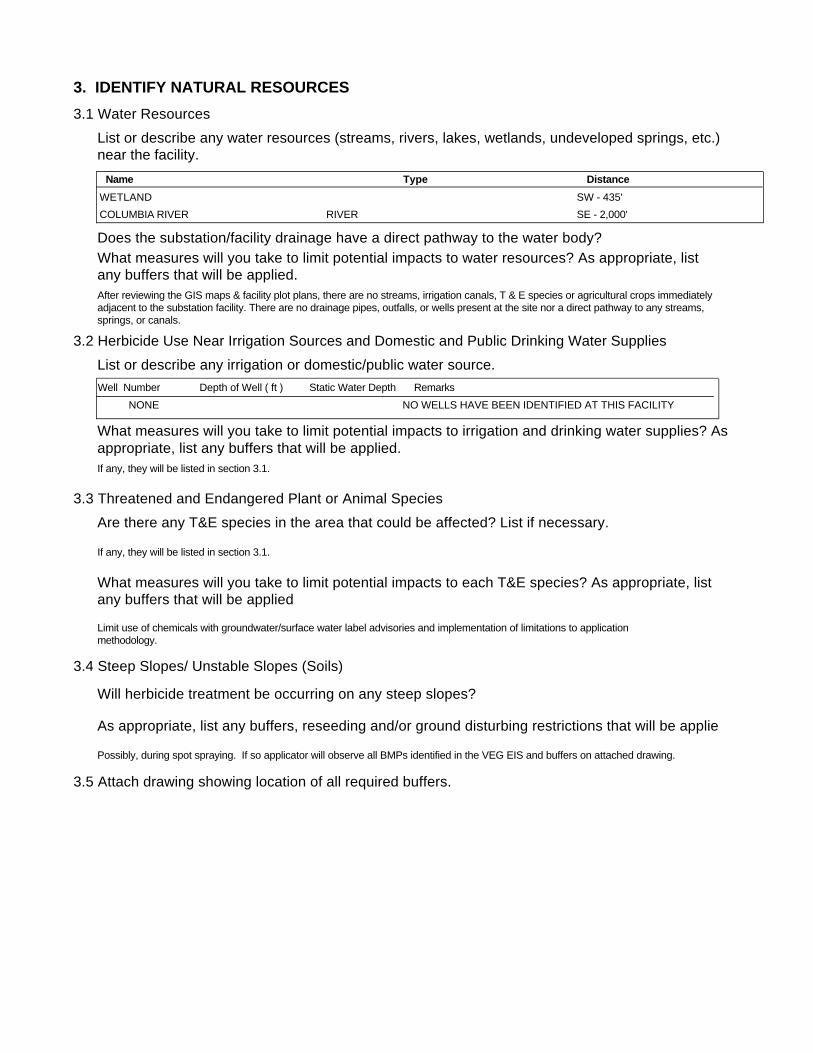
After reviewing the GIS maps & facility plot plans, there are no streams, irrigation canals, T & E species or agricultural crops immediately adjacent to the substation facility. There are no drainage pipes, outfalls, or wells present at the site nor a direct pathway to any streams, springs, or canals.
Limit use of chemicals with groundwater/surface water label advisories and implementation of limitations to application methodology.
If any, they will be listed in section 3.1.
Possibly, during spot spraying. If so applicator will observe all BMPs identified in the VEG EIS and buffers on attached drawing.
If any, they will be listed in section 3.1.
Name Type DistanceWETLAND SW - 435'COLUMBIA RIVER SE - 2,000'RIVER
Well Number Depth of Well ( ft ) Static Water Depth RemarksNONE NO WELLS HAVE BEEN IDENTIFIED AT THIS FACILITY

4. DETERMINE VEGETATION CONTROL METHODSDescribe overall vegetation management scheme and schedule: Bareground managed areas will primarily use herbicides with supplemental usage of mechanical methods. Other areas will be managed as described in section 1.2. Only herbicides from BPA's approved herbicide list will be used. All areas will be managed consistently with the Vegetation EIS. Initial:
Describe debris disposal and revegetation , if any.
For electrical substations the goal is Total Vegetation Management. A licensed contractor sprays the substations annually. BPA's substation herbicide application contracts contain specific language to ensure herbicides are applied consistent with the VEG EIS. Facilities requiring landscaping are designed to be low maintenance and are consistent with Integrated Pest Management procedures, such as using native, low growing plant types and mulches etc…
Subsequent:Herbicides will be applied on an annual or as needed. Active ingredients shall be rotated to ensure plants do not build a tolerance. Mechanical methods shall be performed on an as needed basis. Landscaping (ornamental plants/lawns) may be maintained via contractor or performed by BPA employees.
Future:Future control will be consistent with the methods described above.
5. DETERMINE DEBRIS DISPOSAL AND REVEGETATION
There will be no debris disposal and revegetion with bareground management. For other areas green debris will be recycled on-site to the extent practical.
6. DETERMINE MONITORING NEEDS
Describe debris disposal and revegetation , if any.
6.1 Describe evaluation of BPA/contractor treatment practices to ensure vegetation management measures are working.
Monitoring will occur through herbicide contract management and the observations of BPA Personnel during on site visits.
6.2 Is there a need to monitor adjacent areas for potential herbicide movement/contamination? If so, describe monitoring plan. (Unless monitoring for other reasons, this section should be consistent with BPA-systemwide herbicide monitoring plan not yet finalized.)
There will be no debris disposal and revegetion with bareground management. Debris disposal will take place on-site and will be recycled to the extent practical. Revegetation will be consistent with the existing vegetation of the facility and will incorporate native species where practical.
7. PREPARE APPROPRIATE ENVIRONMENTAL DOCUMENTATION7.1 Describe any potential project impacts or project work that are different than those disclosed in the Transmission System Vegetation Management Program EIS. Describe how those differences impact natural resources and if the differences are "substantial".
7.2 Is there a need for additional NEPA documentation (i.e. Forest Service requirement, Record of Decision, supplemental EIS)? If so, attach.
None
None
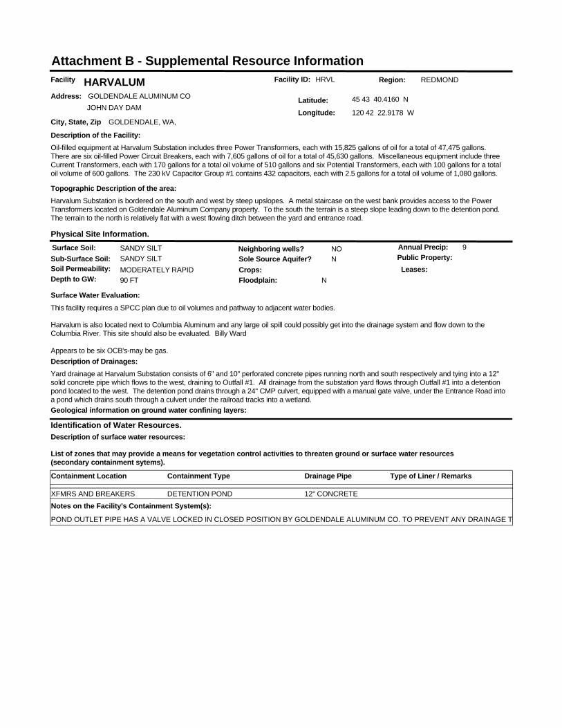
Facility ID: HRVLFacility HARVALUMAddress: GOLDENDALE ALUMINUM CO
JOHN DAY DAM
City, State, Zip GOLDENDALE, WA,
Latitude: 45 43 40.4160 N
Longitude: 120 42 22.9178 W
Identification of Water Resources.
List of zones that may provide a means for vegetation control activities to threaten ground or surface water resources (secondary containment sytems).
Region: REDMOND
Surface Soil: SANDY SILTSub-Surface Soil: SANDY SILTSoil Permeability: MODERATELY RAPID
Sole Source Aquifer? N
Depth to GW: 90 FT
Neighboring wells? NO
Floodplain: N
Annual Precip: 9
Crops:Public Property:
Physical Site Information.
Surface Water Evaluation:This facility requires a SPCC plan due to oil volumes and pathway to adjacent water bodies.
Harvalum is also located next to Columbia Aluminum and any large oil spill could possibly get into the drainage system and flow down to the Columbia River. This site should also be evaluated. Billy Ward
Appears to be six OCB's-may be gas.
Geological information on ground water confining layers:
Description of the Facility:Oil-filled equipment at Harvalum Substation includes three Power Transformers, each with 15,825 gallons of oil for a total of 47,475 gallons. There are six oil-filled Power Circuit Breakers, each with 7,605 gallons of oil for a total of 45,630 gallons. Miscellaneous equipment include three Current Transformers, each with 170 gallons for a total oil volume of 510 gallons and six Potential Transformers, each with 100 gallons for a total oil volume of 600 gallons. The 230 kV Capacitor Group #1 contains 432 capacitors, each with 2.5 gallons for a total oil volume of 1,080 gallons.
Topographic Description of the area:Harvalum Substation is bordered on the south and west by steep upslopes. A metal staircase on the west bank provides access to the Power Transformers located on Goldendale Aluminum Company property. To the south the terrain is a steep slope leading down to the detention pond. The terrain to the north is relatively flat with a west flowing ditch between the yard and entrance road.
Leases:
Description of surface water resources:
Description of Drainages:Yard drainage at Harvalum Substation consists of 6" and 10" perforated concrete pipes running north and south respectively and tying into a 12" solid concrete pipe which flows to the west, draining to Outfall #1. All drainage from the substation yard flows through Outfall #1 into a detention pond located to the west. The detention pond drains through a 24" CMP culvert, equipped with a manual gate valve, under the Entrance Road into a pond which drains south through a culvert under the railroad tracks into a wetland.
Attachment B - Supplemental Resource Information
Containment Location Containment Type Type of Liner / RemarksDrainage Pipe
DETENTION PONDXFMRS AND BREAKERS 12" CONCRETENotes on the Facility's Containment System(s):
POND OUTLET PIPE HAS A VALVE LOCKED IN CLOSED POSITION BY GOLDENDALE ALUMINUM CO. TO PREVENT ANY DRAINAGE TO ADJACENT WETLANDS.
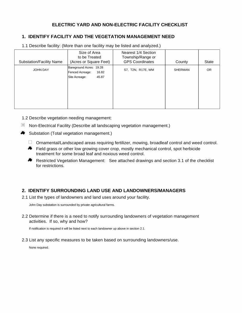
ELECTRIC YARD AND NON-ELECTRIC FACILITY CHECKLIST
1. IDENTIFY FACILITY AND THE VEGETATION MANAGEMENT NEED
1.1 Describe facility: (More than one facility may be listed and analyzed.)
1.2 Describe vegetation needing management:
Substation/Facility Name
Size of Area to be Treated
(Acres or Square Feet)
Nearest 1/4 SectionTownship/Range orGPS Coordinates County State
JOHN DAY ORSHERMANS7, T2N, R17E, WMFenced Acreage: 16.82Site Acreage: 45.87
Bareground Acres: 19.28
Substation (Total vegetation management.)
Non-Electrical Facility (Describe all landscaping vegetation management.)
Ornamental/Landscaped areas requiring fertilizer, mowing, broadleaf control and weed control.Field grass or other low growing cover crop, mostly mechanical control, spot herbicide treatment for some broad leaf and noxious weed control.Restricted Vegetation Management: See attached drawings and section 3.1 of the checklist for restrictions.
2. IDENTIFY SURROUNDING LAND USE AND LANDOWNERS/MANAGERS2.1 List the types of landowners and land uses around your facility.
2.2 Determine if there is a need to notify surrounding landowners of vegetation management activities. If so, why and how?
2.3 List any specific measures to be taken based on surrounding landowners/use.
John Day substation is surrounded by private agricultural farms.
If notification is required it will be listed next to each landowner up above in section 2.1.
None required.
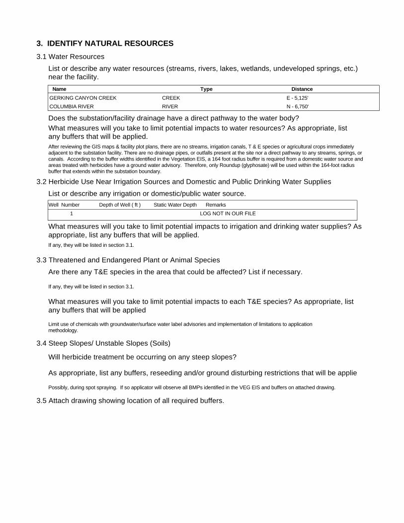
3. IDENTIFY NATURAL RESOURCES3.1 Water Resources
3.2 Herbicide Use Near Irrigation Sources and Domestic and Public Drinking Water Supplies
List or describe any water resources (streams, rivers, lakes, wetlands, undeveloped springs, etc.) near the facility.
Does the substation/facility drainage have a direct pathway to the water body?What measures will you take to limit potential impacts to water resources? As appropriate, list any buffers that will be applied.
List or describe any irrigation or domestic/public water source.
What measures will you take to limit potential impacts to irrigation and drinking water supplies? Asappropriate, list any buffers that will be applied.
3.3 Threatened and Endangered Plant or Animal Species Are there any T&E species in the area that could be affected? List if necessary.
What measures will you take to limit potential impacts to each T&E species? As appropriate, list any buffers that will be applied
3.4 Steep Slopes/ Unstable Slopes (Soils)
Will herbicide treatment be occurring on any steep slopes?
As appropriate, list any buffers, reseeding and/or ground disturbing restrictions that will be applie
3.5 Attach drawing showing location of all required buffers.
After reviewing the GIS maps & facility plot plans, there are no streams, irrigation canals, T & E species or agricultural crops immediately adjacent to the substation facility. There are no drainage pipes, or outfalls present at the site nor a direct pathway to any streams, springs, or canals. According to the buffer widths identified in the Vegetation EIS, a 164 foot radius buffer is required from a domestic water source and areas treated with herbicides have a ground water advisory. Therefore, only Roundup (glyphosate) will be used within the 164-foot radius buffer that extends within the substation boundary.
Limit use of chemicals with groundwater/surface water label advisories and implementation of limitations to application methodology.
If any, they will be listed in section 3.1.
Possibly, during spot spraying. If so applicator will observe all BMPs identified in the VEG EIS and buffers on attached drawing.
If any, they will be listed in section 3.1.
Name Type DistanceGERKING CANYON CREEK E - 5,125'CREEKCOLUMBIA RIVER N - 6,750'RIVER
Well Number Depth of Well ( ft ) Static Water Depth Remarks1 LOG NOT IN OUR FILE

4. DETERMINE VEGETATION CONTROL METHODSDescribe overall vegetation management scheme and schedule: Bareground managed areas will primarily use herbicides with supplemental usage of mechanical methods. Other areas will be managed as described in section 1.2. Only herbicides from BPA's approved herbicide list will be used. All areas will be managed consistently with the Vegetation EIS. Initial:
Describe debris disposal and revegetation , if any.
For electrical substations the goal is Total Vegetation Management. A licensed contractor sprays the substations annually. BPA's substation herbicide application contracts contain specific language to ensure herbicides are applied consistent with the VEG EIS. Facilities requiring landscaping are designed to be low maintenance and are consistent with Integrated Pest Management procedures, such as using native, low growing plant types and mulches etc…
Subsequent:Herbicides will be applied on an annual or as needed. Active ingredients shall be rotated to ensure plants do not build a tolerance. Mechanical methods shall be performed on an as needed basis. Landscaping (ornamental plants/lawns) may be maintained via contractor or performed by BPA employees.
Future:Future control will be consistent with the methods described above.
5. DETERMINE DEBRIS DISPOSAL AND REVEGETATION
There will be no debris disposal and revegetion with bareground management. For other areas green debris will be recycled on-site to the extent practical.
6. DETERMINE MONITORING NEEDS
Describe debris disposal and revegetation , if any.
6.1 Describe evaluation of BPA/contractor treatment practices to ensure vegetation management measures are working.
Monitoring will occur through herbicide contract management and the observations of BPA Personnel during on site visits.
6.2 Is there a need to monitor adjacent areas for potential herbicide movement/contamination? If so, describe monitoring plan. (Unless monitoring for other reasons, this section should be consistent with BPA-systemwide herbicide monitoring plan not yet finalized.)
There will be no debris disposal and revegetion with bareground management. Debris disposal will take place on-site and will be recycled to the extent practical. Revegetation will be consistent with the existing vegetation of the facility and will incorporate native species where practical.
7. PREPARE APPROPRIATE ENVIRONMENTAL DOCUMENTATION7.1 Describe any potential project impacts or project work that are different than those disclosed in the Transmission System Vegetation Management Program EIS. Describe how those differences impact natural resources and if the differences are "substantial".
7.2 Is there a need for additional NEPA documentation (i.e. Forest Service requirement, Record of Decision, supplemental EIS)? If so, attach.
None
None

Facility ID: JDAYFacility JOHN DAYAddress: VISTA DRIVE
City, State, Zip RUFUS, OR, 97050
Latitude: 45 40 40.7563 N
Longitude: 120 44 11.9402 W
Identification of Water Resources.
List of zones that may provide a means for vegetation control activities to threaten ground or surface water resources (secondary containment sytems).
Region: REDMOND
Surface Soil: SANDY SILTSub-Surface Soil: SANDY SILTSoil Permeability: MODERATELY RAPID
Sole Source Aquifer? N
Depth to GW: >700 FT
Neighboring wells? NO
Floodplain: N
Annual Precip: 9
Crops:Public Property:
Physical Site Information.
Surface Water Evaluation:This facility does not require an SPCC plan. There is no pathway to adjacent water.
Geological information on ground water confining layers:Drinking water and soils composition: A spring at the site and two wells at Rufus may be used as a drinking water supply for this substation (The wells at Rufus are 220 and 272 feet deep. Other neighboring wells range in depth from 240 to 767 feet. Static water levels range from 110 to 187 feet. The first water encountered in some wells ranged from 65 to 170 feet. The material penetrated from 0 to 15 feet was soil and sandstone. At least 500 feet of basalt was encountered in some of the deeper wells. This basalt acts as an aquiclude (barrier) and prevents the shallow water table from entering the deeper drinking water aquifer.
Attached: Well Log and List of Surrounding Wells.
Description of the Facility:John Day Substation is a 500 kV switching station with two Station Service Transformers, each with 230 gallons of oil. There are six 15 kV Power Circuit Breakers, each with 1 gallon of oil. Miscellaneous equipment includes three Current Transformers and 43 Potential Transformers with a total oil volume of 4,424 gallons of oil. Capacitor Group #1 consists of 876 non-PCB capacitors, each containing 3 gallons of oil.
Topographic Description of the area:John Day Substation is bordered to the south by a perimeter ditch which flows west, then north along the west fenceline, then east along the north fenceline. This ditch drains into a gully flowing downhill to the north. To the east is a grassy area sloping down to a gully draining to the north.
Leases:
Description of surface water resources:
Description of Drainages:The subsurface drainage piping at John Day Substation consists of multiple runs of 6" open jointed concrete pipe which drain to runs of 6" solid concrete pipe. These pipe runs outfall into ditches surrounding the facility and flow to the north into a gully which drains downhill to the north.
Attachment B - Supplemental Resource Information
Containment Location Containment Type Type of Liner / RemarksDrainage Pipe
NONENotes on the Facility's Containment System(s):
THIS FACILITY HAS NO SECONDARY OIL CONTAINMENT SYSTEM.

ELECTRIC YARD AND NON-ELECTRIC FACILITY CHECKLIST
1. IDENTIFY FACILITY AND THE VEGETATION MANAGEMENT NEED
1.1 Describe facility: (More than one facility may be listed and analyzed.)
1.2 Describe vegetation needing management:
Substation/Facility Name
Size of Area to be Treated
(Acres or Square Feet)
Nearest 1/4 SectionTownship/Range orGPS Coordinates County State
JOHN DAY DAM SS ORSHERMANSEC 28, T3N, R17EFenced Acreage: 0.03Site Acreage: 0.05
Bareground Acres: 0.04
Substation (Total vegetation management.)
Non-Electrical Facility (Describe all landscaping vegetation management.)
Ornamental/Landscaped areas requiring fertilizer, mowing, broadleaf control and weed control.Field grass or other low growing cover crop, mostly mechanical control, spot herbicide treatment for some broad leaf and noxious weed control.Restricted Vegetation Management: See attached drawings and section 3.1 of the checklist for restrictions.
2. IDENTIFY SURROUNDING LAND USE AND LANDOWNERS/MANAGERS2.1 List the types of landowners and land uses around your facility.
2.2 Determine if there is a need to notify surrounding landowners of vegetation management activities. If so, why and how?
2.3 List any specific measures to be taken based on surrounding landowners/use.
John Day Dam Station Service is bordered to the north by an asphalt pathway which lies between the substation and the Columbia River. The yard is bordered to the east by an irregular grassy area. The area to the south of the yard is an elevated grassy area. The soil forms a natural berm at the fenceline which is between 6 and 8 inches high. The area to the west of the yard in a level grass and gravel parking area.
If notification is required it will be listed next to each landowner up above in section 2.1.
None required.
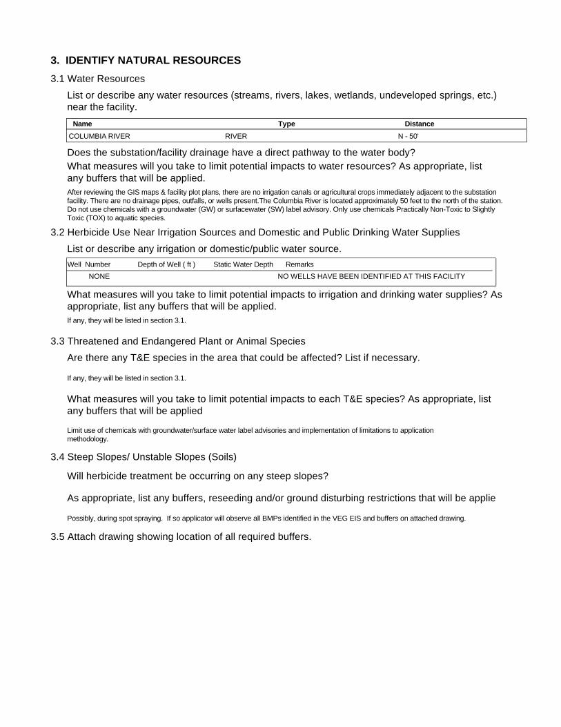
3. IDENTIFY NATURAL RESOURCES3.1 Water Resources
3.2 Herbicide Use Near Irrigation Sources and Domestic and Public Drinking Water Supplies
List or describe any water resources (streams, rivers, lakes, wetlands, undeveloped springs, etc.) near the facility.
Does the substation/facility drainage have a direct pathway to the water body?What measures will you take to limit potential impacts to water resources? As appropriate, list any buffers that will be applied.
List or describe any irrigation or domestic/public water source.
What measures will you take to limit potential impacts to irrigation and drinking water supplies? Asappropriate, list any buffers that will be applied.
3.3 Threatened and Endangered Plant or Animal Species Are there any T&E species in the area that could be affected? List if necessary.
What measures will you take to limit potential impacts to each T&E species? As appropriate, list any buffers that will be applied
3.4 Steep Slopes/ Unstable Slopes (Soils)
Will herbicide treatment be occurring on any steep slopes?
As appropriate, list any buffers, reseeding and/or ground disturbing restrictions that will be applie
3.5 Attach drawing showing location of all required buffers.
After reviewing the GIS maps & facility plot plans, there are no irrigation canals or agricultural crops immediately adjacent to the substation facility. There are no drainage pipes, outfalls, or wells present.The Columbia River is located approximately 50 feet to the north of the station. Do not use chemicals with a groundwater (GW) or surfacewater (SW) label advisory. Only use chemicals Practically Non-Toxic to Slightly Toxic (TOX) to aquatic species.
Limit use of chemicals with groundwater/surface water label advisories and implementation of limitations to application methodology.
If any, they will be listed in section 3.1.
Possibly, during spot spraying. If so applicator will observe all BMPs identified in the VEG EIS and buffers on attached drawing.
If any, they will be listed in section 3.1.
Name Type DistanceCOLUMBIA RIVER N - 50'RIVER
Well Number Depth of Well ( ft ) Static Water Depth RemarksNONE NO WELLS HAVE BEEN IDENTIFIED AT THIS FACILITY

4. DETERMINE VEGETATION CONTROL METHODSDescribe overall vegetation management scheme and schedule: Bareground managed areas will primarily use herbicides with supplemental usage of mechanical methods. Other areas will be managed as described in section 1.2. Only herbicides from BPA's approved herbicide list will be used. All areas will be managed consistently with the Vegetation EIS. Initial:
Describe debris disposal and revegetation , if any.
For electrical substations the goal is Total Vegetation Management. A licensed contractor sprays the substations annually. BPA's substation herbicide application contracts contain specific language to ensure herbicides are applied consistent with the VEG EIS. Facilities requiring landscaping are designed to be low maintenance and are consistent with Integrated Pest Management procedures, such as using native, low growing plant types and mulches etc…
Subsequent:Herbicides will be applied on an annual or as needed. Active ingredients shall be rotated to ensure plants do not build a tolerance. Mechanical methods shall be performed on an as needed basis. Landscaping (ornamental plants/lawns) may be maintained via contractor or performed by BPA employees.
Future:Future control will be consistent with the methods described above.
5. DETERMINE DEBRIS DISPOSAL AND REVEGETATION
There will be no debris disposal and revegetion with bareground management. For other areas green debris will be recycled on-site to the extent practical.
6. DETERMINE MONITORING NEEDS
Describe debris disposal and revegetation , if any.
6.1 Describe evaluation of BPA/contractor treatment practices to ensure vegetation management measures are working.
Monitoring will occur through herbicide contract management and the observations of BPA Personnel during on site visits.
6.2 Is there a need to monitor adjacent areas for potential herbicide movement/contamination? If so, describe monitoring plan. (Unless monitoring for other reasons, this section should be consistent with BPA-systemwide herbicide monitoring plan not yet finalized.)
There will be no debris disposal and revegetion with bareground management. Debris disposal will take place on-site and will be recycled to the extent practical. Revegetation will be consistent with the existing vegetation of the facility and will incorporate native species where practical.
7. PREPARE APPROPRIATE ENVIRONMENTAL DOCUMENTATION7.1 Describe any potential project impacts or project work that are different than those disclosed in the Transmission System Vegetation Management Program EIS. Describe how those differences impact natural resources and if the differences are "substantial".
7.2 Is there a need for additional NEPA documentation (i.e. Forest Service requirement, Record of Decision, supplemental EIS)? If so, attach.
None
None

Facility ID: JDSSFacility JOHN DAY DAM SSAddress: JOHN DAY DAM SITE
City, State, Zip RUFUS, OR,
Latitude: 45 42 33
Longitude: 120 41 45
Identification of Water Resources.
List of zones that may provide a means for vegetation control activities to threaten ground or surface water resources (secondary containment sytems).
Region: REDMOND
Surface Soil: SANDY LOAMSub-Surface Soil: ROCKSoil Permeability: MODERATELY RAPID
Sole Source Aquifer?
Depth to GW: 25 FT
Neighboring wells?
Floodplain: Y
Annual Precip: 9
Crops:Public Property:
Physical Site Information.
Surface Water Evaluation:This facility does not require an SPCC plan. Oil volumes do not meet regulatory requirements.
Despite the low oil volume, the Region has requested that a BMP spill plan be done at this facility due to the close proximity to the Columbia River.
Geological information on ground water confining layers:
Description of the Facility:John Day Dam Station Service has two Station Service Transformers, one with an oil volume of 12 gallons and the other with 316 gallons for a total oil volume of 328 gallons. This facility has one oil filled Power Circuit Breaker with 43 gallons of oil.
Topographic Description of the area:John Day Dam Station Service is bordered to the north by an asphalt pathway which lies between the substation and the Columbia River. The yard itself is basically level and the area just to the north is level although slightly below yard grade. This depression forms a small pooling area as the asphalt walkway forms a small berm, however, the grade and direction of the walkway leads directly to the local fishway and river. The yard is bordered to the east by an irregular grassy area. Immediately outside the fenceline is a depression that runs the full lenth of the yard. This depression varies from 2 inches below yard grade at the southeastern corner to 10 inches in depth at the northeastern corner. The depression is approximately 2 feet wide. The ground then rises to a peak elevation of near the same as the yard itself. This peak is approximately 20 - 25 feet from the fenceline. The ground then slopes down toward a concrete and metal fishway. The area to the south of the yard is an elevated grassy area. The soil forms a natural berm at the fenceline which is between 6 and 8 inches high. The ground then continues to rise between 12 and 18 inches higher than the yard. The area to the west of the yard in a level grass and gravel parking area. The soil at the fenceline forms a natural berm approximately 4 inches high.
Leases:
Description of surface water resources:The Columbia River is located approximately 50 feet to the north of the station.
Description of Drainages:John Day Dam Station Service has no stormwater drainage pipe system on the energized yard.
Attachment B - Supplemental Resource Information
Containment Location Containment Type Type of Liner / RemarksDrainage Pipe
Concrete Berm NoneStation Service Transformer NoneNotes on the Facility's Containment System(s):
There is a concrete berm on three sides of the Station Service Transformer. This berm is approximately six inches high and imbedded into the surface yard rock. The area within the berm is of sufficient size to contain or delay any amount of product that may be released from the transformer. The fourth side (east) of the transformer is open with no containtment berm. This is because of the slope of the yard and the off-site terrain characteristics, in particular the natural berm at the fenceline. If any product were to be released from the transformer in that direction, if would remain on-site and pool at the back of the yard.

ELECTRIC YARD AND NON-ELECTRIC FACILITY CHECKLIST
1. IDENTIFY FACILITY AND THE VEGETATION MANAGEMENT NEED
1.1 Describe facility: (More than one facility may be listed and analyzed.)
1.2 Describe vegetation needing management:
Substation/Facility Name
Size of Area to be Treated
(Acres or Square Feet)
Nearest 1/4 SectionTownship/Range orGPS Coordinates County State
MAUPIN ORWASCOS27, T4S, R14E, WMFenced Acreage: 2.07Site Acreage: 16.5
Bareground Acres: 2.79
Substation (Total vegetation management.)
Non-Electrical Facility (Describe all landscaping vegetation management.)
Ornamental/Landscaped areas requiring fertilizer, mowing, broadleaf control and weed control.Field grass or other low growing cover crop, mostly mechanical control, spot herbicide treatment for some broad leaf and noxious weed control.Restricted Vegetation Management: See attached drawings and section 3.1 of the checklist for restrictions.
2. IDENTIFY SURROUNDING LAND USE AND LANDOWNERS/MANAGERS2.1 List the types of landowners and land uses around your facility.
2.2 Determine if there is a need to notify surrounding landowners of vegetation management activities. If so, why and how?
2.3 List any specific measures to be taken based on surrounding landowners/use.
The substation is located on BPA fee-owned property. Pastureland and Sage Brush surrounds the substation and is the only existing use of the land at this time.
If notification is required it will be listed next to each landowner up above in section 2.1.
None required.

3. IDENTIFY NATURAL RESOURCES3.1 Water Resources
3.2 Herbicide Use Near Irrigation Sources and Domestic and Public Drinking Water Supplies
List or describe any water resources (streams, rivers, lakes, wetlands, undeveloped springs, etc.) near the facility.
Does the substation/facility drainage have a direct pathway to the water body?What measures will you take to limit potential impacts to water resources? As appropriate, list any buffers that will be applied.
List or describe any irrigation or domestic/public water source.
What measures will you take to limit potential impacts to irrigation and drinking water supplies? Asappropriate, list any buffers that will be applied.
3.3 Threatened and Endangered Plant or Animal Species Are there any T&E species in the area that could be affected? List if necessary.
What measures will you take to limit potential impacts to each T&E species? As appropriate, list any buffers that will be applied
3.4 Steep Slopes/ Unstable Slopes (Soils)
Will herbicide treatment be occurring on any steep slopes?
As appropriate, list any buffers, reseeding and/or ground disturbing restrictions that will be applie
3.5 Attach drawing showing location of all required buffers.
After reviewing the GIS maps & facility plot plans, there are no streams, irrigation canals, and/or T & E species immediately adjacent to the substation. There are no drainage pipes, outfalls, or wells present at this site. Surface runoff drains into several pooling areas around the substation in the sage bush. There is no direct pathway to any streams, wells, or canals.
Limit use of chemicals with groundwater/surface water label advisories and implementation of limitations to application methodology.
If any, they will be listed in section 3.1.
Possibly, during spot spraying. If so applicator will observe all BMPs identified in the VEG EIS and buffers on attached drawing.
If any, they will be listed in section 3.1.
Name Type DistanceSTREAM S - 2,250STREAMSTREAM W - 1,250STREAM
Well Number Depth of Well ( ft ) Static Water Depth RemarksNONE NO WELLS HAVE BEEN IDENTIFIED AT THIS FACILITY
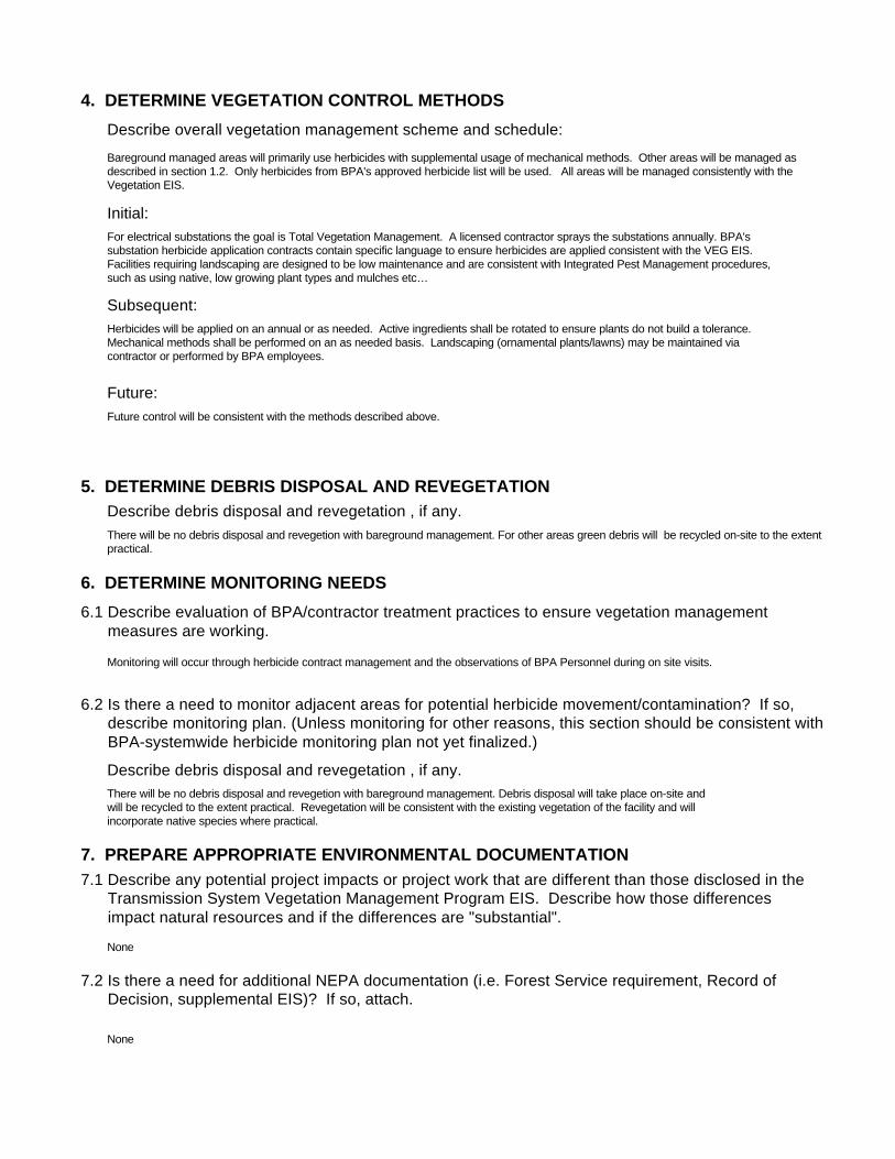
4. DETERMINE VEGETATION CONTROL METHODSDescribe overall vegetation management scheme and schedule: Bareground managed areas will primarily use herbicides with supplemental usage of mechanical methods. Other areas will be managed as described in section 1.2. Only herbicides from BPA's approved herbicide list will be used. All areas will be managed consistently with the Vegetation EIS. Initial:
Describe debris disposal and revegetation , if any.
For electrical substations the goal is Total Vegetation Management. A licensed contractor sprays the substations annually. BPA's substation herbicide application contracts contain specific language to ensure herbicides are applied consistent with the VEG EIS. Facilities requiring landscaping are designed to be low maintenance and are consistent with Integrated Pest Management procedures, such as using native, low growing plant types and mulches etc…
Subsequent:Herbicides will be applied on an annual or as needed. Active ingredients shall be rotated to ensure plants do not build a tolerance. Mechanical methods shall be performed on an as needed basis. Landscaping (ornamental plants/lawns) may be maintained via contractor or performed by BPA employees.
Future:Future control will be consistent with the methods described above.
5. DETERMINE DEBRIS DISPOSAL AND REVEGETATION
There will be no debris disposal and revegetion with bareground management. For other areas green debris will be recycled on-site to the extent practical.
6. DETERMINE MONITORING NEEDS
Describe debris disposal and revegetation , if any.
6.1 Describe evaluation of BPA/contractor treatment practices to ensure vegetation management measures are working.
Monitoring will occur through herbicide contract management and the observations of BPA Personnel during on site visits.
6.2 Is there a need to monitor adjacent areas for potential herbicide movement/contamination? If so, describe monitoring plan. (Unless monitoring for other reasons, this section should be consistent with BPA-systemwide herbicide monitoring plan not yet finalized.)
There will be no debris disposal and revegetion with bareground management. Debris disposal will take place on-site and will be recycled to the extent practical. Revegetation will be consistent with the existing vegetation of the facility and will incorporate native species where practical.
7. PREPARE APPROPRIATE ENVIRONMENTAL DOCUMENTATION7.1 Describe any potential project impacts or project work that are different than those disclosed in the Transmission System Vegetation Management Program EIS. Describe how those differences impact natural resources and if the differences are "substantial".
7.2 Is there a need for additional NEPA documentation (i.e. Forest Service requirement, Record of Decision, supplemental EIS)? If so, attach.
None
None
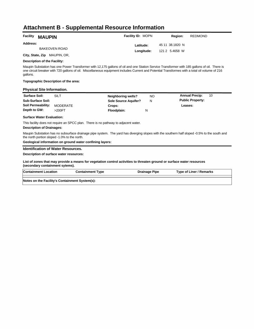
Facility ID: MOPNFacility MAUPINAddress:
BAKEOVEN ROAD
City, State, Zip MAUPIN, OR,
Latitude: 45 11 38.1820 N
Longitude: 121 2 5.4658 W
Identification of Water Resources.
List of zones that may provide a means for vegetation control activities to threaten ground or surface water resources (secondary containment sytems).
Region: REDMOND
Surface Soil: SILTSub-Surface Soil:Soil Permeability: MODERATE
Sole Source Aquifer? N
Depth to GW: >200FT
Neighboring wells? NO
Floodplain: N
Annual Precip: 10
Crops:Public Property:
Physical Site Information.
Surface Water Evaluation:This facility does not require an SPCC plan. There is no pathway to adjacent water.
Geological information on ground water confining layers:
Description of the Facility:Maupin Substation has one Power Transformer with 12,175 gallons of oil and one Station Service Transformer with 185 gallons of oil. There is one circuit breaker with 720 gallons of oil. Miscellaneous equipment includes Current and Potential Transformes with a total oil volume of 216 gallons.
Topographic Description of the area:
Leases:
Description of surface water resources:
Description of Drainages:Maupin Substation has no subsurface drainage pipe system. The yard has diverging slopes with the southern half sloped -0.5% to the south and the north portion sloped -1.0% to the north.
Attachment B - Supplemental Resource Information
Containment Location Containment Type Type of Liner / RemarksDrainage Pipe
Notes on the Facility's Containment System(s):
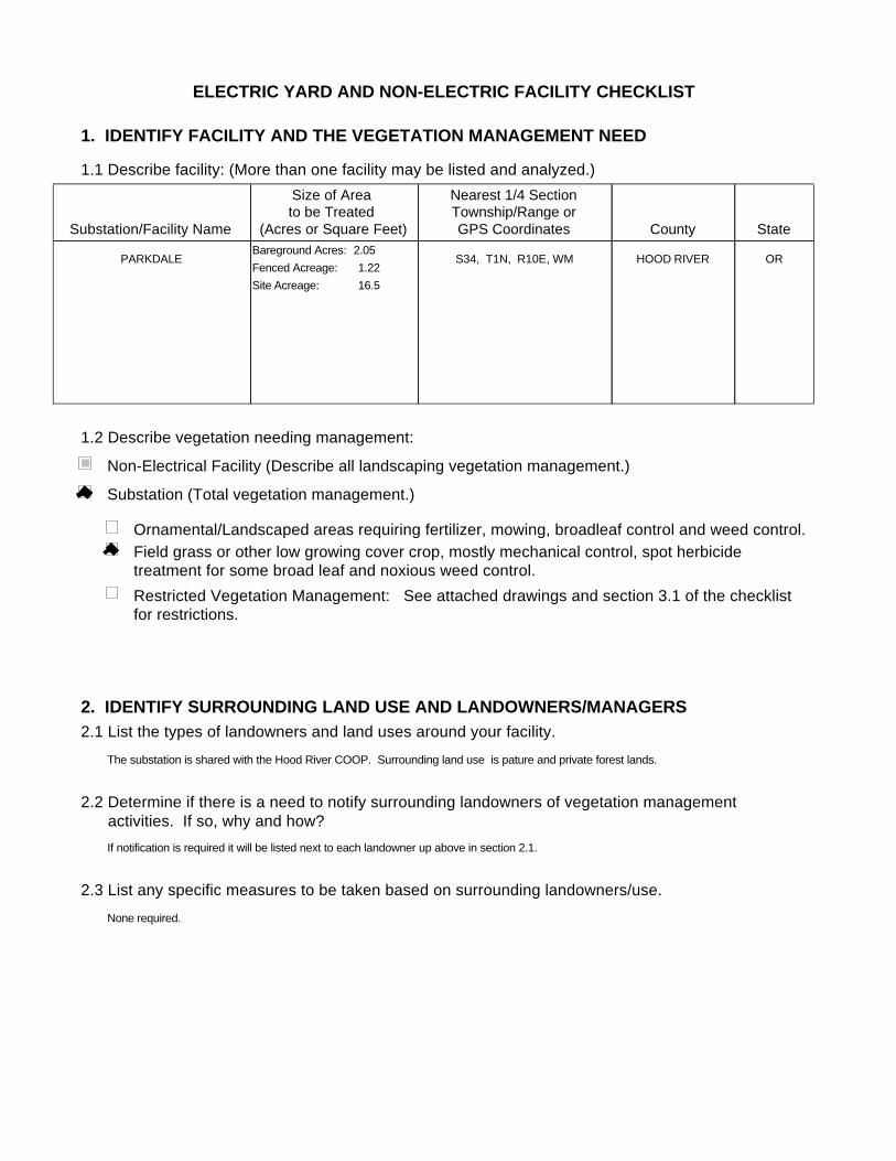
ELECTRIC YARD AND NON-ELECTRIC FACILITY CHECKLIST
1. IDENTIFY FACILITY AND THE VEGETATION MANAGEMENT NEED
1.1 Describe facility: (More than one facility may be listed and analyzed.)
1.2 Describe vegetation needing management:
Substation/Facility Name
Size of Area to be Treated
(Acres or Square Feet)
Nearest 1/4 SectionTownship/Range orGPS Coordinates County State
PARKDALE ORHOOD RIVERS34, T1N, R10E, WMFenced Acreage: 1.22Site Acreage: 16.5
Bareground Acres: 2.05
Substation (Total vegetation management.)
Non-Electrical Facility (Describe all landscaping vegetation management.)
Ornamental/Landscaped areas requiring fertilizer, mowing, broadleaf control and weed control.Field grass or other low growing cover crop, mostly mechanical control, spot herbicide treatment for some broad leaf and noxious weed control.Restricted Vegetation Management: See attached drawings and section 3.1 of the checklist for restrictions.
2. IDENTIFY SURROUNDING LAND USE AND LANDOWNERS/MANAGERS2.1 List the types of landowners and land uses around your facility.
2.2 Determine if there is a need to notify surrounding landowners of vegetation management activities. If so, why and how?
2.3 List any specific measures to be taken based on surrounding landowners/use.
The substation is shared with the Hood River COOP. Surrounding land use is pature and private forest lands.
If notification is required it will be listed next to each landowner up above in section 2.1.
None required.
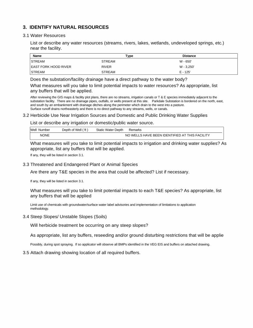
3. IDENTIFY NATURAL RESOURCES3.1 Water Resources
3.2 Herbicide Use Near Irrigation Sources and Domestic and Public Drinking Water Supplies
List or describe any water resources (streams, rivers, lakes, wetlands, undeveloped springs, etc.) near the facility.
Does the substation/facility drainage have a direct pathway to the water body?What measures will you take to limit potential impacts to water resources? As appropriate, list any buffers that will be applied.
List or describe any irrigation or domestic/public water source.
What measures will you take to limit potential impacts to irrigation and drinking water supplies? Asappropriate, list any buffers that will be applied.
3.3 Threatened and Endangered Plant or Animal Species Are there any T&E species in the area that could be affected? List if necessary.
What measures will you take to limit potential impacts to each T&E species? As appropriate, list any buffers that will be applied
3.4 Steep Slopes/ Unstable Slopes (Soils)
Will herbicide treatment be occurring on any steep slopes?
As appropriate, list any buffers, reseeding and/or ground disturbing restrictions that will be applie
3.5 Attach drawing showing location of all required buffers.
After reviewing the GIS maps & facility plot plans, there are no streams, irrigation canals or T & E species immediately adjacent to the substation facility. There are no drainage pipes, outfalls, or wells present at this site. Parkdale Substation is bordered on the north, east, and south by an embankment with drainage ditches along the perimeter which drain to the west into a pasture.Surface runoff drains northeasterly and there is no direct pathway to any streams, wells, or canals.
Limit use of chemicals with groundwater/surface water label advisories and implementation of limitations to application methodology.
If any, they will be listed in section 3.1.
Possibly, during spot spraying. If so applicator will observe all BMPs identified in the VEG EIS and buffers on attached drawing.
If any, they will be listed in section 3.1.
Name Type DistanceSTREAM W - 650'STREAMEAST FORK HOOD RIVER W - 3,250'RIVERSTREAM E - 125'STREAM
Well Number Depth of Well ( ft ) Static Water Depth RemarksNONE NO WELLS HAVE BEEN IDENTIFIED AT THIS FACILITY

4. DETERMINE VEGETATION CONTROL METHODSDescribe overall vegetation management scheme and schedule: Bareground managed areas will primarily use herbicides with supplemental usage of mechanical methods. Other areas will be managed as described in section 1.2. Only herbicides from BPA's approved herbicide list will be used. All areas will be managed consistently with the Vegetation EIS. Initial:
Describe debris disposal and revegetation , if any.
For electrical substations the goal is Total Vegetation Management. A licensed contractor sprays the substations annually. BPA's substation herbicide application contracts contain specific language to ensure herbicides are applied consistent with the VEG EIS. Facilities requiring landscaping are designed to be low maintenance and are consistent with Integrated Pest Management procedures, such as using native, low growing plant types and mulches etc…
Subsequent:Herbicides will be applied on an annual or as needed. Active ingredients shall be rotated to ensure plants do not build a tolerance. Mechanical methods shall be performed on an as needed basis. Landscaping (ornamental plants/lawns) may be maintained via contractor or performed by BPA employees.
Future:Future control will be consistent with the methods described above.
5. DETERMINE DEBRIS DISPOSAL AND REVEGETATION
There will be no debris disposal and revegetion with bareground management. For other areas green debris will be recycled on-site to the extent practical.
6. DETERMINE MONITORING NEEDS
Describe debris disposal and revegetation , if any.
6.1 Describe evaluation of BPA/contractor treatment practices to ensure vegetation management measures are working.
Monitoring will occur through herbicide contract management and the observations of BPA Personnel during on site visits.
6.2 Is there a need to monitor adjacent areas for potential herbicide movement/contamination? If so, describe monitoring plan. (Unless monitoring for other reasons, this section should be consistent with BPA-systemwide herbicide monitoring plan not yet finalized.)
There will be no debris disposal and revegetion with bareground management. Debris disposal will take place on-site and will be recycled to the extent practical. Revegetation will be consistent with the existing vegetation of the facility and will incorporate native species where practical.
7. PREPARE APPROPRIATE ENVIRONMENTAL DOCUMENTATION7.1 Describe any potential project impacts or project work that are different than those disclosed in the Transmission System Vegetation Management Program EIS. Describe how those differences impact natural resources and if the differences are "substantial".
7.2 Is there a need for additional NEPA documentation (i.e. Forest Service requirement, Record of Decision, supplemental EIS)? If so, attach.
None
None
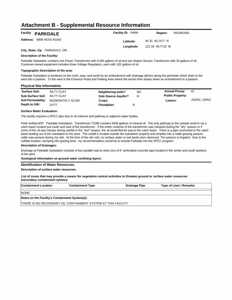
Facility ID: PARKFacility PARKDALEAddress: 6868 HESS ROAD
City, State, Zip PARKDALE, OR,
Latitude: 45 31 45.1477 N
Longitude: 121 33 48.7719 W
Identification of Water Resources.
List of zones that may provide a means for vegetation control activities to threaten ground or surface water resources (secondary containment sytems).
Region: REDMOND
Surface Soil: SILTY CLAYSub-Surface Soil: SILTY CLAYSoil Permeability: MODERATELY SLOW
Sole Source Aquifer? N
Depth to GW: 10 FT
Neighboring wells? NO
Floodplain: N
Annual Precip: 41
Crops:Public Property:
Physical Site Information.
Surface Water Evaluation:This facility requires a SPCC plan due to oil volumes and pathway to adjacent water bodies.
Field verified 8/97. Parkdale Substation: Transformer T1286 contains 9435 gallons of mineral oil. The only pathway to the outside world is via a catch basin located just south and east of the transformer. If the entire contents of the transformer was released during the "dry" season or if some of the oil was release during rainfall or the "wet" season, the oil would find its way to the catch basin. There is a pipe connected to the catch basin leading out of the substation to the west. The outfall is located outside the substation property and empties into a cattle grazing pasture, cattle was present during my visit. At the time of the site visit, no surface water or wet lands were observed. The pasture is irrigated. Due to the outfalls location, dumping into grazing land, my recommendation would be to include Parkdale into the SPCC program.
Geological information on ground water confining layers:
Description of the Facility:Parkdale Substation contains one Power Transformer with 9,435 gallons of oil and one Station Service Transformer with 33 gallons of oil. Customer-owned equipment includes three Voltage Regulators, each with 182 gallons of oil.
Topographic Description of the area:Parkdale Substation is bordered on the north, east, and south by an embankment with drainage ditches along the perimeter which drain to the west into a pasture. To the west is the Entrance Road and Parking Area where the terrain then slopes down an embankment to a pasture.
Leases: AGRIC, GRAZ,
Description of surface water resources:
Description of Drainages:Drainage at Parkdale Substation consists of two parallel east to west runs of 6" perforated concrete pipe located in the center and south portions of the yard.
Attachment B - Supplemental Resource Information
Containment Location Containment Type Type of Liner / RemarksDrainage Pipe
NONENotes on the Facility's Containment System(s):
THERE IS NO SECONDARY OIL CONTAINMENT SYSTEM AT THIS FACILITY
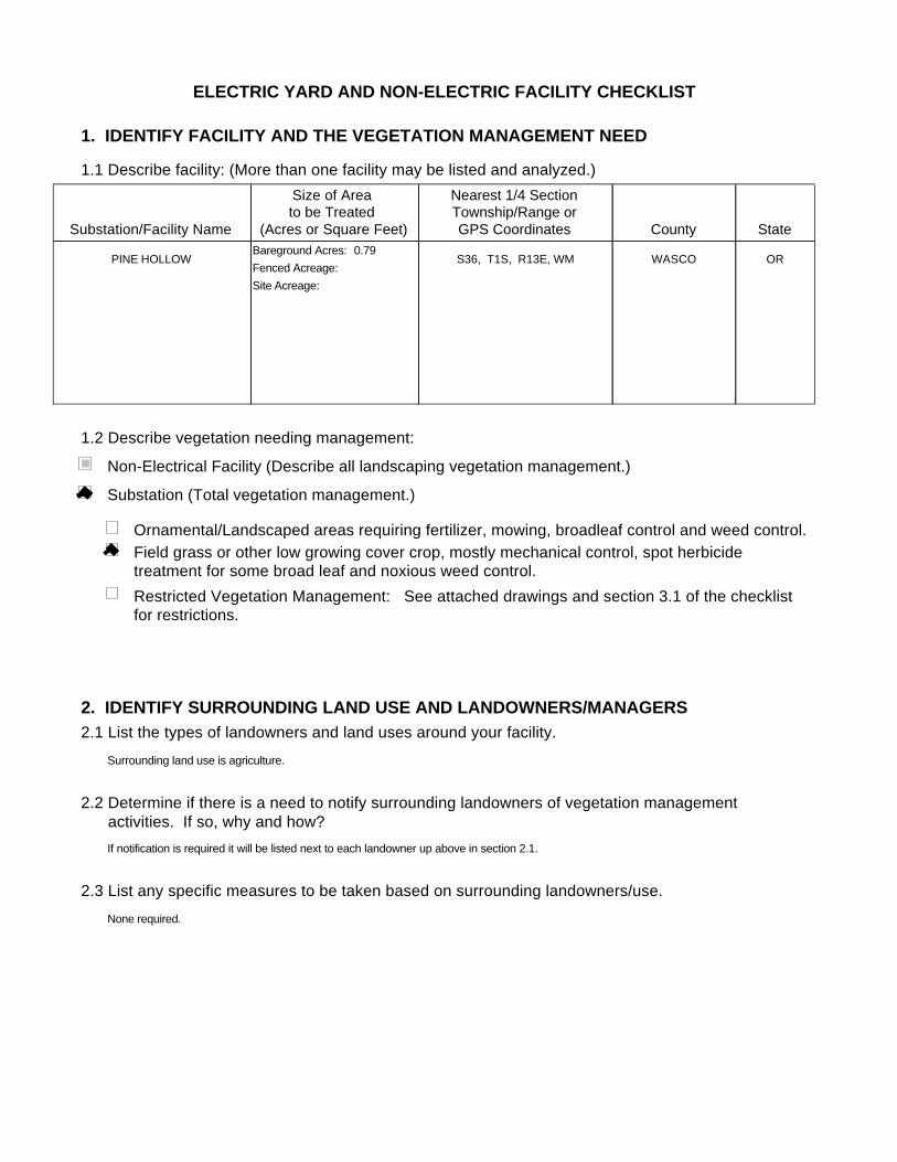
ELECTRIC YARD AND NON-ELECTRIC FACILITY CHECKLIST
1. IDENTIFY FACILITY AND THE VEGETATION MANAGEMENT NEED
1.1 Describe facility: (More than one facility may be listed and analyzed.)
1.2 Describe vegetation needing management:
Substation/Facility Name
Size of Area to be Treated
(Acres or Square Feet)
Nearest 1/4 SectionTownship/Range orGPS Coordinates County State
PINE HOLLOW ORWASCOS36, T1S, R13E, WMFenced Acreage:Site Acreage:
Bareground Acres: 0.79
Substation (Total vegetation management.)
Non-Electrical Facility (Describe all landscaping vegetation management.)
Ornamental/Landscaped areas requiring fertilizer, mowing, broadleaf control and weed control.Field grass or other low growing cover crop, mostly mechanical control, spot herbicide treatment for some broad leaf and noxious weed control.Restricted Vegetation Management: See attached drawings and section 3.1 of the checklist for restrictions.
2. IDENTIFY SURROUNDING LAND USE AND LANDOWNERS/MANAGERS2.1 List the types of landowners and land uses around your facility.
2.2 Determine if there is a need to notify surrounding landowners of vegetation management activities. If so, why and how?
2.3 List any specific measures to be taken based on surrounding landowners/use.
Surrounding land use is agriculture.
If notification is required it will be listed next to each landowner up above in section 2.1.
None required.
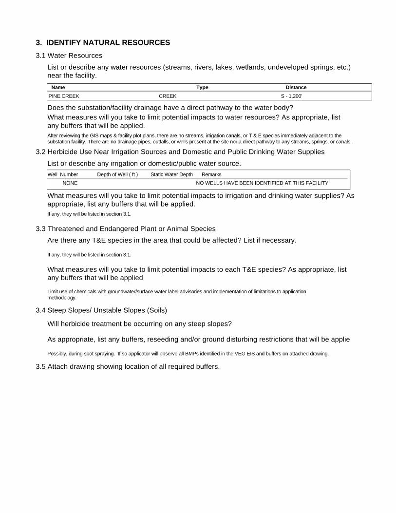
3. IDENTIFY NATURAL RESOURCES3.1 Water Resources
3.2 Herbicide Use Near Irrigation Sources and Domestic and Public Drinking Water Supplies
List or describe any water resources (streams, rivers, lakes, wetlands, undeveloped springs, etc.) near the facility.
Does the substation/facility drainage have a direct pathway to the water body?What measures will you take to limit potential impacts to water resources? As appropriate, list any buffers that will be applied.
List or describe any irrigation or domestic/public water source.
What measures will you take to limit potential impacts to irrigation and drinking water supplies? Asappropriate, list any buffers that will be applied.
3.3 Threatened and Endangered Plant or Animal Species Are there any T&E species in the area that could be affected? List if necessary.
What measures will you take to limit potential impacts to each T&E species? As appropriate, list any buffers that will be applied
3.4 Steep Slopes/ Unstable Slopes (Soils)
Will herbicide treatment be occurring on any steep slopes?
As appropriate, list any buffers, reseeding and/or ground disturbing restrictions that will be applie
3.5 Attach drawing showing location of all required buffers.
After reviewing the GIS maps & facility plot plans, there are no streams, irrigation canals, or T & E species immediately adjacent to the substation facility. There are no drainage pipes, outfalls, or wells present at the site nor a direct pathway to any streams, springs, or canals.
Limit use of chemicals with groundwater/surface water label advisories and implementation of limitations to application methodology.
If any, they will be listed in section 3.1.
Possibly, during spot spraying. If so applicator will observe all BMPs identified in the VEG EIS and buffers on attached drawing.
If any, they will be listed in section 3.1.
Name Type DistancePINE CREEK S - 1,200'CREEK
Well Number Depth of Well ( ft ) Static Water Depth RemarksNONE NO WELLS HAVE BEEN IDENTIFIED AT THIS FACILITY

4. DETERMINE VEGETATION CONTROL METHODSDescribe overall vegetation management scheme and schedule: Bareground managed areas will primarily use herbicides with supplemental usage of mechanical methods. Other areas will be managed as described in section 1.2. Only herbicides from BPA's approved herbicide list will be used. All areas will be managed consistently with the Vegetation EIS. Initial:
Describe debris disposal and revegetation , if any.
For electrical substations the goal is Total Vegetation Management. A licensed contractor sprays the substations annually. BPA's substation herbicide application contracts contain specific language to ensure herbicides are applied consistent with the VEG EIS. Facilities requiring landscaping are designed to be low maintenance and are consistent with Integrated Pest Management procedures, such as using native, low growing plant types and mulches etc…
Subsequent:Herbicides will be applied on an annual or as needed. Active ingredients shall be rotated to ensure plants do not build a tolerance. Mechanical methods shall be performed on an as needed basis. Landscaping (ornamental plants/lawns) may be maintained via contractor or performed by BPA employees.
Future:Future control will be consistent with the methods described above.
5. DETERMINE DEBRIS DISPOSAL AND REVEGETATION
There will be no debris disposal and revegetion with bareground management. For other areas green debris will be recycled on-site to the extent practical.
6. DETERMINE MONITORING NEEDS
Describe debris disposal and revegetation , if any.
6.1 Describe evaluation of BPA/contractor treatment practices to ensure vegetation management measures are working.
Monitoring will occur through herbicide contract management and the observations of BPA Personnel during on site visits.
6.2 Is there a need to monitor adjacent areas for potential herbicide movement/contamination? If so, describe monitoring plan. (Unless monitoring for other reasons, this section should be consistent with BPA-systemwide herbicide monitoring plan not yet finalized.)
There will be no debris disposal and revegetion with bareground management. Debris disposal will take place on-site and will be recycled to the extent practical. Revegetation will be consistent with the existing vegetation of the facility and will incorporate native species where practical.
7. PREPARE APPROPRIATE ENVIRONMENTAL DOCUMENTATION7.1 Describe any potential project impacts or project work that are different than those disclosed in the Transmission System Vegetation Management Program EIS. Describe how those differences impact natural resources and if the differences are "substantial".
7.2 Is there a need for additional NEPA documentation (i.e. Forest Service requirement, Record of Decision, supplemental EIS)? If so, attach.
None
None
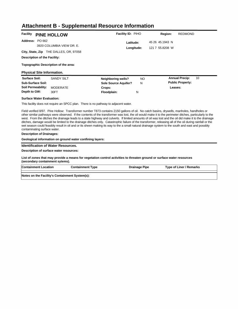
Facility ID: PIHOFacility PINE HOLLOWAddress: PO 662
3920 COLUMBIA VIEW DR. E.
City, State, Zip THE DALLES, OR, 97058
Latitude: 45 26 45.1943 N
Longitude: 121 7 55.8208 W
Identification of Water Resources.
List of zones that may provide a means for vegetation control activities to threaten ground or surface water resources (secondary containment sytems).
Region: REDMOND
Surface Soil: SANDY SILTSub-Surface Soil:Soil Permeability: MODERATE
Sole Source Aquifer? N
Depth to GW: 30FT
Neighboring wells? NO
Floodplain: N
Annual Precip: 10
Crops:Public Property:
Physical Site Information.
Surface Water Evaluation:This facility does not require an SPCC plan. There is no pathway to adjacent water.
Field verified 8/97. Pine Hollow: Transformer number T873 contains 2150 gallons of oil. No catch basins, drywells, manholes, handholes or other similar pathways were observed. If the contents of the transformer was lost, the oil would make it to the perimeter ditches, particularly to the west. From the ditches the drainage leads to a state highway and culverts. If limited amounts of oil was lost and the oil did make it to the drainage ditches, damage would be limited to the drainage ditches only. Catastrophic failure of the transformer, releasing all of the oil during rainfall or the wet season could feasibly result in oil and or its sheen making its way to the a small natural drainage system to the south and east and possibly contaminating surface water.
Geological information on ground water confining layers:
Description of the Facility:
Topographic Description of the area:
Leases:
Description of surface water resources:
Description of Drainages:
Attachment B - Supplemental Resource Information
Containment Location Containment Type Type of Liner / RemarksDrainage Pipe
Notes on the Facility's Containment System(s):

ELECTRIC YARD AND NON-ELECTRIC FACILITY CHECKLIST
1. IDENTIFY FACILITY AND THE VEGETATION MANAGEMENT NEED
1.1 Describe facility: (More than one facility may be listed and analyzed.)
1.2 Describe vegetation needing management:
Substation/Facility Name
Size of Area to be Treated
(Acres or Square Feet)
Nearest 1/4 SectionTownship/Range orGPS Coordinates County State
THE DALLES ORWASCOS32, T2N, R13E, WMFenced Acreage: 1.25Site Acreage: 6.53
Bareground Acres: 1.54
Substation (Total vegetation management.)
Non-Electrical Facility (Describe all landscaping vegetation management.)
Ornamental/Landscaped areas requiring fertilizer, mowing, broadleaf control and weed control.Field grass or other low growing cover crop, mostly mechanical control, spot herbicide treatment for some broad leaf and noxious weed control.Restricted Vegetation Management: See attached drawings and section 3.1 of the checklist for restrictions.
2. IDENTIFY SURROUNDING LAND USE AND LANDOWNERS/MANAGERS2.1 List the types of landowners and land uses around your facility.
2.2 Determine if there is a need to notify surrounding landowners of vegetation management activities. If so, why and how?
2.3 List any specific measures to be taken based on surrounding landowners/use.
The Dalles substation is located on BPA fee-owned land and is surrounded by private residential homes.
If notification is required it will be listed next to each landowner up above in section 2.1.
None required.
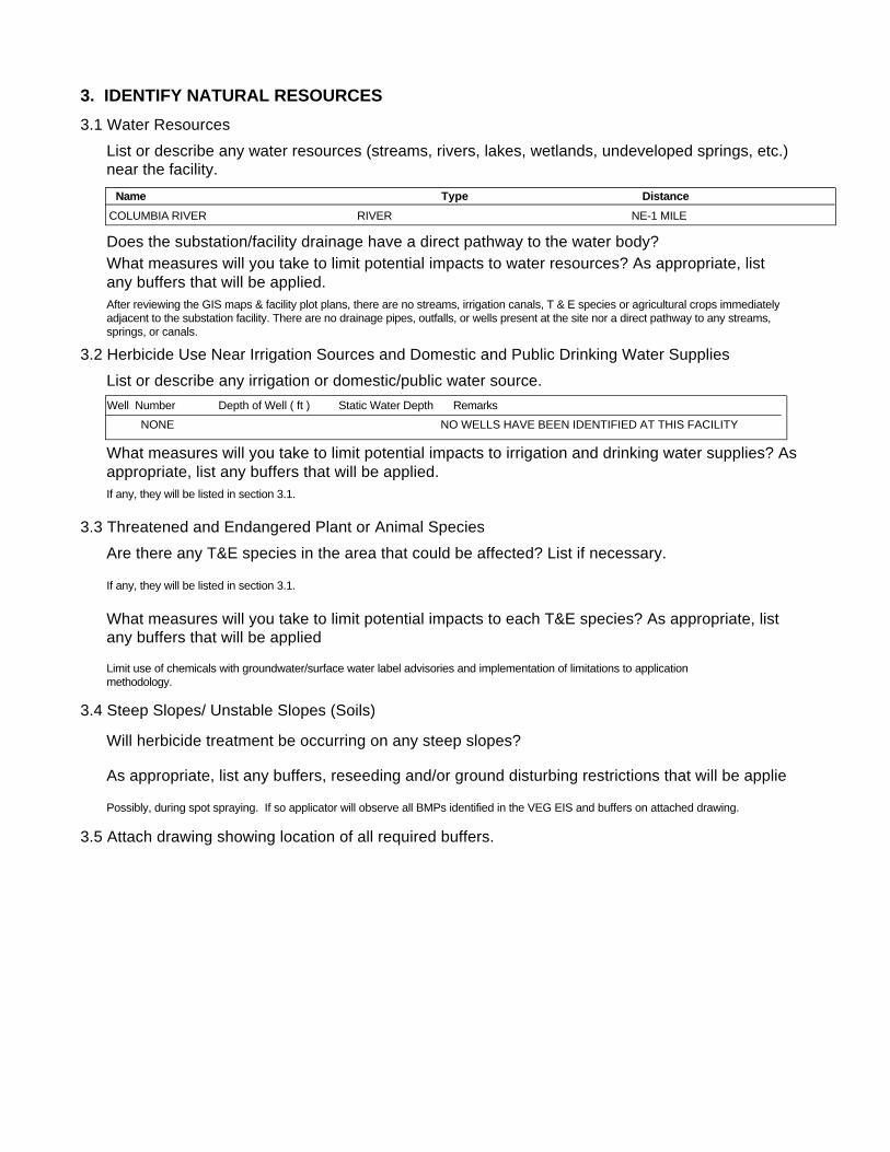
3. IDENTIFY NATURAL RESOURCES3.1 Water Resources
3.2 Herbicide Use Near Irrigation Sources and Domestic and Public Drinking Water Supplies
List or describe any water resources (streams, rivers, lakes, wetlands, undeveloped springs, etc.) near the facility.
Does the substation/facility drainage have a direct pathway to the water body?What measures will you take to limit potential impacts to water resources? As appropriate, list any buffers that will be applied.
List or describe any irrigation or domestic/public water source.
What measures will you take to limit potential impacts to irrigation and drinking water supplies? Asappropriate, list any buffers that will be applied.
3.3 Threatened and Endangered Plant or Animal Species Are there any T&E species in the area that could be affected? List if necessary.
What measures will you take to limit potential impacts to each T&E species? As appropriate, list any buffers that will be applied
3.4 Steep Slopes/ Unstable Slopes (Soils)
Will herbicide treatment be occurring on any steep slopes?
As appropriate, list any buffers, reseeding and/or ground disturbing restrictions that will be applie
3.5 Attach drawing showing location of all required buffers.
After reviewing the GIS maps & facility plot plans, there are no streams, irrigation canals, T & E species or agricultural crops immediately adjacent to the substation facility. There are no drainage pipes, outfalls, or wells present at the site nor a direct pathway to any streams, springs, or canals.
Limit use of chemicals with groundwater/surface water label advisories and implementation of limitations to application methodology.
If any, they will be listed in section 3.1.
Possibly, during spot spraying. If so applicator will observe all BMPs identified in the VEG EIS and buffers on attached drawing.
If any, they will be listed in section 3.1.
Name Type DistanceCOLUMBIA RIVER NE-1 MILERIVER
Well Number Depth of Well ( ft ) Static Water Depth RemarksNONE NO WELLS HAVE BEEN IDENTIFIED AT THIS FACILITY

4. DETERMINE VEGETATION CONTROL METHODSDescribe overall vegetation management scheme and schedule: Bareground managed areas will primarily use herbicides with supplemental usage of mechanical methods. Other areas will be managed as described in section 1.2. Only herbicides from BPA's approved herbicide list will be used. All areas will be managed consistently with the Vegetation EIS. Initial:
Describe debris disposal and revegetation , if any.
For electrical substations the goal is Total Vegetation Management. A licensed contractor sprays the substations annually. BPA's substation herbicide application contracts contain specific language to ensure herbicides are applied consistent with the VEG EIS. Facilities requiring landscaping are designed to be low maintenance and are consistent with Integrated Pest Management procedures, such as using native, low growing plant types and mulches etc…
Subsequent:Herbicides will be applied on an annual or as needed. Active ingredients shall be rotated to ensure plants do not build a tolerance. Mechanical methods shall be performed on an as needed basis. Landscaping (ornamental plants/lawns) may be maintained via contractor or performed by BPA employees.
Future:Future control will be consistent with the methods described above.
5. DETERMINE DEBRIS DISPOSAL AND REVEGETATION
There will be no debris disposal and revegetion with bareground management. For other areas green debris will be recycled on-site to the extent practical.
6. DETERMINE MONITORING NEEDS
Describe debris disposal and revegetation , if any.
6.1 Describe evaluation of BPA/contractor treatment practices to ensure vegetation management measures are working.
Monitoring will occur through herbicide contract management and the observations of BPA Personnel during on site visits.
6.2 Is there a need to monitor adjacent areas for potential herbicide movement/contamination? If so, describe monitoring plan. (Unless monitoring for other reasons, this section should be consistent with BPA-systemwide herbicide monitoring plan not yet finalized.)
There will be no debris disposal and revegetion with bareground management. Debris disposal will take place on-site and will be recycled to the extent practical. Revegetation will be consistent with the existing vegetation of the facility and will incorporate native species where practical.
7. PREPARE APPROPRIATE ENVIRONMENTAL DOCUMENTATION7.1 Describe any potential project impacts or project work that are different than those disclosed in the Transmission System Vegetation Management Program EIS. Describe how those differences impact natural resources and if the differences are "substantial".
7.2 Is there a need for additional NEPA documentation (i.e. Forest Service requirement, Record of Decision, supplemental EIS)? If so, attach.
None
None
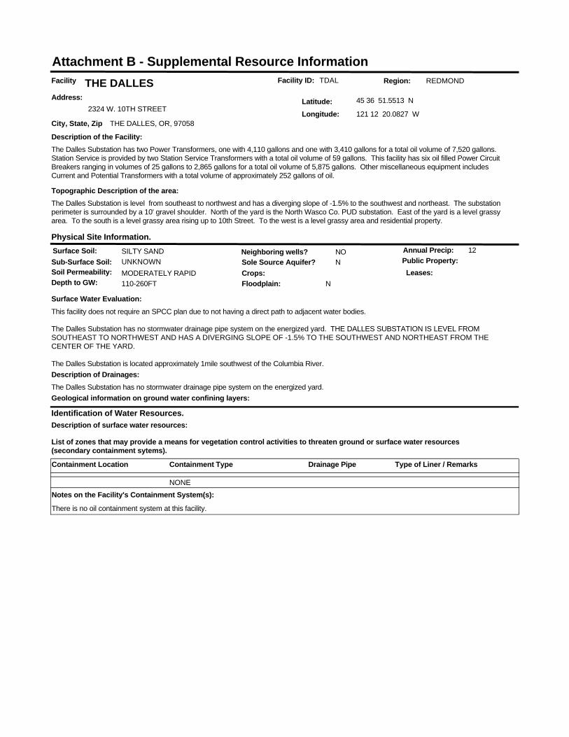
Facility ID: TDALFacility THE DALLESAddress:
2324 W. 10TH STREET
City, State, Zip THE DALLES, OR, 97058
Latitude: 45 36 51.5513 N
Longitude: 121 12 20.0827 W
Identification of Water Resources.
List of zones that may provide a means for vegetation control activities to threaten ground or surface water resources (secondary containment sytems).
Region: REDMOND
Surface Soil: SILTY SANDSub-Surface Soil: UNKNOWNSoil Permeability: MODERATELY RAPID
Sole Source Aquifer? N
Depth to GW: 110-260FT
Neighboring wells? NO
Floodplain: N
Annual Precip: 12
Crops:Public Property:
Physical Site Information.
Surface Water Evaluation:This facility does not require an SPCC plan due to not having a direct path to adjacent water bodies.
The Dalles Substation has no stormwater drainage pipe system on the energized yard. THE DALLES SUBSTATION IS LEVEL FROM SOUTHEAST TO NORTHWEST AND HAS A DIVERGING SLOPE OF -1.5% TO THE SOUTHWEST AND NORTHEAST FROM THE CENTER OF THE YARD.
The Dalles Substation is located approximately 1mile southwest of the Columbia River.
Geological information on ground water confining layers:
Description of the Facility:The Dalles Substation has two Power Transformers, one with 4,110 gallons and one with 3,410 gallons for a total oil volume of 7,520 gallons. Station Service is provided by two Station Service Transformers with a total oil volume of 59 gallons. This facility has six oil filled Power Circuit Breakers ranging in volumes of 25 gallons to 2,865 gallons for a total oil volume of 5,875 gallons. Other miscellaneous equipment includes Current and Potential Transformers with a total volume of approximately 252 gallons of oil.
Topographic Description of the area:The Dalles Substation is level from southeast to northwest and has a diverging slope of -1.5% to the southwest and northeast. The substation perimeter is surrounded by a 10' gravel shoulder. North of the yard is the North Wasco Co. PUD substation. East of the yard is a level grassy area. To the south is a level grassy area rising up to 10th Street. To the west is a level grassy area and residential property.
Leases:
Description of surface water resources:
Description of Drainages:The Dalles Substation has no stormwater drainage pipe system on the energized yard.
Attachment B - Supplemental Resource Information
Containment Location Containment Type Type of Liner / RemarksDrainage Pipe
NONENotes on the Facility's Containment System(s):
There is no oil containment system at this facility.
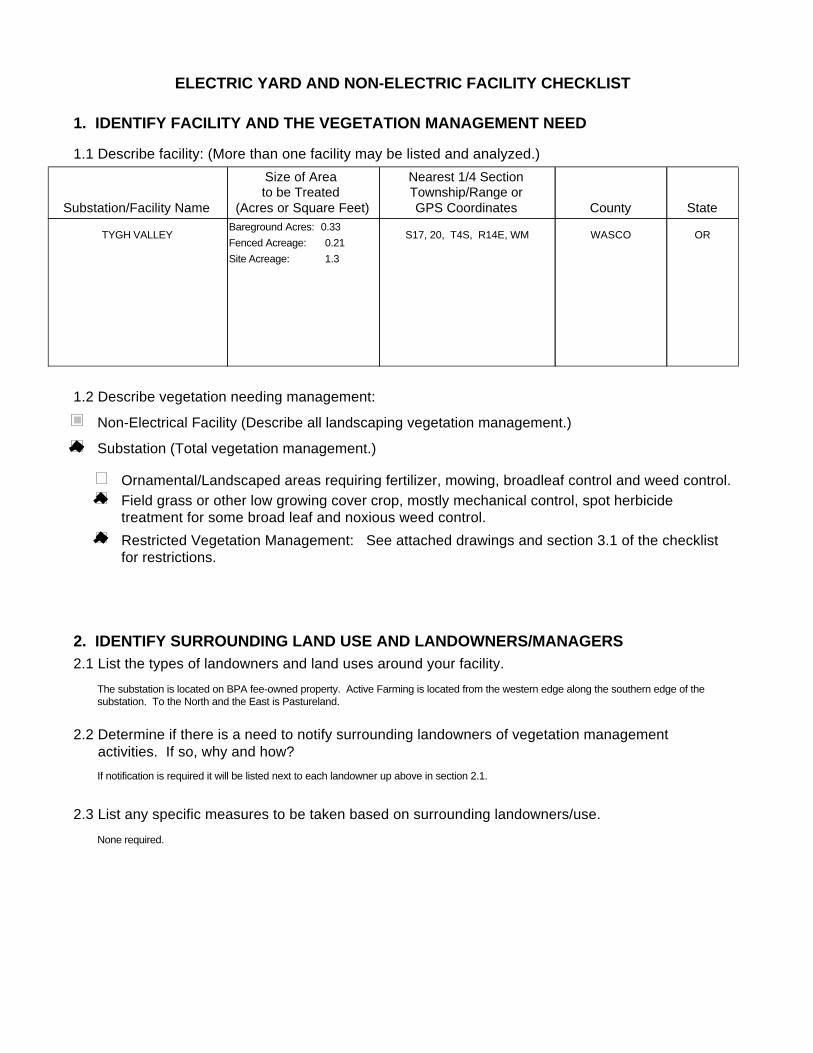
ELECTRIC YARD AND NON-ELECTRIC FACILITY CHECKLIST
1. IDENTIFY FACILITY AND THE VEGETATION MANAGEMENT NEED
1.1 Describe facility: (More than one facility may be listed and analyzed.)
1.2 Describe vegetation needing management:
Substation/Facility Name
Size of Area to be Treated
(Acres or Square Feet)
Nearest 1/4 SectionTownship/Range orGPS Coordinates County State
TYGH VALLEY ORWASCOS17, 20, T4S, R14E, WMFenced Acreage: 0.21Site Acreage: 1.3
Bareground Acres: 0.33
Substation (Total vegetation management.)
Non-Electrical Facility (Describe all landscaping vegetation management.)
Ornamental/Landscaped areas requiring fertilizer, mowing, broadleaf control and weed control.Field grass or other low growing cover crop, mostly mechanical control, spot herbicide treatment for some broad leaf and noxious weed control.Restricted Vegetation Management: See attached drawings and section 3.1 of the checklist for restrictions.
2. IDENTIFY SURROUNDING LAND USE AND LANDOWNERS/MANAGERS2.1 List the types of landowners and land uses around your facility.
2.2 Determine if there is a need to notify surrounding landowners of vegetation management activities. If so, why and how?
2.3 List any specific measures to be taken based on surrounding landowners/use.
The substation is located on BPA fee-owned property. Active Farming is located from the western edge along the southern edge of the substation. To the North and the East is Pastureland.
If notification is required it will be listed next to each landowner up above in section 2.1.
None required.
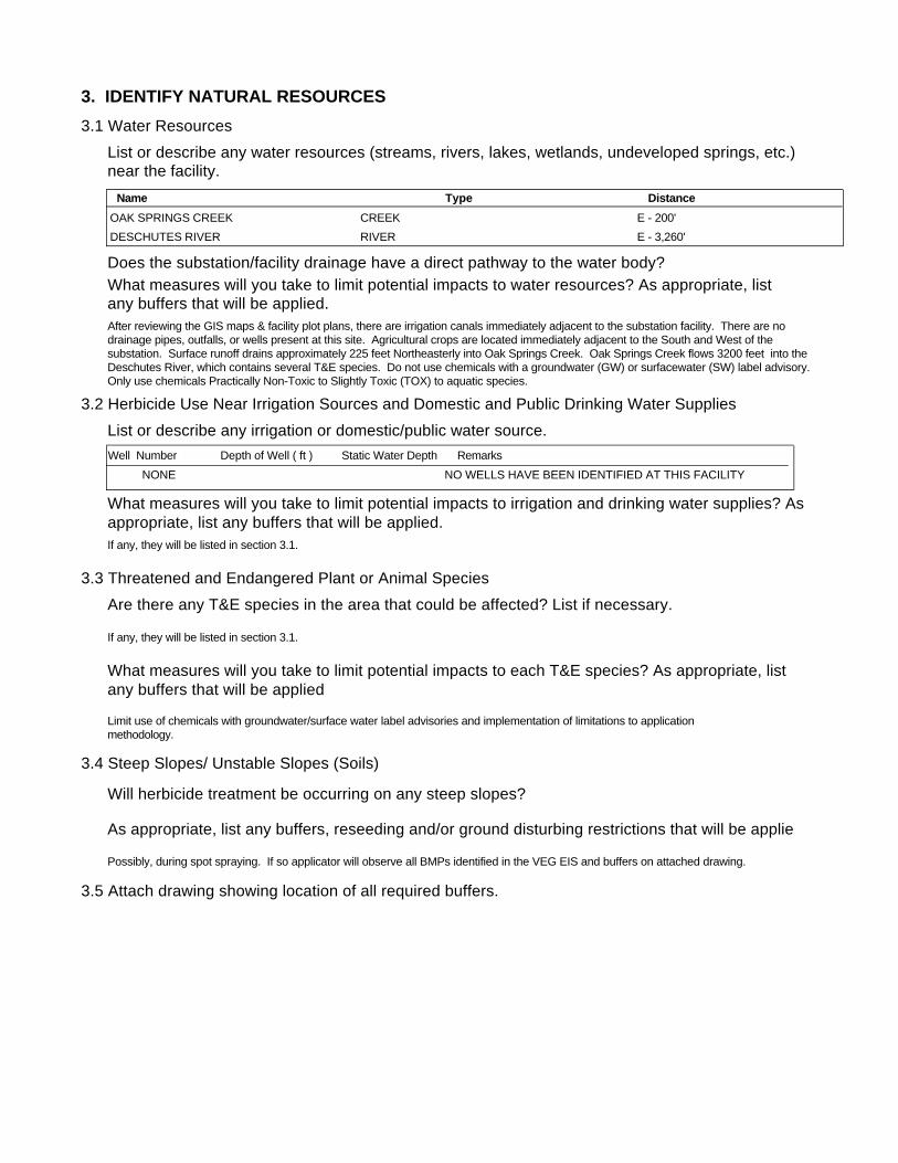
3. IDENTIFY NATURAL RESOURCES3.1 Water Resources
3.2 Herbicide Use Near Irrigation Sources and Domestic and Public Drinking Water Supplies
List or describe any water resources (streams, rivers, lakes, wetlands, undeveloped springs, etc.) near the facility.
Does the substation/facility drainage have a direct pathway to the water body?What measures will you take to limit potential impacts to water resources? As appropriate, list any buffers that will be applied.
List or describe any irrigation or domestic/public water source.
What measures will you take to limit potential impacts to irrigation and drinking water supplies? Asappropriate, list any buffers that will be applied.
3.3 Threatened and Endangered Plant or Animal Species Are there any T&E species in the area that could be affected? List if necessary.
What measures will you take to limit potential impacts to each T&E species? As appropriate, list any buffers that will be applied
3.4 Steep Slopes/ Unstable Slopes (Soils)
Will herbicide treatment be occurring on any steep slopes?
As appropriate, list any buffers, reseeding and/or ground disturbing restrictions that will be applie
3.5 Attach drawing showing location of all required buffers.
After reviewing the GIS maps & facility plot plans, there are irrigation canals immediately adjacent to the substation facility. There are no drainage pipes, outfalls, or wells present at this site. Agricultural crops are located immediately adjacent to the South and West of the substation. Surface runoff drains approximately 225 feet Northeasterly into Oak Springs Creek. Oak Springs Creek flows 3200 feet into the Deschutes River, which contains several T&E species. Do not use chemicals with a groundwater (GW) or surfacewater (SW) label advisory. Only use chemicals Practically Non-Toxic to Slightly Toxic (TOX) to aquatic species.
Limit use of chemicals with groundwater/surface water label advisories and implementation of limitations to application methodology.
If any, they will be listed in section 3.1.
Possibly, during spot spraying. If so applicator will observe all BMPs identified in the VEG EIS and buffers on attached drawing.
If any, they will be listed in section 3.1.
Name Type DistanceOAK SPRINGS CREEK E - 200'CREEKDESCHUTES RIVER E - 3,260'RIVER
Well Number Depth of Well ( ft ) Static Water Depth RemarksNONE NO WELLS HAVE BEEN IDENTIFIED AT THIS FACILITY

4. DETERMINE VEGETATION CONTROL METHODSDescribe overall vegetation management scheme and schedule: Bareground managed areas will primarily use herbicides with supplemental usage of mechanical methods. Other areas will be managed as described in section 1.2. Only herbicides from BPA's approved herbicide list will be used. All areas will be managed consistently with the Vegetation EIS. Initial:
Describe debris disposal and revegetation , if any.
For electrical substations the goal is Total Vegetation Management. A licensed contractor sprays the substations annually. BPA's substation herbicide application contracts contain specific language to ensure herbicides are applied consistent with the VEG EIS. Facilities requiring landscaping are designed to be low maintenance and are consistent with Integrated Pest Management procedures, such as using native, low growing plant types and mulches etc…
Subsequent:Herbicides will be applied on an annual or as needed. Active ingredients shall be rotated to ensure plants do not build a tolerance. Mechanical methods shall be performed on an as needed basis. Landscaping (ornamental plants/lawns) may be maintained via contractor or performed by BPA employees.
Future:Future control will be consistent with the methods described above.
5. DETERMINE DEBRIS DISPOSAL AND REVEGETATION
There will be no debris disposal and revegetion with bareground management. For other areas green debris will be recycled on-site to the extent practical.
6. DETERMINE MONITORING NEEDS
Describe debris disposal and revegetation , if any.
6.1 Describe evaluation of BPA/contractor treatment practices to ensure vegetation management measures are working.
Monitoring will occur through herbicide contract management and the observations of BPA Personnel during on site visits.
6.2 Is there a need to monitor adjacent areas for potential herbicide movement/contamination? If so, describe monitoring plan. (Unless monitoring for other reasons, this section should be consistent with BPA-systemwide herbicide monitoring plan not yet finalized.)
There will be no debris disposal and revegetion with bareground management. Debris disposal will take place on-site and will be recycled to the extent practical. Revegetation will be consistent with the existing vegetation of the facility and will incorporate native species where practical.
7. PREPARE APPROPRIATE ENVIRONMENTAL DOCUMENTATION7.1 Describe any potential project impacts or project work that are different than those disclosed in the Transmission System Vegetation Management Program EIS. Describe how those differences impact natural resources and if the differences are "substantial".
7.2 Is there a need for additional NEPA documentation (i.e. Forest Service requirement, Record of Decision, supplemental EIS)? If so, attach.
None
None

Facility ID: TYVAFacility TYGH VALLEYAddress: OAK SPRINGS ROAD
City, State, Zip TYGH VALLEY, OR,
Latitude: 45 12 53.6318 N
Longitude: 121 5 24.4492 W
Identification of Water Resources.
List of zones that may provide a means for vegetation control activities to threaten ground or surface water resources (secondary containment sytems).
Region: REDMOND
Surface Soil: SANDY SILTSub-Surface Soil: COBBLY SILTY GRAVELSoil Permeability: MODERATELY SLOW-MODERAT
Sole Source Aquifer? N
Depth to GW: UNKNOWN
Neighboring wells? NO
Floodplain: N
Annual Precip: 9
Crops:Public Property:
Physical Site Information.
Surface Water Evaluation:This facility requires a SPCC plan due to oil volumes and pathway to adjacent water bodies.
Yard is sloped -1.0% to the east.
Geological information on ground water confining layers:
Description of the Facility:Tygh Valley Substation has one Power Transformer with 3,145 gallons of oil and one Station Service Transformer containing 8.5 gallons of oil. There is one Circuit Breaker with 36 gallons of oil and three Voltage Regulators, each with 149 gallons of oil. Miscellaneous equipment includes three Potential Transformers , each with 7 gallons of oil.
Topographic Description of the area:Tygh Valley Substation is bordered to the east by the Wasco Electric Co-op switchyards and to the west and south by ranchland. It is bordered to the north by Oak Springs Road and a drainage ditch flowing east approximately 200' to Oak Springs Creek. The creek flows through a 48" CMP culvert under the road, down a steep grade and 2,000' to the Deschutes River and fish hatchery.
Leases:
Description of surface water resources:
Description of Drainages:Tygh Valley Substation has no subsurface drainage system. The yard is graded -1.0% to drain to the east.
Attachment B - Supplemental Resource Information
Containment Location Containment Type Type of Liner / RemarksDrainage Pipe
NONENotes on the Facility's Containment System(s):
THIS FACILITY HAS NO OIL SECONDARY CONTAINMENT SYSTEM