7.0 draft section 4(f) evaluation - minneapolis … · hennepin county regional railroad authority...
TRANSCRIPT

Southwest Transitway Chapter 7 Draft Environmental Impact Statement Draft Section 4(F) Evaluation
October 2012 Page 7-1
7.0 DRAFT SECTION 4(f) EVALUATION
7.1 Background Information and Regulatory Requirements This chapter presents the existing conditions and potential effects on parks, recreation areas, wildlife and waterfowl refuges, and historic properties as they relate to the provisions of Section 4(f) of the U.S. Department of Transportation Act of 1966, codified at 49 U.S.C. § 303 and 23 U.S.C. § 138. Section 4(f) is a federal law intended to prevent the conversion of specific types of property to transportation use, except under certain conditions. The proposed Southwest Transitway project is a transportation project that might receive federal funding and/or discretionary approvals through the U.S. Department of Transportation (USDOT); therefore, documentation of compliance with Section 4(f) is required. This chapter constitutes the preliminary draft Section 4(f) evaluation for this proposed project.
Section 4(f) prohibits the Secretary of Transportation from approving a project that requires the use of publicly owned land of a public park, recreation area, or wildlife and waterfowl refuge of national, state, or local significance, or land of an historic site of national, state, or local significance (as determined by the federal, state, or local officials having jurisdiction over the resource), unless the agency can demonstrate that:
• There is no feasible and prudent alternative to the use of the land; and • The action includes all possible planning to minimize harm to the property
resulting from such use.
As defined in 23 C.F.R. § 774.17, “use” of a Section 4(f) resource occurs when:
• Land is permanently incorporated into a transportation facility (e.g., “direct use”); • There is a temporary occupancy of land that is adverse in terms of the
preservationist purposes (e.g., “temporary use”); or • There is no permanent incorporation of land, but the proximity of a transportation
facility results in impacts so severe that the protected activities, features, or attributes that qualify a resource for protection under Section 4(f) are substantially impaired (e.g., “constructive use”).
A direct use of a Section 4(f) resource takes place when property is permanently incorporated into a proposed transportation facility. This can be done by partial or full acquisition, permanent easements, or temporary easements that exceed regulatory limits.
A temporary use of a Section 4(f) resource occurs when the property is temporarily occupied, for example during construction, and that occupancy is considered adverse in terms of the preservationist purposes of the statute. A temporary occupancy of property does not constitute a use of a Section 4(f) resource when:
• The occupancy is shorter than the time needed for construction of the project and there is no change in ownership of the property;
• The nature and magnitude of the changes to the Section 4(f) properties are minimal;

Chapter 7 Southwest Transitway Draft Section 4(F) Evaluation Draft Environmental Impact Statement
Page 7-2 October 2012
• There are no permanent adverse physical impacts or permanent interference with activities or purposes of the resource;
• The property is restored to the same or better condition; and, • There is documented agreement from the appropriate federal, state, or local
officials having jurisdiction over the property regarding the above conditions.
A constructive use of a Section 4(f) resource occurs when a transportation project does not permanently incorporate land from the resource, but the project’s proximity results in impacts so severe that the protected activities, features, or attributes that qualify the property for protection under Section 4(f) are substantially impaired. Substantial impairment occurs only if the protected activities, features, or attributes of the resource are substantially diminished.
The determination of “feasible and prudent” alternatives must include supporting information that demonstrates unique problems or unusual factors involved in the use of alternatives, which would avoid the use of Section 4(f) properties; or that the cost, social, economic, and environmental impacts or community disruption resulting from such alternatives reach extraordinary magnitudes. An alternative may be rejected as not being feasible and prudent if it:
• Does not meet the purpose and need of the project; • Has additional construction cost of extraordinary magnitude; or, • Results in severe operational or safety problems; unacceptable adverse social,
economic, or environmental impacts; serious community disruption; or, accumulation of the aforementioned impacts that when combined, reach an unacceptable level.
When a proposed project would need to use a minor amount of Section 4(f) protected property, the Federal Transit Administration (FTA) can make a de minimis impact determination. Such findings must include sufficient supporting documentation to demonstrate that the impacts, after avoidance, minimization, mitigation, or enhancement measures are taken into account, are de minimis as defined by the regulation, and that the required coordination has been completed.
23 C.F.R. part 774.17 defines two specific types of de minimis impacts.
• For historic sites, de minimis impact means that the FTA has determined, in accordance with 36 C.F.R. part 800, that no historic property is affected by the project or that the project will have “no adverse effect” on the historic property in question.
• For parks, recreation areas, and wildlife and waterfowl refuges, a de minimis impact is one that will not adversely affect the features, attributes, or activities qualifying the property for protection under Section 4(f).
For de minimis findings for historic properties, FTA is required to notify Minnesota State Historic Preservation Officer (SHPO) of the intent to conclude that the impact to the historic property is de minimis and Minnesota SHPO must concur, in writing, with the Section 106 determination. For de minimis findings for parks and recreation areas, FTA is required to provide written notification to the official with jurisdiction over the park or recreation area and the official with jurisdiction must provide written concurrence with this finding.

Southwest Transitway Chapter 7 Draft Environmental Impact Statement Draft Section 4(F) Evaluation
October 2012 Page 7-3
7.1.1 Section 6(f) In addition to the protection provided by Section 4(f), Section 6(f) of the Land and Water Conservation Fund Act of 1965 (LAWCON) stipulates that any land or facility planned, developed, or improved with LAWCON funds cannot be converted to uses other than parks, recreation, or open space unless land of at least equal fair market value and reasonably equivalent usefulness is provided. Anytime a transportation project would cause such a conversion, regardless of funding sources, such replacement land must be provided. At this time, no Section 6(f) protected property has been identified within the study area. Therefore, no permanent conversion of Section 6(f) park property is proposed and a Section 6(f) review is not required.
7.2 Methodology The methodology used to identify the use of Section 4(f) protected properties included the following steps:
• Develop detailed base maps depicting property ownership overlaid on current aerial photographs.
• Incorporate information on historic property in the vicinity of the proposed alignments that has been developed through the Section 106 process. These properties are documented in Section 3.4, Cultural Resources, of the Draft EIS.
• Incorporate information on publicly owned parks and publicly owned recreation areas within 350 feet of the corridor. This distance is used because 350 feet is the unobstructed screening distance for FTA noise impact assessments and would allow identification of potential constructive uses of Section 4(f) resources. These properties are also documented in Section 3.5, Parklands and Recreation Areas, of the Draft EIS.
• Project the Southwest Light Rail Transit (LRT) construction limits1 onto the base map to determine if any of the Section 4(f) properties would be used by the proposed action.
• Determine the type and magnitude of the use where there appears to be a project-related use of Section 4(f) properties.
The results of this analysis will lead to additional engineering analysis to determine if the use of Section 4(f) property can be avoided and minimized. A series of coordination meetings will be conducted with the parties that control these Section 4(f) protected properties, and/or the regulatory agencies responsible for these properties, to discuss the potential for the use of these properties and the results of avoidance and minimization efforts. The majority of these meetings would
1 In certain areas, the conceptual engineering construction limits include an area for re-grading of the existing interim use trails. This activity would only take place upon agreement between the land owner (HCRRA) and the entity managing the interim use trail. Impacts to 4(f) resources caused by trail re-grading are not considered part of the LRT project, and therefore are not considered 4(f) uses.
Chapter 7 Southwest Transitway Draft Section 4(F) Evaluation Draft Environmental Impact Statement
Page 7-4 October 2012
occur during preliminary engineering and would be presented in the Final Section 4(f) Evaluation.
7.3 Proposed Action The following sections summarize the project location and description of the project. The purpose and need for the project are presented in detail in this Draft EIS in Chapter 1, Purpose and Need for the Proposed Action.
7.3.1 Project Location and Description The proposed action, the Southwest Transitway, is the construction and operation of a 15-mile LRT line in the Minneapolis/St. Paul region, connecting downtown Minneapolis to major activity centers in Hennepin County, Minnesota, including the cities of St. Louis Park, Hopkins, Edina, Minnetonka, and Eden Prairie. Depending on the alternative being evaluated, this action also includes either:
• The rerouting of existing Twin Cities & Western (TC&W) Railroad Company freight rail service from the Canadian Pacific Railway’s (CP)’s Bass Lake Spur and Hennepin County Regional Railroad Authority’s (HCRRA) Cedar Lake (Kenilworth Corridor) to the MN&S Subdivision and BNSF’s Wayzata Subdivision
• The co-location of LRT and TC&W freight rail service on reconstructed freight rail tracks on the CP’s Bass Lake Spur and HCRRA’s Cedar Lake (Kenilworth Corridor)
High-capacity transit improvements in the southwest area of the Twin Cities have been studied by the HCRRA and the Metropolitan Council as well as other agencies, including the Regional Transit Board (RTB), since the mid-1980s. The Southwest Transitway is included in the following plans:
• Metropolitan Council’s 2030 Transportation Policy Plan (2030 TPP) (2009), the region’s long-range transportation plan;
• Hennepin County’s long-range transportation plan, the Hennepin County Transportation System Plan (TSP); and
• The comprehensive and transportation plans of the local municipalities in the study area.
The Southwest Transitway would add system capacity in an area of high travel demand, respond to travel demand created by existing and planned residential and employment growth, and provide a competitive travel option that would attract choice riders2 and serve transit dependent populations.
The Southwest Transitway would improve access and mobility to the job and activity centers both to/from the Minneapolis central business district (CBD) for the traditional work trip. It would also serve reverse-commute trips to the expanding suburban employment centers along the entire 15-mile line. The competitive travel
2 A choice transit rider is one that has a private vehicle available to make a given trip, but
chooses to take transit. The number of choice riders is increasing in and around downtown Minneapolis.

Southwest Transitway Chapter 7 Draft Environmental Impact Statement Draft Section 4(F) Evaluation
October 2012 Page 7-5
time for the Southwest Transitway is attributed to the diagonal nature of the line compared to the north-south/east-west orientation of the roadway network and the increasing levels of congestion of the roadway network. This line would also be an expansion of the region’s transitway system (Hiawatha LRT line, Northstar Commuter Rail, and the Central Corridor LRT line, currently under construction.)
The Southwest Transitway would operate in a combination of environments including in abandoned freight rail right-of-way (ROW), at-grade in street and trunk highway ROW, and in new ROW that would be acquired from public and private entities. In addition, the line would operate in very limited sections of elevated structure and tunnel.
The logical termini for serving the travel needs of the southwest area of the Twin Cities are from the City of Eden Prairie to downtown Minneapolis. Though planned as a part of an integrated transit system, the proposed project exhibits independent utility exclusive of the implementation of other fixed guideway projects in the region.
7.4 Types of Properties Protected by Section 4(f) The Section 4(f) properties found within 350 feet of the proposed project segments include publicly owned parks and recreation areas, conservation areas, and historic sites (historic properties).
A detailed discussion of the various historic properties and districts within the project vicinity is found in Section 3.4 of this Draft EIS. It should be noted that Section 3.4 contains minimal information regarding archaeological sites in the project vicinity because the archaeological survey has not been completed.
The historic properties and districts present in the project vicinity include properties that are listed in the National Register of Historic Places (NRHP), properties that have been determined eligible for listing on the NRHP following consultation with the SHPO, and properties that are currently being evaluated for NRHP eligibility. Properties that have been listed or formally determined to be eligible for listing are subject to Section 4(f) protection. For the purposes of this Section 4(f) evaluation, the properties under evaluation for historic significance are currently discussed only in Section 3.4. Should any of these properties be determined eligible for listing on the NRHP an evaluation of its need to be used by the proposed project would be included in the Final Section 4(f) Evaluation.
A list of the publicly owned parks, recreation areas, and conservation areas located in the vicinity of the Southwest Transitway LRT Project is found in Section 3.5 of this Draft EIS. No formally designated wildlife or waterfowl refuges are found in the project vicinity. At this time, these publicly owned properties are assumed to qualify for Section 4(f) protection based on the criteria set forth in 23 C.F.R. § 774. According to 23 C.F.R. § 774.11, consideration under Section 4(f) is not required when the official(s) with jurisdiction over a park, recreation area, or wildlife and waterfowl refuge determine that the property, considered in its entirety, is not significant. In the absence of such a determination, Section 4(f) property will be presumed to be significant. The FTA will review a determination that a park, recreational area, or wildlife and waterfowl refuge is not significant to assure its reasonableness.

Chapter 7 Southwest Transitway Draft Section 4(F) Evaluation Draft Environmental Impact Statement
Page 7-6 October 2012
The existing trails adjacent to Segments 1, 4, A, and a portion of Segment C (the Cedar Lake LRT Regional Trail, Minnesota River Bluffs LRT Regional Trail, Kenilworth Trail, and Midtown Greenway) were all constructed on HCRRA property under temporary agreements between the HCRRA and the trail permittees. As documented in each trail’s interim use agreement, HCRRA permitted these trails as temporary uses with the stipulation that they may be used until HCRRA develops the corridor for a LRT system or other permitted transportation use. Therefore, these trails are not subject to protection as Section 4(f) property.
The following sections describe the Section 4(f) properties identified in the project vicinity. The properties discussed below have the potential to be used by the proposed project based on the construction limits prepared during conceptual design. The findings presented below will be further developed by FTA through coordination with the Minnesota SHPO and agencies, such as the Minneapolis Park and Recreation Board that are the officials with jurisdiction over the publicly owned parks and publicly owned conservation areas.
7.4.1 Section 4(f) Properties Potentially Used by the Project The following subsections describe the Section 4(f) properties that would potentially be used by the proposed project based on the best engineering information currently available. These determinations will be reviewed as preliminary engineering advances and efforts to reduce or eliminate the need to use land from these properties is completed. The results of avoidance and minimization efforts during preliminary engineering will be presented in the Final Section 4(f) Evaluation.
The historic properties discussed below are only those resources that are listed in or determined eligible for the NRHP. Historic properties under evaluation for historic significance and eligibility for the NRHP are not discussed in this evaluation. More information on cultural resources, regardless of current NRHP status, is found in Section 3.4.
7.4.1.1 Operation and Maintenance Facilities Potential impacts to Section 4(f) properties were considered at Operation and Maintenance Facility (OMF) locations. None of the four proposed OMF locations contain dedicated parkland. The Eden Prairie locations (1, 2, and 3) do not contain historic structures eligible for listing on the NRHP. The Minneapolis location is the site of the Regan Brothers Bakery, which has been determined to be eligible for the NRHP. Selection of the Minneapolis OMF site would likely require demolition of the bakery site, and would be considered a Section 4(f) use.

Southwest Transitway Chapter 7 Draft Environmental Impact Statement Draft Section 4(F) Evaluation
October 2012 Page 7-7
7.4.1.2 Summary by LRT Alternative Table 7.4-1and the sections below summarize the number of Section 4(f) properties that would be used by each LRT alternative according to the information generated during conceptual design. Figures 7.4-1 through Figure 7.4-8 show the Section 4(f) properties within 350 feet of the alternatives.
As Table 7.4-1 shows, only direct or temporary uses are anticipated; no constructive uses of Section 4(f) properties have been identified at this time. This summary is preliminary because design is not sufficiently advanced to conclude that avoidance and minimization measures have been exhausted. Additional efforts will be made during Preliminary Engineering to avoid or minimize the use of any of these Section 4(f) properties. The results of this additional analysis will be presented in the Final Section 4(f) Evaluation. Any properties currently under evaluation for historic significance are not included in this analysis. Should any of these properties be determined eligible for listing on the NRHP an evaluation of its need to be used by the proposed project would be included in the Final Section 4(f) Evaluation and this summary updated accordingly.

Chapter 7 Southwest Transitway Draft Section 4(F) Evaluation Draft Environmental Impact Statement
Page 7-8 October 2012
Table 7.4-1. Potential Use of 4(f) Properties by Alternative
Alternative Section 4(f) Properties Used
Potential for Permanent Use
(acres)
Potential for Temporary Use
(acres)
LRT 1A 0.002 0.076
Segment 1 Edenvale Conservation Area 0.002 0.06
Segment 4 None 0 0
Segment A
Cedar Lake Park Lake of the Isles Cedar Lake Parkway Park Siding Park Kenilworth Channel
0 0 0 0
Historic channel; Replacement of non-contributing bridges, work along banks
0 0 0 0.016
Not available
Segment FRR Historic Channel between Brownie Lake and Cedar Lake
Historic channel Not Applicable
LRT 3A (LPA) 0.227 0.016
Segment 3 Nine Mile Creek Conservation Area 0.227 0
Segment 4 None 0 0
Segment A
Cedar Lake Park Lake of the Isles Cedar Lake Parkway Park Siding Park Kenilworth Channel
0 0 0 0
Historic channel; Replacement of non-contributing bridges, work along banks
0 0 0 0.016
Not available
Segment FRR Historic Channel between Brownie Lake and Cedar Lake
Historic channel Not Applicable

Southwest Transitway Chapter 7 Draft Environmental Impact Statement Draft Section 4(F) Evaluation
October 2012 Page 7-9
Alternative Section 4(f) Properties Used
Potential for Permanent Use
(acres)
Potential for Temporary Use
(acres)
LRT 3A-1 (Co-location alternative)3 1.12 0.016 acre
Segment 3 Nine Mile Creek Conservation Area 0.227 0
Segment 4 None 0 0
Segment A-1
Cedar Lake Park Lake of the Isles Cedar Lake Parkway Park Siding Park Kenilworth Channel
0.81 0.01 0.07 0
Historic channel; Replacement of non-contributing bridges, adding additional bridge, work along banks
Not available Not available Not available
0.016 Not available
LRT 3C-1 (Nicollet Mall) 0.32 0.45
Segment 3 Nine Mile Creek Conservation Area 0.227 0
Segment 4 None 0 0
Segment C-1
Chicago Milwaukee & St. Paul (CM&StP) Railroad bridge over Dean Parkway; CM&StP Railroad bridge Lake of the Isles Park; CM&StP Railroad bridge over Lake Calhoun Parkway
Replacement Not Applicable
Dean Parkway 0.035 0.035
Lake of the Isles Park 0.053 0.16
Chicago Milwaukee & St. Paul Railroad Grade Separation Historic District
Retaining walls and other structures would be replaced
0
3 Please see Section 2.1.2.1 of this Draft EIS for why LRT 3A-1 (co-location alternative) is
included in this Draft EIS.

Chapter 7 Southwest Transitway Draft Section 4(F) Evaluation Draft Environmental Impact Statement
Page 7-10 October 2012
Alternative Section 4(f) Properties Used
Potential for Permanent Use
(acres)
Potential for Temporary Use
(acres)
The Mall/Grand Rounds Historic District 0 0.26
Segment FRR Historic Channel between Brownie Lake and Cedar Lake
Historic channel Not Applicable
LRT 3C-2 (11th/12th Street) 0.32 0.45
Segment 3 Nine Mile Creek Conservation Area 0.227 0
Segment 4 None 0 0
Segment C-2
CM&StP Railroad bridge over Dean Parkway; CM&StP Railroad bridge Lake of the Isles Park; CM&StP Railroad bridge over Lake Calhoun Parkway
Replacement Not Applicable
Dean Parkway 0.035 0.035
Lake of the Isles Park 0.053 0.16
CM&StP Railroad Grade Separation Historic District
Retaining walls and other structures would be replaced
0
The Mall/Grand Rounds Historic District 0 0.26
Segment FRR Historic Channel between Brownie Lake and Cedar Lake
Historic channel Not Applicable
* Under the co-location alternative, the effects of widening the trail/rail corridor across the Kenilworth channel has potential for a greater Section 4(f) use due to adverse impacts to the historic channel compared to the LPA alternative, which would not widen the existing corridor to the same degree.

Southwest Transitway Chapter 7 Draft Environmental Impact Statement Draft Section 4(F) Evaluation
October 2012 Page 7-11
Figure 7.4-1. Section 4(f) Evaluation – Alternative 1A

Chapter 7 Southwest Transitway Draft Section 4(F) Evaluation Draft Environmental Impact Statement
Page 7-12 October 2012
Figure 7.4-2. Section 4(f) Evaluation – Alternative 1A (2)
Southwest Transitway Chapter 7 Draft Environmental Impact Statement Draft Section 4(F) Evaluation
October 2012 Page 7-13
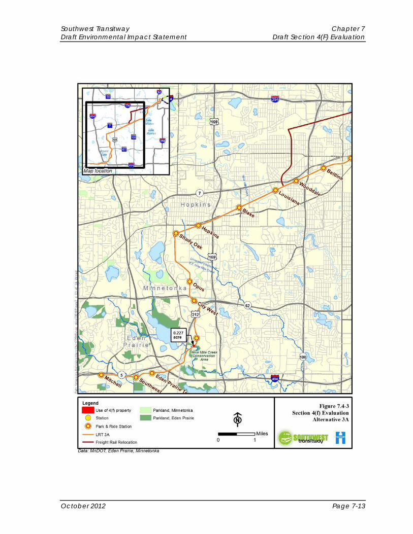
Figure 7.4-3. Section 4(f) Evaluation – Alternative 3A

Chapter 7 Southwest Transitway Draft Section 4(F) Evaluation Draft Environmental Impact Statement
Page 7-14 October 2012
Figure 7.4-4. Section 4(f) Evaluation – Alternative 3A (2)

Southwest Transitway Chapter 7 Draft Environmental Impact Statement Draft Section 4(F) Evaluation
October 2012 Page 7-15
Figure 7.4-5. Section 4(f) Evaluation – Alternative 3A-1

Chapter 7 Southwest Transitway Draft Section 4(F) Evaluation Draft Environmental Impact Statement
Page 7-16 October 2012
Figure 7.4-6. Section 4(f) Evaluation – Alternative 3A-1 (2)

Southwest Transitway Chapter 7 Draft Environmental Impact Statement Draft Section 4(F) Evaluation
October 2012 Page 7-17
Figure 7.4-7. Section 4(f) Evaluation – Alternatives 3C-1 and 3C-2

Chapter 7 Southwest Transitway Draft Section 4(F) Evaluation Draft Environmental Impact Statement
Page 7-18 October 2012
Figure 7.4-8. Section 4(f) Evaluation – Alternative 3C-1 and 3C-2 (2)

Southwest Transitway Chapter 7 Draft Environmental Impact Statement Draft Section 4(F) Evaluation
October 2012 Page 7-19
7.4.1.3 Alternative LRT 1A (Segments 1, 4, A and Freight Rail Relocation) As shown in Figures 7.4-1and 7.4-2, the conceptual engineering designs indicate that LRT 1A would potentially result in the direct use of 0.002 acre of parkland permanently and the temporary use of 0.076 acre of parkland. Additionally, a Section 4(f) use of the historic channel between Brownie and Cedar Lakes is also possible. The parkland that would be used is generally a combination of passive-use open space and transportation land use. No developed recreation features would be used. Land ownership along the segment from downtown Minneapolis to Cedar Lake Park is complicated and may need additional survey or a detailed title search to determine ownership of the underlying land (see the HCRRA Property Ownership Technical Memorandum in Appendix H). The majority of the land along Segment A through the Kenilworth Corridor by Cedar Lake Parkway belongs to the HCRRA.
In Segment 1, approximately 0.002 acre of the edge of the Edenvale Conservation Area would be permanently used, and during construction temporarily occupy an additional 0.058 acre where it abuts the existing CP Bass Lake Spur railroad corridor along a portion of the segment.
In Segment 4, there would be no anticipated uses of 4(f) resources.
In Segment A, the reconstruction of existing bridges and construction of new LRT tracks along existing freight rail alignment is anticipated to occur on HCRRA ROW. Construction of this segment will occur adjacent to Cedar Lake Park, Cedar Lake Parkway, and Lake of the Isles portions of the Minneapolis Chain of Lakes Regional Park; at this time no permanent or temporary uses of parkland are anticipated.
Cedar Lake Parkway and the Cedar Lake-Lake of the Isles Channel have been determined eligible for inclusion on the NRHP as part of the Grand Rounds. It should be noted that the two timber bridges across the Kenilworth Channel are listed as non-contributing elements within the Grand Rounds. The proposed removal of these non-contributing bridges would, in and of itself, not constitute an adverse effect and therefore would not be considered a Section 4(f) use.
The conceptual engineering completed for the project identifies the potential for a temporary use of approximately 0.016 acre of Park Siding Park for grading associated with future trail reconstruction.
In the Freight Rail Relocation segment, the channel between Brownie and Cedar Lakes (including the culvert through which it passes) is eligible for inclusion in the NRHP as part of the Grand Rounds. If the relocation of freight rail service to the BNSF Wayzata Subdivision necessitates modification of the channel and/or culvert, this could constitute an adverse effect and thus would be considered a Section 4(f) use.
Efforts to avoid or minimize these uses for LRT 1A would take place during the preliminary design process. Given the lack of planned resources and the small amount of area likely to be used in any of these locations, it is likely that the impact to land from Edenvale Conservation Area and Park Siding Park would be found to be de minimis if these uses cannot be avoided entirely.

Chapter 7 Southwest Transitway Draft Section 4(F) Evaluation Draft Environmental Impact Statement
Page 7-20 October 2012
7.4.1.4 Alternative LRT 3A (LPA - Segments 3, 4, A and Freight Rail Relocation) The conceptual engineering designs indicate that LRT 3A (LPA) would potentially result in a direct use of 0.227 acre of parkland and the temporary use of an additional 0.016 acre of parkland. Additionally, a Section 4(f) use of the historic channel between Brownie and Cedar Lakes is also possible (Figures 7.4-3 and 7.4-4). The parkland that would be used is generally a combination of passive-use open space and transportation land use. No developed recreation features would be used. Land ownership along the segment from downtown Minneapolis to Cedar Lake Park is complicated and may need additional survey or a detailed title search to determine ownership of the underlying land. The majority of the land along Segment A through the Kenilworth Corridor by Cedar Lake Parkway belongs to the HCRRA.
The conceptual engineering designs indicate that in Segment 3, LRT 3A (LPA) has the potential to permanently use approximately 0.227 acre of land from the Nine Mile Creek Conservation Area. Specifically, the LRT tracks and associated ROW would cross a small portion of the conservation area. The area that would be used for the construction of LRT alignment is primarily open space with no improvements.
In Segment 4, there are no anticipated uses of 4(f) resources.
In Segment A, the reconstruction of existing bridges and construction of new LRT tracks along existing freight rail alignment is anticipated to occur on HCRRA ROW. Construction of this Segment will occur adjacent to Cedar Lake Park, Cedar Lake Parkway, and Lake of the Isles portions of the Minneapolis Chain of Lakes Regional Park; at this time no permanent or temporary uses of parkland are anticipated.
Cedar Lake Parkway and the Cedar Lake-Lake of the Isles Channel have been determined eligible for inclusion on the NRHP as part of the Grand Rounds. It should be noted that the two timber bridges across the Kenilworth Channel are listed as non-contributing elements within the Grand Rounds. The proposed removal of these non-contributing bridges would, in and of itself, not constitute an adverse effect and therefore would not be considered a Section 4(f) use.
The conceptual engineering completed for the project identifies the potential for a temporary use of approximately 0.016 acre of Park Siding Park for grading associated with future trail reconstruction.
In the Freight Rail Relocation segment, the channel between Brownie and Cedar Lakes (including the culvert through which it passes) is eligible for inclusion in the NRHP as part of the Grand Rounds. If the relocation of freight rail service to the BNSF Wayzata Subdivision requires modification of the channel and/or culvert, this could constitute an adverse effect and thus would be considered a Section 4(f) use.
Efforts to avoid or minimize these uses for LRT 3A (LPA) would take place during the preliminary design process. Given the lack of planned resources and the small amount of area likely to be used in any of these locations, it is likely that the impact to land from Nine Mile Creek Conservation Area and Park Siding Park would be found to be de minimis if these uses cannot be avoided entirely.

Southwest Transitway Chapter 7 Draft Environmental Impact Statement Draft Section 4(F) Evaluation
October 2012 Page 7-21
7.4.1.5 Alternative LRT 3A-1 (Co-location alternative - Segments 3, 4, A and Freight Rail Relocation)
The conceptual engineering designs indicate that LRT 3A-1 (co-location alternative) would potentially result in the permanent use of 1.12 acres of parkland and the temporary use of an additional 0.016 acre of parkland (Figures 7.4-5 and 7.4-6). The parkland that would be used is generally a combination of passive-use open space and transportation land use. No developed recreation features would be used. Land ownership along the segment from downtown Minneapolis to Cedar Lake Park is complicated and may need additional survey or a detailed title search to determine ownership of the underlying land. The majority of the land along Segment A through the Kenilworth Corridor by Cedar Lake Parkway belongs to the HCRRA.
The conceptual engineering designs indicated that in Segment 3, LRT 3A-1 (co-location alternative) has the potential to permanently use approximately 0.227 acre of land from the Nine Mile Creek Conservation Area. Specifically, the LRT tracks and associated right of way would cross a small portion of the conservation area. The area that would be used for the construction of LRT alignment is primarily open space with no improvements.
In Segment 4, there are no anticipated uses of 4(f) resources.
Segment A of LRT 3A-1 (co-location alternative), which would co-locate freight rail, light rail and the commuter trail within this segment, would necessitate additional expansion of ROW outside of the HCRRA-owned parcels into adjacent parkland. Section 4(f) uses could occur for the Cedar Lake Park, Cedar Lake Parkway, and Lake of the Isles portions of the Minneapolis Chain of Lakes Regional Park for reconstruction of existing bridges, construction of new LRT tracks and realignment of the existing freight rail tracks. The trail system may need realignment or reconstruction. The conceptual engineering completed to date for the project identifies approximately 0.81 acre of permanent use of Cedar Lake Park for the location of the reconstruction of the freight rail track. Additionally, approximately 0.01 acre of permanent use of Lake of the Isles Park and 0.07 acre of permanent use of Cedar Lake Parkway are anticipated. Construction limits have not been determined for the co-location segment, but it is likely that additional temporary uses of parkland will occur.
The parkland that would be used is generally a combination of passive-use open space and transportation land use. No developed recreation features would be used. The Cedar Lake Park portion of Minneapolis Chain of Lakes Regional Park is wooded and open space park property. Cedar Lake Parkway and the Cedar Lake-Lake of the Isles Channel have been determined eligible for inclusion on the NRHP as part of the Grand Rounds. As discussed for LRT 3A (LPA), it should be noted that the two timber bridges across the Kenilworth Channel are listed as non-contributing elements within the Grand Rounds. The proposed removal of these non-contributing bridges would, in and of itself, not constitute an adverse effect and therefore would not be considered a Section 4(f) use. However, the replacement of these bridges has the potential for an adverse effect if they are not designed in conformance with the Secretary of Interior’s standards. Consultation on the design is expected to

Chapter 7 Southwest Transitway Draft Section 4(F) Evaluation Draft Environmental Impact Statement
Page 7-22 October 2012
occur as part of the Section 106 memorandum of agreement. LRT 3A-1 (co-location alternative) also necessitates the construction of an additional bridge over the Kenilworth Channel for the reconstruction of the freight rail track.
The conceptual engineering completed for the project also identifies the potential for a temporary use of approximately 0.016 acre of Park Siding Park for grading associated with future trail reconstruction.
Efforts to avoid or minimize uses would take place during the preliminary engineering process. Given the lack of planned resources and the small amount of area likely to be used in Nine Mile Creek Conservation Area, Park Siding Park, Cedar Lake Parkway and Lake of the Isles, it is likely that these impacts would be found to be de minimis if these impacts cannot be avoided entirely. The use of Cedar Lake Park, anticipated for the co-location alternative, however, is greater than for LRT 1A and LRT 3A (LPA) and would likely not be avoidable. As such, a finding of de minimis impact would likely not be determined by FTA nor would the Minneapolis Park and Recreation Board likely concur. Therefore, the co-location alternative would constitute a Section 4(f) use of Cedar Lake Park.
7.4.1.6 Alternative LRT 3C-1 (Nicollet Mall - Segments 3, 4, C-1 and Freight Rail Relocation)
As shown in Figures 7.4-7and 7.4-8, the conceptual engineering designs indicate that LRT 3C-1 (Nicollet Mall) would potentially result in the direct use of 0.32 acre of parkland and the temporary use of an additional 0.45 acre. Additionally, a Section 4(f) use of three historic bridges, one historic district, and the historic channel between Brownie and Cedar Lakes is also possible.
The conceptual engineering designs indicated that in Segment 3, LRT 3C-1 (Nicollet Mall) has the potential to permanently use approximately 0.227 acre of land from the Nine Mile Creek Conservation Area. Specifically, the LRT tracks and associated right of way would cross a small portion of the conservation area. The area that would be used for the construction of LRT alignment is primarily open space with no improvements.
In Segment 4, there are no anticipated uses of 4(f) resources.
Conceptual engineering indicates that Segment C-1 of LRT 3C-1 (Nicollet Mall) would have the potential to permanently use approximately 0.09 acre and have the potential for temporary occupancy of an additional 0.45 acre of parkland from three different parks. This land would be from Dean Parkway portion of Minneapolis Chain of Lakes Regional Park for construction of a crossing over Dean Parkway (0.035 acre permanent use and 0.035 acre of temporary use), from the Lake of the Isles Park portion of Minneapolis Chain of Lakes Regional Park for a crossing over Lake of the Isles (0.053 acre permanent use and 0.16 acre temporary use), and from The Mall for construction of at-grade crossings (0 acre of permanent use and 0.26 acre of temporary use).
The parkland that would be used is a combination of passive use open space and transportation land use. No developed recreation features would be used. The Dean Parkway portion of Minneapolis Chain of Lakes Regional Park is a combination of open space and transportation land use. The Lake of the Isles portion of

Southwest Transitway Chapter 7 Draft Environmental Impact Statement Draft Section 4(F) Evaluation
October 2012 Page 7-23
Minneapolis Chain of Lakes Regional Park property is passive use open space. The Mall is a combination of parkway and open space. Efforts to avoid or minimize this use would take place during the preliminary design process. Given the lack of planned resources and the small amount of area to be used in these locations, it is likely that the impact to land from Dean Parkway and Lake of the Isles would be found to be de minimis. The Mall use appears to be temporary occupancy and would not permanently incorporate any park land into a transportation use. Many of these areas have been determined eligible to the NRHP as part of the Grand Rounds.
Conceptual engineering has also indicated that work would take place on or immediately adjacent to several other known historic properties and known historic districts; these are the Chicago Milwaukee & St. Paul (CM&StP)Railroad bridge over Calhoun-Isles Channel, the CM&StP Railroad bridge over Dean Parkway, the CM&StP Railroad bridge over Lake Calhoun Parkway , and the CM&StP Railroad Grade Separation Historic District. As described in Section 3.4, Cultural Resources, the project would have the potential for adverse effects on these properties and corresponding Section 4(f) uses.
In the Freight Rail Relocation Segment, the channel between Brownie and Cedar Lakes (including the culvert through which it passes) is eligible for inclusion in the NRHP as part of the Grand Rounds. If the construction of the new main line necessitates modification of the channel and/or culvert, this could constitute an adverse effect and thus would be considered a Section 4(f) use.
Efforts to avoid or minimize these uses for LRT 3C-1 (Nicollet Mall) would take place during the preliminary design process. Given the lack of planned resources and the small amount of area likely to be used in any of these locations, it is likely that the impact to land from Nine Mile Creek Conservation Area, Lake of the Isles Park, and Dean Parkway would be found to be de minimis if these uses cannot be avoided entirely.
7.4.1.7 Alternative LRT 3C-2 (11th/12th Street - Segments 3, 4, C-2 and Freight Rail Relocation)
Alternative LRT 3C-2 (11th/12th Street) would have the same potential Section 4(f) uses as LRT 3C-1 (Nicollet Mall); see section 7.5.1.6 for more detail.
7.5 Avoidance and Minimization Measures Measures to avoid and minimize uses of properties protected by Section 4(f) are discussed below, including alternatives that would avoid impacts (No Build Alternative and Enhanced Bus Alternative) and measures that will be considered to avoid and minimize Section 4(f) uses for the LRT alternatives throughout the design and permitting process.
7.5.1 No Build Alternative The No Build Alternative would result in a continuation of the transportation system that is currently in place. Transit system improvements under the No Build Alternative include minor modifications to existing bus services and transit facilities. According

Chapter 7 Southwest Transitway Draft Section 4(F) Evaluation Draft Environmental Impact Statement
Page 7-24 October 2012
to current plans, the existing transit facilities and services would mostly be retained under the No Build Alternative, with some routes consolidating services or modifying existing route alignments. The No Build Alternative would result in no Section 4(f) uses.
7.5.2 Enhanced Bus Alternative The Enhanced Bus Alternative, discussed in detail in Section 2.2.2 of this Draft EIS, was carried forward from the Southwest Transitway Alternatives Analysis and scoping. The Enhanced Bus Alternative includes the same highway and roadway network improvements contained in the No Build Alternative. The Enhanced Bus Alternative is not anticipated to result in any modifications to the existing highway or roadway infrastructure in the study area. Both the new express bus routes and current bus routes would use the existing infrastructure, including the high occupancy vehicle (HOV)/high occupancy toll (HOT) lanes on highways and expressways, and bus-only shoulder lanes. The Enhanced Bus Alternative would result in no Section 4(f) uses.
7.5.3 Potential for Avoiding and Minimizing Uses of Properties Protected by Section 4(f) – LRT Alternatives
Measures to avoid or all possible planning to minimize harm of Section 4(f) properties will be evaluated during preliminary engineering, incorporated into the design of the project, and presented in the Final Section 4(f) Evaluation. Once a preferred alternative is selected and preliminary engineering has progressed, methods to avoid non-de minimis impacts to properties protected by Section 4(f) will be developed. Avoidance of properties protected by Section 4(f) will be pursued as a first course of action. When avoidance of Section 4(f) property is not possible, measures will be employed to minimize the use of each Section 4(f) protected property. For those properties that cannot be avoided and for which uses exist even after minimization, a variety of compensatory mitigation measures will be developed to further minimize harm. Avoidance alternatives and minimization measures developed during preliminary engineering will be discussed in detail in the Final Section 4(f) Evaluation.
Once avoidance and minimization measures have been exhausted, the dimensions and location of any regional parkland that needs to be used by the Southwest LRT project will be forwarded to the Minneapolis Park and Recreation Board, Metropolitan Council staff and other appropriate park agencies for affected properties so appropriate mitigation and equally valuable land or facility exchanges can be discussed and evaluated. In addition, if any of the parkland to be used has a restrictive covenant in place between the Metropolitan Council and the Minneapolis Park and Recreation Board, approval to remove this covenant would need to be obtained. This information will be discussed in detail in the Final Section 4(f) Evaluation. Likewise, once avoidance and minimization measures have been exhausted, the dimensions and location of any Section 106 properties needed for the Southwest Transitway project will be forwarded to the SHPO, the Advisory Council on Historic Preservation (as appropriate), and the Metropolitan Council for identification of appropriate mitigation.

Southwest Transitway Chapter 7 Draft Environmental Impact Statement Draft Section 4(F) Evaluation
October 2012 Page 7-25
7.6 Coordination The U.S. Department of the Interior will be provided an opportunity to review the draft Section 4(f) evaluation in accordance with the implementing regulations found at 23 C.F.R. § 774. Coordination with the officials with jurisdiction over the relevant Section 4(f) properties will proceed during the Section 4(f) process and the associated NEPA and Section 106 processes.
The Advisory Council on Historic Preservation has been notified of Section 106 consultation on this project, and has responded that they will not participate unless a specific need arises. Section 106 consultation will continue with the Minnesota SHPO and a number of other consulting parties. Because of the complexity of issues and the number of historic properties present in the project area and its surroundings, agency consultation and public meetings are anticipated to be required to complete the Section 106 and NEPA processes and will be conducted as needed. Agency coordination letters received to-date on the proposed action can be found in Appendix E.
7.7 Conclusion The Section 4(f) analysis, development of avoidance and minimization measures, and associated agency coordination will continue throughout the preliminary design and NEPA review process. As the results of this chapter indicate, the LRT alternatives are anticipated to result in relatively small amounts of Section 4(f) uses when compared to the parkland existing within the study area. For parklands, the impacts are estimated to range between 0.002 to 1.12 acres of permanent use depending on the LRT alternative. For historic properties, there is the potential for Section 4(f) uses on between one and five historic properties/districts, depending on the LRT alternative. These uses would consist of replacing culverts across historic channels, replacing historic bridges (3C alternatives) and placing LRT facilities within eligible or listed features such as the Grand Rounds (all alternatives) and Milwaukee & St. Paul Railroad Grade Separation Historic District (3C alternatives). Consultation on design features to seek compatibility with adjacent historic properties may result in a de minimis finding under Section 4(f). One of the OMF locations (Minneapolis) would result in a use of a Section 4(f) property. The historic Regan Brothers Bakery would likely be demolished if the Minneapolis OMF location is selected and the facility is constructed. None of the alternatives considered are anticipated to result in constructive use of a Section 4(f) property.