67 5 2 1 2 32 3 1 0 2 1 0 1 0 306 0 1 2 0 12 0 1 2 0 1 0 1...
TRANSCRIPT
http://www.pla.co.uk/Safety/PLA-Hydrographic-Service-Published-Surveys
Issue:01 Date:18/10/13Page 1 of 1
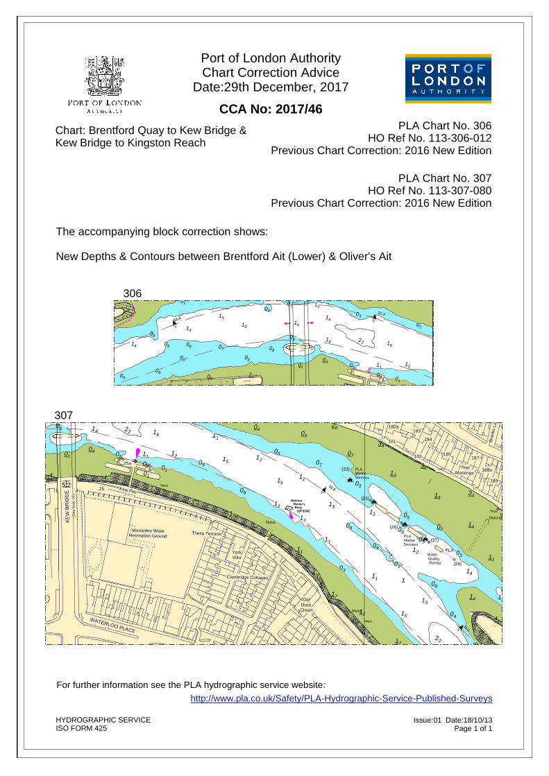
CCA No: 2017/46Chart: Brentford Quay to Kew Bridge & Kew Bridge to Kingston Reach
Port of London AuthorityChart Correction Advice
Date:29th December, 2017
PLA Chart No. 306HO Ref No. 113-306-012
Previous Chart Correction: 2016 New Edition
HYDROGRAPHIC SERVICEISO FORM 425
306
For further information see the PLA hydrographic service website:
11.5
11.411.3
11.2
23
46
19
32
21
06
3412
46
1131
01
18
48
01
51
61
07
61
2308
21
43
05
4108
01
1141
0943
0808
03
31
22141
11
01
18
6191
1641
0351
13
09
09
09 07
02
09
52
2418
38
27 32
12
2
14 30 08
1702
24
01
03 020802
12
1
3025
27
01
21
07
Brentford AitBuoy
(QFl(4)R)
Celandine
The Bush
Linquenda
Big Ness
Induce
ShikaraHeron Chilham
Foul Soldier Blue Inmost
LP
Ciconia PSea Crest
The Legend
LP
LP
P
P
P P PP
piles
P P
PsVertrouwen
Admiral TrumpLeveller
P
NB
LP
Ps
LP
LP
Sluice
Suction Pipe
Suction Pipe
Suction P ipe
Moorings
Kew Marine
piles
LP
(See
Not
e 10
)
FS
FS
LP
P
LP
NB
Sluice
LP
Steps
Steps
Steps
Steps
Royal Botanical Gardens
Sluice
Herbarium
WATERLOO PLACE
Watcombe Cottages
OldDockClose
Ferry Lane
Kew GreenPreparatory
School
Sluice
Kreisel Walk
KE
W B
RID
GE
Westerley WareRecreation Ground
Thetis Terrace
Cambridge Cottages
YorkVilla
Brentford Ait (Lower)
161
162
163160 164
O' Riordan'sTavern
Pumping Station
162a
166a The Hollows165
166167-171
Kew Bridge Road
Regatta Point
Kew BridgeSteam Museum
ThamesideCentre
Bush R
oad
24a24b 23-24
5 2
8 Kew BridgeRoad Pier
Jacana II
25 Kew Pier
25a
179-180
177
Strand-on-the-Green
Ball's Wharf
Pier House
178
Thames Road
TheDome
174
172-3
66 77
175
Sprin
g G
roveDrawdock
176
Kew
Road
Kew
Road
Hearne R
oad
23
30
13
21
43
17
38
01
61
46
43
21
06
14
08
48
01
08
61
02
27
08
02
04
23
91
41
4631
41
2
08
41
05
03
22
51
52
3218
08
08
31
09
0701
01
09
11
12
34
24
1
61
01
18
2108
30
01
32
12
41
27
09
24
12
11
18
51
19
41
02
11
03
25
1603
09
08
0709
02
09
17.317.4 17.2
29.1
29.3
0°17'W
51°29'N
0°17'W 17.5'W
29.2
PLA Chart No. 307HO Ref No. 113-307-080
Previous Chart Correction: 2016 New Edition
The accompanying block correction shows:
New Depths & Contours between Brentford Ait (Lower) & Oliver's Ait
30711.4
11.3
11.2
11.1
54
02
41
09
42
6271
08
3
04
21
36
21
06
51
19
11
31
21
09
38
07
11
17
31
29
03
09
07
12
03
52
11
21
09
34
12
13
51
08
08
05
24
3105
36
71
04
1
09
12
17
32
34
01
06
5
38
48
09
03
51
14
32
51
43
22
1
71
2
08
52
33
01
0809
38
11
4
06
11
61
02
33
22
34
14
01
05
61
33
14
41
61
03
04
29
62
02
19
19
32
34
4631
0118
48
01
5107
61
2308
210501
1141
09
0808
31
22111
016191
1641 0351
09
09
09 07
02
52
18 27 3212
208
24
03 020802 1 27
01 07
Harbour Master's Buoy (QFI(2)R)
(22) PLAMarine Services
(23)
(26)
PLAMarineServices
Water Quality Monitor
(27)
PLA
(28)
Oliver's Ait Buoy
(QFI(2)R)
WATERLOO PLACE
NB
LP
Ps
LP
LP
Watcombe Cottages
OldDockClose
24a
Bush R
oad
23-24
KE
W B
RID
GE
5 2
(See
Not
e 10
)
25
FS
Kew Pier
Cambridge Cottages
FS
Sluice
Thetis TerraceWesterley Ware
Recreation Ground
25a
YorkVilla
25
Bushwood Road
Maze R
oad
Priory Park Club
Short LotsAllotment Gardens
Sluice
LP TheMoorings
LP
P
188a
Sluice
189
192
Oliver's Ait
P
P
PP
PPLAP Grid
LPFSP
192
The MaltHouse
LP
Thames Road
190
LP
191a
ShipCottage
191
Strand-on-the-Green
190
8 Kew BridgeRoad Pier
174
LP
175
PLPNB
Sluice
177
Strand-on-the-Green
179-180
LP Thames RoadLP
178
Pym
ont R
oad
TheDome
Ball's Wharf
Pier House
172-3
Kew
Road
Kew
Road
176Drawdock
Sprin
g G
rove
Hearne R
oad
P
TheBell&
CrownP.H.
LP181
183
182
184
187185
Broo
ks L
ane
Ger
aldi
ne R
oad
Mea
de C
lose
Sluice
Steps
NB 8kts
Steps
Steps
Steps
Steps
180a
6 7
1252
51
3
12
22
11
24
09
08
05
04
02
31
29
04
03
08
41
14
14
61
01
33
11
4
33
1711
09
03
22
08
52
43
01
14
05
51
32
33
09
51
38
19
01
06
5
38
21
34
32
34
11
17
71
38
12
03
13
1
11
36
31
06
03
31
22
09
09
02
36
34
42
07
71
21
07
21
51
29
41
09
06
08
21
1904
1
21
08
48
01
08
61
02
27
08
02
04
23
91
41
4631
41
2
08
41
05
03
22
51
52
3218
08
08
31
09
0701
01
09
11
12
34
24
1
61
01
18
21
01
32
27
09
11
51
19
160309
0709
02
PLA 307
17.2 17.1 16.9
29.1
29.3
0°17'W 0°16'W
51°29'N
0°17'W
51°29'N
29.2
Tide Details, referred to levels at:KEW BRIDGE
5.46 6.53 4.80 5.87 4.14 5.21 3.61 4.68 3.09 4.16------- 1.07-0.61 0.46-0.42 0.19-1.07 -------
Ordnance Datum
ChartDatum
Highest Recorded (1978)Highest Astronomical Tide (HAT)Mean High Water SpringsMean High WaterMean High Water NeapsOrdnance Datum (Newlyn)Mean Low Water NeapsMean Low Water SpringsChart Datum