6.5 pavement design 6.56.5.2 pavement design standards the pavement design are in accordance with...
TRANSCRIPT
6-125
6.5 PAVEMENT DESIGN
6.5.1 General
This section describes pavement design for the project expressway. The pavement design are based on the following;
1) The results and findings of the subgrade characteristics over which the road is to built; 2) The traffic load anticipated to traverse the proposed road alignments over the selected design
life; and 3) The type of pavement to be adopted based on the technical and economical advantages.
6.5.2 Pavement Design Standards
The pavement design are in accordance with the ”Guide for Design of Pavement Structures, 1993” by the American Association of State Highway and Transportation Officials and in reference also to “Design Guidelines, Criteria and Standards for Public Works and Highways” by the Department of Public Works and Highway.
6.5.3 Technical Approach
The design parameters used in the pavement design includes time constrains, traffic, design serviceability loss, reliability, subgrade strength and material properties for pavement structure design.
Followings are major design conditions;
1) Design period
20 years
It is assumed that the design life of pavement consummates the 20-year design period before rehabilitation is performed.
2) Traffic
The structural design of the pavement is based on fatigue loads. Fatigue loading is taken as the cumulative number of passes of an Equivalent Standard Axle Load (ESAL) of 8,300kgs (18kips) per axle, to which the pavement structure will be subjected throughout its design life.
6.5.4 Recommended Pavement Structures
(1) Pavement Structure for Main Expressway
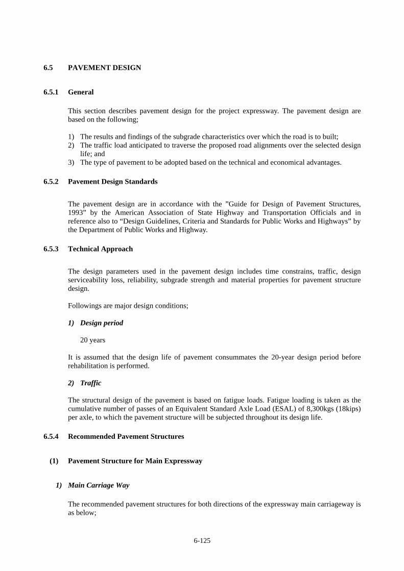
1) Main Carriage Way
The recommended pavement structures for both directions of the expressway main carriageway is as below;
6-126
No. Thickness Pavement Structure 1 50 mm Asphalt Concrete Surface Course 2 50 mm Asphalt Concrete Binder Course 3 150 mm Cement Treated Base Course 4 250 mm Crushed Aggregate Base Course 5 350 mm Crushed Sub-Base Course
FIGURE 6.5.4-1 PAVEMENT STRUCTURE OF MAIN CARRIAGEWAY
6-127
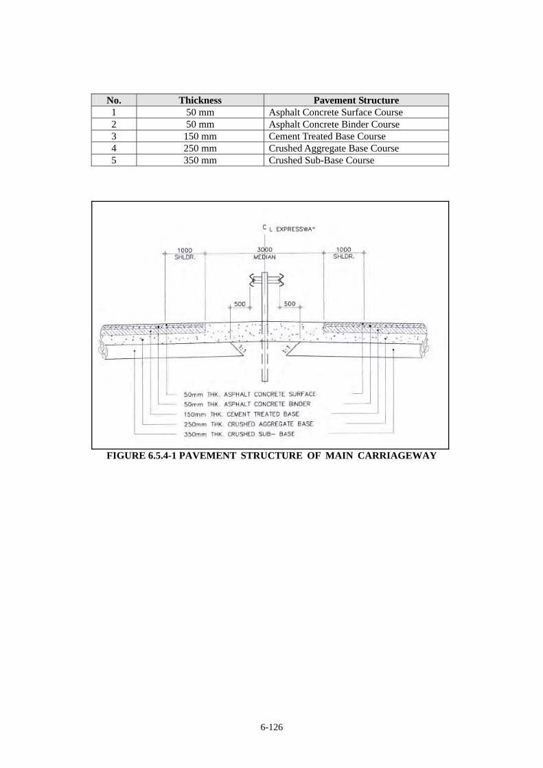
2) Shoulder of Main Expressway
The pavement structure for shoulder followed the designed for the main carriageway. However, the surface course is not applied because shoulders is not subjected to carry full traffic on the expressway but only to accommodate vehicle emergency parking and temporary use of maintenance activities.
No. Thickness Pavement Structure 1 50mm Asphalt Concrete Binder Course 2 150mm Cement Treated Base Course 3 250mm Crushed Aggregate Base Course 4 350mm Crushed Sub-Base Course
FIGURE 6.5.4-2 PAVEMENT STRUCTURE OF SHOULDER
6-128
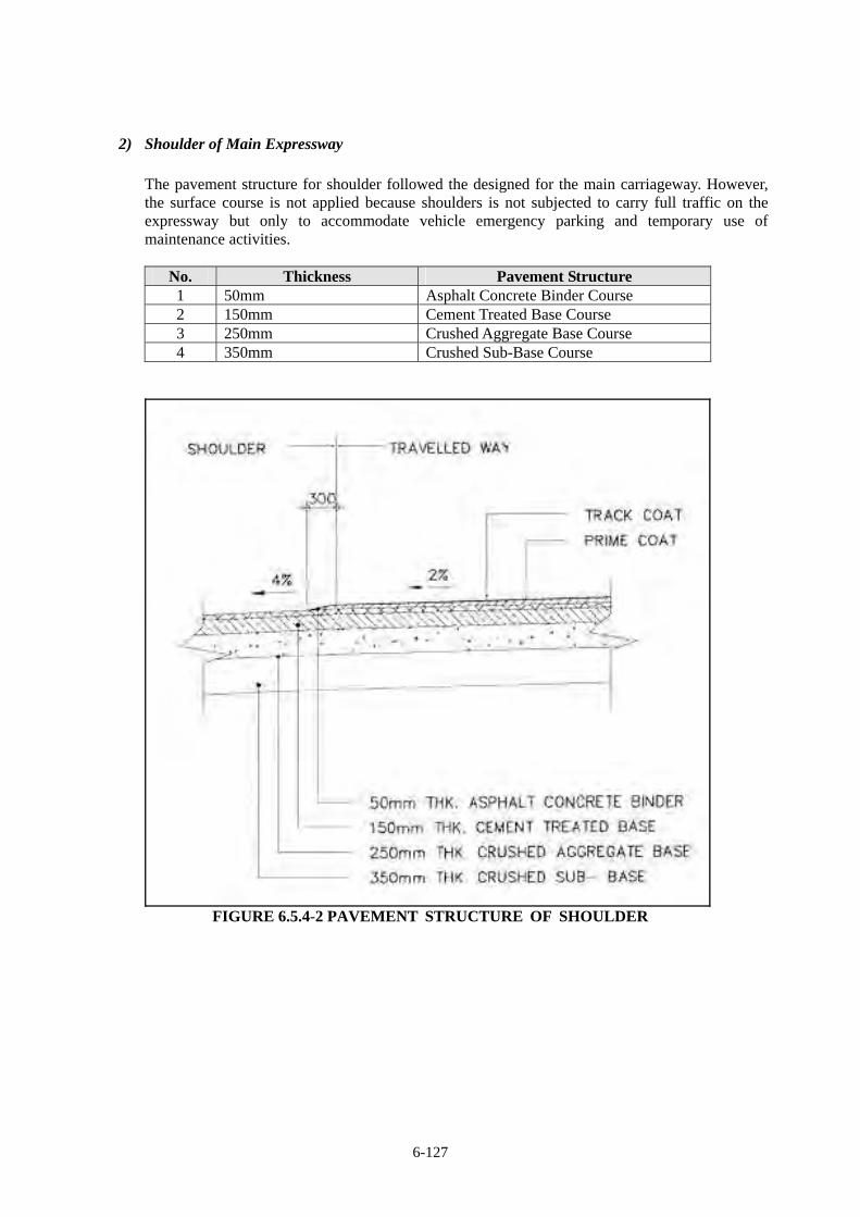
(2) Pavement for Interchange Ramps
1) Carriage way of Ramp
The pavement structure of carriage way of ramp follows the same as the expressway.
2) Shoulder of Ramp
The pavement structure of carriage way of ramp follows the same as the expressway.
3) Toll plaza
Portland Cement Concrete Pavement (PCCP) will be used at least 50m both side from the center of toll gate.
No. Thickness Pavement Structure 1 350mm Portland Cement Concrete Pavement 2 200mm Crushed Aggregate Base Course 3 200mm Crushed Aggregate Sub-Base Course
FIGURE 6.5.4-3 PAVEMENT STRUCTURE OF TOLL PLAZA
6.5.5 Pavement Design Calculation
Pavement calculation is shown as follows;
[Design Period : 20 years]
Project Title: Central Luzon Link Expressway (CLLEX)Total Large V/Total Large V Class 1 Class 2 Class 3
Cars Bus/Trucks Trailer11,236 2% 219 8,441 2,576 219
- 0.0001 5.7000 15.4000
6.50% 0.035 0.050 0.053
2017 1 Open 0.84 14,683.20 3,372.60 18,056.641 2018 2 0.87 15,417.36 3,551.35 18,969.582 2019 3 0.90 16,188.23 3,739.57 19,928.703 2020 4 0.94 16,997.64 3,937.77 20,936.344 2021 5 0.97 17,847.52 4,146.47 21,994.965 2022 6 1.00 18,739.90 4,366.23 23,107.136 2023 7 1.04 19,676.89 4,597.64 24,275.577 2024 8 1.07 20,660.74 4,841.32 25,503.138 2025 9 1.11 21,693.77 5,097.91 26,792.799 2026 10 1.15 22,778.46 5,368.09 28,147.71
10 2027 11 1.19 23,917.39 5,652.60 29,571.1811 2028 12 1.23 25,113.25 5,952.19 31,066.6812 2029 13 1.28 26,368.92 6,267.66 32,637.8513 2030 14 1.32 27,687.36 6,599.84 34,288.5314 2031 15 1.37 29,071.73 6,949.64 36,022.7315 2032 16 1.41 30,525.32 7,317.97 37,844.7016 2033 17 1.46 32,051.58 7,705.82 39,758.8717 2034 18 1.51 33,654.16 8,114.23 41,769.9118 2035 19 1.57 35,336.87 8,544.28 43,882.7219 2036 20 in 20 years 1.62 37,103.72 8,997.13 46,102.47
600,658.18one lane
× 365days × 0.5 × 1.0 = 109,620,118
* Based on Traffic Demand Forecast
** Source:Feasibility Study for the Proposed Central Luzon Expressway, January 2010, DPWH, KEI
CY2008, Summary of Traffic Data by Project Evaluation Division, Planning Service, Report as of January 31,2009
SV03243LZ_AL, S00935LZ, Daang Maharika Highway (LZ), Nueva Ecija 2nd District Engineering Office
Vehicle TypeTraffic Volume in 2017 *
Traffic Volume and Cumulative Equivalent Standard Axle Load (ESAL)(W18kips)
Total
Load Equivalence Factor(LEF)**
Grouth Rate*
(Design ESAL)
Cummulative ESALlane adjustment coefficient
600,658.18
Year
6-129
Design Standard: Guide for Design of Pavement Structures, 1993, American Association of State Highway and Transportation OffcialsDesign Case: 2017 to 2036 (20 years)Project Title: CLLEX
1. Calcuation of Structural Number
(1) Basic FomulaThe fomula shown below is applied for flexible pavement design in accordance with AASHTO design guideline.Design Condition is shown in Table 1.Structural Number is computed to accommodate the basic fomula.
log10 〔△PSI/(4.2-1.5)〕
log10(W18) = ZR×S0+9.36×log10(SN+1)-0.20+ +2.32×log10(MR)-8.07
Index Grounds Remarks2017 ~2036 (20 Years) Design life of pavement of initial pavement structure
1. Traffic W18
2. Level of Reliability R(%) Interstate and other Freeways (AASHTO)The possibility to satisfy road user during design period. Strongerpavement structure is required in accordance with Value.
ZR Value corresponding to R=85% Corresponding to ROverall Standard Deviation S0 Average of Flexible Pavement Variation of reliabiity according to regoinal traffic difference
3. Serviceabiity P0 Standard of AASHTO5: Perfect0: Inperfect
P1 Standard of AASHTO Serviceability expected at the end of design periodPresent Serviceability Index ΔPSI PSI = P0- Pt
4. Pavement Support Layer CBR FS2010MR MR=1,500×CBR Soil Subgrade Strength
(3)Computation of SN1.Left side of Basic Fomula log10(W18)2.Value of Righ side of Basi Fomula3.SN Value required SN
2.Pavement Structure1(inch)=2.540(cm)
Pavement StructureLayer
CoefficienThickness Thickness Drainage Structural Number
(a) D (cm) d (inch) Coeffient SN=a×m×D1 Remarks(m)
Asphalt Concrete Surface new 0.390 5.00 1.969 - 0.768Asphalt Concrete Binder new 0.390 5.00 1.969 - 0.768Cement Treated Base new 0.230 15.00 5.906 1.0 1.358 Cement treated base courseCrushed Aggregate Base new 0.140 25.00 9.843 1.0 1.378 Crushed aggregate,CBR>20Crushed sub-base new 0.110 35.00 13.780 1.0 1.516 Crushed aggregate
Evaluation Required SN 5.737 < 5.787 OK
W18 : Predicted number of 18-kip equivalent single axle load applicationsZR : Standard normal deviateS0 : Combined standard error of the traffic prediction and performance prediction)MR : Resilient modulus (psi)D : Layer thickness(inches)m : Layer drainage coeficientSN is equal to the structural number indicative of the total pavement thickness required:
SN = a1D1 + a2D2m2 + a3D3m3
Value20
Design Condition
(2)Design Condition
Design Period
85
109,620,118
-1.0370.45
CBR(%)Resilient Modulus
Reliability
Standard Normal Deviate
Initial Serviceability Index
Terminal Serviceability Index
Flexible Pavement Design
5.737
2.51.7
8.040
8
Design ESAL
12,000
8.040
4.26-130
CHAPTER 7
PROJECT COST ESTIMATE

7‐1
CHAPTER 7 PROJECT COST ESTIMATE
(Confidential)
CHAPTER 8
ECONOMIC AND FINANCIAL EVALUATION

8-1
CHAPTER 8 ECONOMIC AND FINANCIAL EVALUATION
(Confidential)
CHAPTER 9
ENVIRONMENTAL AND SOCIAL CONSIDERATIONS
9-1
CHAPTER 9 ENVIRONMENTAL AND SOCIAL CONSIDERATIONS
9.1 DESCRIPTION OF THE PROJECT
9.1.1 Background and Purpose
The proposed Central Luzon Link Expressway or CLLEX (Phase-1) has an extension of 30.7
kilometer, 4-lane, access-controlled expressway that is designed to provide a faster and safer
connection between Regions 3 and Metro Manila. The project also aims to improve access to the
‘food baskets’ of Central Luzon (or Region III), and to boost the developmental of the areas
traversed.
The CLLEX Project aims in meeting the following specific objectives:
Provide a free-flowing alternative route for the heavily-congested Pan-Philippine Highway
(PPH) serving the provinces of Bulacan, and Nueva Ecija;
Provide a linkage between the existing Subic-Clark-Tarlac Expressway (SCTEX) and PPH to
strengthen the lateral (or east-west) linkage in Region III.
Provide a highway of international standards access controlled facility.
9.1.2 Necessity of the Project
1) Traffic Congestion on Pan Philippine Highway
Eastern areas of Region III and whole Region II are served by Pan Philippine Highway, which
passes through urban areas at 5-10 km interval. Urban sections of Pan Philippine Highway suffer
chronic traffic congestions due to sharp increase of local traffic such as jeepneys and tricycles,
and travel speed becomes less than 20 km/hr.
With the completion of SCTEX, some traffic of long distance trips, such as between Metro
Manila and Cabanatuan City or Region II, are already diverting to the route of
NLEX-SCTEX-Tarlac-Sta. Rosa Road from Pan Philippine Highway. When Tarlac-Sta. Rosa
Road is replaced by CLLEX, more traffic will be diverted to this route from Pan Philippine
Highway, thus traffic congestion of Pan Philippine Highway will be mitigated.
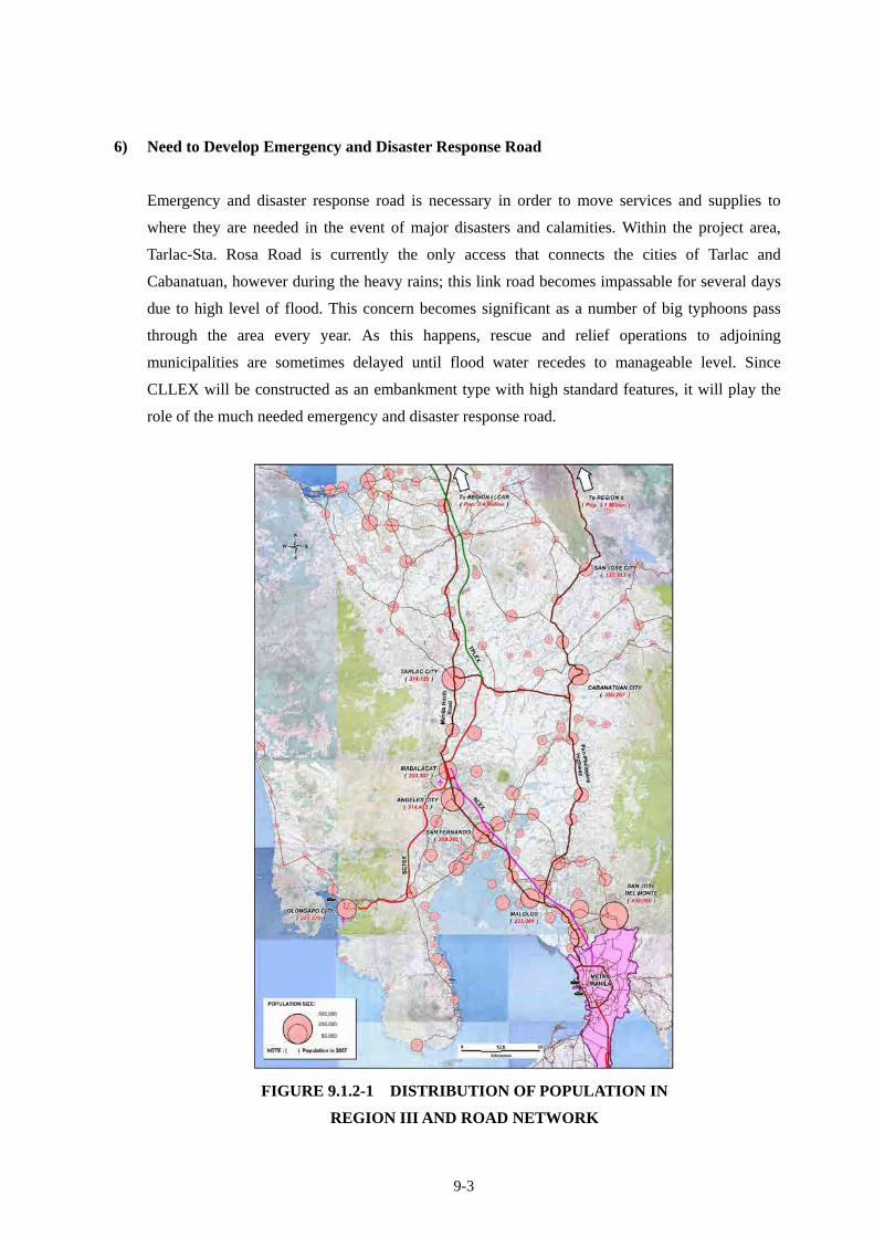
2) Need of Strengthening of Lateral (East-West) Road Network
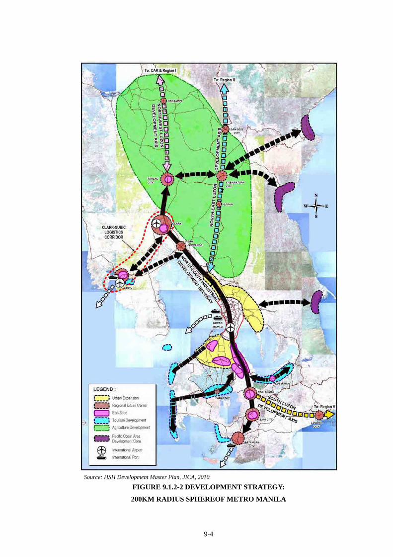
Figure 9.1.2-1 shows the distribution of population in Region III and road network. For
9-2
north-south direction, traffic is served by NLEX-SCTEX-TPLEX, Manila North Road and Pan
Philippine Highway along which major urban centers are distributed. However, road network in
the east-west direction is still weak and needs to be strengthened, thereby socio-economic
inter-action in that direction is stimulated and overall socio-economic activities will be activated
for socio-economic development of the Region and the country as a whole.
3) Need to Develop Regional Growth Pole Cities
Overconcentration of socio-economic activities in Metro Manila has been one of the critical
issues of the country. To mitigate such conditions, Regional Growth Pole Cities must be
developed, so that socio-economic activities of Metro Manila can be shared with such Regional
Growth Pole Cities as Tarlac City and Cabanatuan City.
Tarlac has a special economic zone where there are metalworking plants and feed processing
plants. Cabanatuan has processing plants of feed and foods using crops harvested in surrounding
area. Municipality of Aliaga is now developing the Trading Center where CLLEX interchange is
connected and has also a plan to develop an agro-industrial zone near the boundary with
Cabanatuan City. It is expected that CLLEX project will contribute to developing these industries.
There are some tourist attractions such as Camp Pangatian, General Luna Statue and Marker in
Cabanatuan City. The number of tourists is expected to increase and tourism might be revitalized
by CLLEX.
4) Need to Develop Impoverish Area
Pacific Ocean Coastal area in Region III is one of the impoverished areas of the country.
Cabanatuan City is the base city (or hub city) for the development of Pacific Ocean Coastal area.
If accessibility to Cabanatuan City is improved, the impact will be extended to Pacific Ocean
Coastal area (see Figure 9.1.2-2).
5) Need to Develop Integrated Multi-modal Logistics/Transport System
In order to achieve faster, safer, more cost effective and reliable logistics/transport system, an
expressway network development in the Region is vitally needed.
The approach sections of Rio Chico River Bridge along Tarlac-Sta. Rosa Road which is currently
important to provide transport services in the east-west direction is often flooded and traffic is
interrupted. More reliable transport facility is needed.
9-3
6) Need to Develop Emergency and Disaster Response Road
Emergency and disaster response road is necessary in order to move services and supplies to
where they are needed in the event of major disasters and calamities. Within the project area,
Tarlac-Sta. Rosa Road is currently the only access that connects the cities of Tarlac and
Cabanatuan, however during the heavy rains; this link road becomes impassable for several days
due to high level of flood. This concern becomes significant as a number of big typhoons pass
through the area every year. As this happens, rescue and relief operations to adjoining
municipalities are sometimes delayed until flood water recedes to manageable level. Since
CLLEX will be constructed as an embankment type with high standard features, it will play the
role of the much needed emergency and disaster response road.
FIGURE 9.1.2-1 DISTRIBUTION OF POPULATION IN
REGION III AND ROAD NETWORK
9-4
Source: HSH Development Master Plan, JICA, 2010
FIGURE 9.1.2-2 DEVELOPMENT STRATEGY:
200KM RADIUS SPHEREOF METRO MANILA
9-5
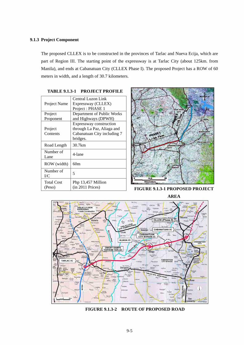
9.1.3 Project Component
The proposed CLLEX is to be constructed in the provinces of Tarlac and Nueva Ecija, which are
part of Region III. The starting point of the expressway is at Tarlac City (about 125km. from
Manila), and ends at Cabanatuan City (CLLEX Phase I). The proposed Project has a ROW of 60
meters in width, and a length of 30.7 kilometers.
TABLE 9.1.3-1 PROJECT PROFILE
FIGURE 9.1.3-1 PROPOSED PROJECT
AREA
FIGURE 9.1.3-2 ROUTE OF PROPOSED ROAD
Project Name Central Luzon Link Expressway (CLLEX) Project : PHASE 1
Project Proponent
Department of Public Works and Highways (DPWH)
Project Contents
Expressway construction through La Paz, Aliaga and Cabanatuan City including 7 bridges.
Road Length 30.7km
Number of Lane
4-lane
ROW (width) 60m
Number of I/C
5
Total Cost (Peso)
Php 13,457 Million (in 2011 Prices)
9-6
9.1.4 Project Rational
1) Philippine Development Plan (2011 – 2016)
Philippine Development Plan (PDP), 2011-2016 was announced in 2011. Development policies
of infrastructure are as follows;
DEVELOPMENT POLICIES OF INFRASTRUCTURE
“Accelerating Infrastructure Development”
(1) To optimize resources and investment
Improve project preparation, development and implementation
Synchronize planning and budgeting
Coordinate and integrate infrastructure initiative
(2) To attract investments in infrastructure
Improve the institutional and regulatory environment of the infrastructure sector
Encourage PPPs
(3) To foster transparency and accountability in infrastructure development
Encourage stakeholder participation
(4) To adopt to climate change and mitigate the impacts of natural disasters
Institutionalize Climate Change Act (CCA) and Disaster Risk Reduction Management
(DRRM)
(5) To provide productive employment opportunities
Adopt a labor-intensive scheme where applicable.
9-7
With regards to the transport sector, issues and challenges are established as follows;
TRANSPORT SECTOR ISSUES AND CHALLENGES
2) Road Development Goals
Public Investment Program (PIP) (2011 - 2016) was formulated by DPWH in 2011. Goals were
set as follows;
DEVELOPMENT GOALS UNDER PIP
1. Provide safe environment through quality infrastructure facilities;
2. Increase mobility and total connectivity of people through quality infrastructure resulting to
improved quality of life;
3. Strengthen national unity, family bonds and tourism by making the movement of people
faster, cheaper and safer;
4. Facilitate the decongestion of Metro Manila via a transport logistics system that would
ensure efficient linkages between its business centers and nearby provinces;
5. Implement more Public-Private Partnership (PPP) projects for much needed infrastructure
(a) Assessment and Issues
Lack of integrated and coordinated transport network
Overlapping and conflicting functions of transport and other concerned agencies
Transport safety and security concerns
(b) Strategic Plan and Focus
Adopt a comprehensive long-term National Transport Policy (NTP)
Develop strategic transport infrastructure assets
Prioritize asset preservation
Provide access to major and strategic tourism destinations and production areas
Promote environmentally sustainable and people-oriented transport
(c) Develop an Integrated Multi-modal Logistics and Transport System
Identify and develop strategic logistics corridors based on a National Logistics Master Plan
Improve Roll-on/roll-off ship (RORO) terminal system
Explore ASEAN connectivity through sea linkages
(d) Separate the Regulatory and Operation Functions of Transport and Other Concerned Agencies. To
address the overlapping and conflicting functions of transport and other concerned agencies.
(e) Comply with Safety and Security Standards. To ensure transport safety and standards.
(f) Provide Linkages to Bring Communities into the Mainstream of Progress and Development. To
promote conflict-affected and highly impoverished areas.
9-8
and level playing field for investment;
6. Study the mechanism for longer maintenance period for roads and bridges; and
7. Generate more transport infrastructure with minimal budget cover or contingent liabilities.
Strategic focuses were set as follows;
STRATEGIC FOCUS
Implement activities in the following order of priorities:
a. Maintenance or asset preservation – to preserve existing roads in good condition
b. Rehabilitation – to restore damaged roads to their original designed condition
c. Improvement – to upgrade road features so that they efficiently meet traffic demands;
and
d. New Construction
Prioritize upgrading of the national road network, as to quality and safety standards
Prioritize national roads to address traffic congestion and safety in urban centers and
designated strategic tourism destinations
Completion of on-going bridges along national roads
Develop more Public-Private Partnership (PPP) projects for much needed infrastructure
and level playing field for investments
Study the mechanism for a longer maintenance period (5 – 10 years) in road and bridges
construction contract provision
Prioritize flood control projects in major and principal river basins to address climate
change based on master plan and adopting new technologies in flood control and slope
management
Prioritize adequate flood control and upgraded drainage design standards and facilities in
flood-disaster prone areas to mitigate loss of river and damage to properties
Promote innovative technology such as geo-textiles and coco-netting in slope protection
and soil erosion control
Promote retarding basin and rain water harvesting for non-domestic use
Prioritize water supply in designated strategic tourist destinations/centers
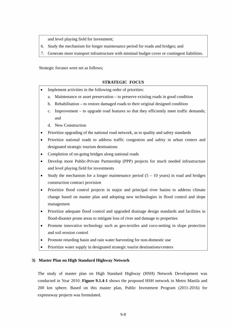
3) Master Plan on High Standard Highway Network
The study of master plan on High Standard Highway (HSH) Network Development was
conducted in Year 2010. Figure 9.1.4-1 shows the proposed HSH network in Metro Manila and
200 km sphere. Based on this master plan, Public Investment Program (2011-2016) for
expressway projects was formulated.
9-9
Proposed HSH Network in Metro Manila and its 200km Sphere
FIGURE 9.1.4-1 PROPOSED HSH NETWORK Source: The Study of Master plan on High Standard Highway Network Development, 2010, JICA
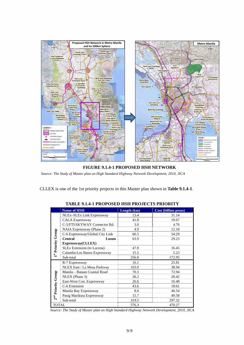
CLLEX is one of the 1st priority projects in this Master plan shown in Table 9.1.4-1.
TABLE 9.1.4-1 PROPOSED HSH PROJECTS PRIORITY
Name of HSH Length (km) Cost (billion pesos) NLEx–SLEx Link Expressway 13.4 31.14 CALA Expressway 41.8 19.67 C-5/FTI/SKYWAY Connector Rd. 3.0 4.76 NAIA Expressway (Phase 2) 4.9 12.18 C-6 Expressway/Global City Link 66.5 54.29 Central Luzon Expressway(CLLEX)
63.9 29.23
SLEx Extension (to Lucena) 47.8 16.45 Calamba-Los Banos Expressway 15.5 5.23
1st P
rior
ity
Gro
up
Sub-total 256.8 172.95
R-7 Expressway 16.1 25.81 NLEX East / La Mesa Parkway 103.0 38.94 Manila – Bataan Coastal Road 70.3 72.94 NLEX (Phase 3) 36.2 28.42 East-West Con. Expressway 26.6 16.48 C-6 Extension 43.6 18.61 Manila Bay Expressway 8.0 46.54 Pasig Marikina Expressway 15.7 49.58
2nd P
rior
ity
Gro
up
Sub-total 319.5 297.32 TOTAL 576.3 470.27
Source: The Study of Master plan on High Standard Highway Network Development, 2010, JICA
Metro Manila
9-10
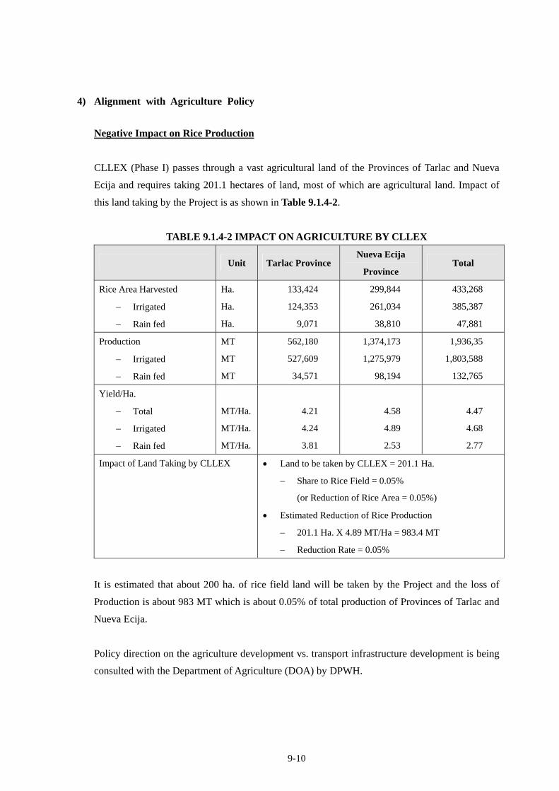
4) Alignment with Agriculture Policy
Negative Impact on Rice Production
CLLEX (Phase I) passes through a vast agricultural land of the Provinces of Tarlac and Nueva
Ecija and requires taking 201.1 hectares of land, most of which are agricultural land. Impact of
this land taking by the Project is as shown in Table 9.1.4-2.
TABLE 9.1.4-2 IMPACT ON AGRICULTURE BY CLLEX
Unit Tarlac Province Nueva Ecija
Province Total
Rice Area Harvested
Irrigated
Rain fed
Ha.
Ha.
Ha.
133,424
124,353
9,071
299,844
261,034
38,810
433,268
385,387
47,881
Production
Irrigated
Rain fed
MT
MT
MT
562,180
527,609
34,571
1,374,173
1,275,979
98,194
1,936,35
1,803,588
132,765
Yield/Ha.
Total
Irrigated
Rain fed
MT/Ha.
MT/Ha.
MT/Ha.
4.21
4.24
3.81
4.58
4.89
2.53
4.47
4.68
2.77
Impact of Land Taking by CLLEX Land to be taken by CLLEX = 201.1 Ha.
Share to Rice Field = 0.05%
(or Reduction of Rice Area = 0.05%)
Estimated Reduction of Rice Production
201.1 Ha. X 4.89 MT/Ha = 983.4 MT
Reduction Rate = 0.05%
It is estimated that about 200 ha. of rice field land will be taken by the Project and the loss of
Production is about 983 MT which is about 0.05% of total production of Provinces of Tarlac and
Nueva Ecija.
Policy direction on the agriculture development vs. transport infrastructure development is being
consulted with the Department of Agriculture (DOA) by DPWH.
9-11
9.2 PHILIPPINES’ LEGAL / POLICY FRAMEWORK ON ENVIRONMENTAL AND SOCIAL CONSIDERATION
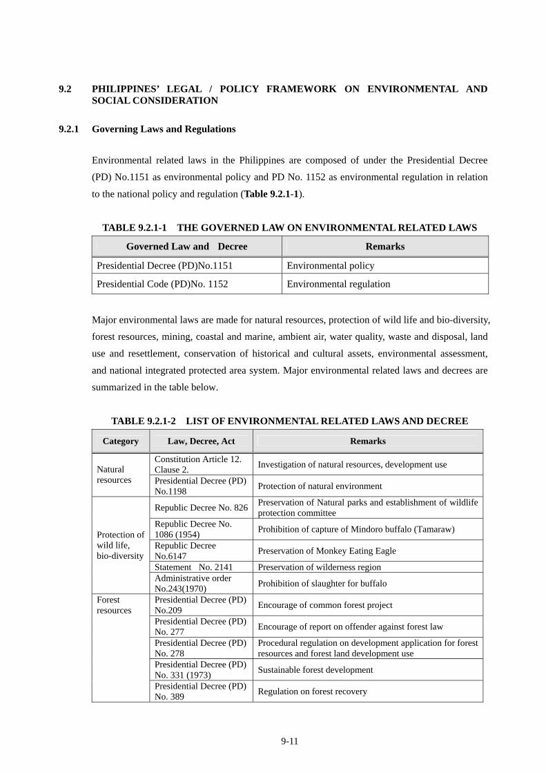
9.2.1 Governing Laws and Regulations
Environmental related laws in the Philippines are composed of under the Presidential Decree
(PD) No.1151 as environmental policy and PD No. 1152 as environmental regulation in relation
to the national policy and regulation (Table 9.2.1-1).
TABLE 9.2.1-1 THE GOVERNED LAW ON ENVIRONMENTAL RELATED LAWS
Governed Law and Decree Remarks
Presidential Decree (PD)No.1151 Environmental policy
Presidential Code (PD)No. 1152 Environmental regulation
Major environmental laws are made for natural resources, protection of wild life and bio-diversity,
forest resources, mining, coastal and marine, ambient air, water quality, waste and disposal, land
use and resettlement, conservation of historical and cultural assets, environmental assessment,
and national integrated protected area system. Major environmental related laws and decrees are
summarized in the table below.
TABLE 9.2.1-2 LIST OF ENVIRONMENTAL RELATED LAWS AND DECREE
Category Law, Decree, Act Remarks
Constitution Article 12. Clause 2.
Investigation of natural resources, development use Natural resources Presidential Decree (PD)
No.1198 Protection of natural environment
Republic Decree No. 826Preservation of Natural parks and establishment of wildlife protection committee
Republic Decree No. 1086 (1954)
Prohibition of capture of Mindoro buffalo (Tamaraw)
Republic Decree No.6147
Preservation of Monkey Eating Eagle
Statement No. 2141 Preservation of wilderness region
Protection of wild life, bio-diversity
Administrative order No.243(1970)
Prohibition of slaughter for buffalo
Presidential Decree (PD) No.209
Encourage of common forest project
Presidential Decree (PD) No. 277
Encourage of report on offender against forest law
Presidential Decree (PD) No. 278
Procedural regulation on development application for forest resources and forest land development use
Presidential Decree (PD) No. 331 (1973)
Sustainable forest development
Forest resources
Presidential Decree (PD) No. 389
Regulation on forest recovery
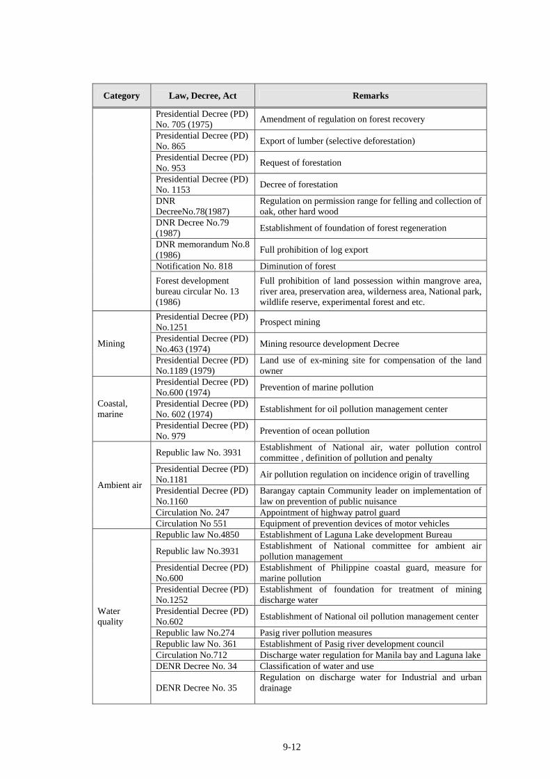
9-12
Category Law, Decree, Act Remarks
Presidential Decree (PD) No. 705 (1975)
Amendment of regulation on forest recovery
Presidential Decree (PD) No. 865
Export of lumber (selective deforestation)
Presidential Decree (PD) No. 953
Request of forestation
Presidential Decree (PD) No. 1153
Decree of forestation
DNR DecreeNo.78(1987)
Regulation on permission range for felling and collection of oak, other hard wood
DNR Decree No.79 (1987)
Establishment of foundation of forest regeneration
DNR memorandum No.8 (1986)
Full prohibition of log export
Notification No. 818 Diminution of forest
Forest development bureau circular No. 13 (1986)
Full prohibition of land possession within mangrove area, river area, preservation area, wilderness area, National park, wildlife reserve, experimental forest and etc.
Presidential Decree (PD) No.1251
Prospect mining
Presidential Decree (PD) No.463 (1974)
Mining resource development Decree Mining
Presidential Decree (PD) No.1189 (1979)
Land use of ex-mining site for compensation of the land owner
Presidential Decree (PD) No.600 (1974)
Prevention of marine pollution
Presidential Decree (PD) No. 602 (1974)
Establishment for oil pollution management center Coastal, marine
Presidential Decree (PD) No. 979
Prevention of ocean pollution
Republic law No. 3931 Establishment of National air, water pollution control committee , definition of pollution and penalty
Presidential Decree (PD) No.1181
Air pollution regulation on incidence origin of travelling
Presidential Decree (PD) No.1160
Barangay captain Community leader on implementation of law on prevention of public nuisance
Circulation No. 247 Appointment of highway patrol guard
Ambient air
Circulation No 551 Equipment of prevention devices of motor vehicles Republic law No.4850 Establishment of Laguna Lake development Bureau
Republic law No.3931 Establishment of National committee for ambient air pollution management
Presidential Decree (PD) No.600
Establishment of Philippine coastal guard, measure for marine pollution
Presidential Decree (PD) No.1252
Establishment of foundation for treatment of mining discharge water
Presidential Decree (PD) No.602
Establishment of National oil pollution management center
Republic law No.274 Pasig river pollution measures Republic law No. 361 Establishment of Pasig river development council Circulation No.712 Discharge water regulation for Manila bay and Laguna lakeDENR Decree No. 34 Classification of water and use
Water quality
DENR Decree No. 35 Regulation on discharge water for Industrial and urban drainage
9-13
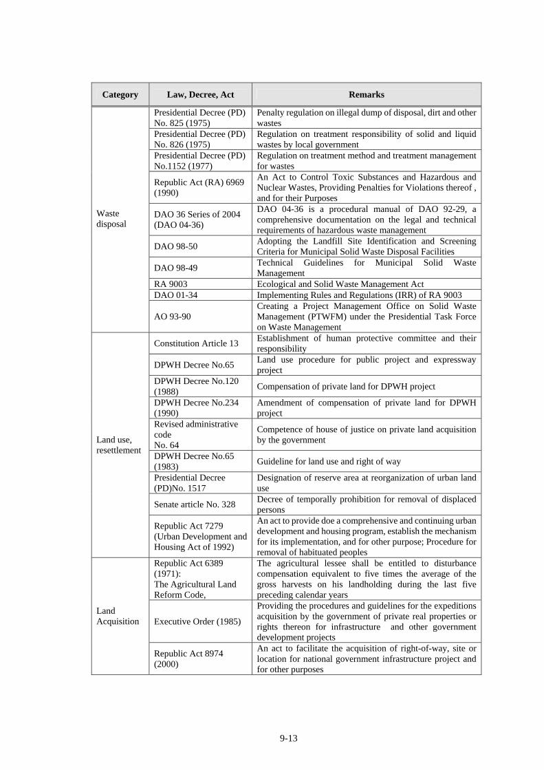
Category Law, Decree, Act Remarks
Presidential Decree (PD) No. 825 (1975)
Penalty regulation on illegal dump of disposal, dirt and other wastes
Presidential Decree (PD) No. 826 (1975)
Regulation on treatment responsibility of solid and liquid wastes by local government
Presidential Decree (PD) No.1152 (1977)
Regulation on treatment method and treatment management for wastes
Republic Act (RA) 6969 (1990)
An Act to Control Toxic Substances and Hazardous and Nuclear Wastes, Providing Penalties for Violations thereof , and for their Purposes
DAO 36 Series of 2004 (DAO 04-36)
DAO 04-36 is a procedural manual of DAO 92-29, a comprehensive documentation on the legal and technical requirements of hazardous waste management
DAO 98-50 Adopting the Landfill Site Identification and Screening Criteria for Municipal Solid Waste Disposal Facilities
DAO 98-49 Technical Guidelines for Municipal Solid Waste Management
RA 9003 Ecological and Solid Waste Management Act DAO 01-34 Implementing Rules and Regulations (IRR) of RA 9003
Waste disposal
AO 93-90 Creating a Project Management Office on Solid Waste Management (PTWFM) under the Presidential Task Force on Waste Management
Constitution Article 13 Establishment of human protective committee and their responsibility
DPWH Decree No.65 Land use procedure for public project and expressway project
DPWH Decree No.120 (1988)
Compensation of private land for DPWH project
DPWH Decree No.234 (1990)
Amendment of compensation of private land for DPWH project
Revised administrative code No. 64
Competence of house of justice on private land acquisition by the government
DPWH Decree No.65 (1983)
Guideline for land use and right of way
Presidential Decree (PD)No. 1517
Designation of reserve area at reorganization of urban land use
Senate article No. 328 Decree of temporally prohibition for removal of displaced persons
Land use, resettlement
Republic Act 7279 (Urban Development and Housing Act of 1992)
An act to provide doe a comprehensive and continuing urban development and housing program, establish the mechanism for its implementation, and for other purpose; Procedure for removal of habituated peoples
Republic Act 6389 (1971): The Agricultural Land Reform Code,
The agricultural lessee shall be entitled to disturbance compensation equivalent to five times the average of the gross harvests on his landholding during the last five preceding calendar years
Executive Order (1985)
Providing the procedures and guidelines for the expeditions acquisition by the government of private real properties or rights thereon for infrastructure and other government development projects
Land Acquisition
Republic Act 8974 (2000)
An act to facilitate the acquisition of right-of-way, site or location for national government infrastructure project and for other purposes

9-14
Category Law, Decree, Act Remarks
Executive Order NO.153 (2002);
Instituting the national drive to suppress and eradicate professional squatting and squatting syndicates; Amending E.O.178 (1999) and E.O. 128 (1993)
Indigenous People’s Rights Act (IPRA) of 1997
sets the conditions, requirements, and safeguards for plans, programs and projects affecting Indigenous Peoples (IPs)
Human rights
NCIP Administrative Order No. 1, Series of 2006
the procedure for obtaining the “Free and Prior Informed Consent” (FPIC) for affected communities
Republic Decree No. 4365
Responsibility of National historic committee on authorization , restoration and maintenance for historical assets
Conservation of historical , cultural assets
Republic Decree No.4346
Responsibility of protection and propulsion of maintenance for cultural assets within National museum
Presidential Decree (PD) No. 1586
Environmental assessment system and administrative organization
Environmental assessment Presidential
Proclamation No. 2146 3 Industrial sectors with large environmental impacts and 12 environmentally critical regions
National integrated protected area system
National integrated protected area system act (1992)
Review of National integrated protected area
Source: Countries’ environmental information maintenance study report; the Philippines (JICA), 1997 et al
The government of Philippine has been ratified international treaties, agreements, and protocols
in relation to environmental and social consideration which are listed below.
Washington Treaty: Convention on the international trade in endangered species of wild
flora and fauna (1981)
International tropical timber agreement (1983)
United Nations convention on the law of the sea (1984)
World heritage convention concerning the protection of the world cultural and natural
heritage (1985)
Montreal Protocol on substances that deplete the Ozone layer (1991)
Vienna convention for the protection of the ozone layer (1991)
Convention on biological diversity (1993)
Basel convention on the control of trans-boundary movement of hazardous wastes and their
disposal (1993)
Ramsar convention on wetlands of international importance, especially as waterfowl
habitat (1994)
Framework convention on climate change (1994)
Kyoto protocol (1998)
Cartagena protocol on bio-safety to the convention on biological diversity (2000)
Stockholm convention on persistent organic pollutants (2001)
9-15
9.2.2 Philippines Environmental Impact Statement System (PEISS)
In the Philippines, all private or public projects or activities which are envisaged to potentially
have a negative impact on the environment are subject to environmental impact assessment (EIA)
by Philippine Environmental Impact Statement System (PEISS). EIA is the preliminary analysis
of the potential impacts of the project on the environment. Aware of the possible negative effects
of the implementation of industrial and other activities, the Philippine government has instituted
measures to encourage the use of EIA as a planning and decision making tool.
PEISS is a set of laws, regulations, administrative orders and guidelines concerned with
Environmental Impact Assessment (EIA). The following are some of the most important of these
laws and guidelines:
Environmental Impact Statement System (EISS), Presidential Decree No. 1586 (1978): An
act establishing and centralizing the Environmental Impact Statement (EIS) System under the
National Environmental Protection Council (NEPC), which merged with the National Pollution
Control Commission (NPCC) in June 1987 to become the Environmental Management Bureau
(EMB).
Presidential Proclamation No. 2146 (1981) and No. 803 (1996): It proclaims Environmentally
Critical Projects (ECPs) to have significant impact on the quality of environment and
Environmentally Critical Areas (ECAs) as environmentally fragile areas within the scope of the
EIS System.
DAO 96-37 revised to become DAO 92-21 Devolved responsibility for EIS to the
EMB-Regional Office and further strengthened the PEISS. Placed emphasis on promoting
maximum public participation in EIA process to validate the social acceptability of the Project.
DENR Administrative Order No. 30 Series of 2003 (DAO 03-30), Revised Procedural Manual
(2007): Provides for implementation of rules and regulations of Presidential Decree No. 1586,
establishing PEISS. Also, provided detailed definitions of technical terms and detailed
information regarding procedures, related laws and regulations.
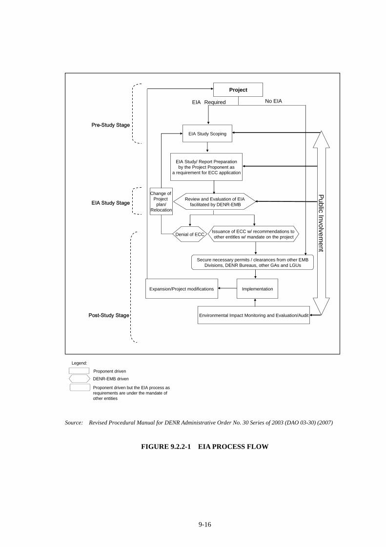
The procedures of EIA can be grouped into; the following stages (as shown in the following
diagram): (1) pre-study stage (screening and scoping), (2) EIA study stage and (3) post-study
stage (review, decision-making and monitoring).
9-16
Pre-Study Stage
EIA Study Stage
Post-Study Stage
Project
EIA Study Scoping
EIA Study/ Report Preparationby the Project Proponent as
a requirement for ECC application
Expansion/Project modifications Implementation
Environmental Impact Monitoring and Evaluation/Audit
Change of Project
plan/Relocation
Public Invo
lvem
ent
No EIAEIA Required
Review and Evaluation of EIAfacilitated by DENR-EMB
Denial of ECCIssuance of ECC w/ recommendations to other entitles w/ mandate on the project
Secure necessary permits / clearances from other EMBDivisions, DENR Bureaus, other GAs and LGUs
Legend:
Proponent driven
DENR-EMB driven
Proponent driven but the EIA process as requirements are under the mandate of other entities
Source: Revised Procedural Manual for DENR Administrative Order No. 30 Series of 2003 (DAO 03-30) (2007)
FIGURE 9.2.2-1 EIA PROCESS FLOW
9-17
9.2.3 Involuntary Resettlement and Land Acquisitions
9.2.3.1 Republic Act 8974 and Its Implementation (IRR)
In November 2000, another law was passed by the Philippine congress to avoid delays in the
implementation of development projects due to ROW acquisition-related problems. Republic Act
8974, otherwise known as “An Act to Facilitate the Acquisition of Right-of-Way, Site or Location
for National Government Infrastructure Projects and For Other Purposes” prescribed new
standards for assessment of the value of the land subject of negotiated sale or expropriation
proceedings, namely:
The classification and use for which the property is suited shall be based “on the approved
land use plan and/or zoning ordinance, if any, of the city concerned”;
The size, shape or location, tax declaration and zonal valuation of the land;
The price of the land as manifested in the ocular findings, oral, as well as documentary
evidence presented;
The reasonable disturbance compensation for the removal and/or demolition of certain
improvement on the land and for the value of improvements thereon;
The development costs for improving the land (this shall be based on the records and
estimates of the City or Municipal Assessor concerned);
The value declared by the owners (as shown in their latest Tax Declaration Certificates or
Sworn Statements);
The current price of similar lands in the vicinity (This shall be based on the records on the
Deeds of Sale in the Office of the Register of Deeds Concerned); and
Such facts and events as to enable the affected property owners to have sufficient funds to
acquire similarly-situated lands of approximate area as those required from them by the
government, and thereby rehabilitate themselves as early as possible.
Another feature of R.A. 8974’s IRR that makes ROW acquisition more acceptable to property
owners is Section 10 which prescribes valuation of affected improvements and/or structures to be
computed based on replacement cost method. The replacement cost of improvements/structures is
defined as “the amount necessary to replace the improvements/structures, based on the current
market prices for materials, equipment, labor, contractor’s profit and overhead, and all other
attendant cost associated with the acquisition and installation in place of the affected
improvement/structures”.
Compared to the previous statues, valuation of land and improvements using this legislation is by
far the most equitable and practical. Adherence to these provisions would also close the gap
9-18
between Philippine legislation and compliance to WB O.P. 4.12 smaller.
Shown below are other important and applicable provisions of the IRR:
Section 4 states that any Implementing Agency which requires acquisition of ROW for its
projects may explore donation as the first option;
Sets the 1st offer for negotiated sale of land (just compensation) as the price indicated in the
current zonal valuation issued by the BIR for the area where the property is located;
Provides for the engagement of government financing institutions or private appraisers as an
option to undertake appraisal of the land and/or improvements/structures, to determine its fair
market value (if PAFs refused the first two offers);
Tasked the National Housing Authority (NHA) to establish and develop informal settlers
(squatter) relocation sites, including provision of adequate utilities and services
9.2.3.2 Executive Order 152 (2002)
Designated the Presidential commission for the Urban Poor (PCUP) as the sole clearing
house for the conduct of demolition and eviction activities involving the homeless and
underprivileged citizens.
Mandated the PCUP to ensure strict compliance to the requirements of just and humane
demolition and eviction under the UDHA of 1992 and the implementing Rules and
Regulations of Section 28.
9.2.3.3 DPWH Department Order No. 5, Series of 2003
Created the Infrastructure Right of Way and Resettlement Project Management Office
(IROW-PMO) and the Implementation of the Improved IROW Process;
Implementing Office (IO) shall ensure that IROW costs are always included in project
budgets;
The IO shall provide an estimated cost breakdown of each project to the IROW-PMO and the
CFMS prior to any disbursement of funds. The first priority of the budget for a project shall
be all costs prior to construction (note that this includes ROW acquisition);
If ROW costs differ from the approved ROW budget after detailed design has been finalized,
a budget adjustment shall be approved;
A Land Acquisition Plan and Resettlement Action Plan (LAPRAP) shall be prepared for all
projects, whether local of foreign funded, that will require ROW acquisitions, using a
standardized compensation package;
Determination of Affected Persons (AP) and improvements shall be based on the cut-off date,
9-19
which is the start of the census of APs and tagging for improvements; and
The IO shall prepare the final as-built ROW Plan upon completion of the project, for
submission to the IROW and Resettlement PMO.
9.2.3.4 Land Acquisition, Resettlement, Rehabilitation, and Indigenous Peoples (LARRIP) Policy,
3rd Edition, (2007)
The Land Acquisition Plan and Resettlement Action Plan (LAPRAP) document shall describe
the project, expected impacts and mitigation measures, socio-economic profile of the APs,
compensation package, timetable of implementation, institutional arrangements, participation,
consultation, and grievance procedures;
LAPRAP shall be prepared using inputs from the IROW Action Plan, the census and
socio-economic survey conducted, detailed engineering study, and parcellary survey results;
LAPRAP shall be the basis for qualifying and compensating APs for lands, structures and/or
improvements, that are partially or fully affected by the Department’s infrastructure projects;
and
Provision of resettlement sites shall be the responsibility of the Local Government Units
(LGUs) concerned, with assistance from the concerned government agencies tasked with
providing housing.
9.2.3.5 Executive Order 708 (2008)
EO 708 (2008) has been devolved the clearing house functions of the PCUP to the respective
cities and municipalities in whose territorial jurisdiction the proposed demolition and eviction
activities of government agencies are to be undertaken.
9.2.3.6 Civil Code of the Philippines, Chapter 3, Prescription of Actions, Article 1141
This Article specifies the prescription of thirty (30) years for real actions over immovable objects.
All lands which shall have been used by the public as a highway, airport, etc. for a period of
thirty (30) years or more, shall be a highway, airport, etc. with the same force and effect as if it
had been duly laid out and recorded as a highway, airport, etc. in the cadastral map.
9.2.3.7 DPWH Department Order No. 187 (Series of 2002)
DO 187 requires all offices to include the cost of ROW acquisition, informal settler (squatter)
relocation, and the development of a resettlement site in the total construction cost of any
proposed projects.
9-20
9.2.3.8 Republic Act 7160 (1991): “Local Government Code”
RA 7160 allows the local government units (LGU) to exercise the power of eminent domain for
public use. The law also empowers the concerned LGU to open or close roads within its
territorial jurisdiction.
9.2.3.9 Republic Act 8371: “Indigenous People’s Rights Act” (IPRA Law)
A “certification precondition” (consent) is required from affected indigenous peoples before any
land taking and/or relocation from their ancestral domain by the project. The process will be
closely followed by representatives of the National Commission on Indigenous Peoples (NCIP).
The IPRA together with the “Free and Prior Informed Consent” (FPIC) guidelines of 2006, will
serve as the guiding framework on addressing IP issues.
9.2.3.10 Republic Act 7279 (Urban Development and Housing Act of 1992) and its IRR
Section 5 of the Act, and Sections 3.1 and 6.6 of its Annex (Guidelines for the inventory and
identification of Lands and Sites for Socialized Housing) states that lands or portions thereof, set
aside by government offices, facilities, and other installations, whether owned by the National
Government, its agencies and instrumentalities, including government-owned and controlled
corporations, or by the Local Governments Units, but which have not been used for the purpose
for which they have been reserved or set aside for the past 10 years from the effective of the Act
(i.e. as of 2002) shall be covered. As such, these areas, when identified as suitable for socialized
housing, shall immediately be transferred to the NHA, subject to the approval of the President of
the Philippines, or by the LGU concerned, as the case may be, for proper disposition with the
Act;
Section 8 of the Act and its Annex “A” mandated all local government units in coordination
with the NHA HLURB, NAMRIA, and the DENR land Management Bureau (LMB) to
identify lands for socialized housing and resettlement areas for the immediate and future
needs of the underprivileged and homeless in the urban areas;
Section 6.3 of the Act’s Annex sets the following criteria to be used for evaluating the
suitability of sites for socialized housing:
To the extent feasible, socialized housing and resettlement projects shall be located in new
areas where employment opportunities are available;
Priority shall be given to areas where basic services and facilities are already existing or
where they can be introduced within a short time;
Transportation costs to work places and other services should be affordable considering
9-21
that the target beneficiaries are the homeless and underprivileged;
The site shall not require excessive leveling, cutting and filling. Sites requiring excessive
engineering works shall be avoided. Likewise, sites on steep slopes and/or week soil
foundation shall not be considered;
Environmentally critical areas like those that are flood prone or earthquake zones or areas
near rivers and canal shall be avoided;
Compatibility with existing zoning; and
Financial feasibility and viability where land valuation offer is low; and
Tenurial status.
Section 16 of the Act provides the eligibility criteria for program beneficiaries as follows:
Must be a Filipino citizen;
Must be an underprivileged and homeless citizen i.e. as defined in Section 3 of the same
Act, refers to beneficiaries of the Act and to individuals or families residing in urban and
urbanizing areas whose income or combined household income falls within the poverty
threshold as defined by the NEDA and who do not own housing facilities, including those
who live in makeshift dwelling units and do not enjoy security of tenure;
Must not own any other real property whether in the urban or rural area; and
Must not be a professional squatter or a member of squatting syndicates.
Section 28 of the Act stipulates that eviction or demolition as a practice shall be
discouraged; however it may be allowed under the following conditions;
When persons or entities occupy danger areas such as esteros, railroad tracks, garbage
dumps, riverbanks, shorelines, waterways, and other public places such as sidewalks, roads,
parks and playgrounds;
When government infrastructure projects with available funding are about to be
implemented; or
When there is a court order for eviction and demolition.
In the execution of the above Section 28, the following shall be mandatory:
Notice upon the affected persons or entities at least thirty (30) days prior to date of eviction
and demolition;
Adequate consultations on the matter of resettlement with the duly designated
representatives of the families to be resettled and the affected communities in the areas
where they are to be relocated;
Presence of local government officials or their representatives during eviction or
demolitions;
Proper identification of all persons taking part in the demolition;
Execution of eviction or demolition only during regular office hours from Mondays to
Fridays and during good weather unless the affected families consent otherwise;
9-22
No use of heavy equipment for demolition except for structures that are permanent and
others of concrete materials;
Proper uniforms for members of the Philippine National Police who shall occupy the first
line of law enforcement and observe proper disturbance control procedures; and
Adequate relocation, whether temporary or permanent; provided however, that in cases of
eviction and demolition pursuant to a court order involving underprivileged and homeless
citizens, relocation shall be undertaken by the LGU concerned and the NHA with assistance
of other government agencies within 45 days from service of notice of final judgment by
the court, after which period the said order shall be executed; provided further that should
relocation not be possible within the said period, financial assistance in the amount
equivalent to the prevailing minimum daily wage multiplied by 60 days shall be extended
to the affected families by the LGU concerned.
9.3 RESPONSIBLE ORGANIZATIONS
9.3.1 Proponent of the Project
The proponent of the Project is the Department of Public Works and Highways (DPWH).
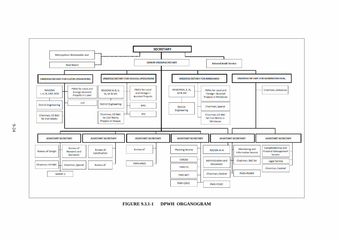
After a long process of evolution by virtue of Executive Order No. 124, dated January 30, 1987,
the Department of Public Works and Highways (DPWH) was organized with five (5) bureaus, six
(6) services, sixteen (16) regional offices, twenty-four (24) project management offices, sixteen
(16) regional equipment services and one-hundred eighteen (118) district engineering offices.
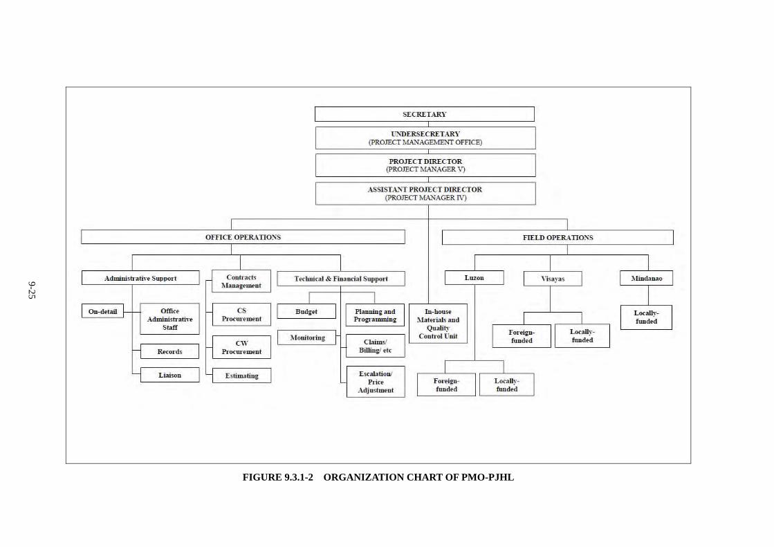
Organization chart of DPWH is shown in Figure 9.3.1-1.
PMO-PJHL: This Office is the project implementing office in DPWH. It is tasked to prepare
bidding documents; participate in negotiations and finalization of bid contracts; and
monitor/supervise the implementation of Japan ODA projects. This office oversees, administers,
supervises and coordinates all construction and prosecution activities in the expressway project.
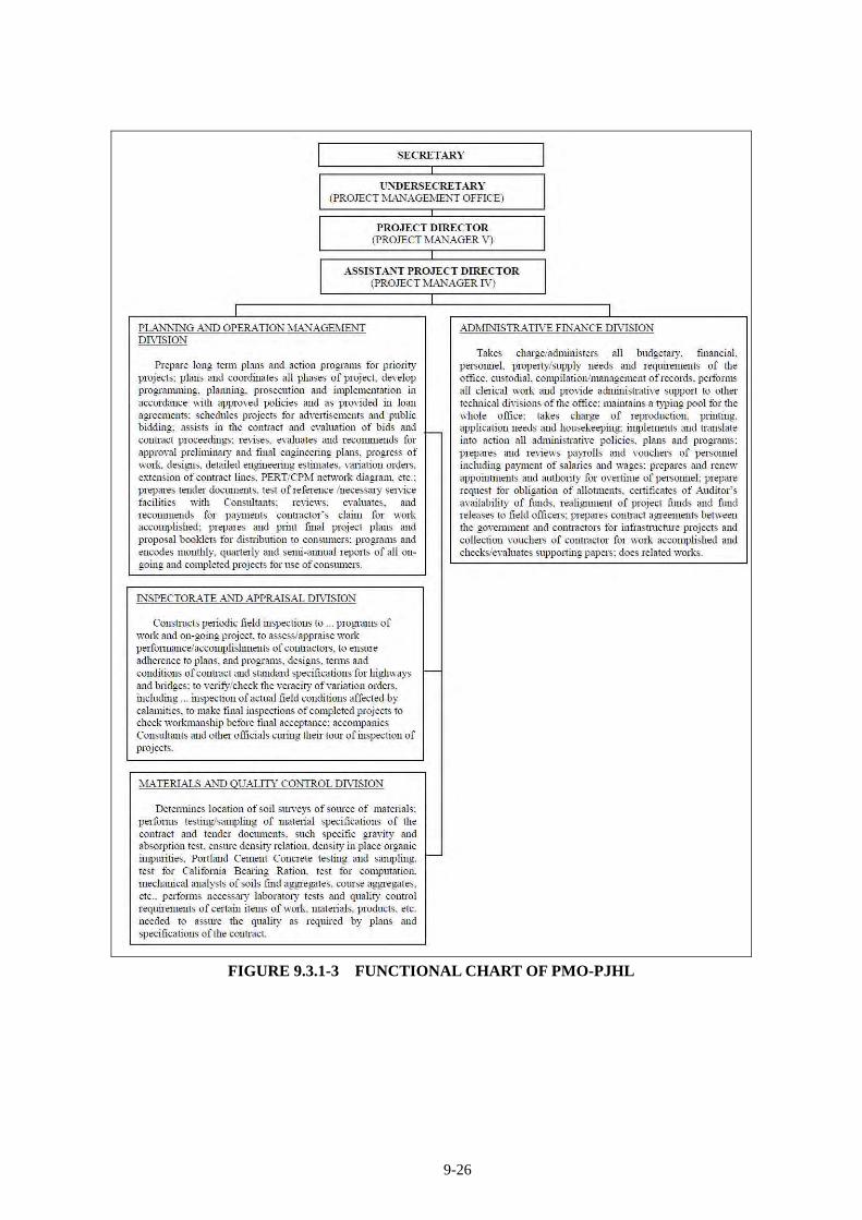
The organizational and functional charts are shown in Figure 9.3.1-2, and 9.3.1-3 respectively.
Planning Service (PS): This Service is assigned to formulate policies, plans and programs for the
development of the national road network, which includes expressways; conduct/review FS of
road/expressway projects; prepare PPP proposals for ODA financing; maintain a national road
database; and prepare multi-year and annual budgets for the construction (including right-of-way
and engineering) and maintenance of national roads.
9-23
PMO-Feasibility Studies: This office is assigned to conduct/supervise FS of major
foreign-assisted and locally-funded road and expressway projects; and assist the PS and
PMO-PJHL in preparing project proposals for ODA financing.
Bureau of Design (BOD): This Bureau is mandated to set engineering design standards;
conduct/supervise/review/approve engineering surveys, designs and construction plans of roads/
expressways, including specifications, quantity estimates and tender documents for roads and
expressways.
Environmental and Social Services Office (ESSO) and PMO-Infrastructure Right-of-Way
and Resettlement (PMO-IROWR) are responsible on social and environmental consideration
and relocation respectively. Detail of these functions is discussed in the next section.
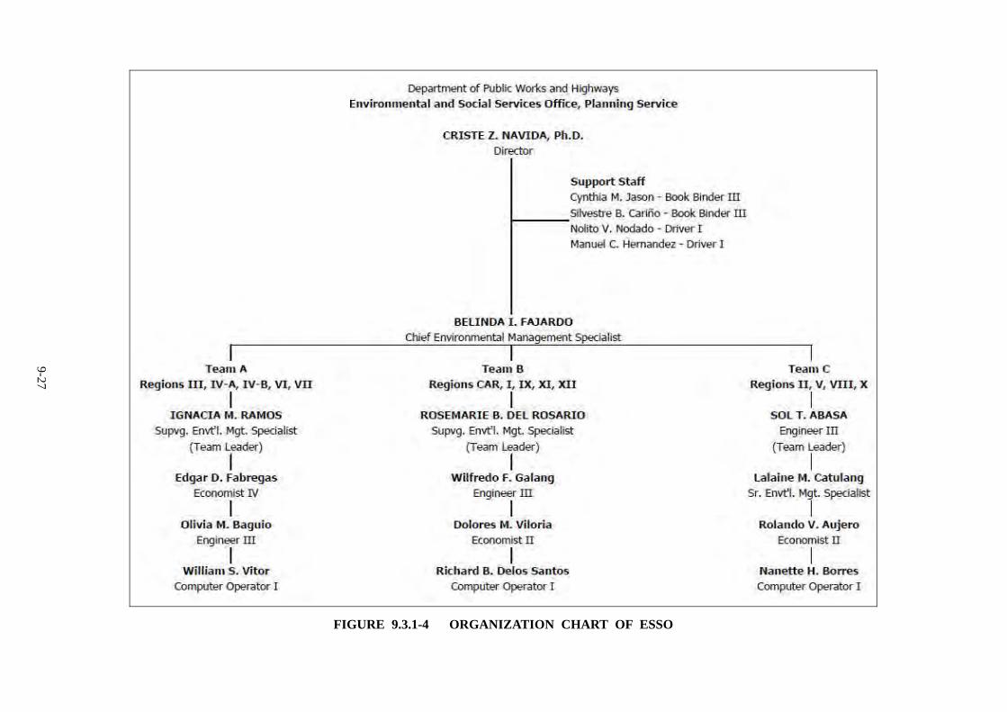
Organization chart of ESSO and its function is shown in Figure 9.3.1-4 and Table 9.3.1-1,
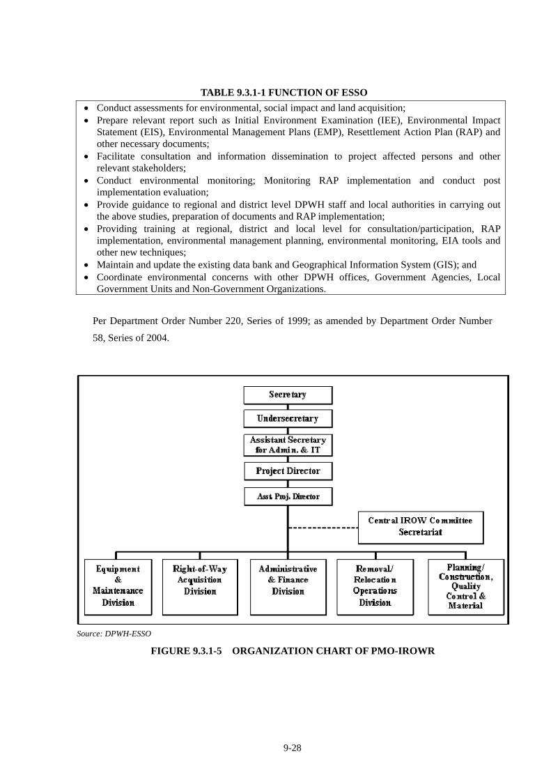
respectively. Organization chart and function of PMO-IROWR is shown in Figure 9.3.1-5, and
Table 9.3.1-2.
9-24
FIGURE 9.3.1-1 DPWH ORGANOGRAM
9-25
FIGURE 9.3.1-2 ORGANIZATION CHART OF PMO-PJHL
9-26
FIGURE 9.3.1-3 FUNCTIONAL CHART OF PMO-PJHL
9-27
FIGURE 9.3.1-4 ORGANIZATION CHART OF ESSO
9-28
TABLE 9.3.1-1 FUNCTION OF ESSO
Conduct assessments for environmental, social impact and land acquisition; Prepare relevant report such as Initial Environment Examination (IEE), Environmental Impact
Statement (EIS), Environmental Management Plans (EMP), Resettlement Action Plan (RAP) and other necessary documents;
Facilitate consultation and information dissemination to project affected persons and other relevant stakeholders;
Conduct environmental monitoring; Monitoring RAP implementation and conduct post implementation evaluation;
Provide guidance to regional and district level DPWH staff and local authorities in carrying out the above studies, preparation of documents and RAP implementation;
Providing training at regional, district and local level for consultation/participation, RAP implementation, environmental management planning, environmental monitoring, EIA tools and other new techniques;
Maintain and update the existing data bank and Geographical Information System (GIS); and Coordinate environmental concerns with other DPWH offices, Government Agencies, Local
Government Units and Non-Government Organizations.
Per Department Order Number 220, Series of 1999; as amended by Department Order Number
58, Series of 2004.
Source: DPWH-ESSO
FIGURE 9.3.1-5 ORGANIZATION CHART OF PMO-IROWR
9-29
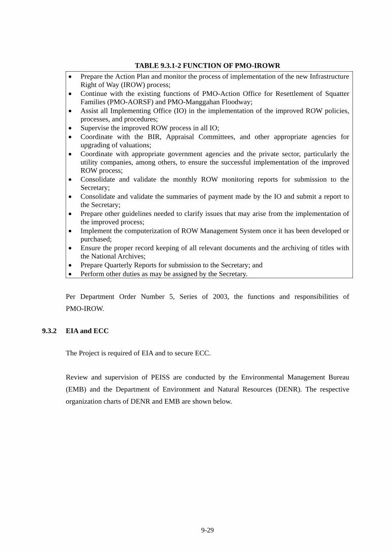
TABLE 9.3.1-2 FUNCTION OF PMO-IROWR
Prepare the Action Plan and monitor the process of implementation of the new Infrastructure Right of Way (IROW) process;
Continue with the existing functions of PMO-Action Office for Resettlement of Squatter Families (PMO-AORSF) and PMO-Manggahan Floodway;
Assist all Implementing Office (IO) in the implementation of the improved ROW policies, processes, and procedures;
Supervise the improved ROW process in all IO; Coordinate with the BIR, Appraisal Committees, and other appropriate agencies for
upgrading of valuations; Coordinate with appropriate government agencies and the private sector, particularly the
utility companies, among others, to ensure the successful implementation of the improved ROW process;
Consolidate and validate the monthly ROW monitoring reports for submission to the Secretary;
Consolidate and validate the summaries of payment made by the IO and submit a report to the Secretary;
Prepare other guidelines needed to clarify issues that may arise from the implementation of the improved process;
Implement the computerization of ROW Management System once it has been developed or purchased;
Ensure the proper record keeping of all relevant documents and the archiving of titles with the National Archives;
Prepare Quarterly Reports for submission to the Secretary; and Perform other duties as may be assigned by the Secretary.
Per Department Order Number 5, Series of 2003, the functions and responsibilities of
PMO-IROW.
9.3.2 EIA and ECC
The Project is required of EIA and to secure ECC.
Review and supervision of PEISS are conducted by the Environmental Management Bureau
(EMB) and the Department of Environment and Natural Resources (DENR). The respective
organization charts of DENR and EMB are shown below.
9-30
EMB REGIONAL OFFICE RDs (16) MGB REGIONAL OFFICE
OFFICE OF THE SECRETARY
SENIOR UNDERSECRETARY AND CHIEF OF STAFF
PUBLIC AFFAIRS OFFICE
OFFICE OF THE UNDERSECRETARY FOR
SPECIAL CONCERNS
OFFICE OF THE UNDERSECRETARY FOR
ADMINISTRATION, FINANCE AND LEGAL
OFFICE OF THE UNDERSECRETARY
FOR FIELD OPERATIONS
OFFICE OF THE SUPERVISING UNDERSECRETARY FOR FOREIGN ASSISTED AND
SPECIAL PROJECTS
OFFICE OF THE UNDERSECRETARY
FOR STAFF BUREAUS
OFFICE OF THE UNDERSECRETARY FOR POLICY AND PLANNING
INTERNAL AUDIT SERVICE
OFFICE OF THE ASSISTANT SECRETARY
FOR LOCAL GOVERNMENT CONCERNS AND LANDS
OFFICE OF THE ASSISTANT SECRETARY FOR RIVER BASIN CONTROL OFFICE
OFFICE OF THE ASSISTANT SECRETARY FOR FOREIGN
ASSISTED AND SPECIAL PROJECTS OFFICE
OFFICE OF THE ASSISTANT SECRETARY FOR FIELD
OPERATIONS
OFFICE OF THE ASSISTANT SECRETARY FOR LEGAL
SERVICE
OFFICE OF THE ASSISTANT SECRETARY FOR
MANAGEMENT SERVICES
PLANNING & POLICY STUDIES OFFICE
RIVER BASIN CONTROL OFFICE
PROJECT DESIGN & PACKAGING SERVICE
PROJECT OPERATIONS & MANAGEMENT
SERVICE
LEGAL SERVICELEGISLATIVE
LIAISON OFFICEADMINISTRATIVE
SERVICE
FINANCIAL AND MANAGEMENT
SERVICE
HUMAN RESOURCE DEVELOPMENT
SERVICE
SPECIAL CONCERNS OFFICE
ECOSYSTEMS RESEARCH AND DEVELOPMENT
BUREAU
FOREST MANAGEMENT
BUREAU
PROTECTED AREAS AND
WILDLIFE BUREAU
LAND MANAGEMENT
BUREAU
REGIONAL ENVIRONMENT AND NATURAL RESOURCES OFFICE
(RENRO)(16)
ENVIRONMENTAL MANAGEMENT BUREAU
MINES & GEOSCIENCES BUREAU
ECOSYSTEMS RESEARCH &
DEVELOPMENT SECTOR
FOREST MANAGEMENT
SECTOR
LAND MANAGEMENT
SECTOR
PROTECTED AREAS, WILDLIFE &
COASTAL ZONE MGT. SECTOR
PENROs(80)
CENROs(170)
NATIONAL MAPPING AND RESOURCE INFORMATION
AUTHORITY
LAGUNA LAKE DEVELOPMENT AUTHORITY
LAND REGISTRATION AUTHORITY
PHILIPPINE MINING DEVELOPMENT CORPORATION
NATURAL RESOURCES DEVELOPMENT CORPORATION
PHILIPPINE FOREST CORPORATION
BUKIDNON FOREST CORPORATION
HEAD EXECUTIVE ASSISTANT
ENVIRONMENTAL LAW ENFORCEMENT
TASK FORCE (19)
POLLUTION ASSOCIATION BOARD
MINES ADJUDICATION BOARD
PASIG REHABILITATION COMMISSION
NATIONAL WATER RESOURCES BOARD
NATIONAL SOLID WASTE MANAGEMENT
COMMISSION
1 Technical Support2 Technical Skills provider for RENROs
1 Technical Support2 Technical Skills provider for RENROs
ADMINISTRATIVE AND LOGISTICAL SUPERVISION
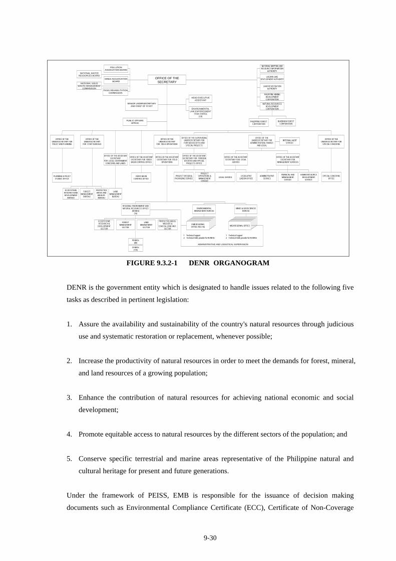
FIGURE 9.3.2-1 DENR ORGANOGRAM
DENR is the government entity which is designated to handle issues related to the following five
tasks as described in pertinent legislation:
1. Assure the availability and sustainability of the country's natural resources through judicious
use and systematic restoration or replacement, whenever possible;
2. Increase the productivity of natural resources in order to meet the demands for forest, mineral,
and land resources of a growing population;
3. Enhance the contribution of natural resources for achieving national economic and social
development;
4. Promote equitable access to natural resources by the different sectors of the population; and
5. Conserve specific terrestrial and marine areas representative of the Philippine natural and
cultural heritage for present and future generations.
Under the framework of PEISS, EMB is responsible for the issuance of decision making
documents such as Environmental Compliance Certificate (ECC), Certificate of Non-Coverage
9-31
(CNC) and Denial Letter. Also, EMB Regional Offices in respective regions are primarily
responsible for the supervision of development projects and conducting consultation related to
such projects.
- Proposed structure per DAO 2002-17 and AO 42
- Existing EMB structure
Office of the Director
Office of the Assistant Director
National Solid Waste Management Commission
Secretariat
Pollution Adjudication Board Secretariat
EMB – Regional Offices
Environmental Quality Division
Air Quality Management
Section
Water Quality Management
Section
Chemicals Management
Section
Hazardous Waste
Management Section
Environmental Quality Division
Air Quality Management
Section
Water Quality Management
Section
Chemicals Management
Section
Hazardous Waste
Management Section
Environmental Impact Assessment and
Management Division
Review and Evaluation
Section
Systems Coordination Planning and
Management Section
Monitoring and Validation Section
Research and Development
Division
Pollution Research Section
Laboratory Services Section
Research and Development
Division
Pollution Research Section
Laboratory Services Section
Environmental Education and
Information Division
Education Section
Information Section
Institutional Coordination and Documentation
Section
Environmental Education and
Information Division
Education Section
Information Section
Institutional Coordination and Documentation
Section
Environmental Planning and Policy
Division
Planning and Program
Evaluation Section
Policy Review and Analysis Section
Information Technology and Statistics Section
Environmental Planning and Policy
Division
Planning and Program
Evaluation Section
Policy Review and Analysis Section
Information Technology and Statistics Section
Administrative and Finance Division
Personnel Section
Records Section
Property Section
Accounting Section
Budget Section
Cashier Section
Administrative and Finance Division
Personnel Section
Records Section
Property Section
Accounting Section
Budget Section
Cashier Section
Legal Division
Legal Research and Advisory
Section
Prosecution Section
Hearing Section
Legal Division
Legal Research and Advisory
Section
Prosecution Section
Hearing Section
Administrative and Finance
Division
Legal and Environmental
Education Division
Environmental Impact Assessment
Division
Environmental Quality Division
Planning & Programming, MIS &
Statistics Division
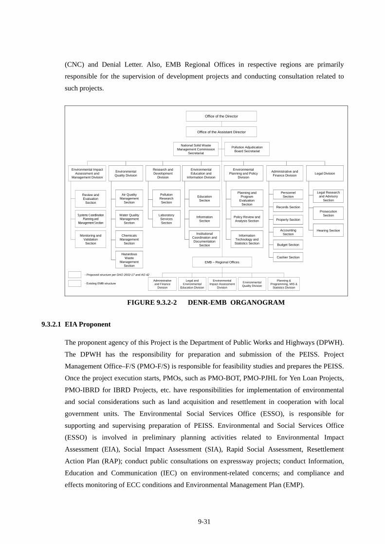
FIGURE 9.3.2-2 DENR-EMB ORGANOGRAM
9.3.2.1 EIA Proponent
The proponent agency of this Project is the Department of Public Works and Highways (DPWH).
The DPWH has the responsibility for preparation and submission of the PEISS. Project
Management Office–F/S (PMO-F/S) is responsible for feasibility studies and prepares the PEISS.
Once the project execution starts, PMOs, such as PMO-BOT, PMO-PJHL for Yen Loan Projects,
PMO-IBRD for IBRD Projects, etc. have responsibilities for implementation of environmental
and social considerations such as land acquisition and resettlement in cooperation with local
government units. The Environmental Social Services Office (ESSO), is responsible for
supporting and supervising preparation of PEISS. Environmental and Social Services Office
(ESSO) is involved in preliminary planning activities related to Environmental Impact
Assessment (EIA), Social Impact Assessment (SIA), Rapid Social Assessment, Resettlement
Action Plan (RAP); conduct public consultations on expressway projects; conduct Information,
Education and Communication (IEC) on environment-related concerns; and compliance and
effects monitoring of ECC conditions and Environmental Management Plan (EMP).
9-32
9.3.2.2 Environmental Compliance Certificate (ECC)
A certificate issued to which the Proponent conforms with, after DENR-EMB explains the ECC
conditions. The ECC is signed by the Proponent to signify full responsibility over
implementation of specified measures which are necessary to comply with existing
environmental regulations.
1) Decision Timeline
Decisions of applications are made within the prescribed timelines within the control of DENR.
Otherwise, the application shall be deemed automatically approved, with the issuance of the
approval document within five (5) working days from the time the prescribed period lapsed.
2) Validity and Expiry
Once a project is implemented, the ECC remains valid and active for the lifetime of the project.
ECC conditions and commitments are permanently relieved from compliance only upon
validation of the EMB of the successful implementation of the Abandonment/ Rehabilitation/
Decommissioning Plan.
The ECC automatically expires if a project has not been implemented within five (5) years from
ECC issuance, or if the ECC was not requested for extension within three (3) months from the
expiration of its validity
3) Amendment of ECC for Minor Change Only
Amendment of ECC can be processed for minor alternation of the project only due to:
Typographical error
Extension of deadlines for submittal of post-ECC requirements
Extension of ECC validity
Change in company name/ ownership
Decrease in land/project area or production capacity
Other amendments deemed “minor” at the discretion of the EMB CO/RO Director.
The following steps are taken to process the request of amendment.
9-33
Within three (3) days from ECC issuance (for projects not started) OR at any time during project implementation, the Proponent prepares and submits to the ECC-endorsing DENR-EMB Office a LETTER-REQUEST for ECC amendment, including data, information, reports or documents to substantiate the requested revisions
The ECC-endorsing EMB office assigns a Case Handler to evaluate the request
ECC-endorsing Authority decides on the Letter-Request, based on Case Handler recommendation.
Maximum Processing Time for Issuance of Decision is 7 workdays for both central and regional offices of EMB.
9.3.2.3 Certificate of Non-Coverage (CNC)
Certifies that based on the submitted Project Description report, the project is NOT covered by
the EIS System and is not required to secure an ECC. The CNC advises the Proponent on
coverage to other requirements by other DENR offices, LGUs, or other government agencies.
9.3.2.4 Denial Letter
Contains the explanation for the disapproval of the application and guidance on how the
application can be improved to a level of acceptability in the next EIA process. Denial is based
on unsatisfactory evaluation by the EIARC (EIA Review Committee) or EMB of the Proponent’s
submitted Additional Information (AI) at the end of the review process.
9.3.3 Involuntary Resettlement and Land Acquisitions
The provision of resettlement site shall be the responsibility of the local government units
(LGUs) concerned, with assistance from the concerned government agencies tasked with
providing housing.
DPWH-PMO-Infrastructure Right-of-Way and Resettlement (PMO-IROWR) is tasked to consult
with LGUs, local communities, project affected persons, and the designer/contractor for
expressway projects; coordinate with the Presidential Commission for the Urban Poor (PCUP)
and the National Housing Authority (NHA) on the relocation of squatter families; conduct census
and tagging of affected lots and improvements; coordinate with the Bureau of Internal Revenue
or BIR (for zonal valuation), Registry of Deeds (for titles), Assessor’s Office, and Department of
Agrarian Reform or DAR (for land conversion); coordinate and negotiate with affected property
owners on the sale of their properties; coordinate with the Office of the Solicitor General (OSG)
for filing of expropriation proceedings; and effect payment of affected properties.
To streamline acquisition of needed R-O-W and at the same time be compliant with international
(WB, ADB, JICA) policies on involuntary resettlement together with the DPWH’s own
9-34
resettlement policy, roles, responsibilities, and efforts of key players and major stakeholders must
be well coordinated. In order to achieve this, it is strongly recommended that, a Lead
Inter-Agency Committee (LIAC) be organized.
The LIAC will help ensure that a common direction is being followed to achieve the ultimate
goal of providing a service infrastructure that will spark development in Mega Manila.
Provided below is a list of said key players and major stakeholders and their corresponding
responsibilities.
9.4 JICA GUIDELINES AND PHILIPPINES’ SOCIAL AND ENVIRONMENTAL CONSIDERATION
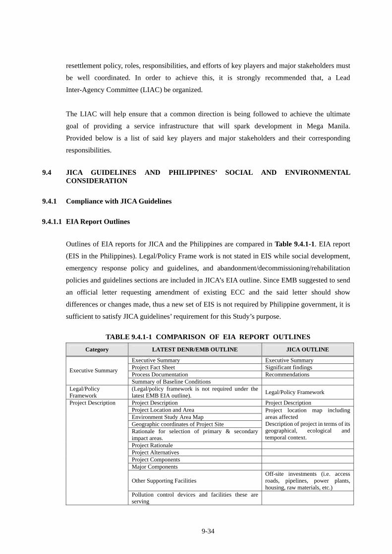
9.4.1 Compliance with JICA Guidelines
9.4.1.1 EIA Report Outlines
Outlines of EIA reports for JICA and the Philippines are compared in Table 9.4.1-1. EIA report
(EIS in the Philippines). Legal/Policy Frame work is not stated in EIS while social development,
emergency response policy and guidelines, and abandonment/decommissioning/rehabilitation
policies and guidelines sections are included in JICA’s EIA outline. Since EMB suggested to send
an official letter requesting amendment of existing ECC and the said letter should show
differences or changes made, thus a new set of EIS is not required by Philippine government, it is
sufficient to satisfy JICA guidelines’ requirement for this Study’s purpose.
TABLE 9.4.1-1 COMPARISON OF EIA REPORT OUTLINES
Category LATEST DENR/EMB OUTLINE JICA OUTLINE
Executive Summary Executive Summary Project Fact Sheet Significant findings Process Documentation Recommendations
Executive Summary
Summary of Baseline Conditions Legal/Policy Framework
(Legal/policy framework is not required under the latest EMB EIA outline).
Legal/Policy Framework
Project Description Project Description Project Location and Area Environment Study Area Map Geographic coordinates of Project Site Rationale for selection of primary & secondary impact areas.
Project location map including areas affected Description of project in terms of its geographical, ecological and temporal context.
Project Rationale Project Alternatives Project Components Major Components
Other Supporting Facilities Off-site investments (i.e. access roads, pipelines, power plants, housing, raw materials, etc.)
Project Description
Pollution control devices and facilities these are serving
9-35
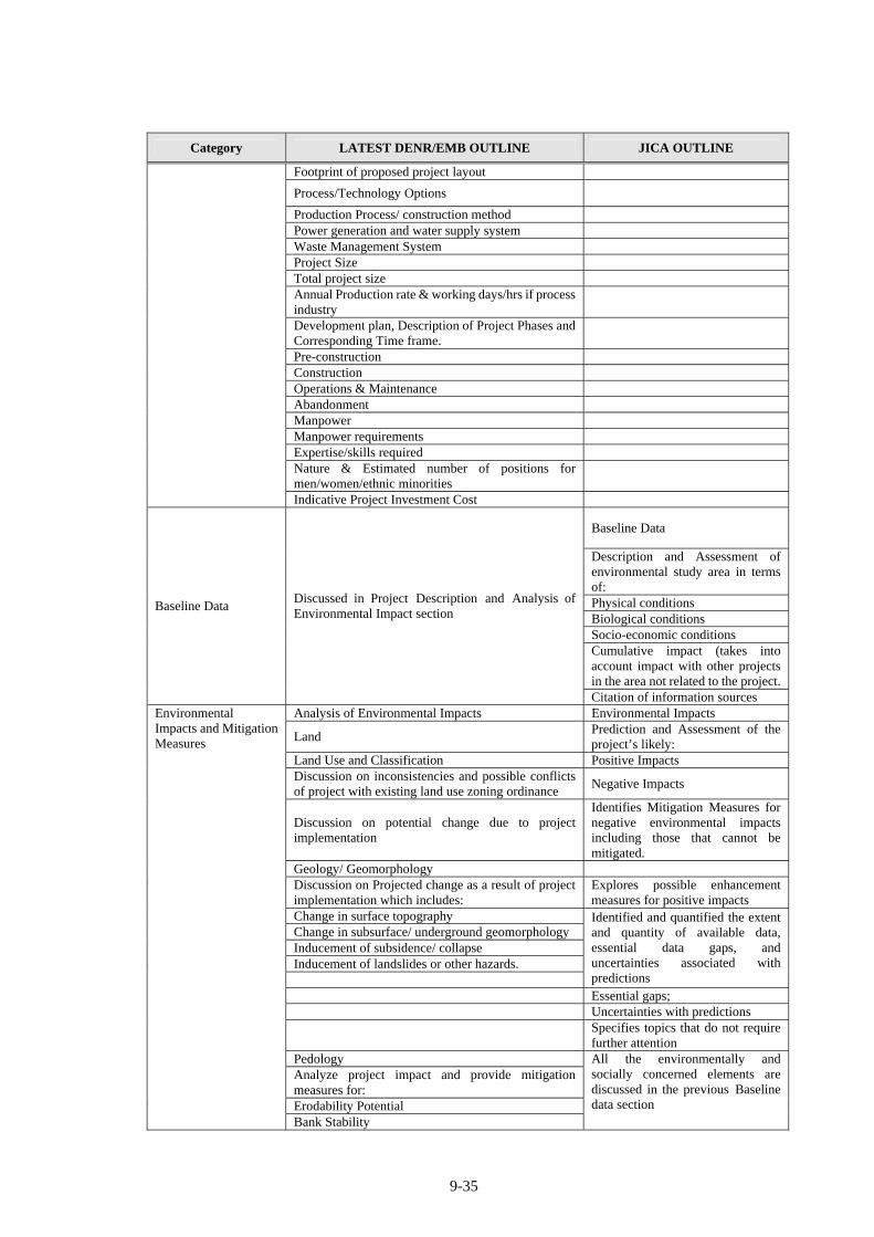
Category LATEST DENR/EMB OUTLINE JICA OUTLINE
Footprint of proposed project layout
Process/Technology Options
Production Process/ construction method Power generation and water supply system Waste Management System Project Size Total project size Annual Production rate & working days/hrs if process industry
Development plan, Description of Project Phases and Corresponding Time frame.
Pre-construction Construction Operations & Maintenance Abandonment Manpower Manpower requirements Expertise/skills required Nature & Estimated number of positions for men/women/ethnic minorities
Indicative Project Investment Cost
Baseline Data
Description and Assessment of environmental study area in terms of: Physical conditions Biological conditions Socio-economic conditions Cumulative impact (takes into account impact with other projects in the area not related to the project.
Baseline Data Discussed in Project Description and Analysis of Environmental Impact section
Citation of information sources Analysis of Environmental Impacts Environmental Impacts
Land Prediction and Assessment of the project’s likely:
Land Use and Classification Positive Impacts Discussion on inconsistencies and possible conflicts of project with existing land use zoning ordinance
Negative Impacts
Discussion on potential change due to project implementation
Identifies Mitigation Measures for negative environmental impacts including those that cannot be mitigated.
Geology/ Geomorphology Discussion on Projected change as a result of project implementation which includes:
Explores possible enhancement measures for positive impacts
Change in surface topography Change in subsurface/ underground geomorphology Inducement of subsidence/ collapse Inducement of landslides or other hazards.
Identified and quantified the extent and quantity of available data, essential data gaps, and uncertainties associated with predictions
Essential gaps; Uncertainties with predictions
Specifies topics that do not require further attention
Pedology Analyze project impact and provide mitigation measures for: Erodability Potential
Environmental Impacts and Mitigation Measures
Bank Stability
All the environmentally and socially concerned elements are discussed in the previous Baseline data section
9-36
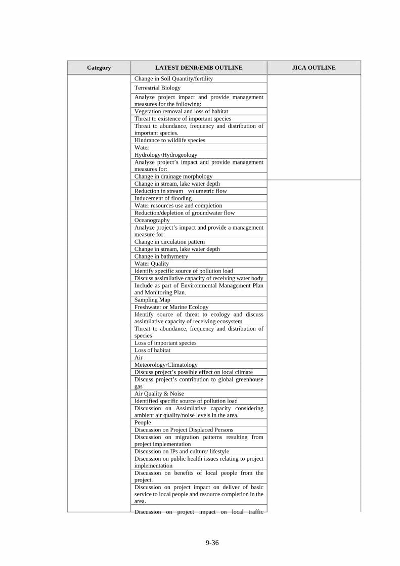
Category LATEST DENR/EMB OUTLINE JICA OUTLINE
Change in Soil Quantity/fertility
Terrestrial Biology
Analyze project impact and provide management measures for the following: Vegetation removal and loss of habitat Threat to existence of important species Threat to abundance, frequency and distribution of important species. Hindrance to wildlife species Water Hydrology/Hydrogeology Analyze project’s impact and provide management measures for: Change in drainage morphology Change in stream, lake water depth Reduction in stream volumetric flow Inducement of flooding Water resources use and completion Reduction/depletion of groundwater flow Oceanography Analyze project’s impact and provide a management measure for:
Change in circulation pattern Change in stream, lake water depth Change in bathymetry Water Quality Identify specific source of pollution load Discuss assimilative capacity of receiving water body Include as part of Environmental Management Plan and Monitoring Plan.
Sampling Map Freshwater or Marine Ecology Identify source of threat to ecology and discuss assimilative capacity of receiving ecosystem
Threat to abundance, frequency and distribution of species
Loss of important species Loss of habitat Air Meteorology/Climatology Discuss project’s possible effect on local climate Discuss project’s contribution to global greenhouse gas
Air Quality & Noise Identified specific source of pollution load Discussion on Assimilative capacity considering ambient air quality/noise levels in the area.
People Discussion on Project Displaced Persons Discussion on migration patterns resulting from project implementation
Discussion on IPs and culture/ lifestyle Discussion on public health issues relating to project implementation
Discussion on benefits of local people from the project.
Discussion on project impact on deliver of basic service to local people and resource completion in the area.
Discussion on project impact on local traffic
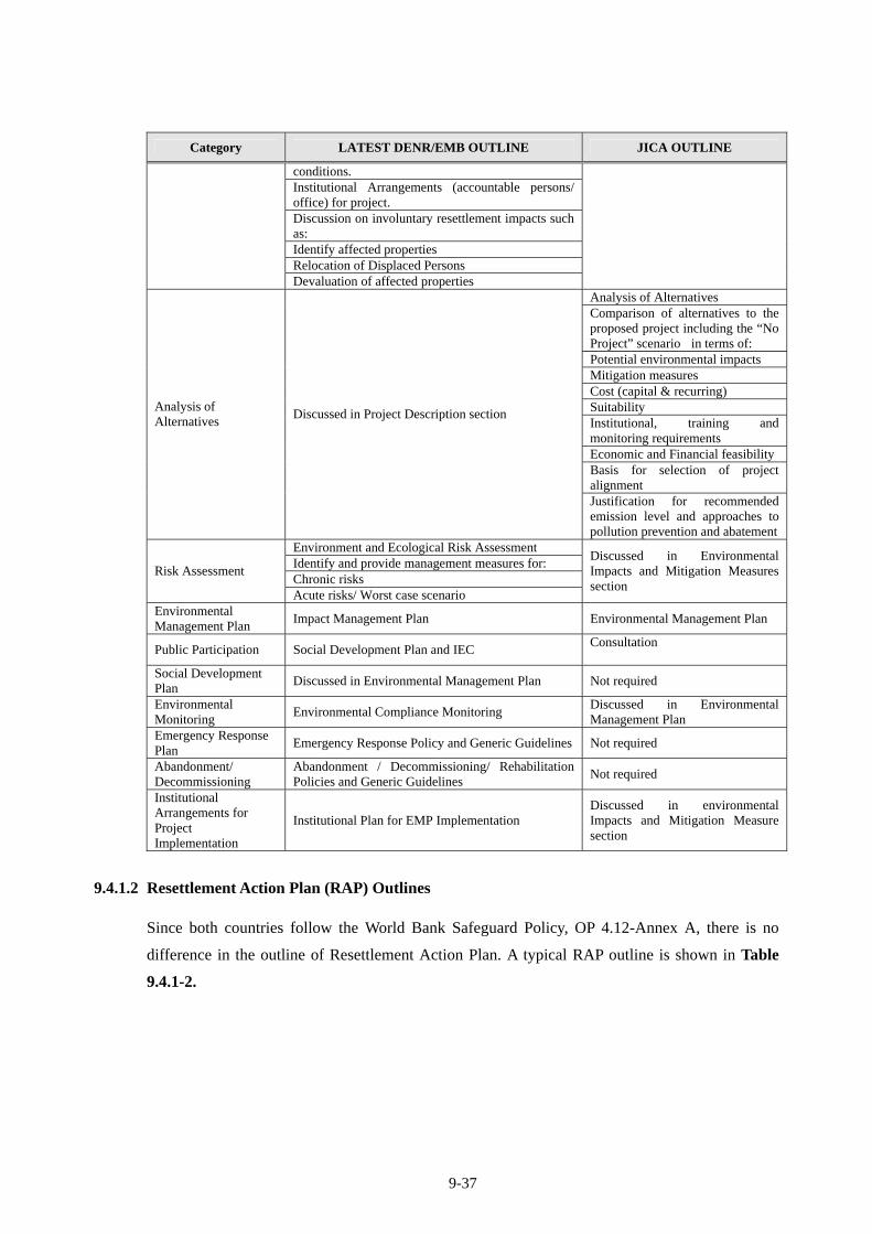
9-37
Category LATEST DENR/EMB OUTLINE JICA OUTLINE
conditions. Institutional Arrangements (accountable persons/ office) for project.
Discussion on involuntary resettlement impacts such as: Identify affected properties Relocation of Displaced Persons
Devaluation of affected properties
Analysis of Alternatives Comparison of alternatives to the proposed project including the “No Project” scenario in terms of: Potential environmental impacts Mitigation measures Cost (capital & recurring) Suitability Institutional, training and monitoring requirements Economic and Financial feasibilityBasis for selection of project alignment
Analysis of Alternatives
Discussed in Project Description section
Justification for recommended emission level and approaches to pollution prevention and abatement
Environment and Ecological Risk Assessment Identify and provide management measures for: Chronic risks
Risk Assessment
Acute risks/ Worst case scenario
Discussed in Environmental Impacts and Mitigation Measures section
Environmental Management Plan
Impact Management Plan Environmental Management Plan
Public Participation Social Development Plan and IEC Consultation
Social Development Plan
Discussed in Environmental Management Plan Not required
Environmental Monitoring
Environmental Compliance Monitoring Discussed in Environmental Management Plan
Emergency Response Plan
Emergency Response Policy and Generic Guidelines Not required
Abandonment/ Decommissioning
Abandonment / Decommissioning/ Rehabilitation Policies and Generic Guidelines
Not required
Institutional Arrangements for Project Implementation
Institutional Plan for EMP Implementation Discussed in environmental Impacts and Mitigation Measure section
9.4.1.2 Resettlement Action Plan (RAP) Outlines
Since both countries follow the World Bank Safeguard Policy, OP 4.12-Annex A, there is no
difference in the outline of Resettlement Action Plan. A typical RAP outline is shown in Table
9.4.1-2.
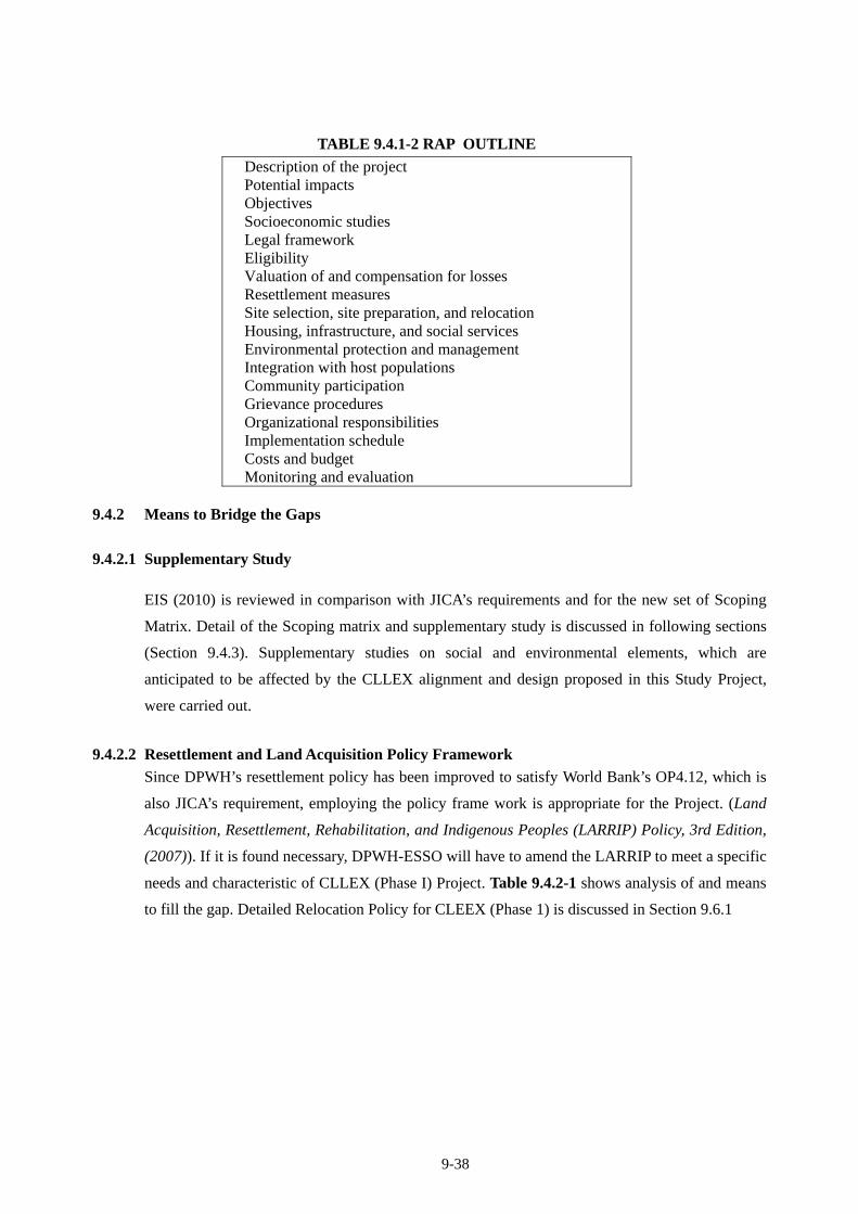
9-38
TABLE 9.4.1-2 RAP OUTLINE
Description of the project Potential impacts Objectives Socioeconomic studies Legal framework Eligibility Valuation of and compensation for losses Resettlement measures Site selection, site preparation, and relocation Housing, infrastructure, and social services Environmental protection and management Integration with host populations Community participation Grievance procedures Organizational responsibilities Implementation schedule Costs and budget Monitoring and evaluation
9.4.2 Means to Bridge the Gaps
9.4.2.1 Supplementary Study
EIS (2010) is reviewed in comparison with JICA’s requirements and for the new set of Scoping
Matrix. Detail of the Scoping matrix and supplementary study is discussed in following sections
(Section 9.4.3). Supplementary studies on social and environmental elements, which are
anticipated to be affected by the CLLEX alignment and design proposed in this Study Project,
were carried out.
9.4.2.2 Resettlement and Land Acquisition Policy Framework
Since DPWH’s resettlement policy has been improved to satisfy World Bank’s OP4.12, which is
also JICA’s requirement, employing the policy frame work is appropriate for the Project. (Land
Acquisition, Resettlement, Rehabilitation, and Indigenous Peoples (LARRIP) Policy, 3rd Edition,
(2007)). If it is found necessary, DPWH-ESSO will have to amend the LARRIP to meet a specific
needs and characteristic of CLLEX (Phase I) Project. Table 9.4.2-1 shows analysis of and means
to fill the gap. Detailed Relocation Policy for CLEEX (Phase 1) is discussed in Section 9.6.1
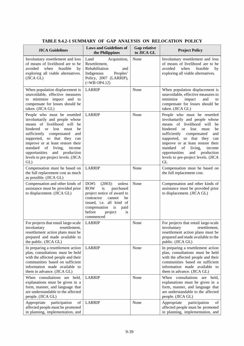
9-39
TABLE 9.4.2-1 SUMMARY OF GAP ANALYSIS ON RELOCATION POLICY
JICA Guidelines Laws and Guidelines of
the Philippines Gap relative to JICA GL
Project Policy
Involuntary resettlement and loss of means of livelihood are to be avoided when feasible by exploring all viable alternatives. (JICA GL)
Land Acquisition, Resettlement, Rehabilitation and Indigenous Peoples’ Policy, 2007 (LARRIP), (=WB OP4.12)
None Involuntary resettlement and loss of means of livelihood are to be avoided when feasible by exploring all viable alternatives.
When population displacement is unavoidable, effective measures to minimize impact and to compensate for losses should be taken. (JICA GL)
LARRIP None When population displacement is unavoidable, effective measures to minimize impact and to compensate for losses should be taken. (JICA GL)
People who must be resettled involuntarily and people whose means of livelihood will be hindered or lost must be sufficiently compensated and supported, so that they can improve or at least restore their standard of living, income opportunities and production levels to pre-project levels. (JICA GL)
LARRIP None People who must be resettled involuntarily and people whose means of livelihood will be hindered or lost must be sufficiently compensated and supported, so that they can improve or at least restore their standard of living, income opportunities and production levels to pre-project levels. (JICA GL
Compensation must be based on the full replacement cost as much as possible. (JICA GL)
LARRIP
None Compensation must be based on the full replacement cost.
Compensation and other kinds of assistance must be provided prior to displacement. (JICA GL)
DO#5 (2003): unless ROW is purchased project notice of award to contractor cannot be issued, i.e. all kind of compensation is paid before project is commenced
None Compensation and other kinds of assistance must be provided prior to displacement. (JICA GL)
For projects that entail large-scale involuntary resettlement, resettlement action plans must be prepared and made available to the public. (JICA GL)
LARRIP None For projects that entail large-scale involuntary resettlement, resettlement action plans must be prepared and made available to the public. (JICA GL)
In preparing a resettlement action plan, consultations must be held with the affected people and their communities based on sufficient information made available to them in advance. (JICA GL)
LARRIP None In preparing a resettlement action plan, consultations must be held with the affected people and their communities based on sufficient information made available to them in advance. (JICA GL)
When consultations are held, explanations must be given in a form, manner, and language that are understandable to the affected people. (JICA GL)
LARRIP None When consultations are held, explanations must be given in a form, manner, and language that are understandable to the affected people. (JICA GL)
Appropriate participation of affected people must be promoted in planning, implementation, and
LARRIP None Appropriate participation of affected people must be promoted in planning, implementation, and
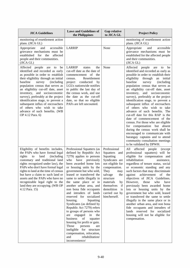
9-40
JICA Guidelines Laws and Guidelines of
the Philippines Gap relative to JICA GL
Project Policy
monitoring of resettlement action plans. (JICA GL)
monitoring of resettlement action plans. (JICA GL)
Appropriate and accessible grievance mechanisms must be established for the affected people and their communities. (JICA GL)
LARRIP None Appropriate and accessible grievance mechanisms must be established for the affected people and their communities. (JICA GL)
Affected people are to be identified and recorded as early as possible in order to establish their eligibility through an initial baseline survey (including population census that serves as an eligibility cut-off date, asset inventory, and socioeconomic survey), preferably at the project identification stage, to prevent a subsequent influx of encroachers of others who wish to take advance of such benefits. (WB OP 4.12 Para. 6)
LARRIP states the cut-off date as the date of commencement of the census. Resettlement project conducted by LGUs nationwide notifies to public the last day of the census work, and use the date as the cut-off date, so that no eligible PAFs are left uncounted.
None Affected people are to be identified and recorded as early as possible in order to establish their eligibility through an initial baseline survey (including population census that serves as an eligibility cut-off date, asset inventory, and socioeconomic survey), preferably at the project identification stage, to prevent a subsequent influx of encroachers of others who wish to take advance of such benefits. The cut-off date for this RAP is the date of commencement of the census. For those who are eligible for compensation but absent during the census work shall be encouraged to communicate with barangay captains and to attend community consultation meetings to be validated by DPWH.
Eligibility of benefits includes, the PAPs who have formal legal rights to land (including customary and traditional land rights recognized under law), the PAPs who don't have formal legal rights to land at the time of census but have a claim to such land or assets and the PAPs who have no recognizable legal right to the land they are occupying. (WB OP 4.12 Para. 15)
Professional Squatters (as defined by Republic Act 7279) applies to persons who have previously been awarded home lots or housing units by the government but who sold, leased or transferred the same to settle illegally in the same place or in another urban area, and non bona fide occupants and intruders of lands reserved for socialized housing. Squatting Syndicates (as defined by Republic Act 7279) refers to groups of persons who are engaged in the business of squatter housing for profit or gain.Those persons are ineligible for structure compensation, relocation, and rehabilitation/ inconvenience/
Professional Squatters and Squatting Syndicates are not eligible for compensation. They may salvage the structure materials by themselves if demolition is carried out by him/herself.
All affected people (except professional squatters) will be eligible for compensation and rehabilitation assistance, regardless of tenure status, social or economic standing and any such factors that may discriminate against achievement of the objectives of JICA Guidelines. However, those who have previously been awarded home lots or housing units by the government but who sold, leased or transferred the same to settle illegally in the same place or in another urban area, and non bona fide occupants and intruders of lands reserved for socialized housing will not be eligible for compensation.
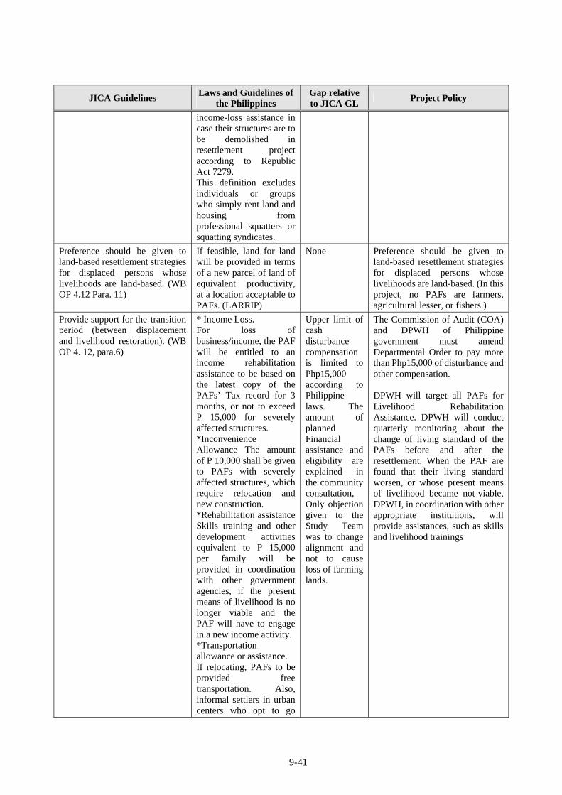
9-41
JICA Guidelines Laws and Guidelines of
the Philippines Gap relative to JICA GL
Project Policy
income-loss assistance in case their structures are to be demolished in resettlement project according to Republic Act 7279. This definition excludes individuals or groups who simply rent land and housing from professional squatters or squatting syndicates.
Preference should be given to land-based resettlement strategies for displaced persons whose livelihoods are land-based. (WB OP 4.12 Para. 11)
If feasible, land for land will be provided in terms of a new parcel of land of equivalent productivity, at a location acceptable to PAFs. (LARRIP)
None Preference should be given to land-based resettlement strategies for displaced persons whose livelihoods are land-based. (In this project, no PAFs are farmers, agricultural lesser, or fishers.)
Provide support for the transition period (between displacement and livelihood restoration). (WB OP 4. 12, para.6)
* Income Loss. For loss of business/income, the PAF will be entitled to an income rehabilitation assistance to be based on the latest copy of the PAFs’ Tax record for 3 months, or not to exceed P 15,000 for severely affected structures. *Inconvenience Allowance The amount of P 10,000 shall be given to PAFs with severely affected structures, which require relocation and new construction. *Rehabilitation assistance Skills training and other development activities equivalent to P 15,000 per family will be provided in coordination with other government agencies, if the present means of livelihood is no longer viable and the PAF will have to engage in a new income activity.*Transportation allowance or assistance. If relocating, PAFs to be provided free transportation. Also, informal settlers in urban centers who opt to go
Upper limit of cash disturbance compensation is limited to Php15,000 according to Philippine laws. The amount of planned Financial assistance and eligibility are explained in the community consultation, Only objection given to the Study Team was to change alignment and not to cause loss of farming lands.
The Commission of Audit (COA) and DPWH of Philippine government must amend Departmental Order to pay more than Php15,000 of disturbance and other compensation. DPWH will target all PAFs for Livelihood Rehabilitation Assistance. DPWH will conduct quarterly monitoring about the change of living standard of the PAFs before and after the resettlement. When the PAF are found that their living standard worsen, or whose present means of livelihood became not-viable, DPWH, in coordination with other appropriate institutions, will provide assistances, such as skills and livelihood trainings
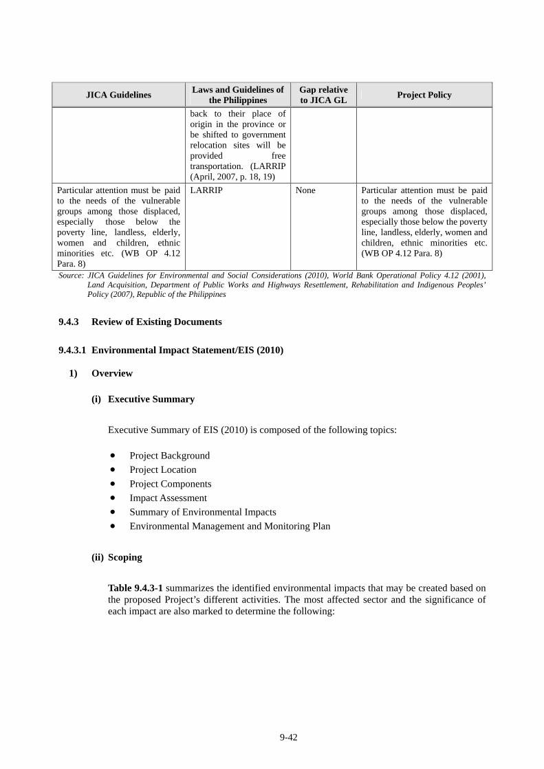
9-42
JICA Guidelines Laws and Guidelines of
the Philippines Gap relative to JICA GL
Project Policy
back to their place of origin in the province or be shifted to government relocation sites will be provided free transportation. (LARRIP (April, 2007, p. 18, 19)
Particular attention must be paid to the needs of the vulnerable groups among those displaced, especially those below the poverty line, landless, elderly, women and children, ethnic minorities etc. (WB OP 4.12 Para. 8)
LARRIP None Particular attention must be paid to the needs of the vulnerable groups among those displaced, especially those below the poverty line, landless, elderly, women and children, ethnic minorities etc. (WB OP 4.12 Para. 8)
Source: JICA Guidelines for Environmental and Social Considerations (2010), World Bank Operational Policy 4.12 (2001), Land Acquisition, Department of Public Works and Highways Resettlement, Rehabilitation and Indigenous Peoples’ Policy (2007), Republic of the Philippines
9.4.3 Review of Existing Documents
9.4.3.1 Environmental Impact Statement/EIS (2010)
1) Overview
(i) Executive Summary
Executive Summary of EIS (2010) is composed of the following topics:
Project Background
Project Location
Project Components
Impact Assessment
Summary of Environmental Impacts
Environmental Management and Monitoring Plan
(ii) Scoping
Table 9.4.3-1 summarizes the identified environmental impacts that may be created based on the proposed Project’s different activities. The most affected sector and the significance of each impact are also marked to determine the following:
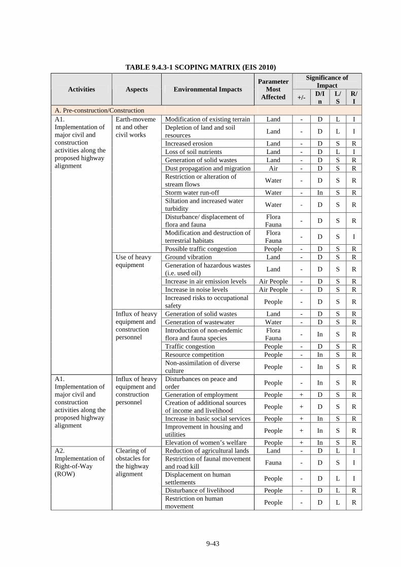
9-43
TABLE 9.4.3-1 SCOPING MATRIX (EIS 2010) Significance of
Impact Activities Aspects Environmental Impacts
Parameter Most
Affected +/- D/In
L/S
R/I
A. Pre-construction/Construction Modification of existing terrain Land - D L I Depletion of land and soil resources
Land - D L I
Increased erosion Land - D S RLoss of soil nutrients Land - D L I Generation of solid wastes Land - D S RDust propagation and migration Air - D S RRestriction or alteration of stream flows
Water - D S R
Storm water run-off Water - In S RSiltation and increased water turbidity
Water - D S R
Disturbance/ displacement of flora and fauna
Flora Fauna
- D S R
Modification and destruction of terrestrial habitats
Flora Fauna
- D S I
Earth-movement and other civil works
Possible traffic congestion People - D S RGround vibration Land - D S RGeneration of hazardous wastes (i.e. used oil)
Land - D S R
Increase in air emission levels Air People - D S RIncrease in noise levels Air People - D S R
Use of heavy equipment
Increased risks to occupational safety
People - D S R
Generation of solid wastes Land - D S RGeneration of wastewater Water - D S RIntroduction of non-endemic flora and fauna species
Flora Fauna
- In S R
Traffic congestion People - D S RResource competition People - In S R
A1. Implementation of major civil and construction activities along the proposed highway alignment
Influx of heavy equipment and construction personnel
Non-assimilation of diverse culture
People - In S R
Disturbances on peace and order
People - In S R
Generation of employment People + D S RCreation of additional sources of income and livelihood
People + D S R
Increase in basic social services People + In S RImprovement in housing and utilities
People + In S R
A1. Implementation of major civil and construction activities along the proposed highway alignment
Influx of heavy equipment and construction personnel
Elevation of women’s welfare People + In S RReduction of agricultural lands Land - D L I Restriction of faunal movement and road kill
Fauna - D S I
Displacement on human settlements
People - D L I
Disturbance of livelihood People - D L R
A2. Implementation of Right-of-Way (ROW)
Clearing of obstacles for the highway alignment
Restriction on human movement
People - D L R
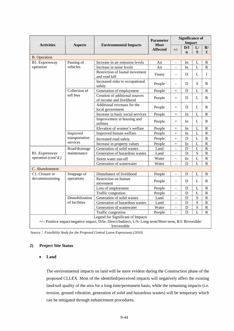
9-44
Significance of Impact
Activities Aspects Environmental Impacts Parameter
Most Affected +/-
D/In
L/S
R/I
B. Operation Increase in air emission levels Air - In L RIncrease in noise levels Air - In L RRestriction of faunal movement and road kill
Fauna - D L I
Passing of vehicles
Increased risks to occupational safety
People - D S R
Generation of employment People + D L RCreation of additional sources of income and livelihood
People + D L R
Additional revenues for the local government
People + D L R
Increase in basic social services People + In L RImprovement in housing and utilities
People + In L R
Collection of toll fees
Elevation of women’s welfare People + In L RImproved human welfare People + In L R
Increased road safety People + D L R
B1. Expressway operation
Improved transportation services Increase in property values People + In L R
Generation of solid wastes Land - D L RGeneration of hazardous wastes Land - D S R
Storm water run-off Water - In L R
B1. Expressway operation (cont’d.)
Road/drainage maintenance
Generation of wastewater Water - D L RC. Abandonment
Disturbance of livelihood People - D L RRestriction on human movement
People - D L R
Loss of employment People - D L R
Stoppage of operations
Traffic congestion People - D L RGeneration of solid wastes Land - D S RGeneration of hazardous wastes Land - D S RGeneration of wastewater Water - D S R
C1. Closure or decommissioning
Demobilization of facilities
Traffic congestion People - D L RLegend for Significant of Impacts
+/-: Positive impact/negative impact, D/In: Direct/Indirect, L/S: Long term/Short term, R/I: Reversible/ Irreversible
Source:Feasibility Study for the Proposed Central Luzon Expressway (2010)
2) Project Site Status
Land
The environmental impacts on land will be more evident during the Construction phase of the
proposed CLLEX. Most of the identified/perceived impacts will negatively affect the existing
land/soil quality of the area for a long time/permanent basis, while the remaining impacts (i.e.
erosion, ground vibration, generation of solid and hazardous wastes) will be temporary which
can be mitigated through enhancement procedures.
9-45
Air
Impacts on ambient air and noise will be more evident during the Construction phase of the
proposed Project. Most of the identified impacts will affect the ambient air and noise quality
of the Project area for a short period and will be localized only.
Water
The environmental impacts on surface water quality of affected area will be more noticeable
during the Construction phase of the proposed CLLEX, but will be lesser in extent during the
Operation. These perceived/identified impacts will negatively affect the existing spots but
will be temporary and localized, and can be minimized through mitigating measures.
Biological/Terrestrial Environment
The impacts on the biological/terrestrial environment will be a combination of temporary and
permanent impacts. During the Construction phase of the proposed CLLEX, the following
activities such as: clearing works, earth moving for land preparation, road construction, and
the improvement of access and service roads intended for various Project will result to
displacement of trees and plants. This may result to the disturbance of native faunal species,
change (modification and destruction) of terrestrial habitats, and an impending loss of plant
associations and their associated fauna. For the Operations phase, restriction of faunal
movement may affect the Project vicinity due to the alteration of the affected terrestrial
habitats. However, it is also during this phase that some positive impacts will be generated
once the project proponent implements the various biodiversity activities (i.e. re-planting,
establishment of nurseries, etc.).
People
The proposed Project will not adversely affect the employment, livelihood and income of the
residents; on the contrary, the proposed Project may even provide income opportunities from
the time of construction until operations. For those who will be directly affected and whose
houses would need to be removed once the ROW clearing operations commenced, their
concern would be addressed by giving a just compensation and through resettlement
adjustment that would be included in the social development plan. In terms of traffic flow for
transporting heavy equipment and laborers, the area is located along the Bypass road and
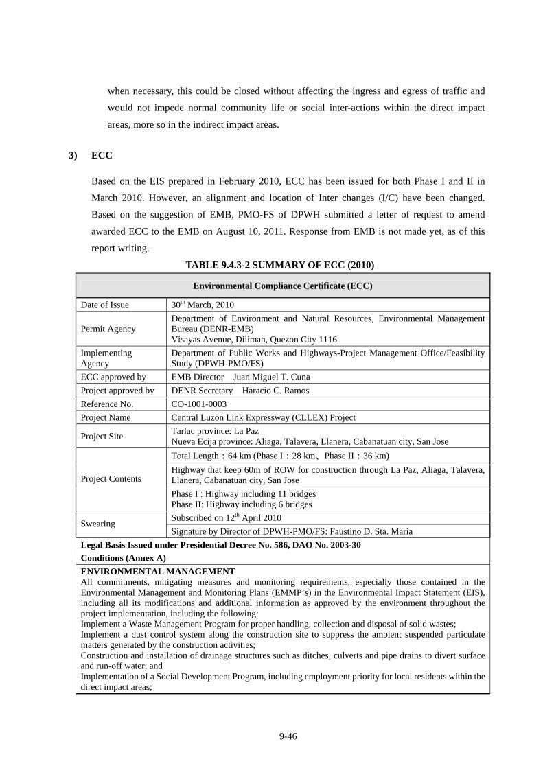
9-46
when necessary, this could be closed without affecting the ingress and egress of traffic and
would not impede normal community life or social inter-actions within the direct impact
areas, more so in the indirect impact areas.
3) ECC
Based on the EIS prepared in February 2010, ECC has been issued for both Phase I and II in
March 2010. However, an alignment and location of Inter changes (I/C) have been changed.
Based on the suggestion of EMB, PMO-FS of DPWH submitted a letter of request to amend
awarded ECC to the EMB on August 10, 2011. Response from EMB is not made yet, as of this
report writing.
TABLE 9.4.3-2 SUMMARY OF ECC (2010)
Environmental Compliance Certificate (ECC)
Date of Issue 30th March, 2010
Permit Agency Department of Environment and Natural Resources, Environmental Management Bureau (DENR-EMB) Visayas Avenue, Diiiman, Quezon City 1116
Implementing Agency
Department of Public Works and Highways-Project Management Office/Feasibility Study (DPWH-PMO/FS)
ECC approved by EMB Director Juan Miguel T. Cuna
Project approved by DENR Secretary Haracio C. Ramos
Reference No. CO-1001-0003
Project Name Central Luzon Link Expressway (CLLEX) Project
Project Site Tarlac province: La Paz Nueva Ecija province: Aliaga, Talavera, Llanera, Cabanatuan city, San Jose
Total Length:64 km (Phase I:28 km、Phase II:36 km)
Highway that keep 60m of ROW for construction through La Paz, Aliaga, Talavera, Llanera, Cabanatuan city, San Jose Project Contents
Phase I : Highway including 11 bridges Phase II: Highway including 6 bridges
Subscribed on 12th April 2010 Swearing
Signature by Director of DPWH-PMO/FS: Faustino D. Sta. Maria
Legal Basis Issued under Presidential Decree No. 586, DAO No. 2003-30
Conditions (Annex A)
ENVIRONMENTAL MANAGEMENT All commitments, mitigating measures and monitoring requirements, especially those contained in the Environmental Management and Monitoring Plans (EMMP’s) in the Environmental Impact Statement (EIS), including all its modifications and additional information as approved by the environment throughout the project implementation, including the following: Implement a Waste Management Program for proper handling, collection and disposal of solid wastes; Implement a dust control system along the construction site to suppress the ambient suspended particulate matters generated by the construction activities; Construction and installation of drainage structures such as ditches, culverts and pipe drains to divert surface and run-off water; and Implementation of a Social Development Program, including employment priority for local residents within the direct impact areas;
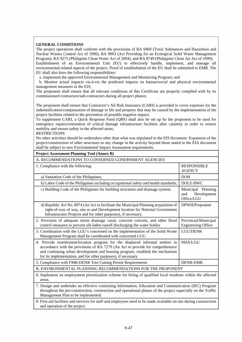
9-47
GENERAL CONDITIONS The project operations shall conform with the provisions of RA 6969 (Toxic Substances and Hazardous and Nuclear Wastes Control Act of 1990), RA 9003 (Act Providing for an Ecological Solid Waste Management Program), RA 9275 (Philippine Clean Water Act of 2004), and RA 8749 (Philippine Clean Air Act of 1999); Establishment of an Environmental Unit (EU) to effectively handle, implement, and manage all environmental-related aspects of the project. Proof of establishment of the EU shall be submitted to EMB. The EU shall also have the following responsibilities: a. Implement the approved Environmental Management and Monitoring Program; and b. Monitor actual impacts vis-à-vis the predicted impacts on human/social and physical environmental management measures in the EIS; The proponent shall ensure that all relevant conditions of this Certificate are properly complied with by its commissioned contractors/sub-contractors during all project phases; The proponent shall ensure that Contractor’s All Risk Insurance (CARI) is provided to cover expenses for the indemnification/compensation of damage to life and property that may be caused by the implementation of the project facilities related to the prevention of possible negative impact; To supplement CARI, a Quick Response Fund (QRF) shall also be set up by the proponent to be used for emergency repairs/restoration of critical damage infrastructure facilities after calamity in order to restore mobility and ensure safety in the affected areas; RESTRICTIONS No other activities should be undertaken other than what was stipulated in the EIS document. Expansion of the project/construction of other structures or any change in the activity beyond those stated in the EIA document shall be subject to new Environmental Impact Assessment requirements.
Project Assessment Planning Tool (Annex B)
A. RECOMMENDATIONS TO CONSERNED GONERNMENT AGENCIES
1. Compliance with the following: RESPONSIBLE AGENCY
a) Sanitation Code of the Philippines; DOH
b) Labor Code of the Philippines including occupational safety and health standards; DOLE-BWC
c) Building Code of the Philippines for building structures and drainage system; Municipal Planning and Development Office/LGU
d) Republic Act No. 8974 (An Act to facilitate the Municipal Planning acquisition of right-of-way of way, site or and Development location for National Government Infrastructure Projects and for other purposes), if necessary.
DPWH/Proponent
2. Provision of adequate storm drainage canal, concrete culverts, and other flood control measures to prevent silt-laden runoff discharging the water bodies
Provincial/Municipal Engineering Office
3. Coordination with the LGU’s concerned on the implementation of the Solid Waste Management Program shall be coordinated with concerned LGU.
LGU/DENR
4. Provide resettlement/location program for the displaced informal settlers in accordance with the provisions of RA 7279 (An Act to provide for comprehensive and continuing urban development and housing program, establish the mechanism for its implementation, and for other purposes), if necessary
NHA/LGU
5. Compliance with FMB-DENR Tree Cutting Permit Requirements DENR-EMB
B. ENVIRONMENTAL PLANNING RECOMMENDATIONS FOR THE PROPONENT
6. Implement an employment prioritization scheme for hiring of qualified local residents within the affected areas.
7. Design and undertake an effective continuing Information, Education and Communication (IEC) Program throughout the pre-construction, construction and operational phases of the project especially on the Traffic Management Plan to be implemented.
8. First aid facilities and services for staff and employees need to be made available on-site during construction and operation of the project.
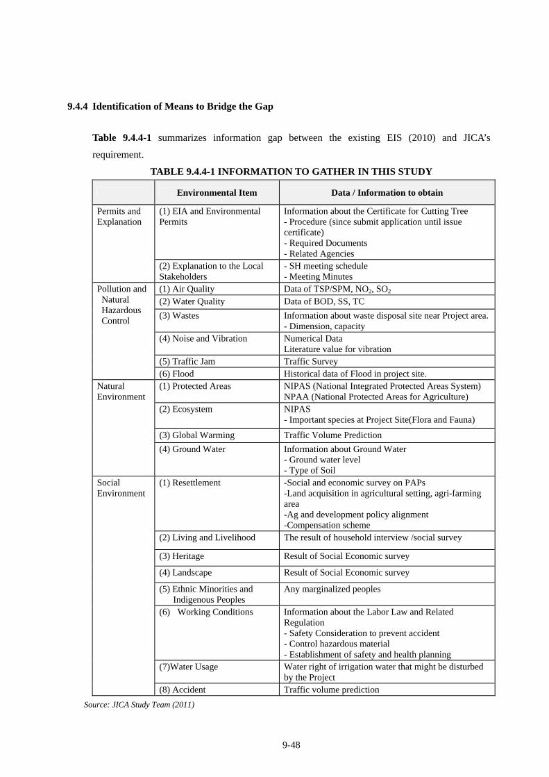
9-48
9.4.4 Identification of Means to Bridge the Gap
Table 9.4.4-1 summarizes information gap between the existing EIS (2010) and JICA’s
requirement.
TABLE 9.4.4-1 INFORMATION TO GATHER IN THIS STUDY
Environmental Item Data / Information to obtain
(1) EIA and Environmental Permits
Information about the Certificate for Cutting Tree - Procedure (since submit application until issue certificate) - Required Documents - Related Agencies
Permits and Explanation
(2) Explanation to the Local Stakeholders
- SH meeting schedule - Meeting Minutes
(1) Air Quality Data of TSP/SPM, NO2, SO2 (2) Water Quality Data of BOD, SS, TC
(3) Wastes Information about waste disposal site near Project area.- Dimension, capacity
(4) Noise and Vibration Numerical Data Literature value for vibration
(5) Traffic Jam Traffic Survey
Pollution and Natural Hazardous Control
(6) Flood Historical data of Flood in project site. (1) Protected Areas NIPAS (National Integrated Protected Areas System)
NPAA (National Protected Areas for Agriculture) (2) Ecosystem NIPAS
- Important species at Project Site(Flora and Fauna)
(3) Global Warming Traffic Volume Prediction
Natural Environment
(4) Ground Water Information about Ground Water - Ground water level - Type of Soil
(1) Resettlement -Social and economic survey on PAPs -Land acquisition in agricultural setting, agri-farming area -Ag and development policy alignment -Compensation scheme
(2) Living and Livelihood The result of household interview /social survey
(3) Heritage Result of Social Economic survey
(4) Landscape Result of Social Economic survey
(5) Ethnic Minorities and Indigenous Peoples
Any marginalized peoples
(6) Working Conditions Information about the Labor Law and Related Regulation - Safety Consideration to prevent accident - Control hazardous material - Establishment of safety and health planning
(7)Water Usage Water right of irrigation water that might be disturbed by the Project
Social Environment
(8) Accident Traffic volume prediction
Source: JICA Study Team (2011)
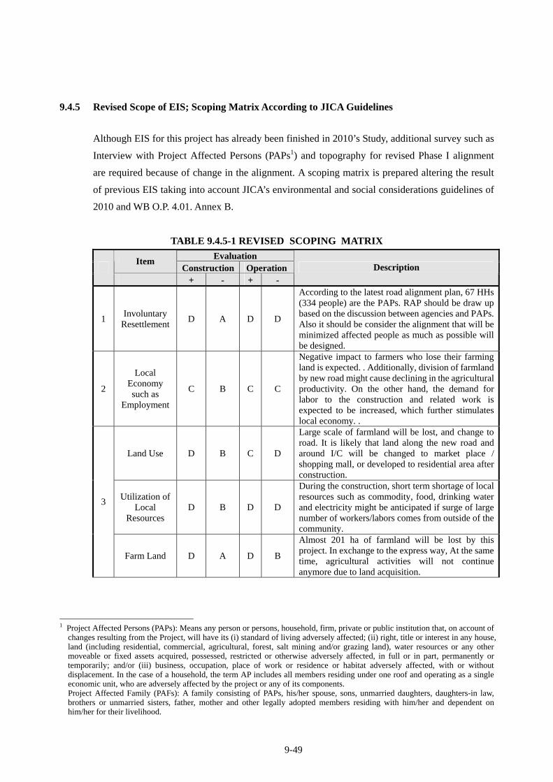
9-49
9.4.5 Revised Scope of EIS; Scoping Matrix According to JICA Guidelines
Although EIS for this project has already been finished in 2010’s Study, additional survey such as
Interview with Project Affected Persons (PAPs1) and topography for revised Phase I alignment
are required because of change in the alignment. A scoping matrix is prepared altering the result
of previous EIS taking into account JICA’s environmental and social considerations guidelines of
2010 and WB O.P. 4.01. Annex B.
TABLE 9.4.5-1 REVISED SCOPING MATRIX
Evaluation Item
Construction Operation + - + -
Description
1 Involuntary
ResettlementD A D D
According to the latest road alignment plan, 67 HHs (334 people) are the PAPs. RAP should be draw up based on the discussion between agencies and PAPs. Also it should be consider the alignment that will be minimized affected people as much as possible will be designed.
2
Local Economy such as
Employment
C B C C
Negative impact to farmers who lose their farming land is expected. . Additionally, division of farmland by new road might cause declining in the agricultural productivity. On the other hand, the demand for labor to the construction and related work is expected to be increased, which further stimulates local economy. .
Land Use D B C D
Large scale of farmland will be lost, and change to road. It is likely that land along the new road and around I/C will be changed to market place / shopping mall, or developed to residential area after construction.
Utilization of Local
Resources D B D D
During the construction, short term shortage of local resources such as commodity, food, drinking water and electricity might be anticipated if surge of large number of workers/labors comes from outside of the community.
3
Farm Land D A D B
Almost 201 ha of farmland will be lost by this project. In exchange to the express way, At the same time, agricultural activities will not continue anymore due to land acquisition.
1 Project Affected Persons (PAPs): Means any person or persons, household, firm, private or public institution that, on account of
changes resulting from the Project, will have its (i) standard of living adversely affected; (ii) right, title or interest in any house, land (including residential, commercial, agricultural, forest, salt mining and/or grazing land), water resources or any other moveable or fixed assets acquired, possessed, restricted or otherwise adversely affected, in full or in part, permanently or temporarily; and/or (iii) business, occupation, place of work or residence or habitat adversely affected, with or without displacement. In the case of a household, the term AP includes all members residing under one roof and operating as a single economic unit, who are adversely affected by the project or any of its components. Project Affected Family (PAFs): A family consisting of PAPs, his/her spouse, sons, unmarried daughters, daughters-in law, brothers or unmarried sisters, father, mother and other legally adopted members residing with him/her and dependent on him/her for their livelihood.
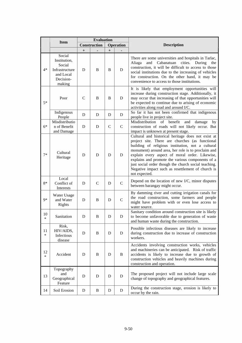
9-50
Evaluation Item
Construction Operation + - + -
Description
4*
Social Institution,
Social Infrastructure
and Local Decision- making
D B B D
There are some universities and hospitals in Tarlac, Aliaga and Cabanatuan cities. During the construction, it will be difficult to access to those social institutions due to the increasing of vehicles for construction. On the other hand, it may be convenience to access to those institutions.
Poor C B B D
It is likely that employment opportunities will increase during construction stage. Additionally, it may occur that increasing of that opportunities will be expected to continue due to arising of economic activities along road and around I/C.
5*
Indigenous People
D D D D So far it has not been confirmed that indigenous people live in project site.
6* Misdistribution of Benefit and Damage
D D C C Misdistribution of benefit and damage by construction of roads will not likely occur. But impact is unknown at present stage.
7* Cultural Heritage
D D D D
Cultural and historical heritage does not exist at project site. There are churches (as functional building of religious institution, not a cultural monument) around area, her role is to proclaim and explain every aspect of moral order. Likewise, explains and promote the various components of a just social order though the church social teaching. Negative impact such as resettlement of church is not expected.
8* Local
Conflict of Interests
D C D C Depend on the location of new I/C, minor disputes between barangay might occur.
9* Water Usage
and Water Rights
D B D C
By damming river and cutting irrigation canals for the road construction, some farmers and people might have problem with or even lose access to water source.
10*
Sanitation D B D D Sanitary condition around construction site is likely to become unfavorable due to generation of waste and human waste during the construction.
11*
Risk, HIV/AIDS, Infectious
disease
D B D D Possible infectious diseases are likely to increase during construction due to increase of construction workers.
12*
Accident D B D B
Accidents involving construction works, vehicles and machineries can be anticipated. Risk of traffic accidents is likely to increase due to growth of construction vehicles and heavily machines during construction and operation.
13
Topography and
Geographical Feature
D D D D The proposed project will not include large scale change of topography and geographical features.
14 Soil Erosion D B D D During the construction stage, erosion is likely to occur by the rain.
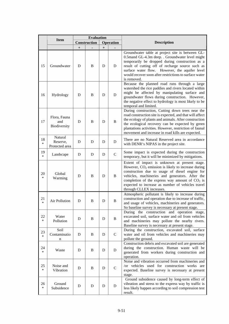
9-51
Evaluation Item
Construction Operation + - + -
Description
15 Groundwater D B D D
Groundwater table at project site is between GL- 0.5mand GL-4.3m deep. . Groundwater level might temporarily be dropped during construction as a result of cutting off of recharge source such as surface water flow. However, the aquifer level would recover soon after restrictions to surface water is removed.
16 Hydrology D B D D
Because the planned road runs through a large watershed the rice paddies and rivers located within might be affected by manipulating surface and groundwater flows during construction. However, the negative effect to hydrology is most likely to be temporal and limited.
17 Flora, Fauna
and Biodiversity
D B D B
During construction, Cutting down trees near the road construction site is expected, and that will affect the ecology of plants and animals. After construction the ecological recovery can be expected by green plantations activities. However, restriction of faunal movement and increase in road kills are expected.
18*
Natural Reserve,
Protected area D D D D
There are no Natural Reserved area in accordance with DENR‘s NIPAS in the project site.
19*
Landscape D D D C Some impact is expected during the construction temporary, but it will be minimized by mitigations.
20*
Global Warming
D B D B
Extent of impact is unknown at present stage. However, CO2 emission is likely to increase during construction due to usage of diesel engine for vehicles, machineries and generators. After the completion of the express way amount of CO2 is expected to increase as number of vehicles travel through CLLEX increases.
21*
Air Pollution D B D B
Atmospheric pollutant is likely to increase during construction and operation due to increase of traffic, and usage of vehicles, machineries and generators. So baseline survey is necessary at present stage.
22*
Water Pollution
D B D B
During the construction and operation stage, excavated soil, surface water and oil from vehicles and machineries may pollute the nearby rivers. Baseline survey is necessary at present stage.
23*
Soil Contaminatio
n D B D C
During the construction, excavated soil, surface water and oil from vehicles and machineries may pollute the ground.
24*
Waste D B D D
Construction debris and excavated soil are generated during the construction. Human waste will be generated from workers during construction and operation.
25*
Noise and Vibration
D B D C
Noise and vibration occurred from machineries and /or vehicles used for construction works are expected. Baseline survey is necessary at present stage.
26*
Ground Subsidence
D D D D
Ground subsidence caused by long-term effect of vibration and stress to the express way by traffic is less likely happen according to soil compression test result.
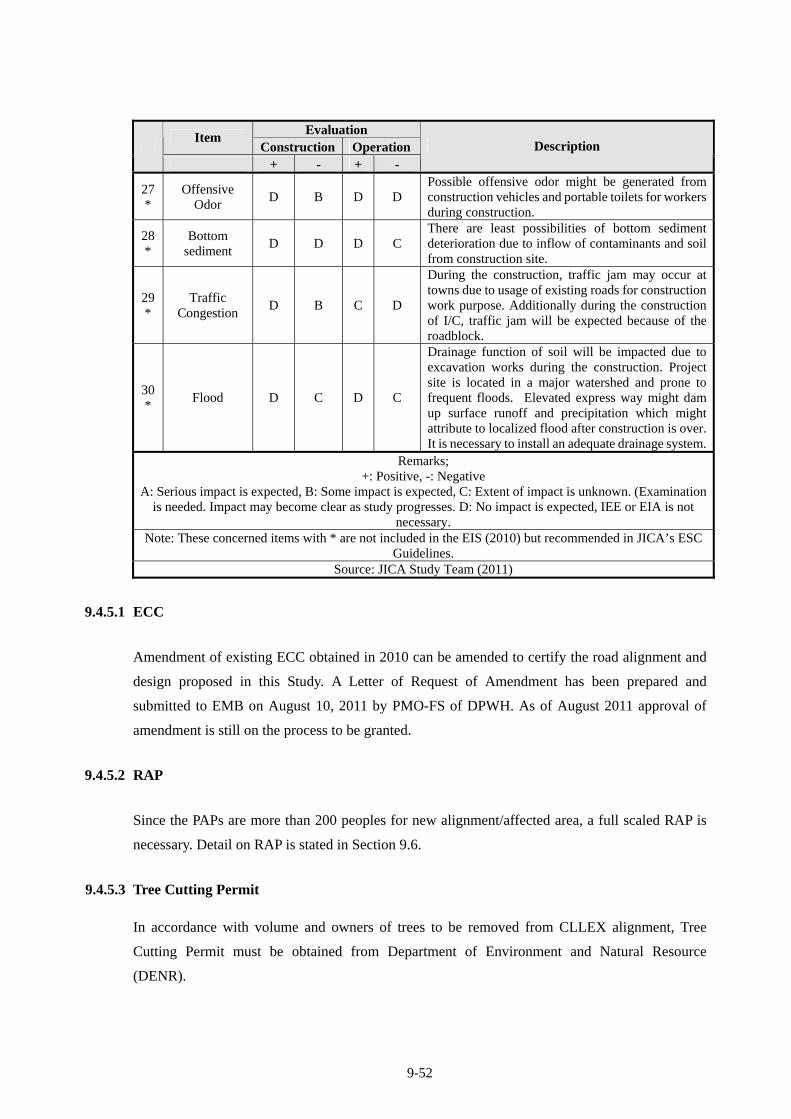
9-52
Evaluation Item
Construction Operation + - + -
Description
27*
Offensive Odor
D B D D Possible offensive odor might be generated from construction vehicles and portable toilets for workers during construction.
28*
Bottom sediment
D D D C There are least possibilities of bottom sediment deterioration due to inflow of contaminants and soil from construction site.
29*
Traffic Congestion
D B C D
During the construction, traffic jam may occur at towns due to usage of existing roads for construction work purpose. Additionally during the construction of I/C, traffic jam will be expected because of the roadblock.
30*
Flood D C D C
Drainage function of soil will be impacted due to excavation works during the construction. Project site is located in a major watershed and prone to frequent floods. Elevated express way might dam up surface runoff and precipitation which might attribute to localized flood after construction is over. It is necessary to install an adequate drainage system.
Remarks; +: Positive, -: Negative
A: Serious impact is expected, B: Some impact is expected, C: Extent of impact is unknown. (Examination is needed. Impact may become clear as study progresses. D: No impact is expected, IEE or EIA is not
necessary. Note: These concerned items with * are not included in the EIS (2010) but recommended in JICA’s ESC
Guidelines. Source: JICA Study Team (2011)
9.4.5.1 ECC
Amendment of existing ECC obtained in 2010 can be amended to certify the road alignment and
design proposed in this Study. A Letter of Request of Amendment has been prepared and
submitted to EMB on August 10, 2011 by PMO-FS of DPWH. As of August 2011 approval of
amendment is still on the process to be granted.
9.4.5.2 RAP
Since the PAPs are more than 200 peoples for new alignment/affected area, a full scaled RAP is
necessary. Detail on RAP is stated in Section 9.6.
9.4.5.3 Tree Cutting Permit
In accordance with volume and owners of trees to be removed from CLLEX alignment, Tree
Cutting Permit must be obtained from Department of Environment and Natural Resource
(DENR).
9-53
The timber rights provided by existing laws, rules and regulations are as follows:
Private Land Timber Permit
The Private Land Timber Permit (PLTP) is a permit issued to landowners for the cutting,
gathering and utilization of naturally grown trees in private lands. This is granted to any person,
association or corporation who is an owner of private land covered by either administrative or
judicial titles such as Free Patents, Homestead and Sales Patents and Torrens Titles obtained
under Land Registration Act No. 496 or Commonwealth Act 141 (the Public Land Act), or by
Certificates of Land Ownership Award (CLOA) covering certified A&D lands issued to
farmer-beneficiaries of the Comprehensive Agrarian Reform Program under RA 6657
(Comprehensive Agrarian Reform Law).
All cutting permit applications shall be issued by the DENR Regional Executive Director (RED)
for volumes not exceeding 50 cubic meters and by the DENR Secretary for volumes exceeding
50 cubic meters.
Special Private Land Timber Permit
he Special Private Land Timber Permit (SPLTP) is a permit issued to a landowner specifically for
the cutting, gathering and utilization of premium hardwood species, both planted and naturally
grown. The qualification requirements for grantees are similar with those for the PLTP.
All cutting permit applications shall be issued by the DENR RED for volumes not exceeding 10
cubic meters and by the DENR Secretary for volumes in excess of 10 cubic meters.
Special Tree Cutting Permit
The Special Tree Cutting Permit (STCP) is a permit for the purpose of tree cutting/pruning/
thinning/ sanitation and other silvicultural treatments in reforestation areas, cutting of trees
affected by development projects or cutting of naturally grown trees along banks of creeks, rivers
or streams for public safety.
Procedure to Get Tree Cutting Permit
The Implementing Office (PMO-PJHL) will request to the DENR, through the Community
Environmental and Natural Resources Office (CENRO) of DENR, the issuance of Tree
Cutting Permit.
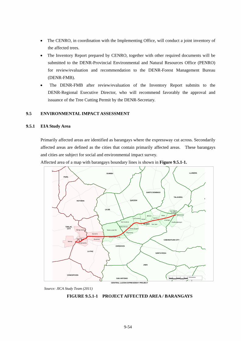
9-54
The CENRO, in coordination with the Implementing Office, will conduct a joint inventory of
the affected trees.
The Inventory Report prepared by CENRO, together with other required documents will be
submitted to the DENR-Provincial Environmental and Natural Resources Office (PENRO)
for review/evaluation and recommendation to the DENR-Forest Management Bureau
(DENR-FMB).
The DENR-FMB after review/evaluation of the Inventory Report submits to the
DENR-Regional Executive Director, who will recommend favorably the approval and
issuance of the Tree Cutting Permit by the DENR-Secretary.
9.5 ENVIRONMENTAL IMPACT ASSESSMENT
9.5.1 EIA Study Area
Primarily affected areas are identified as barangays where the expressway cut across. Secondarily
affected areas are defined as the cities that contain primarily affected areas. These barangays
and cities are subject for social and environmental impact survey.
Affected area of a map with barangays boundary lines is shown in Figure 9.5.1-1.
Guevarra
Santa Lucia Old
San Eustacio
Bibiclat Betes
Umangan
Caalibangbangan
San Juan
PantocLa Purisima
San Miguel na Munti
Dalampang
Sunson
Balingcanaway
ALIAGA
CABANATUAN CITY
SANTA ROSA
ZARAGOZA
LICAB
QUEZON
SANTO DOMINGO
TALAVERA
LA PAZ
VICTORIA
Santa Lucia Young
Santa Monica
Magsaysay
Macalong
Santo Rosario
JAEN
GUIMBA LLANERA
G
SAN ANTONIO
PURA
CONCEPCION
BantogLaungcupang
TARLAC CITY
Amucao
CENTRAL LUZON EXPRESSWAY PROJECT
0 1 2 3 4 5 CentimetersKilometers
Source: JICA Study Team (2011)
FIGURE 9.5.1-1 PROJECT AFFECTED AREA / BARANGAYS
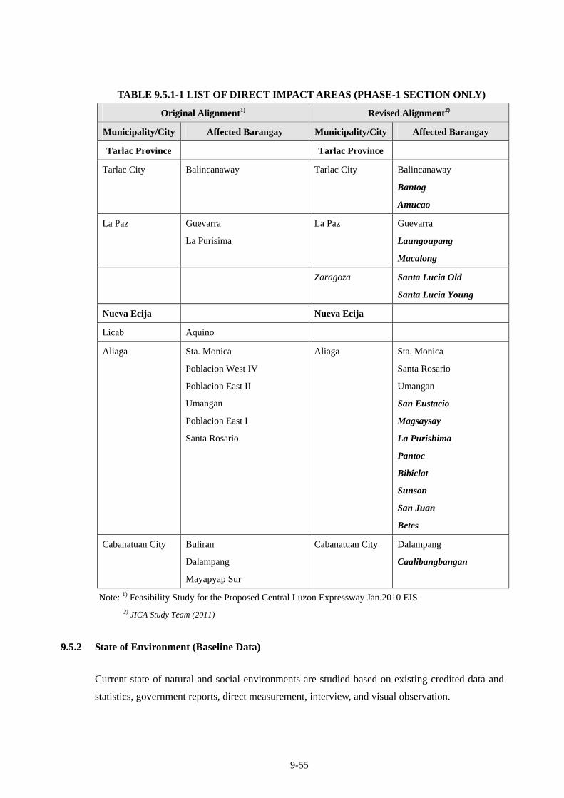
9-55
TABLE 9.5.1-1 LIST OF DIRECT IMPACT AREAS (PHASE-1 SECTION ONLY)
Original Alignment1) Revised Alignment2)
Municipality/City Affected Barangay Municipality/City Affected Barangay
Tarlac Province Tarlac Province
Tarlac City Balincanaway Tarlac City Balincanaway
Bantog
Amucao
La Paz Guevarra
La Purisima
La Paz Guevarra
Laungoupang
Macalong
Zaragoza Santa Lucia Old
Santa Lucia Young
Nueva Ecija Nueva Ecija
Licab Aquino
Aliaga Sta. Monica
Poblacion West IV
Poblacion East II
Umangan
Poblacion East I
Santa Rosario
Aliaga Sta. Monica
Santa Rosario
Umangan
San Eustacio
Magsaysay
La Purishima
Pantoc
Bibiclat
Sunson
San Juan
Betes
Cabanatuan City Buliran
Dalampang
Mayapyap Sur
Cabanatuan City Dalampang
Caalibangbangan
Note: 1) Feasibility Study for the Proposed Central Luzon Expressway Jan.2010 EIS
2) JICA Study Team (2011)
9.5.2 State of Environment (Baseline Data)
Current state of natural and social environments are studied based on existing credited data and
statistics, government reports, direct measurement, interview, and visual observation.
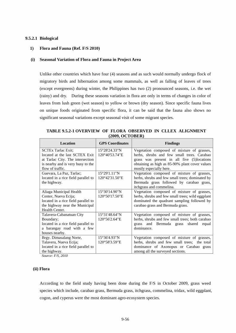
9-56
9.5.2.1 Biological
1) Flora and Fauna (Ref. F/S 2010)
(i) Seasonal Variation of Flora and Fauna in Project Area
Unlike other countries which have four (4) seasons and as such would normally undergo flock of
migratory birds and hibernation among some mammals, as well as falling of leaves of trees
(except evergreens) during winter, the Philippines has two (2) pronounced seasons, i.e. the wet
(rainy) and dry. During these seasons variation in flora are only in terms of changes in color of
leaves from lush green (wet season) to yellow or brown (dry season). Since specific fauna lives
on unique foods originated from specific flora, it can be said that the fauna also shows no
significant seasonal variations except seasonal visit of some migrant species.
TABLE 9.5.2-1 OVERVIEW OF FLORA OBSERVED IN CLLEX ALIGNMENT (2009, OCTOBER)
Location GPS Coordinates Findings
SCTEx Tarlac Exit; located at the last SCTEX Exit at Tarlac City. The intersection is nearby and is very busy to the flow of traffic.
15°28'24.33"N 120°40'53.74"E
Vegetation composed of mixture of grasses, herbs, shrubs and few small trees. Carabao grass was present in all five (5)locations obtaining as high as 85-90% plant cover values mostly especially here.
Guevara, La Paz, Tarlac; located in a rice field parallel to the highway.
15°29'1.11"N 120°42'31.50"E
Vegetation composed of mixture of grasses, herbs, shrubs and few small trees; dominated by Bermuda grass followed by carabao grass, itchgrass and commelina.
Aliaga Municipal Health Center, Nueva Ecija; located in a rice field parallel to the highway near the Municipal Health Center.
15°30'14.90"N 120°50'17.50"E
Vegetation composed of mixture of grasses, herbs, shrubs and few small trees; wild eggplant dominated the quadrant sampling followed by carabao grass and Bermuda grass.
Talavera-Cabanatuan City Boundary; located in a rice field parallel to a barangay road with a few houses nearby.
15°31'48.64"N 120°56'2.64"E
Vegetation composed of mixture of grasses, herbs, shrubs and few small trees; both carabao grass and Bermuda grass shared equal dominance.
Brgy. Dimasalang Norte, Talavera, Nueva Ecija; located in a rice field parallel to the highway.
15°36'4.93"N 120°58'3.59"E
Vegetation composed of mixture of grasses, herbs, shrubs and few small trees; the total dominance of Axonopus or Carabao grass among all the surveyed sections.
Source: F/S, 2010
(ii) Flora
According to the field study having been done during the F/S in October 2009, grass weed
species which include, carabao grass, Bermuda grass, itchgrass, commelina, tridax, wild eggplant,
cogon, and cyperus were the most dominant agro-ecosystem species.
9-57
The present condition of the existing ecosystems in CLLEX area is characterized by relatively
‘very low’ to ‘low’ species diversity and an impaired rates of ecological functioning due primarily
to a lot of human interventions and disturbances as a result of the various land and farming
activities. The proposed Project’s site and its surrounding areas represent a region of ‘low’
ecological significance or importance in terms species diversity. Reconnaissance survey indicates
that species composition, distribution, and density are considered very low since the site is a
highly disturbed agro-ecosystem dominated by food crops and their associated weeds.
Most common such species are as follows: Palay (Oryza sativa), kangkong (Ipomoea aquatica),
banana (Musa sapientum), talahib (Saccharum spontaneum), guinea grass (Panicum maximum),
milkweed (Euphornia hirta), carabao grass (Axonopus compressus), broomweed (Sida acuta),
Bermuda grass (Cynodon dactylon), yardgrass (Eleusine indica), purplenutsedge (Cyperus
rotundus), wild sunflower (Tridax procumbens), wandering jew (Commelina benghalensis),
cogon (Imperata cylindrica) suab-kabayo (Hyptis suaveolens), desmodium (Desmodium
procumbens), and few woody shrubs such as some herbs and vines like sitao (Vigna
sesquepedalis), eggplant (Solanum melongena), makahiya (Mimosa pudica), mikania (Mikania
cordata), verbena (Stachytarpheta jamaicensis), hagonoy (Chromolaena odorata), synedrella
(Synedrella nodiflora) and a few coconut trees (Cocos nucifera).
Commonly observed fruit and lumber wood trees are as follows: Ipil-ipil (Leucaena
leucocephala), mango (Mangifera indica), guava (Psidium guajava), santol
(Sandoericumkoetjape), kaimito (Chrysophyllum cainito), langka (Artocarpus heterophylla),
kamansi (Artocarpus altilis), narra (Pterocarpus indicus), yemane (Gmelina arborea), aratiles
(Muntigia calabura), Ilang-ilang (Canamga odorata), and kawayang-tinik (Bambusa blumeana).
Most of grasses, shrubs and herbs species that were found at some portions of the vicinity of the
proposed Project site were common and have no significant ecological or commercial value. The
plant species encountered are common, ordinary and widespread in distribution and abundance in
other comparable and related ecosystems all over the Philippines. Considered as indicator plant
species, the observed occurrence of lush growth of pure stands in patches of Chromolaena
odorata, Mikania cordata, and Synedrella nodiflora indicate that the CLLAX alignment area is
highly disturbed ecosystem, most especially by rampant and uncontrolled human intervention.
In short, both qualitative and quantitative vegetation analyses revealed that there are no rare,
threatened and endangered plants species present in the project site. Also, seasonal (dry and wet)
differences are not anticipated.
9-58
(iii) Fauna
From the 51 species surveyed, 17 are birds, 15 are mammals, 9 are insects, 8 are reptiles, and 2
are amphibians. Endemicity of wildlife is moderately high with an approximate value of 78
percents. Most common faunal species encountered, sighted or surveyed during the investigation
were mostly birds. The following are further observations taken from the vicinity:
• According to interviews with local residents of the community there were probably around
seventeen (17) species of birds. The birds present in the area can be classified as either
residents or visitors. The resident birds are those, which live their entire life in the area. Large
numbers of the birds that are not native in the area (and in the country in general) are mostly
regular winter migrants, that is, they come to the Philippines at the onset of the cold season in
the northern parts of Asia and return in the summer months when they breed;
• There are eight (8) reptilian species such as pythons, common snake, turtle, bubuli, bayawak,
monitor lizard and the common house lizard. Some of these reptiles are caught by local
poachers and hunters and consumed as exotic foods;
• The wild mammalian group is represented by seven (7) species including bats and various
kinds of rats;
• There are two (2) species of amphibians encountered i.e. the marine toad and the estuarine
frog;
• The domesticated animals raised by the local community include cattle, cats, dogs, chickens,
goats, carabaos, horses and pigs; and
• Insect species commonly associated with the area like bees, ants, grasshoppers, butterflies,
dragonflies, wasps, mosquitoes, spiders and the common housefly were also observed.
TABLE 9.5.2-2 NUMBERS OF FAUNA SPECIES OBSERVED IN CLLEX ALIGNMENT (2009, OCTOBER)
Source: F/S, 2010
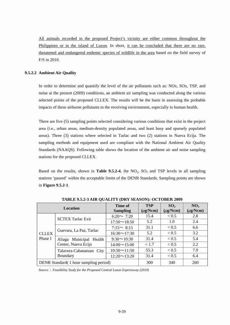
9-59
All animals recorded in the proposed Project’s vicinity are either common throughout the
Philippines or in the island of Luzon. In short, it can be concluded that there are no rare,
threatened and endangered endemic species of wildlife in the area based on the field survey of
F/S in 2010.
9.5.2.2 Ambient Air Quality
In order to determine and quantify the level of the air pollutants such as: NOx, SOx, TSP, and
noise at the present (2009) conditions, an ambient air sampling was conducted along the various
selected points of the proposed CLLEX. The results will be the basis in assessing the probable
impacts of these airborne pollutants to the receiving environment, especially to human health.
There are five (5) sampling points selected considering various conditions that exist in the project
area (i.e., urban areas, medium-density populated areas, and least busy and sparsely populated
areas). Three (3) stations where selected in Tarlac and two (2) stations in Nueva Ecija. The
sampling methods and equipment used are compliant with the National Ambient Air Quality
Standards (NAAQS). Following table shows the location of the ambient air and noise sampling
stations for the proposed CLLEX.
Based on the results, shown in Table 9.5.2-4, the NO2, SO2 and TSP levels in all sampling
stations ‘passed’ within the acceptable limits of the DENR Standards. Sampling points are shown
in Figure 9.5.2-1.
TABLE 9.5.2-3 AIR QUALITY (DRY SEASON): OCTOBER 2009
Location Time of
Sampling TSP
(μg/Ncm)SO2
(μg/Ncm) NO2
(μg/Ncm) 6:20~ 7:20 15.4 < 0.5 2.8
SCTEX Tarlac Exit 17:50~18:50 5.2 1.0 2.4
7:15~ 8:15 31.1 < 0.5 6.6 Guevara, La Paz, Tarlac
16:30~17:30 5.2 < 0.5 3.2
9:30~10:30 31.4 < 0.5 5.4 Aliaga Municipal Health Center, Nueva Ecija 14:00~15:00 < 1.7 < 0.5 2.2
10:50~11:50 55.3 < 0.5 7.9
CLLEX Phase I
Talavera-Cabanatuan City Boundary 12:20~13:20 31.4 < 0.5 6.4
DENR Standard( 1 hour sampling period) 300 340 260
Source:Feasibility Study for the Proposed Central Luzon Expressway (2010)
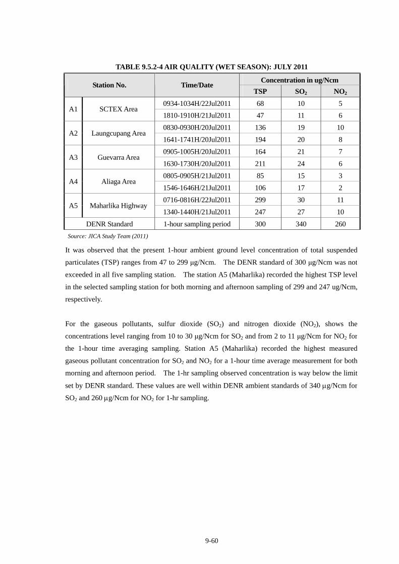
9-60
TABLE 9.5.2-4 AIR QUALITY (WET SEASON): JULY 2011
Concentration in ug/Ncm Station No. Time/Date
TSP SO2 NO2
0934-1034H/22Jul2011 68 10 5 A1 SCTEX Area
1810-1910H/21Jul2011 47 11 6
0830-0930H/20Jul2011 136 19 10 A2 Laungcupang Area
1641-1741H/20Jul2011 194 20 8
0905-1005H/20Jul2011 164 21 7 A3 Guevarra Area
1630-1730H/20Jul2011 211 24 6
0805-0905H/21Jul2011 85 15 3 A4 Aliaga Area
1546-1646H/21Jul2011 106 17 2
0716-0816H/22Jul2011 299 30 11 A5 Maharlika Highway
1340-1440H/21Jul2011 247 27 10
DENR Standard 1-hour sampling period 300 340 260
Source: JICA Study Team (2011)
It was observed that the present 1-hour ambient ground level concentration of total suspended
particulates (TSP) ranges from 47 to 299 μg/Ncm. The DENR standard of 300 μg/Ncm was not
exceeded in all five sampling station. The station A5 (Maharlika) recorded the highest TSP level
in the selected sampling station for both morning and afternoon sampling of 299 and 247 ug/Ncm,
respectively.
For the gaseous pollutants, sulfur dioxide (SO2) and nitrogen dioxide (NO2), shows the
concentrations level ranging from 10 to 30 μg/Ncm for SO2 and from 2 to 11 μg/Ncm for NO2 for
the 1-hour time averaging sampling. Station A5 (Maharlika) recorded the highest measured
gaseous pollutant concentration for SO2 and NO2 for a 1-hour time average measurement for both
morning and afternoon period. The 1-hr sampling observed concentration is way below the limit
set by DENR standard. These values are well within DENR ambient standards of 340 g/Ncm for
SO2 and 260 g/Ncm for NO2 for 1-hr sampling.
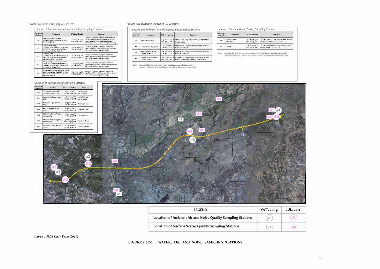
9-61
Source:JICA Study Team (2011)
FIGURE 9.5.2-1 WATER, AIR, AND NOISE SAMPLING STATIONS
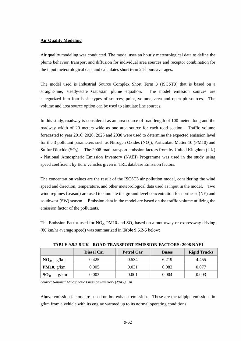
9-62
Air Quality Modeling
Air quality modeling was conducted. The model uses an hourly meteorological data to define the
plume behavior, transport and diffusion for individual area sources and receptor combination for
the input meteorological data and calculates short term 24-hours averages.
The model used is Industrial Source Complex Short Term 3 (ISCST3) that is based on a
straight-line, steady-state Gaussian plume equation. The model emission sources are
categorized into four basic types of sources, point, volume, area and open pit sources. The
volume and area source option can be used to simulate line sources.
In this study, roadway is considered as an area source of road length of 100 meters long and the
roadway width of 20 meters wide as one area source for each road section. Traffic volume
forecasted to year 2016, 2020, 2025 and 2030 were used to determine the expected emission level
for the 3 pollutant parameters such as Nitrogen Oxides (NO2), Particulate Matter 10 (PM10) and
Sulfur Dioxide (SO2). The 2008 road transport emission factors from by United Kingdom (UK)
- National Atmospheric Emission Inventory (NAEI) Programme was used in the study using
speed coefficient by Euro vehicles given in TRL database Emission factors.
The concentration values are the result of the ISCST3 air pollution model, considering the wind
speed and direction, temperature, and other meteorological data used as input in the model. Two
wind regimes (season) are used to simulate the ground level concentration for northeast (NE) and
southwest (SW) season. Emission data in the model are based on the traffic volume utilizing the
emission factor of the pollutants.
The Emission Factor used for NO2, PM10 and SO2 based on a motorway or expressway driving
(80 km/hr average speed) was summarized in Table 9.5.2-5 below:
TABLE 9.5.2-5 UK - ROAD TRANSPORT EMISSION FACTORS: 2008 NAEI
Diesel Car Petrol Car Buses Rigid Trucks
NO2, g/km 0.425 0.534 6.219 4.455
PM10, g/km 0.005 0.031 0.083 0.077
SO2, g/km 0.003 0.001 0.004 0.003
Source: National Atmospheric Emission Inventory (NAEI), UK
Above emission factors are based on hot exhaust emission. These are the tailpipe emissions in
g/km from a vehicle with its engine warmed up to its normal operating conditions.
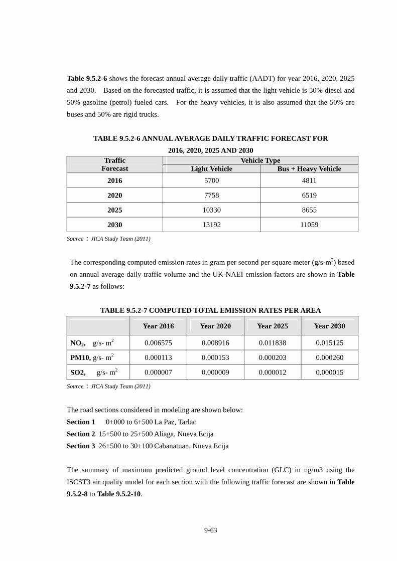
9-63
Table 9.5.2-6 shows the forecast annual average daily traffic (AADT) for year 2016, 2020, 2025
and 2030. Based on the forecasted traffic, it is assumed that the light vehicle is 50% diesel and
50% gasoline (petrol) fueled cars. For the heavy vehicles, it is also assumed that the 50% are
buses and 50% are rigid trucks.
TABLE 9.5.2-6 ANNUAL AVERAGE DAILY TRAFFIC FORECAST FOR
2016, 2020, 2025 AND 2030 Vehicle Type Traffic
Forecast Light Vehicle Bus + Heavy Vehicle
2016 5700 4811
2020 7758 6519
2025 10330 8655
2030 13192 11059
Source:JICA Study Team (2011)
The corresponding computed emission rates in gram per second per square meter (g/s-m2) based
on annual average daily traffic volume and the UK-NAEI emission factors are shown in Table
9.5.2-7 as follows:
TABLE 9.5.2-7 COMPUTED TOTAL EMISSION RATES PER AREA
Year 2016 Year 2020 Year 2025 Year 2030
NO2, g/s- m2 0.006575 0.008916 0.011838 0.015125
PM10, g/s- m2 0.000113 0.000153 0.000203 0.000260
SO2, g/s- m2 0.000007 0.000009 0.000012 0.000015
Source:JICA Study Team (2011)
The road sections considered in modeling are shown below:
Section 1 0+000 to 6+500 La Paz, Tarlac
Section 2 15+500 to 25+500 Aliaga, Nueva Ecija
Section 3 26+500 to 30+100 Cabanatuan, Nueva Ecija
The summary of maximum predicted ground level concentration (GLC) in ug/m3 using the
ISCST3 air quality model for each section with the following traffic forecast are shown in Table
9.5.2-8 to Table 9.5.2-10.
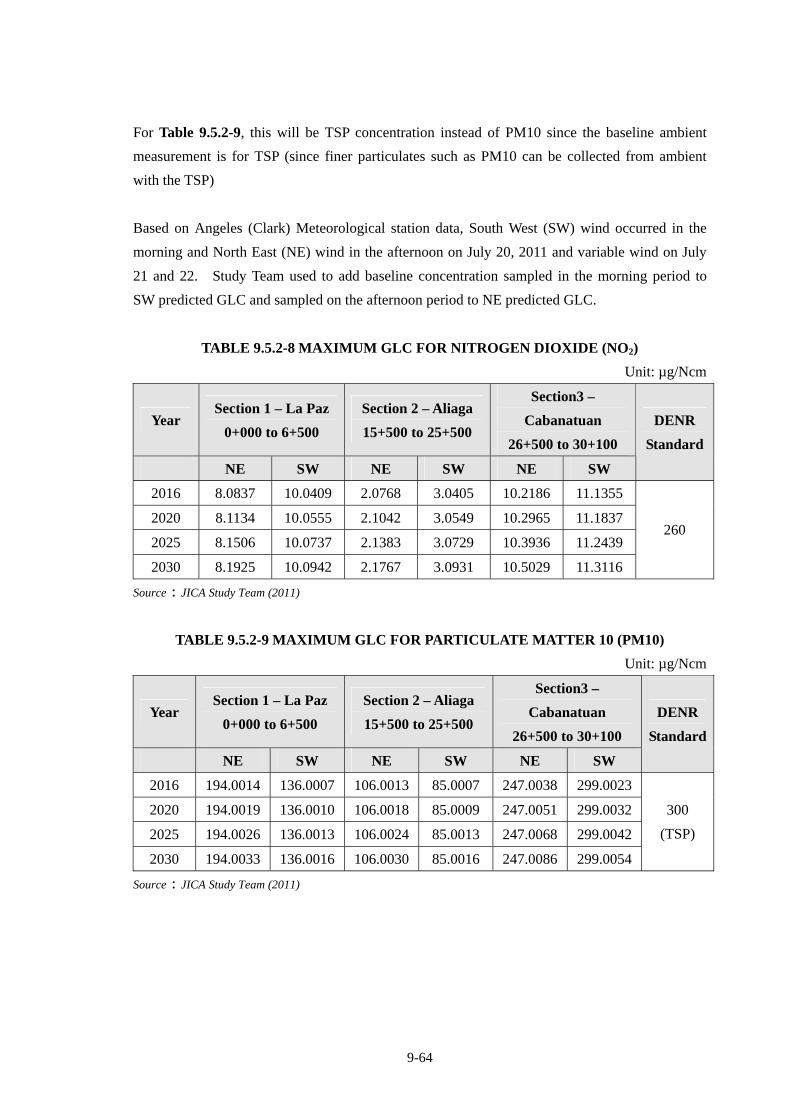
9-64
For Table 9.5.2-9, this will be TSP concentration instead of PM10 since the baseline ambient
measurement is for TSP (since finer particulates such as PM10 can be collected from ambient
with the TSP)
Based on Angeles (Clark) Meteorological station data, South West (SW) wind occurred in the
morning and North East (NE) wind in the afternoon on July 20, 2011 and variable wind on July
21 and 22. Study Team used to add baseline concentration sampled in the morning period to
SW predicted GLC and sampled on the afternoon period to NE predicted GLC.
TABLE 9.5.2-8 MAXIMUM GLC FOR NITROGEN DIOXIDE (NO2)
Unit: µg/Ncm
Year Section 1 – La Paz
0+000 to 6+500
Section 2 – Aliaga
15+500 to 25+500
Section3 –
Cabanatuan
26+500 to 30+100
NE SW NE SW NE SW
DENR
Standard
2016 8.0837 10.0409 2.0768 3.0405 10.2186 11.1355
2020 8.1134 10.0555 2.1042 3.0549 10.2965 11.1837
2025 8.1506 10.0737 2.1383 3.0729 10.3936 11.2439
2030 8.1925 10.0942 2.1767 3.0931 10.5029 11.3116
260
Source:JICA Study Team (2011)
TABLE 9.5.2-9 MAXIMUM GLC FOR PARTICULATE MATTER 10 (PM10)
Unit: µg/Ncm
Year Section 1 – La Paz
0+000 to 6+500
Section 2 – Aliaga
15+500 to 25+500
Section3 –
Cabanatuan
26+500 to 30+100
NE SW NE SW NE SW
DENR
Standard
2016 194.0014 136.0007 106.0013 85.0007 247.0038 299.0023
2020 194.0019 136.0010 106.0018 85.0009 247.0051 299.0032
2025 194.0026 136.0013 106.0024 85.0013 247.0068 299.0042
2030 194.0033 136.0016 106.0030 85.0016 247.0086 299.0054
300
(TSP)
Source:JICA Study Team (2011)
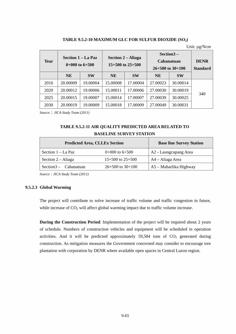
9-65
TABLE 9.5.2-10 MAXIMUM GLC FOR SULFUR DIOXIDE (SO2)
Unit: µg/Ncm
Year Section 1 – La Paz
0+000 to 6+500
Section 2 – Aliaga
15+500 to 25+500
Section3 –
Cabanatuan
26+500 to 30+100
NE SW NE SW NE SW
DENR
Standard
2016 20.00009 19.00004 15.00008 17.00004 27.00023 30.00014
2020 20.00012 19.00006 15.00011 17.00006 27.00030 30.00019
2025 20.00015 19.00007 15.00014 17.00007 27.00039 30.00025
2030 20.00019 19.00009 15.00018 17.00009 27.00049 30.00031
340
Source:JICA Study Team (2011)
TABLE 9.5.2-11 AIR QUALITY PREDICTED AREA RELATED TO
BASELINE SURVEY STATION
Predicted Area, CLLEx Section Base line Survey Station
Section 1 – La Paz 0+000 to 6+500 A2 - Laungcupang Area
Section 2 – Aliaga 15+500 to 25+500 A4 – Aliaga Area
Section3 – Cabanatuan 26+500 to 30+100 A5 – Maharlika Highway
Source:JICA Study Team (2011)
9.5.2.3 Global Warming
The project will contribute to solve increase of traffic volume and traffic congestion in future,
while increase of CO2 will affect global warming impact due to traffic volume increase.
During the Construction Period: Implementation of the project will be required about 2 years
of schedule. Numbers of construction vehicles and equipment will be scheduled in operation
activities. And it will be predicted approximately 59,584 tons of CO2 generated during
construction. As mitigation measures the Government concerned may consider to encourage tree
plantation with corporation by DENR where available open spaces in Central Luzon region.
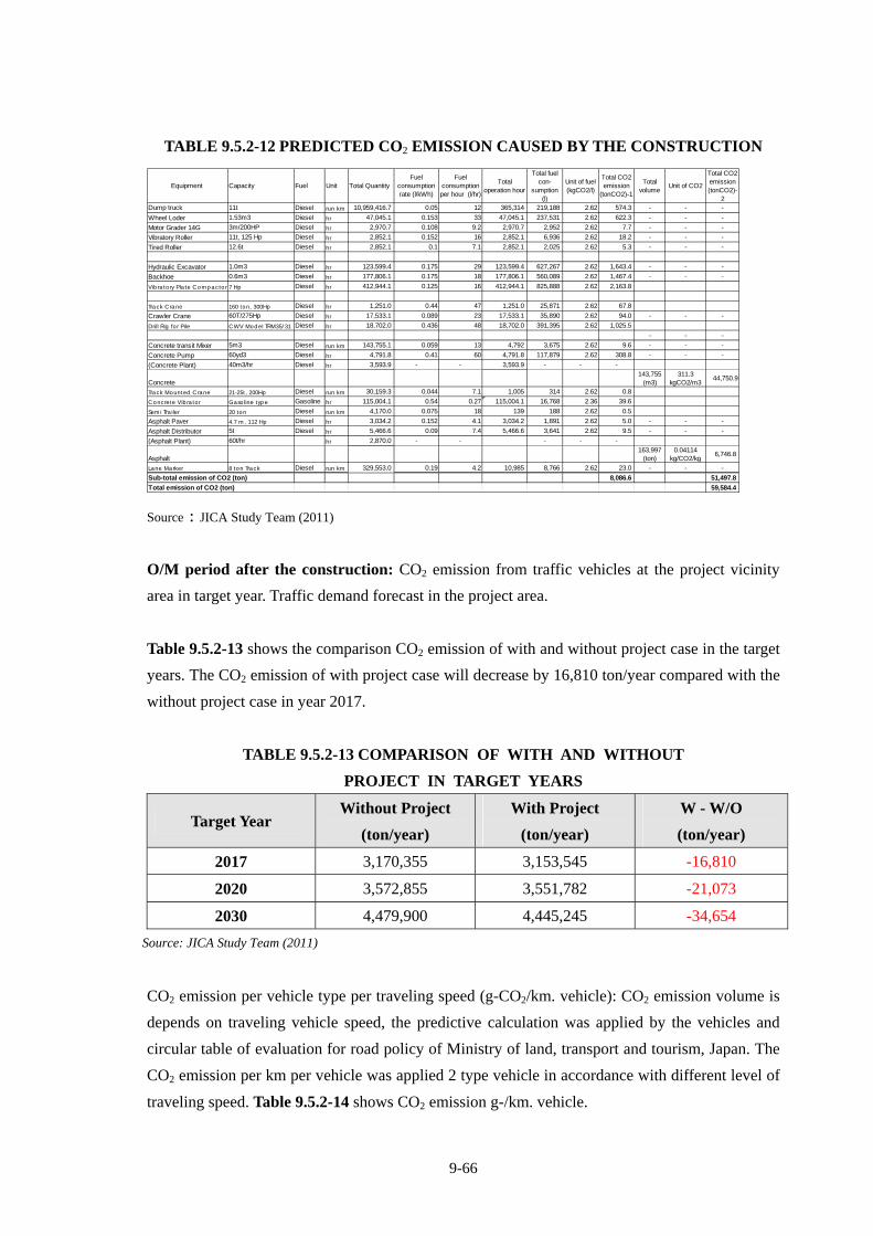
9-66
TABLE 9.5.2-12 PREDICTED CO2 EMISSION CAUSED BY THE CONSTRUCTION
Equipment Capacity Fuel Unit Total QuantityFuel
consumptionrate (l/kWh)
Fuelconsumptionper hour (l/hr)
Totaloperation hour
Total fuelcon-
sumption(l)
Unit of fuel(kgCO2/l)
Total CO2emission
(tonCO2)-1
Totalvolume
Unit of CO2
Total CO2emission(tonCO2)-
2Dump truck 11t Diesel run km 10,959,416.7 0.05 12 365,314 219,188 2.62 574.3 - - -
Wheel Loder 1.53m3 Diesel hr 47,045.1 0.153 33 47,045.1 237,531 2.62 622.3 - - -
Motor Grader 14G 3m/200HP Diesel hr 2,970.7 0.108 9.2 2,970.7 2,952 2.62 7.7 - - -
Vibratory Roller 11t, 125 Hp Diesel hr 2,852.1 0.152 16 2,852.1 6,936 2.62 18.2 - - -
Tired Roller 12.6t Diesel hr 2,852.1 0.1 7.1 2,852.1 2,025 2.62 5.3 - - -
Hydraulic Excavator 1.0m3 Diesel hr 123,599.4 0.175 29 123,599.4 627,267 2.62 1,643.4 - - -
Backhoe 0.6m3 Diesel hr 177,806.1 0.175 18 177,806.1 560,089 2.62 1,467.4 - - -
Vibratory Plate Compactor 7 Hp Diesel hr 412,944.1 0.125 16 412,944.1 825,888 2.62 2,163.8
Track Crane 160 ton, 300Hp Diesel hr 1,251.0 0.44 47 1,251.0 25,871 2.62 67.8
Crawler Crane 60T/275Hp Diesel hr 17,533.1 0.089 23 17,533.1 35,890 2.62 94.0 - - -
Drill Rig for Pile CWV Model TRM35/31 Diesel hr 18,702.0 0.436 48 18,702.0 391,395 2.62 1,025.5
- - -
Concrete transit Mixer 5m3 Diesel run km 143,755.1 0.059 13 4,792 3,675 2.62 9.6 - - -
Concrete Pump 60yd3 Diesel hr 4,791.8 0.41 60 4,791.8 117,879 2.62 308.8 - - -
(Concrete Plant) 40m3/hr Diesel hr 3,593.9 - - 3,593.9 - - -
Concrete143,755
(m3)311.3
kgCO2/m344,750.9
Track Mounted Crane 21-25t, 200Hp Diesel run km 30,159.3 0.044 7.1 1,005 314 2.62 0.8
Concrete Vibrator Gasoline type Gasoline hr 115,004.1 0.54 0.27 115,004.1 16,768 2.36 39.6
Semi Trailer 20 ton Diesel run km 4,170.0 0.075 18 139 188 2.62 0.5
Asphalt Paver 4.7 m, 112 Hp Diesel hr 3,034.2 0.152 4.1 3,034.2 1,891 2.62 5.0 - - -
Asphalt Distributor 5t Diesel hr 5,466.6 0.09 7.4 5,466.6 3,641 2.62 9.5 - - -
(Asphalt Plant) 60t/hr hr 2,870.0 - - - - -
Asphalt163,997
(ton)0.04114
kg/CO2/kg6,746.8
Lane Marker 8 ton Track Diesel run km 329,553.0 0.19 4.2 10,985 8,766 2.62 23.0 - - -
Sub-total emission of CO2 (ton) 8,086.6 51,497.8
Total emission of CO2 (ton) 59,584.4
Source:JICA Study Team (2011)
O/M period after the construction: CO2 emission from traffic vehicles at the project vicinity
area in target year. Traffic demand forecast in the project area.
Table 9.5.2-13 shows the comparison CO2 emission of with and without project case in the target
years. The CO2 emission of with project case will decrease by 16,810 ton/year compared with the
without project case in year 2017.
TABLE 9.5.2-13 COMPARISON OF WITH AND WITHOUT
PROJECT IN TARGET YEARS
Target Year Without Project
(ton/year)
With Project
(ton/year)
W - W/O
(ton/year)
2017 3,170,355 3,153,545 -16,810
2020 3,572,855 3,551,782 -21,073
2030 4,479,900 4,445,245 -34,654
Source: JICA Study Team (2011)
CO2 emission per vehicle type per traveling speed (g-CO2/km. vehicle): CO2 emission volume is
depends on traveling vehicle speed, the predictive calculation was applied by the vehicles and
circular table of evaluation for road policy of Ministry of land, transport and tourism, Japan. The
CO2 emission per km per vehicle was applied 2 type vehicle in accordance with different level of
traveling speed. Table 9.5.2-14 shows CO2 emission g-/km. vehicle.
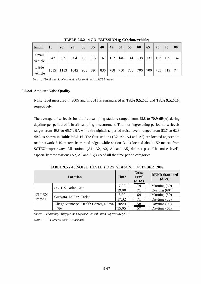
9-67
TABLE 9.5.2-14 CO2 EMISSION (g-CO2/km. vehicle)
km/hr 10 20 25 30 35 40 45 50 55 60 65 70 75 80
Small
vehicle 342 229 204 186 172 161 152 146 141 138 137 137 139 142
Large
vehicle 1515 1133 1042 963 894 836 788 750 723 706 700 705 719 744
Source: Circular table of evaluation for road policy. MTLT Japan
9.5.2.4 Ambient Noise Quality
Noise level measured in 2009 and in 2011 is summarized in Table 9.5.2-15 and Table 9.5.2-16,
respectively.
The average noise levels for the five sampling stations ranged from 48.8 to 70.9 dB(A) during
daytime per period of 1-hr air sampling measurement. The morning/evening period noise levels
ranges from 49.8 to 65.7 dBA while the nighttime period noise levels ranged from 53.7 to 62.3
dBA as shown in Table 9.5.2-16. The four stations (A2, A3, A4 and A5) are located adjacent to
road network 5-10 meters from road edges while station A1 is located about 150 meters from
SCTEX expressway. All stations (A1, A2, A3, A4 and A5) did not pass “the noise level”,
especially three stations (A2, A3 and A5) exceed all the time period categories.
TABLE 9.5.2-15 NOISE LEVEL ( DRY SEASON): OCTOBER 2009
Location TimeNoise Level (dBA)
DENR Standard (dBA)
7:20 79 Morning (60) SCTEX Tarlac Exit
19:00 71 Evening (60) 8:20 69 Morning (50)
Guevara, La Paz, Tarlac 17:32 71 Daytime (55) 10:23 58 Daytime (50)
CLLEX Phase I
Aliaga Municipal Health Center, Nueva Ecija 15:05 57 Daytime (50)
Source:Feasibility Study for the Proposed Central Luzon Expressway (2010)
Note: exceeds DENR Standard
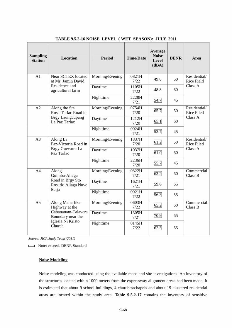
9-68
TABLE 9.5.2-16 NOISE LEVEL ( WET SEASON): JULY 2011
Sampling Station Location Period Time/Date
Average Noise Level (dBA)
DENR Area
Morning/Evening 0821H 7/22 49.8 50
Daytime 1105H 7/22 48.8 60
A1 Near SCTEX located at Mr. Jamin David Residence and agricultural farm
Nighttime 2228H 7/21 54.7 45
Residential/ Rice Field Class A
Morning/Evening 0754H 7/20 65.7 50
Daytime 1212H 7/20 65.1 60
A2 Along the Sta Rosa-Tarlac Road in Brgy Laungcupang La Paz Tarlac
Nighttime 0024H 7/21 53.7 45
Residential/ Rice Filed Class A
Morning/Evening 1837H 7/20 61.2 50
Daytime 1037H 7/20 61.0 60
A3 Along La Paz-Victoria Road in Brgy Guevarra La Paz Tarlac
Nighttime 2236H 7/20 55.7 45
Residential/ Rice Filed Class A
Morning/Evening 0822H 7/21 63.2 60
Daytime 1621H 7/21 59.6 65
A4 Along Guimba-Aliaga Road in Brgy Sto Rosario Aliaga Nuve Ecija Nighttime 0021H
7/22 56.3 55
CommercialClass B
Morning/Evening 0603H 7/22 65.2 60
Daytime 1305H 7/21 70.9 65
A5 Along Maharlika Highway at the Cabanatuan-Talavera Boundary near the Iglesia Ni Kristo Church
Nighttime 0145H 7/22 62.3 55
CommercialClass B
Source: JICA Study Team (2011)
Note: exceeds DENR Standard
Noise Modeling
Noise modeling was conducted using the available maps and site investigations. An inventory of
the structures located within 1000 meters from the expressway alignment areas had been made. It
is estimated that about 9 school buildings, 4 churches/chapels and about 19 clustered residential
areas are located within the study area. Table 9.5.2-17 contains the inventory of sensitive
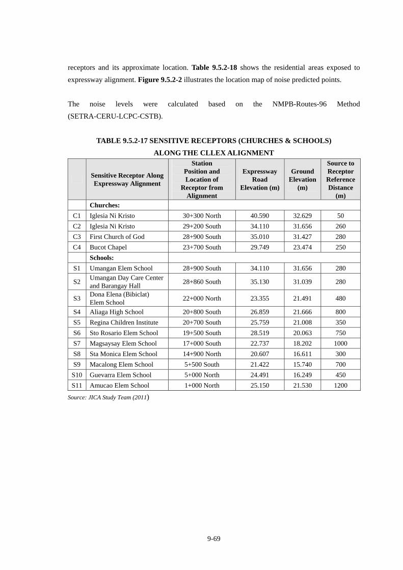
9-69
receptors and its approximate location. Table 9.5.2-18 shows the residential areas exposed to
expressway alignment. Figure 9.5.2-2 illustrates the location map of noise predicted points.
The noise levels were calculated based on the NMPB-Routes-96 Method
(SETRA-CERU-LCPC-CSTB).
TABLE 9.5.2-17 SENSITIVE RECEPTORS (CHURCHES & SCHOOLS)
ALONG THE CLLEX ALIGNMENT
Sensitive Receptor Along Expressway Alignment
Station Position and Location of
Receptor from Alignment
Expressway Road
Elevation (m)
Ground Elevation
(m)
Source to Receptor Reference Distance
(m) Churches:
C1 Iglesia Ni Kristo 30+300 North 40.590 32.629 50
C2 Iglesia Ni Kristo 29+200 South 34.110 31.656 260
C3 First Church of God 28+900 South 35.010 31.427 280
C4 Bucot Chapel 23+700 South 29.749 23.474 250
Schools:
S1 Umangan Elem School 28+900 South 34.110 31.656 280
S2 Umangan Day Care Center and Barangay Hall
28+860 South 35.130 31.039 280
S3 Dona Elena (Bibiclat) Elem School
22+000 North 23.355 21.491 480
S4 Aliaga High School 20+800 South 26.859 21.666 800
S5 Regina Children Institute 20+700 South 25.759 21.008 350
S6 Sto Rosario Elem School 19+500 South 28.519 20.063 750
S7 Magsaysay Elem School 17+000 South 22.737 18.202 1000
S8 Sta Monica Elem School 14+900 North 20.607 16.611 300
S9 Macalong Elem School 5+500 South 21.422 15.740 700
S10 Guevarra Elem School 5+000 North 24.491 16.249 450
S11 Amucao Elem School 1+000 North 25.150 21.530 1200
Source: JICA Study Team (2011)
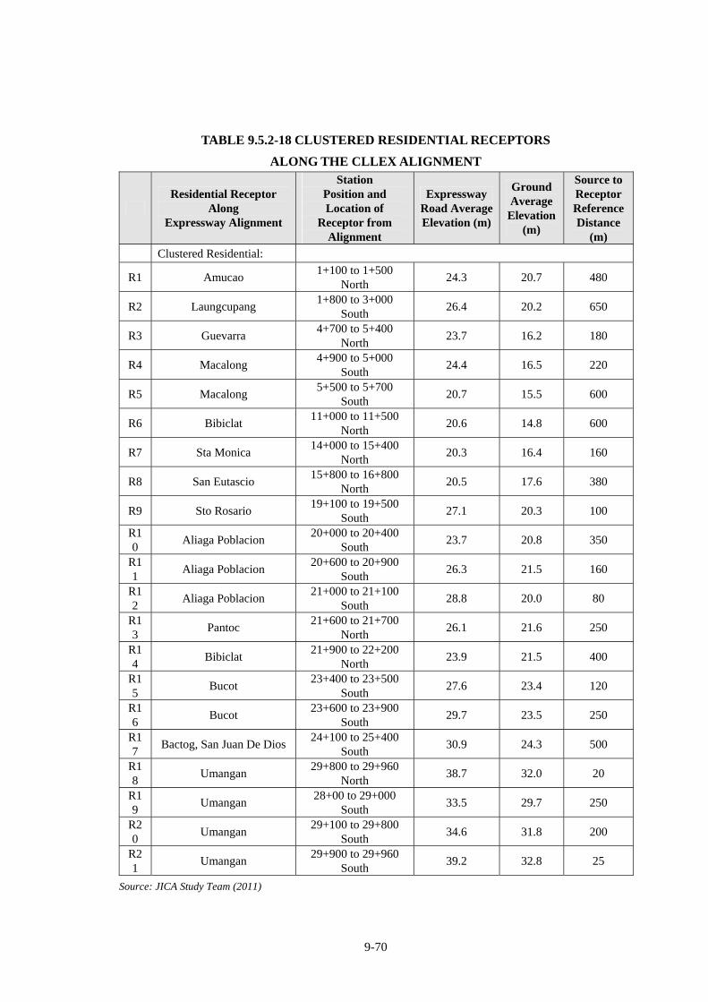
9-70
TABLE 9.5.2-18 CLUSTERED RESIDENTIAL RECEPTORS
ALONG THE CLLEX ALIGNMENT
Residential Receptor
Along Expressway Alignment
Station Position and Location of
Receptor from Alignment
Expressway Road AverageElevation (m)
Ground Average
Elevation (m)
Source to Receptor Reference Distance
(m) Clustered Residential:
R1 Amucao 1+100 to 1+500
North 24.3 20.7 480
R2 Laungcupang 1+800 to 3+000
South 26.4 20.2 650
R3 Guevarra 4+700 to 5+400
North 23.7 16.2 180
R4 Macalong 4+900 to 5+000
South 24.4 16.5 220
R5 Macalong 5+500 to 5+700
South 20.7 15.5 600
R6 Bibiclat 11+000 to 11+500
North 20.6 14.8 600
R7 Sta Monica 14+000 to 15+400
North 20.3 16.4 160
R8 San Eutascio 15+800 to 16+800
North 20.5 17.6 380
R9 Sto Rosario 19+100 to 19+500
South 27.1 20.3 100
R10
Aliaga Poblacion 20+000 to 20+400
South 23.7 20.8 350
R11
Aliaga Poblacion 20+600 to 20+900
South 26.3 21.5 160
R12
Aliaga Poblacion 21+000 to 21+100
South 28.8 20.0 80
R13
Pantoc 21+600 to 21+700
North 26.1 21.6 250
R14
Bibiclat 21+900 to 22+200
North 23.9 21.5 400
R15
Bucot 23+400 to 23+500
South 27.6 23.4 120
R16
Bucot 23+600 to 23+900
South 29.7 23.5 250
R17
Bactog, San Juan De Dios 24+100 to 25+400
South 30.9 24.3 500
R18
Umangan 29+800 to 29+960
North 38.7 32.0 20
R19
Umangan 28+00 to 29+000
South 33.5 29.7 250
R20
Umangan 29+100 to 29+800
South 34.6 31.8 200
R21
Umangan 29+900 to 29+960
South 39.2 32.8 25
Source: JICA Study Team (2011)
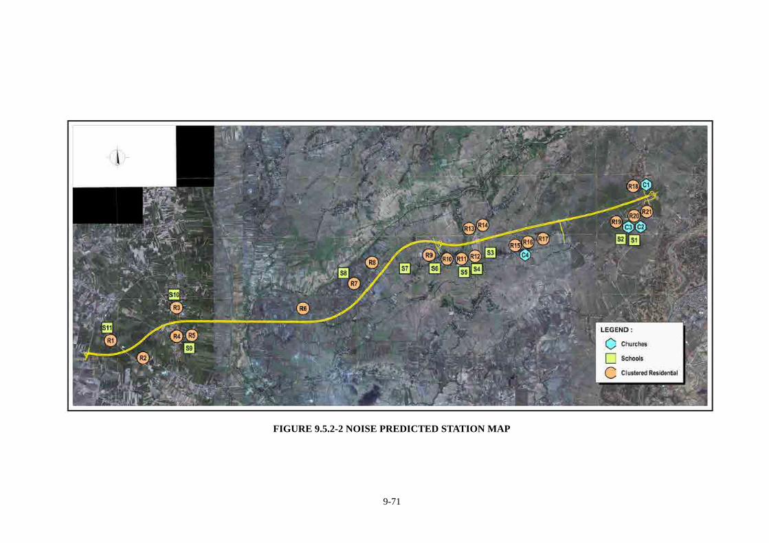
9-71
FIGURE 9.5.2-2 NOISE PREDICTED STATION MAP
9-72
Result of Noise Modeling The Sensitive Redecorators (Church and Schools) The resulting noise levels that reach the sensitive receptors areas yield levels that are mostly non-compliant to Philippine noise standard for nighttime and daytime, all the maximum noise levels during the daytime and nighttime exceeds the maximum threshold at 50 dB(A) and 40 dB(A) respectively. The maximum noise level station is Iglesia ni Cristo in Cabanatuan City (C1, 30+300 North) which is expected to be generated 70.3 dBA during daytime and 66.7 dBA during nighttime in year 2018 (see Table 9.5.2-19). This station will be necessary to install noise barrier. The Clustered Residential For residential areas, the resulting noise levels forecasted on year 2018 ranges from 57.2 to 74.5 dBA during daytime period and from 54.1 to 71.0 dBA for nighttime period (see Table 9.5.2-21). The allowable limit for a residential areas Class B category, the daytime limit is 65dBA and nighttime limit is 55 dBA. The higher noise level stations are shown as follows: R9 Sto Rosario 19+100 to 19+500 South R12 Aliaga Poblacion 21+000 to 21+100 South R18 Umangan 29+800 to 29+960 North R21 Umangan 29+900 to 29+960 South These stations will be necessary to install noise barriers. Table 9.5.2-23 shows the noise reduction from noise barriers height as reference.
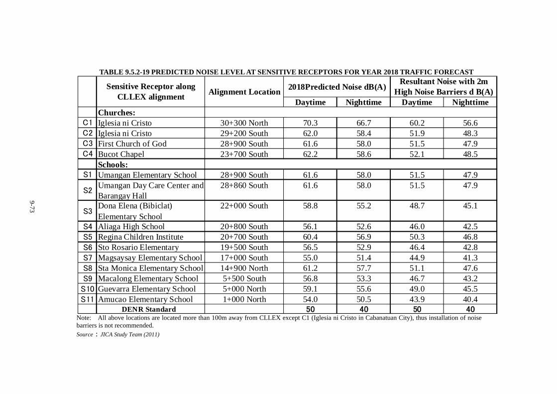
9-73
TABLE 9.5.2-19 PREDICTED NOISE LEVEL AT SENSITIVE RECEPTORS FOR YEAR 2018 TRAFFIC FORECAST
Daytime Nighttime Daytime NighttimeChurches:
C1 Iglesia ni Cristo 30+300 North 70.3 66.7 60.2 56.6C2 Iglesia ni Cristo 29+200 South 62.0 58.4 51.9 48.3C3 First Church of God 28+900 South 61.6 58.0 51.5 47.9C4 Bucot Chapel 23+700 South 62.2 58.6 52.1 48.5
Schools:S1 Umangan Elementary School 28+900 South 61.6 58.0 51.5 47.9
S2Umangan Day Care Center andBarangay Hall
28+860 South 61.6 58.0 51.5 47.9
S3Dona Elena (Bibiclat)Elementary School
22+000 South 58.8 55.2 48.7 45.1
S4 Aliaga High School 20+800 South 56.1 52.6 46.0 42.5S5 Regina Children Institute 20+700 South 60.4 56.9 50.3 46.8S6 Sto Rosario Elementary 19+500 South 56.5 52.9 46.4 42.8S7 Magsaysay Elementary School 17+000 South 55.0 51.4 44.9 41.3S8 Sta Monica Elementary School 14+900 North 61.2 57.7 51.1 47.6S9 Macalong Elementary School 5+500 South 56.8 53.3 46.7 43.2S10 Guevarra Elementary School 5+000 North 59.1 55.6 49.0 45.5S11 Amucao Elementary School 1+000 North 54.0 50.5 43.9 40.4
DENR Standard 50 40 50 40
Sensitive Receptor alongCLLEX alignment
Alignment Location2018Predicted Noise dB(A)
Resultant Noise with 2mHigh Noise Barriers d B(A)
Note: All above locations are located more than 100m away from CLLEX except C1 (Iglesia ni Cristo in Cabanatuan City), thus installation of noise barriers is not recommended. Source:JICA Study Team (2011)
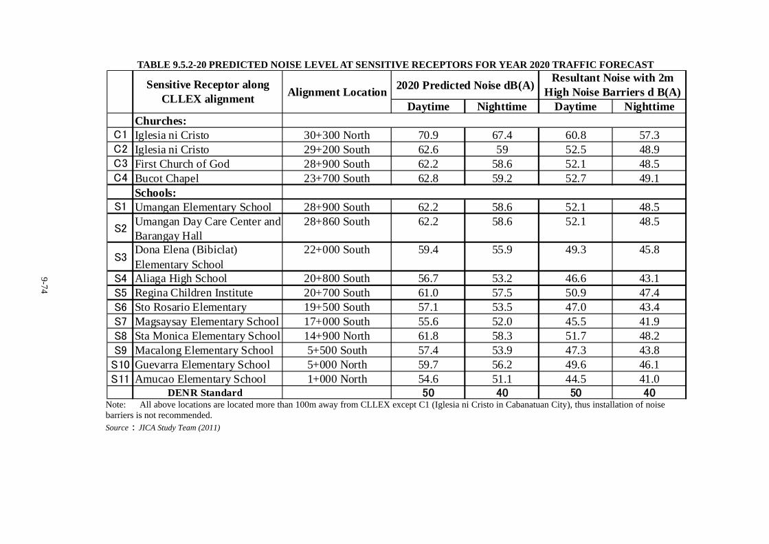
9-74
TABLE 9.5.2-20 PREDICTED NOISE LEVEL AT SENSITIVE RECEPTORS FOR YEAR 2020 TRAFFIC FORECAST
Daytime Nighttime Daytime NighttimeChurches:
C1 Iglesia ni Cristo 30+300 North 70.9 67.4 60.8 57.3C2 Iglesia ni Cristo 29+200 South 62.6 59 52.5 48.9C3 First Church of God 28+900 South 62.2 58.6 52.1 48.5C4 Bucot Chapel 23+700 South 62.8 59.2 52.7 49.1
Schools:S1 Umangan Elementary School 28+900 South 62.2 58.6 52.1 48.5
S2Umangan Day Care Center andBarangay Hall
28+860 South 62.2 58.6 52.1 48.5
S3Dona Elena (Bibiclat)Elementary School
22+000 South 59.4 55.9 49.3 45.8
S4 Aliaga High School 20+800 South 56.7 53.2 46.6 43.1S5 Regina Children Institute 20+700 South 61.0 57.5 50.9 47.4S6 Sto Rosario Elementary 19+500 South 57.1 53.5 47.0 43.4S7 Magsaysay Elementary School 17+000 South 55.6 52.0 45.5 41.9S8 Sta Monica Elementary School 14+900 North 61.8 58.3 51.7 48.2S9 Macalong Elementary School 5+500 South 57.4 53.9 47.3 43.8S10 Guevarra Elementary School 5+000 North 59.7 56.2 49.6 46.1S11 Amucao Elementary School 1+000 North 54.6 51.1 44.5 41.0
DENR Standard 50 40 50 40
Sensitive Receptor alongCLLEX alignment
Alignment Location2020 Predicted Noise dB(A)
Resultant Noise with 2mHigh Noise Barriers d B(A)
Note: All above locations are located more than 100m away from CLLEX except C1 (Iglesia ni Cristo in Cabanatuan City), thus installation of noise barriers is not recommended. Source:JICA Study Team (2011)
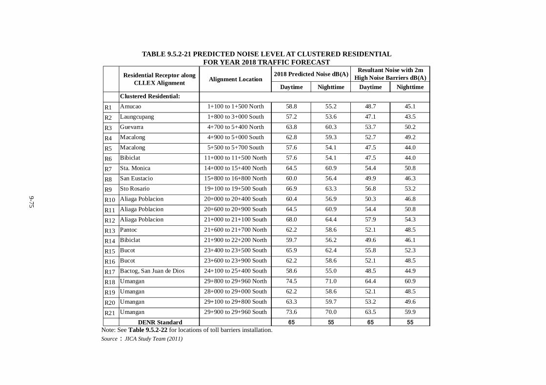
9-75
TABLE 9.5.2-21 PREDICTED NOISE LEVEL AT CLUSTERED RESIDENTIAL
FOR YEAR 2018 TRAFFIC FORECAST
Daytime Nighttime Daytime Nighttime
Clustered Residential:
R1 Amucao 1+100 to 1+500 North 58.8 55.2 48.7 45.1
R2 Laungcupang 1+800 to 3+000 South 57.2 53.6 47.1 43.5
R3 Guevarra 4+700 to 5+400 North 63.8 60.3 53.7 50.2
R4 Macalong 4+900 to 5+000 South 62.8 59.3 52.7 49.2
R5 Macalong 5+500 to 5+700 South 57.6 54.1 47.5 44.0
R6 Bibiclat 11+000 to 11+500 North 57.6 54.1 47.5 44.0
R7 Sta. Monica 14+000 to 15+400 North 64.5 60.9 54.4 50.8
R8 San Eustacio 15+800 to 16+800 North 60.0 56.4 49.9 46.3
R9 Sto Rosario 19+100 to 19+500 South 66.9 63.3 56.8 53.2
R10 Aliaga Poblacion 20+000 to 20+400 South 60.4 56.9 50.3 46.8
R11 Aliaga Poblacion 20+600 to 20+900 South 64.5 60.9 54.4 50.8
R12 Aliaga Poblacion 21+000 to 21+100 South 68.0 64.4 57.9 54.3
R13 Pantoc 21+600 to 21+700 North 62.2 58.6 52.1 48.5
R14 Bibiclat 21+900 to 22+200 North 59.7 56.2 49.6 46.1
R15 Bucot 23+400 to 23+500 South 65.9 62.4 55.8 52.3
R16 Bucot 23+600 to 23+900 South 62.2 58.6 52.1 48.5
R17 Bactog, San Juan de Dios 24+100 to 25+400 South 58.6 55.0 48.5 44.9
R18 Umangan 29+800 to 29+960 North 74.5 71.0 64.4 60.9
R19 Umangan 28+000 to 29+000 South 62.2 58.6 52.1 48.5
R20 Umangan 29+100 to 29+800 South 63.3 59.7 53.2 49.6
R21 Umangan 29+900 to 29+960 South 73.6 70.0 63.5 59.9
DENR Standard 65 55 65 55
Residential Receptor alongCLLEX Alignment
Alignment Location2018 Predicted Noise dB(A)
Resultant Noise with 2mHigh Noise Barriers dB(A)
Note: See Table 9.5.2-22 for locations of toll barriers installation. Source:JICA Study Team (2011)
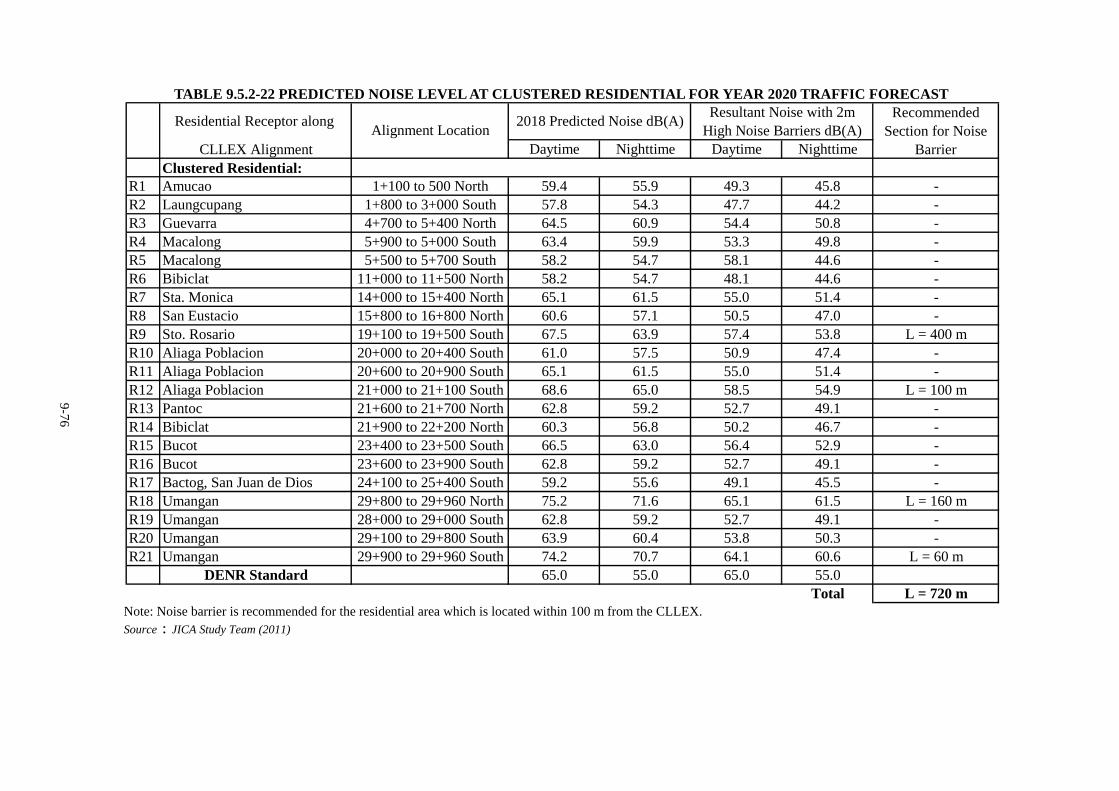
9-76
TABLE 9.5.2-22 PREDICTED NOISE LEVEL AT CLUSTERED RESIDENTIAL FOR YEAR 2020 TRAFFIC FORECAST
CLLEX Alignment Daytime Nighttime Daytime NighttimeClustered Residential:
R1 Amucao 1+100 to 500 North 59.4 55.9 49.3 45.8 -R2 Laungcupang 1+800 to 3+000 South 57.8 54.3 47.7 44.2 -R3 Guevarra 4+700 to 5+400 North 64.5 60.9 54.4 50.8 -R4 Macalong 5+900 to 5+000 South 63.4 59.9 53.3 49.8 -R5 Macalong 5+500 to 5+700 South 58.2 54.7 58.1 44.6 -R6 Bibiclat 11+000 to 11+500 North 58.2 54.7 48.1 44.6 -R7 Sta. Monica 14+000 to 15+400 North 65.1 61.5 55.0 51.4 -R8 San Eustacio 15+800 to 16+800 North 60.6 57.1 50.5 47.0 -R9 Sto. Rosario 19+100 to 19+500 South 67.5 63.9 57.4 53.8 L = 400 mR10 Aliaga Poblacion 20+000 to 20+400 South 61.0 57.5 50.9 47.4 -R11 Aliaga Poblacion 20+600 to 20+900 South 65.1 61.5 55.0 51.4 -R12 Aliaga Poblacion 21+000 to 21+100 South 68.6 65.0 58.5 54.9 L = 100 mR13 Pantoc 21+600 to 21+700 North 62.8 59.2 52.7 49.1 -R14 Bibiclat 21+900 to 22+200 North 60.3 56.8 50.2 46.7 -R15 Bucot 23+400 to 23+500 South 66.5 63.0 56.4 52.9 -R16 Bucot 23+600 to 23+900 South 62.8 59.2 52.7 49.1 -R17 Bactog, San Juan de Dios 24+100 to 25+400 South 59.2 55.6 49.1 45.5 -R18 Umangan 29+800 to 29+960 North 75.2 71.6 65.1 61.5 L = 160 mR19 Umangan 28+000 to 29+000 South 62.8 59.2 52.7 49.1 -R20 Umangan 29+100 to 29+800 South 63.9 60.4 53.8 50.3 -R21 Umangan 29+900 to 29+960 South 74.2 70.7 64.1 60.6 L = 60 m
DENR Standard 65.0 55.0 65.0 55.0Total L = 720 m
Recommended Section for Noise
Barrier
Residential Receptor along Alignment Location
2018 Predicted Noise dB(A)Resultant Noise with 2m
High Noise Barriers dB(A)
Note: Noise barrier is recommended for the residential area which is located within 100 m from the CLLEX. Source:JICA Study Team (2011)
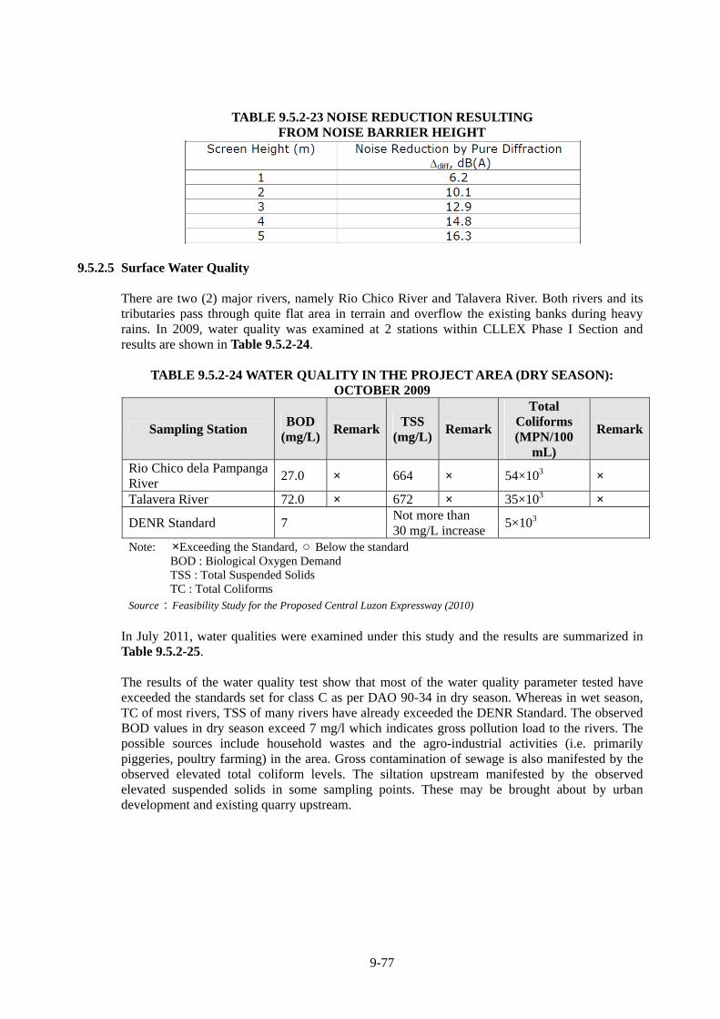
9-77
TABLE 9.5.2-23 NOISE REDUCTION RESULTING FROM NOISE BARRIER HEIGHT
9.5.2.5 Surface Water Quality There are two (2) major rivers, namely Rio Chico River and Talavera River. Both rivers and its tributaries pass through quite flat area in terrain and overflow the existing banks during heavy rains. In 2009, water quality was examined at 2 stations within CLLEX Phase I Section and results are shown in Table 9.5.2-24.
TABLE 9.5.2-24 WATER QUALITY IN THE PROJECT AREA (DRY SEASON):
OCTOBER 2009
Sampling Station BOD
(mg/L)Remark
TSS (mg/L)
Remark
Total Coliforms (MPN/100
mL)
Remark
Rio Chico dela Pampanga River
27.0 × 664 × 54×103 ×
Talavera River 72.0 × 672 × 35×103 ×
DENR Standard 7 Not more than 30 mg/L increase
5×10³
Note: ×Exceeding the Standard, ○ Below the standard BOD : Biological Oxygen Demand TSS : Total Suspended Solids TC : Total Coliforms
Source:Feasibility Study for the Proposed Central Luzon Expressway (2010) In July 2011, water qualities were examined under this study and the results are summarized in Table 9.5.2-25. The results of the water quality test show that most of the water quality parameter tested have exceeded the standards set for class C as per DAO 90-34 in dry season. Whereas in wet season, TC of most rivers, TSS of many rivers have already exceeded the DENR Standard. The observed BOD values in dry season exceed 7 mg/l which indicates gross pollution load to the rivers. The possible sources include household wastes and the agro-industrial activities (i.e. primarily piggeries, poultry farming) in the area. Gross contamination of sewage is also manifested by the observed elevated total coliform levels. The siltation upstream manifested by the observed elevated suspended solids in some sampling points. These may be brought about by urban development and existing quarry upstream.
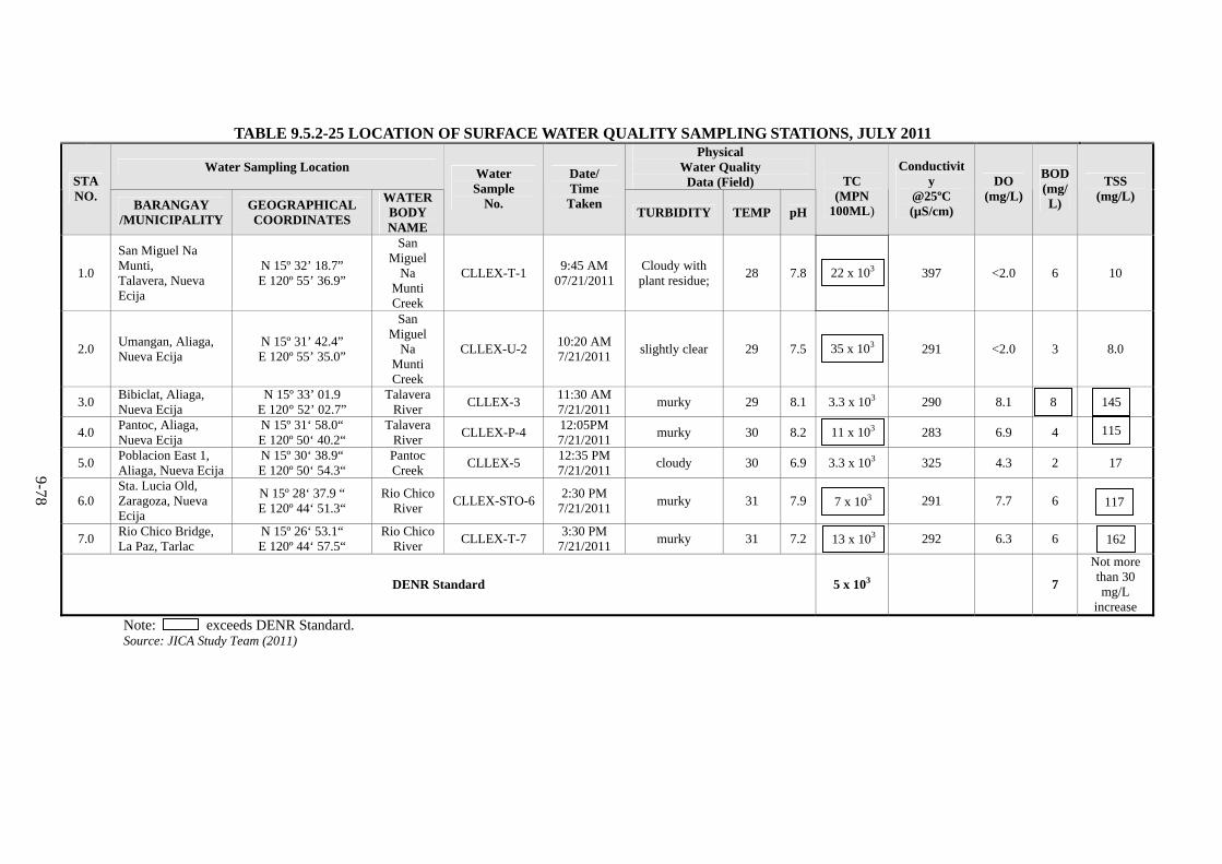
9-78
TABLE 9.5.2-25 LOCATION OF SURFACE WATER QUALITY SAMPLING STATIONS, JULY 2011
Water Sampling Location Physical
Water Quality Data (Field) STA
NO. BARANGAY
/MUNICIPALITYGEOGRAPHICAL COORDINATES
WATER BODY NAME
Water Sample
No.
Date/ Time Taken
TURBIDITY TEMP pH
TC
(MPN 100ML)
Conductivity
@25ºC (µS/cm)
DO (mg/L)
BOD(mg/L)
TSS (mg/L)
1.0
San Miguel Na Munti, Talavera, Nueva Ecija
N 15º 32’ 18.7” E 120º 55’ 36.9”
San Miguel
Na Munti Creek
CLLEX-T-1 9:45 AM
07/21/2011Cloudy with plant residue;
28 7.8
397 <2.0 6 10
2.0 Umangan, Aliaga, Nueva Ecija
N 15º 31’ 42.4” E 120º 55’ 35.0”
San Miguel
Na Munti Creek
CLLEX-U-2 10:20 AM 7/21/2011
slightly clear 29 7.5
291 <2.0 3 8.0
3.0 Bibiclat, Aliaga, Nueva Ecija
N 15º 33’ 01.9 E 120° 52’ 02.7”
Talavera River
CLLEX-3 11:30 AM 7/21/2011
murky 29 8.1 3.3 x 10³ 290 8.1
4.0 Pantoc, Aliaga, Nueva Ecija
N 15º 31‘ 58.0“ E 120º 50‘ 40.2“
Talavera River
CLLEX-P-4 12:05PM 7/21/2011
murky 30 8.2
283 6.9 4
5.0 Poblacion East 1, Aliaga, Nueva Ecija
N 15º 30‘ 38.9“ E 120º 50‘ 54.3“
Pantoc Creek
CLLEX-5 12:35 PM 7/21/2011
cloudy 30 6.9 3.3 x 10³ 325 4.3 2 17
6.0 Sta. Lucia Old, Zaragoza, Nueva Ecija
N 15º 28‘ 37.9 “ E 120º 44‘ 51.3“
Rio Chico River
CLLEX-STO-62:30 PM
7/21/2011 murky 31 7.9
291 7.7 6
7.0 Rio Chico Bridge, La Paz, Tarlac
N 15º 26‘ 53.1“ E 120º 44‘ 57.5“
Rio Chico River
CLLEX-T-7 3:30 PM
7/21/2011 murky 31 7.2
292 6.3 6
DENR Standard 5 x 10³ 7
Not more than 30 mg/L
increase
Note: exceeds DENR Standard. Source: JICA Study Team (2011)
35 x 103
7 x 10³
13 x 103
8 145
115
117
162
22 x 103
11 x 103
9-79
9.5.2.6 Climate
The prevailing climate in the project area is ‘Type I’ based on Philippine Atmospheric and
Geophysical and Astronomical Services Administration’s (PAGASA) Corona’s Classification
System. The Type I classification has dry season from December to May, and wet for the rest of
the year.
Nueva Ecija also has an average relative humidity of 87% while temperature ranges from 21.5°C
to 35.7°C. The recorded average mean amount of rainfall for the year is 1597.1 mm, with highest
amount of 4,304 mm during the month of August (Nueva Ecija Provincial Profile, 2008).
Tarlac belongs to ‘Type I’ climate, and it experiences rainfall during the southwest monsoon
period from June to November, which is the wet season. November to May is the dry season. The
hottest part of the year is March to May and sometimes extends up to June. The heaviest rains
come in July to November with August being the wettest month of the year.
The nearest synoptic meteorological station in the proposed CLLEX is located in Cabanatuan
City, Nueva Ecija. The city and its surrounding area receive an annual rainfall of about 1,904.3
mm. Moreover, Cabanatuan City has the potential to receive 376.60 mm within 24 hours. With
this information and underlying topography, the area is susceptible to flooding during extreme
events of rainfall. The rainy season concurs with the Southwest Monsoon during the months of
June to September. The highest monthly precipitation amount of 381.9 mm was recorded in
August. This month registered the longest number of rainy days with 23. The dry season is
experienced from November to April, with the lowest rainfall of 8.4mm in January (SJBPEIS,
2002). The area is also prone to typhoons, with an average of 1 to 2 major storms hitting the area
per year. These typhoons could potentially bring extensive wind and rain hazards (i.e. landslides,
flooding) in the local area. The principal air streams that are significantly affecting the study area
are the Northeast Monsoon, Southwest Monsoon, and the North Pacific Trades. The Northeast
Monsoon predominates from October to May. The Southwest Monsoon on the other hand
prevails from June to September. The North Pacific Trades is the southern portion of the North
Pacific anti-cyclone. This air stream, which passed over a vast expanse of the North Pacific
Ocean and is extremely warm, is generally dominant over the entire Philippines in April and
early May. It commonly arrives in the country from an easterly direction but may come from any
direction from northeast to southeast.
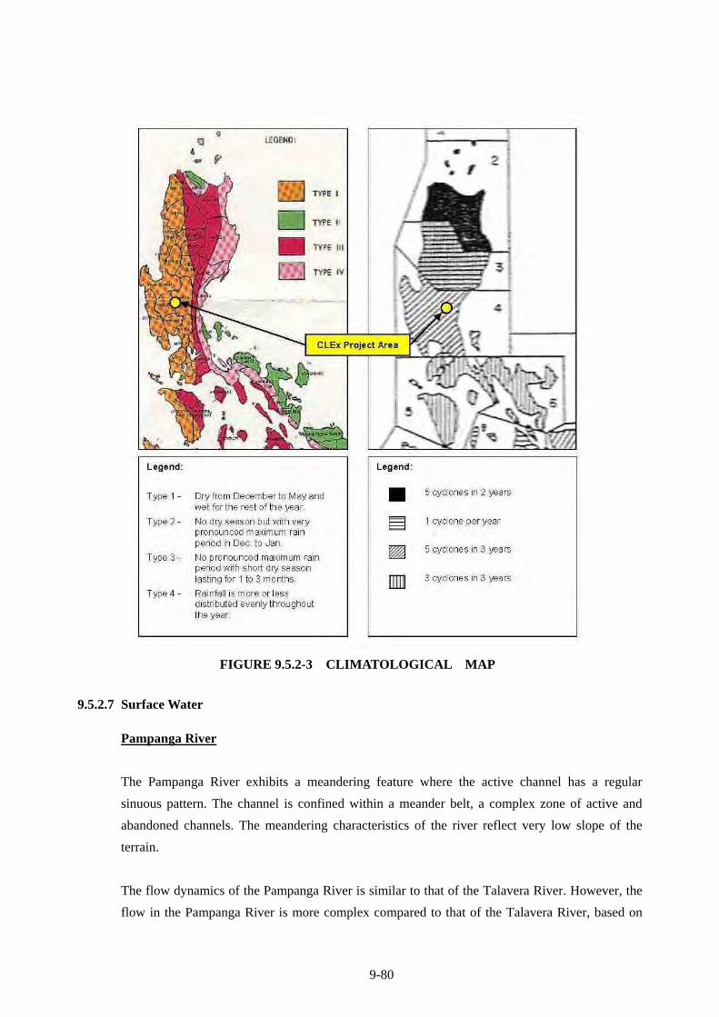
9-80
FIGURE 9.5.2-3 CLIMATOLOGICAL MAP
9.5.2.7 Surface Water
Pampanga River
The Pampanga River exhibits a meandering feature where the active channel has a regular
sinuous pattern. The channel is confined within a meander belt, a complex zone of active and
abandoned channels. The meandering characteristics of the river reflect very low slope of the
terrain.
The flow dynamics of the Pampanga River is similar to that of the Talavera River. However, the
flow in the Pampanga River is more complex compared to that of the Talavera River, based on
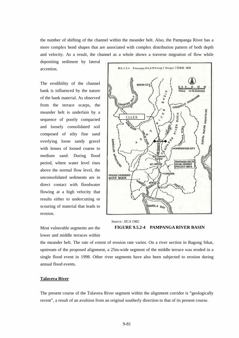
9-81
the number of shifting of the channel within the meander belt. Also, the Pampanga River has a
more complex bend shapes that are associated with complex distribution pattern of both depth
and velocity. As a result, the channel as a whole shows a traverse migration of flow while
depositing sediment by lateral
accretion.
The erodibility of the channel
bank is influenced by the nature
of the bank material. As observed
from the terrace scarps, the
meander belt is underlain by a
sequence of poorly compacted
and loosely consolidated soil
composed of silty fine sand
overlying loose sandy gravel
with lenses of loosed coarse to
medium sand. During flood
period, where water level rises
above the normal flow level, the
unconsolidated sediments are in
direct contact with floodwater
flowing at a high velocity that
results either to undercutting or
scouring of material that leads to
erosion.
Most vulnerable segments are the
lower and middle terraces within
the meander belt. The rate of extent of erosion rate varies. On a river section in Bagong Sikat,
upstream of the proposed alignment, a 25m-wide segment of the middle terrace was eroded in a
single flood event in 1998. Other river segments have also been subjected to erosion during
annual flood events.
Talavera River
The present course of the Talavera River segment within the alignment corridor is “geologically
recent”, a result of an avulsion from an original southerly direction to that of its present course.
CLLEX
Source: JICA 1982
FIGURE 9.5.2-4 PAMPANGA RIVER BASIN
9-82
The banks of the present Talavera River are marked by 3 channel terraces indicating that the
main channel had undergone 2 episodes of readjustments since its avulsion. The terrace edges are
marked with near vertical escarpments, with height of 2 meters at the upper terrace to 1.5 meters
at the lower terrace towards the main channel. Also evident is the upper terraces at the southern
bank have wider lateral extent as compared to those in the northern bank. The lower and middle
terraces at the northern bank on the other hand, have a constricted lateral configuration.
Exposed along the bank is a sequence of poorly compacted and loosely consolidated soil
composed of silty fine sand overlying loose sandy gravel on top of a gravelly clay horizon. The
contact of the soil materials with gravel is about 2m above the normal water level.
Bank sections that are directly affected by peak channel flows are more vulnerable more
especially those on the channel bend. The flow in a meander bend is helicoidal with a component
of surface flows towards the outer bank and the bottom flow towards the outer bank and the
bottom flow towards the inner bank. As a result of the flow pattern, the outer concave bank is the
site of erosion and the inner convex bank is the site of deposition, the channel as a whole
migrating transversely to the flow to deposit sediment by lateral accretion.
Rio Chico River
Tarlac province is bounded by two (2) principal rivers; Tarlac River and Rio Chico River which
are both heavily silted. Tarlac River aggradation problem is attributed to the heavy transport of
lahar due to Mt.Pinatubo eruption while Rio Chico has narrow/limited river cross section with
meandering flow and serves as the catch basin of waterways from Talavera-Aliaga, Zaragoza,
Cabanatuan, Guimba, LIcab and Sto.Domingo and the eastern towns of Tarlac, outfall to
Sacobia- Bamban-Paura River and Quitangil River.
Rio Chico River is one of the tribunal of Pampanga River which is located upper part of
Pampanga River Basin. The Rio Chico River and Talavera River confluent in La Paz and flow to
San Antonio Swamp before meet to Pampanga River.
TABLE 9.5.2-26 CHARACTERISTICS OF RIO CHICO AND PAMPANGA RIVER
Rio Chico River Pampanga River Catchment Area 1700km2 7700km2 River Slope 1/3,500 1/10,000 – 1/8,000 Discharge (50years) 2,400 (at Zaragoza)
3,700(at San Antonio) 4,350 (at Cabiao)
Discharge (100 years) 2,800(at Zaragoza) 4,400(at San Antonio)
4,900 (at Cabiao)
Source: JICA 1982
9-83
9.5.2.8 Precipitation and Flood
Intensities of precipitation for Cabanatuan City and for Munoz in Nueva Ecija Province are
predicted based on historical data (Table 9.5.2-27, 9.5.2-28).
TABLE 9.5.2-27 RAINFALL INTENSITY-DURATION FREQUENCY
CABANATUAN CITY (MM) Return Period
5 10 15 20 30 45 60 80 100 120 150 3 6 12 24
Yrs. min. min. min. min. min. min. min. min. min. min. min. hrs. hrs. hrs. hrs.2 12.10 18.80 24.10 28.60 36.60 45.00 50.70 57.00 62.30 66.10 70.80 75.10 92.60 108.90 127.905 17.5 26.90 34.30 40.50 52.40 65.00 74.60 83.30 90.50 95.60 101.60 108.70 137.80 162.60 194.5010 21.10 32.20 41.10 48.40 62.80 73.80 90.50 100.70 109.10 115.10 121.90 131.00 167.70 198.10 238.6015 23.10 35.30 44.90 52.90 68.70 85.80 99.40 110.50 119.60 126.10 133.40 143.50 184.50 218.10 263.4020 24.50 37.40 47.60 56.00 72.80 91.00 105.70 117.40 127.00 133.80 141.50 152.30 196.30 232.20 280.8025 25.60 39.00 49.70 58.50 76.00 95.10 110.50 122.70 132.70 139.70 147.70 159.10 205.40 243.00 294.3050 28.90 44.00 56.00 65.90 85.70 107.50 125.40 139.00 150.10 158.00 166.80 180.00 233.40 276.30 335.60
100 32.20 49.00 62.30 73.30 95.40 119.80 140.10 155.20 167.50 176.10 185.70 200.70 261.20 309.30 376.60Prepared by: The HYDROMETEOROLOGICAL INVESTIGATIONS and SPECIAL STUDIES SECTION Flood Forecasting Branch, PAGASA
TABLE 9.5.2-28 RAINFALL INTENSITY-DURATION
FREQUENCY FOR MUNOZ, NUEVA ECIJA (MM)
Return Period
60 3 6 12 24
Yrs. min. hrs. hrs. hrs. hrs. 2 58.80 66.30 78.70 89.00 105.40 5 67.10 82.60 98.80 125.60 144.70
10 75.30 93.30 112.10 149.90 170.70 20 83.10 103.70 124.80 173.20 195.70 25 85.60 107.00 128.80 180.50 203.60 50 93.20 117.10 141.30 203.30 228.00
100 100.80 127.10 153.60 225.90 252.30 Prepared by: The HYDROMETEOROLOGICAL INVESTIGATIONS and SPECIAL STUDIES SECTION Flood Forecasting Branch, PAGASA
The preferred alignment was plotted on the topographic maps. Eighteen (18) natural waterways
were identified along the alignment. The catchment areas for each water way were delineated. A
catchment area is defined as the limits of the topographic divide which is the line that separates
water flow between basins. Other hydrologic parameters such as length of waterway and
difference of elevation are identified.
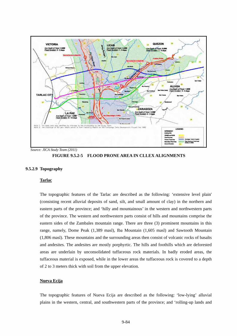
9-84
Source: JICA Study Team (2011)
FIGURE 9.5.2-5 FLOOD PRONE AREA IN CLLEX ALIGNMENTS
9.5.2.9 Topography
Tarlac
The topographic features of the Tarlac are described as the following: ‘extensive level plain'
(consisting recent alluvial deposits of sand, silt, and small amount of clay) in the northern and
eastern parts of the province; and ‘hilly and mountainous’ in the western and northwestern parts
of the province. The western and northwestern parts consist of hills and mountains comprise the
eastern sides of the Zambales mountain range. There are three (3) prominent mountains in this
range, namely, Dome Peak (1,389 masl), Iba Mountain (1,605 masl) and Sawtooth Mountain
(1,806 masl). These mountains and the surrounding areas then consist of volcanic rocks of basalts
and andesites. The andesites are mostly porphyrtic. The hills and foothills which are deforested
areas are underlain by unconsolidated tuffaceous rock materials. In badly eroded areas, the
tuffaceous material is exposed, while in the lower areas the tuffaceous rock is covered to a depth
of 2 to 3 meters thick with soil from the upper elevation.
Nueva Ecija
The topographic features of Nueva Ecija are described as the following: ‘low-lying’ alluvial
plains in the western, central, and southwestern parts of the province; and ‘rolling-up lands and
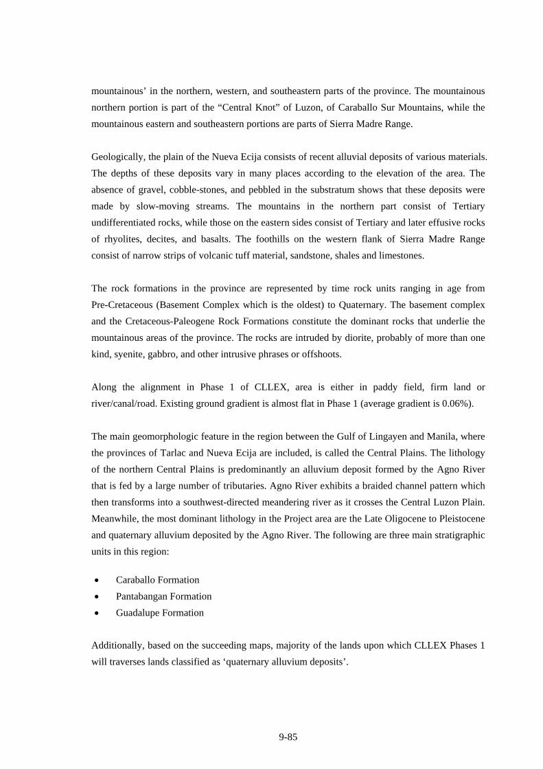
9-85
mountainous’ in the northern, western, and southeastern parts of the province. The mountainous
northern portion is part of the “Central Knot” of Luzon, of Caraballo Sur Mountains, while the
mountainous eastern and southeastern portions are parts of Sierra Madre Range.
Geologically, the plain of the Nueva Ecija consists of recent alluvial deposits of various materials.
The depths of these deposits vary in many places according to the elevation of the area. The
absence of gravel, cobble-stones, and pebbled in the substratum shows that these deposits were
made by slow-moving streams. The mountains in the northern part consist of Tertiary
undifferentiated rocks, while those on the eastern sides consist of Tertiary and later effusive rocks
of rhyolites, decites, and basalts. The foothills on the western flank of Sierra Madre Range
consist of narrow strips of volcanic tuff material, sandstone, shales and limestones.
The rock formations in the province are represented by time rock units ranging in age from
Pre-Cretaceous (Basement Complex which is the oldest) to Quaternary. The basement complex
and the Cretaceous-Paleogene Rock Formations constitute the dominant rocks that underlie the
mountainous areas of the province. The rocks are intruded by diorite, probably of more than one
kind, syenite, gabbro, and other intrusive phrases or offshoots.
Along the alignment in Phase 1 of CLLEX, area is either in paddy field, firm land or
river/canal/road. Existing ground gradient is almost flat in Phase 1 (average gradient is 0.06%).
The main geomorphologic feature in the region between the Gulf of Lingayen and Manila, where
the provinces of Tarlac and Nueva Ecija are included, is called the Central Plains. The lithology
of the northern Central Plains is predominantly an alluvium deposit formed by the Agno River
that is fed by a large number of tributaries. Agno River exhibits a braided channel pattern which
then transforms into a southwest-directed meandering river as it crosses the Central Luzon Plain.
Meanwhile, the most dominant lithology in the Project area are the Late Oligocene to Pleistocene
and quaternary alluvium deposited by the Agno River. The following are three main stratigraphic
units in this region:
Caraballo Formation
Pantabangan Formation
Guadalupe Formation
Additionally, based on the succeeding maps, majority of the lands upon which CLLEX Phases 1
will traverses lands classified as ‘quaternary alluvium deposits’.
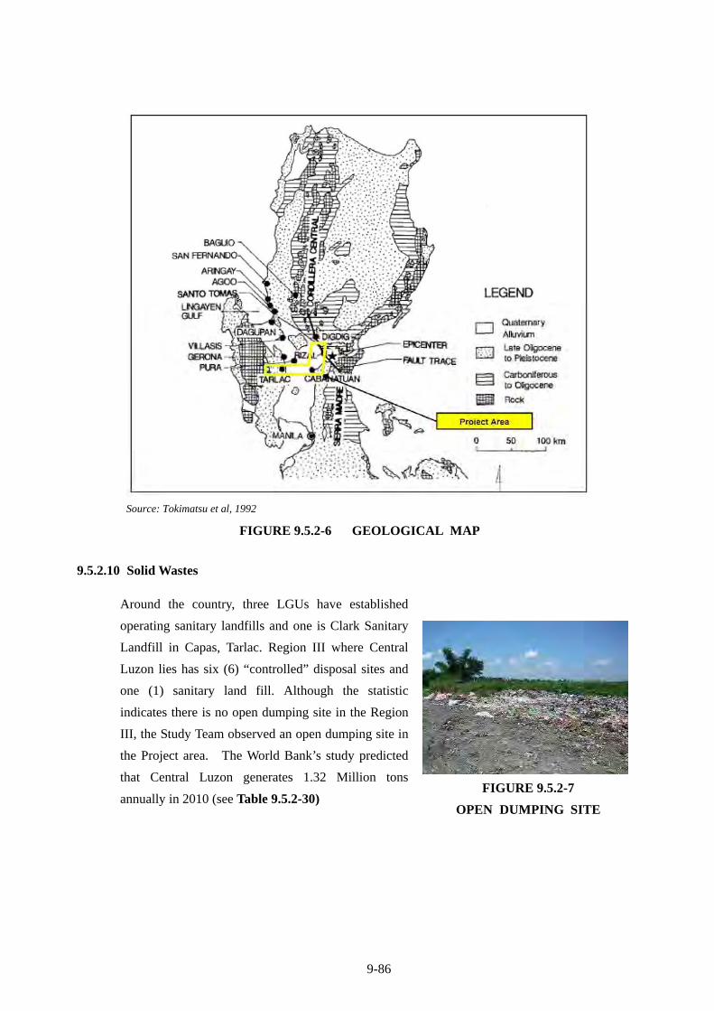
9-86
Source: Tokimatsu et al, 1992
FIGURE 9.5.2-6 GEOLOGICAL MAP
9.5.2.10 Solid Wastes
Around the country, three LGUs have established
operating sanitary landfills and one is Clark Sanitary
Landfill in Capas, Tarlac. Region III where Central
Luzon lies has six (6) “controlled” disposal sites and
one (1) sanitary land fill. Although the statistic
indicates there is no open dumping site in the Region
III, the Study Team observed an open dumping site in
the Project area. The World Bank’s study predicted
that Central Luzon generates 1.32 Million tons
annually in 2010 (see Table 9.5.2-30)
FIGURE 9.5.2-7
OPEN DUMPING SITE
9-87
TABLE 9.5.2-29 SOLID WASTE COLLECTION FACILITY (2007)
TABLE 9.5.2-30 AMOUNT OF SOLID WASTE GENERATED (2007)
Source: Report of the APO Survey on Solid-Waste Management 2004–05, Asian Productivity Organization (2007)
Various types of solid wastes are expected to be generated at the project construction site. With
the number of workers to be deployed, considerable amount of garbage is expected to be
generated. Construction spoils that will be generated also need to be disposed of in accordance
with ECC.
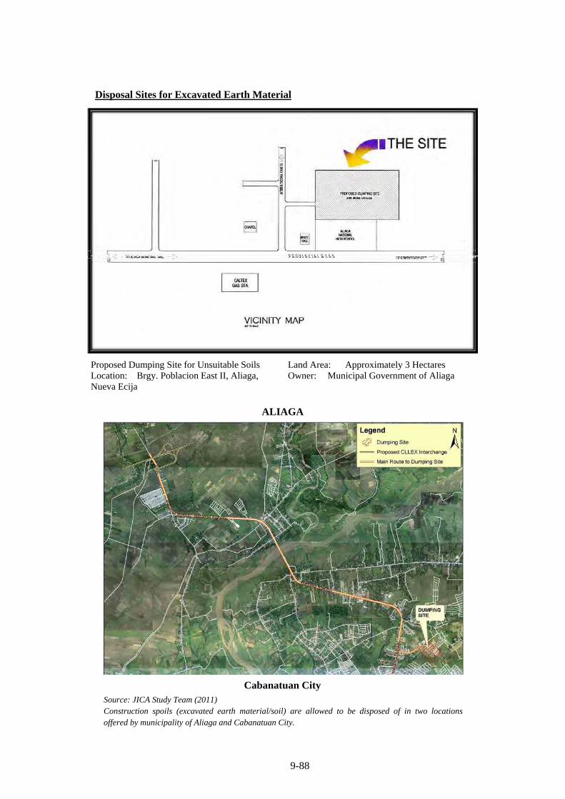
9-88
Disposal Sites for Excavated Earth Material
Proposed Dumping Site for Unsuitable Soils Location: Brgy. Poblacion East II, Aliaga, Nueva Ecija
Land Area: Approximately 3 Hectares Owner: Municipal Government of Aliaga
ALIAGA
Cabanatuan City
Source: JICA Study Team (2011) Construction spoils (excavated earth material/soil) are allowed to be disposed of in two locations offered by municipality of Aliaga and Cabanatuan City.
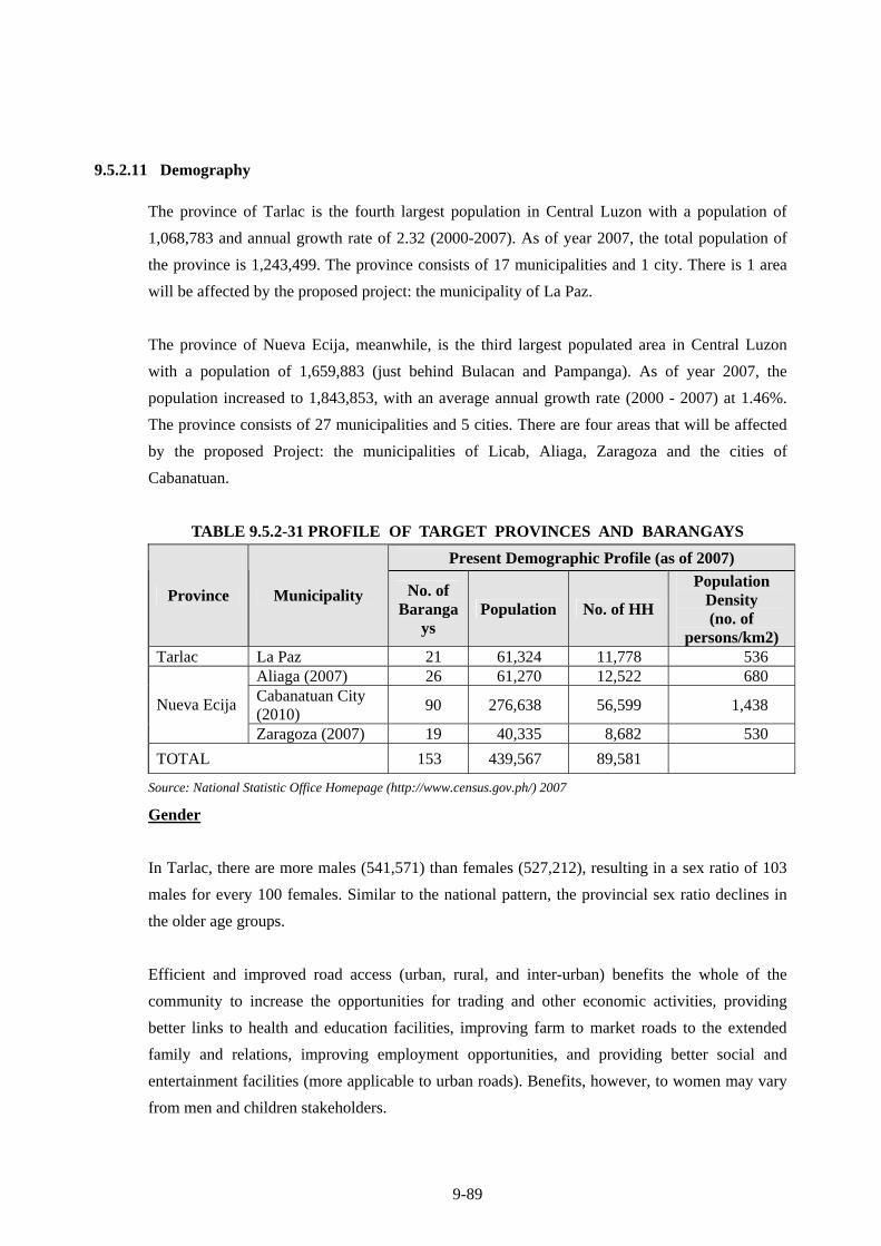
9-89
9.5.2.11 Demography
The province of Tarlac is the fourth largest population in Central Luzon with a population of
1,068,783 and annual growth rate of 2.32 (2000-2007). As of year 2007, the total population of
the province is 1,243,499. The province consists of 17 municipalities and 1 city. There is 1 area
will be affected by the proposed project: the municipality of La Paz.
The province of Nueva Ecija, meanwhile, is the third largest populated area in Central Luzon
with a population of 1,659,883 (just behind Bulacan and Pampanga). As of year 2007, the
population increased to 1,843,853, with an average annual growth rate (2000 - 2007) at 1.46%.
The province consists of 27 municipalities and 5 cities. There are four areas that will be affected
by the proposed Project: the municipalities of Licab, Aliaga, Zaragoza and the cities of
Cabanatuan.
TABLE 9.5.2-31 PROFILE OF TARGET PROVINCES AND BARANGAYS
Present Demographic Profile (as of 2007)
Province Municipality No. of Baranga
ys Population No. of HH
Population Density (no. of
persons/km2) Tarlac La Paz 21 61,324 11,778 536
Aliaga (2007) 26 61,270 12,522 680 Cabanatuan City (2010)
90 276,638 56,599 1,438 Nueva Ecija
Zaragoza (2007) 19 40,335 8,682 530
TOTAL 153 439,567 89,581
Source: National Statistic Office Homepage (http://www.census.gov.ph/) 2007
Gender
In Tarlac, there are more males (541,571) than females (527,212), resulting in a sex ratio of 103
males for every 100 females. Similar to the national pattern, the provincial sex ratio declines in
the older age groups.
Efficient and improved road access (urban, rural, and inter-urban) benefits the whole of the
community to increase the opportunities for trading and other economic activities, providing
better links to health and education facilities, improving farm to market roads to the extended
family and relations, improving employment opportunities, and providing better social and
entertainment facilities (more applicable to urban roads). Benefits, however, to women may vary
from men and children stakeholders.
9-90
Indigenous People
Based on ocular survey in 2010, and even on the focus group discussions, there are no indigenous
people’s communities (IP’s) or even individuals in the area that would be directly or indirectly
affected by the CLLEX project. Therefore, there is no need to make any mitigation program or
resettlement plan to address anything related to Indigenous peoples’ concern
9.5.2.12 Economy
1) Regional Economy
GRDP of Region III is 1,177 billion pesos in 2008 accounting for 8.30 percent of GDP which is
the third in height in the country. Economic growth from 2007 through 2008 is 3.84%, and for the
GRDP per capita production is 12,049 pesos.
Primary Industries (Agriculture, Fisheries and Forestry) have accounted for 24.46% of the GRDP
Region III in 2008, have increased from 1.03% in 2007. Economic growth rates of GRDP from
2007 through 2008 are 2.97% of this sector. Secondary industries in the region (mining,
quarrying, manufacturing, construction, electricity production, gas and water), which accounted
for 35.59% of the GRDP of the Region III of 2008, have increased by 1.05% in 2007. Economic
growth rates of GRDP from 2007 through 2008 are 5.11% of this sector. Tertiary industries are
transportation, trade, economic, public and private real estate projects. Which accounted for
39.95% of the Region III GRDP of 2008, has become the largest industry in this region.
Economic growth rates of GRDP from 2007 through 2008 are 3.25% of this sector.
Region III is the area of tourism development is greatly expected. It has growth potential by
carrying out promotional activities of existing tourism resources as well. To do so aggressive
promotion of tourism facilities and tourism services may be considered to implement such
conduct tours and fairs. The area has scenic mountains, historic monuments, churches, and
attractions such as museums and nature. In 2007, tourists to the Central Luzon are 419,640
people, 67.31% of them from domestic area, then 32.69% is from abroad.
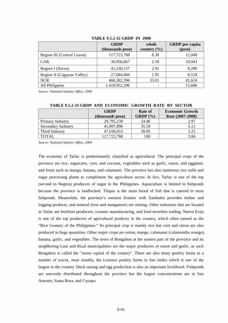
9-91
TABLE 9.5.2-32 GRDP IN 2008
GRDP
(thousands peso) whole
country (%) GRDP per capita
(peso) Region III (Central Luzon) 117,723,788 8.30 12,049
CAR 30,956,667 2.18 19,043
Region I (Ilocos) 41,230,157 2.91 8,289
Region II (Cagayan Valley) 27,684,066 1.95 8,518 NCR 468,382,396 33.01 41,624 All Philippine 1,418,952,296 - 15,686
Source: National Statistic Office, 2009
TABLE 9.5.2-33 GRDP AND ECONOMIC GROWTH RATE BY SECTOR
GRDP
(thousands peso) Rate of
GRDP (%) Economic Growth Rate (2007-2008)
Primary Industry 28,795,239 24.46 2.97 Secondary Industry 41,897,896 35.59 5.11 Third Industry 47,030,653 39.95 3.25 TOTAL 117,723,788 100 3.84
Source: National Statistic Office, 2009
The economy of Tarlac is predominantly classified as agricultural. The principal crops of the
province are rice, sugarcane, corn, and coconut, vegetables such as garlic, onion, and eggplant,
and fruits such as mango, banana, and calamansi. The province has also numerous rice mills and
sugar processing plants to compliment the agriculture sector. In fact, Tarlac is one of the top
(second to Negros) producers of sugar in the Philippines. Aquaculture is limited to fishponds
because the province is landlocked. Tilapia is the main breed of fish that is catered in most
fishponds. Meanwhile, the province’s western frontier with Zambales provides timber and
logging products, and mineral (iron and manganese) ore mining. Other industries that are located
in Tarlac are fertilizer producers, ceramic manufacturing, and food novelties trading. Nueva Ecija
is one of the top producers of agricultural products in the country, which often named as the
“Rice Granary of the Philippines.” Its principal crop is mainly rice but corn and onion are also
produced in huge quantities. Other major crops are onion, mango, calamansi (calamondin orange),
banana, garlic, and vegetables. The town of Bongabon at the eastern part of the province and its
neighboring Laur and Rizal municipalities are the major producers of onion and garlic, as such
Bongabon is called the "onion capital of the country". There are also many poultry farms in a
number of towns, most notably, the Lorenzo poultry farms in San Isidro which is one of the
largest in the country. Duck raising and egg production is also an important livelihood. Fishponds
are unevenly distributed throughout the province but the largest concentrations are in San
Antonio, Santa Rosa, and Cuyapo.
9-92
2) Local Economy
Majority or 50.4% of the households sourced their income primarily from farming. While the
remaining 38.8% and 10.7% earn their income from employment and commerce respectively.
Majority or 49.3%of the respondents does not have any other (secondary) sources of income,
while 8.6% of the respondents secondary income comes from small scale businesses such as
“sari-sari” store. Income from employment constituted 16.1% of the secondary income source.
Around 58.5% of the households earn below Php 43,588 annually, while some 4.0% earn
between Php 43,588 to Php 69,192 per annum. There are also approximately 37.5% that earn
more than P 69,192.
9.5.2.13 Land Use
Central Luzon Region: Central Luzon region shares steady rate of more or less 6% of national
farming area in the Philippines last 50 years. Of which about 0.52 million ha are used to produce
crops. In last 20 years permanent meadows and pastures have disappeared and the forest land has
been gone since 1960s.
Tarlac: The province of Tarlac is the fourth largest province in Central Luzon with an
approximate total land area of 305,340 hectares. It is predominantly composed of agricultural
areas (i.e. plantations, farms and fishponds), and at the same time, the major sector in the
province. La Paz is the area that will be affected by the proposed CLLEX in Tarlac province. In
terms of land use, La Paz also exhibit large areas dedicated to agriculture. Approximately 8.3
kilometers in La Paz will be traversed by the proposed Project. As a result, 50 hectares for La Paz
will be allocated for the implementation of the proposed Project’s ROW.
Nueva Ecija: The province of Nueva Ecija is the largest province in Central Luzon with an
approximate total land area of 533,015 hectares (Nueva Ecija ENS profile, 2009). Similar to
Tarlac, Nueva Ecija also has vast land areas dedicated for agricultural use such as farmlands and
fishponds, which are the top sectors in the province.
Two (2) municipalities: Zaragosa, and Aliaga,; and one (1) city: Cabanatuan will be directly
affected by the proposed CLLEX.
In terms of land use, all the municipalities and cities affect by the Project dedicate most of their
land use for agricultural use. Approximately 5.3 kilometers in Zaragosa, 15.4 kilometers in
Aliaga, 1.7 kilometers in Cabanatuan City will be traversed by the proposed Project. As a result,
32 hectares for Zaragosa, 93 hectares for Aliaga, and 10 hectares for Cabanatuan City will be
allocated for the implementation of the proposed Project’s ROW.
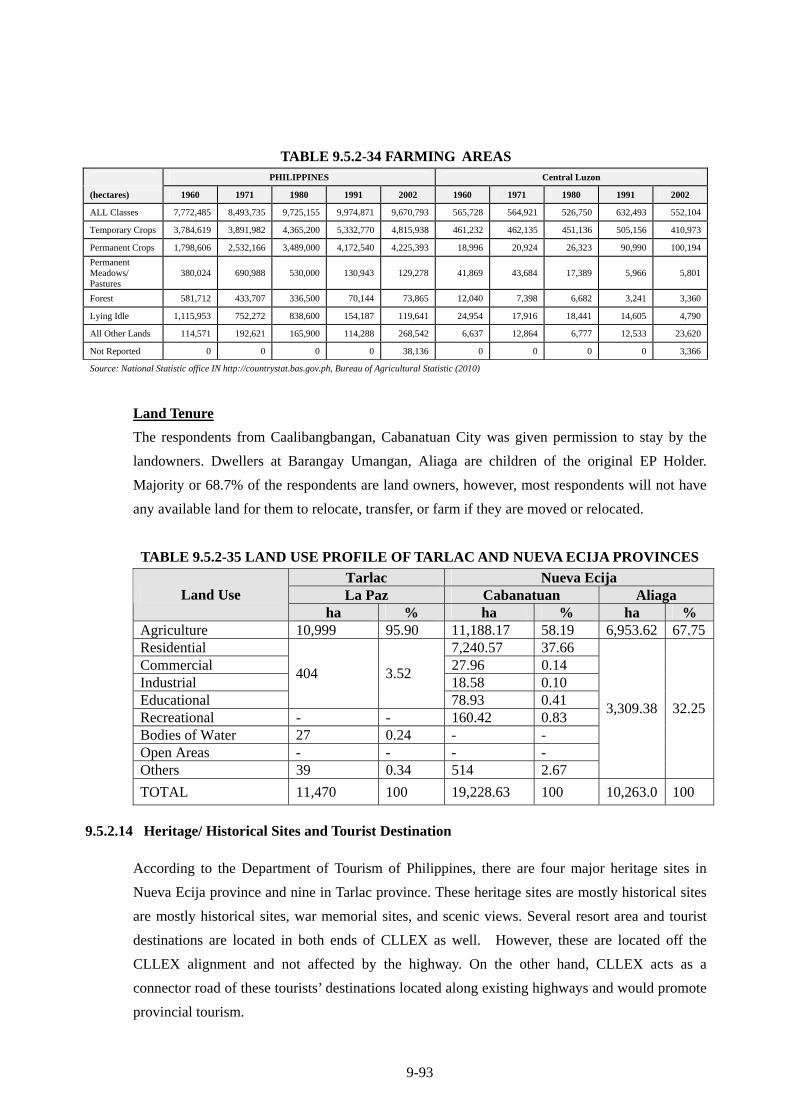
9-93
TABLE 9.5.2-34 FARMING AREAS PHILIPPINES Central Luzon
(hectares) 1960 1971 1980 1991 2002 1960 1971 1980 1991 2002
ALL Classes 7,772,485 8,493,735 9,725,155 9,974,871 9,670,793 565,728 564,921 526,750 632,493 552,104
Temporary Crops 3,784,619 3,891,982 4,365,200 5,332,770 4,815,938 461,232 462,135 451,136 505,156 410,973
Permanent Crops 1,798,606 2,532,166 3,489,000 4,172,540 4,225,393 18,996 20,924 26,323 90,990 100,194
Permanent Meadows/ Pastures
380,024 690,988 530,000 130,943 129,278 41,869 43,684 17,389 5,966 5,801
Forest 581,712 433,707 336,500 70,144 73,865 12,040 7,398 6,682 3,241 3,360
Lying Idle 1,115,953 752,272 838,600 154,187 119,641 24,954 17,916 18,441 14,605 4,790
All Other Lands 114,571 192,621 165,900 114,288 268,542 6,637 12,864 6,777 12,533 23,620
Not Reported 0 0 0 0 38,136 0 0 0 0 3,366
Source: National Statistic office IN http://countrystat.bas.gov.ph, Bureau of Agricultural Statistic (2010)
Land Tenure
The respondents from Caalibangbangan, Cabanatuan City was given permission to stay by the
landowners. Dwellers at Barangay Umangan, Aliaga are children of the original EP Holder.
Majority or 68.7% of the respondents are land owners, however, most respondents will not have
any available land for them to relocate, transfer, or farm if they are moved or relocated.
TABLE 9.5.2-35 LAND USE PROFILE OF TARLAC AND NUEVA ECIJA PROVINCES
Tarlac Nueva Ecija La Paz Cabanatuan Aliaga Land Use
ha % ha % ha % Agriculture 10,999 95.90 11,188.17 58.19 6,953.62 67.75Residential 7,240.57 37.66 Commercial 27.96 0.14 Industrial 18.58 0.10 Educational
404 3.52
78.93 0.41 Recreational - - 160.42 0.83 Bodies of Water 27 0.24 - - Open Areas - - - - Others 39 0.34 514 2.67
3,309.38 32.25
TOTAL 11,470 100 19,228.63 100 10,263.0 100
9.5.2.14 Heritage/ Historical Sites and Tourist Destination
According to the Department of Tourism of Philippines, there are four major heritage sites in
Nueva Ecija province and nine in Tarlac province. These heritage sites are mostly historical sites
are mostly historical sites, war memorial sites, and scenic views. Several resort area and tourist
destinations are located in both ends of CLLEX as well. However, these are located off the
CLLEX alignment and not affected by the highway. On the other hand, CLLEX acts as a
connector road of these tourists’ destinations located along existing highways and would promote
provincial tourism.
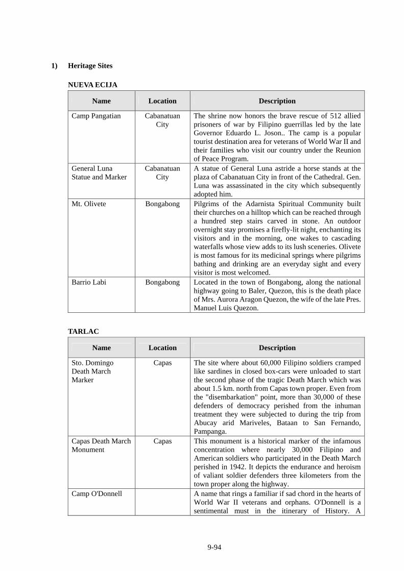
9-94
1) Heritage Sites
NUEVA ECIJA
Name Location Description
Camp Pangatian
Cabanatuan City
The shrine now honors the brave rescue of 512 allied prisoners of war by Filipino guerrillas led by the late Governor Eduardo L. Joson.. The camp is a popular tourist destination area for veterans of World War II and their families who visit our country under the Reunion of Peace Program.
General Luna Statue and Marker
Cabanatuan City
A statue of General Luna astride a horse stands at the plaza of Cabanatuan City in front of the Cathedral. Gen. Luna was assassinated in the city which subsequently adopted him.
Mt. Olivete
Bongabong
Pilgrims of the Adarnista Spiritual Community built their churches on a hilltop which can be reached through a hundred step stairs carved in stone. An outdoor overnight stay promises a firefly-lit night, enchanting its visitors and in the morning, one wakes to cascading waterfalls whose view adds to its lush sceneries. Olivete is most famous for its medicinal springs where pilgrims bathing and drinking are an everyday sight and every visitor is most welcomed.
Barrio Labi
Bongabong
Located in the town of Bongabong, along the national highway going to Baler, Quezon, this is the death place of Mrs. Aurora Aragon Quezon, the wife of the late Pres. Manuel Luis Quezon.
TARLAC
Name Location Description
Sto. Domingo Death March Marker
Capas
The site where about 60,000 Filipino soldiers cramped like sardines in closed box-cars were unloaded to start the second phase of the tragic Death March which was about 1.5 km. north from Capas town proper. Even from the "disembarkation" point, more than 30,000 of these defenders of democracy perished from the inhuman treatment they were subjected to during the trip from Abucay arid Mariveles, Bataan to San Fernando, Pampanga.
Capas Death March Monument
Capas This monument is a historical marker of the infamous concentration where nearly 30,000 Filipino and American soldiers who participated in the Death March perished in 1942. It depicts the endurance and heroism of valiant soldier defenders three kilometers from the town proper along the highway.
Camp O'Donnell A name that rings a familiar if sad chord in the hearts of World War II veterans and orphans. O'Donnell is a sentimental must in the itinerary of History. A
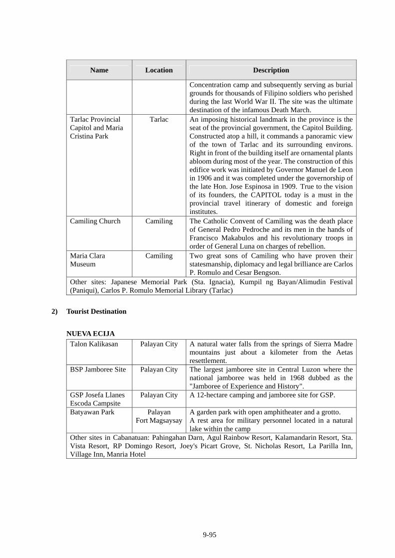
9-95
Name Location Description
Concentration camp and subsequently serving as burial grounds for thousands of Filipino soldiers who perished during the last World War II. The site was the ultimate destination of the infamous Death March.
Tarlac Provincial Capitol and Maria Cristina Park
Tarlac
An imposing historical landmark in the province is the seat of the provincial government, the Capitol Building. Constructed atop a hill, it commands a panoramic view of the town of Tarlac and its surrounding environs. Right in front of the building itself are ornamental plants abloom during most of the year. The construction of this edifice work was initiated by Governor Manuel de Leon in 1906 and it was completed under the governorship of the late Hon. Jose Espinosa in 1909. True to the vision of its founders, the CAPITOL today is a must in the provincial travel itinerary of domestic and foreign institutes.
Camiling Church
Camiling
The Catholic Convent of Camiling was the death place of General Pedro Pedroche and its men in the hands of Francisco Makabulos and his revolutionary troops in order of General Luna on charges of rebellion.
Maria Clara Museum
Camiling
Two great sons of Camiling who have proven their statesmanship, diplomacy and legal brilliance are Carlos P. Romulo and Cesar Bengson.
Other sites: Japanese Memorial Park (Sta. Ignacia), Kumpil ng Bayan/Alimudin Festival (Paniqui), Carlos P. Romulo Memorial Library (Tarlac)
2) Tourist Destination
NUEVA ECIJA
Talon Kalikasan Palayan City A natural water falls from the springs of Sierra Madre mountains just about a kilometer from the Aetas resettlement.
BSP Jamboree Site Palayan City
The largest jamboree site in Central Luzon where the national jamboree was held in 1968 dubbed as the "Jamboree of Experience and History".
GSP Josefa Llanes Escoda Campsite
Palayan City A 12-hectare camping and jamboree site for GSP.
Batyawan Park
Palayan Fort Magsaysay
A garden park with open amphitheater and a grotto. A rest area for military personnel located in a natural lake within the camp
Other sites in Cabanatuan: Pahingahan Darn, Agul Rainbow Resort, Kalamandarin Resort, Sta. Vista Resort, RP Domingo Resort, Joey's Picart Grove, St. Nicholas Resort, La Parilla Inn, Village Inn, Manria Hotel
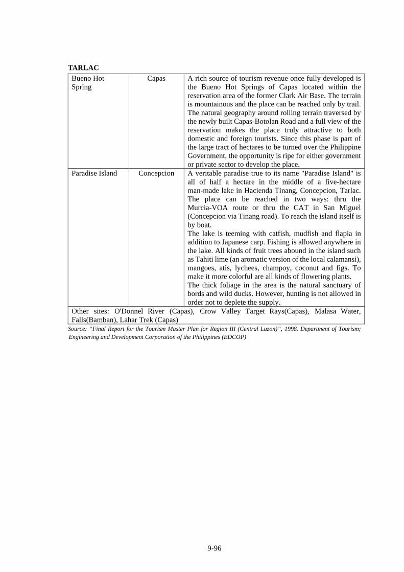
9-96
TARLAC
Bueno Hot Spring
Capas
A rich source of tourism revenue once fully developed is the Bueno Hot Springs of Capas located within the reservation area of the former Clark Air Base. The terrain is mountainous and the place can be reached only by trail. The natural geography around rolling terrain traversed by the newly built Capas-Botolan Road and a full view of the reservation makes the place truly attractive to both domestic and foreign tourists. Since this phase is part of the large tract of hectares to be turned over the Philippine Government, the opportunity is ripe for either government or private sector to develop the place.
Paradise Island
Concepcion
A veritable paradise true to its name "Paradise Island" is all of half a hectare in the middle of a five-hectare man-made lake in Hacienda Tinang, Concepcion, Tarlac. The place can be reached in two ways: thru the Murcia-VOA route or thru the CAT in San Miguel (Concepcion via Tinang road). To reach the island itself is by boat. The lake is teeming with catfish, mudfish and flapia in addition to Japanese carp. Fishing is allowed anywhere in the lake. All kinds of fruit trees abound in the island such as Tahiti lime (an aromatic version of the local calamansi), mangoes, atis, lychees, champoy, coconut and figs. To make it more colorful are all kinds of flowering plants. The thick foliage in the area is the natural sanctuary of bords and wild ducks. However, hunting is not allowed in order not to deplete the supply.
Other sites: O'Donnel River (Capas), Crow Valley Target Rays(Capas), Malasa Water, Falls(Bamban), Lahar Trek (Capas)
Source: “Final Report for the Tourism Master Plan for Region III (Central Luzon)”, 1998. Department of Tourism; Engineering and Development Corporation of the Philippines (EDCOP)
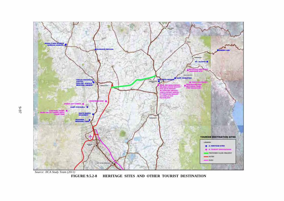
9-97
Source: JICA Study Team (2011)
FIGURE 9.5.2-8 HERITAGE SITES AND OTHER TOURIST DESTINATION
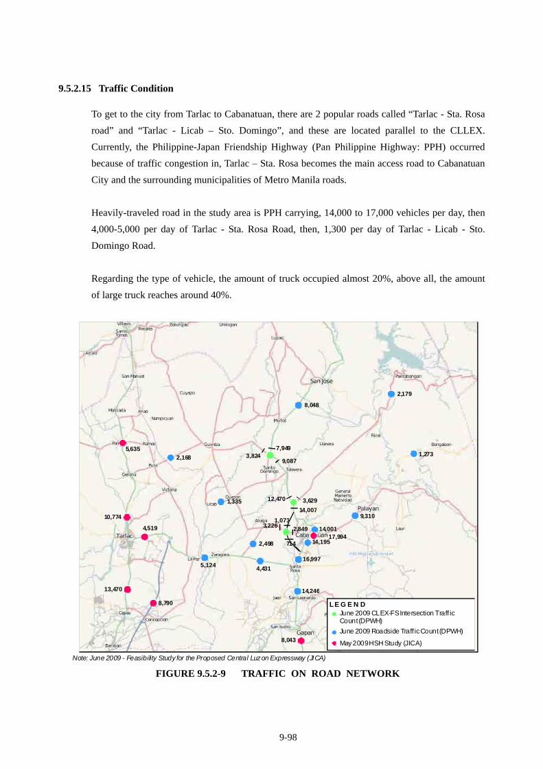
9-98
9.5.2.15 Traffic Condition
To get to the city from Tarlac to Cabanatuan, there are 2 popular roads called “Tarlac - Sta. Rosa
road” and “Tarlac - Licab – Sto. Domingo”, and these are located parallel to the CLLEX.
Currently, the Philippine-Japan Friendship Highway (Pan Philippine Highway: PPH) occurred
because of traffic congestion in, Tarlac – Sta. Rosa becomes the main access road to Cabanatuan
City and the surrounding municipalities of Metro Manila roads.
Heavily-traveled road in the study area is PPH carrying, 14,000 to 17,000 vehicles per day, then
4,000-5,000 per day of Tarlac - Sta. Rosa Road, then, 1,300 per day of Tarlac - Licab - Sto.
Domingo Road.
Regarding the type of vehicle, the amount of truck occupied almost 20%, above all, the amount
of large truck reaches around 40%.
Note: June 2009 - Feasibility Study for the Proposed Central Luzon Expressway (JICA)
2,179
1,273
9,310
8,048
2,168
1,335
5,1244,431
14,246
2,498
16,997
14,001
14,195
Intersection CountMid-block Count
L E G E N DJune 2009 CLEX-FS Intersection Traff ic Count (DPWH)
June 2009 Roadside Traff ic Count (DPWH)
7,949
9,0873,824
3,629
14,007
12,470
1,0733,226
714
2,849
May 2009 HSH Study (JICA)8,043
13,470
8,790
4,519
10,774
5,635
17,994
FIGURE 9.5.2-9 TRAFFIC ON ROAD NETWORK
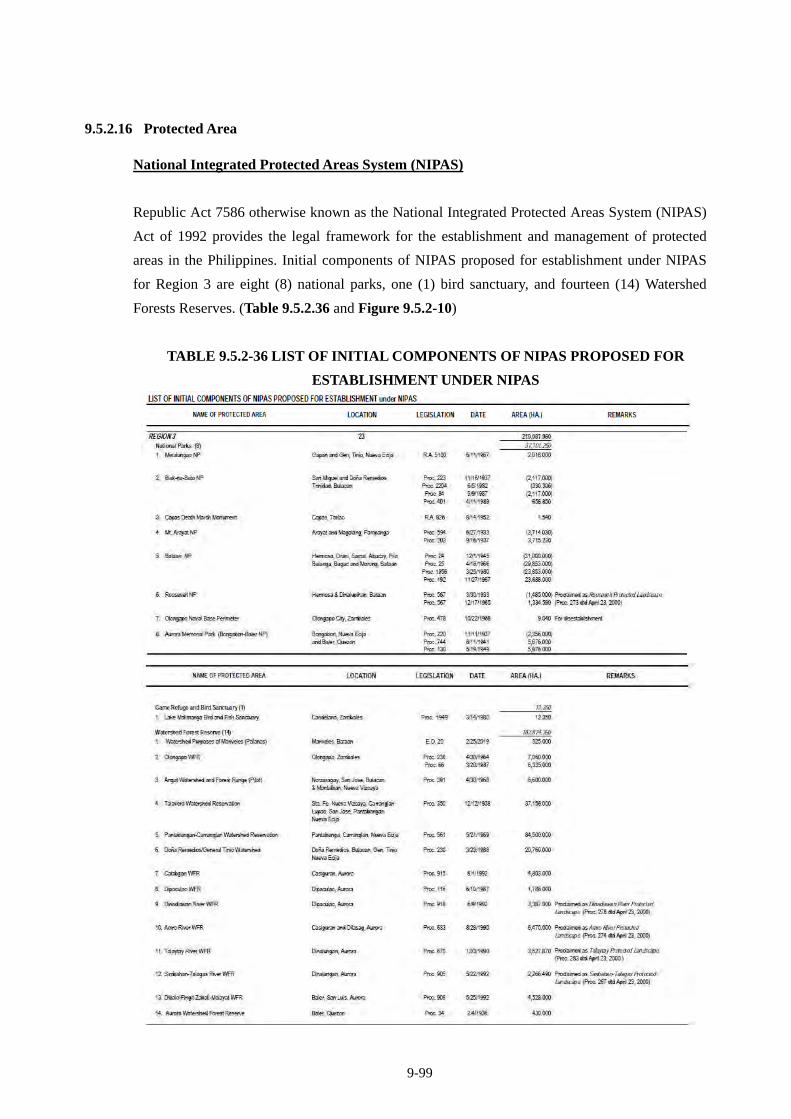
9-99
9.5.2.16 Protected Area
National Integrated Protected Areas System (NIPAS)
Republic Act 7586 otherwise known as the National Integrated Protected Areas System (NIPAS)
Act of 1992 provides the legal framework for the establishment and management of protected
areas in the Philippines. Initial components of NIPAS proposed for establishment under NIPAS
for Region 3 are eight (8) national parks, one (1) bird sanctuary, and fourteen (14) Watershed
Forests Reserves. (Table 9.5.2.36 and Figure 9.5.2-10)
TABLE 9.5.2-36 LIST OF INITIAL COMPONENTS OF NIPAS PROPOSED FOR
ESTABLISHMENT UNDER NIPAS
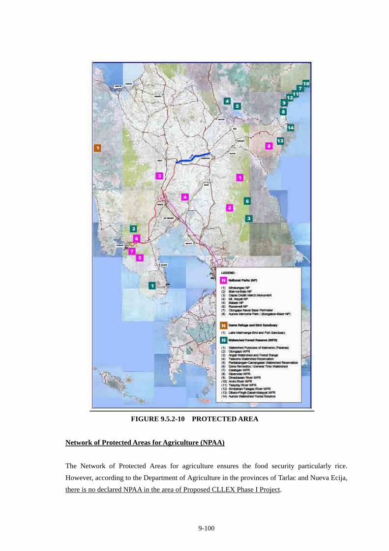
9-100
FIGURE 9.5.2-10 PROTECTED AREA
Network of Protected Areas for Agriculture (NPAA)
The Network of Protected Areas for agriculture ensures the food security particularly rice.
However, according to the Department of Agriculture in the provinces of Tarlac and Nueva Ecija,
there is no declared NPAA in the area of Proposed CLLEX Phase I Project.
9-101
9.5.2.17 Agriculture
Central Luzon contains the largest plain in the country and produces most of the country's rice
supply, earning itself the nickname "Rice Bowl of the Philippines". The Department of
Agriculture estimated rice production in 2010 for the provinces of Tarlac and Nueva Ecija is
presented in Table 9.5.2-37.
TABLE 9.5.2-37 ESTIMATED PRODUCTION IN 2010, AREA HARVESTED AND YIELD
PER HECTARE, BY FARM TYPE
Tarlac Nueva Ecija
Production (MT) 562,180 1,374,173
Irrigated 527,609 1,275,979
Rainfed 34,571 98,194
Upland - -
Area Harvested (Ha) 133,424 299,844
Irrigated 124,353 261,034
Rainfed 9,071 38,810
Upland - -
Yield/Hectare (MT) 4.21 4.58
Irrigated 4.24 4.89
Rainfed 3.81 2.53
Source: Bureau of Agricultural Statistics, Department of Agriculture
Nueva Ecija is one of the top producers of agricultural products in the country. Its principal crops
are mainly rice but corn and onion are also produced in quantity. The province is often referred to
as the “Rice Granary of the Philippines.” Other major crops are onion, mango, calamansi
(calamondin orange), banana, garlic, and vegetables. The town of Bongabon at the eastern part of
the province at the foot of the Sierra Madre Mountains and its neighboring Laur and Rizal are the
major producers of onion and garlic. Bongabon is called the "onion capital of the country".
The economy of Tarlac is dominantly agricultural. Principal crops are rice and sugarcane. Other
major crops are corn and coconut; vegetables such as eggplant, garlic, and onion; and fruit trees
like mango, banana, and calamansi. It is among the biggest producers of Rice and Sugarcane
notably grown in Hacienda Luisita in Barangay San Miguel, Tarlac City which is owned by the
Cojuangco Family.

9-102
9.5.2.18 Social Institutions and Infrastructures
(i) Education and Schools
The Province of Tarlac has a total of 490 public elementary schools in which there are 150,840
elementary students are enrolled. These students are taught by 3,621 public elementary school
teachers. Complementing the elementary schools are 83 private sector elementary schools, which
have a combined enrolment of 10,825 pupils. There are 489 teachers in these private elementary
schools.
In the secondary level, there are 57 public high schools, including technical/vocational high
schools. There are 62,048 students enrolled in these secondary schools, taught by 1,464 teachers.
In the private sector are 51 high schools with a total enrolment of 20,375. The total number of
private secondary school teachers is 656.
Higher education in the province is provided by public and private universities and colleges
offering academic, technical and vocational courses. Among the state tertiary institutions, Tarlac
State University (TSU) is considered the premier school, and has the highest number of enrollees,
while Tarlac College of Agriculture (TCA) in Camiling is the only specialty institution that offers
agricultural courses. The student enrolment in these state colleges alone reaches more than
13,000.
There are three colleges in the province that offer medical courses: Central Luzon Doctors
Hospital Education Institution in Tarlac City, OLRA College Foundation in San Manuel, and the
St. Luke College Foundation in San Isidro, Tarlac City. There are 23 tertiary schools in the
private sector with a combined enrolment of more than 10,000.
For the province of Nueva Ecija, its literacy rate is high, with an average rating of 94%. Based on
the data from Department of Education for Calendar Year 2008, the enrollees increased by 29%
or 58, 537 elementary students and 17% or 33,622 high school students compared to 2007
enrollees.
In Cabanatuan City, 63 schools, from grade to high schools, three universities and five other
higher education institutions locate.
(ii) Health Care and Medical Facility
In Tarlac province, the health and medical care is delivered by a network of hospitals, rural health
units (RHUs), barangay health stations (BHS), voluntary units and workers, and non-government
9-103
organizations distributed throughout the province. Patients from San Clemente, Sta. Ignacia, and
Mayantoc that require tertiary services in the public sector are referred to Camiling District
Hospital, while clients from Bamban, Capas, and Concepcion are referred to Concepcion District
Hospital. The rest of the population is referred to Tarlac Provincial Hospital and other secondary
hospitals in Tarlac City.
There are five (5) government hospitals in the province with a total bed capacity of 355, the
biggest of which is Tarlac Provincial Hospital, located some 500 meters south of the provincial
capitol building. Tarlac Provincial Hospital has a total bed capacity of 200 and has the following
services: general medicine, surgery, pediatrics, obstetrics-gynecology, and nurse training and
education. Complementing the government hospitals are 14 private hospitals with a total bed
capacity of 707 (PDPFP-Tarlac Province, 2009).
For Nueva Ecija province, there are five (5) government hospitals where the largest is the Dr.
Paulino J. Garcia Memorial Research and Medical Center Provincial Hospital in Cabanatuan City
with a total bed capcity of 450 beds. There is also a provincial hospital, the Eduardo L. Joson
Memorial Hospital, with a capacity of 100 beds. The province has also 61 health centers
(“RHUs”) that are staffed with 162 personnel.
(iii) Religions and Worship Places
According to National Census of 2000, majority of the Filipino (80.9% of national population)
are Roman Catholic. Others are as follows: Muslim 5%, Evangelical Christian 2.8%, Iglesia ni
Cristo Christian 2.3%, Aglipayan Christian 2%, other Christian 4.5%, other religion 1.8%,
unspecified 0.6%, and none (atheist) 0.1%.
According to interview survey to directly affected area in CLLEX, following numbers of
believers for different kinds of religions were found: Roman Catholics are the majority at 82.1%.
About 5.8% are members of Iglesia ni Kristo while Baptist and Born Again composed of 6.7%
and 5.3% respectively.
There are ten major churches along sides of 10km-stretch of Pan-Philippine Highway, in the
south and north of the proposed Cabanatuan Interchange Change: Valdefuente Catholic Church in
Cabanatuan City, Evangelical Methodist Church, San Lorenzo Ruiz Parish Church, Baranggay
Dinarayat Catholic Chapel, Kingdom Hall of Jehovah’s Witnesses, La Torre Catholic Chapel,
Wesleyan Methodist Church and 2 Iglesia ni Cristo Churches in Talavera, and San Miguel na
Munti Chapel in Aliaga.
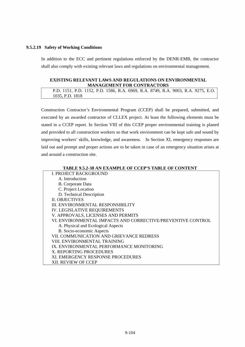
9-104
9.5.2.19 Safety of Working Conditions
In addition to the ECC and pertinent regulations enforced by the DENR-EMB, the contractor
shall also comply with existing relevant laws and regulations on environmental management.
EXISTING RELEVANT LAWS AND REGULATIONS ON ENVIRONMENTAL MANAGEMENT FOR CONTRACTORS
P.D. 1151, P.D. 1152, P.D. 1586, R.A. 6969, R.A. 8749, R.A. 9003, R.A. 9275, E.O. 1035, P.D. 1818
Construction Contractor’s Environmental Program (CCEP) shall be prepared, submitted, and
executed by an awarded contractor of CLLEX project. At least the following elements must be
stated in a CCEP report. In Section VIII of this CCEP proper environmental training is planed
and provided to all construction workers so that work environment can be kept safe and sound by
improving workers’ skills, knowledge, and awareness. In Section XI, emergency responses are
laid out and prompt and proper actions are to be taken in case of an emergency situation arises at
and around a construction site.
TABLE 9.5.2-38 AN EXAMPLE OF CCEP’S TABLE OF CONTENT I. PROJECT BACKGROUND
A. Introduction B. Corporate Data C. Project Location D. Technical Description
II. OBJECTIVES III. ENVIRONMENTAL RESPONSIBILITY IV. LEGISLATIVE REQUIREMENTS V. APPROVALS, LICENSES AND PERMITS VI. ENVIRONMENTAL IMPACTS AND CORRECTIVE/PREVENTIVE CONTROL
A. Physical and Ecological Aspects B. Socio-economic Aspects
VII. COMMUNICATION AND GRIEVANCE REDRESS VIII. ENVIRONMENTAL TRAINING IX. ENVIRONMENTAL PERFORMANCE MONITORING X. REPORTING PROCEDURES XI. EMERGENCY RESPONSE PROCEDURES XII. REVIEW OF CCEP
9-105
9.5.3 Analysis of Alternatives
The following alternatives were studied.
1) Expressway Alignment
Three (3) alternatives were studied focusing on the most appropriate alignment selection at the
flood-prone area;
Alternative-1: 2010 FS Alignment Alternative-2: Passing at Downstream of Confluence Point Alternative-3: Passing at Upper stream of Confluence Point
Evaluation of alternative alignments is shown in Figure 9.5.3-1. Alternative-2 was recommended
due to the following;
The most preferred alignment for traffic between Manila side and Cabanatuan City which is
dominant traffic on CLLEX.
The alignment passes through the area where there are banks on both sides of the river;
therefore water course is controlled and stable. Flood water overflows the banks, thus enough
bridge length needs to be provided.
Number of affected houses is the least.
Construction cost is least, although it is almost the same as Alternative-3.
Alternative-1 passes through the confluent points of two rivers, not appropriate for the
alignment to pass.
From the view point of river crossing location, Alternative-3 is also appropriate, however,
from the view points of traffic efficiency, Alternative-3 is not recommended.
An alternative alignment between Aliaga and Cabanatuan City, particularly where to end Phase I
at Cabanatuan City was pre-screened. Possible alternative alignment is to end Phase I at south of
Cabanatuan City, however this screened out due to the following reasons;
Pan Philippine Highway is terribly congested in Cabanatuan City. To reduce traffic congestion in
Cabanatuan City, through traffic coming from the north of Cabanatuan City including from
Region II should be captured before they enter into Cabanatuan City urban area. Thus, CLLEX
Phase I should end at the northern trip of Cabanatuan City.
If CLLEX ends at the southern side of Cabanatuan City, it has to cross the big river of Pampanga
River two times, and needs two long bridges, one(1) is about 600 m bridge in Phase I and another
is about 1,000 m bridge in Phase II.
9-106
2) Interchange Alternatives
Aliaga: There are 3 Alternatives as shown Figure 9.5.3-2 Considering the construction cost and
accessibility, Alternative-2 is recommended, although 2 houses are need to relocate in case of
Alternative-2.
Alternative-2 is the cheapest, minimum land take of agri-land and good accessibility to Aliaga
Trading Center and Bus Terminal. The owners of the affected two (2) houses are the same owners
of the Aliaga Trading Center and the Bus Terminal. According to the Aliaga Municipality opinion,
it is easy to negotiate with owners because the project will contribute to the Trading Center’s
business.
Aliaga IC area has no wetland and there is no difference among alternatives regarding to natural
environment influence.
The municipal government of Aliaga also selected Alternative-2.
Cabanatuan: There are 2 Alternatives as shown Figure 9.5.3-3. Considering the Land
acquisition, construction cost and accessibility, Alternative-2 is recommended.
The City Government of Cabanatuan also selected Alternative-2.
9-107
(Confidential)
FIGURE 9.5.3-1 MONITOR IMPLEMENTATION OF ENVIRONMENTAL MITIGATION MEASURES
EVALUATION OF ALTERNATIVE ALIGNMENT
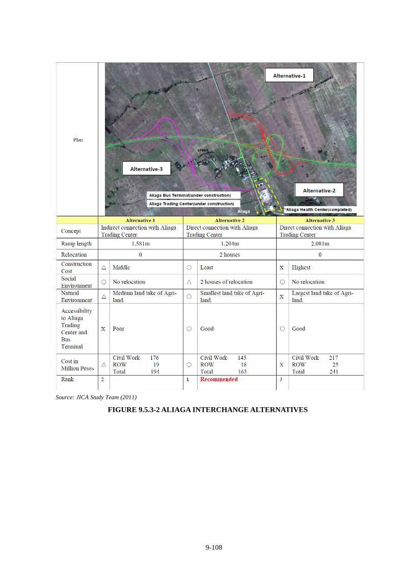
9-108
Source: JICA Study Team (2011)
FIGURE 9.5.3-2 ALIAGA INTERCHANGE ALTERNATIVES
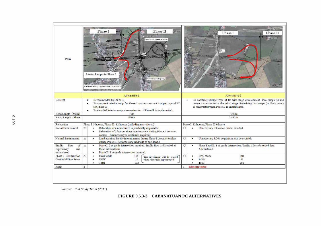
9-109
Source: JICA Study Team (2011)
FIGURE 9.5.3-3 CABANATUAN I/C ALTERNATIVES
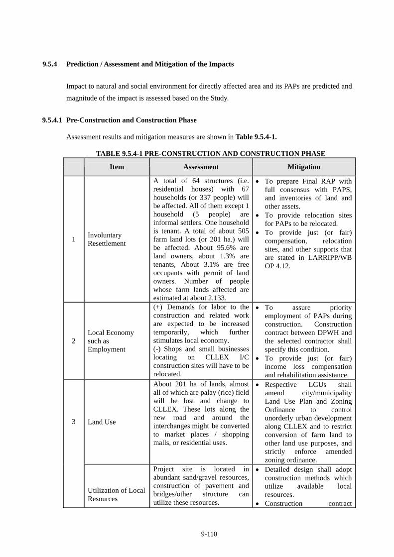
9-110
9.5.4 Prediction / Assessment and Mitigation of the Impacts
Impact to natural and social environment for directly affected area and its PAPs are predicted and
magnitude of the impact is assessed based on the Study.
9.5.4.1 Pre-Construction and Construction Phase
Assessment results and mitigation measures are shown in Table 9.5.4-1.
TABLE 9.5.4-1 PRE-CONSTRUCTION AND CONSTRUCTION PHASE
Item Assessment Mitigation
1 Involuntary Resettlement
A total of 64 structures (i.e. residential houses) with 67 households (or 337 people) will be affected. All of them except 1 household (5 people) are informal settlers. One household is tenant. A total of about 505 farm land lots (or 201 ha.) will be affected. About 95.6% are land owners, about 1.3% are tenants, About 3.1% are free occupants with permit of land owners. Number of people whose farm lands affected are estimated at about 2,133.
To prepare Final RAP with full consensus with PAPS, and inventories of land and other assets.
To provide relocation sites for PAPs to be relocated.
To provide just (or fair) compensation, relocation sites, and other supports that are stated in LARRIPP/WB OP 4.12.
2 Local Economy such as Employment
(+) Demands for labor to the construction and related work are expected to be increased temporarily, which further stimulates local economy. (-) Shops and small businesses locating on CLLEX I/C construction sites will have to be relocated.
To assure priority employment of PAPs during construction. Construction contract between DPWH and the selected contractor shall specify this condition.
To provide just (or fair) income loss compensation and rehabilitation assistance.
Land Use
About 201 ha of lands, almost all of which are palay (rice) field will be lost and change to CLLEX. These lots along the new road and around the interchanges might be converted to market places / shopping malls, or residential uses.
Respective LGUs shall amend city/municipality Land Use Plan and Zoning Ordinance to control unorderly urban development along CLLEX and to restrict conversion of farm land to other land use purposes, and strictly enforce amended zoning ordinance.
3
Utilization of Local Resources
Project site is located in abundant sand/gravel resources, construction of pavement and bridges/other structure can utilize these resources.
Detailed design shall adopt construction methods which utilize available local resources.
Construction contract
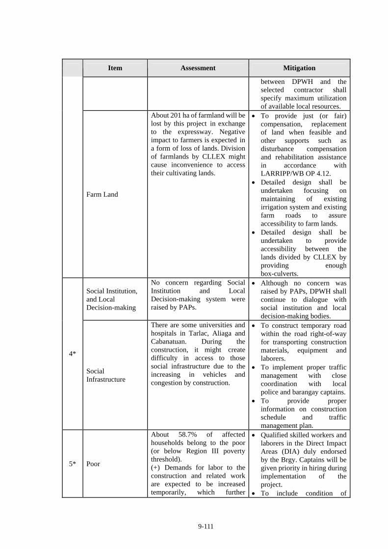
9-111
Item Assessment Mitigation
between DPWH and the selected contractor shall specify maximum utilization of available local resources.
Farm Land
About 201 ha of farmland will be lost by this project in exchange to the expressway. Negative impact to farmers is expected in a form of loss of lands. Division of farmlands by CLLEX might cause inconvenience to access their cultivating lands.
To provide just (or fair) compensation, replacement of land when feasible and other supports such as disturbance compensation and rehabilitation assistance in accordance with LARRIPP/WB OP 4.12.
Detailed design shall be undertaken focusing on maintaining of existing irrigation system and existing farm roads to assure accessibility to farm lands.
Detailed design shall be undertaken to provide accessibility between the lands divided by CLLEX by providing enough box-culverts.
Social Institution, and Local Decision-making
No concern regarding Social Institution and Local Decision-making system were raised by PAPs.
Although no concern was raised by PAPs, DPWH shall continue to dialogue with social institution and local decision-making bodies.
4*
Social Infrastructure
There are some universities and hospitals in Tarlac, Aliaga and Cabanatuan. During the construction, it might create difficulty in access to those social infrastructure due to the increasing in vehicles and congestion by construction.
To construct temporary road within the road right-of-way for transporting construction materials, equipment and laborers.
To implement proper traffic management with close coordination with local police and barangay captains.
To provide proper information on construction schedule and traffic management plan.
5* Poor
About 58.7% of affected households belong to the poor (or below Region III poverty threshold). (+) Demands for labor to the construction and related work are expected to be increased temporarily, which further
Qualified skilled workers and laborers in the Direct Impact Areas (DIA) duly endorsed by the Brgy. Captains will be given priority in hiring during implementation of the project.
To include condition of
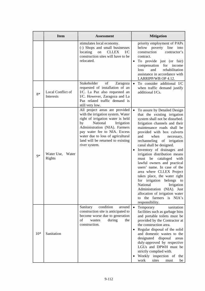
9-112
Item Assessment Mitigation
stimulates local economy. (-) Shops and small businesses locating on CLLEX I/C construction sites will have to be relocated.
priority employment of PAPs below poverty line into construction contractor’s contract.
To provide just (or fair) compensation for income loss and rehabilitation assistance in accordance with LARRIPP/WB OP 4.12.
8* Local Conflict of Interests
Stakeholder of Zaragoza requested of installation of an I/C. La Paz also requested an I/C. However, Zaragoza and La Paz related traffic demand is still very low.
To consider additional I/C when traffic demand justify additional I/Cs.
9* Water Use, Water Rights
All project areas are provided with the irrigation system. Water right of irrigation water is held by National Irrigation Administration (NIA). Farmers pay water fee to NIA. Excess water due to loss of agricultural land will be returned to existing river system.
To assure by Detailed Design that the existing irrigation system shall not be disturbed. Irrigation channels and their maintenance roads shall be provided with box culverts and when necessary, rechanneling of irrigation canal shall be designed.
Inventory of drainages and irrigation distribution means must be cataloged with lawful owners and practical users’ name. In case of the area where CLLEX Project takes place, the water right for irrigation belongs to National Irrigation Administration (NIA). Just allocation of irrigation water to the farmers is NIA’s responsibility.
10* Sanitation
Sanitary condition around construction site is anticipated to become worse due to generation of wastes during the construction.
Temporary sanitation facilities such as garbage bins and portable toilets must be provided by the Contractor at the construction area.
Regular disposal of the solid and domestic wastes to the designated disposal areas duly-approved by respective LGUs and DPWH must be strictly complied with.
Weekly inspection of the work sites must be
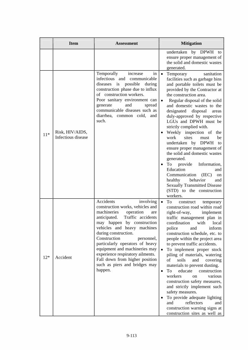
9-113
Item Assessment Mitigation
undertaken by DPWH to ensure proper management of the solid and domestic wastes generated.
11* Risk, HIV/AIDS, Infectious disease
Temporally increase in infectious and communicable diseases is possible during construction phase due to influx of construction workers. Poor sanitary environment can generate and spread communicable diseases such as diarrhea, common cold, and such.
Temporary sanitation facilities such as garbage bins and portable toilets must be provided by the Contractor at the construction area.
Regular disposal of the solid and domestic wastes to the designated disposal areas duly-approved by respective LGUs and DPWH must be strictly complied with.
Weekly inspection of the work sites must be undertaken by DPWH to ensure proper management of the solid and domestic wastes generated.
To provide Information, Education and Communication (IEC) on healthy behavior and Sexually Transmitted Disease (STD) to the construction workers.
12* Accident
Accidents involving construction works, vehicles and machineries operation are anticipated. Traffic accidents may happen by construction vehicles and heavy machines during construction. Construction personnel, particularly operators of heavy equipment and machineries may experience respiratory ailments.Fall down from higher position such as piers and bridges may happen.
To construct temporary construction road within road right-of-way, implement traffic management plan in coordination with local police and inform construction schedule, etc. to people within the project area to prevent traffic accidents.
To implement proper stock piling of materials, watering of soils and covering materials to prevent dusting.
To educate construction workers on various construction safety measures, and strictly implement such safety measures.
To provide adequate lighting and reflectors and construction warning signs at construction sites as well as
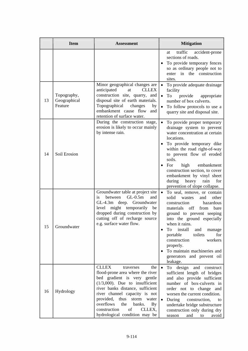
9-114
Item Assessment Mitigation
at traffic accident-prone sections of roads.
To provide temporary fences so as ordinary people not to enter in the construction sites.
13 Topography, Geographical Feature
Minor geographical changes are anticipated at CLLEX construction site, quarry, and disposal site of earth materials. Topographical changes by embankment cause flow and retention of surface water.
To provide adequate drainage facility
To provide appropriate number of box culverts.
To follow protocols to use a quarry site and disposal site.
14 Soil Erosion
During the construction stage, erosion is likely to occur mainly by intense rain.
To provide proper temporary drainage system to prevent water concentration at certain locations.
To provide temporary dike within the road right-of-way to prevent flow of eroded soils.
For high embankment construction section, to cover embankment by vinyl sheet during heavy rain for prevention of slope collapse.
15 Groundwater
Groundwater table at project site is between GL-0.5m and GL-4.3m deep. Groundwater level might temporarily be dropped during construction by cutting off of recharge source e.g. surface water flow.
To seal, remove, or contain solid wastes and other construction hazardous materials off from bare ground to prevent seeping into the ground especially when it rains.
To install and manage portable toilets for construction workers properly.
To maintain machineries and generators and prevent oil leakage.
16 Hydrology
CLLEX traverses the flood-prone area where the river bed gradient is very gentle (1/3,000). Due to insufficient river banks distance, sufficient river channel capacity is not provided, thus storm water overflows the banks. By construction of CLLEX, hydrological condition may be
To design and construct sufficient length of bridges and also provide sufficient number of box-culverts in order not to change and worsen the current condition.
During construction, to undertake bridge substructure construction only during dry season and to avoid
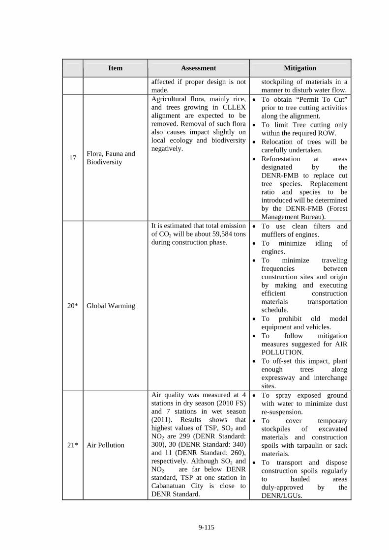
9-115
Item Assessment Mitigation
affected if proper design is not made.
stockpiling of materials in a manner to disturb water flow.
17 Flora, Fauna and Biodiversity
Agricultural flora, mainly rice, and trees growing in CLLEX alignment are expected to be removed. Removal of such flora also causes impact slightly on local ecology and biodiversity negatively.
To obtain “Permit To Cut” prior to tree cutting activities along the alignment.
To limit Tree cutting only within the required ROW.
Relocation of trees will be carefully undertaken.
Reforestation at areas designated by the DENR-FMB to replace cut tree species. Replacement ratio and species to be introduced will be determined by the DENR-FMB (Forest Management Bureau).
20* Global Warming
It is estimated that total emission of CO2 will be about 59,584 tons during construction phase.
To use clean filters and mufflers of engines.
To minimize idling of engines.
To minimize traveling frequencies between construction sites and origin by making and executing efficient construction materials transportation schedule.
To prohibit old model equipment and vehicles.
To follow mitigation measures suggested for AIR POLLUTION.
To off-set this impact, plant enough trees along expressway and interchange sites.
21* Air Pollution
Air quality was measured at 4 stations in dry season (2010 FS) and 7 stations in wet season (2011). Results shows that highest values of TSP, SO2 and NO2 are 299 (DENR Standard: 300), 30 (DENR Standard: 340) and 11 (DENR Standard: 260), respectively. Although SO2 and NO2 are far below DENR standard, TSP at one station in Cabanatuan City is close to DENR Standard.
To spray exposed ground with water to minimize dust re-suspension.
To cover temporary stockpiles of excavated materials and construction spoils with tarpaulin or sack materials.
To transport and dispose construction spoils regularly to hauled areas duly-approved by the DENR/LGUs.
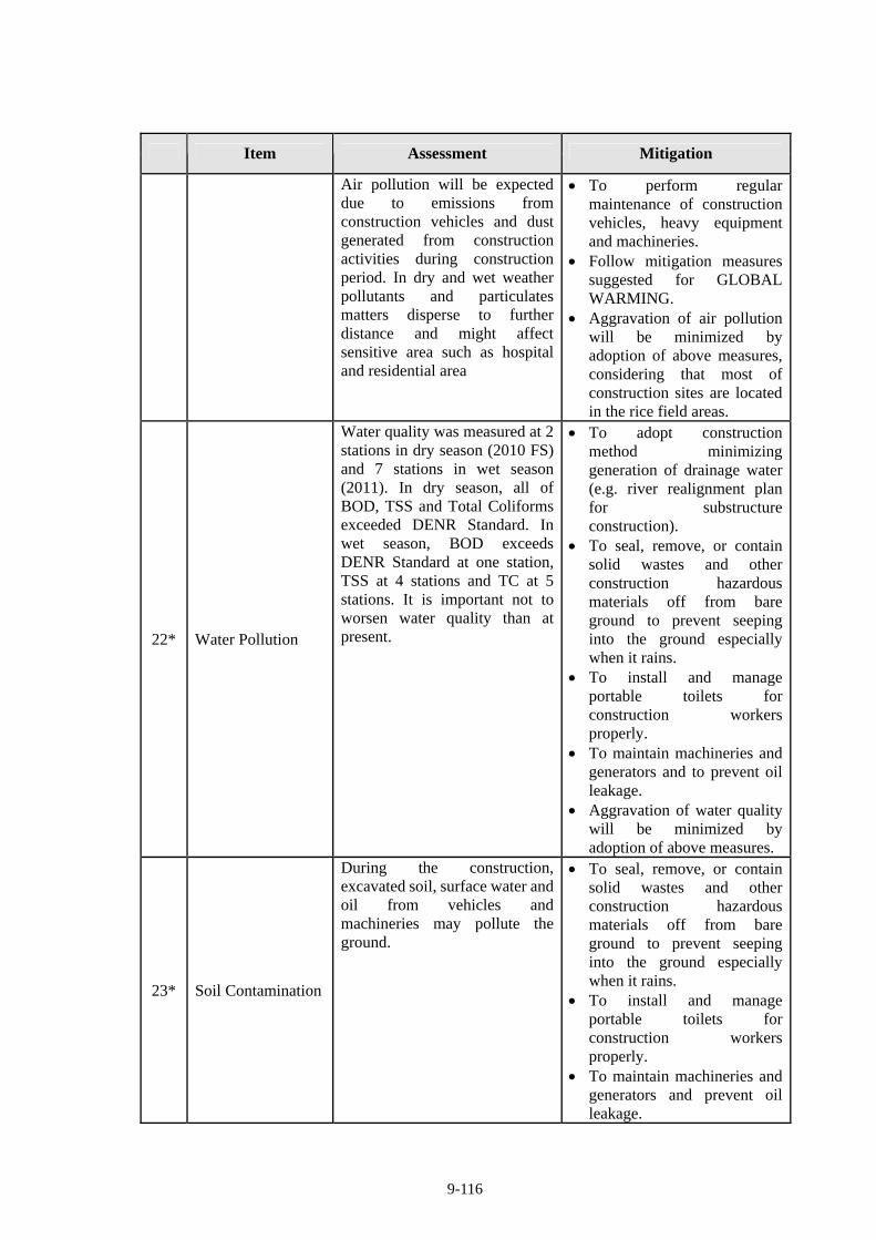
9-116
Item Assessment Mitigation
Air pollution will be expected due to emissions from construction vehicles and dust generated from construction activities during construction period. In dry and wet weather pollutants and particulates matters disperse to further distance and might affect sensitive area such as hospital and residential area
To perform regular maintenance of construction vehicles, heavy equipment and machineries.
Follow mitigation measures suggested for GLOBAL WARMING.
Aggravation of air pollution will be minimized by adoption of above measures, considering that most of construction sites are located in the rice field areas.
22* Water Pollution
Water quality was measured at 2 stations in dry season (2010 FS) and 7 stations in wet season (2011). In dry season, all of BOD, TSS and Total Coliforms exceeded DENR Standard. In wet season, BOD exceeds DENR Standard at one station, TSS at 4 stations and TC at 5 stations. It is important not to worsen water quality than at present.
To adopt construction method minimizing generation of drainage water (e.g. river realignment plan for substructure construction).
To seal, remove, or contain solid wastes and other construction hazardous materials off from bare ground to prevent seeping into the ground especially when it rains.
To install and manage portable toilets for construction workers properly.
To maintain machineries and generators and to prevent oil leakage.
Aggravation of water quality will be minimized by adoption of above measures.
23* Soil Contamination
During the construction, excavated soil, surface water and oil from vehicles and machineries may pollute the ground.
To seal, remove, or contain solid wastes and other construction hazardous materials off from bare ground to prevent seeping into the ground especially when it rains.
To install and manage portable toilets for construction workers properly.
To maintain machineries and generators and prevent oil leakage.
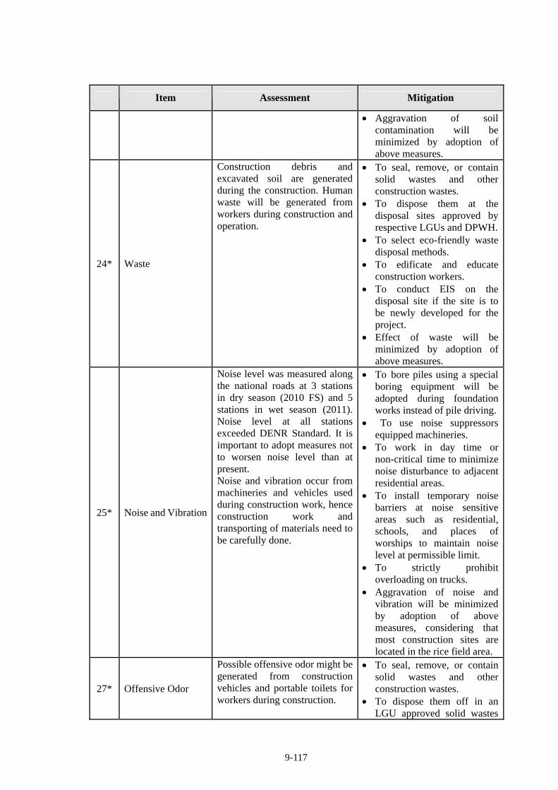
9-117
Item Assessment Mitigation
Aggravation of soil contamination will be minimized by adoption of above measures.
24* Waste
Construction debris and excavated soil are generated during the construction. Human waste will be generated from workers during construction and operation.
To seal, remove, or contain solid wastes and other construction wastes.
To dispose them at the disposal sites approved by respective LGUs and DPWH.
To select eco-friendly waste disposal methods.
To edificate and educate construction workers.
To conduct EIS on the disposal site if the site is to be newly developed for the project.
Effect of waste will be minimized by adoption of above measures.
25* Noise and Vibration
Noise level was measured along the national roads at 3 stations in dry season (2010 FS) and 5 stations in wet season (2011). Noise level at all stations exceeded DENR Standard. It is important to adopt measures not to worsen noise level than at present. Noise and vibration occur from machineries and vehicles used during construction work, hence construction work and transporting of materials need to be carefully done.
To bore piles using a special boring equipment will be adopted during foundation works instead of pile driving.
To use noise suppressors equipped machineries.
To work in day time or non-critical time to minimize noise disturbance to adjacent residential areas.
To install temporary noise barriers at noise sensitive areas such as residential, schools, and places of worships to maintain noise level at permissible limit.
To strictly prohibit overloading on trucks.
Aggravation of noise and vibration will be minimized by adoption of above measures, considering that most construction sites are located in the rice field area.
27* Offensive Odor
Possible offensive odor might be generated from construction vehicles and portable toilets for workers during construction.
To seal, remove, or contain solid wastes and other construction wastes.
To dispose them off in an LGU approved solid wastes
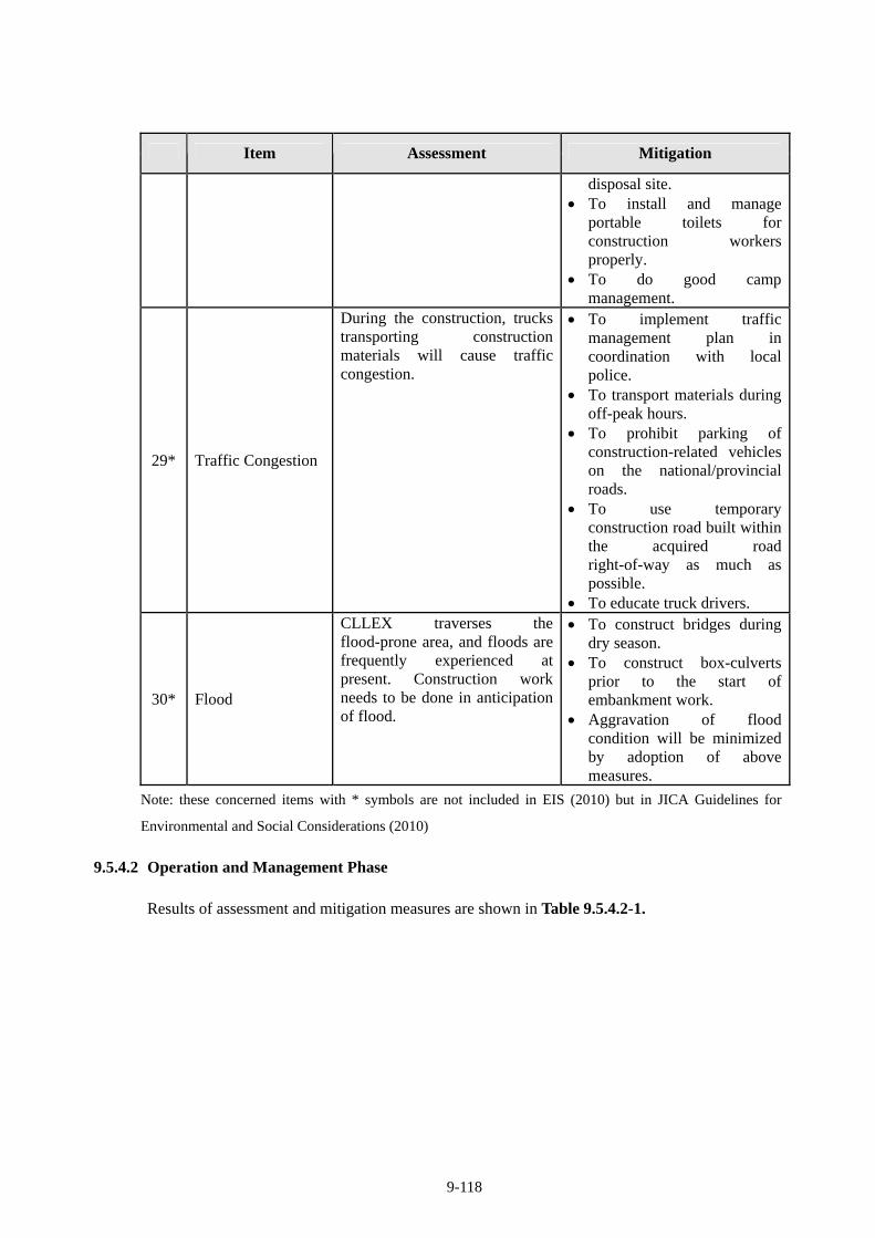
9-118
Item Assessment Mitigation
disposal site. To install and manage
portable toilets for construction workers properly.
To do good camp management.
29* Traffic Congestion
During the construction, trucks transporting construction materials will cause traffic congestion.
To implement traffic management plan in coordination with local police.
To transport materials during off-peak hours.
To prohibit parking of construction-related vehicles on the national/provincial roads.
To use temporary construction road built within the acquired road right-of-way as much as possible.
To educate truck drivers.
30* Flood
CLLEX traverses the flood-prone area, and floods are frequently experienced at present. Construction work needs to be done in anticipation of flood.
To construct bridges during dry season.
To construct box-culverts prior to the start of embankment work.
Aggravation of flood condition will be minimized by adoption of above measures.
Note: these concerned items with * symbols are not included in EIS (2010) but in JICA Guidelines for
Environmental and Social Considerations (2010)
9.5.4.2 Operation and Management Phase
Results of assessment and mitigation measures are shown in Table 9.5.4.2-1.
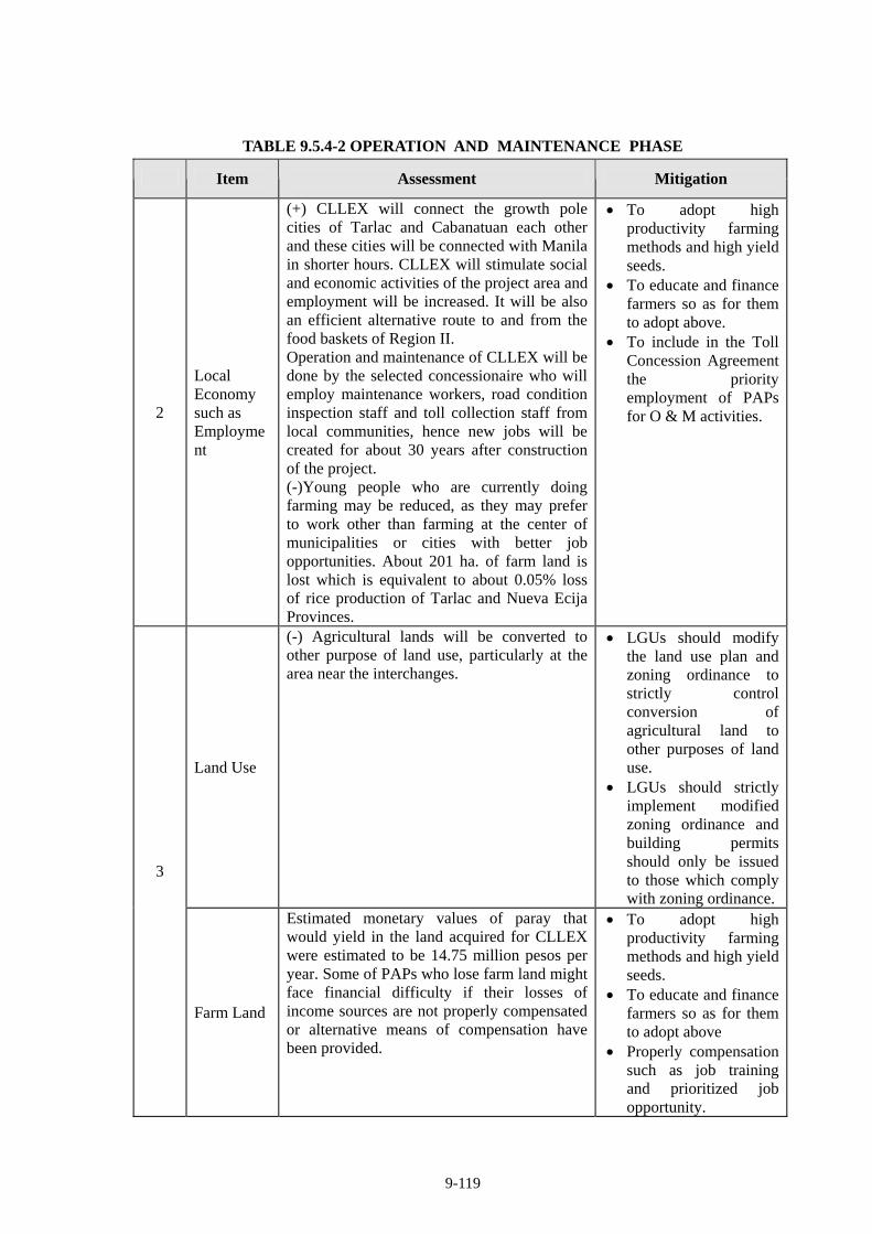
9-119
TABLE 9.5.4-2 OPERATION AND MAINTENANCE PHASE
Item Assessment Mitigation
2
Local Economy such as Employment
(+) CLLEX will connect the growth pole cities of Tarlac and Cabanatuan each other and these cities will be connected with Manila in shorter hours. CLLEX will stimulate social and economic activities of the project area and employment will be increased. It will be also an efficient alternative route to and from the food baskets of Region II. Operation and maintenance of CLLEX will be done by the selected concessionaire who will employ maintenance workers, road condition inspection staff and toll collection staff from local communities, hence new jobs will be created for about 30 years after construction of the project. (-)Young people who are currently doing farming may be reduced, as they may prefer to work other than farming at the center of municipalities or cities with better job opportunities. About 201 ha. of farm land is lost which is equivalent to about 0.05% loss of rice production of Tarlac and Nueva Ecija Provinces.
To adopt high productivity farming methods and high yield seeds.
To educate and finance farmers so as for them to adopt above.
To include in the Toll Concession Agreement the priority employment of PAPs for O & M activities.
Land Use
(-) Agricultural lands will be converted to other purpose of land use, particularly at the area near the interchanges.
LGUs should modify the land use plan and zoning ordinance to strictly control conversion of agricultural land to other purposes of land use.
LGUs should strictly implement modified zoning ordinance and building permits should only be issued to those which comply with zoning ordinance.
3
Farm Land
Estimated monetary values of paray that would yield in the land acquired for CLLEX were estimated to be 14.75 million pesos per year. Some of PAPs who lose farm land might face financial difficulty if their losses of income sources are not properly compensated or alternative means of compensation have been provided.
To adopt high productivity farming methods and high yield seeds.
To educate and finance farmers so as for them to adopt above
Properly compensation such as job training and prioritized job opportunity.
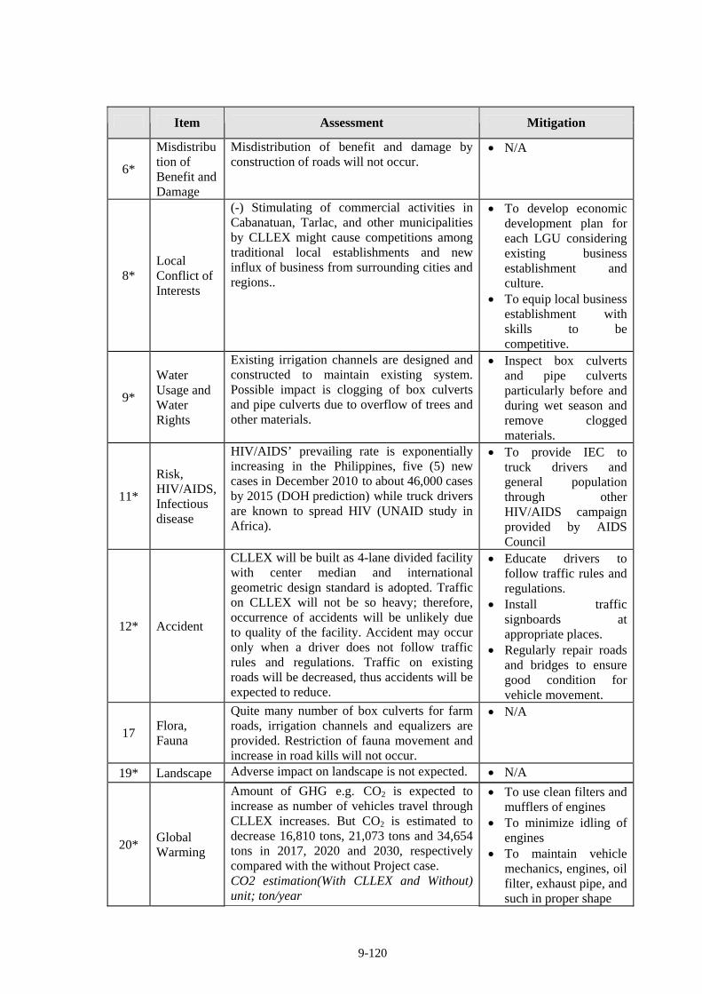
9-120
Item Assessment Mitigation
6*
Misdistribution of Benefit and Damage
Misdistribution of benefit and damage by construction of roads will not occur.
N/A
8* Local Conflict of Interests
(-) Stimulating of commercial activities in Cabanatuan, Tarlac, and other municipalities by CLLEX might cause competitions among traditional local establishments and new influx of business from surrounding cities and regions..
To develop economic development plan for each LGU considering existing business establishment and culture.
To equip local business establishment with skills to be competitive.
9*
Water Usage and Water Rights
Existing irrigation channels are designed and constructed to maintain existing system. Possible impact is clogging of box culverts and pipe culverts due to overflow of trees and other materials.
Inspect box culverts and pipe culverts particularly before and during wet season and remove clogged materials.
11*
Risk, HIV/AIDS, Infectious disease
HIV/AIDS’ prevailing rate is exponentially increasing in the Philippines, five (5) new cases in December 2010 to about 46,000 cases by 2015 (DOH prediction) while truck drivers are known to spread HIV (UNAID study in Africa).
To provide IEC to truck drivers and general population through other HIV/AIDS campaign provided by AIDS Council
12* Accident
CLLEX will be built as 4-lane divided facility with center median and international geometric design standard is adopted. Traffic on CLLEX will not be so heavy; therefore, occurrence of accidents will be unlikely due to quality of the facility. Accident may occur only when a driver does not follow traffic rules and regulations. Traffic on existing roads will be decreased, thus accidents will be expected to reduce.
Educate drivers to follow traffic rules and regulations.
Install traffic signboards at appropriate places.
Regularly repair roads and bridges to ensure good condition for vehicle movement.
17 Flora, Fauna
Quite many number of box culverts for farm roads, irrigation channels and equalizers are provided. Restriction of fauna movement and increase in road kills will not occur.
N/A
19* Landscape Adverse impact on landscape is not expected. N/A
20* Global Warming
Amount of GHG e.g. CO2 is expected to increase as number of vehicles travel through CLLEX increases. But CO2 is estimated to decrease 16,810 tons, 21,073 tons and 34,654 tons in 2017, 2020 and 2030, respectively compared with the without Project case. CO2 estimation(With CLLEX and Without) unit; ton/year
To use clean filters and mufflers of engines
To minimize idling of engines
To maintain vehicle mechanics, engines, oil filter, exhaust pipe, and such in proper shape
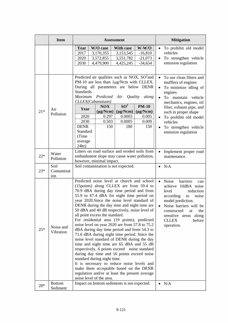
9-121
Item Assessment Mitigation
Year W/O case With case W-W/O2017 3,170,355 3,153,545 -16,8102020 3,572,855 3,551,782 -21,0732030 4,479,900 4,425,245 -34,654
To prohibit old model vehicles
To strengthen vehicle emission regulation
21* Air Pollution
Predicted air qualities such as NOX, SO2and PM-10 are less than 1μg/Ncm with CLLEX. During all parameters are below DENR Standards. Maximum Predicted Air Quality along CLLEX(Cabanatuan)
Year NOX
(μg/Ncm)SO2
(μg/Ncm)PM-10
(μg/Ncm)2020 0.297 0.0003 0.0052030 0.503 0.0005 0.009
DENR Standard (Time average 24hr)
150 180 150
To use clean filters and mufflers of engines
To minimize idling of engines
To maintain vehicle mechanics, engines, oil filter, exhaust pipe, and such in proper shape
To prohibit old model vehicles
To strengthen vehicle emission regulation
22* Water Pollution
Litters on road surface and eroded soils from embankment slope may cause water pollution, however, minimal impact.
Implement proper road maintenance.
23* Soil Contamination
Soil contamination is not expected. N/A
25* Noise and Vibration
Predicted noise level at church and school (15points) along CLLEX are from 59.4 to 70.9 dBA during day time period and from 55.9 to 67.4 dBA for night time period on year 2020.Since the noise level standard of DENR during the day time and night time are 50 dBA and 40 dB respectively, noise level of all point excess the standard. For residential area (19 points), predicted noise level on year 2020 are from 57.8 to 75.2 dBA during day time period and from 54.3 to 71.6 dBA during night time period. Since the noise level standard of DENR during the day time and night time are 65 dBA and 55 dB respectively, 6 points exceed noise standard during day time and 16 points exceed noise standard during night time. It is necessary to reduce noise levels and make them acceptable based on the DENR regulation and/or at least the present average noise level of the area.
Noise barriers can achieve 10dBA noise level reduction according to noise model prediction.
Noise barriers will be constructed at the sensitive areas along CLLEX before operation.
28* Bottom Sediment
Impact on bottom sediments is not expected. N/A
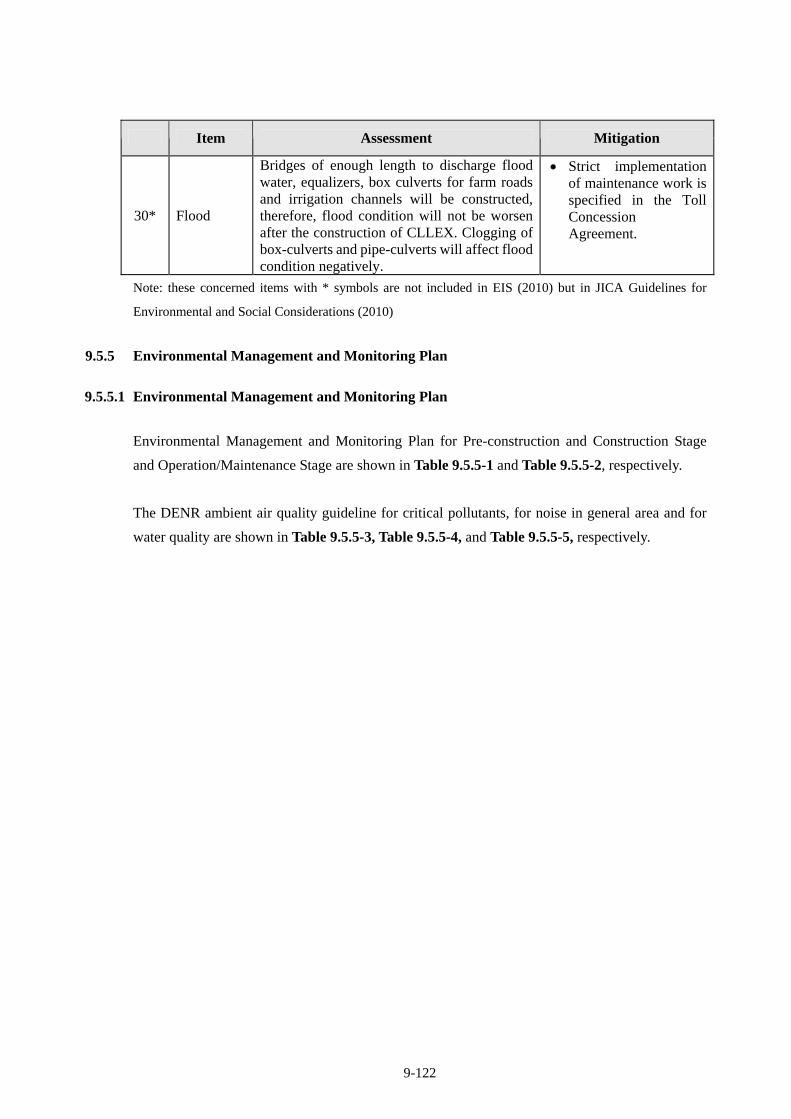
9-122
Item Assessment Mitigation
30* Flood
Bridges of enough length to discharge flood water, equalizers, box culverts for farm roads and irrigation channels will be constructed, therefore, flood condition will not be worsen after the construction of CLLEX. Clogging of box-culverts and pipe-culverts will affect flood condition negatively.
Strict implementation of maintenance work is specified in the Toll Concession Agreement.
Note: these concerned items with * symbols are not included in EIS (2010) but in JICA Guidelines for
Environmental and Social Considerations (2010)
9.5.5 Environmental Management and Monitoring Plan
9.5.5.1 Environmental Management and Monitoring Plan
Environmental Management and Monitoring Plan for Pre-construction and Construction Stage
and Operation/Maintenance Stage are shown in Table 9.5.5-1 and Table 9.5.5-2, respectively.
The DENR ambient air quality guideline for critical pollutants, for noise in general area and for
water quality are shown in Table 9.5.5-3, Table 9.5.5-4, and Table 9.5.5-5, respectively.
9-123
TABLE 9.5.5-1 ENVIRONMENTAL MANAGEMENT AND MONITORING PLAN
PRE-CONSTRUCTION AND CONSTRUCTION STAGE
(Confidential)

9-124 (Confidential)

9-125 (Confidential)

9-126 (Confidential)

9-127 (Confidential)

9-128 (Confidential)

9-129 (Confidential)

9-130 (Confidential)

9-131 (Confidential)

9-132 (Confidential)

9-133
(Confidential)
9-134
TABLE 9.5.5-2 ENVIRONMENTAL MANAGEMENT AND MONITORING PLAN
OPERATION AND MAINTENANCE STAGE
(Confidential)

9-135 (Confidential)

9-136
(Confidential)
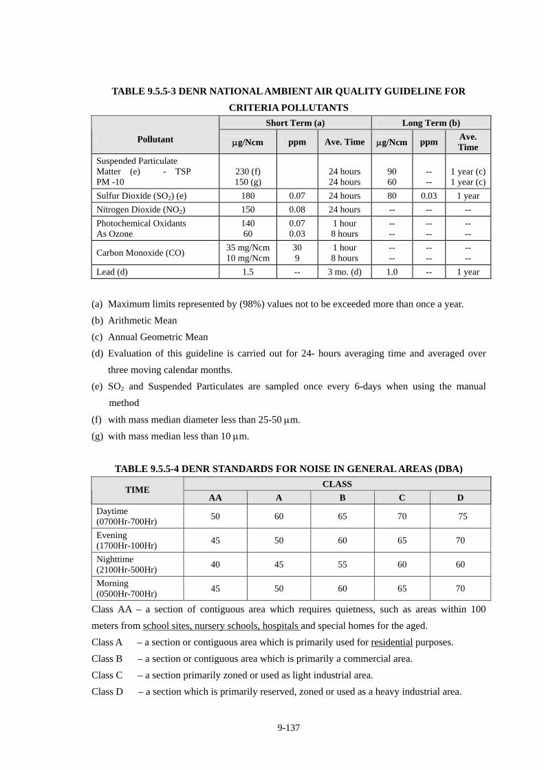
9-137
TABLE 9.5.5-3 DENR NATIONAL AMBIENT AIR QUALITY GUIDELINE FOR
CRITERIA POLLUTANTS
Short Term (a) Long Term (b)
Pollutant g/Ncm ppm Ave. Time g/Ncm ppm Ave. Time
Suspended Particulate Matter (e) - TSP PM -10
230 (f) 150 (g)
24 hours 24 hours
90 60
-- --
1 year (c)1 year (c)
Sulfur Dioxide (SO2) (e) 180 0.07 24 hours 80 0.03 1 year
Nitrogen Dioxide (NO2) 150 0.08 24 hours -- -- --
Photochemical Oxidants As Ozone
140 60
0.07 0.03
1 hour 8 hours
-- --
-- --
-- --
Carbon Monoxide (CO) 35 mg/Ncm10 mg/Ncm
30 9
1 hour 8 hours
-- --
-- --
-- --
Lead (d) 1.5 -- 3 mo. (d) 1.0 -- 1 year
(a) Maximum limits represented by (98%) values not to be exceeded more than once a year.
(b) Arithmetic Mean
(c) Annual Geometric Mean
(d) Evaluation of this guideline is carried out for 24- hours averaging time and averaged over
three moving calendar months.
(e) SO2 and Suspended Particulates are sampled once every 6-days when using the manual
method
(f) with mass median diameter less than 25-50 m.
(g) with mass median less than 10 m.
TABLE 9.5.5-4 DENR STANDARDS FOR NOISE IN GENERAL AREAS (DBA)
CLASS TIME
AA A B C D
Daytime (0700Hr-700Hr)
50 60 65 70 75
Evening (1700Hr-100Hr)
45 50 60 65 70
Nighttime (2100Hr-500Hr)
40 45 55 60 60
Morning (0500Hr-700Hr)
45 50 60 65 70
Class AA – a section of contiguous area which requires quietness, such as areas within 100
meters from school sites, nursery schools, hospitals and special homes for the aged.
Class A – a section or contiguous area which is primarily used for residential purposes.
Class B – a section or contiguous area which is primarily a commercial area.
Class C – a section primarily zoned or used as light industrial area.
Class D – a section which is primarily reserved, zoned or used as a heavy industrial area.

9-138
TABLE 9.5.5-5 WATER QUALITY CRITERIA FOR CONVENTIONAL AND OTHER
POLLUTANTS CONTRIBUTING TO AESTHETIC AND OXYGEN DEMAND
FOR FRESH WATERS
Class C Class D
Fresh Surface Water Parameter Unit Fishery, Recreational(Boating),
Industrial use (after treated)
For agriculture, irrigation, livestock, industrial use, other
inland water
Temperature oC 3oC maximum rise 3oC maximum rise
pH - 6.5 - 8.5 6.0 - 9.0
Dissolved Oxygen (DO) mg/L minimum 5.0 mg/L 3.0 (at 40% saturation)
Biochemical Oxygen Demand (BOD5)
mg/L < 10.0 mg/L 10 (15)
Total Coliform MPN/ 100ml
5,000 N/A
Total Suspended Solids (TSS) mg/L Not more than 30mg/L increase Not more than 60mg/L increase
Total Dissolved Solids (TDS) mg/L N/A 1000
(or natural back ground value if greater than 1000)
SAR N/A 8-18
N/A: No standards stipulated in DAO No. 34 Series of 1990
Monitoring form for JICA for this project is shown in Table 9.5.5-6.
TABLE 9.5.5-6 MONITORING FORM OF JICA
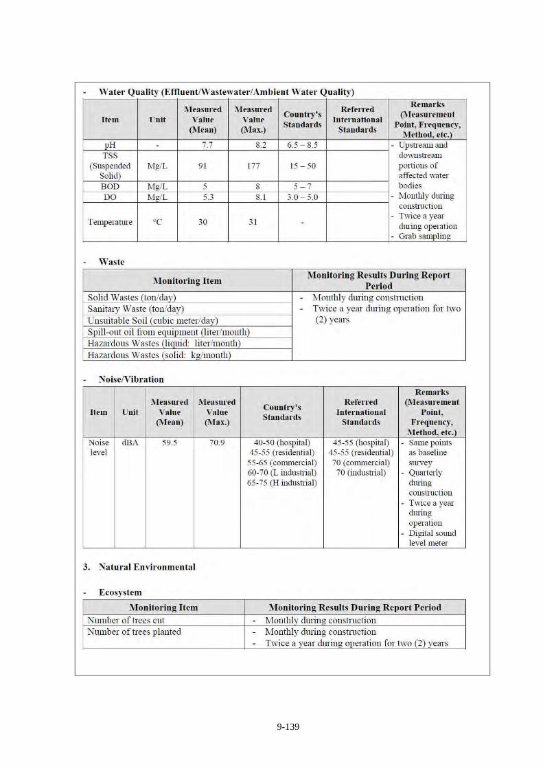
9-139
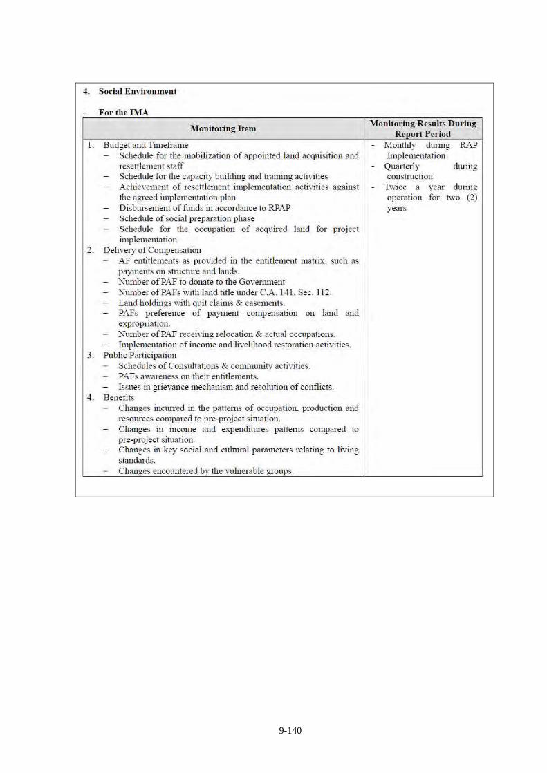
9-140
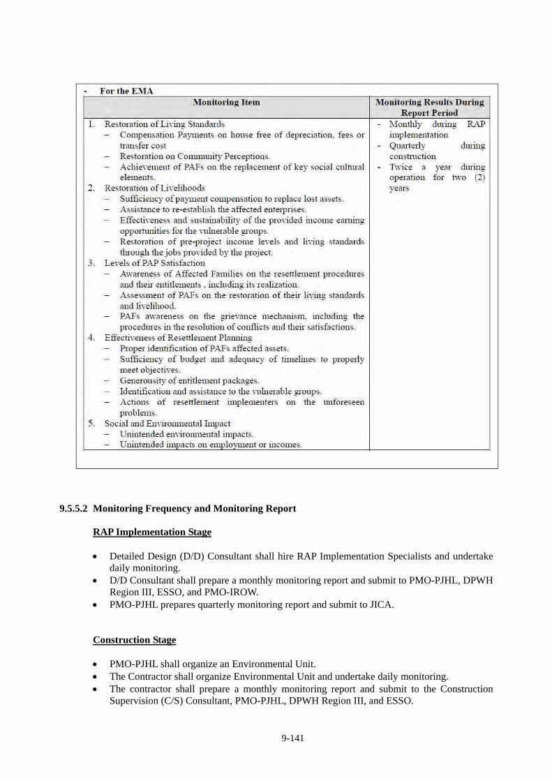
9-141
9.5.5.2 Monitoring Frequency and Monitoring Report
RAP Implementation Stage Detailed Design (D/D) Consultant shall hire RAP Implementation Specialists and undertake
daily monitoring. D/D Consultant shall prepare a monthly monitoring report and submit to PMO-PJHL, DPWH
Region III, ESSO, and PMO-IROW. PMO-PJHL prepares quarterly monitoring report and submit to JICA. Construction Stage PMO-PJHL shall organize an Environmental Unit. The Contractor shall organize Environmental Unit and undertake daily monitoring. The contractor shall prepare a monthly monitoring report and submit to the Construction
Supervision (C/S) Consultant, PMO-PJHL, DPWH Region III, and ESSO.
9-142
C/S Consultant shall hire Environmental Monitoring Specialists and undertake daily monitoring.
C/S Consultant shall prepare a monthly monitoring report and submit to PMO-PJHL, DPWH Region III, and ESSO.
PMO-PJHL prepares quarterly monitoring report and submits to JICA. Operation and Maintenance Stage The Concessionaire shall organize Environmental Unit and undertake daily monitoring. The Concessionaire shall measure noise and air quality semi-annually and submit it to
PMO-BOT. The Concessionaire shall prepare semi-annual monitoring report and submit it to PMO-BOT
and ESSO. PMO-BOT prepares semi-annual monitoring report and submit to JICA for the first 2 years of
O/M Stage.
9.5.6 Institutional Arrangement and Budget
9.5.6.1 Institutional Arrangement
Environmental management and monitoring organization is shown in Figure 9.5.6-1 which shows concerned agencies by implementation stage and their functions. PMO-PJHL, PMO-BOT, the Contractor and the Concessionaire are required to organize an “Environmental Unit”.
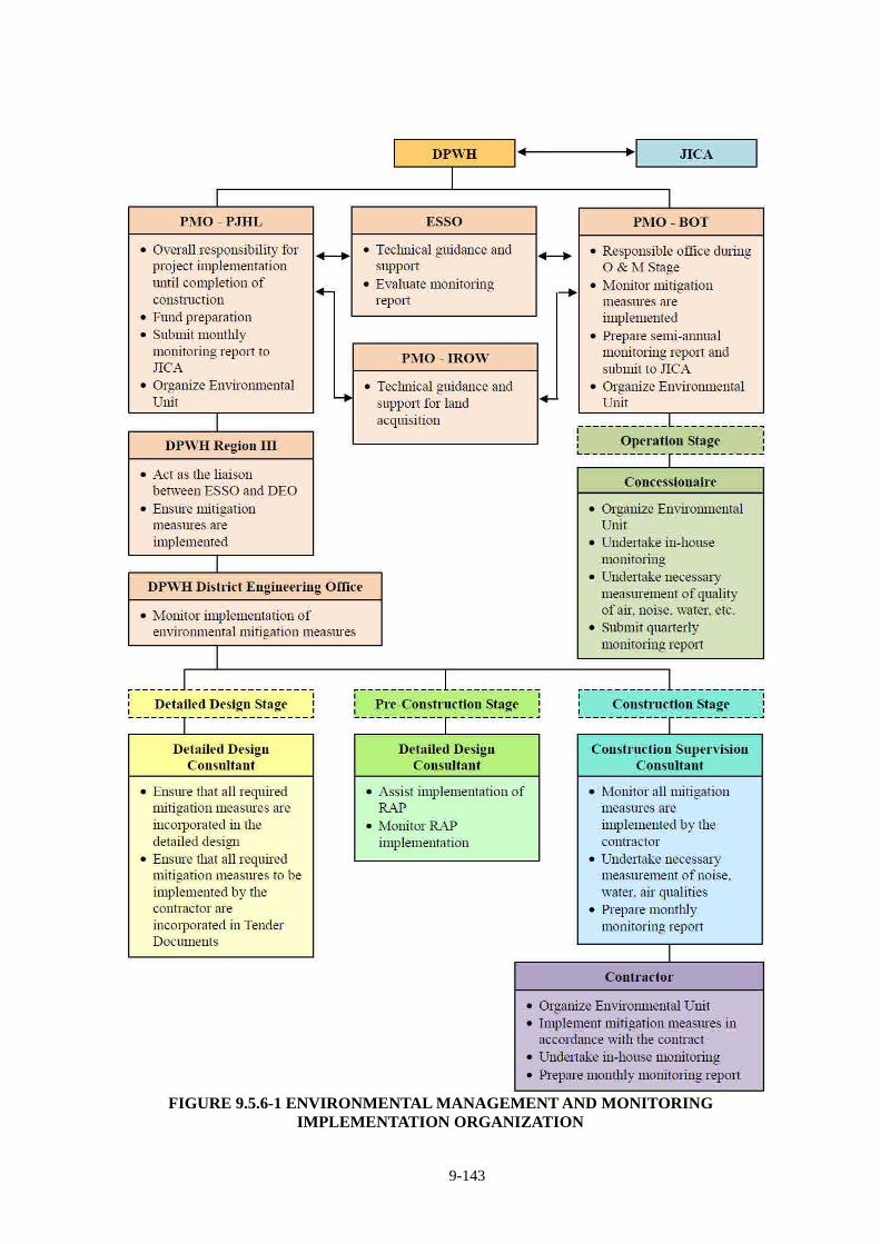
9-143
FIGURE 9.5.6-1 ENVIRONMENTAL MANAGEMENT AND MONITORING
IMPLEMENTATION ORGANIZATION
9-144
9.5.6.2 Budget
(Confidential)
9.5.7 System for Environmental Management
Project proponent and construction contractor must ensure compliance with ECC by Establishing
an Environmental Unit (EU) to effectively handle, implement, and manage all
environmental-related aspects of the project. Proof of establishment of the EU shall be submitted
to EMB. The EU shall also have the following responsibilities:
Implement the approved Environmental Management and Monitoring Program; and
Monitor actual impacts vis-à-vis the predicted impacts on human/social and physical
environmental management measures in the EIS.
9-145
9.6 RELOCATION ACTION PLAN
9.6.1 Relocation Policy
Since CLLEX is located in a rural area, DPWH’s relocation policy in LARRIPP which has been
created for the World Bank funded project, i.e. satisfies OP4.12, can be applied.
The Government of the Republic of Philippines is bound to follow the Project Resettlement
Policy (the Project Policy) for the CLLEX (Phase-1) specifically which is intended to comply
with JICA’s guidelines.
Where there are gaps between the Republic of Philippines legal framework for resettlement
and JICA’s Policy on Involuntary Resettlement, practicable mutually agreeable approaches
will be designed consistent with Government practices and JICA’s Policy.
Land acquisition and involuntary resettlement will be avoided where feasible, or minimized,
by identifying possible alternative project designs that have the least adverse impact on the
communities in the project area.
Where displacement of households is unavoidable, all PAPs (including communities) losing
assets, livelihoods or resources will be fully compensated and assisted so that they can
improve, or at least restore, their former economic and social conditions.
Compensation and rehabilitation support will be provided to any PAPs, that is, any person or
household or business which on account of project implementation would have his, her or
their standard of living adversely affected;
Right, title or interest in any house, interest in, or right to use, any land (including
premises, agricultural and grazing land, commercial properties, tenancy, or right in
annual or perennial crops and trees or any other fixed or moveable assets, acquired or
possessed, temporarily or permanently;
Income earning opportunities, business, occupation, work or place of residence or habitat
adversely affected temporarily or permanently; or
Social and cultural activities and relationships affected or any other losses that may be
identified during the process of resettlement planning.
All affected people will be eligible for compensation and rehabilitation assistance,
irrespective of tenure status, social or economic standing and any such factors that may
discriminate against achievement of the objectives outlined above.
Lack of legal rights to the assets lost or adversely affected tenure status and social or
economic status will not bar the PAPs from entitlements to such compensation and
rehabilitation measures or resettlement objectives.
All PAPs residing, working, doing business and/or cultivating land within the project
impacted areas as of the date of the latest census and inventory of lost assets (IOL), are
9-146
entitled to compensation for their lost assets (land and/or non-land assets), at replacement
cost, if available and restoration of incomes and businesses, and will be provided with
rehabilitation measures sufficient to assist them to improve or at least maintain their
pre-project living standards, income-earning capacity and production levels.
PAPs that lose only part of their physical assets will not be left with a portion that will be
inadequate to sustain their current standard of living. The minimum size of remaining land
and structures will be agreed during the resettlement planning process.
People temporarily affected are to be considered PAPs and resettlement plans address the
issue of temporary acquisition.
Where a host community is affected by the development of a resettlement site in that
community, the host community shall be involved in any resettlement planning and
decision-making. All attempts shall be made to minimize the adverse impacts of resettlement
upon host communities.
The resettlement plans will be designed in accordance with Land Acquisition, Resettlement,
Rehabilitation and Indigenous Peoples’ Policy (LARRIPP) of DPWH (February, 2007) and
JICA’s Policy on Involuntary Resettlement.
The Resettlement Plan will be translated into local languages and disclosed for the reference
of PAPs as well as other interested groups.
Payment for land and/or non-land assets will be based on the principle of replacement cost.
Compensation for PAPs dependent on agricultural activities will be land-based wherever
possible.
Resettlement assistance will be provided not only for immediate loss, but also for a transition
period needed to restore livelihood and standards of living of PAPs. Such support could take
the form of short-term jobs, subsistence support, salary maintenance, or similar
arrangements.
The resettlement plan must consider the needs of those most vulnerable to the adverse
impacts of resettlement (including the poor, those without legal title to land, ethnic minorities,
women, children, elderly and disabled) and ensure they are considered in resettlement
planning and mitigation measures identified. Assistance should be provided to help them
improve their socio-economic status.
PAPs will be involved in the process of developing and implementing resettlement plans.
PAPs and their communities will be consulted about the project, the rights and options
available to them, and proposed mitigation measures for adverse effects, and to the extent
possible be involved in the decisions that are made concerning their resettlement.
Adequate budgetary support will be fully committed and made available to cover the costs of
land acquisition (including compensation and income restoration measures) within the agreed
implementation period.
9-147
Displacement does not occur before provision of compensation and of other assistance
required for relocation.
Sufficient civic infrastructure must be provided in resettlement site prior to relocation.
Acquisition of assets, payment of compensation, and the resettlement and start of the
livelihood rehabilitation activities of PAPs, will be completed prior to any construction
activities, except when a court of law orders so in expropriation cases
Livelihood restoration measures must also be in place but not necessarily completed prior to
construction activities, as these may be ongoing activities.
Organization and administrative arrangements for the effective preparation and
implementation of the resettlement plan will be identified and in place prior to the
commencement of the process; this will include the provision of adequate human resources
for supervision, consultation, and monitoring of land acquisition and rehabilitation activities.
Appropriate reporting (including auditing and redress functions), monitoring and evaluation
mechanisms, will be identified and set in place as part of the resettlement management
system.
An external monitoring group will be hired by the project and will evaluate the resettlement
process and final outcome. Such groups may include qualified consultants, NGOs, research
institutions or universities.
Monitoring reports shall be forwarded directly to the JICA.
9.6.2 Summary of Relocation and Assets
9.6.2.1 Household Interview Survey
Households in the project area were classified into the following three (3) types;
Type-A: Households who are living in the residential houses which are affected by the project. A
total of 67 households were identified and 64 (or 96%) households answered the interview.
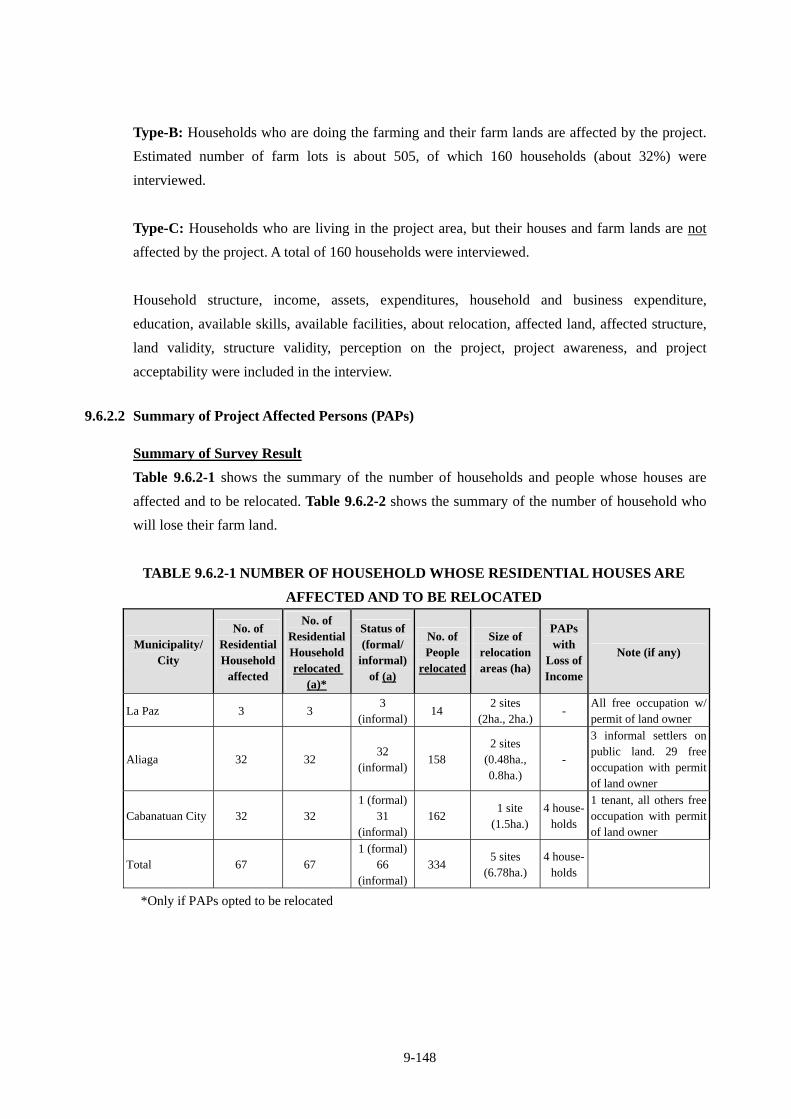
9-148
Type-B: Households who are doing the farming and their farm lands are affected by the project.
Estimated number of farm lots is about 505, of which 160 households (about 32%) were
interviewed.
Type-C: Households who are living in the project area, but their houses and farm lands are not
affected by the project. A total of 160 households were interviewed.
Household structure, income, assets, expenditures, household and business expenditure,
education, available skills, available facilities, about relocation, affected land, affected structure,
land validity, structure validity, perception on the project, project awareness, and project
acceptability were included in the interview.
9.6.2.2 Summary of Project Affected Persons (PAPs)
Summary of Survey Result
Table 9.6.2-1 shows the summary of the number of households and people whose houses are
affected and to be relocated. Table 9.6.2-2 shows the summary of the number of household who
will lose their farm land.
TABLE 9.6.2-1 NUMBER OF HOUSEHOLD WHOSE RESIDENTIAL HOUSES ARE
AFFECTED AND TO BE RELOCATED
Municipality/ City
No. of Residential Household
affected
No. of Residential Household relocated
(a)*
Status of (formal/
informal) of (a)
No. of People
relocated
Size of relocation areas (ha)
PAPs with
Loss of Income
Note (if any)
La Paz 3 3 3
(informal)14
2 sites (2ha., 2ha.)
- All free occupation w/ permit of land owner
Aliaga 32 32 32
(informal)158
2 sites (0.48ha., 0.8ha.)
-
3 informal settlers on public land. 29 free occupation with permit of land owner
Cabanatuan City 32 32 1 (formal)
31 (informal)
162 1 site
(1.5ha.)4 house-
holds
1 tenant, all others free occupation with permit of land owner
Total 67 67 1 (formal)
66 (informal)
334 5 sites
(6.78ha.) 4 house-
holds
*Only if PAPs opted to be relocated
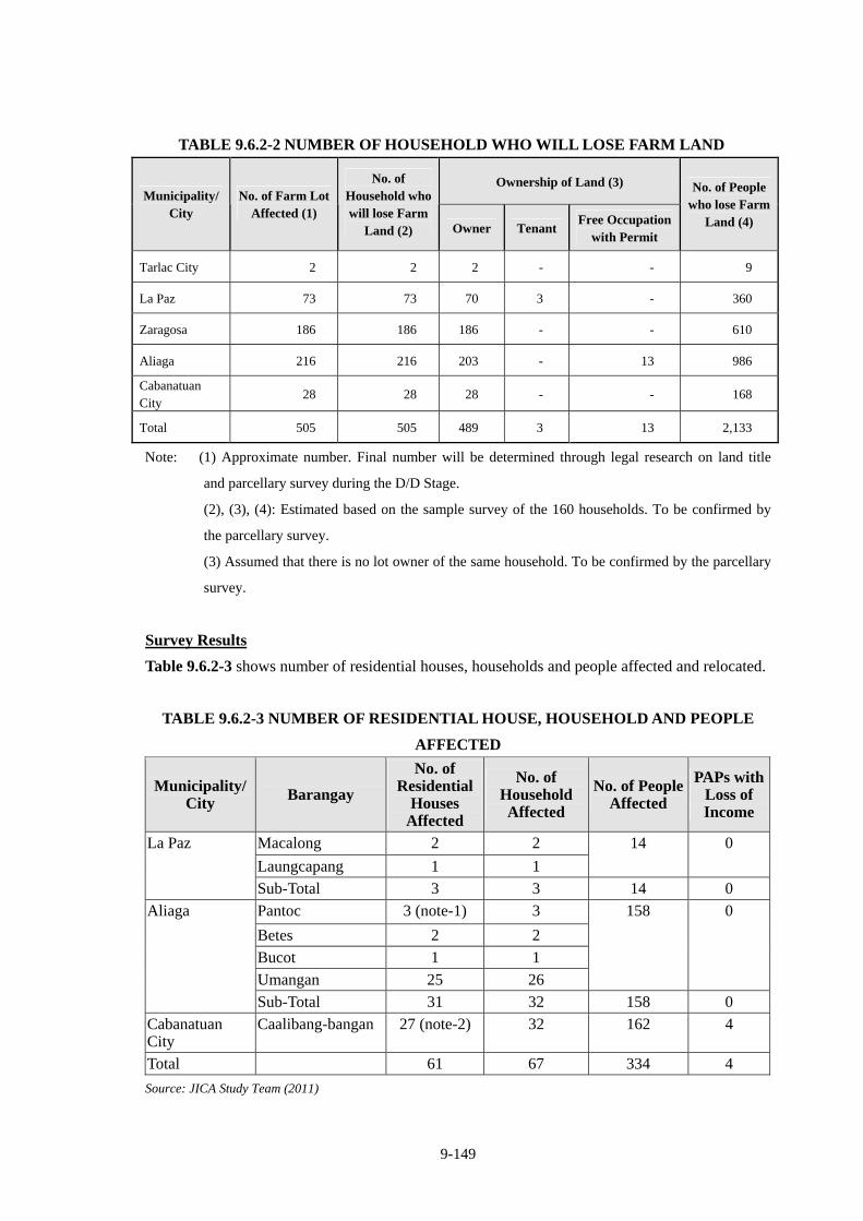
9-149
TABLE 9.6.2-2 NUMBER OF HOUSEHOLD WHO WILL LOSE FARM LAND
Ownership of Land (3) Municipality/
City No. of Farm Lot
Affected (1)
No. of Household who will lose Farm
Land (2) Owner TenantFree Occupation
with Permit
No. of People who lose Farm
Land (4)
Tarlac City 2 2 2 - - 9
La Paz 73 73 70 3 - 360
Zaragosa 186 186 186 - - 610
Aliaga 216 216 203 - 13 986
Cabanatuan City
28 28 28 - - 168
Total 505 505 489 3 13 2,133
Note: (1) Approximate number. Final number will be determined through legal research on land title
and parcellary survey during the D/D Stage.
(2), (3), (4): Estimated based on the sample survey of the 160 households. To be confirmed by
the parcellary survey.
(3) Assumed that there is no lot owner of the same household. To be confirmed by the parcellary
survey.
Survey Results
Table 9.6.2-3 shows number of residential houses, households and people affected and relocated.
TABLE 9.6.2-3 NUMBER OF RESIDENTIAL HOUSE, HOUSEHOLD AND PEOPLE
AFFECTED
Municipality/ City Barangay
No. of Residential
Houses Affected
No. of Household Affected
No. of People Affected
PAPs with Loss of Income
Macalong 2 2
Laungcapang 1 1
14 0 La Paz
Sub-Total 3 3 14 0
Pantoc 3 (note-1) 3
Betes 2 2
Bucot 1 1
Umangan 25 26
158 0 Aliaga
Sub-Total 31 32 158 0
Cabanatuan City
Caalibang-bangan 27 (note-2) 32 162 4
Total 61 67 334 4
Source: JICA Study Team (2011)
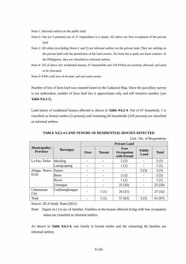
9-150
Note-1: Informal settlers on the public land
Note-2: One (or 5 persons) out of 27 respondents is a tenant. All others are free occupation of the private
land
Note-3: All others (excluding Notes-1 and 2) are informal settlers on the private land. They are settling on
the private land with the permission of the land owners. No lease fee is paid, nor lease contract. In
the Philippines, they are classified as informal settlers.
Note-4: All of above (61 residential houses, 67 households and 334 PAPs) are severely affected, and need
to be relocated.
Note-5: PAPs with loss of income: sari-sari store owner
Number of lots of farm land was counted based on the Cadastral Map. Since the parcellary survey
is not undertaken, number of farm land lots is approximate only and still tentative number. (see
Table 9.6.2-5).
Land tenure of residential houses affected is shown in Table 9.6.2-4. Out of 67 household, 1 is
classified as formal settlers (5 persons) and remaining 66 households (329 persons) are classified
as informal settlers.
TABLE 9.6.2-4 LAND TENURE OF RESIDENTIAL HOUSES AFFECTED
Unit : No. of Respondents
Private Land Municipality/
Province Barangay Own Tenant
Free Occupation with Permit
Public Land Total
Macalog - - 2 (2) - 2 (2) La Paz, Tarlac
Laungcapang - - 1 (1) - 1 (1)
Pantoc - - - 3 (3) 3 (3)
Betes - - 2 (2) - 2 (2)
Bucot - - 1 (1) - 1 (1)
Aliaga, Nueva Ecija
Umangan - - 25 (26) - 25 (26)
Cabanatuan City
Caalibangbangan - 1 (1) 26 (31) - 27 (32)
Total - 1 (1) 57 (63) 3 (3) 61 (67)
Source: JICA Study Team (2011)
Note: Figure in ( ) is no. of families. Families in the houses affected living with free occupation
status are classified as informal settlers.
As shown in Table 9.6.2-4, one family is formal settler and the remaining 66 families are
informal settlers.
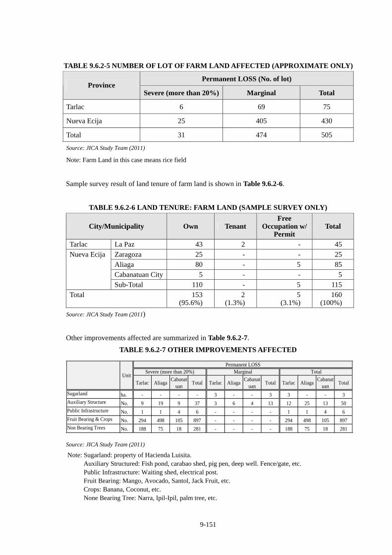
9-151
TABLE 9.6.2-5 NUMBER OF LOT OF FARM LAND AFFECTED (APPROXIMATE ONLY)
Permanent LOSS (No. of lot) Province
Severe (more than 20%) Marginal Total
Tarlac 6 69 75
Nueva Ecija 25 405 430
Total 31 474 505
Source: JICA Study Team (2011)
Note: Farm Land in this case means rice field
Sample survey result of land tenure of farm land is shown in Table 9.6.2-6.
TABLE 9.6.2-6 LAND TENURE: FARM LAND (SAMPLE SURVEY ONLY)
City/Municipality Own Tenant Free
Occupation w/ Permit
Total
Tarlac La Paz 43 2 - 45
Zaragoza 25 - - 25
Aliaga 80 - 5 85
Cabanatuan City 5 - - 5
Nueva Ecija
Sub-Total 110 - 5 115
Total 153 (95.6%)
2 (1.3%)
5 (3.1%)
160 (100%)
Source: JICA Study Team (2011)
Other improvements affected are summarized in Table 9.6.2-7.
TABLE 9.6.2-7 OTHER IMPROVEMENTS AFFECTED
Tarlac AliagaCabanat
uanTotal Tarlac Aliaga
Cabanatuan
Total Tarlac AliagaCabanat
uanTotal
Sugarland ha. - - - - 3 - - 3 3 - - 3Auxiliary Structure No. 9 19 9 37 3 6 4 13 12 25 13 50Public Infrastructure No. 1 1 4 6 - - - - 1 1 4 6Fruit Bearing & Crops No. 294 498 105 897 - - - - 294 498 105 897Non Bearing Trees No. 188 75 18 281 - - - - 188 75 18 281
UnitSevere (more than 20%) Marginal Total
Permanent LOSS
Source: JICA Study Team (2011)
Note: Sugarland: property of Hacienda Luisita. Auxiliary Structured: Fish pond, carabao shed, pig pen, deep well. Fence/gate, etc. Public Infrastructure: Waiting shed, electrical post. Fruit Bearing: Mango, Avocado, Santol, Jack Fruit, etc. Crops: Banana, Coconut, etc. None Bearing Tree: Narra, Ipil-Ipil, palm tree, etc.
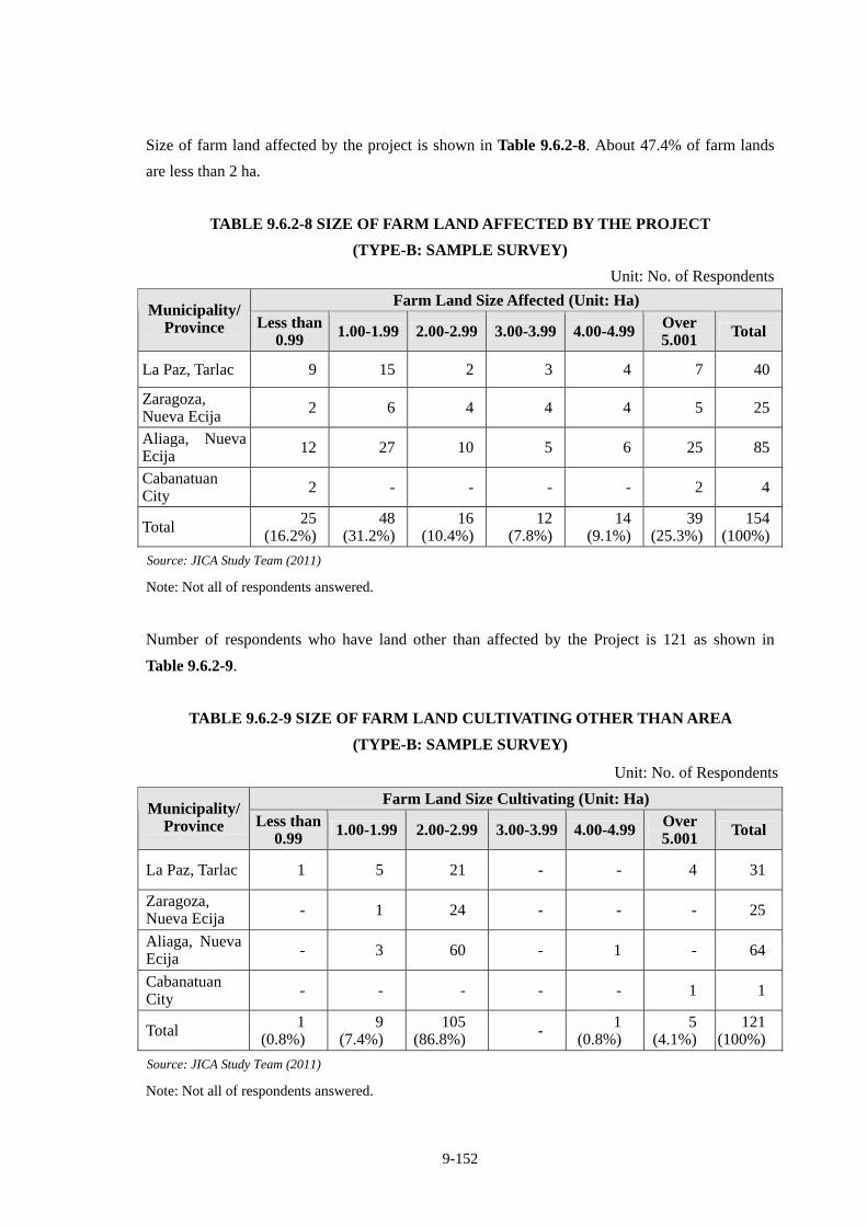
9-152
Size of farm land affected by the project is shown in Table 9.6.2-8. About 47.4% of farm lands
are less than 2 ha.
TABLE 9.6.2-8 SIZE OF FARM LAND AFFECTED BY THE PROJECT
(TYPE-B: SAMPLE SURVEY)
Unit: No. of Respondents
Farm Land Size Affected (Unit: Ha) Municipality/
Province Less than 0.99 1.00-1.99 2.00-2.99 3.00-3.99 4.00-4.99 Over
5.001 Total
La Paz, Tarlac 9 15 2 3 4 7 40
Zaragoza, Nueva Ecija 2 6 4 4 4 5 25
Aliaga, Nueva Ecija 12 27 10 5 6 25 85
Cabanatuan City 2 - - - - 2 4
Total 25 (16.2%)
48(31.2%)
16(10.4%)
12(7.8%)
14 (9.1%)
39 (25.3%)
154(100%)
Source: JICA Study Team (2011)
Note: Not all of respondents answered.
Number of respondents who have land other than affected by the Project is 121 as shown in
Table 9.6.2-9.
TABLE 9.6.2-9 SIZE OF FARM LAND CULTIVATING OTHER THAN AREA
(TYPE-B: SAMPLE SURVEY)
Unit: No. of Respondents
Farm Land Size Cultivating (Unit: Ha) Municipality/
Province Less than 0.99 1.00-1.99 2.00-2.99 3.00-3.99 4.00-4.99 Over
5.001 Total
La Paz, Tarlac 1 5 21 - - 4 31
Zaragoza, Nueva Ecija - 1 24 - - - 25
Aliaga, Nueva Ecija - 3 60 - 1 - 64
Cabanatuan City - - - - - 1 1
Total 1 (0.8%)
9 (7.4%)
105 (86.8%) - 1
(0.8%) 5
(4.1%) 121
(100%)
Source: JICA Study Team (2011)
Note: Not all of respondents answered.
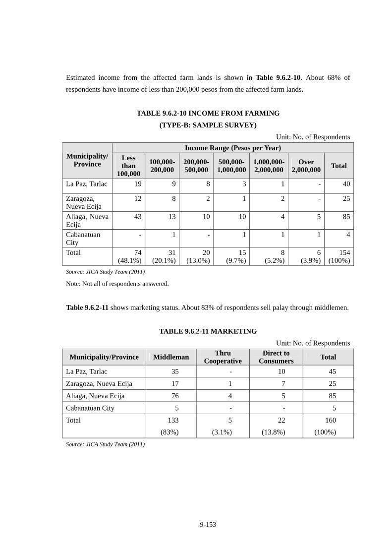
9-153
Estimated income from the affected farm lands is shown in Table 9.6.2-10. About 68% of
respondents have income of less than 200,000 pesos from the affected farm lands.
TABLE 9.6.2-10 INCOME FROM FARMING
(TYPE-B: SAMPLE SURVEY)
Unit: No. of Respondents
Income Range (Pesos per Year) Municipality/
Province Less than
100,000
100,000- 200,000
200,000- 500,000
500,000- 1,000,000
1,000,000- 2,000,000
Over 2,000,000 Total
La Paz, Tarlac 19 9 8 3 1 - 40
Zaragoza, Nueva Ecija
12 8 2 1 2 - 25
Aliaga, Nueva Ecija
43 13 10 10 4 5 85
Cabanatuan City
- 1 - 1 1 1 4
Total 74 (48.1%)
31(20.1%)
20(13.0%)
15(9.7%)
8 (5.2%)
6 (3.9%)
154(100%)
Source: JICA Study Team (2011)
Note: Not all of respondents answered.
Table 9.6.2-11 shows marketing status. About 83% of respondents sell palay through middlemen.
TABLE 9.6.2-11 MARKETING
Unit: No. of Respondents
Municipality/Province Middleman Thru Cooperative
Direct to Consumers Total
La Paz, Tarlac 35 - 10 45
Zaragoza, Nueva Ecija 17 1 7 25
Aliaga, Nueva Ecija 76 4 5 85
Cabanatuan City 5 - - 5
Total 133
(83%)
5
(3.1%)
22
(13.8%)
160
(100%)
Source: JICA Study Team (2011)
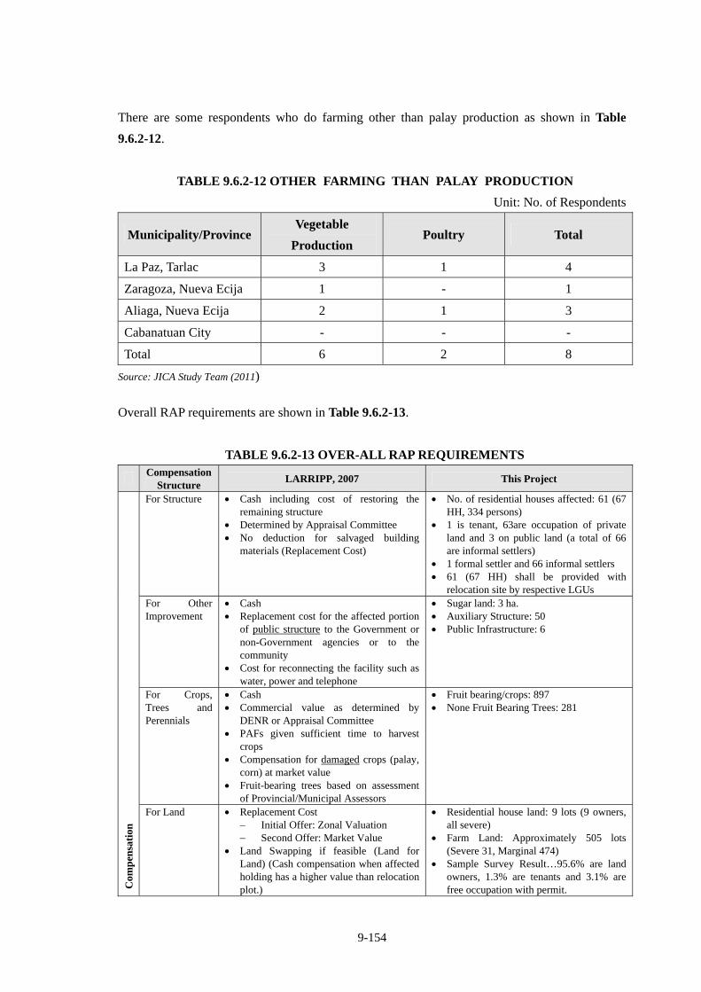
9-154
There are some respondents who do farming other than palay production as shown in Table
9.6.2-12.
TABLE 9.6.2-12 OTHER FARMING THAN PALAY PRODUCTION
Unit: No. of Respondents
Municipality/Province Vegetable
Production Poultry Total
La Paz, Tarlac 3 1 4
Zaragoza, Nueva Ecija 1 - 1
Aliaga, Nueva Ecija 2 1 3
Cabanatuan City - - -
Total 6 2 8
Source: JICA Study Team (2011)
Overall RAP requirements are shown in Table 9.6.2-13.
TABLE 9.6.2-13 OVER-ALL RAP REQUIREMENTS
Compensation
Structure LARRIPP, 2007 This Project
For Structure Cash including cost of restoring the remaining structure
Determined by Appraisal Committee No deduction for salvaged building
materials (Replacement Cost)
No. of residential houses affected: 61 (67 HH, 334 persons)
1 is tenant, 63are occupation of private land and 3 on public land (a total of 66 are informal settlers)
1 formal settler and 66 informal settlers 61 (67 HH) shall be provided with
relocation site by respective LGUs For Other Improvement
Cash Replacement cost for the affected portion
of public structure to the Government or non-Government agencies or to the community
Cost for reconnecting the facility such as water, power and telephone
Sugar land: 3 ha. Auxiliary Structure: 50 Public Infrastructure: 6
For Crops, Trees and Perennials
Cash Commercial value as determined by
DENR or Appraisal Committee PAFs given sufficient time to harvest
crops Compensation for damaged crops (palay,
corn) at market value Fruit-bearing trees based on assessment
of Provincial/Municipal Assessors
Fruit bearing/crops: 897 None Fruit Bearing Trees: 281
Com
pen
sati
on
For Land Replacement Cost Initial Offer: Zonal Valuation Second Offer: Market Value
Land Swapping if feasible (Land for Land) (Cash compensation when affected holding has a higher value than relocation plot.)
Residential house land: 9 lots (9 owners, all severe)
Farm Land: Approximately 505 lots (Severe 31, Marginal 474)
Sample Survey Result…95.6% are land owners, 1.3% are tenants and 3.1% are free occupation with permit.
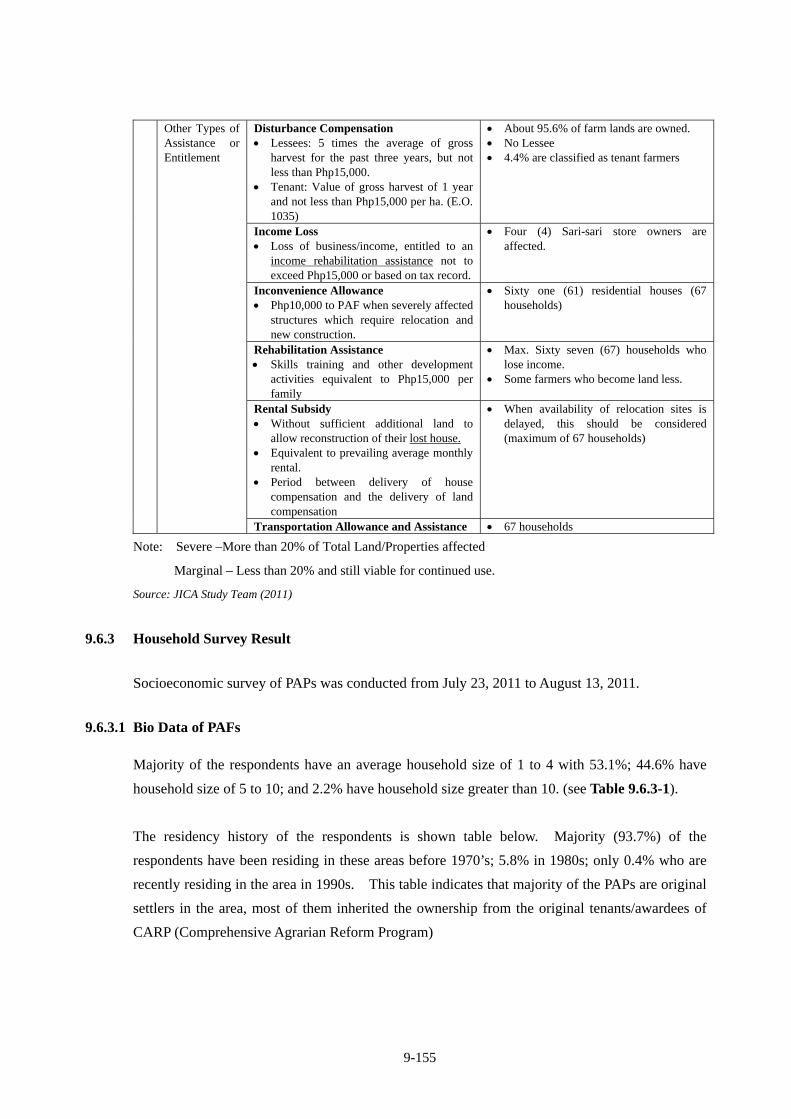
9-155
Disturbance Compensation Lessees: 5 times the average of gross
harvest for the past three years, but not less than Php15,000.
Tenant: Value of gross harvest of 1 year and not less than Php15,000 per ha. (E.O. 1035)
About 95.6% of farm lands are owned. No Lessee 4.4% are classified as tenant farmers
Income Loss Loss of business/income, entitled to an
income rehabilitation assistance not to exceed Php15,000 or based on tax record.
Four (4) Sari-sari store owners are affected.
Inconvenience Allowance Php10,000 to PAF when severely affected
structures which require relocation and new construction.
Sixty one (61) residential houses (67 households)
Rehabilitation Assistance Skills training and other development
activities equivalent to Php15,000 per family
Max. Sixty seven (67) households who lose income.
Some farmers who become land less.
Rental Subsidy Without sufficient additional land to
allow reconstruction of their lost house. Equivalent to prevailing average monthly
rental. Period between delivery of house
compensation and the delivery of land compensation
When availability of relocation sites is delayed, this should be considered (maximum of 67 households)
Other Types of Assistance or Entitlement
Transportation Allowance and Assistance 67 households
Note: Severe –More than 20% of Total Land/Properties affected
Marginal – Less than 20% and still viable for continued use.
Source: JICA Study Team (2011)
9.6.3 Household Survey Result
Socioeconomic survey of PAPs was conducted from July 23, 2011 to August 13, 2011.
9.6.3.1 Bio Data of PAFs
Majority of the respondents have an average household size of 1 to 4 with 53.1%; 44.6% have
household size of 5 to 10; and 2.2% have household size greater than 10. (see Table 9.6.3-1).
The residency history of the respondents is shown table below. Majority (93.7%) of the
respondents have been residing in these areas before 1970’s; 5.8% in 1980s; only 0.4% who are
recently residing in the area in 1990s. This table indicates that majority of the PAPs are original
settlers in the area, most of them inherited the ownership from the original tenants/awardees of
CARP (Comprehensive Agrarian Reform Program)
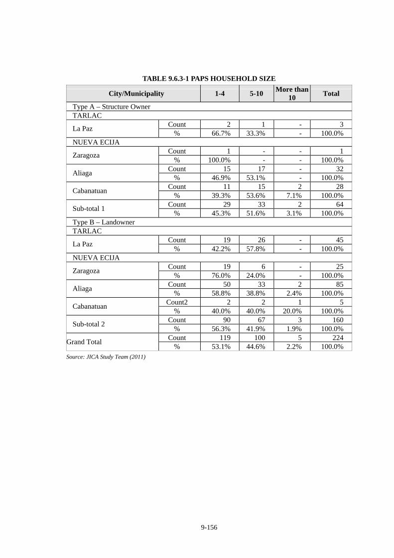
9-156
TABLE 9.6.3-1 PAPS HOUSEHOLD SIZE
City/Municipality 1-4 5-10 More than
10 Total
Type A – Structure Owner TARLAC
Count 2 1 - 3 La Paz
% 66.7% 33.3% - 100.0% NUEVA ECIJA
Count 1 - - 1 Zaragoza
% 100.0% - - 100.0% Count 15 17 - 32
Aliaga % 46.9% 53.1% - 100.0%
Count 11 15 2 28 Cabanatuan
% 39.3% 53.6% 7.1% 100.0% Count 29 33 2 64
Sub-total 1 % 45.3% 51.6% 3.1% 100.0%
Type B – Landowner TARLAC
Count 19 26 - 45 La Paz
% 42.2% 57.8% - 100.0% NUEVA ECIJA
Count 19 6 - 25 Zaragoza
% 76.0% 24.0% - 100.0% Count 50 33 2 85
Aliaga % 58.8% 38.8% 2.4% 100.0%
Count2 2 2 1 5 Cabanatuan
% 40.0% 40.0% 20.0% 100.0% Count 90 67 3 160
Sub-total 2 % 56.3% 41.9% 1.9% 100.0%
Count 119 100 5 224 Grand Total
% 53.1% 44.6% 2.2% 100.0% Source: JICA Study Team (2011)
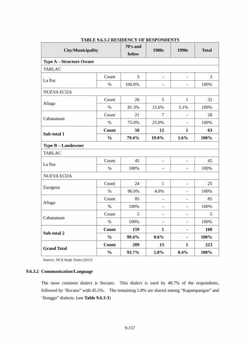
9-157
TABLE 9.6.3-2 RESIDENCY OF RESPONDENTS
City/Municipality 70’s and
below 1980s 1990s Total
Type A – Structure Owner
TARLAC
Count 3 - - 3 La Paz
% 100.0% - - 100%
NUEVA ECIJA
Count 26 5 1 32 Aliaga
% 81.3% 15.6% 3.1% 100%
Count 21 7 - 28 Cabanatuan
% 75.0% 25.0% - 100%
Count 50 12 1 63 Sub-total 1
% 79.4% 19.0% 1.6% 100%
Type B – Landowner
TARLAC
Count 45 - - 45 La Paz
% 100% - - 100%
NUEVA ECIJA
Count 24 1 - 25 Zaragosa
% 96.0% 4.0% - 100%
Count 85 - - 85 Aliaga
% 100% - - 100%
Count 5 - - 5 Cabanatuan
% 100% - - 100%
Count 159 1 - 160 Sub-total 2
% 99.4% 0.6% - 100%
Count 209 13 1 223 Grand Total
% 93.7% 5.8% 0.4% 100%
Source: JICA Study Team (2011)
9.6.3.2 Communication/Language
The most common dialect is Ilocano. This dialect is used by 48.7% of the respondents,
followed by ‘Ilocano” with 45.5%. The remaining 5.8% are shared among “Kapampangan” and
‘Ilonggo” dialects. (see Table 9.6.3-3)
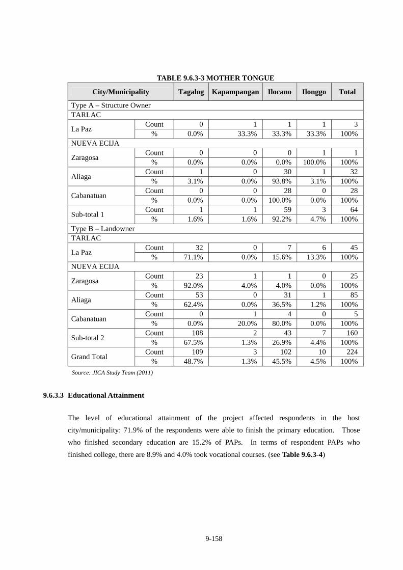
9-158
TABLE 9.6.3-3 MOTHER TONGUE
City/Municipality Tagalog Kapampangan Ilocano Ilonggo Total
Type A – Structure Owner TARLAC
Count 0 1 1 1 3La Paz
% 0.0% 33.3% 33.3% 33.3% 100%NUEVA ECIJA
Count 0 0 0 1 1Zaragosa
% 0.0% 0.0% 0.0% 100.0% 100%Count 1 0 30 1 32
Aliaga % 3.1% 0.0% 93.8% 3.1% 100%
Count 0 0 28 0 28Cabanatuan
% 0.0% 0.0% 100.0% 0.0% 100%Count 1 1 59 3 64
Sub-total 1 % 1.6% 1.6% 92.2% 4.7% 100%
Type B – Landowner TARLAC
Count 32 0 7 6 45La Paz
% 71.1% 0.0% 15.6% 13.3% 100%NUEVA ECIJA
Count 23 1 1 0 25Zaragosa
% 92.0% 4.0% 4.0% 0.0% 100%Count 53 0 31 1 85
Aliaga % 62.4% 0.0% 36.5% 1.2% 100%
Count 0 1 4 0 5Cabanatuan
% 0.0% 20.0% 80.0% 0.0% 100%Count 108 2 43 7 160
Sub-total 2 % 67.5% 1.3% 26.9% 4.4% 100%
Count 109 3 102 10 224Grand Total
% 48.7% 1.3% 45.5% 4.5% 100%
Source: JICA Study Team (2011)
9.6.3.3 Educational Attainment
The level of educational attainment of the project affected respondents in the host
city/municipality: 71.9% of the respondents were able to finish the primary education. Those
who finished secondary education are 15.2% of PAPs. In terms of respondent PAPs who
finished college, there are 8.9% and 4.0% took vocational courses. (see Table 9.6.3-4)
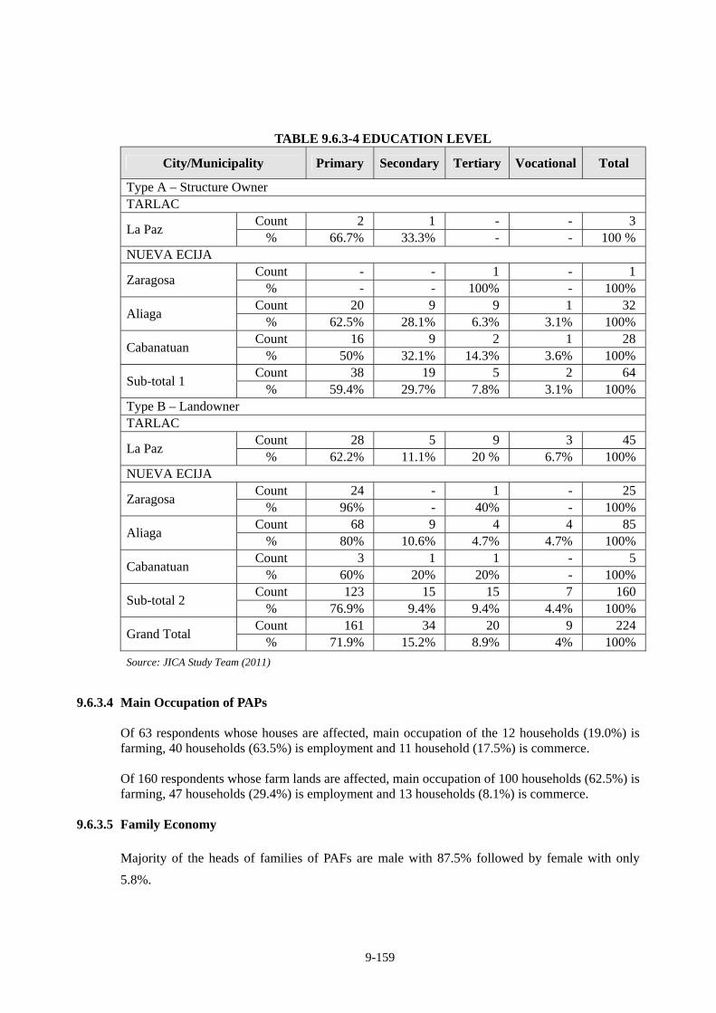
9-159
TABLE 9.6.3-4 EDUCATION LEVEL
City/Municipality Primary Secondary Tertiary Vocational Total
Type A – Structure Owner TARLAC
Count 2 1 - - 3La Paz
% 66.7% 33.3% - - 100 %NUEVA ECIJA
Count - - 1 - 1Zaragosa
% - - 100% - 100%Count 20 9 9 1 32
Aliaga % 62.5% 28.1% 6.3% 3.1% 100%
Count 16 9 2 1 28Cabanatuan
% 50% 32.1% 14.3% 3.6% 100%Count 38 19 5 2 64
Sub-total 1 % 59.4% 29.7% 7.8% 3.1% 100%
Type B – Landowner TARLAC
Count 28 5 9 3 45La Paz
% 62.2% 11.1% 20 % 6.7% 100%NUEVA ECIJA
Count 24 - 1 - 25Zaragosa
% 96% - 40% - 100%Count 68 9 4 4 85
Aliaga % 80% 10.6% 4.7% 4.7% 100%
Count 3 1 1 - 5Cabanatuan
% 60% 20% 20% - 100%Count 123 15 15 7 160
Sub-total 2 % 76.9% 9.4% 9.4% 4.4% 100%
Count 161 34 20 9 224Grand Total
% 71.9% 15.2% 8.9% 4% 100%
Source: JICA Study Team (2011)
9.6.3.4 Main Occupation of PAPs
Of 63 respondents whose houses are affected, main occupation of the 12 households (19.0%) is farming, 40 households (63.5%) is employment and 11 household (17.5%) is commerce. Of 160 respondents whose farm lands are affected, main occupation of 100 households (62.5%) is farming, 47 households (29.4%) is employment and 13 households (8.1%) is commerce.
9.6.3.5 Family Economy
Majority of the heads of families of PAFs are male with 87.5% followed by female with only
5.8%.
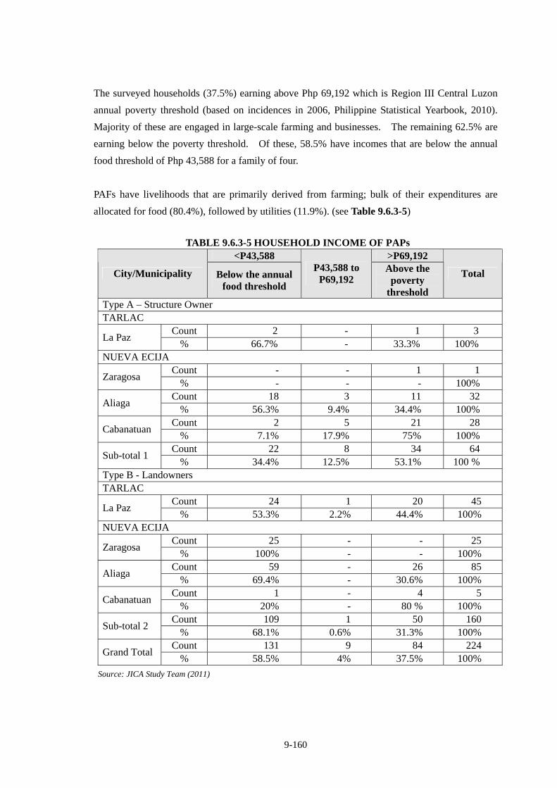
9-160
The surveyed households (37.5%) earning above Php 69,192 which is Region III Central Luzon
annual poverty threshold (based on incidences in 2006, Philippine Statistical Yearbook, 2010).
Majority of these are engaged in large-scale farming and businesses. The remaining 62.5% are
earning below the poverty threshold. Of these, 58.5% have incomes that are below the annual
food threshold of Php 43,588 for a family of four.
PAFs have livelihoods that are primarily derived from farming; bulk of their expenditures are
allocated for food (80.4%), followed by utilities (11.9%). (see Table 9.6.3-5)
TABLE 9.6.3-5 HOUSEHOLD INCOME OF PAPs <P43,588 >P69,192
City/Municipality Below the annual food threshold
P43,588 to P69,192
Above the poverty
threshold
Total
Type A – Structure Owner TARLAC
Count 2 - 1 3 La Paz
% 66.7% - 33.3% 100% NUEVA ECIJA
Count - - 1 1 Zaragosa
% - - - 100% Count 18 3 11 32
Aliaga % 56.3% 9.4% 34.4% 100%
Count 2 5 21 28 Cabanatuan
% 7.1% 17.9% 75% 100% Count 22 8 34 64
Sub-total 1 % 34.4% 12.5% 53.1% 100 %
Type B - Landowners TARLAC
Count 24 1 20 45 La Paz
% 53.3% 2.2% 44.4% 100% NUEVA ECIJA
Count 25 - - 25 Zaragosa
% 100% - - 100% Count 59 - 26 85
Aliaga % 69.4% - 30.6% 100%
Count 1 - 4 5 Cabanatuan
% 20% - 80 % 100% Count 109 1 50 160
Sub-total 2 % 68.1% 0.6% 31.3% 100%
Count 131 9 84 224 Grand Total
% 58.5% 4% 37.5% 100%
Source: JICA Study Team (2011)
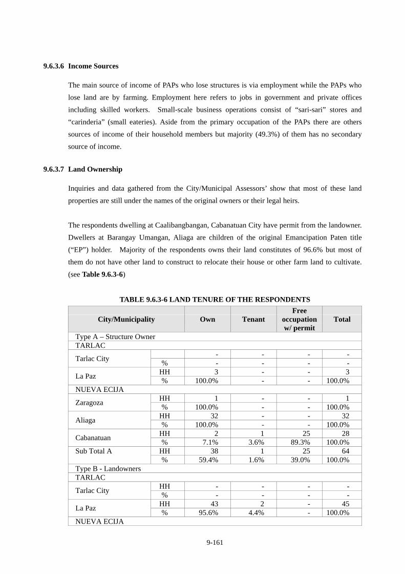
9-161
9.6.3.6 Income Sources
The main source of income of PAPs who lose structures is via employment while the PAPs who
lose land are by farming. Employment here refers to jobs in government and private offices
including skilled workers. Small-scale business operations consist of “sari-sari” stores and
“carinderia” (small eateries). Aside from the primary occupation of the PAPs there are others
sources of income of their household members but majority (49.3%) of them has no secondary
source of income.
9.6.3.7 Land Ownership
Inquiries and data gathered from the City/Municipal Assessors’ show that most of these land
properties are still under the names of the original owners or their legal heirs.
The respondents dwelling at Caalibangbangan, Cabanatuan City have permit from the landowner.
Dwellers at Barangay Umangan, Aliaga are children of the original Emancipation Paten title
(“EP”) holder. Majority of the respondents owns their land constitutes of 96.6% but most of
them do not have other land to construct to relocate their house or other farm land to cultivate.
(see Table 9.6.3-6)
TABLE 9.6.3-6 LAND TENURE OF THE RESPONDENTS
City/Municipality Own Tenant Free
occupation w/ permit
Total
Type A – Structure Owner TARLAC
- - - - Tarlac City
% - - - - HH 3 - - 3
La Paz % 100.0% - - 100.0%
NUEVA ECIJA HH 1 - - 1
Zaragoza % 100.0% - - 100.0%
HH 32 - - 32 Aliaga
% 100.0% - - 100.0% HH 2 1 25 28
Cabanatuan % 7.1% 3.6% 89.3% 100.0%
HH 38 1 25 64 Sub Total A % 59.4% 1.6% 39.0% 100.0%
Type B - Landowners TARLAC
HH - - - - Tarlac City
% - - - - HH 43 2 - 45
La Paz % 95.6% 4.4% - 100.0%
NUEVA ECIJA
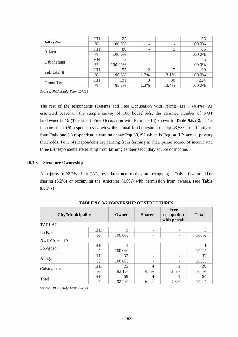
9-162
HH 25 - - 25 Zaragoza
% 100.0% - - 100.0% HH 80 - 5 85
Aliaga % 100.0% - - 100.0%
HH 5 - - 5 Cabanatuan
% 100.00% - - 100.0% HH 153 2 5 160
Sub-total B % 96.6% 1.3% 3.1% 100.0%
HH 191 3 30 224 Grand Total
% 85.3% 1.3% 13.4% 100.0% Source: JICA Study Team (2011)
The rest of the respondents (Tenants and Free Occupation with Permit) are 7 (4.4%). As
estimated based on the sample survey of 160 households, the assumed number of NOT
landowner is 16 (Tenant - 3, Free Occupation with Permit - 13) shown in Table 9.6.2-2. The
income of six (6) respondents is below the annual food threshold of Php 43,588 for a family of
four. Only one (1) respondent is earning above Php 69,192 which is Region III’s annual poverty
thresholds. Four (4) respondents are earning from farming as their prime source of income and
three (3) respondents are earning from farming as their secondary source of income.
9.6.3.8 Structure Ownership
A majority or 92.2% of the PAPs own the structures they are occupying. Only a few are either
sharing (6.2%) or occupying the structures (1.6%) with permission from owners. (see Table
9.6.3-7)
TABLE 9.6.3-7 OWNERSHIP OF STRUCTURES
City/Municipality Owner Sharer Free
occupation with permit
Total
TARLAC HH 3 - - 3
La Paz % 100.0% - - 100%
NUEVA ECIJA HH 1 - - 1
Zaragoza % 100.0% - - 100%
HH 32 - - 32 Aliaga
% 100.0% - - 100% HH 23 4 1 28
Cabanatuan % 82.1% 14.3% 3.6% 100%
HH 59 4 1 64 Total
% 92.2% 6.2% 1.6% 100% Source: JICA Study Team (2011)
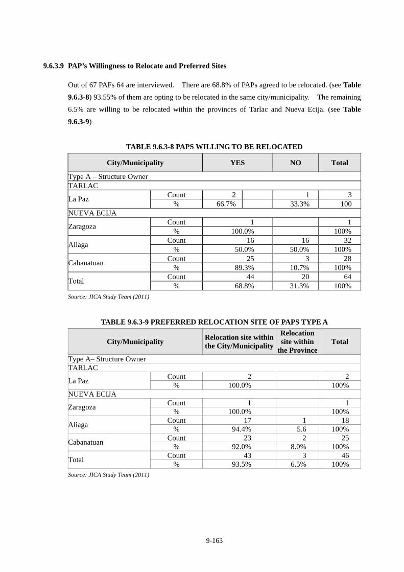
9-163
9.6.3.9 PAP’s Willingness to Relocate and Preferred Sites
Out of 67 PAFs 64 are interviewed. There are 68.8% of PAPs agreed to be relocated. (see Table
9.6.3-8) 93.55% of them are opting to be relocated in the same city/municipality. The remaining
6.5% are willing to be relocated within the provinces of Tarlac and Nueva Ecija. (see Table
9.6.3-9)
TABLE 9.6.3-8 PAPS WILLING TO BE RELOCATED
City/Municipality YES NO Total
Type A – Structure Owner TARLAC
Count 2 1 3 La Paz
% 66.7% 33.3% 100 NUEVA ECIJA
Count 1 1 Zaragoza
% 100.0% 100% Count 16 16 32
Aliaga % 50.0% 50.0% 100%
Count 25 3 28 Cabanatuan
% 89.3% 10.7% 100% Count 44 20 64
Total % 68.8% 31.3% 100%
Source: JICA Study Team (2011)
TABLE 9.6.3-9 PREFERRED RELOCATION SITE OF PAPS TYPE A
City/Municipality Relocation site within the City/Municipality
Relocation site within
the Province Total
Type A– Structure Owner TARLAC
Count 2 2 La Paz
% 100.0% 100% NUEVA ECIJA
Count 1 1 Zaragoza
% 100.0% 100% Count 17 1 18
Aliaga % 94.4% 5.6 100%
Count 23 2 25 Cabanatuan
% 92.0% 8.0% 100% Count 43 3 46
Total % 93.5% 6.5% 100%
Source: JICA Study Team (2011)
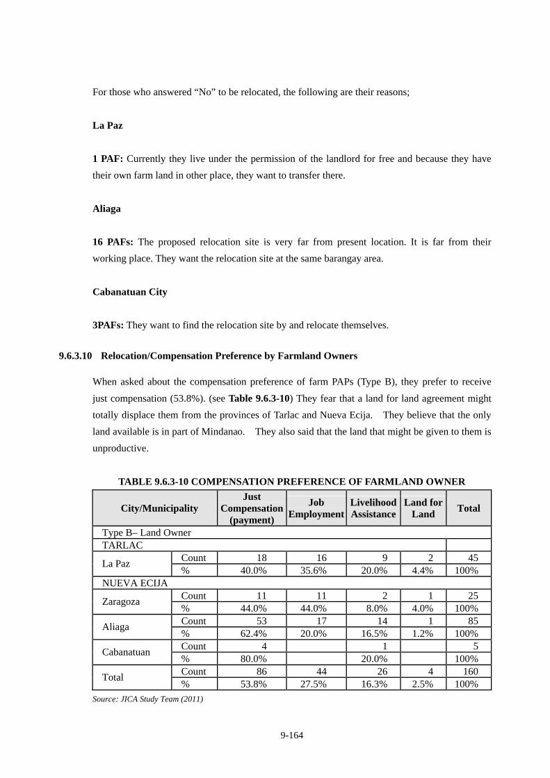
9-164
For those who answered “No” to be relocated, the following are their reasons;
La Paz
1 PAF: Currently they live under the permission of the landlord for free and because they have
their own farm land in other place, they want to transfer there.
Aliaga
16 PAFs: The proposed relocation site is very far from present location. It is far from their
working place. They want the relocation site at the same barangay area.
Cabanatuan City
3PAFs: They want to find the relocation site by and relocate themselves.
9.6.3.10 Relocation/Compensation Preference by Farmland Owners
When asked about the compensation preference of farm PAPs (Type B), they prefer to receive
just compensation (53.8%). (see Table 9.6.3-10) They fear that a land for land agreement might
totally displace them from the provinces of Tarlac and Nueva Ecija. They believe that the only
land available is in part of Mindanao. They also said that the land that might be given to them is
unproductive.
TABLE 9.6.3-10 COMPENSATION PREFERENCE OF FARMLAND OWNER
City/Municipality Just
Compensation (payment)
Job Employment
Livelihood Assistance
Land for Land
Total
Type B– Land Owner TARLAC
Count 18 16 9 2 45 La Paz
% 40.0% 35.6% 20.0% 4.4% 100% NUEVA ECIJA
Count 11 11 2 1 25 Zaragoza
% 44.0% 44.0% 8.0% 4.0% 100% Count 53 17 14 1 85
Aliaga % 62.4% 20.0% 16.5% 1.2% 100% Count 4 1 5
Cabanatuan % 80.0% 20.0% 100% Count 86 44 26 4 160
Total % 53.8% 27.5% 16.3% 2.5% 100%
Source: JICA Study Team (2011)
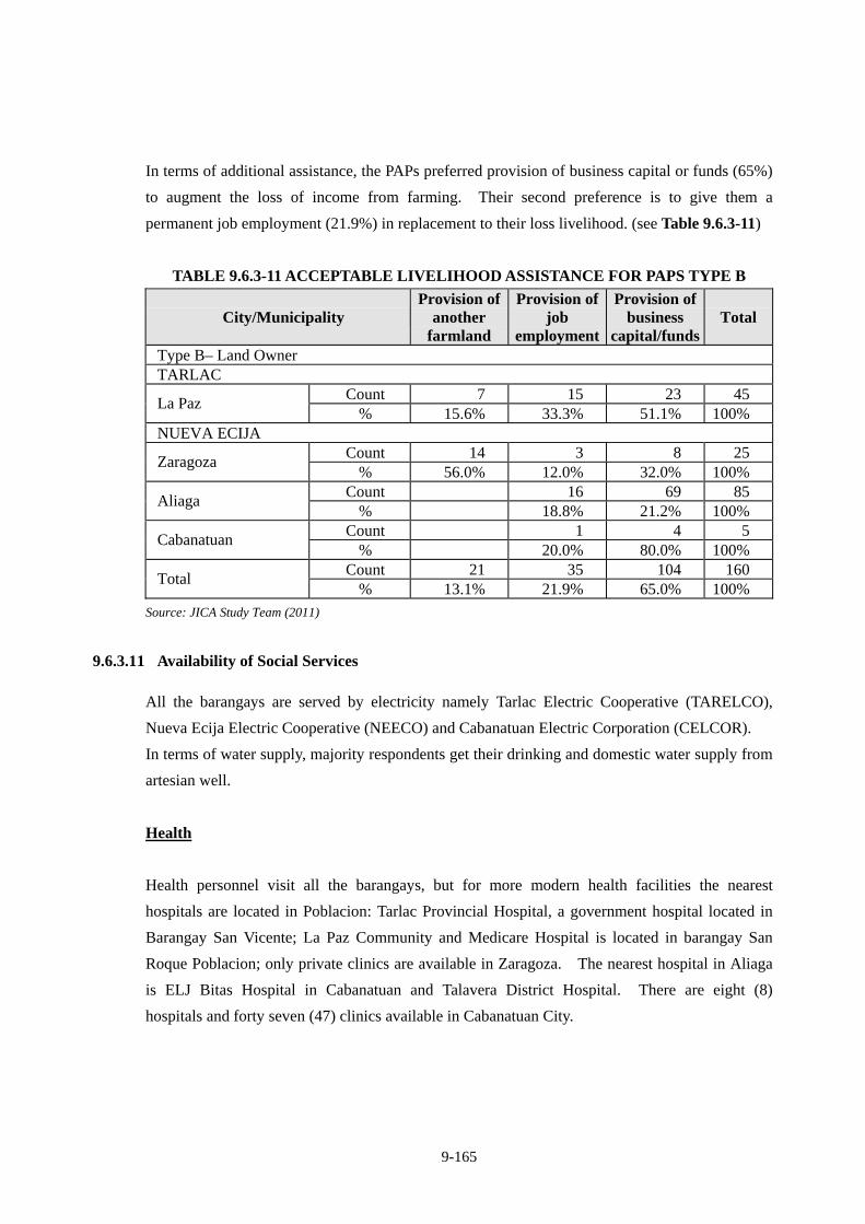
9-165
In terms of additional assistance, the PAPs preferred provision of business capital or funds (65%)
to augment the loss of income from farming. Their second preference is to give them a
permanent job employment (21.9%) in replacement to their loss livelihood. (see Table 9.6.3-11)
TABLE 9.6.3-11 ACCEPTABLE LIVELIHOOD ASSISTANCE FOR PAPS TYPE B
City/Municipality Provision of
another farmland
Provision of job
employment
Provision of business
capital/funds Total
Type B– Land Owner TARLAC
Count 7 15 23 45 La Paz
% 15.6% 33.3% 51.1% 100% NUEVA ECIJA
Count 14 3 8 25 Zaragoza
% 56.0% 12.0% 32.0% 100% Count 16 69 85
Aliaga % 18.8% 21.2% 100%
Count 1 4 5 Cabanatuan
% 20.0% 80.0% 100% Count 21 35 104 160
Total % 13.1% 21.9% 65.0% 100%
Source: JICA Study Team (2011)
9.6.3.11 Availability of Social Services
All the barangays are served by electricity namely Tarlac Electric Cooperative (TARELCO),
Nueva Ecija Electric Cooperative (NEECO) and Cabanatuan Electric Corporation (CELCOR).
In terms of water supply, majority respondents get their drinking and domestic water supply from
artesian well.
Health
Health personnel visit all the barangays, but for more modern health facilities the nearest
hospitals are located in Poblacion: Tarlac Provincial Hospital, a government hospital located in
Barangay San Vicente; La Paz Community and Medicare Hospital is located in barangay San
Roque Poblacion; only private clinics are available in Zaragoza. The nearest hospital in Aliaga
is ELJ Bitas Hospital in Cabanatuan and Talavera District Hospital. There are eight (8)
hospitals and forty seven (47) clinics available in Cabanatuan City.
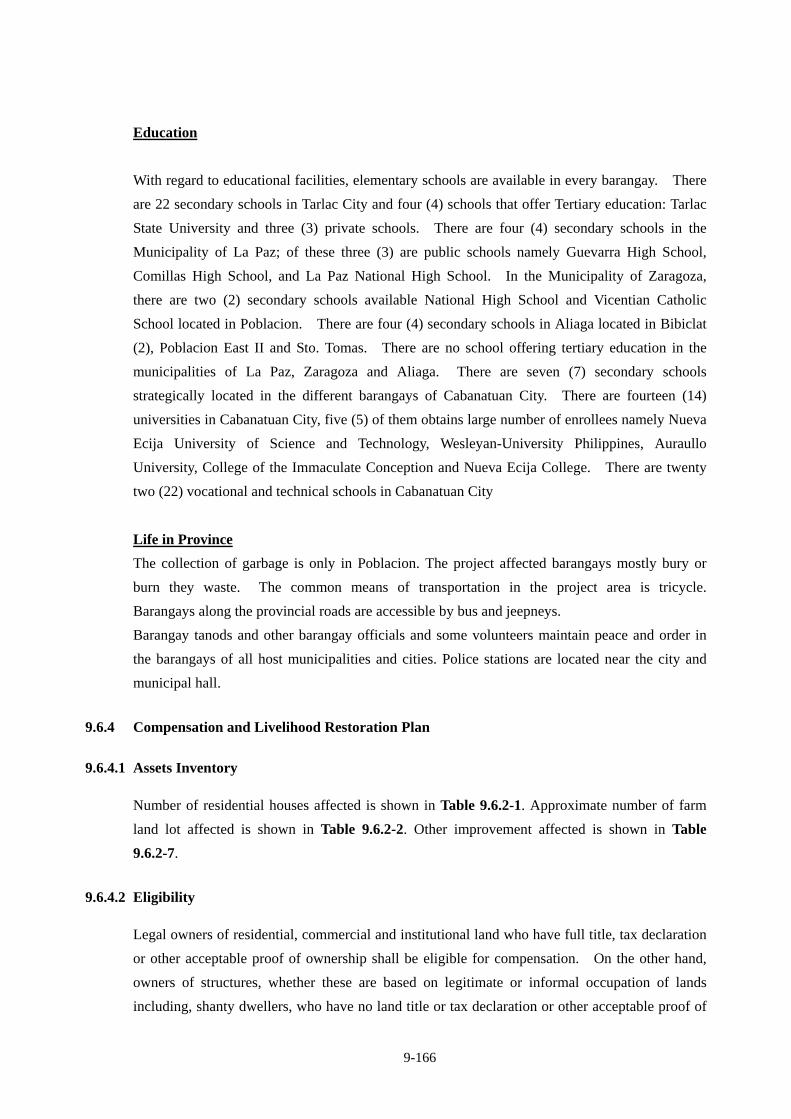
9-166
Education
With regard to educational facilities, elementary schools are available in every barangay. There
are 22 secondary schools in Tarlac City and four (4) schools that offer Tertiary education: Tarlac
State University and three (3) private schools. There are four (4) secondary schools in the
Municipality of La Paz; of these three (3) are public schools namely Guevarra High School,
Comillas High School, and La Paz National High School. In the Municipality of Zaragoza,
there are two (2) secondary schools available National High School and Vicentian Catholic
School located in Poblacion. There are four (4) secondary schools in Aliaga located in Bibiclat
(2), Poblacion East II and Sto. Tomas. There are no school offering tertiary education in the
municipalities of La Paz, Zaragoza and Aliaga. There are seven (7) secondary schools
strategically located in the different barangays of Cabanatuan City. There are fourteen (14)
universities in Cabanatuan City, five (5) of them obtains large number of enrollees namely Nueva
Ecija University of Science and Technology, Wesleyan-University Philippines, Auraullo
University, College of the Immaculate Conception and Nueva Ecija College. There are twenty
two (22) vocational and technical schools in Cabanatuan City
Life in Province
The collection of garbage is only in Poblacion. The project affected barangays mostly bury or
burn they waste. The common means of transportation in the project area is tricycle.
Barangays along the provincial roads are accessible by bus and jeepneys.
Barangay tanods and other barangay officials and some volunteers maintain peace and order in
the barangays of all host municipalities and cities. Police stations are located near the city and
municipal hall.
9.6.4 Compensation and Livelihood Restoration Plan
9.6.4.1 Assets Inventory
Number of residential houses affected is shown in Table 9.6.2-1. Approximate number of farm
land lot affected is shown in Table 9.6.2-2. Other improvement affected is shown in Table
9.6.2-7.
9.6.4.2 Eligibility
Legal owners of residential, commercial and institutional land who have full title, tax declaration
or other acceptable proof of ownership shall be eligible for compensation. On the other hand,
owners of structures, whether these are based on legitimate or informal occupation of lands
including, shanty dwellers, who have no land title or tax declaration or other acceptable proof of
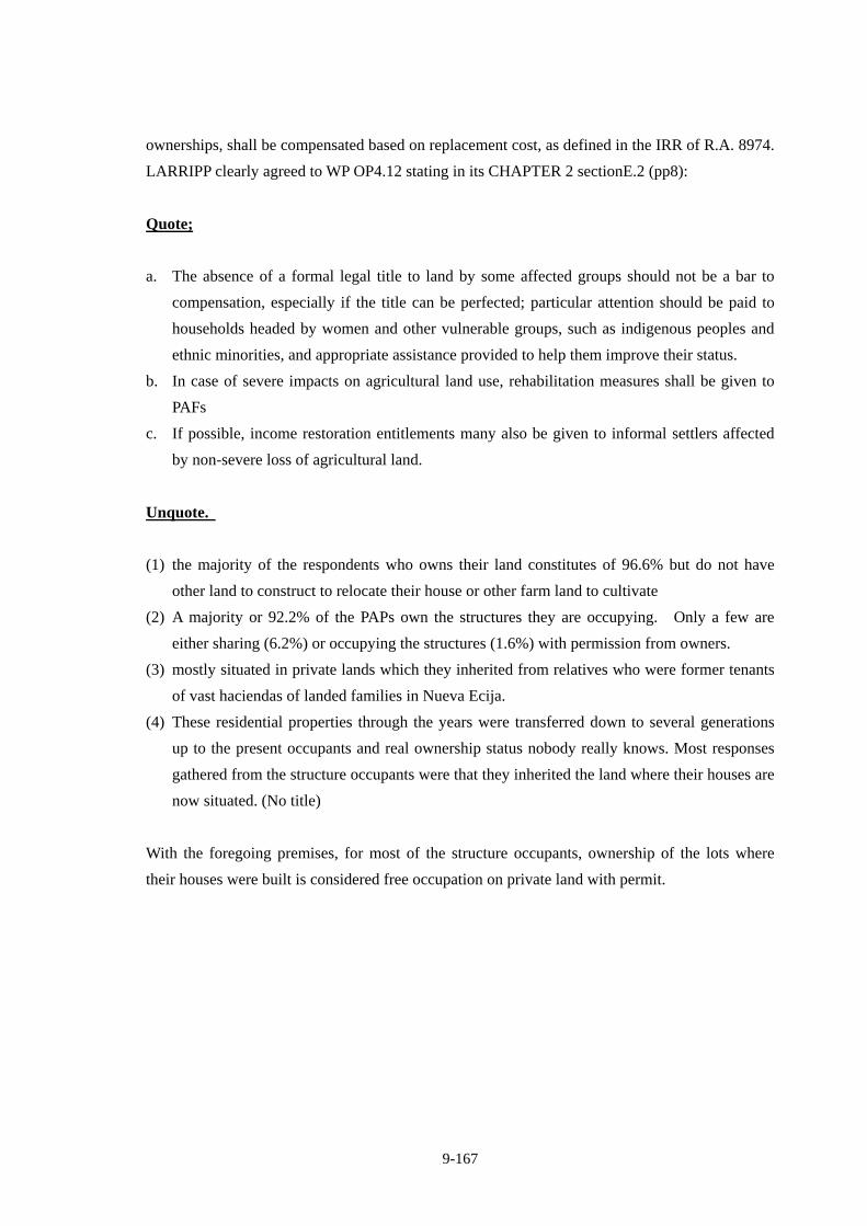
9-167
ownerships, shall be compensated based on replacement cost, as defined in the IRR of R.A. 8974.
LARRIPP clearly agreed to WP OP4.12 stating in its CHAPTER 2 sectionE.2 (pp8):
Quote;
a. The absence of a formal legal title to land by some affected groups should not be a bar to
compensation, especially if the title can be perfected; particular attention should be paid to
households headed by women and other vulnerable groups, such as indigenous peoples and
ethnic minorities, and appropriate assistance provided to help them improve their status.
b. In case of severe impacts on agricultural land use, rehabilitation measures shall be given to
PAFs
c. If possible, income restoration entitlements many also be given to informal settlers affected
by non-severe loss of agricultural land.
Unquote.
(1) the majority of the respondents who owns their land constitutes of 96.6% but do not have
other land to construct to relocate their house or other farm land to cultivate
(2) A majority or 92.2% of the PAPs own the structures they are occupying. Only a few are
either sharing (6.2%) or occupying the structures (1.6%) with permission from owners.
(3) mostly situated in private lands which they inherited from relatives who were former tenants
of vast haciendas of landed families in Nueva Ecija.
(4) These residential properties through the years were transferred down to several generations
up to the present occupants and real ownership status nobody really knows. Most responses
gathered from the structure occupants were that they inherited the land where their houses are
now situated. (No title)
With the foregoing premises, for most of the structure occupants, ownership of the lots where
their houses were built is considered free occupation on private land with permit.

9-168
TABLE 9.6.4-1 ENTITLEMENT MATRIX
Type of Loss Application Entitled Person
Compensation/Entitlements Actions For Each Compensation/
Entitlement
Organization Responsible For Each
Action LAND (classified as Agricultural, Residential, Commercial or Institutional).
More than 20% of the total landholding lost or where less than 20% lost but the remaining land holding become economically unviable.
Project affected Family (PAF) with Torrens Certificate of Title (TCT) or tax declaration (Tax declaration can be legalized to full title).
PAF will be entitled to: Cash compensation for loss of land
at 100% replacement cost at the informed request of PAFs. This entitlement covers the residential land if the remaining farm land holding becomes economically unviable and (it’s the only asset/property the PAF has, thus) the Project Affected Family (PAF) is obliged to relocate their house to other place for new jobs (refer to STRUCTURE (B) below).
If feasible, land for land will be provided in terms of a new parcel of land of equivalent productivity, at a location acceptable to PAFs.
Cash compensation for damaged
crops at market value at the time of taking.
Cash compensation for disturbance allowance equivalent to 5 times of average gross harvest, but not greater than P 15,000.00
Rehabilitation assistance in the form of skills training equivalent to the amount of P15,000.00, per family, if the present means of
(1) Public consultation meeting
(2) Parcellary survey to identify land owners, area to be acquired, preparation of subdivision map, etc.
(3) Assessment of land value, procurement of independent land/asset appraiser, damaged crops, disturbance compensation, etc.
(4) Validation of assessment
(5) Preparation of RAP Report
(6) Approval of RAP (7) Disclosure of
Compensation Package (8) Land purchase contract
with land owners (9) Payment to land owners(10) Transfer of Title
(1) PMO, RO/DEO with D/D Consultant
(2) PMO,RO/DEO with D/D Consultant
(3) Independent land/ Asset Appraiser
(4) PMO, RO/DEO, MRIC/CRIC
(5) PMO, D/D Consultant
(6) DPWH Secretary (7) PMO, RO/DEO
(8) RO/DEO
(9) PMO, RO/DEO
(10) RO/DEO
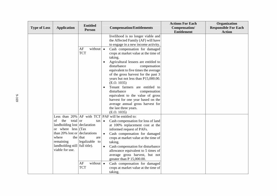
9-169
Type of Loss Application Entitled Person
Compensation/Entitlements Actions For Each Compensation/
Entitlement
Organization Responsible For Each
Action livelihood is no longer viable and the Affected Family (AF) will have to engage in a new income activity.
AF without TCT
Cash compensation for damaged crops at market value at the time of taking.
Agricultural lessees are entitled to disturbance compensation equivalent to five times the average of the gross harvest for the past 3 years but not less than P15,000.00. (E.O. 1035)
Tenant farmers are entitled to disturbance compensation equivalent to the value of gross harvest for one year based on the average annual gross harvest for the last three years. (E.O. 1035)
AF with TCT or tax declaration (Tax declarations that are legalizable to full title).
PAF will be entitled to: Cash compensation for loss of land
at 100% replacement cost at the informed request of PAFs.
Cash compensation for damaged crops at market value at the time of taking.
Cash compensation for disturbance allowance equivalent to 5 times of average gross harvest, but not greater than P 15,000.00.
Less than 20% of the total landholding lost or where less than 20% lost or where the remaining landholding still viable for use.
AF without TCT
Cash compensation for damaged crops at market value at the time of taking.
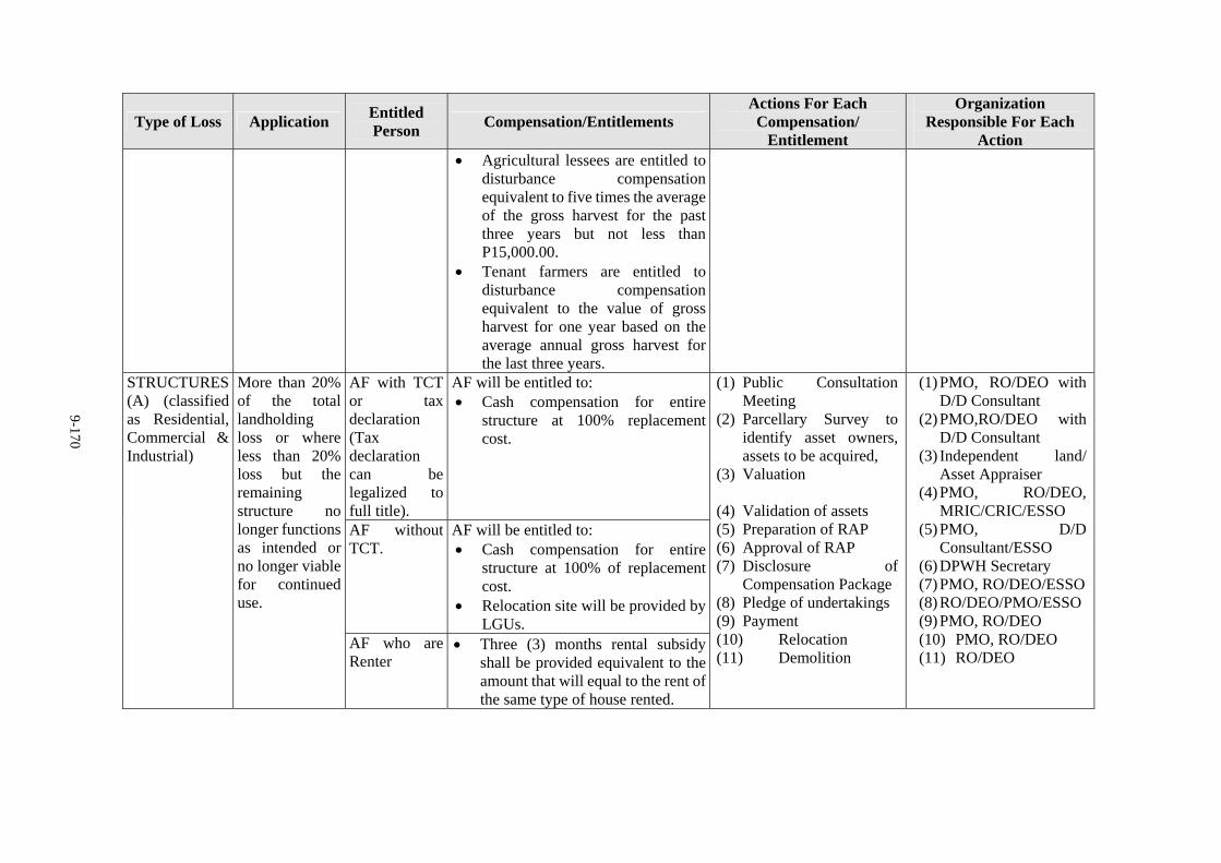
9-170
Type of Loss Application Entitled Person
Compensation/Entitlements Actions For Each Compensation/
Entitlement
Organization Responsible For Each
Action Agricultural lessees are entitled to
disturbance compensation equivalent to five times the average of the gross harvest for the past three years but not less than P15,000.00.
Tenant farmers are entitled to disturbance compensation equivalent to the value of gross harvest for one year based on the average annual gross harvest for the last three years.
AF with TCT or tax declaration (Tax declaration can be legalized to full title).
AF will be entitled to: Cash compensation for entire
structure at 100% replacement cost.
AF without TCT.
AF will be entitled to: Cash compensation for entire
structure at 100% of replacement cost.
Relocation site will be provided by LGUs.
STRUCTURES(A) (classified as Residential, Commercial & Industrial)
More than 20% of the total landholding loss or where less than 20% loss but the remaining structure no longer functions as intended or no longer viable for continued use.
AF who are Renter
Three (3) months rental subsidy shall be provided equivalent to the amount that will equal to the rent of the same type of house rented.
(1) Public Consultation Meeting
(2) Parcellary Survey to identify asset owners, assets to be acquired,
(3) Valuation
(4) Validation of assets (5) Preparation of RAP (6) Approval of RAP (7) Disclosure of
Compensation Package (8) Pledge of undertakings (9) Payment (10) Relocation (11) Demolition
(1) PMO, RO/DEO with D/D Consultant
(2) PMO,RO/DEO with D/D Consultant
(3) Independent land/ Asset Appraiser
(4) PMO, RO/DEO, MRIC/CRIC/ESSO
(5) PMO, D/D Consultant/ESSO
(6) DPWH Secretary (7) PMO, RO/DEO/ESSO (8) RO/DEO/PMO/ESSO (9) PMO, RO/DEO (10) PMO, RO/DEO (11) RO/DEO
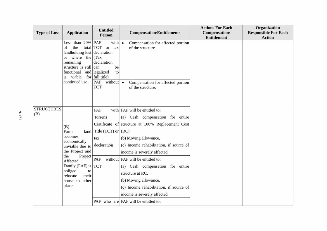
9-171
Type of Loss Application Entitled Person
Compensation/Entitlements Actions For Each Compensation/
Entitlement
Organization Responsible For Each
Action PAF with TCT or tax declaration (Tax declaration can be legalized to full title).
Compensation for affected portion of the structure..
Less than 20% of the total landholding lost or where the remaining structure is still functional and is viable for continued use.
PAF without TCT
Compensation for affected portion of the structure.
PAF with
Torrens
Certificate of
Title (TCT) or
tax
declaration
PAF will be entitled to:
(a) Cash compensation for entire
structure at 100% Replacement Cost
(RC),
(b) Moving allowance,
(c) Income rehabilitation, if source of
income is severely affected
PAF without
TCT
PAF will be entitled to:
(a) Cash compensation for entire
structure at RC,
(b) Moving allowance,
(c) Income rehabilitation, if source of
income is severely affected
STRUCTURES(B)
(B) Farm land becomes economically unviable due to the Project and the Project Affected Family (PAF) is obliged to relocate their house to other place.
PAF who are PAF will be entitled to:
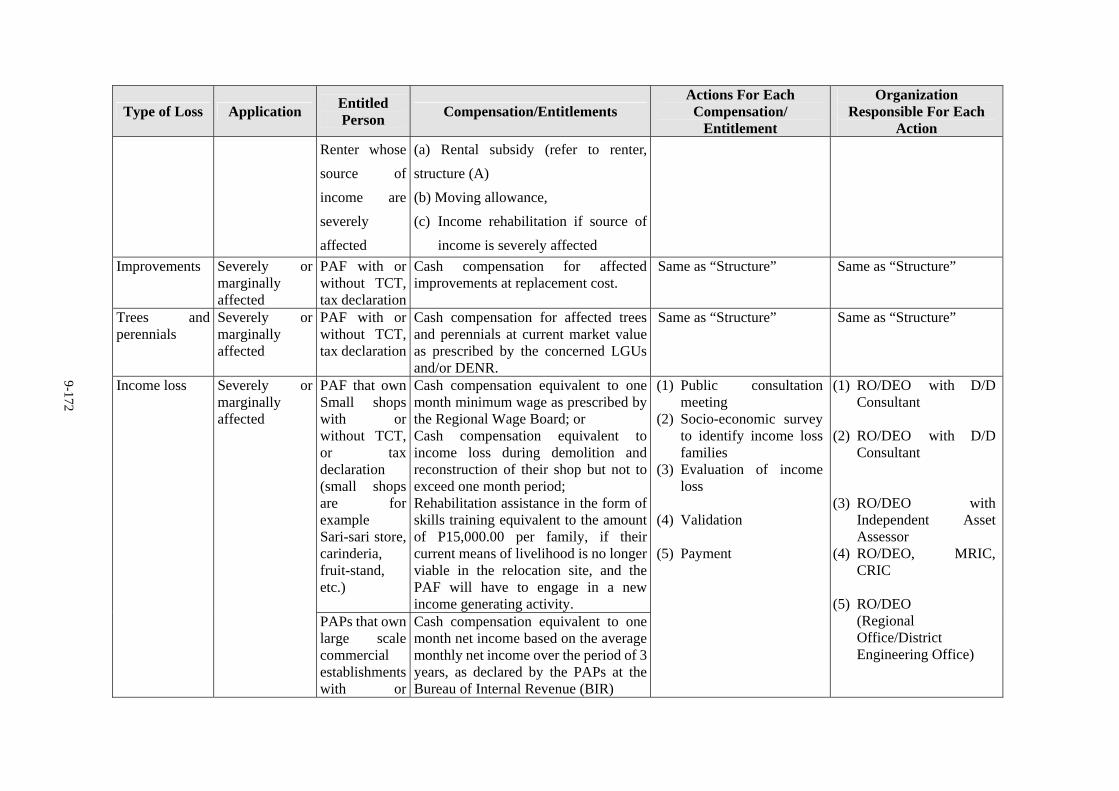
9-172
Type of Loss Application Entitled Person
Compensation/Entitlements Actions For Each Compensation/
Entitlement
Organization Responsible For Each
Action
Renter whose
source of
income are
severely
affected
(a) Rental subsidy (refer to renter,
structure (A)
(b) Moving allowance,
(c) Income rehabilitation if source of
income is severely affected
Improvements Severely or marginally affected
PAF with or without TCT, tax declaration
Cash compensation for affected improvements at replacement cost.
Same as “Structure” Same as “Structure”
Trees and perennials
Severely or marginally affected
PAF with or without TCT, tax declaration
Cash compensation for affected trees and perennials at current market value as prescribed by the concerned LGUs and/or DENR.
Same as “Structure” Same as “Structure”
PAF that own Small shops with or without TCT, or tax declaration (small shops are for example Sari-sari store, carinderia, fruit-stand, etc.)
Cash compensation equivalent to one month minimum wage as prescribed by the Regional Wage Board; or Cash compensation equivalent to income loss during demolition and reconstruction of their shop but not to exceed one month period; Rehabilitation assistance in the form of skills training equivalent to the amount of P15,000.00 per family, if their current means of livelihood is no longer viable in the relocation site, and the PAF will have to engage in a new income generating activity.
Income loss Severely or marginally affected
PAPs that own large scale commercial establishmentswith or
Cash compensation equivalent to one month net income based on the average monthly net income over the period of 3 years, as declared by the PAPs at the Bureau of Internal Revenue (BIR)
(1) Public consultation meeting
(2) Socio-economic survey to identify income loss families
(3) Evaluation of income loss
(4) Validation
(5) Payment
(1) RO/DEO with D/D Consultant
(2) RO/DEO with D/D Consultant
(3) RO/DEO with
Independent Asset Assessor
(4) RO/DEO, MRIC, CRIC
(5) RO/DEO (Regional Office/District Engineering Office)
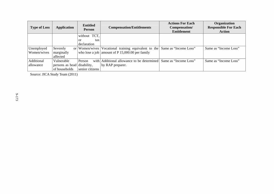
9-173
Type of Loss Application Entitled Person
Compensation/Entitlements Actions For Each Compensation/
Entitlement
Organization Responsible For Each
Action without TCT, or tax declaration
Unemployed Women/wives
Severely or marginally affected
Women/wives who lose a job
Vocational training equivalent to the amount of P 15,000.00 per family
Same as “Income Loss” Same as “Income Loss”
Additional allowance
Vulnerable persons as head of households
Person with disability, senior citizens
Additional allowance to be determined by RAP preparer.
Same as “Income Loss” Same as “Income Loss”
Source: JICA Study Team (2011)
9-174
9.6.4.3 Valuation and Compensation for Losses
Valuation for compensating loss of land shall be in accordance with Section 5 of R.A. 8974; for
dwellings and other structures, on replacement cost as defined in Section 10 of its Implementing
Rules and Regulations (IRR), as well as the LARRIPP of the DPWH. Small-scale commercial
establishments like sari-sari stores, which will incur temporary decrease in income due to limited
access/frontage, shall also be provided income rehabilitation assistance. Inconvenience allowance
shall be given to PAPs with severely affected structures, which require relocation and new
construction.
For informal settlers, affected families shall be provided free transportation (including those who
opt to go back to their province) upon their transfer to the relocation sites. Rehabilitation
assistance such as skills training and other development activities per family will be provided in
coordination with other government agencies, if the present means of livelihood is no longer
viable and the PAPs will have to engage in a new income activity. Rental Subsidy will be given
to PAPs without sufficient additional land to allow the reconstruction of their lost house.
1) Principle of Replacement Cost
All compensation for land and non-land assets owned by households/shop owners who meet the
cut-off-date will be based on the principle of replacement cost.
Replacement cost is the amount calculated before displacement which is needed to replace an affected asset without depreciation and without deduction for taxes and/or costs of transaction.
Existing regulations, methods and market price survey results of DPWH, DENR, DA, and LGUs will be used where ever available for compensation calculations for building, crops and trees.
Independent asset assessor is employed to valuate lands, structures, trees and other compensations.
Houses and other related structures based on actual current market prices of affected materials, labor and mark-up costs. Unit cost for the materials is updated every year, using standard price in each region. Labor cost is added as 25 % of the material cost. In addition to the total estimated direct cost, 20 % mark-up is included in the grand total of replacement cost, covering transfer cost and taxes.
Annual crops equivalent to current market value of crops at the time of compensation;
For perennial crops, cash compensation at replacement cost that should be in line with local government regulations, if available, is equivalent to current market value given the type and age at the time of compensation.
For timber trees, cash compensation at replacement cost that should be in line with local government regulations, if available, will be equivalent to current market value for each type, age and relevant productive value at the time of compensation based on the diameter at breast height of each tree.
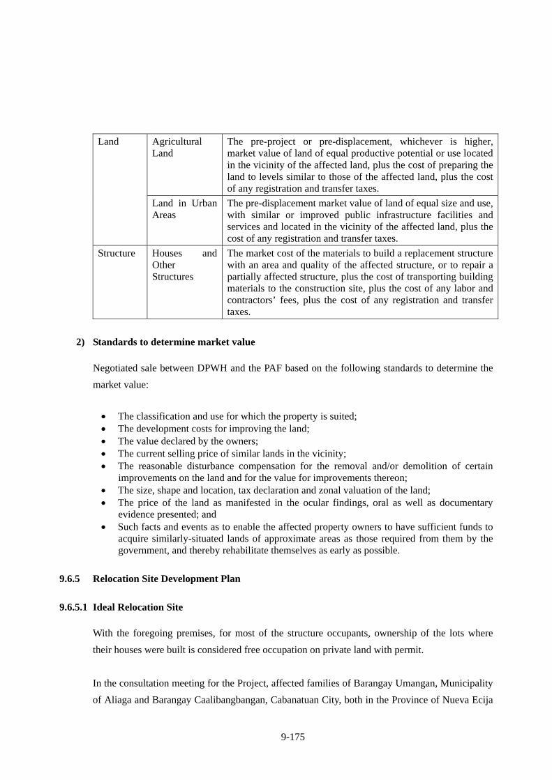
9-175
Agricultural Land
The pre-project or pre-displacement, whichever is higher, market value of land of equal productive potential or use located in the vicinity of the affected land, plus the cost of preparing the land to levels similar to those of the affected land, plus the cost of any registration and transfer taxes.
Land
Land in Urban Areas
The pre-displacement market value of land of equal size and use, with similar or improved public infrastructure facilities and services and located in the vicinity of the affected land, plus the cost of any registration and transfer taxes.
Structure Houses and Other Structures
The market cost of the materials to build a replacement structure with an area and quality of the affected structure, or to repair a partially affected structure, plus the cost of transporting building materials to the construction site, plus the cost of any labor and contractors’ fees, plus the cost of any registration and transfer taxes.
2) Standards to determine market value
Negotiated sale between DPWH and the PAF based on the following standards to determine the
market value:
The classification and use for which the property is suited; The development costs for improving the land; The value declared by the owners; The current selling price of similar lands in the vicinity; The reasonable disturbance compensation for the removal and/or demolition of certain
improvements on the land and for the value for improvements thereon; The size, shape and location, tax declaration and zonal valuation of the land; The price of the land as manifested in the ocular findings, oral as well as documentary
evidence presented; and Such facts and events as to enable the affected property owners to have sufficient funds to
acquire similarly-situated lands of approximate areas as those required from them by the government, and thereby rehabilitate themselves as early as possible.
9.6.5 Relocation Site Development Plan
9.6.5.1 Ideal Relocation Site
With the foregoing premises, for most of the structure occupants, ownership of the lots where
their houses were built is considered free occupation on private land with permit.
In the consultation meeting for the Project, affected families of Barangay Umangan, Municipality
of Aliaga and Barangay Caalibangbangan, Cabanatuan City, both in the Province of Nueva Ecija
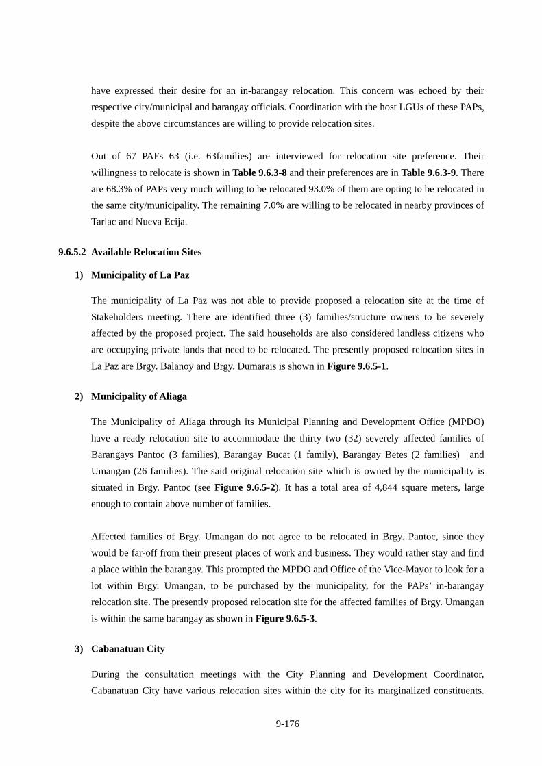
9-176
have expressed their desire for an in-barangay relocation. This concern was echoed by their
respective city/municipal and barangay officials. Coordination with the host LGUs of these PAPs,
despite the above circumstances are willing to provide relocation sites.
Out of 67 PAFs 63 (i.e. 63families) are interviewed for relocation site preference. Their
willingness to relocate is shown in Table 9.6.3-8 and their preferences are in Table 9.6.3-9. There
are 68.3% of PAPs very much willing to be relocated 93.0% of them are opting to be relocated in
the same city/municipality. The remaining 7.0% are willing to be relocated in nearby provinces of
Tarlac and Nueva Ecija.
9.6.5.2 Available Relocation Sites
1) Municipality of La Paz
The municipality of La Paz was not able to provide proposed a relocation site at the time of
Stakeholders meeting. There are identified three (3) families/structure owners to be severely
affected by the proposed project. The said households are also considered landless citizens who
are occupying private lands that need to be relocated. The presently proposed relocation sites in
La Paz are Brgy. Balanoy and Brgy. Dumarais is shown in Figure 9.6.5-1.
2) Municipality of Aliaga
The Municipality of Aliaga through its Municipal Planning and Development Office (MPDO)
have a ready relocation site to accommodate the thirty two (32) severely affected families of
Barangays Pantoc (3 families), Barangay Bucat (1 family), Barangay Betes (2 families) and
Umangan (26 families). The said original relocation site which is owned by the municipality is
situated in Brgy. Pantoc (see Figure 9.6.5-2). It has a total area of 4,844 square meters, large
enough to contain above number of families.
Affected families of Brgy. Umangan do not agree to be relocated in Brgy. Pantoc, since they
would be far-off from their present places of work and business. They would rather stay and find
a place within the barangay. This prompted the MPDO and Office of the Vice-Mayor to look for a
lot within Brgy. Umangan, to be purchased by the municipality, for the PAPs’ in-barangay
relocation site. The presently proposed relocation site for the affected families of Brgy. Umangan
is within the same barangay as shown in Figure 9.6.5-3.
3) Cabanatuan City
During the consultation meetings with the City Planning and Development Coordinator,
Cabanatuan City have various relocation sites within the city for its marginalized constituents.
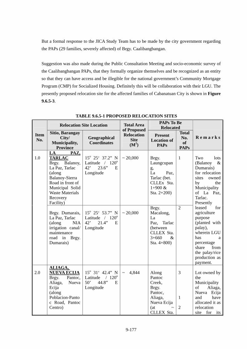
9-177
But a formal response to the JICA Study Team has to be made by the city government regarding
the PAPs (29 families, severely affected) of Brgy. Caalibangbangan.
Suggestion was also made during the Public Consultation Meeting and socio-economic survey of
the Caalibangbangan PAPs, that they formally organize themselves and be recognized as an entity
so that they can have access and be illegible for the national government’s Community Mortgage
Program (CMP) for Socialized Housing. Definitely this will be collaboration with their LGU. The
presently proposed relocation site for the affected families of Cabanatuan City is shown in Figure
9.6.5-3.
TABLE 9.6.5-1 PROPOSED RELOCATION SITES
Relocation Site Location PAPs To Be Relocated
Item No.
Sitio, Barangay City/
Municipality, Province
Geographical Coordinates
Total Areaof ProposedRelocation
Site (M2)
Present Location of
PAPs
Total No. of
PAPs
R e m a r k s
LA PAZ, TARLAC Brgy. Balanoy, La Paz, Tarlac (along Balanoy-Sierra Road in front of Municipal Solid Waste Materials Recovery Facility)
15o 25‘ 37.2” N Latitude / 120o 42’ 23.6” E Longitude
~ 20,000
Brgy. Laungcupang, La Paz, Tarlac (bet. CLLEx Sta. 1+900 & Sta. 2+200)
1
1.0
Brgy. Dumarais, La Paz, Tarlac (along NIA irrigation canal/ maintenance road in Brgy. Dumarais)
15o 25‘ 53.7” N Latitude / 120o 42’ 21.4” E Longitude
~ 20,000
Brgy. Macalong, La Paz, Tarlac (between CLLEX Sta. 3+660 & Sta. 4+800)
2
Two lots (Balanoy & Dumarais) for relocation sites owned by the Municipality of La Paz, Tarlac. Presently leased for agriculture purpose (planted with palay), wherein LGU has a percentage share from the palay/rice production as payment.
2.0
ALIAGA, NUEVA ECIJA Brgy. Pantoc, Aliaga, Nueva Ecija (along Poblacion-Pantoc Road, Pantoc Centro)
15o 31‘ 42.4” N Latitude / 120o 50’ 44.8” E Longitude
~ 4,844
Along Pantoc Creek, Brgy. Pantoc, Aliaga, Nueva Ecija(at ~ CLLEX Sta.
3 1 2
Lot owned by the Municipality of Aliaga, Nueva Ecija and have allocated it as relocation site for its
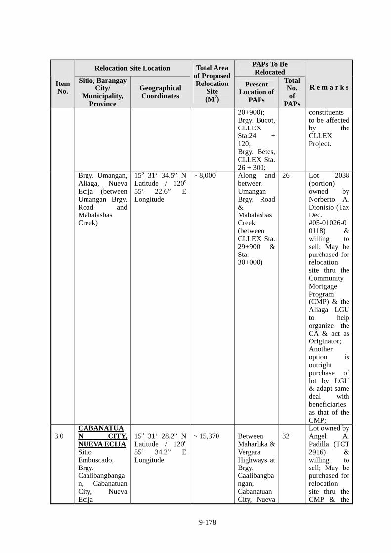
9-178
Relocation Site Location PAPs To Be Relocated
Item No.
Sitio, Barangay City/
Municipality, Province
Geographical Coordinates
Total Areaof ProposedRelocation
Site (M2)
Present Location of
PAPs
Total No. of
PAPs
R e m a r k s
20+900); Brgy. Bucot, CLLEX Sta.24 + 120; Brgy. Betes, CLLEX Sta. 26 + 300;
constituents to be affected by the CLLEX Project.
Brgy. Umangan, Aliaga, Nueva Ecija (between Umangan Brgy. Road and Mabalasbas Creek)
15o 31‘ 34.5” N Latitude / 120o 55’ 22.6” E Longitude
~ 8,000
Along and between Umangan Brgy. Road & Mabalasbas Creek (between CLLEX Sta. 29+900 & Sta. 30+000)
26
Lot 2038 (portion) owned by Norberto A. Dionisio (Tax Dec. #05-01026-00118) & willing to sell; May be purchased for relocation site thru the Community Mortgage Program (CMP) & the Aliaga LGU to help organize the CA & act as Originator; Another option is outright purchase of lot by LGU & adapt same deal with beneficiaries as that of the CMP;
3.0
CABANATUAN CITY, NUEVA ECIJA Sitio Embuscado, Brgy. Caalibangbangan, Cabanatuan City, Nueva Ecija
15o 31‘ 28.2” N Latitude / 120o 55’ 34.2” E Longitude
~ 15,370 Between
Maharlika & Vergara Highways at Brgy. Caalibangbangan, Cabanatuan City, Nueva
32
Lot owned by Angel A. Padilla (TCT 2916) & willing to sell; May be purchased for relocation site thru the CMP & the
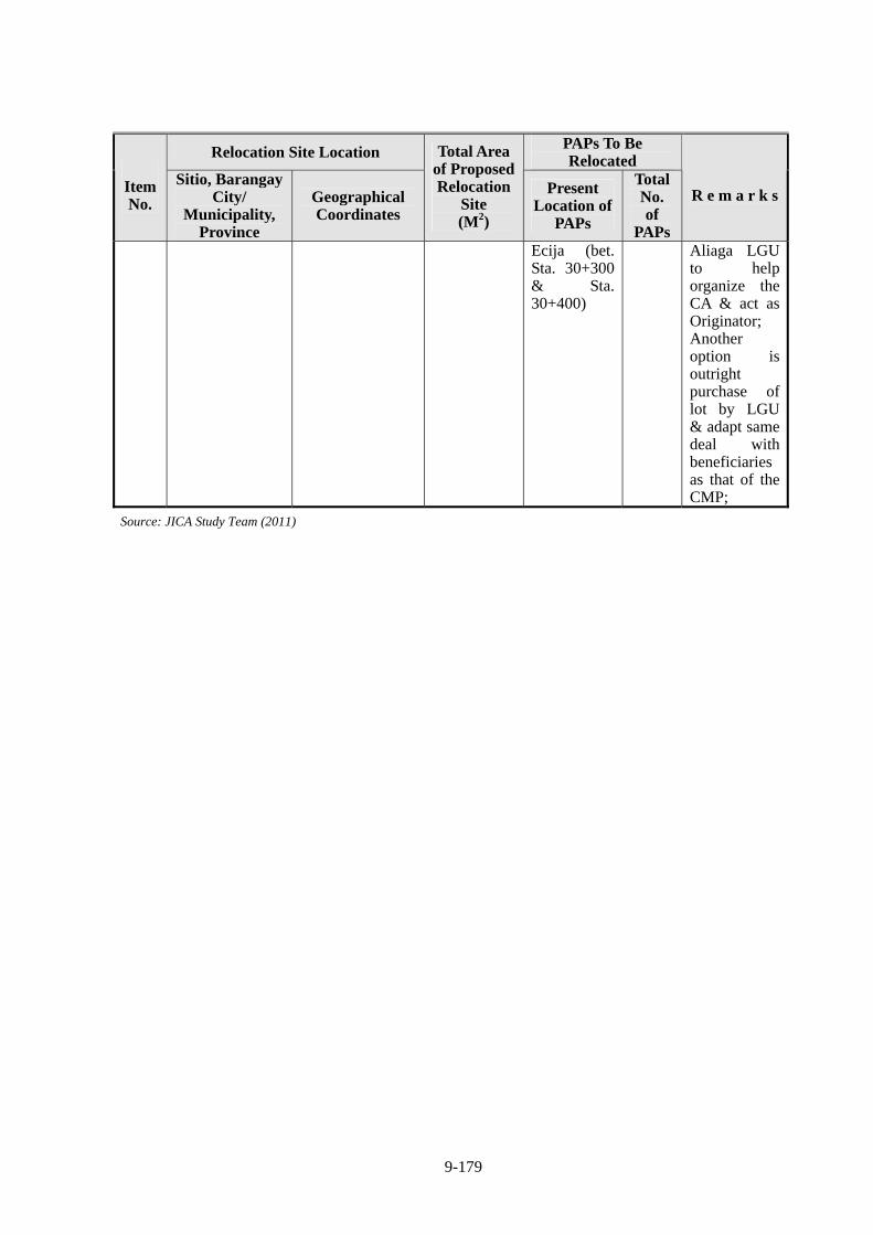
9-179
Relocation Site Location PAPs To Be Relocated
Item No.
Sitio, Barangay City/
Municipality, Province
Geographical Coordinates
Total Areaof ProposedRelocation
Site (M2)
Present Location of
PAPs
Total No. of
PAPs
R e m a r k s
Ecija (bet. Sta. 30+300 & Sta. 30+400)
Aliaga LGU to help organize the CA & act as Originator; Another option is outright purchase of lot by LGU & adapt same deal with beneficiaries as that of the CMP;
Source: JICA Study Team (2011)
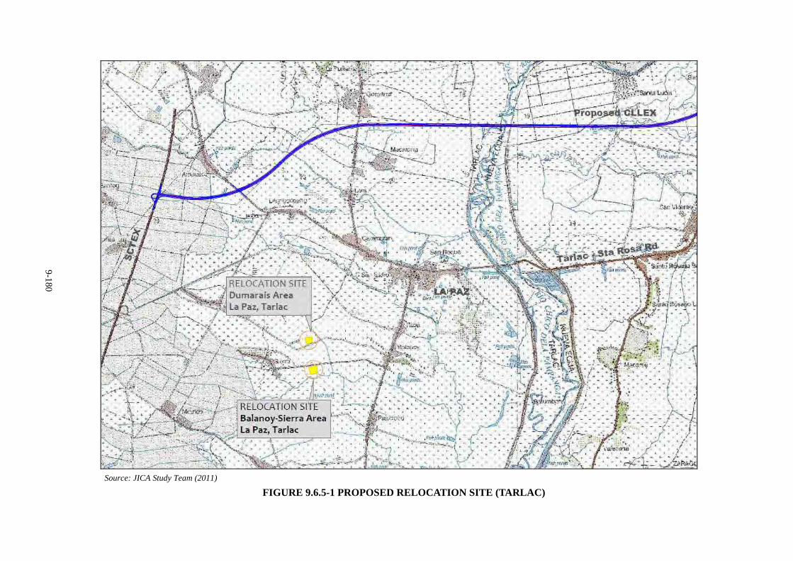
9-180
Source: JICA Study Team (2011)
FIGURE 9.6.5-1 PROPOSED RELOCATION SITE (TARLAC)
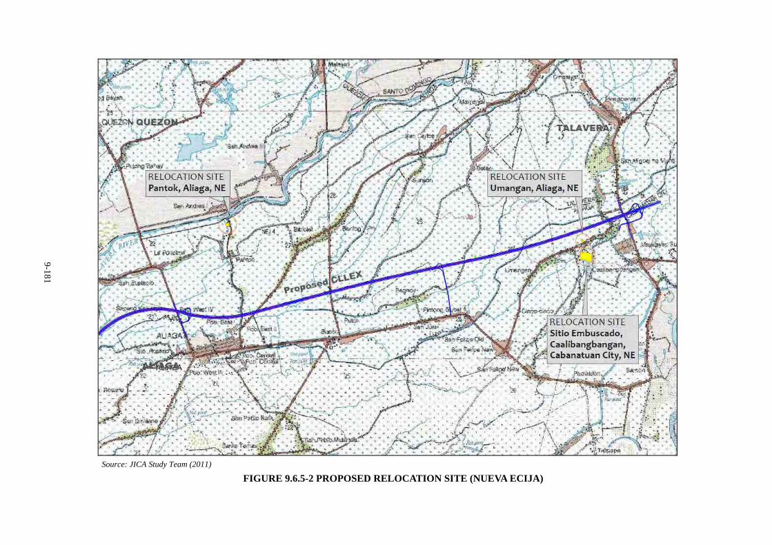
9-181
Source: JICA Study Team (2011)
FIGURE 9.6.5-2 PROPOSED RELOCATION SITE (NUEVA ECIJA)
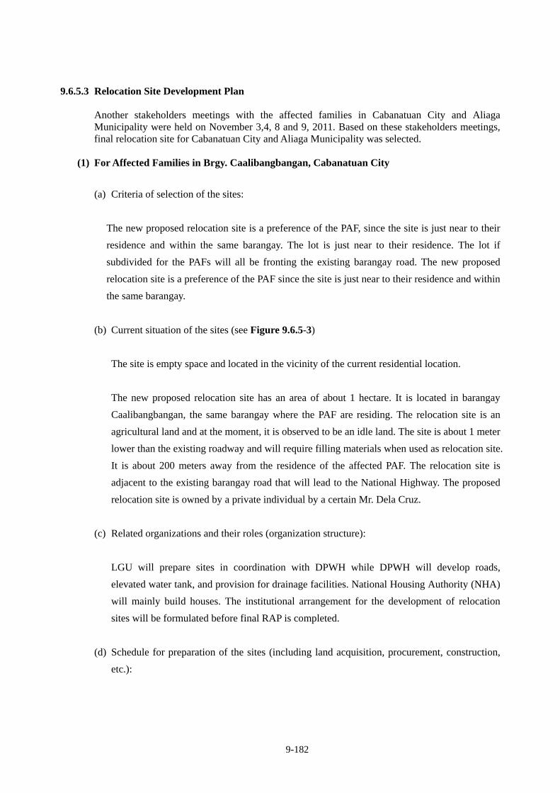
9-182
9.6.5.3 Relocation Site Development Plan
Another stakeholders meetings with the affected families in Cabanatuan City and Aliaga Municipality were held on November 3,4, 8 and 9, 2011. Based on these stakeholders meetings, final relocation site for Cabanatuan City and Aliaga Municipality was selected.
(1) For Affected Families in Brgy. Caalibangbangan, Cabanatuan City
(a) Criteria of selection of the sites:
The new proposed relocation site is a preference of the PAF, since the site is just near to their
residence and within the same barangay. The lot is just near to their residence. The lot if
subdivided for the PAFs will all be fronting the existing barangay road. The new proposed
relocation site is a preference of the PAF since the site is just near to their residence and within
the same barangay.
(b) Current situation of the sites (see Figure 9.6.5-3)
The site is empty space and located in the vicinity of the current residential location.
The new proposed relocation site has an area of about 1 hectare. It is located in barangay
Caalibangbangan, the same barangay where the PAF are residing. The relocation site is an
agricultural land and at the moment, it is observed to be an idle land. The site is about 1 meter
lower than the existing roadway and will require filling materials when used as relocation site.
It is about 200 meters away from the residence of the affected PAF. The relocation site is
adjacent to the existing barangay road that will lead to the National Highway. The proposed
relocation site is owned by a private individual by a certain Mr. Dela Cruz.
(c) Related organizations and their roles (organization structure):
LGU will prepare sites in coordination with DPWH while DPWH will develop roads,
elevated water tank, and provision for drainage facilities. National Housing Authority (NHA)
will mainly build houses. The institutional arrangement for the development of relocation
sites will be formulated before final RAP is completed.
(d) Schedule for preparation of the sites (including land acquisition, procurement, construction,
etc.):
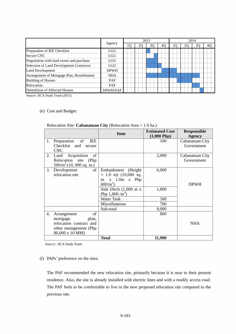
9-183
Preparation of IEE Checklist LGUSecure CNC LGUNegotiation with land owner and purchase LGUSelection of Land Development Contractor LGULand Development DPWHArrangement of Mortgage Plan, Resettlement NHABuilding of Houses PAFRelocation PAFDemolition of Affected Houses DPWH/PAFSource: JICA Study Team (2011)
2013 20144Q
Agency 2Q 3Q 4Q 1Q 2Q 3Q1Q
(e) Cost and Budget:
Relocation Site: Cabanatuan City (Relocation Area = 1.0 ha.)
Item Estimated Cost (1,000 Php)
Responsible Agency
1. Preparation of IEE Checklist and secure CNC
100 Cabanatuan City Government
2. Land Acquisition of Relocation site (Php 200/m2x10, 000 sq. m.)
2,000 Cabanatuan City Government
Embankment (Height = 1.0 m) (10,000 sq. m. x 1.0m x Php 600/m3)
6,000
Side Ditch (1,000 m x Php 1,800 /m3)
1,800
Water Tank 500
3. Development of relocation site
Miscellaneous 700
DPWH
Sub-total 9,000 4. Arrangement of
mortgage plan, relocation contract and other management (Php 80,000 x 10 MM)
800
NHA
Total 11,900 Source: JICA Study Team
(f) PAPs’ preference on the sites:
The PAF recommended the new relocation site, primarily because it is near to their present
residence. Also, the site is already installed with electric lines and with a readily access road.
The PAF feels to be comfortable to live in the new proposed relocation site compared to the
previous site.
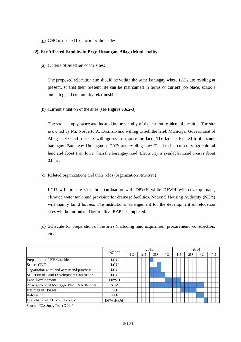
9-184
(g) CNC is needed for the relocation sites
(2) For Affected Families in Brgy. Umangan, Aliaga Municipality
(a) Criteria of selection of the sites:
The proposed relocation site should be within the same barangay where PAFs are residing at
present, so that their present life can be maintained in terms of current job place, schools
attending and community relationship.
(b) Current situation of the sites (see Figure 9.6.5-3)
The site is empty space and located in the vicinity of the current residential location. The site
is owned by Mr. Norberto A. Dionisio and willing to sell the land. Municipal Government of
Aliaga also confirmed its willingness to acquire the land. The land is located in the same
barangay: Barangay Umangan as PAFs are residing now. The land is currently agricultural
land and about 1 m. lower than the barangay road. Electricity is available. Land area is about
0.8 ha.
(c) Related organizations and their roles (organization structure):
LGU will prepare sites in coordination with DPWH while DPWH will develop roads,
elevated water tank, and provision for drainage facilities. National Housing Authority (NHA)
will mainly build houses. The institutional arrangement for the development of relocation
sites will be formulated before final RAP is completed.
(d) Schedule for preparation of the sites (including land acquisition, procurement, construction,
etc.)
Preparation of IEE Checklist LGUSecure CNC LGUNegotiation with land owner and purchase LGUSelection of Land Development Contractor LGULand Development DPWHArrangement of Mortgage Plan, Resettlement NHABuilding of Houses PAFRelocation PAFDemolition of Affected Houses DPWH/PAFSource: JICA Study Team (2011)
2013 20144Q
Agency 2Q 3Q 4Q 1Q 2Q 3Q1Q
9-185
(e) Cost and Budget:
(Confidential)
(f) PAPs’ preference on the sites:
All PAFs belongs to one family wherein owner of the land is their father who already passed
away and the land subdivided was accordingly to his children. Although the land was
subdivided, registration was not executed yet (free occupation status). PAFs are planning to
buy new land at their choice using the replacement cost as payment for the new land.
Nonetheless, if their plan is not pursued, they have alternative choice to reside at the
proposed relocation site.
(g) ECC or CNC needed for the relocation sites
CNC is needed for developing the site.
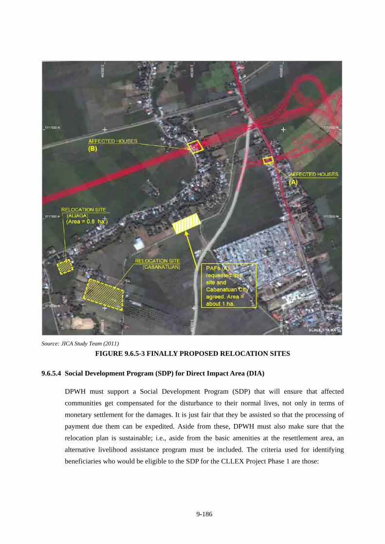
9-186
Source: JICA Study Team (2011)
FIGURE 9.6.5-3 FINALLY PROPOSED RELOCATION SITES
9.6.5.4 Social Development Program (SDP) for Direct Impact Area (DIA)
DPWH must support a Social Development Program (SDP) that will ensure that affected
communities get compensated for the disturbance to their normal lives, not only in terms of
monetary settlement for the damages. It is just fair that they be assisted so that the processing of
payment due them can be expedited. Aside from these, DPWH must also make sure that the
relocation plan is sustainable; i.e., aside from the basic amenities at the resettlement area, an
alternative livelihood assistance program must be included. The criteria used for identifying
beneficiaries who would be eligible to the SDP for the CLLEX Project Phase 1 are those:
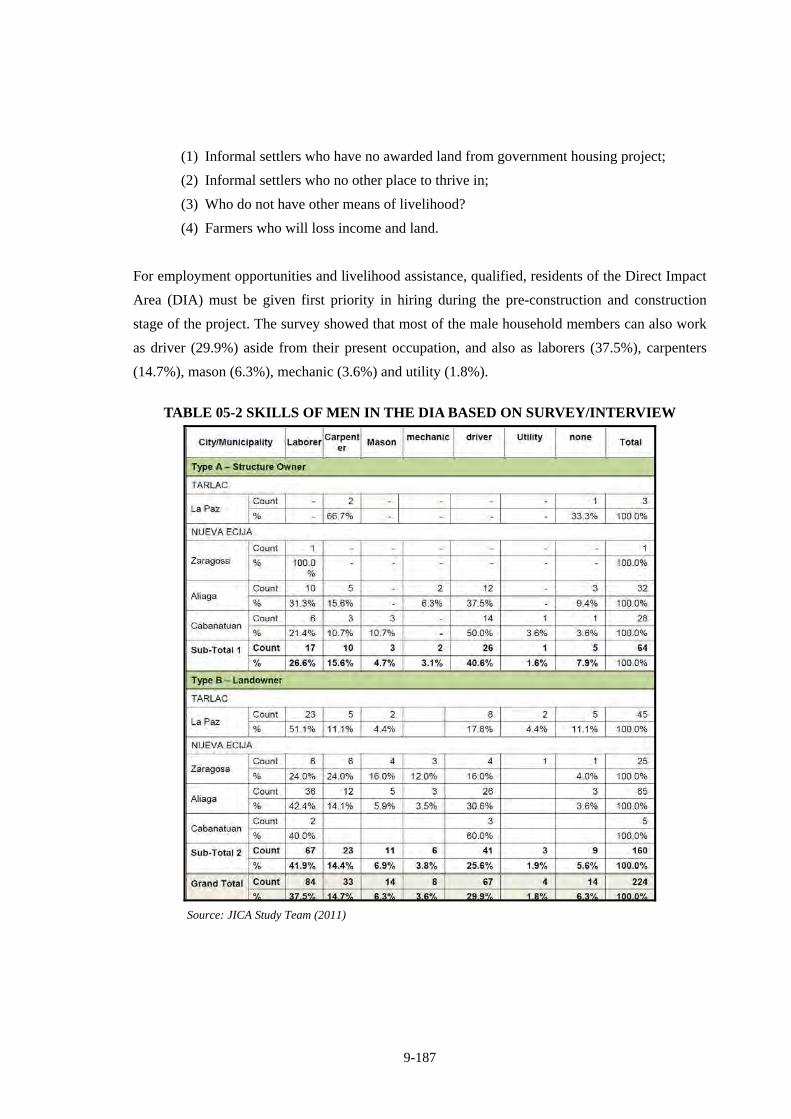
9-187
(1) Informal settlers who have no awarded land from government housing project;
(2) Informal settlers who no other place to thrive in;
(3) Who do not have other means of livelihood?
(4) Farmers who will loss income and land.
For employment opportunities and livelihood assistance, qualified, residents of the Direct Impact
Area (DIA) must be given first priority in hiring during the pre-construction and construction
stage of the project. The survey showed that most of the male household members can also work
as driver (29.9%) aside from their present occupation, and also as laborers (37.5%), carpenters
(14.7%), mason (6.3%), mechanic (3.6%) and utility (1.8%).
TABLE 05-2 SKILLS OF MEN IN THE DIA BASED ON SURVEY/INTERVIEW
Source: JICA Study Team (2011)
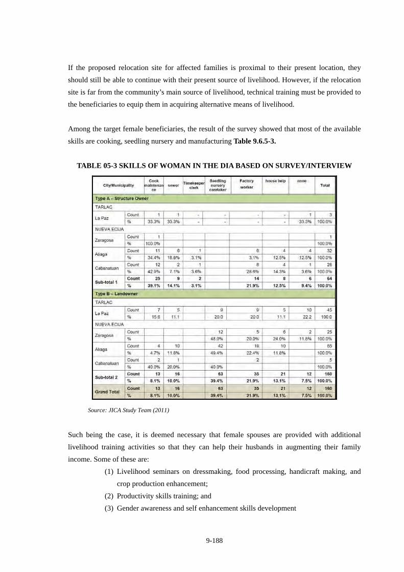
9-188
If the proposed relocation site for affected families is proximal to their present location, they
should still be able to continue with their present source of livelihood. However, if the relocation
site is far from the community’s main source of livelihood, technical training must be provided to
the beneficiaries to equip them in acquiring alternative means of livelihood.
Among the target female beneficiaries, the result of the survey showed that most of the available
skills are cooking, seedling nursery and manufacturing Table 9.6.5-3.
TABLE 05-3 SKILLS OF WOMAN IN THE DIA BASED ON SURVEY/INTERVIEW
Source: JICA Study Team (2011)
Such being the case, it is deemed necessary that female spouses are provided with additional
livelihood training activities so that they can help their husbands in augmenting their family
income. Some of these are:
(1) Livelihood seminars on dressmaking, food processing, handicraft making, and
crop production enhancement;
(2) Productivity skills training; and
(3) Gender awareness and self enhancement skills development
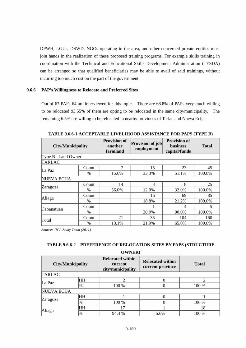
9-189
DPWH, LGUs, DSWD, NGOs operating in the area, and other concerned private entities must
join hands in the realization of these proposed training programs. For example skills training in
coordination with the Technical and Educational Skills Development Administration (TESDA)
can be arranged so that qualified beneficiaries may be able to avail of said trainings, without
incurring too much cost on the part of the government.
9.6.6 PAP’s Willingness to Relocate and Preferred Sites
Out of 67 PAFs 64 are interviewed for this topic. There are 68.8% of PAPs very much willing
to be relocated 93.55% of them are opting to be relocated in the same city/municipality. The
remaining 6.5% are willing to be relocated in nearby provinces of Tarlac and Nueva Ecija.
TABLE 9.6.6-1 ACCEPTABLE LIVELIHOOD ASSISTANCE FOR PAPS (TYPE B)
City/Municipality Provision of
another farmland
Provision of job employment
Provision of business
capital/funds Total
Type B– Land Owner TARLAC
Count 7 15 23 45 La Paz
% 15.6% 33.3% 51.1% 100.0% NUEVA ECIJA
Count 14 3 8 25 Zaragoza
% 56.0% 12.0% 32.0% 100.0% Count 16 69 85
Aliaga % 18.8% 21.2% 100.0%
Count 1 4 5 Cabanatuan
% 20.0% 80.0% 100.0% Count 21 35 104 160
Total % 13.1% 21.9% 65.0% 100.0%
Source: JICA Study Team (2011)
TABLE 9.6.6-2 PREFERENCE OF RELOCATION SITES BY PAPS (STRUCTURE
OWNER)
City/Municipality Relocated within
current city/municipality
Relocated within current province
Total
TARLAC HH 2 0 2
La Paz % 100 % 0 100 %
NUEVA ECIJA HH 1 0 1
Zaragoza % 100 % 0 100 % HH 17 1 18
Aliaga % 94.4 % 5.6% 100 %
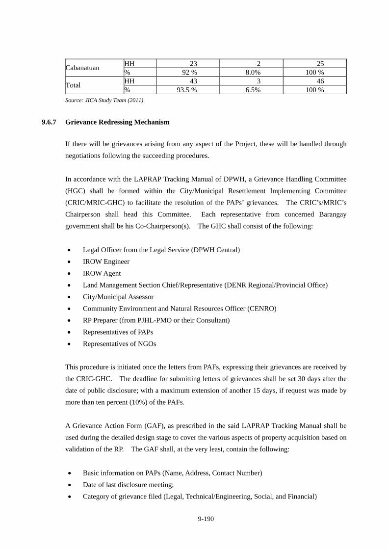
9-190
HH 23 2 25 Cabanatuan
% 92 % 8.0% 100 % HH 43 3 46
Total % 93.5 % 6.5% 100 %
Source: JICA Study Team (2011)
9.6.7 Grievance Redressing Mechanism
If there will be grievances arising from any aspect of the Project, these will be handled through
negotiations following the succeeding procedures.
In accordance with the LAPRAP Tracking Manual of DPWH, a Grievance Handling Committee
(HGC) shall be formed within the City/Municipal Resettlement Implementing Committee
(CRIC/MRIC-GHC) to facilitate the resolution of the PAPs’ grievances. The CRIC’s/MRIC’s
Chairperson shall head this Committee. Each representative from concerned Barangay
government shall be his Co-Chairperson(s). The GHC shall consist of the following:
Legal Officer from the Legal Service (DPWH Central)
IROW Engineer
IROW Agent
Land Management Section Chief/Representative (DENR Regional/Provincial Office)
City/Municipal Assessor
Community Environment and Natural Resources Officer (CENRO)
RP Preparer (from PJHL-PMO or their Consultant)
Representatives of PAPs
Representatives of NGOs
This procedure is initiated once the letters from PAFs, expressing their grievances are received by
the CRIC-GHC. The deadline for submitting letters of grievances shall be set 30 days after the
date of public disclosure; with a maximum extension of another 15 days, if request was made by
more than ten percent (10%) of the PAFs.
A Grievance Action Form (GAF), as prescribed in the said LAPRAP Tracking Manual shall be
used during the detailed design stage to cover the various aspects of property acquisition based on
validation of the RP. The GAF shall, at the very least, contain the following:
Basic information on PAPs (Name, Address, Contact Number)
Date of last disclosure meeting;
Category of grievance filed (Legal, Technical/Engineering, Social, and Financial)
9-191
Type of action taken (Resolved at the CRIC level, or referred to higher authorities.
Respective Barangay Captains, as Co-Chairperson of the GHC shall be the first recipient of the
GAF. All GAFs shall be consolidated by the CRIC/MRIC Chairperson and presented to the
CRIC/MRIC for deliberation and appropriate action, on a weekly basis. Unresolved grievances
at the CRIC/MRIC level shall be elevated to the respective District Engineering Offices for
resolution of complaints. Recommendations of the District Engineer shall be elevated to the
Regional ESSO for approval and final action. If there are still unresolved grievances, a case
shall be filed in the proper courts.
PAPs shall be exempted from all administrative and legal fees incurred in pursuant to the
grievance redress procedures.
9.6.8 Institutional Arrangement
The implementation of the RAP will be pursued by various government offices in cooperation
with the PAFs and expressway concessionaire. In this section, the various players involved in the
RAP implementation are named and their respective roles defined. While the expressway project
is pursued under the Japan ODA Loan arrangements, the primary responsibility for the
implementation of the project still lies with government specifically the Department of Public
Works and Highways. This section is based on DAO D.O. 5, Series of 2003 and the DPWH
LARRIP 3rd Edition.
9.6.8.1 Department of Public Works and Highways
DPWH is the Executing Agency (EA) who is responsible to the Philippine Government and the
donor agency for the planning and implementation of the expressway project. DPWH will initiate
through its relevant departments and PMOs the preparation of all documents necessary for the
approval and implementation of the expressway project which includes the updating of feasibility
studies, securing of clearances/permits, acquisition of ROW, and monitoring of project
implementation. The expressway project will be overseen by the Office of the Assistant Secretary
for Planning who shall report directly to the DPWH Secretary on matters related to the project.
9.6.8.2 Philippine-Japan-Highway Loan – Project Management Office (PJHL-PMO)
PJHL-PMO has the overall operational responsibility for implementing the project from the
detailed design up to construction. In coordination with other relevant government agencies and
the detailed design consultant, the PJHL-PMO shall manage and supervise the project, including
resettlement planning and land acquisition. It shall ensure that funds for the timely
9-192
implementation of the RAP is available and that expenses are properly accounted for.
PJHL-PMO will be assisted by ESSO and IROW-PMO who provides technical guidance and
support in the preparation and implementation of the RAP.
9.6.8.3 Environmental and Social Services Office (ESSO)
ESSO shall provide technical guidance and support in the implementation of the RAP and will be
responsible for the following resettlement activities:
Oversee the preparation and planning of the RAP;
Submit RAP budgetary requirements for approval and allocation of needed financial
resources by the DPWH central office;
In accordance to the Department’s resettlement policies, guide the project consultants, and
Regional Offices in their tasks, such as parcellary survey of project area, verification of PAFs,
final inventory of affected assets, and information dissemination;
Amend or update the RAP in the event problems arise during the internal and/or external
monitoring of its implementation;
Follow-up with the DPWH Accounting Office for the processing of compensation claims of
PAFs;
In collaboration with the IROW-PMO, monitor the actual payment of compensation to PAFs;
and
In collaboration with IROW-PMO, prepare periodic supervision and monitoring reports on
RAP implementation for submission to the PJHL-PMO and the donor institution.
9.6.8.4 Infrastructure Right-of-Way (IROW)- PMO
IROW-PMO will provide guidance to PJHL-PMO and consultants on the preparation of RAP;
It will spearhead the negotiations with the PAFs and secure agreements on the final valuation
of the affected assets which will be used in the payment of compensation;
It will finalize the compensation plan for the PAFs, based on the result of the negotiation
process; and submit the same to the DPWH financial service for approval and payment;
In collaboration with ESSO, monitor the progress of RAP implementation, including
compensation disbursements and prepare monitoring reports for submission to the
PJHL-PMO and donor institution.
9-193
9.6.8.5 District Engineering Office (DEO) of DPWH
The concerned DEO will serve as the major player in the implementation of the RAP with the
following functions:
Oversee the staking-out, verification and validation of the PAF’s affected assets;
Conduct inventories of properties that will be affected in coordination with the Detailed
Design Consultant;
Prepare parcellary maps of the project area in coordination with the Detailed Design
Consultant;
Approve disbursement vouchers/payments on PAFs compensation and other benefits;
Submit disbursement reports on payments to PAFs to the Regional/Central Office accounting
office and PJHL-PMO;
Submit monthly progress reports to ESSO, Regional Office and PJHL-PMO; and
Serve as an active member of the Resettlement Implementation Committee (RIC) of the
City/Municipality.
9.6.8.6 Regional Office (Region III) of DPWH
The Regional Office shall act as the Liaison between ESSO, IROW-PMO and the District
Engineering Offices and shall ensure that the RAP is implemented as planned. Its specific
activities are:
Oversee the activities of DEOs;
Monitor the RAP implementation and fund disbursement;
Submit monthly progress reports to ESSO;
Monitor payments to PAFs;
Address grievances filed at its office by the PAFs for speedy resolution.
9.6.8.7 Resettlement Implementation Committee (RIC)
The RIC shall be composed of representatives from the Regional Office and District Engineering
Office, the City/Municipality LGU, affected barangays, and PAFs/PAPs. No NCIP nor ICC/IP
representatives are included in the RIC as Region III is not a recognized ancestral land. The
establishment of the RIC shall be made through the signing of a Memorandum of Understanding
(MOU) between DPWH, the concerned LGU. The function of the RIC includes:
Assist the project consultants and DPWH staff engaged in RAP preparation activities in (a)
validating the list of PAFs; b) validating the assets of the PAFs that will be affected by the
9-194
project; (c) assist DPWH in arranging for a suitable relocation facility for the displaced
PAFs, and (d) participate in monitoring the RAP implementation;
Assist the DPWH staff engaged in the RAP preparation in the public information campaign,
public participation and consultation meetings;
Receive complaints and grievances from PAFs and other stakeholders and refer the matter
to the appropriate authorities;
Maintain a record of all public meetings, complaints and actions taken to address
complaints and grievances; and
In coordination with concerned government authorities, assist in the enforcement of
laws/ordinances regarding encroachment into the project site or ROW.
9.6.8.8 National Housing Authority (NHA)
Although relocation of informal settlers is among the tasks of the National Housing Authority
(NHA), there are just too many government projects that require relocation, particularly in urban
areas where there is very little land that can be utilized as relocation site. It is quite important to
coordinate with NHA at the early stage of the Project. For this particular project, NHA’s functions
are as follows;
Coordinate with DPWH and LGUs for relocation of PAFs;
Build houses at relocation sites, if necessary;
Undertake the Social Development Program (SDP).
9.6.8.9 Organization Chart of RAP Implementation
Organization chart of RAP Implementation is shown in Figure 9.6.8-1.
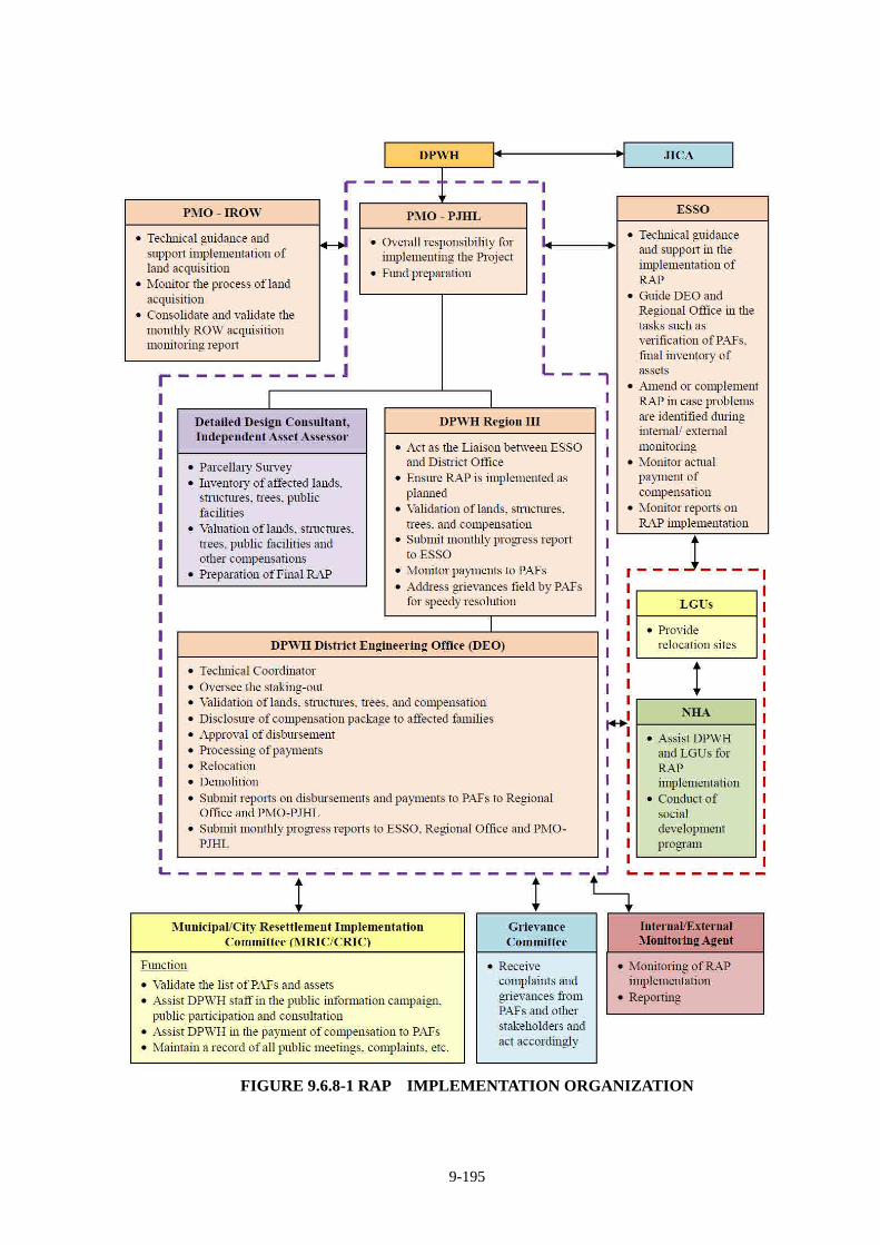
9-195
FIGURE 9.6.8-1 RAP IMPLEMENTATION ORGANIZATION
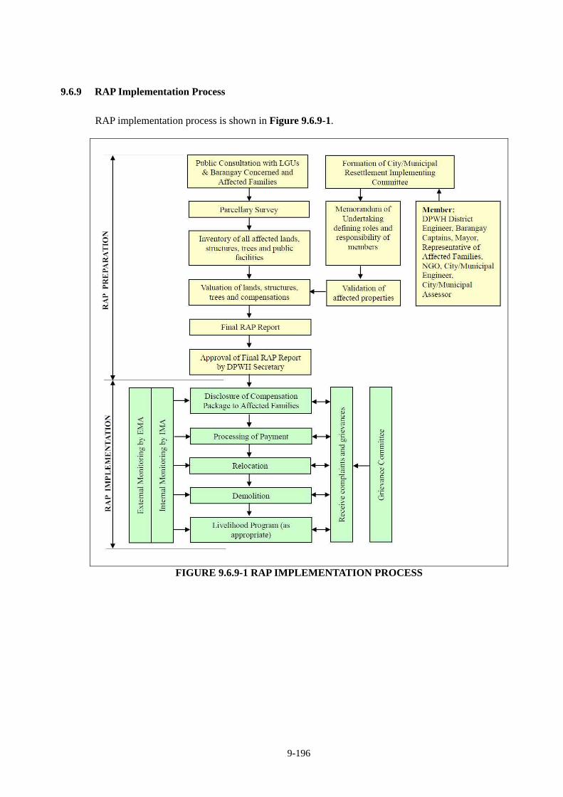
9-196
9.6.9 RAP Implementation Process
RAP implementation process is shown in Figure 9.6.9-1.
FIGURE 9.6.9-1 RAP IMPLEMENTATION PROCESS
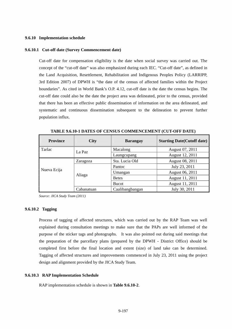
9-197
9.6.10 Implementation schedule
9.6.10.1 Cut-off date (Survey Commencement date)
Cut-off date for compensation eligibility is the date when social survey was carried out. The
concept of the “cut-off date” was also emphasized during each IEC. “Cut-off date”, as defined in
the Land Acquisition, Resettlement, Rehabilitation and Indigenous Peoples Policy (LARRIPP,
3rd Edition 2007) of DPWH is “the date of the census of affected families within the Project
boundaries”. As cited in World Bank’s O.P. 4.12, cut-off date is the date the census begins. The
cut-off date could also be the date the project area was delineated, prior to the census, provided
that there has been an effective public dissemination of information on the area delineated, and
systematic and continuous dissemination subsequent to the delineation to prevent further
population influx.
TABLE 9.6.10-1 DATES OF CENSUS COMMENCEMENT (CUT-OFF DATE)
Province City Barangay Starting Date(Cutoff date)
Macalong August 07, 2011 Tarlac
La Paz Laungcupang August 12, 2011
Zaragoza Sta. Lucia Old August 08, 2011 Pantoc July 23, 2011 Umangan August 06, 2011 Betes August 11, 2011
Aliaga
Bucot August 11, 2011
Nueva Ecija
Cabanatuan Caalibangbangan July 30, 2011
Source: JICA Study Team (2011)
9.6.10.2 Tagging
Process of tagging of affected structures, which was carried out by the RAP Team was well
explained during consultation meetings to make sure that the PAPs are well informed of the
purpose of the sticker tags and photographs. It was also pointed out during said meetings that
the preparation of the parcellary plans (prepared by the DPWH - District Office) should be
completed first before the final location and extent (size) of land take can be determined.
Tagging of affected structures and improvements commenced in July 23, 2011 using the project
design and alignment provided by the JICA Study Team.
9.6.10.3 RAP Implementation Schedule RAP implementation schedule is shown in Table 9.6.10-2.
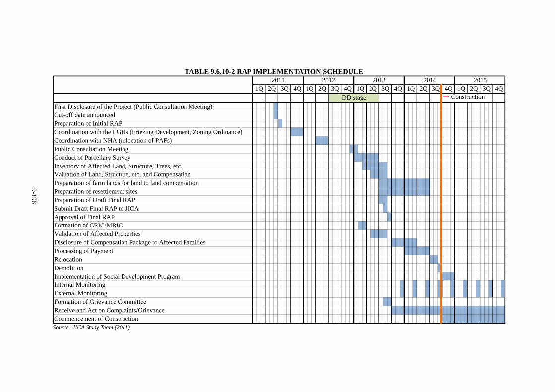
9-198
TABLE 9.6.10-2 RAP IMPLEMENTATION SCHEDULE
→ Construction
First Disclosure of the Project (Public Consultation Meeting)Cut-off date announcedPreparation of Initial RAPCoordination with the LGUs (Friezing Development, Zoning Ordinance)Coordination with NHA (relocation of PAFs)Public Consultation MeetingConduct of Parcellary SurveyInventory of Affected Land, Structure, Trees, etc.Valuation of Land, Structure, etc, and Compensation Preparation of farm lands for land to land compensationPreparation of resettlement sitesPreparation of Draft Final RAPSubmit Draft Final RAP to JICAApproval of Final RAPFormation of CRIC/MRICValidation of Affected PropertiesDisclosure of Compensation Package to Affected FamiliesProcessing of PaymentRelocationDemolitionImplementation of Social Development ProgramInternal MonitoringExternal MonitoringFormation of Grievance CommitteeReceive and Act on Complaints/GrievanceCommencement of Construction
DD stage
2Q2011
1Q 2Q 3Q 4Q2015
1Q 4Q 1Q4Q2012
1Q 2Q 3Q 4Q 1Q2013
2Q 3Q3Q 2Q 3Q 4Q2014
Source: JICA Study Team (2011)
9-199
9.6.11 Financial Arrangement
All necessary cost except purchasing/providing the resettlement sites shall be arranged, budgeted
and released by PMO-PJHL of DPWH. LGUs shall provide available or new relocation sites of
which procurement cost shall be arranged by the respective LGUs.
9.6.12 Estimated Cost
Acquisition cost of land and structure/improvement/trees, compensation cost, resettlement site
development cost, RAP implementation cost, etc. are estimated as shown in Table 9.6.12-1.
TABLE 9.6.12-1 ESTIMATED RAP IMPLEMENTATION COST
(Confidential)

9-200
(Confidential)
9-201
Estimated cost of land, structures and trees by city/municipality is shown in Table 9.6.12-2.
TABLE 9.6.12-2 COST OF LAND, STRUCTURE AND TREES BY
CITY/MUNICIPALITY
(Confidential)
9.6.13 Monitoring and Evaluation
9.6.13.1 Monitoring Agents
(1) Internal Monitoring
An Internal Monitoring Agent (IMA) will be commissioned by the PMO-PJHL to undertake
independent internal monitoring and evaluation.
The tasks of the IMA are to:
a) Regularly supervise and monitor the implementation of the RAP in coordination with the concerned CRIC/MRIC. The findings will be documented in the quarterly report to be submitted to the PMO and ESSO, and PMO-PJHL in turn will submit the report to JICA.
b) Verify that the re-inventory baseline information of all PAFs has been carried out and that the valuation of assets lost or damaged, the provision of compensation and other entitlements, and relocation, if any, has been carried out in accordance with the LARRIP and the respective RAP Reports.
c) Ensure that the RAP are implemented as designed and planned.
d) Verify that funds for implementing the RAP are provided by the PMO-PJHL in a timely
manner and in amounts sufficient for the purpose.
e) Record all grievances and their resolution and ensure that complaints are dealt with promptly.
All activities in RAP implementation will require for quality and quantity results which are time
bounded. The PMO-PJHL will be responsible for the internal monitoring of the actual
9-202
implementation jointly with ESSO of DPWH against the planned activities, time frame, budget
and entitlement that will be done on an on-going basis throughout the subproject construction and
in the livelihood period of the affected households.
(2) External Monitoring
An External Monitoring Agent (EMA) will be commissioned by the PMO-PJHL to undertake
independent external monitoring and evaluation. The EMA for the Project will be either a
qualified individual or a consultancy firm with qualified and experienced staff. The Terms of
Reference of the engagement of the EMA shall be prepared by the DPWH and shall be
acceptable to the JICA prior to the engagement.
The tasks of the EMA shall be the following:
a) Verify results of internal monitoring;
b) Verify and assess the results of the information campaign for PAFs rights and entitlements;
c) Verify that the compensation process has been carried out with the procedures communicated
with the PAFs during the consultations;
d) Assess whether resettlement objectives have been met; specifically, whether livelihoods and
living standards have been restored or enhanced;
e) Assess efficiency, effectiveness, impact and sustainability of resettlement and RAP
implementation drawing lessons as a guide to future resettlement and indigenous peoples’
policy making and planning;
f) Ascertain whether the resettlement were appropriate to meet the objectives, and whether the
objectives were suited to PAF conditions;
g) Suggest modification in the implementation procedures of the RAP, if necessary, to achieve
the principles and objectives of the Resettlement Policy;
h) Review on how compensation rates were evaluated; and
i) Review of the handling of compliance and grievances cases.
External monitoring and evaluation will be of two kinds: 1) random observation visits and 2)
consultation with PAFs, both at their current residence area and at their relocation site.
9-203
9.6.13.2 Stages and Frequency of Monitoring The stages and monitoring frequency of the contract packages by the IMA and EMA as follows.
(1) Inception Report
This is the first activity that both IMA and EMA shall undertake to determine whether or not the
RAP was carried out as planned and according to this Policy.
The IMA / EMA will submit an Inception Report and Compliance Report one month after receipt
of Notice to Proceed for the engagement. The engagement of the IMA/EMA shall be scheduled
to meet the Policy’s requirement of concluding RAP implementation activities at least one (1)
month prior to the start of civil works.
(2) IMA Monthly Monitoring
The IMA will be required to conduct a monthly monitoring of RAP implementation activities.
(3) IMA Final Evaluation
Final evaluation of the implementation of the LARRIP will be conducted three months after the
completion of payments of compensation to PAFs.
(4) IMA Post-Resettlement Semi-Annual Monitoring and Evaluation
This activity will be undertaken every 6 months until the construction works end, to determine
whether the social and economic conditions of the PAFs after the implementation of the project
have improved.
When the PAF are found that their living standard worsens, or whose present means of livelihood
became not-viable, DPWH, in coordination with other appropriate institutions, will provide
assistances, such as skills and livelihood trainings.
(5) EMA Semi-Annual Monitoring
This activity will be undertaken every 6 months until the construction works end to follow-up
whether the social and economic conditions of the PAFs after the implementation of the project
have improved.
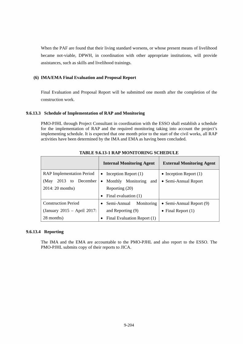
9-204
When the PAF are found that their living standard worsens, or whose present means of livelihood
became not-viable, DPWH, in coordination with other appropriate institutions, will provide
assistances, such as skills and livelihood trainings.
(6) IMA/EMA Final Evaluation and Proposal Report
Final Evaluation and Proposal Report will be submitted one month after the completion of the
construction work.
9.6.13.3 Schedule of Implementation of RAP and Monitoring
PMO-PJHL through Project Consultant in coordination with the ESSO shall establish a schedule for the implementation of RAP and the required monitoring taking into account the project’s implementing schedule. It is expected that one month prior to the start of the civil works, all RAP activities have been determined by the IMA and EMA as having been concluded.
TABLE 9.6.13-1 RAP MONITORING SCHEDULE
Internal Monitoring Agent External Monitoring Agent
RAP Implementation Period
(May 2013 to December
2014: 20 months)
Inception Report (1)
Monthly Monitoring and
Reporting (20)
Final evaluation (1)
Inception Report (1)
Semi-Annual Report
Construction Period
(January 2015 – April 2017:
28 months)
Semi-Annual Monitoring
and Reporting (9)
Final Evaluation Report (1)
Semi-Annual Report (9)
Final Report (1)
9.6.13.4 Reporting The IMA and the EMA are accountable to the PMO-PJHL and also report to the ESSO. The PMO-PJHL submits copy of their reports to JICA.
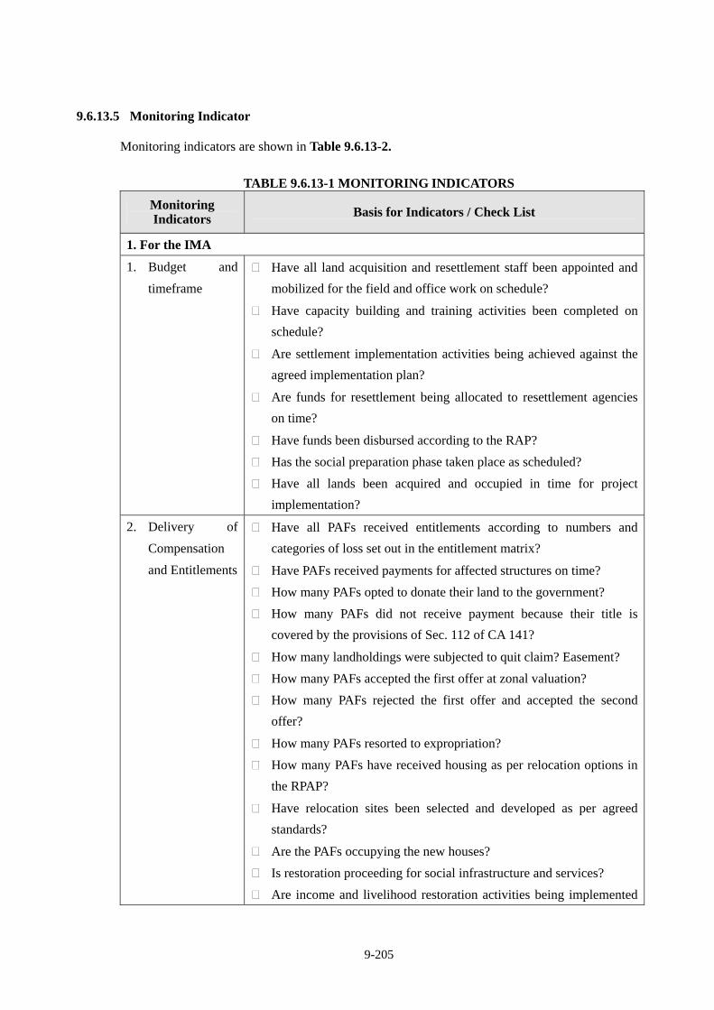
9-205
9.6.13.5 Monitoring Indicator Monitoring indicators are shown in Table 9.6.13-2.
TABLE 9.6.13-1 MONITORING INDICATORS
Monitoring Indicators Basis for Indicators / Check List
1. For the IMA
1. Budget and
timeframe
Have all land acquisition and resettlement staff been appointed and
mobilized for the field and office work on schedule?
Have capacity building and training activities been completed on
schedule?
Are settlement implementation activities being achieved against the
agreed implementation plan?
Are funds for resettlement being allocated to resettlement agencies
on time?
Have funds been disbursed according to the RAP?
Has the social preparation phase taken place as scheduled?
Have all lands been acquired and occupied in time for project
implementation?
2. Delivery of
Compensation
and Entitlements
Have all PAFs received entitlements according to numbers and
categories of loss set out in the entitlement matrix?
Have PAFs received payments for affected structures on time?
How many PAFs opted to donate their land to the government?
How many PAFs did not receive payment because their title is
covered by the provisions of Sec. 112 of CA 141?
How many landholdings were subjected to quit claim? Easement?
How many PAFs accepted the first offer at zonal valuation?
How many PAFs rejected the first offer and accepted the second
offer?
How many PAFs resorted to expropriation?
How many PAFs have received housing as per relocation options in
the RPAP?
Have relocation sites been selected and developed as per agreed
standards?
Are the PAFs occupying the new houses?
Is restoration proceeding for social infrastructure and services?
Are income and livelihood restoration activities being implemented
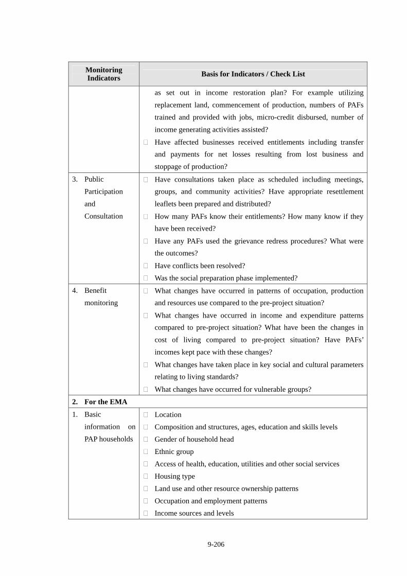
9-206
Monitoring Indicators Basis for Indicators / Check List
as set out in income restoration plan? For example utilizing
replacement land, commencement of production, numbers of PAFs
trained and provided with jobs, micro-credit disbursed, number of
income generating activities assisted?
Have affected businesses received entitlements including transfer
and payments for net losses resulting from lost business and
stoppage of production?
3. Public
Participation
and
Consultation
Have consultations taken place as scheduled including meetings,
groups, and community activities? Have appropriate resettlement
leaflets been prepared and distributed?
How many PAFs know their entitlements? How many know if they
have been received?
Have any PAFs used the grievance redress procedures? What were
the outcomes?
Have conflicts been resolved?
Was the social preparation phase implemented?
4. Benefit
monitoring
What changes have occurred in patterns of occupation, production
and resources use compared to the pre-project situation?
What changes have occurred in income and expenditure patterns
compared to pre-project situation? What have been the changes in
cost of living compared to pre-project situation? Have PAFs’
incomes kept pace with these changes?
What changes have taken place in key social and cultural parameters
relating to living standards?
What changes have occurred for vulnerable groups?
2. For the EMA
1. Basic
information on
PAP households
Location
Composition and structures, ages, education and skills levels
Gender of household head
Ethnic group
Access of health, education, utilities and other social services
Housing type
Land use and other resource ownership patterns
Occupation and employment patterns
Income sources and levels
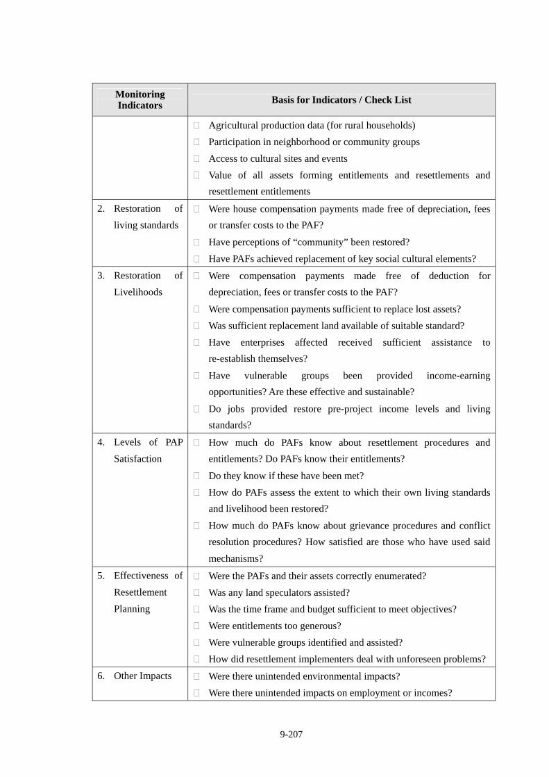
9-207
Monitoring Indicators Basis for Indicators / Check List
Agricultural production data (for rural households)
Participation in neighborhood or community groups
Access to cultural sites and events
Value of all assets forming entitlements and resettlements and
resettlement entitlements
2. Restoration of
living standards
Were house compensation payments made free of depreciation, fees
or transfer costs to the PAF?
Have perceptions of “community” been restored?
Have PAFs achieved replacement of key social cultural elements?
3. Restoration of
Livelihoods
Were compensation payments made free of deduction for
depreciation, fees or transfer costs to the PAF?
Were compensation payments sufficient to replace lost assets?
Was sufficient replacement land available of suitable standard?
Have enterprises affected received sufficient assistance to
re-establish themselves?
Have vulnerable groups been provided income-earning
opportunities? Are these effective and sustainable?
Do jobs provided restore pre-project income levels and living
standards?
4. Levels of PAP
Satisfaction
How much do PAFs know about resettlement procedures and
entitlements? Do PAFs know their entitlements?
Do they know if these have been met?
How do PAFs assess the extent to which their own living standards
and livelihood been restored?
How much do PAFs know about grievance procedures and conflict
resolution procedures? How satisfied are those who have used said
mechanisms?
5. Effectiveness of
Resettlement
Planning
Were the PAFs and their assets correctly enumerated?
Was any land speculators assisted?
Was the time frame and budget sufficient to meet objectives?
Were entitlements too generous?
Were vulnerable groups identified and assisted?
How did resettlement implementers deal with unforeseen problems?
6. Other Impacts Were there unintended environmental impacts?
Were there unintended impacts on employment or incomes?
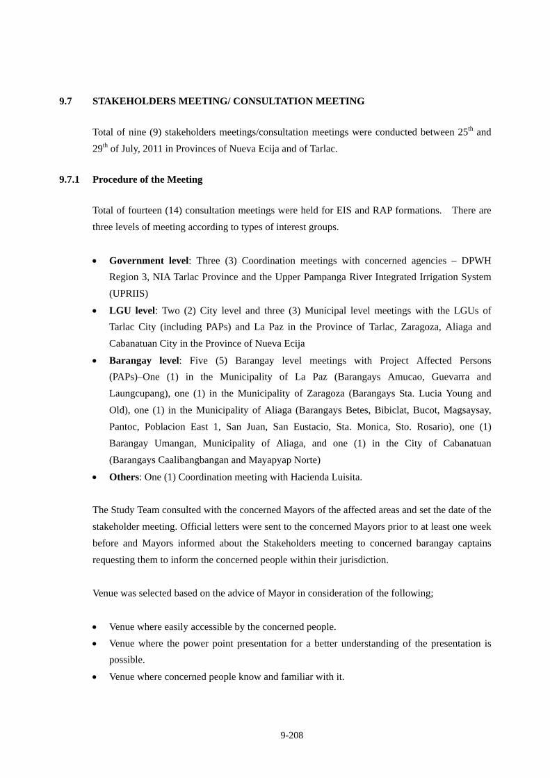
9-208
9.7 STAKEHOLDERS MEETING/ CONSULTATION MEETING
Total of nine (9) stakeholders meetings/consultation meetings were conducted between 25th and
29th of July, 2011 in Provinces of Nueva Ecija and of Tarlac.
9.7.1 Procedure of the Meeting
Total of fourteen (14) consultation meetings were held for EIS and RAP formations. There are
three levels of meeting according to types of interest groups.
Government level: Three (3) Coordination meetings with concerned agencies – DPWH
Region 3, NIA Tarlac Province and the Upper Pampanga River Integrated Irrigation System
(UPRIIS)
LGU level: Two (2) City level and three (3) Municipal level meetings with the LGUs of
Tarlac City (including PAPs) and La Paz in the Province of Tarlac, Zaragoza, Aliaga and
Cabanatuan City in the Province of Nueva Ecija
Barangay level: Five (5) Barangay level meetings with Project Affected Persons
(PAPs)–One (1) in the Municipality of La Paz (Barangays Amucao, Guevarra and
Laungcupang), one (1) in the Municipality of Zaragoza (Barangays Sta. Lucia Young and
Old), one (1) in the Municipality of Aliaga (Barangays Betes, Bibiclat, Bucot, Magsaysay,
Pantoc, Poblacion East 1, San Juan, San Eustacio, Sta. Monica, Sto. Rosario), one (1)
Barangay Umangan, Municipality of Aliaga, and one (1) in the City of Cabanatuan
(Barangays Caalibangbangan and Mayapyap Norte)
Others: One (1) Coordination meeting with Hacienda Luisita.
The Study Team consulted with the concerned Mayors of the affected areas and set the date of the
stakeholder meeting. Official letters were sent to the concerned Mayors prior to at least one week
before and Mayors informed about the Stakeholders meeting to concerned barangay captains
requesting them to inform the concerned people within their jurisdiction.
Venue was selected based on the advice of Mayor in consideration of the following;
Venue where easily accessible by the concerned people.
Venue where the power point presentation for a better understanding of the presentation is
possible.
Venue where concerned people know and familiar with it.
9-209
The consultation meetings were undertaken to:
Inform about the Project/CLLEX including alternatives of project designs;
Inform of and confirm the revised Scoping Matrix and concerns with the stakeholders;
Inform and generate awareness and understanding of the concerned public about the project;
Provide the stakeholders and avenue to ventilate salient issues and concerns regarding the
project;
Give an opportunity to the stakeholders to have an open discussion with the Preparers,
Proponent, and LGUs about the project;
Inform the stakeholders of their rights and privileges; and
Enable the stakeholders to effectively participate and make informed and guided decisions.
Complete and proper documentations of the proceedings were strictly observed. All participants
of each activity were noted and proceedings were recorded on a digital voice recorder.
Photographs were likewise taken during the consultations.
Results of the Stakeholder meetings were summarized in the minutes of the meeting which were
sent to concerned Mayors requesting them to distribute minutes to concerned Barangay Captains
who are requested to post the minutes at the Barangay Hall.
CONSULTATION MEETING SCHEDULE AND PARTICIPANTS
Date/Time Target Municipality Main Participants
25 July, 2011 14:00 – 16:00
Aliaga, Province of Nueva Ecija
Municipal Officials, Barangay Officials, People’s Organization, Farmer’s Association, NGO, Homeowner’s Association, Transport Group
26 July, 2011 10:00 – 12:00
Cabanatuan, Province of Nueva City
City Officials, Barangay Officials, People’s Organization, Farmer’s Association, NGO, Homeowner’s Association, Transport Group
26 July, 2011 14:00 – 16:00
Cabanatuan, Province of Nueva City
PAPs, City Officials, Barangay Officials, People’s Organization, Farmer’s Association, NGO, Homeowner’s Association, Transport Group
27 July, 2011 14:00 – 16:00
Tarlac, Province of Tarlac
PAPs, City Officials, Barangay Officials, People’s Organization, Farmer’s Association, NGO, Homeowner’s Association, Transport Group, Hacienda Luisita
28 July, 2011 10:00 – 12:00
Zaragoza, Province of Nueva Ecija
Municipal Officials, Barangay Officials, People’s Organization, Farmer’s Association, NGO, Homeowner’s Association, Transport Group
28 July, 2011 1400 – 16:30
La Paz, Province of Tarlac
PAPs, City Officials, Barangay Officials, People’s Organization, Farmer’s Association, NGO, Homeowner’s Association, Transport Group
9-210
29 July, 2011 10:00 – 12:00
Aliaga, Province of Nueva Ecija
PAPs, City Officials, Barangay Officials, People’s Organization, Farmer’s Association, NGO, Homeowner’s Association, Transport Group
29 July, 2011 10:00 – 12:00
Zaragoza, Province of Nueva Ecija
PAPs, City Officials, Barangay Officials, People’s Organization, Farmer’s Association, NGO, Homeowner’s Association, Transport Group
9.7.2 Program
An outline of consultation meeting is shown below.
A PROGRAM OF STAKEHOLDER MEETING
9.7.3 Attendants
INFORMATION EDUCATION AND COMMUNICATION MEETINGS
Number of Attendees Activity Milestone and Purpose Venue (Male) (Female)
Date
DPWH Region III Office of the Regional Director, City of San Fernando, Pampanga
2 3 July 18, 2011
Coordination Meeting
National Irrigation Authority (NIA)
NIA Office, Brgy. Matatalaib, Tarlac City
4 July 22, 2011
9-211
INFORMATION EDUCATION AND COMMUNICATION MEETINGS
Number of Attendees Activity Milestone and Purpose Venue (Male) (Female)
Date
NIA-Upper Pampanga River Integrated Irrigation System (UPRIIS)
Brgy. Capt. Pepe, Cagayan Valley Road, Cabanatuan City
4 July 22, 2011
Hacienda Luisita Conference room, Central Azucarera De Tarlac, Tarlac
5 1 August 5, 2011
a. LGU Officials of Aliaga
G/F, Kairos Hotel and Resort, Aliaga, Nueva Ecija
39 14 July 25, 2011
b. LGU Officials of Cabanatuan
City Hall of Cabanatuan, Nueva Ecija
18 8 July 26, 2011
c. LGU Officials of Tarlac
City Hall of Tarlac, Province of Tarlac
16 10 July 27, 2011
d. LGU Officials of La Paz
Municipal Hall of Lapaz, Tarlac
13 8 July 27, 2011
IEC of LGUs
e. LGU Officials of Zaragoza
Municipal Hall of Zaragoza, Nueva Ecija
24 11 July 28, 2011
Barangay Hall of Caalibangbangan, Cabanatuan City, Nueva Ecija
22
15
July 26, 2011
ABC Session Hall of Lapaz, Tarlac
24
36
July 28, 2011
Municipal Session Hall of Zaragoza, Nueva Ecija
26
14
July 29, 2011
2/F, Kairos Hotel and Resort, Aliaga, Nueva Ecija
94
22
July 29, 2011
IEC of PAPs Project Disclosure: a. To inform the PAPs
about: the configuration of the proposed CLLEX Expresswaythe expected adverse impacts such as displacements of households, damage to crops; That there will be parcellary survey to finalize number of PAPs to be affected and extent of impact; The concept of Cut-Off Dates
b. To encourage PAP’s
to speak up their ideas, concerns and apprehensions, and other related issues (open discussion)
Umangan, Aliaga, Nueva Ecija
11 13 August 06, 2011
9-212
9.7.4 Discussion
EIS and RAP were discussed in the same meeting.
Aside from IEC Meetings, the Consultant paid visits to the Office of Provincial Assessor of
Tarlac and Nueva Ecija, City Assessors of Tarlac and Cabanatuan and Municipal Assessors of La
Paz, Zaragoza and Aliaga to request for assistance in identifying owners of lots to be affected.
The project was also presented to the different department and offices of the Local Government
Unit such as Treasury, Municipal Agrarian Reform Office (MARO), Provincial Agrarian Reform
Office (PARO) and Department of Agrarian Reform (DAR).
During these meetings, the project in terms of ROW width, type of surfacing, alignments, and
target implementation schedule, among others, were presented to the PAPs. To familiarize them
with the RAP preparation process, field activities that were undertaken namely: (i) linear
mapping and tagging; (ii) taking of PAP’s photograph in front of their houses/properties carrying
a board showing the tag/control number of the affected structure/property; and (iii) conduct of
socioeconomic.
SUMMARY OF MINUTES OF MEETING
Inquiry and Opinion Response
We suggest that instead of an embankment, we should use viaducts for the project.
The design of the embankments now will have box culverts that will act as equalizers so that it may not cause or worsen floodings.
If the height of the embankment is 6~7meters, from Barangay Sto. Rosario, to Barangay. Magsaysay up to Sta. Monica, this will cause river-like floods. If possible, not to use embankment.
Viaducts cost 10 times more than an embankment. All aspects of the project including engineering, environmental concerns are carefully studied including the projects economic benefits. NEDA would not approve the project if the economic benefits are not good. 25
Jul
y 20
11 A
liag
a
We suggest that only one interchange would be constructed in Aliaga instead in San Juan. We can instead transfer the interchange to Sto. Rosario.
We will send this concern to the engineering and design team so that they will consider your suggestion when they deal with flooding.
26 J
uly
2011
Cab
anat
uan It may be better if we hire a private
appraiser because the prevailing price is very low if applied to the just compensation pushed by the government.
DPWH will follow the prevailing BIR zonal value based on RA 8974. DPWH will present to the owners the price of value of their land. If the owners does not agree with the price, the LGU will have to intervene and will have to convene an appraisal committee and they will appraise the property
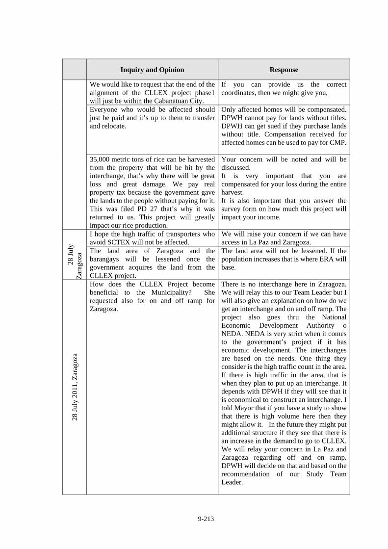
9-213
Inquiry and Opinion Response
We would like to request that the end of the alignment of the CLLEX project phase1 will just be within the Cabanatuan City.
If you can provide us the correct coordinates, then we might give you,
Everyone who would be affected should just be paid and it’s up to them to transfer and relocate.
Only affected homes will be compensated. DPWH cannot pay for lands without titles. DPWH can get sued if they purchase lands without title. Compensation received for affected homes can be used to pay for CMP.
35,000 metric tons of rice can be harvested from the property that will be hit by the interchange, that’s why there will be great loss and great damage. We pay real property tax because the government gave the lands to the people without paying for it. This was filed PD 27 that’s why it was returned to us. This project will greatly impact our rice production.
Your concern will be noted and will be discussed. It is very important that you are compensated for your loss during the entire harvest. It is also important that you answer the survey form on how much this project will impact your income.
I hope the high traffic of transporters who avoid SCTEX will not be affected.
We will raise your concern if we can have access in La Paz and Zaragoza.
28 J
uly
Zar
agoz
a The land area of Zaragoza and the barangays will be lessened once the government acquires the land from the CLLEX project.
The land area will not be lessened. If the population increases that is where ERA will base.
28 J
uly
2011
, Zar
agoz
a
How does the CLLEX Project become beneficial to the Municipality? She requested also for on and off ramp for Zaragoza.
There is no interchange here in Zaragoza. We will relay this to our Team Leader but I will also give an explanation on how do we get an interchange and on and off ramp. The project also goes thru the National Economic Development Authority o NEDA. NEDA is very strict when it comes to the government’s project if it has economic development. The interchanges are based on the needs. One thing they consider is the high traffic count in the area. If there is high traffic in the area, that is when they plan to put up an interchange. It depends with DPWH if they will see that it is economical to construct an interchange. I told Mayor that if you have a study to show that there is high volume here then they might allow it. In the future they might put additional structure if they see that there is an increase in the demand to go to CLLEX. We will relay your concern in La Paz and Zaragoza regarding off and on ramp. DPWH will decide on that and based on the recommendation of our Study Team Leader.
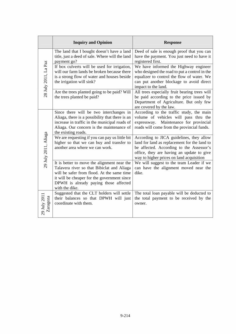
9-214
Inquiry and Opinion Response
The land that I bought doesn’t have a land title, just a deed of sale. Where will the land payment go?
Deed of sale is enough proof that you can have the payment. You just need to have it registered first.
If box culverts will be used for irrigation, will our farm lands be broken because there is a strong flow of water and houses beside the irrigation will sink?
We have informed the Highway engineer who designed the road to put a control in the equalizer to control the flow of water. We can put another blockage to avoid direct impact to the land.
28 J
uly
2011
, La
Paz
Are the trees planted going to be paid? Will the trees planted be paid?
All trees especially fruit bearing trees will be paid according to the price issued by Department of Agriculture. But only few are covered by the law.
Since there will be two interchanges in Aliaga, there is a possibility that there is an increase in traffic in the municipal roads of Aliaga. Our concern is the maintenance of the existing roads.
According to the traffic study, the main volume of vehicles will pass thru the expressway. Maintenance for provincial roads will come from the provincial funds.
We are requesting if you can pay us little bit higher so that we can buy and transfer to another area where we can work.
According to JICA guidelines, they allow land for land as replacement for the land to be affected. According to the Assessor’s office, they are having an update to give way to higher prices on land acquisition
29 J
uly
2011
, Ali
aga
It is better to move the alignment near the Talavera river so that Bibiclat and Aliaga will be safer from flood. At the same time it will be cheaper for the government since DPWH is already paying those affected with the dike.
We will suggest to the team Leader if we can have the alignment moved near the dike.
29 J
uly
2011
Z
arag
oza
Suggested that the CLT holders will settle their balances so that DPWH will just coordinate with them.
The total loan payable will be deducted to the total payment to be received by the owner.
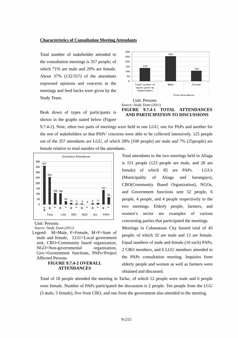
9-215
Characteristics of Consultation Meeting Attendants
Total number of stakeholder attended to
the consultation meetings is 357 people; of
which 71% are male and 29% are female.
About 37% (132/357) of the attendants
expressed opinions and concerns in the
meetings and feed backs were given by the
Study Team.
Beak down of types of participants is
shown in the graphs stated below (Figure
9.7.4-2). Note, often two parts of meetings were held in one LGU; one for PAPs and another for
the rest of stakeholders so that PAPs’ concerns were able to be collected intensively. 125 people
out of the 357 attendants are LGU, of which 28% (100 people) are male and 7% (25people) are
female relative to total number of the attendants.
Total attendants to the two meetings held in Aliaga
is 151 people (123 people are male, and 28 are
female) of which 85 are PAPs. LGUs
(Municipality of Aliaga and barangays),
CBO(Community Based Organization), NGOs,
and Government functions sent 52 people, 6
people, 4 people, and 4 people respectively to the
two meetings. Elderly people, farmers, and
women’s sector are examples of various
concerning parties that participated the meetings.
Meetings in Cabanatuan City hosted total of 45
people; of which 32 are male and 13 are female.
Equal numbers of male and female (10 each) PAPs,
2 CBO members, and 6 LGU members attended to
the PAPs consultation meeting. Inquiries from
elderly people and women as well as farmers were
obtained and discussed.
Total of 18 people attended the meeting in Tarlac, of which 12 people were male and 6 people
were female. Number of PAPs participated the discussion is 2 people. Ten people from the LGU
(5 male, 5 female), five from CBO, and one from the government also attended to the meeting.
132
253
104
0
50
100
150
200
250
300
Total number ofinputs given bystakeholders
Male Female
Total attendance
Unit: Persons Source: Study Team (2011) FIGURE 9.7.4-1 TOTAL ATTENDANCES
AND PARTICIPATION TO DISCUSSIONS
Cumulative Attendances
357
253
104 100
2510 3 4 0 8 11
131
65
0
50
100
150
200
250
300
350
400
M+F M F M F M F M F M F M F
Total LGU CBO NGO Gov PAPs
Unit: Persons Source: Study Team (2011)
Legend: M=Male, F=Female, M+F=Sum of male and female, LGU=Local government unit, CBO=Community based organization, NGO=Non-governmental organization, Gov.=Government functions, PAPs=Project Affected Persons
FIGURE 9.7.4-2 OVERALL ATTENDANCES
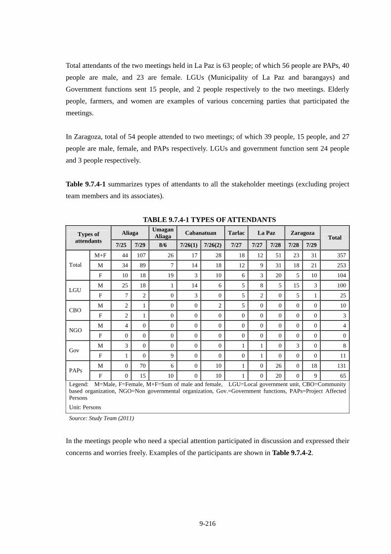
9-216
Total attendants of the two meetings held in La Paz is 63 people; of which 56 people are PAPs, 40
people are male, and 23 are female. LGUs (Municipality of La Paz and barangays) and
Government functions sent 15 people, and 2 people respectively to the two meetings. Elderly
people, farmers, and women are examples of various concerning parties that participated the
meetings.
In Zaragoza, total of 54 people attended to two meetings; of which 39 people, 15 people, and 27
people are male, female, and PAPs respectively. LGUs and government function sent 24 people
and 3 people respectively.
Table 9.7.4-1 summarizes types of attendants to all the stakeholder meetings (excluding project
team members and its associates).
TABLE 9.7.4-1 TYPES OF ATTENDANTS
Aliaga Umagan Aliaga
Cabanatuan Tarlac La Paz Zaragoza Types of attendants
7/25 7/29 8/6 7/26(1) 7/26(2) 7/27 7/27 7/28 7/28 7/29 Total
M+F 44 107 26 17 28 18 12 51 23 31 357
M 34 89 7 14 18 12 9 31 18 21 253Total
F 10 18 19 3 10 6 3 20 5 10 104
M 25 18 1 14 6 5 8 5 15 3 100LGU
F 7 2 0 3 0 5 2 0 5 1 25
M 2 1 0 0 2 5 0 0 0 0 10CBO
F 2 1 0 0 0 0 0 0 0 0 3
M 4 0 0 0 0 0 0 0 0 0 4NGO
F 0 0 0 0 0 0 0 0 0 0 0
M 3 0 0 0 0 1 1 0 3 0 8Gov
F 1 0 9 0 0 0 1 0 0 0 11
M 0 70 6 0 10 1 0 26 0 18 131PAPs
F 0 15 10 0 10 1 0 20 0 9 65
Legend: M=Male, F=Female, M+F=Sum of male and female, LGU=Local government unit, CBO=Community based organization, NGO=Non governmental organization, Gov.=Government functions, PAPs=Project Affected Persons
Unit: Persons
Source: Study Team (2011)
In the meetings people who need a special attention participated in discussion and expressed their
concerns and worries freely. Examples of the participants are shown in Table 9.7.4-2.
9-217
TABLE 9.7.4-2 EXAMPLES OF ATTENDEES WHOM SPECIAL ATTENTION
MUST BE PAID TO
(Confidential)
9-218
Types of concerns
Types of concerns and worries expressed and discussed in the stakeholder meetings are
summarizes in table below. Total of 132 concerns were brought up to the meetings. Most
concerned issue is regarding to “ownership, compensation”; 33 counts or 25% of the issues were
about amount of compensation that is determined based on ownership of real properties. Next
most concerned issue is involuntary relocation; 18 counts or 14% of the issues discussed were
about how, when and where to be relocated.
PAPs and non-PAPs have different level of and focus to their concerns. As for a concern about
loss of agricultural lands; PAPs concern loss of their lands/source of income and compensation
for it which directly impact their lives while non-PAPs and LGUs concern loss of tax income and
food security which does not directly impact their life.
LGUs officials brought up “Local Conflict of Interest”(2%), such as alternation of interchange
locations, economical benefits to specific LGUs, and inclusion of existing roads to maintenance
scheme, “utilization of local resources(location of fill material)”(1%), “air pollution”(1%),
“traffic congestion” (1%), and “flood”(9%; partially a concern of PAPs as well). The rest of the
concerns (86%) were mostly brought up by PAPs which are all related to land
acquisition/compensation and relocation matters.
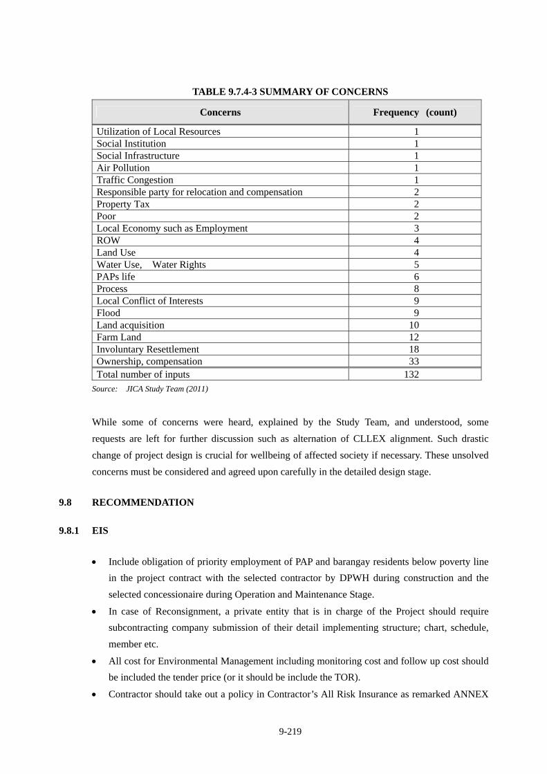
9-219
TABLE 9.7.4-3 SUMMARY OF CONCERNS
Concerns Frequency (count)
Utilization of Local Resources 1 Social Institution 1 Social Infrastructure 1 Air Pollution 1 Traffic Congestion 1 Responsible party for relocation and compensation 2 Property Tax 2 Poor 2 Local Economy such as Employment 3 ROW 4 Land Use 4 Water Use, Water Rights 5 PAPs life 6 Process 8 Local Conflict of Interests 9 Flood 9 Land acquisition 10 Farm Land 12 Involuntary Resettlement 18 Ownership, compensation 33 Total number of inputs 132
Source: JICA Study Team (2011)
While some of concerns were heard, explained by the Study Team, and understood, some
requests are left for further discussion such as alternation of CLLEX alignment. Such drastic
change of project design is crucial for wellbeing of affected society if necessary. These unsolved
concerns must be considered and agreed upon carefully in the detailed design stage.
9.8 RECOMMENDATION
9.8.1 EIS
Include obligation of priority employment of PAP and barangay residents below poverty line
in the project contract with the selected contractor by DPWH during construction and the
selected concessionaire during Operation and Maintenance Stage.
In case of Reconsignment, a private entity that is in charge of the Project should require
subcontracting company submission of their detail implementing structure; chart, schedule,
member etc.
All cost for Environmental Management including monitoring cost and follow up cost should
be included the tender price (or it should be include the TOR).
Contractor should take out a policy in Contractor’s All Risk Insurance as remarked ANNEX
9-220
A on previous EIS.
DPWH should update LARRIPP and compensation/entitlement amount stipulated in it should
be amended.
9.8.2 RAP
PMO-PJHL of DPWH should start discussion with concerned LGUs and PAPs to decide the
most appropriate relocation sites which are acceptable by PAPs as early as possible. If
development of relocation sites is needed, DPWH shall develop the sites utilizing the project
fund.
Any fee short to JICA’s requirement for relocation is included in construction cost as stated in
LARRIPP CHAPTER 2 sectionE.2.e and f (pp8).
Compensation of agricultural land for those who cultivate Hacienda’s land and customary
possessed land must be discussed and agreed with the LGU.
Project specific RAP Implementation Framework must be prepared in D/D Stage before
construction stage.
Ensure a priority employment opportunity of PAPs who lives on farming whose base is the
land lost for ROW/the project from the company that operate and maintain CLLEX.
Monitor and ensure fair and just compensation and relocation have been done to all PAPs
with full consensus before CLLEX construction tender is out by quarterly monitoring
activities which is mandate for DPWH.
9.9 ECC STATUS
The original ECC based on the alignment recommended by 2010 FS was issued by EMB on
March 30, 2010. With the amendment of the alignment recommended by this study, DPWH
requested EMB the amendment of ECC on August 12, 2011.
EMB issued the amendment of ECC on November 2, 2011.
CHAPTER 10
PROJECT IMPLEMENTATION PLAN

10-1
CHAPTER 10 PROJECT IMPLEMENTATION PLAN
(Confidential)
CHAPTER 11
OPERATION AND EFFECT INDICATORS
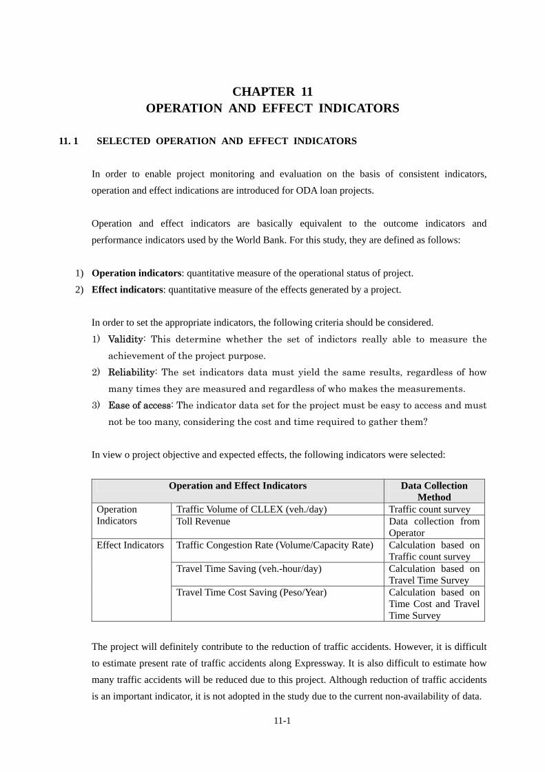
11-1
CHAPTER 11 OPERATION AND EFFECT INDICATORS
11. 1 SELECTED OPERATION AND EFFECT INDICATORS
In order to enable project monitoring and evaluation on the basis of consistent indicators,
operation and effect indications are introduced for ODA loan projects.
Operation and effect indicators are basically equivalent to the outcome indicators and
performance indicators used by the World Bank. For this study, they are defined as follows:
1) Operation indicators: quantitative measure of the operational status of project.
2) Effect indicators: quantitative measure of the effects generated by a project.
In order to set the appropriate indicators, the following criteria should be considered.
1) Validity: This determine whether the set of indictors really able to measure the
achievement of the project purpose.
2) Reliability: The set indicators data must yield the same results, regardless of how
many times they are measured and regardless of who makes the measurements.
3) Ease of access: The indicator data set for the project must be easy to access and must
not be too many, considering the cost and time required to gather them?
In view o project objective and expected effects, the following indicators were selected:
Operation and Effect Indicators Data Collection Method
Traffic Volume of CLLEX (veh./day) Traffic count survey Operation Indicators Toll Revenue Data collection from
Operator Traffic Congestion Rate (Volume/Capacity Rate) Calculation based on
Traffic count survey Travel Time Saving (veh.-hour/day) Calculation based on
Travel Time Survey
Effect Indicators
Travel Time Cost Saving (Peso/Year) Calculation based on Time Cost and Travel Time Survey
The project will definitely contribute to the reduction of traffic accidents. However, it is difficult
to estimate present rate of traffic accidents along Expressway. It is also difficult to estimate how
many traffic accidents will be reduced due to this project. Although reduction of traffic accidents
is an important indicator, it is not adopted in the study due to the current non-availability of data.
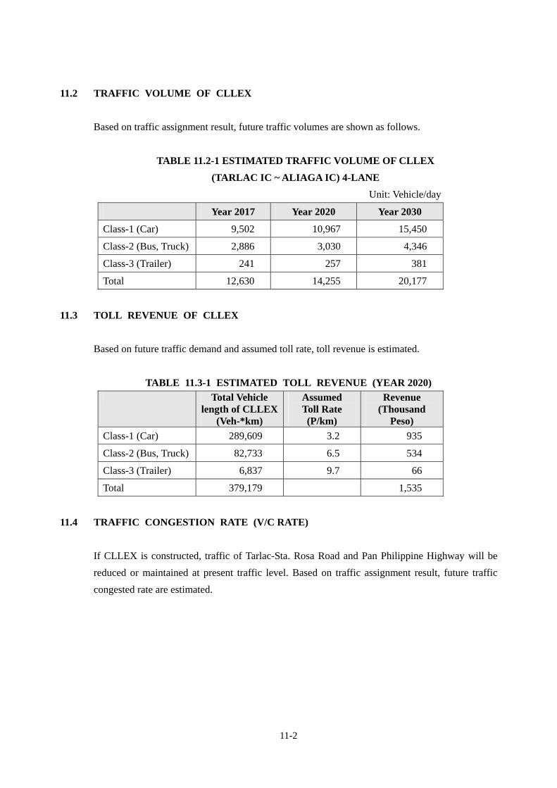
11-2
11.2 TRAFFIC VOLUME OF CLLEX
Based on traffic assignment result, future traffic volumes are shown as follows.
TABLE 11.2-1 ESTIMATED TRAFFIC VOLUME OF CLLEX
(TARLAC IC ~ ALIAGA IC) 4-LANE
Unit: Vehicle/day
11.3 TOLL REVENUE OF CLLEX
Based on future traffic demand and assumed toll rate, toll revenue is estimated.
TABLE 11.3-1 ESTIMATED TOLL REVENUE (YEAR 2020)
Total Vehicle length of CLLEX
(Veh-*km)
Assumed Toll Rate (P/km)
Revenue (Thousand
Peso)
Class-1 (Car) 289,609 3.2 935
Class-2 (Bus, Truck) 82,733 6.5 534
Class-3 (Trailer) 6,837 9.7 66
Total 379,179 1,535
11.4 TRAFFIC CONGESTION RATE (V/C RATE)
If CLLEX is constructed, traffic of Tarlac-Sta. Rosa Road and Pan Philippine Highway will be
reduced or maintained at present traffic level. Based on traffic assignment result, future traffic
congested rate are estimated.
Year 2017 Year 2020 Year 2030
Class-1 (Car) 9,502 10,967 15,450
Class-2 (Bus, Truck) 2,886 3,030 4,346
Class-3 (Trailer) 241 257 381
Total 12,630 14,255 20,177
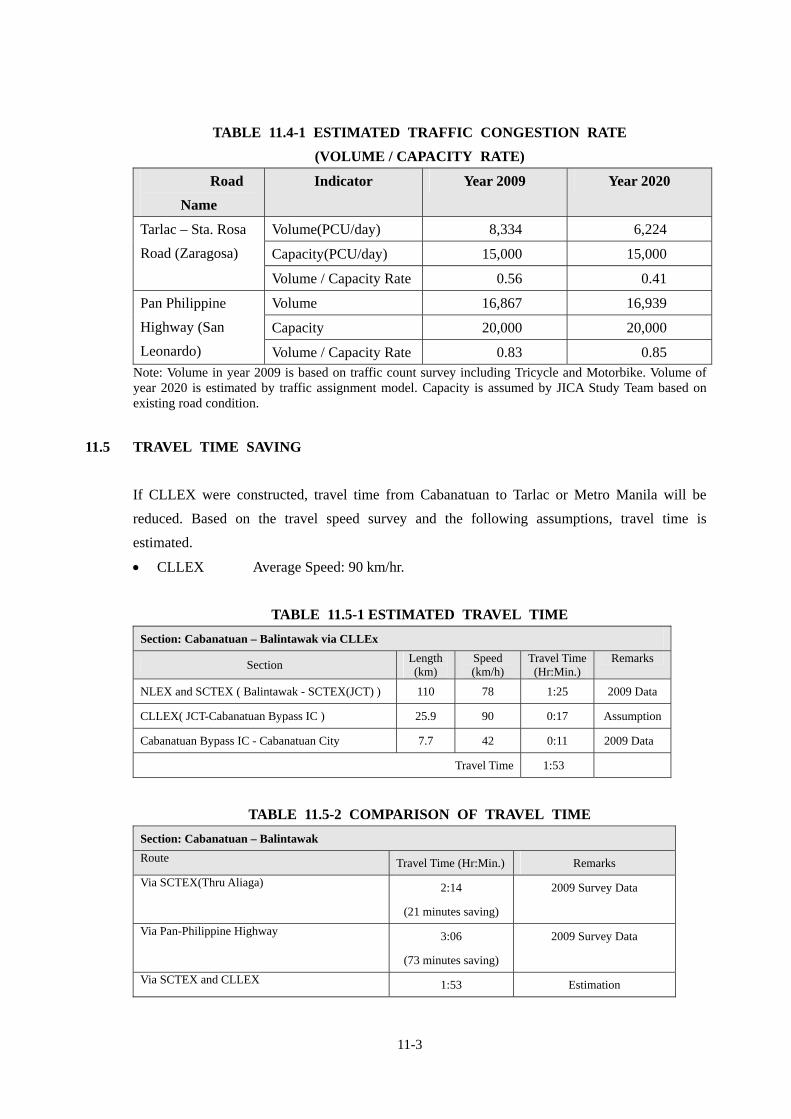
11-3
TABLE 11.4-1 ESTIMATED TRAFFIC CONGESTION RATE
(VOLUME / CAPACITY RATE)
Road
Name
Indicator Year 2009 Year 2020
Volume(PCU/day) 8,334 6,224
Capacity(PCU/day) 15,000 15,000
Tarlac – Sta. Rosa
Road (Zaragosa)
Volume / Capacity Rate 0.56 0.41
Volume 16,867 16,939
Capacity 20,000 20,000
Pan Philippine
Highway (San
Leonardo) Volume / Capacity Rate 0.83 0.85 Note: Volume in year 2009 is based on traffic count survey including Tricycle and Motorbike. Volume of year 2020 is estimated by traffic assignment model. Capacity is assumed by JICA Study Team based on existing road condition.
11.5 TRAVEL TIME SAVING
If CLLEX were constructed, travel time from Cabanatuan to Tarlac or Metro Manila will be
reduced. Based on the travel speed survey and the following assumptions, travel time is
estimated.
CLLEX Average Speed: 90 km/hr.
TABLE 11.5-1 ESTIMATED TRAVEL TIME
Section: Cabanatuan – Balintawak via CLLEx
Section Length (km)
Speed (km/h)
Travel Time (Hr:Min.)
Remarks
NLEX and SCTEX ( Balintawak - SCTEX(JCT) ) 110 78 1:25 2009 Data
CLLEX( JCT-Cabanatuan Bypass IC ) 25.9 90 0:17 Assumption
Cabanatuan Bypass IC - Cabanatuan City 7.7 42 0:11 2009 Data
Travel Time 1:53
TABLE 11.5-2 COMPARISON OF TRAVEL TIME
Section: Cabanatuan – Balintawak
Route Travel Time (Hr:Min.) Remarks
Via SCTEX(Thru Aliaga) 2:14
(21 minutes saving)
2009 Survey Data
Via Pan-Philippine Highway 3:06
(73 minutes saving)
2009 Survey Data
Via SCTEX and CLLEX 1:53 Estimation
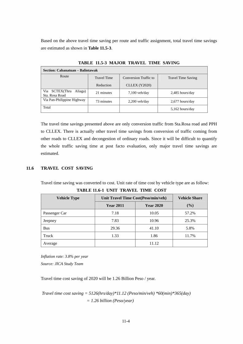
11-4
Based on the above travel time saving per route and traffic assignment, total travel time savings
are estimated as shown in Table 11.5-3.
TABLE 11.5-3 MAJOR TRAVEL TIME SAVING
Section: Cabanatuan – Balintawak
Route Travel Time
Reduction
Conversion Traffic to
CLLEX (Y2020)
Travel Time Saving
Via SCTEX(Thru Aliaga) Sta. Rosa Road
21 minutes 7,100 veh/day 2,485 hours/day
Via Pan-Philippine Highway 73 minutes 2,200 veh/day 2,677 hours/day
Total 5,162 hours/day
The travel time savings presented above are only conversion traffic from Sta.Rosa road and PPH
to CLLEX. There is actually other travel time savings from conversion of traffic coming from
other roads to CLLEX and decongestion of ordinary roads. Since it will be difficult to quantify
the whole traffic saving time at post facto evaluation, only major travel time savings are
estimated.
11.6 TRAVEL COST SAVING
Travel time saving was converted to cost. Unit rate of time cost by vehicle type are as follow:
TABLE 11.6-1 UNIT TRAVEL TIME COST
Inflation rate: 3.8% per year
Source: JICA Study Team
Travel time cost saving of 2020 will be 1.26 Billion Peso / year.
Travel time cost saving = 5126(hrs/day)*11.12 (Peso/min/veh) *60(min)*365(day)
= 1.26 billion (Peso/year)
Unit Travel Time Cost(Peso/min/veh) Vehicle Type
Year 2011 Year 2020
Vehicle Share
(%)
Passenger Car 7.18 10.05 57.2%
Jeepney 7.83 10.96 25.3%
Bus 29.36 41.10 5.8%
Truck 1.33 1.86 11.7%
Average 11.12
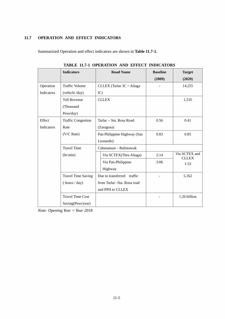
11-5
11.7 OPERATION AND EFFECT INDICATORS
Summarized Operation and effect indicators are shown in Table 11.7-1.
TABLE 11.7-1 OPERATION AND EFFECT INDICATORS
Indicators Road Name Baseline
(2009)
Target
(2020)
Traffic Volume
(vehicle /day)
CLLEX (Tarlac IC ~ Aliaga
IC)
- 14,255 Operation
Indicators
Toll Revenue
(Thousand
Peso/day)
CLLEX 1,535
Tarlac – Sta. Rosa Road
(Zaragosa)
0.56 0.41 Traffic Congestion
Rate
(V/C Rate) Pan Philippine Highway (San
Leonardo)
0.83 0.85
Cabanatuan – Balintawak
Via SCTEX(Thru Aliaga) 2:14
Travel Time
(hr:min)
Via Pan-Philippine
Highway
3:06
Via SCTEX and CLLEX
1:53
Travel Time Saving
( hours / day)
Due to transferred traffic
from Tarlac -Sta. Rosa road
and PPH to CLLEX
- 5,162
Effect
Indicators
Travel Time Cost
Saving(Peso/year)
- 1.26 billion
Note: Opening Year = Year 2018