4.7 hydrology and water quality - …€¦ · 4.7 hydrology and water quality ... (pbs&j 2008);...
TRANSCRIPT
4.7-1
4.7 Hydrology and Water Quality
City of Huntington Beach The Village at Bella Terra EIR
4.7 HYDROLOGY AND WATER QUALITY The purpose of this section is to describe stormwater drainage impacts associated with construction and operation of the proposed project, including effects on surface water and groundwater quantity and quality, and flooding resulting from implementation of the proposed project. For purposes of this discussion, stormwater includes rainwater that is captured into the storm drain system and eventually conveyed to the Pacific Ocean or infiltrates to groundwater. Impacts to the sanitary sewer system, which is the system that collects sewage and conveys it directly to the water reclamation/treatment plants, are addressed in Section 4.14 (Utilities and Service Systems) of this document. In addition, groundwater supplies are also addressed in Section 4.14.
The primary sources of information for the analysis presented in this section include information from the Federal Emergency Management Agency (FEMA); Final City of Huntington Beach Wet Utilities Study for The Village at Bella Terra Project (WUS) (PBS&J 2008); Water Supply Assessment and Water Supply Verification for Bella Terra II (WSA/WSV) (Hunsaker & Associates Irvine, Inc. 2008c); Preliminary Water Quality Management Plan for “The Village at Bella Terra” (PWQMP) (Hunsaker & Associates Irvine, Inc. 2008a); Updated Geotechnical Investigation Proposed the Center at Beach Edinger Avenue West of Beach Boulevard Huntington Beach, California (Geotechnical Report) (Geotechnical Professionals, Inc. 2002); the City of Huntington Beach; the Water Quality Control Plan, Santa Ana River Basin (Basin Plan) (SARWQCB 2008); City of Huntington Beach Citywide Urban Runoff Management Plan (URMP) (HB 2005a); City of Huntington Beach Urban Water Management Plan (UWMP) (HB 2005b); Orange County Water District Groundwater Management Plan (GMP) (OCWD 2004); and the Orange County Drainage Area Management Plan (DAMP) (OCFCD 2003), and other references as noted.
All comments received in response to the IS/NOP circulated for the proposed project were taken into consideration during preparation of this EIR, and if relevant, have been addressed in this section or others within this document.
4.7.1 Environmental Setting The proposed project site is located at in the northeastern portion of the City of Huntington Beach in western Orange County, California. The proposed project site is located within a developed 15.85-acre site bordered by Center Avenue to the north; the Union Pacific Railroad (UPRR) right-of-way (ROW) and commercial properties to the west, Edinger Avenue to the south, and the existing Bella Terra Mall to the east.
The project site is currently developed for retail and auto service use. A vacant 190,100-square-foot (sf) retail building, formerly occupied by a Montgomery Ward Department store, occupies the central portion of the project site. A vacant 18,600 sf auto repair facility associated with the Montgomery Ward store is located on the southwestern portion of the project site. Both developments were vacated in 2001. A portion of the proposed project would also be located on a parking area that currently serves the Bella Terra Mall (existing parking area). This parking would be removed as a result of project development and replaced with new improvements as part of new construction plans. Incorporating this existing parking
4.7-2
Chapter 4 Environmental Analysis
City of Huntington Beach The Village at Bella Terra EIR
area into the project site area for The Village at Bella Terra project would require a future lot line adjustment.
The project site is relatively flat (20 to 27 feet above mean sea level), with localized variations in surface grade (Geotechnical Professionals, Inc. 2002). The underlying materials consist of fill overlying native materials. Fill material extends to 2.5 to 12 feet below grade and consist of silty sands, clays, and mixtures of silty sands and clays (Geotechnical Professionals, Inc. 2002). Sands are loose to dense and clays soft to stiff. Underlying natural materials consist of interbedded layers of organic silts and clays, clays, peat, silty sands, and sands. Peat deposits generally occur in layers up to 4 feet thick within the upper 20 feet. Peat deposits also occur in thinner layers interbedded with the organic silts and clays to depths of about 45 feet. The organic silts/clays and peat are very soft to stiff, becoming stiffer with depth. The upper silty sands and sand layers are generally loose to medium dense and become dense to very dense at depth of 45 to 60+ feet. Locally, deeper zones of loose to medium dense sands are present (Geotechnical Professionals, Inc. 2002). In accordance with the UWMP, the site soils are classified as Hydrologic Group C, which means that the pervious area soils have a moderately high runoff rate and somewhat poor infiltration.9
Groundwater was encountered at depths of 5 to 15 feet below ground surface (10 to 19 feet above mean sea level) (Geotechnical Professionals, Inc. 2002). The depth to groundwater is anticipated to fluctuate across the site and seasonally(Geotechnical Professionals, Inc. 2002).
Climate records for the Newport Beach Harbour station10 (south of the project site) and Long Beach WSCMO11 station12 (north of the project site) indicate that mean monthly temperatures range from about 55.9 to 57.0 degrees Fahrenheit (°F) during January to about 68.1 to 75.1°F during August. The mean monthly maximum temperature occurs during August and is about 73.0 to 84.6°F; mean monthly minimum temperature occurs during December and is about 48.0 to 45.3°F. Annual precipitation at Newport Beach Harbour is about 11.65 inches per year, with about 92 percent occurring from November through April. Annual precipitation at Long Beach WSCMO is about 12.94 inches per year, with about 92 percent occurring from November through April.
Regional Hydrology and Drainage
The City of Huntington Beach (City) is located within the Santa Ana River Basin (SARB), a 2,800-square-mile area located roughly between Los Angeles and San Diego. The SARB is a group of connected inland basins and open coastal basins drained by surface streams flowing generally southwestward to the Pacific Ocean. The SARB can be divided into an upper basin and a lower basin. The project site is located within the lower basin drainage and surface flows are dominated by the flood control dam at El Prado.
9 Highest infiltration and lowest runoff is associated with Hydrologic Group A, and lowest infiltration and highest runoff is associated with soil Hydrologic Group D 10 Western Regional Climate Center. Historical Climate Data. Newport Beach Harbour, California, NCDC 1971-2000 Normals. http://www.wrcc.dri.edu/cgi-bin/cliMAIN.pl?ca6175 Accessed on May 12, 2007. 11 WSCO = Weather Service Contract Meteorological Observatory 12 Western Regional Climate Center. Historical Climate Data. Long Beach WSCMO, California, NCDC 1971-2000 Normals. http://www.wrcc.dri.edu/cgi-bin/cliMAIN.pl?ca5085 Accessed on May 12, 2007.
4.7-3
4.7 Hydrology and Water Quality
City of Huntington Beach The Village at Bella Terra EIR
The Santa Ana River canyon, which separates Chino Hills from the Santa Ana Mountains, is the major drainage of Orange County. The lower Santa Ana River has been channelized and modified so that in most years flow does not reach the Pacific Ocean and is used to recharge groundwater.
The project site is located within the Westminster Watershed of the SARB, which covers 74.1 square miles in the southwestern corner of Orange County. Three main tributaries drain this watershed: (1) the Los Alamitos Channel, (2) the Bolsa Chica Channel, and (3) the East Garden Grove–Wintersburg Channel, which drains past the Bolsa Chica Wetlands, into Outer Bolsa Bay, Huntington Harbour, Anaheim Bay, and finally into the Pacific Ocean. The project site is within the East Garden Grove–Wintersburg Channel drainage area of the Westminster Watershed.
The Orange County Flood Control District (OCFCD) is responsible for the design, construction, operation, and maintenance of regional flood control facilities.13 The County flood channels are maintained annually, and maintenance includes debris and vegetation removal. The existing storm drainage channels were originally designed to accommodate 25-year flood events or less, the standard at the time. However, when the channels were constructed, they were generally built to accommodate only 65 percent of the 25-year flood event. The channels were built with restrictive channel bottoms, which reduce the amount of water the channel could carry, but slow the flow rate of runoff water while still enabling the system to convey runoff. The County now uses 100-year flood event standards for new storm drain construction and drainage improvements, and portions of the channels have been improved to accommodate up to a 100-year storm event.
Local Hydrology and Drainage
Drainage from within the City is conveyed through streets and gutters to a City storm drain system consisting of underground pipes, pump stations, and open channels, as well as several Orange County channels. The City is responsible for its own subregional and local drainage facilities, which ultimately route runoff into OCFCD facilities. The City owns and operates fifteen storm drainage channel pumping stations that are generally located near principal Orange County drainage channels. Runoff water is collected at each pump station through the City’s drainage facilities, and then transferred to the nearest OCFCD channel, which ultimately conveys water to the Pacific Ocean. The City’s channels, originally designed to accommodate up to 25-year flood events, are generally constructed at ground level (or at-grade). The at-grade channels accelerate flooding potential because the amount of water that may be pumped into an at-grade channel is less than what can be pumped to a below-grade channel. As a result, those areas located adjacent to an at-grade channel can flood in a storm event because the pump stations are unable to pump a sufficient amount of water into the channels without the channels overflowing.
The Drainage Element of the Citywide Urban Runoff Management Plan (HB 2005a) incorporates a city-based Master Plan of Drainage (MPD) that is a comprehensive drainage study of the community, which identifies and creates an inventory of existing storm drain facilities, identifies those areas where system elements do not meet the latest goals established by the City, ranks the severity of the difference between existing capacity and the capacity needed to achieve those goals, prepares planning level cost opinions for
13 City of Huntington Beach. Citywide Urban Runoff Management Plan. 2005. p. 4-5 through 4-7.
4.7-4
Chapter 4 Environmental Analysis
City of Huntington Beach The Village at Bella Terra EIR
system upgrades, and recommends system improvements to initiate corrections as funding becomes available. The City can initiate the individual drainage projects within its budgetary, political, and discretionary constraints. Hydrologic and hydraulic modeling has determined that several areas within the City’s drainage system are undersized for the current storm flows and subject to potential flooding (MPD 2005).
On-Site Drainage Patterns and Conveyance
Stormwater from the project site flows primarily southwestwardly toward Edinger Avenue. A portion of flow from the western part of the project site is conveyed to the Murdy Channel through the on-site storm drain system, while overland flow and flow from the eastern portion of the project site flows to a 25-year capacity storm drain system in Edinger Avenue and then discharges into the Murdy Channel. Flow from an existing parking area of the Bella Terra Mall that would be included in the project site following a lot line adjustment, also drains through an on-site storm drain system to the Murdy Channel through the Bella Terra Mall storm drain system. A Preliminary Drainage Review (Appendix C of the WUS) identified that runoff from the Bella Terra Mall spills over into the northwesterly portion of the project site (Hunsaker and Associates 2008b).
Water flows from east to west in the Murdy Channel north of the project site, and then continues south at the intersection of Center Avenue and the Union Pacific Raiload Right of Way (UPR ROW). At Center Avenue and the UPR ROW, minor detention occurs within the existing on-site system.14
Stormwater flow that reaches the Edinger Avenue storm drain system flows to the west and into the Murdy Channel. At about the northern terminus of Kim Lane, the Murdy Channel turns west. Just before Magellan Lane, the Murdy Channel turns south again, and continues south to its outfall at the East Garden Grove-Wintersburg Channel (C05). At Heil Avenue, the Heil pump station lifts water in the Murdy Channel so it can discharge to the East Garden Grove-Wintersburg Channel. The East Garden Grove-Wintersburg Channel runs primarily east to west within the project vicinity and discharges to Bolsa Bay, Huntington Harbour, and eventually, the Pacific Ocean.15
The project site is currently subject to flooding from deficiencies in the on-site drainage system and is located in a FEMA Special Flood Hazard Zone A because of flooding from the East Garden Grove-Wintersburg Channel during the 100-year flood event (FEMA 2004). The base flood elevation (BFE) has not been formally determined by FEMA for this site. However, FEMA, the County of Orange, and the City have agreed to use the best engineering data available for this site regarding flood impacts. A study by West Engineers estimates the depth of flooding at one foot.16
All drainage from the project site, including roof drainage, driveway drainage, and other surface drainage, is anticipated to either sheet flow to Edinger Avenue or pipe flow to the Murdy Channel. However, the
14 EN Engineering, Inc. 2005. Bella Terra Phase II Huntington Center Remodel Site Plan Review 02-10, City of Huntington Beach, Orange County, California, Hydrology and Hydraulics Basis of Design Report. September 27, 2005. 15 City of Huntington Beach. 2005. Citywide Urban Runoff Management Plan. 16 Jane James. City of Huntington Beach Senior Planner. Email dated May 23, 2008 The Village at Bella Terra PW Comments on WUS to Ruta Thomas, PBS&J.
4.7-5
4.7 Hydrology and Water Quality
City of Huntington Beach The Village at Bella Terra EIR
existing drainage system and drainage areas are unknown and the volume of overflow runoff from the Bella Terra Mall north of the project site is unknown (Hunsaker and Associates 2008b). The existing parking area of the Bella Terra Mall, which would be included as part of the project site, drains to the Bella Terra Mall Laterals S-3-6, S-3-5, S-3-4, and S-3-3 and possibly Line S-3B. These storm drain inlets discharge into the south-flowing Line S-3 (a 16- to 30- inch storm drain) to west- then south-flowing Line S-2 (a 42-inch storm drain) that outlets to the west-flowing 46-inch storm drain in Edinger Avenue (Line S-1A).17
Flooding and Conveyance Capacity
The project site is located in a 100-year Special Flood Hazard Area Zone A as mapped by FEMA (FEMA 2004); however, no base flood elevation (BFE) has been determined. Based upon the best engineering data available, it is anticipated that flooding would occur in a 100-year storm to a depth of one foot above the existing grade.18
According to the MPD, there are no current off-site system capacity deficiencies in the City storm drain system. However, the MPD analysis was based on stormwater detention mitigation measures identified for the adjacent Bella Terra Mall project, which were not implemented. Actual existing street flow capacity, storm drain system capacity, and area runoff is not provided for in the MPD. The City storm drain channels were originally designed to convey the 25-year storm event. Therefore, without the stormwater detention that was originally tabled for the Bella Terra Mall, it can be assumed that conveyance capacity of the City storm drainage system within the project site vicinity (including the Murdy Channel) is affected and runoff from the project site should be limited to the 25-year storm event.
Surface Water Quality
Storm water discharges from the urbanized areas in Orange County consist mainly of surface runoff from residential, commercial, and industrial developments. In addition, there are storm water discharges from agricultural land uses in the non-urbanized area of Orange County, including farming and animal operations.
Discharges from various areas within the City drain directly or indirectly into urban streams, city lakes, bays, wetlands, estuaries, and the Pacific Ocean. The City owns, operates, and maintains a storm drainage system for the purpose of conveying storm runoff to reduce or eliminate flooding under peak storm flow conditions. The storm drainage system begins with the streets and roads, and includes inlets, storm drains, open channels, pump stations, detention basins, and other appurtenances. While the primary purpose of the storm drain system is to reduce or eliminate flood hazards, the system carries both dry- and wet-weather urban runoff and the pollutants associated with activities from urban land use.
17 EN Engineering, Inc. 2005. Bella Terra Phase II Huntington Center Remodel Site Plan Review 02-10, City of Huntington Beach, Orange County, California, Hydrology and Hydraulics Basis of Design Report: Bella Terra Storm Drain Index. September 27, 2005. 18 James, Jane. Sr. Planner, City of Huntington Beach. Email to Thomas, Ruta K, May 23, 2008, 2:45 p.m.
4.7-6
Chapter 4 Environmental Analysis
City of Huntington Beach The Village at Bella Terra EIR
Several major channels owned and maintained by Orange County are also within the City. These channels receive runoff from areas within the City as well as from substantial drainage areas in other upstream jurisdictions.
The discussion of water quality will be within the context of urban runoff because the project site is located within an urbanized area. Urban runoff (both dry and wet weather) discharges into storm drains and, in some cases, flows directly to creeks, rivers, lakes, and the ocean. Polluted runoff can have harmful effects on drinking water, recreational water, and wildlife.
Urban runoff pollutants include a wide array of environmental, chemical, and biological compounds from both point and nonpoint sources. In the urban environment, stormwater characteristics depend on site characteristics (e.g., land use, perviousness, pollution prevention, types and amounts of Best Management Practices [BMPs]), rain events (duration, amount of rainfall, intensity, and time between events), operations and maintenance practices (e.g., street sweeping), soil type and particle sizes, multiple chemical conditions, the amount of vehicular traffic, and atmospheric deposition. The United States Environmental Protection Agency (USEPA) estimates that short-term runoff from construction sites, without adequate erosion and runoff control measures, can contribute more sediment to receiving waters than that which is deposited by natural processes over a period of several decades (USEPA 2007).
The quality of urban runoff in the City is typical of most urban areas and includes a variety of common contaminants (HB 2005a). These pollutants consist primarily of suspended sediments, fertilizers and pesticides, animal waste, and contaminants that are commonly associated with automobiles (e.g., petroleum compounds such as oil, grease, and hydrocarbons). In addition, urban stormwater often contains high levels of soluble and particulate heavy metals generated from traffic, industrial facilities, and occasionally, residential sources.
Runoff Quality
For purposes of this report, urban runoff for discussing water quality issues has been divided into two categories summarized as follows:
■ Dry weather urban runoff, which occurs when there is no precipitation-generated runoff. Typical sources include landscape irrigation runoff; driveway and sidewalk washing; non-commercial vehicle washing; groundwater seepage; fire flow; potable water line operations and maintenance discharges; and permitted or illegal non storm water discharges. Irrigation runoff and washing processes generally contribute to dry weather urban runoff only during the dry season (typically from April through September.). It can be a significant source of bacteria and other constituents that can be introduced through day-to-day urban activities as well as illicit discharges, dumping, or spills.
■ Wet weather urban runoff refers collectively to non-point source discharges that result from precipitation events. Wet weather discharges includes all stormwater runoff. Stormwater discharges are generated by runoff from land and impervious areas such as paved streets, parking lots, and building rooftops during rainfall and snow events (e.g., such as might occur in mountainous regions of the watershed) that often contain pollutants in quantities that could adversely affect water quality. Most urban stormwater discharges are considered diffuse sources and are regulated
4.7-7
4.7 Hydrology and Water Quality
City of Huntington Beach The Village at Bella Terra EIR
by the Stormwater NPDES Permit or Construction General Permit (see Regulatory Framework of this section).
The URMP has projected the annual dry weather runoff for the City of Huntington Beach at 2,800 acre-feet (AF). Furthermore, this plan estimates, that the average annual wet weather runoff is about 8,000 (AF). Based on these estimates, dry weather runoff, which is often considered inconsequential nuisance flows, can contribute over one-fourth of the total annual runoff.
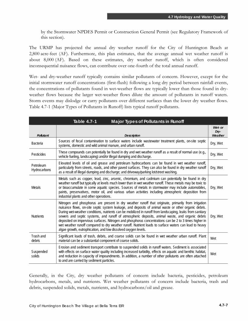
Wet- and dry-weather runoff typically contains similar pollutants of concern. However, except for the initial stormwater runoff concentrations (first-flush) following a long dry period between rainfall events, the concentrations of pollutants found in wet-weather flows are typically lower than those found in dry-weather flows because the larger wet-weather flows dilute the amount of pollutants in runoff waters. Storm events may dislodge or carry pollutants over different surfaces than the lower dry weather flows. Table 4.7-1 (Major Types of Pollutants in Runoff) lists typical runoff pollutants.
Table 4.7-1 Major Types of Pollutants in Runoff
Pollutant Description
Wet- or Dry-
Weather
Bacteria Sources of fecal contamination to surface waters include wastewater treatment plants, on-site septic systems, domestic and wild animal manure, and urban runoff. Dry, Wet
Pesticides These compounds can potentially be found in dry and wet weather runoff as a result of normal use (e.g., vehicle fueling, landscaping) and/or illegal dumping and discharge. Dry, Wet
Petroleum Hydrocarbons
Elevated levels of oil and grease and petroleum hydrocarbons can be found in wet weather runoff, particularly from streets, roads, and other paved surfaces. They can also be found in dry weather runoff as a result of illegal dumping and discharge; and driveway/parking lot/street washing.
Dry, Wet
Metals
Metals such as copper, lead, zinc, arsenic, chromium, and cadmium can potentially be found in dry weather runoff but typically at levels much lower than in wet weather runoff. These metals may be toxic to or bioaccumulate in some aquatic species. Sources of metals in stormwater may include automobiles, paints, preservatives, motor oil, and various urban activities including atmospheric deposition from industrial plants and other operations.
Dry, Wet
Nutrients
Nitrogen and phosphorus are present in dry weather runoff that originate, primarily from irrigation nuisance flows, on-site septic system leakage, and deposits of animal waste or other organic debris. During wet-weather conditions, nutrients can be mobilized in runoff from landscaping, leaks from sanitary sewers and septic systems, and runoff of atmospheric deposits, animal waste, and organic debris deposited on impervious surfaces. Nitrogen and phosphorus concentrations can be 2 to 3 times higher in wet weather runoff compared to dry weather runoff. Nutrient loads to surface waters can lead to heavy algae growth, eutrophication, and low dissolved oxygen levels.
Dry, Wet
Trash and debris
Significant loads of trash, debris, and coarse solids can be found in wet weather urban runoff. Plant material can be a substantial component of coarse solids. Wet
Suspended solids
Erosion and sediment transport contribute to suspended solids in runoff waters. Sediment is associated with effects on surface water quality including increased turbidity, effects on aquatic and benthic habitat, and reduction in capacity of impoundments. In addition, a number of other pollutants are often attached to and are carried by sediment particles.
Wet
Generally, in the City, dry weather pollutants of concern include bacteria, pesticides, petroleum hydrocarbons, metals, and nutrients. Wet weather pollutants of concern include bacteria, trash and debris, suspended solids, metals, nutrients, and hydrocarbons/oil and grease.
4.7-8
Chapter 4 Environmental Analysis
City of Huntington Beach The Village at Bella Terra EIR
Wet Weather
Wet-weather monitoring indicates that acute (1-hour maximum) California Toxics Rule criteria (CTR) (See Regulatory Environment) for copper was regularly exceeded in the East Garden Grove–Wintersburg Channel (45 percent of samples using the freshwater criteria and 100 percent using the salt water criteria) and Huntington Harbour (43 to 80 percent of samples) (HB 2006a).
Zinc acute CTR was exceeded only occasionally (0 to 6 percent of samples for East Garden Grove–Wintersburg Channel and 0 to 10 percent of samples for Huntington Harbour) and nickel acute criteria was not exceeded (HB 2006a). Copper chronic (4-day average) CTR criteria was exceeded in 75 to 100 percent of wet weather samples and nickel chronic criteria was exceeded in 0 to 50 percent of wet weather samples from Huntington Bay (HB 2006a). No exceedance of chronic CTR criteria was measured for zinc (HB 2006a).
Dry Weather
Dry-weather monitoring indicates that acute CTR copper criteria were exceeded in 55 to 88 percent of samples in Huntington Harbour (HB 2006a). No acute CTR criteria were exceeded for either nickel or zinc during dry weather (HB 2006a). No summary of dry-weather chronic criteria exceedance was available.
Mass Loading
Mass loading (total amount of pollutants transported in channel waters) within the East Garden Grove–Wintersburg Channel was approximately 4 tons of nitrate, 2 tons of phosphate, 35 tons of copper, 110 tons of zinc, and 21 tons of lead (HB 2006b).
Natural Treatment System
The Natural Treatment System—East Garden Grove Wintersburg Channel Project for dry weather treatment using Talbert and Huntington Lakes—is a Santa Ana Regional Water Quality Control Board Approved Supplemental Environmental Project (SEP) (Huntington Beach 2007). This proposed project would divert approximately 3 million gallons per day of urban runoff from the large regional channel, the East Garden Grove–Wintersburg Channel, into the Huntington Beach Central Park for natural treatment and restoration of aquatic resources. The project would provide multiple benefits, including: the reduction in polluted runoff entering Bolsa Chica Wetlands, Huntington Harbour and Anaheim Bay; the restoration of aquatic resources in Central Park, including Talbert Lake, Huntington Lake, and Shipley Nature Center; enhancements to groundwater protection by reinforcing the sea-water intrusion barrier; and educational opportunities.
Water Quality Standards and Total Maximum Daily Loads
The project site is located within the Wintersburg Channel Planning Area for water quality. The Wintersburg Channel Planning Area is the portion of the East Garden Grove–Wintersburg Channel drainage area and receives upstream flow from the Slater Channel, as well as East Garden Grove
4.7-9
4.7 Hydrology and Water Quality
City of Huntington Beach The Village at Bella Terra EIR
Channel and Ocean View Channel. Within the City itself, these channels join to form the East Garden Grove–Wintersburg Channel. Further downstream, the Slater Channel enters into East Garden Grove–Wintersburg Channel. The channel then discharges into the Outer Bolsa Bay and then into Huntington Harbour, Anaheim Bay, and the Pacific Ocean. The East Garden Grove–Wintersburg Channel has a drainage area of approximately 5.3 square miles. Surface waters in the Outer Bolsa Bay, Huntington Harbour, and Anaheim Bays are all tidally influenced. The predominant land uses for this planning area are a mixture of single and multi-family residential, commercial, and industrial areas.
Designated beneficial uses for Bolsa Bay (no Hydrologic Unit identified) include: water and non-water contact recreation; commercial and sport fishing; preservation of biological habitats of special significance; wildlife habitat; rare, threatened, or endangered species; spawning, reproduction, and/or early development; shellfish harvesting; and marine habitat. Designated beneficial uses for Huntington Harbour (Hydrologic Unit 801.11) include: navigation; water and non-water contact recreation; commercial and sport fishing; wildlife habitat; rare, threatened, or endangered species; spawning, reproduction, and/or early development; and marine habitat. It is also listed as excepted from the municipal and domestic supply beneficial use. Anaheim Bay (Hydrologic Unit 801.11) designated beneficial uses include: navigation (Outer Bay); water and non-water contact recreation; preservation of biological habitats of special significance; wildlife habitat; rare, threatened, or endangered species; spawning, reproduction, and/or early development; and marine habitat. It is also listed as excepted from the municipal and domestic supply beneficial use. There are no site specific water quality objectives for total dissolved solids, hardness, chloride, total inorganic nitrogen, sulfate, or chemical oxygen demand.
Some receiving waters in the vicinity of the Project Area have been listed pursuant to Section 303(d) as not attaining water quality standards established by USEPA. Anaheim Bay is listed as impaired (not meeting its designated beneficial uses) by dieldrin, nickel, PCBs, and sediment toxicity from unknown sources (SARWQCB 2006). Huntington Harbour is listed as impaired by chlordane, copper, lead, nickel, PCBs, and sediment toxicity from unknown sources, and by pathogens from urban runoff/storm sewers (SARWQCB 2006). No TMDLs have yet been developed for these impaired water bodies and the proposed completion date is 2019 (SARWQCB 2006).
No water quality objectives are applicable to the Murdy or East Garden Grove–Wintersburg Channels; however, discharge from these channels eventually reaches Outer Bolsa Bay, Huntington Harbour, and Anaheim Bay. At the Heil pump station (Murdy Channel), dry weather total copper and lead concentrations exceeded the 6-month median and daily maximum water quality objective for protection of marine aquatic life.19 Total and dissolved nickel and zinc exceeded the 6-month median water quality objective, and total zinc exceeded the daily maximum water quality objective.20 Other measured constituents of concern measured did not exceed water quality objectives.21
19 URMP Appendix A: Table B: Water Quality Objectives. 2005. 20 URMP Appendix A: Table B: Water Quality Objectives. 2005. 21 URMP Appendix A: Table B: Water Quality Objectives. 2005.
4.7-10
Chapter 4 Environmental Analysis
City of Huntington Beach The Village at Bella Terra EIR
Groundwater
Orange County Groundwater Basin
The projects site overlies the Coastal Plain of Orange County Groundwater Basin, Department of Water Resources Basin Number 8-1 (Orange County Basin) (CDWR 2004). The Orange County Basin underlies a coastal alluvial plain in the northwestern portion of Orange County. It covers an area of approximately 350 square miles, bordered by the Coyote and Chino Hills to the north, the Santa Ana Mountains to the northeast, the Pacific Ocean to the southwest, and terminates at the Orange County line to the northwest, where the entire aquifer system is contiguous with the Central Basin of Los Angeles County (CDWR 2004). Groundwater flow is unrestricted across the county line. The Newport-Inglewood fault zone forms the southwestern boundary of all but the shallow aquifers in the basin. The major surface water drainages overlying this groundwater basin are the San Gabriel and Santa Ana Rivers, as well as San Diego and Santiago Creeks, all of which have headwaters outside of the groundwater basin.
The aquifers comprising the Orange County Basin extend over 2,000 feet deep, and form a complex series of interconnected sand and gravel deposits (CDWR 2004). The proportion of fine materials increases from the mountain areas towards the coast, resulting in areas of recharge (forebay area) where materials are coarser and more interconnected, and pressure areas where materials are finer and the aquifer becomes confined. In coastal and central portions of the Orange County Basin, these deposits are separated by extensive lower-permeability clay and silt deposits, known as aquitards. In the inland area, generally northeast of Interstate 5, the clay and silt deposits become thinner and more discontinuous, allowing for larger quantities of groundwater to flow more easily between shallow and deeper aquifers.
Historical groundwater flow was generally toward the ocean in the southwest, but pumping has greatly altered the hydraulic gradient and caused water levels to drop below sea level inland of the Newport-Inglewood fault zone. The present hydraulic gradient is primarily from recharge areas toward withdrawal areas. Salt water intrusion has migrated inland along the coastal regions and some water supplies have been contaminated in this area. A salt-water intrusion barrier in the Alamitos and Talbert Gaps has been successful in blocking this intrusion. Overall, groundwater storage capacity in the Orange County Basin is estimated at 38,000,000 AF.
The Orange County Basin is recharged primarily from local rainfall (greater in wet years), base flow from the Santa Ana River (much of which is actually recycled wastewater from treatment plants in Riverside and San Bernardino Counties), imported water percolated into the basin, and reclaimed wastewater directly recharged into the basin (HB 2005b).
The Orange County Basin is not adjudicated, based on the Department of Water Resources’ official departmental bulletins, California’s Groundwater Bulletin 118 (updated 2003) and Bulletin 160, and the California Water Plan Update (2005); the Orange County groundwater basin is not specifically identified as a basin in an overdraft condition. However, the Orange County Water District (OCWD) considers the Orange County groundwater basin to be in an overdrafted condition. OCWD’s Groundwater Management Plan summarizes the accumulated overdraft and water level elevations within the basin.
4.7-11
4.7 Hydrology and Water Quality
City of Huntington Beach The Village at Bella Terra EIR
OCWD estimates that the accumulated overdraft in June 2004 was approximately 400,000 AF (OCWD 2004).
OCWD manages the City’s groundwater basin and conducts a comprehensive water quality monitoring program. OCWD collects over 13,500 groundwater samples each year from over 800 wells. The water quality data collected from these wells is used to assess ambient conditions of the basin, monitor the effects of extraction, monitor the effectiveness of the seawater intrusion barriers, evaluate impacts from historic and current land use, address poor water quality areas, and also provide early warning of emerging contaminants of concern.
The project site is underlain by the SARWQCB’s Orange Groundwater Management Zone (hydrologic units 801.13, 801.14, 845.61, and 845.63). This subbasin has the designated beneficial uses of municipal and domestic, agricultural, industrial service, and industrial process supplies (SARWQCB 2008). Specific groundwater quality objectives for the Orange Groundwater Management Zone are only identified for total dissolved solids (TDS < 580 mg/L) and nitrate as nitrogen (Nitrate-N < 3.4 mg/L). Otherwise, general narrative and numeric water quality objectives listed in the Basin Plan for the designated beneficial uses apply.
OCWD groundwater monitoring has assessed the following potential pollutants (HB 2005b):
■ Nitrates. The Orange County groundwater basin has a number of constituents that are water quality concerns. Although nitrates are present throughout the basin, only a small number of areas exceed the drinking water regulatory maximum contaminant level (MCL). The Regional Water Quality Control Board’s groundwater subbasin nitrate-nitrogen water quality objective is 3.4 mg/L (the MCL is 10 mg/L).
■ Total Dissolved Solids (TDS). OCWD has been proactive to combat increased salinity within the basin; however, many wells within OCWD, with the exception of any in the City of Huntington Beach, exceed the SARWQCB’s water quality objective of 580 mg/L. TDS concentrations from groundwater pumped from the City of Huntington Beach wells averages about 336 mg/L of TDS.
■ Volatile Organic Compounds (VOC). OCWD has an aggressive VOC monitoring program. Because of the monitoring program, VOCs have been detected in a number of wells within OCWD. Several drinking water wells have been taken out of service, although not within the City.
■ Methyl Tertiary-Butyl Ether (MTBE). Drinking water wells within OCWD are tested for methyl tertiary-butyl ether, more commonly known as MTBE. The health effects of MTBE are uncertain; however, USEPA currently classifies MTBE as a possible human carcinogen. Two wells within OCWD, but not within the City, have been taken out of service because of MTBE contamination.
■ N-nitrosodimethylamine (NDMA). Ultraviolet light treatment was added to the process for recycled water treatment and use at the Talbert Barrier to reduce the occurrence of NDMA, a known carcinogen, in injection waters. The City’s wells have been tested for NDMA and have not had measured concentrations that exceeded the action level.
■ Emerging Contaminants. Pharmaceuticals, personal care products, and endocrine disruptors are considered emerging environmental contaminants. There are water quality concerns associated
4.7-12
Chapter 4 Environmental Analysis
City of Huntington Beach The Village at Bella Terra EIR
with these emerging contaminants because of their wide spread use among the population and their impact on human health because of exposure to low doses over long periods of time. OCWD is aware of these contaminants and is working with California Department of Health and Safety (DHS) to track and report their concentrations in the groundwater.
■ Colored Groundwater. The OCWD 2004 Groundwater Management Plan reports nine wells have been drilled in the colored zone, including the City’s Well No. 8. This well will be used to irrigate Central Park in 2006. These wells aid in reducing the groundwater level of the colored aquifer and thus minimize the potential for upward vertical migration of colored water into the clear zones.
However, overall, groundwater supplies do not exceed drinking water regulatory requirements (maximum contaminant level or MCL) (HBPWD 2007).
Water Supply
Water at the proposed project site would be served by the City and derived from a combination of local groundwater and imported water. Historically, the City has used groundwater more than imported water to satisfy water system demands. Actual percentages of groundwater and imported water vary somewhat on an annual basis depending on the extent to which these programs are implemented. Currently, the City receives approximately 64 percent of its water supply from groundwater wells accessing the Orange County Basin and approximately 36 percent of its supply from imported water from MWDOC (WUS 2008). To ensure a lasting supply for the region, the basin is managed by the OCWD, and the City pays a replenishment assessment to the district for each acre-foot of water taken from the groundwater basin. Allowable Basin Pumping Percentage (BPP) for each purveyor is typically set by OCWD on an annual basis.
4.7.2 Regulatory Framework
Federal
Clean Water Act (CWA)
The Clean Water Act (CWA) was designed to restore and maintain the chemical, physical, and biological integrity of the Nation’s waters. The USEPA has delegated responsibility for implementation of portions of the CWA, including water quality control planning and control programs, such as the National Pollutant Discharge Elimination System (NPDES) Program, to the CSWRCB and RWQCB. While the NPDES system is administered by federal and State programs, the local authority provides the specific details with which projects must comply. Thus, the NPDES system is described in detail under the Local regulations.
Total Maximum Daily Loads (TMDLs)
The CWA Section 303(d) established the Total Maximum Daily Load (TMDL) Program. The purpose of the TMDL program is for states to identify streams, lakes, and coastal waters that do not meet certain
4.7-13
4.7 Hydrology and Water Quality
City of Huntington Beach The Village at Bella Terra EIR
water quality standards and are not expected to meet standards solely through technology-based controls of point source discharges. For such watersheds, a TMDL for the constituent(s) for which the water body is impaired must be determined.
The TMDL is a calculation of the maximum amount of a pollutant that a waterbody can receive and still achieve the target water quality objective. All sources of the constituent(s) must be identified and loads quantified. Load reductions are determined and then allocated among the sources. Finally, an implementation plan is prepared to achieve the load reductions.
Anaheim Bay and Huntington Harbour are water bodies in the City listed on the 2006 California 303(d) list (see Environmental Settings Section). To date, no TMDLs have been established for receiving water bodies in the City but the expected completion date is 2019 for all listed constituents.
Floodplain Development
The Federal Emergency Management Agency (FEMA) is responsible for determining flood elevations and floodplain boundaries based on Army Corps of Engineers (Corps) studies. FEMA is also responsible for producing and distributing the Flood Insurance Rate Maps (FIRMs), which are used in the National Flood Insurance Program (NFIP). These maps identify the locations of special flood hazard areas, including the 100-year floodplain.
FEMA allows non-residential development in the floodplain; however, construction activities are restricted within the flood hazard areas depending upon the potential for flooding within each area. Federal regulations governing development in a floodplain are set forth in Title 44, Part 60 of the Code of Federal Regulations (CFR) which enables FEMA to require municipalities that participate in the National Flood Insurance Program (NFIP) to adopt certain flood hazard reduction standards for construction and development in 100-year flood plains.
Section 60.3(c)(2) of the NFIP regulations requires that the lowest occupied floor of a residential structure be elevated to, or above, the 100-year flood elevation (the base flood elevation). Section 60.3(c)(3) adds that nonresidential or commercial structures can be either elevated or dry flood-proofed to, or above, the 100-year flood elevation.
State
Responsibility for the protection of water quality in California resides with the California State Water Resources Control Board (CSWRCB) and nine Regional Water Quality Control Boards (RWQCBs). The CSWRCB establishes statewide policies and regulations for the implementation of water quality control programs mandated by federal and state water quality statutes and regulations. The RWQCBs develop and implement Water Quality Control Plans (Basin Plans) that consider regional beneficial uses, water quality characteristics, and water quality problems. The Santa Ana Regional Water Quality Control Board (SARWQCB) implements a number of federal and State laws, the most important of which are the State Porter-Cologne Water Quality Control Act and the Federal Clean Water Act.
4.7-14
Chapter 4 Environmental Analysis
City of Huntington Beach The Village at Bella Terra EIR
All projects resulting in discharges, including the proposed project, whether to land or water, are required to obtain approval of Waste Discharge Requirements (WDRs) by the RWQCBs. Land and groundwater-related WDRs (i.e., non-NPDES WDRs) regulate discharges of privately or publicly treated domestic wastewater and process and wash-down wastewater. WDRs for discharges to surface waters also serve as NPDES permits, which are further described below.
Porter-Cologne Water Quality Control Act
The State of California’s Porter-Cologne Water Quality Control Act (Division 7 of the California Water Code) provides the basis for water quality regulation within California, including the California Toxics Rule (CTR), Policy for Implementation of Toxics Standards for Inland Surface Waters, Enclosed Bays, and Estuaries of California (State Implementation Plan or SIP), Inland Surface Water Quality Standards, California Urban Water Management Act, and NPDES permits. The CSWRCB administers water rights, water pollution control, and water quality functions throughout the state, while the RWQCBs conduct planning, permitting, and enforcement activities. The Porter-Cologne Water Quality Control Act authorizes the CSWRCB to adopt, review, and revise policies for all waters of the state (including both surface and groundwater) and directs the RWQCBs to develop regional Basin Plans. Section 13170 of the California Water Code also authorizes the CSWRCB to adopt water quality control plans on its own initiative.
Waste Discharge Requirements
The water quality objectives are achieved primarily through the establishment and enforcement of waste discharge requirements. All dischargers of waste to waters of the State are subject to regulation under the Porter-Cologne Act. This includes both point and diffuse source dischargers. All current and proposed discharges to land must be regulated under Waste Discharge Requirements (WDRs), waivers of WDRs, a basin plan prohibition, or some combination of these administrative tools. Discharges of waste directly to State waters would be subject to an individual NPDES permit, which also serves as a WDR.
The RWQCBs have primary responsibility for issuing WDRs. The RWQCBs may issue individual WDRs to cover individual discharges or general WDRs to cover a category of discharges. WDRs may include effluent limitations or other requirements that are designed to implement applicable water quality control plans, including designated beneficial uses and the water quality objectives established to protect those uses and prevent the creation of nuisance conditions.
National Pollutant Discharge Elimination System (NPDES)
The CSWRCB and RWQCBs also implement, monitor, and enforce the NPDES storm water permitting and waste discharge requirements within their jurisdiction. In general, the regulations require all communities with populations over 50,000 to develop programs for reducing pollutants carried by stormwater runoff into waters of the United States. The CSWRCB and RWQCBs also develop and implement state or regional general permits regulating certain types of discharges. These permits serve as the mechanism for enforcement of the program.
4.7-15
4.7 Hydrology and Water Quality
City of Huntington Beach The Village at Bella Terra EIR
NPDES General Permit for Storm Water Discharges Associated with Construction Activity (Construction General Permit)
The CSWRCB permits all regulated construction activities under NPDES General Permit for Storm Water Discharges Associated with Construction Activity (Order No. 98-08-DWQ (1999) (NPDES No. CAS000002). In accordance with NPDES Phase I regulations, to minimize the potential effects of construction runoff on receiving water quality, California requires that any construction activity affecting 5 acres or more must obtain coverage under the Construction General Permit. Implementation of NPDES Phase II expanded this requirement to include construction activities disturbing 1 acre or more.
The General Construction Permit requires projects that disturb 1 or more acres obtain coverage under the Construction General Permit. This includes submittal of a Notice of Intent (NOI) to comply with permit conditions and the preparation and implementation of a storm water pollution prevention plan (SWPPP), which must be prepared before construction and coverage under the Construction General Permit begins. Components of SWPPPs typically include specifications for BMPs to be implemented during project construction for the purpose of minimizing the discharge of pollutants in storm water from the construction area. In addition, a SWPPP includes measures to minimize the amount of pollutants in runoff after construction is completed, and identifies a plan to inspect and maintain project BMPs and facilities. Because the proposed project would disturb more than 1 acre, construction would be subject to the Construction General Permit.
A Draft General Construction Permit has been prepared by the CSWRCB as of March 18, 2008 and a SWRCB hearing was recently held (June 4, 2008). If adopted, prior to the beginning of construction activities, the proposed project would be subject to the new requirements in the amended General Construction Permit. This Draft Construction General Permit differs from Order 99-08-DWQ in the following significant ways:
■ Technology-based Numeric Action Levels: this General Permit includes NALs for pH and turbidity.
■ Technology-based Numeric Effluent Limitations: this General Permit contains NELs for pH during any construction phase where there is a high risk of pH discharge and turbidity for all discharges. The turbidity NEL of 1000 NTU is essentially the intersection of the realm of minimum-technology that sites have to employ (to meet the traditional Best Available Technology Economically Achievable (BAT)/Best Conventional Pollutant Control Technology (BCT) standard) and the traditional, numeric receiving water limitations for turbidity.
■ Risk-based Permitting Approach: this General Permit establishes a four-level risk calculation, with only the lowest three levels covered under this General Permit. Those dischargers that are determined to be Risk Level 4 are not covered by this General Permit, and thereby are required to submit a Report of Waste Discharge (ROWD) to the appropriate Regional Water Board and seek coverage under an individual or other applicable general permit.
■ Minimum Requirements Specified: this General Permit specifies more minimum BMPs and requirements that were previously only required as elements of the SWPPP or were suggested by guidance.
4.7-16
Chapter 4 Environmental Analysis
City of Huntington Beach The Village at Bella Terra EIR
■ Project Site Soil Characteristics Monitoring and Reporting: this General Permit requires all dischargers to monitor and report the soil characteristics at the project location. This primary purpose of this requirement is to provide better risk determination and eventually better program evaluation.
■ Effluent Monitoring and Reporting: this General Permit requires effluent monitoring and reporting for pH and turbidity in storm water discharges. The purpose of this monitoring is to be used to determine compliance with the NELs and evaluate whether NALs included in this General Permit are exceeded.
■ Receiving Water Monitoring and Reporting: this General Permit requires some Risk Level 2 and Risk Level 3 dischargers to monitor receiving waters.
■ New Development and Re-development Storm Water Performance Standards: this General Permit specifies runoff reduction requirements for all sites not covered by a Phase I or Phase II MS4 NPDES permit, to avoid, minimize and/or mitigate post-construction storm water runoff impacts.
■ Rain Event Action Plan: this General Permit requires sites to develop and implement a Rain Event Action Plan (REAP) that must be designed to protect all exposed portions of the site within 48 hours prior to any likely precipitation event.
■ Site Photographic Self Monitoring and Reporting: this General Permit requires all projects to provide photographs of their sites at least once quarterly if there are rain events causing a discharge during that quarter. The purpose of this requirement is to help Regional Water Board staff prioritize their compliance evaluation measures (inspections, etc.). In addition, this reporting will make compliance related-information more available to the public.
■ Annual Reporting: this General Permit requires all projects that are enrolled for more than one continuous three-month period to submit information and annually certify that their site is in compliance with these requirements. The primary purpose of this requirement is to provide information needed for overall program evaluation and pubic information.
■ Certification/Training Requirements for Key Project Personnel: this General Permit requires that key personnel (e.g., SWPPP preparers, inspectors, etc.) have specific training or certifications to ensure their level of knowledge and skills are adequate to ensure their ability to design and evaluate project specifications that will comply with Permit requirements.
Local/ Regional
Santa Ana River Basin Water Quality Control Plan (Basin Plan)
The Santa Ana RWQCB (Region 8) has jurisdiction over the Santa Ana River Basin. The Santa Ana RWQCB (SARWQCB) is required by law to develop, adopt, and implement a Water Quality Control Plan for the entire region. The principal elements of the Water Quality Control Plan are a statement of beneficial water uses that the SARWQCB will protect; water quality objectives needed to protect the designated beneficial water uses; and strategies and time schedules for achieving the water quality objectives. The water quality objectives are achieved primarily through the establishment and enforcement of waste discharge requirements (WDRs). Both beneficial uses and water quality objectives comprise the relevant water quality standards.
4.7-17
4.7 Hydrology and Water Quality
City of Huntington Beach The Village at Bella Terra EIR
The Santa Ana Water Quality Control Plan Basin Plan (SARWQCB 2008) specifically (1) designates beneficial uses for surface and ground waters; (2) sets narrative and numerical objectives that must be attained or maintained to protect the designated beneficial uses and conform to the state’s anti-degradation policy; and (3) describes implementation programs to protect all waters in the region. In cases where the Basin Plan does not contain a criterion for a particular pollutant, other criteria are used to establish a water quality objective. These may be applied from CSWRCB documents (e.g., the Inland Surface Waters Plan and the Pollutant Policy Document) or from water quality criteria developed under Section 304(a) of the Clean Water Act (e.g., California Toxics Rule).
The SARWQCB has set water quality objectives for all surface waters in the region. Chemical constituents are regulated depending upon the beneficial use of the water body. Water quality objectives are also set for groundwater and enclosed bays and estuaries. The proposed project would be subject to the requirements of the Basin Plan.
General Waste Discharge Requirements for Discharges to Surface Waters That Pose an Insignificant (De Minimus) Threat to Water Quality (De Minimus Threat General Permit)
Low threat discharges are regulated under Order No. R8-2006-0004 Amending Order No. R8-2003-0061, NPDES No. CAG998001 As amended by Order No. R8-2005-0041, General Waste Discharge Requirements for Discharges to Surface Waters That Pose An Insignificant (De Minimus) Threat to Water Quality. De minimus threat discharges are not expected to cause toxicity, therefore, no toxicity limits are specified in this general permit. Construction dewatering wastes (except stormwater) are regulated as de minimus threat discharges to surface waters that is subject to the terms and conditions of this Order and all dischargers must comply with the effluent limitations specified in the Revised Discharge Specifications A.1.a and A.1.b and monitoring and reporting program of this Order. Based on the Geotechnical Report, it is anticipated that development of the proposed project could require groundwater dewatering during construction and/or operation, and would be subject to the requirements of this De Minimus Threat General Permit.
Orange County Municipal Stormwater NPDES Permit (Stormwater NPDES Permit)
Stormwater discharges from the City are regulated under the California Regional Water Quality Control Board Santa Ana Region Waste Discharge Requirements for the County of Orange, Orange County Flood Control District, and The Incorporated Cities of Orange County within the Santa Ana Region Areawide Urban Storm Water Runoff Orange County (Order No. R8-2002-0010, NPDES No. CAS618030) Stormwater NPDES Permit.
The co-permittees of this Stormwater NPDES Permit are responsible for the management of storm drain systems within their jurisdictions and required to: implement management programs, monitoring programs, implementation plans and all BMPs outlined in the Drainage Area Master Plan (DAMP) within each respective jurisdiction, and take any other actions as may be necessary to meet the Maximum Extent Practicable (MEP) standard.
4.7-18
Chapter 4 Environmental Analysis
City of Huntington Beach The Village at Bella Terra EIR
Receiving water limitations are identified in the Stormwater NPDES Permit and include the following requirements:
■ Discharges from the MS4s shall not cause or contribute to exceedances of receiving water quality standards (designated beneficial uses and water quality objectives) for surface waters or groundwaters.
■ The DAMP and its components shall be designed to achieve compliance with receiving water limitations.
Provisions for compliance inspection are incorporated in the Stormwater NPDES Permit and include requirements for construction site inspections, including review of erosion control and BMP implementation plans and effectiveness. Each co-permittee is also required to enforce its ordinances and permits at all construction sites.
Requirements for new development and significant re-development include the establishment of a mechanism to ensure (prior to issuance of any local permits or other approvals) that all construction sites that are required to obtain coverage under the State’s Construction General Permit have filed with the State Board a NOI to be covered by the relevant general permit and prepare and implement a SWPPP.
The Stormwater NPDES Permit also requires preparation and implementation of a water quality management plan (WQMP) for urban runoff for new development and significant redevelopment that defines how short and long-term impacts on receiving water quality from new developments and re-developments are minimized. The permittees are required to prepare and implement a WQMP for urban runoff for priority projects. The proposed project would be considered a priority project requiring a project-specific WQMP (Project WQMP) because it would include more than 10 units of residential use.
Minimum structural BMPs must either be sized to comply with either the volume-based or flow-based numeric sizing criteria or be deemed by the Principal Permittee to provide equivalent or superior treatment, either on a site basis or a watershed basis. Any structural infiltration BMPs must also meet the minimum requirement to not cause or contribute to an exceedance of groundwater water quality objectives or cause nuisance pollution and shall be implemented to protect groundwater quality.
This Stormwater NPDES Permit also includes a Monitoring and Reporting Program for the County of Orange, Orange County Flood Control District, and Incorporated Cities of Orange County within the Santa Ana Region Areawide Urban Storm Water Runoff area (Order No. R8-2002-0010 NPDES No. CAS618030).
A new Draft Stormwater NPDES Permit has been prepared and is expected to be adopted by July 2008. Until the new/revised permit has been adopted, the existing Stormwater NPDES Permit is the applicable permit. The current draft includes similar requirements for control of pollutants in stormwater runoff as the existing Stormwater NPDES Permit; however, enforcement provisions are stronger.
4.7-19
4.7 Hydrology and Water Quality
City of Huntington Beach The Village at Bella Terra EIR
Orange County Drainage Area Management Plan (DAMP)
The purpose of the DAMP was to satisfy NPDES permit conditions for creating and implementing an Urban Runoff Management Program (URMP) to reduce pollutant discharges to the maximum extent practicable (MEP) for protection of receiving waterbody water quality and support of designated beneficial uses. The DAMP contains guidance on both structural and nonstructural BMPs for meeting these goals.
City of Huntington Beach Local Implementation Plan (LIP)
The current specific water pollution control program elements are documented in the DAMP and the corresponding City of Huntington Beach Stormwater NPDES Permit Local Implementation Plan of 2003 (City of Huntington Beach LIP). The City has developed the City of Huntington Beach LIP using the DAMP as its basis. The City of Huntington Beach LIP provides a written account of activities that the City has undertaken, or is undertaking, to meet the requirements of the Third Term NPDES Permit and a means of displaying a meaningful improvement in water quality. As with the DAMP, the City of Huntington Beach LIP proposes a wide range of continuing and enhanced BMPs and control techniques that will be implemented and reported on as part of the Third Term Permit reports.
The City of Huntington Beach LIP has also incorporated the model construction program described in the DAMP. The construction program includes requirements, guidelines, and methods that construction site owners, developers, contractors and other responsible parties must use for pollution prevention to protect water quality from construction discharges. Regardless of size or priority, all construction projects are required to implement BMPs to prevent runoff and discharges into the storm drain system or water bodies. At a minimum, all construction projects must include erosion and sediment controls, as well as waste and materials management controls. The City of Huntington Beach LIP designates the construction-specific BMPs that the City has determined acceptable for use within the City’s jurisdiction.
Citywide Urban Runoff Management Plan (URMP)
The Citywide Urban Runoff Management Plan (URMP) provides a broad framework for managing the quantity and quality of all urban runoff that reaches receiving waters from the land surfaces and through the storm drain system within the City. The Water Quality Element of the URMP focuses primarily on managing runoff quality, while the Drainage Element addresses flood hazards and inconveniences. The URMP identifies potential common solutions that can address both water quality and quantity concerns.
Section 3: Water Quality Element
The Water Quality Element provides a basis for implementing a comprehensive program for improving water quality through a combination of methods to reduce the level of urban runoff and pollutants emanating from private as well as public property and thus enhancing the quality of water discharged from the municipal storm drain system within the City.
4.7-20
Chapter 4 Environmental Analysis
City of Huntington Beach The Village at Bella Terra EIR
Water Quality Management Plan
During the project review, approval, and permitting process, the City requires all new development and significant redevelopment to address the quantity and quality of storm water runoff from the completed development. A project WQMP describing how the project will address runoff is required for all projects listed under the City’s “Priority Project Category.”
The project WQMP describes how the project will meet the following requirements:
■ Incorporate and implement all applicable Source Control BMPs.
■ Consider the implementation of Site Design BMPs (e.g., pervious pavement, bioretention), and document those BMPs included and those not included.
■ Either implement Treatment Control BMPs or participate in or contribute to an acceptable regional or watershed management program.
The City has general/standard conditions of approval to protect receiving water quality from short- and long-term impacts of new development and significant redevelopment. Prior to issuance of any grading or building permit for projects that disturb soil of one or more acres, the Applicant shall demonstrate, by providing a copy of the Notice of Intent submitted to the CSWRCB and a copy of the subsequent issuance of a Waste Discharge Identification number, that coverage has been obtained under the Construction General Permit. Projects subject to this requirement shall also prepare, submit, and implement a Stormwater Pollution Prevention Plan, including erosion control measures. This also includes the requirement that the Applicant demonstrate that all structural and non-structural BMPs described in the project WQMP have been installed and implemented in accordance with approved plans and specifications prior to close-out of a grading or building permit and/or issuance of a Certificate of Occupancy.
Section 4: Drainage Element
The Drainage Element of the URMP incorporates a city-based Master Plan of Drainage (MPD) that is a comprehensive drainage study of the community, which identifies and creates an inventory of existing storm drain facilities, identifies those areas where system elements do not meet the latest goals established by the City, ranks the severity of the difference between existing capacity and the capacity needed to achieve those goals, prepares planning level cost opinions for system upgrades, and recommends system improvements to initiate the corrections.
City of Huntington Beach Municipal Code
In order to comply with NPDES permit requirements, the City of Huntington Beach has codified requirements in their municipal code. The following sections of the City’s municipal code would be applicable to the proposed project:
■ Chapter 14.25 (Storm Water and Urban Runoff Management) ■ Chapter 14.48 (Drainage) ■ Chapter 14.52 (Water Efficient Landscape Requirement) ■ Chapter 17.05 (Grading and Excavation Code)
4.7-21
4.7 Hydrology and Water Quality
City of Huntington Beach The Village at Bella Terra EIR
City of Huntington Zoning Code
The City of Huntington Beach Zoning Code Chapter 222 provide methods for reducing flood hazards (Section 222.08) and development standards and standards of construction (222.14) for development within Floodplain Overlay Districts. The project site is within a Floodplain Overlay District, and therefore, subject to these Zoning Codes.
City of Huntington Beach General Plan
The following goals, objectives, and policies within the Huntington Beach General Plan are applicable to hydrology and water quality.
Utilities Element
Goal U2 Provide a wastewater collection and treatment system which is able to support permitted land uses; upgrade existing deficient systems; and pursue funding sources to reduce costs of wastewater service provisions in the City.
Objective U 2.1 Ensure the city provides and maintains a wastewater collection and treatment facilities system which adequately conveys and treats wastewater generated by existing and planned development at maximized cost efficiency.
Policy U 2.1.6 Require that sewer capacity is available before building permits are issued for new development.
Goal U3 Provide a flood control system which is able to support the permitted land uses while preserving the public safety; upgrade existing deficient systems; and pursue funding sources to reduce the costs of flood control provisions in the City.
Objective U3.1 Ensure that adequate storm drain and flood control facilities are provided and properly maintained in order to protect life and property from flood hazards.
Policy U 3.1.6 During development review, determine if any structures meant for human habitation are constructed within the 100-year flood plain. If necessary, evaluate the structures’ flood safety, and require remedial actions.
Objective U 3.2 Ensure the costs of infrastructure improvements to the storm drain and control system are borne by those who benefit.
Policy U 3.2.1 Require improvements to the existing storm drain and flood control facilities necessitated by new development be borne by the new development benefiting from the improvements; either through the payment of fees; or by the actual
4.7-22
Chapter 4 Environmental Analysis
City of Huntington Beach The Village at Bella Terra EIR
construction of the improvements in accordance with State Nexus Legislation.
Objective U 3.3 Ensure that storm drain facilities (channels and outputs) do not generate significant adverse impacts on the environment in which the facilities traverse or empty.
Policy U 3.3.1 Evaluate any existing environmental degradation or potential degradation from current or planned storm drain and flood control facilities in wetlands or other sensitive environments.
Policy U 3.3.2 Where feasible, utilize natural overland flows, open channels, and swale routings as preferred alignments for components of drainage systems.
Policy U 3.3.3 Require that new developments employ the most efficient drainage technology to control drainage and minimize damage to environmental sensitive areas.
4.7.3 Project Impacts and Mitigation
Analytic Method
The proposed project is a General Plan Amendment (GPA) and Zoning Text Amendment (ZTA) for mixed-use residential and commercial development. The potential development combinations result in a maximum total building area floor area ratio of 1.75 or 1,208,245 sf of total commercial and residential development.
The proposed project contains two options: GPA/ZTA Option 1 (Option 1) and GPA/ZTA Option 2 (Option 2). GPA/ZTA Option 1 would include 713 residential units and 138,085 sf of commercial uses. This option would be developed at 45 dwelling units per acre for residential uses and a floor area ratio of 0.2 for commercial uses. GPA/ZTA Option 2 would include 538 residential units and 414,255 sf of commercial uses. This option would be developed at 34 dwelling units per acre for residential uses and a floor area ratio of 0.6 for commercial uses. Both GPA/ZTA options would result in an increase in allowable uses compared to the existing General Plan and Zoning designations for the project site; however, the ratios of the type of land uses would differ. Implementation of the proposed project would result in the development of a mixed-use scenario in which either more residential uses would be permitted (Option 1) or more commercial uses would be permitted (Option 2).
For analysis of impacts on hydrology and water quality, it would make no real difference which option is selected because both would include both multi-family residential and commercial land uses and would fall into the overall category of mixed-residential for water quality evaluation purposes. The more pertinent factors would be the developed area footprint (including parking, driveways, and pedestrian
4.7-23
4.7 Hydrology and Water Quality
City of Huntington Beach The Village at Bella Terra EIR
corridors), if there are any structures placed below grade, if site design includes stormwater quality BMPs, and the elevation of residential units, all of which would equally affect either Option.
Thresholds of Significance
The following thresholds of significance are based on Appendix G of the 2008 CEQA Guidelines. For purposes of this EIR, implementation of the proposed project may have a significant adverse impact if it would do any of the following:
■ Violate any water quality standards or waste discharge requirements
■ Substantially deplete groundwater supplies or interfere substantially with groundwater recharge such that there would be a net deficit in aquifer volume or a lowering of the local groundwater table level (e.g., the production rate of pre-existing nearby wells would drop to a level which would not support existing land uses or planned uses for which permits have been granted)
■ Substantially alter the existing drainage pattern of the site or area, including through the alteration of the course of a stream or river, in a manner that would result in substantial erosion or siltation on or off site
■ Substantially alter the existing drainage pattern of the site or area, including through the alteration of the course of a stream or river, or substantially increase the rate or amount of surface runoff in a manner that would result in flooding on or off site
■ Create or contribute runoff water that would exceed the capacity of existing or planned stormwater drainage systems or provide substantial additional sources of polluted runoff
■ Otherwise substantially degrade water quality
■ Place housing within a 100-year flood hazard area as mapped on a federal Flood Hazard Boundary or Flood Insurance Rate Map or other flood hazard delineation map
■ Place within a 100-year flood hazard area structures that would impede or redirect flood flows
■ Expose people or structures to a significant risk of loss, injury, or death involving flooding, including flooding as a result of the failure of a levee or dam
■ Expose people or structures to a significant risk of loss, injury, or death involving inundation by seiche, tsunami, or mudflow
■ Require or result in the construction of new stormwater drainage facilities or expansion of existing facilities, the construction of which could cause significant environmental effects (Utilities)
The Stormwater NPDES Permit also requires that the following potential impacts shall be considered during CEQA review:
1. Potential impact of project construction on storm water runoff 2. Potential impact of project’s post-construction activity on storm water runoff 3. Potential for discharge of storm water pollutants from areas of material storage, vehicle or
equipment fueling, vehicle or equipment maintenance (including washing), waste handling, hazardous materials handling or storage, delivery areas, loading docks, or other outdoor work areas
4. Potential for discharge of storm water to affect the beneficial uses of the receiving waters
4.7-24
Chapter 4 Environmental Analysis
City of Huntington Beach The Village at Bella Terra EIR
5. Potential for significant changes in the flow velocity or volume of storm water runoff to cause environmental harm
6. Potential for significant increases in erosion of the project site or surrounding areas 7. Under the Utilities Service Systems section: would the project include a new or retrofitted storm
water treatment control Best Management Practice (BMP), (e.g., water quality treatment basin, constructed treatment wetlands), the operation of which could result in significant environmental effects (e.g., increased vectors and odors)?
Effects Not Found to Be Significant
Threshold Would the project expose people or structures to a significant risk of loss, injury, or death involving flooding, including flooding as a result of the failure of a levee or dams?
The project site is not located in any dam inundation area as identified in the City of Huntington Beach General Plan, Hazards Element, or the Prado Dam Inundation Area, as identified in the Orange County General Plan, Figure 2-19 (OC 1987). Consequently people and structures would not be subject to dam inundation failure risks. Therefore, no impact would occur as a result of dam failure, and no further analysis is required in this EIR.
The nearest large watercourse is the Santa Ana River, located over 3 miles from the project site. Levees constructed along the Santa Ana River also minimize the flood risks to areas within the project site. In 1997 and through 2002, FEMA revised the flood maps for areas within the City of Huntington Beach, in recognition of the improvements made to the Santa Ana River Channel. These revisions reduced the anticipated flood level in the City. Therefore, there would be no impact associated with failure of the Santa Ana River levee system and no further analysis of this system is required in this EIR.
The nearest channelized water course within the project vicinity is the Murdy Channel. This channel is below-grade (not confined in a levee system) up-gradient and adjacent to the project site. Therefore, there would be no impact from levee failure of the Murdy Channel.
The East Garden Grove–Wintersburg Channel is located down gradient of the project site but is an at-grade structure (confined within levees). The East Garden Grove–Wintersburg Channel levees have not been certified by FEMA, and therefore, must be considered subject to levee failure. Revised FEMA maps (February 18, 2004) show the area that would be inundated during a 100-year flood event (1 percent chance of occurring in any given year) including levee failure. Therefore, the potential flood hazards associated with failure of the East Garden Grove–Wintersburg Channel levee system is addressed in the impacts discussion, below, for thresholds concerning the 100-year flood hazard areas.
Additionally, project site flooding could occur as a result of storm drainage system capacity constraints. Potential impacts associated with stormwater conveyance capacities are discussed in the impacts discussion, below.
4.7-25
4.7 Hydrology and Water Quality
City of Huntington Beach The Village at Bella Terra EIR
Threshold Would the project substantially deplete groundwater supplies or interfere substantially with groundwater recharge such that there would be a net deficit in aquifer volume or a lowering of the local groundwater table level (e.g., the production rate of pre-existing nearby wells would drop to a level which would not support existing land uses or planned uses for which permits have been granted)?
According to the City’s 2005 Urban Water Management Plan, groundwater wells currently supply 64 percent of the City’s water, while the remaining 36 percent is imported (WUS 2008). The project site largely consists of impervious surfaces at this time, and the amount of impervious surfaces would not change substantially with implementation of the proposed project. The project site is neither a designated groundwater recharge area nor does the project site serve as a primary source of groundwater recharge. The City of Huntington Beach has two recharge facilities, the Talbert and Alamitos Barriers; neither of which will be impacted by the proposed project. Therefore, the potential for a reduction in groundwater recharge would be negligible and would not affect City groundwater wells. No impact would result, and no further analysis is necessary in the EIR.
Potential effects on groundwater dewatering and water supplies are addressed in the impacts discussion, below.
Threshold Would the project substantially alter the existing drainage pattern of the site or area, including through the alteration of the course of a stream or river, in a manner that would result in substantial erosion or siltation on or off site? (Including additional NPDES criteria 1, 2, 5, and 6)
The proposed project would not result in off-site erosion hazards. Discharge from the project site is to a lined drainage system including the City streets, underground storm drain systems, and lined Murdy and East Garden Grove-Wintersburg Channels. Therefore, there would be no impact of the project site on off-site erosion and no further analysis is necessary in this EIR.
Impacts associated with on-site erosion and siltation hazards are addressed in the impacts discussion below.
Threshold Would the project otherwise substantially degrade water quality?
Infiltration BMPs are not proposed or included as Mitigation Measures for the proposed project and the amount of pervious surfaces available for infiltration of stormwater runoff would not be substantially altered; therefore, groundwater quality would not be affected by implementation of the proposed project. Furthermore, the proposed project land use is similar to existing conditions, except for the addition of residential uses, such that there would not be substantial additional sources of pollutants that could infiltrate to groundwater. Consequently, implementation of the proposed project would not otherwise degrade water quality and there would be no impact.
4.7-26
Chapter 4 Environmental Analysis
City of Huntington Beach The Village at Bella Terra EIR
Threshold Would the project expose people or structures to a significant risk of loss, injury, or death involving inundation by seiche, tsunami, or mudflow?
Tsunamis are large sea waves generated by submarine earthquakes, or similar large-scale, short-duration phenomena, such as volcanic eruptions, that can cause considerable damage to low-lying coastal areas. Seiches are waves, also caused by large-scale, short-duration phenomena, that result from the oscillation of confined bodies of water (such as reservoirs and lakes) that also may damage low-lying adjacent areas, although not as severely as a tsunami. The project site is not located within a moderate Tsunami Run-up Area as delineated on Figure EH-8 in the City of Huntington General Plan, Hazards Element. Therefore, there would be no risk associated with tsunamis.
The closest enclosed bodies of water that could result in earthquake-induced seiches are Huntington Lake, Talbert Lake, and Sully Miller Lake. All of these lakes are more than 1 mile from and topographically down-gradient of the project site. Therefore, potential seiche activity in these lakes would not be expected to reach the project site and there would be no risk from seiches.
Mudflow hazards typically occur where unstable hillslopes are located above gradient or where site soils are unstable and subject to liquefaction, and when substantial rainfall saturates soils causing failure. The project site is not located near steep unstable hillslopes susceptible to mudslide. There would be no substantial mass earth movement during saturated soil conditions. Therefore, the proposed project would not result in a significant loss, injury, or death by mudflow.
In summary, there would be no impact that would expose people or structures at the project site to a significant risk of loss, injury, or death involving inundation by a seiche or tsunami, and no further analysis of these is required in this EIR.
Impacts and Mitigation Measures
Threshold Would the project violate any water quality standards or waste discharge requirements or otherwise substantially degrade water quality? (Including additional NPDES criteria 1 through 4 and 6)
Threshold Would the project create or contribute runoff water that would exceed the capacity of existing or planned stormwater drainage systems or provide substantial additional sources of polluted runoff? (Including additional NPDES criteria 1, 2, 4, and 6).
Impact 4.7-1 Construction and operation of either Option of the proposed project could increase stormwater pollutant loads or concentrations, which could result in a violation of waste discharge requirements or water quality standards and provide substantial additional sources of polluted runoff. This is a potentially significant impact.
Pollutants in urban runoff can impact the beneficial uses of the receiving waters and cause or threaten to cause a condition of pollution or nuisance. While the proposed project would not result in any point-
4.7-27
4.7 Hydrology and Water Quality
City of Huntington Beach The Village at Bella Terra EIR
source discharge subject to an individual permit (WDR), it would be subject to the Construction General Permit, Stormwater NPDES Permit, and the De Minimus Threat General Permit for construction dewatering. Additionally, sanitary waste discharges would be subject to the individual NPDES permits for the Orange County Sanitary District Reclamation Plant No. 1 and Treatment Plant No. 2.
Construction Phase
The proposed project would include construction activities, such as clearing and grubbing, pavement removal and replacement, excavation and trenching for foundations and utilities, soil compaction, cut and fill activities, and grading, all of which would temporarily disturb soils. Disturbed soils are susceptible to high rates of erosion from wind and rain, resulting in sediment transport from the site. Erosion and sedimentation affects water quality through interference with photosynthesis, oxygen exchange, and the respiration, growth, and reproduction of aquatic species. Additionally, other pollutants, such as nutrients, trace metals, and hydrocarbons, can attach to sediment and be transported downstream, which could contribute to degradation of water quality.
The delivery, handling, and storage of construction materials and wastes, as well as the use of construction equipment, could also introduce a risk for stormwater contamination that could impact water quality. Spills or leaks from heavy equipment and machinery can result in oil and grease contamination, and some hydrocarbon compound pollution associated with oil and grease can be toxic to aquatic organisms at low concentrations. Staging areas or building sites can also be the source of pollution due to the use of paints, solvents, cleaning agents, and metals during construction. Impacts associated with metals in stormwater include toxicity to aquatic organisms, such as bioaccumulation, and the potential contamination of drinking supplies. Pesticide use (including herbicides, fungicides) associated with site preparation work (as opposed to pesticide use for landscaping) is another potential source of stormwater contamination. Pesticide impacts to water quality include toxicity to aquatic species and bioaccumulation in larger species. Larger pollutants, such as trash, debris, and organic matter, are additional pollutants that could be associated with construction activities. Impacts include health hazards and aquatic ecosystem damage associated with bacteria, viruses, and vectors. Construction impacts on water quality are potentially significant and could lead to exceedance of standards or criteria.
All construction activities, including installation and realignment of utilities, would all be subject to existing regulatory requirements as follows:
■ As required by the Stormwater NPDES Permit and associated DAMP, Construction General Permit, and codified in Municipal Code 14.25.040 (New Development and Significant Redevelopment), prior to the issuance of a grading or building permit, the project Applicant shall file a NOI with the State of California to comply with the requirements of the General Construction Permit. This will include the preparation of a SWPPP incorporating BMPs for construction-related control of erosion and sedimentation contained in stormwater runoff. The SWPPP may include, but would not necessarily be limited to, the following applicable measures (OCFCD 2003):
> Erosion and Sediment Control BMPs, which may include the following:
o Construction scheduling, such as phasing and season avoidance, to minimize erosion and sediment
4.7-28
Chapter 4 Environmental Analysis
City of Huntington Beach The Village at Bella Terra EIR
o Perimeter protection, such as straw wattles or silt fences
o Check dam to prevent gulley erosion and/or slow water down to allow sediment to settle out
o Gravel bag berm/barriers to prevent runoff or run-on of surface water flows
o Street sweeping and vacuuming to remove vehicle- tracked soil and sediment
o Storm Drain Inlet Protection such as filter bags and perimeter protection
o Stabilized Construction Entrances/Exits, Stabilized Construction Roads, Tire Washing to prevent vehicle tracking of sediment and debris on roadways
o Wind Erosion Control BMP such as soil stabilizers (would require more water quality modeling), wetting down of dry sediment, or covering exposed surfaces
o Covering exposed surfaces as soon as possible (e.g., hydroseeding, hydraulic mulch, soil binders, and others)
o Velocity dissipation devices
o Water Conservation Practices BMP
o Storm drain inlet protection
> Vehicle and Equipment Operation BMPs (vehicle and equipment cleaning/maintenance, potable water/irrigation controls)
> Equipment staging areas to localize and establish BMPs for control of pollutants associated with equipment re-fueling, operation, and maintenance which may include the following:
o Construction equipment shall be brought to the site no sooner than it is needed and shall be removed from the site as soon as practical. Major equipment overhaul will take place off site
o Vehicle and equipment maintenance facilities will be prepared and used to prevent discharges of fuel and other vehicle fluids.
o Vehicle and equipment fueling will take place in a contained staging area to prevent discharges of fuel and other vehicle fluids
> Waste Management and Materials Management BMPs. Waste management and material pollution BMPs for control of pollutants associated with the storage of construction materials and construction activities may include the following:
o Material Delivery and Storage—materials will be stored either off site or under cover. Hazardous materials will be stored in contained areas
o Material Use—selection of less environmentally detrimental materials will be used, where feasible and practical
o Stockpile Management—stockpiles will be minimized and covered to prevent leaching of potential chemicals and sediment
o Spill Prevention and Control will be implemented to prevent contamination of soil or water with construction and equipment operations chemicals
o Solid Waste Management
o Sanitary/Septic Waste Management
4.7-29
4.7 Hydrology and Water Quality
City of Huntington Beach The Village at Bella Terra EIR
o Hazardous Waste Management—hazardous chemicals used in construction will be disposed of in accordance with hazardous waste materials management regulations, including Municipal Code: Title VII, Chapter 8.7823(i), which states that “[A]ll hazardous substances and hazardous materials shall be stored in such a manner as to prevent such substances or materials from coming into contact with stormwater or other runoff which discharges into the storm drain system. It is unlawful for any person to dispose of any hazardous waste in any trash container used for municipal trash disposal.”
o Contaminated Soil Management—soil found to exhibit signs of pre-existing contamination will be tested and disposed of as required based on level of contamination. No contaminated soil will be brought on site and used as fill material
o Concrete Waste Management, such as contained concrete washout areas
> Water conservation
> Dewatering operations BMPs
> Slope drains
Because of the shallow depth to groundwater (5 feet below ground surface) and the Geotechnical Report (Geotechnical Professionals, Inc. 2002) requirement for excavation and replacement of existing fill material and support of structures on deep pilings, groundwater is expected to be encountered during construction activities. Therefore, the following regulatory requirement is also applicable:
■ The discharger or project Applicant, must comply with the De Minimus Threat General Permit. This general permit includes discharges associated with construction dewatering. The discharger must:
> Meet effluent limitations criteria listed in the order
> Comply with the monitoring and reporting requirements
Furthermore, the City of Huntington Beach LIP requires that all construction projects, regardless of size or priority, are required to implement stormwater BMPs that shall include, at a minimum, erosion and sediment controls. This LIP has incorporated the model construction program described in the DAMP and includes requirements, guidelines, and methods that must be used for pollution prevention to protect water quality from construction discharges.
The development of a construction SWPPP has been identified by the CSWRCB as protective of water quality during construction activities. Incorporation of required BMPs for materials and waste storage and handling, equipment and vehicle maintenance and fueling, as well as for outdoor work areas, would reduce potential discharge of stormwater pollutants from these sources. The City has codified this requirement and others pertaining to erosion and sediment controls into part of the Municipal Code prior to allowing a project to obtain a any grading or building permit. Prior to receiving a grading or building permit, the project applicant must obtain approval of their SWPPP by the Public Works Department.
The proposed project would be considered a Significant Redevelopment Project under City Municipal Code and a Priority Project under the DAMP (Table 7.11-1 Priority Projects Categories, Exhibit 7.11
4.7-30
Chapter 4 Environmental Analysis
City of Huntington Beach The Village at Bella Terra EIR
Model Water Quality Management Plan) because it would involve more than 3,000 sf of pavement, construction of more than 10 residential units, and commercial uses with more than 100,000 sf, requiring both a precise grading permit and a building permit. Additionally, the proposed project could be considered a Priority Project if it includes more than 5,000 sf of surface parking, restaurants where the land area of development is 5,000 sf or more including parking area, or automotive repair shops.
Grading permit regulations are included in Municipal Code:
■ Section 17.05.310 (Erosion control and water quality requirement systems) including:
> The prohibition of grading more than 200 cubic between October 1 and April 30 on any single grading site under permit unless an erosion control system has been approved or waived by the Director of Public Works (Director)
> A civil engineer shall be responsible for the design of all erosion control improvements and initial approval of the installation of permanent and semi-permanent erosion control devices during each rainy season
> Desilting facilities shall be provided and maintained by the owner at drainage outlets from the graded site; equipment and workers for emergency work shall be made available at all times during the rainy season
> And, any violation of an applicable federal or state-issued stormwater permit, or failure to conform to the City’s water quality requirements prepared pursuant to such a permit is also a violation of this Chapter.
■ Additionally, Section 17.05.320 (Erosion control plans) requires preparation of erosion control plans prepared by the engineer of record and in accordance with provisions of the Grading Manual shall be submitted to the Director for approval by September 15 of each year for projects under any grading permit.
■ Section 17.05.330 (Erosion control maintenance) specifies required maintenance of erosion control BMPs and Section 17.05.340 (Inspection authority) specifies that grading operations for which a permit is required shall be subject to inspection by the Director.
The development of the proposed project would also be subject to the De Minimus Threat General Permit WDR for construction dewatering, including both discharge and effluent limitations based on site and groundwater characteristics. Compliance with this general discharge permit is considered by the RWQCB to be protective of water quality. The active monitoring of construction sites for compliance with regulations would also ensure compliance with this general permit.
Additionally, the URMP incorporates provisions for construction site inspection to ensure that construction BMPs are implemented and operating effectively. Consequently, there would be no violation of the Construction General Permit or De Minimus Threat General Permit WDRs with implementation of the proposed project.
Consequently, the potential violation of WDRs would be less than significant. Furthermore, these existing regulations are considered protective of water quality and would therefore prevent violation of water quality standards and minimize the potential for contributing additional sources of polluted runoff. Existing regulations would ensure that the potential of discharges of polluted stormwater from
4.7-31
4.7 Hydrology and Water Quality
City of Huntington Beach The Village at Bella Terra EIR
construction to affect beneficial uses of receiving waters would be not be substantial. Implementation of existing project requirements would ensure that any violation of WDRs, violation of water quality standards, and contributions of additional sources of polluted runoff during construction would be less than significant.
Operation
Wastewater Generation
Details on the potential proposed project impacts on sanitary sewer systems are discussed in Section 4.14 (Utilities and Service System) of this EIR. The remaining capacity at Reclamation Plant No. 1 is 98 million gallons per day (mgd) and the remaining capacity at Treatment Plant No. 2 is approximately 24 mgd (PBS&J 2008b). As such, it is assumed there would be more than adequate capacity to treat the net increase of up to 222,457 gpd (0. mgd) of wastewater that would be generated by the proposed project (PBS&J 2008). The individual NPDES permits for these treatment facilities are based on effluent quality and design capacity of the treatment systems. Effluent limitations are identified in the permits to be protective of water quality. Because treatment system capacity would not be exceeded with implementation of the proposed project, the proposed project would not violate these WDRs and there would be no violation of water quality standards associated with wastewater from the proposed project.
Stormwater
Operational land use within the project site would be greatly altered with the proposed project compared to existing conditions; new residential, commercial, and likely open space/landscaping would replace existing vacant retail, auto service, and parking/other vacant areas. However, overall project site annual stormwater runoff would likely remain similar to existing conditions because the overall amount of impervious surfaces would not be altered.
During the operational phase of the proposed project, the major source of pollution in stormwater runoff would be contaminants that have accumulated on rooftops and other impervious surfaces, such as driveways and pedestrian walkways. Pollutants associated with the operational phase of the proposed project include nutrients, oil and grease, metals, organics, pesticides, and gross pollutants (including trash, debris, and bacteria).
Nutrients that may be present in post-construction stormwater include nitrogen and phosphorous resulting from fertilizers applied to landscaping and atmospheric deposition. Excess nutrients can impact water quality by promoting excessive and/or a rapid growth of aquatic vegetation, which reduces water clarity and results in oxygen depletion. Pesticides can also enter stormwater after application on landscaping areas of the proposed project, which are toxic to aquatic organisms and can bioaccumulate in larger species, such as birds and fish. Oil and grease can enter stormwater from vehicle leaks, traffic, and maintenance activities. Metals may enter stormwater as surfaces corrode, decay, or leach. Potential gross pollutants associated with operational activities include clippings associated with landscape maintenance, street litter, and pathogens (bacteria). Pathogens (from sanitary sewer overflows, spills, and leaks from portable toilets, pets, wildlife, and human activities) can impact water contact recreation, non-contact
4.7-32
Chapter 4 Environmental Analysis
City of Huntington Beach The Village at Bella Terra EIR
water recreation, and shellfish harvesting. Microbial contamination of the beaches from urban runoff and other sources has resulted in a number of health advisories issued by the Orange County Health Officer.
The proposed project would not be expected to result in an increase in runoff because the project site is already mostly impervious surfaces and discharge is to a lined or underground storm drain system, therefore, there would be no potential for off-site erosion. The proposed project could include use of hazardous materials on site (such as pool and spa cleaning materials). Additionally, the addition of residential and retail uses could contribute more gross pollutants (e.g., trash, debris, pet waste) to stormwater runoff. Operation of the proposed project could include vehicle or equipment maintenance or fueling and vehicle storage. Oil and grease, sediment, and metals may increase or decrease depending upon the site design; covered parking as opposed to the current surface parking could help reduce pollutants, but implementation of surface parking with a higher use rate could contribute to increased pollutants. Pesticides and nutrients used for landscaping would be expected to be similar to existing conditions because the amount of landscaping would remain about the same. Aerially deposited metals, nutrients, and other constituents, would also be expected to remain the same because of the same amount of impervious surfaces compared to existing conditions.
The DAMP requires design review of public agency projects (Section A-7: New Development and Significant Redevelopment) and for the City of Huntington Beach to ensure that the construction plans for its public works projects reflect the structural BMPs described in the project’s approved WQMP.
In accordance with the DAMP, Municipal Code, and City of Huntington Beach LIP, all new development and significant redevelopment projects requiring a grading and/or building permit are required to develop and implement a WQMP that includes BMPs, depending upon the project size and characteristics. The proposed project, which is a DAMP identified Priority Project and City of Huntington Beach identified Significant Redevelopment Project, would be required to prepare and implement a project WQMP that would be reviewed and approved by the City prior to receiving a precise grading permit and must include the following BMPs:
■ Site Design BMPs
> The development plan shall minimize directly connected impervious areas (DCIA).
> Runoff reduction areas may be implemented where groundwater protection and vector control is ensured.
> The development plan shall also minimize impervious area, maximize permeability, and reduce the C-factor (runoff coefficient) of the project site.
■ Routine Non-Structural BMPs (see PBS&J 2008 or DAMP for BMP details)
> Education for Property Owners, Tenants and Occupants
> Activity Restrictions—Conditions, covenants, and restrictions (CCRs) shall be prepared by the Applicant for the purpose of surface water quality protection. Use restrictions may be developed by a building operator through lease terms, and others.
> Common Area Landscape Management—ongoing maintenance, consistent with County Water Conservation Resolution and the City of Huntington Beach Water Ordinance, and per the City
4.7-33
4.7 Hydrology and Water Quality
City of Huntington Beach The Village at Bella Terra EIR
Arboricultural and Landscape Standards and Specifications, and fertilizer and/or pesticide usage consistent with Management Guidelines for Use of Fertilizers (DAMP Section 5.5) is required.
> BMP Maintenance.
> Title 22 California Code of Regulations Compliance and relevant sections of the California Health & Safety Code regarding hazardous waste management.
> Spill Contingency Plan
> Underground Storage Tank Compliance
> Hazardous Materials Disclosure Compliance
> Uniform Fire Code Implementation
> Common Area Litter Control
> Employee Training
> Housekeeping of Loading Docks.
> Common Area Catch Basin Inspection
> Street Sweeping Private Streets and Parking Lots—Streets and parking lots are required to be swept in late summer or early fall prior to the start of the rainy season
> Retail Gasoline Outlets
■ Routine Structural Source Control BMPs (see the WUS [PBS&J 2008] or the DAMP [OCFCD 2003] for BMP details)
> Provide Storm Drain System Stenciling and Signage
> Design Outdoor Hazardous Material Storage Areas To Reduce Pollutant Introduction
> Design Trash Storage Areas to Reduce Pollutant Introduction
> Use Efficient Irrigation Systems and Landscape Design
> Protect Slopes and Channels
> Loading Dock Areas—cover loading dock areas, or design drainage to preclude urban run-on and runoff; direct connections to the municipal storm drain system from below grade loading docks (truck wells) or similar structures are prohibited.
> Community Car Wash Racks—in complexes larger than 100 dwelling units where car washing is allowed, a designated car wash area that does not drain to a storm drain system shall be provided for common usage.
■ Project-based Treatment Control BMPs; and/or participation in an approved regional or watershed management program as defined in Section 7-II.3.3.3 of the DAMP in the affected watershed (see the WUS [PBS&J 2008] or the DAMP [OCFCD 2003] for BMP details)
> Loading Dock Areas
> Maintenance Bays
> Vehicle Wash Areas
> Outdoor Processing Areas
4.7-34
Chapter 4 Environmental Analysis
City of Huntington Beach The Village at Bella Terra EIR
> Equipment Wash Areas
> Fueling Areas
> Wash Water Controls For Food Preparation Areas
> Community Car Wash Racks—The DAMP requires on-site vehicle wash areas for residential areas with more than 100 units.
■ Treatment Control BMPs (see the WUS [PBS&J 2008] or the DAMP [OCFCD 2003] for BMP details)
> Select Treatment Control BMPs for the Pollutants of Concern
> Numeric Design Standards
> Locate Treatment Control BMPs Near Pollutant Sources
> Limitations on the Use of Infiltration BMPs
■ Provide Proof of Ongoing BMP Maintenance (see the WUS [PBS&J 2008] or the DAMP [OCFCD 2003] for BMP details)
Acceptable structural and non-structural BMPs are listed in the DAMP and California Stormwater Quality Association (CASQA) Stormwater BMP Handbook for New Development and Redevelopment (2003) in compliance with the Stormwater NPDES Permit. Treatment flow rate or volume design requirements for structural BMPs are specified in the Stormwater NPDES Permit. Overall, as calculated in the WUS (PBS&J 2008) the treatment BMP design water quality flow volume for the entire project site stormwater runoff would be about 0.70 acre-feet and the water quality flow rate would be about 2.63 cfs.
These existing regulatory requirements would reduce potential proposed project impacts on water quality. However, based on the project site characteristics and nature of the proposed project, certain BMPs would not be suitable and implementation of non-structural BMPs would not be assured. Therefore, proposed project impacts would remain potentially significant.
Implementation of the following mitigation measure, in conjunction with existing regulatory requirements, would reduce potential proposed project impacts to the less-than-significant level.
MM4.7-1 The Applicant shall prepare a City of Huntington Beach-approved Water Quality Management Plan in accordance with the DAMP requirements for a Project WQMP and measures described below.
A final WQMP shall be prepared to satisfy the requirements of the DAMP and City LIP. The final WQMP shall incorporate water quality BMPs for all improved phases of the proposed project. Prior to receiving a precise grading permit, three signed copies and an electronic copy on CD (.pdf or .doc format) shall be submitted to the Public Works Department. The final WQMP shall include the following additional requirements:
Project and Site Characterization Requirements
■ Entitlement Application numbers and site address shall be included on the title sheet of the WQMP
4.7-35
4.7 Hydrology and Water Quality
City of Huntington Beach The Village at Bella Terra EIR
■ In project description section, explain whether proposed use includes onsite food preparation, eating areas (if not please state), outdoor activities to be expected, vehicle maintenance, service, washing cleaning (if prohibited onsite, please state).
■ All potential pollutants of concern for the proposed project land use type as per Table 7.II-1 of the Orange County Model Water Quality Management Plan shall be identified
■ A narrative describing how all potential pollutants of concern will be addressed through the implementation of BMPs and describing how site design BMP concepts will be considered and incorporated into the project design shall be included.
■ Existing soil types and estimated percentages of perviousness for existing and proposed conditions shall be identified
■ In Section I of the WQMP, state verbatim the Development Requirements from the Planning Department’s letter to the Applicant.
■ A figure showing the selected treatment BMPs and drainage areas shall be included in the WQMP.
Structural Treatment BMPs
■ Infiltration-type BMPs shall not be used. These would not be suitable or feasible for the project site because, as mentioned above, the project site soils have a shallow depth to seasonal high groundwater.
■ Wet swales and grassed channels shall not be used because of the slow infiltration rates of project site soils and potentially shallow depth to groundwater
■ Dry and wet detention basins and constructed wetlands are not recommended for the project site because of the amount of area required for treatment and potential impacts to shallow groundwater. Additionally, wet detention basins would require approval by the vector control agency.
■ If proprietary Structural Treatment Control devices are used, they shall be sited and designed also in compliance with the manufacturers design criteria.
■ Treatment BMPs shall be selected such that standing water drains within 24 hours or as required by the City’s vector control.
■ Excess stormwater runoff shall bypass the treatment BMPs unless they are designed to handle the flow rate or volume from a 100-year storm event without reducing effectiveness. Effectiveness of any treatment BMP for removing the pollutants of concern shall be documented.
■ The WQMP shall incorporate water efficient landscaping using drought tolerant, native plants in accordance with Landscape and Irrigation Plans as set forth by the Association (see below).
■ Pet waste stations shall be provided and maintained.
■ Building materials shall minimize exposure of bare metals to stormwater. Copper or Zinc roofing materials, including downspouts, shall not be used. Bare metal surfaces shall be painted with non-lead containing paint.
For all structural treatment and source control BMPs, the WQMP shall identify the responsible party, such as a Master Residential Association and Master Commercial Association or property
4.7-36
Chapter 4 Environmental Analysis
City of Huntington Beach The Village at Bella Terra EIR
owner, for maintenance of the treatment system, and a funding source or sources for its operation and maintenance. The term Association refers to the responsible party. Operations and maintenance BMPs shall include, but not be limited to:
■ The Association shall dictate minimum landscape maintenance standards and tree trimming requirements for the total project site. Landscape maintenance must be performed by a qualified landscape maintenance company or individual in accordance with a Chemical Management Plan detailing chemical application methods, chemical handling procedures, and worker training. Pesticide application shall be performed by a certified applicator. No chemicals shall be stored on-site unless in a covered and contained area and in accordance with an approved Materials Management Plan. Application rates shall not exceed labeled rates for pesticides, and shall not exceed soil test rates for nutrients. Slow release fertilizers shall be used to prevent excessive nutrients in runoff or irrigation waters.
■ The Association shall have the power and duty to establish, oversee, guide, and require proper maintenance and tree trimming procedures per the ANSI A-300 Standards as established by the International Society of Arborist. The Association shall require that all trees be trimmed by or under the direct observation/direction of a licensed/certified Arborist, for the entire The Village at Bella Terra improvement area. The Association shall establish minimum standards for maintenance for the total community, and establish enforcement thereof for the total community. The Association shall rectify problems arising from incorrect tree trimming, chemical applications, and other maintenance within the total community.
■ Landscape irrigation shall be performed in accordance with an Irrigation Management Plan to minimize excess irrigation contributing to dry- and wet-weather runoff. If automated sprinklers are used, they shall be inspected at least quarterly and adjusted yearly to minimize potential excess irrigation flows. Landscape irrigation maintenance shall be performed in accordance with the approved irrigation plans, the City Water Ordinance and per the City Arboricultural and Landscape Standards and Specifications.
■ Proprietary stormwater treatment systems maintenance shall be in accordance with the manufacturer’s recommendations. If a non-proprietary treatment system is used, maintenance shall be in accordance with standard practices as identified in the CASQA (2003) handbooks, City BMP guidelines, or other City-accepted guidance.
■ Education programs. Signage, enforcement of pet waste controls, and public education would improve use and compliance, and therefore, effectiveness of this BMP and reduce potential for hazardous materials and other waste in stormwater runoff. The Association shall prepare and install appropriate signage, disseminate information to residents and retail businesses, and include pet waste controls in the Association agreement/Conditions, Covenants, and Restrictions.
■ Street sweeping shall be performed at an adequate frequency to prevent build up of pollutants (see http://www.fhwa.dot.gov/environment/ultraurb/ for street sweeping effectiveness).
■ Maintenance Plan. The Association shall develop a maintenance plan for BMPs and facilities identifying responsible parties and maintenance schedules and appropriate BMPs to minimize discharges of contaminants to storm drain systems during maintenance operations. No discharge of building or courtyard/open space wash water shall enter the storm drain system unless treated and approved by the City of Huntington Beach.
4.7-37
4.7 Hydrology and Water Quality
City of Huntington Beach The Village at Bella Terra EIR
■ Reporting requirements: the Association shall prepare an annual report and submit the annual report to the City of Huntington Beach documenting the BMPs operations and maintenance conducted that year. The annual report shall also address the potential system deficiencies and corrective actions taken or planned.
The Applicant is encouraged to consider the following BMPs:
■ Use of porous concrete or asphalt (if acceptable to the Geotechnical Engineer) or other pervious pavement for driveways, paths, sidewalks, and courtyards/open space areas to the maximum extent practicable will reduce pollutants in stormwater runoff as well as provide some detention within the material void space. If porous paver blocks are used, they must be adequately maintained to provide continued porosity (effectiveness).
■ Incorporation of rain gardens or cisterns to reuse runoff for landscape irrigation
■ Site design and landscape planning to group water use requirements for efficient irrigation
■ Sand filters or other filters(including media filters) for rooftop runoff
■ Dry swales a dry swale treatment system could be used if sufficient area, slope gradient, and length of swale could be incorporated into the project design (PBS&J 2008). Dry swales could remove substantial amounts of nutrients, suspended solids, metals, and petroleum hydrocarbons (PBS&J 2008).
■ Other proprietary treatment devices (if supporting documentation is provided)
These BMPs shall not be used because they have not been shown to be effective in many situations. Therefore, unless sufficient objective studies and review are available and supplied with the WQMP to correctly size devices and to document expected pollutant removal rates the WQMP shall not include:
■ Hydrodynamic separator type devices as a BMP for removing any pollutant except trash and gross particulates
■ Oil and Grit separators
Implementation of the existing regulations along with mitigation measure MM4.7-1 would reduce potential pollutant loads and ensure that appropriate BMPs are used (e.g., constraints on infiltration-type BMPs and documented effectiveness for the pollutants of concern), that regulatory requirements are met, and that any post-construction violation of WDRs or water quality standards would be less than significant. Furthermore, the potential for discharge of storm water pollutants from areas of material storage, vehicle or equipment fueling, vehicle or equipment maintenance (including washing), waste handling, hazardous materials handling or storage, delivery areas, loading docks or other outdoor work areas would be less than significant.
4.7-38
Chapter 4 Environmental Analysis
City of Huntington Beach The Village at Bella Terra EIR
Threshold Would the project substantially deplete groundwater supplies or interfere substantially with groundwater recharge such that there would be a net deficit in aquifer volume or a lowering of the local groundwater table level (e.g., the production rate of pre-existing nearby wells would drop to a level which would not support existing land uses or planned uses for which permits have been granted)?
Impact 4.7-2 Construction and Operation of either Option of the proposed project could deplete groundwater supplies. This impact would be less than significant.
The historical high groundwater levels occur at 5 feet below ground surface at the project site and unsaturated soils have a high water content (Geotechnical Professionals, Inc. 2002). Consequently, construction dewatering for utilities, foundation excavation and fill, and below-grade parking would be required; excavation for fill removal and replacement, alone, would extend to a depth of over 4 feet. However, any potential dewatering impacts would be temporary and therefore, less than significant. Development of the project would also require coverage under the De Minimus Threat General Permit, which would include discharge quantity and quality limitations, based on site and groundwater characteristics. Consequently, potential impacts associated with construction dewatering on the local groundwater table and water supplies would be less than significant.
Some permanent structures (e.g., basements and underground parking) could be located below the local groundwater table. If the project proponent elects to use a permanent groundwater dewatering system instead of dry flood-proofing and full-hydrostatic pressure load construction to protect these structures, the proposed project could permanently lower the localized groundwater table. The extent of this effect on the local groundwater table will depend upon the lateral transmissivity of project site and neighboring subsurface materials and depth of dewatering. Permanent dewatering activities would require coverage under the De Minimus Threat General Permit or an individual WDR/NPDES Permit, and consequently, it would be subject to discharge quantity limitations. The actual amount of required dewatering is currently unknown but not expected to be substantial based on the large amount of underlying alluvial materials with low permeabilities. Additionally, in portions of the project site, the groundwater table may be below the lowest floor level during construction, but above this level during the wet weather season, requiring dewatering only during certain conditions or not at all.
The City has identified project conditions of approval for groundwater dewatering and surface drainage that would also serve to minimize potential effects of temporary or permanent groundwater dewatering.
CR4.7-1 Prior to receiving a precise grading or building permit, the Applicant shall prepare a site Grading and Drainage Plan containing the recommendations of the final Soils and Geotechnical Reports analysis for temporary and permanent groundwater dewatering as well as for surface drainage.
Additionally, if the project Applicant proposes to develop underground structures that include permanent groundwater dewatering implementation of mitigation measure MM4.7-2 would ensure that permanent groundwater dewatering does not cause or contribute to a lowering of the local groundwater table that would affect nearby water supply wells.
4.7-39
4.7 Hydrology and Water Quality
City of Huntington Beach The Village at Bella Terra EIR
MM4.7-2 The Applicant shall prepare a Groundwater Hydrology Study to determine the lateral transmissivity of area soils and a safe pumping yield such that dewatering activities do not interfere with nearby water supplies. Based on the Groundwater Hydrology Study, the Geotechnical, Hydrogeologic, or other qualified Engineer shall determine whether permanent groundwater dewatering is feasible within the constraints of a safe pumping level. The project Applicant shall incorporate the qualified Engineers designs and recommendations into project plans. If safe groundwater dewatering is determined to not be feasible, permanent groundwater dewatering shall not be implemented. The City’s Director of Public Works shall approve or disapprove of any permanent groundwater dewatering based on the Groundwater Hydrology Study and qualified Engineer recommendations.
Consequently, potential impacts associated with permanent dewatering on the local groundwater table and water supplies would be less than significant with implementation of existing regulatory requirements, project conditions of approval CR4.7-1, and mitigation measure MM4.7-2.
The proposed project would not implement any new water supply wells or increase demand beyond the available water supply with incorporation of required water conservation measures (WUS 2008; Hunsaker and Associates, Inc. 2008c). Therefore, operation of the proposed project would not affect the local groundwater table such that there would be a reduction in groundwater levels or production rates for pre-existing nearby wells and regional groundwater supplies are sufficient for operation of the proposed. Therefore, potential effect of the proposed project on groundwater supplies would be less than significant.
Threshold Would the project substantially alter the existing drainage pattern of the site or area, including through the alteration of the course of a stream or river, in a manner that would result in substantial erosion or siltation on or off site? (Including additional NPDES criteria 1, 2, 5, and 6)
Impact 4.7-3 Implementation of either Option of the proposed project would alter the project site runoff characteristics that could result in more on-site erosion and off-site siltation. This is considered a less-than-significant impact.
Construction Phase
Please refer to the discussion for Impact 4.7-1.
The proposed project would include construction activities, such as excavation and trenching for foundations and utilities, soil compaction, cut and fill activities, and grading, all of which would temporarily disturb soils. Disturbed soils are susceptible to high rates of erosion from wind and rain, resulting in sediment transport from the site. Construction of the proposed project would require a City Grading Permit (Municipal Code Section 7.05.060) including Erosion control and water quality requirement systems (Municipal Code Section 17.05.310), an Erosion Control Plan (Municipal Code Section 17.05.320), erosion control maintenance (Municipal Code Section 17.05.330) and grading operations inspections (Municipal Code Section 17.05.340). Additionally, because the proposed project would disturb more than one-acre of surface area, it would be subject to the Construction General Permit requirements, including preparation of a SWPPP. The City of Huntington Beach LIP also requires that all construction projects, regardless of size or priority, implement stormwater BMPs that
4.7-40
Chapter 4 Environmental Analysis
City of Huntington Beach The Village at Bella Terra EIR
shall include, at a minimum, erosion and sediment controls. The City of Huntington Beach LIP has incorporated the model construction program described in the DAMP and includes requirements, guidelines, and methods that must be used for pollution prevention to protect water quality from construction discharges. Therefore, existing regulatory requirements would ensure that construction of the proposed project would not result in substantial on-site erosion or off-site siltation and impacts would be less than significant.
Operation
Please refer to the discussion for Impact 4.7-1.
Operation of the proposed project would not result in a significant change in land use or the potential for increased site runoff; the existing site is commercial and parking and the proposed project would be mixed residential with both commercial and high density multi-family residential uses. Exposed surfaces would be required to be stabilized in accordance with Municipal Code, the City of Huntington Beach LIP, and DAMP. The proposed project would also be required to develop and implement a WQMP including post-construction structural and non-structural BMPs for erosion and sediment controls. Therefore, existing regulatory requirements would ensure that operational erosion and off-site siltation would not be substantial and potential impacts associated with on-site erosion or off-site siltation would be reduced to less-than-significant levels.
Threshold Would the project substantially alter the existing drainage pattern of the site or area, including through the alteration of the course of a stream or river, or substantially increase the rate or amount of surface runoff in a manner that would result in flooding on or off site? (Including additional NPDES criteria 1, 2, and 5)
Threshold Would the project create or contribute runoff water that would exceed the capacity of existing or planned stormwater drainage systems or provide substantial additional sources of polluted runoff? (Including additional NPDES criteria 1, 2, 4, and 6).
Impact 4.7-4 Implementation of either Option of the proposed project would substantially alter the project site runoff characteristics that could result in more flooding on or off site. This is considered a potentially significant impact.
The project site is currently flat and about 90 percent impervious surfaces that drain as sheet flow to local streets and Edinger Avenue or underground storm drains to the Murdy Channel. The proposed project would not result in a substantial overall change in the amount of impervious surfaces. However, the proposed project may substantially alter the project site drainage by grading to change drainage direction, infrastructure alterations that could alter drainage areas, and changes to the amount of impervious surfaces draining to Edinger Avenue.
According to the MPD, there are no current off-site system capacity deficiencies in the City storm drain system. However, the MPD study was conducted assuming that stormwater detention mitigation measures identified for the adjacent Bella Terra Mall development would be implemented. These
4.7-41
4.7 Hydrology and Water Quality
City of Huntington Beach The Village at Bella Terra EIR
mitigation measures were not all implemented but were substituted with other improvements (or calculations) in the as-built plans. Additionally, the County of Orange East Garden Grove–Wintersburg Channel is subject to flooding during the 100-year storm event with levee failure as identified by FEMA and City storm drain channels (such as the Murdy Channel) were only designed for a 25-year storm event. Therefore, existing conveyance capacity in the East Garden Grove-Wintersburg Channel, and likely also within the Murdy Channel, are already impaired and potentially subject to flooding conditions.
Additionally, if the proportion of flow from the project site (e.g., change in area, impervious fraction, and/or routing) to the different drainage systems (e.g., direct to Murdy Channel, flow to Edinger Avenue, or local Bella Terra Mall storm drain system to Edinger Avenue storm drain system) is altered, it could increase the amount of runoff to one or more of the existing off-site storm drain systems for the 10-year, 25-year, 50-year, and/or 100-year storm events, compared to those assessed in the MPD.
Because the overall runoff from the project site would not be expected to increase with implementation of the proposed project, it is not expected that overall flow to the Murdy Channel would be substantially altered. However, the stormwater detention mitigation measures for the Bella Terra Mall development were not implemented as originally tabulated in the MPD, and therefore, the MPD does not reflect actual constraints to the existing storm drainage system capacity. Consequently, stormwater runoff from the project site could exceed the existing system’s conveyance capacity, even if overall runoff rates are not increased compared to existing conditions. Furthermore, the storm drain system for the adjacent Bella Terra Mall development has a higher surface water elevation north of the existing Montgomery Ward site than the project site. Therefore, stormwater would spill south and onto the project site contributing to project site run-on. Without details on existing and proposed project drainage areas, area runoff characteristics, and flow patterns, and information on the on-site storm drain system capacity and street drainage design, stormwater conveyance capacity limitations of the Murdy Channel, Bella Terra Mall storm drain system, and Edinger Avenue storm drain systems are unknown, and therefore, on- or off-site flooding impacts are potentially significant.
Because both the existing and proposed drainage conditions are unknown, implementation of the proposed project could substantially alter the project site drainage such that storm drain system capacity could be exceeded resulting in on- or off-site flooding.
Implementation of the following mitigation measure would reduce proposed project potential stormwater impacts on storm drain system capacity to less-than-significant levels.
MM4.7-3 Prepare a Hydrology and Hydraulics Study and City-approved Site Development and Drainage Plan and reduce peak runoff rates to the existing conditions 25-year storm event peak runoff rate; the design capacity of the City storm drainage channels.
Prior to receiving a precise grading permit, the project Applicant shall:
■ Prepare a Site Development and Drainage Plan
■ Prepare an existing and proposed project Hydrology and Hydraulics Study based on the Site Development and Drainage Plan. The existing hydrology shall include an evaluation of run-on to
4.7-42
Chapter 4 Environmental Analysis
City of Huntington Beach The Village at Bella Terra EIR
the project site because of spillage from the Bella Terra Mall drainage system, north of the Montgomery Ward Site.
■ Implement stormwater detention BMPs, based on the Hydrology and Hydraulics Study, for all storm events up to the 100-year storm event, to ensure that peak flow rates from the project site to the off-site storm drain system do not exceed the existing 25-year storm event peak flow rate.
■ Analyze existing street flow capacity to determine exceedance of any design criteria and guidelines from the City’s MPD.
■ Additionally, stormwater detention BMPs shall be implemented such that areas draining to the existing piped storm drain systems do not exceed existing peak flow rates for the 10- and 25-year storm events and that peak flows to local streets do not exceed MPD and City design guidelines: > In accordance with the MPD, streets must be designed to leave at least one-lane free of
ponded water in each direction for conveyance of the 10-year storm event, must be contained within the curbs for the 25-year storm event, cannot exceed 0.2 foot above the street curbs for the 50-year storm event, and cannot exceed 0.5 foot above the street curbs for the 100-year storm event.
> The internal storm drain system must be adequate to detain sufficient stormwater runoff such that the street flow requirements are not exceeded.
> Surface ponding or sump areas on the site will be limited to a maximum depth of 8-nches, and shall be distributed to areas away from building pads, and remote areas of parking lots.
> Surface ponding or sump areas shall not exceed 1/3 of the proposed parking area in surface area. If there are proposed underground parking structures, they shall not be used for retention or storage, unless approved by the Director of Public Works.
■ Stormwater retention areas shall be analyzed for back to back 24-hour 100-year storm events per the requirements of the Orange County Flood Control Manual.
■ The final Hydrology and Hydraulics Study shall identify and evaluate the routing through the project site in relation to the new buildings, landscaping, utilities, and others. Sufficient detention, provided to mitigate constrained capacities in the Bella Terra Mall drainage system, shall be implemented for run-on from north of the Montgomery Ward site onto the project site.
■ The final Hydrology and Hydraulics Study shall incorporate all NPDES requirements in effect at the time that the precise grading permit is anticipated to be issued or when the study is accepted as complete.
■ Precise final grading and street improvement plans and studies shall be submitted to the Public Works Department for review and approval. The project developer shall incorporate into a final Drainage Plan all recommendations and requirements identified the review of the final Hydrology and Hydraulics Study and identified stormwater detention requirements/features.
Following grading, excavation, and installation of utilities, the Public Works Department shall inspect the project site and verify that project site drainage is in accordance with the Final Drainage Plan and that required detention/storm drain system improvements have been implemented.
Implementation of mitigation measure MM4.7-3 would reduce the potential for flooding and storm conveyance capacity to less-than-significant levels.
4.7-43
4.7 Hydrology and Water Quality
City of Huntington Beach The Village at Bella Terra EIR
Threshold Would the project place housing within a 100-year flood hazard area as mapped on a federal Flood Hazard Boundary or Flood Insurance Rate Map or other flood hazard delineation map?
Impact 4.7-5 Implementation of either Option of the proposed project would place housing within a 100-year flood hazard area. This is considered a less-than-significant impact.
The project site is located within a 100-year flood hazard area from failure of the East Garden Grove-Wintersburg Channel as mapped by FEMA. This area is identified as a flood Zone A; subject to flooding during a 100-year flood event but no Base Flood Elevation (BFE) has been determined. FEMA allows development of residential uses within a flood hazard area if the lowest occupied flood is elevated to, or above, the 100-year flood elevation. Nonresidential or commercial structures can be either elevated or dry flood-proofed to, or above, the 100-year flood elevation. The BFE has not been determined by FEMA for this site, however, FEMA, the County of Orange, and the City have agreed to use best engineering data available for this site regarding flood impacts. The best engineering data in this case is a study by West Engineers, which estimates the depth of flooding at one foot. Therefore, the following existing regulatory requirements apply:
■ Residential uses (including basements) must be elevated such that the lowest floor would be constructed 2 feet above highest existing grade (as required by FEMA and Chapter 222 of the City of Huntington Beach Zoning and Subdivision Ordinance).
■ Non-residential structures, including utilities and sanitary facilities must be elevated or flood-proofed to below the flood depth and capable of resisting hydrostatic and hydrodynamic loads and effects of buoyancy as required by Chapter 222 of the City of Huntington Beach Zoning and Subdivision Ordinance.
In accordance with FEMA requirements, following minimum development requirements would also apply that would help prevent potential impacts associated with on-site flooding:
■ The Applicant shall comply with the following and the City of Huntington Beach shall review the development plan/design to ensure that requirements are met:22
(1) Obtain all necessary permits from those governmental agencies from which approval is required by Federal or State law, including Section 404 of the Federal Water Pollution Control Act Amendments of 1972, 33 U.S.C. 1334;
(2) Ensure that proposed building sites will be reasonably safe from flooding. If a proposed building site is in a flood-prone area, all new construction and substantial improvements shall (a) be designed (or modified) and adequately anchored to prevent flotation, collapse, or lateral
movement of the structure resulting from hydrodynamic and hydrostatic loads, including the effects of buoyancy,
(b) be constructed with materials resistant to flood damage, (c) be constructed by methods and practices that minimize flood damages, and
22 Federal Code of Regulations Title 44 Emergency Management and Assistance Section 60.3 Flood plain management criteria for flood-prone areas.
4.7-44
Chapter 4 Environmental Analysis
City of Huntington Beach The Village at Bella Terra EIR
(d) be constructed with electrical, heating, ventilation, plumbing, and air conditioning equipment and other service facilities that are designed and/or located so as to prevent water from entering or accumulating within the components during conditions of flooding.
(3) New and replacement water supply systems to be designed to minimize or eliminate infiltration of flood waters into the systems; and
(4) New and replacement sanitary sewage systems to be designed to minimize or eliminate infiltration of flood waters into the systems and discharges from the systems into flood waters and onsite waste disposal systems to be located to avoid impairment to them or contamination from them during flooding.
■ The City of Huntington Beach shall:23
Review the proposed new development to determine whether it would be reasonably safe from flooding. If a development proposal is in a flood-prone area, any such proposals shall be reviewed to ensure that (i) all such proposals are consistent with the need to minimize flood damage within the flood-prone area, (ii) all public utilities and facilities, such as sewer, gas, electrical, and water systems are located and constructed to minimize or eliminate flood damage, and (iii) adequate drainage is provided to reduce exposure to flood hazards;
These standards have been designed to be protective of human health and safety. Consequently, with implementation of existing regulations, the proposed project impacts associated with housing within a flood hazard area would be less than significant.
Additionally, if the project Applicant proposes to develop underground structures, implementation of the following mitigation measure would reduce potential on-site flood impacts to the less-than-significant level.
MM4.7-4 The Applicant shall design and implement project site drainage features to minimize stormwater runoff and flood waters from entering into any proposed underground parking structures or otherwise contribute to flood hazards and shall incorporate flood-proofing and hydrostatic pressure measures for all below-ground structures.
Prior to receiving a precise grading or building permit, the Applicant shall prepare a Precise Grading and Site Development and Drainage Plan identifying BMPs to minimize underground structure flooding. The Precise Grading and Site Development and Drainage Plan shall implement design features to minimize flooding of underground structures such as, but not limited to:
■ Grade areas to drain away from the structure entryways
■ Implement runon prevention (e.g., berms or dikes) to direct project site runoff and flood flows away from underground structure entryways
■ Elevate underground structure entryways to two-feet above the existing grade (approximate depth of potential flooding from the East Garden Grove-Wintersburg Channel)
23 Federal Code of Regulations Title 44 Emergency Management and Assistance Section 60.3 Flood plain management criteria for flood-prone areas.
4.7-45
4.7 Hydrology and Water Quality
City of Huntington Beach The Village at Bella Terra EIR
■ Implement sumps and pumps within the underground structures to remove any runoff entering the underground structures (this measure shall also be subject to the WQMP and DAMP BMP requirements for discharge treatment and disposal)
Additionally, the Applicant shall incorporate flood-proofing measures to prevent seepage flooding. Underground structures materials and design shall be in accordance with FEMA floodplain development requirements and the 2007 California Building Code for structures subject to flooding and hydrostatic pressures.
■ The geotechnical engineer and/or waterproofing specialist shall prepare design requirements for flood-proofing the underground structures and ensuring that structures are build to withstand hydrostatic pressures.
■ Any utilities located in below grade structures shall be protected from ponding water and seepage in accordance with the geotechnical engineer recommendations and 2007 California Building Code.
■ The Applicant shall also design on-site runoff to drain away from building foundations and shall not allow for more than 8 inches of ponding at any location on-site.
Implementation of mitigation measures MM4.7-3 and MM4.7-4, along with project condition of approval CR4.7-1, would reduce the potential for on-site flooding of underground structures and other areas and on-site flood impacts would be less than significant.
Threshold Would the project place within a 100-year flood hazard area structures that would impede or redirect flood flows?
Impact 4.7-6 Implementation of either Option of the proposed project would place structures within a 100-year flood hazard area that could impede or redirect flood flows. This is considered a less-than-significant impact.
As mentioned above, the proposed project would place structures within a flood hazard area as mapped by FEMA. The regulatory floodway is the channel of a stream plus any adjacent floodplain areas that must be kept free of encroachment so that the 100-year flood discharge can be conveyed without increasing the base flood elevation more than a specified amount. FEMA has mandated that projects can cause no rise in the regulatory floodway and no more than a one-foot cumulative rise for all projects in the base (100-year) floodplain. The BFE and floodway zone for this flood hazard area has not yet been defined by FEMA. However, the project site is located at the edge of the flood hazard area, in an area that is likely flooded by lateral spreading, and would not result in substantially more structures in the overall floodplain compared to existing conditions (the floodplain is currently primarily developed with structures). Therefore, potential impacts of proposed project structures on flood flows would be less than significant.
4.7-46
Chapter 4 Environmental Analysis
City of Huntington Beach The Village at Bella Terra EIR
Threshold Would the project result in the construction of new stormwater drainage facilities or expansion of existing facilities, the construction of which could cause significant environmental effects?
Impact 4.7-7 Implementation of either Option of the proposed project could result in the construction of new stormwater drainage facilities. However, incorporation existing regulations would reduce potential environmental impacts to less-than-significant levels.
Please refer to the discussion for Impact 4.7-1, Impact 4.7-2, and Impact 4.7-3.
The proposed project’s implementation of local on-site storm drainage systems would include construction activities that could contribute additional sources of polluted runoff to the storm drain system. Existing regulations require preparation and implementation of a SWPPP, and a City precise grading permit would also be required. Any potential construction dewatering would be subject to the De Minimus Threat General Permit conditions. The City of Huntington Beach LIP also requires that all construction projects, regardless of size or priority, implement stormwater BMPs that shall include, at a minimum, erosion and sediment controls. The construction of additional new or expanded off-site storm drain facilities may be required, even with implementation of mitigation measure MM4.7-2, if existing storm drain system capacities are found to be exceeded in the final Hydrology and Hydraulics Study. Impacts associated with construction of any potential improvements to the off-site system, if required by the City for project development, would be similar to those discussed for construction of the proposed project under Impact 4.7-1 and existing regulations would ensure that the proposed project does not result in substantial environmental effects and potential impacts would be less than significant.
4.7.4 Cumulative Impacts A cumulative impact analysis is only provided for those thresholds that result in a less-than-significant, potentially significant, or significant and unavoidable impact. A cumulative impact analysis is not provided for Effects Found Not to Be Significant, which result in no project-related impacts.
The geographic context for surface water hydrology and water quality cumulative impact analysis is the Westminster Watershed and the limits of the Orange County Groundwater Basin with regard to groundwater impacts. The surface area above the Orange County Groundwater Basin is largely built-out (OC 2005). However, there are still some open space and open space and rural residential areas within the groundwater basin surface area. Major areas of vacant lands within Westminster Watershed include the Seal Beach Naval Area and coastal wetland areas (OCWCRD n.d.a). The Court of Appeals has determined that residential development is not permitted in these lowland wetlands and they are currently designated as Open Space Reserves.
The cumulative analysis includes those projects in the cumulative projects list (Table 3-3 in Chapter 3 [Project Description]), as well as full buildout of the Westminster Watershed, which includes portions of the cities of Anaheim, Cypress, Fountain Valley, Garden Grove, Huntington Beach, Los Alamitos, Santa Ana, Seal Beach, Stanton, and Westminster. The Westminster Watershed covers 74.1 square miles in the
4.7-47
4.7 Hydrology and Water Quality
City of Huntington Beach The Village at Bella Terra EIR
southwestern corner of Orange County. Three main tributaries drain this watershed. The Los Alamitos Channel drains into the San Gabriel River while the Bolsa Chica Channel empties into Huntington Harbour and then to Anaheim Bay. The East Garden Grove–Wintersburg Channel drains past the Bolsa Chica Wetlands and then into Huntington Harbour. Land use within the Westminster Watershed is primarily single and multi-family residential, commercial, and industrial with some parkland (HB 2005a). This analysis also includes implementation of TMDLs for 2006 303(d)-listed water quality limited segments (Huntington Harbour and Anaheim Bays) and addresses potential effects of global climate change.
Some receiving waters in the Westminster Watershed have been listed pursuant to Section 303(d) as not attaining water quality standards established by USEPA. Anaheim Bay is listed as impaired (not meeting its designated beneficial uses) by dieldrin, nickel, PCBs, and sediment toxicity from unknown sources. Huntington Harbour is listed as impaired by chlordane, copper, lead, nickel, PCBs, and sediment toxicity from unknown sources, and by pathogens from urban runoff/storm sewers. Dry and wet-weather discharge within the watershed have exceeded chronic and acute California Toxics Rule (CTR) criteria for certain pollutants. Consequently, even reducing the proposed project discharges of pollutants to existing conditions levels could contribute to cumulative violations of water quality standards if existing project site runoff concentrations exceed the CTR criteria.
Continued development and redevelopment within the Westminster Watershed area would be subject to the Stormwater NPDES Permit, Construction General Permit, De Minimus Threat General Permit, and DAMP regulatory requirements, along with any specific municipal codes and Local Implementation Plans and would have to undergo the environmental review process to determine project-specific potential impacts and mitigation. The DAMP requires local agency/municipality construction site inspection, Local Implementation Plans, and Water Quality Monitoring Programs. Furthermore, all construction activities that disturb more than 1 acre of land surface would be required to prepare and implement a construction SWPPP, which would minimize potential pollutant transport during construction and potential violation of water quality standards. The Stormwater NPDES Permit requires incorporation of both the Construction General Permit and Stormwater NPDES Permit requirements into local regulatory ordinances and codes. Additionally, construction site inspection is required by the DAMP, the SWPPP requires water quality monitoring, and the De Minimus Threat General Permit includes monitoring requirements, and Reports of Waste Discharge to the RWQCB for individual WDR that may be required would ensure that the WDRs are not violated. These permits have been identified as protective of water quality.
Each co-permittee, including the City of Huntington Beach, must also develop a WQMP that must be protective of water quality. Furthermore, all priority projects in the area would be required by the DAMP to develop a project-specific WQMP. Other, non-priority projects would also be required to implement minimal BMPs, including erosion and sediment controls. Implementation of required water conservation measures would minimize potential dry-weather runoff and therefore, potential pollutant transport to surface waters. These conditions would ensure that potential pollutants in stormwater and dry-weather runoff are minimized and that violation of the Stormwater NPDES Permit or water quality standards would not be considerable.
4.7-48
Chapter 4 Environmental Analysis
City of Huntington Beach The Village at Bella Terra EIR
Additionally, although no TMDLs have yet been developed for these impaired water bodies, they are scheduled for completion by 2019. Implementation of these TMDLs and continued monitoring in the watershed would provide potential mitigation for both existing pollutants and new pollutants found to be contributing to degradation of water quality and further ensure that water quality standards are not violated.
Individual dischargers are subject to individual NPDES permits or WDRs and are regulated by the RWQCB, which issues cease and desist orders for dischargers in violation of their permits/WDRs. The Orange County Sanitary District (OCSD), an individually permitted discharger, was originally considered a potential major contributor to degradation of coastal water quality by bacteria contamination. In 2002, the Orange County Sanitary District (OCSD) began chlorination of wastewater effluent. Since then, fecal coliform counts within the OCSD discharge have been minimal to below detection limits and not correlated with bacterial contamination of Huntington Beach. These results suggest that tidal flow out of the Santa Ana River may be a source of high bacteria concentration, potentially impacting the beach; particularly for total coliform and that the OCSD does not violate its WDRs or contribute to cumulative violation of water quality standards.
The Federal Clean Vessel Act prohibits the discharge of sewage into No Discharge Zone (NDZ) waters. Huntington Harbour was designated a NDZ by the USEPA in 1976. In 1994, Huntington Harbour was listed on the 303(d) list of impaired water bodies due to bacterial contamination. No bacteria TMDL have yet been established for Huntington Harbour. Once established, the TMDL is expected to include a zero waste load allocation for vessel waste discharges, in light of the NDZ status of Huntington Harbour. However, existing facilities did not have the capacity to handle vessel sewage. Consequently, the Santa Ana Regional Board developed a comprehensive Vessel Sewage Disposal Program under the CSWRCB General Order Requiring Owners and Operators of Specified Vessel Terminals Located in Newport Bay and Huntington Harbour to Install, Maintain, and Operate Pumpout Facilities and Dump Stations where Necessary to Protect Water Quality (CSWRCB Water Quality Order No. 2004-0017-DWQ)). The Vessel Sewage Disposal Program requires the installation of pumpout facilities and dump stations in compliance with existing mandates of the Harbours and Navigation Code and applicable State Board regulations. The Santa Ana Regional Board’s program is consistent with the State Board’s minimum standards for the design, construction, operation, and maintenance of pumpout facilities. This program will help reduce potential cumulative bacteria contamination of Huntington Harbour.
Therefore, potential additional sources of polluted runoff and violation of water quality standards or waste discharge requirements would not be cumulatively considerable with implementation of existing requirements and future TMDLs. Furthermore, the proposed project impacts on polluted runoff, water quality standards, and waste discharge requirements are less than significant; proposed project mitigation measure MM4.7-1 would be implemented to reduce potential stormwater pollutant loads. Therefore, the proposed project would not contribute considerably to cumulative impacts and cumulative impacts would be less than significant.
Development of the proposed project in the Westminster Watershed could alter the watershed drainage patterns that could contribute to increases in erosion and siltation. However, most of the area is already built out and existing regulations would be applicable to any new or re-development, which would
4.7-49
4.7 Hydrology and Water Quality
City of Huntington Beach The Village at Bella Terra EIR
minimize potential effects. Additionally, the storm drain system within the Westminster watershed is lined or piped and would not be subject to erosion from increased storm flows. Therefore, cumulative effects on erosion and siltation would not be considerable. Compliance with existing regulations, including the precise grading permit, City of Huntington Beach LIP, and DAMP and incorporation of proposed project mitigation measure MM4.7-1 would ensure that the potential proposed project contributions to cumulative erosion and siltation are less than significant and cumulative impacts would therefore be less than significant.
Continued development of the Westminster Watershed could alter the watershed drainage patterns that could increase stormwater runoff. Many stormwater conveyance facilities within areas of Huntington Beach are currently considered inadequate for conveying stormflows and flood during storm events. Planned storm drain system improvements would be subject to existing regulatory requirements, including the Construction General Permit, Stormwater NPDES Permit, and DAMP, which would minimize impacts associated with development of new or planned stormwater drainage systems within the watershed. Furthermore, most of the area is already built out (OCWCRD n.d.b) and existing regulations would be applicable to any new or re-development, which would minimize potential impacts associated with their implementation. Furthermore, local agencies and the Army Corps of Engineers have or are remediating existing flooding conditions through channel and stormwater infrastructure improvements. Therefore, cumulative effects on stormwater runoff would not be considerable. Incorporation of proposed project mitigation measure MM4.7-2 would ensure that the potential proposed project contributions to cumulative storm drain conveyance capacity exceedance and flooding are less than significant and cumulative impacts would therefore be less than significant.
Global climate change could, however, alter the existing drainage conditions to exacerbate the existing and potentially future flood conditions in the watershed. Global climate change could affect regional surface water hydrology and sea level rise, both of which could contribute to increased flooding. Warming in western mountains is projected to cause decreased snowpack, more winter flooding, and reduced summer flows (IPCC 2007). Because of uncertainties in the climate sensitivity, it is not clear how rapidly sea levels will rise, even under the highest emission scenarios (CCC 2006). Therefore, cumulative impacts of flooding could be potentially significant and unavoidable but is speculative. Incorporation of proposed project mitigation measure MM4.7-2 would ensure that the potential proposed project contributions to cumulative stormwater flows are not considerable and cumulative impacts would therefore be less than significant.
Portions of the Westminster watershed are subject to flooding from the East Garden Grove-Wintersburg Channel during a 100-year storm event. The Base Flood Elevation for much of the area is not identified on the FEMA flood hazard maps. Additionally, the floodway boundary has not been defined by FEMA. Development within these areas could, therefore, subject residential uses to flooding during the 100-year flood event and structures within this area could impede or redirect flood flows. FEMA, the County of Orange, and the City have agreed to use best engineering data available for this site regarding flood impacts. The best engineering data in this case is a study by West Engineers and can be used to determine building pad elevations. FEMA minimum floodplain development requirements and local agency codes and ordinances include provisions protective of residential uses, which would be applied to development based on the West Engineers study. Additionally, the majority of the flood zone is already
4.7-50
Chapter 4 Environmental Analysis
City of Huntington Beach The Village at Bella Terra EIR
built out; redevelopment of existing structures and placement of new structures would not be expected to impede or redirect flood flows. However, during the environmental review process, if a project is anticipated to create substantial fill in the floodplain, an analysis of the effect of this fill on flood flows would be required. Therefore, development within the FEMA Zone A of the Westminster watershed would not result in hazardous conditions for people or structures and would not impede or redirect flood flows and cumulative impacts would not be considerable. Implementation of the proposed project would be required to elevate residences to 1 foot above the flood depth and elevate or flood proof non-residential structures below the flood depth. Therefore, the proposed project impacts associated with residential structures within the flood hazard area would be less than significant. Additionally, the project site is located at the floodplain fringe and structural fill associated with the proposed project would not significantly affect flood flows. Therefore, the proposed project would not contribute considerably to cumulative impacts and cumulative impacts would be less than significant.
4.7.5 References California Climate Change Center (CCCC). 2006. Projecting Future Sea Level. White Paper. Dan Cayan,
Peter Bromirski, Katharine Hayhoe, Mary Tyree, Mike Dettinger, and Reinhard Flick. March 2006 CEC-500-2005-202-SF
California Department of Water Resources (CDWR). 2004. California’s Groundwater Bulletin 118: South Coast Hydrologic Region, Coastal Plain of Orange County Groundwater Basin Coastal Plain of Orange County Groundwater Basin updated February 27, 2004.
California State Water Resources Control Board (CSWRCB). 2007. Final 2006 Clean Water Act Section 303(d) List of Water Quality Limited Segments: Region 8. Approved June 27, 2007.
FIRM Flood Insurance Rate Map Orange County and Incorporated Areas. Panel 251 of 550 Map Number 06059C0251H Huntington Beach, City of Community Number 0605034 Panel Number 0251 H. Revised February 18, 2004.
Fuscoe Engineering. 2007. Technical Memorandum: Base Flood Elevation Study, the Ripcurl Development, City of Huntington Beach, California. Prepared for AMSTAR / Red Oak Huntington Beach, LLC, October 18.
Geocon Inland Empire, Inc. 2006. Geotechnical Investigation Proposed College Country Mixed-Use Development 7302–7400 Center Avenue Huntington Beach California. Prepared for Amstar/Red Oak Huntington Beach, LLC, Newport Beach, California, December 12.
Geotechnical Professionals Inc. 2002. Updated Geotechnical Investigation Proposed the Center at Beach Edinger Avenue West of Beach Boulevard Huntington Beach, California. Prepared by The Ezralow Company, March 19.
Intergovernmental Panel on Climate Change (IPCC). 2007. Summary for Policymakers, Working Group II. Contribution to the Fourth Assessment Report, April, 2007. In Stephen H. Schneider, Melvin and Joan Lane Professor for Interdisciplinary Environmental Studies; Professor, Department of Biological Sciences; Senior Fellow, Woods Institute for the Environment Stanford University. Presentation on May 22, 2007. http://www.climatechange.ca.gov/documents/index.html.
Hunsaker & Associates Irvine, Inc. 2008a. Preliminary Water Quality Management Plan for “The Village at Bella Terra.” Prepared for DJM Capital Partners, April 23.
4.7-51
4.7 Hydrology and Water Quality
City of Huntington Beach The Village at Bella Terra EIR
———. 2008b. The Village at Bella Terra Preliminary Drainage Review. Letter prepared for the City of Huntington Beach Planning Department, May 21.
———. 2008c. Water Supply Assessment and Water Supply Verification for Bella Terra II.
Huntington Beach, City of. 2005a. Citywide Urban Runoff Management Plan.
———. 2005b. Urban Water Management Plan.
———. 2006a. Report of Waste Discharge Section 11.0 Water Quality Monitoring Summary and Analysis, Table 11.2 Summary of Exceedances of CTR Acute Criteria Across the Region, July.
———. 2006b. Report of Waste Discharge Section 11.0 Water Quality Monitoring Summary and Analysis, Table 11.3 Summary of Exceedances of CTR Chronic Criteria in Harbors and Bays, July.
———. 2006c. Report of Waste Discharge Section 11.0 Water Quality Monitoring Summary and Analysis, Figures 11.6 and 11.5: Baseline Levels (Adjusted for TSS)of Total Nutrient at Long-Term Mass Loading Stations and Baseline Levels (Adjusted for TSS) of Total Metals at Long-Term Mass Loading Stations. July 2006.
Huntington Beach Public Works Division (HBPWD). 2007. 2007 Drinking Water Quality Report City of Huntington Beach Utilities Division.
National Tsunami Hazard Mitigation Program (NTHMP). 2001. Designing for Tsunamis—Seven Principles for Planning and Designing for Tsunami Hazards.
Noble, Xu, Rosenfeld, Largier, Hamilton, Jones, and Robertson. 2003. Huntington Beach Shoreline Contamination Investigation, Phase III: U.S. Geological Survey Open-file Report 03-62, version 1.0 http://pubs.usgs.gov/of/2003/of03-62/findings.html.
Orange, County of (OC). 1987. Safety Element. Orange County General Plan. Figure 2-19 (Prado Dam and Santiago Reservoir Inundation Areas), August 1989.
———. 2005. Land Use Element Amendment 2005. Orange County General Plan. Chapter III Land Use Element Map. http://www.ocplanning.net/docs/GeneralPlan2005/Chapter_III_Land_Use_ Element_Map_2005.pdf (accessed June 11, 2007).
Orange County Flood Control District (OCFCD). 2003. Orange County Stormwater Program 2003 Drainage Area Management Plan. September 2003. http://www.ocwatersheds.com/StormWater/documents_damp_toc.asp
Orange County Water District (OCWD). 2004. Orange County Water District Groundwater Management Plan, March.
Orange County Watershed & Coastal Resources Division (OCWCRD). n.d.a. Westminster Watershed—Land Use. http://www.ocwatersheds.com/watersheds/westminster_land_use.asp (accessed June 12, 2007).
———. n.d.b. Westminster Reconnaissance Study Section 905(b) (WRDA 86) http://www.ocwatersheds.com/watersheds/c_westminster_reports_studies_reconnaissance.asp (accessed June 13, 2007).
———. n.d.c. The Urban Runoff Battle Ready, Fire, Aim!. http://www.ocwatersheds.com/brochures/The%20Urban%20Runoff%20Battle%206-20-01.pdf (accessed June 12, 2007).
4.7-52
Chapter 4 Environmental Analysis
City of Huntington Beach The Village at Bella Terra EIR
———. n.d.d. Westminster Reconnaissance Study Section 905(b) (WRDA 86). http://www.ocwatersheds.com/watersheds/c_westminster_reports_studies_reconnaissance.asp (accessed June 13, 2007).
PBS&J. 2008. Final City of Huntington Beach Wet Utilities Study for The Village at Bella Terra Project, July 2008.
Santa Ana Regional Water Quality Control Board (SARWQCB). 2008. Water Quality Control Plan Santa Ana Region (#8). Updated February 2008.
Schneider, Stephen H., and Melvin and Joan Lane. 2007. Professor for Interdisciplinary Environmental Studies; Professor, Department of Biological Sciences; Senior Fellow, Woods Institute for the Environment Stanford University. Presentation on May 22, 2007. http://www.climatechange.ca.gov/documents/index.html.
U.S. Environmental Protection Agency (USEPA). 1997. Establishment of Numeric Criteria for Priority Pollutants for the State of California; California Toxics Rule. EPA-823-F-97-008.
———. 2000. Water Quality Standards; Establishment of Numeric Criteria for Priority Toxic Pollutants for the State of California (California Toxics Rule). EPA-823-00-008, April.
———. 2007. Developing Your Stormwater Pollution Prevention Plan A Guide for Construction Sites. EPA 833-R-060-04 May 2007.
U.S. Geological Survey. 1981. 1:24,000 Topomap Garden Grove, California, United States, revised July 1, 1981.
Western Regional Climate Center. 2004. Historical Climate Data. Long Beach WSCMO, California, NCDC 1971-2000 Normals. http://www.wrcc.dri.edu/cgi-bin/cliMAIN.pl?ca5085 (accessed May 12, 2007).
———. n.d. Historical Climate Data. Newport Beach Harbour, California, NCDC 1971-2000 Normals. http://www.wrcc.dri.edu/cgi-bin/cliMAIN.pl?ca6175 (accessed May 12, 2007).