4. chapter four: meteorological, hydrological and climate services to
TRANSCRIPT
Strengthening Multi-Hazard Early Warning Systems and Risk Assessment in the Western Balkans and Turkey: Assessment of Capacities, Gaps and Needs
CHAPTER 4: CROATIA 67
4. CHAPTER FOUR: METEOROLOGICAL, HYDROLOGICAL AND CLIMATE SERVICES TO SUPPORT DISASTER RISK REDUCTION AND EARLY WARNING SYSTEMS IN CROATIA
The Government of the Republic of Croatia adopted the Natural and Man-made Catastrophes and Major Disasters Vulnerability Assessment on May 9, 2009. Key natural hazards affecting Croatia, as stated in the Assessment, are: flooding (river flooding and flash floods), earthquakes and forest fires. The other natural hazards affecting Croatia are: heavy rains, drought, heavy snow, icing on the roads, hailstorm, strong winds and heat waves. The biggest economic losses during the latest decades have been caused by drought, storm and hail and earthquakes. A number of hazards pose risks across the borders in the South East Europe (SEE) region, especially floods, forest fires and dispersion of airborne pollutants.
This chapter presents all the findings related to the assessment of the DRR institutional framework and the technical capacities of the NMHS of Croatia (Drzavni Hidrometeoroloski Zavod, hereafter referred to as DHMZ) to support Disaster Risk Reduction. It highlights that:
• The DHMZ is at high technical and scientific level compared to most of the NHMSs in SEE countries, but suffers from inadequate weather radar network, limited number of on-line automatic stations with present weather sensors, automatic cloud height sensors and rain gauges, insufficient number of forecasters and scientists and adequate premises compared to advanced NMHSs in EU countries;
• The technical and human resources of DHMZ need to be enhanced in operational monitoring, warning, forecasting and mapping of hydrometeorological hazards;
• It is necessary to enhance investments in climate modelling and forecasting and analysis to support strategic and sectoral planning for at-risk sectors and investment plans of industry in order to promote economic development of the country;
• Development of Risk Assessment, EWS and other capacities to support national risk management could also benefit from regional coordination and cooperation, leveraging expertise, capacities, resources and information across the region among IPA beneficiaries and with various regional centers in Europe.

Strengthening Multi-Hazard Early Warning Systems and Risk Assessment in the Western Balkans and Turkey: Assessment of Capacities, Gaps and Needs
CHAPTER 4: CROATIA 68
4.1. Croatia’s vulnerability to hydrometeorological hazards
4.1.1. General overview of country’s economic sectors
Croatia is located across central and south-eastern Europe. It stands at the cross roads of the Adriatic Sea, the Balkans and Pannonian Plain. Croatia is bordered by Hungary, Slovenia, Bosnia and Herzegovina, Serbia and Montenegro. The International Monetary Fund (IMF) classifies Croatia as an emerging and developing economy. The World Bank classifies the country as a high income economy.
Croatia’s total land area is 56,594 square kilometers and the country has a population of 4,489,409. Croatian economy, after struggling under the 1991 broke outs, stood on its legs once the tourism revived. According to per the IMF data, the nominal GDP in 2009 was $78.98 billion, which meant that the per capita GDP was $17,600. In comparison, Croatia ranked 70th in the world.
In 2009, economic output was dominated by the service sector which accounted for 73,6% percent of GDP, followed by the industrial sector with 20,5% and agriculture accounting for 5,9% of GDP. According to 2004 data, 2.7% of the workforce were employed in agriculture, 32.8% by industry and 64.5% in services. The industrial sector is dominated by shipbuilding, food processing, pharmaceuticals, information technology, biochemical and timber industry. Tourism is a notable source of income during the summers, with over 11 million foreign tourists in 2008 generating revenue of € 8 billion.
4.1.2. Hydrometeorological hazards in Croatia
As per the OFDA/CRED International Disaster Database, there is a high frequency of occurrence of flood and drought in the country for the period 1989 – 2006 (Figure 8), although drought has not been pointed out as one of the key hazards in the National Vulnerability Assessment.
HAIL
26%
FLOODS
9%
FIRES
4%
FROST
8%
RAINFALL
5%
SEVERE
STORMS
5%
DROUGHT
39%
OTHER
2%
DRIFTWOOD
2%
0
10
20
30
40
50
60
70
80
90
100
1995 1996 1997 1998 1999 2000 2001 2002 2003 2004 2005 2006 2007 2008Year
%OTHERS
DRIFTWOODS
RAINFALL
FROST
FIRES
SEVERE STORMS
FLOODS
HAIL
DROUGHT
Figure 8. Economic losses due to natural hazards in Croatia - 1995–2008, total and per year.
The Government of the Republic of Croatia adopted the Natural and Man-made Catastrophes and Major Disasters Vulnerability Assessment on May 9, 2009. Key natural hazards affecting Croatia,
Strengthening Multi-Hazard Early Warning Systems and Risk Assessment in the Western Balkans and Turkey: Assessment of Capacities, Gaps and Needs
CHAPTER 4: CROATIA 69
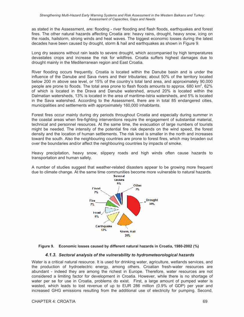
as stated in the Assessment, are: flooding - river flooding and flash floods, earthquakes and forest fires. The other natural hazards affecting Croatia are: heavy rains, drought, heavy snow, icing on the roads, hailstorm, strong winds and heat waves. The biggest economic losses during the latest decades have been caused by drought, storm & hail and earthquakes as shown in Figure 9.
Long dry seasons without rain leads to severe drought, which accompanied by high temperatures devastates crops and increase the risk for wildfires. Croatia suffers highest damages due to drought mainly in the Mediterranean region and East Croatia.
River flooding occurs frequently. Croatia is located within the Danube basin and is under the influence of the Danube and Sava rivers and their tributaries; about 50% of the territory located below 200 m above sea level, or 15% of the country’s total land area, and approximately 90,000 people are prone to floods. The total area prone to flash floods amounts to approx. 680 km2, 62% of which is located in the Drava and Danube watershed, around 20% is located within the Dalmatian watersheds, 13% is located in the area of maritime-Istria watersheds, and 5% is located in the Sava watershed. According to the Assessment, there are in total 85 endangered cities, municipalities and settlements with approximately 160,000 inhabitants.
Forest fires occur mainly during dry periods throughout Croatia and especially during summer in the coastal areas when fire-fighting interventions require the engagement of substantial material, technical and personnel resources. At the same time, the evacuation of large numbers of tourists might be needed. The intensity of the potential fire risk depends on the wind speed, the forest density and the location of human settlements. The risk level is smaller in the north and increases toward the south. Also the neighbouring countries are prone to forest fires, which may broaden out over the boundaries and/or affect the neighbouring countries by impacts of smoke.
Heavy precipitation, heavy snow, slippery roads and high winds often cause hazards to transportation and human safety.
A number of studies suggest that weather-related disasters appear to be growing more frequent due to climate change. At the same time communities become more vulnerable to natural hazards.
Figure 9. Economic losses caused by different natural hazards in Croatia, 1980-2002 (%)
4.1.3. Sectoral analysis of the vulnerability to hydrometeorological hazards
Water is a critical natural resource. It is used for drinking water, agriculture, wetlands services, and the production of hydroelectric energy, among others. Croatian fresh-water resources are abundant - indeed they are among the richest in Europe. Therefore, water resources are not considered a limiting factor for development in Croatia. However, while there is no shortage of water per se for use in Croatia, problems do exist. First, a large amount of pumped water is wasted, which leads to lost revenue of up to EUR 286 million (0.9% of GDP) per year and increased GHG emissions resulting from the additional use of electricity for pumping. Second,

Strengthening Multi-Hazard Early Warning Systems and Risk Assessment in the Western Balkans and Turkey: Assessment of Capacities, Gaps and Needs
CHAPTER 4: CROATIA 70
farmers often face water shortages at certain critical times of the year’s growing season and, in general, the soil lacks moisture. Croatia uses a small fraction of the water resources available (about 1%). However, climate change may stress some of the systems that depend upon freshwater.
The Croatian energy sector is potentially vulnerable if climate change results in more frequently reduced river flows – which is likely given by the predictions of climate models simulating a drier Croatia. In the period 2000 – 2007, 50% of Croatian electricity production came from hydropower. During drought seasons in 2003 and 2007, significant losses in production resulted in increased costs for electricity production. A likely scenario for the future is a direct loss between EUR 16 - 82 million annually, with multiplier effects throughout the economy.
The impact from extreme weather on agriculture is expected to be significant because of the vulnerability of agriculture to climate conditions in general. Precipitation, temperature, weather extremes and flood and droughts do have separate and joined impact on the agricultural production. Agriculture is important to the economy of Croatia due to its overall value and its impact on food security, vulnerable populations, and the employment it generates. In 2001, 92% of Croatia was classified as rural and 48% of the Croatian population lived in rural areas. Generally, rural households are more vulnerable due to poorer access to basic infrastructure and poorer housing conditions than households in urban areas. Existing climate variability already has a significant impact on agriculture. Extreme weather events have resulted in average losses of EUR 176 million per year during 2000-2007. This represents 0.6% of national GDP, or 9.3% of the national Gross Value Added (GVA) generated by the agricultural, forestry and fisheries sector. Looking at the future effect on maize alone, the lost revenue due to climate change is estimated at about EUR 6-16 million in 2050 and EUR 31 - 43 million in 2100. This corresponds to 0.8-5.7% of all revenue from arable crop sales in Croatia in 2005. Most of this damage is due to water shortage during critical phases, as well as flooding and hailstorms, which also cause damage. Critical years, such as 2003 and 2007, showed huge economic damage that is difficult to recover. While some Government-supported insurance programmes and a new irrigation programme exist, current vulnerability to climate variability remains – particularly related to drought and also to flooding recently.
Tourism has long time been important in Croatia. In 2007 only, tourists stayed for a total of 56 million overnights and spent EUR 6.7 billion. Tourism generates about 20% of GDP and 28.7% of total employment (336,000 jobs). Thus, the tourism industry contributes significantly to human development in Croatia through the jobs and created salaries. By 2018, one-third of total employment is expected to occur in the tourism sector. In addition to those directly working in the tourist industry, there are many people employed in related industries that are directly impacted. Tens of thousands of families rely on tourism income in the gray economy and they supplement their incomes through tourism (unregistered apartment rentals, unregistered sales of agricultural, aquaculture or fishery products, etc.). The value of unregistered accommodation alone is equal to almost 1% of the entire country’s GDP. Most projections of tourism in the EU show that by the end of the century, because of climate change, hotter daytime temperatures along the Adriatic coast will cause many beach tourists to avoid these destinations in the summer months in favor of cooler locations at the north. Conversely, the conditions for tourism along the coastline has indicated as improved in the spring and, to a lesser extent, in the autumn. Overlooking these facts could have serious adverse consequences on many local communities and, given important role of beach tourism, to the national economy. Hotter, drier summers with more extreme weather events such as floods and droughts and a rising sea level, may put human and economic development gains at risk.

Strengthening Multi-Hazard Early Warning Systems and Risk Assessment in the Western Balkans and Turkey: Assessment of Capacities, Gaps and Needs
CHAPTER 4: CROATIA 71
4.2. Institutional Framework of Disaster Risk Reduction in Croatia
4.2.1. Legal framework and policy supporting DRR in Croatia
In Croatia the key legal document regulating disaster management is the Protection and Rescue Law, (adopted in 2004 and amended in 2007 and 2009). Other relevant laws regulating issues related to disaster risk reduction and the hydrometeorological sector include:
• Law on the Performance of the Hydro-meteorological Service in the Socialistic Republic of Croatia (Official Gazette No. 14, 1978) defines the responsibilities of DHMZ;
• Law on Physical Planning (Zoning) (OG No. 30/94, 68/98, 35/99, 32/02); • Law on Water (OG No. 48/95); • By–Law on Environmental Information System (OG No. 74/99, 79/99); • Law on the Air Traffic 1998 (e.g., Article 166: Regulations issued by the Minister is based
on the opinion of the DHMZ Director); • Law on the Hail Suppression System (OG No. 53/01).
Other Environmental and Nature Protection Regulations are: • Environmental Protection Act (OG No. 110/07); • Regulation on Environmental Impact Assessment (OG No. 64/08); • Environmental Protection Emergency Plan (OG No. 82/99, 86/99, 12/01, 14/01); • Ordinance on Environmental Emission Inventory (OG No. 36/96).
Other Water Protection Regulations are: • By-law on Hazardous Substances in Water (OG No. 78/98); • The Ordinance on Issuance of Water Management Documents (OG No. 28/96); • Regulation on Limit Values of Indices, Hazardous and Other Substances in Waste Water
(OG No. 40/99, 6/01).
Besides these laws, there is however no specific disaster risk reduction related policy or strategy. DRR is not a defined priority in any framework and strategy and neither does it feature as a driver in achieving the MDGs.
The Strategy of Government Programmes for 2010-2012 has been adopted on September 10, 2009. This strategy directs the work of ministries or state administration bodies and partially addresses disaster management as part of the General Objective 10, “Police and armed forces in the citizens’ service. In addition, within the Specific Objective 12.1. “Environmental protection and effective environmental management” the DHMZ has been tasked to improve the quality and the amount of meteorological (climate related) and hydrological information, and raise awareness and involve the public. Previously, role and mandate of DHMZ was regulated by the Law on the Performance of the Hydro-meteorological Service in the Socialistic Republic of Croatia (OG No. 14/78). Spatial Planning, and Water Management have been addressed as a part of the regional development of the Republic of Croatia but DRR has not yet been tackled.
As per Protection and Rescue Law, the National Protection and Rescue Directorate (NPRD) is developing/updating the National Disaster Preparedness Plan for the Republic of Croatia, based on the National Vulnerability Assessment and Ordinance on the Methodology for the Development of the Risk Assessments and the Rescue and Protection Plans. According to the same Law, other ministries should develop risk assessment related to their area of responsibility, while county and local self-governments are responsible for the development of draft protection and rescue plans (i.e. disaster preparedness plans) for their respective administrative unit.
Strengthening Multi-Hazard Early Warning Systems and Risk Assessment in the Western Balkans and Turkey: Assessment of Capacities, Gaps and Needs
CHAPTER 4: CROATIA 72
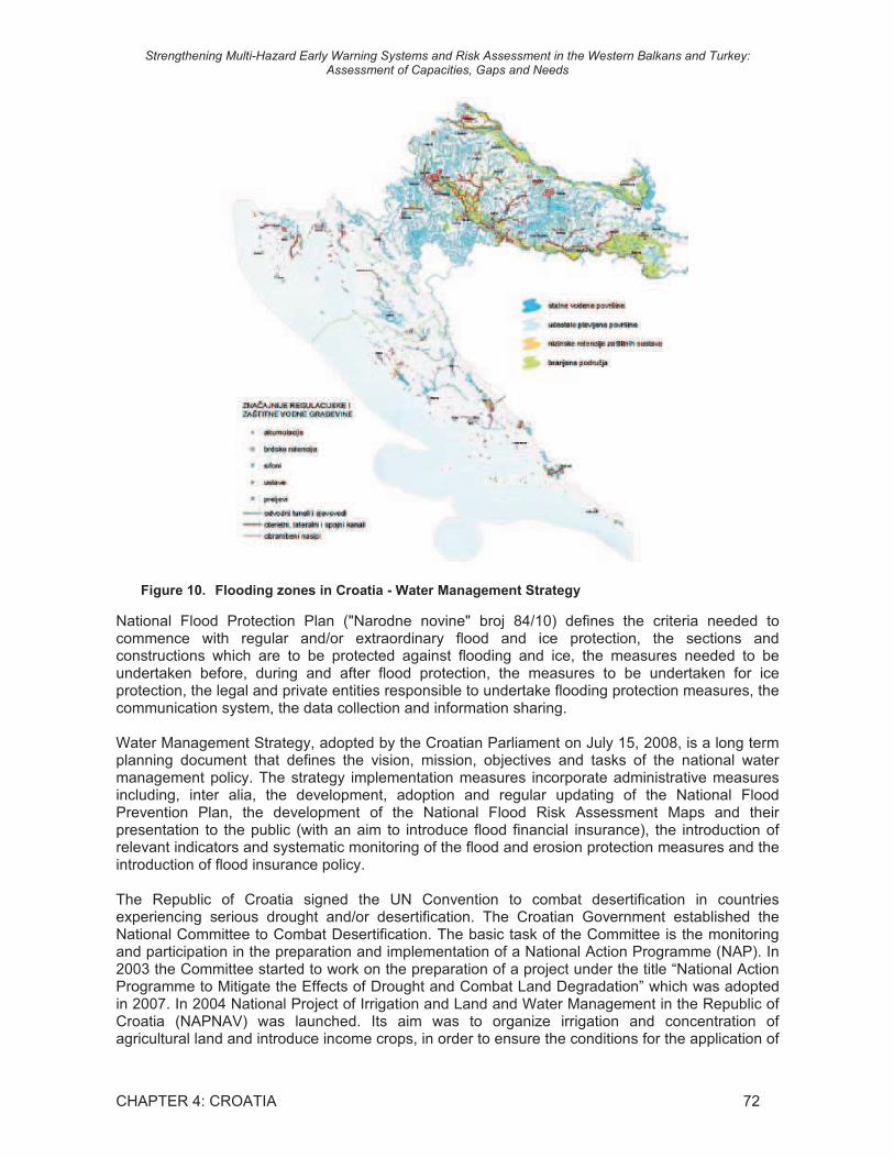
Figure 10. Flooding zones in Croatia - Water Management Strategy
National Flood Protection Plan ("Narodne novine" broj 84/10) defines the criteria needed to commence with regular and/or extraordinary flood and ice protection, the sections and constructions which are to be protected against flooding and ice, the measures needed to be undertaken before, during and after flood protection, the measures to be undertaken for ice protection, the legal and private entities responsible to undertake flooding protection measures, the communication system, the data collection and information sharing.
Water Management Strategy, adopted by the Croatian Parliament on July 15, 2008, is a long term planning document that defines the vision, mission, objectives and tasks of the national water management policy. The strategy implementation measures incorporate administrative measures including, inter alia, the development, adoption and regular updating of the National Flood Prevention Plan, the development of the National Flood Risk Assessment Maps and their presentation to the public (with an aim to introduce flood financial insurance), the introduction of relevant indicators and systematic monitoring of the flood and erosion protection measures and the introduction of flood insurance policy.
The Republic of Croatia signed the UN Convention to combat desertification in countries experiencing serious drought and/or desertification. The Croatian Government established the National Committee to Combat Desertification. The basic task of the Committee is the monitoring and participation in the preparation and implementation of a National Action Programme (NAP). In 2003 the Committee started to work on the preparation of a project under the title “National Action Programme to Mitigate the Effects of Drought and Combat Land Degradation” which was adopted in 2007. In 2004 National Project of Irrigation and Land and Water Management in the Republic of Croatia (NAPNAV) was launched. Its aim was to organize irrigation and concentration of agricultural land and introduce income crops, in order to ensure the conditions for the application of

Strengthening Multi-Hazard Early Warning Systems and Risk Assessment in the Western Balkans and Turkey: Assessment of Capacities, Gaps and Needs
CHAPTER 4: CROATIA 73
new technologies. This should result in better utilization of natural resources for more efficient agricultural production, and finally bring about the development of rural areas.
At the sub-regional level, the Sava River Commission prepared in 2009 the Sava River Action Plan, designed in full coherence with the European Flood Directive (EFD) and flood action plans for sub-basins. The Action Plan requires Member States to first carry out a preliminary flood risk assessment to identify areas at risk of flooding. For such areas Member States would need to draw up flood risk maps and establish flood risk management plans focused on prevention, protection and preparedness.
At the European level, the following regulations of the European Union have been signed by Croatia:
• European Flood Directive of 18 September 2007 on the assessment and management of flood risks;
• Council Directive 90/313/EEC of 7 June 1990 on the freedom of access to information on the environment;
• Commission Decision 2008/721/EC of 5 August 2008 setting up an advisory structure of Scientific Committees and experts in the field of consumer safety, public health and the environment and repealing Decision 2004/210/EC;
• Directive 2008/50/EC of the European Parliament and of the Council of 21 May 2008 on ambient air quality and cleaner air for Europe.
And at the International levels, the following treaties have been signed by the Republic of Croatia: • Law on Ratification of the United Nations Framework Convention on Climate Change (Rio
de Janeiro 1992); • Kyoto Protocol to the Convention on Climate Change (Kyoto 1999); • Convention on Long-range Transboundary Air Pollution (Geneva 1979); • Protocol to the Convention on Long-range Transboundary Air Pollution on Long Term
Financing of the Cooperative Programme for Monitoring and Evaluation of the Long-range Transmission of Air Pollutants in Europe (Geneva, 1984);
• Protocol to the 1979 Convention on Long-range Transboundary Air Pollution on Further Reduction of Sulfur Emissions (Oslo 1994);
• Protocol to the 1979 Convention on Long-range Transboundary Air Pollution on Persistent Organic Pollutants (Aarhus 1998);
• Stockholm Convention on Persistent Organic Pollutants (Stockholm 2001); • Law on Ratification of the United Nations Convention to Combat Desertification in Countries
Experiencing Serious Drought and/or Desertification, Particularly in Africa – Convention to Combat Desertification (Paris 1994);
• Cooperation Agreement with WMO, International Civil Aviation Organization (ICAO), and EUMETSAT;
• Cooperation Agreement with ECMWF, EUMETNET, and Economic Interest Grouping of the National Meteorological Services of the European Economic Area (ECOMET).
At the moment, the existing legal framework does not properly recognize DRR in Croatia. Disaster risk reduction and disaster prevention and mitigation are not addressed nor recognized as topics by the Protection and Response Law. The Law equals them with the activities aimed to eliminate the consequences of disasters. Within that framework, the national protection and rescue system, and its key actor NPRD, has been more oriented toward preparedness for rescue and emergency response rather then to disaster prevention.
4.2.2. Institutional framework
4.2.2.1. List of agencies involved in DRR
The Government of the Republic of Croatia is responsible for the management and efficient functioning of the protection and rescue system in disasters. At the same time, the responsibilities

Strengthening Multi-Hazard Early Warning Systems and Risk Assessment in the Western Balkans and Turkey: Assessment of Capacities, Gaps and Needs
CHAPTER 4: CROATIA 74
related to DRR, disaster prevention and mitigation are widely distributed among various institutions within the state administration. The organization and structures established at national level are, in general terms speaking, mirrored at the other administrative levels. There is no DRR leading agency, although National Protection and Rescue Directorate (NPRD) is contributing to the overall DRR coordination. DRR is highly diversified, both at the legislative and organizational/institutional level, with several Ministries and Governmental entities being responsible for different aspects of disaster prevention and mitigation, while NPRD has been focused primarily on preparedness for response and response. The agencies engaged in DRR for hydrometeorological hazards are:
• The National Protection and Rescue Directorate (NPRD); • The Croatian Meteorological and Hydrological Service (DHMZ); • The Croatian Waters (CW).
4.2.2.2. National Protection and Rescue Directorate
The National Protection and Rescue Directorate (NPRD) is an independent, professional and administrative organization in the Republic of Croatia, which prepares, plans and manages the operational forces and coordinates actions of all the protection and rescue system. The basic NPRD tasks are stipulated by the Law on Protection and Rescue. The most important tasks are risk and vulnerability assessment (not for floods nor drought), drafting measures aimed at preventing crises and accidents, ensuring that these measures are implemented, and effective emergency management in case of major disasters.
The 112 center of NPRD is the established mechanism for continuous collection and sharing of general risk information. The Service 112 reports on all risks and hazards, and if needed, alerts citizens, legal entities, administration bodies, rescue services, respective civil protection forces and relevant NPRD management. The Service also keeps records on hazards, accidents and disasters, and maintains the public alarm system in the Republic of Croatia and coordinates decisions and orders sharing.
Concerning DRR, the NPRD has the following essential functions: • to estimate the risk of disasters and major accidents to the area, the cause or subject, and
to hold vulnerability assessments and develop plans for protection and rescue of local (regional) governments;
• to prepare statutory guidance for risk management to all protection and rescue stakeholders;
• to monitor and analyse the situation in the field of protection and rescue, and to propose to Croatian Government measures to improve the situation and directing the development of protection and rescue system;
• to collect, analyze and direct the data on hazards and consequences of disasters and major accidents in a single information system;
• to lead a unified information database of operational forces, means and measures taken in the protection and rescue;
• to propose to the Croatian Government assessment of threats and plan for protection and rescue of Croatian;
• to perform the preparation, construction and maintenance of public warning systems, • to perform regular duties of 112; • to develop and update the bylaws and standard operating procedures; • to propose types and amounts of state commodity reserves necessary for the protection
and rescue; • to collaborate with industry and scientific institutions in developing technology and
equipment for protection and rescue; • to cooperate with the competent authorities of other countries and international
organizations to protect and rescue.
NPRD is divided into organizational entities (Figure 11). The central national administration consists of the Directors Cabinet, International Cooperation Department and the Internal Affairs

Strengthening Multi-Hazard Early Warning Systems and Risk Assessment in the Western Balkans and Turkey: Assessment of Capacities, Gaps and Needs
CHAPTER 4: CROATIA 75
Department as well as five sectors: (i) Civil Protection Sector (ii) Fire Fighting Sector (iii) Sector for 112 System (iv) Fire Fighting and Protection and Rescue School and (v) Personnel, Legal and Finance Sector. The functionality of the Directorate is ensured through its territorial organization i.e. each County has a County Protection and Rescue Office consisting of Prevention, Planning and Supervision Department and the County 112 center. In County Offices of the four biggest cities Zagreb, Rijeka, Osijek and Split there are Protection and Rescue Departments, while in the County Offices on the coast (Zadar, Šibenik, Split and Dubrovnik) there are also State Intervention Units (Figure 12).
Figure 11. NPRD structure
StructureStructure ofof NationalNational ProtectionProtection andand RescueRescue DirectorateDirectorate::
20 COUNTY OFFICES
- Protection & Rescue Department
- County 112 Centre
NATIONAL INTERVENTION UNIT
Figure 12. NPRD offices and units
DIRECTOR
DEPUTY DIRECTOR
INTERNATIONAL COOPERATION DEPARTMENT
CIVIL PROTECTION SECTOR
FIREFIGHTING SECTOR
SECTOR FOR 112 SYSTEM
FIREFIGHTING, P&R SCHOOL
PERSONNEL, LEGAL & FINANCE SECTOR
Assistant DirectorAssistant DirectorAssistant Director Assistant DirectorAssistant Director
DIRECTOR’S CABINET
National Level
COUNTY PROTECTION AND RESCUE OFFICEHEAD OF OFFICE
PREVENTION, PLANNING AND INSPECTION DEPT.
COUNTY 112 CENTRENATIONAL INTERVENTION UNITS
(X 4)
ADMINISTRATIVE COMPETENCEEXPERT COMPETENCE
County Level
PROTECTION AND RESCUE DEPT. (X4)
INTERNAL REVISON DEPT.
DIRECTOR
DEPUTY DIRECTOR
DIRECTOR
DEPUTY DIRECTOR
INTERNATIONAL COOPERATION DEPARTMENT
CIVIL PROTECTION SECTOR
FIREFIGHTING SECTOR
SECTOR FOR 112 SYSTEM
FIREFIGHTING, P&R SCHOOL
PERSONNEL, LEGAL & FINANCE SECTOR
Assistant DirectorAssistant DirectorAssistant Director Assistant DirectorAssistant Director
DIRECTOR’S CABINET
National Level
COUNTY PROTECTION AND RESCUE OFFICEHEAD OF OFFICE
PREVENTION, PLANNING AND INSPECTION DEPT.
COUNTY 112 CENTRENATIONAL INTERVENTION UNITS
(X 4)
ADMINISTRATIVE COMPETENCEEXPERT COMPETENCE
County Level
PROTECTION AND RESCUE DEPT. (X4)
COUNTY PROTECTION AND RESCUE OFFICEHEAD OF OFFICE
PREVENTION, PLANNING AND INSPECTION DEPT.
COUNTY 112 CENTRENATIONAL INTERVENTION UNITS
(X 4)
ADMINISTRATIVE COMPETENCEEXPERT COMPETENCE
County Level
PROTECTION AND RESCUE DEPT. (X4)
COUNTY PROTECTION AND RESCUE OFFICEHEAD OF OFFICE
COUNTY PROTECTION AND RESCUE OFFICEHEAD OF OFFICE
PREVENTION, PLANNING AND INSPECTION DEPT.
COUNTY 112 CENTRENATIONAL INTERVENTION UNITS
(X 4)NATIONAL INTERVENTION UNITS
(X 4)
ADMINISTRATIVE COMPETENCEEXPERT COMPETENCE
ADMINISTRATIVE COMPETENCEEXPERT COMPETENCE
County Level
PROTECTION AND RESCUE DEPT. (X4)
INTERNAL REVISON DEPT.

Strengthening Multi-Hazard Early Warning Systems and Risk Assessment in the Western Balkans and Turkey: Assessment of Capacities, Gaps and Needs
CHAPTER 4: CROATIA 76
4.2.2.3. Croatian Meteorological and Hydrological Service
DHMZ is part of Croatian governmental administration. As a central state institution it has responsibilities in meteorology, hydrology, climatology and air quality. DHMZ reports directly to the Ministry of Finance, so the arrangement is different from the European NHMSs, which typically are under other ministries. Currently the role of DHMZ is to provide basic statistics and analyses of extremes and climate variability to be used for strategy planning of DRR, but it is not actively included into the planning procedure of the DRR system in the country.
DHMZ is a national centre of exellence based on high standards of scientific, professional and technical resources for the production, collection and dissemination of high-quality meteorological and hydrological information. DHMZ basic tasks are stipulated by the Law on meteorological and hydrological activities in Croatia as follows: to provide support to economic development, environment protection, to act towards the preservation of life and material goods from natural hazards and disasters and to mitigate their consequences.
The role of DHMZ is defined in the “Law on the Performance of the Hydro-meteorological Service in the Socialistic Republic of Croatia (OG No. 14/78)” issued 11.4.1978:
• to be responsible for national observation networks (meteorology, hydrology, air quality, sea water quality, fresh water quality);
• to give warnings on coming hydrometeorological hazards and their development; • to provide reports, forecasts and warnings to the relevant republic administrative entities on
hydro-meteorological hazards valuable for floods and other risks protection, as well as for the navigation security, and to provide reports and forecasts on air pollution and warnings on sudden pollutions of rivers, lakes, see and air;
• to participate in national and international exchange of data and information.
DHMZ is also responsible for international work, cooperation and implementation of work and activities under the Framework Convention on Climate Change, and Vienna Convention on the protection of the ozone layer.
Meteorological and Hydrological Service of Croatia is composed by eight research and operational divisions as described in Figure 13.
Concerning DRR, the DHMZ produces services and actions for different levels of the DRR community in coordination with the National Protection and Rescue Directorate at national and community level. The role of DHMZ is to provide basic statistics and analyses of extremes and climate variability to be used for strategy planning of DRR, but it is not actively included into the planning procedure of the DRR system in the country. Concerning floods risk assessment, DHMZ is a provider of hydrological and meteorological data to CW, which has the mandate for floods risk assessment for defense planning. DHMZ provides also short/medium/long term weather forecasts for floods forecasting. Concerning drought, DHMZ performs hazard assessment and mapping, even if no other institution is in charge of drought risk assessment. It should be noticed that DHMZ produces forest fires risk mapping, which is very closely linked with drought. DMHZ has also established Disaster Risk Reduction Focal Point that coordinates activities at national, regional and international level.
An important milestone of DHMZ implication in DRR was the beginning of the performance of METEOALARM on 13th July 2009.
Finally, DHMZ is still very active in performing partnership with media and issuing meteorological and hydrological information on internet, newspapers, mobile, radio and television, including weather presentation at the national and private radio and television stations.

Strengthening Multi-Hazard Early Warning Systems and Risk Assessment in the Western Balkans and Turkey: Assessment of Capacities, Gaps and Needs
CHAPTER 4: CROATIA 77
Figure 13. Structure of DHMZ
Budget of DHMZ is about 15 M€ in 2011, as well as in next 2 years i.e. for 2012 and 2013, respectively. Remarkably, hail suppression activity is still performing by ~ 5 M€ budget support. It is assured coverage of total DHMZ performance by the state budget up to 95%, still not canceling non-profit activity what is 16% of 2008 DHMZ budget. These non-profit funds are not adding to the DHMZ total budget because it is drowned in the state budget. The benefit of this non-profit contribution is in raising the DHMZ cost-benefit scale and has convincing potential in applying for budget rebalances for more funds.
In Croatia there also other entities, which provide hydrological or meteorological services and operate observations or observation networks. These include:
• Croatian Air Navigation Services (www.crocontrol.hr) is a state institution in charge of aeronautical weather service. Aviation meteorology division from Croatian Air Control operates synoptic meteorological stations at main airports;
• Croatian Army has its own meteorological unit; • Hrvatske Autoceste operates about 100 automatic weather stations along the motorways; • Institute of Oceanography and Fishery; Hydrographic Institute Split and Ruder Boskovic
Institute are active in oceanography; • Croatian Health Institute performs Air quality monitoring.
4.2.2.4. Croatian Waters
Croatian Waters (CW) is the responsible governmental organization for flood risk management, floods risk assessment and for floods defense planning. CW conducts integrated management of Croatian water resources on four river basin districts comprising one or more river basins of the major watercourses or parts thereof, which constitute a natural hydrographic unit, as follows:
• The river basin district of the Sava River basin ; • The river basin district of the Drava and Danube river basins; • The river basin district of the Istrian-Littoral basin; • The river basin district of the Dalmatian basin.

Strengthening Multi-Hazard Early Warning Systems and Risk Assessment in the Western Balkans and Turkey: Assessment of Capacities, Gaps and Needs
CHAPTER 4: CROATIA 78
The main activities of Croatian Waters, based on the principle of sustainable development and conducted with the purpose of achieving integrated water management, are the following:
• protection from adverse effects of water; • water use; • protection of water from pollution.
Figure 14. Croatia Waters structure
Croatian Waters activities related to floods risk reduction are: • monitoring the quantities and levels of surface water, groundwater, and sediment; • regulation of watercourses, construction of water regulation and water protection structures,
as well as of water structures for amelioration drainage; • technical and economic maintenance of watercourses, water estate, water regulation and
water protection structures, including maintenance of navigable waterways and structures for the protection against erosion and torrents, as well as of water structures for amelioration drainage;
• protection from floods on state waters in accordance with the National Flood Protection Plan;
• protection from floods on local waters, protection from erosion and torrents, and amelioration drainage in accordance with flood protection plans for catchment areas enacted by county assemblies;
• coordinating implementation of the National Water Protection Plan, coordinating water protection planning of regional and local communities.

Strengthening Multi-Hazard Early Warning Systems and Risk Assessment in the Western Balkans and Turkey: Assessment of Capacities, Gaps and Needs
CHAPTER 4: CROATIA 79
The Croatian Waters have signed an agreement with the 112 center of NPRD concerning flood risk and pollution risk (water quality) for fresh water and coastal waters.
Croatian Waters also has an agreement with DHMZ; they share the observation network, data and databases. DHMZ produces quality controlled national and international (transboundary rivers) hydrological data (both near real-time and historical) in agreed format. Concerning flash floods warnings, the responsibility is shared between DHMZ and Croatian Waters. For defense of river floods Croatian Waters is responsible for fighting against the flood (with assistance of army and others), while warning of the people is the responsibility of the 112 center of NPRD.
4.2.2.5. Institutional mapping of the key vulnerable sectors
Ministry of Economy, Labor and Entrepreneurship conducts active policy of employment and administrative and other work concerning:
• Industry, except food and tobacco industry; shipbuilding; energy; mining; crafts; cooperatives, except agricultural; small and medium entrepreneurship; trade; trade politics; national production protection politics; economic cooperation with foreign countries;
• Involvement in European economic integration; coordination of activities concerning Croatia's membership in the World Trade Organization and participation in multilateral trade negotiations within the framework of this organization;
• Export and foreign investment promotion; establishment and development of entrepreneurial and free zones, situation and market appearances; supply and prices; consumer protection; strategic commodity reserves; privatization of shares and stakes in companies owned by the Republic of Croatia; restructuring and recovery of legal entities is a part of the Ministry of Economy activities.
The Ministry of Economy conducts administrative and other work concerning: work relations; labor market and employment; relationships with unions and employers' associations; labor law status of Croatian citizens employed in foreign countries and work concerning their return and employment in the county; labor law status of aliens employed in the Republic of Croatia; occupational safety; international cooperation in labor and employment sector and pension and disability insurance system and policy. The Ministry of economy also conducts work concerning: promotion and systematic enhancement of crafts, cooperatives, except agricultural, small and medium entrepreneurship; effects of economic system instruments and economic policies and measures on the development of crafts, cooperatives, small and medium entrepreneurship and business activities of craftsmen and entrepreneurs; realization of international cooperation, implementation of special programs of the Government of the Republic of Croatia in the area of crafts, cooperatives, small and medium entrepreneurship.
Ministry of Agriculture, Fisheries and Rural Development does administrative and other tasks related to: state border inspection of plant's protection and state border veterinary inspection; setting up and carrying out of land management, except ownership rights; regulation of legal rights on agricultural land, forests and forest land owned by the state, except ownership rights; forestry and hunting; inspection tasks related to agriculture, fishing, forestry and hunting, quality of agricultural and food products and veterinary medicine; carrying out the stimulative measures in agriculture and fishing and their adjustment to the World Trade Organization criteria; regulation and coordination of co-financing with the state budget of agriculture, fishing and processing of agricultural products; agricultural co-operatives; protection and recognition of agricultural plant species; protection of agricultural land; definition of registration procedures for agricultural land; management and disposition of state owned agricultural land; conversion of agricultural land to building land; regulation of relations and terms of manufacture, transport and use of plant protection agents in agriculture and forestry; definition of terms of manufacture of wine and other grape and wine derived products; carrying out of measures for detection and prevention of contagious diseases of animals and definition of terms and means of carrying out of disinfections and pest control; definition of boundaries between inner and outer fishing sea belt, fishing boundaries and definition of purpose, type and quantity of fishing tools and equipment which may be used in fishing.

Strengthening Multi-Hazard Early Warning Systems and Risk Assessment in the Western Balkans and Turkey: Assessment of Capacities, Gaps and Needs
CHAPTER 4: CROATIA 80
The Ministry of Tourism regulates tourism “industry” in Croatia, especially, coordinating marketing and promotion of Croatia as touristic destination. It was shown that tourism in Croatia could be under influence of global climate worming including effects of sea-level rise and water supply. During summer it can become uncomfortable in some areas while the touristic season could be longer in general. Services in the tourism sector within the tourism sector are: the provision of services of a tourist agency, tourist guide, tourist escort, entertainment organizer, agency representative, tourism services in nautical tourism, tourism services on rural farms or family agricultural farms, tourism services in other forms of the tourism offer and other services provided to tourists in connection with their travel and stay.
The Ministry of Environmental Protection, Physical Planning and Construction performs administrative and other tasks related to general policy of environmental protection in order to fulfill conditions for sustainable development; protection of air, soil, water, sea, plant and animal life in the totality of their interaction; ensuring the monitoring of the status of air, soil and marine environment pollution and ensuring the implementation of measures to prevent air, soil and marine environment pollution and protection measures; preparation of measures to improve the environmental protection status and to implement the environmental protection goals laid down in the environmental protection strategy and to prepare reports on the environmental status in the state; proposing, promoting and monitoring of measures for environmental protection improvement; ensuring implementation of environmental impact assessment; ensuring implementation of the pollution cadastre; systematic monitoring of the environmental status; keeping of the environmental information system; establishing environmental measures, requirements and approvals; care, co-ordination and supervision of financing environmental protection programmes; waste management; preparation of proposals for environmental protection standards; assessment of working conditions for legal and natural persons in the field of environmental protection; achievement of international environmental protection co-operation; administrative supervision and supervision over the expert work of the Environmental Protection and Energy Efficiency Fund; environmental protection inspection; encouragement of environmental protection-related education and research. The Ministry performs administrative and other tasks related to physical planning in the Republic of Croatia and coordination of regional physical development; planning, use and protection of space; international cooperation in physical planning; spatial planning inspection tasks; spatial information system; monitoring of the status of space and implementation of physical planning documents of the Republic of Croatia; location permits; cooperation in development of physical planning documents of counties, cities and municipalities in order to ensure requirements for management and protection of space and coordination of activities of state administration bodies participating in development, adoption and implementation of physical planning documents; ensuring requirements for development and improvement of operation of legal and physical persons in the field of physical planning; settlement planning and regulation of the building land use. The Ministry performs administrative and other tasks related to the establishment of requirements for the designing and construction of construction works; business operation of legal and physical persons in the field of construction, the Croatian Chamber of Architects and Civil Engineers and other engineers involved in construction; monitoring and analyzing the quality of construction and designing services in construction; construction and use permits; use, maintenance and removal of construction works; building inspection tasks, as well as conducting administrative procedures in the field of housing and municipal economy. The Ministry performs administrative and other tasks related to the functioning of instruments and measures of economic policy in construction; housing; housing policy; apartment and settlement construction; social and official apartments; implementation of special programmes of the Government of the Republic of Croatia in housing; municipal economy; policy, monitoring and improvement of the status in municipal economy; international cooperation in construction and housing.
Ministry of Science, Education and Sport is in charge of administrative and other activities relating to the following: preschool education, elementary school and secondary education in the country and abroad; curriculum; textbooks, educational standards; development of the educational system; professional education and permanent education of kindergarten and school teachers;

Strengthening Multi-Hazard Early Warning Systems and Risk Assessment in the Western Balkans and Turkey: Assessment of Capacities, Gaps and Needs
CHAPTER 4: CROATIA 81
student standard; inspection and professional and pedagogic control; establishment of educational institutions and control of their compliance with the laws; securing financial and material conditions for work in education; qualifying the children, youth and adults for acquiring technical knowledge and skills, and activities of various associations in its domain. The Ministry also performs administrative and other activities relating to the following: system and design of curricula for higher education in the country and abroad, and securing financial and material conditions for work, professional education and permanent education of teachers, accommodation, food and other issues relating to student standard, and inspection in higher education. The Ministry performs administrative and other activities relating to the following: development of the scientific-research activities and scientific and technical information and communications; development of scientific-research and other legal persons; development of science and application of scientific achievements in certain areas, harmonization of the financing program of constant research activity and contractual projects for the purpose or realization of the national scientific-research program and scientific programs of special interest; planning, harmonization and implementation of IT development and its interconnection into an integral IT system of the Republic of Croatia; monitoring, recording and realization of scientific, technical and technological cooperation with foreign countries and international organizations pursuant to international agreements; sending Croatian experts abroad and participation of foreign experts in research in the Republic of Croatia, cooperation with Croatian experts abroad; activities regarding scholarships, specialist training and practical training of Croatian and foreign experts pursuant to international, national, business and other agreements. The Ministry performs administrative and other activities relating to the following: development of sports and physical education; protection and advancement of the health of children, youth and adults, and to the activities of sports associations. The Ministry performs administrative and other activities relating to the following: qualification of children, youth and adults for acquiring technical knowledge, and skills, and to the activities of associations in the field.
Ministry of Regional Development, Forestry and Water Management, performs among other administrative and other tasks related to: planning, implementation and coordination of regional development policy, encouraging the development of areas lagging behind the national average development, encouraging the development of cross-border, transnational and interregional cooperation and project development for the use of pre-accession funds of the European Union and other international sources of funding intended for regional development; Coordination of all activities related to harmonization with the EU in regional policy and structural instruments; Forestry, forest protection, regulation of relations in the woods and forest land owned by the state, keeping records of forests and other registers; Planning and relations of production, transport and use of forest seeds and forest seedlings, forest ecology, forest protection against natural disasters and human impacts, fires, conservation of forest genetic resources and forest reproductive material; timber industry, a record capacity for primary processing of wood, manufacture of pulp, paper and other wood industry capacity, monitoring and analysis of wood products in the EU and the world, encouraging the use of renewable energy in the form of biomass, improving the processing and use of wood and wood products; Defining the national policy of water management and coordination of water management development with the needs of economic development and EU accession process, and the conclusion and implementation of intergovernmental agreements and other documents in the field of water management, organization and implementation of projects in water management; water management and water-economic system, regulation of watercourses and other water and protection from the harmful effects of water and ice; protection from erosion and torrents of water protection and protection of the sea from pollution from land; hydro drainage and irrigation; securing water supplies to supply the village with drinking water and industrial water to the economy, the use of water power: planning and coordinating the development and construction of public water supply systems and public sewerage systems of national interest; Inspection for protection from water, water use and water protection from pollution.
Ministry of the Sea, Transport and Infrastructure does administrative and other tasks related to: protection of the sea from the ship caused pollution; sea ports, maritime property and definition of borders of maritime property, marine insurance and maritime agencies; inland waterways ports;

Strengthening Multi-Hazard Early Warning Systems and Risk Assessment in the Western Balkans and Turkey: Assessment of Capacities, Gaps and Needs
CHAPTER 4: CROATIA 82
shipping centres on land; airports; means of transport except the tasks which are responsibility of other ministries; telecommunications and post; definition of technical prerequisites and terms of use of facilities, technical equipment and installations of telecommunications and radio communications; legislation of subordinated laws and regulations about concessions for providing public telecommunication services; broadcasting and distribution of radio and television programmes; international coordination of utilization of radio frequency ranges, domestic utilization of radio frequency ranges; issuing of permits for radio stations to domestic and foreign persons; inspection duties; safety of maritime shipping, domestic and international road traffic and roads, except the tasks which are the responsibility of Ministry of Interior, rail traffic safety, air traffic safety, inland waterways traffic safety, telecommunications and post, domestic and international postal and telecommunications traffic and regulation of radio frequency ranges; tasks of Coast Guard (port authorities).
Figure 15. Water Management decision-making diagram in Croatia
4.2.3. Operational relationship with Disaster Risk Management and other Technical agencies
At national level, there is a disaster management system in place, which is predominantly disaster preparedness and response oriented.
The NPRD is the leading organization for the protection and rescue of people, assets and environment. The NPRD collects data, establishes data-bases and records on all events, accidents and disasters in country as well as on big accidents and disasters abroad, disaggregates their consequences and protection and rescue intervention modalities; it analyses data per categories, time and geographic area, and reports on them on monthly and yearly basis to the government; it monitors the protection and rescue situation, collects and analyses data on hazards and disaster consequences, and keeps the records on operational protection and rescue forces, their location, equipment and material needs, in a single GIS database.
Other governmental entities, such as DHMZ, Republic Seismological Survey, Croatian Forests, Croatian Waters and similar, are also collecting, storing and analyzing data and information from their respective area of responsibility, relevant for effective and efficient disaster management. All of them are linked to the integrated operational-communicational centre (Centre 112), and information is shared via System 112.
Strengthening Multi-Hazard Early Warning Systems and Risk Assessment in the Western Balkans and Turkey: Assessment of Capacities, Gaps and Needs
CHAPTER 4: CROATIA 83
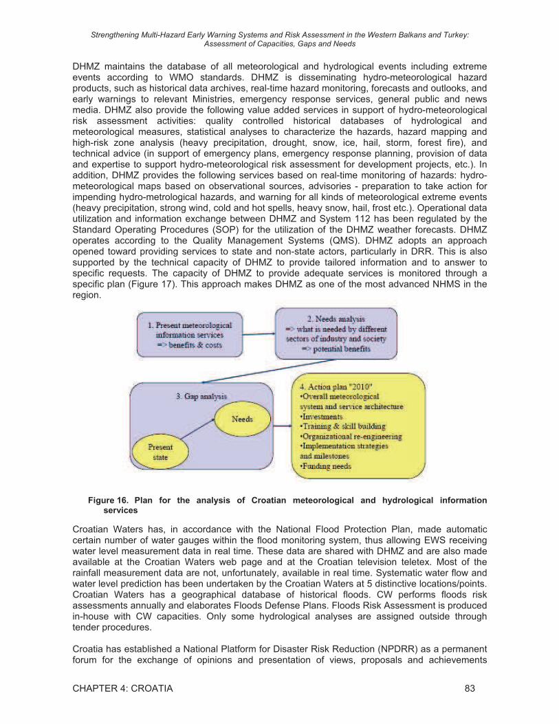
DHMZ maintains the database of all meteorological and hydrological events including extreme events according to WMO standards. DHMZ is disseminating hydro-meteorological hazard products, such as historical data archives, real-time hazard monitoring, forecasts and outlooks, and early warnings to relevant Ministries, emergency response services, general public and news media. DHMZ also provide the following value added services in support of hydro-meteorological risk assessment activities: quality controlled historical databases of hydrological and meteorological measures, statistical analyses to characterize the hazards, hazard mapping and high-risk zone analysis (heavy precipitation, drought, snow, ice, hail, storm, forest fire), and technical advice (in support of emergency plans, emergency response planning, provision of data and expertise to support hydro-meteorological risk assessment for development projects, etc.). In addition, DHMZ provides the following services based on real-time monitoring of hazards: hydro-meteorological maps based on observational sources, advisories - preparation to take action for impending hydro-metrological hazards, and warning for all kinds of meteorological extreme events (heavy precipitation, strong wind, cold and hot spells, heavy snow, hail, frost etc.). Operational data utilization and information exchange between DHMZ and System 112 has been regulated by the Standard Operating Procedures (SOP) for the utilization of the DHMZ weather forecasts. DHMZ operates according to the Quality Management Systems (QMS). DHMZ adopts an approach opened toward providing services to state and non-state actors, particularly in DRR. This is also supported by the technical capacity of DHMZ to provide tailored information and to answer to specific requests. The capacity of DHMZ to provide adequate services is monitored through a specific plan (Figure 17). This approach makes DHMZ as one of the most advanced NHMS in the region.
Figure 16. Plan for the analysis of Croatian meteorological and hydrological information services
Croatian Waters has, in accordance with the National Flood Protection Plan, made automatic certain number of water gauges within the flood monitoring system, thus allowing EWS receiving water level measurement data in real time. These data are shared with DHMZ and are also made available at the Croatian Waters web page and at the Croatian television teletex. Most of the rainfall measurement data are not, unfortunately, available in real time. Systematic water flow and water level prediction has been undertaken by the Croatian Waters at 5 distinctive locations/points. Croatian Waters has a geographical database of historical floods. CW performs floods risk assessments annually and elaborates Floods Defense Plans. Floods Risk Assessment is produced in-house with CW capacities. Only some hydrological analyses are assigned outside through tender procedures.
Croatia has established a National Platform for Disaster Risk Reduction (NPDRR) as a permanent forum for the exchange of opinions and presentation of views, proposals and achievements
Strengthening Multi-Hazard Early Warning Systems and Risk Assessment in the Western Balkans and Turkey: Assessment of Capacities, Gaps and Needs
CHAPTER 4: CROATIA 84
regarding DRR in all areas of human activity. The goal of the Platform is to provide guidance in integrating DRR in state policies and raising awareness of safety culture primarily through education. Platform produces annual reports and produces a platform to different organizations to meet and change opinions about the DRR. DHMZ is a member of the platform. Currently the platform has no legal or statutory basis being largely an ad hoc discussion forum.
There are no DRR focal points in the sectoral ministries although members of the Croatian National Platform Committee might be considered as such. The NPRD is the key entity for coordination, organization and management of disaster management issues, including emergency preparedness and response. The DHMZ, within its own structure, has established DRR Focal Point that coordinates activities at national, regional and international level.
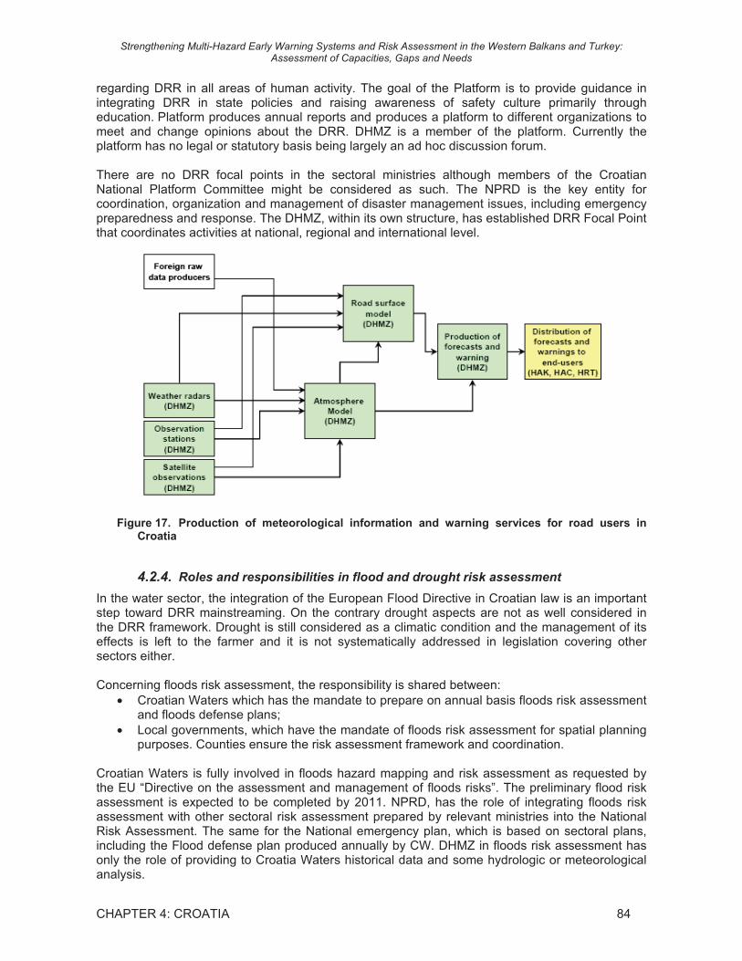
Figure 17. Production of meteorological information and warning services for road users in Croatia
4.2.4. Roles and responsibilities in flood and drought risk assessment
In the water sector, the integration of the European Flood Directive in Croatian law is an important step toward DRR mainstreaming. On the contrary drought aspects are not as well considered in the DRR framework. Drought is still considered as a climatic condition and the management of its effects is left to the farmer and it is not systematically addressed in legislation covering other sectors either.
Concerning floods risk assessment, the responsibility is shared between: • Croatian Waters which has the mandate to prepare on annual basis floods risk assessment
and floods defense plans; • Local governments, which have the mandate of floods risk assessment for spatial planning
purposes. Counties ensure the risk assessment framework and coordination.
Croatian Waters is fully involved in floods hazard mapping and risk assessment as requested by the EU “Directive on the assessment and management of floods risks”. The preliminary flood risk assessment is expected to be completed by 2011. NPRD, has the role of integrating floods risk assessment with other sectoral risk assessment prepared by relevant ministries into the National Risk Assessment. The same for the National emergency plan, which is based on sectoral plans, including the Flood defense plan produced annually by CW. DHMZ in floods risk assessment has only the role of providing to Croatia Waters historical data and some hydrologic or meteorological analysis.

Strengthening Multi-Hazard Early Warning Systems and Risk Assessment in the Western Balkans and Turkey: Assessment of Capacities, Gaps and Needs
CHAPTER 4: CROATIA 85
Concerning drought, there is no institution in charge of risk assessment. DHMZ produces drought indices and drought mapping (meteorological and agricultural drought). DHMZ provides characterization and mapping of extreme events (including drought related parameters) to the Ministry of Agriculture for the assessment of exposure to climatic risks.
Figure 18. Workflow for drought and floods risk assessment in Croatia
National risk maps are available for the national level as part of the Natural and Man-made Catastrophes and Big Disasters Vulnerability Assessment. At the moment this assessment covers only the national level. Counties and local self-governments have commenced developing their respective vulnerability assessments: 90% have contracted the risk assessment development, 50% have started the development and 15% have finished the risk assessments. Risk maps should be part of the vulnerability assessments done at the regional and local self-government levels.
Up to now DHMZ has not participated in national projects to produce actual risk analyses for DRR or economic sectors. But, due to fact that most of the natural hazards are related to weather and climate it is natural that the DHMZ needs to have a very active and visible role in DRR. The DHMZ should be integrated into the DRR planning process in order to exploit its scientific capability and technical capacity in hazard characterization and mapping. In order to achieve this goal, the cooperation at the national level between DHMZ and NPRD and relevant institutions and end-users should be improved to further enhance national system for preventing and mitigating the impact of extreme weather and climate events.
4.2.5. Budget and funding for DRR
At the national level funding mechanism is a combination of a budget allocations for the National Protection and Rescue Directorate, other respective Governmental entities (DHMZ, Croatian Waters, Croatian Forests) and funds allocated for the implementation of specific disaster protection plans (like National Flood Protection Plan, Intervention Plan during Wild and Forest Fires on the territory of the Republic of Croatia and Activity Program for the Implementation of the Special Fire Protection Measures in Republic of Croatia in 2010). At the county and local self-government levels, fund should be allocated in their respective budgets.

Strengthening Multi-Hazard Early Warning Systems and Risk Assessment in the Western Balkans and Turkey: Assessment of Capacities, Gaps and Needs
CHAPTER 4: CROATIA 86
4.3. Technical Capacities of Hydrometeorological Services to support Disaster Risk Reduction
4.3.1. Monitoring and observations networks and data exchange
Observations, and especially the upper air observations are essential for global, regional and local weather forecasting and numerical modelling of the atmosphere. Long-time historical time series of accurate quality controlled observations are required for hazard analyses, climatological studies and monitoring of climate change. Real-time observations are critical for:
• prompt reaction in meteorological, hydrological and air quality emergency situations; • reduction of vulnerability to the risks of meteorological, hydrological and environmental
hazards; • short term forecasts; • validation of forecasting models; • improved data assimilation, which will benefit the global, regional, local and mesoscale
NWP modelling.
DHMZ has a relatively dense hydro-meteorological observation network (Table 21). The most important parameters collected by DHMZ are: air temperature, humidity and pressure, wind speed and direction, snow depth, sunshine duration, cloudiness, potential evapotranspiration, soil and sea temperature, river level and discharge. The DHMZ main weather stations are operated by professional observers, from 2 to 5 per stations. For the time been on all main weather stations, in exception of the wind, weather parameters are parallel measured by observers and electronic sensors. A few number of ordinary and rainfall stations is equipped with electronic sensors (about 32) mainly used for specific users like National Electricity Company, Hrvatske Ceste etc.
Real-time or near real-time data is available from 32 Automatic Weather Stations (AWS), weather radars and UV and Ozone measurements, which is a very small share compared to EUMETNET observation networks. Average distance between main meteorological stations is about 50 km, between climatological stations about 20 km and precipitation stations about 10 km. Currently DHMZ AWSs do not include some modern equipment like present weather sensors, visibility, cloud height sensors or sun shine trackers. Also the measurement frequency and data collection frequency vary from NHMS to NHMS, even if generally the data collection frequency in increasing. DHMZ is also operating 47 automatic hydrological stations plus 52 stations overseen by the Croatian Waters. DHMZ has two manned upper air sounding stations equipped with Vaisala PTU system using GPS tracking. Soundings are made twice a day; 00 GMT and 12 GMT. DHMZ operates lightning detection system, as part of the European EUCLID-network.
Weather radars are powerful tools in flood prone countries to forecast floods, and in general to provide basis for nowcasting and location of precipitation areas during hazard events and rescue operations. However, weather radars are very expensive investments. Currently DHMZ has 8 radars, of which 6 are analogical radars used mainly for hail monitoring. Only 2 of the radars are weather radars of older type: 1 analogical/Doppler purchased in 1981 and 1 digital/Doppler purchased in 1994. The Adriatic coast and Southern Croatia are not covered by meteorological radar monitoring.
Additionally DHMZ has air quality stations (21), surface level ozone sensors (1) and UV radiation sensors (2). Moreover DHMZ collects phenological data from about 60 agrometeorological stations.
DHMZ has adequate calibration system and the measurements done meet the WMO standards.
In addition, there are other institutions maintaining observing systems in the atmospheric, terrestrial, oceanic and environmental domains in Croatia. Hrvatske Autoceste d.o.o operates about 100 automatic weather stations along the motorways, Croatian Air Navigation Services has 5 meteorological stations, Institute of Oceanography and Fishery has 3 automatic weather stations, 1 moored-buoy and 2 research ships, and the Ruder Boskovic Institute has 1 moored-buoy equipped

Strengthening Multi-Hazard Early Warning Systems and Risk Assessment in the Western Balkans and Turkey: Assessment of Capacities, Gaps and Needs
CHAPTER 4: CROATIA 87
with automatic oceanographic and meteorological station, 1 AWS and 1 marigraph. Currently there is need for better coordination at national level among networks.
Table 21: Observation stations operated by DHMZ
Number Types of observation stations
2007 2010 2011
Connected to WMO GTS
Data transmitted using:
Atmospheric domain
Surface synoptic stations (> 8 obs/day) Manned stations 40 40 41 40 PSTN, web AWS or AWOS 32 30 30 0 GPRS, satellitte Cloud-height – automatic 0 0 Ordinary climate station (3 obs./d) 110 110 117 2 PSNT, web Rainfall station (2 obs./d) 336 Rainfall station – automatic Agrometeorological stations 60 Meteorological towers 0 0 Upper air radio sond stations 2 2 PSNT, web Pilot balloon stations 0 0 SODAR/RASS 1 1 0 Wind profiler stations 0 0 Lidar 0 0 Access to AMDAR data 0 0 Weather radars 2 2 0 Hale radars 6 6 0 Lightning detection stations 0 ? Lightning detection hub station 0 ? Satellite MSG ground station 1 Hydrological domain
Discharge station - manual 80 0 Discharge station – automatic 47 +
52*
Water level post – manual Water level station – automatic Maritime domain
Offshore – manned stations 10 0 PSNT, web
Offshore – AWS 0 0 Buoys 0 0 Buoys with meteorological observations
0 0
Tidal/Marigraph stations 5 5 Hydrographic Institute Split
Tidal stations with met. observations 0 0 Research vessels 1 1 Hydrographic
Institute Split Environmental domain
Air quality 21 0 Water quality 0 Nuclear deposition Ozone – near surface 1 0 web Ozone – upper air UV radiation 2 0 GAW 0
*DHMZ receives data from 52 hydrological stations owned by Croatia Waters

Strengthening Multi-Hazard Early Warning Systems and Risk Assessment in the Western Balkans and Turkey: Assessment of Capacities, Gaps and Needs
CHAPTER 4: CROATIA 88
4.3.2. Hydrometeorological data management systems
Historical hydrometeorological data is critical for hazard analyses, and planning and design within various economic sectors. It is necessary also to have an adequate data base for atmospheric modelling and verification. In this regard, hydrometeorological data must be properly quality-ensured and stored in historical user-friendly digital databases.
DHMZ collects hydrological, meteorological, oceanographic, air quality and water quality data from its official national networks. The digital database(s) include Climate Data, Synoptic Data, Automatic Weather Stations Data, Aeronotical Data (Metar, TAF, Sigmet, Airmet, Gamet), Ravinsonde Data, Preciptation Water Analyse Data, UV-B Data and Ozon Data.
The time series of climate data (typically 3 observations per day) are very long on any level (from 1861), but other time series are quite short:
• Climate Data; From beginning for 50 stations (the longest since 1861) and additional 60 since 1981 to Present;
• Synoptic Data; From 1980 to Present; • Automatic Weather Stations Data; From 1995 to Present; • Ravinsonde Data; From 1971 to Present; • Precipitation Data; From 1981 to Present.
DHMZ also maintains a database of official information on the meteorological and hydrological events including extreme events making damages in Croatia according to WMO standards. The database includes data about stormy wind, flash floods, river floods, coastal flooding, hail storm, thunderstorm and lightning, heavy snow, freezing rain, fog, heat waves, cold periods, drought, hydrological hazards to aviation, hydrometeorological hazards to road and railroad, avalanches, forest fire and wild land fire. DHMZ also maintains database on hazardous airborne and waterborne substances. DHMZ has a relational database developed in-house using PostreSQL, Flat file system and Borland Parad. The data management is on quite good level and is based on servers, workstations and PCs, using Intel, LINUX, IRIX and Minor. Following metadata is stored: official name, geographical coordinates and altitude. Quality control of data is done, for real-time data lower quality than for non-real data.
Phenological data are managed in a database, which will be soon renewed with a new one build in-house using PostgressSQL platform in order to harmonize this database with the meteorological and the hydrological ones. Phenological data for 10 stations have been integrated in the European phonological database built in the framework of the COST 725.
Also other governmental entities, such as Croatian Waters, Croatian Forests, are also collecting, storing and analyzing relevant data from their respective area of responsibility. The hydrological data collected through Croatian Waters network of automatic hydrological stations are managed and quality controlled by DHMZ in a joint database. Both institutions have full access to the database.
The process of linking separate databases into a single database and their transfer to the Geographic Information Systems (GIS) is time-consuming and requires financial means and appropriate information technology equipment and well-trained personnel. DHMZ has just started the development of a general geo-database and is acquiring official geographic layers.
4.3.3. Hazard analysis and mapping to support risk assessment
DHMZ has done several analyses of extreme weather conditions and produced hazard maps of e.g. heavy precipitation, drought, snow, ice, hail, storms and forest fire. NPRD is the designated national agency responsible for compiling, archiving, and providing official information on the impacts of disasters in the country. In this respect, NPRD is adopting very ambitious objectives, particularly concerning hazard data management and risk assessment through a single multi-

Strengthening Multi-Hazard Early Warning Systems and Risk Assessment in the Western Balkans and Turkey: Assessment of Capacities, Gaps and Needs
CHAPTER 4: CROATIA 89
hazard and multi-source Geographical Information System, which would merge all data on natural and technological hazards and make them available on the Internet.
Regarding droughts, DHMZ analyzes extreme weather conditions and produces drought maps, depending on user requirements or for specific projects. Different agrometeorological parameters are calculated and mapped for drought characterization: water balance, soil water content, dry days and spells. At DHMZ, Palmer index should become operational in the near future. Trends over time are calculated for each index. In the framework of the Drought Management Centre for South-Eastern Europe (DMCSEE) project, the DHMZ produces SPI maps. Tailored to the Ministry of Agriculture, DHMZ produces risk maps of specific agrometeorological conditions aiming to assess the exposure of the territory (Municipalities are the basic analysis unit) to climate risks. For each parameter (hail, wind, temperature,..) critical threshold maps are prepared. Moreover, a characterization of Croatian territory has been produced for agricultural planning and for agriculture subventions definition according to the European Directives including the (i) zones characterized by strong winds; (ii) zones characterized by frequent hail events, (iii) zones with extreme temperatures (high and low) and (iv) zones with low precipitation. DHMZ produced also Drought maps for the preparation of the National Action Plan in the framework of the UNCCD. DHMZ, as many of SEE NHMS, has not yet developed any application of remote sensing in agrometeorology.
Regarding floods, DHMZ doesn’t run numerical hydrological models, but statistical analyses are performed on hydrological data for normal reporting or on demand. It also has collaborations with the JRC EFAS initiative for floods forecast. In this framework, stages at JRC and trainings have been organized.
Croatian Waters is preparing hydrological analyses for the whole country in cooperation and through data sharing with the DHMZ. Croatian Waters also does not use numerical hydrological models, but only analytical correlations using rainfall, water levels and discharge. Meteorological forecasts are used probabilistically for floods forecasts. It is also producing flood risk analyses and inundation maps. Hazard maps are produced for each occurred flood. Local Croatian Water teams collect flood extension data with GPS and, measuring the water levels at water gauges, they evaluate the water depth in the flooded areas. Digital floods maps are then produced. In some cases, floods maps have been produced using remote sensed images e.g. Landsat for the inundations in 1993. But this technique is not operationally used, because CW estimates that cost/benefit ratio is still higher than using field surveys. Potential flood maps are produced both at central and local level according to the capacities of local offices of CW.
Floods and drought impact data are collected by local commissions coordinated by Municipalities in which participate Croatian Water local teams, Ministry of Finance and Ministry of Statistics. Damages are stored at the Ministry of Finance as economic value of damages per municipality or town. But there is a general lack of precise information about hazard impacts, particularly geographic data disaggregated at lower than municipality level and per type of damage. Also damages in agriculture are not available, neither the crop areas affected by floods nor the effect of drought to the yields.
DHMZ has GIS capacities, with one GIS expert within the climatological department and another in the hydrology department. Elwiss and ArcGIS packages are used. The Kriging extension of ArcGIS is used for interpolating agrometeorological parameters used in drought mapping. The SRTM DEM at 90 m resolution is used for the interpolation. Concerning official geo-information, GIS official layers for Croatia (like DEM, hydrographical network, etc.) are produced by a private company (Geodata), which has the monopole of geographic information. DHMZ has limited possibility to access these data because of their expensive prices.
CW has GIS capacities and is building a geodatabase containing basic physical layers such as: (i) Digital topographic maps at 1:25.000; (ii) Official DEM of Croatia (in acquisition), and (iii) Hydrographical network (in acquisition). The geodatabase should contain also the flood maps produced in the last 3 years. The lack of longer time-series hinders frequency or return period

Strengthening Multi-Hazard Early Warning Systems and Risk Assessment in the Western Balkans and Turkey: Assessment of Capacities, Gaps and Needs
CHAPTER 4: CROATIA 90
analysis using the floods maps. Flood risk assessment is then performed simulating past floods using historical data from the inundated sites and frequency analysis on the water levels. Moreover CW has the project to use digital urban master plans to be overlaid to past flood maps in order to enhance the flood risk assessment.
Up to now DHMZ has not participated in national projects to produce actual risk analyses for DRR or economic sectors. Probably one of the main gaps in the involvement of DHMZ for the development of tailored products for flood and drought risk assessment as well as for other hydrometeorological hazards is that DHMZ does not receive any feedback from the users.
4.3.4. Forecasting
DHMZ produces operational forecasts for different time scales, as described in Table 22: nowcasting (0-3 hours), short range forecasts (up to 72 hours), medium range forecasts (up to 10 days) and long-range seasonal forecasts (up to 6 months).
DHMZ, Marine Meteorological Centre Split (PMC), produces +12h, +24 h, +36h, +48h, +72h and +120h weather forecasts and warnings for the Adriatic Sea, and wave height (m) and mean wave direction forecast until +84 h. The Adriatic Sea forecasts are given in Croatian, English, German and Italian.
Currently hydrological numerical models are not in use and no hydrological forecasts are produced. Forecasting of air quality and dispersion of smoke from different origins can be done with numerical models linked to the NWPs. DHMZ has the HYSPLIT numerical model for airborne pollutants, but currently such models are not run operationally.
Special forecasts are produced for agriculture (2/week), land and water transport (2/day), energy production (1/day), construction, water management and tourism (by request).
Table 22: Different types of operational forecasts produced by DHMZ
Weather hydrological environmental Forecast type
provide n/d on web provide n/d web provide n/d web
Nowcasting If necessary yes no no 12 hours yes yes no no 24 hours yes yes no no 48 hours yes yes no no 3-,4-, 5-days yes 2 yes no no one week no no 10 days yes 2 no no no monthly outlooks no no seasonal outlooks yes no no no n/d: number of runs per day
DHMZ forecasts are based on the use of numerical models, real-time satellite information and observation data. Forecasts up to 10 days are based on NWP products from the ECMWF model, which run with 16 horizontal resolution. DHMZ own NWP modeling is done up to + 72 hours. Nowcasting suffers from lack of weather radar data. The operational NWP model is the ALADIN/HR (or AROME), which is the latest joint product of the European HIRLAM +Aladin consortiums. It is run twice a day at the domain shown in Figure 20. The horizontal grid size is 8x8 km2 and number of vertical levels is 37. The length of time steps is 1 hour. AROME can also be used for mesoscale modeling at e.g. 2-3 km horizontal resolution, as done by some of the AROME consortium members. DHMZ also has capacity to operate other NWPs like MM5, COAMPS, HYSPLIT and EMEP4HR, which are mainly used for research and air quality purposes, but can also be coupled to ALADIN/HR at the high resolution mesoscale level when needed.
Weather conditions above Croatia are highly modified by orographic and surface features. This requires further development in mesoscale modelling and further increase in spatial resolution. At
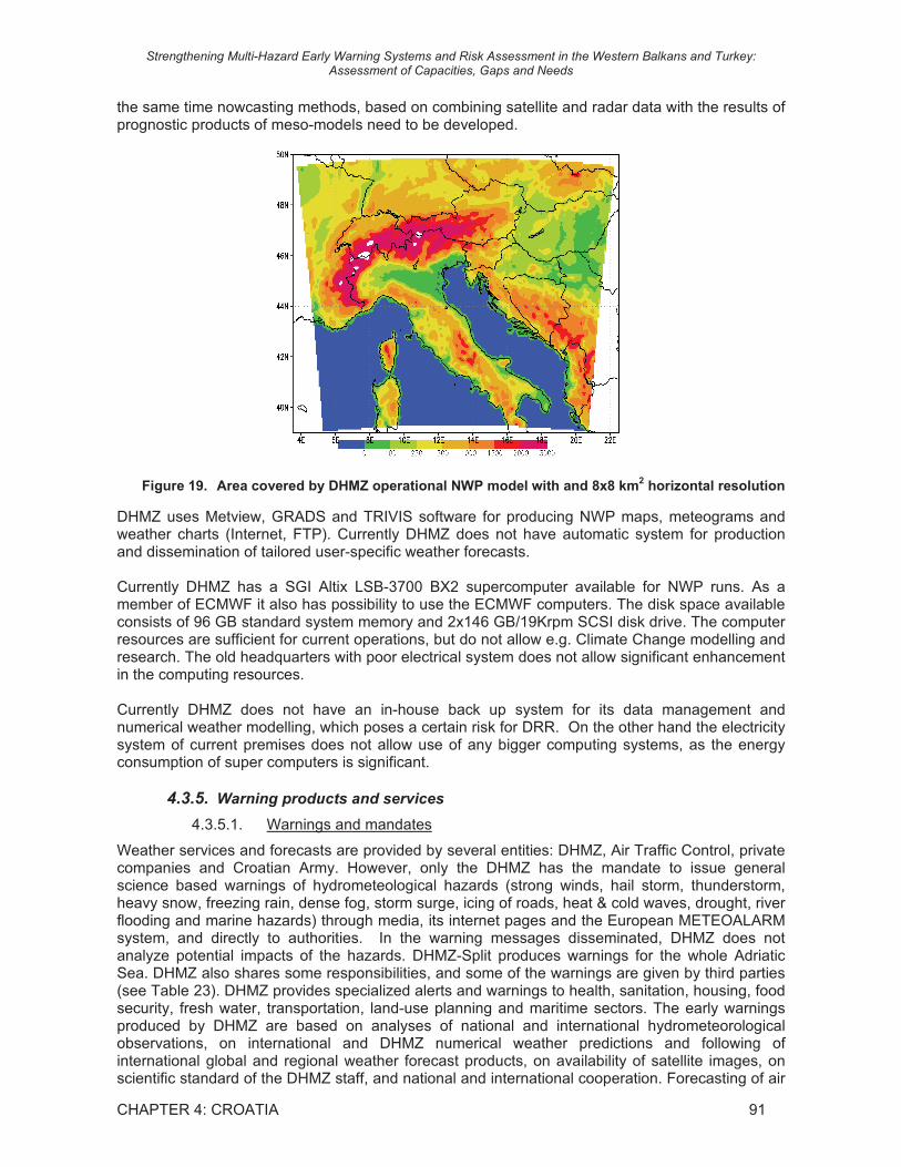
Strengthening Multi-Hazard Early Warning Systems and Risk Assessment in the Western Balkans and Turkey: Assessment of Capacities, Gaps and Needs
CHAPTER 4: CROATIA 91
the same time nowcasting methods, based on combining satellite and radar data with the results of prognostic products of meso-models need to be developed.
Figure 19. Area covered by DHMZ operational NWP model with and 8x8 km2 horizontal resolution
DHMZ uses Metview, GRADS and TRIVIS software for producing NWP maps, meteograms and weather charts (Internet, FTP). Currently DHMZ does not have automatic system for production and dissemination of tailored user-specific weather forecasts.
Currently DHMZ has a SGI Altix LSB-3700 BX2 supercomputer available for NWP runs. As a member of ECMWF it also has possibility to use the ECMWF computers. The disk space available consists of 96 GB standard system memory and 2x146 GB/19Krpm SCSI disk drive. The computer resources are sufficient for current operations, but do not allow e.g. Climate Change modelling and research. The old headquarters with poor electrical system does not allow significant enhancement in the computing resources.
Currently DHMZ does not have an in-house back up system for its data management and numerical weather modelling, which poses a certain risk for DRR. On the other hand the electricity system of current premises does not allow use of any bigger computing systems, as the energy consumption of super computers is significant.
4.3.5. Warning products and services
4.3.5.1. Warnings and mandates
Weather services and forecasts are provided by several entities: DHMZ, Air Traffic Control, private companies and Croatian Army. However, only the DHMZ has the mandate to issue general science based warnings of hydrometeological hazards (strong winds, hail storm, thunderstorm, heavy snow, freezing rain, dense fog, storm surge, icing of roads, heat & cold waves, drought, river flooding and marine hazards) through media, its internet pages and the European METEOALARM system, and directly to authorities. In the warning messages disseminated, DHMZ does not analyze potential impacts of the hazards. DHMZ-Split produces warnings for the whole Adriatic Sea. DHMZ also shares some responsibilities, and some of the warnings are given by third parties (see Table 23). DHMZ provides specialized alerts and warnings to health, sanitation, housing, food security, fresh water, transportation, land-use planning and maritime sectors. The early warnings produced by DHMZ are based on analyses of national and international hydrometeorological observations, on international and DHMZ numerical weather predictions and following of international global and regional weather forecast products, on availability of satellite images, on scientific standard of the DHMZ staff, and national and international cooperation. Forecasting of air

Strengthening Multi-Hazard Early Warning Systems and Risk Assessment in the Western Balkans and Turkey: Assessment of Capacities, Gaps and Needs
CHAPTER 4: CROATIA 92
quality and dispersion of smoke from different origins can be done with numerical models linked to the NWPs. Concerning e.g. the recent Icelandic volcano ash the DHMZ did modelling of dispersion, and has the role of advisor to the aviation sector. In order to produce new warnings e.g. to the health or transportation sector cooperation between DHMZ and respective sector is needed, as well as properly financed R&D projects.
The Croatian Waters is the responsible governmental organization for flood risk management. The Croatian Waters have signed an agreement with the112 center of NPRD concerning flood risk and pollution risk (water quality) for fresh water and coastal waters. Croatian Waters also has an agreement with DHMZ; DHMZ produces quality controlled national and international (transboundary rivers) hydrological data (both near real-time and historical) in agreed format. Concerning flash floods the responsibility is shared among DHMZ and Croatian Waters. For defense of river floods, Croatian Waters is responsible for fighting against the flood (with assistance of army and others), while warning of the people is the responsibility of the 112 center of NPRD.
Table 23: Warnings for natural and technical hazards in Croatia based on Annex 2
Hazard Exists in
the country Frequency
per year Warning by Type
Heavy precipitation Yes DHMZ I Flash floods Yes DHMZ + CW II River flooding Yes 1 DHMZ + CW +
PRD II
Coastal Flooding 1 Hailstorm Yes DHMZ I Thunderstorm or lightning Yes DHMZ I Heavy snow Yes DHMZ I Freezing rain Yes DHMZ + CR II Dense fog Yes DHMZ + CR II Tornado or cyclone No DHMZ I Hard wind Yes DHMZ IIII Storm surge Yes DHMZ + HI II Heatwave Yes DHMZ I Cold wave Yes 2 DHMZ I Drought Yes 2 DHMZ + MA + CW II Marine hazard Yes 5 DHMZ I Sandstorm No Landslide or mudslide Yes 1 DHMZ + GI II Avalanche Yes 1 Airborne hazardous substance Yes DHMZ +NS + PRD II Waterborne hazards Yes DHMZ +NS + PRD II Hydrometeorological hazards for aviation Yes 2 CAC III Forest or wildland fire Yes 10 DHMZ + PRD II Smoke, dust or haze Yes DHMZ I Earthquakes Yes 1 GI III Tsunamis No DHMZ + GI + HI II Volcanic events No DHMZ + GI II Dispersion of insect pests Yes Desert locust storm No Hazard for allergic reactions Yes HI = Hydrographic Institute, CR = Croatian Roads, CW = Croatian Waters, MA = Ministry of Agriculture,
PRD = National Protection and Rescue Directive, GI = Geological Institute, NS= State Institute of Nuclear safety, CAC= Croatian Aeronautical Control.
The 112 center of NPRD is the established mechanism for continuous collection and sharing of general risk information. The Service 112 reports on all risks and hazards, and if needed, alerts citizens, legal entities, administration bodies, rescue services, respective civil protection forces and relevant NPRD management. The Service also keeps records on hazards, accidents and disasters,
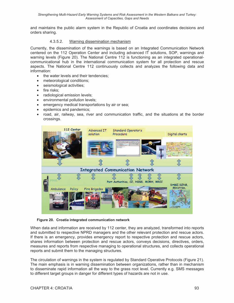
Strengthening Multi-Hazard Early Warning Systems and Risk Assessment in the Western Balkans and Turkey: Assessment of Capacities, Gaps and Needs
CHAPTER 4: CROATIA 93
and maintains the public alarm system in the Republic of Croatia and coordinates decisions and orders sharing.
4.3.5.2. Warning dissemination mechanism
Currently, the dissemination of the warnings is based on an Integrated Communication Network centered on the 112 Operation Center and including advanced IT solutions, SOP, warnings and warning levels (Figure 20). The National Centre 112 is functioning as an integrated operational-communicational hub in the international communication system for all protection and rescue aspects. The National Centre 112 continuously collects and analyzes the following data and information:
• the water levels and their tendencies; • meteorological conditions; • seismological activities; • fire risks; • radiological emission levels; • environmental pollution levels; • emergency medical transportations by air or sea; • epidemics and pandemics; • road, air, railway, sea, river and communication traffic, and the situations at the border
crossings.
Figure 20. Croatia integrated communication network
When data and information are received by 112 center, they are analyzed, transformed into reports and submitted to respective NPRD managers and the other relevant protection and rescue actors. If there is an emergency, provides emergency report to respective protection and rescue actors, shares information between protection and rescue actors, conveys decisions, directives, orders, measures and reports from respective managing to operational structures, and collects operational reports and submit them to the managing structures.
The circulation of warnings in the system is regulated by Standard Operative Protocols (Figure 21). The main emphasis is in warning dissemination between organizations, rather than in mechanism to disseminate rapid information all the way to the grass root level. Currently e.g. SMS messages to different target groups in danger for different types of hazards are not in use.

Strengthening Multi-Hazard Early Warning Systems and Risk Assessment in the Western Balkans and Turkey: Assessment of Capacities, Gaps and Needs
CHAPTER 4: CROATIA 94
Figure 21. Standard Operative Procedures between NPRD and DHMZ for weather forecasts
In addition to the SOP of the 112 system, DHMZ has adopted also web and IT solutions. For communication and dissemination of information and alerts, DHMZ has tailored Internet pages available for Fire Brigades only (at all 3 levels: country, counties, local). DHMZ provides warnings to the public through TV, radio and other media and its internet pages. However, it does not have the mandate to cut TV or radio programs in case of emergency or exceptionally harsh weather conditions, or to have an information stripe to be added on every TV presentation (as in many of the EU countries). It gives warnings directly to 112, Fire Brigades, Government, ministries, aviation authorities and to different economic sectors like agriculture and transportation. DHMZ Split provides warnings to maritime sector. Forest fire index is produced by DHMZ for the Fire Brigades, but it is not announced for public, as it has been noticed that this activates pyromaniacs. In case of hazard, or potential hazard, the DHMZ also gives information and advisories through phone and mobile phones. Shipping companies, national rescue organization and the pollution mitigation authorities at sea usually monitor the standard meteorological reports in textual and graphical format, and if necessary communicate personally with the forecaster. DHMZ also transfers all its information to be disseminated through the NPRD internet pages. Finally, as member of EUMETNET the DHMZ also provides warnings to the EU METEOALARM system. However this cannot be considered as an active but a passive method to disseminate information.
Currently DHMZ does not have a state-of-the-art fully automated dissemination system of products and warnings. Such a system would significantly speed up the dissemination system and provide the warnings in individually tailored formats to each sector and part of the DRR system. Nevertheless, this approach demands to strengthen the mutual exchanges with the DRR partners in order to understand the needs and requirements of the users and obtain feedbacks from them.
4.3.6. Climate change analysis
DHMZ cooperates with major European Climate Change R&D and modelling centers such as the HADLEY center (UK), and the Max Planck Institute (Germany). DHMZ has produced downscaled projections of climate change for Croatia. Currently DHMZ does not have sufficient amount of scientific staff, numerical modelling staff and computer power to produce independently large scale and very detailed climate change studies. It can be expected that Croatia could significantly benefit

Strengthening Multi-Hazard Early Warning Systems and Risk Assessment in the Western Balkans and Turkey: Assessment of Capacities, Gaps and Needs
CHAPTER 4: CROATIA 95
from the new South East European Virtual Climate Change Center (SEEVCCC), which was established in 2008 within the NMHS of Serbia.
4.3.7. Research and Development
The research cooperation and networking with European NHMSs and other research units could be improved. Currently DHMZ does not fully utilize the possibilities to gain from the EU research cooperation and funding, and the FP7 research and networking (e.g. Marie Curie) programmes, and COST actions, are not well known. However, it may be noted that it is difficult to find e.g. meteorology directly as a research topic, but it can built into proposals under several research areas like renewable energy, nuclear energy, construction, transportation, environment, etc.
4.3.8. Information Technology and Telecommunication capacities
Quick reliable communication system is critical for collection of data, data sharing and dissemination of products and warnings. Internet has become a very important tool among advanced NMHS to disseminate information and warnings. Croatia has an integrated communication network within the DRR management and respective agencies and DHMZ is part of that network.
Table 24: Equipment in use for data communication and warnings and other products dissemination
Telecommunication Equipment
To receive data
To send data
To send warnings
To send products
Telephone X X X X
Mobile Phone
Telefax X X X X
Dedicated Leased Lines X X
UHF radio transceiver
High frequency/Single side band radio
HF Radio Email
Aeronautical Fixed Telecommunication Network
Very Small Aperture Terminal
Data Collection Platforms used to transmit data from AWSs
X X
Global Telecommunication system (WMO-GTS)
X X
Meteosat Second Generation Satellite system
X
Other satellite systems
Internet X X X
Email X X
Post/mail X X X
Print media
TV –national X
TV-commercial X
Radio X
Bulletins X X
Printed text
DHMZ is connected to Internet via 10 Mb broad-band, and to WMO GTS via a 512 kb cable. The data exchange protocols meet the WMO, EU, EUMET and the EUMETNET standards.
DHMZ has an adequate contingency plan that ensures continuity of warning products of warnings and services in case of organizational emergencies. In case of power failure reserve power is available.

Strengthening Multi-Hazard Early Warning Systems and Risk Assessment in the Western Balkans and Turkey: Assessment of Capacities, Gaps and Needs
CHAPTER 4: CROATIA 96
4.3.9. Human resources
The number of staff is relatively high, compared to other SEE NHMSs. More than half of the staff is technicians; more than half of them work with observations or hail prevention. The scientific level and education of the operational staff is quite good with respect to the duties, but DHMZ suffers from lack of academic and ICT staff.
Table 25: Number of DHMZ staff by branch and level of education
Unlike the hydrometeorological services of the European Union, the DHMZ does not have capacity and forecaster resources to operate a 24/7 monitoring, analysis and forecasting system. This causes a significant risk to operational DRR and early warning system, even if current staff could be made to work overtime and additional shifts in case of threat of a hazard or during an event of a hydrometeorological extreme. The office hours for the weather forecasting department are from 04 to 18, daily.
Figure 22. Current and proposed human resources capacities for DHMZ
The number of communication experts is 3, which is not enough to ensure 24/7 communication system. DHMZ has a number of experts working in data management and computing: 5 “helpdesk” experts, 3 data base experts, 2 quality control experts and 3 software experts. None of these
Field and education
Meteorologist Hydrologist Engineer Physicist, Chemist,
Economist Branch Techn-
icians
BSc MSc PhD BSc MSc PhD BSc MSc PhD BSc MSc PhD
Other
TO
TA
L
Observation network 90 15 1 2 1 109Telecommunication 10 2 1 1 14 Data management 15 5 2 3 1 26 Weather forecasting 5 15 3 1 24 Hydrological forecasting 10 1 1 3 15
NWP 1 2 2 1 6 R & D 3 5 8 3 19 Weather modification 70 10 80 IT personnel 5 5 10 Commercial services Accounting 15 15 General administration 10 5 15 Other 17 26 5 2 3 3 1 29 86 TOTAL 251 86 22 9 8 1 1 3 3 1 34 419
Female in % of total 30 60 60 50 60 Men in % of total 70 40 40 50 10
Strengthening Multi-Hazard Early Warning Systems and Risk Assessment in the Western Balkans and Turkey: Assessment of Capacities, Gaps and Needs
CHAPTER 4: CROATIA 97
experts are available 24/7. The number of main computers and other computing experts is low compared to more advanced NHMSs. Currently DHMZ employs two translators and additionally the services of one translator are used by outsourcing to translate mainly weather forecasts. At more advanced NHMSs the weather forecasts are produced automatically in required languages.
In future it is necessary to increase the number of academic staff in order to meet properly the increasing demand to produce R&D services to the community. Also the development of tools, software and services will be done through investment into R&D. However, this cannot be properly implemented without sufficient number of high quality and trained ICT and IT staff.
4.3.10. Internal capacity building
DHMZ has invested in internal capacity building and technical training of the staff by providing technical training on the forecasting of hazards including up-to-date training of new forecasting technologies, by conducting training of disaster risk reduction processes and by inviting experts and lecturers from other organizations. DHMZ also participates in drills concerning DRR activities.
DHMZ has a quite extensive interaction programme with industry and customers including press conferences, reports and training for media, educational modules and training programmes targeted at general public and collaboration with schools and universities.
4.3.11. Premises
Current premises do not meet the standards of a developed NHMS with needs of secure computing and communication systems, business type cooperation with the industry and other end-users of hydrometeorological services, adequate working space for experts and other staff and for the technical equipment and instruments, and they do not give an image of a modern and active governmental research and service institute.
Current premises do not make it possible to promote the communication, data management and numerical forecasting with adequate back-up systems (all critical for EWS and DRR) due to restrictions in the electricity capacity in the ancient and obsolete headquarters of the DHMZ.
4.3.12. Financing
DHMZ, as a critical part of the DRR, is severely under-financed for essential parts concerning DRR. DHMZ does not have resources to operate a 24/7 analysing and forecasting system (unlike the EUMETNET NHMSs). DHMZ is also under-financed with respect to purchase, operate and maintain adequate hydrometeorological observation network (adequate number automatic real-time meteorological and hydrological stations) or modern weather radar and lightning detection networks. However, DHMZ has important governmental financing for hail monitoring and suppression. The benefits from this financing for DRR, and the agriculture sector in general, are very doubtful and the whole system scientifically questionable. Due to the structure of the DHMZ financing and budget, DHMZ cannot use its current human and financial resources to promote its services to DRR.
Up to now, the DHMZ has not received financial resources to implement investments in order to strengthen its capacity to better promote national, regional and European DRR, as proposed by the recent UNISDR-WMO-WB initiatives and project reports. The value of better hydrometeorological observations and services to the national economic development, and especially to DRR, is not yet fully recognized and appreciated by the Croatian Government and politicians.
DHMZ benefits from cooperation with EUMETNET, ECMWF, EUMETSAT, EU METEOALARM and cooperation with regional and other European NHMSs. Participation in these organization is financed by the government (as proposed in the SEE 2007).

Strengthening Multi-Hazard Early Warning Systems and Risk Assessment in the Western Balkans and Turkey: Assessment of Capacities, Gaps and Needs
CHAPTER 4: CROATIA 98
4.3.13. International and Regional Cooperation
Successful operation of NMHS is based on international cooperation. Weather forecasts and forecasting of natural hazards are based on products from global and regional scale state-of-the-art numerical weather prediction models, use of satellite data and sharing of data from conventional and modern remote sensing systems. Regional, local and mesoscale numerical weather prediction models are developed by international consortiums, to which membership provides better and more services than to non-members.
The European NHMSs have globally unique opportunities to benefit high level services and cooperation from memberships of European hydrometeorological organizations, including ECMWF´s the state-of-the-art weather forecast modelling, medium-range weather forecast products at 16 km horizontal resolution (in near future at 8 km resolution) including the Extreme Forecast Index (EFI), re-analysing data to be used e.g. for climatological studies and the ECMWF super computer resources. The integration into the European hydrometeorological infrastructure was given the highest priority in the 2007 project in developing the capacities of the NHMSs to adopt best European practices and to improve quality of products and services in support of national economic development and DRR. DHMZ has actively become member of main organizations and the leading consortium of numerical weather prediction models.
Table 26: International and regional cooperation activities of DHMZ
International and regional organization and cooperation mechanisms�
DHMZ status�
WMO member, PR WMO RAVI Member, Presidency RMDCN Yes IOC Member UN-ISDR Cooperation UNDP cooperation Red Cross cooperation EU active cooperation EUMETSAT Member ECMWF Co-operating State EUMETNET Member METEOALARM Member ECOMET Member EUFP7 projects, networks Some projects EU JRC Participates in flood forecasting, forest fire
index EU PHARE Projects within air quality EUCLID Member EUR-OPA member DMCSEE Member SEEVCCC Member SAVA Commission Member NWP consortium AROME NMHS bilateral Austria, France, Hungary, Slovenia, BiH,
Slovakia, Hungary, Montenegro, Poland NMHS MoU Finland, Germany, Netherlands DPPI Member RCC Member
European Union research and networking programs create consortiums of excellence, and provides good opportunities to NMHS to network with NMHSs and commercial R&D companies and strengthen their scientific, human and technical capacities. Up to now DHMZ has not effectively used the possibilities provided the EU R&D programmes, and the capacity of the DHMZ

Strengthening Multi-Hazard Early Warning Systems and Risk Assessment in the Western Balkans and Turkey: Assessment of Capacities, Gaps and Needs
CHAPTER 4: CROATIA 99
staff has been low to produce project applications and/or to participate build-up of scientific consortiums.
Currently the level of international cooperation is more active than in the other SEE NHMSs. DHMZ has a visible role within WMO and leading role in regional cooperation.
The main frameworks for regional and sub-regional cooperation are the Regional Cooperation Council (RCC), Disaster Preparedness and Prevention Initiative (DPPI), Central European Initiative and Civil-Military Emergency Preparedness and the South Eastern Europe Council.
Three years ago the idea to link all countries in the Danube watershed into one information network has been launched in DPPI with the objective to harmonize hydrological data, because some countries were measuring the water levels while others the water flow (m3 per second).
Moreover, bilateral agreements with Slovenia, Bosnia and Herzegovina, Hungary, Austria and Slovak Republic, as well as membership to the International Sava River Basin Commission and the International Commission for the Protection of the Danube River should enhance the early warnings, prevention from and mitigation of flooding of Sava and Danube rivers and their tributaries.
In the sub-region, DHMZ is also contributing to steering activities of the Drought Management Centre for Southeastern Europe (DMCSEE) in Ljubljana (Slovenia) ), participates in the DMCSEE project financed by EU and is building up resources and potentials for the establishment of the Sub-regional (WIS-DCPC) Marine Meteorological Centre (Croatia).
Concerning data exchange and common modelling of transboundary rivers Crotian Waters has a cautious approach. On the basis of the experience of past initiatives, CW stresses the concept of an “acceptable level of data exchange”, even if they recognize the importance of the interoperability of systems and the exchange of data for hydrological modelling and analysis in shared catchments. Building on the Sava River experience, where problems in databases interoperability and in the sensibility of flood forecast models have been experienced, CW stresses the need of introducing some correction mechanisms able to harmonize the modelling sensibility between different countries. Indeed, the Sava commission identifies common criteria and the thresholds for the analysis. These criteria are established considering the technical capacity and the level of detail achievable by the different countries of the commission. In the case of Croatia such criteria are below national standards. Thus CW has the option or to use different criteria for Sava and for the other rivers, or to adopt Sava standards also for the other rivers reducing the quality of the results. CW sustains that both options are not acceptable dealing with the security of people and assets. CW stresses that national protection standards and rules must be common over all the country and the best achievable. So, the solution for CW is to establish a level of compensation that allow for each country the use of their own quality standard in terms of precision on transboundary rivers modelling. Nevertheless, CW would improve the hydrological and meteorological data exchange with neighboring countries through the DHMZ, which should ensure data quality control and data management.
4.4. Technical recommendations to strengthen DHMZ capacities in support of DRR
Among the SEE countries the technical capacity of DHMZ is at a high level, but compared to advanced EUMETNET NHMSs its observation networks and premises are obsolete, human resources are understaffed and financial resources are very low. It is necessary to modernize the DHMZ and ensure adequate human, technical and financial resources in order to sustain their role in different phases of the DRR: operational monitoring, mapping of hydrological and meteorological hazards, forecasting and warning per the following technical recommendations:
Legal framework and institutional arrangements related to the role of NMHS in DRR

Strengthening Multi-Hazard Early Warning Systems and Risk Assessment in the Western Balkans and Turkey: Assessment of Capacities, Gaps and Needs
CHAPTER 4: CROATIA 100
1. There are needs to promote awareness of the great potential which the DHMZ has to contribute to the DRR and the social and economic development in the countries;
2. There are needs to better integrate the DHMZ into the DRR planning process;
3. There is a need to increase the number of type I warnings by enhancing the mandate of DHMZ.
Operational relationships with other agencies
4. There is need to improve the cooperation at the national level between DHMZ and NPRD and relevant institutions and end-users to further enhance national system for preventing and mitigating the impact of extreme weather and climate events.
Monitoring and observations networks and data exchange
5. There are needs to modernize the hydrological and meteorological early warning systems - in terms of real-time data collection and dissemination of information;
6. There are urgent needs to further automatize the hydrological, meteorological and marine observation systems and to increase the number of automatic stations in cooperation with DRR management and industry;
7. There is a need to further strengthen the observation network by developing remote sensing systems, including 4-5 dual-polarization weather radars.
Forecasting
8. There is a need to further develop capacities to support DRR through nowcasting;
9. There is a need to improve the capacities in Numerical Weather Prediction (NWP) modelling to produce operationally mesoscale products and to implement data assimilation;
10. There are needs to promote use of very high resolution NWP models, which are essential for hydrological modelling in complex terrain;
11. There are urgent needs to implement hydrological forecasts;
12. There is a need to improve capacities to use automatic analysing, editing and dissemination tools;
13. There is a need to invest in proper back up capacity for NWP modelling.
Hydrometeorological data management systems
14. There is an urgent need to initiate a data rescue programme to digitise and quality ensure the historical data;
15. There is a need to develop the technical capacities for data management and to adopt automatic quality control systems of hydrometeorological data.
Hazard analysis and mapping to support risk assessment
16. There is a need to develop hazard analysis and mapping (through GIS tools) based on historical data and climate change projections to support risk assessment;
17. There is a need to strengthen the systematic collection of drought/floods impact information on a state level with standardized procedure and long-lasting approach;
18. It is necessary to invest more in climate mapping, forecasting and analysis so as to plan adequate adaptation measures in risk-exposed sectors;
19. There is a need to train staff in drought/floods analyzing, forecasting and warning to better respond to the requests of users or in the case that DHMZ is charged of other activities in risk assessment;
20. There is a need to strengthen GIS and remote sensing capacities for the agrometeorology Division, to strengthen agrometeorological modelling for specific crops (grape, olives),.agrometeorological operational modelling and forecasts, application of seasonal weather forecasts for crop yield modelling and to involve young scientists in agrometeorology.
Strengthening Multi-Hazard Early Warning Systems and Risk Assessment in the Western Balkans and Turkey: Assessment of Capacities, Gaps and Needs
CHAPTER 4: CROATIA 101
Information technology and telecommunication issues
21. There are urgent needs to promote automatic production of tailored end-user-orientated services and automatic dissemination of forecasts and warnings.
Warning products and services
22. There is an urgent need to establish a 24/7 science based analysing, forecasting and warning system at DHMZ;
23. There is urgent need to promote production of flood and flash flood warnings;
24. To increase the number of warning products;
25. There is need to give the DHMZ mandate to have alarms shown on every TV channel as an info-stripe when needed.
Climate change analysis
26. There is the need of strengthening DHMZ technical capacity to better monitor climate through enhanced investments in climate modelling, forecasting and analysis ^to develop climate change impact studies to support sectoral planning for DRR and other at-risk sectors.
Human Resources
27. It is necessary to ensure adequate human, technical and financial resources to the DHMZ to sustain their role in different phases of the DRR: operational monitoring, mapping of hydrological and meteorological hazards, warning and forecasting;
28. There is urgent needs to increase the number of skilled weather forecasters to enhance the forecasting capacity to achieve 24/7 operation;
29. There are urgent needs to increase the number of hydrological modellers and researchers, NWP model experts, ICT and IT experts, engineers and observation network and maintenance experts, data management experts, PR experts and marketing experts;
30. There are urgent needs to promote training of the mid-management in leadership, project management and participation in EU R&D projects;
31. There are needs to improve laws, statutes, administrative practices and accounting systems to promote NHMS´s possibilities improve their commercial services, participation in EU R&D projects and to better adjust the structure and amount of staff to respond to new challenges, to enhance the base of financing and to promote sustainable development.
Facilities
32. There are urgent needs to have new premises for DHMZ in order to ensure data communication and exchange and production of NWP based weather forecasts which are critical for DRR, operation of industry and wellbeing of people.
Regional cooperation
33. A regional Multi-Hazard Early Warning System composed of inter-operable national Early Warning Systems should be designed through a regional cooperation process. A comprehensive design and planning document should include institutional and technical aspects of MHEWS, as well as a cost-benefit analysis and a fund-raising strategy;
34. Risk assessment at regional, national and local level is the foundation for development of agreements and implementation plans;
35. Modernisation and interoperability of the meteorological and hydrological networks should be implemented at the sub-regional level to benefit from economies of scale and financing

Strengthening Multi-Hazard Early Warning Systems and Risk Assessment in the Western Balkans and Turkey: Assessment of Capacities, Gaps and Needs
CHAPTER 4: CROATIA 102
opportunities. This plan should include automatic on-line stations, a sub-regional radar network as well as a lightning detection network;
36. To improve their forecasting capacities SEE countries should increase their cooperation with global, regional and specialized Centres (eg ECMWF) producing NWP, by developing their NWP capacities and become members of NWP model consortiums. Linkages between NWP models and hydrological models should also be developed for a better flood forecasting;
37. A regional harmonisation of watch and warning systems should be promoted;
38. Cross-border exchanges of real-time data, forecasts and warnings should be increased.
4.5. Recommendations of the Croatia National Policy Dialogue
Based on the detailed assessments of the DRR policies and practices as well as the NMHS capacities, gaps and needs in the beneficiaries to support DRR, policy recommendations were developed. Initial results were presented to national stakeholders for review and discussions during National Policy Dialogues organised by WMO together with the UNDP in Zagreb, on 7-8 June 2010. During this meeting, high-level participants endorsed the assessment, as well as the set of recommendations emanating from it and presented hereunder.
HFA priority 1: Ensure that disaster risk reduction (DRR) is a national and a local priority with a strong institutional basis for implementation
Recommendation 1: To encourage all existing disaster risk reduction actors in Croatia, as defined by the existing legal framework, to work together and invest additional efforts in recognizing and fulfilling existing disaster risk reduction tasks and responsibilities.
Recommendation 2: To strengthen coordination, strategic planning and management of disaster risk reduction at the national level through modifications of the existing institutional set-up by empowering, i.e. providing authority, accountability and responsibility to the National Platform to evolve into a multi-stakeholder national mechanism that serves as an advocate of disaster prevention and disaster risk reduction; provides coordination, analysis and advice on areas of priority; and undertakes strategic DRR planning and management.
Recommendation 3: To facilitate and support establishment of mirrored/similar/same mechanisms at the county and local self-government levels through strengthening and reinforcing local capacities, institutions and governance capabilities. HFA priority 2: Identify, assess and monitor disaster risks and enhance early warning Recommendation 4: To enhance the early warning system and interoperability of the System 112 through modernization of the continuous and real-time collection and information sharing by expanding the hydrological, meteorological and air-quality monitoring networks, establishing integrated fire-protection system and ensuring functional horizontal and vertical links among all disaster risk reduction actors.
Recommendation 5: To strengthen technical and human resources of the State Seismological Survey, and enhance the modernization and improvement of the seismological monitoring network and data transmission system.
Recommendation 6: To enhance technical and human resources of the Meteorological and Hydrological Service in operational monitoring, warning, forecasting and mapping of hydrological, meteorological and ecological risks.
Recommendation 7: To further strengthen operational cooperation of the National Protection and Rescue Directorate and the Hydrological and Meteorological Service through joint training and

Strengthening Multi-Hazard Early Warning Systems and Risk Assessment in the Western Balkans and Turkey: Assessment of Capacities, Gaps and Needs
CHAPTER 4: CROATIA 103
improvements to the standard operating procedures across agencies linked to the different threat levels and lessons learnt from each disaster event.
Recommendation 8: To enhance investments in climate modelling and forecasting and analysis to support strategic and sectoral planning for at-risk sectors.
Recommendation 9: To increase the awareness of the citizens and media regarding the early warning system and the European Emergency Number 112.
HFA priority 3: Use knowledge, innovation and education to build a culture of safety and resilience at all levels
Recommendation 10: The Ministry for Science, Education and Sport is mandated to mainstream disaster risk reduction into national educational curriculum by establishing Curriculum Revision Working Group composed of the representatives from the Ministry for Science, Education and Sport, from the National Protection and Rescue Directorate, Meteorological and Hydrological Service, the Republic Seismological Survey, other respective line Ministries, the Croatian Red Cross, expert organizations and individuals. HFA priority 4: Reduce the underlying risk factors
Recommendation 11: To develop the disaster risk reduction Strategy and corresponding Implementation/Action Plan as a first mutual step undertaken by the key disaster risk reduction actors, e.g. the National Protection and Rescue Directorate, the Hydrological and Meteorological Service, the Republic Seismological Survey, line Ministries and respective public enterprises, the Croatian Red Cross, civil society and business community toward integration of disaster risk reduction into the development policies, strategies and sectoral plans, followed with the implementation of the said Strategy.
Recommendation 12: To develop national capacities for climate services to support medium and long-term sectoral planning through strong collaboration and cooperation across line ministries and with the Meteorological and Hydrological Service, and through enhanced regional cooperation with other South Eastern European and EU countries.
HFA priority 5: Strengthen disaster preparedness for effective response at all levels
Recommendation 13: To proceed with the establishment, in Croatia, of the Centre of Excellence for a training of fire fighters and coordination of response to forest fires in the countries of South Eastern Europe, including the harmonization of the development of fire-fighting brigades in the countries of the region through standardization of equipment and procedures, thus promoting regional cooperation and collaboration in disaster risk reduction in South Eastern Europe.