3d documentation of global historic sites: the … · a nodal ninja mount to enable photo-mapping...
TRANSCRIPT
* Corresponding author
3D DOCUMENTATION OF GLOBAL HISTORIC SITES: THE ‘SCOTTISH TEN’
PROJECT AND ITS APPLICATIONS FOR CULTURAL HERITAGE
L. Wilsona*, A. Rawlinsonb, D.S. Mitchella, D.K. Pritchardb and H.C. McGregora
aHistoric Scotland, Longmore House, Edinburgh, EH9 1SH, Scotland – (lyn.wilson, david.mitchell,
chris.mcgregor)@scotland.gsi.gov.uk bDigital Design Studio, Glasgow School of Art, The Hub, Pacific Quay, Glasgow, G51 1EA, Scotland – (a.rawlinson,
d.pritchard)@gsa.ac.uk
KEYWORDS: Scottish Ten, cultural heritage, terrestrial laser scanning, georeferencing, recording, analysis, monitoring,
visualisation.
ABSTRACT: The Scottish Ten project seeks to digitally document World Heritage Sites in Scotland and culturally significant
international heritage sites, using technologies such as terrestrial laser scanning, aerial LiDAR, high resolution photography, digital
photogrammetry, high-accuracy GPS and digital total stations. The project has numerous aims, centering around conservation,
cultural heritage management, promoting Scotland’s technical and scientific expertise and Scottish cultural connections. This paper
focuses on the recent 3D survey work in the Heart of Neolithic Orkney World Heritage Site in Scotland. Two principal sites, Skara
Brae and Maeshowe, are described, the methodologies undertaken and the results so far. Aside from generating accurate survey
records, data will be utilised for analysis and interpretation, monitoring, visualisation and numerous other purposes. Although the
data is still at the early stages of processing, the paper highlights the significant potential of 3D survey for understanding and
managing the Heart of Neolithic Orkney and the benefits of 3D survey for cultural heritage applications in general.
1. INTRODUCTION
The Scottish Ten is an ambitious global project to fully digitally
document Scotland’s five UNESCO world heritage sites and
five international heritage sites (www.scottishten.org).
Conceived in 2009, the project is funded by the Scottish
Government and will run for five years to completion. A range
of digital technologies is involved, including terrestrial laser
scanning, aerial LiDAR, high-resolution photography, digital
photogrammetry, high-accuracy GPS and digital total stations.
The Scottish sites are; the Old and New Towns of Edinburgh,
New Lanark 18th Century Mill Village, St Kilda islands, the
Antonine Wall (the most northerly frontier of the Roman
Empire) and the Heart of Neolithic Orkney. The international
sites known to date are; Mount Rushmore National Memorial,
USA and Rani Ki Vav Royal Step Well, India. Others will be
confirmed in due course. To date, on-site work for New Lanark,
Neolithic Orkney and Mount Rushmore has been completed.
The project has numerous broad aims:
• To accurately record important historical sites for the
benefit of future generations in Scotland and overseas.
• To share and disseminate Scottish technical expertise and
foster international collaboration.
• To provide digital media to site managers to better care for
the heritage resource.
• To recognise international Scottish cultural connections.
The Centre for Digital Documentation and Visualisation
(CDDV) is a limited liability partnership between Historic
Scotland and the Digital Design Studio at Glasgow School of
Art and has been established as a vehicle to deliver the Scottish
Ten. The point cloud data will be hosted with CyArk
(www.cyark.org) when complete.
2. CASE STUDY
2.1 3D Digital Documentation of The Heart of Neolithic
Orkney and Cultural Heritage Applications
The World Heritage Site in Orkney covers a unique cultural
landscape, dating back approximately 5,000 years. One of the
main sites within this landscape is Skara Brae, a Neolithic
village comprising individual domestic housing. It is the best
preserved group of prehistoric houses in Western Europe. The
chambered tomb at Maeshowe is significant not only as a
Neolithic monumental masterpiece and the finest example of its
kind in NW Europe, but also for its fantastic collection of 12th
century Viking inscriptions, the interior walls being covered
with graffiti runes and other carvings. Stone circles and
standing stones complete the current World Heritage
inscription.
The sites are conserved and managed by Historic Scotland, the
Scottish government agency charged with safeguarding the
nations heritage and promoting its enjoyment and understanding
for future generations. In August 2010, the Centre for Digital
Documentation and Visualisation working in partnership with
Historic Scotland undertook a comprehensive 3D survey of all
sites within the World Heritage zone.
2.2 Objectives
The objectives of the project were numerous:
• Generate a highly accurate digital 3D survey.
• Develop an interpretation and education tool, based on
virtual reality reconstructions.
• Visual aid to understanding construction phases of
structures.
International Archives of the Photogrammetry, Remote Sensing and Spatial Information Sciences, Volume XXXVIII-5/W16, 2011ISPRS Trento 2011 Workshop, 2-4 March 2011, Trento, Italy
39
The International Archives of the Photogrammetry, Remote Sensing and Spatial Information Sciences, Vol. 38-5, W16
• Conservation aid.
• Condition monitoring.
• Coastal erosion monitoring.
• Promote public engagement and partnership working.
• Allow virtual access to remote and inaccessible sites.
• Develop and promote virtual tourism.
3. METHODOLOGY
Airborne LiDAR data and ortho-rectified photography was
collected for the entire World Heritage zone at 0.5m resolution
with imagery in 24-bit colour.
Terrestrial laser scanning (TLS) is now a well-established
method for large-scale heritage documentation (e.g. Bedford
and Papworth 2009, Lerma et al. 2010, Wilson et al. 2010).
TLS was therefore the principal survey technique used at each
main site, and was carried out at 5-10mm resolution using a
combination of time-of-flight and phase-based scanners (Leica
ScanStation 2 and C10 and Leica HDS6100). Closed-loop
traverses provided an accuracy of ±2mm for each site.
Additional scans were registered to the primary point cloud
using high definition surveying (HDS) targets. TLS data
collection was augmented by digital total station surveys (Leica
TCRA 1105+) and GPS data collection (Leica GNSS 1200+
receiver) to fully georeference the point clouds. High-resolution
360° panoramic photography was obtained from each scan
location using a Nikon D3X camera with Nikon 12mm lens and
a Nodal Ninja mount to enable photo-mapping directly onto the
point cloud.
Triangulation laser scanners were used for sub-mm close-range
capture of carvings and inscriptions (Hexagon Romer arm with
Perceptron Scanworks v5 laser scanner and Konica-Minolta
Vivid 9i).
Data processing is currently in progress on this project, but
some initial results are given here. The project utilises Leica
Cyclone, Leica GeoOffice, TheoLt (using the TheoNetAdjust
functionality), Polyworks and 3D Studio Max software
packages. All datasets will be combined and used within a GIS
environment (using ArcGIS).
4. RESULTS AND DISCUSSION
4.1 Skara Brae
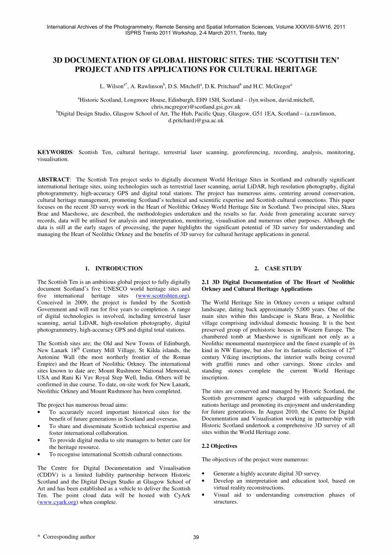
Skara Brae village is situated in very close proximity to the
North Sea. It consists of a complex system of small houses
interlinked by passageways and tunnel systems (Figure 1). The
site has been fully documented in 3D and georeferenced, with
an overall point cloud accuracy of ±6mm.
Figure 1. Aerial photo of Skara Brae, showing close network of
houses and proximity of site to coastline © P. and M. Snodin
2009.
Recording
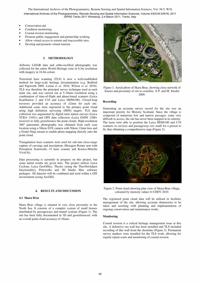
Generating an accurate survey record for the site was an
important priority for Historic Scotland. Since the village is
composed of numerous low and narrow passages, some very
difficult to access, the site has never been mapped in its entirety.
The team were able to position the Leica HDS6100 and C10
scanners in crevices and passageways too small for a person to
fit, thus obtaining a comprehensive map (Figure 2).
Figure 2. Point cloud showing plan view of Skara Brae village,
coloured by intensity values © CDDV 2010.
The registered point cloud data will be utilised in facilities
management of the site, allowing accurate dimensions to be
taken and assisting with planning and implementation of
ongoing conservation and maintenance works.
Monitoring
Coastal erosion is a critical heritage management issue at this
site. A defensive sea wall has been installed and TLS included
recording of this wall from the shoreline (Figure 3). Permanent
survey markers were installed for the TLS work, allowing for
regular repeat scans and monitoring of coastal erosion.
International Archives of the Photogrammetry, Remote Sensing and Spatial Information Sciences, Volume XXXVIII-5/W16, 2011ISPRS Trento 2011 Workshop, 2-4 March 2011, Trento, Italy
40
The International Archives of the Photogrammetry, Remote Sensing and Spatial Information Sciences, Vol. 38-5, W16
Figure 3. Sea wall defences visible in TLS data from Skara
Brae, as recorded from the shoreline and coloured by intensity
values © CDDV 2010.
This initial dataset will act as a baseline and subsequent
recording will be carried out at defined time intervals.
Digitisation of the sea wall defences will be of assistance in
quantifying any future erosion (Figure 4). Conservation
intervention will take place when and where necessary.
Figure 4. Digitisation of sea wall defences from TLS data ©
CDDV 2011.
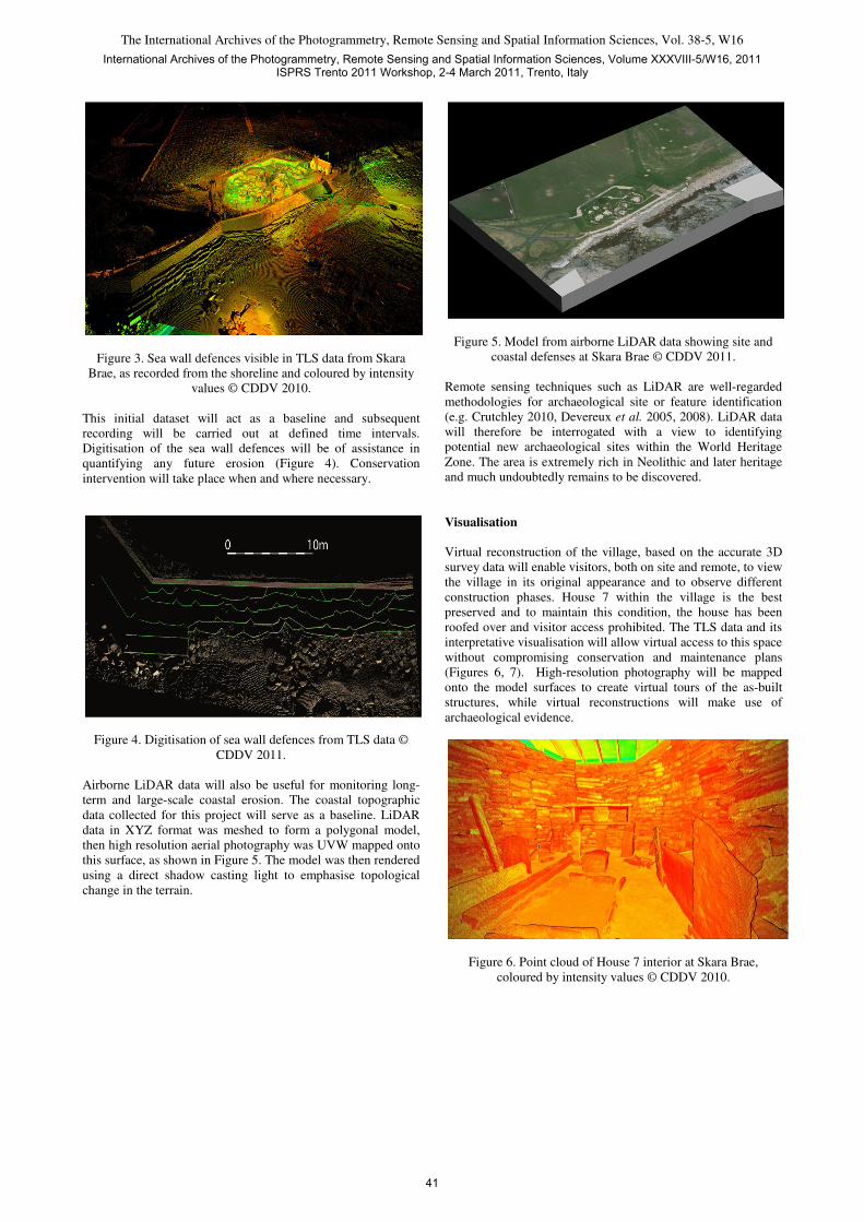
Airborne LiDAR data will also be useful for monitoring long-
term and large-scale coastal erosion. The coastal topographic
data collected for this project will serve as a baseline. LiDAR
data in XYZ format was meshed to form a polygonal model,
then high resolution aerial photography was UVW mapped onto
this surface, as shown in Figure 5. The model was then rendered
using a direct shadow casting light to emphasise topological
change in the terrain.
Figure 5. Model from airborne LiDAR data showing site and
coastal defenses at Skara Brae © CDDV 2011.
Remote sensing techniques such as LiDAR are well-regarded
methodologies for archaeological site or feature identification
(e.g. Crutchley 2010, Devereux et al. 2005, 2008). LiDAR data
will therefore be interrogated with a view to identifying
potential new archaeological sites within the World Heritage
Zone. The area is extremely rich in Neolithic and later heritage
and much undoubtedly remains to be discovered.
Visualisation
Virtual reconstruction of the village, based on the accurate 3D
survey data will enable visitors, both on site and remote, to view
the village in its original appearance and to observe different
construction phases. House 7 within the village is the best
preserved and to maintain this condition, the house has been
roofed over and visitor access prohibited. The TLS data and its
interpretative visualisation will allow virtual access to this space
without compromising conservation and maintenance plans
(Figures 6, 7). High-resolution photography will be mapped
onto the model surfaces to create virtual tours of the as-built
structures, while virtual reconstructions will make use of
archaeological evidence.
Figure 6. Point cloud of House 7 interior at Skara Brae,
coloured by intensity values © CDDV 2010.
International Archives of the Photogrammetry, Remote Sensing and Spatial Information Sciences, Volume XXXVIII-5/W16, 2011ISPRS Trento 2011 Workshop, 2-4 March 2011, Trento, Italy
41
The International Archives of the Photogrammetry, Remote Sensing and Spatial Information Sciences, Vol. 38-5, W16
Figure 7. Meshed point cloud data showing interior of House 7
at Skara Brae. The mesh was created with an interpolation step
of 8mm and contains 6 million polygons. The model was
rendered in 3D Studio Max using the VRAY rendering engine
with a physical camera © CDDV 2011.
4.2 Maeshowe
Maeshowe chambered tomb (Figure 8) is covered by a
protective grassy mound which requires ongoing conservation
and maintenance to prevent water ingress into the tomb itself.
The interior consists of a low passageway leading to an interior
central chamber, with three smaller chambers leading from it.
Figure 8. Maeshowe chambered tomb, as seen from the air ©
Crown Copyright 2008.
Recording
The site has been fully documented inside and out in 3D and
georeferenced, with an overall point cloud accuracy of ±6mm.
Figure 9 shows a cross-section through the registered point
cloud, which ties interior and exterior scans together. TLS
allows a unique visualisation through the tomb.
Figure 9. Cross-section through point cloud of Maeshowe
chambered tomb, coloured by intensity values © CDDV 2010.
Analysis
Accurate CAD drawings have been produced from the point
cloud data to assist conservation architects with ongoing
conservation and maintenance work. Section drawings allow for
analysis of the structure in detail (Figure 10).
Figure 10. CAD section drawing through Maeshowe chambered
tomb in a NE-SW orientation © CDDV 2011.
Monitoring
As previously mentioned, the interior of Maeshowe tomb is
adorned with a rich collection of Neolithic carvings and 12th
Century Viking runic inscriptions. Historically, there was some
concern over water ingress to the monument and the possibility
of clays washing out from the sandstone. This could potentially
have put the inscriptions at risk. Remedial conservation work
was undertaken by Historic Scotland as soon as the problem
was identified, but a monitoring programme was implemented
nevertheless.
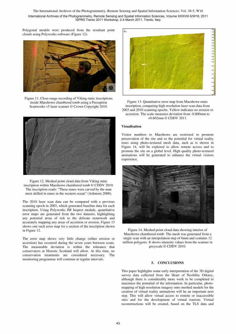
The carvings and inscriptions were scanned at very high
resolution (0.1mm) using a Perceptron v5 scanner (Figure 11).
International Archives of the Photogrammetry, Remote Sensing and Spatial Information Sciences, Volume XXXVIII-5/W16, 2011ISPRS Trento 2011 Workshop, 2-4 March 2011, Trento, Italy
42
The International Archives of the Photogrammetry, Remote Sensing and Spatial Information Sciences, Vol. 38-5, W16
Polygonal models were produced from the resultant point
clouds using Polyworks software (Figure 12).
Figure 11. Close-range recording of Viking runic inscriptions
inside Maeshowe chambered tomb using a Perception
Scanworks v5 laser scanner © Crown Copyright 2010.
Figure 12. Meshed point cloud data from Viking runic
inscription within Maeshowe chambered tomb © CDDV 2010.
The inscription reads: “These runes were carved by the man
most skilled in runes in the western ocean” (Ashmore 2000).
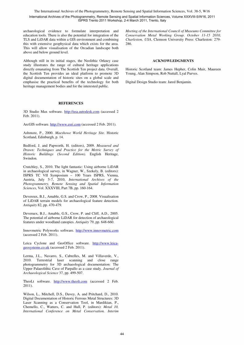
The 2010 laser scan data can be compared with a previous
scanning epoch in 2003, which generated baseline data for each
inscription. Using Polyworks IM Inspect module, quantitative
error maps are generated from the two datasets, highlighting
any potential areas of risk to the delicate stonework and
accurately mapping any areas of accretion or erosion. Figure 13
shows one such error map for a section of the inscription shown
in Figure 12.
The error map shows very little change (either erosion or
accretion) has occurred during the seven years between scans.
The measurable deviation is within the tolerance that
conservators at Historic Scotland will allow. At this time, no
conservation treatments are considered necessary. The
monitoring programme will continue at regular intervals.
Figure 13. Quantitative error map from Maeshowe runic
inscription, comparing high resolution laser scan data from
2003 and 2010 scanning epochs. Yellow indicates no erosion or
accretion. The scale measures deviation from -0.800mm to
+0.602mm © CDDV 2011.
Visualisation
Visitor numbers to Maeshowe are restricted to promote
preservation of the site and so the potential for virtual reality
tours using photo-textured mesh data, such as is shown in
Figure 14, will be explored to allow remote access and to
promote the site on a global level. High quality photo-textured
animations will be generated to enhance the virtual visitors
experience.
Figure 14. Meshed point cloud data showing interior of
Maeshowe chambered tomb. The mesh was generated from a
single scan with an interpolation step of 6mm and contains 12
million polygons. It shows intensity values from the scanner in
greyscale © CDDV 2010.
5. CONCLUSIONS
This paper highlights some early interpretation of the 3D digital
survey data collected from the Heart of Neolithic Orkney,
although there is considerably more work to be completed to
maximise the potential of the information. In particular, photo-
mapping of high resolution imagery onto meshed models for the
creation of virtual reality animations will be an important next
step. This will allow virtual access to remote or inaccessible
sites and for the development of virtual tourism. Virtual
reconstructions will be created, based on the TLS data and
International Archives of the Photogrammetry, Remote Sensing and Spatial Information Sciences, Volume XXXVIII-5/W16, 2011ISPRS Trento 2011 Workshop, 2-4 March 2011, Trento, Italy
43
The International Archives of the Photogrammetry, Remote Sensing and Spatial Information Sciences, Vol. 38-5, W16
archaeological evidence to formulate interpretation and
education tools. There is also the potential for integration of the
TLS and LiDAR data within a GIS environment and combining
this with extensive geophysical data which exists for the area.
This will allow visualisation of the Orcadian landscape both
above and below ground level.
Although still in its initial stages, the Neolithic Orkney case
study illustrates the range of cultural heritage applications
directly emanating from The Scottish Ten project data. Overall,
the Scottish Ten provides an ideal platform to promote 3D
digital documentation of historic sites on a global scale and
emphasise the practical benefits of the technology for both
heritage management bodies and for the interested public.
REFERENCES
3D Studio Max software. http://usa.autodesk.com (accessed 2
Feb. 2011).
ArcGIS software. http://www.esri.com (accessed 2 Feb. 2011).
Ashmore, P., 2000. Maeshowe World Heritage Site. Historic
Scotland, Edinburgh, p. 14.
Bedford, J. and Papworth, H. (editors), 2009. Measured and
Drawn: Techniques and Practice for the Metric Survey of
Historic Buildings (Second Edition). English Heritage,
Swindon.
Crutchley, S., 2010. The light fantastic: Using airborne LiDAR
in archaeological survey, in Wagner, W., Szekely, B. (editors):
ISPRS TC VII Symposium – 100 Years ISPRS, Vienna,
Austria, July 5-7, 2010, International Archives of the
Photogrammetry, Remote Sensing and Spatial Information
Sciences, Vol. XXXVIII, Part 7B, pp. 160-164.
Devereux, B.J., Amable, G.S. and Crow, P., 2008. Visualisation
of LiDAR terrain models for archaeological feature detection.
Antiquity 82, pp. 470-479.
Deveruex, B.J., Amable, G.S., Crow, P. and Cliff, A.D., 2005.
The potential of airborne LiDAR for detection of archaeological
features under woodland canopies. Antiquity 79, pp. 648-660.
Innovmetric Polyworks software. http://www.innovmetric.com
(accessed 2 Feb. 2011).
Leica Cyclone and GeoOffice software. http://www.leica-
geosystems.co.uk (accessed 2 Feb. 2011).
Lerma, J.L., Navarro, S., Cabrelles, M. and Villaverde, V.,
2010. Terrestrial laser scanning and close range
photogrammetry for 3D archaeological documentation: The
Upper Palaeolithic Cave of Parpallo as a case study. Journal of
Archaeological Science 37, pp. 499-507.
TheoLt software. http://www.theolt.com (accessed 2 Feb.
2011).
Wilson, L., Mitchell, D.S., Davey, A. and Pritchard, D., 2010.
Digital Documentation of Historic Ferrous Metal Structures: 3D
Laser Scanning as a Conservation Tool, in Mardikian, P.,
Chemello, C., Watters, C. and Hull, P. (editors): Metal 10,
International Conference on Metal Conservation. Interim
Meeting of the International Council of Museums Committee for
Conservation Metal Working Group. October 11-15 2010,
Charleston, USA, Clemson University Press: Charleston: 279-
286.
ACKNOWLEDGMENTS
Historic Scotland team: James Hepher, Colin Muir, Maureen
Young, Alan Simpson, Rob Nuttall, Lyal Purves.
Digital Design Studio team: Jared Benjamin.
International Archives of the Photogrammetry, Remote Sensing and Spatial Information Sciences, Volume XXXVIII-5/W16, 2011ISPRS Trento 2011 Workshop, 2-4 March 2011, Trento, Italy
44