3.5 community facilities and parklands 3.5.1...
TRANSCRIPT
Chapter 3—Environmental Analysis, Impacts, and Mitigation Section 3.5—Community Facilities and Parklands
Metro Gold Line Foothill Extension—Azusa to Montclair Draft Environmental Impact Report 3.5-1 August 2012
3.5 COMMUNITY FACILITIES AND PARKLANDS
3.5.1 Regulatory Setting
3.5.1.1 State and Federal
California Public Park Preservation Act The California Public Park Preservation Act (Public Resources Code Sections 5400–5409) provides that a public agency that acquires public parkland for non-park use must either pay compensation that is sufficient to acquire substantially equivalent substitute parkland or provide substitute parkland of comparable characteristics. If less than 10 percent of the parkland (but not more than 1 acre) is acquired, the operating entity may improve the portion of the parkland and facilities not acquired using the funds received.
California Building Code California Code of Regulations Title 24 of the California Building Code is a compilation of building standards. The State of California fire regulations set forth in Section 13000 et seq. of the California Health and Safety Code include building standards (as also set forth in the California Building Code), as well as standards for fire protection and notification systems; fire protection devices, such as extinguishers and smoke alarms; high-rise buildings and childcare facilities, and fire suppression training. In cases where there is no local fire authority, as well as in all State-owned and State-occupied facilities, the California State Fire Marshal has full enforcement jurisdiction over State fire regulations.
California Health and Safety Code Each school district in California is subject to the regulations of the California Education Code and the California State Board of Education pertaining to funding, school curriculum, operations, and facilities (including location considerations).
Uniform Fire Code The National Fire Protection Association (NFPA), Uniform Fire Code 2009 (UFC) contains regulations pertaining to the construction and maintenance of buildings and the use of the premises. In addition to provisions to protect and assist fire responders, topics addressed in the UFC include fire department access, fire hydrants, automatic sprinkler systems, fire alarm systems, fire and explosion hazards safety, hazardous materials storage and use, industrial processes, and many other general and specialized fire safety requirements for new and existing buildings and the premises. The UFC contains specialized technical regulations related to fire and human safety. Typically, local fire protection services conduct UFC inspection of all new developments.
3.5.1.2 Local Parklands, public services (e.g., police and fire protection), libraries, and other community facilities (e.g., educational facilities) are regulated by local agencies; therefore, the project would be subject to the policies of Los Angeles and San Bernardino Counties, as well as the cities of Glendora, San Dimas, La Verne, Pomona, Claremont, and Montclair. In addition, nearby public schools are under the jurisdiction of the various school districts (Glendora, Bonita, Pomona, Claremont, Ontario-Montclair, or Upland Unified
Chapter 3—Environmental Analysis, Impacts, and Mitigation Section 3.5—Community Facilities and Parklands
3.5-2 Metro Gold Line Foothill Extension—Azusa to Montclair Draft Environmental Impact Report August 2012
School Districts), which have their own policies and procedures. Specific policies pertaining to other community facilities are subject to land use and zoning regulations (Section 3.10).
Parklands
City of Glendora Goal OSR-1 of the Glendora Community Plan 2025 Open Space and Recreation Element calls for the preservation of open space resources. Policies OSR-1.1 through OSR-1.11 seek to accomplish this goal through coordination with local and regional agencies, as well as organizations such as the Glendora Community Conservancy and support of local and regional efforts to acquire, develop, and maintain open space areas and linkages.
City of San Dimas The City of San Dimas General Plan Open Space Element establishes a standard of 2.0 acres of land per 1,000 residents for neighborhood parks and 3.5 acres of land per 1,000 residents for community parks as acceptable service ratios. In addition, Policy 6.2.1 of the Open Space Element states that the City prefers land dedication to a fee for acquisition of existing parkland.
City of La Verne Goal-1 of the City of La Verne General Plan, Resource Management, calls for an attractive, safe, and accessible park and recreation system. To accomplish this goal, the General Plan calls for park and recreational facilities to be developed and maintained by using a minimum standard of 4 acres per 1,000 persons.
City of Pomona One of the objectives of the City of Pomona General Plan is the development of an open space plan that provides opportunities for recreation and education while preserving the scenic, cultural and historic values of the city. It is the policy of the City of Pomona to develop a long-range priority system for the acquisition and development of specific open space areas where the location, size, design and intended use reflect the needs of the local neighborhood and the city.
City of Claremont Chapter 5 of the City of Claremont General Plan states that the Claremont City Council adopted a standard of 4 acres of parkland per 1,000 residents. This is the standard by which the City assesses park dedication fees for new developments.
City of Montclair Goal OS-1.0.0 of the City of Montclair General Plan is the protection and preservation of open space resources in the community and the maintenance of scenic, recreational or productive values. Accordingly, the City has a park land dedication goal of 3 acres of parkland per 1,000 residents.
Police Protection Services
City of Glendora The Glendora Community Plan 2025 Policies SAF-6.1 and SAF-6.2 call for consultation with the Glendora Police Department to identify and address impacts of proposed development on police services, including impacts related to traffic congestion and other growth-related issues.
Chapter 3—Environmental Analysis, Impacts, and Mitigation Section 3.5—Community Facilities and Parklands
Metro Gold Line Foothill Extension—Azusa to Montclair Draft Environmental Impact Report 3.5-3 August 2012
City of San Dimas The Los Angeles County Sheriff’s Department (LASD) serves San Dimas. Policies pertaining to law enforcement in the city are found in the Los Angeles County General Plan Policy PS 8.1.
City of La Verne Policies 5.1 and 5.2 of the City of La Verne General Plan Public Safety Element call for adequate police protection, as well as reduced crime through new development that emphasizes safety. Implementation measures associated with these policies include Measure 5.1a (maintaining a ratio of 1.25 sworn officers per 1,000 residents) and Measure 5.2b (circulating all proposed project plans, both public and private, to the police department for evaluation of public safety impacts as part of the development review process).
City of Pomona The City of Pomona General Plan does not include police services policies that are applicable to the project.
City of Claremont The City of Claremont General Plan does not include police services policies that are applicable to the project.
City of Montclair Policies SE-3.1.2 and SE-3.1.3 of the City of Montclair General Plan encourage and facilitate design considerations in new developments that would prevent or discourage criminal activity by providing security and surveillance.
Fire Protection Services
City of Glendora The Los Angeles County Fire Department serves Glendora; therefore, policies related to fire protection are dictated by the Los Angeles County Fire Code. In addition, the City has developed several goals and policies to reduce risks to life and property from wildland fires. These goals and policies regulate new developments and land uses in hillside areas that are outside Study Area.
City of San Dimas Objective 1.4 of the City of San Dimas General Plan Safety Element calls for the provision of effective and efficient fire protection services. The two policies that are geared toward achieving this objective, Policies 1.4.1 and 1.4.2, ensure sufficient water pressure and flow, as well as adequate response times for both new and existing development.
City of La Verne Policy 5.4 of the City of La Verne General Plan Public Safety Element calls for adequate fire protection by maintaining a seven-minute response time or a response time determined acceptable by the fire chief. Consistent with this policy, subdivision and development requests that are unable to meet this standard—whether by location, design, or the imposition of fire prevention and protection measures satisfactory to the fire chief—will be rejected.
City of Pomona The City of Pomona General Plan does not include fire services policies that are applicable to the project.
Chapter 3—Environmental Analysis, Impacts, and Mitigation Section 3.5—Community Facilities and Parklands
3.5-4 Metro Gold Line Foothill Extension—Azusa to Montclair Draft Environmental Impact Report August 2012
City of Claremont The City of Claremont General Plan fire protection policies are not applicable to the project.
City of Montclair Policy SE-4.4.0 of the City of Montclair General Plan requires that all development plans be reviewed by local planning, fire, water, health, road, and flood control authorities in order to provide adequate fire protection to the city.
Educational Facilities
City of Glendora The Glendora Community Plan 2025 policies for educational facilities are not applicable to the project.
City of San Dimas The City of San Dimas General Plan policies for educational facilities are not applicable to the project.
City of La Verne Policy 4.1 of the City of La Verne General Plan Community Facilities Element calls for the provision of adequate school facilities and curriculum. Implementation measures require (1) new developments to pay the full cost of the schools that will serve them; (2) new developments to pay fees to secure facilities; and (3) the dedication of land or buildings to the satisfaction of the local school district. In addition, Policy 8.1 calls for increased partnership opportunities among the City, merchants, and the University of La Verne.
City of Pomona The City of Pomona General Plan does not include education policies that are applicable to the project.
City of Claremont The City of Claremont General Plan policies for educational facilities are not applicable to the project.
City of Montclair Policy PF-1.1.1 seeks to protect elementary and secondary school plant investments by preserving the character and quality of residential and non-residential development.
3.5.2 Existing Conditions
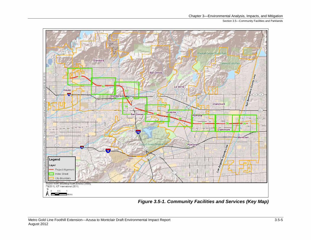
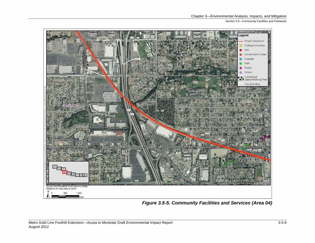
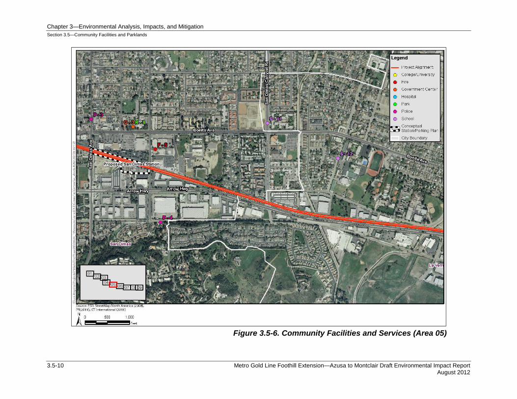
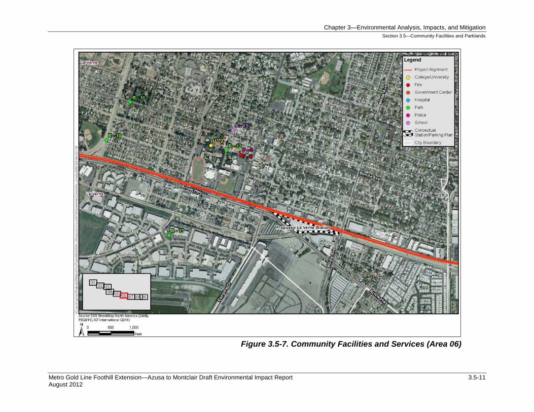
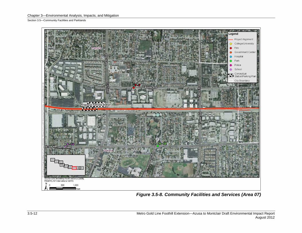
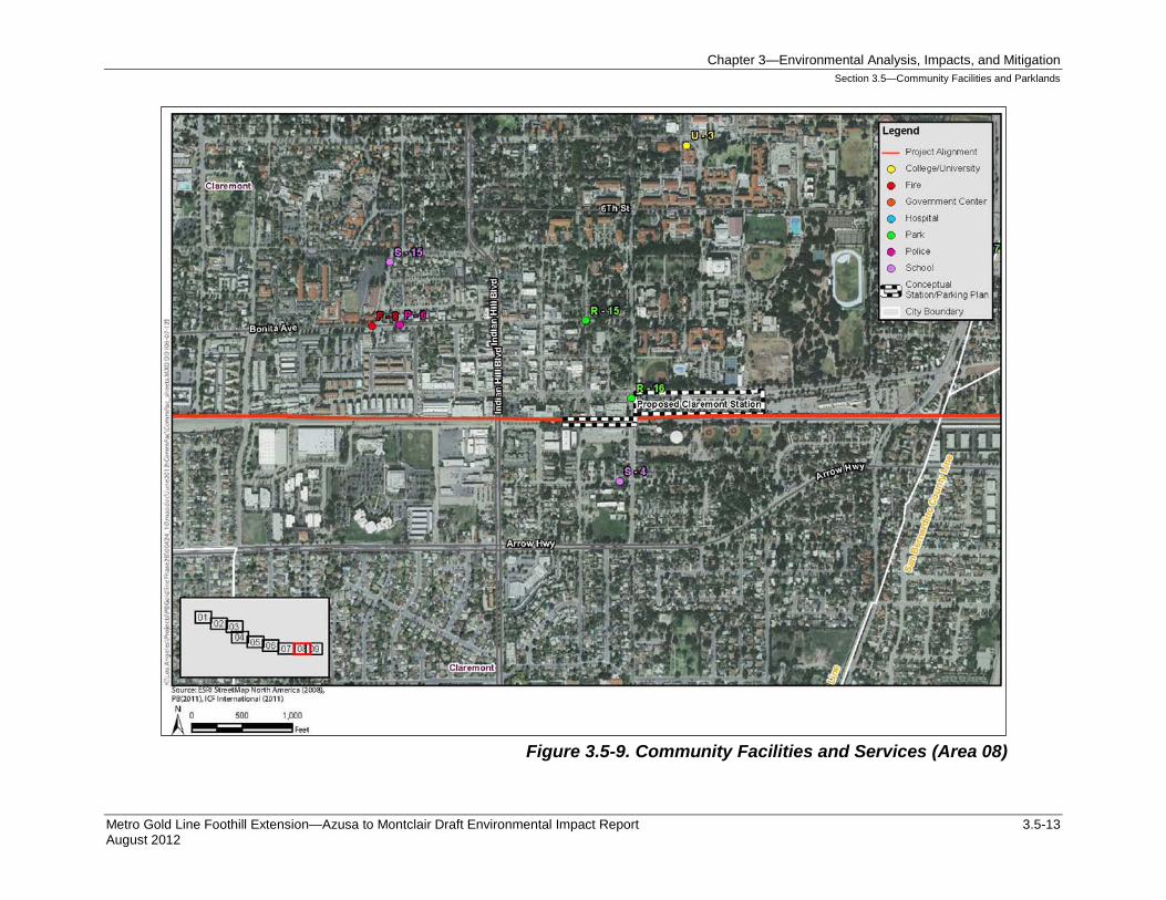
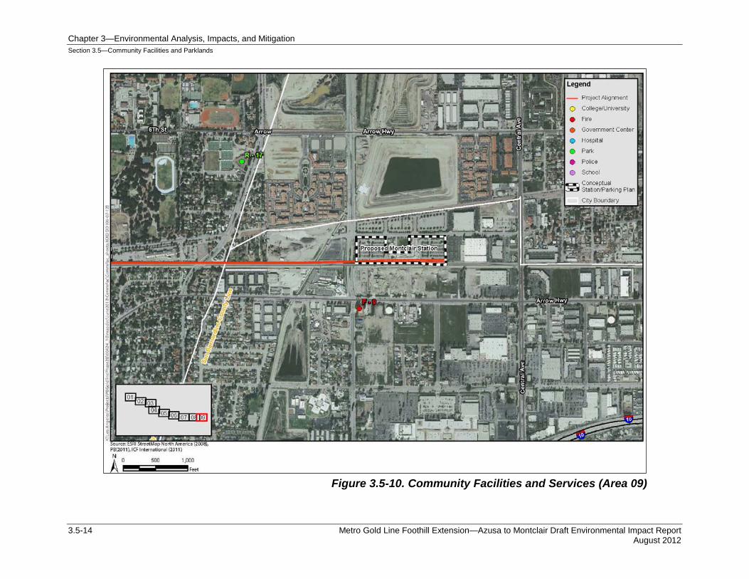
Figure 3.5-1 (key map) and Figure 3.5-2 through Figure 3.5-10 show the locations of community facilities. An inventory of community services and facilities within the Study Area is provided in Table 3.5-1 through Table 3.5-8. Each public facility is identified by type, name, address, and distance from the project.
Chapter 3—Environmental Analysis, Impacts, and Mitigation Section 3.5—Community Facilities and Parklands
Metro Gold Line Foothill Extension—Azusa to Montclair Draft Environmental Impact Report 3.5-5 August 2012
Figure 3.5-1. Community Facilities and Services (Key Map)
Chapter 3—Environmental Analysis, Impacts, and Mitigation Section 3.5—Community Facilities and Parklands
3.5-6 Metro Gold Line Foothill Extension—Azusa to Montclair Draft Environmental Impact Report August 2012
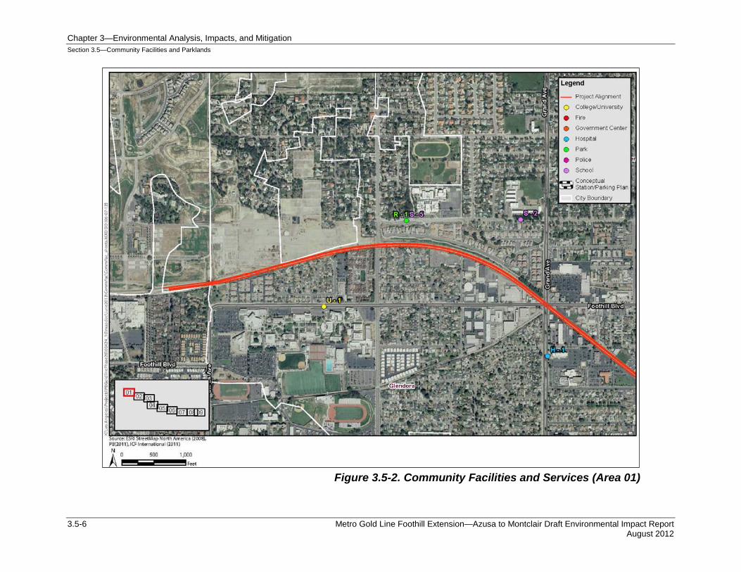
Figure 3.5-2. Community Facilities and Services (Area 01)
Chapter 3—Environmental Analysis, Impacts, and Mitigation Section 3.5—Community Facilities and Parklands
Metro Gold Line Foothill Extension—Azusa to Montclair Draft Environmental Impact Report 3.5-7 August 2012
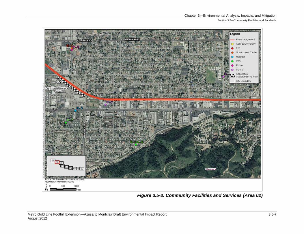
Figure 3.5-3. Community Facilities and Services (Area 02)
Chapter 3—Environmental Analysis, Impacts, and Mitigation Section 3.5—Community Facilities and Parklands
3.5-8 Metro Gold Line Foothill Extension—Azusa to Montclair Draft Environmental Impact Report August 2012
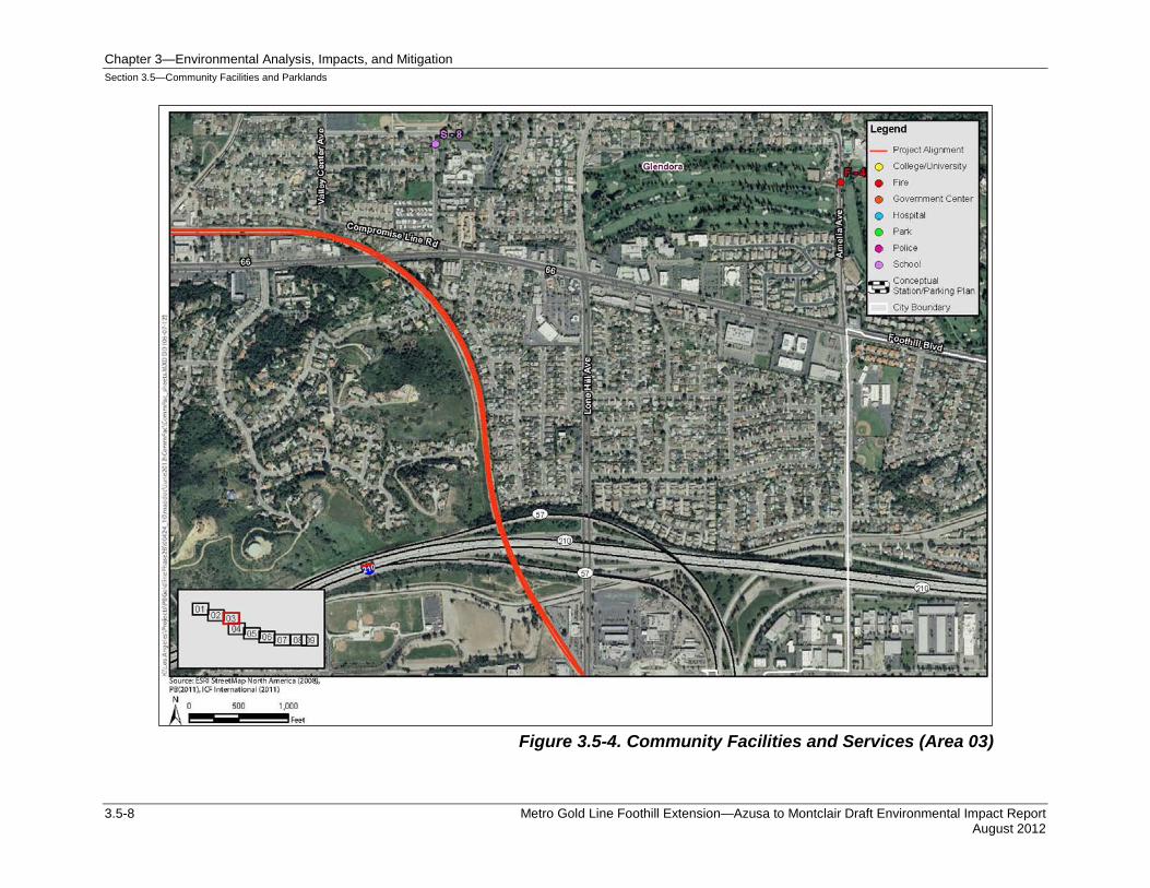
Figure 3.5-4. Community Facilities and Services (Area 03)
Chapter 3—Environmental Analysis, Impacts, and Mitigation Section 3.5—Community Facilities and Parklands
Metro Gold Line Foothill Extension—Azusa to Montclair Draft Environmental Impact Report 3.5-9 August 2012
Figure 3.5-5. Community Facilities and Services (Area 04)
Chapter 3—Environmental Analysis, Impacts, and Mitigation Section 3.5—Community Facilities and Parklands
3.5-10 Metro Gold Line Foothill Extension—Azusa to Montclair Draft Environmental Impact Report August 2012
Figure 3.5-6. Community Facilities and Services (Area 05)
Chapter 3—Environmental Analysis, Impacts, and Mitigation Section 3.5—Community Facilities and Parklands
Metro Gold Line Foothill Extension—Azusa to Montclair Draft Environmental Impact Report 3.5-11 August 2012
Figure 3.5-7. Community Facilities and Services (Area 06)
Chapter 3—Environmental Analysis, Impacts, and Mitigation Section 3.5—Community Facilities and Parklands
3.5-12 Metro Gold Line Foothill Extension—Azusa to Montclair Draft Environmental Impact Report August 2012
Figure 3.5-8. Community Facilities and Services (Area 07)
Chapter 3—Environmental Analysis, Impacts, and Mitigation Section 3.5—Community Facilities and Parklands
Metro Gold Line Foothill Extension—Azusa to Montclair Draft Environmental Impact Report 3.5-13 August 2012
Figure 3.5-9. Community Facilities and Services (Area 08)
Chapter 3—Environmental Analysis, Impacts, and Mitigation Section 3.5—Community Facilities and Parklands
3.5-14 Metro Gold Line Foothill Extension—Azusa to Montclair Draft Environmental Impact Report August 2012
Figure 3.5-10. Community Facilities and Services (Area 09)
Chapter 3—Environmental Analysis, Impacts, and Mitigation Section 3.5—Community Facilities and Parklands
Metro Gold Line Foothill Extension—Azusa to Montclair Draft Environmental Impact Report 3.5-15 August 2012
3.5.2.1 Police Protection Services Police protection services in the Study Area are provided by a combination of individual city police departments and Los Angeles Sheriff’s Department (LASD). Glendora, La Verne, Claremont, and Montclair are served by City police departments and Pomona and San Dimas and unincorporated portions of Los Angeles County are served by the LASD.
Police protection for all Metro buses and trains is provided by the LASD Transit Services Bureau. The Bureau’s duties include policing railroad rights-of-way within Los Angeles County and providing on-board security for the entire Metro system. The Bureau has 392 sworn officers.
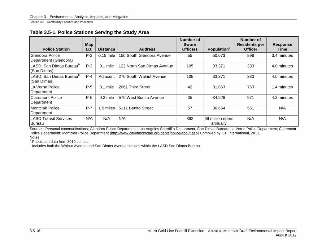
There are seven county and city police stations located within one mile of the project alignment. Table 3.5-1 shows the number of officers serving in the police departments in the Study Area. The Build Alternative project traverses the northern reaches of the City of Pomona and is more than two miles north of the Pomona Police Department. Therefore, there would be no impacts related to the construction and operation of the project to police services in Pomona; therefore, no further discussion for the City of Pomona is provided in this analysis. The portion of the project in the City of Pomona would be served by the LASD Transit Services Bureau during operation of the project.
City of Glendora The Glendora Police Department serves a population of approximately 50,000 from one central station at 150 South Glendora Avenue, approximately 0.15-mile north of the project. The project traverses Policing Districts 1, 3, and 4 of the Glendora Police Department service area.
City of San Dimas The LASD San Dimas Bureau has two substations—one adjacent to the alignment at 270 South Walnut Avenue and the other approximately 0.1-mile away at 122 North San Dimas Avenue. The San Dimas Bureau serves San Dimas and the unincorporated communities of Covina, Azusa, Glendora, La Verne, and Claremont.
City of La Verne The La Verne Police Department, with 42 sworn police officers, serves a population of approximately 31,000. The department has one central station at 2061 Third Street, approximately 0.1-mile north of the project.
Chapter 3—Environmental Analysis, Impacts, and Mitigation Section 3.5—Community Facilities and Parklands
3.5-16 Metro Gold Line Foothill Extension—Azusa to Montclair Draft Environmental Impact Report August 2012
Table 3.5-1. Police Stations Serving the Study Area
Police Station Map I.D. Distance Address
Number of Sworn
Officers Populationa
Number of Residents per
Officer Response
Time Glendora Police Department (Glendora)
P-2 0.15 mile 150 South Glendora Avenue 55 50,073 898 3.4 minutes
LASD, San Dimas Bureaub (San Dimas)
P-3 0.1 mile 122 North San Dimas Avenue 105 33,371 333 4.0 minutes
LASD, San Dimas Bureaub (San Dimas)
P-4 Adjacent 270 South Walnut Avenue 105 33,371 333 4.0 minutes
La Verne Police Department
P-5 0.1 mile 2061 Third Street 42 31,063 753 1.4 minutes
Claremont Police Department
P-6 0.2 mile 570 West Bonita Avenue 35 34,926 971 4.2 minutes
Montclair Police Department
P-7 1.5 miles 5111 Benito Street 57 36,664 551 N/A
LASD Transit Services Bureau
N/A N/A N/A 392 69 million riders annually
N/A N/A
Sources: Personal communications; Glendora Police Department; Los Angeles Sherriff’s Department, San Dimas Bureau; La Verne Police Department; Claremont Police Department; Montclair Police Department (http://www.cityofmontclair.org/depts/police/about.asp) Compiled by ICF International, 2011. Notes: a Population data from 2010 census. b Includes both the Walnut Avenue and San Dimas Avenue stations within the LASD San Dimas Bureau.
Chapter 3—Environmental Analysis, Impacts, and Mitigation Section 3.5—Community Facilities and Parklands
Metro Gold Line Foothill Extension—Azusa to Montclair Draft Environmental Impact Report 3.5-17 August 2012
City of Claremont The Claremont Police Department provides police protection to an estimated 35,000 residents. The department typically has four patrol officers on duty 24 hours a day. The Claremont Police Department is located at 570 West Bonita Avenue, approximately 0.2-mile north of the project.
City of Montclair The Montclair Police Department has 57 sworn officers, plus a support staff of 21 civilian employees and 20 volunteers. The department serves a population of approximately 37,000. The police station is located at 5111 Benito Street in Montclair, approximately 1.5 mile south of the project.
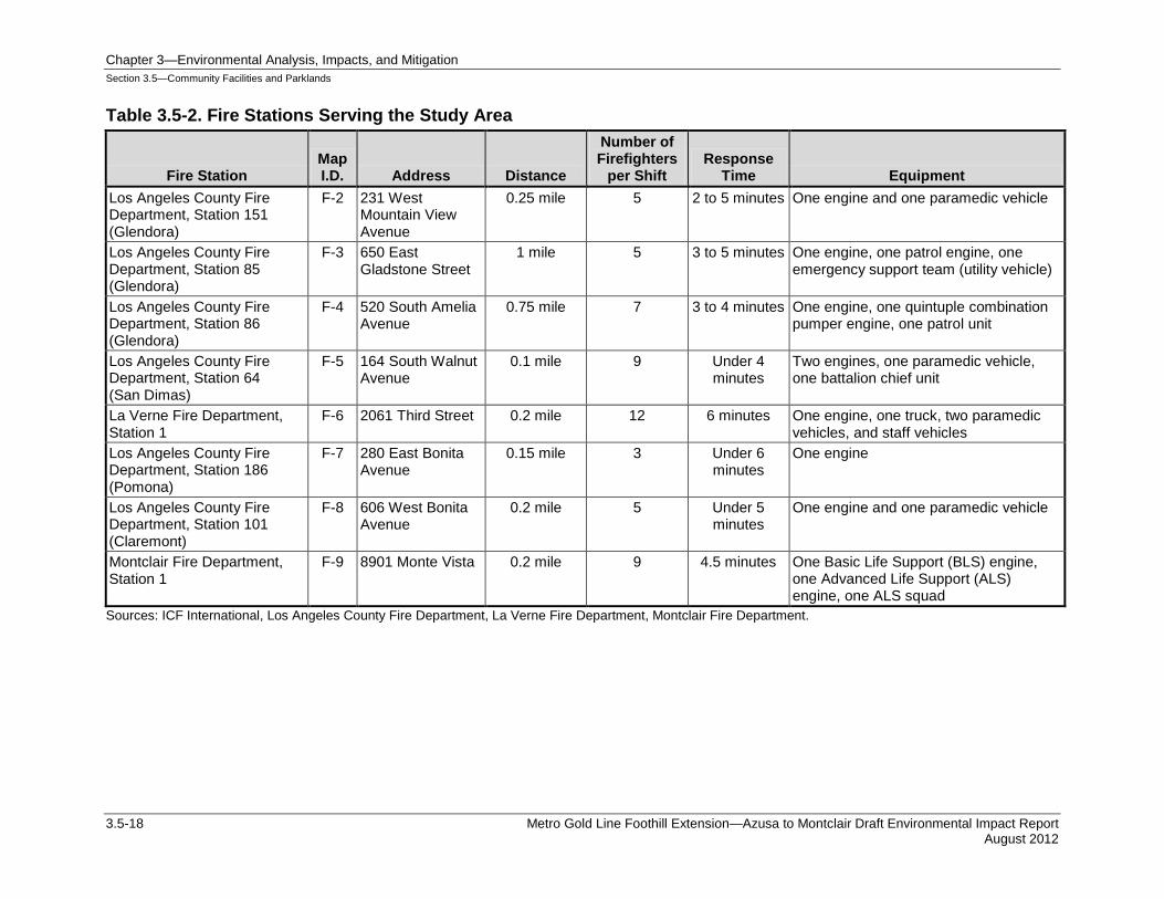
3.5.2.2 Fire Protection With exception of the City of Montclair, which is served by its City Fire Department, fire protection in the Study Area is provided by the Los Angeles County Fire Department (LACOFD). Glendora, San Dimas, Pomona, and Claremont, as well as unincorporated portions of Los Angeles County, are served by LACOFD. Nine city and county fire stations are located within one mile of the project. Generally, the stations are dispersed one to three miles apart to provide adequate service coverage and response times within a wide geographic area. Most of the stations are staffed with five to nine firefighters in a given shift, although larger stations, such as La Verne Fire Department Station 1, may have as many as 12 firefighters on duty. Typical response times range from two to six minutes. Table 3.5-2 provides a detailed overview of each station within one mile of the Build Alternative project.
Some of the cities along the alignment are divided by I-210 freeway or by railroad tracks (some of which are active). The freeway and railroad tracks can create detours and delays for emergency response providers when trying to reach an address on the other side of the freeway or tracks. However, fire departments along the alignment are continually improving emergency response plans and routes to accommodate the freeway and railroad tracks and maintain response times.
Chapter 3—Environmental Analysis, Impacts, and Mitigation Section 3.5—Community Facilities and Parklands
3.5-18 Metro Gold Line Foothill Extension—Azusa to Montclair Draft Environmental Impact Report August 2012
Table 3.5-2. Fire Stations Serving the Study Area
Fire Station Map I.D. Address Distance
Number of Firefighters
per Shift Response
Time Equipment Los Angeles County Fire Department, Station 151 (Glendora)
F-2 231 West Mountain View Avenue
0.25 mile 5 2 to 5 minutes One engine and one paramedic vehicle
Los Angeles County Fire Department, Station 85 (Glendora)
F-3 650 East Gladstone Street
1 mile 5 3 to 5 minutes One engine, one patrol engine, one emergency support team (utility vehicle)
Los Angeles County Fire Department, Station 86 (Glendora)
F-4 520 South Amelia Avenue
0.75 mile 7 3 to 4 minutes One engine, one quintuple combination pumper engine, one patrol unit
Los Angeles County Fire Department, Station 64 (San Dimas)
F-5 164 South Walnut Avenue
0.1 mile 9 Under 4 minutes
Two engines, one paramedic vehicle, one battalion chief unit
La Verne Fire Department, Station 1
F-6 2061 Third Street 0.2 mile 12 6 minutes One engine, one truck, two paramedic vehicles, and staff vehicles
Los Angeles County Fire Department, Station 186 (Pomona)
F-7 280 East Bonita Avenue
0.15 mile 3 Under 6 minutes
One engine
Los Angeles County Fire Department, Station 101 (Claremont)
F-8 606 West Bonita Avenue
0.2 mile 5 Under 5 minutes
One engine and one paramedic vehicle
Montclair Fire Department, Station 1
F-9 8901 Monte Vista 0.2 mile 9 4.5 minutes One Basic Life Support (BLS) engine, one Advanced Life Support (ALS) engine, one ALS squad
Sources: ICF International, Los Angeles County Fire Department, La Verne Fire Department, Montclair Fire Department.
Chapter 3—Environmental Analysis, Impacts, and Mitigation Section 3.5—Community Facilities and Parklands
Metro Gold Line Foothill Extension—Azusa to Montclair Draft Environmental Impact Report 3.5-19 August 2012
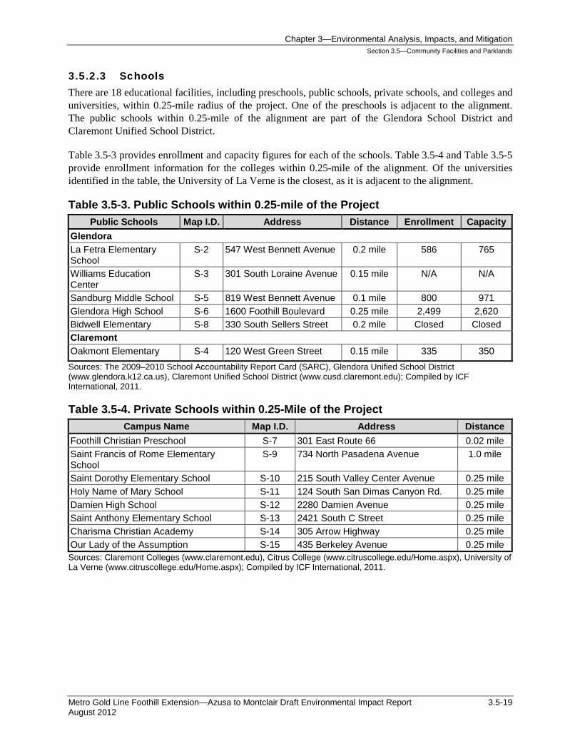
3.5.2.3 Schools There are 18 educational facilities, including preschools, public schools, private schools, and colleges and universities, within 0.25-mile radius of the project. One of the preschools is adjacent to the alignment. The public schools within 0.25-mile of the alignment are part of the Glendora School District and Claremont Unified School District.
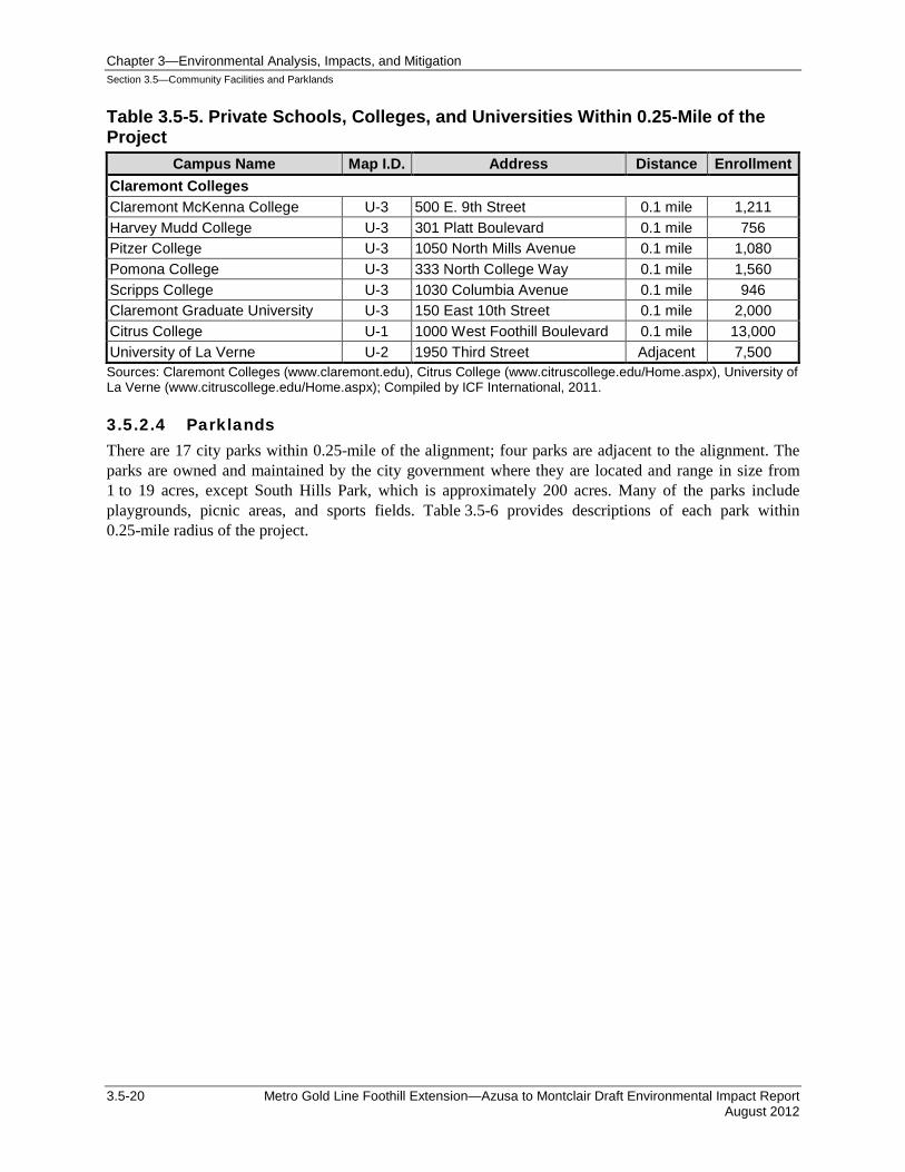
Table 3.5-3 provides enrollment and capacity figures for each of the schools. Table 3.5-4 and Table 3.5-5 provide enrollment information for the colleges within 0.25-mile of the alignment. Of the universities identified in the table, the University of La Verne is the closest, as it is adjacent to the alignment.
Table 3.5-3. Public Schools within 0.25-mile of the Project Public Schools Map I.D. Address Distance Enrollment Capacity
Glendora La Fetra Elementary School
S-2 547 West Bennett Avenue 0.2 mile 586 765
Williams Education Center
S-3 301 South Loraine Avenue 0.15 mile N/A N/A
Sandburg Middle School S-5 819 West Bennett Avenue 0.1 mile 800 971 Glendora High School S-6 1600 Foothill Boulevard 0.25 mile 2,499 2,620 Bidwell Elementary S-8 330 South Sellers Street 0.2 mile Closed Closed Claremont Oakmont Elementary S-4 120 West Green Street 0.15 mile 335 350 Sources: The 2009–2010 School Accountability Report Card (SARC), Glendora Unified School District (www.glendora.k12.ca.us), Claremont Unified School District (www.cusd.claremont.edu); Compiled by ICF International, 2011.
Table 3.5-4. Private Schools within 0.25-Mile of the Project Campus Name Map I.D. Address Distance
Foothill Christian Preschool S-7 301 East Route 66 0.02 mile Saint Francis of Rome Elementary School
S-9 734 North Pasadena Avenue 1.0 mile
Saint Dorothy Elementary School S-10 215 South Valley Center Avenue 0.25 mile Holy Name of Mary School S-11 124 South San Dimas Canyon Rd. 0.25 mile Damien High School S-12 2280 Damien Avenue 0.25 mile Saint Anthony Elementary School S-13 2421 South C Street 0.25 mile Charisma Christian Academy S-14 305 Arrow Highway 0.25 mile Our Lady of the Assumption S-15 435 Berkeley Avenue 0.25 mile Sources: Claremont Colleges (www.claremont.edu), Citrus College (www.citruscollege.edu/Home.aspx), University of La Verne (www.citruscollege.edu/Home.aspx); Compiled by ICF International, 2011.
Chapter 3—Environmental Analysis, Impacts, and Mitigation Section 3.5—Community Facilities and Parklands
3.5-20 Metro Gold Line Foothill Extension—Azusa to Montclair Draft Environmental Impact Report August 2012
Table 3.5-5. Private Schools, Colleges, and Universities Within 0.25-Mile of the Project
Campus Name Map I.D. Address Distance Enrollment Claremont Colleges Claremont McKenna College U-3 500 E. 9th Street 0.1 mile 1,211 Harvey Mudd College U-3 301 Platt Boulevard 0.1 mile 756 Pitzer College U-3 1050 North Mills Avenue 0.1 mile 1,080 Pomona College U-3 333 North College Way 0.1 mile 1,560 Scripps College U-3 1030 Columbia Avenue 0.1 mile 946 Claremont Graduate University U-3 150 East 10th Street 0.1 mile 2,000 Citrus College U-1 1000 West Foothill Boulevard 0.1 mile 13,000 University of La Verne U-2 1950 Third Street Adjacent 7,500 Sources: Claremont Colleges (www.claremont.edu), Citrus College (www.citruscollege.edu/Home.aspx), University of La Verne (www.citruscollege.edu/Home.aspx); Compiled by ICF International, 2011.
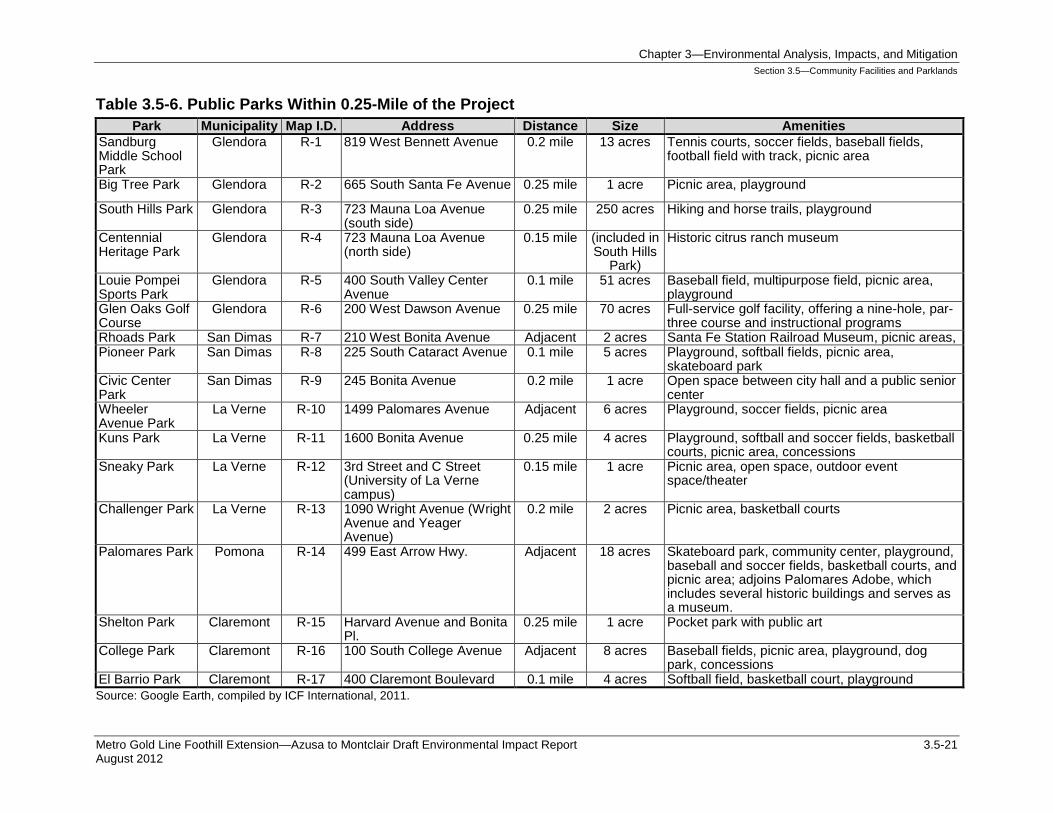
3.5.2.4 Parklands There are 17 city parks within 0.25-mile of the alignment; four parks are adjacent to the alignment. The parks are owned and maintained by the city government where they are located and range in size from 1 to 19 acres, except South Hills Park, which is approximately 200 acres. Many of the parks include playgrounds, picnic areas, and sports fields. Table 3.5-6 provides descriptions of each park within 0.25-mile radius of the project.
Chapter 3—Environmental Analysis, Impacts, and Mitigation Section 3.5—Community Facilities and Parklands
Metro Gold Line Foothill Extension—Azusa to Montclair Draft Environmental Impact Report 3.5-21 August 2012
Table 3.5-6. Public Parks Within 0.25-Mile of the Project Park Municipality Map I.D. Address Distance Size Amenities
Sandburg Middle School Park
Glendora R-1 819 West Bennett Avenue 0.2 mile 13 acres Tennis courts, soccer fields, baseball fields, football field with track, picnic area
Big Tree Park Glendora R-2 665 South Santa Fe Avenue 0.25 mile 1 acre Picnic area, playground
South Hills Park Glendora R-3 723 Mauna Loa Avenue (south side)
0.25 mile 250 acres Hiking and horse trails, playground
Centennial Heritage Park
Glendora R-4 723 Mauna Loa Avenue (north side)
0.15 mile (included in South Hills
Park)
Historic citrus ranch museum
Louie Pompei Sports Park
Glendora R-5 400 South Valley Center Avenue
0.1 mile 51 acres Baseball field, multipurpose field, picnic area, playground
Glen Oaks Golf Course
Glendora R-6 200 West Dawson Avenue 0.25 mile 70 acres Full-service golf facility, offering a nine-hole, par-three course and instructional programs
Rhoads Park San Dimas R-7 210 West Bonita Avenue Adjacent 2 acres Santa Fe Station Railroad Museum, picnic areas, Pioneer Park San Dimas R-8 225 South Cataract Avenue 0.1 mile 5 acres Playground, softball fields, picnic area,
skateboard park Civic Center Park
San Dimas R-9 245 Bonita Avenue 0.2 mile 1 acre Open space between city hall and a public senior center
Wheeler Avenue Park
La Verne R-10 1499 Palomares Avenue Adjacent 6 acres Playground, soccer fields, picnic area
Kuns Park La Verne R-11 1600 Bonita Avenue 0.25 mile 4 acres Playground, softball and soccer fields, basketball courts, picnic area, concessions
Sneaky Park La Verne R-12 3rd Street and C Street (University of La Verne campus)
0.15 mile 1 acre Picnic area, open space, outdoor event space/theater
Challenger Park La Verne R-13 1090 Wright Avenue (Wright Avenue and Yeager Avenue)
0.2 mile 2 acres Picnic area, basketball courts
Palomares Park Pomona R-14 499 East Arrow Hwy. Adjacent 18 acres Skateboard park, community center, playground, baseball and soccer fields, basketball courts, and picnic area; adjoins Palomares Adobe, which includes several historic buildings and serves as a museum.
Shelton Park Claremont R-15 Harvard Avenue and Bonita Pl.
0.25 mile 1 acre Pocket park with public art
College Park Claremont R-16 100 South College Avenue Adjacent 8 acres Baseball fields, picnic area, playground, dog park, concessions
El Barrio Park Claremont R-17 400 Claremont Boulevard 0.1 mile 4 acres Softball field, basketball court, playground Source: Google Earth, compiled by ICF International, 2011.
Chapter 3—Environmental Analysis, Impacts, and Mitigation Section 3.5—Community Facilities and Parklands
3.5-22 Metro Gold Line Foothill Extension—Azusa to Montclair Draft Environmental Impact Report August 2012
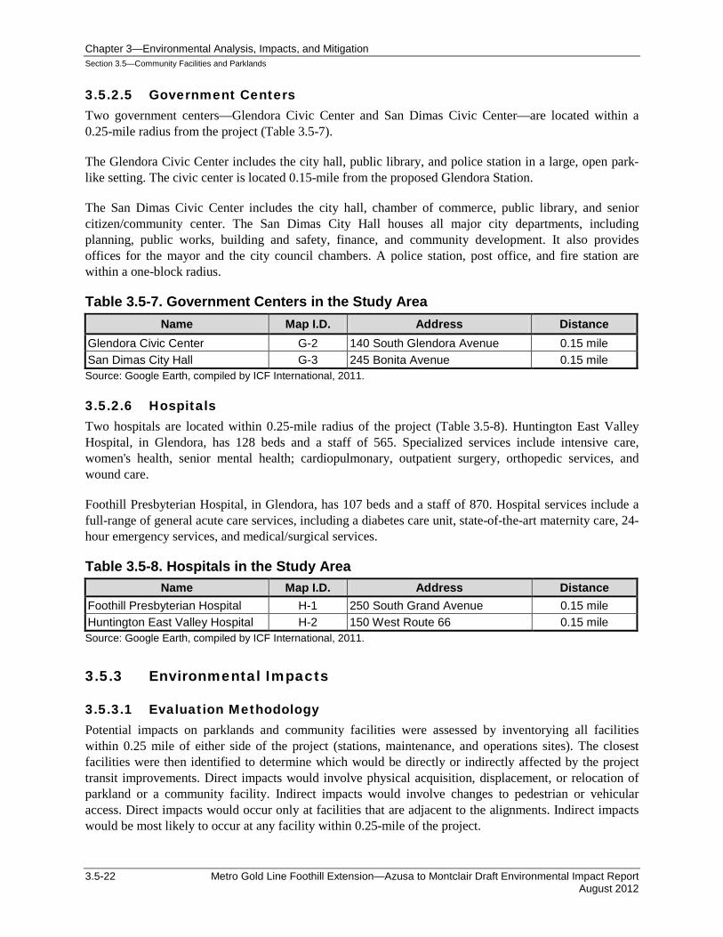
3.5.2.5 Government Centers Two government centers—Glendora Civic Center and San Dimas Civic Center—are located within a 0.25-mile radius from the project (Table 3.5-7).
The Glendora Civic Center includes the city hall, public library, and police station in a large, open park-like setting. The civic center is located 0.15-mile from the proposed Glendora Station.
The San Dimas Civic Center includes the city hall, chamber of commerce, public library, and senior citizen/community center. The San Dimas City Hall houses all major city departments, including planning, public works, building and safety, finance, and community development. It also provides offices for the mayor and the city council chambers. A police station, post office, and fire station are within a one-block radius.
Table 3.5-7. Government Centers in the Study Area Name Map I.D. Address Distance
Glendora Civic Center G-2 140 South Glendora Avenue 0.15 mile San Dimas City Hall G-3 245 Bonita Avenue 0.15 mile Source: Google Earth, compiled by ICF International, 2011.
3.5.2.6 Hospitals Two hospitals are located within 0.25-mile radius of the project (Table 3.5-8). Huntington East Valley Hospital, in Glendora, has 128 beds and a staff of 565. Specialized services include intensive care, women's health, senior mental health; cardiopulmonary, outpatient surgery, orthopedic services, and wound care.
Foothill Presbyterian Hospital, in Glendora, has 107 beds and a staff of 870. Hospital services include a full-range of general acute care services, including a diabetes care unit, state-of-the-art maternity care, 24-hour emergency services, and medical/surgical services.
Table 3.5-8. Hospitals in the Study Area Name Map I.D. Address Distance
Foothill Presbyterian Hospital H-1 250 South Grand Avenue 0.15 mile Huntington East Valley Hospital H-2 150 West Route 66 0.15 mile Source: Google Earth, compiled by ICF International, 2011.
3.5.3 Environmental Impacts
3.5.3.1 Evaluation Methodology Potential impacts on parklands and community facilities were assessed by inventorying all facilities within 0.25 mile of either side of the project (stations, maintenance, and operations sites). The closest facilities were then identified to determine which would be directly or indirectly affected by the project transit improvements. Direct impacts would involve physical acquisition, displacement, or relocation of parkland or a community facility. Indirect impacts would involve changes to pedestrian or vehicular access. Direct impacts would occur only at facilities that are adjacent to the alignments. Indirect impacts would be most likely to occur at any facility within 0.25-mile of the project.
Chapter 3—Environmental Analysis, Impacts, and Mitigation Section 3.5—Community Facilities and Parklands
Metro Gold Line Foothill Extension—Azusa to Montclair Draft Environmental Impact Report 3.5-23 August 2012
Pedestrian and vehicular access is discussed in Chapter 2, Transportation. Safety and security issues for motorists and the surrounding community are discussed in Section 3.12. Other potential indirect impacts are those related to air quality and noise, and are addressed in Section 3.1 and Section 3.11, respectively.
3.5.3.2 Impact Criteria A project would have a significant impact if it would:
• Result in substantial adverse physical impacts associated with the provision of new or physically altered governmental facilities or the need for new or physically altered governmental facilities, the construction of which would cause significant environmental impacts, to maintain acceptable service ratios, response times, or other performance objectives for any of the following public services − Fire protection − Police protection − Schools − Parks − Other community facilities − Recreational facilities
• Increase the use of existing neighborhood and regional parks or other recreational facilities such that substantial physical deterioration of the facilities would occur or be accelerated
• Include recreational facilities or require the construction or expansion of recreational facilities, which might have an adverse physical effect on the environment
3.5.3.3 Short-Term Construction Impacts
No Build Alternative The No Build Alternative does not involve construction; therefore, no construction impacts to parklands or public facilities and services would occur.
Transportation Systems Management (TSM) Alternative The TSM Alternative is a rapid bus system that would not require major construction. Under the TSM Alternative, any construction impacts associated with new or enhanced bus stops would be less than significant.
Build Alternative
Police Protection Potential impacts on police protection services would be related to traffic and disruptions along access routes. Construction vehicles could increase traffic congestion, and road closures or road construction could affect emergency response times. Local roads that cross the alignment would be partially closed during track construction. Typically, half of the road would be closed to allow track installation, and the other half would remain open to traffic. Most intersections would be affected for only a few days (i.e., during track construction). These intermittent traffic disruptions would be temporary and would not substantially affect police response times. A traffic management plan (TMP), described in Chapter 2, would be implemented addressing traffic issues during construction. The TMP includes provisions for coordinating with the police and fire departments of the affected Cities to develop alternate routes or
Chapter 3—Environmental Analysis, Impacts, and Mitigation Section 3.5—Community Facilities and Parklands
3.5-24 Metro Gold Line Foothill Extension—Azusa to Montclair Draft Environmental Impact Report August 2012
adjust service areas, thereby allowing the departments to maintain emergency service coverage areas and response times during project construction. Therefore, impacts to police protection would be less than significant.
Fire Protection Impacts of the Build Alternative project on fire protection services would be related to water supply interruptions that could affect fire flow and to traffic disruptions that could affect emergency response times. In general, the required fire flow is closely related to land use. The quantity of water necessary for fire protection varies with the type of development, life hazard, occupancy, and the degree of fire hazard. The type of land use and required fire flow varies along the alignment. During construction, there could be temporary water supply disruptions; however, disruptions would be infrequent and localized, and typically last less than one hour. All construction practices would comply with local fire codes.
Access disruptions, such as road closures or road construction, could affect emergency response times; however, these intermittent disruptions would be temporary. There would be no long-term road closures or detours during project construction; however, some short-term closures may be required to install tracks across roadways that intersect the alignment. In general, fire stations along the alignment would be evenly distributed, with nine stations north of the alignment and seven stations south of the alignment. Most stations are located approximately two miles apart. This even distribution of fire stations along the alignment would ensure adequate fire service coverage. Further, the TMP would include provisions for coordinating with local and county fire departments to develop alternative routes or adjust service areas, thereby enabling the departments to maintain emergency service coverage areas and response times during project construction. Therefore, impact would be less than significant.
Schools There are six public schools, eight private schools, and three colleges/universities within 0.25-mile of the project alignment. Construction activities would include grading the alignment and installing new tracks. Most locations along the alignment would experience intermittent noise and air quality impacts during project construction. Construction at stations would occur over a longer period and would be at a fixed location; therefore, construction impacts near stations could be more intense than in other places along the alignment.
The potential for temporary construction noise impacts would be limited to locations within about 125 feet of the corridor. However, construction noise impacts would be eliminated or reduced and would not be significant due to compliance with the local, state, and regulatory requirements and/or permits, and the implementation of additional measures to mitigate impacts identified in Section 3.11.
Schools located along the alignment are in densely populated urban environments, and the incremental change in noise levels or air quality during construction would not be substantial. Mitigation measures will be implemented to reduce fugitive dust to a level that would be less than significant (refer to Section 3.1). During construction, roads near schools may experience an increase in traffic as trucks travel to and from the Study Area. However, this would be a small increase in traffic; with implementation of the Traffic Management Control Plan (TMCP) provision for reducing construction traffic near schools, it would not result in significant impacts on school children in the Study Area. The TMCP would be developed in close coordination with local jurisdictions, the local emergency response agencies, and school districts, and would address the school districts needs to ensure uninterrupted operations of school buses and other circulation and traffic issues related to schools along the alignment.
Chapter 3—Environmental Analysis, Impacts, and Mitigation Section 3.5—Community Facilities and Parklands
Metro Gold Line Foothill Extension—Azusa to Montclair Draft Environmental Impact Report 3.5-25 August 2012
• City of Glendora—Because of the distance that would separate the four Glendora public schools (between 0.1 mile and 0.25 mile) in the Study Area from construction activities, impacts related to construction noise, dust, and safety would be minimal. Further, each school is surrounded by urban uses, including roadways and buildings that would act as buffers to these construction effects. Therefore, construction-related impacts would be less than significant.
• City of La Verne—The University of La Verne would be exposed to noise impacts. Noise mitigation measures would be implemented to reduce noise to a level that would be less than significant.
• City of Claremont—Oakmont Elementary School in Claremont is located 0.15 mile from the right-of-way. However, industrial buildings and a parking lot separate the school property from the alignment. Therefore, construction-related impacts would be less than significant.
Parkland Construction activities would result in periodic noise, vibration, air quality, and visual impacts that could indirectly affect parks and recreational facilities. Parks located adjacent to the alignment would be affected more by construction nuisance impacts than those located farther away. Most construction-related impacts would be temporary and affect park patrons for only a few days or weeks (i.e., while track is being installed near the park). The potential for temporary noise impacts would be limited to locations within about 125 feet of the alignment. Also, construction activities would be conducted in compliance with the applicable local, and state regulatory requirements and would include implementation of additional measures to mitigate impacts identified in Section 3.11. As a result, potential noise impacts would be eliminated or reduced to level that would be less than significant. Mitigation measures also would be implemented to reduce fugitive dust impacts to a level that would be less than significant.
• City of Glendora—There are six parks located within 0.25-mile of the alignment (i.e., Sandburg Middle School Park, Big Tree Park, South Hills Park, Centennial Heritage Park, Louie Pompei Sports Park, and Glen Oaks Golf Course). Park patrons would experience typical construction impacts, such as temporary and intermittent increases in noise and emissions.
• City of San Dimas—The project would be constructed along the northeastern boundary of Rhodes Park. This area of the park contains a railroad museum and is separated from the alignment by a fence. Currently, the tracks adjacent to the park are active; however, only one or two freight trains use this segment of the railroad line each day. A new fence will be installed along the alignment to prevent access to the railroad right-of-way and ensure the safety of park patrons.
Rhodes Park would not be considered noise-sensitive. It is a small park used primarily by visitors to the railroad museum. Although construction dust may affect park patrons, air quality mitigation measures will be implemented to reduce fugitive dust impacts. In addition, the presence of catenaries along the alignment would not significantly detract from the visual setting of the park (see Section 3.13).
Pioneer Park and Civic Center Park are separated from the alignment by intervening structures and roads. Therefore, potential air quality or noise impacts resulting from project construction would not significantly affect park patrons.
• City of La Verne—Wheeler Avenue Park is located just north of the alignment and is separated from the alignment by Palomares Avenue and another rail line. The southern and eastern boundaries of the park are fenced. Park patrons would experience typical construction impacts related to intermittent and temporary increases in dust and noise from construction equipment and activities (described in Section 3.1 and Section 3.11).
Chapter 3—Environmental Analysis, Impacts, and Mitigation Section 3.5—Community Facilities and Parklands
3.5-26 Metro Gold Line Foothill Extension—Azusa to Montclair Draft Environmental Impact Report August 2012
Kuns Park is separated from the alignment by intervening structures and roads. Challenger Park is separated from the alignment by an undeveloped area. Both parks are far enough from the tracks so that potential dust and noise from project construction would have limited potential to affect park patrons.
• City of Pomona—Palomares Park is adjacent to the south of the alignment; the existing railroad tracks are less than 50 feet from the park. A fence along the northern boundary of the park separates it from the tracks. Currently, the railroad tracks adjacent to the park are active; however, only one or two freight trains a day use this segment of the line. Project construction could expose park patrons to loud noise; however, the park was determined not to be a noise-sensitive receptor. Construction dust may affect park patrons; however, mitigation measures would be implemented to reduce dust levels that would have limited potential to significantly affect park patrons (refer to Section 3.1).
• City of Claremont—College Park is adjacent to the south of the alignment. The existing railroad tracks are less than 50 feet from the park. A fence and vegetation along the northern boundary of the park separate it from the tracks. Currently, these tracks are active, although only one or two freight trains a day use this segment of the line. Project construction would expose park patrons to loud noise; however, the park was determined not to be a noise-sensitive receptor. Construction dust may affect park patrons; however, air quality mitigation measures would be implemented to reduce fugitive dust impacts to a level that would have limited potential to significantly affect park patrons (refer to Section 3.1).
Shelton Park and El Barrio Park are separated from the alignment by intervening structures and roads. Therefore, potential noise impacts resulting from project construction would be unlikely to affect park patrons.
• City of Montclair—There are no parks in Montclair within 0.25-mile of the project.
Government Centers Potential impacts of the project on government centers would be related to construction traffic, detours, and access disruptions. Employees and patrons may experience elevated noise levels and reduced air quality because of construction activities. However, these temporary effects would be intermittent and, therefore, are not expected to be disruptive of the centers’ functions or operations.
Two government centers are located within 0.25-mile radius of the alignment: the Glendora Civic Center and San Dimas City Hall. Both would experience typical construction impacts, such as minor traffic disruptions and construction nuisances; however, access would be maintained to all buildings at all times during project construction, and impacts would be temporary. Therefore, construction impacts would not be expected to affect the function of these government centers, and impacts would be less than significant.
Hospitals Potential construction impacts on hospitals would be related to emergency access disruptions, elevated noise levels, and reduced air quality. Because of the availability of alternate routes, no construction activities are expected to affect emergency vehicles while en route to area hospitals. In addition, a TMP would be implemented during the construction period, which would establish alternate routes and ensure that emergency service coverage areas and response times would be maintained.
Construction noise, vibration, and air quality impacts could affect hospital operations and patients. However, hospitals along the alignment are located in a densely populated urban environment where
Chapter 3—Environmental Analysis, Impacts, and Mitigation Section 3.5—Community Facilities and Parklands
Metro Gold Line Foothill Extension—Azusa to Montclair Draft Environmental Impact Report 3.5-27 August 2012
construction of this magnitude is not uncommon. Furthermore, hospital ventilation systems are capable of filtering typical construction dust.
Temporary construction noise impacts would be limited to locations within about 125 feet of the alignment. Construction activities would be conducted in compliance with local, state, and/or federal regulatory requirements and/or the permits, as well as the measures to mitigate impacts identified in Section 3.11. As a result, noise impacts would be eliminated or substantially reduced through compliance with local regulations. Also, mitigation measures would be implemented to reduce fugitive dust (refer to Section 3.1).
Two hospitals are located within 0.25-mile of the alignment: Foothill Presbyterian Hospital and Huntington East Valley Hospital. Both hospitals would experience typical construction impacts, such as minor access disruptions, elevated noise levels, and reduced air quality. However, none of these impacts is expected to be significant.
Emergency access to the hospitals would be maintained at all times. Furthermore, streets that cross the alignment would remain open during project construction providing access. Noise mitigation measures would be implemented at several of the medical buildings near Foothill Presbyterian Hospital and would reduce noise impacts. Therefore, impacts to hospitals would be less than significant.
3.5.3.4 Long-Term Impacts
No Build Alternative Under the No Build Alternative there would be no subsequent operational impacts to parklands or community services and facilities. New public facilities would be required to accommodate the projected growth in the region, but would not be associated with the Build Alternative.
Transportation Systems Management (TSM) Alternative Under this alternative, the reconfiguration of existing Metro and Foothill Transit bus operations would not result in any adverse impacts to parklands or other community facilities and services. There could be some moderate improvements to accessibility of schools, parks, libraries, and hospitals near the proposed bus routes, as the TSM Alternative is intended to enhance public transit service to the cities within the Study Area.
Build Alternative
Police and Fire Protection Potential long-term impacts to police and fire protection services would be related to the demand for additional services, safety, and increased response times. The project would be designed to accommodate existing and projected transit demand. It is not intended to induce population growth in the region. Additional demands for police and fire protection services in the Study Area would result from future residential and commercial growth in accordance with each City’s land use plans, not from the Build Alternative. Therefore, growth in the Study Area would be accommodated through established processes associated with police and fire department services expansion to accommodate urban growth.
The Construction Authority would work with the police and fire departments along the alignment during the design process to ensure that safety issues are adequately addressed. In addition, Metro would develop
Chapter 3—Environmental Analysis, Impacts, and Mitigation Section 3.5—Community Facilities and Parklands
3.5-28 Metro Gold Line Foothill Extension—Azusa to Montclair Draft Environmental Impact Report August 2012
a Local Emergency Preparedness Plan, which would include the project. The plan would address evacuation and rescue procedures, as well as procedures for handling train collisions or upsets.
Since the LASD Transit Services Bureau would provide police services along the alignment, at light-rail transit (LRT) stations, and on LRT trains, it is not anticipated that the project would result in the need for additional police officers or firefighters or special equipment to respond to project-related emergencies. Since no extraordinary fire hazards are associated with LRT operations, the project would not substantially affect the number of calls for assistance from city fire departments. As a result, service levels associated with police and fire protection are expected to remain adequate with the project.
Access disruptions, such as at-grade crossings, could affect emergency response times; however, LRT trains are relatively short, and traffic at an intersection is typically delayed for less than one minute. Access disruptions would be minimized by developing and implementing alternate routes or amending service areas, as necessary, to maintain emergency service coverage areas and response times following project completion.
The Glendora, La Verne, Pomona, and Claremont police and fire departments would experience impacts that would be considered typical for operation of an LRT project. The project would not substantially increase the demand for police or fire protection services in the Study Area, as the LASD Transit Services Bureau would handle most emergency calls. Therefore, the project would not result in the need for additional police officers or firefighters.
In San Dimas, the City police and fire stations are located on Walnut Street, just north of the alignment (the police station is under construction). Because Walnut Street would have an at-grade rail crossing, response times south of the alignment may be reduced slightly. However, it is not anticipated that this would be substantial because the amount of time it would take for a train to pass would be brief (less than one minute), and multiple alternate routes cross the alignment. Access disruptions would be minimized by developing and implementing alternate routes or amending service areas, as necessary, to maintain emergency service coverage and response times following project completion. Additionally, police response times would remain relatively unaffected because most police officers are in the field and not working at the police station during their shifts.
The alignment is located on the northern boundary of Montclair. Therefore, response times for emergency services providers would be relatively unaffected by project operations because Montclair firefighters and police officers would rarely have reason to cross the alignment.
Schools The project would not result in increased student enrollment because its implementation would not result induce substantial population growth. The project would serve current and future population as forecasted in adopted plans of each City. However, other impacts may occur because of the project’s proximity to individual schools along the alignment.
There could be safety concerns for younger students who would walk to and from school near the alignment. However, elementary schools generally set up catchment areas that locate school bus pickups in orientation to rail corridors and other major transportation corridors so children do not have to cross major streets or rail tracks. As a result, effects on elementary school students would be minimal. In addition, gates, bells, and lights would be installed at intersections to alert students of oncoming trains. Middle school and high school students are more likely to use transit to travel to and from school;
Chapter 3—Environmental Analysis, Impacts, and Mitigation Section 3.5—Community Facilities and Parklands
Metro Gold Line Foothill Extension—Azusa to Montclair Draft Environmental Impact Report 3.5-29 August 2012
therefore, improved transit access resulting from implementation of the Build Alternative could be a benefit to some students.
Operation of the project would not substantially increase noise levels or reduce air quality at most schools in the Study Area. However, schools located within 125 feet of the alignment could be subject to substantial increases in noise and vibration. Implementation of the noise mitigation measures discussed in Section 3.11 would reduce noise and vibration to a level that would be less than significant.
The project incorporates a range of safety features, including installations of gates, bells, and lights at intersections crossings, to alert pedestrian of oncoming trains, including students. With these features, safety concerns for students attending four public schools in the City of Glendora that are located within 0.25-mile from the alignment, including Sandburg Middle School and Glendora High School, are anticipated to be addressed. La Fetra Elementary School and the Williams Educational Center are not located on major roads; therefore, the alignment would not be as accessible as local bus services for students using public transit. Further, elementary schools generally set up catchment areas so children do not have to cross major streets. Therefore, effects on elementary school students would be minimal. Because adequate distances would separate these four Glendora public schools from the alignment, they would not be significantly affected by noise or vibration.
The University of La Verne would be exposed to potentially significant noise impacts; however, noise mitigation measures would be implemented to reduce noise impacts to a level that would be less than significant (refer to Section 3.11).
Oakmont Elementary School is separated from the alignment by multiple neighborhood streets; there is no direct access to the alignment. Therefore, safety concerns would be minimal. Furthermore, elementary schools generally set up catchment areas so that children do not have to cross major streets. Because an adequate distance would separate the school from the alignment, it would not be significantly affected by noise or vibration.
No schools in the Cities of San Dimas, Pomona, or Montclair are located within 0.25-ile of the alignment.
Parklands It is not expected that recreational facilities and parks located near the project would be overburdened or subject to increased use that would accelerate physical deterioration of park facilities. Typically, neighborhood parks are not located on major roads or near rail alignments, as they are intended to serve local residents in a neighborhood setting. Therefore, a majority of the parks within the Study Area would not be readily accessible from the proposed station stops, and the use of parks in the Study Area would not increase substantially as a result of the Build Alternative operations. Furthermore, the project would not substantially induce population growth in the Study Area and thereby would not significantly increase use of the parks.
No parkland would be acquired under the Build Alternative. Although four parks are located adjacent to the alignment, none would experience direct or indirect noise or vibration that would be significant after implementation of the noise mitigation measures (Section 3.11). Existing and planned capacity and service levels for parks and recreational facilities along the alignment are expected to be adequate with or without the project.
Chapter 3—Environmental Analysis, Impacts, and Mitigation Section 3.5—Community Facilities and Parklands
3.5-30 Metro Gold Line Foothill Extension—Azusa to Montclair Draft Environmental Impact Report August 2012
Parks in the Cities of Glendora, La Verne, Pomona, and Claremont are not located near a proposed LRT station and therefore would not be directly accessible to Gold Line riders. The parks would not experience an increase in use that would accelerate deterioration of park facilities as the project would not substantially induce population growth that could increase use of the parks within the Study Area.
Three parks are located within 0.25 mile of the alignment in the City of San Dimas. Rhodes Park is in the immediate vicinity of a proposed LRT station and would be accessible to Gold Line riders. This small park is home to the Pacific Railroad Museum; therefore, operation of an LRT line would be consistent with the park’s primary use as a museum. Further, operation of the project could bring additional patrons to the museum, which is currently underutilized.
Pioneer Park is a small neighborhood park, located approximately one-half block from the alignment. It is unlikely the park would be the destination of many Gold Line riders as it is generally used only by local residents in the surrounding neighborhood and is not a well-known or frequently visited park for residents in the greater region.
Civic Center Park is located approximately 0.25 mile from the alignment. It is not a typical neighborhood park but, rather, an open space that is associated with San Dimas City Hall; therefore, it is unlikely that the project would result in an increase in use that would accelerate deterioration of park facilities. The park does not have a high degree of recreational value because it has no recreational facilities; it is intended to serve employees and visitors at the City Hall. The park is not a recreational destination in and of itself, and any increase in use would be due to an increase in visitors to San Dimas City Hall. The project would not induce substantial population growth in the Study Area and thus, would not increase use of parks in San Dimas.
All of the parks are located too far from the alignment to be significantly affected by noise or vibration.
No parks in Montclair are located within 0.25-mile of the alignment.
Government Centers The Build Alternative would have a beneficial effect for employees of and visitors to the Glendora Civic Center and San Dimas City Hall by making public transportation more readily available. These centers are located along the alignment, and, with implementation of the Build Alternative, would be more accessible. All the government centers are located more than 1,000 feet away from the train track alignment. As such, the noise and vibration will not affect the normal functioning of these centers and no long-term noise or vibration impacts would occur.
Hospitals Since the project would not result in any long-term street closures or increases in local traffic congestion, no significant impacts are expected that would affect emergency vehicle access to hospitals, including two hospitals that are located within 0.25-mile of the alignment: Foothill Presbyterian Hospital and Huntington East Valley Hospital. Both hospitals would experience typical impacts. Furthermore, with implementation of the noise mitigation measures (Section 3.11), none of the medical centers in the Study Area would experience any significant noise impacts. The project would increase accessibility to hospitals located along the alignment and this effect would be beneficial.
Chapter 3—Environmental Analysis, Impacts, and Mitigation Section 3.5—Community Facilities and Parklands
Metro Gold Line Foothill Extension—Azusa to Montclair Draft Environmental Impact Report 3.5-31 August 2012
The Glendora Station would be located approximately 0.25- mile from Foothill Presbyterian Hospital and Huntington East Valley Hospital, which would increase accessibility and would be beneficial to patients and employees. Further, noise mitigation measures would be implemented at several of the medical buildings near Foothill Presbyterian Hospital to reduce noise impacts to a level that would be less than significant. Huntington East Valley Hospital would not be adversely affected by noise from the project.
3.5.3.5 Cumulative Impacts As with other Metro LRT lines, the Los Angeles County Sheriff’s Department would patrol Gold Line facilities. The respective Cities’ police departments would provide additional services when needed and requested by LASD. Because LACMTA (Metro) maintains its own security, the project is not expected to contribute to cumulative impacts to police services or cumulative increases in demand for police services.
The project would not significantly increase demand for fire protection services because such demand is primarily attributable to increased residential and commercial development rather than transit projects. Therefore, the project would not contribute to significant adverse cumulative impacts.
Because the Gold Line Foothill Extension is a transit project, it would not increase school enrollment and, therefore, would not contribute to adverse cumulative impacts to schools. Likewise, the project would not increase cumulative demand for parks, hospitals, libraries, and other government facilities and, therefore, would not contribute to significant cumulative impacts on such facilities.
3.5.4 Mitigation Measures
3.5.4.1 Short-Term Construction Mitigation Measures No significant impact to public facilities or services would occur with implementation of noise and air quality mitigation measures detailed in Section 3.1 and Section 3.11. No additional short-term construction mitigation measures are required.
3.5.4.2 Long-Term Mitigation Measures No significant impact on public facilities or services would occur. Therefore, long-term mitigation measures would not be required.
3.5.5 Level of Impact after Mitigation
Impacts on parklands and community facilities and services would be less than significant.
