3.2 employment and town centres - amazon web services · 3.2 employment and town centres 3.2.1...
TRANSCRIPT

3.2 Employment and Town Centres
3.2.1 Major Town Centre
The Major Town Centre (MTC) is located at the cross roads between the historic Beattys Road Reserve and new extensions to two arterial roads, forming a unique place-making structure for the centre. The urban form is delineated by the new and historic road structure, which is partly transformed into open space to create a strong framework for the centre which has at its heart key community gathering places. Additionally, a major waterway element has the potential to form a more naturalistic backdrop and break in the urban form as a linear wetland/ retarding basin linking to the broader open space network.
The MTC will form the heart of a regional catchment and will provide retail, commercial, cultural, community, sporting and social facilities. Adjacency to the Business and Industrial Precinct to the west will further strengthen the diverse employment potential and offer of the centre.
PLUMPTON PRECINCT STRUCTURE PLAN - June 2016 27
PRECINCTS
AREA SUBJECT TOURBAN DESIGN FRAMEWORK
TOWN CENTRE ‘HEART’
OPEN SPACE SPINE
HIGH DENSITY RESIDENTIAL
COMMERCIAL
OFF
ICE
& C
OM
MER
CIA
L IN
TERF
ACE
ENTE
RTA
INM
ENT
HIGH DENSITY RESIDENTIAL
RETAIL / SERVICES
AREA SUBJECT TOURBAN DESIGN FRAMEWORK
TOWN SQUARE
PARK / ACTIVE PLAY
WATERWAY, WETLANDS & RETARDING BASIN
BEATTYS ROAD HISTORIC GOLDFIELDS ROUTE
6-WAY “PINWHEEL” STREET STRUCTURE
PLACEMAKING
VIEWS TO MT. KOROROIT
VIEWS TO MT. ATKINSON
VIEWS TO MT. COTTRELL
AREA SUBJECT TOURBAN DESIGN FRAMEWORK
BEATTYS ROAD RESERVE
ARTERIAL ROAD
CONNECTOR STREET
CONNECTOR STREET - INDUSTRIAL
CONNECTOR STREET - TOWN CENTRE
FEATURE MAIN STREET
LOCAL ACCESS STREET
BUS CAPABLE STREET
ROAD & TRANSPORT NETWORK
AREA SUBJECT TOURBAN DESIGN FRAMEWORK
BEATTYS ROAD RESERVE
ARTERIAL ROAD
CONNECTOR STREET
DRAINAGE
URBAN DESIGN FRAMEWORK EXTENT
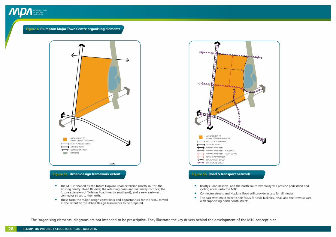
Figure 6 Plumpton Major Town Centre organising elements
• The MTC is shaped by the future Hopkins Road extension (north-south); the existing Beattys Road Reserve; the retarding basin and waterway corridor; the future extension of Tarleton Road (west – southeast); and a new east-west connector street to the north.
• These form the major design constraints and opportunities for the MTC, as well as the extent of the Urban Design Framework to be prepared.
Figure 6a Urban design framework extent Figure 6b Road & transport network
• Beattys Road Reserve, and the north-south waterway will provide pedestrian and cycling access into the MTC
• Connector streets and Hopkins Road will provide access for all modes
• The east-west main street is the focus for civic facilities, retail and the town square, with supporting north-south streets.
The ‘organising elements’ diagrams are not intended to be prescriptive. They illustrate the key drivers behind the development of the MTC concept plan.
PLUMPTON PRECINCT STRUCTURE PLAN - June 201628
PRECINCTS
AREA SUBJECT TOURBAN DESIGN FRAMEWORK
TOWN CENTRE ‘HEART’
OPEN SPACE SPINE
HIGH DENSITY RESIDENTIAL
COMMERCIAL
OFF
ICE
& C
OM
MER
CIA
L IN
TERF
ACE
ENTE
RTA
INM
ENT
HIGH DENSITY RESIDENTIAL
RETAIL / SERVICES
AREA SUBJECT TOURBAN DESIGN FRAMEWORK
TOWN SQUARE
PARK / ACTIVE PLAY
WATERWAY, WETLANDS & RETARDING BASIN
BEATTYS ROAD HISTORIC GOLDFIELDS ROUTE
6-WAY “PINWHEEL” STREET STRUCTURE
PLACEMAKING
VIEWS TO MT. KOROROIT
VIEWS TO MT. ATKINSON
VIEWS TO MT. COTTRELL
AREA SUBJECT TOURBAN DESIGN FRAMEWORK
BEATTYS ROAD RESERVE
ARTERIAL ROAD
CONNECTOR STREET
CONNECTOR STREET - INDUSTRIAL
CONNECTOR STREET - TOWN CENTRE
FEATURE MAIN STREET
LOCAL ACCESS STREET
BUS CAPABLE STREET
ROAD & TRANSPORT NETWORK
AREA SUBJECT TOURBAN DESIGN FRAMEWORK
BEATTYS ROAD RESERVE
ARTERIAL ROAD
CONNECTOR STREET
DRAINAGE
URBAN DESIGN FRAMEWORK EXTENTPRECINCTS
AREA SUBJECT TOURBAN DESIGN FRAMEWORK
TOWN CENTRE ‘HEART’
OPEN SPACE SPINE
HIGH DENSITY RESIDENTIAL
COMMERCIAL
OFF
ICE
& C
OM
MER
CIA
L IN
TERF
ACE
ENTE
RTA
INM
ENT
HIGH DENSITY RESIDENTIAL
RETAIL / SERVICES
AREA SUBJECT TOURBAN DESIGN FRAMEWORK
TOWN SQUARE
PARK / ACTIVE PLAY
WATERWAY, WETLANDS & RETARDING BASIN
BEATTYS ROAD HISTORIC GOLDFIELDS ROUTE
6-WAY “PINWHEEL” STREET STRUCTURE
PLACEMAKING
VIEWS TO MT. KOROROIT
VIEWS TO MT. ATKINSON
VIEWS TO MT. COTTRELL
AREA SUBJECT TOURBAN DESIGN FRAMEWORK
BEATTYS ROAD RESERVE
ARTERIAL ROAD
CONNECTOR STREET
CONNECTOR STREET - INDUSTRIAL
CONNECTOR STREET - TOWN CENTRE
FEATURE MAIN STREET
LOCAL ACCESS STREET
BUS CAPABLE STREET
ROAD & TRANSPORT NETWORK
AREA SUBJECT TOURBAN DESIGN FRAMEWORK
BEATTYS ROAD RESERVE
ARTERIAL ROAD
CONNECTOR STREET
DRAINAGE
URBAN DESIGN FRAMEWORK EXTENT
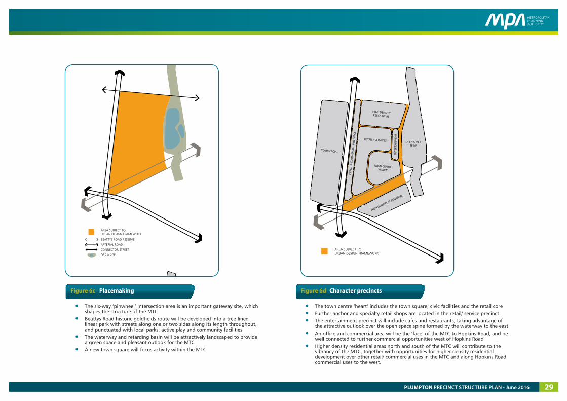
Figure 6c Placemaking Figure 6d Character precincts
• The six-way ‘pinwheel’ intersection area is an important gateway site, which shapes the structure of the MTC
• Beattys Road historic goldfields route will be developed into a tree-lined linear park with streets along one or two sides along its length throughout, and punctuated with local parks, active play and community facilities
• The waterway and retarding basin will be attractively landscaped to provide a green space and pleasant outlook for the MTC
• A new town square will focus activity within the MTC
• The town centre ‘heart’ includes the town square, civic facilities and the retail core
• Further anchor and specialty retail shops are located in the retail/ service precinct
• The entertainment precinct will include cafes and restaurants, taking advantage of the attractive outlook over the open space spine formed by the waterway to the east
• An office and commercial area will be the ‘face’ of the MTC to Hopkins Road, and be well connected to further commercial opportunities west of Hopkins Road
• Higher density residential areas north and south of the MTC will contribute to the vibrancy of the MTC, together with opportunities for higher density residential development over other retail/ commercial uses in the MTC and along Hopkins Road commercial uses to the west.
PLUMPTON PRECINCT STRUCTURE PLAN - June 2016 29
anchor retail
retail (commercial / mixed use / residential over)
mix of commercial uses (residential over)
mixed use (must have business / other employment use on ground floor at minimum) with loop road frontage
entertainment / food
commercial (residential over)
business
large format retail
car parking
community facilities
high density residential
residential
active frontage
accentuated height
plaza
high quality public realm
pedestrian priority (e.g. pavement treatment)
active playspace (e.g. skatepark)
retarding basin / waterway
beattys road linear park
extent of beattys road reserve
arterial road (6 lanes)
connector street
connector street - town centre
connector street - industrial
feature main street
local access street
roundabout (including pedestrian / cycle crossing points)
signalised intersection
priority crossing (e.g raised path)
bike route
shared path
key pedestrian circulation
car park access point
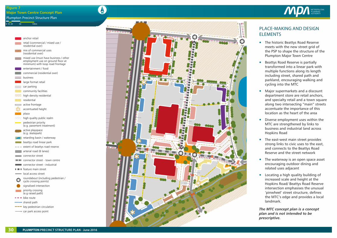
Major Town Centre Concept Plan
Plumpton Precinct Structure Plan
Figure 7Major Town Centre Concept Plan
5020100 100m
Copyright, Metropolitan Planning Authority, 2016 The state of Victoria does not warrant the accuracy or completeness of information in this publication and any person using or relying upon such information does so on the basis that the State of Victoria shall bear no responsibility or liability whatsoever for any errors, faults, defects or omission in the information.
PLACE-MAKING AND DESIGN ELEMENTS
• The historic Beattys Road Reserve meets with the new street grid of the PSP to shape the structure of the Plumpton Major Town Centre
• Beattys Road Reserve is partially transformed into a linear park with multiple functions along its length including street, shared path and parkland, encouraging walking and cycling into the MTC
• Major supermarkets and a discount department store are retail anchors, and specialty retail and a town square along two intersecting “main” streets accentuate the importance of this location as the heart of the area
• Diverse employment uses within the MTC are strengthened by links to business and industrial land across Hopkins Road
• The east-west main street provides strong links to civic uses to the east, and connects to the Beattys Road Reserve and the street network
• The waterway is an open space asset encouraging outdoor dining and related uses adjacent
• Locating a high quality building of increased scale and height at the Hopkins Road/ Beattys Road Reserve intersection emphasises the unusual ‘pinwheel’ street structure, defines the MTC’s edge and provides a local landmark.
The MTC concept plan is a concept plan and is not intended to be prescriptive.
PLUMPTON PRECINCT STRUCTURE PLAN - June 201630
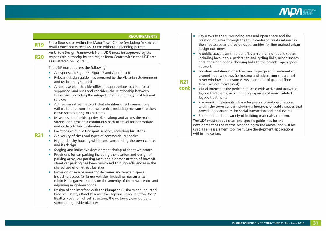
REQUIREMENTS
R19 Shop floor space within the Major Town Centre (excluding ‘restricted retail’) must not exceed 45,000m² without a planning permit.
R20 An Urban Design Framework Plan (UDF) must be approved by the responsible authority for the Major Town Centre within the UDF area as illustrated on Figure 6.
R21
The UDF must address the following:
• A response to Figure 6, Figure 7 and Appendix B • Relevant design guidelines prepared by the Victorian Government
and Melton City Council• A land use plan that identifies the appropriate location for all
supported land uses and considers the relationship between these uses, including the integration of community facilities and services
• A fine-grain street network that identifies direct connectivity within, to and from the town centre, including measures to slow down speeds along main streets
• Measures to prioritise pedestrians along and across the main streets, and provide a continuous path of travel for pedestrians and cyclists to key destinations
• Locations of public transport services, including bus stops• A diversity of sizes and types of commercial tenancies• Higher density housing within and surrounding the town centre,
and its design• Staging and indicative development timing of the town centre• Provisions for car parking including the location and design of
parking areas, car parking rates and a demonstration of how off-street car parking has been minimised through efficiencies in the shared use of off-street facilities
• Provision of service areas for deliveries and waste disposal including access for larger vehicles, including measures to minimise negative impacts on the amenity of the town centre and adjoining neighbourhoods
• Design of the interface with the Plumpton Business and Industrial Precinct; Beattys Road Reserve; the Hopkins Road/ Tarleton Road/ Beattys Road ‘pinwheel’ structure; the waterway corridor; and surrounding residential uses
R21 cont
• Key views to the surrounding area and open space and the creation of vistas through the town centre to create interest in the streetscape and provide opportunities for fine grained urban design outcomes
• A public space plan that identifies a hierarchy of public spaces including local parks, pedestrian and cycling links, urban spaces and landscape nodes, showing links to the broader open space network
• Location and design of active uses, signage and treatment of ground floor windows (ie frosting and advertising should not cover windows, to ensure views in and out of ground floor tenancies are maintained)
• Visual interest at the pedestrian scale with active and activated façade treatments, avoiding long expanses of unarticulated façade treatments
• Place-making elements, character precincts and destinations within the town centre including a hierarchy of public spaces that provide opportunities for social interaction and local events
• Requirements for a variety of building materials and form.The UDF must set out clear and specific guidelines for the development of the centre, responding to the above, and will be used as an assessment tool for future development applications within the centre.
PLUMPTON PRECINCT STRUCTURE PLAN - June 2016 31
Table 4 Town centre hierarchy
TOWN CENTRE
SHOP FLOOR SPACE
(excluding ‘restricted
retail’ uses)*
COMMERCIAL FLOOR SPACE
(indicative only – includes medical, non-government
organisations etc.)
LOCATION AND ANCILLARY USES
Plumpton Major Town Centre
(MTC)
45,000 m2 58,500 m2 Provides a full range of retail, commercial, mixed use and higher-order community facilities including library and youth/ senior facilities. Includes high density housing and a high amenity food and beverage/ entertainment area located along an attractive waterway corridor and wetland connecting to the open space network.
Plumpton Local Town Centre
(LTC)
7,200 m2 5,400 m2 Provides a range of local services for the community in the south-west of the Precinct. Co-located with a government primary school, non-government primary school, community facilities and sporting reserve and on the open space network.
Plumpton Local Convenience Centre
(LCC)
500 m2 500 m2 To provide top-up groceries and local services for the area in the south-east of the Precinct, where residents are beyond a comfortable walk to the LTC or MTC. Co-located with a government primary school, community facilities and a sporting reserve.
* Note that this does not imply that restricted uses are not permitted, but they are not included within this floor space figure.
Table 5 Anticipated employment creation in precinct
LAND USE BASED EMPLOYMENT
MEASURE JOBS TOTAL IN PSP
ESTIMATED JOBS
Community centre jobs/centre 10 4 40
Primary School jobs/ school 40 4 160
Secondary School jobs/ school 90 2 180
Other community services (medical, NGO)
1 job/50sqm 0.02 21240 425
Retail 1 job/ 30sqm 0.03 84960 2,832
Commercial/ mixed use
1 job/ 20 sqm 0.05 42400 2,120
Industrial/ commercial employment area
1 job/ 60sqm 0.17 38200 6,367
Home-based business
1 job/ 20 dwellings
0.05 10,680 534
TOTAL 12,657
PLUMPTON PRECINCT STRUCTURE PLAN - June 201632
anchor retail
retail (commercial / mixed use / residential over)
mix of commercial uses (residential over)
small local enterprises
commercial (residential over)
entertainment / food
car parking
community facilities
government primary school
residential
active frontage
accentuated height
constructed waterway (indicative)
drainage culvert (indicative)
plaza
high quality public realm treatment
pedestrian priority (e.g. pavement treatment)
connector street
feature main street
local access street
roundabout (including pedestrian / cycle crossing points)
pedestrian priority crossing
key pedestrian circulation
bike route
car park access
251050 50m 100m
Plumpton Precinct Structure Plan
Figure 8Local Town Centre Concept Plan
Copyright, Metropolitan Planning Authority, 2016 The state of Victoria does not warrant the accuracy or completeness of information in this publication and any person using or relying upon such information does so on the basis that the State of Victoria shall bear no responsibility or liability whatsoever for any errors, faults, defects or omission in the information.
PLACE-MAKING AND DESIGN ELEMENTS
• Activity is focused along the central, pedestrian-priority main street
• Specialty retail shops provide an active and attractive interface to the street, ‘sleeved’ around a supermarket anchor
• A high quality connection across the connector road provides strong links to community and education uses to the east
• Built form along the edges of the LTC provide an attractive interface to surrounding residential uses
• The waterway shapes the LTC and provides an attractive outlook for cafes/ entertainment and a public plaza, as well as office workers
• Opportunities for height along Plumpton Road draw attention to the LTC within the surrounding residential area
• The adjacent constructed waterway/swale links to the broader open space network and will be an attractive part of the landscape
• Small local enterprises located on the periphery of the LTC provide for diverse local businesses and services.
The LTC concept plan is a concept plan and is not intended to be prescriptive.
PLUMPTON PRECINCT STRUCTURE PLAN - June 2016 33
3.2.2 Local Town Centre
Plumpton Local Town Centre will service local needs and will provide opportunities for ‘small local enterprises’ to develop and form part of the LTC and community hub. It is located close to a future sports reserve and adjacent to community facilities and a government and non-government school, and will enable a strong sense of place through responding to an attractive landscaped waterway swale and the existing Plumpton Road.
‘Small local enterprises’ are supporting services and ancillary uses which are typically on the periphery of, or near, Local Town Centres in traditional inner and middle ring areas in Melbourne. Uses may include, but are not limited to the following (subject to planning permit requirements):
• Printers, craft centres, storage, equipment repairs and servicing, studio/ workrooms, veterinary clinics, dance studios.
They can require many different layout options, varied floor space sizes, servicing, storage and lower-order rentals than in the core retail areas. These are integral to the creation of LTCs and help support three of the principles in Appendix C, by:
• Providing a full range of local services (Principle 4 - adapted)
• Integrating local employment and service opportunities (Principle 6 - adapted)
• Promoting sustainability, adaptability and localisation (Principle 10 - adapted).
REQUIREMENTS
R22 Land use and development within the Local Town Centre must respond to the concept plan in Figure 8 and address Appendix C.
R23 Design of buildings in the Local Town Centre must provide visual interest at the pedestrian scale, with active and activated façade treatments. Long expanses of unarticulated façade treatments must be avoided.
3.2.3 Local Convenience Centre
The Local Convenience Centre will service local needs and will provide opportunities for some small local enterprises to develop. The LCC will develop into a community hub as it is co-located with future sporting reserves, primary school and community facilities.
REQUIREMENTS
R24 The Local Convenience Centre must be oriented towards the connector street and consider the relationship and interface with surrounding uses.
R25 Shop floor space within the local convenience centre must not exceed 500m² without a planning permit.
R26
Buildings as part of a local convenience centre must:
• Provide primary access to tenancies from the connector street• Provide active and articulated frontages to the adjoining street
network• Have active frontages and must be designed in a way which
contributes to the public domain• Locate any servicing infrastructure or car parking to the rear or
centre of the allotment in a manner that protects the amenity of the surrounding neighbourhood.
R27 Safe and convenient pedestrian access must be provided to the local convenience centre, including a safe pedestrian street crossing and proximity to bus stop locations.
GUIDELINES
G21 A local convenience centre should be located as illustrated on Plan 3, unless otherwise agreed by the responsible authority, and should be consistent with the guidance provided in relation to the hierarchy of centres in Table 4.
G22
The design of the Local Convenience Centre should:
• Feature clear circulation and a high degree of permeability for pedestrians
• Provide for a mix of tenancies• Incorporate a range of uses including retail, offices and medium
density residential use.
PLUMPTON PRECINCT STRUCTURE PLAN - June 201634
MELTO
N H
IGH
WAYHOPKINS ROAD
TARLETO
N RO
AD
precinct boundary
lot outline (indicative only)
industrial
business
mixed use (m
ust have business / other em
ployment use on
ground floor at minim
um) w
ith loop road frontage
town centre
local convenience
residential
omr public acquisition overlay
substation
waterw
ay
local park
landscaping & setback
requirement at interface to
residential areas
attractive frontage to waterw
ay / arterial road
beattys road linear park
road bridge
arterial road (6 lanes)
arterial road (4 lanes)
connector street
connector street - town centre
connector street - industrial
key local access street
key local access street - industrial (indicative only)
signalised intersection
shared path
Plumpton Precinct Structure Plan
Copyright, Metropolitan Planning Authority, 2016 The state of Victoria does not warrant the accuracy or completeness of information in this publication and any person using or relying upon such information does so on the basis that the State of Victoria shall bear no responsibility or liability whatsoever for any errors, faults, defects or omission in the information.
10050250 200m
Figure 9Business & Industrial Precinct Concept Plan
PLUMPTON PRECINCT STRUCTURE PLAN - June 2016 35
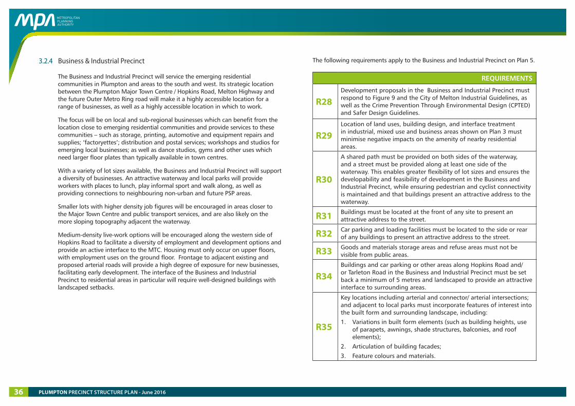
3.2.4 Business & Industrial Precinct
The Business and Industrial Precinct will service the emerging residential communities in Plumpton and areas to the south and west. Its strategic location between the Plumpton Major Town Centre / Hopkins Road, Melton Highway and the future Outer Metro Ring road will make it a highly accessible location for a range of businesses, as well as a highly accessible location in which to work.
The focus will be on local and sub-regional businesses which can benefit from the location close to emerging residential communities and provide services to these communities – such as storage, printing, automotive and equipment repairs and supplies; ‘factoryettes’; distribution and postal services; workshops and studios for emerging local businesses; as well as dance studios, gyms and other uses which need larger floor plates than typically available in town centres.
With a variety of lot sizes available, the Business and Industrial Precinct will support a diversity of businesses. An attractive waterway and local parks will provide workers with places to lunch, play informal sport and walk along, as well as providing connections to neighbouring non-urban and future PSP areas.
Smaller lots with higher density job figures will be encouraged in areas closer to the Major Town Centre and public transport services, and are also likely on the more sloping topography adjacent the waterway.
Medium-density live-work options will be encouraged along the western side of Hopkins Road to facilitate a diversity of employment and development options and provide an active interface to the MTC. Housing must only occur on upper floors, with employment uses on the ground floor. Frontage to adjacent existing and proposed arterial roads will provide a high degree of exposure for new businesses, facilitating early development. The interface of the Business and Industrial Precinct to residential areas in particular will require well-designed buildings with landscaped setbacks.
The following requirements apply to the Business and Industrial Precinct on Plan 5.
REQUIREMENTS
R28 Development proposals in the Business and Industrial Precinct must respond to Figure 9 and the City of Melton Industrial Guidelines, as well as the Crime Prevention Through Environmental Design (CPTED) and Safer Design Guidelines.
R29 Location of land uses, building design, and interface treatment in industrial, mixed use and business areas shown on Plan 3 must minimise negative impacts on the amenity of nearby residential areas.
R30
A shared path must be provided on both sides of the waterway, and a street must be provided along at least one side of the waterway. This enables greater flexibility of lot sizes and ensures the developability and feasibility of development in the Business and Industrial Precinct, while ensuring pedestrian and cyclist connectivity is maintained and that buildings present an attractive address to the waterway.
R31 Buildings must be located at the front of any site to present an attractive address to the street.
R32 Car parking and loading facilities must be located to the side or rear of any buildings to present an attractive address to the street.
R33 Goods and materials storage areas and refuse areas must not be visible from public areas.
R34 Buildings and car parking or other areas along Hopkins Road and/ or Tarleton Road in the Business and Industrial Precinct must be set back a minimum of 5 metres and landscaped to provide an attractive interface to surrounding areas.
R35
Key locations including arterial and connector/ arterial intersections; and adjacent to local parks must incorporate features of interest into the built form and surrounding landscape, including:
1. Variations in built form elements (such as building heights, use of parapets, awnings, shade structures, balconies, and roof elements);
2. Articulation of building facades;
3. Feature colours and materials.
PLUMPTON PRECINCT STRUCTURE PLAN - June 201636
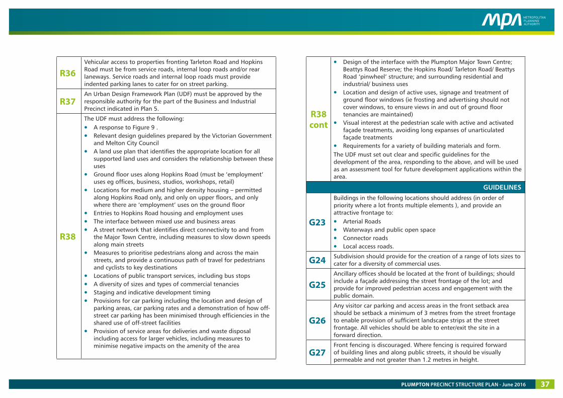
R36 Vehicular access to properties fronting Tarleton Road and Hopkins Road must be from service roads, internal loop roads and/or rear laneways. Service roads and internal loop roads must provide indented parking lanes to cater for on street parking.
R37 An Urban Design Framework Plan (UDF) must be approved by the responsible authority for the part of the Business and Industrial Precinct indicated in Plan 5.
R38
The UDF must address the following:
• A response to Figure 9 . • Relevant design guidelines prepared by the Victorian Government
and Melton City Council• A land use plan that identifies the appropriate location for all
supported land uses and considers the relationship between these uses
• Ground floor uses along Hopkins Road (must be ‘employment’ uses eg offices, business, studios, workshops, retail)
• Locations for medium and higher density housing – permitted along Hopkins Road only, and only on upper floors, and only where there are ‘employment’ uses on the ground floor
• Entries to Hopkins Road housing and employment uses• The interface between mixed use and business areas• A street network that identifies direct connectivity to and from
the Major Town Centre, including measures to slow down speeds along main streets
• Measures to prioritise pedestrians along and across the main streets, and provide a continuous path of travel for pedestrians and cyclists to key destinations
• Locations of public transport services, including bus stops• A diversity of sizes and types of commercial tenancies• Staging and indicative development timing • Provisions for car parking including the location and design of
parking areas, car parking rates and a demonstration of how off-street car parking has been minimised through efficiencies in the shared use of off-street facilities
• Provision of service areas for deliveries and waste disposal including access for larger vehicles, including measures to minimise negative impacts on the amenity of the area
R38 cont
• Design of the interface with the Plumpton Major Town Centre; Beattys Road Reserve; the Hopkins Road/ Tarleton Road/ Beattys Road ‘pinwheel’ structure; and surrounding residential and industrial/ business uses
• Location and design of active uses, signage and treatment of ground floor windows (ie frosting and advertising should not cover windows, to ensure views in and out of ground floor tenancies are maintained)
• Visual interest at the pedestrian scale with active and activated façade treatments, avoiding long expanses of unarticulated façade treatments
• Requirements for a variety of building materials and form.The UDF must set out clear and specific guidelines for the development of the area, responding to the above, and will be used as an assessment tool for future development applications within the area.
GUIDELINES
G23
Buildings in the following locations should address (in order of priority where a lot fronts multiple elements ), and provide an attractive frontage to:
• Arterial Roads• Waterways and public open space• Connector roads• Local access roads.
G24 Subdivision should provide for the creation of a range of lots sizes to cater for a diversity of commercial uses.
G25 Ancillary offices should be located at the front of buildings; should include a façade addressing the street frontage of the lot; and provide for improved pedestrian access and engagement with the public domain.
G26
Any visitor car parking and access areas in the front setback area should be setback a minimum of 3 metres from the street frontage to enable provision of sufficient landscape strips at the street frontage. All vehicles should be able to enter/exit the site in a forward direction.
G27 Front fencing is discouraged. Where fencing is required forward of building lines and along public streets, it should be visually permeable and not greater than 1.2 metres in height.
PLUMPTON PRECINCT STRUCTURE PLAN - June 2016 37

THIS PAGE HAS BEEN LEFT INTENTIONALLY BLANK
PLUMPTON PRECINCT STRUCTURE PLAN - June 201638
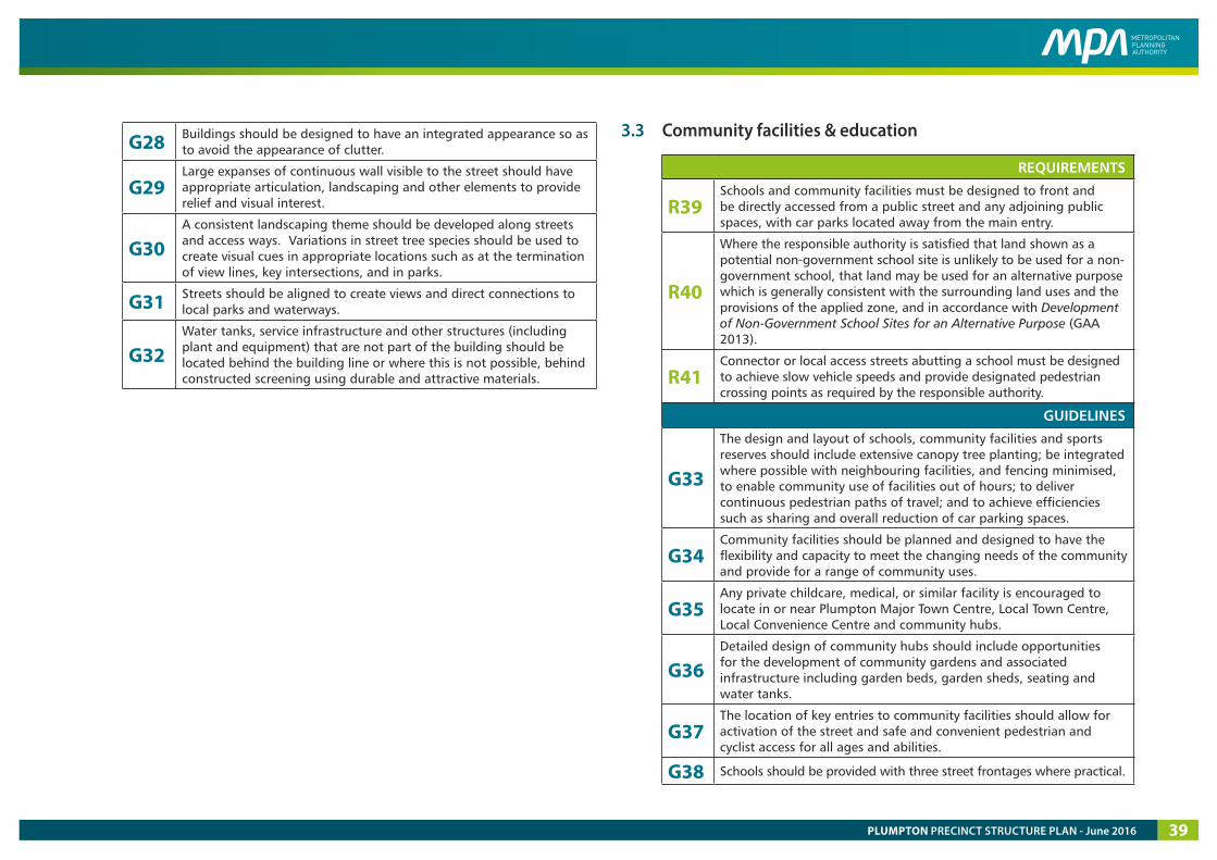
G28 Buildings should be designed to have an integrated appearance so as to avoid the appearance of clutter.
G29 Large expanses of continuous wall visible to the street should have appropriate articulation, landscaping and other elements to provide relief and visual interest.
G30 A consistent landscaping theme should be developed along streets and access ways. Variations in street tree species should be used to create visual cues in appropriate locations such as at the termination of view lines, key intersections, and in parks.
G31 Streets should be aligned to create views and direct connections to local parks and waterways.
G32 Water tanks, service infrastructure and other structures (including plant and equipment) that are not part of the building should be located behind the building line or where this is not possible, behind constructed screening using durable and attractive materials.
3.3 Community facilities & education
REQUIREMENTS
R39 Schools and community facilities must be designed to front and be directly accessed from a public street and any adjoining public spaces, with car parks located away from the main entry.
R40
Where the responsible authority is satisfied that land shown as a potential non-government school site is unlikely to be used for a non-government school, that land may be used for an alternative purpose which is generally consistent with the surrounding land uses and the provisions of the applied zone, and in accordance with Development of Non-Government School Sites for an Alternative Purpose (GAA 2013).
R41 Connector or local access streets abutting a school must be designed to achieve slow vehicle speeds and provide designated pedestrian crossing points as required by the responsible authority.
GUIDELINES
G33
The design and layout of schools, community facilities and sports reserves should include extensive canopy tree planting; be integrated where possible with neighbouring facilities, and fencing minimised, to enable community use of facilities out of hours; to deliver continuous pedestrian paths of travel; and to achieve efficiencies such as sharing and overall reduction of car parking spaces.
G34 Community facilities should be planned and designed to have the flexibility and capacity to meet the changing needs of the community and provide for a range of community uses.
G35 Any private childcare, medical, or similar facility is encouraged to locate in or near Plumpton Major Town Centre, Local Town Centre, Local Convenience Centre and community hubs.
G36 Detailed design of community hubs should include opportunities for the development of community gardens and associated infrastructure including garden beds, garden sheds, seating and water tanks.
G37 The location of key entries to community facilities should allow for activation of the street and safe and convenient pedestrian and cyclist access for all ages and abilities.
G38 Schools should be provided with three street frontages where practical.
PLUMPTON PRECINCT STRUCTURE PLAN - June 2016 39
MELTON HWY
PLU
MPT
ON
RD
VERE
CT
SARI
C CT
HUME DR
TAYLORS RD
BEATTYS RD
HO
PKINS RD
CITY
VIS
TA C
T
KENNEDY DR
TARLETON RD
gas e
asem
ent
pow
er e
asem
ent
Pedestrian / cyclist connection across OMR
Vehicle access to and across OMR
TAYLORS HILL WEST PSP
Future possible extension to Sunbury
GREEN WEDGE
WARRENSBROOK PSP
KOROROIT PSPROCKBANK NORTH PSP
LOS-2LOS-2
SR-01SR-01SR-02SR-02
LP-08LP-08
SR-03SR-03
LOS-03LOS-03
SR-04SR-04 LP-11LP-11
LP-12LP-12
LOS-01LOS-01
SR-05SR-05
LP-09LP-09
LP-19LP-19
LP-10LP-10
LP-18LP-18
LP-17LP-17
LP-13LP-13
LP-14LP-14
LP-15LP-15
LP-16LP-16
SR-06SR-06SR-07SR-07
LP-07LP-07LP-06LP-06
LP-05LP-05
LP-04LP-04
LP-03LP-03
LP-01LP-01
LP-02LP-02
LP-20LP-20
LP-21LP-21
LP-22LP-22
precinct boundary
waterway reserve
local sports reserve
local park (within residential areas)
local park (within dedicated employment areas)
local park in beattys road reserve
easement
service open space (beattys road reserve)
open space identi�cation number (local park & sports reserve.)
local park & sports reserve residential catchment - 400 metres (refer to Table 7)
local sports reserve residential catchment - one kilometre
pedestrian crossing / bridge
SR-01SR-01LP-01LP-01
Plumpton Precinct Structure Plan
0 200 400 600 800 1,000m
1:25,000 @ A4
Copyright, Metropolitan Planning Authority, 2016 The state of Victoria does not warrant the accuracy or completeness of information in this publication and any person using or relying upon such information does so on the basis that the State of Victoria shall bear no responsibility or liability whatsoever for any errors, faults, defects or omission in the information.
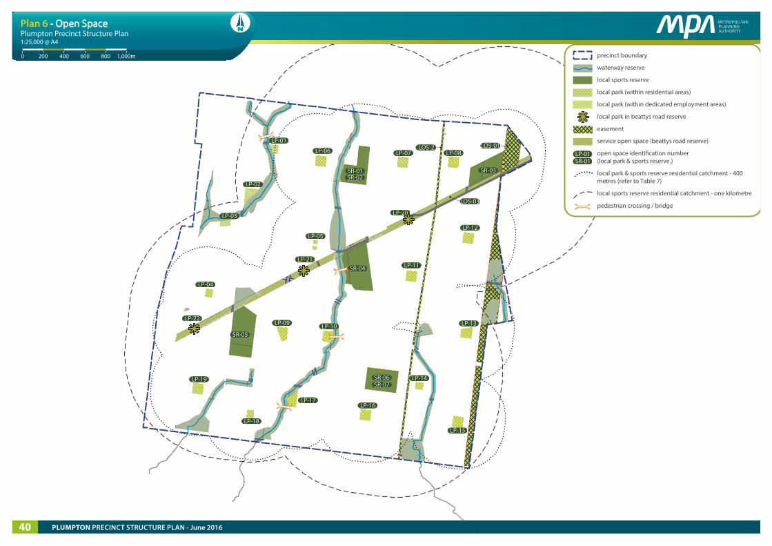
Plan 6 - Open Space
PLUMPTON PRECINCT STRUCTURE PLAN - June 201640
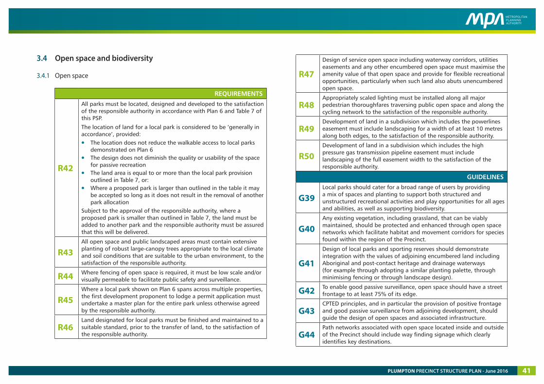
3.4 Open space and biodiversity
3.4.1 Open space
REQUIREMENTS
R42
All parks must be located, designed and developed to the satisfaction of the responsible authority in accordance with Plan 6 and Table 7 of this PSP.
The location of land for a local park is considered to be ‘generally in accordance’, provided:
• The location does not reduce the walkable access to local parks demonstrated on Plan 6
• The design does not diminish the quality or usability of the space for passive recreation
• The land area is equal to or more than the local park provision outlined in Table 7, or:
• Where a proposed park is larger than outlined in the table it may be accepted so long as it does not result in the removal of another park allocation
Subject to the approval of the responsible authority, where a proposed park is smaller than outlined in Table 7, the land must be added to another park and the responsible authority must be assured that this will be delivered.
R43 All open space and public landscaped areas must contain extensive planting of robust large-canopy trees appropriate to the local climate and soil conditions that are suitable to the urban environment, to the satisfaction of the responsible authority.
R44 Where fencing of open space is required, it must be low scale and/or visually permeable to facilitate public safety and surveillance.
R45 Where a local park shown on Plan 6 spans across multiple properties, the first development proponent to lodge a permit application must undertake a master plan for the entire park unless otherwise agreed by the responsible authority.
R46 Land designated for local parks must be finished and maintained to a suitable standard, prior to the transfer of land, to the satisfaction of the responsible authority.
R47
Design of service open space including waterway corridors, utilities easements and any other encumbered open space must maximise the amenity value of that open space and provide for flexible recreational opportunities, particularly when such land also abuts unencumbered open space.
R48 Appropriately scaled lighting must be installed along all major pedestrian thoroughfares traversing public open space and along the cycling network to the satisfaction of the responsible authority.
R49 Development of land in a subdivision which includes the powerlines easement must include landscaping for a width of at least 10 metres along both edges, to the satisfaction of the responsible authority.
R50 Development of land in a subdivision which includes the high pressure gas transmission pipeline easement must include landscaping of the full easement width to the satisfaction of the responsible authority.
GUIDELINES
G39 Local parks should cater for a broad range of users by providing a mix of spaces and planting to support both structured and unstructured recreational activities and play opportunities for all ages and abilities, as well as supporting biodiversity.
G40 Any existing vegetation, including grassland, that can be viably maintained, should be protected and enhanced through open space networks which facilitate habitat and movement corridors for species found within the region of the Precinct.
G41
Design of local parks and sporting reserves should demonstrate integration with the values of adjoining encumbered land including Aboriginal and post-contact heritage and drainage waterways (for example through adopting a similar planting palette, through minimising fencing or through landscape design).
G42 To enable good passive surveillance, open space should have a street frontage to at least 75% of its edge.
G43 CPTED principles, and in particular the provision of positive frontage and good passive surveillance from adjoining development, should guide the design of open spaces and associated infrastructure.
G44 Path networks associated with open space located inside and outside of the Precinct should include way finding signage which clearly identifies key destinations.
PLUMPTON PRECINCT STRUCTURE PLAN - June 2016 41
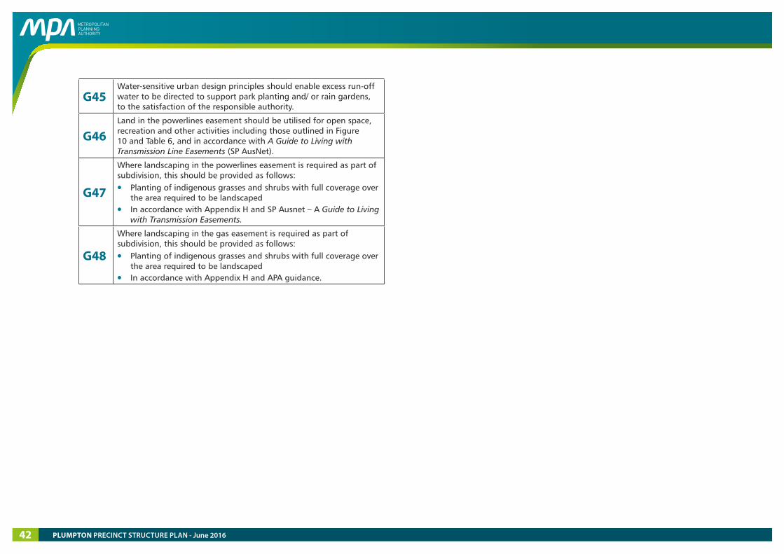
G45 Water-sensitive urban design principles should enable excess run-off water to be directed to support park planting and/ or rain gardens, to the satisfaction of the responsible authority.
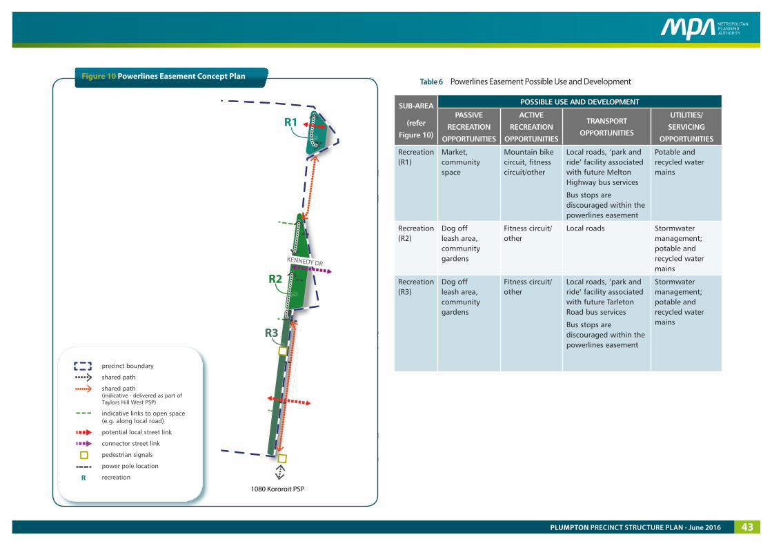
G46 Land in the powerlines easement should be utilised for open space, recreation and other activities including those outlined in Figure 10 and Table 6, and in accordance with A Guide to Living with Transmission Line Easements (SP AusNet).
G47
Where landscaping in the powerlines easement is required as part of subdivision, this should be provided as follows:
• Planting of indigenous grasses and shrubs with full coverage over the area required to be landscaped
• In accordance with Appendix H and SP Ausnet – A Guide to Living with Transmission Easements.
G48
Where landscaping in the gas easement is required as part of subdivision, this should be provided as follows:
• Planting of indigenous grasses and shrubs with full coverage over the area required to be landscaped
• In accordance with Appendix H and APA guidance.
PLUMPTON PRECINCT STRUCTURE PLAN - June 201642
MELTON HWY
PLU
MPT
ON
RD
VERE
CT
SARI
C CT
HUME DR
TAYLORS RD
BEATTYS RD
HO
PKINS RD
CITY
VIS
TA C
T
KENNEDY DR
TARLETON RD
gas e
asem
ent
pow
er e
asem
ent
Pedestrian / cyclist connection across OMR
Vehicle access to and across OMR
TAYLORS HILL WEST PSP
Future possible extension to Sunbury
GREEN WEDGE
WARRENSBROOK PSP
KOROROIT PSPROCKBANK NORTH PSP
R1
R2
R3
1080 Kororoit PSP
KENNEDY DR
precinct boundary
shared path
shared path (indicative - delivered as part of Taylors Hill West PSP)
indicative links to open space (e.g. along local road)
potential local street link
connector street link
pedestrian signals
power pole location
recreationR
Plumpton Precinct Structure Plan
Powerlines Easement - Concept Plan
400 6002000 800
1:15,000 @ A4 v200815
Copyright, Metropolitan Planning Authority, 2015 The state of Victoria does not warrant the accuracy or completeness of information in this publication and any person using or relying upon such information does so on the basis that the State of Victoria shall bear no responsibility or liability whatsoever for any errors, faults, defects or omission in the information.
800
Table 6 Powerlines Easement Possible Use and Development
SUB-AREA
(refer
Figure 10)
POSSIBLE USE AND DEVELOPMENT
PASSIVE
RECREATION
OPPORTUNITIES
ACTIVE
RECREATION
OPPORTUNITIES
TRANSPORT
OPPORTUNITIES
UTILITIES/
SERVICING
OPPORTUNITIES
Recreation (R1)
Market, community space
Mountain bike circuit, fitness circuit/other
Local roads, ‘park and ride’ facility associated with future Melton Highway bus services
Bus stops are discouraged within the powerlines easement
Potable and recycled water mains
Recreation (R2)
Dog off leash area, community gardens
Fitness circuit/ other
Local roads Stormwater management; potable and recycled water mains
Recreation (R3)
Dog off leash area, community gardens
Fitness circuit/ other
Local roads, ‘park and ride’ facility associated with future Tarleton Road bus services
Bus stops are discouraged within the powerlines easement
Stormwater management; potable and recycled water mains
Figure 10 Powerlines Easement Concept Plan
PLUMPTON PRECINCT STRUCTURE PLAN - June 2016 43
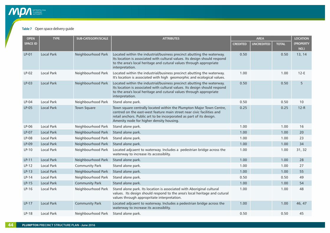
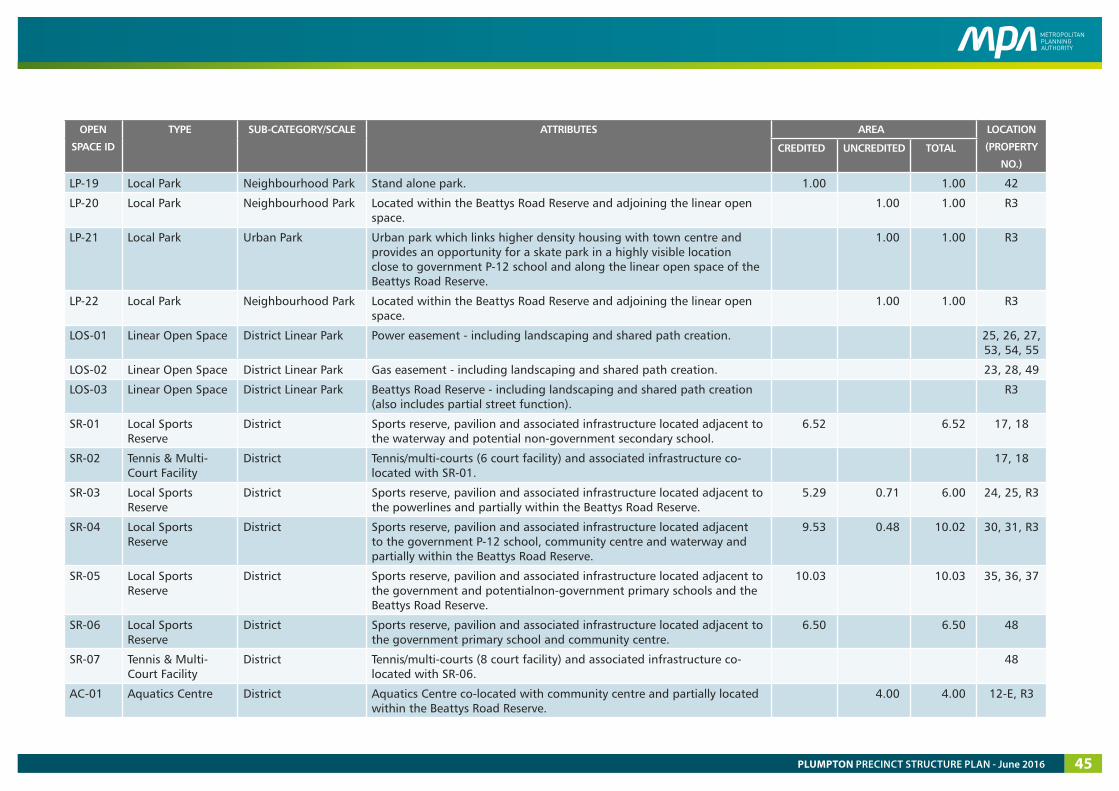
Table 7 Open space delivery guide
OPEN
SPACE ID
TYPE SUB-CATEGORY/SCALE ATTRIBUTES AREA LOCATION
(PROPERTY
NO.)CREDITED UNCREDITED TOTAL
LP-01 Local Park Neighbourhood Park Located within the industrial/business precinct abutting the waterway. Its location is associated with cultural values. Its design should respond to the area's local heritage and cutural values through appropriate interpretation.
0.50 0.50 13, 14
LP-02 Local Park Neighbourhood Park Located within the industrial/business precinct abutting the waterway. It's location is associated with high geomorphic and ecological values.
1.00 1.00 12-E
LP-03 Local Park Neighbourhood Park Located within the industrial/business precinct abutting the waterway. Its location is associated with cultural values. Its design should respond to the area's local heritage and cutural values through appropriate interpretation.
0.50 0.50 5
LP-04 Local Park Neighbourhood Park Stand alone park. 0.50 0.50 10
LP-05 Local Park Town Square Town square centrally located within the Plumpton Major Town Centre, centred on the east-west feature main street near civic facilities and retail anchors. Public art to be incorporated as part of its design. Amenity node for higher density housing.
0.25 0.25 12-R
LP-06 Local Park Neighbourhood Park Stand alone park. 1.00 1.00 16
LP-07 Local Park Neighbourhood Park Stand alone park. 1.00 1.00 20
LP-08 Local Park Neighbourhood Park Stand alone park. 1.00 1.00 23
LP-09 Local Park Neighbourhood Park Stand alone park. 1.00 1.00 34
LP-10 Local Park Neighbourhood Park Located adjcaent to waterway. Includes a pedestrian bridge across the waterway to increase its accessiblity.
1.00 1.00 31, 32
LP-11 Local Park Neighbourhood Park Stand alone park. 1.00 1.00 28
LP-12 Local Park Community Park Stand alone park. 1.00 1.00 27
LP-13 Local Park Neighbourhood Park Stand alone park. 1.00 1.00 55
LP-14 Local Park Neighbourhood Park Stand alone park. 0.50 0.50 49
LP-15 Local Park Community Park Stand alone park. 1.00 1.00 54
LP-16 Local Park Neighbourhood Park Stand alone park. Its location is associated with Aboriginal cultural values. Its design should respond to the area's local heritage and cutural values through appropritate interpretation.
1.00 1.00 48
LP-17 Local Park Community Park Located adjcaent to waterway. Includes a pedestrian bridge across the waterway to increase its accessiblity.
1.00 1.00 46, 47
LP-18 Local Park Neighbourhood Park Stand alone park. 0.50 0.50 45
PLUMPTON PRECINCT STRUCTURE PLAN - June 201644
OPEN
SPACE ID
TYPE SUB-CATEGORY/SCALE ATTRIBUTES AREA LOCATION
(PROPERTY
NO.)CREDITED UNCREDITED TOTAL
LP-19 Local Park Neighbourhood Park Stand alone park. 1.00 1.00 42
LP-20 Local Park Neighbourhood Park Located within the Beattys Road Reserve and adjoining the linear open space.
1.00 1.00 R3
LP-21 Local Park Urban Park Urban park which links higher density housing with town centre and provides an opportunity for a skate park in a highly visible location close to government P-12 school and along the linear open space of the Beattys Road Reserve.
1.00 1.00 R3
LP-22 Local Park Neighbourhood Park Located within the Beattys Road Reserve and adjoining the linear open space.
1.00 1.00 R3
LOS-01 Linear Open Space District Linear Park Power easement - including landscaping and shared path creation. 25, 26, 27, 53, 54, 55
LOS-02 Linear Open Space District Linear Park Gas easement - including landscaping and shared path creation. 23, 28, 49
LOS-03 Linear Open Space District Linear Park Beattys Road Reserve - including landscaping and shared path creation (also includes partial street function).
R3
SR-01 Local Sports Reserve
District Sports reserve, pavilion and associated infrastructure located adjacent to the waterway and potential non-government secondary school.
6.52 6.52 17, 18
SR-02 Tennis & Multi-Court Facility
District Tennis/multi-courts (6 court facility) and associated infrastructure co-located with SR-01.
17, 18
SR-03 Local Sports Reserve
District Sports reserve, pavilion and associated infrastructure located adjacent to the powerlines and partially within the Beattys Road Reserve.
5.29 0.71 6.00 24, 25, R3
SR-04 Local Sports Reserve
District Sports reserve, pavilion and associated infrastructure located adjacent to the government P-12 school, community centre and waterway and partially within the Beattys Road Reserve.
9.53 0.48 10.02 30, 31, R3
SR-05 Local Sports Reserve
District Sports reserve, pavilion and associated infrastructure located adjacent to the government and potentialnon-government primary schools and the Beattys Road Reserve.
10.03 10.03 35, 36, 37
SR-06 Local Sports Reserve
District Sports reserve, pavilion and associated infrastructure located adjacent to the government primary school and community centre.
6.50 6.50 48
SR-07 Tennis & Multi-Court Facility
District Tennis/multi-courts (8 court facility) and associated infrastructure co-located with SR-06.
48
AC-01 Aquatics Centre District Aquatics Centre co-located with community centre and partially located within the Beattys Road Reserve.
4.00 4.00 12-E, R3
PLUMPTON PRECINCT STRUCTURE PLAN - June 2016 45
R2 (TARLETON RD)
R1 (P
LUM
PTO
N R
D)
R4 (S
ARI
C CT
)
R3 (BEATTYS RD)
1 2
3
4
5
67
89
1011-R
11-R
11-E
12 - R12 - E
13
14
15
16 17 18 19 20 21
22
2324
25
26
27
28
29
30
31
32
33
34
35
36
37
38
42
39 - E
39 - R
40
41
4344 45 46
47 48
49
50 51
52
53
54
55
MELTON HWY
precinct boundary
native vegetation that can be removed
no native vegetation
scattered trees to be retained
property boundary & number7
Plumpton Precinct Structure Plan
0 200 400 600 800 1,000m
1:25,000 @ A4
Copyright, Metropolitan Planning Authority, 2016 The state of Victoria does not warrant the accuracy or completeness of information in this publication and any person using or relying upon such information does so on the basis that the State of Victoria shall bear no responsibility or liability whatsoever for any errors, faults, defects or omission in the information.
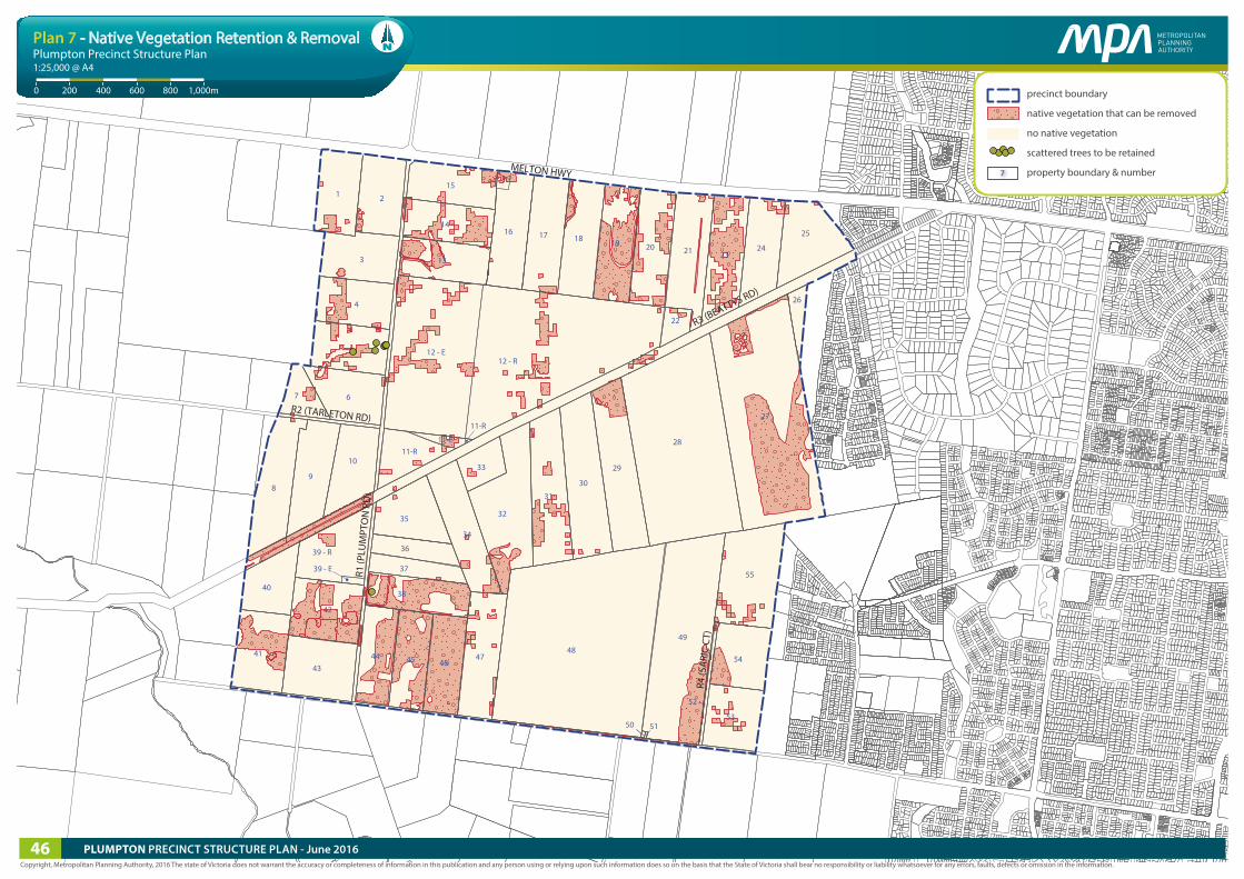
Plan 7 - Native Vegetation Retention & Removal
PLUMPTON PRECINCT STRUCTURE PLAN - June 201646
3.4.2 Biodiversity and threatened species
REQUIREMENTS
R51
Native vegetation may be removed as illustrated on Plan 7.
At the time of publication, the scattered trees identified as to be retained have not been approved for retention in accordance with the Guidance Note: Implementing the Biodiversity Conservation Strategy for Melbourne’s Growth Corridors (DELWP, 2015) for the purposes of the approval under Part 10 of the Environment Protection and Biodiversity Conservation Act 1999 (Cth) dated 5 September 2013. The habitat compensation obligations of the 5 September 2013 approval continue to apply to these scattered trees.
GUIDELINES
G49 Planting in the open space network including streets, parks, utilities easements and waterways should make use of indigenous species to the satisfaction of the responsible authority (and Melbourne Water as relevant).
G50
The layout and design of the waterways, wetlands and retarding basins (including the design of paths, bridges and boardwalks and the stormwater drainage system) connecting to the Kororoit Creek to the south should integrate with biodiversity and natural systems to the satisfaction of the responsible authority and Melbourne Water as relevant.
PLUMPTON PRECINCT STRUCTURE PLAN - June 2016 47
MELTON HWY
PLU
MPT
ON
RD
VERE
CT
SARI
C CT
HUME DR
TAYLORS RD
BEATTYS RD
HO
PKINS RD
CITY
VIS
TA C
T
KENNEDY DR
TARLETON RD
gas e
asem
ent
pow
er e
asem
ent
Pedestrian / cyclist connection across OMR
Vehicle access to and across OMR
TAYLORS HILL WEST PSP
Future possible extension to Sunbury
GREEN WEDGE
WARRENSBROOK PSP
KOROROIT PSPROCKBANK NORTH PSP
18
19
20
214
22
17
6
7
14
2
11
1
10
Road access into Warrensbrook PSP
Pedestrian / cyclist connection across OMR
Vehicle access to and across OMR
Future possible extension to Sunbury
E-W RD 1
N-S
RD
2
N-S
RD
1
N-S RD
5
N-S RD
4
E-W RD 2
E-W RD 4
E-W RD 3
N-S RD 3
precinct boundary
outer metropolitan ring road (OMR)
arterial road (6 lanes)
arterial road (4 lanes)
connector road
feature main street
town centre - connector
industrial connector road
local access street
local access street level 2
industrial access street
signalised intersection
left-in, left-out
pedestrian crossing
bridge / culvert
cross section number (refer street cross sections)7
Note:Not all access streets are shown on this plan. Refer to �gure 9 for street details in the business / industrial area.
Plumpton Precinct Structure Plan
0 200 400 600 800 1,000m
1:25,000 @ A4
Copyright, Metropolitan Planning Authority, 2016 The state of Victoria does not warrant the accuracy or completeness of information in this publication and any person using or relying upon such information does so on the basis that the State of Victoria shall bear no responsibility or liability whatsoever for any errors, faults, defects or omission in the information.
Plan 8 - Road Network Plan
PLUMPTON PRECINCT STRUCTURE PLAN - June 201648
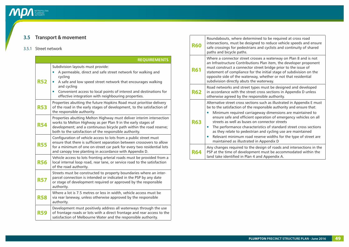
3.5 Transport & movement
3.5.1 Street network
REQUIREMENTS
R52
Subdivision layouts must provide:
• A permeable, direct and safe street network for walking and cycling
• A safe and low speed street network that encourages walking and cycling
• Convenient access to local points of interest and destinations for effective integration with neighbouring properties.
R53 Properties abutting the future Hopkins Road must prioritise delivery of the road in the early stages of development, to the satisfaction of the responsible authority.
R54 Properties abutting Melton Highway must deliver interim intersection works to Melton Highway as per Plan 9 in the early stages of development; and a continuous bicycle path within the road reserve; both to the satisfaction of the responsible authority.
R55 Configuration of vehicle access to lots from a public street must ensure that there is sufficient separation between crossovers to allow for a minimum of one on-street car park for every two residential lots and canopy tree planting in accordance with Appendix D.
R56 Vehicle access to lots fronting arterial roads must be provided from a local internal loop road, rear lane, or service road to the satisfaction of the road authority.
R57 Streets must be constructed to property boundaries where an inter-parcel connection is intended or indicated in the PSP by any date or stage of development required or approved by the responsible authority.
R58 Where a lot is 7.5 metres or less in width, vehicle access must be via rear laneway, unless otherwise approved by the responsible authority.
R59 Development must positively address all waterways through the use of frontage roads or lots with a direct frontage and rear access to the satisfaction of Melbourne Water and the responsible authority.
R60 Roundabouts, where determined to be required at cross road intersections, must be designed to reduce vehicle speeds and ensure safe crossings for pedestrians and cyclists and continuity of shared paths and bicycle paths.
R61
Where a connector street crosses a waterway on Plan 8 and is not an Infrastructure Contributions Plan item, the developer proponent must construct a connector street bridge prior to the issue of statement of compliance for the initial stage of subdivision on the opposite side of the waterway, whether or not that residential subdivision directly abuts the waterway.
R62 Road networks and street types must be designed and developed in accordance with the street cross sections in Appendix D unless otherwise agreed by the responsible authority.
R63
Alternative street cross sections such as illustrated in Appendix E must be to the satisfaction of the responsible authority and ensure that:
• Minimum required carriageway dimensions are maintained to ensure safe and efficient operation of emergency vehicles on all streets as well as buses on connector streets
• The performance characteristics of standard street cross sections as they relate to pedestrian and cycling use are maintained
• Relevant minimum road reserve widths for the type of street are maintained as illustrated in Appendix D
R64 Any changes required to the design of roads and intersections in the PSP at the time of development must be accommodated within the land take identified in Plan 4 and Appendix A.
PLUMPTON PRECINCT STRUCTURE PLAN - June 2016 49

THIS PAGE HAS BEEN LEFT INTENTIONALLY BLANK
PLUMPTON PRECINCT STRUCTURE PLAN - June 201650
GUIDELINES
G51
Approximately 30% of streets (including connector streets) within a subdivision should apply an alternative cross section to the standard street cross sections outlined in Appendix D, to the satisfaction of the responsible authority. Examples of potential variations are provided in Appendix E. Other non-standard variations are encouraged regarding, but not limited to:
• Varied street tree placement• Varied footpath or carriageway placement• Varied carriageway or parking bay pavement material• Introduction of elements to create a boulevard effect• Differing tree outstand treatments.For the purposes of this guideline, variation to tree species between or within streets does not constitute a standard street cross section variation.
G52 Street layouts should provide multiple convenient routes to key destinations such as schools, community facilities, sports reserves, Plumpton Major Town Centre and the Local Town Centre.
G53 Street block lengths should not exceed 240 metres to ensure a safe, permeable and low speed environment for pedestrians, cyclists and vehicles is achieved.
G54 Culs-de-sac should not detract from convenient pedestrian, cycle and vehicular connections.
G55
The frequency of vehicular crossovers on widened verges (in excess of six metres) should be minimised through the use of a combination of:
• Rear loaded lots with laneway access• Vehicular access from the side of a lot• Combined or grouped crossovers• Increased lot widths.
G56 Slip lanes should be avoided in areas of high pedestrian activity and only be provided at any intersection between connector streets and arterial roads where they are necessitated by unusually high traffic volumes, and to the satisfaction of the coordinating road authority.
G57 Alignment of future primary arterial roads may be altered so long as the intended performance and function of the roads are maintained to the satisfaction of the coordinating road authority and in consultation with affected landowners.
G58 Access onto arterial roads from local streets should be left-in, left-out only and generally no closer than 200m to an intersection, to the satisfaction of the coordinating road authority.
G59 Streets should be the primary interface between development and waterways, with open space and lots with a direct frontage allowed only as a minor component of the waterway interface.
G60 Where lots with direct frontage are provided, they should be set back five metres from the waterway corridor (as defined in Appendix G) to provide pedestrian and service vehicle access to those lots, to the satisfaction of Melbourne Water and the responsible authority.
G61 All signalised intersections should be designed in accordance with the VicRoads’ Growth Area Road Network Planning Guidance & Policy Principles (2015).
PLUMPTON PRECINCT STRUCTURE PLAN - June 2016 51
MELTON HWY
PLU
MPT
ON
RD
VERE
CT
SARI
C CT
HUME DR
TAYLORS RD
BEATTYS RD
HO
PKINS RD
CITY
VIS
TA C
T
KENNEDY DR
TARLETON RD
gas e
asem
ent
pow
er e
asem
ent
Pedestrian / cyclist connection across OMR
Vehicle access to and across OMR
TAYLORS HILL WEST PSP
Future possible extension to Sunbury
GREEN WEDGE
WARRENSBROOK PSP
KOROROIT PSPROCKBANK NORTH PSP
Road access into Warrensbrook PSP
Pedestrian / cyclist connection across OMR
Vehicle access to and across OMR
Future possible extension to Sunbury
precinct boundary
signalised intersection
pedestrian signals
bus capable road (arterial)
bus capable road (other)
feature main street
on-road bicycle lane
two -way o�-road bicycle path
o�-road shared path
two -way o�-road bicycle path outside PSP area
shared path outside PSP area
pedestrian / cycle bridge
Plumpton Precinct Structure Plan
0 200 400 600 800 1,000m
1:25,000 @ A4
Copyright, Metropolitan Planning Authority, 2016 The state of Victoria does not warrant the accuracy or completeness of information in this publication and any person using or relying upon such information does so on the basis that the State of Victoria shall bear no responsibility or liability whatsoever for any errors, faults, defects or omission in the information.
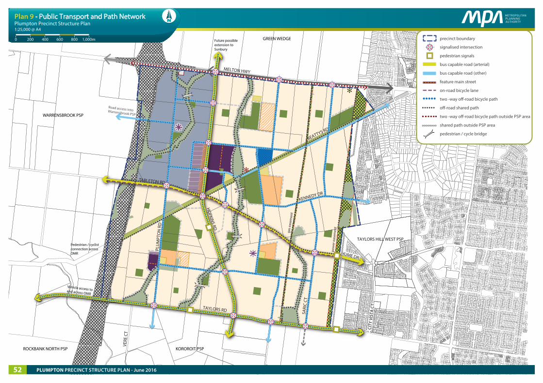
Plan 9 - Public Transport and Path Network
PLUMPTON PRECINCT STRUCTURE PLAN - June 201652
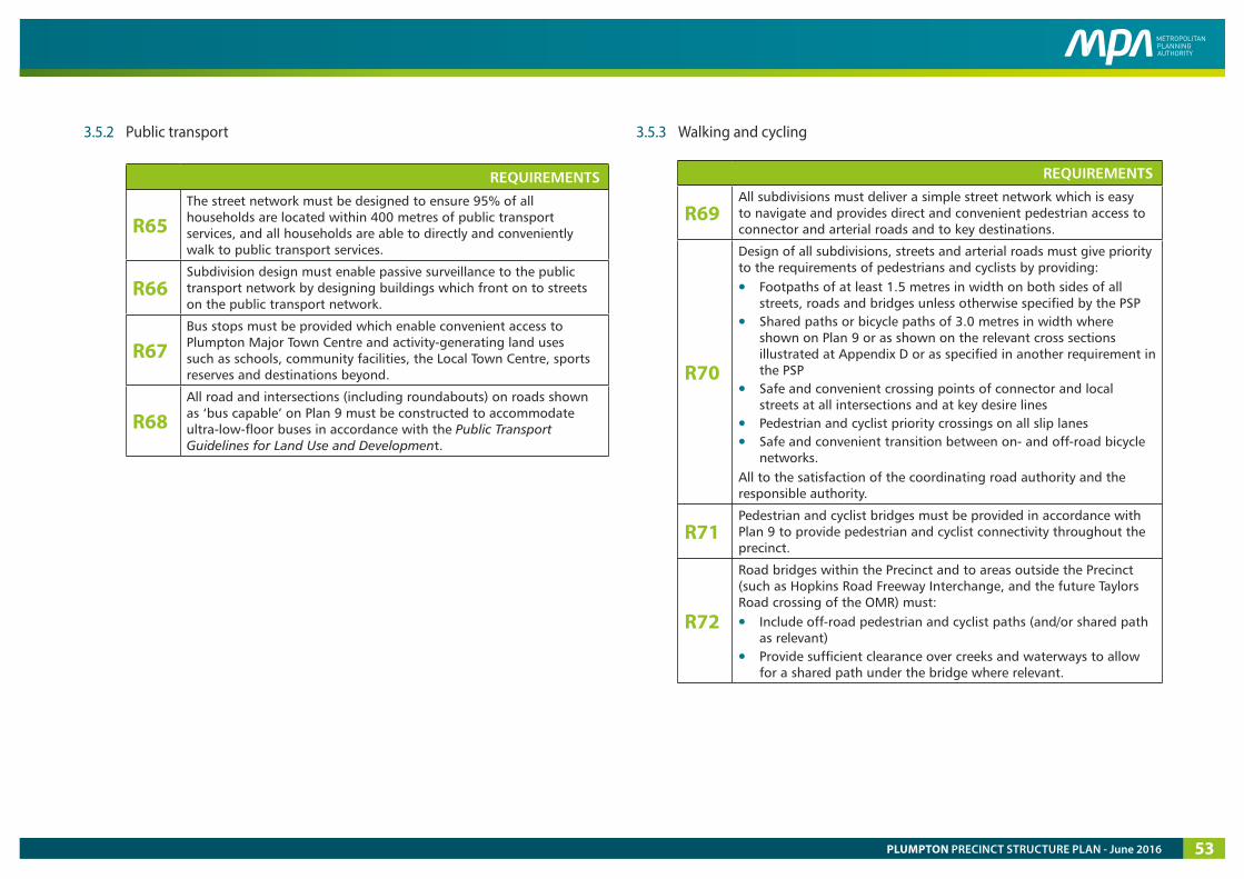
3.5.2 Public transport
REQUIREMENTS
R65 The street network must be designed to ensure 95% of all households are located within 400 metres of public transport services, and all households are able to directly and conveniently walk to public transport services.
R66 Subdivision design must enable passive surveillance to the public transport network by designing buildings which front on to streets on the public transport network.
R67 Bus stops must be provided which enable convenient access to Plumpton Major Town Centre and activity-generating land uses such as schools, community facilities, the Local Town Centre, sports reserves and destinations beyond.
R68 All road and intersections (including roundabouts) on roads shown as ‘bus capable’ on Plan 9 must be constructed to accommodate ultra-low-floor buses in accordance with the Public Transport Guidelines for Land Use and Development.
3.5.3 Walking and cycling
REQUIREMENTS
R69 All subdivisions must deliver a simple street network which is easy to navigate and provides direct and convenient pedestrian access to connector and arterial roads and to key destinations.
R70
Design of all subdivisions, streets and arterial roads must give priority to the requirements of pedestrians and cyclists by providing:
• Footpaths of at least 1.5 metres in width on both sides of all streets, roads and bridges unless otherwise specified by the PSP
• Shared paths or bicycle paths of 3.0 metres in width where shown on Plan 9 or as shown on the relevant cross sections illustrated at Appendix D or as specified in another requirement in the PSP
• Safe and convenient crossing points of connector and local streets at all intersections and at key desire lines
• Pedestrian and cyclist priority crossings on all slip lanes• Safe and convenient transition between on- and off-road bicycle
networks. All to the satisfaction of the coordinating road authority and the responsible authority.
R71 Pedestrian and cyclist bridges must be provided in accordance with Plan 9 to provide pedestrian and cyclist connectivity throughout the precinct.
R72
Road bridges within the Precinct and to areas outside the Precinct (such as Hopkins Road Freeway Interchange, and the future Taylors Road crossing of the OMR) must:
• Include off-road pedestrian and cyclist paths (and/or shared path as relevant)
• Provide sufficient clearance over creeks and waterways to allow for a shared path under the bridge where relevant.
PLUMPTON PRECINCT STRUCTURE PLAN - June 2016 53

THIS PAGE HAS BEEN LEFT INTENTIONALLY BLANK
PLUMPTON PRECINCT STRUCTURE PLAN - June 201654

R73
Shared and pedestrian paths along waterways, to the satisfaction of Melbourne Water and the responsible authority, must be:
• Delivered by development proponents consistent with the network shown on Plan 9
• Positioned above 1:10 year flood levels with a crossing of the waterway designed above 1:100 year flood level to maintain hydraulic function of the waterway
• Constructed to a standard that satisfies the requirements of Melbourne Water.
Where a shared path is to be delivered on only one side of a minor waterway, a path must also be delivered on the other side of the waterway, but may be constructed to a lesser standard (i.e. crushed rock or similar granular material).
R74 Safe, accessible and convenient pedestrian and cycle crossing points must be provided at all intersections, key desire lines and locations of high amenity.
R75 Bicycle priority at intersections of minor streets and connector streets with dedicated off-road bicycle paths must be achieved through strong and consistent visual clues and supportive directional and associated road signs.
R76 Alignment of the off-road bicycle path must be designed for cyclists to travel up to 30km/h to the satisfaction of the responsible authority.
R77
Bicycle parking facilities including bicycle hoops and way-finding signage must be provided by development proponents in, and to, key destinations such as Plumpton Major Town Centre, the Local Town Centre, schools, community facilities and across the open space network.
GUIDELINES
G62 Lighting should be installed along shared, pedestrian and cycle paths linking to key destinations, unless otherwise agreed by the responsible authority.
3.5.4 Town centre transport, access and connectivity
REQUIREMENTS
R78 Heavy vehicle movements (loading and deliveries) must not front the main streets and should be located to the rear and/or side street and screened, or ‘sleeved’ by more active uses.
R79 Town Centre main streets must be designed for a low speed environment of 40km/h or less such that vehicles and cyclists share the carriageway and pedestrians can safely cross the road.
R80 Increased permeability in the road network within and surrounding the Major Town Centre and Local Town Centre should be delivered via shorter block lengths and the avoidance of culs-de-sac.
R81 Safe and easy access for pedestrian and cycle trips must be provided to town centres through the layout and design of the surrounding street network, including connections to the Beattys Road Reserve linear path and paths along waterways.
GUIDELINES
G63 Pedestrian priority should be provided across all side roads along main streets and all car park entrances.
G64 Bicycle parking should be provided at entry points to the town centre and designed to include weather protection, passive surveillance and lighting to the satisfaction of the responsible authority.
G65 Car park entrances directly from main streets should be minimised and alternative access should be provided from other streets.
G66 Car parking should be provided efficiently through use of shared, consolidated parking areas.
G67 A safe, clearly identified and continuous path of pedestrian travel should be provided throughout all car parking areas.
PLUMPTON PRECINCT STRUCTURE PLAN - June 2016 55
MELTON HWY
PLU
MPT
ON
RD
VERE
CT
SARI
C CT
HUME DR
TAYLORS RD
BEATTYS RD
HO
PKINS RD
CITY
VIS
TA C
T
KENNEDY DR
TARLETON RD
gas e
asem
ent
pow
er e
asem
ent
Pedestrian / cyclist connection across OMR
Vehicle access to and across OMR
TAYLORS HILL WEST PSP
Future possible extension to Sunbury
GREEN WEDGE
WARRENSBROOK PSP
KOROROIT PSPROCKBANK NORTH PSP
60m
60m
60m
60m
60m
60m
45m
55m
55m
50m
45m
Sinclairs Road DSS 4106
Beattys Road DSS 4143
Plumpton Road DSS 1408
Olive Grove DSS 4142 Saric Court DSS
4178
Taylors HillWest DSS
4150
WI-01WI-01WI-02WI-02
WI-04WI-04
WI-05WI-05
WI-06WI-06
WI-09WI-09
WI-10WI-10
WI-11WI-11
WI-12WI-12
WI-18WI-18
WI-17WI-17
WI-16WI-16
WI-07WI-07
WI-08WI-08
WI-13WI-13
WI-14WI-14WI-15WI-15
WI-03WI-03
precinct boundary
stormwater quality treatment & drainage asset
natural waterway corridor
constructed waterway corridor
1m contours
catchment area
water infrastructure (refer table 8)
opportunity to utilise water from adjacent stormwater quality treatment asset and to irrigate sports reserve
culvert
pedestrian bridge
overland �ow path
WI-04WI-04
Note:Stormwater quality treatment assets and waterway widths on this plan are subject to con�rmation through detailed design to the satisfaction of Melbourne Water.
Plumpton Precinct Structure Plan
0 200 400 600 800 1,000m
1:25,000 @ A4
Copyright, Metropolitan Planning Authority, 2016 The state of Victoria does not warrant the accuracy or completeness of information in this publication and any person using or relying upon such information does so on the basis that the State of Victoria shall bear no responsibility or liability whatsoever for any errors, faults, defects or omission in the information.
Plan 10 - Integrated Water Management
PLUMPTON PRECINCT STRUCTURE PLAN - June 201656
4.0 INTEGRATED WATER MANAGEMENT & UTILITIES
4.1 Integrated water management
REQUIREMENTS
R82
Stormwater runoff from the development must meet or exceed the performance objectives of the CSIRO Best Practice Environmental Management Guidelines for Urban Stormwater prior to discharge to receiving waterways and as outlined on Plan 10, unless otherwise approved by Melbourne Water and the responsible authority.
R83 Final design and boundary of constructed wetlands, retarding basins, stormwater quality treatment infrastructure, and associated paths, boardwalks, bridges, and planting, must be to the satisfaction of both the responsible authority and Melbourne Water.
R84
Applications must demonstrate how:
• Waterways and integrated water management design enables land to be used for multiple recreation and environmental purposes
• Overland flow paths and piping within road reserves will be connected and integrated across property/parcel boundaries
• Melbourne Water and the responsible authority freeboard requirements for overland flow paths will be adequately contained within the road reserves
• Relevant integrated water management (IWM) requirements of this PSP will be achieved, to the satisfaction of the retail water authority, including the supply of recycled water.
Drainage assets must be designed to the satisfaction of Western Water and/or City West Water (where relevant), Melbourne Water and the responsible authority.
R85
Development staging must provide for delivery of ultimate waterway and drainage infrastructure including stormwater quality treatment. Where this is not possible, development must demonstrate how any interim solution adequately manages and treats stormwater generated from the development and how this will enable delivery of an ultimate drainage solution, all to the satisfaction of the responsible authority.
R86 Stormwater conveyance and treatment must be designed in accordance with the relevant Development Services Scheme, Plan 10 and Table 8 to the satisfaction of Melbourne Water and the responsible authority.
GUIDELINES
G68 Development should have regard to relevant policies and strategies being implemented by the responsible authority, Melbourne Water, City West Water and Western Water including any approved Integrated Water Management Plan.
G69
Where practical, integrated water management systems should be designed to:
• Maximise habitat values for local flora and fauna species• Enable future harvesting and/or treatment and re-use of
stormwater, including those options or opportunities outlined on Plan 10.
G70
The design and layout of roads, road reserves, and public open space should optimise water use efficiency and long-term viability of vegetation and public uses through the use of overland flow paths, Water Sensitive Urban Design initiatives such as rain gardens and/or locally treated storm water for irrigation to contribute to a sustainable and green urban environment.
G71 Development should reduce reliance on potable water by increasing the utilisation of fit-for-purpose alternative water sources such as storm water, rain water and recycled water.
PLUMPTON PRECINCT STRUCTURE PLAN - June 2016 57

THIS PAGE HAS BEEN LEFT INTENTIONALLY BLANK
PLUMPTON PRECINCT STRUCTURE PLAN - June 201658
Table 8 Water infrastructure
ID (REFER PLAN 10)
DESCRIPTION OF WATER INFRASTRUCTURE RESPONSIBILITYPROPERTY
NO.AREA (HA) DSS
WI-01 Wetland - associated with geomorphic value waterways with riparian values. Melbourne Water 12-E 2.03 Beattys Road
WI-02 Sediment basin and bio-retension basin. Melton City Council 5 0.33 Beattys Road
WI-03 Retarding Basin. Melbourne Water 5, 6 Beattys Road
WI-04 Sediment basin. Melton City Council 6 0.17 Beattys Road
WI-05 Sediment basin and bio-retension basin. Melton City Council 9 0.18 Beattys Road
WI-06 Retarding basin and wetland - partially located within Beattys Road reservation. Melton City Council 11-R, R3 2.40 Plumpton Road
WI-07 Retarding basin and wetland. Melton City Council 43 3.67 Plumpton Road
WI-08 Retarding basin and wetland. Melbourne Water 45, 46 1.58 Olive Grove
WI-09 Sediment basin. Melton City Council 32, 48 0.45 Olive Grove
WI-10 Sediment basin. Melton City Council 32, 48 0.33 Olive Grove
WI-11Retarding basin - edges to have attractive landscaping and grasses to provide appealing interface with Major Town Centre even when holding minimal water. Embankment of the retarding basin to be clearly separate from road structure in Beattys Road reservation.
Melbourne Water 12-R 5.11 Olive Grove
WI-12 Sediment basin. Melton City Council 12-R, 17 0.44 Olive Grove
WI-13Retarding basin - adjacent to high pressure gas transmission pipeline and gas city gate. Consult with pipeline owner prior to design as per requirements.
Melbourne Water 28 1.55 Sinclairs Road
WI-14Swale - across the high pressure gas transmission pipeline. Consult with pipeline owner prior to design as per requirements.
Melton City Council 48, 49 4.36 Sinclairs Road
WI-15Retarding basin - adjacent to high pressure gas transmission pipeline. Consult with pipeline owner prior to design as per requirements.
Melbourne Water 49 2.64 Sinclairs Road
WI-16 WI-17
Retarding basin - located in powerlines easement. Consult with powerlines easement owner prior to design as per requirements.
Melton City Council 27 3.12 Saric Court
WI-18Swale - across the high pressure gas transmission pipeline. Consult with pipeline owner prior to design as per requirements.
Melbourne Water 23 0.06 Saric Court
PLUMPTON PRECINCT STRUCTURE PLAN - June 2016 59
MELTON HWY
PLU
MPT
ON
RD
VERE
CT
SARI
C CT
HUME DR
TAYLORS RD
BEATTYS RD
HO
PKINS RD
CITY
VIS
TA C
T
KENNEDY DR
TARLETON RD
gas e
asem
ent
pow
er e
asem
ent
Pedestrian / cyclist connection across OMR
Vehicle access to and across OMR
TAYLORS HILL WEST PSP
Future possible extension to Sunbury
GREEN WEDGE
WARRENSBROOK PSP
KOROROIT PSPROCKBANK NORTH PSP
66 K
v
66 K
v
66 Kv
220
Kv
500
Kv
Holden water tank
NOTES:Alignment and sizes of utilities shown on this plan are indicative and subject to con�rmation by the relevant authority.
precinct boundary
proposed potable water main
proposed recycled water main
existing high pressure gas pipeline
gas pipeline measurement length
gas main
220 Kv electricity network
500 Kv electricity network
66 Kv electricity network
sewer network
sewer rising main
pump station
utilities easement
zone substation
Plumpton Precinct Structure Plan
0 200 400 600 800 1,000m
1:25,000 @ A4
Copyright, Metropolitan Planning Authority, 2016 The state of Victoria does not warrant the accuracy or completeness of information in this publication and any person using or relying upon such information does so on the basis that the State of Victoria shall bear no responsibility or liability whatsoever for any errors, faults, defects or omission in the information.
Plan 11 - Utilities
PLUMPTON PRECINCT STRUCTURE PLAN - June 201660
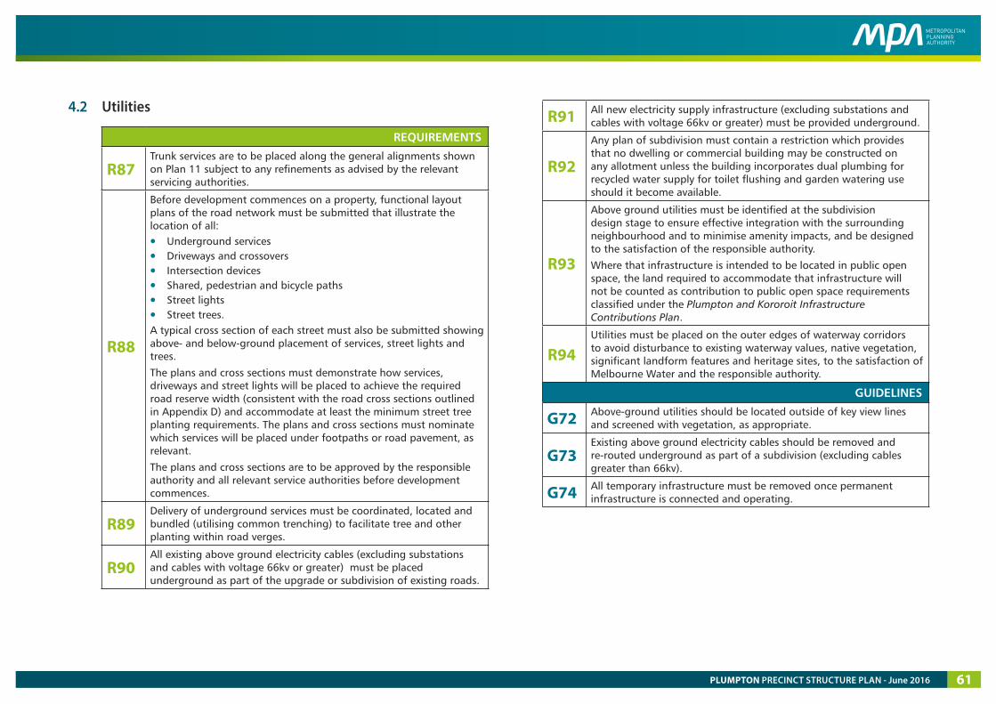
4.2 Utilities
REQUIREMENTS
R87 Trunk services are to be placed along the general alignments shown on Plan 11 subject to any refinements as advised by the relevant servicing authorities.
R88
Before development commences on a property, functional layout plans of the road network must be submitted that illustrate the location of all:
• Underground services• Driveways and crossovers• Intersection devices• Shared, pedestrian and bicycle paths• Street lights• Street trees.A typical cross section of each street must also be submitted showing above- and below-ground placement of services, street lights and trees.
The plans and cross sections must demonstrate how services, driveways and street lights will be placed to achieve the required road reserve width (consistent with the road cross sections outlined in Appendix D) and accommodate at least the minimum street tree planting requirements. The plans and cross sections must nominate which services will be placed under footpaths or road pavement, as relevant.
The plans and cross sections are to be approved by the responsible authority and all relevant service authorities before development commences.
R89 Delivery of underground services must be coordinated, located and bundled (utilising common trenching) to facilitate tree and other planting within road verges.
R90 All existing above ground electricity cables (excluding substations and cables with voltage 66kv or greater) must be placed underground as part of the upgrade or subdivision of existing roads.
R91 All new electricity supply infrastructure (excluding substations and cables with voltage 66kv or greater) must be provided underground.
R92
Any plan of subdivision must contain a restriction which provides that no dwelling or commercial building may be constructed on any allotment unless the building incorporates dual plumbing for recycled water supply for toilet flushing and garden watering use should it become available.
R93
Above ground utilities must be identified at the subdivision design stage to ensure effective integration with the surrounding neighbourhood and to minimise amenity impacts, and be designed to the satisfaction of the responsible authority.
Where that infrastructure is intended to be located in public open space, the land required to accommodate that infrastructure will not be counted as contribution to public open space requirements classified under the Plumpton and Kororoit Infrastructure Contributions Plan.
R94 Utilities must be placed on the outer edges of waterway corridors to avoid disturbance to existing waterway values, native vegetation, significant landform features and heritage sites, to the satisfaction of Melbourne Water and the responsible authority.
GUIDELINES
G72 Above-ground utilities should be located outside of key view lines and screened with vegetation, as appropriate.
G73 Existing above ground electricity cables should be removed and re-routed underground as part of a subdivision (excluding cables greater than 66kv).
G74 All temporary infrastructure must be removed once permanent infrastructure is connected and operating.
PLUMPTON PRECINCT STRUCTURE PLAN - June 2016 61
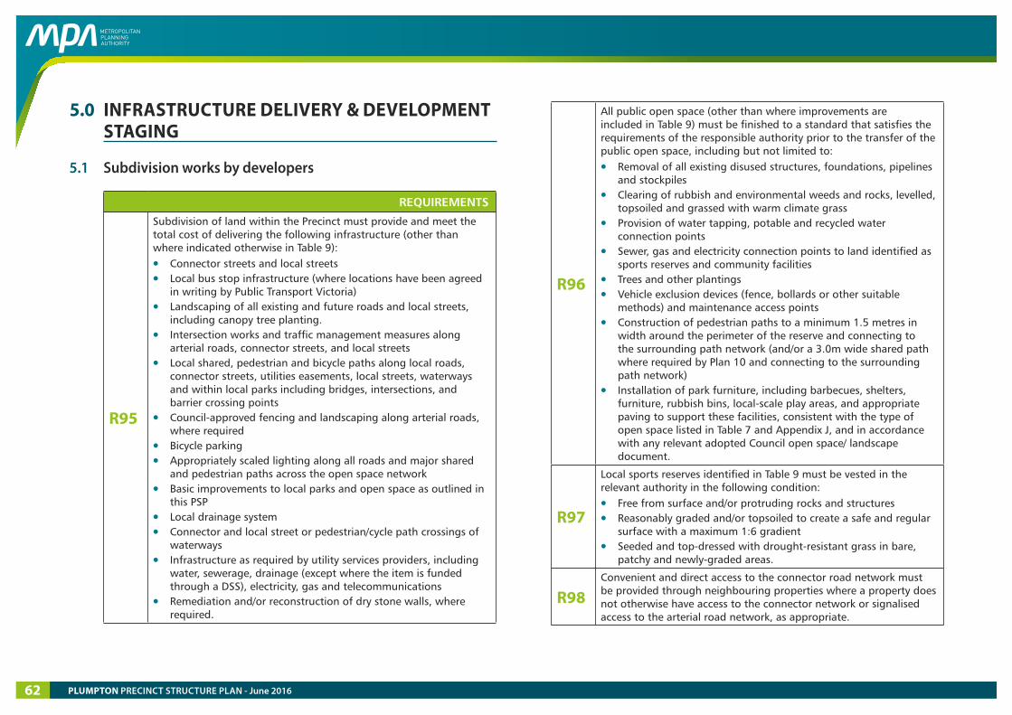
5.0 INFRASTRUCTURE DELIVERY & DEVELOPMENT STAGING
5.1 Subdivision works by developers
REQUIREMENTS
R95
Subdivision of land within the Precinct must provide and meet the total cost of delivering the following infrastructure (other than where indicated otherwise in Table 9):
• Connector streets and local streets• Local bus stop infrastructure (where locations have been agreed
in writing by Public Transport Victoria)• Landscaping of all existing and future roads and local streets,
including canopy tree planting.• Intersection works and traffic management measures along
arterial roads, connector streets, and local streets• Local shared, pedestrian and bicycle paths along local roads,
connector streets, utilities easements, local streets, waterways and within local parks including bridges, intersections, and barrier crossing points
• Council-approved fencing and landscaping along arterial roads, where required
• Bicycle parking• Appropriately scaled lighting along all roads and major shared
and pedestrian paths across the open space network• Basic improvements to local parks and open space as outlined in
this PSP• Local drainage system• Connector and local street or pedestrian/cycle path crossings of
waterways • Infrastructure as required by utility services providers, including
water, sewerage, drainage (except where the item is funded through a DSS), electricity, gas and telecommunications
• Remediation and/or reconstruction of dry stone walls, where required.
R96
All public open space (other than where improvements are included in Table 9) must be finished to a standard that satisfies the requirements of the responsible authority prior to the transfer of the public open space, including but not limited to:
• Removal of all existing disused structures, foundations, pipelines and stockpiles
• Clearing of rubbish and environmental weeds and rocks, levelled, topsoiled and grassed with warm climate grass
• Provision of water tapping, potable and recycled water connection points
• Sewer, gas and electricity connection points to land identified as sports reserves and community facilities
• Trees and other plantings• Vehicle exclusion devices (fence, bollards or other suitable
methods) and maintenance access points• Construction of pedestrian paths to a minimum 1.5 metres in
width around the perimeter of the reserve and connecting to the surrounding path network (and/or a 3.0m wide shared path where required by Plan 10 and connecting to the surrounding path network)
• Installation of park furniture, including barbecues, shelters, furniture, rubbish bins, local-scale play areas, and appropriate paving to support these facilities, consistent with the type of open space listed in Table 7 and Appendix J, and in accordance with any relevant adopted Council open space/ landscape document.
R97
Local sports reserves identified in Table 9 must be vested in the relevant authority in the following condition:
• Free from surface and/or protruding rocks and structures• Reasonably graded and/or topsoiled to create a safe and regular
surface with a maximum 1:6 gradient• Seeded and top-dressed with drought-resistant grass in bare,
patchy and newly-graded areas.
R98 Convenient and direct access to the connector road network must be provided through neighbouring properties where a property does not otherwise have access to the connector network or signalised access to the arterial road network, as appropriate.
PLUMPTON PRECINCT STRUCTURE PLAN - June 201662

R99 Where a street has already been constructed or approved for construction to a property boundary, subsequent development must connect with that street to adopt a consistent cross-section until a suitable transition can be made.
R100 Any development in proximity to the Melton Highway that triggers the VicRoads Requirements of Developers – Noise Sensitive Uses document must respond to its requirements to the satisfaction of the responsible authority and VicRoads.
5.2 Development staging
REQUIREMENTS
R101
Development staging must provide for the timely provision and delivery of:
• Arterial road reservations• Connector streets • Street links between properties, constructed to the property
boundary• Connection of the on- and off-road pedestrian and bicycle
network.
R102 Streets must be constructed to property boundaries where an inter-parcel connection is intended or indicated in this precinct structure plan, by any date or stage of development required or approved by the responsible authority.
GUIDELINES
G75
Staging of development will be determined largely by the development proposals on land within the precinct and the availability of infrastructure services. Development applications should demonstrate how the development will:
• Integrate with adjoining developments, including the timely provision of road and path connections, to a practical extent
• Provide open space and amenity to new residents in the early stages of the development, where relevant
• Provide sealed road access to each new allotment• Deliver any necessary trunk services extensions, including
confirmation of the agreed approach and timing by the relevant service provider.
G76
Staging of transport infrastructure should prioritise early delivery of a connected arterial road network to:
• Ensure that subdivisions are designed to access the future arterial network rather than the existing road network;
• Reduce pressure on existing roads which were built to cater for rural, not urban , use
• Reduce pressure on the existing low standard crossing of Kororoit Creek at Sinclairs Road in the draft Kororoit PSP area to the south.
G77 The early delivery of community facilities, local parks and playgrounds is encouraged within each neighbourhood and may be delivered in stages, to the satisfaction of the responsible authority.
PLUMPTON PRECINCT STRUCTURE PLAN - June 2016 63
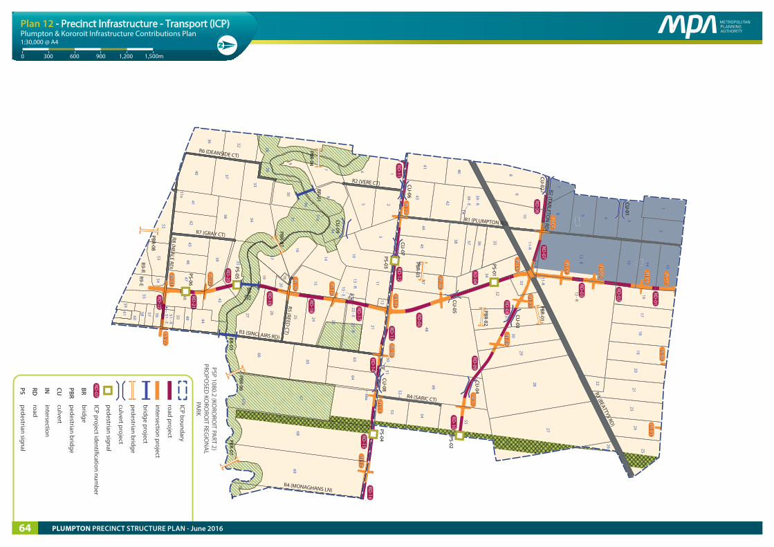
MELTO
N H
WY
PLUMPTON RD
VERE CT
SARIC CT
HU
ME D
R
TAYLO
RS RD
BEATTYS RD
HOPKINS RD
CITY VISTA CT
KENN
EDY D
R
TARLETO
N RD
gas easement
power easement
Pedestrian / cyclist connection across O
MR
Vehicle access to and across O
MR
TAYLO
RS HILL W
EST PSP
Future possible extension to Sunbury
GREEN
WED
GE
WA
RRENSBRO
OK PSP
KORO
ROIT PSP
ROCKBA
NK N
ORTH
PSP
PLUMPTON RD
SARIC CT
VERE CT
CLARKE RD
MONAGHANS LN
DEANSIDE DRIVE
GRAY CT
TAYLO
RS RD
REED CT
NEA
LE RD
SINCLAIRS RD
HOPKINS RD
WESTERN
FWY
CITY VISTA CT
ROCKBA
NK N
TH PSP
PLUM
PTON
PSP
MT. A
TKINSO
N PSP &
TARN
EIT PLAIN
S PSP
TAYLO
RS HILL W
EST PSP
CARO
LINE SPRIN
GS
MELBO
URNE-BALLARAT RAILWAY
gas easement
power lines easement
Vehicle access to
and across OM
R
OUTER METROPOLITAN RING
Kororoit Creek
Kororoit Creek
RD-01
RD-03
RD-02
IN-01
IN-01
RD-06
RD-07
RD-08
RD-04
RD-05
RD-09
RD-10
RD-11
RD-12
RD-13
RD-14
RD-15
RD-16
RD-17
RD-18
RD-19
RD-20
RD-21
RD-22
IN-04
IN-04
IN-03
IN-03
IN-02
IN-02
IN-05
IN-05
IN-06
IN-06
IN-07
IN-07
IN-08
IN-08
IN-09
IN-09
IN-10
IN-10
IN-11
IN-11
IN-12
IN-12
IN-13
IN-13
IN-14
IN-14
IN-15
IN-15
IN-16
IN-16
IN-17
IN-17
IN-18
IN-18
IN-19
IN-19
IN-20
IN-20
IN-21
IN-21
IN-22
IN-22
14
9
8
6
5 2
3
10
1121
22 - R22 - E
13 - R13 - E
23
24
25
15
16
17
1819
20
2627
66
65
6364
66a6768
69
7067a
9a
31a
8a
36 32 2829
3031
33
37
4041
42
38 34
35
4339
4546
4748
51 - R51 - E
50 49 44
52
51a
5354
55
56
57
5860
6159
R6
R9-ER9-R
7
12
14
R2 (VERE CT)
R6 (DEANSIDE CT)
R7 (GRAY CT)R8 (NEA
LE RD)
R5 (REED CT)R3 (SINCLAIRS RD)
R4 (MONAGHANS LN)
R2 (TARLETO
N RD
)R1 (PLUMPTON RD)
R4 (SARIC CT)
R3 (BEATTYS RD)
12
3
4567
89
1011-R
11-R
11-E
12 - R12 - E 13 14 15
1617
1819
2021
22
2324
25
26
27
28
29
30
31
32
33
34
3536
37
38
42
39 - E
39 - R
40
41
4344
4546
47 48
49
5051
52
53 54
55
PSP 1080.2 (KORO
ROIT PA
RT 2) PRO
POSED
KORO
ROIT REG
ION
AL
PARK
PBR-07BR-03
PBR-04
PBR-06BR-02
PBR-07
BR-01
CU-01
CU-02
PBR-01
PBR-03
PBR-08
CU-05
CU-08
CU-07
CU-06
CU-03
PBR-02
PS-01
PS-02
PS-03PS-04
PS-05PS-06
CU-09
CU-04
ICP boundary
road project
intersection project
bridge project
pedestrian bridge
culvert project
pedestrian signal
ICP project identi�cation number
bridge
pedestrian bridge
culvert
intersection
road
pedestrian signal
BRPBR
CUINRDPS
RD-07
Copyright, Metropolitan Planning Authority, 2016 The state of Victoria does not warrant the accuracy or completeness of information in this publication and any person using or relying upon such information does so on the basis that the State of Victoria shall bear no responsibility or liability whatsoever for any errors, faults, defects or omission in the information.
Plumpton & Kororoit Infrastructure Contributions Plan
9000 300 600 1,200 1,500m
1:30,000 @ A4
Plan 12 - Precinct Infrastructure - Transport (ICP)
PLUMPTON PRECINCT STRUCTURE PLAN - June 201664
6.0 PRECINCT INFRASTRUCTURE The Precinct Infrastructure Table at Table 9 sets out the infrastructure and services required to meet the needs of proposed development within the Precinct, as illustrated on Plans 12 and 13. Indicative timing is designated as ‘S’ (short term); ‘M’ (medium term); and ‘L’ (long term). The infrastructure items and services are to be provided through a number of mechanisms which may include:
• Subdivision construction works by developers.
• Agreement under Section 173 of the Act
• Utility service provider requirements
• The future Plumpton and Kororoit ICP
• Relevant development contributions from adjoining areas
• Capital works projects by Council, State government agencies and non-government organisations
• Works In Kind (WIK) projects undertaken by developers on behalf of Council or State government agencies.
PLUMPTON PRECINCT STRUCTURE PLAN - June 2016 65
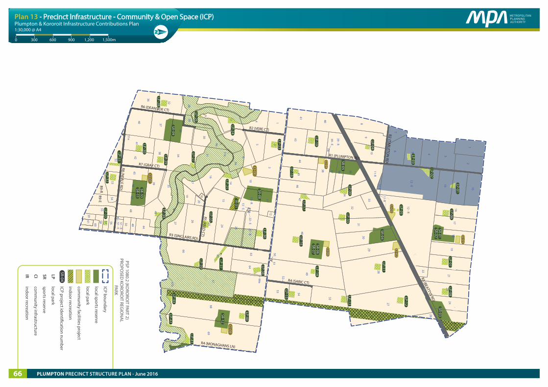
MELTO
N H
WY
PLUMPTON RD
VERE CT
SARIC CT
HU
ME D
R
TAYLO
RS RD
BEATTYS RD
HOPKINS RD
CITY VISTA CT
KENN
EDY D
R
TARLETO
N RD
gas easement
power easement
Pedestrian / cyclist connection across O
MR
Vehicle access to and across O
MR
TAYLO
RS HILL W
EST PSP
Future possible extension to Sunbury
GREEN
WED
GE
WA
RRENSBRO
OK PSP
KORO
ROIT PSP
ROCKBA
NK N
ORTH
PSP
PLUMPTON RD
SARIC CT
VERE CT
CLARKE RD
MONAGHANS LN
DEANSIDE DRIVE
GRAY CT
TAYLO
RS RD
REED CT
NEA
LE RD
SINCLAIRS RD
HOPKINS RD
WESTERN
FWY
CITY VISTA CT
ROCKBA
NK N
TH PSP
PLUM
PTON
PSP
MT. A
TKINSO
N PSP &
TARN
EIT PLAIN
S PSP
TAYLO
RS HILL W
EST PSP
CARO
LINE SPRIN
GS
MELBO
URNE-BALLARAT RAILWAY
gas easement
power lines easement
Vehicle access to
and across OM
R
OUTER METROPOLITAN RING
Kororoit Creek
Kororoit Creek
14
9
8
6
5 2
3
10
1121
22 - R22 - E
13 - R13 - E
23
24
25
15
16
17
1819
20
2627
66
65
6364
66a6768
69
7067a
9a
31a
8a
36 32 2829
3031
33
37
4041
42
38 34
35
4339
4546
4748
51 - R51 - E
50 49 44
52
51a
5354
55
56
57
5860
6159
R6
R9-ER9-R
7
12
14
R2 (VERE CT)
R6 (DEANSIDE CT)
R7 (GRAY CT)R8 (NEA
LE RD)
R5 (REED CT)R3 (SINCLAIRS RD)
R4 (MONAGHANS LN)
R2 (TARLETO
N RD
)R1 (PLUMPTON RD)
R4 (SARIC CT)
R3 (BEATTYS RD)
12
3
4567
89
1011-R
11-R
11-E
12 - R12 - E 13 14 15
1617
1819
2021
22
2324
25
26
27
28
29
30
31
32
33
34
3536
37
38
42
39 - E
39 - R
40
41
4344
4546
47 48
49
5051
52
53 54
55
LP-37LP-37
LP-31LP-31
LP-23LP-23
LP-24LP-24
LP-25LP-25
LP-26LP-26
LP-27LP-27
LP-29LP-29
LP-30LP-30
LP-28LP-28
SR-09SR-09
LP-32LP-32
LP-33LP-33
LP-34LP-34
LP-35LP-35
LP-36LP-36
LP-39LP-39 LP-38
LP-38
LP-40LP-40
LP-41LP-41
LP-42LP-42
LP-43LP-43
SR-08SR-08
SR-10SR-10SR-11SR-11
SR-12SR-12
IR-01IR-01
LOS-04
LOS-04
LOS-05
LOS-05
LOS-2
LOS-2
SR-01SR-01SR-02SR-02
LP-08LP-08
SR-03SR-03
LOS-03
LOS-03
SR-04SR-04
LP-11LP-11
LP-12LP-12
LOS-01
LOS-01
SR-05SR-05
LP-09LP-09
LP-19LP-19
LP-10LP-10
LP-18LP-18
LP-17LP-17
LP-13LP-13
LP-14LP-14
LP-15LP-15
LP-16LP-16 SR-06
SR-06SR-07SR-07
LP-07LP-07
LP-06LP-06
LP-05LP-05
LP-04LP-04
LP-03LP-03
LP-01LP-01
LP-02LP-02
LP-20LP-20
LP-21LP-21
LP-22LP-22
CI-03CI-03
CI-04CI-04
CI-05CI-05
CI-02CI-02
CI-08CI-08
CI-06CI-06CI-07
CI-07
CI-01CI-01
PSP 1080.2 (KORO
ROIT PA
RT 2) PRO
POSED
KORO
ROIT REG
ION
AL
PARK
ICP boundary
local sports reserve
local park
comm
unity facilities project
indoor recreation
ICP project identi�cation number
local park
sports reserve
comm
unity infrastructure
indoor recreation
SR-04
LPSRCIIR
Copyright, Metropolitan Planning Authority, 2016 The state of Victoria does not warrant the accuracy or completeness of information in this publication and any person using or relying upon such information does so on the basis that the State of Victoria shall bear no responsibility or liability whatsoever for any errors, faults, defects or omission in the information.
Plumpton & Kororoit Infrastructure Contributions Plan
9000 300 600 1,200 1,500m
1:30,000 @ A4
Plan 13 - Precinct Infrastructure - Community & Open Space (ICP)
PLUMPTON PRECINCT STRUCTURE PLAN - June 201666
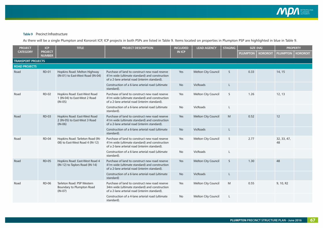
Table 9 Precinct Infrastructure
As there will be a single Plumpton and Kororoit ICP, ICP projects in both PSPs are listed in Table 9. Items located on properties in Plumpton PSP are highlighted in blue in Table 9.
PROJECT CATEGORY
ICP PROJECT NUMBER
TITLE PROJECT DESCRIPTION INCLUDED IN ICP
LEAD AGENCY STAGING SIZE (HA) PROPERTY
PLUMPTON KOROROIT PLUMPTON KOROROIT
TRANSPORT PROJECTS
ROAD PROJECTS
Road RD-01 Hopkins Road: Melton Highway (IN-01) to East-West Road (IN-04)
Purchase of land to construct new road reserve 41m wide (ultimate standard) and construction of a 2-lane arterial road (interim standard).
Yes Melton City Council S 0.33 14, 15
Construction of a 6-lane arterial road (ultimate standard).
No VicRoads L
Road RD-02 Hopkins Road: East-West Road 1 (IN-04) to East-West 2 Road (IN-05)
Purchase of land to construct new road reserve 41m wide (ultimate standard) and construction of a 2-lane arterial road (interim standard).
Yes Melton City Council S 1.26 12, 13
Construction of a 6-lane arterial road (ultimate standard).
No VicRoads L
Road RD-03 Hopkins Road: East-West Road 2 (IN-05) to East-West 3 Road (IN-06)
Purchase of land to construct new road reserve 41m wide (ultimate standard) and construction of a 2-lane arterial road (interim standard).
Yes Melton City Council M 0.52 12
Construction of a 6-lane arterial road (ultimate standard).
No VicRoads L
Road RD-04 Hopkins Road: Tarleton Road (IN-08) to East-West Road 4 (IN-12)
Purchase of land to construct new road reserve 41m wide (ultimate standard) and construction of a 2-lane arterial road (interim standard).
Yes Melton City Council S 2.77 32, 33, 47, 48
Construction of a 6-lane arterial road (ultimate standard).
No VicRoads L
Road RD-05 Hopkins Road: East-West Road 4 (IN-12) to Taylors Road (IN-14)
Purchase of land to construct new road reserve 41m wide (ultimate standard) and construction of a 2-lane arterial road (interim standard).
Yes Melton City Council S 1.30 48
Construction of a 6-lane arterial road (ultimate standard)
No VicRoads L
Road RD-06 Tarleton Road: PSP Western Boundary to Plumpton Road (IN-07)
Purchase of land to construct new road reserve 34m wide (ultimate standard) and construction of a 2-lane arterial road (interim standard).
Yes Melton City Council M 0.55 9, 10, R2
Construction of a 4-lane arterial road (ultimate standard).
No Melton City Council L
PLUMPTON PRECINCT STRUCTURE PLAN - June 2016 67
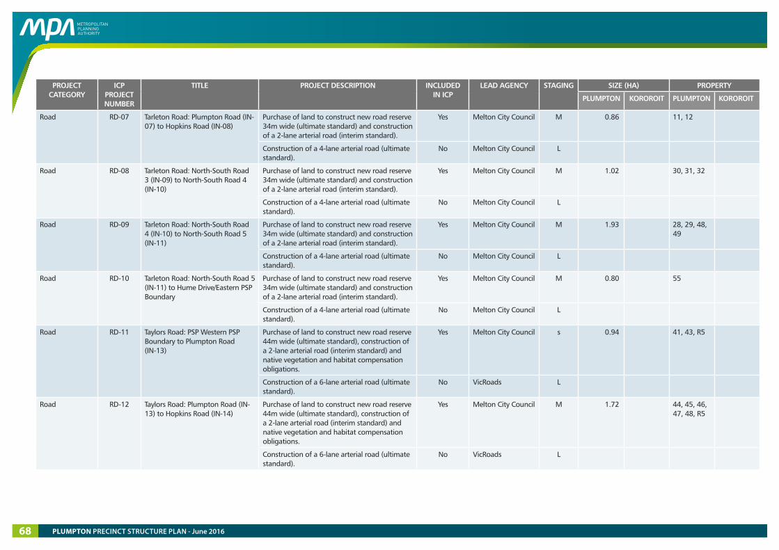
PROJECT CATEGORY
ICP PROJECT NUMBER
TITLE PROJECT DESCRIPTION INCLUDED IN ICP
LEAD AGENCY STAGING SIZE (HA) PROPERTY
PLUMPTON KOROROIT PLUMPTON KOROROIT
Road RD-07 Tarleton Road: Plumpton Road (IN-07) to Hopkins Road (IN-08)
Purchase of land to construct new road reserve 34m wide (ultimate standard) and construction of a 2-lane arterial road (interim standard).
Yes Melton City Council M 0.86 11, 12
Construction of a 4-lane arterial road (ultimate standard).
No Melton City Council L
Road RD-08 Tarleton Road: North-South Road 3 (IN-09) to North-South Road 4 (IN-10)
Purchase of land to construct new road reserve 34m wide (ultimate standard) and construction of a 2-lane arterial road (interim standard).
Yes Melton City Council M 1.02 30, 31, 32
Construction of a 4-lane arterial road (ultimate standard).
No Melton City Council L
Road RD-09 Tarleton Road: North-South Road 4 (IN-10) to North-South Road 5 (IN-11)
Purchase of land to construct new road reserve 34m wide (ultimate standard) and construction of a 2-lane arterial road (interim standard).
Yes Melton City Council M 1.93 28, 29, 48, 49
Construction of a 4-lane arterial road (ultimate standard).
No Melton City Council L
Road RD-10 Tarleton Road: North-South Road 5 (IN-11) to Hume Drive/Eastern PSP Boundary
Purchase of land to construct new road reserve 34m wide (ultimate standard) and construction of a 2-lane arterial road (interim standard).
Yes Melton City Council M 0.80 55
Construction of a 4-lane arterial road (ultimate standard).
No Melton City Council L
Road RD-11 Taylors Road: PSP Western PSP Boundary to Plumpton Road (IN-13)
Purchase of land to construct new road reserve 44m wide (ultimate standard), construction of a 2-lane arterial road (interim standard) and native vegetation and habitat compensation obligations.
Yes Melton City Council s 0.94 41, 43, R5
Construction of a 6-lane arterial road (ultimate standard).
No VicRoads L
Road RD-12 Taylors Road: Plumpton Road (IN-13) to Hopkins Road (IN-14)
Purchase of land to construct new road reserve 44m wide (ultimate standard), construction of a 2-lane arterial road (interim standard) and native vegetation and habitat compensation obligations.
Yes Melton City Council M 1.72 44, 45, 46, 47, 48, R5
Construction of a 6-lane arterial road (ultimate standard).
No VicRoads L
PLUMPTON PRECINCT STRUCTURE PLAN - June 201668
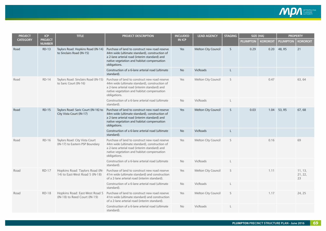
PROJECT CATEGORY
ICP PROJECT NUMBER
TITLE PROJECT DESCRIPTION INCLUDED IN ICP
LEAD AGENCY STAGING SIZE (HA) PROPERTY
PLUMPTON KOROROIT PLUMPTON KOROROIT
Road RD-13 Taylors Road: Hopkins Road (IN-14) to Sinclairs Road (IN-15)
Purchase of land to construct new road reserve 44m wide (ultimate standard), construction of a 2-lane arterial road (interim standard) and native vegetation and habitat compensation obligations.
Yes Melton City Council S 0.29 0.20 48, R5 21
Construction of a 6-lane arterial road (ultimate standard).
No VicRoads L
Road RD-14 Taylors Road: Sinclairs Road (IN-15) to Saric Court (IN-16)
Purchase of land to construct new road reserve 44m wide (ultimate standard), construction of a 2-lane arterial road (interim standard) and native vegetation and habitat compensation obligations.
Yes Melton City Council S 0.47 63, 64
Construction of a 6-lane arterial road (ultimate standard).
No VicRoads L
Road RD-15 Taylors Road: Saric Court (IN-16) to City Vista Court (IN-17)
Purchase of land to construct new road reserve 44m wide (ultimate standard), construction of a 2-lane arterial road (interim standard) and native vegetation and habitat compensation obligations.
Yes Melton City Council S 0.03 1.04 53, R5 67, 68
Construction of a 6-lane arterial road (ultimate standard).
No VicRoads L
Road RD-16 Taylors Road: City Vista Court (IN-17) to Eastern PSP Boundary
Purchase of land to construct new road reserve 44m wide (ultimate standard), construction of a 2-lane arterial road (interim standard) and native vegetation and habitat compensation obligations.
Yes Melton City Council S 0.16 69
Construction of a 6-lane arterial road (ultimate standard).
No VicRoads L
Road RD-17 Hopkins Road: Taylors Road (IN-14) to East-West Road 5 (IN-18)
Purchase of land to construct new road reserve 41m wide (ultimate standard) and construction of a 2-lane arterial road (interim standard).
Yes Melton City Council S 1.11 11, 13, 21, 22, 23
Construction of a 6-lane arterial road (ultimate standard).
No VicRoads L
Road RD-18 Hopkins Road: East-West Road 5 (IN-18) to Reed Court (IN-19)
Purchase of land to construct new road reserve 41m wide (ultimate standard) and construction of a 2-lane arterial road (interim standard).
Yes Melton City Council S 1.17 24, 25
Construction of a 6-lane arterial road (ultimate standard).
No VicRoads L
PLUMPTON PRECINCT STRUCTURE PLAN - June 2016 69
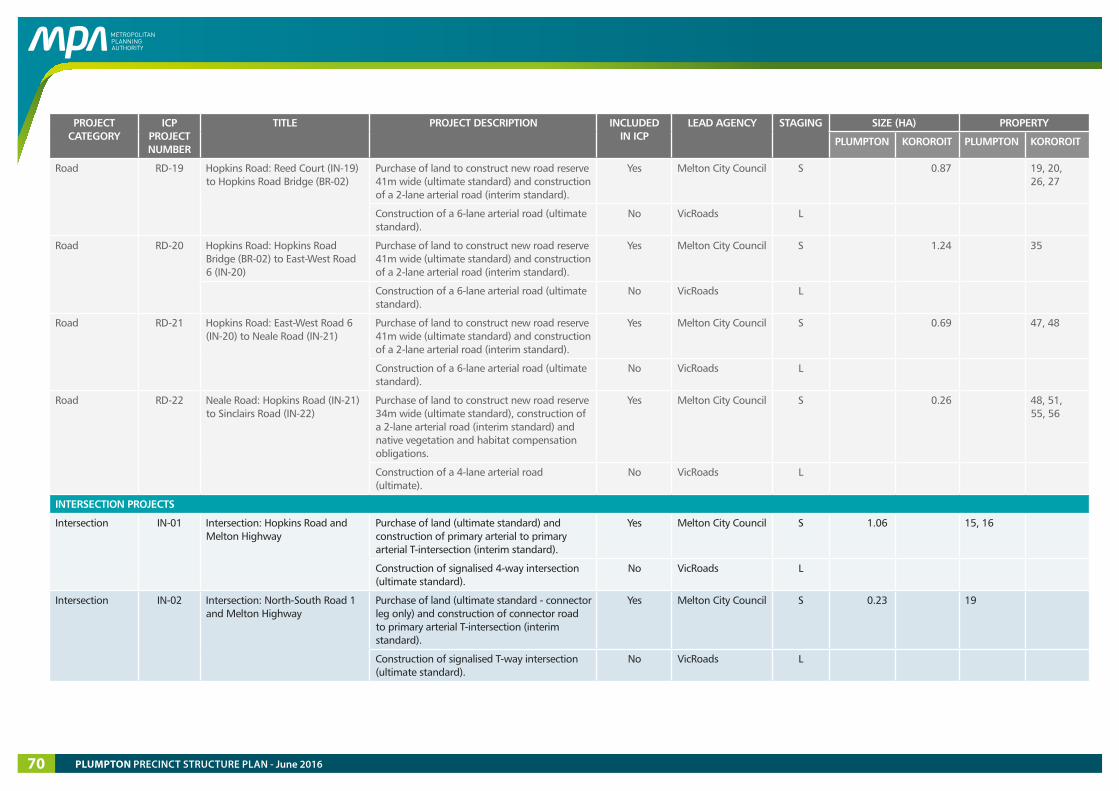
PROJECT CATEGORY
ICP PROJECT NUMBER
TITLE PROJECT DESCRIPTION INCLUDED IN ICP
LEAD AGENCY STAGING SIZE (HA) PROPERTY
PLUMPTON KOROROIT PLUMPTON KOROROIT
Road RD-19 Hopkins Road: Reed Court (IN-19) to Hopkins Road Bridge (BR-02)
Purchase of land to construct new road reserve 41m wide (ultimate standard) and construction of a 2-lane arterial road (interim standard).
Yes Melton City Council S 0.87 19, 20, 26, 27
Construction of a 6-lane arterial road (ultimate standard).
No VicRoads L
Road RD-20 Hopkins Road: Hopkins Road Bridge (BR-02) to East-West Road 6 (IN-20)
Purchase of land to construct new road reserve 41m wide (ultimate standard) and construction of a 2-lane arterial road (interim standard).
Yes Melton City Council S 1.24 35
Construction of a 6-lane arterial road (ultimate standard).
No VicRoads L
Road RD-21 Hopkins Road: East-West Road 6 (IN-20) to Neale Road (IN-21)
Purchase of land to construct new road reserve 41m wide (ultimate standard) and construction of a 2-lane arterial road (interim standard).
Yes Melton City Council S 0.69 47, 48
Construction of a 6-lane arterial road (ultimate standard).
No VicRoads L
Road RD-22 Neale Road: Hopkins Road (IN-21) to Sinclairs Road (IN-22)
Purchase of land to construct new road reserve 34m wide (ultimate standard), construction of a 2-lane arterial road (interim standard) and native vegetation and habitat compensation obligations.
Yes Melton City Council S 0.26 48, 51, 55, 56
Construction of a 4-lane arterial road (ultimate).
No VicRoads L
INTERSECTION PROJECTS
Intersection IN-01 Intersection: Hopkins Road and Melton Highway
Purchase of land (ultimate standard) and construction of primary arterial to primary arterial T-intersection (interim standard).
Yes Melton City Council S 1.06 15, 16
Construction of signalised 4-way intersection (ultimate standard).
No VicRoads L
Intersection IN-02 Intersection: North-South Road 1 and Melton Highway
Purchase of land (ultimate standard - connector leg only) and construction of connector road to primary arterial T-intersection (interim standard).
Yes Melton City Council S 0.23 19
Construction of signalised T-way intersection (ultimate standard).
No VicRoads L
PLUMPTON PRECINCT STRUCTURE PLAN - June 201670

PROJECT CATEGORY
ICP PROJECT NUMBER
TITLE PROJECT DESCRIPTION INCLUDED IN ICP
LEAD AGENCY STAGING SIZE (HA) PROPERTY
PLUMPTON KOROROIT PLUMPTON KOROROIT
Intersection IN-03 Intersection: North-South Road 2 and Melton Highway
Purchase of land (ultimate standard - connector leg only) and construction of connector road to primary arterial T-intersection (interim standard).
Yes Melton City Council S 0.23 24
Construction of signalised T-way intersection (ultimate standard).
No VicRoads L
Intersection IN-04 Intersection: Hopkins Road and East-West Road 1
Purchase of land (ultimate standard) and construction of primary arterial to connector road/local road 4-way intersection (interim standard).
Yes Melton City Council S 1.44 13, 14, 16
Construction of 4-way intersection (ultimate standard).
No VicRoads L
Intersection IN-05 Intersection: Hopkins Road and East-West Road 2
Purchase of land (ultimate standard) and construction of primary arterial to connector road 4-way intersection (interim standard).
Yes Melton City Council S 1.52 12
Construction of 4-way intersection (ultimate standard).
No VicRoads L
Intersection IN-06 Intersection: Hopkins Road and East-West Road 3
Purchase of land (ultimate standard) and construction of primary arterial to connector road 4-way intersection (interim standard).
Yes Melton City Council S 1.50 12
Construction of 4-way intersection (ultimate standard).
No VicRoads L
Intersection IN-07 Intersection: Plumpton Road and Tarleton Road
Purchase of land (ultimate standard), construction of connector road to secondary arterial 4-way intersection (interim standard) and native vegetation and habitat compensation obligations.
Yes Melton City Council M 0.64 6, 10, 11, 12, R1, R2
Construction of 4-way intersection (ultimate standard).
No Melton City Council L
Intersection IN-08 Intersection: Hopkins Road and Tarleton Road
Purchase of land (ultimate standard), construction of primary arterial to secondary arterial 4-way intersection (interim standard) and native vegetation and habitat compensation obligations.
Yes Melton City Council S 3.12 11, 12, 33, R3
Construction of 4-way intersection (ultimate standard).
No VicRoads L
PLUMPTON PRECINCT STRUCTURE PLAN - June 2016 71
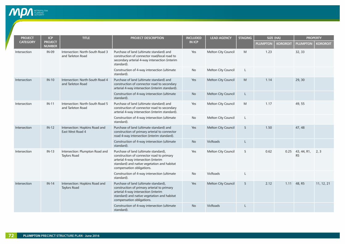
PROJECT CATEGORY
ICP PROJECT NUMBER
TITLE PROJECT DESCRIPTION INCLUDED IN ICP
LEAD AGENCY STAGING SIZE (HA) PROPERTY
PLUMPTON KOROROIT PLUMPTON KOROROIT
Intersection IN-09 Intersection: North-South Road 3 and Tarleton Road
Purchase of land (ultimate standard) and construction of connector road/local road to secondary arterial 4-way intersection (interim standard).
Yes Melton City Council M 1.23 32, 33
Construction of 4-way intersection (ultimate standard).
No Melton City Council L
Intersection IN-10 Intersection: North-South Road 4 and Tarleton Road
Purchase of land (ultimate standard) and construction of connector road to secondary arterial 4-way intersection (interim standard).
Yes Melton City Council M 1.14 29, 30
Construction of 4-way intersection (ultimate standard).
No Melton City Council L
Intersection IN-11 Intersection: North-South Road 5 and Tarleton Road
Purchase of land (ultimate standard) and construction of connector road to secondary arterial 4-way intersection (interim standard).
Yes Melton City Council M 1.17 49, 55
Construction of 4-way intersection (ultimate standard).
No Melton City Council L
Intersection IN-12 Intersection: Hopkins Road and East West Road 4
Purchase of land (ultimate standard) and construction of primary arterial to connector road 4-way intersection (interim standard).
Yes Melton City Council S 1.50 47, 48
Construction of 4-way intersection (ultimate standard).
No VicRoads L
Intersection IN-13 Intersection: Plumpton Road and Taylors Road
Purchase of land (ultimate standard), construction of connector road to primary arterial 4-way intersection (interim standard) and native vegetation and habitat compensation obligations.
Yes Melton City Council S 0.62 0.25 43, 44, R1, R5
2, 3
Construction of 4-way intersection (ultimate standard).
No VicRoads L
Intersection IN-14 Intersection: Hopkins Road and Taylors Road
Purchase of land (ultimate standard), construction of primary arterial to primary arterial 4-way intersection (interim standard) and native vegetation and habitat compensation obligations.
Yes Melton City Council S 2.12 1.11 48, R5 11, 12, 21
Construction of 4-way intersection (ultimate standard).
No VicRoads L
PLUMPTON PRECINCT STRUCTURE PLAN - June 201672
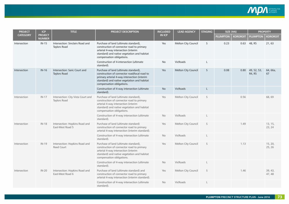
PROJECT CATEGORY
ICP PROJECT NUMBER
TITLE PROJECT DESCRIPTION INCLUDED IN ICP
LEAD AGENCY STAGING SIZE (HA) PROPERTY
PLUMPTON KOROROIT PLUMPTON KOROROIT
Intersection IN-15 Intersection: Sinclairs Road and Taylors Road
Purchase of land (ultimate standard), construction of connector road to primary arterial 4-way intersection (interim standard) and native vegetation and habitat compensation obligations.
Yes Melton City Council S 0.23 0.63 48, R5 21, 63
Construction of 4-intersection (ultimate standard).
No VicRoads L
Intersection IN-16 Intersection: Saric Court and Taylors Road
Purchase of land (ultimate standard), construction of connector road/local road to primary arterial 4-way intersection (interim standard) and native vegetation and habitat compensation obligations.
Yes Melton City Council S 0.08 0.80 49, 52, 53, R4, R5
64, 66a, 67
Construction of 4-way intersection (ultimate standard).
No VicRoads L
Intersection IN-17 Intersection: City Vista Court and Taylors Road
Purchase of land (ultimate standard), construction of connector road to primary arterial 4-way intersection (interim standard) and native vegetation and habitat compensation obligations.
Yes Melton City Council S 0.56 68, 69
Construction of 4-way intersection (ultimate standard).
No VicRoads L
Intersection IN-18 Intersection: Hopkins Road and East-West Road 5
Purchase of land (ultimate standard) construction of connector road to primary arterial 4-way intersection (interim standard).
Yes Melton City Council S 1.49 13, 15, 23, 24
Construction of 4-way intersection (ultimate standard).
No VicRoads L
Intersection IN-19 Intersection: Hopkins Road and Reed Court
Purchase of land (ultimate standard), construction of connector road to primary arterial 4-way intersection (interim standard) and native vegetation and habitat compensation obligations.
Yes Melton City Council S 1.13 15, 20, 25, 26
Construction of 4-way intersection (ultimate standard).
No VicRoads L
Intersection IN-20 Intersection: Hopkins Road and East-West Road 6
Purchase of land (ultimate standard) and construction of connector road to primary arterial 4-way intersection (interim standard).
Yes Melton City Council S 1.46 39, 43, 47, 48
Construction of 4-way intersection (ultimate standard).
No VicRoads L
PLUMPTON PRECINCT STRUCTURE PLAN - June 2016 73
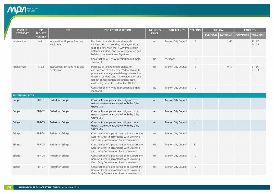
PROJECT CATEGORY
ICP PROJECT NUMBER
TITLE PROJECT DESCRIPTION INCLUDED IN ICP
LEAD AGENCY STAGING SIZE (HA) PROPERTY
PLUMPTON KOROROIT PLUMPTON KOROROIT
Intersection IN-21 Intersection: Hopkins Road and Neale Road
Purchase of land (ultimate standard), construction of secondary arterial/connector road to primary arterial 4-way intersection (interim standard) and native vegetation and habitat compensation obligations.
Yes Melton City Council S 1.09 47, 47, 54, 55
Construction of 4-way intersection (ultimate standard).
No VicRoads L
Intersection IN-22 Intersection: Sinclairs Road and Neale Road
Purchase of land (ultimate standard), construction of connector road/local road to primary arterial signalised 4-way intersection (interim standard) and native vegetation and habitat compensation obligations. Note: eastern leg subject to future PSP 1080.2.
Yes Melton City Council S 0.17 51, 56, 73, 83
Construction of 4-way intersection (ultimate standard).
No Melton City Council L
BRIDGE PROJECTS
Bridge PBR-01 Pedestrian Bridge Construction of pedestrian bridge across a natural waterway associated with the Olive Grove DSS.
Yes Melton City Council S
Bridge PBR-02 Pedestrian Bridge Construction of pedestrian bridge across a natural waterway associated with the Olive Grove DSS.
Yes Melton City Council L
Bridge PBR-03 Pedestrian Bridge Construction of pedestrian bridge across a natural waterway associated with the Olive Grove DSS.
Yes Melton City Council L
Bridge PBR-04 Pedestrian Bridge Construction of a pedestrian bridge across the Kororoit Creek in accordance with Growling Grass Frog Conservation Area requirements.
Yes Melton City Council L
Bridge PBR-05 Pedestrian Bridge Construction of a pedestrian bridge across the Kororoit Creek in accordance with Growling Grass Frog Conservation Area requirements.
Yes Melton City Council M
Bridge PBR-06 Pedestrian Bridge Construction of a pedestrian bridge across the Kororoit Creek in accordance with Growling Grass Frog Conservation Area requirements.
Yes Melton City Council L
Bridge PBR-07 Pedestrian Bridge Construction of a pedestrian bridge across the Kororoit Creek in accordance with Growling Grass Frog Conservation Area requirements.
Yes Melton City Council L
PLUMPTON PRECINCT STRUCTURE PLAN - June 201674
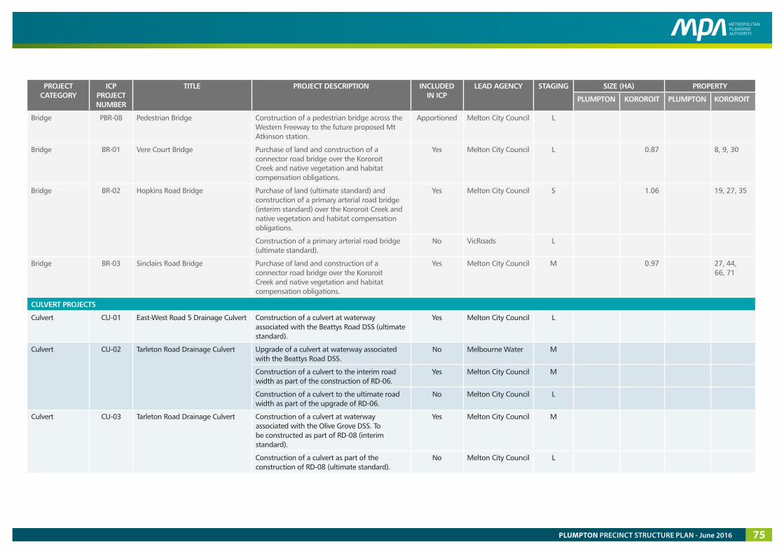
PROJECT CATEGORY
ICP PROJECT NUMBER
TITLE PROJECT DESCRIPTION INCLUDED IN ICP
LEAD AGENCY STAGING SIZE (HA) PROPERTY
PLUMPTON KOROROIT PLUMPTON KOROROIT
Bridge PBR-08 Pedestrian Bridge Construction of a pedestrian bridge across the Western Freeway to the future proposed Mt Atkinson station.
Apportioned Melton City Council L
Bridge BR-01 Vere Court Bridge Purchase of land and construction of a connector road bridge over the Kororoit Creek and native vegetation and habitat compensation obligations.
Yes Melton City Council L 0.87 8, 9, 30
Bridge BR-02 Hopkins Road Bridge Purchase of land (ultimate standard) and construction of a primary arterial road bridge (interim standard) over the Kororoit Creek and native vegetation and habitat compensation obligations.
Yes Melton City Council S 1.06 19, 27, 35
Construction of a primary arterial road bridge (ultimate standard).
No VicRoads L
Bridge BR-03 Sinclairs Road Bridge Purchase of land and construction of a connector road bridge over the Kororoit Creek and native vegetation and habitat compensation obligations.
Yes Melton City Council M 0.97 27, 44, 66, 71
CULVERT PROJECTS
Culvert CU-01 East-West Road 5 Drainage Culvert Construction of a culvert at waterway associated with the Beattys Road DSS (ultimate standard).
Yes Melton City Council L
Culvert CU-02 Tarleton Road Drainage Culvert Upgrade of a culvert at waterway associated with the Beattys Road DSS.
No Melbourne Water M
Construction of a culvert to the interim road width as part of the construction of RD-06.
Yes Melton City Council M
Construction of a culvert to the ultimate road width as part of the upgrade of RD-06.
No Melton City Council L
Culvert CU-03 Tarleton Road Drainage Culvert Construction of a culvert at waterway associated with the Olive Grove DSS. To be constructed as part of RD-08 (interim standard).
Yes Melton City Council M
Construction of a culvert as part of the construction of RD-08 (ultimate standard).
No Melton City Council L
PLUMPTON PRECINCT STRUCTURE PLAN - June 2016 75
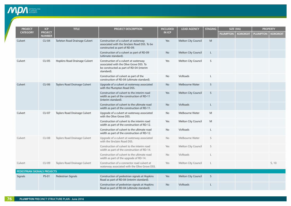
PROJECT CATEGORY
ICP PROJECT NUMBER
TITLE PROJECT DESCRIPTION INCLUDED IN ICP
LEAD AGENCY STAGING SIZE (HA) PROPERTY
PLUMPTON KOROROIT PLUMPTON KOROROIT
Culvert CU-04 Tarleton Road Drainage Culvert Construction of a culvert at waterway associated with the Sinclairs Road DSS. To be constructed as part of RD-09.
Yes Melton City Council M
Construction of a culvert as part of RD-09 (ultimate standard).
No Melton City Council L
Culvert CU-05 Hopkins Road Drainage Culvert Construction of a culvert at waterway associated with the Olive Grove DSS. To be constructed as part of RD-04 (interim standard).
Yes Melton City Council S
Construction of culvert as part of the construction of RD-04 (ultimate standard).
No VicRoads L
Culvert CU-06 Taylors Road Drainage Culvert Upgrade of a culvert at waterway associated with the Plumpton Road DSS.
No Melbourne Water S
Construction of culvert to the interim road width as part of the construction of RD-11 (interim standard).
Yes Melton City Council S
Construction of culvert to the ultimate road width as part of the construction of RD-11.
No VicRoads L
Culvert CU-07 Taylors Road Drainage Culvert Upgrade of a culvert at waterway associated with the Olive Grove DSS.
No Melbourne Water M
Construction of culvert to the interim road width as part of the construction of RD-12.
Yes Melton City Council M
Construction of culvert to the ultimate road width as part of the construction of RD-12.
No VicRoads L
Culvert CU-08 Taylors Road Drainage Culvert Upgrade of a culvert at waterway associated with the Sinclairs Road DSS.
No Melbourne Water S
Construction of culvert to the interim road width as part of the construction of RD-14.
Yes Melton City Council S
Construction of culvert to the ultimate road width as part of the upgrade of RD-14.
No VicRoads L
Culvert CU-09 Taylors Road Drainage Culvert Construction of a connector road culvert at waterway associated with the Olive Grove DSS.
Yes Melton City Council L 5, 10
PEDESTRIAN SIGNALS PROJECTS
Signals PS-01 Pedestrian Signals Construction of pedestrian signals at Hopkins Road as part of RD-04 (interim standard).
Yes Melton City Council S
Construction of pedestrian signals at Hopkins Road as part of RD-04 (ultimate standard).
No VicRoads L
PLUMPTON PRECINCT STRUCTURE PLAN - June 201676

PROJECT CATEGORY
ICP PROJECT NUMBER
TITLE PROJECT DESCRIPTION INCLUDED IN ICP
LEAD AGENCY STAGING SIZE (HA) PROPERTY
PLUMPTON KOROROIT PLUMPTON KOROROIT
Signals PS-02 Pedestrian Signals Construction of pedestrian signals at Tarletons Road as part of RD-10 (interim standard).
Yes Melton City Council M
Construction of pedestrian signals at Tarletons Road as part of RD-10 (ultimate standard).
No VicRoads L
Signals PS-03 Pedestrian Signals Construction of pedestrian signals at Taylors Road as part of RD-12 (interim standard).
Yes Melton City Council M
Construction of pedestrian signals at Taylors Road as part of RD-12 (ultimate standard).
No VicRoads L
Signals PS-04 Pedestrian Signals Construction of pedestrian signals at Taylors Road as part of RD-15 (interim standard).
Yes Melton City Council S
Construction of pedestrian signals at Taylors Road as part of RD-15 (ultimate standard).
No VicRoads L
Signals PS-05 Pedestrian Signals Construction of pedestrian signals at Hopkins Road as part of RD-20 (interim standard).
Yes Melton City Council S
Construction of pedestrian signals at Hopkins Road as part of RD-20 (ultimate standard).
No VicRoads L
Signals PS-06 Pedestrian Signals Construction of pedestrian signals at Hopkins Road as part of RD-21 (interim standard).
Yes Melton City Council S
Construction of pedestrian signals at Hopkins Road as part of RD-21 (ultimate standard).
No VicRoads L
PUBLIC TRANSPORT PROJECTS
Public Transport - Bus services Delivery of bus services No Public Transport Victoria
S (part)
COMMUNITY FACILITIES AND OPEN SPACE
COMMUNITY FACILITY PROJECTS
Community CO-01 Plumpton Community Centre (Plumpton North Community Hub)
Purchase of land and construction of a multi-purpose community centre including community rooms and additional facilities to cater for childcare and maternal health.
Yes Melton City Council M 1.01 12
Community CO-02 Plumpton Community Centre & Neighbourhood House (Plumpton Major Town Centre Community Hub)
Purchase of land and construction of a multi-purpose community centre and neighbhood house facilities. This will include community rooms, childcare and maternal health, youth space, additional classroom space and specialist facilities.
Yes Melton City Council S 1.20 29
PLUMPTON PRECINCT STRUCTURE PLAN - June 2016 77
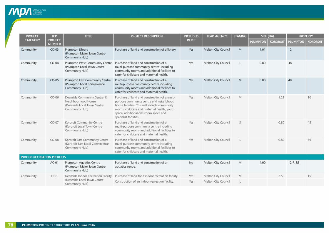
PROJECT CATEGORY
ICP PROJECT NUMBER
TITLE PROJECT DESCRIPTION INCLUDED IN ICP
LEAD AGENCY STAGING SIZE (HA) PROPERTY
PLUMPTON KOROROIT PLUMPTON KOROROIT
Community CO-03 Plumpton Library (Plumpton Major Town Centre Community Hub)
Purchase of land and construction of a library. Yes Melton City Council M 1.01 12
Community CO-04 Plumpton West Community Centre (Plumpton Local Town Centre Community Hub)
Purchase of land and construction of a multi-purpose community centre including community rooms and additional facilities to cater for childcare and maternal health.
Yes Melton City Council L 0.80 38
Community CO-05 Plumpton East Community Centre (Plumpton Local Convenience Community Hub)
Purchase of land and construction of a multi-purpose community centre including community rooms and additional facilities to cater for childcare and maternal health.
Yes Melton City Council M 0.80 48
Community CO-06 Deanside Community Centre & Neighbourhood House (Deanside Local Town Centre Community Hub)
Purchase of land and construction of a multi-purpose community centre and neighbhood house facilities. This will include community rooms, childcare and maternal health, youth space, additional classroom space and specialist facilities.
Yes Melton City Council M 1.21 10
Community CO-07 Kororoit Community Centre (Kororoit Local Town Centre Community Hub)
Purchase of land and construction of a multi-purpose community centre including community rooms and additional facilities to cater for childcare and maternal health.
Yes Melton City Council S 0.80 45
Community CO-08 Kororoit East Community Centre (Kororoit East Local Convenience Community Hub)
Purchase of land and construction of a multi-purpose community centre including community rooms and additional facilities to cater for childcare and maternal health.
Yes Melton City Council L 0.80 69
INDOOR RECREATION PROJECTS
Community AC-01 Plumpton Aquatics Centre (Plumpton Major Town Centre Community Hub)
Purchase of land and construction of an aquatics centre.
No Melton City Council M 4.00 12-R, R3
Community IR-01 Deanside Indoor Recreation Facility (Deanside Local Town Centre Community Hub)
Purchase of land for a indoor recreation facility. Yes Melton City Council M 2.50 15
Construction of an indoor recreation facility. Yes Melton City Council L
PLUMPTON PRECINCT STRUCTURE PLAN - June 201678
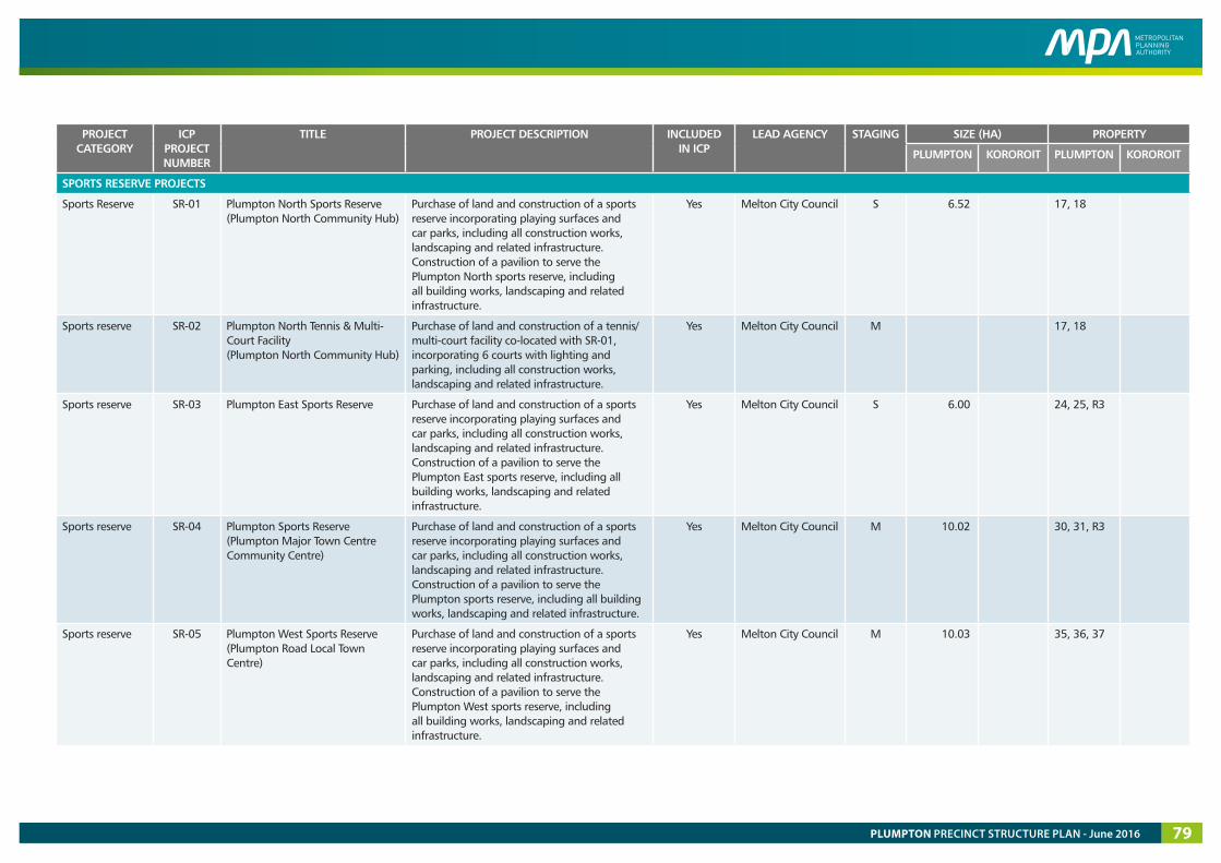
PROJECT CATEGORY
ICP PROJECT NUMBER
TITLE PROJECT DESCRIPTION INCLUDED IN ICP
LEAD AGENCY STAGING SIZE (HA) PROPERTY
PLUMPTON KOROROIT PLUMPTON KOROROIT
SPORTS RESERVE PROJECTS
Sports Reserve SR-01 Plumpton North Sports Reserve (Plumpton North Community Hub)
Purchase of land and construction of a sports reserve incorporating playing surfaces and car parks, including all construction works, landscaping and related infrastructure. Construction of a pavilion to serve the Plumpton North sports reserve, including all building works, landscaping and related infrastructure.
Yes Melton City Council S 6.52 17, 18
Sports reserve SR-02 Plumpton North Tennis & Multi-Court Facility (Plumpton North Community Hub)
Purchase of land and construction of a tennis/multi-court facility co-located with SR-01, incorporating 6 courts with lighting and parking, including all construction works, landscaping and related infrastructure.
Yes Melton City Council M 17, 18
Sports reserve SR-03 Plumpton East Sports Reserve Purchase of land and construction of a sports reserve incorporating playing surfaces and car parks, including all construction works, landscaping and related infrastructure. Construction of a pavilion to serve the Plumpton East sports reserve, including all building works, landscaping and related infrastructure.
Yes Melton City Council S 6.00 24, 25, R3
Sports reserve SR-04 Plumpton Sports Reserve (Plumpton Major Town Centre Community Centre)
Purchase of land and construction of a sports reserve incorporating playing surfaces and car parks, including all construction works, landscaping and related infrastructure. Construction of a pavilion to serve the Plumpton sports reserve, including all building works, landscaping and related infrastructure.
Yes Melton City Council M 10.02 30, 31, R3
Sports reserve SR-05 Plumpton West Sports Reserve (Plumpton Road Local Town Centre)
Purchase of land and construction of a sports reserve incorporating playing surfaces and car parks, including all construction works, landscaping and related infrastructure. Construction of a pavilion to serve the Plumpton West sports reserve, including all building works, landscaping and related infrastructure.
Yes Melton City Council M 10.03 35, 36, 37
PLUMPTON PRECINCT STRUCTURE PLAN - June 2016 79
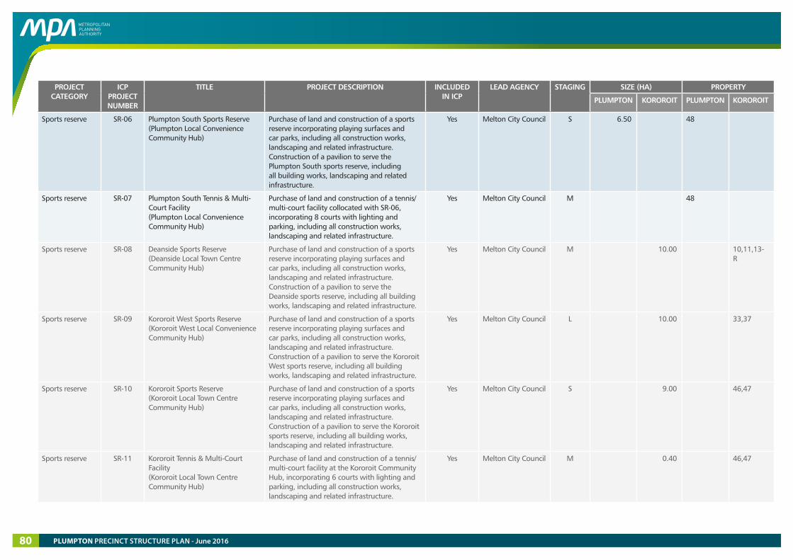
PROJECT CATEGORY
ICP PROJECT NUMBER
TITLE PROJECT DESCRIPTION INCLUDED IN ICP
LEAD AGENCY STAGING SIZE (HA) PROPERTY
PLUMPTON KOROROIT PLUMPTON KOROROIT
Sports reserve SR-06 Plumpton South Sports Reserve (Plumpton Local Convenience Community Hub)
Purchase of land and construction of a sports reserve incorporating playing surfaces and car parks, including all construction works, landscaping and related infrastructure. Construction of a pavilion to serve the Plumpton South sports reserve, including all building works, landscaping and related infrastructure.
Yes Melton City Council S 6.50 48
Sports reserve SR-07 Plumpton South Tennis & Multi-Court Facility (Plumpton Local Convenience Community Hub)
Purchase of land and construction of a tennis/multi-court facility collocated with SR-06, incorporating 8 courts with lighting and parking, including all construction works, landscaping and related infrastructure.
Yes Melton City Council M 48
Sports reserve SR-08 Deanside Sports Reserve (Deanside Local Town Centre Community Hub)
Purchase of land and construction of a sports reserve incorporating playing surfaces and car parks, including all construction works, landscaping and related infrastructure. Construction of a pavilion to serve the Deanside sports reserve, including all building works, landscaping and related infrastructure.
Yes Melton City Council M 10.00 10,11,13-R
Sports reserve SR-09 Kororoit West Sports Reserve (Kororoit West Local Convenience Community Hub)
Purchase of land and construction of a sports reserve incorporating playing surfaces and car parks, including all construction works, landscaping and related infrastructure. Construction of a pavilion to serve the Kororoit West sports reserve, including all building works, landscaping and related infrastructure.
Yes Melton City Council L 10.00 33,37
Sports reserve SR-10 Kororoit Sports Reserve (Kororoit Local Town Centre Community Hub)
Purchase of land and construction of a sports reserve incorporating playing surfaces and car parks, including all construction works, landscaping and related infrastructure. Construction of a pavilion to serve the Kororoit sports reserve, including all building works, landscaping and related infrastructure.
Yes Melton City Council S 9.00 46,47
Sports reserve SR-11 Kororoit Tennis & Multi-Court Facility (Kororoit Local Town Centre Community Hub)
Purchase of land and construction of a tennis/multi-court facility at the Kororoit Community Hub, incorporating 6 courts with lighting and parking, including all construction works, landscaping and related infrastructure.
Yes Melton City Council M 0.40 46,47
PLUMPTON PRECINCT STRUCTURE PLAN - June 201680
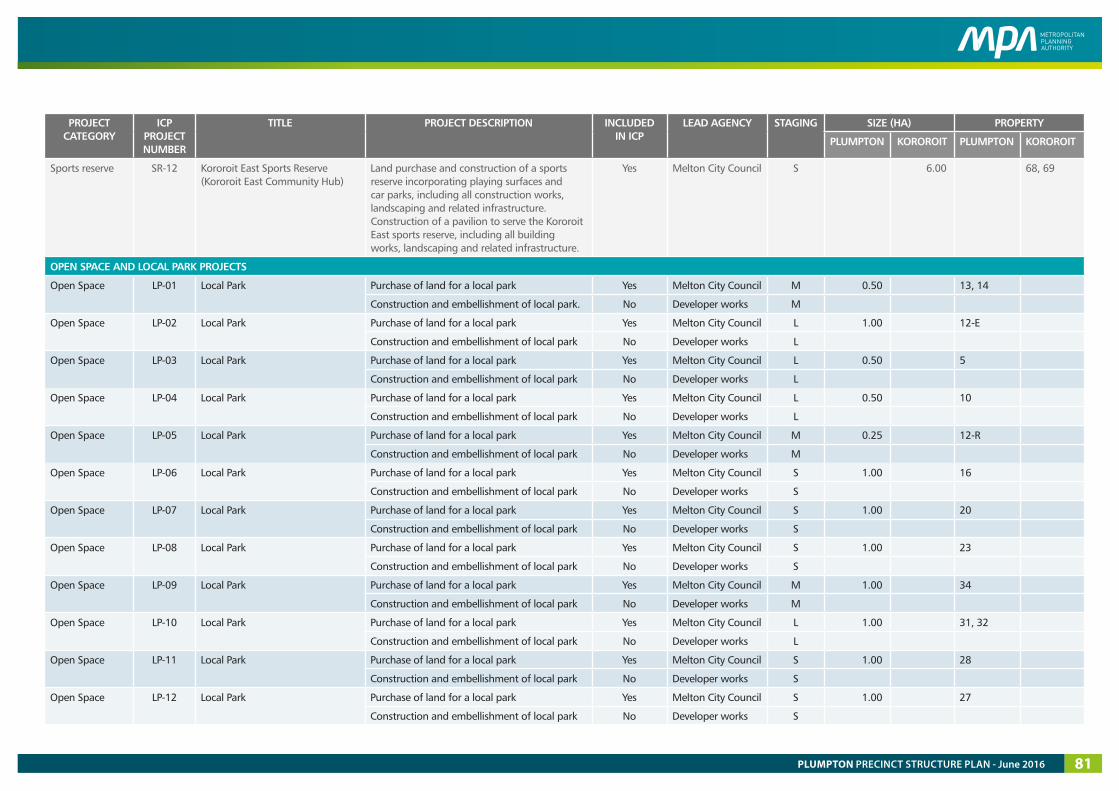
PROJECT CATEGORY
ICP PROJECT NUMBER
TITLE PROJECT DESCRIPTION INCLUDED IN ICP
LEAD AGENCY STAGING SIZE (HA) PROPERTY
PLUMPTON KOROROIT PLUMPTON KOROROIT
Sports reserve SR-12 Kororoit East Sports Reserve (Kororoit East Community Hub)
Land purchase and construction of a sports reserve incorporating playing surfaces and car parks, including all construction works, landscaping and related infrastructure. Construction of a pavilion to serve the Kororoit East sports reserve, including all building works, landscaping and related infrastructure.
Yes Melton City Council S 6.00 68, 69
OPEN SPACE AND LOCAL PARK PROJECTS
Open Space LP-01 Local Park Purchase of land for a local park Yes Melton City Council M 0.50 13, 14
Construction and embellishment of local park. No Developer works M
Open Space LP-02 Local Park Purchase of land for a local park Yes Melton City Council L 1.00 12-E
Construction and embellishment of local park No Developer works L
Open Space LP-03 Local Park Purchase of land for a local park Yes Melton City Council L 0.50 5
Construction and embellishment of local park No Developer works L
Open Space LP-04 Local Park Purchase of land for a local park Yes Melton City Council L 0.50 10
Construction and embellishment of local park No Developer works L
Open Space LP-05 Local Park Purchase of land for a local park Yes Melton City Council M 0.25 12-R
Construction and embellishment of local park No Developer works M
Open Space LP-06 Local Park Purchase of land for a local park Yes Melton City Council S 1.00 16
Construction and embellishment of local park No Developer works S
Open Space LP-07 Local Park Purchase of land for a local park Yes Melton City Council S 1.00 20
Construction and embellishment of local park No Developer works S
Open Space LP-08 Local Park Purchase of land for a local park Yes Melton City Council S 1.00 23
Construction and embellishment of local park No Developer works S
Open Space LP-09 Local Park Purchase of land for a local park Yes Melton City Council M 1.00 34
Construction and embellishment of local park No Developer works M
Open Space LP-10 Local Park Purchase of land for a local park Yes Melton City Council L 1.00 31, 32
Construction and embellishment of local park No Developer works L
Open Space LP-11 Local Park Purchase of land for a local park Yes Melton City Council S 1.00 28
Construction and embellishment of local park No Developer works S
Open Space LP-12 Local Park Purchase of land for a local park Yes Melton City Council S 1.00 27
Construction and embellishment of local park No Developer works S
PLUMPTON PRECINCT STRUCTURE PLAN - June 2016 81

PROJECT CATEGORY
ICP PROJECT NUMBER
TITLE PROJECT DESCRIPTION INCLUDED IN ICP
LEAD AGENCY STAGING SIZE (HA) PROPERTY
PLUMPTON KOROROIT PLUMPTON KOROROIT
Open Space LP-13 Local Park Purchase of land for a local park Yes Melton City Council M 1.00 55
Construction and embellishment of local park No Developer works M
Open Space LP-14 Local Park Purchase of land for a local park Yes Melton City Council M 0.50 49
Construction and embellishment of local park No Developer works M
Open Space LP-15 Local Park Purchase of land for a local park Yes Melton City Council S 1.00 54
Construction and embellishment of local park No Developer works S
Open Space LP-16 Local Park Purchase of land for a local park Yes Melton City Council S 1.00 48
Construction and embellishment of local park No Developer works S
Open Space LP-17 Local Park Purchase of land for a local park Yes Melton City Council M 1.00 46, 47
Construction and embellishment of local park No Developer works M
Open Space LP-18 Local Park Purchase of land for a local park Yes Melton City Council M 0.50 45
Construction and embellishment of local park No Developer works M
Open Space LP-19 Local Park Purchase of land for a local park Yes Melton City Council S 1.00 42
Construction and embellishment of local park No Developer works S
Open Space LP-20 Local Park - Beattys Road Reserve Construction and embellishment of local park No Developer works M R3
Open Space LP-21 Local Park - Beattys Road Reserve Construction and embellishment of local park No Developer works M R3
Open Space LP-22 Local Park - Beattys Road Reserve Construction and embellishment of local park No Developer works L R3
Open Space LP-23 Local Park Purchase of land for a local park Yes Melton City Council L 1.00 2
Construction and embellishment of local park No Developer works L
Open Space LP-24 Local Park Purchase of land for a local park Yes Melton City Council L 1.00 7
Construction and embellishment of local park No Developer works L
Open Space LP-25 Local Park Purchase of land for a local park Yes Melton City Council L 0.85 14
Construction and embellishment of local park No Developer works L
Open Space LP-26 Local Park Purchase of land for a local park Yes Melton City Council L 0.12 9
Construction and embellishment of local park No Developer works L
Open Space LP-27 Local Park Purchase of land for a local park Yes Melton City Council M 0.50 34
Construction and embellishment of local park No Developer works M
Open Space LP-28 Local Park Purchase of land for a local park Yes Melton City Council M 1.00 32
Construction and embellishment of local park No Developer works M
Open Space LP-29 Local Park Purchase of land for a local park Yes Melton City Council M 1.00 38
Construction and embellishment of local park No Developer works M
PLUMPTON PRECINCT STRUCTURE PLAN - June 201682
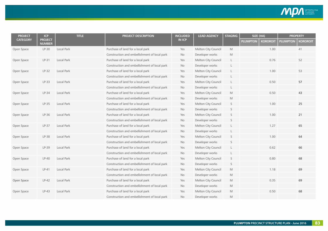
PROJECT CATEGORY
ICP PROJECT NUMBER
TITLE PROJECT DESCRIPTION INCLUDED IN ICP
LEAD AGENCY STAGING SIZE (HA) PROPERTY
PLUMPTON KOROROIT PLUMPTON KOROROIT
Open Space LP-30 Local Park Purchase of land for a local park Yes Melton City Council M 1.00 41
Construction and embellishment of local park No Developer works M
Open Space LP-31 Local Park Purchase of land for a local park Yes Melton City Council L 0.76 52
Construction and embellishment of local park No Developer works L
Open Space LP-32 Local Park Purchase of land for a local park Yes Melton City Council L 1.00 53
Construction and embellishment of local park No Developer works L
Open Space LP-33 Local Park Purchase of land for a local park Yes Melton City Council L 0.50 57
Construction and embellishment of local park No Developer works L
Open Space LP-34 Local Park Purchase of land for a local park Yes Melton City Council M 0.50 43
Construction and embellishment of local park No Developer works M
Open Space LP-35 Local Park Purchase of land for a local park Yes Melton City Council S 1.00 25
Construction and embellishment of local park No Developer works S
Open Space LP-36 Local Park Purchase of land for a local park Yes Melton City Council S 1.00 21
Construction and embellishment of local park No Developer works S
Open Space LP-37 Local Park Purchase of land for a local park Yes Melton City Council L 1.27 65
Construction and embellishment of local park No Developer works L
Open Space LP-38 Local Park Purchase of land for a local park Yes Melton City Council S 1.00 64
Construction and embellishment of local park No Developer works S
Open Space LP-39 Local Park Purchase of land for a local park Yes Melton City Council L 0.62 66
Construction and embellishment of local park No Developer works L
Open Space LP-40 Local Park Purchase of land for a local park Yes Melton City Council S 0.80 68
Construction and embellishment of local park No Developer works S
Open Space LP-41 Local Park Purchase of land for a local park Yes Melton City Council M 1.18 69
Construction and embellishment of local park No Developer works M
Open Space LP-42 Local Park Purchase of land for a local park Yes Melton City Council M 0.35 69
Construction and embellishment of local park No Developer works M
Open Space LP-43 Local Park Purchase of land for a local park Yes Melton City Council M 0.50 68
Construction and embellishment of local park No Developer works M
PLUMPTON PRECINCT STRUCTURE PLAN - June 2016 83
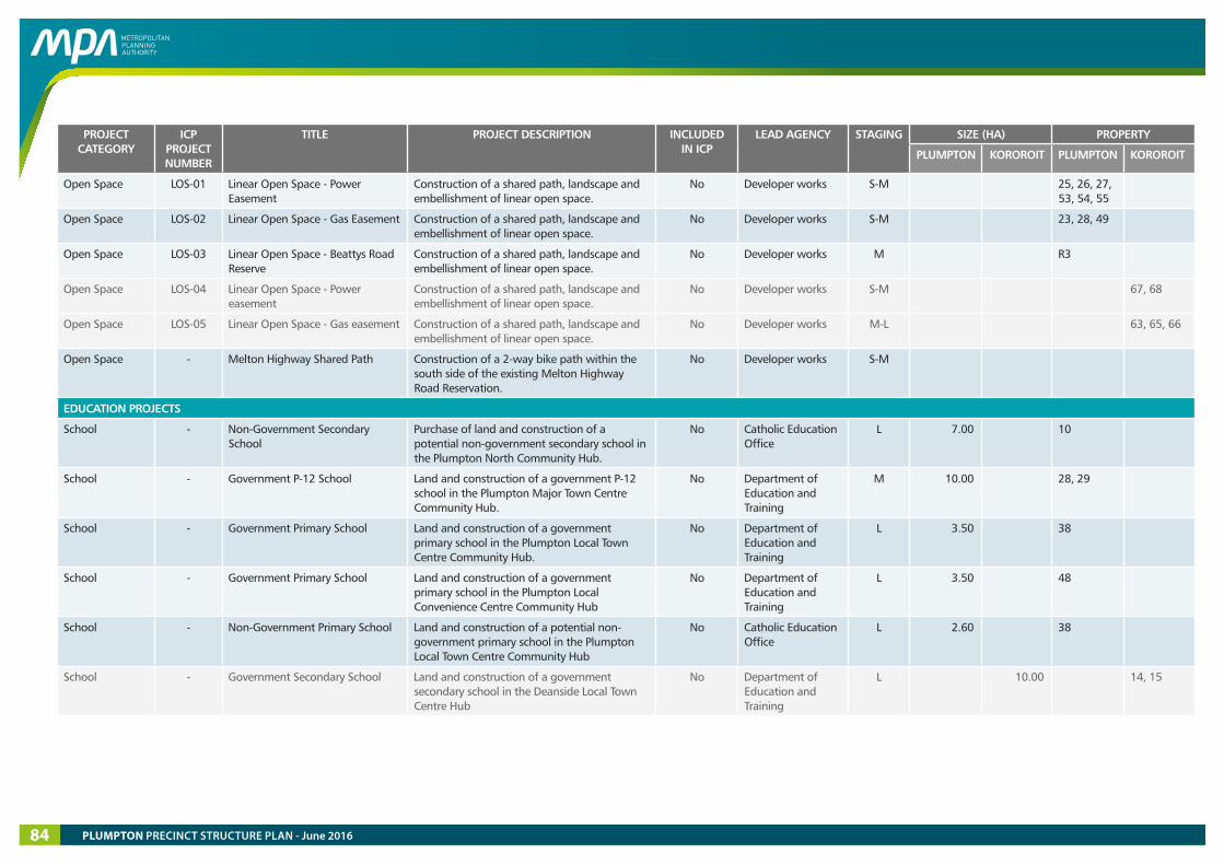
PROJECT CATEGORY
ICP PROJECT NUMBER
TITLE PROJECT DESCRIPTION INCLUDED IN ICP
LEAD AGENCY STAGING SIZE (HA) PROPERTY
PLUMPTON KOROROIT PLUMPTON KOROROIT
Open Space LOS-01 Linear Open Space - Power Easement
Construction of a shared path, landscape and embellishment of linear open space.
No Developer works S-M 25, 26, 27, 53, 54, 55
Open Space LOS-02 Linear Open Space - Gas Easement Construction of a shared path, landscape and embellishment of linear open space.
No Developer works S-M 23, 28, 49
Open Space LOS-03 Linear Open Space - Beattys Road Reserve
Construction of a shared path, landscape and embellishment of linear open space.
No Developer works M R3
Open Space LOS-04 Linear Open Space - Power easement
Construction of a shared path, landscape and embellishment of linear open space.
No Developer works S-M 67, 68
Open Space LOS-05 Linear Open Space - Gas easement Construction of a shared path, landscape and embellishment of linear open space.
No Developer works M-L 63, 65, 66
Open Space - Melton Highway Shared Path Construction of a 2-way bike path within the south side of the existing Melton Highway Road Reservation.
No Developer works S-M
EDUCATION PROJECTS
School - Non-Government Secondary School
Purchase of land and construction of a potential non-government secondary school in the Plumpton North Community Hub.
No Catholic Education Office
L 7.00 10
School - Government P-12 School Land and construction of a government P-12 school in the Plumpton Major Town Centre Community Hub.
No Department of Education and Training
M 10.00 28, 29
School - Government Primary School Land and construction of a government primary school in the Plumpton Local Town Centre Community Hub.
No Department of Education and Training
L 3.50 38
School - Government Primary School Land and construction of a government primary school in the Plumpton Local Convenience Centre Community Hub
No Department of Education and Training
L 3.50 48
School - Non-Government Primary School Land and construction of a potential non-government primary school in the Plumpton Local Town Centre Community Hub
No Catholic Education Office
L 2.60 38
School - Government Secondary School Land and construction of a government secondary school in the Deanside Local Town Centre Hub
No Department of Education and Training
L 10.00 14, 15
PLUMPTON PRECINCT STRUCTURE PLAN - June 201684
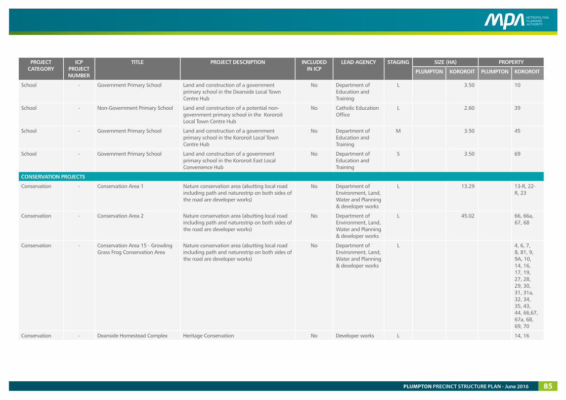
PROJECT CATEGORY
ICP PROJECT NUMBER
TITLE PROJECT DESCRIPTION INCLUDED IN ICP
LEAD AGENCY STAGING SIZE (HA) PROPERTY
PLUMPTON KOROROIT PLUMPTON KOROROIT
School - Government Primary School Land and construction of a government primary school in the Deanside Local Town Centre Hub
No Department of Education and Training
L 3.50 10
School - Non-Government Primary School Land and construction of a potential non-government primary school in the Kororoit Local Town Centre Hub
No Catholic Education Office
L 2.60 39
School - Government Primary School Land and construction of a government primary school in the Kororoit Local Town Centre Hub
No Department of Education and Training
M 3.50 45
School - Government Primary School Land and construction of a government primary school in the Kororoit East Local Convenience Hub
No Department of Education and Training
S 3.50 69
CONSERVATION PROJECTS
Conservation - Conservation Area 1 Nature conservation area (abutting local road including path and naturestrip on both sides of the road are developer works)
No Department of Environment, Land, Water and Planning & developer works
L 13.29 13-R, 22-R, 23
Conservation - Conservation Area 2 Nature conservation area (abutting local road including path and naturestrip on both sides of the road are developer works)
No Department of Environment, Land, Water and Planning & developer works
L 45.02 66, 66a, 67, 68
Conservation - Conservation Area 15 - Growling Grass Frog Conservation Area
Nature conservation area (abutting local road including path and naturestrip on both sides of the road are developer works)
No Department of Environment, Land, Water and Planning & developer works
L 4, 6, 7, 8, 81, 9, 9A, 10, 14, 16, 17, 19, 27, 28, 29, 30, 31, 31a, 32, 34, 35, 43, 44, 66,67, 67a, 68, 69, 70
Conservation - Deanside Homestead Complex Heritage Conservation No Developer works L 14, 16
PLUMPTON PRECINCT STRUCTURE PLAN - June 2016 85