26 nov16 participatory_gravityfed_water_conveyance_system_for_irrigation_in_himalayan_foothills
TRANSCRIPT

Participatory Gravity-fed Water Conveyance System for Irrigation in Himalayan FoothillsSystem for Irrigation in Himalayan Foothills
Dr Ambrish Kumar, Principal Scientist(SWC Engg).d f l h dIndian Institute of Soil & Water Conservation, Dehradun
Outlines
Pl i d i d I l t ti f• Planning , design and Implementation of Water conveyance system
• Optimizing dimensions of surface irrigation methods – Check & Borderirrigation methods Check & Border
• Impact analysis and upscaling

Hill Agricultureg• Low productivity and cropping intensity, subsistence level of
farming is attributed to poor water resource development infarming is attributed to poor water resource development in the hilly areas.
• Farmers use water of low‐discharge springs (discharge <20L) at very small scale in a unsystematic and scattered manner of vegetablesmall scale in a unsystematic and scattered manner of vegetable production.
In Uttarakhand, irrigated agriculture(12 % of total arable land) concentrated to valleysland) concentrated to valleys major area is covered by Guhl irrigation system (Small size channel/water course)

Drawbacks of GuhlsDrawbacks of Guhls• Seepage from Guhls ranging from 12 to 35 %from 12 to 35 %
• Breaking the Guhls by the farmers near theirfarmers near their fields/terraces
High repair and maintenance cost due to damage occurred by frequent Landslides/landslip
Normally Over size of Guhls are constructed
Wastage of land under Guhls network

Water losses and utilization efficiency under different components of Canal irrigation system (Agarwal and
Khanna, 1983)Khanna, 1983) System
h t i tiWater losses (%)
characteristics Canals Distributaries Field
water courses
Field application
Total Net utilization
Entire system 15 7 22 27 71 29Entire system unlined Only canals lined
15
4
7
7
22
25
27
30
71
66
29
34
Canal and 4 2 26 32 64 36Canal and distributory lined
4 2 26 32 64 36
Whole system lined
4 2 6 42 54 46
Whole system lined and sprinkler method
4 2 6 6 18 82
Whole system 4 2 6 3 10 90Whole system lined and drip method
4 2 6 3 10 90

Alternative solution
Gravity fed Water Conveyance System using PipelinePipeline
• Himalayan Foothills: village cluster – Gadoria, D h l P li d D khDevthala, Pasauli, and Dungakhet.
• Population: Socially backward‐ 82%; economically poor – 80%

Least Irrigated area in Pasauli (11 %) but in Devthala, agriculture was entirely rain dependant.
W t• Water conveyance
• Water distribution
W li i• Water application

Elevation of intake structure along left bank of the streamleft bank of the stream
Plan of the intake structure of thePlan of the intake structure of the water conveyance system

Galvanized Iron(GI)pipeline
Dia of pipe : 100mmLength: 2080 mGravity head: 37 87 mGravity head: 37.87 mDischarge: 10 LPSDesigned for Gravity flow.
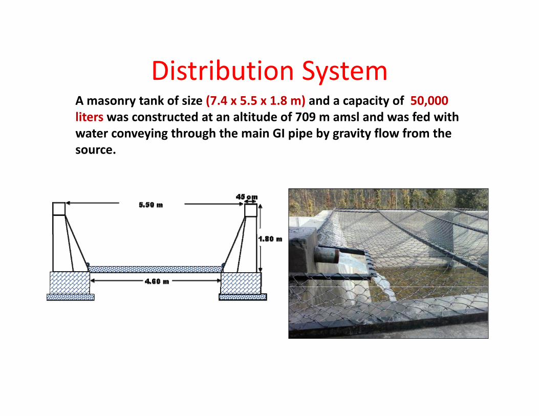
Distribution SystemDistribution SystemA masonry tank of size (7.4 x 5.5 x 1.8 m) and a capacity of 50,000 liters was constructed at an altitude of 709 m amsl and was fed with
i h h h i GI i b i fl f hwater conveying through the main GI pipe by gravity flow from the source.

To minimize the cost of the system, PVC pipes of 110 mm was laid out in the
BlocksPW:16 28 ha;pipes of 110 mm was laid out in the
command area. PW:16.28 ha; slope: 4.3%PE:5.5 ha; slope: 13%D: 4.5 ha; l 4 3 %slope: 4.3 %

On‐farm Water Management• In all three blocks, one riser is provided at every 1.5 ha, this is termed as unit command area.
• To enhance the application efficiency of irrigation, collapsible synthetic pipes are being used to irrigate individual fields of the unit command area areindividual fields of the unit command area are encouraged to use.

To avoid the conflict: in one season, delivery of water follows h f h d h il i d ithe sequence from head to the tail riser and in next season delivery sequence gets reversed
• To enhance the water use efficiency, Drip irrigation system has been equipped with three risers with objective to popularize the system

Cost EffectivenessItem Quantity Expenditure
(in Lakhs)Initial Expenditure(Rs/Ha)
GI pipeline, 4’ 2 km 17.95one lakh
In case of WC water conveyance system (as per PVC pipeline, 4’ 1.6 km 3.96
Trenching/Laying/jointing GI & PVC 1 18
conveyance system (as per norms of state):
1.5 lakh/ha
Trenching/Laying/jointing/fixing
GI & PVC 1.18
Intake & masonry 3.00
Annual Repair & maintenance cost (Indicative) Intake & masonry
tank/pipe support works3.00(Indicative)
For pipeline: 1% For WC: 10 %
Total 26.09

Design and optimization of Border and Check basin on mildly slopping broad terraces using SIRMODmildly slopping broad terraces using SIRMOD
• To calibrate and validate the SIRMOD model, recommended dimensions for border and check basin irrigation methods was used (published data of water management, AICRP; Yadav, 1982).
• Thereafter it was used to design optimum size of border and check• Thereafter, it was used to design optimum size of border and check basin for different soils and land slope conditions in the 3 blocks of command area
• The model was run with various combination of length of the field between 20-50 m for sandy loam and 30-70 m for clay loam soil under different downfield slope between 1 and2%.
• Width was fixed as 15 m as most of the farmers maintained same• Width was fixed as 15 m as most of the farmers maintained same width of the field in all the 3 blocks.
• The average discharge of risers in all the 3 blocks was 10 lps.

Efficiencies at different dimensions and discharge in Sandy loam Soilon
Length(m) and discharge(lps)
brat
iC
alib
C
Flow pattern of SIRMOD simulation for L=50 m, W= 7.5 m, Q=14 lps

Estimated efficiencies at different basin lengths & slopes in sandy loam soil
L= 20 m, W=15 m, Q= 6 lps L= 30 m, W=15 m, Q= 8 lps

Optimum discharge and dimensions in mildly slopping land using SIRMOD
Soil typeLength
(m)Width
(m)Discharge
(lps)Slope (%)
slopping land using SIRMOD
( ) ( ) ( ps)
Basin Irrigation
SandySandy loam
20 15 5-6 1-2
Sandy 30 15 8 1 2
yLoam
30 15 8 1-2
Border irrigationSandy Loam
40 15 10 0.5-1.5
ClClay Loam
50-70 15 10 0.5-1.0

I L d hImpact: Landuse change

Impact of the Irrigation system
• The maximum increase in irrigated land was 391.9% in village P li f ll d b 22% i D kh t d l t (0 8%) i G d iPasauli, followed by 22% in Dungakhet and least (0.8%) in Godaria.
• Gross irrigated area during PrP was 46.92 ha and reached to the level of 130.15 ha at EoP indicating that gross irrigated area increased by 83.23 ha though the net irrigated area was increased by 25.3 ha.
• Irrigability index value: 3 29• Irrigability index value: 3.29.
• Productivity of major crops increased by 48% with enhanced cropping intensity by 29% due to intervening crop of Toria in between Maize‐Wheat sequence.
• Crop diversification index improved from 0.84 (pre‐project) to 0.96 at the end of the project, helped to minimize the negative impactat the end of the project, helped to minimize the negative impact of climatic aberrations.

• Beneficiary farmers contributed 15 % of the total cost ofBeneficiary farmers contributed 15 % of the total cost of the component, i.e. Rs 25,91,932.00.
• Planting of napier grass on the field boundaries andPlanting of napier grass on the field boundaries and terrace shoulder bounds: around 93% agricultural area
• Induced Eco‐development Index (IEI) of the irrigated p ( ) gcommand area : 0.316
• The conveyance efficiency : > 95 % with designing discharge at remotest riser.
• Cultivation of Rabiwheat on fallow land resulted increased additional net income of Rs. 17500/‐ ha
• Overall additional regular employment generated to the tune of 65 mandays per ha per annum.

Conclusion & Recommendation
• Himalayan hills have great potential to convert least an economic rainfed farming into the most profitable irrigated farming system through participatory water resource developmentt oug pa t c pato y ate esou ce de e op e t
• The study revealed that active involvement of beneficiary farming community at all the stages of the project life holds the key for sustainability of the systemsustainability of the system.
• Development of an efficient irrigation system, i.e. technically as well as socially, is followed by many other activities such as land l li b di i i h l d i h i hleveling, bunding, terracing in the area, coupled with niche farming with intensive land use management system; ultimately leads to sustainable livelihood security in the area.
• However, the proactive strategies for conflict resolution among the beneficiaries as well as upstream – downstream areas is equally essential.q y
• Upscale ‐ Present Guhl/water course system needs to be replaced by piped conveyance system in hilly agriculture.

Developing water conveyance system in Tube well command area(UP)
T/w equipping with PVC pipeline PVC pipeline in T/w command area
Outlet with air vent Irrigation by Raingun

THANKS