2.4 hydrology and hydrological analysis 2.4.1 hydrological...
TRANSCRIPT

Summary (Part I) The Study on Flood and Debris Flow in the Caspian Coastal Area Chapter 2 focusing on the Flood-hit Region in Golestan Province
PI - 20 JICA CTI Engineering International Co., Ltd.
Furthermore bank erosion also occurred at many bends downstream of the Golestan Forest. Floodwater flowed down toward the Golestan reservoir alternating erosion and deposition in the river channel.
Ghyz Galeh
Dasht-e-Sheykh
Gelman Darreh
Madarsoo
Dasht
Polder Dike
BreachedDam
Cheshmeh KhanValley-Head
Erosion
N0 1 2 3 4km
Fig. PI.15 Satellite Imagery around Dasht Village
The following figure shows historical changes of river cross-section at Tangrah water level station of MOE. Although the elevation of data is not so reliable, it is clearly understood that the 2001 Flood significantly widened river channel. The river channel changed from 20 m wide before 2001, to 100 m wide after the flood.
Cross-Sectional Changes of Tangrah Station
4
5
6
7
8
9
10
11
0 20 40 60 80 100 120
Distance (m)
Height (m)
1987
1991
1995
2000
2002
Fig. PI.16 River Cross-sectional Changes at Tangrah Station
2.4 Hydrology and Hydrological Analysis
2.4.1 Hydrological Network There are two hydrological stations in the Madarsoo River basin, which are located at Dasht and Tangrah. The station at Dasht is a newly built station after past two disastrous floods.

The Study on Flood and Debris Flow in the Caspian Coastal Area Summary (Part I)focusing on the Flood-hit Region in Golestan Province Chapter 2
JICA CTI Engineering International Co., Ltd. PI - 21
Station at Tangrah was also destroyed by the 2001 flood and repaired in 2002. However, there are other stations like Galikesh, Tamar and Hoji Ghousan in Golestan Dam basin (Fig. PI.17). Two types of hydrological stations, namely, online and ordinary are managed by MOE. Real time water levels data are being recorded through online telecommunication network at intervals of 10 minutes.
Fig. PI.17 Location of Hydrological Stations
2.4.2 Meteo-Hydrological Data in the Recent Floods Discharge in the 2001 and 2002 Floods
During the 2001 flood, the maximum hourly discharges at stations on the day of flood (11 August) were: 468 m3/s (Galikesh at 2:00), 1,650 m3/s (Tangrah at 6:00), and 241 m3/s (Hoji Ghousan at 10:00). Further, the maximum hourly inflow into Golestan Dam was 2,736 m3/s at 10:00 o’clock. If we sum up the maximum discharges at stations and compare with the maximum inflow of the Golestan Dam it seems those figures might be reasonable.
On the other hand, in the 2002 flood, the maximum hourly discharges at stations on the day of flood (13 August) were: 58 m3/s (Tamar) and 300 m3/s (Hoji Ghousan) at 6:00 o’clock. Hourly discharges data of other stations were not available.
Rainfall Pattern in the 2005 Flood
According to rainfall recorded at Tangrah during the 2005 Flood event, rain started at 20:10 (09 August) and continued till 07:10 (10 August). Therefore, rainfall duration was 11 hours, although in-between 3 hours have nominal rainfall. The total amount of rainfall was 136.8 mm; and the highest intensity rain occurred at 23:00 of 09 August. The maximum 10, 30 and 60 minutes rainfall amounts were 18.5, 46.3 and 80.8 mm, respectively (Fig. PI.18). It shows quite high intensity rainfall occurred, which caused violent flash flood in the basin. Moreover, about 76% of total rainfall occurred within the first 4 hours of rain. Similarly, about 43.93% of total rainfall amount was occurred in the third hour of rain; about 20.91% of total rainfall amount was occurred in the fourth hour of rain.

Summary (Part I) The Study on Flood and Debris Flow in the Caspian Coastal Area Chapter 2 focusing on the Flood-hit Region in Golestan Province
PI - 22 JICA CTI Engineering International Co., Ltd.
Fig. PI.18 Rainfall Intensity at Tangrah
Flow Estimation at Dasht Bridge in the 2005 Flood
Online hourly water levels data at Dasht Bridge were available for the 2005 flood event. The peak water level at Dasht Bridge was 5.20 m during the flood. Online water levels hydrograph shows peak flow was at 2:00 AM of 10 August. The flood hydrograph is quite sharply risen and fallen; it indicates flash-flood has occurred. Further, river flows were estimated using Broad Crested Weir formula based on the bridge dimensions and online hourly water levels data (Fig. PI.19). The peak discharge estimated is 725 m3/s.
050
100150200250300350400450500550600650700750
0:00
3:00
6:00
9:00
12:0
015
:00
18:0
021
:00
0:00
3:00
6:00
9:00
12:0
015
:00
18:0
021
:00
0:00
3:00
6:00
9:00
12:0
015
:00
18:0
021
:00
0:00
3:00
6:00
9:00
12:0
015
:00
18:0
021
:00
0:00
Time (Hr)
Q (m
3 /s)
08/09/2005 08/10/2005 08/11/2005 08/12/2005
Fig. PI.19 River Flows at Dasht Bridge in the 2005 Flood
2.4.3 Basin (Aerial) Rainfall Estimation Representative rainfall stations selection, calculating weighting factors for those stations and determining basis of estimation are pre-requisites for basin rainfall estimations. After this, basin rainfalls can be calculated.

The Study on Flood and Debris Flow in the Caspian Coastal Area Summary (Part I)focusing on the Flood-hit Region in Golestan Province Chapter 2
JICA CTI Engineering International Co., Ltd. PI - 23
Selection of Representative Rainfall Stations
Stations were selected based on spatial coverage and availability of daily rainfall time series. Altogether 10 representative rainfall stations were selected to get good spatial coverage.
Weighting Factors for Stations
Among the selected 10 representative stations, the following combination of available stations was set up for Thiessen polygons development.
Combination (1): Six representative stations for 1974-96 years,
Combination (2): Eight representative stations for 1997-2000 years, and
Combination (3): All 10 representative stations for 2001-05 years.
Basis of Estimation
Annual maximum 2-day rainfall data at stations in the basin were used for generating series of estimated basin and sub-basin rainfall.
Estimation of Basin and Sub-basin Rainfalls
Using 2-day rainfall at the selected stations and coefficients of Thiessen polygons, the annual maximum 2-day aerial rainfall series for the basin and sub-basins was computed (Table PI.10).
Table PI.10 Annual Maximum 2-Day Basin Rainfall
Year Date Basin1 2 3 4 5 6 7 8
1974 27-28 Nov 36 34 11 31 54 53 50 49 211975 29-30 Nov 30 27 15 20 36 35 46 33 571976 24-25 Apr 20 18 2 9 38 36 35 24 61977 21-22 Apr 26 23 12 20 42 41 41 8 271978 2-3 May 33 33 12 33 53 51 49 9 321979 13-14 Sep 23 23 4 18 40 39 36 18 131980 29-30 Dec 15 15 3 13 27 27 22 8 11981 6-7 Oct 20 19 3 15 37 36 31 7 51982 24-25 Jun 20 20 5 19 33 32 28 9 91983 12-13 Dec 28 33 17 38 21 22 29 29 591984 6-7 Oct 34 37 19 36 52 51 41 10 101985 11-12 Oct 26 20 5 12 43 41 51 25 481986 3-4 Aug 37 31 15 24 58 55 59 51 351987 20-21 Mar 41 33 8 20 65 62 75 57 631988 1-2 Apr 54 46 4 24 100 95 98 56 401989 5-6 Jan 30 40 27 56 30 32 15 8 41990 15-16 Mar 30 28 19 23 37 36 42 22 461991 4-5 May 38 42 34 41 35 35 37 34 481992 13-14 May 77 62 28 45 105 101 131 102 1461993 15-16 Feb 18 13 7 6 29 28 36 13 351994 5-6 Jan 30 23 7 14 46 44 53 45 421995 22-23 Jun 34 30 17 25 45 44 50 43 451996 25-26 Jun 31 27 5 18 57 55 56 15 271997 6-7 Nov 16 11 17 1 8 18 31 9 411998 18-19 Mar 13 16 23 2 11 7 9 11 51999 12-13 Jul 20 24 10 10 25 14 27 13 532000 7-8 Feb 17 17 0 10 22 23 31 21 292001 10-11 Aug 97 94 41 147 165 152 115 53 222002 12-13 Aug 45 36 8 56 88 64 73 25 962003 24-25 May 44 32 22 41 51 75 75 51 272004 19-20 Sep 21 8 4 13 5 50 55 27 182005 9-10 Aug 75 72 40 102 107 118 93 37 10
Sub - basins

Summary (Part I) The Study on Flood and Debris Flow in the Caspian Coastal Area Chapter 2 focusing on the Flood-hit Region in Golestan Province
PI - 24 JICA CTI Engineering International Co., Ltd.
2.4.4 Computation of Probable Basin and Sub-Basin Rainfall The series of annual maximum 2-day basin rainfall (1974-2005) was analyzed using different types of probability distribution function (Fig. PI.20). Log Pearson 3 (Log P3) probability distribution function has the best fit with the rainfall series. The probable 2-day basin rain with different return periods are derived from the Log P3 distribution function (Table PI.11). Using these probable 2-day basin rains of 25-, 50- and 100-year return periods, probable 2-day sub-basins rains have been computed using distribution or multiplier factors (Table PI.12). These probable 2-day sub-basins rains with 25-, 50- and 100-year return periods were used in MIKE SHE hydrological model to estimate probable discharge in river system in the basin.
As a result of the probability computation, recurrences of the recent three floods could be evaluated using 2-day basin rainfall as tabulated in Table PI.11. These are:
2001 Flood (97 mm): 55-year
2002 Flood (45 mm): 5-year
2005 Flood (75 mm): 25-year
Immediately after the 2001 Flood, this flood was evaluated as an extraordinary magnitude like more than several thousands year recurrence, since such large-scale floods had never been experienced and recorded as tabulated in Table PI.10. After experienced in succeeding two floods in 2002 and 2005, the accumulated hydrological data revealed that even the 2001 Flood could not be considered such extraordinary floods. Thus the hydrological design parameters such as rainfall intensity and probability relations had to be changed drastically before and after this half-decade of 2001 to 2005. It is not still clear whether such drastic changes in hydrology were induced by so-called global climatic change or not.
Table PI.11 Probable 2-Day Basin Rainfall
2 - Years 5 - Years 10 - Years 20 - Years 25 - Years 30 - Years 50 - Years 80 - Years 100 - Years 200 - YearsProbable 2-daybasin rainfalls(mm/2day)
28.3 43.6 56.5 71.2 76.1 80.9 94.4 108.3 115.4 139.8
Return PeriodsItem
Table PI.12 Probable 2-Day Basin and Sub-Basin Rainfall
Return Period Flood TypeBasin Sub-basin 1 Sub-basin 2 Sub-basin 3 Sub-basin 4 Sub-basin 5 Sub-basin 6 Sub-basin 7 Sub-basin 8
1988 65 6 34 141 134 139 80 561992 61 28 44 104 100 130 101 1452001 73 32 115 129 119 90 41 172002 60 14 94 147 106 122 42 1612005 74 41 104 109 120 95 37 101988 81 7 42 175 167 172 99 691992 76 34 55 128 124 161 125 1802001 91 39 143 160 148 112 51 222002 74 17 117 183 132 152 53 2002005 92 51 129 136 149 117 46 121988 99 9 51 214 204 211 121 851992 93 42 67 157 151 197 152 2202001 111 48 174 196 181 136 63 262002 90 21 143 223 161 186 64 2442005 112 62 157 166 182 144 57 15
100 Years 115.4
25 Years
50 Years
76.1
94.4
Probable Aerial Rainfalls (mm/2day)

The Study on Flood and Debris Flow in the Caspian Coastal Area Summary (Part I)focusing on the Flood-hit Region in Golestan Province Chapter 2
JICA CTI Engineering International Co., Ltd. PI - 25
Fig. PI.20 Probability Distribution Functions and 2-Day Basin Rainfall
2.4.5 Hydrological Modeling Introduction
An integrated and distributed MIKE SHE hydrological model is used to evaluate rainfall-runoff process in the Madarsoo River basin. The model is able to analyze impacts of watershed management practices, land use, soil types, topographic features, flow regulation structures, etc. over the basin on river flows. For this, MIKE SHE model was coupled with MIKE 11 river modeling system to simulate flows in the river system. Inflows and hydrodynamic processes in rivers are taken into consideration for model development. The model computes river flows taking account of overland flow, interflow and base-flow.
Summary (Part I) The Study on Flood and Debris Flow in the Caspian Coastal Area Chapter 2 focusing on the Flood-hit Region in Golestan Province
PI - 26 JICA CTI Engineering International Co., Ltd.
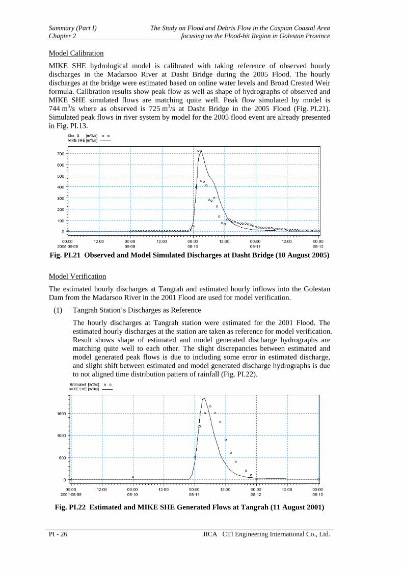
Model Calibration
MIKE SHE hydrological model is calibrated with taking reference of observed hourly discharges in the Madarsoo River at Dasht Bridge during the 2005 Flood. The hourly discharges at the bridge were estimated based on online water levels and Broad Crested Weir formula. Calibration results show peak flow as well as shape of hydrographs of observed and MIKE SHE simulated flows are matching quite well. Peak flow simulated by model is 744 m3/s where as observed is 725 m3/s at Dasht Bridge in the 2005 Flood (Fig. PI.21). Simulated peak flows in river system by model for the 2005 flood event are already presented in Fig. PI.13.
Fig. PI.21 Observed and Model Simulated Discharges at Dasht Bridge (10 August 2005)
Model Verification
The estimated hourly discharges at Tangrah and estimated hourly inflows into the Golestan Dam from the Madarsoo River in the 2001 Flood are used for model verification.
(1) Tangrah Station’s Discharges as Reference
The hourly discharges at Tangrah station were estimated for the 2001 Flood. The estimated hourly discharges at the station are taken as reference for model verification. Result shows shape of estimated and model generated discharge hydrographs are matching quite well to each other. The slight discrepancies between estimated and model generated peak flows is due to including some error in estimated discharge, and slight shift between estimated and model generated discharge hydrographs is due to not aligned time distribution pattern of rainfall (Fig. PI.22).
Fig. PI.22 Estimated and MIKE SHE Generated Flows at Tangrah (11 August 2001)

The Study on Flood and Debris Flow in the Caspian Coastal Area Summary (Part I)focusing on the Flood-hit Region in Golestan Province Chapter 2
JICA CTI Engineering International Co., Ltd. PI - 27
(2) Golestan Dam Reservoir Inflows as Reference
Hourly inflows into the Golestan Dam reservoir from the Madarsoo River were estimated for the 2001 Flood from reservoir storage curve and water level changes in the reservoir. The estimated inflows into the reservoir were crosschecked with discharges at Tangrah (Madarsoo River), Galikesh (Oghan River) and Hojigoushan (Gorgan River). The estimated hourly inflows into the Golestan Dam reservoir from the Madarsoo River were also taken as reference for model verification. Result shows that estimated (from reservoir storage curve) and model generated peak inflows into the reservoir as well as shape of hydrographs are matching well to each other (Fig. PI.23). As mentioned above, slight shift between the estimated and model generated hydrographs is due to not aligned time distribution pattern of rainfall.
MIKE SHE generated peak flows in river system during the 2001 Flood are already presented in Fig. PI.13.
Fig. PI.23 Estimated and MIKE SHE Generated Inflows into Golestan Dam Reservoir
from Madarsoo River (11 August 2001)
2.5 Related Projects
2.5.1 Urgent River Restoration Projects Many kinds of infrastructures in the Madarsoo River basin have been devastated caused by the two times huge flooding in 2001 and 2002. The plan and implementation of projects for restoration of damaged infrastructure and prevention of recurrence have been conducted by the governmental organizations concerned from the huge flood damages occurrence.
The projects of MOE and MORT have been mainly aimed for rehabilitation of the damaged infrastructures and restoration of the least original function, while those of MOJA for mitigation of damages in recurrence.
The principle of the jurisdiction of the projects is:
(1) MOJA is responsible for flood, erosion and debris/sediment control in watershed management.
(2) MOE is responsible for flood and erosion control in river improvement.
(3) MORT is responsible for restoration of damaged roads and bridges.
MOJA Urgent Projects
MOJA has a conceptual master plan on the Golestan Dam basin including the Madarsoo River basin according to the principle based on the general policy, which follows the third National Five-Year Plan. Scope of the master plan consists of the followings as watershed management in the Golestan Dam basin.

Summary (Part I) The Study on Flood and Debris Flow in the Caspian Coastal Area Chapter 2 focusing on the Flood-hit Region in Golestan Province
PI - 28 JICA CTI Engineering International Co., Ltd.
(1) To preserve/restore natural condition,
(2) To promote sustainable development on social-economical activity,
(3) To protect natural environment and human activities from water-related destruction, and
(4) To reduce and control flood peak discharge.
Based on the said master plan, MOJA has determined to implement the urgent projects to reduce physical damages caused by the probable flood and debris flow in five (5) sub-basins of the Madarsoo River basin.
Those projects aim to 1) to reduce the probable flood peak discharge with the water storage function of the proposed countermeasures, 2) to accelerate the infiltration of flooding water stored by the proposed countermeasures and 3) to control the erosion in the hillsides with the proposed countermeasures.
The urgent projects have been formulated concretely in 2002 after the 2001 Flood and a part of its implementation has been completed as of September 2005. The overall location map of those projects in the Madarsoo River basin is shown in Fig. PI.24.
Fig. PI.24 Location of the Overall Urgent Measures Proposed by MOJA
MOE Urgent Projects
MOE has conducted the river improvement plan with the Urgent Measures in the Madarsoo River basin since the flood occurrence in 2001 because the roads, bridges and river banks along the river course has been seriously damaged. The river improvement stretch proposed by MOE is approximately 65 km from Kalaleh Bridge to Dasht Bridge along the river.
In order to protect the essential infrastructures along the Madarsoo River from the further probable flood damages, MOE has determined to implement the river urgent improvements of the nine locations. The improvement plans include the protection of the existing road system against flood and/or debris flow in association with MORT as well as river widening to accommodate the probable flood.

The Study on Flood and Debris Flow in the Caspian Coastal Area Summary (Part I)focusing on the Flood-hit Region in Golestan Province Chapter 2
JICA CTI Engineering International Co., Ltd. PI - 29
In addition, MOE has simultaneously conducted to formulate the Master Plan in accordance with a 100-year return period over the Golestan Dam Basin. However, as of January 2005, the Master Plan has not been finalized yet due to the continuation of the study by MOE staff.
Unfortunately, the flood has been occurred in August 2005. The flood seriously damaged the riverbank protections, which are composed of the MOE urgent measures, along the Madarsoo River. Consequently, MOE Golestan Office is carrying out the overall review for the Master Plan and urgent measures in terms of hydraulic conditions, riparian structures strengthening and structural arrangements.
The following information illustrated in Fig. PI.25 is described for the urgent measures undertaken by MOE before the 2005 Flood occurrence.
Fig. PI.25 Location of the Urgent Measures Proposed by MOE
2.5.2 Road Network Improvement Current Status of Road Network in Golestan Province
Since the 1990s, the traffic density in this province increased year by year as well as the evolution of motorization. Before 1998 Golestan Province had a poor road network with 2-lane way and the traffic density much exceeded the capacity of this road network.
National Road Improvement Program started by widening the roads and bridges to extend the highway network such as Sari-Gorgan Highway and Gorgan-Ali Abad Highway in 1998. Fig. PI.26 shows current status of the road network. In this figure, all highlighted highway was constructed in recent 5 years.

Summary (Part I) The Study on Flood and Debris Flow in the Caspian Coastal Area Chapter 2 focusing on the Flood-hit Region in Golestan Province
PI - 30 JICA CTI Engineering International Co., Ltd.
Fig. PI.26 Current Status of Road Network in Golestan Province (2004)
On-going Road Projects in Golestan Province
Following the above-mentioned completed highway project (widening), National Road Improvement Project is continuously conducted in the stretches between Gorgan and Ali Abad, etc. as shown in Fig. PI.27.
Fig. PI.27 On-going Road Projects in Golestan Province (2004–2005)
The Study on Flood and Debris Flow in the Caspian Coastal Area Summary (Part I)focusing on the Flood-hit Region in Golestan Province Chapter 2
JICA CTI Engineering International Co., Ltd. PI - 31
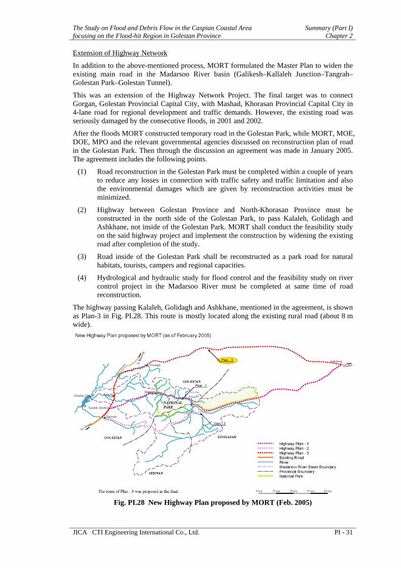
Extension of Highway Network
In addition to the above-mentioned process, MORT formulated the Master Plan to widen the existing main road in the Madarsoo River basin (Galikesh–Kallaleh Junction–Tangrah– Golestan Park–Golestan Tunnel).
This was an extension of the Highway Network Project. The final target was to connect Gorgan, Golestan Provincial Capital City, with Mashad, Khorasan Provincial Capital City in 4-lane road for regional development and traffic demands. However, the existing road was seriously damaged by the consecutive floods, in 2001 and 2002.
After the floods MORT constructed temporary road in the Golestan Park, while MORT, MOE, DOE, MPO and the relevant governmental agencies discussed on reconstruction plan of road in the Golestan Park. Then through the discussion an agreement was made in January 2005. The agreement includes the following points.
(1) Road reconstruction in the Golestan Park must be completed within a couple of years to reduce any losses in connection with traffic safety and traffic limitation and also the environmental damages which are given by reconstruction activities must be minimized.
(2) Highway between Golestan Province and North-Khorasan Province must be constructed in the north side of the Golestan Park, to pass Kalaleh, Golidagh and Ashkhane, not inside of the Golestan Park. MORT shall conduct the feasibility study on the said highway project and implement the construction by widening the existing road after completion of the study.
(3) Road inside of the Golestan Park shall be reconstructed as a park road for natural habitats, tourists, campers and regional capacities.
(4) Hydrological and hydraulic study for flood control and the feasibility study on river control project in the Madarsoo River must be completed at same time of road reconstruction.
The highway passing Kalaleh, Golidagh and Ashkhane, mentioned in the agreement, is shown as Plan-3 in Fig. PI.28. This route is mostly located along the existing rural road (about 8 m wide).
Fig. PI.28 New Highway Plan proposed by MORT (Feb. 2005)

Summary (Part I) The Study on Flood and Debris Flow in the Caspian Coastal Area Chapter 2 focusing on the Flood-hit Region in Golestan Province
PI - 32 JICA CTI Engineering International Co., Ltd.
Other Issues on Road and Bridge Management in Golestan Province
MORT provincial unit stresses that the road in the Madarsoo River basin needs urgent improvement project. They reported many critical points, which need urgent improvement projects.
As the result of consideration on the current flood condition, the numerous constructed bridges should be replaced with the longer spanned bridges, and the road embankments along the river should be reinforced.
2.5.3 Watershed Management Outline of the Plan
The plan has been formulated in 2003. The plan has been conducted the fundamental study which consisted of geology, topography, soil, vegetation focusing on the Madarsoo sub-watershed. On the basis of this study implementation plan has been formulated including the goal of plan, contents of plan, method of countermeasure, and prioritization among the project.
The following sub-watershed has been given high priority among the nine sub-watersheds in the Madarsoo River basin and the plan has been formulated in each sub-watershed: (1) Cheshmeh Kahn sub-basin, (2) Dasht-e-Sheikh sub-basin, (3) Ghiz Ghaleh sub-basin, (4) Tangrah sub-basin, and (5) Loveh sub-basin.
The main contents of the plan are as follows.
Check dam construction to mitigate the flood intensity
Terracing to protect the soil surface erosion
Restoration and improvement of forest and rangeland
Countermeasure of overgrazing
Extension and training to implement the project smoothly
Cost estimate
Biological Countermeasure
Among the above five sub-watersheds, the biological countermeasures have been introduced mainly in two sub-watersheds: Dasht-e-Sheikh and Tangrah sub-basins. The biological countermeasures to be conducted in two sub-watersheds are enumerated in the following table.
Table PI.13 Biological Countermeasures Dasht-e-Sheikh sub-basin
1) Planting+fertilizing 2) Planting banqquet +seeding +fertilizing 3) Planting banqquet +fertilizing 4) Terracing 5) Hill planting + fertilizing 6) Seeding + fertilizing 7) Fertilizing
Tangrah sub-basin 1) Irrigated farmland-strip sodding 2) Irrigated & non-irrigated farmland, strip sodding 3) Terraced farmland not to be Irrigated 4) Forestation on the terraced farmland 5) Planting on the grassland 6) Planting on the mountainside 7) Recovery planting with seeding on the mountain side 8) Available rangeland to be fertilized

The Study on Flood and Debris Flow in the Caspian Coastal Area Summary (Part I)focusing on the Flood-hit Region in Golestan Province Chapter 2
JICA CTI Engineering International Co., Ltd. PI - 33
2.5.4 Forest Management Loveh Forestry Plan Area
Loveh forestry plan area is located in the western part of the basin managed by NRGO (Natural Resource General Organization). Now one concession holder has conducted the management in the forest area. The production aim of Loveh forestry plan area is to product forest by introducing natural regeneration system in oak forest.
The forest consists of oak, hornbeam, alder, plum tree, elm, maple and so on. Undergrowth in the forest is rare. This situation is good for the seedling after germination. But succeeding seedlings seldom remain in this forest.
Defoliation and fallen branches accumulate on the ground and the soil is getting deep and soft. It is considered that those cycles contribute to prevent the soil surface run-off.
Management System
The harvesting activities have been continued in this area for 40 years and management plan has been revised every 20 years. Loveh forestry plan is one of the “management units” in the Golestan province.
The shelter cutting system that is one of the reforestation methods has been conducted in this area as management system and cutting period is adopted at 150 years at the viewpoint of inclination of trees (oak).
The flow of shelter cutting system is as follows.
Selecting the site for the harvesting
Harvesting without mother trees
Land preparation in nursery
Regeneration (20,000 to 30,000 seedlings/ha)
Increment of young trees
Pruning and thinning
Final cutting (250 trees /ha)
Forest management plan consists of the outline of the planning area, site condition (forest, soil, topography), volume table, growing stock, and thematic maps (site, road, management).
NRGO in Golestan Province
NRGO is one of the government organizations under the MOJA, established 1929. NRGO in Golestan province was established in 1950s, and has branch office in district level and village level. NRGO consists of general affair department, technical affair department, and land conservation department, and there are several responsible sections under each department. There are forest management section, reforestation section and rangeland management section under technical affair department.
For the formulating the forestry plan and its implementation, NRGO selects the consultant to conduct feasibility study (F/S). On the basis of F/S, NRGO makes the specification of work and selects some contractors to be concession holder. Contractors have been given the period of concession for 20 to 30 years. Contractors implement the project under inspection of NRGO.
Issues for Forest Management
According to the stuff of NRGO, there are some issues for forest management in this area.
Exploitation of the forest for construction of pipeline of natural oil/gas
Reduction of forest land by development of farmland

Summary (Part I) The Study on Flood and Debris Flow in the Caspian Coastal Area Chapter 2 focusing on the Flood-hit Region in Golestan Province
PI - 34 JICA CTI Engineering International Co., Ltd.
Illegal activities in the forest land by grazing
2.6 Disaster Management
2.6.1 Flood Monitoring and Warning System Organizational Conditions for Existing Flood Warning System
(1) Organization for Flood Disaster Management in Golestan Province
For flood disaster management in the province, the responsible organization is Provincial Disaster Management Committee (PDMC). General Governor of Golestan province organizes the Golestan Disaster Management Committee among the governmental agencies concerned. 27 provincial and governmental agencies are committee members. The major acting members during floods are MPO, MOE, MET, MORT, MOJA and Red Crescent, etc.
(2) Present Flood Information Flow and Related Agencies
Fig. PI.29 illustrates present flood information flow. All flood information is concentrated into PDMC. PDMC will issue necessary instruction and order to related agencies as well as inhabitants in disaster-occurring area. MET sends initial information on floods to PDMC in a form of weather bulletin or flood warning notice. PDMC issues an order to take action against floods to all agencies concerned.
Major organizations concerning the flood disaster management are described below.
Fig. PI.29 Present Flood Information Flow
Provincial Disaster Management Committee (PDMC)
The core organization of the disaster prevention and fighting is PDMC under General Governor of the Golestan Province. PDMC is decision-making organization for the disaster mitigation and necessary actions to be taken by the committee members

The Study on Flood and Debris Flow in the Caspian Coastal Area Summary (Part I)focusing on the Flood-hit Region in Golestan Province Chapter 2
JICA CTI Engineering International Co., Ltd. PI - 35
based on their disaster prevention and fighting action program. However, PDMC has only four staffs and no actual flood-fighting materials. Especially, PDMC takes an active part for coordination of flood warning and fighting, and recovery of damages by floods. PDMC staffs always are being ready for preparedness to the disaster occurrence.
Telephone including mobile and facsimile are used for communication between PDMC and MET. Once PDMC instructs flood prevention/mitigation measures to the related agencies, the agencies shall obey such instruction. At the same time flood information is conveyed to the MOI for preparation of flood in adjacent river basins. If flood situation becomes serious, PDMC establishes flood disaster task force in Gorgan city or disaster site, and calls necessary committee members to discuss proper countermeasures. During 9 to 10 August Flood in 2005, PDMC conducted such action especially to Red Crescent, police and MORT. They closed the road and conducted patrol activities in the Golestan National Park to make the visitors/campers evacuate out of the park. As the result, there were no casualties in the Madarsoo River basin in the 2005 Flood.
Meteorological Organization Golestan (MET)
MET issues two (2) kinds of weather information to PMDC as well as related government agencies and the public. Flood notice is closely related to the flood forecasting and warning system. However, reliability of such information is not so high enough for flood forecasting since it is based on global weather information. For increase of reliability in spot weather forecasting, rainfall forecast for next three hours and the Radar Rain gauge system will be at least required.
Red Crescent Golestan
Red Crescent is the most organized and powerful organization for disaster prevention/ mitigation operation. It has enough experienced staffs and relief goods. Red Crescent Golestan has responsibility to act necessary prevention, evacuation and rescue before, during and after disaster. There is Red Crescent Road Center in Gorgan city and major towns have branch offices in the Golestan province that mainly work rescue activities for traffic accidents. At the same time, road center has also a function of local disaster rescue center. At first, Red Crescent receives weather bulletin and flood notice from MET, and then Red Crescent receives dispatch order to the disaster site through PDMC. Staffs of Red Crescent at the nearest branch office, including flood specialist and volunteers, will be dispatched to the disaster site for flood evacuation and fighting to coordinate with village chief. In this action, young volunteers play major roles of the actions. Therefore, Red Crescent promotes one-from-one-family program to increase numbers of volunteers.
Present Data Collection System
MET-Golestan, under IRIMO (Islamic Republic Iran Meteorological Organization), installed three climatologic and rain gauge stations connecting to public telephone line. Out of three stations, two stations are located in the Madarsoo River basin. Furthermore, MET plans to expand monitoring network, installing four more rain gauge stations.
On the other hand, MOE-Golestan installed online observation stations for flood monitoring and warning after the 2001 and 2002 Floods. Four stations, two rain gauges and two water level gauges, out of six are located in the Madarsoo River basin, and they are connected to MOE-Golestan office through the public telephone network.
Present Data Transmission System
Data transmission of existing monitoring stations has two different systems; public telephone line and GSM mobile telephone network. The existing online stations in the Madarsoo basin are connected to the public telephone network. GSM mobile telephone network is not utilized

Summary (Part I) The Study on Flood and Debris Flow in the Caspian Coastal Area Chapter 2 focusing on the Flood-hit Region in Golestan Province
PI - 36 JICA CTI Engineering International Co., Ltd.
so far. MET has a plan to change public telephone line to GSM MODEM to solve interfacing problem between telephone network and data logger.
Data Processing system
Personal-computer-based system is employed for data processing both in MET and MOE.
(1) MET system
MET online data collection system software UMAD, made by German Mevis T version 1.7, has an automatic observation function. One of control functions is polling instant value (ON/OFF) and can be set any time-interval including online mode. This shall be used for automatic observation of every one-hour data collection as an online station. System has two inputs; one is GSM MODEM and the other is public telephone network MODEM. In case of flood event, both lines shall be connected as online bases. Therefore, real time online observation data for two stations can be received.
(2) MOE System
MOE data collection system software HIDLAS, made by OTT, has a function for automatic data collection. This function has not been used so far, but it can be used for automatic observation of every one-hour data collection.
System Operational Condition
(1) MET System
Meteorological data collection rule is based on WMO standard. They have three kinds of time intervals for data collection as shown in the following table.
Table PI.14 Observation Time Interval
Type of station Data collection interval Observation time Synoptic 24 times a day Every one hour Climatologic Three times a day 6:30, 12:00, 18:30 Rain gauge Once a day 18:30
Among the above classified stations, online stations are accessed from data collection PC at MET through the dial-up telephone MODEM at fixed time-interval manually. Climatologic stations send back previous data stored in the data logger. When stormy weather is foreseen, the PC can connect to the stations continuously as online operation. Also, all stations can be accessed through polling mode in fixed time-interval. However, automatic real time polling mode is not equipped so far.
Hardware of rainfall gauge stations has no significant problems so far, except Hagholkhajeh station. The data logger and battery has been stolen after installation. Small space with low fence caused its problem. Large space and tall fence shall be necessary for keeping security.
Telecommunication problem still remains due to improper functioning of public telephone network. MET tries to change the network from public telephone line to GSM MODEM. However, GSM mobile telephone service does not cover the entire basin. Therefore, online stations connected to public telephone line have to remain until GSM mobile telephone service expands over the basin.
(2) MOE System
Basic hydrological data collection is made in one-hour interval. On the other hand, flood forecasting and warning system requires 10-minutes data during heavy rainfall. The time interval of MOE online stations is basically every two-hour, and after office

The Study on Flood and Debris Flow in the Caspian Coastal Area Summary (Part I)focusing on the Flood-hit Region in Golestan Province Chapter 2
JICA CTI Engineering International Co., Ltd. PI - 37
hour (14 o’clock) no observation is made until 8 o’clock in the next morning. In view of flood forecasting and warning system operation, MOE online data collection system cannot properly function.
Rain gauge and water level stations are accessed from data collection PC at MOE through the dial-up telephone MODEM in fixed time-interval manually. Those stations send back previous data stored in the data logger. Therefore, the present system is not substantially real-time data collection system.
System Maintenance Condition
Normally, meteorological service requires 24-hour operation and maintenance for weather instruments in good condition. Therefore, MET has maintenance teams to repair the weather monitoring instruments including rainfall observation equipment. However, there is no regular and routine maintenance works established. Only maintenance teams will visit the site when some trouble happens.
MOE dose not have any maintenance team. The operator of data collection system will visit the site when some trouble happens. If he cannot repair the equipment troubled in the system, MOE will ask repair work to the system suppliers. There is no regular and routine maintenance works established.
Lessons in the 2005 Flood
In the evening of August 9 to the morning of August 10, 2005, heavy rain occurred over the Madarsoo River basin. It caused medium scale flood in the basin and caused serious damages on road and bridges in the basin. The followings are lessons based on of action taken by related agencies in the 2005 Flood in view of early flood warning system.
MET issued a reliable flood notice having enough lead-time for evacuation.
Related agencies such as police, MORT, Red Crescent, DOE Park Office stood ready to take necessary actions on 24-hour basis against floods.
In view of early warning system, MOE monitoring system did not well function before the flood. Furthermore, MET online system also could obtain rainfall data at Golestan National Park only. MET could not receive rainfall data from the other stations due to the telephone line problems.
2.6.2 Community-based Disaster Management Social Structure
The village awareness survey was made targeting 30 villages in the Madarsoo River basin, in which total population amounts to 6,894 families equivalent to 32,449 persons. The average household members are 4.7 persons. The population level of villages differs considerably from minimum 193 to maximum 3,200. The average village population is 1,082.
Population ratio by age groups is as follows: 0 to 14 years is 34 %, 15 to 64 years is 60.5 %, and over 65 years is 5.5 %. Children under 15 years old, considered as a vulnerable group, form one third of the population.
The following table indicates the general characteristics of the households in the villages.

Summary (Part I) The Study on Flood and Debris Flow in the Caspian Coastal Area Chapter 2 focusing on the Flood-hit Region in Golestan Province
PI - 38 JICA CTI Engineering International Co., Ltd.
Table PI.15 General Household Characteristics Category Characteristics
Family type Nuclear of Children 4 plus (50%)Housing unit 235 m2 (average)
Single-floor (90 %) Land ownership Self-own (96 %) Monthly Income 500,000-1,500,000 Rials Ethnic group Turkmen (47 %)
Fars (23.5 %) Kurd (13.0 %)
Occupation Farming Animal husbandry
Majority of families are nuclear family, and nearly half of the family has more than 4 children, among them 28 % of the family has more than 6 children. The size of housing unit is mostly above 100 m2, and the average is 235 m2. Most (more than 90 %) housing units are single floor. Majority of people (96%) own their land. Monthly income is between 500,000 to 1,500,000 Rials. Turkmen families account for nearly half, followed by Fars (one-forth) and Kurds (one-eighth).
Majority (one-third) of the villagers are farmers. Animal husbandry of sheep and cow accounts for 8 %. Public officials including teachers are 6 %. Nearly 5 % is unemployed. Others are workers and clerks.
Comparative numbers of villagers in the study area were once nomads and started to settle down after the land reform in 1962 and the Islamic Revolution in 1979. Most people work within the village but have urban behavioral pattern. It is probably because the area is not far from city. The mode of life varies throughout the year. Spring, summer, and autumn are basically the season for cultivation and harvesting, while winter is the time of vacation.
Local Organization and Cohesion
(1) Organization
Village-based organizations that can be commonly found are agricultural cooperation, Basij, Imam Khomeini’s foundation and Red Crescent Society. They are not only locally based, but also nationwide networks. These organizations played an important role of rescue and relief operations.
(2) Meeting place
Common meeting place for villagers are mosques. For small private gathering, houses of white-beard council members are occasionally used by local people. For holding workshops for villagers, mosques provide screens, audio system, and comfortable atmospheres.
(3) Mutual Cooperation
Bond of family, bond of neighborhoods is tight. People know each other about who lives where and where the elderly and handicapped lives. People help each other and share information on regular basis. At the time of floods, evacuated people took shelter at houses on the high elevation in the villages, and helped each other.
(4) Village Actors
Village actors related to decision-making are primary three village councilors. Within the council, dehiyar who is elected by the council is responsible for financial administrations. Whereas, white-beard elderly, Imam of the mosque, teachers, and young educated villagers are also influential figures in villages.
The Study on Flood and Debris Flow in the Caspian Coastal Area Summary (Part I)focusing on the Flood-hit Region in Golestan Province Chapter 2
JICA CTI Engineering International Co., Ltd. PI - 39
(5) Decision-making System
Village council is the final authority to decide village matters. The white-beard of elderly and respected, Imam, teachers are also respective figures for consulting various matters. Nowadays, white-beard sometimes gets opinions from young educated people in the village. Villagers elect village councilors. Council members held annual council meeting.
Disaster Experience and Knowledge
(1) Flood Situation
In severely damaged villages, most people evacuated to elevated site being wet. Electricity went off due to heavy rainfall, and sooner their houses were inundated more than 1 m or even washed away. Some farmlands were damaged of itself or of its irrigation pipelines. Nearby civil structures and public facilities, such as bridges, schools, police stations were damaged. Falling rubles due to debris flow injured some people. Electric devises like TVs, refrigerators and furniture were damaged. Some villages incurred casualties. Most victims were women and children.
(2) Past Disaster Response
Many people got information from the regular TV news program. Some conveyed this information to villagers by motorbikes. Some village councilors could inform villagers about the possible floods before critical situation. Due to power failure, mosque speakers could not work to inform. Nobody instructed the evacuation beforehand, and thus most people evacuated by their own decision, facing dangers of inundation of their houses, to the elevated site. Most village councilors informed the related public authorities, but they could not reach villages because of the inaccessibility of roads and bridges. Official relief by helicopter was failed because of the heavy rain; and the relief could reach the next morning.
(3) Information Distribution System
The common way of distributing information is through the mosque speaker. No bulletin board was used. Mouth to mouth informal communication is commonly used and useful. In case of floods in the past, some council members utilized firing guns for information of extraordinary situation.
(4) Risk Perception of Flood and Debris flow
Majority of people in the flood-experienced villages think the hazard of flood and debris flow is dangerous and that it is hard to cope with them. Thus, the awareness for such disaster is very high. The risk perception of floods is higher than debris flow.
(5) Analytical Capacity for Evacuation
Majority of people (90 %) know where they should evacuate, but several percents of the respondents do not know the evacuation place. Some people went to see the floodwater of the river to inform the villagers. Accurate flood monitoring system that can inform early warnings is very much expected by the villagers.
Participation
(1) Interest to Disaster Risk Management
Nearly 80 % of the respondents want to attend the disaster risk management activities. Type of activities they want to participate is active one; to become a member of the rescue team counted most, and to receive rescue and evacuation training, to become a member of disaster management committee.
In most villages, there are unwritten social and moral rules and obligations to participation. Those who refuse to participate are sometimes isolated from others.
Summary (Part I) The Study on Flood and Debris Flow in the Caspian Coastal Area Chapter 2 focusing on the Flood-hit Region in Golestan Province
PI - 40 JICA CTI Engineering International Co., Ltd.
(2) Self-help Attitude
Villagers have notion that public facilities are provided by the public sectors. Actually the system has been as such. Survey shows that the villagers have motivation of flood risk management. The past disaster made them motivate to react by their own of what they can do. Through workshops of disaster risk management in villages, the role of villagers, public sectors and local organizations can be delineated, and self-help attitude can be enhanced.
(3) Consideration to Women
Workshops for villagers need to be conducted separately for women. Village organizations like Basij have separate body for women. Red Crescent society can hold joint workshops. Based on the village survey, 5 % answered that the decision were left to the head of the family. However, women usually have complete decision-making power regarding their personal life.
2.7 Environment
2.7.1 Environmental Scoping Environmental Guidelines and Laws
Revised version of JICA Guidelines for Environmental and Social Considerations published in April 2004, provides the following definitions “environmental and social considerations” means considering environmental impacts on air, water, soil, ecosystem, fauna and flora as well as social impacts including involuntary resettlement and respect for human rights of indigenous people and so on. The guidelines Categorizes the projects as shown below:
Table PI.16 Project Categorization in JICA Guidelines
Category Description A Projects likely to have significant adverse impacts on the environment and society.
Projects in sensitive sectors with characteristics liable to cause adverse environmental impacts, as well projects located in or near sensitive areas are also fall in category A
B Projects are classified as category B if their potential adverse impacts on the environment and society are less adverse than those of category A. Most of impacts are site-specific and reversible through normal mitigation measures
C Projects with minimal adverse impacts on the environment and society are in category C.
Disclosure of information (transparency), consultation with local stakeholders, and participation of people in projects are emphasized in the guidelines. However JICA refers to international standards, treaties/declarations and good practices which Japan, international and regional organizations have, it urges the recipient government to conduct environmental assessment (evaluation) in accordance with laws, regulations and guidelines of the country.
DOE (Department of the Environment) of Iran published its revised version of Environmental Guidelines and Standards in the autumn of 2003. The guidelines provide information and guidance on conduction of environmental studies and preparation of environmental impact assessment report. According to the guidelines, 18 kinds of projects are expected to have significant adverse impacts on the environment and society, thus requiring environmental impact assessment (EIA) prior to their implementation.
Preparation of Scoping for the Study
Document of environmental Scoping for the Study was prepared based on the collected data/ information, field survey, discussing with counterparts in MOJA and consultation with relevant institutions such as DOE.

The Study on Flood and Debris Flow in the Caspian Coastal Area Summary (Part I)focusing on the Flood-hit Region in Golestan Province Chapter 2
JICA CTI Engineering International Co., Ltd. PI - 41
Conduction of Scoping revealed that the captioned project falls in category B of JICA environmental categorization, with following justification:
(1) The proposed project is of disaster mitigation and management in nature and sprit, aiming at reducing flood/debris flow damages, preventing soil erosion/land degradation, thereby enhancing the status of ecosystem. Such works are environment-friendly, widely known, easily accepted by people, and executed with small scale in a limited area. Thus inserting no significant adverse impact on the environment or society.
(2) Structural measures being established in hazardous localities are so designed to counter deterioration of physical and biological environments, and safeguard the society.
(3) However part of Golestan National Park occurs in the study area, but no structural measure is recommended for this park. Instead, flood forecasting and warning systems are installed to alarm the visitors/campers about occurrence of flood on time and accelerate evacuation.
(4) According to environmental laws and regulation prevailing in Iran, only large-scale projects (corresponding to category A of JICA), require environmental impact assessment, while captioned project is of small scale and for disaster mitigation and management.
(5) The project neither plans involuntary resettlement, nor proposes any change in existing institution and customs, thus its smooth execution is expected.
2.7.2 Environmental Situation Environmental Situation in Iran
(1) Natural Environment and Ecology in Iran
Iran lies in northern part of temperate zone, between latitudes 25°03’ and 39°47’ north and longitudes 44°14’ and 63°20’ east. Alborz Mountain Range in north, Zagross Mountain Range in west and some other mountain chains extending from Khorasan to Baluchestan in east, surround plateau of Iran which is mostly desert in the middle. There are many summits in Iran, of which Damavand with 5,671 m from sea level, in northeast of Tehran is the highest one. Two major deserts namely Dasht Loot and Dasht Kavir, covering an area of 360,000 km2, occur in central part. These are among the hottest and driest places in the world. Average altitude of the country is about 1,200 m.
Iran hosts about 8,200 species of flora, of which 2,500 species are endemic. Forests in north of Iran are comprised of beech, walnut, and fig tree, while oak is the main tree in forests of Zagros Mountains. Desert forests are composed of small trees and shrubs, mainly of spinach family, being enables to grow in salty soil. Many wild medicinal plants and herbs grow all over Iran, being used domestically or exported for gaining hard currency.
A vast variety of animal species have their habitat in Iran, and so far about 160 species of mammals, 164 species of reptiles, and 500 species of birds have been identified, of which some are endemic species. Most of species live in Alborz and Zagros Mountains, and on the coasts of Caspian Sea.
(2) Natural Reserves
Degradation of natural environment as a consequence of human activity and overexploitation of natural resources has resulted in destruction of some of valuable flora and fauna species. To prevent further degradation of the environment some localities in the country have been declared as natural reserves by DOE. Total area of

Summary (Part I) The Study on Flood and Debris Flow in the Caspian Coastal Area Chapter 2 focusing on the Flood-hit Region in Golestan Province
PI - 42 JICA CTI Engineering International Co., Ltd.
these reserves is about 11.7 million ha, corresponding to 7.2 % of total area of the country.
There are more than 100 sizable wetlands in Iran, 21 of which are of international importance, and registered by Ramsar Convention. Moreover numerous natural attractions exist in Iran, being visited by foreign and domestic tourists and nature lovers throughout the year.
(3) Environmental Laws, Regulations and Standards
Islamic Republic of Iran has established comprehensive environmental legislations, which are rooted in the Constitution and Islamic culture and wisdom. Article 50 of Constitution, and Articles 684 to 688, 560, 558 of the Islamic Punishment Law (Taazirat) provide foundation and strength to all environmental laws, regulations and standards prevailing in the country. Legislations relevant to the captioned project are tabulated below with brief content.
It should be noted that DOE is principal organization for administrating the environmental status in Iran. DOE is attached to Office of President of the country, and president appoints its head. DOE has a General Directorate in each province, which monitors status of environment as well as implementation of environmental programs at provincial level.
Table PI.17 Environmental Laws, Regulations and Standards in Iran
Legislation Brief Content
(1) Civil laws Law of nationalization of water-1968 Designation of water as a national resource Environmental protection and enhancement law- 1974 (amended in 1992)
Protection and enhancement of ecosystem
Law on conservation and utilization of Forests and rangeland- 1975
Sustainable and wised utilization of forest and rangeland
Law of just distribution of water-1982 Definition of pollution and prohibition of water pollution
Law on prevention of water pollution-1994 Prevention of water pollution Law of third five-year socio-economic and cultural development plan of Iran- 2000
Requirement of EIA for large production and service providing projects
Law of fourth five-year socio-economic and cultural development plan of Iran- 2004
Necessity of conducting EIA on large projects, in accordance with guidelines provided by DOE
Environmental Guidelines and Standards, published by DOE in the year 2003
Itemization of projects requiring EIA, and guidelines for conducting EIA
Regulation on limits of bed and banks of rivers, stream, wetlands, and water supply and irrigation/drainage networks- 2000
Identification and delineation of limits of river banks
Regulation concerning the requirement of environmental impact assessment (EIA) in developmental projects- 1994
Mandatory of conducting EIA for large projects
Regulation for conducting EIA-1997 Preparation of EIA in accordance with the guidelines of Department of the environment
(2) Islamic Laws Islamic punishment law (Taazirat)- 2005. Punishment for causing environmental pollution,
damaging public facilities (dam, canal), and destroying cultural/historical heritages.

The Study on Flood and Debris Flow in the Caspian Coastal Area Summary (Part I)focusing on the Flood-hit Region in Golestan Province Chapter 2
JICA CTI Engineering International Co., Ltd. PI - 43
Environmental Situation in Golestan, Semnan and Khorasan Provinces
(1) Golestan Province
Golestan province lies in northern part of Iran. Turkmenistan in the north, Semnan province in south, Khorasan province in east, and Caspian Sea and Mazandaran province in west surround this province. Total area of the province is 20,438 km2, with a population density of 81 persons/km2. Golestan is one of important and strategic provinces having marine and overland connecting routes to Central Asia.
According to the recent estimation (2005) by Management and Planning Organization of Golestan province, population of Golestan is about 1.7 million, of which 0.8 million (46.8 %) live in urban, and 0.9 million (53.2 %) live in rural areas.
Parts of project area occur in Kalaleh and Minu Dasht districts, which their population status is tabulated below:
Table PI.18 Population of Kalaleh and Minu Dasht Districts
District Total population Urban population Rural Population Kalaleh 163,579 (100 %) 40,370 (24.7 %) 123,209 (75.3 %) Minu Dasht 157,270 (100 %) 53,193 (33.8 %) 104,077 (66.2 %)
In 2003, employment and unemployment rates were 86.3 % and 13.7 %, respectively, and distribution of employed population in major economic activities was as below:
Agriculture: 34.3 %
Industry: 24.8 %
Services: 40.9 %
Agriculture is an important sector in Golestan, and more than 92 kinds of field and orchard crops are produced here, of which cotton, oilseeds, wheat, rice, potato, tobacco, and barley can be mentioned. Livestock raising and fishery are also widely practiced and contribute to economy of the province.
Area of rangeland is 1,126,000 ha, and area of forest is 430,000 ha. Total area for farmland and orchard is 580,000 ha. Annual rainfall varies from 200 to 700 mm, in accordance with topography and localities.
Golestan National Park, the first Iranian national park registered by UNESCO, and some other natural reserves occur in this province, which their status is given table below:
Table PI.19 Type, Number and Area of Natural Reserves in Golestan Province
Type Number Area (ha) % of Reserve Area % of Province National Park 1 88,576 61.1 4.3 Wildlife Habitat 3 56,318 38.9 2.7 Protected Area 0 0 0 0 Natural Monument 0 0 0 0
Total 4 144,894 100.0 7.0 Source: JICA Study Team- 2005, based on documents of Department of the Environment (DOE), Iran.
(2) Semnan Province
The province Semnan covers an area of 95,815 km2, to the east of which is Khorasan province, to the north are provinces of Golestan and Mazandaran, to the west stand the provinces of Tehran and Qom, and to its south are Esfahan and Yazd provinces.
Summary (Part I) The Study on Flood and Debris Flow in the Caspian Coastal Area Chapter 2 focusing on the Flood-hit Region in Golestan Province
PI - 44 JICA CTI Engineering International Co., Ltd.
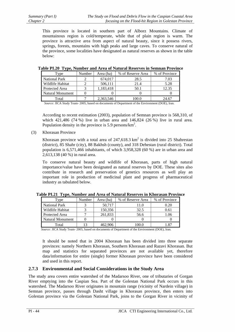
This province is located in southern part of Alborz Mountains. Climate of mountainous region is cold/temperate, while that of plain region is warm. The province is attractive area from aspect of natural beauty, since it possess rivers, springs, forests, mountains with high peaks and large caves. To conserve natural of the province, some localities have designated as natural reserves as shown in the table below:
Table PI.20 Type, Number and Area of Natural Reserves in Semnan Province
Type Number Area (ha) % of Reserve Area % of Province National Park 2 674,017 28.5 7.03 Wildlife Habitat 2 506,111 21.4 5.28 Protected Area 3 1,183,418 50.1 12.35 Natural Monument 0 0 0 0
Total 7 2,363,546 100.0 24.67 Source: JICA Study Team- 2005, based on documents of Department of the Environment (DOE), Iran.
According to recent estimation (2003), population of Semnan province is 568,310, of which 421,486 (74 %) live in urban area and 146,824 (26 %) live in rural area. Population density in the province is 5.9 persons/km2.
(3) Khorasan Province
Khorasan province with a total area of 247,618.3 km2 is divided into 25 Shahrestan (district), 85 Shahr (city), 88 Bakhsh (county), and 318 Dehestan (rural district). Total population is 6,571,466 inhabitants, of which 3,958,328 (60 %) are in urban area and 2,613,138 (40 %) in rural area.
To conserve natural beauty and wildlife of Khorasan, parts of high natural importance/value have been designated as natural reserves by DOE. These sites also contribute in research and preservation of genetics resources as well play an important role in production of medicinal plant and progress of pharmaceutical industry as tabulated below.
Table PI.21 Type, Number and Area of Natural Reserves in Khorasan Province
Type Number Area (ha) % of Reserve Area % of Province National Park 3 50,717 11.0 0.20 Wildlife Habitat 3 150,356 32.5 0.61 Protected Area 7 261,833 56.6 1.06 Natural Monument 0 0 0 0
Total 13 462,906 100.0 1.87 Source: JICA Study Team- 2005, based on documents of Department of the Environment (DOE), Iran.
It should be noted that in 2004 Khorasan has been divided into three separate provinces: namely Northern Khorasan, Southern Khorasan and Razavi Khorasan. But map and statistics for separated provinces are not available yet, therefore data/information for entire (single) former Khorasan province have been considered and used in this report.
2.7.3 Environmental and Social Considerations in the Study Area The study area covers entire watershed of the Madarsoo River, one of tributaries of Gorgan River emptying into the Caspian Sea. Part of the Golestan National Park occurs in this watershed. The Madarsoo River originates in mountain range (vicinity of Nardein village) in Semnan province, passes through Dasht village in Khorasan province, then enters into Golestan province via the Golestan National Park, joins to the Gorgan River in vicinity of

The Study on Flood and Debris Flow in the Caspian Coastal Area Summary (Part I)focusing on the Flood-hit Region in Golestan Province Chapter 2
JICA CTI Engineering International Co., Ltd. PI - 45
Garkaz village, and thereafter empties into the Caspian Sea. The river is 142 km in length, having an average slope of 1.4 %, and a catchments area of 2364 km2.
Total present population (2005) in the study area is 93,141 inhabitants, with a population density of 0.39 persons/ha, and average family size of 6.5 persons, as attained by the study team through filed survey and data collection activities.
2.8 Others
2.8.1 Institutional and Legal System Status of Laws in Iran
Important laws in Iran related to flood disaster prevention are selected and translated for the review as listed in Table PI.22. It is noted that laws for environmental management has long history in Iran, as most of them were established in 1960s. Especially, the environmental protection is mentioned in the Constitution of Iran, as well as in socio-economic and cultural development plan for a long time in Iran. Environmental policy appeared in Second National Development Plan (1995-2000), attaching special importance to environmental protection, primarily in the areas of air and soil pollution. Later, it is explicitly stated in chapter 12, “Environmental policies” in the third national development plan (2001-2004). Chapter 5 in Part 2 of the Fourth National Development Plan is also dedicated to Environmental Protection.
Laws for resource management such as “fair distribution of water” have been established in 1980s, which defines the responsibility of MOE from the viewpoint of water resource management.
The Law for disaster prevention emerged in 1992, which defines responsible institutions and its coordination for different kind of disasters. Recently, “The Integrated Disaster Plan of Iran” was established in 2003, which states functions of responsible organizations and procedures of disaster prevention.
In the third socio-economic and cultural development plan, the article 181 states that “Government is required to provide in the annual budget bill during the Third Plan period, necessary funds to prevent, provide relief assistance to renovate and rebuild the areas damaged by unpredictable events”. This Article is revalidated in fourth plan in Chapter 10 “national security” as well.
However, it is noted that in the definition of terms in Iranian laws, flood is not regarded as disaster. For example, “Flood control” is defined as ”storage of water in surface or underground reservoir” in article 29 of “The law of fair distribution water”. Similarly, ”Watershed management“ is defined as “management of environment of watershed that reach best objective of the management for sustainable utilizing” in the “Executable decree for law of the protection and stabilization of the bed and bank of the river that pass from the border of the country”.

Summary (Part I) The Study on Flood and Debris Flow in the Caspian Coastal Area Chapter 2 focusing on the Flood-hit Region in Golestan Province
PI - 46 JICA CTI Engineering International Co., Ltd.
Table PI.22 List of Important Laws Related to Flood in Iran Year Area Name of Law
1963 Forest National Forest Law 1967 Environment Game and Fish Law 1968 Forest Protection and Utilization of Forest and Range 1975 Environment Protection and Enhancement of Environment Law 1979 Environment Constitution, article 45 and 50 1983 Water Fair Distribution of Water 1984 River Protection and Stabilization of Riverbed & Banks of River that Pass
from Border of Iran Country 1986 Insurance Agriculture Production Insurance Fund Law 1989 Development The First Socio-Economic and Cultural Development Plan 1992 Disaster Organizing National Committee to Decrease Effect of Natural
Disaster 1995 Development The Second Socio-Economic and Cultural Development Plan 2000 Development The Third Socio-Economic and Cultural Development Plan 2000 Watershed Establishment of MOJA 2003 Disaster The Integrated Disaster Plan of Iran 2005 Development The Fourth Socio-Economic and Cultural Development Plan
Flood Prevention Measures in Iran
Though not specifically mentioned in the law, there are many efforts for flood disaster prevention among different institutions in Iran. In Iran, each ministry has provincial office, and provincial office from each ministry forms provincial government, with a governor appointed by central government as a chief. Responsibility and interests among related institutions are summarized in the following table.
Table PI.23 Interests and Responsibilities among Institutions in Iran
Forest Water Road Disaster MOJA Exploitation
Forestation Watershed management
Recovery
MOE Water Resources, River
Recovery
MORT Exploitation Road protection Road construction Warning (IRIMO) DOE Environmental Protection Recovery MPO Development Recovery MOI Prevention Response
Watershed Management
MOJA has two important functions, biological and mechanical measures, related to flood disaster prevention. In provincial level, Natural Resource General Office (NRGO) is responsible for biological measures such as forestation. Watershed management department is responsible for mechanical measures such as check dam construction. In Tehran, these sections are merged as Forest, Rangeland and Watershed Organization (FRW).
Agriculture Insurance
In Iran, the history of agriculture insurance dates back to 1970, but the insurance was actually implemented since 1984. The Insurance Fund is administered through a Head Office in Tehran, 29 provincial Directorates and a total of more than 1750 Agricultural Bank branches in the country. The Minister of Agriculture, as the head of the Fund’s General Assembly is responsible for the administration of the program through the Board of Directors. Participation to the agricultural insurance is voluntary basis, but governmental support for premium payment gives strong incentive for farmers’ participation. The chief perils covered

The Study on Flood and Debris Flow in the Caspian Coastal Area Summary (Part I)focusing on the Flood-hit Region in Golestan Province Chapter 2
JICA CTI Engineering International Co., Ltd. PI - 47
are: flood, hail, storm, windstorm, heavy rainfall, frost, frostbite, and earthquake. So far debt is covered in limited manner.
The Fund has extended the active areas of insurance from 2 provinces to all 29 provinces of the country thus increasing the areas insured from 90,000 ha in 1984 to nearly 6 million ha at present. The range of products, both agricultural and horticultural has increased from cotton and sugar beet to 25 main products in addition to livestock, forestry and pastures.
Development Control
Management and Planning Organization (MPO) was formed in March 2000, by the amalgamation of two major and powerful organizations, namely PBO (Plan and Budget Organization) and SOAE (State Organization for Administrative and Employment Affairs) and formally began its activities as of July 2000. MPO was formed to help realize the President’ s responsibilities and authorities and also to pave the way for integration and consolidation of macro management in the country.
MPO works with provincial governor to allocate budget to each ministries. The budget for the projects in province is coordinated by MPO. Currently, about half of the budget comes from central government, while another half comes directly to the local government.
Ministry of Housing and Urban Development (MOHUD) plays an important role in development control, as it is responsible land management and development control of towns and cities. In the rural area, Housing Foundation is in charge of controlling the housing development.
Disaster Management
In 1992, the law of organizing national committee for decreasing effects of natural disaster was established, which aims to exchange information, study, science research and to find logical solutions for prevention and decreasing the effects of natural disasters. The prime minister is the chairman of the national committee, and the prime minister orders about formation of the provincial committees under the chairman ship of the provincial governor.
Different members are defined for different kind of natural disasters in “Executive Regulation of Law about Forming a National Committee for Decreasing the Natural Disaster”. For flood and oscillation of seawater and turbulence of river is under the responsibility of MOE. The members for flood are as follows: MOI, MOE, MOJA, MORT, MOHUD, Building and Housing Research Center, Radio and TV Organization, MET, Geology Organization, Ministry of Telecommunication.
According to this executive regulation, related ministries in both central and local level are required to have a meeting regularly to discuss disaster prevention activities. The main topics in such discussion are budget for new projects from provincial office of different ministries. After the 2001 Flood in Golestan, there has been “flood committee” steered by MOJA. Later on, the committee is merged in provincial disaster committee under urban development department of provincial government.
2.8.2 GIS Database Configuration GIS Database Design
Through the study, the team found necessity to generate a high quality GIS database for flood control. The index map of the GIS database is shown in the following figures.

Summary (Part I) The Study on Flood and Debris Flow in the Caspian Coastal Area Chapter 2 focusing on the Flood-hit Region in Golestan Province
PI - 48 JICA CTI Engineering International Co., Ltd.
71634
71643 71642 72643
70641 71644 71641 72644 72641
7164-I-4 7164-I-5
7064-I-87064-I-7 7064-I-97164-I-97064-I-10 7164-I-10
7064-I-137064-I-12 7064-I-14 7064-I-15 7164-I-11 7164-I-137164-I-12 7164-I-14 7164-I-15
7064-I-187064-I-17 7064-I-19 7064-I-20 7164-I-187164-I-16 7164-I-17
7164-IV-37164-IV-1 7164-IV-2
7064-IV-87064-IV-6 7064-IV-7 7164-IV-6 7164-IV-7
7064-IV-137064-IV-11 7064-IV-12 7064-IV-14 7064-IV-15 7164-IV-11
7064-IV-20
N
8 0 8 16 24 Kilometers
1:50,000 IndexIRS Satellite ImageQuick Bird Satellite ImageMadarsoo River Basin1:10,000 IndexRiverGolestan Dam
LEGEND
Fig. PI.30 Index Map of GIS Database Design
The GIS database covering the whole Madarsoo River basin is based on 1:50,000 scale topographic map. The study area is covered with nine map sheets as shown in the above index map. There are five categories: 1) basic data, 2) topographic data, 3) natural environmental data, 4) social economic data, and 5) disaster-related data.
In the disaster area of the Madarsoo River basin, the team designed a big scale (1:10,000 scale) GIS database. This database is generated by Quick Bird satellite imagery. The data layer includes topographic features, detail building and residence information as shown below.
Table PI.24 Specification of GIS Database Design in 1:10,000 Scale
Data Content Data Description 1:10,000 Topographic Map Features
According to USGS design, 2.0m interval contour line and 1.0m interval sub-contour line, roads and their widths, bridges and their lengths and widths, buildings, rivers, irrigation canals, vegetation covers, specified areas, etc.
Building and Residence Information
Height, material, construction year, type of building owner, residence number, phone number, etc.
Adjustment of GIS Database Design
Through the investigation, the team found that there was a 1:25,000 scale topographic map covering the Madarsoo basin except for rivermouth area around the Golestan dam reservoir. Thus the team adjusted the GIS database design to use the 1:25,000 topographic map instead of 1:50,000 topographic maps for getting higher quality of GIS database as illustrated in the following table and figure.

The Study on Flood and Debris Flow in the Caspian Coastal Area Summary (Part I)focusing on the Flood-hit Region in Golestan Province Chapter 2
JICA CTI Engineering International Co., Ltd. PI - 49
Table PI.25(1/2) Specification of Adjusted GIS Database Category Layer Data Type Data Source Attributions
LANDSAT ETM+ Image Satellite 8 Band
IRS LIC Image Satellite 4 Band
IRS PAN Image Satellite 1 Band
QuickBird Image Satellite 5 Band Stereo Arial Photo 1:40,000 scale Arial photos Stereoscope interpretation Panchromatic
Topographic Map 1:50,000 scale Scan Map
Topographic Map 1:25,000 scale Scan Map
Geology Map 1:100,000 scale Scan Map
Data Source Preparation
GPS Point Point Field Survey X, Y, Z Administration boundaries Polygon, Line Topographic Map (1:25,000) Statistics data Administration
and Basin Boundary Data Basin boundaries Polygon River and Contour (1:25,000) Name, ID
River Structures Line and Point Topographic Map (1:25,000) Name, Type
and Built DateRainfall and Hydrological Stations Point Existing Map Name and Type
Social Economy Data
Historic, Cultural and Tourism Points Point Existing Map Name and Type
Land Use Polygon Land Sat ETM, IRS-LISSIII and PAN; Land Use Map (1:250,000)
Type and Name
Soil Distribution Polygon Soil Map (1:250,000) Soil Type, Label and Describe
Natural Protect Area Polygon Natural Protect Map (1:500,000) Name and Type
Rainfall Distribution Polygon Rainfall Map (1:500,000) Average Rainfall per month
Natural Environment data
Geology and Fault Line Polygon, Line Geological Map (1:100,000) Geological Classification
Road Network Line Topographic Map (1:25,000) Name and Payment Condition Code
River Network Line Topographic Map (1:25,000) Name, River Class, STR-order
Water Body Polygon Topographic Map (1:25,000) Name and Type
Build up area Polygon Topographic Map (1:25,000), Satellite Image Name and Type
AS-BUILD-LINE Polyline Topographic Map (1:25,000) ID, Describe
Villages Point Topographic Map (1:25,000) Name, Type and Statistic Data
Topographic Data
Contours Line, Point Topographic Map (1:25,000), Topographic Map (1:50,000) Elevation

Summary (Part I) The Study on Flood and Debris Flow in the Caspian Coastal Area Chapter 2 focusing on the Flood-hit Region in Golestan Province
PI - 50 JICA CTI Engineering International Co., Ltd.
Table PI.25(2/2) Specification of Adjusted GIS Database
Category Layer Data Type Data Source Attributions
Land Cover Polygon Quick Bird Satellite Image Type Topographic Map Data (1:10,000) Contour Lines Line DEM and Field Point Survey Elevation
Flood Event in Past Years
Text Doc, Photos and Videos Album
Survey Data and Existing Map
Record and coordination of every flood event
Flood Simulation for 25 and 100-year Flood Polygon Mark 11 Simulation with
DEM and other GIS data
Hazard Map Generation Data
Landslide Disaster Data Polygon Land Classification Code, Class Name
Index 1:25,000Index 1:10,000Study Area
LEGEND
Fig. PI.31 Index Map of GIS Database
GIS Data for Hazard Map Generation
In the disaster area, the team also collected the flooding information in the past. Furthermore the analysis result for the future flooding was also prepared into the GIS database for hazard map generation.
(1) Flood Event in the Past
Through the interview survey and flood information collection, the team established a flood event database. It includes record and coordination of every flood event in the past years with a photos and video album. This information can be used in generating an education hazard map.
(2) Flood Simulation for 25- and 100-Year Floods
The team used the above GIS database in flood simulation for 25- and 100-year. To overlay this simulation result with the other GIS data layers, such as Quick Bird image data, it is easy to understand the areas where are prone to affect the flood disaster in the future. Therefore people could be known the areas where are safe

The Study on Flood and Debris Flow in the Caspian Coastal Area Summary (Part I)focusing on the Flood-hit Region in Golestan Province Chapter 2
JICA CTI Engineering International Co., Ltd. PI - 51
places and how to reach there. This information could be used in generating emergency hazard map.
Fig. PI.32 Image Map of Flood Simulation for 25- and 100-Year Floods
Landslide Disaster Information from Land Classification
Using Land Classification data in GIS database, the landslide disaster area can be easily clarified. To overlay this landslide data with other GIS data layers, such as slope, geology, land use, buildings and so on, people will easily know where landslide disaster tends to occur, and where should be handled in high priority. Furthermore, flood control experts of MOJA can use this information to reduce the damage from the flood and debris flow disaster.
Fig.PI.33 Image Map of Land Classification Information
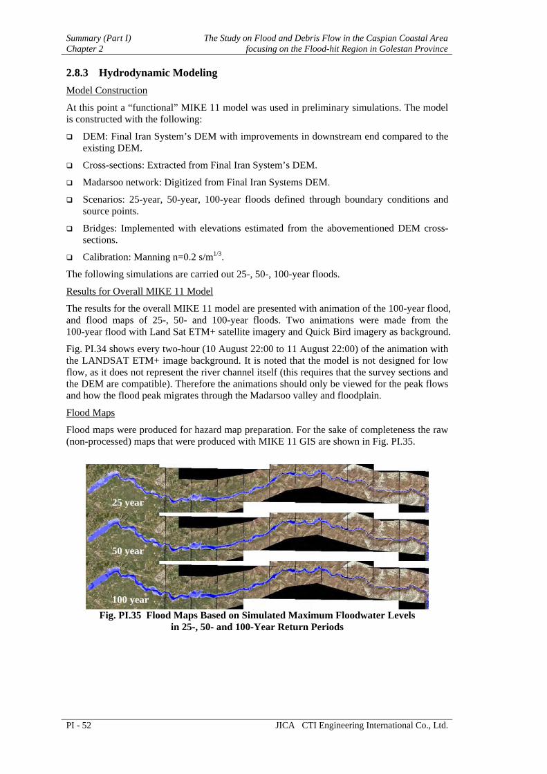
Summary (Part I) The Study on Flood and Debris Flow in the Caspian Coastal Area Chapter 2 focusing on the Flood-hit Region in Golestan Province
PI - 52 JICA CTI Engineering International Co., Ltd.
2.8.3 Hydrodynamic Modeling Model Construction
At this point a “functional” MIKE 11 model was used in preliminary simulations. The model is constructed with the following:
DEM: Final Iran System’s DEM with improvements in downstream end compared to the existing DEM.
Cross-sections: Extracted from Final Iran System’s DEM.
Madarsoo network: Digitized from Final Iran Systems DEM.
Scenarios: 25-year, 50-year, 100-year floods defined through boundary conditions and source points.
Bridges: Implemented with elevations estimated from the abovementioned DEM cross-sections.
Calibration: Manning n=0.2 s/m1/3.
The following simulations are carried out 25-, 50-, 100-year floods.
Results for Overall MIKE 11 Model
The results for the overall MIKE 11 model are presented with animation of the 100-year flood, and flood maps of 25-, 50- and 100-year floods. Two animations were made from the 100-year flood with Land Sat ETM+ satellite imagery and Quick Bird imagery as background.
Fig. PI.34 shows every two-hour (10 August 22:00 to 11 August 22:00) of the animation with the LANDSAT ETM+ image background. It is noted that the model is not designed for low flow, as it does not represent the river channel itself (this requires that the survey sections and the DEM are compatible). Therefore the animations should only be viewed for the peak flows and how the flood peak migrates through the Madarsoo valley and floodplain.
Flood Maps
Flood maps were produced for hazard map preparation. For the sake of completeness the raw (non-processed) maps that were produced with MIKE 11 GIS are shown in Fig. PI.35.
Fig. PI.35 Flood Maps Based on Simulated Maximum Floodwater Levels
in 25-, 50- and 100-Year Return Periods
25 year
50 year
100 year

The Study on Flood and Debris Flow in the Caspian Coastal Area Summary (Part I)focusing on the Flood-hit Region in Golestan Province Chapter 2
JICA CTI Engineering International Co., Ltd. PI - 53
Fig. PI.34 Flood Maps (100-Year Event) from the Animation
with the LANDSAT ETM+ Satellite Imagery
10 Aug 22:00
11 Aug 00:00
11 Aug 02:00
11 Aug 04:00
11 Aug 06:00
11 Aug 08:00
11 Aug 10:00
11 Aug 12:00
11 Aug 14:00
11 Aug 16:00
11 Aug 18:00
11 Aug 20:00
11 Aug 22:00

Summary (Part I) The Study on Flood and Debris Flow in the Caspian Coastal Area Chapter 3 focusing on the Flood-hit Region in Golestan Province
PI - 54 JICA CTI Engineering International Co., Ltd.
CHAPTER 3 FORMULATION OF MASTER PLAN
3.1 Basic Frame of Master Plan
3.1.1 Goal and Objectives In two consecutive years of 2001 and 2002, and recently the year of 2005, the severe intensive downpour occurred in the Madarsoo River basin. Triggered by torrential downpour in August 2001, visitors of the Golestan Forest as well as residents in the basin suffered severe damages from the tremendous flood and debris flow not previously experienced. After learning irreplaceable lessons in both floods, lots of improvements have been made over the disaster management fields by the relevant organizations in the Golestan Province.
The master plan for flood and debris flow mitigation and management shall cover the entire fields and shall integrate the efforts being made by the relevant organizations. Thus the master plan shall be comprehensive including entire process of disaster management: preparedness, urgent response, recovery and development, and prevention and mitigation as illustrated in Fig. PI.36.
To save people's lives
To create the river basin well-managed against flood and debris flowdisaster so as to enhance the people's living standards
Goals
To secure social, environmental andeconomic functions of natural and
social assets
Flood and debris flow disasters
Objectives
To improve basinconditions againstflood and debrisflow occurrence
To protect villages, road andrelated infrastructures, and
Golestan Forest
To protect villagersand visitors
Fig. PI.36 Goals and Objectives of the Master Plan
The Goals are:
“To create the river basin well-managed against flood and debris flow disaster so as to enhance the people’s living standards”.
It implies that only minimal and tolerable damages cloud be admitted in the basin during the design flood. In order to realize such goals, the following two objectives shall be pursued at least:
(1) To save people’s lives, and
(2) To secure social, environmental and economic functions of natural and social assets.

The Study on Flood and Debris Flow in the Caspian Coastal Area Summary (Part I)focusing on the Flood-hit Region in Golestan Province Chapter 3
JICA CTI Engineering International Co., Ltd. PI - 55
Following the goals and objectives, the master plan shall cover the wide fields in space and time and integrate the protective, remedial and improving measures against flood and debris flow.
3.1.2 Target Year and Phased Implementation As agreed in the scope of work meeting in September 2003, the target year of the Master Plan shall be set in the year 2025 (Iranian Year 1404).
3.1.3 Hydrological Design Scale With reference to required design scale in Iran, the following safety levels for flood control planning are usually adopted in accordance with basin situations:
Urban area: 50- to 100-year flood
Rural area: 25-year flood
In conformity with the standard of Iran and MOE planning, the following hydrological design scales are adopted in this master plan study.
Protecting farmlands and rural villages: 25-year flood
Protecting important structures (trunk road and bridges) and town areas: 100-year flood
3.1.4 Basic Concepts for Master Plan Configuration The master plan shall cover the wide fields, mainly focusing on from flood and debris flow occurrence to disaster breakout, in space and time. This means that various types of countermeasures shall be comprehensively combined, which are not only suitable for sub-basin’s natural conditions, climate, soil and topography but also totally preventive and curable to the process of disaster occurrences, rainfall to runoff, flood and debris flow. Fig. PI.37 illustrates this idea. Spatial extent of the basin can be broadly divided into three characterized areas. These are summarized in the following table.
Table PI.26 Comprehensive Flood and Debris Flow Mitigation and Management Components
Area Natural/Social Features Suitable and Effective Measures
Additional Effects
Headwaters Small amount of rain Source control (rain, soil) -Groundwater recharge Mild mountain slope -Land treatment -Increase of crop yields Mild declining plain -Biological measures -Increase of husbandry Rural villages -Flood retention capacity Mountain Large amount of rain Source control (rain, soil) -Protection of natural Valley Steep mountain slope -Land treatment forests and land use Narrow valley-bottom -Biological measures -Reduction of traffic Golestan Forest National -Sediment/debris control damages Park Flood control -Groundwater recharge Many visitors and campers -Bank protection Floodplains Intermediate amount of rain Flood control -Avoidance of extreme Mild or no hilly area -Bank protection damages Flat and wide terracing -Protection of infrastructure -Accumulation of Villages in upper terrace Floodplain management resident’s knowledge Granary in both terraces -Land use control -Flood hazard map Entire Basin Flood Preparedness -Continuing education -Early warning dissemination for disaster -Placement for evacuation preparedness -Training for emergency

Summary (Part I) The Study on Flood and Debris Flow in the Caspian Coastal Area Chapter 3 focusing on the Flood-hit Region in Golestan Province
PI - 56 JICA CTI Engineering International Co., Ltd.
SPATIAL EXTENT
Flood Runoff
Rainfall-Runoff Process, Soil Erosion
TEMPORAL EXTENT IN THE PROCESS OF FLOODING
FLOODPLAINSIN THE LOWER REACHES
MOUNTAIN VALLEY ANDGOLESTAN FOREST
IN THE MIDDLE REACHES
HEADWATERSIN THE UPPER REACHES
Intensive Rainfall
Watershed Management: Land Treatment, Biological Measures, etc.
Watershed Management: FloodRetention Structures, Biological
Measures, etc.
Debris Flow
Hydrological Real-Time MonitoringSystem, Early Warning and
Evacuating System
Flooding, Bank Erosion
Flood Control: Channeling, Bank Protection, etc.
Floodplain Management: Floodplain Zoning, Land Use Control, etc.
Flood Preparedness: Early Warning System, Warning Dissemination System, Training for Emergency, etc.
Sediment Control: Sabo Dams &Biological Measures etc.
Fig. PI.37 Master Plan Components to Cover Temporal and Spatial Extents
of Flood and Debris Flow Occurrence
3.1.5 Master Plan Components Based on the above discussion, the selected countermeasures, which could be arranged to cope with flood and debris flow in space and time, shall be combined for the master plan components as supporting sub-schemes. These countermeasures could be organized into master plan components considering area by area, from upper to lower reaches, for easy understanding. The following figure illustrates the master plan components to be proposed.

The Study on Flood and Debris Flow in the Caspian Coastal Area Summary (Part I)focusing on the Flood-hit Region in Golestan Province Chapter 3
JICA CTI Engineering International Co., Ltd. PI - 57
Flood and Debris Flow Mitigation andManagement Master Plan
Headwaters and Middle Reaches
Headwaters (Ghiz Ghaleh River, Dast-e-Sheikhand Gelman Darreh River Basins)
Middle Reaches (Golestan Forest)
Middle Reaches(Tangrah - Beshoily)
Middle and Lower Reaches (Tangrah - GolestanDam Entrance)
Middle and Lower Reaches (Tangrah - GolestanDam Entrance)
Entire Reaches of the Basin
Watershed Management Plan
River Restoration andImprovement Plan
Golestan Forest Park DisasterManagement Plan
Debris Flow Control Plan
Flood Control Plan
Floodplain Management Plan
Flood Preparedness Plan
Fig. PI.38 Components of Master Plan for Flood and Debris Flow Mitigation and Management
(1) Watershed Management Plan
The headwaters of Madarsoo River could be divided into four sub-basins, namely Cheshmeh Khan, Nardein-Sefid Daly-Gelman Darreh, Dast-e-Sheikh, and Ghyz Ghale from the east. In addition to these areas, the mountain and hilly areas in the middle reaches, from Dasht junction down to the end of hilly area, shall be also a target for Watershed Management Plan. The plan shall be formulated through review of watershed management master plan prepared by MOJA and mutual discussion with counterparts.
From flood control aspects, this plan contributes attenuation of runoff peak and volume and retardation of lag-time by combination of increase of infiltration capacity and increase of onsite rainfall-retention functions. Furthermore, from sediment/debris flow control aspects this plan contributes reduction of potential occurrence of debris flow due to decrease of sediment yields as source material of debris flow.
(2) River Restoration and Improvement Plan
Compared with Cheshmeh Khan, Nardein-Sefid Daly-Gelman Darreh sub-basins, Dast-e-Sheikh and Ghyz Ghale sub-basins are receiving relatively much more rainfall. In addition to the natural attribute, two dams in the Dast-e-Sheikh basin and two dams in the Ghyz Ghale basin were constructed before the 2001 Flood. During the 2001 Flood, all of the dams were breached and their water storage and flood/sediment control functions were completely lost.
In this context, some restoration plan in Dasht area is necessary so as to consolidate the stored sediment in the river channel, to control floodwater, to discharge floodwater safely through newly proposed channel system including the Gelman-Darreh River, and to increase the groundwater and sub-surface water recharge into the aquifer. This plan also needs a good coordination work with MOJA counterparts.

Summary (Part I) The Study on Flood and Debris Flow in the Caspian Coastal Area Chapter 3 focusing on the Flood-hit Region in Golestan Province
PI - 58 JICA CTI Engineering International Co., Ltd.
(3) Golestan Forest Park Disaster Management Plan
The Golestan Forest Park area is the most disastrous part in the Madarsoo River basin, as demonstrated in the 2001 Flood.
In the 2001 Flood, around 200 visitors and campers died in the park. Most of the camping sites are situated on the previous debris flow deposits due to flat topography, and usually campers and visitors enjoy its natural environment extending over 15 km long along the riverbank. In the 2001 flood, debris flow occurred in the six mountain streams in the park. Debris flow in five streams out of six attacked the camping sites. Furthermore extremely large floodflow coming from the upper stretch simultaneously swept away visitors and campers as well as natural forest alongside of the Madarsoo River course in the park.
According to geomorphological study through aerial photo interpretation, landslide-prone areas extend widely in the most tributaries’ basin in the Golestan Forest Park. These areas have potential to yield the sediment source of debris flow. Therefore it could be considered that the most tributaries have also potential to produce disastrous debris flow.
In due consideration of the above situation, Golestan Forest Park Disaster Management Plan shall contain the following improvements at least.
Early warning and evacuation plan for visitors and campers, and
Traffic safety plan during floods.
Recently the large-scale flood attacked the Golestan Forest Park again on 10 August 2005. Beforehand MET-Golestan announced flood warning as their weather forecast, and related offices such as Police and DOE shut off the connection road and drove visitors out of the Park. As a result these activities achieved no casualties being affected by the 2005 Flood in the Golestan Forest Park. This fact may show the management direction mentioned above is the most appropriate measures for the Golestan Forest Park.
(4) Debris Flow Control Plan
In the area downstream of Tangrah (entrance of the Golestan Forest Park from the lower side), there are several mountain streams with potential of debris flow occurrence. In fact, debris flow occurred in the five mountain streams in the 2001 Flood. Three residents died due to debris flow in Tergenly village at that time.
Thus debris flow control measures shall be planned in these streams in combination with the said watershed management plan. This plan also needs a good coordination work with MOJA counterparts.
(5) Flood Control Plan
Flood control, in particular bank protection in and around the housing area of villages and in immediately up and downstream stretches of bridges, shall be planned from Tangrah down to the entrance of the Golestan Reservoir. For structural designing of the bank protection and relevant structures, the design scale shall be set at 100-year flood, taking into consideration that a 50-year design flood was adopted for the urgent rehabilitation works.
This plan shall keep good conformity with the urgent rehabilitation works and the long-term flood control and road improvement plans prepared or being prepared by MOE and MORT. Therefore a good coordination work with MOE and MORT is required.

The Study on Flood and Debris Flow in the Caspian Coastal Area Summary (Part I)focusing on the Flood-hit Region in Golestan Province Chapter 3
JICA CTI Engineering International Co., Ltd. PI - 59
(6) Floodplain Management Plan
Meteo-hydrological attributes of the Madarsoo River floods are characterized as big differences between flood discharges in normal years and ones in excessive severe floods. Both of them show different order of magnitude, for instance around 20 to 100 m3/s in normal years, and 1,650 m3/s in 2001, 700 m3/s in 2002 and 1,060 m3/s in 2005 at Tangrah station.
Another topographic attribute is terracing by free meandering of the Madarsoo River course. In the floodplains, which extending in the Gorgan River basin as well as the Madarsoo River basin, villages are located on the upper terrace, while only farmlands are located on the lower terrace. Habitat segregation or selection could be traditionally made due to low population pressure. But in the lower part of the Golestan Dam, some part of Gonbad-e-Kavoos city is situated in the lower terrace, as a reference.
In due consideration of the above-mentioned two characteristics, the optimum way for flood control could be formulated with utilization of;
river channel for average flood conveyance, and
lower terrace as high-water channel for excessive flood conveyance.
In fact, existing river channel can accommodate annual maximum flood discharges of thirty-one (31) years in the recent thirty-three (33) years (since 1970 until 2002).
In order to realize the above flood control scheme, the floodplain management plan is indispensable. This plan includes;
To delineate flood hazard area, which means high-water channel area in 100-year flood,
To control land use in the flood hazard area, and
To closely link to the flood preparedness plan, in particular early warning system.
(7) Flood Preparedness Plan
Flood preparedness plan including early warning system is indispensable to mitigate the damage against flood and debris flow, from the viewpoints of saving people’s lives. The plan will contain the following sub-schemes;
Meteo-hydrological monitoring network improvement,
Early flood warning system,
Warning dissemination system, and
Training for emergency.
This plan has to keep close relationship with related plans in accordance with area characteristics, for instance;
River Restoration and Improvement Plan for Dasht area,
Golestan Forest Park Disaster Management Plan,
Debris Flow Control Plan for villages of Tangrah, Tergenly and Beshoily,
Floodplain Management Plan for the Floodplain area.
3.1.6 Socio-Economic Frame Forecast Socio-economic frame in the target year of 2025 is forecasted for the basis of the Master Plan of the Study. Population projection and future land use were already discussed as presented in Tables PI.4 and PI.7 in Section 2.2.

Summary (Part I) The Study on Flood and Debris Flow in the Caspian Coastal Area Chapter 3 focusing on the Flood-hit Region in Golestan Province
PI - 60 JICA CTI Engineering International Co., Ltd.
3.1.7 Hydrological Setup Following hydrological design scale described in Section 3.1.3, design floods are computed in a series of hydrological analysis as presented in 2.4.
Provable Design Floods without Projects
Spatial and temporal distribution patterns of rainfall are derived from five historical large floods; namely 1988, 1992, 2001, 2002 and 2005 Floods. The design flood hydrographs of five flood patterns at Tangrah in 25-, 50-, and 100-year return period are presented below.
0
200
400
600
800
1000
1200
1400
Day
Dis
char
ge (m
3/s
)
1988 Flood Type
1992 Flood Type2001 Flood Type
2002 Flood Type
2005 Flood Type
tt - 1t - 2 t + 1 t + 2
0
200
400
600
800
1000
1200
1400
1600
1800
2000
Day
Dis
char
ge (m
3/s
)
1988 Flood Type
1992 Flood Type2001 Flood Type
2002 Flood Type
2005 Flood Type
tt - 1t - 2 t + 1 t + 2
0
250
500
750
1000
1250
1500
1750
2000
2250
2500
Day
Dis
char
ge (m
3/s
)
1988 Flood Type
1992 Flood Type2001 Flood Type
2002 Flood Type
2005 Flood Type
tt - 1t - 2 t + 1 t + 20
200
400
600
800
1000
1200
1400
Day
Dis
char
ge (m
3/s
)
1988 Flood Type
1992 Flood Type2001 Flood Type
2002 Flood Type
2005 Flood Type
tt - 1t - 2 t + 1 t + 2
0
200
400
600
800
1000
1200
1400
1600
1800
2000
Day
Dis
char
ge (m
3/s
)
1988 Flood Type
1992 Flood Type2001 Flood Type
2002 Flood Type
2005 Flood Type
tt - 1t - 2 t + 1 t + 2
0
250
500
750
1000
1250
1500
1750
2000
2250
2500
Day
Dis
char
ge (m
3/s
)
1988 Flood Type
1992 Flood Type2001 Flood Type
2002 Flood Type
2005 Flood Type
tt - 1t - 2 t + 1 t + 2
Fig. PI.39 Probable Flood Hydrographs at Tangrah in 25-, 50- and 100-Year Return
Periods (from left to right)
Among five flood patters, peak flows generated with the 2001 flood type rainfalls are highest at all points along the mainstream. However, the peak discharge of 2001 flood type as presented in Fig. PI.39 is deemed to be too sharp and large. Further the 1988 flood type as the next largest discharge has not enough rainfall records. Therefore, it is suggested to select the 2005 flood type as a design flood for the flood control master plan development. In addition, rainfall records of hourly rainfall as well as daily rainfall were observed only in the 2005 Flood.
As a result, the design flood distributing over the Madarsoo River basin is illustrated below, including 50-year flood. These flood discharges are utilized as design discharge without projects after rounding up.

The Study on Flood and Debris Flow in the Caspian Coastal Area Summary (Part I)focusing on the Flood-hit Region in Golestan Province Chapter 3
JICA CTI Engineering International Co., Ltd. PI - 61
25-Year Flood Discharge
50-Year Flood Discharge
100-Year Flood Discharge
Fig. PI.40 Probable Discharge Distribution without Projects over the Madarsoo River Basin (2005 Flood Pattern)
Provable Design Floods with Watershed Management
The impact of watershed management practices like terracing, banqueting and furrow constructions and saplings plantation are analyzed. For this, area coverage of planned watershed management project in different sub-basins was collected (Table. PI.26). Coverage of the planned watershed management project was input in MIKE SHE hydrological model. Model parameters were adjusted accordingly for the areas and then generated flows in river system of basin. Manning’s roughness coefficient, detention storage, infiltration rate, etc. were adjusted in the model for planned watershed management project areas to generate river flows for 25-, 50- and 100-year return periods.

Summary (Part I) The Study on Flood and Debris Flow in the Caspian Coastal Area Chapter 3 focusing on the Flood-hit Region in Golestan Province
PI - 62 JICA CTI Engineering International Co., Ltd.
Table PI.27 Coverage of Planned Watershed Management Projects Item Dasht-e-Shiekh Ghyz Ghale Tangrah Chesmeh Khan
Terracing (Ha) 120 125 200Banquet (Ha) 1360 180 1740 145Furrow (Ha) 2850 2650Plantation (Ha) 25 150
Results show considerable impact of planned watershed management project in peak river flow as illustrated in the following figure. These results will be used for river restoration and improvement plan as basic design data.
25-Year Flood Discharge
50-Year Flood Discharge
100-Year Flood Discharge
Fig. PI.41 Probable Discharge Distribution with Watershed Management Project over the Madarsoo River Basin (2005 Flood Pattern)

The Study on Flood and Debris Flow in the Caspian Coastal Area Summary (Part I)focusing on the Flood-hit Region in Golestan Province Chapter 3
JICA CTI Engineering International Co., Ltd. PI - 63
3.2 Watershed Management Plan
3.2.1 Management Policy for Madarsoo Watershed Background of Implementation Plan
After the 2001 and 2002 Floods, MOJA dispatched the experts to the Gorgan River basin to investigate the disaster condition and arranged the issue of the rehabilitation and prevention of the Gorgan River basin. In response to the result of investigation, MOJA formulated watershed management plan to the Madarsoo River basin, which was seriously damaged in the 2001 Flood over the Gorgan River basin, under flood control committee.
In the Madarsoo River basin, MOJA selected the 5 sub-basins at the viewpoint of runoff, soil erosion, damage and so on, and MOJA formulated the implementation plan in these sub-basins as illustrated in Fig. PI.42. The position of the watershed management plan is one of the components of the master plan for flood and debris flow mitigation and management.
Fig. PI.42 Locations and Countermeasures Planned
in the MOJA Mid-Team Watershed Management Plan
Purpose and Strategy
From implementation plan in different sub-basins the purpose and strategy of implementation plan arranged is summarized as follows.
Table PI.28 Planning Purposes and Strategies of Watershed Management Purpose of Planning Strategy of Planning
Increasing infiltration rate & decreasing runoff Increasing the vegetation cover in range land &
forest areas Decreasing peak discharge of floods Soil conservation Improvement of life condition of people &
increasing their income
Flood control and decreasing flood damage Sediment and soil erosion control

Summary (Part I) The Study on Flood and Debris Flow in the Caspian Coastal Area Chapter 3 focusing on the Flood-hit Region in Golestan Province
PI - 64 JICA CTI Engineering International Co., Ltd.
The implementation plan have planned and designed to bring the maximum effects of proposition based on the watershed management policy. Typical watershed management activities are classified into the following five (4) types:
Mechanical engineering: Gabion dam, masonry dam, earth dam and river engineering works
Bio-mechanical engineering: Terracing, banquette and furrow
Biological engineering: Changing dry farming, strip cropping, fertilizing in range land, seeding in range land, mass seeding, planting, and tending forest and planting tree in the forest area
Protective activities: Enforcement of closures and maintenance, expelling sheep from forest area, and training and extension
3.2.2 Middle-Term Watershed Management Plan Watershed management plan should be implemented in nine years. The project size in each sub-basin is tabulated as follows:
Table PI.29 Summary of Planned Mechanical Measures in the Selected Sub-basins Counter
Measures Dasht-e-Sheikh Ghiz Ghaleh Tangrah Loveh Cheshmae
Kahn Earth dam 7N: Storage=
2.8x10⁶ m3 18N: Storage= 2.8x10⁶ m3
5N: Storage= 0.7 x10⁶ m3
Gabion dam 36N: 3,249 m3 49N: 2,213 m3 42N: 2,728 m3 21N: 954 m3 21N: 1,330 m3 Masonry dam
35N: 24,105 m3 25N: 38,659 m3 9N: 5,700 m3 6N: 2,595 m3 36N: 1,276 m3
River engineering
900 m
Table PI.30 Summary of Planned Bio-mechanical and Biological Measures
in the Selected Sub-basins Counter
Measures Dasht-e-Sheikh
Ghiz Ghaleh Tangrah Loveh Cheshmae Kahn
Terracing 120 ha 125 ha 200 ha Banquette 1,360 ha 180 ha 1,740 ha 145 ha Furrow 2,850 ha 2,650 ha Changing dry farming 140 ha 500 ha 300 ha Supporting drinking water for sheep
32 N 9 N 10 N
Fertilizing in rangeland
6,000 ha 2,700 ha
Seeding in rangeland 4,200 ha 2,700 ha Mass seeding 240 ha 70 ha 180 ha 2,939 ha Planting 4,104 ha 380 ha 180 ha 2,630 ha Tending forest 60 ha 767 ha Cleaning (forest) 30 ha 42 ha Seeding (forest) 60 ha 35 ha Planting (forest) 25 ha 150 ha

The Study on Flood and Debris Flow in the Caspian Coastal Area Summary (Part I)focusing on the Flood-hit Region in Golestan Province Chapter 3
JICA CTI Engineering International Co., Ltd. PI - 65
Table PI.31 Summary of Planned Protective Activities in the Selected Sub-basins Counter Measure
Dasht-e-Sheikh
Ghiz Ghaleh Tangrah Loveh Cheshmae Kahn
Training and extension
Farmers, range-men
1,000 person 1,200 person
1,250 person
Enforcement of closures and maintenance
Implementation project area
85 ha of forest
4, 350 ha 9,418 ha
Fence in forest 28 km 15 km Building a channel 2 km 6 km Improving forest roads
28 km
Existing sheep from forest area
6, 000 head
3.2.3 Project Cost and Implementation Program The project cost in each sub-basin is shown as follows. Total cost of the implementation plan is 79,374 million Rial.
Table PI.32 Project Cost by Sub-basin
Year Dasht-e- Sheik
Cheshmae Khan
Ghiz-ghaleh Tangrah Loveh Total
1 10,110.7 349.4 8,373.1 9,621.7 1,114.5 29,569.42 3,459.6 804.4 4,767.5 1,592.5 62.5 10,686.53 3,151.7 445.3 7,338.2 1,077.2 62.5 12,074.94 3,848.3 845.7 3,000.8 1,215.5 62.5 08,972.85 5,121.1 575.3 3,222.5 1,557.2 62.5 10,538.66 2,717.0 372.2 - 1,050.5 - 4,139.77 180.2 465.0 - 888.0 - 1,533.28 180.2 323.3 - 1,160.0 - 1,663.59 - 194.9 - - - 194.9
Total 28,768.8 4,375.5 26,702.1 18.162.6 1,364.5 79,373.5unit: million Rial
3.2.4 Evaluation of Countermeasures and Recommendations On the basis of the field survey and discussion with counterparts, the following improvement points are proposed mainly on biological measures and operational activities in the implementation plan.
Terracing
The terracing in the dry farming is not so popular to the villagers. The reasons are (1) lack of the knowledge, (2) lack of the visit to the village by the extension worker (trainer), and (3) conservative and respect to their own experiences (Villagers believe that conventional method is cheaper than the terracing method.).
To cope with those issues, the following improvements are recommended.
(1) Perennial crop planting, like a fodder tree, on the slope between each terracing for the agriculture income and protection of the runoff and soil erosion.
(2) Coordination with agriculture extension worker (trainer) to introduce the terracing to the villagers.

Summary (Part I) The Study on Flood and Debris Flow in the Caspian Coastal Area Chapter 3 focusing on the Flood-hit Region in Golestan Province
PI - 66 JICA CTI Engineering International Co., Ltd.
Banquette
Gully erosion in the banquette occurred in the Dasht-e-Sheikh sub-basin. The gully erosion seems to be caused by improper designing and lack of maintenance works. To cope with those issues, the following improvements are recommended.
(1) Checking of storage capacity: The rainfall shall be estimated before design and the banquette shall be divided into several parts along the contour line to avoid the water concentration.
(2) Appropriate density of banquette: The banquette will be constructed according to the topography and inclination. It is also important to care the topographic conditions for design of the banquette on the upper part of the slope.
Encouragement of the Closure and Maintenance
In the north west region of Iran the natural regeneration is the element of forest management. But it is difficult to regenerate and to maintain the forest by the overgrazing, farming and illegal cutting. Finally poor vegetation cover accelerates soil erosion. To cope with those issues, the following improvements are recommended.
(1) Delegation of forest maintenance: The delegation shall conclude between NRGO and villagers to maintain the forest such as patrol in the surrounding forest, tending the forest (weeding, pruning). It is considered appropriate that NRGO gives the villagers land use right to get the incentive like a fuel woods in the forest.
(2) Cooperation with the villagers: Through the extension and training activities, it needs to understand the forest function, especially water discharge and runoff. It is important to show the management system to the villagers.
Sustainable Forest Management
From the recent trend of forest production in Iran forest production has been decreasing to protect the forest as the natural resources, biodiversity, water conservation, etc. To cope with those issues, the following improvements are recommended.
(1) Establishment of the goal for sustainable use: The goal of the forest management needs to shift from the forest production to the water and soil conservation by appropriate zoning.
(2) Density control for selecting cutting: NRGO has tried to introduce selective cutting system as new forest management system in Loveh forest management unit. The model project needs to establish the regeneration method, the logging method and cutting method for density control at the viewpoint of water and soil conservation.
Extension and Training
Villagers attended the training course by MOJA, but they still have not understood the watershed management. To cope with those issues, the following improvements are recommended.
(1) Problem analysis in each sub-basin: Problem analysis is one of the methods to clarify the problems of the villagers about water resources management, soil conservation and living conditions by using PRA (Participatory Rural Appraisal) method. At the same time necessary training shall be conducted to the villagers.
(2) Cooperation with agriculture extension workers: Agriculture extension workers shall always contact to the villagers to improve their living conditions. Watershed management office needs to establish the good relationship with agriculture extension workers.

The Study on Flood and Debris Flow in the Caspian Coastal Area Summary (Part I)focusing on the Flood-hit Region in Golestan Province Chapter 3
JICA CTI Engineering International Co., Ltd. PI - 67
Coordination with Other Agency
The implementation plan belongs to the three provinces, Golestan, North Khorasan and Semnan. Even MOJA staff in different provinces does not know another MOJA’s activities of the watershed management in the same sub-basin. To cope with those issues, the following improvements are recommended.
(1) Solution by Flood Control Committee: Flood Control Committee has been established after the flood disaster in 2001 and 2002. This committee member consists of MOJA, NRGO, DOE, MORT, MOE, etc. in the provincial level. The chairman of this committee is from MOJA in Golestan. Flood Control Committee should coordinate other related agencies on implementation plan, monitoring and evaluation of progress of the project.
(2) Good communication for conservation activities: MOJA discussed with DOE in Semnan province to construct check dams in the protected area, and it took time to receive the permission. Originally the check dam has controlled the sedimentation from the upper part of the protected area. Thus DOE shall request MOJA to construct the check dams to the other sub-basins in the protected area.
3.3 River Restoration and Improvement Plan
3.3.1 Issues to be Addressed Three large streams join in the flat topography of Dasht area. These are Gelman Darreh with a drainage area of 787 km2, Dasht-e-Sheikh with 125 km2, and Ghyz Ghaleh with 126 km2. In the 2001 Flood, three disastrous events occurred in the Dasht area.
(1) Swollen floodwater along the Ghyz Ghaleh breached an earth dam located at 4 km upstream of Dasht village, and floodwater convolving stored sediment by the dam rushed towards the village area. After the 2001 Flood polder dike was constructed to protect the village from the direct hitting of floodflow.
(2) Larger and long-lasting floodflow came from the Gelman Darreh, and it washed away crops and fruit trees in the valley-bottom plain of Dasht area.
(3) The rapid hydraulic change by damming up and its sudden collapse might induce serious channel scouring and bank erosion along the river course, and valley-head erosion around the upper end of water temporarily impounded area.
In due consideration of the above mentioned situations during floods, the following three issues shall be addressed in the river restoration and improvement plan so that the Dasht village becomes safer and its agriculture-based economy becomes more productive.
(1) Sediment consolidation in the Ghyz Ghaleh River
(2) Flood control of channel network
(3) Erosion Control
3.3.2 River Restoration and Improvement Plan The proposed river restoration plan aims to protect the human life and private properties, and public infrastructures in and around Dasht village from the flood and/or sediment flow damages under the design scale of 25-year return period as tabulated below.

Summary (Part I) The Study on Flood and Debris Flow in the Caspian Coastal Area Chapter 3 focusing on the Flood-hit Region in Golestan Province
PI - 68 JICA CTI Engineering International Co., Ltd.
Table PI.33 25-Year Design Flood Discharge unit: m3/s
River Design Discharge Remarks Gelman Darreh 430 Dasht-e-Sheikh 90 Ghyz Ghaleh 160 Madarsoo 660 After confluence of the above three rivers
The proposed plan contains the main countermeasures to enlarge the flow capacity and to strengthen channel bed stability and bank protection of the existing rivers against a probable flood.
The subject area is composed of the related three river systems; namely Gelman Darreh- Madarsoo River, Dasht-e-Sheikh River and Ghiz Ghaleh River. The proposed river system arrangement based on the probable flood of 25-year return period is shown in Fig. PI.43 and the features of improvement of the related river system are described as follows:
Gelman Darreh-Madarsoo River
The proposed river improvement stretch of the Gelman Darreh including the Madarsoo River is from the confluence with the Cheshmeh Khan River to about 6.5 km upstream of the Gelman Darreh in accordance with the existing agricultural road crossing the river.
As regards the erosion control in the valley-head, the channel works is proposed to preserve the appropriate sediment conveyance from the headwater area for the downstream riverbed maintenance. If the sediment conveyance to the downstream of the river is limited with the storage capacity of a gully control dam or erosion control dam, it will be predicted that the downstream riverbed is degraded further by floodwater and the riparian structures along the Madarsoo River are damaged due to the loss of the foundation stability.
The improvement of the Gelman Darreh-Madarsoo River is mainly proposed to enlarge the channel width for the range from 64.0 m to 46.2 m and design high water level in the middle and upper reaches is set in accordance with the existing ground level as much as possible. The proposed channel alignment follows the existing stream alignment because the existing channel is located on the lower part comparatively in the Gelman Darreh floodplain and it is assumed to collect the floodwater easily over the subject area. Fig. PI.44 shows the proposed typical cross section and revetment works of the Gelman Darreh-Madarsoo River.
Dasht-e-Sheikh River
The proposed river improvement stretch of the Dasht-e-Sheikh River is located in the surrounding Dasht village farmlands for the distance of about 5.1 km to protect the farmlands from flood inundation due to Dasht-e-Sheikh River.
The improvement plan is mainly proposed to enlarge the channel width for the range from 58.2 m to 21.7 m and design high water level of the improvement stream is set in accordance with the existing ground level of the farmlands because the existing river shape of the Dasht-e-Sheikh River has been disappeared and when the new channel is planned in the torrential stream, the excavated channel is recommended by taking into account a reliability of flood control and an easy maintenance. Fig. PI.45 shows the proposed typical cross section of the Dasht-e-Sheikh River, while the proposed revetment is the same type as presented in Fig. PI.44 for the Gelman Darreh-Madarsoo River.
On the proposed plan, the huge excavated material (V= approx. 4.0 million m3) may appear after the project implementation. The removal of surplus soil is recommended to reclaim in the immediately southern part of the proposed Dasht-e-Sheikh River because the area, which is spread for about 110 ha, has been devastated due to previous floods and there is a possibility of the development as new agricultural lands to increase the income for the Dasht villagers.

The Study on Flood and Debris Flow in the Caspian Coastal Area Summary (Part I)focusing on the Flood-hit Region in Golestan Province Chapter 3
JICA CTI Engineering International Co., Ltd. PI - 69
Ghiz Ghaleh River
Floodflow in the Ghiz Ghaleh River has directly attacked the Dasht village, frequently. The floods have sometimes caused the serious damages in human life and farmlands.
To prevent the damages caused by the flood and/or sediment flow in the Dasht village, the flood and sediment flow control facilities composed of the two structural measures are planned in the Ghiz Ghaleh River. The said two structural measures are diversion channel for the Ghiz Ghaleh River and sediment control dam. The arrangement of the proposed flood and sediment control facilities is shown in Fig. PI.46 and the design concept for the structures are mentioned below.
(1) Proposed Diversion Channel
The proposed diversion channel aims to prevent the flood flow from spreading directly toward the Dasht village. The diversion channel is recommended that the watercourse of the Ghyz Ghaleh River is diverted to the southwest Dasht farmlands and the channel is connected to the proposed Dasht-e-Sheikh River in order to ensure the appropriate drainage channel system. Design discharge for proposed channel is adopted for 160 m3/s under the design scale.
The control point of proposed diversion channel can be set on the existing excavated channel in the existing NRGO plantation, which is located at the right bank of 1.5 km downstream from the existing breached earth dam since the end of the existing channel has the natural diversion weir and it is possible that the floodwater run down to the Dasht-e-Sheikh River straight.
(2) Proposed Sediment Control Dam
The proposed sediment control dam is planned to rehabilitate a function of the existing earth dam, which has been breached by the 2001 Flood and to retain the sediment deposits of the existing earth dam at the original position in order to protect the Dasht village and its farmlands from the eroded sediment deposits.
The design scale of its spillway is provided with a 100-year return period and design invert elevation of its spillway (same as proposed dam height) is considered with the surface elevation of existing sediment deposits in the upstream. The typical section of the proposed sediment control dam is shown in Fig. PI.47.

Summary (Part I) The Study on Flood and Debris Flow in the Caspian Coastal Area Chapter 3 focusing on the Flood-hit Region in Golestan Province
PI - 70 JICA CTI Engineering International Co., Ltd.
Fig. PI.43 Proposed Arrangement of River Restoration and Improvement Plan

The Study on Flood and Debris Flow in the Caspian Coastal Area Summary (Part I)focusing on the Flood-hit Region in Golestan Province Chapter 3
JICA CTI Engineering International Co., Ltd. PI - 71
Fig. PI.44 Proposed Typical Cross Sections and Revetment
of the Gelman Darreh-Madarsoo River

Summary (Part I) The Study on Flood and Debris Flow in the Caspian Coastal Area Chapter 3 focusing on the Flood-hit Region in Golestan Province
PI - 72 JICA CTI Engineering International Co., Ltd.
Fig. PI.45 Proposed Typical Cross Sections of the Dasht-e-Sheikh River

The Study on Flood and Debris Flow in the Caspian Coastal Area Summary (Part I)focusing on the Flood-hit Region in Golestan Province Chapter 3
JICA CTI Engineering International Co., Ltd. PI - 73
Fig. PI.46 Proposed Arrangement of Sediment Control Dam Facilities
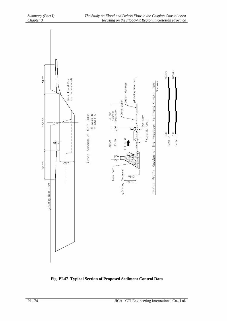
Summary (Part I) The Study on Flood and Debris Flow in the Caspian Coastal Area Chapter 3 focusing on the Flood-hit Region in Golestan Province
PI - 74 JICA CTI Engineering International Co., Ltd.
Fig. PI.47 Typical Section of Proposed Sediment Control Dam

The Study on Flood and Debris Flow in the Caspian Coastal Area Summary (Part I)focusing on the Flood-hit Region in Golestan Province Chapter 3
JICA CTI Engineering International Co., Ltd. PI - 75
3.3.3 Project Cost and Implementation Program Project Cost
The construction cost for the river restoration and improvement plan is estimated at 253.2 billion Rials (equivalent to 28.2 million US$). The summary of the project cost for the channel improvement of Gelman Darreh- Dasht-e-Sheikh Rivers and Ghiz Ghaleh River is shown as follows:
Table PI.34(1) Summary of the Project Cost Estimate (Gelman Darreh- Dasht-e-Sheikh River)
Quantity UnitAmount
(1,000 Rials)I. Construction Base Cost 138,453,000
1. Preparatory Works 1 l.s. 12,587,0002. Channel Works 1 l.s. 125,866,000
II. Land Acquisition Cost 3,442,000III. Administration Cost 1 l.s. 6,923,000
(5% of Item I)IV. Engineering Cost 1 l.s. 13,846,000
(10% of Item I)V. Physical Contingency 1 l.s. 32,533,000
(20% of Item I + II + III + IV)VI. Total 195,197,000
Round Total 195,200,000in accordance with (as of August 2005)
Work Item
US$21,699,000
Table PI.34(2) Summary of the Project Cost Estimate (Ghiz Ghaleh River)
Quantity UnitAmount
(1,000 Rials)I. Construction Base Cost 40,500,000
1. Preparation Works 1 l.s. 3,682,0002. Diversion Channel Works 1 l.s. 20,170,0003. Sediment Control Dam Works 1 l.s. 16,648,000
II. Land Acquisition Cost 0III. Administration Cost 1 l.s. 2,025,000
(5% of Item I)IV. Engineering Cost 1 l.s. 4,050,000
(10% of Item I)V. Physical Contingency 1 l.s. 9,315,000
(20% of Item I + II + III + IV)VI. Total 55,890,000
Round Total 55,890,000in accordance with (as of August 2005) US$6,213,000
Work Item
Implementation Program
The breached earth dam in the Ghiz Ghaleh stored an enormous volume of sediment in its upstream basin. If large-scale floods occur, erode stored sediment, and transport it towards the Dasht village, the village had to suffer not only floodwater inundation but also sediment deposits in the town area simultaneously. Thus the existing breached dam and stored sediment could be the most serious disaster-causing factor to the village.
In this context, the first priority should be given to construction of sediment control dam in the Ghiz Galeh River. Following this project, river improvement in three rivers should be conducted continuously. Considering the sequence of the works and their realistic work volume, the following implementation program could be proposed.

Summary (Part I) The Study on Flood and Debris Flow in the Caspian Coastal Area Chapter 3 focusing on the Flood-hit Region in Golestan Province
PI - 76 JICA CTI Engineering International Co., Ltd.
Table PI.35 Implementation Program of River Restoration and Improvement Plan Year Sediment Control Dams River Improvement 1st Detailed Design 2nd Construction (4 years) 3rd 4th 5th Detailed Design 6th Construction (5 years) 7th 8th 9th 10th
3.4 Golestan Forest Park Disaster Management Plan
3.4.1 Issues to be Addressed In the 2001 Flood, around 200 visitors and campers died in the park. Most of the camping sites are situated on the previous debris flow deposits due to flat topography, and usually campers and visitors enjoy its natural environment extending over 15 km along the riverbank. In the 2001 flood, debris flow occurred in the six mountain streams in the park. Debris flow in five streams out of six attacked the camping sites. Furthermore extremely large floodflow coming from the upper stretch simultaneously swept away visitors and campers as well as natural forest alongside of the Madarsoo River course in the park. Thus the Golestan Forest Park area is the most disastrous part in the Madarsoo River basin as demonstrated in the 2001 Flood.
Recently the large-scale flood attacked the Golestan Forest Park again on 10 August 2005. Beforehand MET-Golestan announced flood warning as their weather forecast on 8 August, and Traffic Police shut off the connection road and drove visitors out of the Park in the afternoon on 9 August. As a result these activities achieved no casualties being affected by the 2005 Flood in the Golestan Forest Park.
Issues on the total flood forecasting and warning system could be broadly categorized into three items through carefully reviewing the activities during the 2005 Flood and the existing hydro-meteorological monitoring system.
(1) Improvement on Meteo-Hydrological Data Collection System
Existing meteo-hydrological data monitoring and collection system has various issues, if those systems are utilized for flood forecasting and warning system in the Madarsoo River basin.
(2) Establishment of Responsible Organization for Flood Forecasting and Warning
There is no data exchange between MET and MOE. Furthermore there is no responsible organization to integrate meteo-hydrological data, to analyze those data, to determine an announcement of flood warning, and to strongly support the decision making by the Provincial Disaster Management Committee (PDMC). Such responsible organization is necessary as a Center of Flood Forecasting and Warning System.
(3) Improvement of Smooth and Efficient Emergency Activities for Evacuation
So far weather bulletin issued by MET is only a basis for initial action of emergency activities against flood disaster. The weather bulletin gives global weather information and no precise rainfall data. As a result, hitting ratio of the forecast is rather low. In the 2005 Flood, it was proven that emergency activities to evacuate people from the Golestan Forest Park area were very effective. It might be great

The Study on Flood and Debris Flow in the Caspian Coastal Area Summary (Part I)focusing on the Flood-hit Region in Golestan Province Chapter 3
JICA CTI Engineering International Co., Ltd. PI - 77
learning effects from the disastrous 2001 Flood. Therefore improving hitting ration of the forecast shall be a succeeding target to create the safer region against the flood disaster.
3.4.2 Disaster Management Plan Flood Forecasting and Warning Improvement Concept
Regarding the existing flood information system, MET shall continue to issue weather bulletin and flood notice. In addition, the Flood Forecasting and Warning System (FFWS) shall be established utilizing existing equipment and facilities as much as possible. MET will observe rainfall through existing and additional rain gauge station, and the data shall transfer to the FFWS center by digital telephone network. MOE will also observe own gauges through existing and additional rain gauges and water level stations.
The FFWS center shall be established at PDMC as requested in the Technical Committee Meeting in March 2006. The FFWS center will perform integrating data processing and data editing in a form of flood forecasting and warning information. The related agencies can access to FFWS Web server to obtain the latest flood information on graphic and table basis.
The PDMC is also responsible for announcing warning and evacuation order to concerning agencies as well as municipality within the Madarsoo River basin through the telephone or facsimile. Each municipality officers where flood-warning posts will be equipped are responsible to operate flood-warning equipment by manual operation. Warning for visitors and campers in the Golestan Forest National Park shall be made in the same manner of present flood-warning method that the police shall close the entrance of both sides of road and the patrol car shall call attention to the visitors and campers for evacuation to outside of the park. The concept of the total system is illustrated in Fig. PI.48.
At present in PDMC, there are no meteorologists and hydrologists to analyze meteo-hydrological data and to set the threshold level of rainfall and water level. Therefore, if the FFWS center is established in PDMC, reinforcement of human power is crucially necessary.
ONLINE RAINFALL OBSERVATION
ONLINE RAINFALL & WATER LEVEL OBSERVATION
METEOROLOGICAL OFFICE GOLESTAN
GENERAL GOVERNOR, GOLESTAN
PROVINCE DISASTER MANAGEMENT CENTER
RESIDENTS IN MADARSOO RIVER BASIN
PASSENGER FOR GOLESTAN NATIONAL
PARK
PROMPT AND SAFE EVACUATION to protect lives and properties
OFFICE OF ROAD & TRANSPORT, RED CRESCENT, POLICE, MASS MEDIA AND NECESSARY AGENCIES
FLOOD WARNING
POST
FLOOD WARNING
POSTPATROL AND GUIDE FOR
EVACUATION
PATROL AND GUIDE FOR
EVACUATIONANNOUNCEMENTSIREN
ANNOUNCEMENTSIREN
WEATHER INFORMATION
MUNICIPALITY OFFICE
MUNICIPALITY OFFICE
TELEPHONE/FAXTELEPHONE/FAX
DATA COLLECTION SUBSYSTEM
DATA PROCESSING SUBSYSTEM
FLOOD WARNING SUBSYSTEM
DATA COLLECTION SUBSYSTEM
FFWS Center
Weather Information Flood Warning Information
MOE GOLESTAN
Fig. PI.48 Required Flood Information Flow
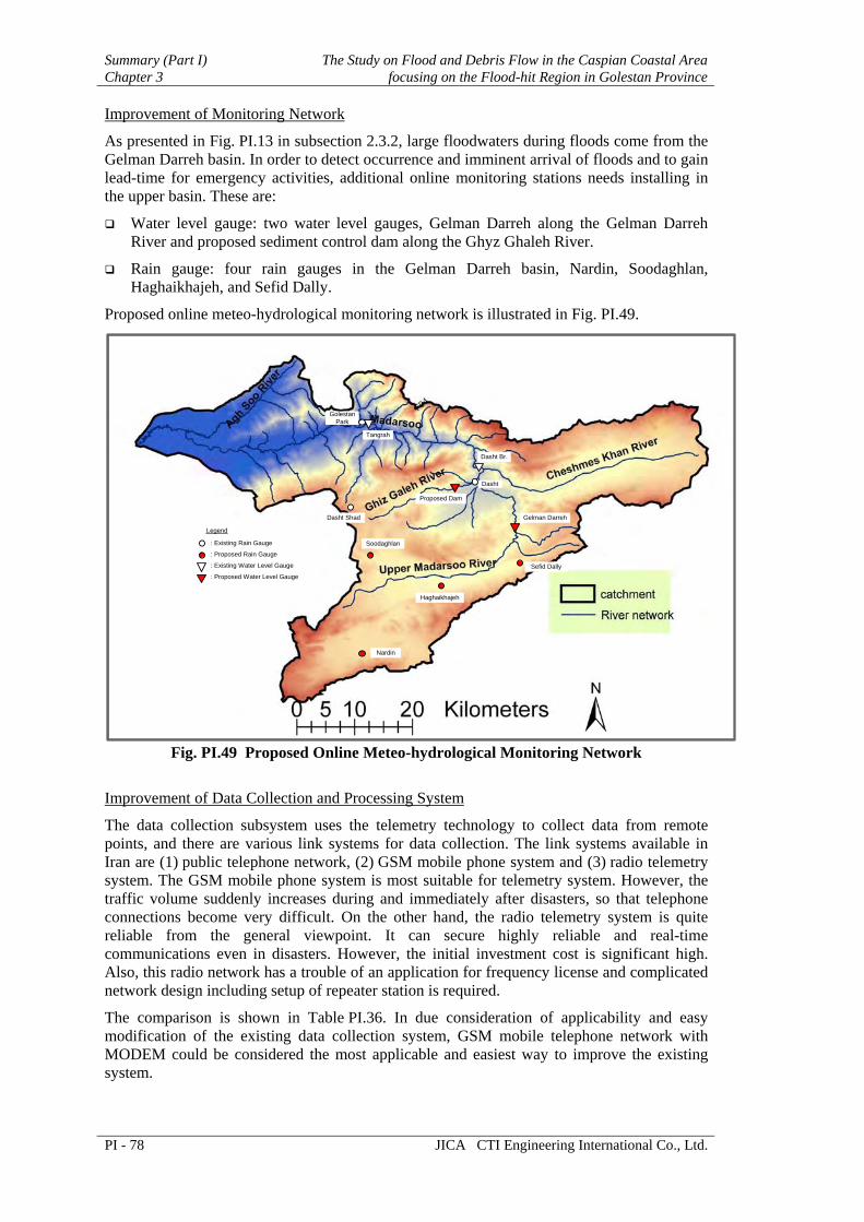
Summary (Part I) The Study on Flood and Debris Flow in the Caspian Coastal Area Chapter 3 focusing on the Flood-hit Region in Golestan Province
PI - 78 JICA CTI Engineering International Co., Ltd.
Improvement of Monitoring Network
As presented in Fig. PI.13 in subsection 2.3.2, large floodwaters during floods come from the Gelman Darreh basin. In order to detect occurrence and imminent arrival of floods and to gain lead-time for emergency activities, additional online monitoring stations needs installing in the upper basin. These are:
Water level gauge: two water level gauges, Gelman Darreh along the Gelman Darreh River and proposed sediment control dam along the Ghyz Ghaleh River.
Rain gauge: four rain gauges in the Gelman Darreh basin, Nardin, Soodaghlan, Haghaikhajeh, and Sefid Dally.
Proposed online meteo-hydrological monitoring network is illustrated in Fig. PI.49.
GolestanPark
Tangrah
Dasht Br.
Dasht
Proposed Dam
Dasht Shad
Soodaghlan
Nardin
Haghaikhajeh
Sefid Dally
Gelman Darreh
Legend
: Existing Rain Gauge
: Proposed Rain Gauge
: Existing Water Level Gauge
: Proposed Water Level Gauge
Fig. PI.49 Proposed Online Meteo-hydrological Monitoring Network
Improvement of Data Collection and Processing System
The data collection subsystem uses the telemetry technology to collect data from remote points, and there are various link systems for data collection. The link systems available in Iran are (1) public telephone network, (2) GSM mobile phone system and (3) radio telemetry system. The GSM mobile phone system is most suitable for telemetry system. However, the traffic volume suddenly increases during and immediately after disasters, so that telephone connections become very difficult. On the other hand, the radio telemetry system is quite reliable from the general viewpoint. It can secure highly reliable and real-time communications even in disasters. However, the initial investment cost is significant high. Also, this radio network has a trouble of an application for frequency license and complicated network design including setup of repeater station is required.
The comparison is shown in Table PI.36. In due consideration of applicability and easy modification of the existing data collection system, GSM mobile telephone network with MODEM could be considered the most applicable and easiest way to improve the existing system.

The Study on Flood and Debris Flow in the Caspian Coastal Area Summary (Part I)focusing on the Flood-hit Region in Golestan Province Chapter 3
JICA CTI Engineering International Co., Ltd. PI - 79
Table PI.36 Summary of Network Comparison Transmission Method Advantage Disadvantage Dial-up Telephone Line
Easy installation by user side No own maintenance work
Low transmission speed Taking long time for restoration
in trouble Monthly payment of due for
subscription. Dedicated Exclusive Telephone Line
Continuous obtaining online data from the observation station
High line quality and reliability
Higher telephone subscription Taking long time for restoration
in trouble
GSM MODEM Easy installation by user side. No own maintenance work
Working within GSM service coverage
Monthly payment of due for subscription
No connection during traffic congestion time such as floods
VHF/UHF Radio Link
Continuous obtaining online data from the observation station
Stable and reliable data transmission
No communication charge
Complicated process for frequency application
High installation cost including repeater station
Necessity of own maintenance work
Regarding data processing and transmission system, the system will use existing data processing software to add some improvement. For the data transmission system that is feasible in Iran, the digital telephone network such as ISDN and ADSL are available. In considering present situation and cost, ADSL or ISDN line will be used for the connection among the related offices, PDMC-FFWSC, MET, MOE and so on. Layout plan of Data processing and monitoring system is presented in the following figure.
UPS
Plasma Display
Distributor
Data Display Control Unit
UPS
UPS
HUB
Laser Printer
Dial up RouterGSM MODEM
UPS
Plasma Display
Distributor
Data Display Control Unit
UPS
UPS
HUB
Laser Printer
Dial up Router GSM MODEM
Metorological Office Golestan MOE Golestan Office
Online-Real time Data Collection
Online data Collection PC
Online data Collection PC
Provincial Disaster Management Center
UPS
Plasma Display
Distributor
Data Display Control Unit
UPS
UPS
HUB
Laser Printer
Dial up Router
UPS
HUB
Inkjet Printer
Dial up Router
DIGITAL NETWORK
Flood Monitor PC
Flood Monitor PC
FLOOD MONITORING STATION
Police, Red Crescent, DOE, MORT and MOJA
Web Server UPS
Fig. PI.50 Layout Plan of Data Processing and Transmission Network

Summary (Part I) The Study on Flood and Debris Flow in the Caspian Coastal Area Chapter 3 focusing on the Flood-hit Region in Golestan Province
PI - 80 JICA CTI Engineering International Co., Ltd.
Improvement of Data Dissemination and Warning System
The flood forecasting system will give early flood warning information. The related agencies take necessary actions based on such information. After that, information dissemination system (warning post) to inform flood warning and evacuation order should be necessary for inhabitants who live and work within the Madarsoo river basin. The warning posts will be installed in each village where the flooding water affects along the Madarsoo River. The warning post will also use for public information broadcasting during normal period.
The 26 warning posts are planed to disseminate warning information to particular area not only for the purpose of Golestan Forest Park Disaster Management but also for Flood Preparedness in the entire basin. Planned warning post will be installed from Ghazal Police station where is entrance of the Golestan Forest National Park from the east side, to the rivermouth at the Golestan Dam. Necessity numbers of warning post will be discussed with concerning agencies and village residents. The warning post will be installed at the village office or house of the village master.
3.4.3 Implementation Program and Project Cost Establishment of flood forecasting and warning system shall proceed following step-wise plan as summarized below.
Table PI.37 Implementation Program of Flood Forecasting and Warning System No. Work Item Necessary Period
(year) Remarks
1. Improvement of monitoring system 1 4 rain and 2 water level gauges 2. Improvement of data collection system 1 3. Improvement of data processing and
transmission system 2 including establishment of
FFWS Center 4. Installation of data dissemination and
warning system 1 24 warning posts (excluding
Dasht and Terjenly villages)
In accordance with the above implementation program, project cost is estimated as tabulated below. The following table shows overall flood forecasting and warning system in the Madarsoo River basin including installation of warning posts in the middle and lower reaches.
Table PI.38 Project Cost for Overall Flood Forecasting and Warning System
Work Item Amount (1,000 Rials) 1. Improvement of monitoring system 994,600 -1 Furnishing Works 420,000 -2 Others 574,600 2. Improvement of data collection, processing and
transmission system 1,740,500
-1 Furnishing Works 735,000 -2 Others 1,005,500 3. Installation of data dissemination and warning system 3,836,200 -1 Flood Warning Post 1,620,000 -2 Others 2,216,200
Total Round Total
6,571,300 6,600,000
Others include the costs for preparatory works, installation works, administration, engineering, physical contingency, and miscellaneous.
In addition, only concentrating to the Golestan Forest Park area, the necessary project cost could be summarized as follows. Number of warning posts and their cost are reduced.
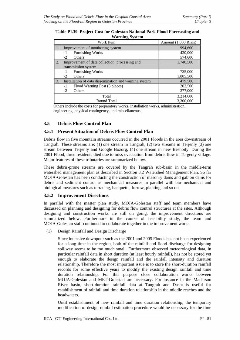
The Study on Flood and Debris Flow in the Caspian Coastal Area Summary (Part I)focusing on the Flood-hit Region in Golestan Province Chapter 3
JICA CTI Engineering International Co., Ltd. PI - 81
Table PI.39 Project Cost for Golestan National Park Flood Forecasting and Warning System
Work Item Amount (1,000 Rials) 1. Improvement of monitoring system 994,600 -1 Furnishing Works 420,000 -2 Others 574,600 2. Improvement of data collection, processing and
transmission system 1,740,500
-1 Furnishing Works 735,000 -2 Others 1,005,500 3. Installation of data dissemination and warning system 479,500 -1 Flood Warning Post (3 places) 202,500 -2 Others 277,000
Total Round Total
3,214,600 3,300,000
Others include the costs for preparatory works, installation works, administration, engineering, physical contingency, and miscellaneous.
3.5 Debris Flow Control Plan
3.5.1 Present Situation of Debris Flow Control Plan Debris flow in five mountain streams occurred in the 2001 Floods in the area downstream of Tangrah. These streams are: (1) one stream in Tangrah, (2) two streams in Terjenly (3) one stream between Terjenly and Google Bozorg, (4) one stream in new Beshoily. During the 2001 Flood, three residents died due to miss-evacuation from debris flow in Tergenly village. Major features of these tributaries are summarized below.
These debris-prone streams are covered by the Tangrah sub-basin in the middle-term watershed management plan as described in Section 3.2 Watershed Management Plan. So far MOJA-Golestan has been conducting the construction of masonry dams and gabion dams for debris and sediment control as mechanical measures in parallel with bio-mechanical and biological measures such as terracing, banquette, furrow, planting and so on.
3.5.2 Improvement Directions In parallel with the master plan study, MOJA-Golestan staff and team members have discussed on planning and designing for debris flow control structures at the sites. Although designing and construction works are still on going, the improvement directions are summarized below. Furthermore in the course of feasibility study, the team and MOJA-Golestan staff continued to collaborate together in the improvement works.
(1) Design Rainfall and Design Discharge
Since intensive downpour such as the 2001 and 2005 Floods has not been experienced for a long time in the region, both of the rainfall and flood discharge for designing spillway seems to be too much small. Furthermore observed meteorological data, in particular rainfall data in short duration (at least hourly rainfall), has not be stored yet enough to elaborate the design rainfall and the rainfall intensity and duration relationship. Therefore the most important issue is to store the short-duration rainfall records for some effective years to modify the existing design rainfall and time duration relationship. For this purpose close collaboration works between MOJA-Golestan and MET-Golestan are necessary. For instance in the Madarsoo River basin, short-duration rainfall data at Tangrah and Dasht is useful for establishment of rainfall and time duration relationship in the middle reaches and the headwaters.
Until establishment of new rainfall and time duration relationship, the temporary modification of design rainfall estimation procedure would be necessary for the time

Summary (Part I) The Study on Flood and Debris Flow in the Caspian Coastal Area Chapter 3 focusing on the Flood-hit Region in Golestan Province
PI - 82 JICA CTI Engineering International Co., Ltd.
being. The team prepared the temporary rainfall and time duration relationship in the Feasibility Study stage.
(2) Improvement Works in Debris-Prone Streams
The necessary improvement works in the said debris-prone streams is summarized below.
Table PI.40 Proposed Improvement Works in Debris-Prone Streams
Site Photo Necessary Improvement Works
Tangrah
Construction of debris flow deposition basin immediately upstream of village
Channeling works from basin to outfall
Terjenly (two streams)
Channeling works, in particular downstream of road crossing
Installation of drainage culvert under the road
between Terjenly and Google Bozorg
Construction of debris flow deposition basin immediately upstream of the road
Channeling works from basin to outfall including drainage culvert under the road
Beshoily
Construction of a series of sabo dams
Closure of another stream at the bifurcation
(3) Preparation of Debris Flow Hazard Map
Regarding emergency evacuation for residents, debris flow hazard map shall be prepared as illustrated below. In both Tangrah and Tergenly villages, residential areas

The Study on Flood and Debris Flow in the Caspian Coastal Area Summary (Part I)focusing on the Flood-hit Region in Golestan Province Chapter 3
JICA CTI Engineering International Co., Ltd. PI - 83
are located in the fan area, where is formed of debris and sediment deposits. Thus residents shall evacuate to nearby terrace.
Fig. PI.51 Debris Flow Hazard Map
(prepared through aerial photo interpretation, geomorphological analysis)
3.6 Flood Control Plan
3.6.1 Present Status After demolition of structures of road and riverbank during the disastrous 2001 flood, MOE and MORT conducted urgent rehabilitation works to the damaged structures. In particular, MOE has a responsibility to hydrological and hydraulic analysis for river structures. MOE is preparing two-phased plan: namely urgent measures and master plan.
(1) Urgent Measures
The major task of urgent measures is rehabilitation of structures damaged by the 2001 Flood. The river improvement stretch is about 65 km from Kalaleh Bridge through the Golestan Forest National Park up to Dasht Bridge.
MOE selected nine locations for the urgent river improvement works; namely 1) Golestan National Park, 2) Tangrah Check Point, 3) Terjenly, 4) Sadegh Abad

Summary (Part I) The Study on Flood and Debris Flow in the Caspian Coastal Area Chapter 3 focusing on the Flood-hit Region in Golestan Province
PI - 84 JICA CTI Engineering International Co., Ltd.
Diversion Dam, 5) Loveh Bridge, 6) Korang Kaftar Bridge, 7) 14 Metry bridge, 8) Ajen Ghareh Khojeh and 9) Kalaleh Bridge, from upstream.
Most of the locations were completed before the recent flood attacked in the Madarsoo River basin on 10 August 2005.
(2) Master Plan in the Golestan Dam Basin
MOE simultaneously has been formulating the master plan covering the Golestan dam basin including the Madarsoo River basin. A 100-year return period was adopted as a design scale.
Under the above situation, the 2005 Flood made an attack to the Madarsoo River basin. The recently rehabilitated structures and newly installed flood control structures were seriously damaged in one or two years after completion of construction works. After the flood disaster, MOE has to prepare or modify their rehabilitation plan based on the damages experienced. Furthermore the master plan being prepared by MOE should be also adjusted to the statistic background of rainfall affected by recent successive floods in 2001, 2002 and 2005. Therefore, the JICA team proposed some recommendations from engineering and disaster management viewpoints to MOE so that the master plan and rehabilitation plan could be elaborated, and the structures to be constructed by MOE and MORT would be much more strengthened to the previous one.
3.6.2 Recommendations on Flood Control Plan The following are recommendations to rehabilitation plan and flood control master plan being prepared by MOE and road improvement plan conducted by MORT.
(1) Hydrological Planning
According to previous study for urgent rehabilitation works, the design discharge was estimated at 250 m3/s in the Golestan Park, and 400 m3/s in the lower part of the Madarsoo River. However, the study results reveal the August 10 Flood in 2005 is almost equivalent to 25-year flood. The peak discharges might be 750 m3/s at Dasht Bridge, 1,060 m3/s at Tangrah, and 1,210 m3/s at 14 Metry bridge based on hydro-hydraulic simulation made by the study team, as already presented in Fig. PI.13.
Furthermore, the historical disastrous 2001 Flood was evaluated as an event in 55-year recurrence. Therefore a 100-year flood should be larger than the 2001 Flood. These hydrological considerations are important to improve the planning process for flood control in this region.
(2) Structural Considerations
According to MOE explanation, the river floodwall has a embedment of 1.5m deep underneath the riverbed surface. Thus many parts of the floodwall fell down during the 2005 Flood due to the local scouring at the foot of floodwalls.
Torrential stream riverbed tends to make local scouring seriously because of steep riverbed gradient and high floodflow velocity, in particular along the concave bank in the bend. Therefore, the determination of a suitable embedment depth of the riparian structures shall be considered carefully in comparison of integrating previous and recent survey results.
(3) Critical Constrictions of the Madarsoo River Course
According to the cross section survey along the Madarsoo River obtained from MOE-Golestan, the flow capacity analysis is carried out for the existing low water channel. Existing low water channel arrangement is shown in Fig. PI.52. The 14 Metry bridge and the Besh Oily bridge sections made the narrowest portions due to the bridge constructions in the middle reaches of the Madarsoo River, and in the recent flood,

The Study on Flood and Debris Flow in the Caspian Coastal Area Summary (Part I)focusing on the Flood-hit Region in Golestan Province Chapter 3
JICA CTI Engineering International Co., Ltd. PI - 85
those narrow sections have caused the flood inundation in and around the bridge section.
-200 .00
-150 .00
-100 .00
-50 .00
0 .00
50 .00
100 .00
150 .00
200 .00
0 10 20 30 40 50 60 70
Distance (km)
Lo
w W
ate
r C
han
nel
Wid
th (
m)
Le ft Bank Right Bank
Kalaleh BR
Besh Oi ly BR
Tangra
h V
illa
ge
Go
lesta
n D
am
(L=84m)
(L=18m)
Note: The number in the parentheses shows the existing bridge length.
14 Metry BR
(L=13m)
Ajan Ghareh Khojeh BR
(L=42m)
Loveh BR
(L=45m)
Korang Kaftar BR
(L=30m)
Fig. PI.52 Existing Low Water Channel Arrangement
(4) Road Improvement for Smooth Emergency Activities
During 2001 flood, the main road between Kalaleh and Tangrah has been closed here and there along the Madarsoo River caused by flood inundation from the Madarsoo River and/or debris flow avalanches from the mountain streams, so that it is experienced that the sufficient emergency activities to rescue the victim have hardly done with the main road and have been delayed.
To avoid road closing during and immediately after the flooding, it is proposed that the existing road system shall be raised to strengthen against flood damages, especially between 14 Metry bridge and Tangrah village. The appropriate height of raising road shall be determined with flood inundation simulation.
According to the flood simulation analysis without countermeasures, it is assumed that four (4) locations between 14 Metry bridge and Tangrah on the main road are covered with water on the condition of the 100-year flood. Fig. PI.53 show the submerged locations with 3 to 4 m deep based on the flood simulation analysis.
Fig. PI.53 Presumed Locations of Submerged Main Road