2.3 agricultural resources - sandiegocounty.gov · the nursery operations include ... or special...
TRANSCRIPT

Valiano Project Subchapter 2.3
Final Environmental Impact Report Agricultural Resources
2.3-1
2.3 Agricultural Resources
An agricultural resources study was prepared for the Proposed Project to determine the potential for significant impacts to agricultural resources as a result of Project development (Agricultural Resources Report: Valiano, December 2014November 2015). This study was prepared by HELIX in conformance with the County Report Format and Content Requirements for Agricultural Resources (March 2007). The results of this study are summarized below and included as Appendix D of this EIR. For purposes of this analysis, and pursuant to Attachment A of the Guidelines for Determining Significance and Report Format and Content Requirements, Agricultural Resources (County 2007d), agricultural resources are generally defined to include areas that are available and viable for agricultural use. Such areas include: (1) active agricultural operations; (2) areas designated as, and meeting the associated definition of, California Department of Conservation (CDC) Farmland Mapping and Monitoring Program (FMMP) Prime Farmland, Farmland of Statewide Importance, Unique Farmland or Farmland of Local Importance (as defined below in Section 2.3.1.2); and (3) areas with a history of agricultural production based on data sources such as aerial photographs. 2.3.1 Existing Conditions
2.3.1.1 Regional Agricultural Setting
The Proposed Project site is located in a semi-rural area encompassing a mix of urban development, agriculture, and open space. Nearby urban development includes high-density residential and commercial uses to the north (San Marcos) and east (Escondido); nearby areas to the north, west, and south encompass agricultural uses, low- to moderate density residential development and large expanses of natural open space. The majority of the Project site region is privately owned, with surrounding public lands limited primarily to a number of local parks, schools, and a habitat/recreation reserve. Local agricultural sites include relatively large areas of avocado orchards adjacent to portions of the northern, southern, and southwestern Proposed Project site boundaries (and similar uses present on site); smaller orchards and nurseries to the east, west, south and southwest, primarily related to estate residential properties; a minor greenhouse area to the east; and minor row/field crop and vineyard cultivation to the east, also associated with estate residential properties (refer to Figures 2.3-1a and 2.3-1b, Surrounding Agricultural Land Use). The nursery operations include uses such as decorative crops (e.g., dollar eucalyptus), ornamental landscaping and fruit trees, as well as lesser amounts of herbaceous crops. Several of the nursery sites encompass open-air container plants, in-ground plantings, and/or enclosed structures apparently used for temperature- and/or drought-sensitive varieties. It should also be noted that an area of former agricultural uses is located just south of the Proposed Project, on the 468-acre Harmony Grove Village Specific Plan site currently under development. This property formerly encompassed over 300 acres of agricultural uses, including approximately 135 acres of egg ranches/poultry farms and 81 acres of dairy operations that have been terminated/removed, as well as 91 acres of citrus (lemons) and avocado groves that have been partially removed or abandoned (including most areas adjacent to

Valiano Project Subchapter 2.3
Final Environmental Impact Report Agricultural Resources
2.3-2
the Project site), and are proposed (and approved) for complete removal/ development (HELIX 2006). Additional discussion of off-site agricultural resources in the vicinity of the Project site is provided below in Section 2.3.1.4. Local elevations range from approximately 500 feet amsl along portions of San Marcos Creek to the northwest, to 1,736 feet amsl at Mt. Whitney, approximately one mile southwest of the site. The Proposed Project site region is characterized by a Mediterranean climate, with moderate year-round temperatures and relatively low precipitation levels, most of which falls during the winter months. Municipal water service is available in much of the area (particularly in the more developed portions), including the Project site, which is served by the Rincon MWD; a number of associated water lines are located along or adjacent to the eastern Project site boundary. The more rural outlying areas within the region likely utilize groundwater in lieu of (or to supplement) municipal service. Soils in the Proposed Project site region are characterized by generally well-drained to excessively drained loams, sandy loams and silt loams with clayey subsoils in the valleys, and coarse sandy to rocky loams overlying weathered bedrock in the upland areas. On-site soils consist primarily of moderately well-drained to excessively-drained sandy loams. The CDC FMMP produces Important Farmland maps and statistical data used for categorizing agricultural lands and analyzing related impacts (CDC 2007a, 2004). Agricultural lands are rated according to soil quality and irrigation status, with Important Farmland maps scheduled for update every two years based on aerial photograph review, computer mapping analysis, public input, and field reconnaissance. The eight land use categories identified on the Important Farmland maps are defined below in Section 2.3.1.2. An approximately 1,427-acre Project Zone of Influence (ZOI) was identified for the Project site pursuant to the County Agricultural Guidelines (County 2007d). The locations of mapped Important Farmland designations within the Project site, the associated ZOI, and the Project agricultural cumulative study area (as defined below in Section 2.3.3) are shown on Figure 2.3-2, FMMP Important Farmland Map. As seen from this figure, the Proposed Project site region includes large contiguous areas of Other Land in developed and open space areas, smaller blocks of Urban and Built-up Land in denser urban development, relatively small areas of Unique Farmland and Farmland of Local Importance to the east, west and/or south, and one minor area of Prime Farmland to the west. The Farmland of Statewide Importance, Grazing Land and Water designations are not mapped within the Project site or surrounding areas. Additional discussion of FMMP Important Farmland designations within the Project site and surrounding areas is provided below in Sections 2.3.1.3 and 2.3.1.4. 2.3.1.2 Regulatory Setting
The Proposed Project is subject to several regulatory requirements related to agriculture, as outlined in the current County Agricultural Guidelines (2007d) and summarized below.

Valiano Project Subchapter 2.3
Final Environmental Impact Report Agricultural Resources
2.3-3
U.S. Natural Resources Conservation Service The U.S. Natural Resources Conservation Service (NRCS, formerly the SCS, 1973) maps soils according to distinct soil series and individual soil types. The SCS soil classification system also includes assessments of Land Capability Classification and Storie Index ratings; summary definitions are provided below. Evaluation of soil types per the criteria for the CDC FMMP Soil
Candidate Listing for Prime Farmland and Farmland of Statewide Importance (2010) is required as part of the County’s methodology for evaluation of agricultural resources impacts (refer to Section 2.3.2.1). Storie Index The Storie Index designation “[e]xpresses numerically the relative degree of suitability, or value, of a soil for general intensive agriculture. The rating is based on soil characteristics only. It does not take into account other factors such as the availability of water for irrigation, climate, and distance from markets, which might determine the desirability of growing specific crops in a given locality” (SCS 1973). The four factors that represent the inherent characteristics and qualities of the soil (profile characteristics, texture of surface soil, slope, and other conditions that limit use of the soil) are considered in the index rating. The final rating can fall between 100 (excellent) and less than 10 (very poor). According to the San Diego Area Soil Survey (SCS 1973), Grade 1 through Grade 6 soils (the relevant Grades for the Project site) are characterized as follows: (1) Grade 1 soils have few or no limitations that restrict their use for crops; (2) Grade 2 soils are suitable for most crops but exhibit minor limitations that narrow the choices; (3) Grade 3 soils are suitable for a few, or special crops, with management; (4) Grade 4 soils are severely limited for all crops and require special management; (5) Grade 5 soils are not suited for cultivated crops but may be used for pasture or range; and (6) Grade 6 soils are generally not suitable for agriculture. Land Capability Classification The Land Capability Classification concept is defined as follows in the San Diego Area Soil Survey (SCS 1973):
Capability groupings show, in a general way, the suitability of soils for most kinds of field crops. The groups are made according to the limitations of the soils when used for field crops, the risk of damage when they are used, and the way they respond to treatment. The grouping does not take into account major and generally expensive landforming that would change slope, depth, or other characteristics of the soils; does not take into consideration possible but unlikely major reclamation projects; and does not apply to rice, cranberries, horticultural crops, or other crops requiring special management. In the capability system, all kinds of soils are grouped at three levels: the capability class (Roman numeral designation), the subclass (letter designation), and the unit (Arabic numeral designation).

Valiano Project Subchapter 2.3
Final Environmental Impact Report Agricultural Resources
2.3-4
Soils are divided into Classes I through VIII, with these designations representing a range in quality from Class I soils that have few limitations for agricultural use, to Class VIII soils that have no commercial crop production capability. Capability Classes are further divided into subclasses and capability units to define limitations for agricultural use. Subclasses indicate soil limitations based on erodibility (e), water regime (w), depth and/or texture (s), and climate area (c). Capability units further reveal the main limitation for the placement of a soil into the given class and subclass. Numerals used to designate units within the classes and subclasses include: (0) sand and gravel in the substratum; (1) erosion hazard; (2) wetness caused by poor drainage or flooding; (3) slow or very slow permeability; (4) coarse texture or excessive gravel; (5) fine or very fine textured soil; (6) salts or alkali; (7) cobblestones, stones, or rocks; (8) nearly impervious bedrock or hardpan; and (9) toxicity or low fertility (SCS 1973). California Department of Conservation Farmland Mapping and Monitoring Program The CDC FMMP produces Important Farmland maps and statistical data used for categorizing agricultural lands and analyzing related impacts (CDC 2007a, 2004). Agricultural lands are rated according to soil quality and irrigation status, with Important Farmland maps scheduled for update every two years based on aerial photograph review, computer mapping analysis, public input, and field reconnaissance. The eight land use categories identified on the Important Farmland maps are defined below; these include Prime Farmland, Farmland of Statewide Importance, Unique Farmland, Farmland of Local Importance, Grazing Land, Urban and Built-up Land, Other Land, and Water. The locations of mapped Important Farmland designations within the Proposed Project site, the associated ZOI, and the Project agricultural cumulative study area (as defined below in Section 2.3.3) are shown on Figure 2.3-2. The Important Farmland designations of relevance to the Proposed Project are defined as follows. Prime Farmland Prime Farmland includes areas that have the best combination of physical and chemical characteristics for the production of crops, including (but not limited to) moisture regime, soil temperature, pH, groundwater depth, sodium content, flooding, erodibility, permeability, rock fragment content and rooting depth. It has the soil quality, growing season, and moisture supply needed to produce sustained high yields of crops when treated and managed, including water management, according to current farming methods. Prime Farmland must have been used for the production of irrigated crops at some time during the two update cycles (four years) prior to the mapping date. Farmland of Statewide Importance Farmland of Statewide Importance includes areas other than Prime Farmland that have a good combination of physical and chemical characteristics for the production of crops (including all characteristics listed for Prime Farmland except permeability and rooting depth). It must have been used for the production of irrigated crops at some time during the two update cycles prior to the mapping date.

Valiano Project Subchapter 2.3
Final Environmental Impact Report Agricultural Resources
2.3-5
Unique Farmland Unique Farmland includes areas that do not meet the criteria for Prime Farmland (areas that have the best combination of physical and chemical characteristics for the production of crops) or Farmland of Statewide Importance (areas other than Prime Farmland that have a good combination of physical and chemical characteristics for the production of crops), but that have been used for the production of specific high economic value crops during the two update cycles prior to the mapping date. It has the special combination of soil quality, location, growing season, and moisture supply needed to produce sustained high quality and/or high yields of a specific crop when treated and managed according to current farming methods. Examples of such crops may include oranges, olives, avocados, rice, grapes, and cut flowers. Farmland of Local Importance Farmland of Local Importance includes areas other than Prime Farmland, Farmland of Statewide Importance or Unique Farmland that are currently producing crops, have the capability of such production, or are used for the production of confined livestock. Farmland of Local Importance may be important to local economies due to its productivity or value and is defined by each county’s local advisory committee and adopted by its Board of Supervisors. For San Diego County, the definition of Farmland of Local Importance is given by the CDC (2007b) as:
Land that meets all the characteristics of Prime and Statewide, with the exception of irrigation. Farmlands not covered by the above categories but are of significant economic importance to the county. They have a history of good production for locally adapted crops. The soils are grouped in types that are suited for truck crops (such as tomatoes, strawberries, cucumbers, potatoes, celery, squash, romaine lettuce, and cauliflower) and soils suited for orchard crops (avocados and citrus).
Grazing Land Grazing Land includes areas on which the existing vegetation is suited to the grazing of livestock. It has a minimum mapping unit of 40 acres. Urban and Built-up Land Urban and Built-up Land includes areas used for residential, industrial, commercial, institutional, and other developed purposes. Transportation facilities (e.g., highways and railroads) and vacant (non-agricultural) areas surrounded by urban development and less than 40 acres in size are mapped as part of associated Urban and Built-up Land, while uses such as farmsteads, commercial feedlots, and poultry facilities are not included within this designation. Other Land Land areas not included in any other Important Farmland mapping category are designated as Other Land. Common examples include low density rural developments; brush, timber, wetland, and riparian areas not suitable for livestock grazing; confined livestock, poultry or aquaculture

Valiano Project Subchapter 2.3
Final Environmental Impact Report Agricultural Resources
2.3-6
facilities; vacant and non-agricultural areas larger than 40 acres and surrounded by urban development; and strip mines, borrow pits and water bodies smaller than 40 acres. Water This category is defined as perennial water bodies with an extent of at least 40 acres. As seen from Figure 2.3-2, the Proposed Project site region includes large contiguous areas of Other Land in developed and open space areas, smaller blocks of Urban and Built-up Land in denser urban development, relatively scattered and small areas of Unique Farmland (totaling approximately 416 acres) and Farmland of Local Importance (totaling approximately 190 acres) to the west and south, and one small area of Prime Farmland (2.4 acres) to the west. The Farmland of Statewide Importance, Grazing Land and Water designations are not mapped within the Project site or surrounding areas. Additional discussion of FMMP Important Farmland designations within the Project site and surrounding areas is provided below in Sections 2.3.1.3 and 2.3.1.4. California Land Conservation Act of 1965 (Williamson Act) The California Land Conservation Act of 1965, commonly referred to as the Williamson Act (California Administrative Code §51200 et. seq.), enables local governments to enter into contracts with private landowners for the purpose of restricting specific parcels of land to agricultural or related open space use. The issuance of such a contract precludes non-agricultural development of the subject property for a period of 10 years. In return, the landowner receives property tax assessments that are lower than normal because the assessments are based on farming and/or open space uses rather than full market value. Local governments receive an annual subvention of forgone property tax revenues from the state via the Open Space Subvention Act of 1971. Contracts issued under the Williamson Act automatically renew each year for a new 10-year period, unless the landowner files a Notice of Non-renewal to terminate the contract at the end of the current 10-year period. During the 10-year cancellation period, property taxes are gradually raised to the appropriate level for developable land. The Williamson Act also authorizes cities and counties to establish agricultural preserves, with these areas intended to identify locations wherein the issuing city or county is willing to enter into Williamson Act contracts. Agricultural preserves are generally intended to avoid areas where public utility improvements and related land acquisitions may be required. The Williamson Act does not specifically address the issue of compatible land uses in sites adjacent to agricultural preserves or contract lands, other than to require that “[c]ities and counties shall determine the types of uses to be deemed ‘compatible uses’ in a manner which recognizes that a permanent or temporary population increase often hinders or impairs agricultural operations.” (California Administrative Code §51220.5). No current Williamson Act designations are present within the site. One Williamson Act contract parcel (currently not in agricultural use) and two agricultural preserves are located south of the Proposed Project, including one overlying contract/preserve located within the ZOI. Additional discussion of the Williamson Act, as well as these contract lands and agricultural preserves, is provided below in Sections 2.3.1.3 and 2.3.1.4.

Valiano Project Subchapter 2.3
Final Environmental Impact Report Agricultural Resources
2.3-7
San Diego Local Agency Formation Commission The Proposed Project includes an annexation into the County Sanitation District for sewer service. The annexation would be conducted pursuant to LAFCO requirements, and the San Diego LAFCO would serve as a CEQA Responsible Agency for the Proposed Project. The LAFCO review would include consideration of the conversion of Prime Agricultural Land to non-agricultural use, pursuant to San Diego LAFCO Policy L-101, Preservation of Open Space and Agricultural Lands. Prime agricultural land is defined by LAFCO in Government Code §56964 to include “[a]n area of land…that has not been developed for a use other than agricultural use and that meets any of the following qualifications:
(a) Land that qualifies, if irrigated, for rating as Class I or Class II in the USDA Natural Resources Conservation Service land use capability classification, whether or not the land is actually irrigated, provided that irrigation is feasible.
(b) Land that qualifies for rating 80 through 100 Storie Index Rating. (c) Land that supports livestock used for the production of food and fiber and that has an annual
carrying capacity equivalent to at least one animal unit per acre as defined by the USDA in the National Handbook on Range and Related Grazing Lands.
(d) Land planted with fruit or nut-bearing trees, vines, bushes, or crops that have a nonbearing
period of less than five years and that will return during the commercial bearing period on an annual basis from the production of unprocessed agricultural plant production not less than four hundred dollars ($400) per acre.
(e) Land that has returned from the production of unprocessed agricultural plant products an
annual gross value of not less than four hundred dollars ($400) per acre for 3 of the previous 5 calendar years.
The LAFCO goals include the following: (1) encourage orderly growth; (2) promote logical and efficient public services for cities and special districts; (3) streamline governmental structure; and (4) discourage premature conversion of prime agricultural and open space lands to urban uses (LAFCO 2013). With respect to the last goal, LAFCO Legislative Policy L-101 states:
LAFCO’s are required to consider how spheres of influence or changes of local governmental organization could affect open space and prime agricultural lands. Commissions are directed to guide development away from prime agricultural lands – unless that action would not promote the planned, orderly, and efficient development of an area – and to encourage development of existing vacant or non-prime agricultural lands within a jurisdiction before approving any proposal that would allow the development of open space lands outside of an agency’s boundary (Govt. Code §56377). Proposals must be further reviewed for their effect on maintaining the physical and economic integrity of agricultural lands (Govt. Code §56668).

Valiano Project Subchapter 2.3
Final Environmental Impact Report Agricultural Resources
2.3-8
It is the policy of the San Diego LAFCO to:
1. Discourage proposals that would convert prime agricultural or open space lands to other uses unless such an action would not promote the planned, orderly, efficient development of an area or the affected jurisdiction has identified all prime agricultural lands within its SOI and adopted measures that would effectively preserve prime agricultural lands for agricultural use;
2. Require pre-zoning of territory (city only) to identify areas subject to agricultural/
preservation and planned development; and
3. Follow San Diego LAFCO’s adopted procedures to define agricultural and open space lands and to determine when a proposal may adversely affect such lands.
Pursuant to guidance in the County Agricultural Guidelines (County 2007d), Policy No. 1 and Policy No. 3 above are addressed in the following analysis; Policy No. 2 is not applicable to the Proposed Project. 2.3.1.3 Project Site Agricultural Characteristics
On-site topography is generally characterized by a north-south trending ridge extending through much of the western portion of the property, a large knoll in the southeastern-most area, several larger drainages flanking these upland features, and generally level terrain in other on-site areas. Surface drainage from most of the Proposed Project site flows primarily to the east and south, with some variability in direction due to local topography. Associated off-site flows continue generally south before ultimately entering Escondido Creek. The northernmost portion of the site, along with the adjacent Rincon MWD R7 Reservoir site parcel, drains north and west through via overland (sheet) flow and a number of small, unnamed drainages, and with these flows eventually flows intoentering San Marcos Creek.; Portions of the site in this area is are proposed as a 36.535.4-acre agricultural easement (described further in Section 2.3.5) and thus would not be developed. The site is currentlywas recently used for commercial agriculture, with extensive areas of active avocado orchards, as shown on Figures 2.3-3a and 2.3-3b, Agricultural Resources Map, as well as four minor apiary (bee keeping) sites. As described in the History of Agricultural Use section, commercial agricultural operations on the Project site were initially conducted in the early part of the 20th Century, and current orchard operations have occurred more or less continuously on site since the late 1960s or early 1970s. The determination of on-site agricultural resources was based on the following efforts/data sources: (1) site visits conducted on February 7 and 9, 2013; (2) review of current/historic aerial photographs dated 2012, 2005, 1995/1994, 1990, 1980, 1974, 1963, 1953, 1947, 1929, and 1928; (3) review of the Project Cultural Resources and Phase I/II ESA hazardous materials reports (Affinis 2014 and Geocon Incorporated [Geocon] 2012c and 2013b, respectively); (4) review of the Project Biotechnical Report (HELIX 2014c2015d); and (5) review of FMMP Important Farmland maps, and Prime Farmland/Farmland of Statewide Importance candidate soils.

Valiano Project Subchapter 2.3
Final Environmental Impact Report Agricultural Resources
2.3-9
Identified agricultural resources within the Proposed Project site encompass a total of approximately 137.2 acres, including areas used currently recently and/or historically for agricultural operations (orchards, row/field crops and apiary sites), as well as portions of the FMMP-designated Unique Farmland and Farmland of Local Importance (Figures 2.3-3a and 2.3-3b). Because the agricultural use areas and Important Farmland designations overlap in several portions of the site, the total on-site agricultural resource acreage is less than the sum of the individual acreages for these two categories. Specifically, the 137.2 acres of agricultural resources within the site encompass: (1) 117.0 acres of recently active avocado orchards (portions of which were damaged or destroyed during a 2014 wildfire event); (2) 0.4 acre of recently active apiary uses; (3) 100.5 acres of Unique Farmland; (4) 27.3 acres of Farmland of Local Importance; (5) 12.9 acres of historic (circa 1928) orchard use in the southeastern portion of the site; (6) 1.6 acres of historic orchard use in the east-central portion of the site; and (7) 1.51.4 acres of historic row/field crop production in the east-central portion of the site (refer to the discussion of historical agricultural use below in this section for additional information). Portions of the site not identified as agricultural resources include: areas that do not encompass active or historical agricultural use or applicable FMMP designations; developed and unavailable areas such as roads, structures, and power line easements; sensitive biological habitats; and eucalyptus forest and woodland habitats (Figure 2.3-3). These areas are excluded as on-site agricultural resources because they have likely not been previously used for agriculture, and they are assumed to be unavailable for future agricultural use based on the following considerations:
• The underlying soil quality in developed areas has likely been compromised through grading, compaction and/or fill placement, and areas within transmission line easements are unavailable for current or future agricultural use.
• Sensitive habitat areas would either be precluded from agricultural use based on
environmental concerns or would require mitigation that would likely be prohibitively expensive (e.g., habitat restoration and/or the purchase of off-site mitigation credits). Specifically, in the Project site area, approximate mitigation costs for purchase of select native upland and wetland habitat credits would be as follows: (1) for Diegan coastal sage scrub, estimated costs at the closest mitigation bank likely to be used for the Proposed Project (Red Mountain) would be approximately $35,000 per acre for unoccupied habitat (i.e., unoccupied by sensitive species including the California gnatcatcher); and (2) for most wetland habitats, estimated costs in the Escondido region would range between approximately $350,000 and $500,000 per acre, with potential mitigation bank sites including Red Mountain, Brook Forest, San Luis Rey and Moosa Creek (HELIX 2014g).
• Removal of eucalyptus forest or woodland habitats to accommodate commercial
agriculture would likely be prohibitively expensive, due to requirements including tree and stump/root system removal. Specifically, costs for a recent (2012) eucalyptus removal effort on a nearby property (Harmony Grove Village) ranged between approximately $50,000 to $75,000 per acre (including tree/stump/root system removal and disposal), based on site-specific conditions such as access and equipment requirements (HELIX 2014h). While the referenced effort entailed more difficult access conditions than the Proposed Project site, even costs at or below the low end of the listed range would represent

Valiano Project Subchapter 2.3
Final Environmental Impact Report Agricultural Resources
2.3-10
a substantial economic burden to implementing agricultural operations in areas of eucalyptus forest or woodland habitat on the Project site.
On-site soils, Important Farmlands, agricultural history, climate, and water resources associated with the Proposed Project site (and the identified 137.2 acres of on-site agricultural resources) are described below, along with Williamson Act contract/agricultural preserves and Prime Agricultural Land considerations pursuant to LAFCO criteria. Soils Soils within the Proposed Project site and vicinity have been mapped by the U.S. Natural Resources Conservation Service (NRCS, formerly the SCS, 1973). As shown on Figure 2.3-4, NRCS Soils Map, and Table 2.3-1, On-Site Soils, Land Capability Units, Storie Index Ratings,
Crop Suitability and Candidate Soil Status, the Project site includes nine distinct soil series and 14 individual soil types. Five of the identified soil types within the Project site are identified as meeting the criteria for CDC FMMP Soil Candidate Listing for Prime Farmland and Farmland of
Statewide Importance (2010), as depicted in Table 2.3-1. While the entire site has been mapped for topsoils as shown on Figure 2.3-4, approximately 16.6 acres have been developed for uses such as structures and roads, resulting in the underlying soils likely being altered or lost due to grading, compaction, and/or placement of fill. Mapped soils within the on-site portions of the R7 Reservoir access road and pipeline easements/facilities include Cieneba Very Rocky Coarse Sandy Loam, 30 to 75 Percent Slopes (CmrG) and Fallbrook-Vista Sandy Loams, 15 to 30 percent slopes (FvE, with these areas reflected in Table 2.3-1). The entire 3.2-acre parcel that includes the proposed R7 Reservoir structure and related easement/facility areas incorporates CmrG soils. Storie Index ratings for soils within the Proposed Project site are shown in Table 2.3-1. The Project site soil ratings range from less than 5 to 81, and represent Grade 1 through Grade 6 soils, as follows: (1) Grade 1 soils (34.6 acres on site), which have few or no limitations that restrict their use for crops; (2) Grade 2 soils (0.7 acre on site), which are suitable for most crops but exhibit minor limitations that narrow the choices; (3) Grade 3 soils (60.3 acres on site), which are suitable for a few, or special crops, with management; (4) Grade 4 soils (9.1 acres on site), which are severely limited for all crops and require special management; (5) Grade 5 soils (86.2 acres on site), which are not suited for cultivated crops but may be used for pasture or range; and (6) Grade 6 soils (47.8 acres on site, as well as the entire 3.2-acre R7 Reservoir parcel), which are generally not suitable for agriculture. Land Capability Classification Land Capability classifications within the Proposed Project site are shown in Table 2.3-1; the associated ratings indicate soils with moderate to severe limitations based on the noted criteria (SCS 1973).
FMMP Important Farmland Designations The CDC Division of Land Resource Protection, FMMP, produces Important Farmland maps and statistical data, as previously mentioned. Four of the previously listed eight Important Farmland designations are located within the Proposed Project site, including Unique Farmland, Farmland

Valiano Project Subchapter 2.3
Final Environmental Impact Report Agricultural Resources
2.3-11
of Local Importance, Urban and Built-up Land, and Other Land. Figure 2.3-2 and Table 2.3-2, FMMP Important Farmland Designations within the Project Site, ZOI and Agricultural
Cumulative Study Area, present the areas of mapped FMMP Important Farmlands present on the Project site, in the ZOI, and in the agricultural cumulative study area (defined in Section 2.3.3). Approximately 100.5 acres of Unique Farmland are present within the Proposed Project site; these areas are concentrated mainly in the western and northern portions of the property and are associated with previous on-site avocado orchards. In addition, the entire 3.2-acre R7 Reservoir parcel, is also mapped as Unique Farmland. Approximately 27.3 acres of Farmland of Local Importance are mapped in the western and northern portions of the Project site, with associated agricultural uses consisting of previous avocado orchards. Approximately 1.2 acres of Urban and Built-up Land are located along the property boundary in the southeastern and northern portions of the Project site. Approximately 109.7 acres of Other Land are mapped in the northern, eastern, and southeastern portions of the site. History of Agricultural Use Available historic information from the Project Cultural Resources Investigation (Affinis 2014) indicates that portions of the Proposed Project site were originally patented (conveyed to private ownership) in the late 19th Century, with a number of “farm-related” facilities reportedly erected in the late 19th to mid-20th centuries. The Cultural Resources Investigation identifies two “historic farm complexes” within the site, including one (P-37-026762) in the south-central portion of the site, and one (the “Fines Complex”) in the southeastern site corner. Both of these areas, along with other applicable on-and off-site resources, are evaluated below in the discussion of historic aerial photographs, which include photos from the Project Cultural Resources and Phase I/II (hazardous materials) reports dated 1928, 1928/1929, 1947, 1953, 1963, 1974, 1980, 1990, 1994/1995, and 2005, as well as a current (2012) photo. The 2012 photo is provided as Figure 1-2 of this EIR, and the remaining photos are included in Appendix D of this EIR). Additional aerial photos available from online sources were also used to review areas not visible in the Cultural Resource and Phase I/II report photos (Google Earth 2013 and Historic Aerials 2013). The earliest available photos indicate that the “Fines Complex” and associated areas in the southeastern Project site were in agricultural production (extensive orchard cultivation) by at least 1928, while no agricultural uses are attributed to historic site P-37-026762 and adjacent areas within the Project site at that time. By 1947, photos indicate that the orchard cultivation associated with the “Fines Complex” was no longer present, and the northernmost portion of the site was undeveloped, supporting native vegetation but no agricultural activity. In addition, an approximately 1.6-acre area of apparent orchard cultivation was present in the east-central portion of the site in 1947, in association with similar adjacent off-site uses to the south. Based on the location and minor extent of this use, this on-site orchard use may have resulted from a surveyor’s error or other misinterpretation of the on-the-ground property boundary. The 1953 and 1963 photos showed similar conditions on site, although the 1.6-acre area of orchards in the east-central area appears abandoned in 1963 (with no trees present), and expanded agricultural development is present to the east in the form of orchards; to the south on the Harmony Grove Village site, (dairy-related facilities and chicken coop structures); to the west and southwest in the form of large-scale orchards, row/field crops and nursery sites; and to the north/northwest (mainly orchards,

Valiano Project Subchapter 2.3
Final Environmental Impact Report Agricultural Resources
2.3-12
row/field crops and a small dairy or feed lot). Based on analysis of the 1974 photo, the majority of the current (pre-wildfire) on-site avocado orchards are assumed to have been planted during the late 1960s and early 1970s, and no agricultural uses were present in the southeastern, south-central, and central portions of the site. The 1980 and 1990 photos showed conditions on site to be similar to current (pre-wildfire) conditions, with extensive avocado groves in the western area and agricultural uses in other portions of the site limited to minor apiary facilities. These photos also show that much of the previous agricultural use (orchards) further north of the Proposed Project site had been replaced with ongoing urban development by 1980, with only minor cultivation remaining in association with estate residential uses. Later photos indicate that a small area of row/field crops in the east-central portion of the site (likely associated with nearby estate residential development) was apparently initiated sometime between 1997 and 2002 and was active until it was discontinued in 2009. In addition, large-scale egg ranch/dairy facilities were present on the Harmony Grove Village site to the south as of approximately 1994/1995. The 2012 aerial photo included as Figure 1-2 displays current (pre-wildfire) conditions on site and in most off-site areas. Compared to 2005, some additional avocado cultivation is present in the west-central portion of the site and a few areas exhibit smaller trees, suggesting replacement of mature trees. Additional off-site orchard cultivation is present in adjacent areas to the south and southwest, as well as nearby locations to the west associated with estate residential uses. While all of the previously described orchard areas to the east of the site were replaced by urban development by time of the 2012 photo, it shows several new agricultural uses east of the property boundary, including minor orchards and small areas of apparent row/field crops, greenhouse, and vineyard operations; all uses except greenhouses were apparently associated with estate residential sites. All of the previously described agricultural uses in areas further north of the site were replaced with urban development by 2012. The egg ranch and dairy uses at the Harmony Grove Village site to the south are still present in the 2012 photo, although this site is currently being developed and all egg- and dairy-related uses/facilities (along with some orchards) had been terminated/removed as of February 2013. Agricultural uses in areas further to the southwest continue to include numerous small orchards related to estate residential sites, and a number of relatively large commercial nursery operations. Pursuant to the above information, the following conclusions are provided: (1) commercial agricultural operations (orchards) on the Proposed Project site were initially conducted in the southeastern portion of the site during the early part of the 20th Century, with these activities discontinued by the late 1940s; (2) minor and short-lived agricultural activities occurred on-site in the east-central portion of property during the 1950s (orchards) and late 1990s/early 2000s (row crops); and (3) existing commercial orchard operations in the western and northern portions of the site have occurred more or less continuously since the late 1960s or early 1970s, with portions of these areas destroyed in the 2014 wildfire event as previously described. Based on the nature and extent of current (pre-wildfire) and historical on-site agricultural use, limited soil testing, and information received from the San Diego County Department of Agriculture, Weights and Measures (AWM), pesticide use (and the potential for associated residues) at the site is considered low. As noted from the historical photograph analysis, current (pre-wildfire) and historical agricultural operations on site and in nearby areas consist predominantly of avocado or citrus orchards, as well as small-scale mixed-use orchards,

Valiano Project Subchapter 2.3
Final Environmental Impact Report Agricultural Resources
2.3-13
row/field crop cultivation, vineyards, and greenhouses. Orchards and greenhouses typically entail only minor pesticide use, while the other on- and off-site agricultural uses are minor in scale, associated with estate residential sites, and unlikely to be commercial in nature. A total of 13 soil samples from the western and central portions of the site were laboratory tested for organochlorine pesticides and arsenic as part of the limited Phase II hazardous materials investigation, with none of the noted compounds detected at or above laboratory reporting limits (Geocon 2013b). Agricultural-related pesticide use records for the Proposed Project site obtained from the AWM indicate that no recorded pesticide use and/or storage occurred on site during the period of 2008 to 2012 (refer to Appendix D). Climate As noted in Section 2.3.1.1, the Project site region is characterized by a Mediterranean climate, with moderate year-round temperatures and relatively low precipitation levels, most of which falls during the winter months. Average annual precipitation at the nearest reporting station (City of San Marcos, 92078) is approximately 15.1 inches, with the highest average rainfall totals occurring in January (3.0 inches), February (3.5 inches), and March (2.7 inches). The driest months are June, July, and August, with average rainfall totals of 0.12, 0.08, and 0.08 inches, respectively (Weather.com 2013). July, August, and September are the warmest average months in the Project site region, with average daily highs of 87ºF for July and September, and 89ºF for August. Corresponding average lows are 62ºF for July and September, and 63ºF for August. December and January represent the coldest months, with average high temperatures of 68 and 69ºF respectively, and corresponding average lows of 42 and 43ºF. Temperature extremes are relatively uncommon in the Project vicinity, with a record high temperature of 112ºF recorded in 2006, and a record low of 25ºF in 2007 (Weather.com 2013). The County is divided into a series of “plant climates,” which are defined as areas “[i]n which specific plants, groups or associations are evident and will grow satisfactorily, assuming water and soil are favorable.” (Gilbert 1970). Plant climates in San Diego County occur as a series of five generally north-south trending linear zones, including the Maritime, Coastal, Transitional, Interior, and Desert zones. These areas are influenced by factors including topography and proximity to the ocean and are generally gradational inland; the Proposed Project site is located in the Transitional Zone (County 2006b). The Maritime and Coastal zones located west of the Project site exhibit relatively low relief and are dominated by oceanic influences, with typically narrow diurnal and seasonal temperature changes and relatively high humidities. These factors begin to decline further inland, with the Transitional Zone displaying more topographic and climatic variation and often alternating between (or combining characteristics of) both the oceanic and inland areas. The Transitional Zone includes a series of valleys that are partially screened from maritime/coastal and interior/desert influences by topography and exhibits more variable temperature and humidity fluctuations than areas further west but has generally higher humidity levels and lower temperature extremes than the Interior and Desert zones to the east. More localized climate zones have been defined by adapting the plant climate definitions; these are termed Generalized Plant Climate Zones, or Sunset Zones, based on the Sunset Western Garden Books that popularized their use (County 2007, 2006b). Sunset Zones differentiate local microclimates, freeze/frost potential, and air/water drainage, based on conditions such as latitude,

Valiano Project Subchapter 2.3
Final Environmental Impact Report Agricultural Resources
2.3-14
elevation, topography, and the influence of oceanic and/or continental air masses. The Proposed Project site is located in Sunset Zones 20 and 21, which consist of: (1) Zone 20 - a cold air basin that can be dominated by both coastal and inland influences, with low temperatures ranging from 23 to 28ºF; and (2) Zone 21 - an air drained thermal belt, with low temperatures ranging from 23 to 36ºF (and rarely dropping below 30ºF). Sunset Zones also incorporate the U.S. Department of Agriculture (USDA) hardiness ratings, which designate 11 zones depicting the lowest temperature at which individual plant species will thrive (County 2007). The Project site is located in USDA hardiness Zone 10a, which exhibits an average minimum temperature range of 30 to 35ºF (USDA 2007a). In summary, the Proposed Project site climate exhibits generally mild year round temperatures and infrequent episodes of freezing and severe frost. These conditions make it suitable for a number of temperature-sensitive crops such as citrus, avocados, nuts, row/field crops, and nursery products (e.g., flowers). Water Resources Municipal water service is currently provided to the Proposed Project site by the Rincon MWD, with a number of associated water lines located along or adjacent to the eastern site boundary. One existing groundwater well is located on site and reportedly extends to a depth of 100 feet, although no data are available regarding associated well/water depths or yield (Geocon 2012c). Shallow groundwater was encountered in alluvial deposits during subsurface geotechnical explorations conducted for the Project in the central and east-central portions of the site and is also anticipated to occur in the southeastern portion of the site (Geocon 2012b and 2012c). The Project geotechnical reports interpreted these observed/anticipated occurrences as perched aquifers, which consist generally of unconfined (i.e., not under pressure) groundwater contained by impermeable or semi-permeable strata. The presence and extent of perched groundwater bodies are typically associated with and influenced by seasonal precipitation and local irrigation. Williamson Act Contracts and Agricultural Preserves As noted in Section 2.3.1.2, no Williamson Act contract lands or agricultural preserves are located within the Proposed Project site. An existing Williamson Act parcel and overlying agricultural preserve located southeast of the site boundary within the Project ZOI, as well other preserves and contract lands in surrounding areas, are described below in Section 2.3.1.4. LAFCO Prime Agricultural Land As previously noted, the Proposed Project would require a review conducted pursuant to LAFCO requirements. As described above in Section 2.3.1.2, part of the LAFCO review entails evaluating the conversion of Prime Agricultural Land, pursuant to San Diego LAFCO Policy L-101, Preservation of Open Space and Agricultural Lands, which involves assessment of soils with regard to the Storie Index and Land Capability Classifications. As described above under Soils (Land Capability Classification) and shown in Table 2.3-1, approximately 34.6 acres of mapped soils within the Proposed Project site exhibit a Capability

Valiano Project Subchapter 2.3
Final Environmental Impact Report Agricultural Resources
2.3-15
Class II and a Storie Index rating of 80 or more, with no additional on-site soils meeting the stated soil criteria. These areas include 32.7 acres of Visalia Sandy Loam, 2 to 5 percent slopes, and 1.9 acres of Wyman Loam, 2 to 5 percent slopes (refer to Table 2.3-1 and Figure 2.3-4 for soil data and locations). The Project site does not include any livestock operations but does encompass approximately 117.0 acres of recently active avocado orchards, portions of which were damaged or destroyed during a 2014 wildfire event as previously described. Based on these conditions, the Project site would not meet the LAFCO Policy L-101 criterion for Prime Agricultural Land related to supporting livestock (criterion “c” as stated in Section 2.3.1.2) but would meet the criteria related to soil quality (criteria “a” and “b” from LAFCO Policy L-101 in Section 2.3.1.2), and recently active agricultural production (criteria “d” and “e” from LAFCO Policy L-101 in Section 2.3.1.2). Per the above discussion of on-site agricultural resources; however (as depicted on Figure 2.3-3), portions of the site are considered unavailable for agricultural use (and are thus not considered Prime Agricultural Land) due to the presence of roads and structures, sensitive habitats, and mature eucalyptus woodland. The exclusion of these areas is based on the same considerations identified for agricultural resources in Section 2.3.1.3, including: (1) the underlying soil quality in developed areas has likely been compromised through grading and compaction, and areas within utility easements are unavailable for agricultural use; (2) sensitive habitat areas would either be precluded from agricultural use based on environmental concerns, or would require mitigation that would likely be prohibitively expensive (e.g., habitat restoration and/or the purchase of off-site mitigation credits); and (3) removal of eucalyptus woodland to accommodate agriculture would likely be prohibitively expensive (i.e., tree and stump/root system removal). Accordingly, approximately 140.2 acres within the Project site are considered Prime Agricultural Land pursuant to LAFCO criteria and existing on-site conditions. This area includes the noted 117.0 acres of existing orchards, as well as 23.2 acres of qualifying soils that are not encumbered with roads, structures, easements, sensitive habitats, or mature eucalyptus woodland (including 22 acres of Visalia soils and 1.2 acres of Wyman soils). The 3.2-acre R7 Reservoir parcel also includes 3.1 acres of Prime Agricultural Land (i.e., recently active orchards), based on the noted LAFCO definition and the presence of several unpaved roads, with a total described area of 143.3 acres of Prime Agricultural Land within the Project site and the adjacent R7 Reservoir parcel. 2.3.1.4 Off-site Agricultural Resources
As shown on Figures 2.3-1a, 2.3-2 and 2.3-5, FMMP Important Farmland designations, a Williamson Act contract parcel and two agricultural preserves, and active agricultural operations are present within the 1,427-acre Project ZOI (which includes the 3.2-acre R7 Reservoir parcel); these designations and uses are outlined below. FMMP Important Farmland Designations Important Farmland designations mapped within the Proposed Project site, ZOI and surrounding areas are depicted on Figure 2.3-2, with associated mapped acreages provided in Table 2.3-2. As seen from these data, four of the eight previously identified Important Farmland categories occur within the Project ZOI, including Unique Farmland, Farmland of Local Importance, Urban and Built-up Land, and Other Land. All of these Important Farmland categories were previously defined in Section 2.3.1.2; a summary description of the Important Farmland categories within the Project ZOI provided below.

Valiano Project Subchapter 2.3
Final Environmental Impact Report Agricultural Resources
2.3-16
Unique Farmland Approximately 131.6 acres of Unique Farmland are present within the ZOI, located south of the Proposed Project site and within the 3.2-acre R7 Reservoir parcel. Existing (or recently active) agricultural uses associated with Unique Farmland include orchards and nurseries.
Farmland of Local Importance Approximately 35.6 acres of Farmland of Local Importance are present within the ZOI, located south and east of the Proposed Project site. Associated existing agricultural uses within the ZOI include nurseries in areas to the south. Urban and Built-up Land Approximately 462.3 acres of this designation are located within the Project ZOI, mainly to the west, south and east of the site. Agricultural uses in this designation include minor areas of orchards and greenhouses. Other Land Approximately 797.3 acres of Other Land are present within the Project ZOI in areas to the west, south and northeast of the site. Agricultural uses present within this designation include minor areas of orchards, (apparent) row/field crops, and vineyards. Williamson Act Contract Lands/Agricultural Preserves One active Williamson Act contract parcel and an associated (overlying) agricultural preserve is located within the Project ZOI, as depicted on Figure 2.3-4. This 12-acre Williamson Act contract parcel/agricultural preserve (Contract No. 77-45, Preserve No. 95) is owned by the Harry and Shirley Houtman Trust, and is located approximately 700 feet southeast of the Project site. Based on field reconnaissance and a previous investigation of this property (HELIX 2006), it is not currently in agricultural use. Agricultural Preserve No. 89, Ward Egg Ranch, is located just outside of the ZOI, approximately 0.3 mile southwest of the Proposed Project site. This designation includes approximately 35.3 acres, although as previously noted, the associated property is currently being developed as a mixed-use residential site, all associated facilities/uses have been removed/terminated, and the preserve designation has likely been (or will be) removed. An additional agricultural preserve (No. 105, Revelle) is located outside of the Project ZOI to the southwest, approximately 3.9 miles from the site. This area includes open space and urban development (e.g., residential and golf course), but does not encompass any current agricultural uses (refer to Figure 2.3-4).

Valiano Project Subchapter 2.3
Final Environmental Impact Report Agricultural Resources
2.3-17
Active Agricultural Operations As described in Section 2.3.1.1 and shown on Figures 2.3-1a and 2.3-1b, the Proposed Project site region encompasses generally scattered agricultural operations, including relatively large blocks of avocado orchards, smaller areas of mixed-use and citrus orchards, several relatively large nursery operations, and minor areas of row/field crops, greenhouses, and vineyards. In addition, a number of former agricultural facilities/operations located just south of the Project site have been recently removed or abandoned as part of the Harmony Grove Village project development approved in 2007 (e.g., egg ranches/poultry farms, dairy operations, and orchards, refer to Sections 2.3.1.1 and 2.3.1.3). Because the egg ranch and dairy facilities and uses are no longer present/active, they are not discussed further in the following analysis. While portions of the associated off-site orchards have been removed, or abandoned, or affected by the 2014 wildfire event as previously described, the bulk of these uses are still in place and are evaluated below. Summary descriptions of assumed active agricultural operations within the Project ZOI are provided below, with more regional descriptions given in Section 2.3.3, Cumulative Impacts. Avocado and Citrus Orchards Relatively large areas of active avocado and citrus orchards are located adjacent to the southern Project site boundary, occupying approximately 89.8 acres (with portions of this area recently removed, or abandoned or destroyed as previously noted). In addition, approximately 3.1 acres of the 3.2-acre R7 Reservoir parcel include active (or recently active) avocado orchards. Avocado and citrus orchards within the Project ZOI are located on variable slopes in areas designated primarily as Unique Farmland and Farmland of Local Importance. Nurseries A 40.8-acre nursery operation is located south of the site in areas designated as Unique Farmland and Farmland of Local Importance. This site consists of intensive operations for predominantly in-ground plantings of decorative varieties (e.g., dollar eucalyptus). While the cultivated plants themselves were observed to be in generally good condition, the operation as a whole exhibited evidence of disuse or abandonment, such as unrepaired access roads and irrigation hardware. Additionally, no evidence of commercial or wholesale activity was observed (e.g., offices, signs, or customer/staff activity). Mixed-use Orchards This designation consists primarily of citrus orchards in the Project ZOI, as well as minor additional uses such as avocados, nuts, and other fruits (e.g., persimmons). Observed mixed-use orchards within the Project ZOI are small and associated with estate residential development. A total of 2.1 acres of mixed-use orchards are mapped within three areas inside the Project ZOI, located approximately 1,000 feet west, and 50 to 475 feet south of the Project site.

Valiano Project Subchapter 2.3
Final Environmental Impact Report Agricultural Resources
2.3-18
Greenhouses Greenhouse operations within the ZOI encompass one small area (2.5 acres) approximately 1,000 feet east of the Project site. The associated greenhouse structures were fully enclosed and opaque, with no outdoor use (e.g., container or in-ground), plantings, or signs to identify the associated uses. Vineyards Two small (approximately 0.2-acre each) vineyards are located within the Project ZOI, with both of these areas approximately 250 feet east of the nearest Project site boundary (and 300 feet or more from Proposed Project development) and associated with estate residential properties.
Row/Field Crops Two small (1.6- and 1.2-acre) areas of apparent row/field crops are located approximately 200 and 900 feet east of the site (and 300 to 1,000 feet from Proposed Project development), and within the Project ZOI. These areas are associated with estate residential properties and could not be directly accessed to verify the nature of the use or associated crop type(s), although both areas appeared to be fallow or in between seasonal plantings during the February 7 and 9, 2013 field surveys. 2.3.2 Analysis of Project Effects and Determination as to Significance
2.3.2.1 Methodology
The County has approved a local methodology that is used to determine the importance of agricultural resources in the unincorporated area of San Diego County, known as the Local Agricultural Resource Assessment (LARA) Model. The LARA Model takes into account six factors, including water, climate, soil quality, surrounding land uses, land use consistency, and slope, in determining the importance of agricultural resources. The following subheadings provide a description of the Proposed Project site rating for each LARA Model factor, including justification for the factor ratings assigned to the Project site. Each factor receives a rating of high, moderate or low importance based on site-specific information, as detailed in the LARA Model instructions (County 2007; see Appendix D of this EIR). The factor ratings for the Project site are summarized in Table 2.3-3, Summary of LARA Model Factor
Ratings, with the final LARA Model results based on the associated combination of factor ratings shown in Table 2.3-4, Interpretation of LARA Model Results. LARA Model Factors Descriptions of the LARA Model factor evaluations conducted for the Proposed Project are outlined below, with additional information provided in the referenced LARA Model Instructions included in Appendix D of this EIR.

Valiano Project Subchapter 2.3
Final Environmental Impact Report Agricultural Resources
2.3-19
Required Factors Water The LARA Model water rating for the Proposed Project site is high, based on the site location within the SDCWA service area, and the fact that existing water infrastructure and metered water service is currently provided by the Rincon MWD (refer to Sections 2.3.1.1 and 2.3.1.3). The Project site is located within a fractured crystalline rock groundwater aquifer (with one existing on-site well as previously described), and within shallow groundwater that is associated with alluvium observed on-site (refer to Section 2.3.1.3). Pursuant to the County Agricultural guidelines (refer to Appendix D), sites where imported water is available receive the highest water rating in the LARA Model regardless of groundwater availability. This conclusion is based on the fact that imported water is considered essential to long-term agricultural use in San Diego County, due to the limited availability of local rainfall and groundwater resources. Climate The Proposed Project site climate rating is high, based on its location within Sunset Zones 20 and 21 as described under the Climate heading in Section 2.3.1.3. Both of these zones are rated high in Table 6 of Appendix D of this EIR, based on factors including the favorable climate, the associated infrequency of freezing temperatures, proximity to urban areas, and the development pressures in Zone 21, due to on-going urban encroachment. Soil Quality Pursuant to the LARA Model, soil quality within the Proposed Project site is rated as moderate, based on the fact that the site yielded a Soil Quality Matrix score of 0.15, and has a minimum of 10 acres of contiguous mapped CDC Prime Farmland or Farmland of Statewide Importance candidate soils (refer to Table 2.3-2 and Figure 2.3-4, and Table Figure 8 in Appendix D). A copy of the Soil Quality Matrix Worksheet used to determine the Project site score is included as Table B-1 in Appendix D. As outlined in Appendix D, the presence of CDC Prime Farmland and Farmland of Statewide Importance candidate soils is used in the LARA Model soil quality rating because these designations are used in the corresponding FMMP Prime Farmland and Farmland of Statewide Importance categories (as defined belowin Section 2.3.1.2), as well as the fact that limited quantities of these high quality soils occur in San Diego County.
Complementary Factors Surrounding Land Use The surrounding land use rating for the Proposed Project is high, based on the fact that more than 50 percent of lands within the Project ZOI are “compatible with agriculture,” as shown in Appendix D. Approximately 1,050 acres (or 73.6 percent) of the 1,427-acre ZOI encompass lands that are compatible with agriculture, including existing agricultural uses (see Figure 2.3-1a), protected resource lands (e.g., a Williamson Act contract/agricultural preserve, see Figure 2.3-4), and areas developed or zoned as rural residential areas (i.e., areas with parcel sizes of 2 acres or more). Surrounding land use is included as a complementary factor in determining the importance

Valiano Project Subchapter 2.3
Final Environmental Impact Report Agricultural Resources
2.3-20
of agricultural resources due to the fact that compatible land uses make a site generally more attractive for agricultural use. This is based on the expectation that such compatible uses will result in fewer potential nuisance issues (noise, dust, etc.) from non-agricultural neighbors than would likely occur in association with more urban uses. Accordingly, while agricultural uses can be viable in a more urban setting (depending on the type of agricultural use), the likelihood of establishing agricultural operations and the long-term viability of such pursuits will generally be higher in areas with compatible land uses as described. Land Use Consistency The land use consistency rating for the Proposed Project is low, based on the fact that the median parcel size of the Project site is more than 10 acres larger than the median parcel size within the ZOI (refer to Appendix D). The Project site includes 13 parcels with a median size of 11.3 acres, while the ZOI includes 700 parcels with a median size of 1.0 acre. As outlined in Appendix D, land use consistency is included as a complementary factor in determining the importance of agricultural resources based on the assumption that larger parcel sizes will generally represent areas that have not been significantly urbanized and are more likely to support and be compatible with viable agricultural operations. Median parcel size is used in the analysis to account for the fact that a small number of very large or very small parcels could potentially skew the results if the average parcel size was utilized. Topography The topographic (slope) rating identified for the portion of the Proposed Project site that is “available for agricultural use” (as shown in Appendix D) in the LARA Model is moderate, based on the fact that the noted portion of the Project site exhibits an average slope between 15 and 25 percent. The Project site slope is included as a complementary factor in the LARA Model to reflect the fact that topography can represent an important element in the overall viability of a property for agricultural use. Sites with more level terrain can typically accommodate a greater range of potential agricultural uses and are more amenable to efforts such as the use of mechanized operations and the effective management of irrigation runoff and erosion. LARA Model Results A summary of the LARA Model factor ratings described above are in provided in Table 2.3-3, followed by an interpretation of these results in Table 2.3-4. As seen from the information in Table 2.3-3, the Proposed Project site exhibits: (1) high ratings for two required factors (climate and water); (2) a moderate rating for the third required factor (soil quality): (3) a high rating for one complementary factor (surrounding land use); (4) a moderate rating for one complimentary factor (topography); and (5) a low rating for the third complementary factor (land use consistency). Accordingly, per the rating factors shown in Table 2.3-4, the site conforms to Scenario Two and is an important agricultural resource.

Valiano Project Subchapter 2.3
Final Environmental Impact Report Agricultural Resources
2.3-21
2.3.2.2 Direct Impacts to On-site Agricultural Resources
Guideline for the Determination of Significance The Proposed Project would have a potentially significant environmental impact if:
1. The Project site has important agricultural resources as defined by the LARA Model; and the Project would result in the conversion of agricultural resources that meet the soil quality criteria for Prime Farmland or Farmland of Statewide Importance, as defined by the FMMP; and as a result, the Project would substantially impair the ongoing viability of the site for agricultural use.
Additionally, because the Proposed Project involves a LAFCO action to provide services to the Project site, the Proposed Project would have a potentially significant environmental impact if it were inconsistent with LAFCO Legislative Policy L-101. Guideline Source Guideline No. 1 is taken from the County Agricultural Guidelines for Determining Significance – Agricultural Resources (2007d). Analysis Proposed Project Site Effects Related to the LARA Model Results Based on the information provided above in Sections 2.3.1.3 and 2.2, the Proposed Project site includes approximately 137.2 acres of agricultural resources, and the site has been determined to be an important agricultural resource based on the noted LARA Model results. From the described information on agricultural resources and candidate soils (refer to Figures 2.3-2 and 2.3-3), Project-related impacts to identified on-site agricultural resources that occur within areas of Prime Farmland or Farmland of Statewide Importance candidate soils encompass approximately 13.1 13.1 acres. This includes 11.6 acres of historic orchard use in the southeastern portion of the site, 0.2 acre of historic orchard use in in the east-central area, and 1.21.3 acres of historic row/field crop production in the east-central area; the noted impact locations are shown on Figure 2.3-3. It should also be noted that a small (0.1-acre) area of on-site agricultural resources encompassing apiary uses overlaps the area of on-site Prime/Statewide candidate soils, as shown on Figure 2.3-3. This area was not included in the on-site agricultural resource impact total, however, due to the fact that apiary activities are generally temporary (seasonal) in nature, not dependent on physical conditions such as soil quality, and therefore flexible with respect to location. Based on the described considerations, the significance guideline identified in Section 2.3.2.2, and the related criteria identified in the County Agricultural Guidelines (2007d), the Proposed Project would impact a total of 13.013.0 acres of on-site agricultural resources that encompass Prime Farmland or Farmland of Statewide Importance candidate soils. Thus, the Proposed Project would substantially impair the ongoing viability of the site for agricultural use. Accordingly, potential

Valiano Project Subchapter 2.3
Final Environmental Impact Report Agricultural Resources
2.3-22
direct impacts to important agricultural resources within the site would be significant
(Impact AG-1).
The proposed R7 Reservoir and related facilities include areas within the Project site (i.e., portions of the proposed access road and pipeline), as well as within the adjacent 3.2-acre parcel surrounded by the site (i.e., the water tank and portions of the access road/pipeline, refer to Figure 1-13, Open
Space Areas). The following analysis addresses direct impacts from the R7 Reservoir facilities located on the adjacent 3.2-acre parcel (with the on-site facilities related to the reservoir included in the on-site analysis provided above), and the results also included in the assessment of LAFCO consistency provided below where appropriate. Construction of the proposed R7 Reservoir and related facilities would result in total direct impacts to approximately 0.7 acre of active (or recently active) avocado orchards on the adjacent 3.2-acre parcel. While this area would constitute agricultural resources under County Guidelines as previously described (i.e., due to recent agricultural operations), the associated impacts would not be significant due to the fact that the impacted areas encompass soil types which are not designated as Prime Farmland or Farmland of Statewide Importance candidate soils (i.e., CmrG soils, refer to Table 2.3-1). Direct Impacts from Off-site Proposed Project Facilities As described in Section 1.2.1.2, proposed off-site facilities involve widening and related improvements along four off-site roadways, including Hill Valley Drive, Eden Valley Lane, Mt. Whitney Road, and Country Club Drive (refer to Figure 1-14). Because none of the off-site roadway improvements would affect areas of CDC candidate soils, no associated significant
impacts would result. LAFCO Consistency As noted above in Section 2.3.1.3, the Proposed Project site includes approximately 140.2 acres of Prime Agricultural Land as defined by LAFCO, with an additional 3.1 acres of Prime Agricultural Land located on the adjacent 3.2-acre parcel associated with the proposed R7 Reservoir and related facilities (and no additional LAFCO Prime Agricultural Land is associated with the proposed off-site roadway improvements). Of this 143.3-acre area of LAFCO Prime Agricultural Land, approximately 95.0 95.4 acres would be directly impacted by Project implementation (including 80.582.26 acres of avocado orchards and 14.613.1 acres of qualifying soils). The Proposed Project would be consistent with the LAFCO Policy No. 1 and Policy No. 3, based on the following considerations. As previously noted, LAFCO Policy No. 2 would not be applicable to the Project.
• Pursuant to Policy No. 1, “discouraging” the Proposed Project on the basis of converting Prime Agricultural Land would not “[p]romote the planned, orderly, efficient development…” of the Project site. Land Use: Despite its existing recent and historic agricultural history, the Project site is in an area that encompasses extensive existing urban development to the north (City of San Marcos) and east (City of Escondido), with additional urban development occurring in areas to the south, east and west. This is most
Valiano Project Subchapter 2.3
Final Environmental Impact Report Agricultural Resources
2.3-23
directly evidenced by the 468-acre Harmony Grove Village project site adjacent to the south, along with a proposed 24-acre business park to the east and larger mixed-use developments to the west. Public Services: In terms of wastewater services, the Proposed Project site is not located in a wastewater service district but would be annexed into the San Diego County Sanitation District. The Harmony Grove Village site is currently under development and involved the establishment of a County Sewer Maintenance District (the Harmony Grove District) that borders the Project site, as well as extending existing District water lines/facilities and other utilities to provide service in this area. Additionally, as described in Section 2.3.1.3, the Proposed Project site is located within the existing water district boundaries of the Rincon Municipal Water District (with existing water lines/meters located in adjacent areas to the east). The Project site is also located adjacent to the Meadowlark Basin of the Vallecitos Water District (VWD) sewer service area (VWD 2010), and is within approximately 0.5 to 0.75 mile of the City of Escondido sewer service area, Hale Avenue Resource Recovery Facility (HARRF; a wastewater treatment plant), and related facilities such as sewer trunk lines and lift stations (the current City Wastewater Master Plan identifies several additional “future customers” within approximately 0.5 mile of the Project site, with additional discussion of planned future capital improvements provided below; City of Escondido 2012). Mixed Uses: The Project site is within an area of mixed urban and rural uses, although substantial ongoing and planned urban development is occurring, along with the related addition/expansion of public services. As a result, the Proposed Project has been designed to serve as a transitional or buffer area between the surrounding high-density urban communities to the north and east in the cities of San Marcos and Escondido, and the lower-density areas to the west and south (including Harmony Grove Village). To this end, proposed residential and related development would be clustered to limit the impact footprint and provide a “logical” transition between nearby urban and semi-rural uses, through efforts such as appropriate lot size locations (e.g., providing larger lots in areas with adjacent low-density uses) and setbacks (including graded and ungraded setbacks within lots adjacent to off-site agricultural areas). The Project design would also establish open space connections with lower density off-site uses, with approximately 146 149.4 acres (or over 6162 percent) of the Project site located outside of the proposed development footprint (including areas within proposed residential lots that would be graded during initial site development but subsequently landscaped and retained as open space). Specifically, this includes approximately 28.231.2 acres of biological open space easements, 56.455.7 acres of common areas (e.g., parks, landscaping, and trails), 25.427.1 acres of slope easements, and the previously noted 36.535.4-acre agricultural easement (as described below in Section 2.3.5).
• Based on the above discussion, the Proposed Project development would correspond with the nature of existing and ongoing urban and semi-rural development now exhibited in the Project vicinity, provide a logical transition between these uses, and reflect “planned, orderly, efficient development” consistent with the associated LAFCO Policy No. 1. Refer to Table 3.1.4-1, Consistency findings for General Plan Policies.
• Pursuant to Policy No. 3, the identification of Prime Agricultural Land within the Proposed
Project site was based on LAFCO criteria a and b from Government Code §56964, with

Valiano Project Subchapter 2.3
Final Environmental Impact Report Agricultural Resources
2.3-24
the remaining criteria (c through e) being not applicable to the Project site (refer to Section 2.3.1.3). The determination of Prime Agricultural Land was further refined through consideration of site-specific conditions affecting soil quality and/or the availability of individual areas for agricultural use, including the presence of existing development/ disturbance, utility easements, native habitats, and mature eucalyptus forest/woodland as described in Section 2.3.1.3. Accordingly, the resulting identification of approximately 140.2143.3 total acres of Prime Agricultural Land (including 140.2 acres within the Project site and 3.1 acres within the adjacent R7 Reservoir parcel) is consistent with “…LAFCO’s adopted procedures to define agricultural…lands and to determine when a proposal may adversely affect such lands.”
The Proposed Project is also considered consistent with the LAFCO Commission goals to: (1) encourage orderly growth; (2) promote logical and efficient public services for cities and special districts; (3) streamline governmental structure; and (4) discourage premature conversion of prime agricultural and open space lands to urban uses. Goals 1 through 3 would be addressed through the development review process being conducted for the Proposed Project, including evaluation of potential Project effects under CEQA; annexation of the Project site into the County Sanitation District; and requirements to obtain a GPA, Rezone, Vesting Tentative Map, and MUP (with associated development conditions). Specifically, this process would entail findings related to issues and requirements such as growth inducement (e.g., through density/zoning consistency), availability and provision of adequate public services such as water and sewer, and maximizing regulatory/service efficiency (e.g., through annexation into the existing sewer district). Additionally, the Project would be consistent with the promotion of “…logical and efficient public services for cities and special districts” as noted above under the discussion of Policy No. 1, based on the description of local sewer and water districts facility/boundary locations relative to the Proposed Project site, as well as assessments of existing capacity and plans for future expansion to ensure adequate capacity for projected growth. Specifically, all of the identified local districts exhibit generally adequate water and/or wastewater capacity for current demands (with operations in the previously described Harmony Grove District related to the pending Harmony Grove Village development, County 2010c), and address existing shortfalls and projected future demands through extensive capital improvement programs identified in the associated master plans. As previously indicated, these master plans include numerous additional planned facilities such as treatment and conveyance structures, with the intent of ensuring adequate service capabilities for future demands projected in local (e.g., general plans) and regional (e.g., SANDAG) forecasts. Specifically, the 2014 Rincon MWD Master Plan Update identifies over $28 million in capital improvement program (CIP) projects, including approximately $12.2 million for Phase 1 facilities (prior to 2018) and $15.9 million for Phase 2 projects (after 2018, Rincon MWD 2014). Approximately $5.4 million (44 percent) of the Phase 1 improvements are potable water system expansion projects intended to serve new development in the ID-1 South Improvement District, which incorporates the proposed project site and adjacent areas (including Harmony Grove Village). Proposed Phase 1 expansion projects in the ID-1 South Improvement District include construction of a new 3.0-million gallon storage reservoir and nearly 3,000 linear feet of new 16-inch transmission line, with an additional 4,400 linear feet of 16-inch transmission line identified for the ID-1 South Improvement District under Phase 2. In addition, over $4 million is identified for new Phase 1 local supply projects in the ID-1 South Improvement District, including over 10,000 linear feet of 8-inch raw (untreated) water transmission line extensions (with an additional 20,000 linear feet of

Valiano Project Subchapter 2.3
Final Environmental Impact Report Agricultural Resources
2.3-25
8-inch raw water transmission line extensions identified for the ID-1 South Improvement District under Phase 2, Rincon MWD 2014). With respect to Goal 4, the described conversion of Prime Agricultural Land within the Project site is not considered premature. Specifically, this conclusion is based on: (1) the previously described locations of existing and ongoing urban development in the Project vicinity; (2) the noted locations of utility district service areas/facilities, including planned future capital improvements; (3) the inclusion of Project design elements to minimize the impact footprint, preserve open space (including existing an agricultural uses easement that encompasses Prime Agricultural Land), provide buffers and setbacks in appropriate areas, and establish a transition between nearby urban and rural uses; and (4) the fact that the Proposed Project would maintain consistency with applicable goals and policies in the County General Plan though adoption of the associated GPA. Based on the above conditions, the Proposed Project would be consistent with applicable LAFCO goals and policies related to the proposed conversion of Prime Agricultural Lands, and no
significant impacts would occur. 2.3.2.3 Indirect Impacts to Agricultural Resources
Guideline for the Determination of Significance The Proposed Project would have a potentially significant environmental impact if it would:
2. Propose a non-agricultural land use within one-quarter mile of an active agricultural operation or land under a Williamson Act Contract (Contract) and as a result of the project, land use conflicts between the agricultural operation or Contract land and the proposed project would likely occur and could result in conversion of agricultural resources to a non-agricultural use.
3. Propose a school, church, day care or other use that involves a concentration of people at
certain times within one mile of an agricultural operation or land under Contract and as a result of the project, land use conflicts between the agricultural operation or Contract land and the proposed project would likely occur and could result in conversion of agricultural resources to a non-agricultural use.
4. Involve other changes to the existing environment, which due to their location or nature,
could result in the conversion of off-site agricultural resources to a non-agricultural use or could adversely impact the viability of agriculture on land under a Williamson Act Contract.
Guideline Source Guideline Nos. 2 through 4 are taken from the County Agricultural Guidelines (2007d).

Valiano Project Subchapter 2.3
Final Environmental Impact Report Agricultural Resources
2.3-26
Analysis The Proposed Project does not propose a school, church, day care or other use that involves a concentration of people at certain times, so Guideline No. 3 is not applicable. In considering the potential for indirect impacts to agricultural resources, it should be noted that the Proposed Project includes a number of design considerations to address potential nuisance factors to/from off-site agricultural operations, such as theft/vandalism, air/water contamination, and potential dust and noise conflicts (i.e., from off-site areas). These measures involve the use of fencing to restrict ingress/egress; the use of open space (including agricultural) preservation (including an agricultural easement), landscaping (including potential on-site orchards and gardens) and setbacks in appropriate areas; and conformance with pertinent standards regarding hydrology/ water quality and air quality. Specifically, the Project design includes setbacks in association with numerous lots located near off-site agricultural uses in Neighborhoods 1, 2, 4, and 5. These areas would provide separation from off-site uses, as well as establishing transitional uses such as landscaping and private orchards and gardens. Project Effects To and From Nearby Agricultural Resources (Guideline No. 2) As described above in Section 2.3.1.4, the Project ZOI encompasses a number of active (or recently active) agricultural operations, as well as one active Williamson Act contract. These areas are shown on Figures 2.3-1a and 2.3-5, Williamson Act and Agriculture Preserves, (respectively), and are described below with respect to proximity to the Project site and related potential impacts. Implementation of the Proposed Project would result in the development of a residential property in an area with generally minor, albeit adjacent or in close proximity, agricultural uses consisting primarily of avocado and mixed-use orchards, minor row/field crops and vineyards, and a commercial nursery. This scenario could potentially generate interface conflicts with nearby agricultural resources, as outlined below. For purposes of this analysis, “nearby” agricultural resources are defined to include existing (or recently active) and potential agricultural operations within the Project ZOI.
Properties with existing (or recently active) agricultural operations and agricultural zoning or designations (i.e., areas that could potentially accommodate various types of agricultural use) that are within the Project ZOI include the following (refer to Figure 2.3-1a): (1) recently active avocado orchards adjacent to the site on the south and southwest (and within the adjacent 3.2-acre parcel that includes that proposed R7 Reservoir and related facilities); (2) a nursery operation with predominantly in-ground decorative plantings (e.g., dollar eucalyptus) approximately 1,800 feet south of the site; (3) minor areas of citrus and mixed use (primarily citrus) orchards to the west and south in association with estate residential uses; (4) minor greenhouse and (apparent) row/field crop areas to the east; (5) two small vineyards associated with estate residential properties to the east; and (6) several currently undeveloped properties in surrounding areas. Potential interface conflicts to and from these properties are discussed below to determine whether interface conflicts could result in the conversion of agriculture to a non-agricultural use. As previously, discussed, a number of former agricultural facilities/operations located just south of the Project site have been recently removed as part of the Harmony Grove Village project development approved in 2007 (e.g., egg ranch/poultry farm and dairy operations, refer to Sections 2.3.1.1 and 2.3.1.3). Because

Valiano Project Subchapter 2.3
Final Environmental Impact Report Agricultural Resources
2.3-27
these facilities and uses were observed to be no longer present/active during the February 7 and 9, 2013 field surveys, they are not discussed further in the following analysis. Orchard Operations
Relatively extensive avocado and citrus orchards are located in areas adjacent or near the Proposed Project site on the south and southwest, as well as within the adjacent 3.2-acre R7 Reservoir parcel. Because orchard operations typically do not entail substantial noise, dust, vector, or chemical generation as compared to more intensive agricultural operations, they are considered generally compatible with most urban uses, and would not result in substantial conflicts with (or associated impacts to) the Proposed Project. The County Agricultural Guidelines (2007d) note that “…orchard crops such as avocados and citrus are often compatible with residential uses…a project proposed near but not adjacent to orchard crops, will not usually result in significant indirect impacts to these resources.” The Project design also includes minimum lot sizes that average of approximately 6,000 and 8,50012,000 s.f., in areas with nearby orchards that are set back 150 feet or more (refer to Figures 1-4 and 2.3-1a). The resulting buffer areas and relatively low-density development would provide opportunities to further reduce potential conflicts through measures such as structure location/orientation and screening (e.g., with landscaping). It should also be noted that: (1) the Project design includes a 36.535.4-acre agricultural easement in the northern portion of the site (refer to Figure 1-4) that would be used for continued operation of associated avocado groves maintained to ensure the availability and viability of this area for agricultural use (with such uses potentially including avocados [should water become available again], vineyards and/or other orchards that require less irrigation, such as pomegranates and olives).; and (2) transitional uses such as small orchards and gardens would be allowable within applicable individual residential lots on the proposed development (including lots in Neighborhoods 1, 2, 4, and 5 that are near the off-site orchards), creating the potential for blending with and/or screening from larger off-site orchards. As a result of the described conditions, no significant effects related to interface conflicts to or from adjacent orchards would result from Project implementation. The Proposed Project would not be anticipated to result in potential conflicts with nearby orchards, such as trespassing, theft, and vandalism, since the site would be fenced to prevent unauthorized access to those nearby agricultural operations. Implementation of the Proposed Project would also not result in conditions or effects (e.g., substantial air contaminant generation) that would adversely impact or be incompatible with nearby orchards, and Project implementation would include both short-term (construction) and long-term measures to avoid or minimize drainage and water quality effects to surrounding areas. This would involve efforts such as designing storm drain systems to accommodate 100-year flows and prevent on-site or off-site flooding and controlling contaminant discharge through conformance with applicable regulatory requirements (e.g., the NPDES). Nursery Operations
An existing nursery operation consisting of mainly in-ground decorative plantings is located approximately 1,800 feet south of the Project site. While the plantings at this site are predominantly viable, most access roads and irrigation systems appeared to be in disrepair and no evidence of

Valiano Project Subchapter 2.3
Final Environmental Impact Report Agricultural Resources
2.3-28
wholesale or retail activities, such as office/parking facilities or vehicular traffic, was observed during field investigation. Accordingly, this operation may potentially be inactive or abandoned. Regardless of the status of this site, however, no associated substantial interface conflicts with (or impacts to/from) the Proposed Project are anticipated due to the intervening distance to the Project site and the nature of the primary crop (dollar eucalyptus), which is generally not subject to intensive nuisance generation. Citrus and Mixed-use Orchards
Minor areas of citrus and mixed-use orchards (totaling 2.1 acres) are located west and south of the Proposed Project site in association with estate residential uses. The mixed-use orchards are primarily citrus, with associated crops including nut and other fruit trees (e.g., persimmons and pomegranates). As described above for avocado orchards, these types of uses generally do not result in substantial interface conflicts or impacts to/from residential uses; therefore, no associated significant effects are anticipated from implementation of the Proposed Project. Greenhouses
A small (2.5-acre) greenhouse operation is located approximately 1,000 feet north and east of the closest Proposed Project site boundaries. While the nature of associated activities is unknown (as previously described), no associated significant interface conflicts or impacts to/from residential uses are anticipated from implementation of the Proposed Project. This conclusion is based on the small area involved and the intervening distance to the site, as well as the fact that all greenhouse activities are apparently confined within enclosed structures, with no evidence of exterior plantings or other operations. Row/Field Crops
As previously described, two minor (1.6- and 1.2-acre) areas of apparent row/field crops are located approximately 200 and 900 feet east of the Proposed Project site (with the closest area of row crops located 300 feet from Proposed Project residential development). Due to the noted intervening distances, the small extent of these areas, and the fact that they are associated with estate residential sites and likely not commercial in nature (with substantial chemical use therefore unlikely), any associated nuisance factors such as dust, noise or chemical applications are expected to be minimal. Accordingly, no associated significant interface conflicts or impacts to/from residential uses are anticipated from implementation of the Proposed Project. Vineyards
Two small (approximately 0.2-acres each) vineyards are located approximately 250 feet east and 1,000 feet north of the site (with the closest vineyard area located approximately 300 feet from proposed residential development) and are associated with estate residential properties (with an associated residence located between the closest vineyard and the Project site). No associated significant interface conflicts or impacts to/from residential uses are anticipated from implementation of the Proposed Project, for similar reasons as described above for row/field crops.

Valiano Project Subchapter 2.3
Final Environmental Impact Report Agricultural Resources
2.3-29
Agricultural Zoning and Williamson Act Contract Lands
Surrounding areas within the Project site ZOI include a number of zoning designations that would allow agricultural uses under the jurisdiction of the County (e.g., A-70, Limited Agriculture), City of San Marcos (e.g., A-1, Agriculture 1; and Hillside Residential 1), and City of Escondido (e.g., R-A, Residential Agriculture). Accordingly, while currently undeveloped properties to the north, east, and west could potentially be subject to future agricultural use, no associated significant interface conflicts or impacts to/from Project residential uses would be anticipated. This conclusion is based on the following considerations:
• Off-site land use and zoning designations in all the noted jurisdictions are not exclusive to agriculture, and agricultural uses in these areas are typically associated with additional uses such as estate residential development, which permits and anticipates the co-existence of single-family estate housing and high-value crop production, such as citrus and avocados (pp. 3 and 41-43 of Guidelines). Specifically, this includes: (1) areas to the west and north in the City of San Marcos zoned A-1 and HR-1, with allowable residential densities of between one and eight du per acre (and low-density estate residential development and related agricultural uses present); (2) the Harmony Grove Village Specific Plan to the south, which includes a number of areas identified for estate residential lots (minimum two-acres) and open space adjacent to the Proposed Project site; and (3) areas to the east in the County zoned A-70 and Single-family Residential (RS), with allowable densities of 1 to 2 du per acre (and most of these areas supporting existing estate residential uses).
• Local topographic and soil conditions generally limit the type of agricultural uses in
surrounding areas to the west and south, with uses more dependent upon such conditions (such as row crops) that would potentially result in interface conflicts with residential development considered unlikely to occur in these areas. A number of existing orchards are present in portions of these areas, however (including avocado and mixed-use orchards), with such uses less affected by soil quality and considered the most likely type of associated potential future agricultural development. As previously noted, orchards generally do not result in substantial interface conflicts with residential uses. Additionally, while minor areas of row crops, vineyards and greenhouses are present in areas to the east, the potential expansion of such uses is considered unlikely, based on soil quality limitations and/or the presence of existing residential sites in most nearby areas (including residential sites in closer proximity than Proposed Project development).
• The Proposed Project includes a Design Consideration to ensure conformance with the County Agricultural Enterprises and Consumer Information Ordinance (County Code Section 63.401 et seq.), as outlined below in Section 2.3.5.
As previously described, an active Williamson Act Contract parcel (Contract No. 77-45) is located approximately 700 feet southeast of the Proposed Project site and includes 12 acres (refer to Figure 2.3-5). No associated significant interface conflicts or impacts to/from residential or related on- and off-site uses are anticipated from implementation of the Proposed Project, however, based on the nature of and intervening distance to potential off-site uses, as well as the fact that this property is not currently in agricultural use (refer to Section 2.3.1.4).

Valiano Project Subchapter 2.3
Final Environmental Impact Report Agricultural Resources
2.3-30
Project Effects to More Distant Agricultural Resources (Guideline No. 4) As depicted on Figure 2.3-1b, existing agricultural operations in more distant areas include a number of relatively large avocado orchard and nursery operations, as well as smaller areas of citrus and mixed-use orchards. None of these existing uses are anticipated to involve substantial interface conflicts with (or impacts to/from) the Proposed Project, based on the intervening distances to the Project site, and the nature of associated operations (i.e., for similar reasons as noted above for such uses in the Project site ZOI). A number of the more distant agricultural uses described above, as well as currently vacant properties in these areas with suitable topography and/or soils, may be subject to development for different types of agriculture as previously discussed for nearby agricultural sites. Based on the conclusions provided above for existing uses in more distant areas, however, no associated substantial interface conflicts with (or impacts to/from) the Proposed Project would result from such conversions/development. As previously described, two agricultural preserves are located approximately 0.3 mile south (No. 89, Ward Egg Ranch) and 3.9 miles southwest (No. 105, Revelle) of the Proposed Project site. No substantial interface conflicts with (or impacts to/from) the Proposed Project are anticipated in relation to these preserves, based on the intervening distances from the Project site, the lack of current associated agricultural activities, and the fact that the area encompassing Preserve No. 89 is currently being developed as a mixed-use residential property. Summary of Indirect Impacts to Agricultural Resources The Proposed Project would not result in significant effects related to interface conflicts with existing or potential future off-site agricultural operations. This conclusion is based on the following considerations:
• Large-scale agricultural operations in close proximity to the site are predominantly avocado orchards, which are generally compatible with residential uses;
• The Project design includes (a) minimum residential lot sizes that average of approximately
6,000 to 20,00012,000 s.f. residential lotsin areas near off-site orchards, with houses being setback from the adjacent orchards (150 feet minimum): (b) a 36.535.4-acre agricultural preserve easement that would be maintained to ensure the availability and viability of this area for agricultural use encompassing existing avocado orchards (and potentially other uses such as vineyards and additional orchards including citrus, pomegranates, nuts, and olives): (c) landscaping to buffer off-site areas: and (d) opportunities for on-site transitional uses, such as private orchards/gardens, on residential lots;
• Other agricultural uses in relatively close proximity to the Project site (including
citrus/mixed-use orchards, greenhouses, vineyards, and apparent row/field crop plots) are located at least 300 feet from proposed residential development, and are minor in extent, with associated nuisance factors expected to be minimal because they are subject to appropriate setbacks, buffers, and transitional uses (Guidelines Section 4.2.2, pp. 43);

Valiano Project Subchapter 2.3
Final Environmental Impact Report Agricultural Resources
2.3-31
• Based on soil, topography and existing land use conditions, orchards are considered the most likely type of potential future agricultural use in areas surrounding the Project site;
• Other existing agricultural uses and Williamson Act Contract lands/preserves in the Project
ZOI are located at distances ranging from 700 to 1,800 feet from the Project site, are minor in extent, and/or generally do not encompass uses that would involve excessive nuisance factors such as noise, dust or chemical applications;
• Agricultural uses/designations in areas outside the ZOI are minor in nature/extent and/or
include substantial intervening distances to the Project site; and • The Proposed Project includes a Design Consideration to ensure conformance with the
County Agricultural Enterprises and Consumer Information Ordinance via written notification to all prospective property buyers.
No other potential interface impacts to off-site agricultural resources related to trespassing, theft, vandalism, or air/water contamination are anticipated, based on the incorporation of Project design measures such as fencing and setbacks, as well as required conformance with applicable regulatory standards. Indirect impacts to agricultural resources would be less than significant. 2.3.2.4 Conflicts with Provisions of the Williamson Act
Guideline for the Determination of Significance The Proposed Project would have a potentially significant environmental impact if it would:
5. Conflict with a Williamson Act Contract (Contract) or the provisions of the California Land Conservation Act of 1965 (Williamson Act).
Guideline Source Guideline No. 5 is taken from the County Agricultural Guidelines (2007d). Analysis As previously indicated, there are no Williamson Act contract lands or preserves within the Project site, and no conflicts with such designations would occur from implementation of the Proposed Project (pursuant to Significance Guideline No. 5). As noted in Sections 2.3.1.4 and 2.3.2.3, a Williamson Act contract parcel and two agricultural preserves are present within the 1,427-acre Project ZOI, at distances ranging from 700 to 1,800 feet from the Project site. As previously noted, one of the preserves (Agricultural Preserve No. 89, Ward Egg Ranch) is currently being developed as a mixed-use residential site, all associated agricultural uses have been terminated, and the preserve designation has likely been (or will be) removed.

Valiano Project Subchapter 2.3
Final Environmental Impact Report Agricultural Resources
2.3-32
The remaining Williamson Act contract parcel/agricultural preserve is minor in extent, and generally does not encompass uses that would involve excessive nuisance factors such as noise, dust, or chemical applications. Agricultural designations in areas outside the ZOI are minor in nature and extent and include substantial intervening distances to the Project site. Impacts related to Conflicts with Provisions of the Williamson Act would be less than
significant.
2.3.3 Cumulative Impact Analysis
Cumulative impacts are those caused by the additive effects of impacts to agricultural resources from multiple projects over time. Impacts for a given project may be less than significant on an individual basis, although the additive (or cumulative) effect when viewed in connection with impacts from past, present, and probable future projects may result in the significant loss or degradation of agricultural resources. Guidelines for the Determination of Significance The guidelines for determining the significance of cumulative impacts are based on the same Guidelines used to determine project level impacts, except that the analysis considers the cumulative effects of impacts from the Proposed Project and applicable projects within the agricultural cumulative study area described below. Accordingly, the reader is referred to the discussions of significance guidelines for project level impacts provided in Section 2.3.2 for the significance guidelines for cumulative impacts. Analysis Pursuant to applicable CEQA requirements, the following analysis includes an assessment of potential cumulative impacts based on the “List of Projects Method” as defined in Section 15130(b)(1)(A) of the State CEQA Guidelines. The List of Projects Method involves evaluating potential impacts from the Proposed Project in concert with other “past, present and probable future projects” within an established cumulative study area (as defined below). The agricultural cumulative study area is shown on Figure 2.3-6, Agricultural Cumulative Study
Area, and was generated on the basis of the following considerations: (1) applicable cumulative project locations relative to the Proposed Project site; (2) the presence of active agricultural activity or designations (e.g., Williamson Act contracts/preserves); (3) agricultural resource potential (e.g., the presence of high quality soils); (4) physical barriers such as steep or rocky terrain; and (5) cultural barriers such as major roadway corridors or substantial urban development. Based on these factors, the cumulative study area boundaries shown on Figure 2.3-6 reflect criteria including substantial high-density urban development to the north (City of San Marcos), east (City of Escondido) and west (Cities of Carlsbad and Encinitas); and steep, rocky terrain and designated open space (the Elfin Forest Recreational Reserve) to the south and southwest. Applicable projects (as identified by the County and cities of San Marcos and Escondido) within the identified agricultural resource cumulative study area are also shown on Figure 2.3-6, and

Valiano Project Subchapter 2.3
Final Environmental Impact Report Agricultural Resources
2.3-33
summary descriptions of project features and identified agricultural resource data are provided in Appendix D. Pursuant to the County Agricultural Guidelines (2007d), the analysis includes the following information: (1) a general description of agricultural resources within the cumulative project sites; (2) a determination of whether these sites include important agricultural resources based on specified LARA Model factors (i.e., soils, water and climate), and the inclusion of site-specific LARA Model results, if available; (3) identification of specific LARA Model results if available, or generation of an estimate of direct impacts to agricultural resources for each cumulative project site based on project size, density and the extent of on-site agricultural resources; and (4) an estimate of potential indirect impacts to off-site agricultural uses. Based on review of County, City of San Marcos and City of Escondido project files, analysis of applicable databases (e.g., CDC and NRCS websites), and field reconnaissance efforts, agricultural resources and associated potential impacts identified for the listed projects in Appendix D and on Figure 2.3-6 include numerous areas of CDC-designated Prime Farmland and Farmland of Statewide Importance candidate soils. As noted in Appendix D of this EIR, for cumulative projects that are already developed and do not have site-specific LARA Model results, associated impact footprints and CDC candidate soil mapping were used to calculate impacts to agricultural resources, while a number of assumptions were made regarding the extent of agricultural impacts to provide a more conservative analysis. For larger estate residential lots (i.e., 2 acres or more), half of the total lot size was assumed to be impacted through construction of buildings and related improvements (e.g., landscaping and swimming pools). The assumption that half of the noted lot types would be impacted is considered conservative, as it is common in San Diego County for two-acre or larger lots to encompass agricultural uses on more than half of the total lot area (with corresponding impacts thus totaling less than half the lot area). Similarly, for smaller lots and non-residential development, the entire project site was generally (and conservatively) assumed to be impacted (unless specific information to the contrary was available). Based on these assumptions and additional information provided above in this section and in Appendix D, cumulative impact totals and significance conclusions are provided below for CDC Prime/Statewide candidate soils within the described cumulative study area, as well as for active agriculture and farm sites (with the use of these criteria based on direction in the County Agricultural Guidelines, 2007d; refer to Section 2.3.2.1). CDC Prime Farmland and Farmland of Statewide Importance Candidate Soils Cumulative impacts to CDC Prime and Statewide candidate soils would encompass approximately 340.8338.9 acres as outlined below.
• The Proposed Project would impact approximately 35.033.1 acres of CDC candidate soils within the Project site.
• The Taylor Hill Valley project (No. 37 on Figure 2.3-6) would impact approximately
0.1 acre of CDC candidate soils.
• The Harmony Grove Village project (No. 41 on Figure 2.3-6) impacted approximately 150.8 acres of CDC candidate soils.

Valiano Project Subchapter 2.3
Final Environmental Impact Report Agricultural Resources
2.3-34
• The Anderson TM project (No. 54 on Figure 2.3-6) would impact approximately 4.0 acres of CDC candidate soils. However, the LARA Model results showed that the Project is not an Important Agricultural Resource.
• The Anderson TPM project (No. 55 on Figure 2.3-6) was concluded to have no significant
agricultural impacts in an environmental analysis conducted for the project site.
• The Baumgartner TPM project (No. 56 on Figure 2.3-6) was concluded to have no significant agricultural impacts in agricultural and environmental analyses conducted for the project site.
• The University Commons/Old Creek Ranch Specific Plan project (No. 99 on Figure 2.3-6)
impacted approximately 94.5 acres of CDC soils.
• The San Elijo Hills Town Center project (No. 100 on Figure 2.3-6) impacted approximately 45.4 acres of CDC candidate soils.
• The Kenny Ray Harmony Grove project (no. 101 on Figure 2.3-6) would impact
approximately 11 acres of CDC candidate soils.
The cumulative impacts to CDC candidate soils would represent approximately 22.522.4 percent of the total area of CDC candidate soils within the cumulative study area (i.e., 340.8338.9 out of 1,516.0 acres). Due to the relatively large percentage of CDC candidate soils that would be directly affected by the cumulative projects (including the Proposed Project), this is considered a cumulatively significant impact. The Project contribution to this impact would be less than considerable, however, based on the following considerations: (1) Project-related impacts would represent only approximatelyless than 10 percent of the cumulative total (i.e., 35.133.1 out of 340.8338.9 acres); (2) under the Proposed Project design, nearly 38 over 41percent of the on-site CDC candidate soils would be preserved (i.e., 21.423.3 out of 56.5 acres); and (3) impacts to CDC candidate soils from the Proposed Project would be partially offset by the required mitigation for direct on-site impacts, which would total 13.0 13.1 acres (refer to Section 2.3.5). Cumulative Impacts to Active Agriculture Based on the information and assumptions on agricultural resource impacts provided in Appendix D, the Proposed Project, in concert with other identified cumulative projects, would result in the total loss of approximately 408 443 acres of active agricultural uses (or recently active) within the 12,805.4-acre cumulative study area. Specifically, this includes approximately 174208.8 acres of primarily avocado orchards (including 80.5117.7 acres of avocados on the Project site and the adjacent 3.2-acre parcel associated with the R7 Reservoir, and 91.1 acres on the Harmony Grove Village site), 135 acres of egg ranches, 81 acres of dairy operations, and 18.1 acres of commercial nurseries (with no Project-related impacts to egg ranches, dairies, or nurseries). The regional loss of 408443 acres of active agriculture would not be cumulatively
significant, based on the following considerations:

Valiano Project Subchapter 2.3
Final Environmental Impact Report Agricultural Resources
2.3-35
• The total area of active agriculture in the County during 2013 was 305,573 acres (County of San Diego 2013e), with the noted impact of 408 443 acres representing approximately 0.1 percent of this total, and thus not cumulatively considerable.
• Individually, the noted cumulative acreage losses for avocados and nurseries (with acreage
figures not provided for dairies or egg ranches, and commodity analyses provided below) represent approximately 0.8one percent of the total harvested acreage in 2013 for avocados (i.e., 174 208.8 out of 21,082 acres); and 0.2 percent of the total 2013 acreage in for nurseries (i.e., 18.1 out of 8,892 acres, not including cut flower crops, County of San Diego 2013e).
• Based on an Agricultural Technical Study conducted for the Harmony Grove Village
Project (HELIX 2006), 2004 operations at the site produced approximately 2.5 million dozen eggs, and an average of approximately 94,170 hundredweight (CWT) of milk. These totals represent approximately 3.5 percent of Countywide egg production in 2004 (and 4 percent in 2013), and 7.1 percent of Countywide milk production in 2004 (and 21.7 percent in 2013, County of San Diego 2013e, 2004).
• Agricultural acreage in San Diego County has generally increased both recently and
historically, with the noted 305,573 acres in 2013 representing an increase of 1,590 acres (1 percent) from 2012, and an increase of 78,908 acres (35 percent) over the period of 2002 to 2013 (County of San Diego 2013e, 2002b).
Cumulative Impacts to Farm Sites The cumulative projects described above and in Appendix D would result (or have resulted) in a reduction of farms, within the cumulative study area. Specifically, this includes the following projects which resulted in the known loss of established farm operations: (1) Harmony Grove Village, which eliminated established orchard, dairy and egg ranch operations, as well as ; (2) The Anderson TM, which eliminated an established commercial nursery operation; and (3) the Anderson TPM, which eliminated an established commercial nursery operation. In addition, there are several other cumulative projects which impacted important agricultural resources that may have supported farm operations prior to development (although no known specific data are available regarding farming operations on these sites). The 2013 County Crop Statistics and Annual Report lists 5,732 farms in the County, a decrease of 955 farms from the previous year, but an increase of nearly 10 percent from the 5,225 farms identified in 2002 by the USDA (USDA 2007b, County of San Diego 2013e and 2012c). While the described known and potential loss of farms associated with identified cumulative projects could potentially represent a significant cumulative impact, the Proposed Project contribution would not be cumulatively
considerable. Specifically, this conclusion is based on the fact that the Project site includes a single, recently active, farming operation (i.e., avocado orchards), with a portion (35.4 acres) of this operation to be partially retainedarea to remain available and viable for agricultural use after implementation of the Proposed Project through issuance of the previously described agricultural easement. Even with the assumption that the on-site agricultural operation would be eliminated, however, the Proposed Project contribution to the loss of farm sites would not be

Valiano Project Subchapter 2.3
Final Environmental Impact Report Agricultural Resources
2.3-36
cumulatively considerable. That is, the loss of a single farming operation at the Project site would represent less than 0.02 percent of the 5,732 farms present in San Diego County during 2013. 2.3.4 Significance of Impacts Prior to Mitigation
The following significant impacts related to agricultural resources would occur under Proposed Project implementation: Impact AG-1 On-site direct impacts: the Proposed Project would result in approximately 13.0
13.1 acres of significant impacts to on-site agricultural resources, based on the results of the LARA Model analysis described in Section 2.3.2.2.
The Proposed Project is not expected to result in significant indirect impacts related to interface conflicts to or from existing or potential future off-site agricultural operations. Two Project Design Considerations have also been identified in association with the proposed 36.535.4-acre on-site agricultural easement, and conformance with the County Agricultural Enterprises and Consumer Information Ordinance (County Code Section 63.401 et seq.), as outlined below in Section 2.3.5.
2.3.5 Mitigation
Based on the discussion in Section 2.3.2.2, implementation of the Proposed Project would result in approximately 13.0 13.1 acres of direct impacts to identified on-site agricultural resources that encompass Prime Farmland or Farmland of Statewide Importance candidate soils, with no impacts to CDC candidate soils from the proposed R7 Reservoir facilities or off-site roadway improvements. One mitigation measure, along with two Project Design Considerations related to the proposed on-site agricultural easement and conformance with the County Agricultural Enterprises and Consumer Information Ordinance, addresses the impact and agricultural policy issues. Project Design Considerations On-site Agricultural Easement A 36.535.4-acre agricultural easement, which consists of recently active avocado orchards (portions of which were damaged or destroyed during a 2014 wildfire event), shall be granted to the County of San Diego to protect the availability and viability of the associated easement area for potential agricultural uses such as vineyards or other orchards (e.g., citrus, pomegranates, or olives). This easement would preclude residential-related development or other inappropriate uses, with all non-agricultural uses to be prohibited, including: (1) the construction or placement of any residence, garage, or any accessory structures designed or intended for human occupancy; (2) the construction or placement of any recreational amenities such as tennis courts or swimming pools; and (3) other non-agricultural-related grading or construction that would render any portion of the noted easement unavailable or non-viable for agricultural use. Such uses may include partial retention of the existing viable avocado orchards, as well as additional agricultural uses such as vineyards and/or other orchards (e.g., citrus, pomegranates, nuts and olives). The agricultural easement would preclude development other than agriculture, uses incompatible with agriculture, and non-agricultural uses. Exceptions to the prohibitions include grading and construction for

Valiano Project Subchapter 2.3
Final Environmental Impact Report Agricultural Resources
2.3-37
agricultural wells, water distribution systems, other activities/facilities required for agricultural operation, and fuel management activities required by a written order from the Fire Marshall. Due to the 2014 wildfire event and drought conditions that have affected the easement area (and associated agricultural use), the 35.4-acre agricultural easement may not be reestablished as an avocado grove (with avocadoes typically requiring high irrigation levels). Rather, the easement area would be managed and maintained to ensure that it is available and viable for associated potential agricultural uses. Agricultural uses within the proposed easement area could be implemented directly through the HOA (i.e., by retaining a qualified agricultural manager/ consultant), or though options such as leasing or selling the easement parcel to a third party for agricultural development in conformance with the Specific Plan. Prior to the approval of the Final Map or issuance of any permit, an Agricultural Maintenance Agreement (Agreement) between the easement land owner(s) or lessee(s), and the County of San Diego, will be developed to ensure proper maintenance of the 35.4-acre agricultural easement. The Agreement may be transferred to individual property owners/lessees or the HOA, and will address the following elements to the satisfaction of PDS: Management of the agricultural easement and operations requires the development and execution of an Agricultural Maintenance Agreement to ensure that the 36.5-acre agricultural will be properly maintained. This agreement will address the following elements:
• The Project owner(s), lessee(s), and/or HOA would retain an agriculturalwill employ a qualified manager/consultant to oversee the continued operation of agricultural activities withinmaintain the 36.535.4-acre easement area in perpetuity and ensure that it is available and viable for associated potential agricultural uses. This may include activities such as “stumping” the remaining and burned (dead) avocado trees; providing erosion, weed and rodent control; and maintaining the irrigation system used for the previous agricultural operations (as outlined below).
• Agricultural fencing and signage shall be installed along the easement boundaries prior to
approval of Project Grading and/or Improvement Plans and shall be maintained as necessary.
• Signage will be corrosion resistant, a minimum size of 6 inches by 9 inches, spaced 100 feet
apart, attached to fencing not less than three feet in height from the ground surface, and will state “County Easement: Agricultural Uses Only (Project Ref: 3100-5575 [TM]).”
• The wells and water distribution facilities used for the previous agricultural operations
within the 36.535.4-acre easement area will be properly maintained (including replacement as necessary). Specifically, the irrigation system will be maintained in an operable condition so that it is available for potential future agricultural use within the easement area, unless additional and/or replacement facilities are required/proposed. This could entail grading and construction for installation of additional (or replacement) wells and related facilities, as well as infrastructure for delivery of recycled water (when available) to supplement or replace the use of groundwater for agricultural irrigation.

Valiano Project Subchapter 2.3
Final Environmental Impact Report Agricultural Resources
2.3-38
• The Project Bureau of Real Estate HOA budget will include 10 years of maintenance operations for the 35.4-acre easement area (as described above), unless conveyed to a third party operator (which would then develop and implement the maintenance operation)Prior to approval of the Final Map, a security adequate to cover 10 years of operations in the 36.5-acre easement will be provided, based on an a cost estimate generated by the Project applicant and/or HOA and approved by the Director of PDS. Security for the maintenance operations would be provided after the approval of the Maintenance Agreement but prior to the approval of the Final Map and issuance of any permit.
County Agricultural Enterprises and Consumer Information Ordinance This Project is subject to the County Agricultural Enterprises and Consumer Information Ordinance (County Code Section 63.401 et seq.). This Ordinance is intended primarily to identify and limit the circumstances under which agricultural activities may constitute a nuisance. The Ordinance notes that agricultural uses may be converted to other uses or zones, whether or not the parcels are zoned for agricultural uses. It prohibits land use changes near existing agricultural uses that would result in existing agricultural uses to be deemed a nuisance. The Ordinance requires prospective property buyers (whether new sales or re-sales) to be notified that agricultural activities may occur in the vicinity, and that associated inconveniences, irritations or discomforts could potentially result. Therefore, all prospective buyers of property (whether new sales or re-sales) within the Project site shall receive written notification regarding the potential occurrence of agricultural activities (and associated nuisance factors) in adjacent areas. Mitigation Measure Pursuant to Section 5.1.1 of the County Agricultural Guidelines (2007d), on-site mitigation for direct impacts to 13.0 13.1 acres of agricultural resources encompassing candidate soils would require on or offsite preservation of suitable agricultural resources at a 1:1 ratio. If 13.0 13.1 acres of on-site agricultural resources encompassing Prime of Statewide candidate soils were preserved as “available and viable” for agricultural use, the associated impacts would be considered less than significant. The use of on-site agricultural resource preservation to fully mitigate Proposed Project impacts is considered infeasible, however, based on the following considerations: (1) the Project design does not include lots of two acres or larger in size, with all proposed lots in appropriate areas of agricultural resources and candidate soils less than one acre in size (and most less than one-half acre); and (2) on-site preservation of approximately 13.0 13.1 acres of applicable agricultural areas would create substantial land use effects (and related financial impacts) for the Proposed Project, due to the required loss of several residential lots in Neighborhoods 3 and/or 5, as well as associated potential effects to proposed open space, landscaping, wastewater, storm water and/or recycled water facilities. As a result, a potential redesign to preserve the described agricultural elements onsite is considered infeasible and would cause the project to be economically unviable (Integral Communities 2014; personal communication).
Additional discussion of the PACE Program and the noted mitigation options is provided below. With implementation of the described mitigation, direct Project-related impacts to on-site agricultural resources would be reduced to less than significant.

Valiano Project Subchapter 2.3
Final Environmental Impact Report Agricultural Resources
2.3-39
The PACE Program is intended to promote the long-term preservation of agriculture in the County, as part of the General Plan Update process. Under the PACE Program, willing agricultural property owners are compensated for placing a perpetual easement on their agricultural property to limit future non-agricultural uses and development potential. As a result, the agricultural land is preserved, and the property owner receives compensation that can make its continued use for agriculture more viable. The pilot phase of this Program was completed in Year 2013, with several agricultural easements established (County 2013c). On September 17, 2014, the Board of Supervisors approved the PACE Program to include mitigation banking for projects, as defined by CEQA. Based on this approval, project applicants are able to purchase “mitigation credits” for impacts to agricultural resources (County 2014b). The noted potential mitigation option to preserve appropriate on-site areas could potentially include applicable portions of appropriate residential lots (e.g., undeveloped areas on larger lots) or other areas that encompass CDC candidate soils as previously described. Specifically, the preservation of such areas would require the establishment of agricultural easements to ensure the availability and viability of the subject areas for future agricultural use. The establishment of an easement restricts non-agricultural development to ensure that the underlying areas remain available for agricultural use. Any agricultural easements established on the Proposed Project site would be granted to the County of San Diego, as described above. While individual locations within the Project site that may be suitable for the establishment of agricultural easements have not been specifically identified, they may potentially include applicable areas in Neighborhood 1 (e.g., appropriate portions of proposed open space lots), Neighborhood 3 (e.g., undeveloped areas near the proposed detention basin), and Neighborhood 5 (e.g., larger applicable residential lots and undeveloped areas associated with the WTWRF and wet weather storage area, refer to Figures 1-4, 2.3-3a and 2.3-3b). M-AG-1 Mitigation for on-site direct impacts to 13.10 acres of agricultural resources
encompassing candidate soils would require on or offsite preservation of suitable agricultural resources at a 1:1 ratio. Options to implement this mitigation include: (1) providing 13.0 13.1 acres of off-site mitigation through the acquisition of agricultural mitigation credits via the County Purchase of Agricultural Conservation Easement (PACE) Program; (2) providing a combination of PACE mitigation credits and establishment of on-and/or off-site agricultural easements in appropriate areas encompassing CDC candidate soils and totaling 13.10 acres, or (3) purchasing off-site agricultural lands with easements totaling 13.10 acres that meet the intent of the County Agricultural Guidelines, all to the satisfaction of the Director of PDS.

Valiano Project Subchapter 2.3
Final Environmental Impact Report Agricultural Resources
2.3-40
2.3.6 Conclusion
Potential Project-related impacts to applicable on-site agricultural resources would total 13.0 13.1 acres and would be significant pursuant to the County Agricultural Guidelines (County 2007d). Based on these guidelines, the Project applicant would be required to obtain a total of 13.0 13.1 acres of mitigation credits in the form agricultural easements. With the described mitigation, direct Project-related impacts to on-site agricultural resources would be reduced to less than significant because there would be like-compensation for the impacts to the agricultural resources and the agricultural easements purchased for mitigation would be preserved and managed for present and future use.

Valiano Project Subchapter 2.3
Final Environmental Impact Report Agricultural Resources
2.3-41
Table 2.3-1
ON-SITE SOILS, LAND CAPABILITY UNITS, STORIE INDEX RATINGS,
CROP SUITABILITY AND CANDIDATE SOIL STATUS
Soil
Symbol1
Capability
Unit
Storie Index
Rating/Grade
Acreage
On Site Crop Suitability
Prime/Statewide
Candidate Soil?
ClD2 VIe-1 16/5 12.1 Fair for avocados and flowers. No
CmE2 VIIs-8 10/5 74.0 N/A No CmrG VIIs-8 <5/6 47.8 N/A No EsE2 Vie-8 32/4 7.6 Fair for citrus. No
EsD2 IVe-8 43/3 11.1 Fair for citrus, tomatoes, and flowers. No
FvE VIe-1 45/3 14.9 Fair for avocados and citrus. No
FvD IVe-1 54/3 11.7 Fair for avocados, citrus, tomatoes, and flowers.
No
HrC IIIe-3 41/3 1.0 Good for tomatoes; fair for truck crops and flowers.
Yes
LpD2 IIIe-1 34/4 1.5 Good for flowers; fair for citrus, truck crops, and tomatoes.
No
PfC IIIe-3 60/2 0.7 Good for flowers; fair for tomatoes. Yes
VaB IIe-1 81/1 32.7
Good for avocados, citrus, truck crops, and flowers; fair for tomatoes.
Yes
VsC IIIe-1 45/3 20.2
Good for avocados and flowers; fair for citrus, truck crops, and tomatoes.
Yes
VsD IVe-1 43/3 1.5 Good for avocados; fair for citrus, tomatoes, and flowers.
No
WmB IIe-1 81/1 1.9 Fair for citrus, truck crops, tomatoes, and flowers
Yes
TOTAL 238.72 -- Source: SCS (1973) 1 Refer to Figure 2.3-4 for soil locations and Appendix D of this EIR for Soil Series names. 2 Totals may vary slightly from those in other portions of this section due to rounding. N/A = No listing in the referenced Soil Survey.

Valiano Project Subchapter 2.3
Final Environmental Impact Report Agricultural Resources
2.3-42
Table 2.3-2
FMMP IMPORTANT FARMLAND DESIGNATIONS WITHIN THE PROJECT SITE,
ZOI AND AGRICULTURAL CUMULATIVE STUDY AREA (acres)1
Important Farmland Designations Proposed
Project Site ZOI
Cumulative
Study Area2
Prime Farmland 0 0 2.4 Farmland of Statewide Importance 0 0 0 Unique Farmland 100.5 131.6 516.2 Farmland of Local Importance 27.3 35.6 217.7 Urban and Built-up Land 1.2 462.3 1,881.9 Other Land 109.7 797.3 10,187.2
TOTAL 238.73 1,426.83 12,805.43
1 See Figure 2.3-2 for mapped locations. 2 Includes all area within the cumulative study area and the ZOI, but not the Proposed Project site. Refer to Section 2.3.3 for
a discussion of the cumulative study area and related impact analysis. 3 Totals may vary slightly from those in other portions of this section due to rounding.
Table 2.3-3
SUMMARY OF LARA MODEL FACTOR RATINGS
Factors LARA Model Rating
High Moderate Low
Required Factors
Climate X Water X Soil Quality X
Complementary Factors
Surrounding Land Use X Land Use Consistency X Topography (Slope) X

Valiano Project Subchapter 2.3
Final Environmental Impact Report Agricultural Resources
2.3-43
Table 2.3-4
INTERPRETATION OF LARA MODEL RESULTS
LARA Model Results LARA Model
Interpretation Possible
Scenarios Required Factors Complementary Factors
Scenario 1 All three factors rated high At least one factor rated high or moderate
The site is an important agricultural
resource
Scenario 2 Two factors rated high, one factor rated moderate
At least two factors rated high or moderate
Scenario 3 One factor rated high, two factors rated moderate
At least two factors rated high
Scenario 4 All factors rated moderate All factors rated high Scenario 5 At least one factor rated low N/A The site is not an
important agricultural resource Scenario 6 All other model results
Source: County (2007d)

Valiano Project Subchapter 2.3
Final Environmental Impact Report Agricultural Resources
2.3-44
THIS PAGE INTENTIONALLY LEFT BLANK

Rincon MWDReservoir
7 Site
Eden Valley Lane
Mt Whitney Road
Roma
nce R
oad
La Moree Road
A̧
East Barham Drive Mission Road
Coun
try C
lub D
rive
Hill Valley Drive
Figure 2.3-1a
VALIANOSurrounding Agricultural Land Use
Project BoundaryZone of Influence (ZOI)Avocado OrchardsGreenhousesMixed Use OrchardsNurseryRow/Field CropsVineyards
I:\PR
OJE
CTS
\I\IP
Q\IP
Q-0
8_V
alia
no\M
ap\E
NV
\EIR
\Fig
2-3-
1a_A
gLan
dUse
.mxd
IP
Q-1
1 1
0/30
/15
-RK
0 1,000FeetN

See Inset 3
See Inset 2
See Inset 1
See Inset 4
See Figure 5a
A̧
Coun
try C
lub D
rive
!"a$
Melrose Drive
Elfin Forest Road
San Elijo Road
Harm
ony G
rove
Road
Ranch
o Santa Fe Road
Figure 2.3-1b
VALIANOSurrounding Agricultural Land Use
Project BoundaryCumulative Study AreaZone of Influence (ZOI)Avocado OrchardsCitrus OrchardsGreenhousesMixed Use OrchardsNurseryRow/Field CropsVineyards
Inset 1
Inset 2
Inset 3
1 inch = 1,500 feet
1 inch = 1,500 feet
1 inch = 1,500 feet
Inset 4
1 inch = 1,500 feet
I:\PR
OJE
CTS
\I\IP
Q\IP
Q-0
8_V
alia
no\M
ap\E
NV
\EIR
\Fig
2-3-
1b_A
gLan
dUse
.mxd
IP
Q-1
1 1
0/30
/15
-RK
0 3,500FeetN

A̧
Coun
try C
lub D
rive
!"a$
Melrose Drive
Rancho Santa
FeRo
ad
Elfin Forest Road
San Elijo Road
Harm
ony G
rove
Road
Figure 2.3-2
VALIANOFMMP Important Farmland Map
Cumulative Study AreaZone of Influence (ZOI)Project Boundary
FarmlandPrime FarmlandFarmland of Local ImportanceUnique FarmlandOther LandUrban and Built-up Land
I:\PR
OJE
CTS
\I\IP
Q\IP
Q-0
8_V
alia
no\M
ap\E
NV
\EIR
\Fig
2-3-
2_FM
MP.
mxd
IP
Q-1
1 0
3/14
/14
-RK
0 3,500FeetN

FreshwaterMarsh
Former ResidentialStructure Pumphouse
Dam andImpound
Foreman's House/Equipment Shed
RINCON MWDRESERVOIR
7 SITE
Calic
o Lan
eEden Valley Lane
Mt. Whitney Road
Roma
nce R
oad
Hill Valley Drive
Figure 2.3-3a
VALIANOAgricultural Resources Map
Project BoundaryAgricultural ResourcesPrime/Statewide Candidate SoilsDeveloped AreasProposed Road and Tank Areas
Sensitive HabitatsSouthern Riparian ForestSouthern Riparian Woodland - DisturbedSouthern Willow ScrubFreshwater MarshDisturbed WetlandMule Fat ScrubHerbaceous WetlandCoast Live Oak WoodlandCoast Live Oak Woodland - DisturbedDiegan Coastal Sage ScrubSouthern Mixed ChaparralEucalyptus ForestEucalyptus Woodland
I:\PR
OJE
CTS
\I\IP
Q\IP
Q-0
8_V
alia
no\M
ap\E
NV
\EIR
\Fig
2-3-
3a_A
g_R
esou
rces
.mxd
IP
Q-1
1 1
0/20
/15
-RK
0 400FeetN

Existing BarnStructures
Calic
o Lan
eEden Valley Lane
Coun
try C
lub D
rive
Kauana Loa Drive
Figure 2.3-3b
VALIANOAgricultural Resources Map
Project BoundaryAgricultural ResourcesPrime/Statewide Candidate SoilsDeveloped Areas
Sensitive HabitatsSouthern Riparian WoodlandFreshwater MarshMule Fat ScrubHerbaceous WetlandCoast Live Oak WoodlandCoast Live Oak Woodland - DisturbedDiegan Coastal Sage ScrubDiegan Coastal Sage Scrub - DisturbedSouthern Mixed ChaparralEucalyptus ForestEucalyptus Woodland
I:\PR
OJE
CTS
\I\IP
Q\IP
Q-0
8_V
alia
no\M
ap\E
NV
\EIR
\Fig
2-3-
3b_A
g_R
esou
rces
.mxd
IP
Q-1
1 0
3/14
/14
-RK
0 400FeetN

Rincon MWDReservoir
7 Site
Eden Valley Lane
Mt Whitney Road
La Moree Road
Coun
try C
lub D
rive
Kauana Loa Drive
Figure 2.3-4
VALIANONRCS Soils Map
Project BoundaryPrime/Statewide Candidate Soils
Soil TypeCieneba coarse sandy loam, 5 to 15 percent slopes, erodedCieneba rocky coarse sandy loam, 9 to 30 percent slopes, erodedCieneba very rocky coarse sandy loam, 30 to 75 percent slopesEscondido very fine sandy loam, 15 to 30 percent slopes, erodedEscondido very fine sandy loam, 9 to 15 percent slopes, erodedFallbrook-Vista sandy loams, 15 to 30 percent slopesFallbrook-Vista sandy loams, 9 to 15 percent slopesHuerhuero loam, 2 to 9 percent slopesLas Posas fine sandy loam, 9 to 15 percent slopes, erodedPlacentia sandy loam, thick surface, 2 to 9 percent slopesVisalia sandy loam, 2 to 5 percent slopesVista coarse sandy loam, 5 to 9 percent slopesVista coarse sandy loam, 9 to 15 percent slopesVista coarse sandy loam, 9 to 15 percent slopes, erodedWyman loam, 2 to 5 percent slopes
I:\PR
OJE
CTS
\I\IP
Q\IP
Q-0
8_V
alia
no\M
ap\E
NV
\EIR
\Fig
2-3-
4_So
il.m
xd
IPQ
-11
10/
30/1
5 -R
K
0 1,000FeetN

Eden Valley Lane
Mt Whitney Road
La Moree Road
A̧East Barham Drive
Coun
try C
lub D
rive
Melrose Drive
W San Marcos Boulevard
Discovery Street
San Elijo Road
Poinsettia Lane
!"a$
Ward Egg RanchAgricultural Preserve #89
Williamson Act #77-45Agricultural Preserve #95
Houtman Harry H andShirley H Trust 03-19-01
Agricultural Preserve #105Revelle
RalphsAgricultural
Preserve #60
Figure 2.3-5
VALIANOWilliamson Act and Agriculture Preserves
Cumulative Study AreaZone of Influence (ZOI)Project BoundaryAgricultural PreserveWilliamson Act
I:\PR
OJE
CTS
\I\IP
Q\IP
Q-0
8_V
alia
no\M
ap\E
NV
\EIR
\Fig
2-3-
5_W
illia
mso
nAct
.mxd
IP
Q-1
1 0
6/18
/13
-RK
0 3,500FeetN
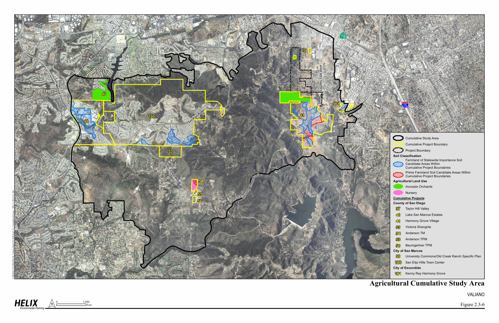
A̧
Coun
try C
lub D
rive
!"a$
Melrose Drive
Rancho
Santa
FeRo
ad
Elfin Forest Road
San Elijo Road
Harm
ony G
rove
Road
55
54
56
53
40
37
41
101
99100
Figure 2.3-6
VALIANOAgricultural Cumulative Study Area
Cumulative Study AreaCumulative Project BoundaryProject Boundary
Soil ClassificationFarmland of Statewide Importance SoilCandidate Areas WithinCumulative Project BoundariesPrime Farmland Soil Candidate Areas WithinCumulative Project Boundaries
Agricultural Land UseAvocado OrchardsNursery
Cumulative ProjectsCounty of San Diego
Taylor Hill ValleyLake San Marcos EstatesHarmony Grove VillageVictoria ShangrilaAnderson TMAnderson TPMBaumgartner TPM
City of San MarcosUniversity Commons/Old Creek Ranch Specific PlanSan Elijo Hills Town Center
City of EscondidoKenny Ray Harmony Grove
I:\PR
OJE
CTS
\I\IP
Q\IP
Q-0
8_V
alia
no\M
ap\E
NV
\EIR
\Fig
2-3-
6_C
umul
ativ
eSA
.mxd
IP
Q-1
1 0
4/13
/15
-RK
0 3,500FeetN
37404153545556
99100
101