2017 annual mineral resources and ore reserves … · of the australasian institute of mining and...
TRANSCRIPT
2017 Annual Mineral Resources and Ore Reserves Report
at 30th June 2017
Compiled By: Jane Bateman (FAusIMM, MAIG)
Glen Carthew (MAusIMM)
Robert Love (FAusIMM)
Tim Richards (MAusIMM)
Compilation Date: 15th July 2017
Table of Contents
SECTION 1 2017 MINERAL RESOURCES AND ORE RESERVES STATEMENT ............................................ 1
MINERAL RESOURCES 30TH JUNE 2017 ............................................................................................................................ 2
ORE RESERVES 30TH JUNE 2017 ...................................................................................................................................... 3
SECTION 2 2017 MINERAL RESOURCES AND ORE RESERVES SUMMARY .............................................. 4
OVERVIEW ................................................................................................................................................................... 5
PROCESS ...................................................................................................................................................................... 7
MINERAL RESOURCES REVISIONS ...................................................................................................................................... 8
Gwalia (+1,191,000 Ounces Ounces net of depletion and sterilisation ) ............................................................. 8
Simberi Oxide (-207,000 Ounces) ......................................................................................................................... 8
Simberi Sulphide (-428,000 Ounces) .................................................................................................................... 9
ORE RESERVES REVISIONS ............................................................................................................................................. 10
Gwalia (+325,000 Ounces) ................................................................................................................................. 10
Simberi Oxide and Sulphide (-24,000 Ounces) ................................................................................................... 11
SECTION 3 2016 MINERAL RESOURCES STATEMENT SUPPORTING DOCUMENTATION ....................... 13
ST BARBARA LTD SHORT FORM RESOURCE REPORT - GWALIA ................................................................................................ 14
ST BARBARA LTD SHORT FORM RESOURCE REPORT – TOWER HILL ......................................................................................... 21
ST BARBARA LTD SHORT FORM RESOURCE REPORT – SIMBERI OXIDE AND SULPHIDE ................................................................. 26
SECTION 4 2016 ORE RESERVES STATEMENT SUPPORTING DOCUMENTATION .................................. 36
ST BARBARA LTD SHORT FORM ORE RESERVE REPORT – GWALIA MINE .................................................................................. 37
ST BARBARA LTD SHORT FORM ORE RESERVE REPORT – TOWER HILL MINE ............................................................................ 49
ST BARBARA LTD SHORT FORM ORE RESERVE REPORT – SIMBERI GOLD MINE .......................................................................... 56
APPENDIX 1 COMPETENT PERSON CONSENT FORMS ....................................................................... 64
Page | 1
Section 1
2017 Mineral Resources and Ore Reserves Statement
Page | 2
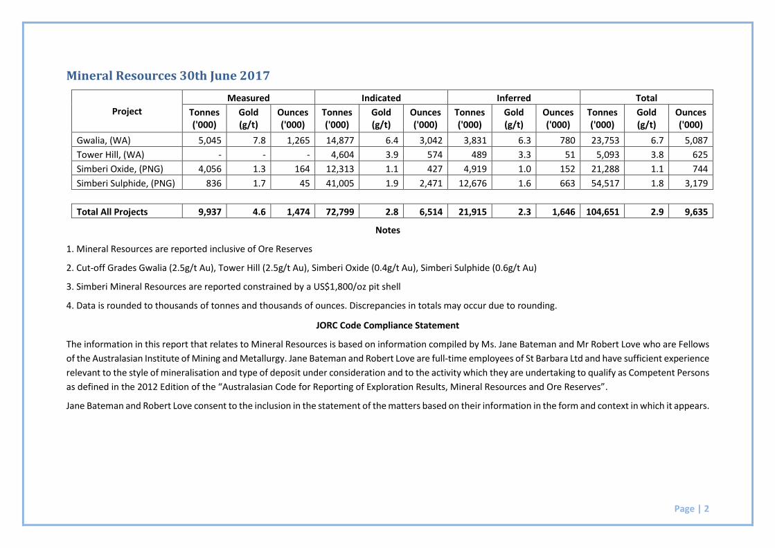
Mineral Resources 30th June 2017
Project
Measured Indicated Inferred Total
Tonnes ('000)
Gold (g/t)
Ounces ('000)
Tonnes ('000)
Gold (g/t)
Ounces ('000)
Tonnes ('000)
Gold (g/t)
Ounces ('000)
Tonnes ('000)
Gold (g/t)
Ounces ('000)
Gwalia, (WA) 5,045 7.8 1,265 14,877 6.4 3,042 3,831 6.3 780 23,753 6.7 5,087
Tower Hill, (WA) - - - 4,604 3.9 574 489 3.3 51 5,093 3.8 625
Simberi Oxide, (PNG) 4,056 1.3 164 12,313 1.1 427 4,919 1.0 152 21,288 1.1 744
Simberi Sulphide, (PNG) 836 1.7 45 41,005 1.9 2,471 12,676 1.6 663 54,517 1.8 3,179
Total All Projects 9,937 4.6 1,474 72,799 2.8 6,514 21,915 2.3 1,646 104,651 2.9 9,635
Notes
1. Mineral Resources are reported inclusive of Ore Reserves
2. Cut-off Grades Gwalia (2.5g/t Au), Tower Hill (2.5g/t Au), Simberi Oxide (0.4g/t Au), Simberi Sulphide (0.6g/t Au)
3. Simberi Mineral Resources are reported constrained by a US$1,800/oz pit shell
4. Data is rounded to thousands of tonnes and thousands of ounces. Discrepancies in totals may occur due to rounding.
JORC Code Compliance Statement
The information in this report that relates to Mineral Resources is based on information compiled by Ms. Jane Bateman and Mr Robert Love who are Fellows
of the Australasian Institute of Mining and Metallurgy. Jane Bateman and Robert Love are full-time employees of St Barbara Ltd and have sufficient experience
relevant to the style of mineralisation and type of deposit under consideration and to the activity which they are undertaking to qualify as Competent Persons
as defined in the 2012 Edition of the “Australasian Code for Reporting of Exploration Results, Mineral Resources and Ore Reserves”.
Jane Bateman and Robert Love consent to the inclusion in the statement of the matters based on their information in the form and context in which it appears.
Page | 3
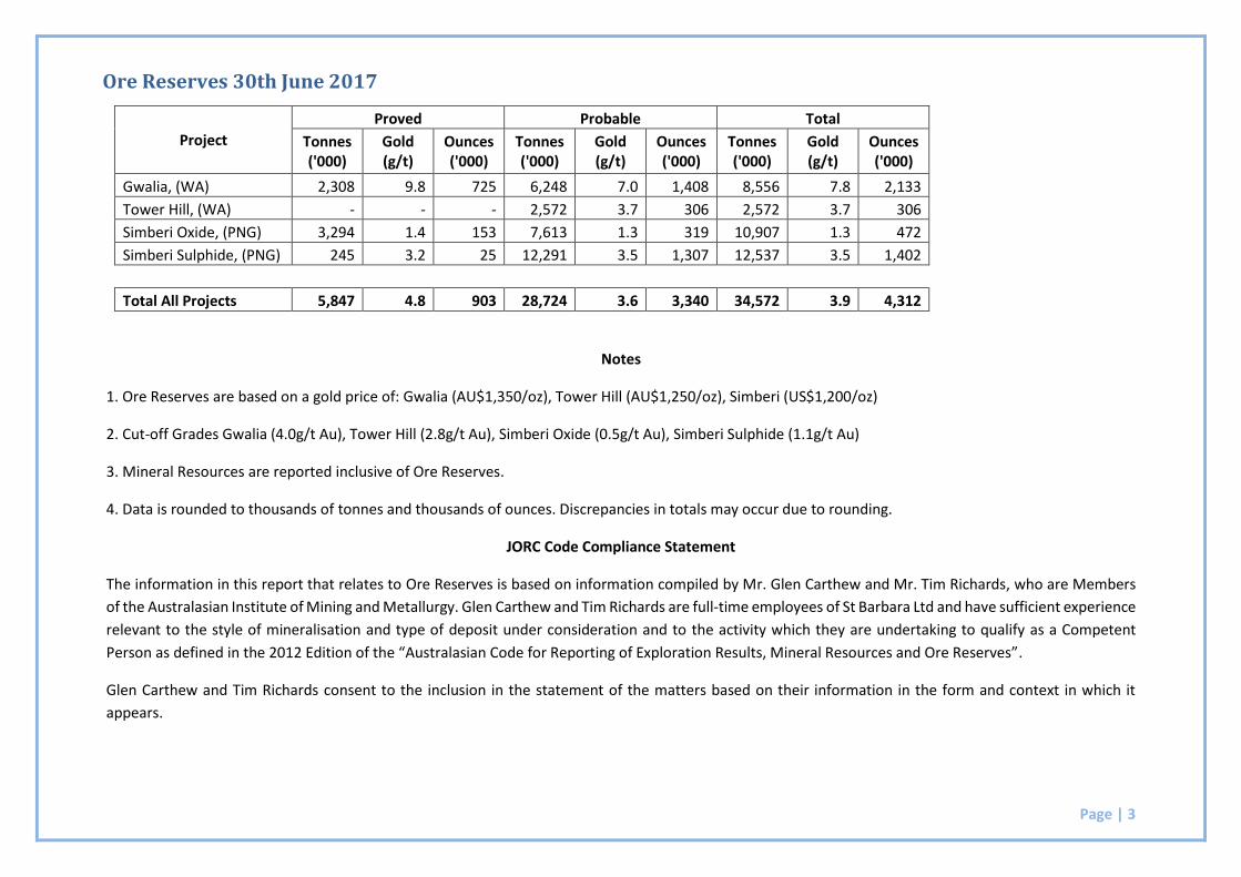
Project
Proved Probable Total
Tonnes ('000)
Gold (g/t)
Ounces ('000)
Tonnes ('000)
Gold (g/t)
Ounces ('000)
Tonnes ('000)
Gold (g/t)
Ounces ('000)
Gwalia, (WA) 2,308 9.8 725 6,248 7.0 1,408 8,556 7.8 2,133
Tower Hill, (WA) - - - 2,572 3.7 306 2,572 3.7 306
Simberi Oxide, (PNG) 3,294 1.4 153 7,613 1.3 319 10,907 1.3 472
Simberi Sulphide, (PNG) 245 3.2 25 12,291 3.5 1,307 12,537 3.5 1,402
Total All Projects 5,847 4.8 903 28,724 3.6 3,340 34,572 3.9 4,312
Notes
1. Ore Reserves are based on a gold price of: Gwalia (AU$1,350/oz), Tower Hill (AU$1,250/oz), Simberi (US$1,200/oz)
2. Cut-off Grades Gwalia (4.0g/t Au), Tower Hill (2.8g/t Au), Simberi Oxide (0.5g/t Au), Simberi Sulphide (1.1g/t Au)
3. Mineral Resources are reported inclusive of Ore Reserves.
4. Data is rounded to thousands of tonnes and thousands of ounces. Discrepancies in totals may occur due to rounding.
JORC Code Compliance Statement
The information in this report that relates to Ore Reserves is based on information compiled by Mr. Glen Carthew and Mr. Tim Richards, who are Members
of the Australasian Institute of Mining and Metallurgy. Glen Carthew and Tim Richards are full-time employees of St Barbara Ltd and have sufficient experience
relevant to the style of mineralisation and type of deposit under consideration and to the activity which they are undertaking to qualify as a Competent
Person as defined in the 2012 Edition of the “Australasian Code for Reporting of Exploration Results, Mineral Resources and Ore Reserves”.
Glen Carthew and Tim Richards consent to the inclusion in the statement of the matters based on their information in the form and context in which it
appears.
Ore Reserves 30th June 2017
Page | 4
Section 2
2017 Mineral Resources and Ore Reserves Summary
Page | 5
Overview
St Barbara's Mineral Resources and Ore Reserves position as at 30th June 2017 is summarised and
compared with the 2016 statement in Table 1.
Project 2016 Ore Reserves
2017 Production 2017 Ore Reserves
Tonnes (‘000)
Grade (g/t)
Ounces (‘000)
Ounces (‘000)
Tonnes (‘000)
Grade (g/t)
Ounces (‘000)
Gwalia (WA) 6,795 8.3 1,808 265 8,556 7.8 2,133
Tower Hill (WA) 2,572 3.7 306 - 2,572 3.7 306
Total Leonora 9,367 7.0 2,114 265 11,128 6.8 2,439
Simberi (Oxide) 14,094 1.3 576 116 10,907 1.3 472
Simberi (Sulphide) 13,556 3.0 1,321 - 12,537 3.5 1,402
Total Simberi 27,650 2.1 1,897 116 23,444 2.5 1,873
Grand Total 37,017 3.4 4,011 381 34,572 3.9 4,312
Project 2016 Mineral Resources
2017 Mineral Resources
Tonnes (‘000)
Grade (g/t)
Ounces (‘000)
Tonnes (‘000)
Grade (g/t)
Ounces (‘000)
Gwalia (WA) 17,294 7.0 3,896 23,753 6.7 5,087
Tower Hill (WA) 5,093 3.8 625 5,093 3.8 625
Total Leonora 22,387 6.3 4,521 28,846 6.2 5,712
Simberi (Oxide) 29,428 1.0 951 21,288 1.1 744
Simberi (Sulphide) 67,850 1.7 3,607 54,517 1.8 3,179
Total Simberi 97,278 1.5 4,558 75,805 1.6 3,923
Grand Total 119,665 2.4 9,079 104,651 2.9 9,635 Table 1: St Barbara 2017 and 2016 Ore Reserves and Mineral Resources Summary
The Company’s Ore Reserves and Mineral Resources have increased above net depletion primarily as a
consequence of resource extension drilling at Gwalia (Figures 1 & 2). At Simberi, Ore Reserves have been
reduced marginally after mining depletion, however a reduction in operating costs has helped to offset
these losses due to mining. A review of the Simberi geology model has resulted in an overall reduction of
Mineral Resources for this operation, but this has largely impacted Inferred sulphide resources only.
Page | 6
Figure 1: Summary Ore Reserves Variance FY16/FY17
Figure 2: Summary Mineral Resources Variance FY16/FY17
Page | 7
Process
Compilation of the 2017 Mineral Resource and Ore Reserve Report commenced in June 2017 with major
work having been completed on the following projects:
Revision of the Gwalia Deeps Mineral Resource and Ore Reserve inclusive of latest grade control
and resource definition drilling, and
Revision of the Simberi Mineral Resource and Ore Reserve inclusive of grade control drilling and
mapping data.
Each of the projects that have a revised or new estimate of Mineral Resources and Ore Reserves has been
compiled in accordance with the Company's Mineral Resource Estimation System and Ore Reserve
System. These systems provide a framework for the timely and reliable estimation and reporting of the
Company's Mineral Resources and Ore Reserves in accordance with the JORC (2012) Code.
Accountabilities for compilation of the 2017 Annual Mineral Resource and Ore Reserve are summarised
in Table 2.
Competent Person
Role Project Professional Membership
Membership Number
Mineral Resource
Robert Love Manager Geology (Leonora)
Gwalia AusIMM 104745
Jane Bateman Manager Mineral Resources (Perth)
Simberi Oxide Simberi Sulphide Tower Hill
AusIMM & AIG
110324 & 6350
Ore Reserve
Glen Carthew Mine Design Superintendent (Leonora)
Gwalia Tower Hill AusIMM 225657
Tim Richards General Manager Simberi Operations
Simberi Oxide Simberi Sulphide
AusIMM 204564
Table 2: 2017 Annual Mineral Resource and Ore Reserve accountabilities
Page | 8
Mineral Resources Revisions
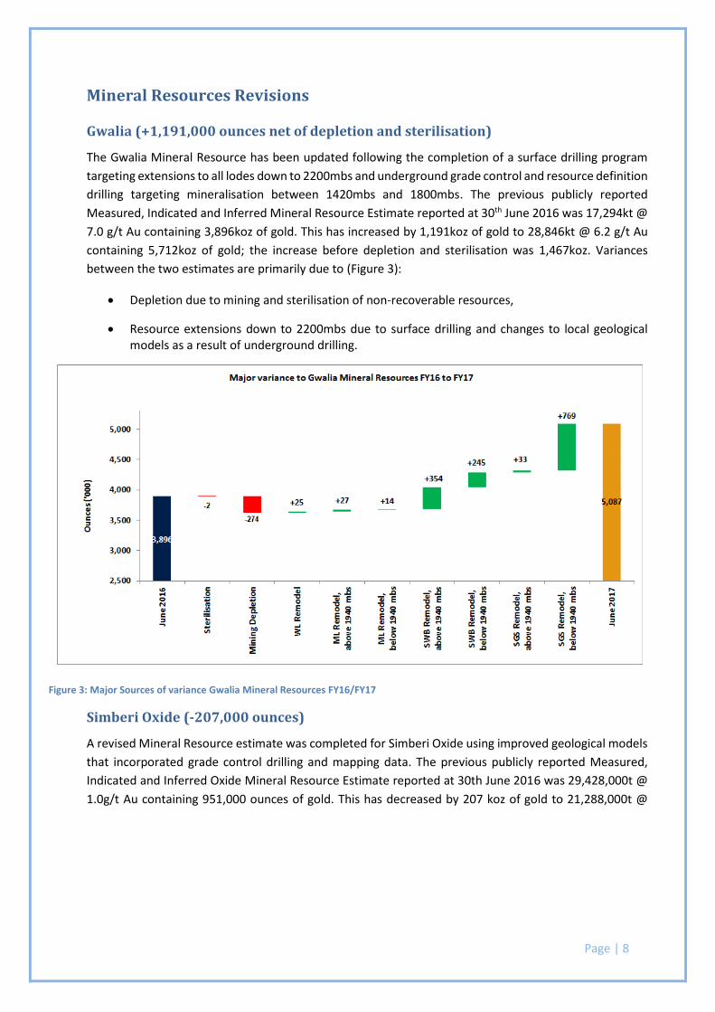
Gwalia (+1,191,000 ounces net of depletion and sterilisation)
The Gwalia Mineral Resource has been updated following the completion of a surface drilling program
targeting extensions to all lodes down to 2200mbs and underground grade control and resource definition
drilling targeting mineralisation between 1420mbs and 1800mbs. The previous publicly reported
Measured, Indicated and Inferred Mineral Resource Estimate reported at 30th June 2016 was 17,294kt @
7.0 g/t Au containing 3,896koz of gold. This has increased by 1,191koz of gold to 28,846kt @ 6.2 g/t Au
containing 5,712koz of gold; the increase before depletion and sterilisation was 1,467koz. Variances
between the two estimates are primarily due to (Figure 3):
Depletion due to mining and sterilisation of non-recoverable resources,
Resource extensions down to 2200mbs due to surface drilling and changes to local geological models as a result of underground drilling.
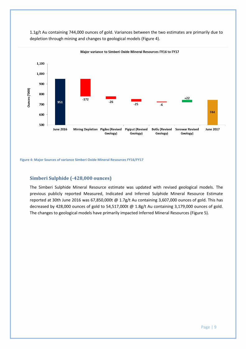
Simberi Oxide (-207,000 ounces)
A revised Mineral Resource estimate was completed for Simberi Oxide using improved geological models
that incorporated grade control drilling and mapping data. The previous publicly reported Measured,
Indicated and Inferred Oxide Mineral Resource Estimate reported at 30th June 2016 was 29,428,000t @
1.0g/t Au containing 951,000 ounces of gold. This has decreased by 207 koz of gold to 21,288,000t @
Figure 3: Major Sources of variance Gwalia Mineral Resources FY16/FY17
Page | 9
1.1g/t Au containing 744,000 ounces of gold. Variances between the two estimates are primarily due to
depletion through mining and changes to geological models (Figure 4).
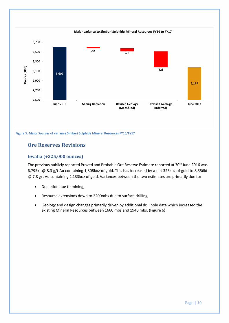
Simberi Sulphide (-428,000 ounces)
The Simberi Sulphide Mineral Resource estimate was updated with revised geological models. The
previous publicly reported Measured, Indicated and Inferred Sulphide Mineral Resource Estimate
reported at 30th June 2016 was 67,850,000t @ 1.7g/t Au containing 3,607,000 ounces of gold. This has
decreased by 428,000 ounces of gold to 54,517,000t @ 1.8g/t Au containing 3,179,000 ounces of gold.
The changes to geological models have primarily impacted Inferred Mineral Resources (Figure 5).
Figure 4: Major Sources of variance Simberi Oxide Mineral Resources FY16/FY17
Page | 10
Ore Reserves Revisions
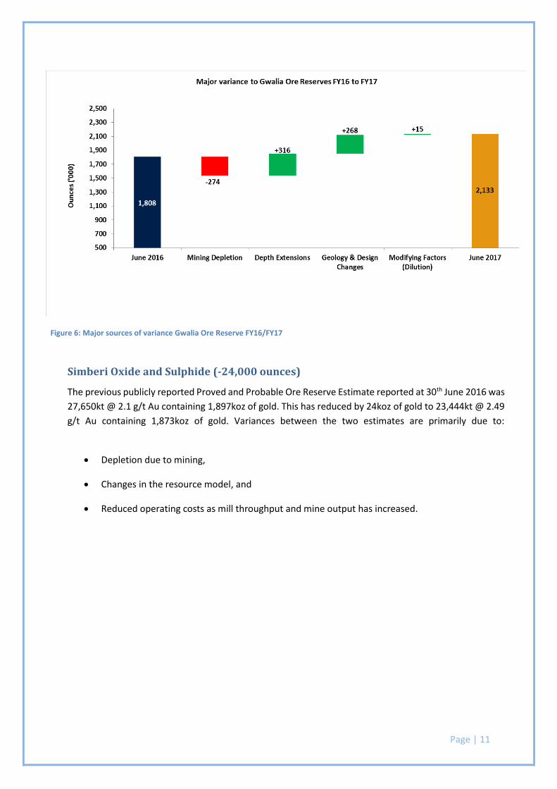
Gwalia (+325,000 ounces)
The previous publicly reported Proved and Probable Ore Reserve Estimate reported at 30th June 2016 was
6,795kt @ 8.3 g/t Au containing 1,808koz of gold. This has increased by a net 325koz of gold to 8,556kt
@ 7.8 g/t Au containing 2,133koz of gold. Variances between the two estimates are primarily due to:
Depletion due to mining,
Resource extensions down to 2200mbs due to surface drilling,
Geology and design changes primarily driven by additional drill hole data which increased the existing Mineral Resources between 1660 mbs and 1940 mbs. (Figure 6)
Figure 5: Major Sources of variance Simberi Sulphide Mineral Resources FY16/FY17
Page | 11
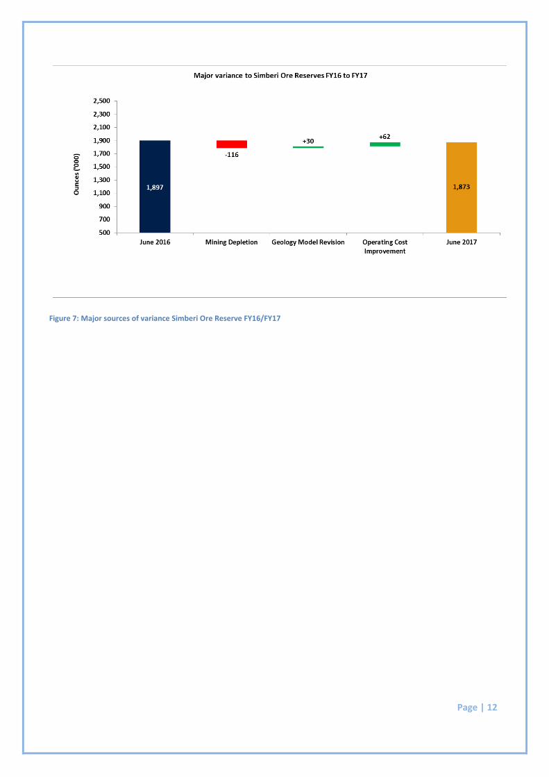
Simberi Oxide and Sulphide (-24,000 ounces)
The previous publicly reported Proved and Probable Ore Reserve Estimate reported at 30th June 2016 was
27,650kt @ 2.1 g/t Au containing 1,897koz of gold. This has reduced by 24koz of gold to 23,444kt @ 2.49
g/t Au containing 1,873koz of gold. Variances between the two estimates are primarily due to:
Depletion due to mining,
Changes in the resource model, and
Reduced operating costs as mill throughput and mine output has increased.
Figure 6: Major sources of variance Gwalia Ore Reserve FY16/FY17
Page | 12
Figure 7: Major sources of variance Simberi Ore Reserve FY16/FY17
Page | 13
Section 3
2017 Mineral Resources Statement Supporting Documentation
Gwalia Mine Page | 14
ST BARBARA LIMITED SHORT FORM RESOURCE REPORT
Gwalia Mine
TENEMENT: M37/25, M37/333, M37/849
OWNER: St Barbara Ltd 100%
OPERATOR: St Barbara Ltd (ACN 009 165 066)
Level 10, 432 St Kilda Road,
MELBOURNE,VIC 3004
COMMODITIES: Gold
MODELED BY: Pierre Pihouee and Callum Browne
REPORT BY: Pierre Pihouee
MODEL DATE: 30 June 2017
JORC CODE COMPLIANCE STATEMENT
The information in this report that relates to Mineral Resources is based on information compiled by Robert Love,
who is a Fellow of the Australasian Institute of Mining and Metallurgy. Robert Love is a full-time employee of St
Barbara Limited and has sufficient experience relevant to the style of mineralisation and type of deposit under
consideration and to the activity which he is undertaking to qualify as a Competent Person as defined in the 2012
Edition of the “Australasian Code for Reporting of Exploration Results, Mineral Resources and Ore Reserves”
Robert Love consents to the inclusion in the report of the matters based on his information in the form and context
in which it appears.
Gwalia Mine Page | 15
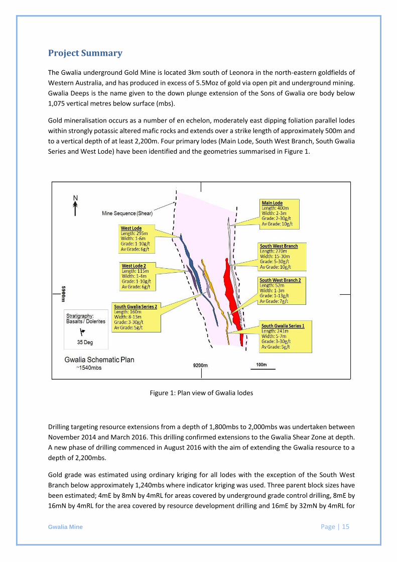
Project Summary
The Gwalia underground Gold Mine is located 3km south of Leonora in the north-eastern goldfields of
Western Australia, and has produced in excess of 5.5Moz of gold via open pit and underground mining.
Gwalia Deeps is the name given to the down plunge extension of the Sons of Gwalia ore body below
1,075 vertical metres below surface (mbs).
Gold mineralisation occurs as a number of en echelon, moderately east dipping foliation parallel lodes
within strongly potassic altered mafic rocks and extends over a strike length of approximately 500m and
to a vertical depth of at least 2,200m. Four primary lodes (Main Lode, South West Branch, South Gwalia
Series and West Lode) have been identified and the geometries summarised in Figure 1.
Figure 1: Plan view of Gwalia lodes
Drilling targeting resource extensions from a depth of 1,800mbs to 2,000mbs was undertaken between
November 2014 and March 2016. This drilling confirmed extensions to the Gwalia Shear Zone at depth.
A new phase of drilling commenced in August 2016 with the aim of extending the Gwalia resource to a
depth of 2,200mbs.
Gold grade was estimated using ordinary kriging for all lodes with the exception of the South West
Branch below approximately 1,240mbs where indicator kriging was used. Three parent block sizes have
been estimated; 4mE by 8mN by 4mRL for areas covered by underground grade control drilling, 8mE by
16mN by 4mRL for the area covered by resource development drilling and 16mE by 32mN by 4mRL for
Gwalia Mine Page | 16
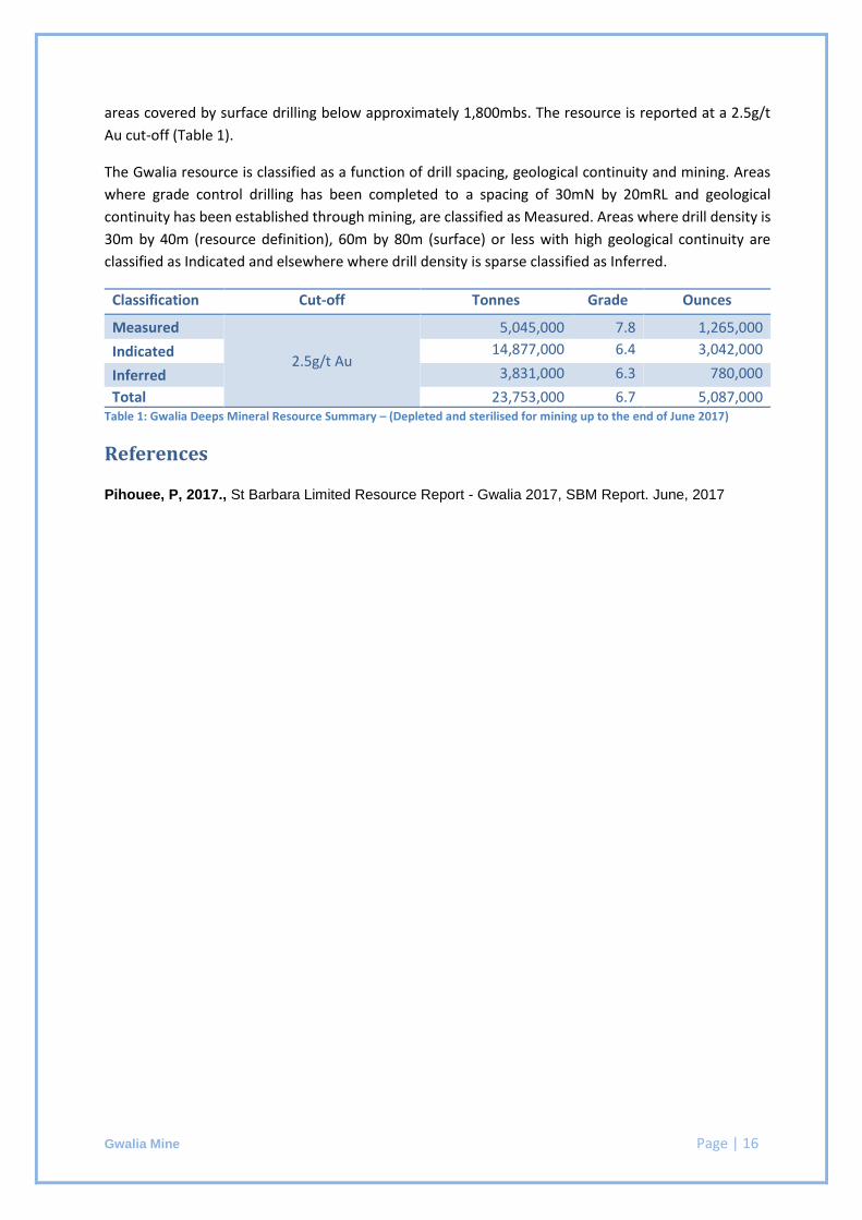
areas covered by surface drilling below approximately 1,800mbs. The resource is reported at a 2.5g/t
Au cut-off (Table 1).
The Gwalia resource is classified as a function of drill spacing, geological continuity and mining. Areas
where grade control drilling has been completed to a spacing of 30mN by 20mRL and geological
continuity has been established through mining, are classified as Measured. Areas where drill density is
30m by 40m (resource definition), 60m by 80m (surface) or less with high geological continuity are
classified as Indicated and elsewhere where drill density is sparse classified as Inferred.
Classification Cut-off Tonnes Grade Ounces
Measured
2.5g/t Au
5,045,000 7.8 1,265,000
Indicated 14,877,000 6.4 3,042,000
Inferred 3,831,000 6.3 780,000
Total 23,753,000 6.7 5,087,000 Table 1: Gwalia Deeps Mineral Resource Summary – (Depleted and sterilised for mining up to the end of June 2017)
References
Pihouee, P, 2017., St Barbara Limited Resource Report - Gwalia 2017, SBM Report. June, 2017
Gwalia Mine Page | 17
Checklist of Assessment and Reporting Criteria
Sampling Techniques and Data
Criteria Comments
Sampling Techniques Sampling boundaries are geologically defined and mostly one metre in length unless a significant geological feature warrants a change from this standard unit. The upper or right-hand side of the core is routinely submitted for sample analysis, with each one metre of half core providing between 2.5 – 3 kg of material as an assay sample.
Drilling Techniques Surface and underground diamond drill holes used NQ2 (50.6mm) sized core (standard tubes). SBM surface drill holes have been down hole surveyed by north seeking gyro and underground drill holes have been surveyed by single shot electronic camera. Surface holes are orientated using a Reflex ACT II RD orientation tool.
Drill Sample Recovery Core is metre marked and orientated and checked against drillers blocks to ensure that any core loss is accounted for. Sample recovery was rarely less than 100%. Minor occurrences of core loss can in most instances be attributed to drilling conditions and not ground conditions.
Logging All SBM holes are logged primarily for lithology, alteration and vein type/intensity which are key to modelling gold grade distributions. Validation of geological data is controlled via the use of library codes and reliability and consistency of data is monitored through regular peer review.
Sub-sampling techniques and sample preparation
SBM half core is cut using a core saw before being sent to an accredited lab (SGS laboratory in Kalgoorlie) where the entire sample is crushed to achieve particle size <4mm followed by complete pulverisation (90%
passing 75 m). Quality of assay data and laboratory tests
SBM samples were analysed for gold using fire assay with a 50g charge and analysis by flame Atomic Absorption Spectrometry (AAS). QC included insertion of 3 commercial standards (1 per 20 samples), use of barren flush material between designated high grade samples during the pulverising stage, re-numbered sample pulp residues re-submitted to original laboratory, and sample pulp residues submitted to accredited umpire laboratory, submission of residual (duplicate) half core from ore intervals. The analysis of gold was sound and re-analysis of pulps showed acceptable repeatability with no significant bias.
Verification of sampling and assay
Sampling data is recorded electronically in spreadsheets which ensure only valid non-overlapping data can be recorded. Assay and down hole survey data are subsequently merged electronically. All drill data is stored in a SQL database on secure company server.
Location of data points Collars for surface holes are recorded by DGPS. Upon completion of underground drill holes an authorised surveyor will pick up the collar by placing a survey rod into the hole to measure azimuth and dip. This process may also occur while the hole is in progress by surveying the drill rods in the hole.
Data spacing and distribution
Data spacing for grade control drilling is approximately 10m x 15m from 1000mbs to 1480mbs, resource definition is approximately 20m x 30m from 1480mbs – 1800mbs and surface drilling is approximately 60m x 80m from 1800mbs to 2200mbs. Drilling data is sufficient to establish down plunge continuity for all lodes.
Gwalia Mine Page | 18
Criteria Comments Orientation of data in relation to geological structure
Sampling is perpendicular to lode orientations, and based on past production and underground mapping.
Sample security Only SBM personnel or approved contractors are allowed on drill sites; drill samples are only removed from drill site by approved contractors to SBM’s secure core logging/processing facility; cut core is consigned to accredited laboratories for sample preparation and analysis.
Audits or reviews Regular reviews of core logging and sampling have been completed through SBM mentoring and auditing. Laboratory inspections have been conducted throughout the review period by SBM personnel. Inspections are documented electronically and stored on secure company server. No significant issues were identified.
Estimation and Reporting of Mineral Resources
Criteria Comments
Database Integrity Information is captured through spread sheets and validated prior to loading into the SBM corporate database which ensures only valid non-overlapping data can be recorded. Assay and down hole survey data are subsequently merged electronically. All drill data is stored in an SQL database on secure company server. Validation of data included visual checks of hole traces, analytical and geological data and ad hoc validation of 20 holes to original core photos and hard copy geological logs.
Site Visits The Competent Person directly supervised geological modelling and mineral resource estimation, and is the site Manager Geology.
Geological Interpretation Mineralisation domains are defined by abundance of quartz and quartz/carbonate veining, the presence of distinctive laminated veining (quartz/sericite/sulphides +/- au), strong potassic alteration, abundance of sulphides (commonly >3% pyrite) and elevated gold grade (>0.5g/t).
Dimensions The mineralised zone strikes 15 degrees east of true north over a distance of 500m and plunges 45 degrees to the southeast. The mineralised zone consists of several stepped or en echelon style foliation parallel lodes disposed in plan in a “horse-shoe” shape with the limbs converging at the southern end. The mineralised zone and individual lodes dip east at 35 to 45 degrees and are conformable with the foliation of the Mine Sequence mafic schists. Individual lode widths vary from 2m to 30m true width. Mineralisation has been tested to approximately 2,080m below surface and remains open.
Estimation and modelling techniques
All domains were estimated using ordinary kriging except for South West Branch below the dyke (~1240mbs) where indicator kriging was used for grade estimation. Three parent block sizes have been estimated; 4mE x 8mN x 4mRL for areas covered by underground grade control drilling, 8mE x 16mN x 4mRL for the area covered by resource development drilling and 16mE x 32mN x 4mRL for areas covered by surface drilling below approximately 1,800 metres vertical depth. Estimation was completed using Datamine Studio RM. Search parameters reflect a high grade plunge orientation north east for WL, east north-east to east for SGS and south-east for SWB and ML consistent with geological observation of high grade mineralisation geometry:

Gwalia Mine Page | 19
Criteria Comments
Main Lode – Rotation Azimuth = 345 degrees, Dip = 35 degrees, Pitch = 135 degrees. Max search distances = 300m. Major/Semi-Major anisotropy = 3; Major/Minor = 30. Min samples = 8, max samples = 20
South West Branch – Rotation Azimuth = 335 degrees, Dip = 40 degrees, Pitch = 125 degrees. Max search distances = 240m. Major/Semi-Major anisotropy = 3; Major/Minor = 12. Min samples = 8, max samples =20
South Gwalia Series 1 – Rotation Azimuth = 340 degrees, Dip = 45 degrees, Pitch = 100 degrees. Max search distances = 170m. Major/Semi-Major anisotropy = 1.7; Major/Minor = 8.5. Min samples = 8, max samples =20
South Gwalia Series 2 – Rotation Azimuth = 345 degrees, Dip = 45 degrees, Pitch = 70 degrees. Max search distances = 210m. Major/Semi-Major anisotropy = 1.5; Major/Minor = 10.5. Min samples = 8, max samples =20
West Lode – Rotation Azimuth = 347 degrees, Dip = 40 degrees, Pitch = 60 degrees. Max search distances = 150m. Major/Semi-Major anisotropy = 1.88; Major/Minor = 7.5. Min samples = 8, max samples =20
Isolated high grade composites were top cut prior to estimation for each domain (ML=120g/t, SWB=180/220g/t SGS1=90g/t, SGS2=90g/t, WL=90g/t). The model was validated by plotting composite and block model average grades against RL
Moisture Tonnages are estimated on a dry basis Cut-off parameters The model is reported at a 2.5g/t Au cut-off on 20mRL x 20mN panels for
each lode to account for non-selective mining across strike. Mining factors or assumptions
The mining method is underground, open stoping with paste fill. Minimum stoping panels are 20mRL x 15mN with the resource reported on similar size panels to reflect this relationship.
Metallurgical factors or assumptions
Metallurgical recovery has been proven to be consistently >95%
Environmental factors or assumptions
The project covers an area that has been previously impacted by mining. The tenement area includes existing ethnographic heritage sites. SBM have undertaken extensive Aboriginal Heritage Surveys within the tenements and management measures are in place.
Bulk density Bulk density is assigned on a lode by lode basis and is routinely monitored via grade control drilling using the weight in air/weight in water method. Density ranges between 2.71g/cm3 and 2.79g/cm3
Classification The Gwalia resource is classified as a function of drill spacing, geological continuity and mining. Areas where grade control drilling has been completed to 20m x 30m and geological continuity has been established through mining are classified as Measured. Areas where drill density is 30m x 40m, 60m x 80m or less with high geological continuity are classified as Indicated and elsewhere where drill density is sparse classified as Inferred.
Audits or Reviews The Gwalia Mineral Resource Estimate is reviewed internally in August, January and May of each year by site geologists and scrutinised by a panel of competent company geologists. The review covers all aspects of
Gwalia Mine Page | 20
Criteria Comments
the estimate including source data, geological model, resource estimate and classification In addition; the reporting of the company Mineral Resources is guided by the company’s Mineral Resource Estimation System and is overseen by the Executive Leadership team prior to being reviewed by the company’s Audit Committee.
Discussion of relative accuracy/confidence
The resource estimate is a global estimate. Grade control drilling is completed in advance of development to improve local estimates of grade.
Tower Hill Page | 21
ST BARBARA LIMITED SHORT FORM RESOURCE REPORT
Tower Hill
TENEMENT: M37/0055
OWNER: St Barbara Ltd 100%
OPERATOR: St Barbara Ltd (ACN 009 165 066)
Level 10, 432 St Kilda Road,
MELBOURNE, VIC, 3004
COMMODITIES: Gold
MODELED BY: Bob Love, Rebekah Evans, Shane Kenworthy, Jane Bateman
REPORT BY: Kathryn Jagodzinski
MODEL DATE: 21 February 2011
JORC CODE COMPLIANCE STATEMENT
The information in this report that relates to Mineral Resources is based on information compiled by Jane
Bateman, who is a Fellow of the Australasian Institute of Mining and Metallurgy. Jane Bateman is a full-time
employee of St Barbara Limited and has sufficient experience relevant to the style of mineralisation and type of
deposit under consideration and to the activity which she is undertaking to qualify as a Competent Person as
defined in the 2012 Edition of the “Australasian Code for Reporting of Exploration Results, Mineral Resources
and Ore Reserves” Jane Bateman consents to the inclusion in the report of the matters based on her information
in the form and context in which it appears.
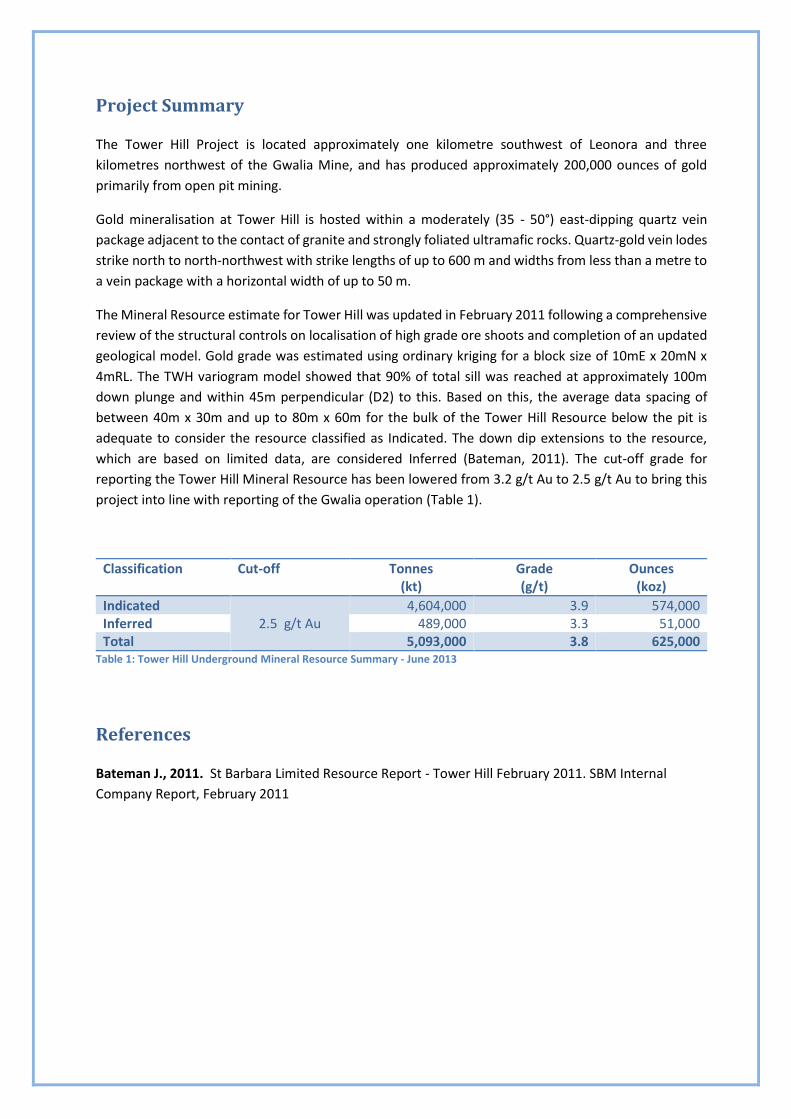
Project Summary
The Tower Hill Project is located approximately one kilometre southwest of Leonora and three
kilometres northwest of the Gwalia Mine, and has produced approximately 200,000 ounces of gold
primarily from open pit mining.
Gold mineralisation at Tower Hill is hosted within a moderately (35 - 50°) east-dipping quartz vein
package adjacent to the contact of granite and strongly foliated ultramafic rocks. Quartz-gold vein lodes
strike north to north-northwest with strike lengths of up to 600 m and widths from less than a metre to
a vein package with a horizontal width of up to 50 m.
The Mineral Resource estimate for Tower Hill was updated in February 2011 following a comprehensive
review of the structural controls on localisation of high grade ore shoots and completion of an updated
geological model. Gold grade was estimated using ordinary kriging for a block size of 10mE x 20mN x
4mRL. The TWH variogram model showed that 90% of total sill was reached at approximately 100m
down plunge and within 45m perpendicular (D2) to this. Based on this, the average data spacing of
between 40m x 30m and up to 80m x 60m for the bulk of the Tower Hill Resource below the pit is
adequate to consider the resource classified as Indicated. The down dip extensions to the resource,
which are based on limited data, are considered Inferred (Bateman, 2011). The cut-off grade for
reporting the Tower Hill Mineral Resource has been lowered from 3.2 g/t Au to 2.5 g/t Au to bring this
project into line with reporting of the Gwalia operation (Table 1).
Classification Cut-off Tonnes (kt)
Grade (g/t)
Ounces (koz)
Indicated 2.5 g/t Au
4,604,000 3.9 574,000 Inferred 489,000 3.3 51,000 Total 5,093,000 3.8 625,000
Table 1: Tower Hill Underground Mineral Resource Summary - June 2013
References
Bateman J., 2011. St Barbara Limited Resource Report - Tower Hill February 2011. SBM Internal
Company Report, February 2011
Tower Hill Page | 23
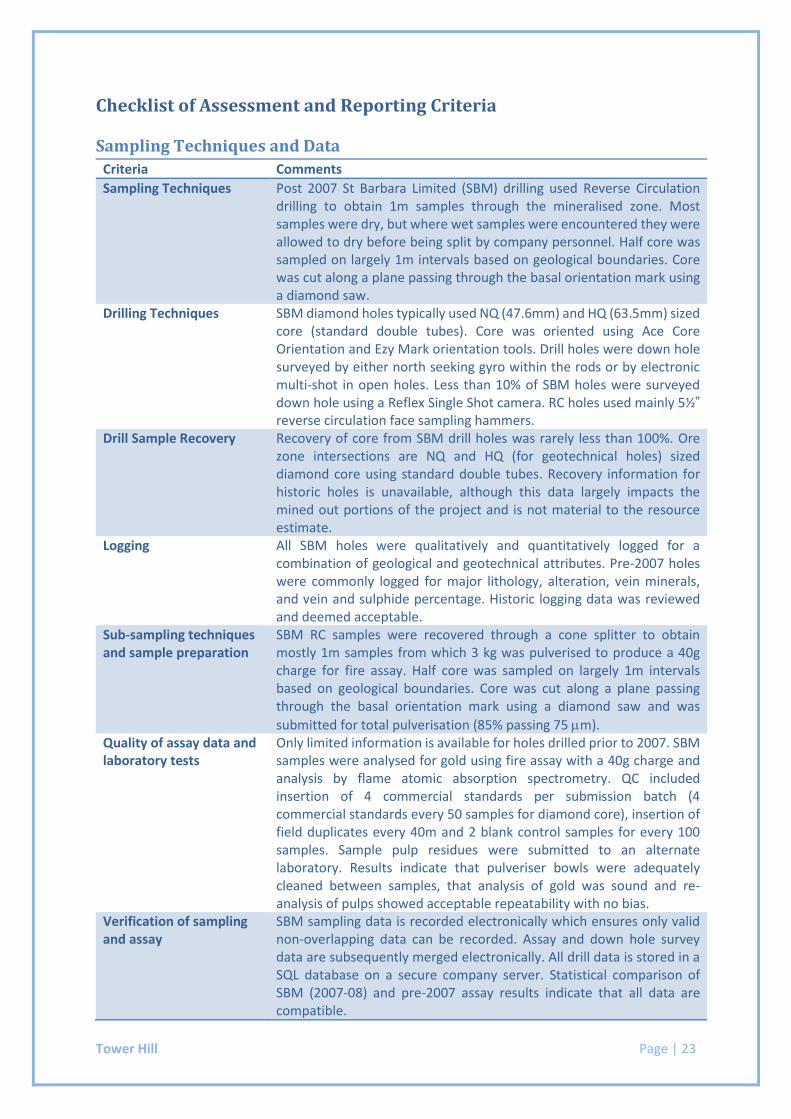
Checklist of Assessment and Reporting Criteria
Sampling Techniques and Data
Criteria Comments
Sampling Techniques Post 2007 St Barbara Limited (SBM) drilling used Reverse Circulation drilling to obtain 1m samples through the mineralised zone. Most samples were dry, but where wet samples were encountered they were allowed to dry before being split by company personnel. Half core was sampled on largely 1m intervals based on geological boundaries. Core was cut along a plane passing through the basal orientation mark using a diamond saw.
Drilling Techniques SBM diamond holes typically used NQ (47.6mm) and HQ (63.5mm) sized core (standard double tubes). Core was oriented using Ace Core Orientation and Ezy Mark orientation tools. Drill holes were down hole surveyed by either north seeking gyro within the rods or by electronic multi-shot in open holes. Less than 10% of SBM holes were surveyed down hole using a Reflex Single Shot camera. RC holes used mainly 5½”
reverse circulation face sampling hammers. Drill Sample Recovery Recovery of core from SBM drill holes was rarely less than 100%. Ore
zone intersections are NQ and HQ (for geotechnical holes) sized diamond core using standard double tubes. Recovery information for historic holes is unavailable, although this data largely impacts the mined out portions of the project and is not material to the resource estimate.
Logging All SBM holes were qualitatively and quantitatively logged for a combination of geological and geotechnical attributes. Pre-2007 holes were commonly logged for major lithology, alteration, vein minerals, and vein and sulphide percentage. Historic logging data was reviewed and deemed acceptable.
Sub-sampling techniques and sample preparation
SBM RC samples were recovered through a cone splitter to obtain mostly 1m samples from which 3 kg was pulverised to produce a 40g charge for fire assay. Half core was sampled on largely 1m intervals based on geological boundaries. Core was cut along a plane passing through the basal orientation mark using a diamond saw and was
submitted for total pulverisation (85% passing 75 m). Quality of assay data and laboratory tests
Only limited information is available for holes drilled prior to 2007. SBM samples were analysed for gold using fire assay with a 40g charge and analysis by flame atomic absorption spectrometry. QC included insertion of 4 commercial standards per submission batch (4 commercial standards every 50 samples for diamond core), insertion of field duplicates every 40m and 2 blank control samples for every 100 samples. Sample pulp residues were submitted to an alternate laboratory. Results indicate that pulveriser bowls were adequately cleaned between samples, that analysis of gold was sound and re-analysis of pulps showed acceptable repeatability with no bias.
Verification of sampling and assay
SBM sampling data is recorded electronically which ensures only valid non-overlapping data can be recorded. Assay and down hole survey data are subsequently merged electronically. All drill data is stored in a SQL database on a secure company server. Statistical comparison of SBM (2007-08) and pre-2007 assay results indicate that all data are compatible.
Tower Hill Page | 24
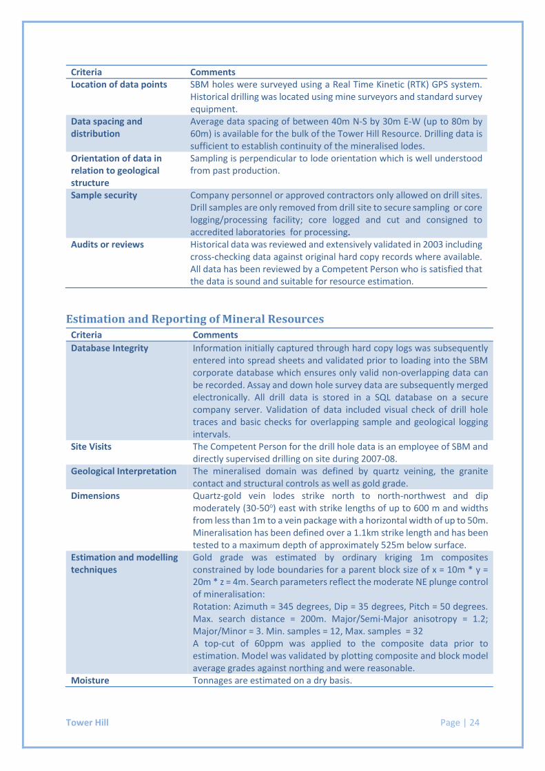
Criteria Comments Location of data points SBM holes were surveyed using a Real Time Kinetic (RTK) GPS system.
Historical drilling was located using mine surveyors and standard survey equipment.
Data spacing and distribution
Average data spacing of between 40m N-S by 30m E-W (up to 80m by 60m) is available for the bulk of the Tower Hill Resource. Drilling data is sufficient to establish continuity of the mineralised lodes.
Orientation of data in relation to geological structure
Sampling is perpendicular to lode orientation which is well understood from past production.
Sample security Company personnel or approved contractors only allowed on drill sites. Drill samples are only removed from drill site to secure sampling or core logging/processing facility; core logged and cut and consigned to accredited laboratories for processing.
Audits or reviews Historical data was reviewed and extensively validated in 2003 including cross-checking data against original hard copy records where available. All data has been reviewed by a Competent Person who is satisfied that the data is sound and suitable for resource estimation.
Estimation and Reporting of Mineral Resources
Criteria Comments
Database Integrity Information initially captured through hard copy logs was subsequently entered into spread sheets and validated prior to loading into the SBM corporate database which ensures only valid non-overlapping data can be recorded. Assay and down hole survey data are subsequently merged electronically. All drill data is stored in a SQL database on a secure company server. Validation of data included visual check of drill hole traces and basic checks for overlapping sample and geological logging intervals.
Site Visits The Competent Person for the drill hole data is an employee of SBM and directly supervised drilling on site during 2007-08.
Geological Interpretation The mineralised domain was defined by quartz veining, the granite contact and structural controls as well as gold grade.
Dimensions Quartz-gold vein lodes strike north to north-northwest and dip moderately (30-50o) east with strike lengths of up to 600 m and widths from less than 1m to a vein package with a horizontal width of up to 50m. Mineralisation has been defined over a 1.1km strike length and has been tested to a maximum depth of approximately 525m below surface.
Estimation and modelling techniques
Gold grade was estimated by ordinary kriging 1m composites constrained by lode boundaries for a parent block size of x = 10m * y = 20m * z = 4m. Search parameters reflect the moderate NE plunge control of mineralisation: Rotation: Azimuth = 345 degrees, Dip = 35 degrees, Pitch = 50 degrees. Max. search distance = 200m. Major/Semi-Major anisotropy = 1.2; Major/Minor = 3. Min. samples = 12, Max. samples = 32 A top-cut of 60ppm was applied to the composite data prior to estimation. Model was validated by plotting composite and block model average grades against northing and were reasonable.
Moisture Tonnages are estimated on a dry basis.
Tower Hill Page | 25
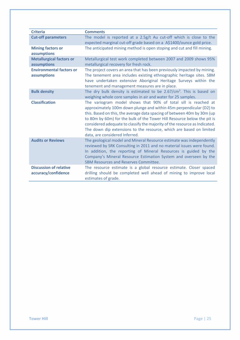
Criteria Comments Cut-off parameters The model is reported at a 2.5g/t Au cut-off which is close to the
expected marginal cut-off grade based on a A$1400/ounce gold price. Mining factors or assumptions
The anticipated mining method is open stoping and cut and fill mining.
Metallurgical factors or assumptions
Metallurgical test work completed between 2007 and 2009 shows 95% metallurgical recovery for fresh rock.
Environmental factors or assumptions
The project covers an area that has been previously impacted by mining. The tenement area includes existing ethnographic heritage sites. SBM have undertaken extensive Aboriginal Heritage Surveys within the tenement and management measures are in place.
Bulk density The dry bulk density is estimated to be 2.67/cm3. This is based on weighing whole core samples in air and water for 25 samples.
Classification The variogram model shows that 90% of total sill is reached at approximately 100m down plunge and within 45m perpendicular (D2) to this. Based on this, the average data spacing of between 40m by 30m (up to 80m by 60m) for the bulk of the Tower Hill Resource below the pit is considered adequate to classify the majority of the resource as Indicated. The down dip extensions to the resource, which are based on limited data, are considered Inferred.
Audits or Reviews The geological model and Mineral Resource estimate was independently reviewed by SRK Consulting in 2011 and no material issues were found. In addition, the reporting of Mineral Resources is guided by the Company’s Mineral Resource Estimation System and overseen by the SBM Resources and Reserves Committee.
Discussion of relative accuracy/confidence
The resource estimate is a global resource estimate. Closer spaced drilling should be completed well ahead of mining to improve local estimates of grade.
Simberi Oxide & Sulphide Page | 26
ST BARBARA LIMITED SHORT FORM RESOURCE REPORT
Simberi – Oxide and Sulphide
TENEMENT: ML136
OWNER: St Barbara Ltd 100%
OPERATOR: Simberi Gold Company Limited
Simberi Island, New Ireland Province,
Papua New Guinea
COMMODITIES: Gold
MODELED BY: Jeff Moncrieff, Jane Bateman
REPORT BY: Jane Bateman, Jeff Moncrieff
MODEL DATE: 30 June 2017
JORC CODE COMPLIANCE STATEMENT
The information in this report that relates to Mineral Resources is based on information compiled by Jane
Bateman, who is a Fellow of the Australasian Institute of Mining and Metallurgy and a Member of the Australian
Institute of Geoscientists. Jane Bateman is a full-time employee of St Barbara Limited and has sufficient
experience relevant to the style of mineralisation and type of deposit under consideration and to the activity which
she is undertaking to qualify as a Competent Person as defined in the 2012 Edition of the “Australasian Code for
Reporting of Exploration Results, Mineral Resources and Ore Reserves”. Jane Bateman consents to the inclusion
in the report of the matters based on her information in the form and context in which it appears.
Simberi Oxide & Sulphide Page | 27
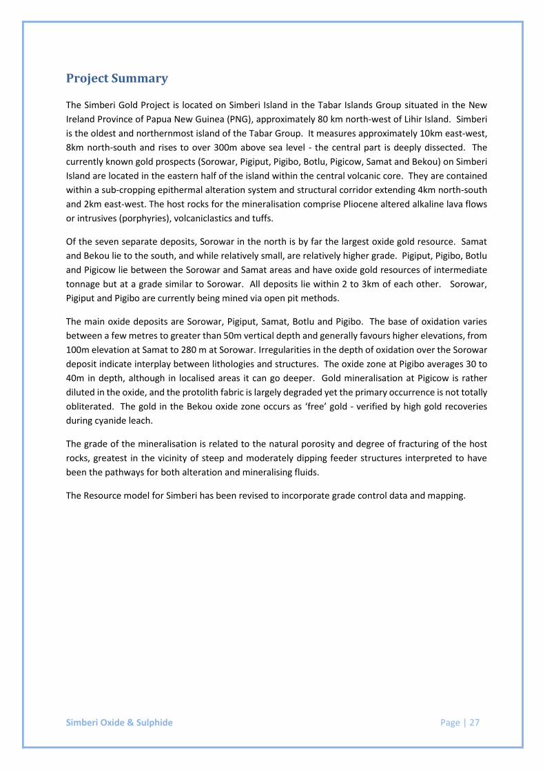
Project Summary
The Simberi Gold Project is located on Simberi Island in the Tabar Islands Group situated in the New
Ireland Province of Papua New Guinea (PNG), approximately 80 km north-west of Lihir Island. Simberi
is the oldest and northernmost island of the Tabar Group. It measures approximately 10km east-west,
8km north-south and rises to over 300m above sea level - the central part is deeply dissected. The
currently known gold prospects (Sorowar, Pigiput, Pigibo, Botlu, Pigicow, Samat and Bekou) on Simberi
Island are located in the eastern half of the island within the central volcanic core. They are contained
within a sub-cropping epithermal alteration system and structural corridor extending 4km north-south
and 2km east-west. The host rocks for the mineralisation comprise Pliocene altered alkaline lava flows
or intrusives (porphyries), volcaniclastics and tuffs.
Of the seven separate deposits, Sorowar in the north is by far the largest oxide gold resource. Samat
and Bekou lie to the south, and while relatively small, are relatively higher grade. Pigiput, Pigibo, Botlu
and Pigicow lie between the Sorowar and Samat areas and have oxide gold resources of intermediate
tonnage but at a grade similar to Sorowar. All deposits lie within 2 to 3km of each other. Sorowar,
Pigiput and Pigibo are currently being mined via open pit methods.
The main oxide deposits are Sorowar, Pigiput, Samat, Botlu and Pigibo. The base of oxidation varies
between a few metres to greater than 50m vertical depth and generally favours higher elevations, from
100m elevation at Samat to 280 m at Sorowar. Irregularities in the depth of oxidation over the Sorowar
deposit indicate interplay between lithologies and structures. The oxide zone at Pigibo averages 30 to
40m in depth, although in localised areas it can go deeper. Gold mineralisation at Pigicow is rather
diluted in the oxide, and the protolith fabric is largely degraded yet the primary occurrence is not totally
obliterated. The gold in the Bekou oxide zone occurs as ‘free’ gold - verified by high gold recoveries
during cyanide leach.
The grade of the mineralisation is related to the natural porosity and degree of fracturing of the host
rocks, greatest in the vicinity of steep and moderately dipping feeder structures interpreted to have
been the pathways for both alteration and mineralising fluids.
The Resource model for Simberi has been revised to incorporate grade control data and mapping.
Simberi Oxide & Sulphide Page | 28
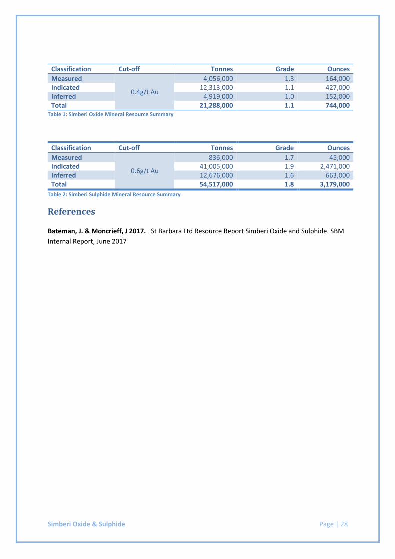
Classification Cut-off Tonnes Grade Ounces
Measured
0.4g/t Au
4,056,000 1.3 164,000 Indicated 12,313,000 1.1 427,000 Inferred 4,919,000 1.0 152,000 Total 21,288,000 1.1 744,000
Table 1: Simberi Oxide Mineral Resource Summary
Classification Cut-off Tonnes Grade Ounces
Measured
0.6g/t Au
836,000 1.7 45,000 Indicated 41,005,000 1.9 2,471,000 Inferred 12,676,000 1.6 663,000 Total 54,517,000 1.8 3,179,000
Table 2: Simberi Sulphide Mineral Resource Summary
References
Bateman, J. & Moncrieff, J 2017. St Barbara Ltd Resource Report Simberi Oxide and Sulphide. SBM
Internal Report, June 2017
Simberi Oxide & Sulphide Page | 29
Checklist of Assessment and Reporting Criteria
Sampling Techniques and Data
Criteria Comments
Sampling Techniques Chips from reverse circulation (RC) drilling and half-core from diamond holes (DH) have been used to sample the Simberi deposits. Drilling by Kennecott occurred between 1984 and 1989. Subsequent drilling by Nord was carried out between 1995 and 1998. Allied drilled from 2004 to 2012. During the early part of the Kennecott percussive drilling program (up to approximately RC320, February-May 1989), each 1m sample was collected from a cyclone in a calico bag. The sample was dried and jaw crushed to less than 7mm and a 1.5kg riffle split sub-sample dispatched for assay. The Kennecott 1m diamond drill core samples were cut in half using a diamond saw, dried, jaw crushed and hammer milled to -30mesh. A 200-250g sub-sample was pulverised to -80mesh before submitting to the laboratory. Nord sampled percussive and diamond holes every 1m. RC samples were collected in polyweave bags direct from a cyclone. Approximately 100g of every RC sample were washed, dried and retained for reference. RC samples were hammer milled at a Nord sample preparation facility, located on Simberi Island, to approximately -30mesh. The sample preparation facility was supervised by contract personnel from Astrolabe Pty Ltd, an analytical laboratory in Madang. A 1kg subsample was riffle split for dispatch for assay and the remainder stored. Nord diamond core was photographed, logged and cut in half using a diamond saw. One half was dried, jaw-crushed, hammer milled and reduced to a 1kg sub-sample using a riffle splitter. The sub-samples were dispatched to Astrolabe (Madang, PNG) for final preparation and assay up until September 1996. Allied RC samples were collected at 1m intervals then dried. Each sample was jaw-crushed, hammer milled to -80mesh and reduced to two approximate 1kg sub-samples using a riffle splitter. One 1kg sample was hammer milled to -30mesh and the other ‘reject’ split was archived on site for a minimum of 3 months after assays were returned. The 1kg crushed samples were dispatched to ALS. In mid-2008, a new core shed and sample preparation facility was constructed with upgraded security and new sample processing equipment. This allowed a change to the RC sampling and preparation procedures. Samples from the cyclone were collected in large polyweave bags and weighed. Sub-samples were placed in calico bags. For dry/damp samples a riffle splitter was used to produce approximately 500g for processing and approximately 500g for ‘reject’ or archive. Spear sampling was conducted on wet samples to obtain two 800g sub-samples, one for archive and one for processing. Sub-samples were sent to sample prep for drying in electric ovens. Before mid-2008, Allied diamond core samples were processed in a similar way to the RC samples. Core was sampled on 1m intervals, cut in
Simberi Oxide & Sulphide Page | 30
Criteria Comments
half using diamond saws and dried. One half of each sample was stored on site in the secured core shed, the other half was crushed with a jaw crusher and split to two approximately 1kg samples. One was hammer milled to -30mesh and the ‘reject’ sample archived for a minimum of 3 months after assays were returned. The 1kg samples were dispatched to ALS Townsville for fire assay. St Barbara have completed 11 diamond drill holes (PQ3) and 121 RC holes. Core was sampled at 1m intervals irrespective of geology using a petrol clipper saw along its long axis on a plane representing approximately half of the core. RC drill spoil was collected at 1m intervals direct from the cyclone in polyweave bags. SBM personnel riffle split to collect 1kg to 3kg sub-samples which were crushed and pulverised at the Simberi laboratory.
Drilling Techniques From 1984 to 1990 drilling was carried out by Kennecott, comprising 447 (43,727m) RC drill holes (3.75 - 4 inch), 73 (15,970m) diamond drill holes and 11 (153m) diamond holes drilled for metallurgical purposes. Most diamond holes were drilled PQ to depths of up to 200-250m and HQ thereafter. From 1994 to 1998 Nord completed a further 432 (26,241m) RC holes and 35 (6,415m) diamond holes. Many of these diamond holes were triple-tubed for metallurgical sampling and testwork. Allied drilled 816 RC (62,003m) holes and 219 (42,098m) diamond holes after 2003. All diamond drillhole core has been photographed. Downhole surveys were restricted to only some of the early Kennecott and Nord diamond drill holes and the bulk of the later Allied diamond drilling. Most of the RC drilling is shallow, averaging less than 100m, and errors due to hole deviation are considered to be minimal. SBM (2014-2015) completed diamond holes using a track mounted Cortech CSD1300G drill rig. RC drilling was completed using a track mounted Gemrok 1000H MP rig.
Drill Sample Recovery Overall historical sample recovery was better than 90%, but core recovery through fracture zones was relatively poor in some of the holes. Some early Kennecott RC holes were drilled with water injection, increasing the likelihood of sample contamination and data loss in these holes. Diamond drilling completed by SBM averaged 93% recovery. No recovery details were recorded for RC drilling
Logging Lithology, alteration, structure and assay data exists in the historical data, as well as an extensive set of core photographs. All holes were logged for a combination of geological and geotechnical attributes. Only validated geological data was included in the resource database. All recent drilling completed by SBM was comprehensively logged with data stored in the company’s Datashed database
Sub-sampling techniques and sample preparation
During the Kennecott percussive drilling program (up to approximately RC320, February-May 1989), the jaw-crushed sample was split to 250g, disc pulverised to -80mesh, further split to a 50g aliquot and finely pulverised for assay. Lack of correlation between duplicate and original sample assays led Kennecott to revise the sample preparation procedure. Subsequently (up to RC447, 1992) a 250g split (-80mesh) was
Simberi Oxide & Sulphide Page | 31
Criteria Comments
sent to the laboratory. At the laboratory a 50g aliquot was taken for pulverising and assay. A similar sized aliquot from the 200-250g sub-samples (-80mesh) from the Kennecott diamond core samples was fire assayed. Every Nord 1m RC sample was hammer milled to approximately -30mesh and a 5g aliquot finely pulverised and fire assayed. Nord diamond core sub-samples were dispatched to Astrolabe (Madang, PNG) for final preparation and assay up until September 1996. At the laboratory the 1kg sub-samples were dried, pulverised and a 50g sub-sample was fire assayed for gold using an atomic absorption spectrometer (AAS) finish. After September 1996, the samples were dispatched to Australian Laboratory Services (ALS) in Townsville, Queensland, for preparation and assay using the same method. The 1kg (-30mesh) sub-samples from the Allied RC drilling were dispatched to ALS and finely pulverised. A 50g sub-sample was fire assayed and the remainder stored at their facility in Garbutt, Queensland. The Simberi processing equipment was flushed with glass before each hole was processed. After the new core shed and sample preparation facility was constructed (2008) spear sampling was conducted on wet samples to obtain two 800g sub-samples, one for archive and one for processing. Dried RC samples of up to 600g were milled in an LM2 to obtain a 90% pass through 75 microns for dispatch to the laboratory. The laboratory procedures on Simberi Island were reviewed by ALS Chemex in October 2004 and found to be satisfactory. Before mid-2008, Allied drill core samples were processed in a similar way to the RC samples. 1kg from the half-core sample was hammer milled to -30mesh and the ‘reject’ sample archived for a minimum of 3 months after assays were returned. The processing equipment was flushed with glass before each hole was processed. The 1kg samples were dispatched to ALS Townsville for pulverising and a 50g sub-sample was fire assayed. For SBM drilling all samples were prepped using the on-site laboratory. Samples were initially crushed to <2mm using a Terminator jaw crusher. Samples greater than 1kg were riffle split and this subsample was pulverised using an Essa LM2 pulveriser, with 150-200g dispatched to ALS in Townsville for analysis.
Quality of assay data and laboratory tests
Kennecott evaluated the results of a re-assay program in 1992 dividing the data into oxide, transition and sulphide as well as grade classes. As a result the following corrections were made to the assay data: oxide -6.1%, transition -10.3% and sulphide -9.2%. Duplicate sampling by Nord concluded that the majority of the duplicate pairs agreed well. Nord’s internal standard samples were reported as having acceptable agreement. Allied’s sample preparation and analytical control procedures included the use of blanks to monitor contamination, duplicates to test splitting and milling efficiency and standards to monitor analytical accuracy and precision. Gold assays for 288 standards showed precision well within
Simberi Oxide & Sulphide Page | 32
Criteria Comments
two standard deviations. Gold assays for 574 duplicates, representing 4.2% of the (Allied) samples assayed show good agreement with a correlation coefficient of 0.994. In addition, Au assays for 570 samples submitted to a second laboratory also showed good agreement, with a correlation coefficient of 0.996. Between drill holes sample preparation equipment was cleaned with crushed glass and compressed air. Between samples the same equipment was cleaned with compressed air and a brush. Due to the poor initial selection of blank material, the blanks analysis data could not be used to accurately determine the degree of contamination and points to a minor QC sample handling problem. Allied conducted Round Robin inter-laboratory checks in 2009 and 2010 with satisfactory results. SBM have inserted non-certified blank material at a ratio of 1:25; inserted certified reference material at a ratio of 1:21; field duplicates (RC) 1:47 and the pulverisation and analysis of coarse reject (core) at a ratio of 1:22. No bias or contamination issues were detected
Verification of sampling and assay
Kennecott and Nord drilled twinned holes in order to investigate the variability of information returned by them. Overall grades were consistent between these holes with any observed discrepancies likely to be caused by local geological variability than any drilling technique or sampling problems. Routine QAQC of the drilling programs has shown that assay results are of sufficient quality for use in a mineral resource estimate.
Location of data points All drill collars were surveyed using traditional EDM instruments based on UTM WGS 84. An audit by McMullen Nolan and Partners Surveyors Ltd in 2005, using two dual frequency GPS units, determined that the Simberi survey had very high accuracy. Since 2007 an additional QC step was introduced to record all collars with a GPS to cross check the surveyed coordinates. Results from a LiDAR survey flown in early 2012 are pending and will improve topographic control. SBM mine survey team has surveyed the SBM drilling. No down hole surveys were completed on RC holes. Diamond holes were surveyed down hole every 15 metres using a single shot camera.
Data spacing and distribution
Drill spacing at Sorowar is mostly on fence lines oriented SW-NE, spaced 20m apart. Inclined (-60o) holes drilled towards the NE are spaced about 30m along the fence lines. At Pigibo the fence lines are 50m apart with inclined (-60o) holes drilled towards the south. Holes are spaced about 40m, or less, along the fence lines. The drill orientation at Pigiput is similar to Pigibo but with fence lines 25m apart and holes spaced 20m along the lines. There are some radially oriented holes (sharing a common collar location) in the northern portion of Pigiput – about a dozen clusters or fans. At Botlu the holes are drilled towards the southwest (234o) at -60o. The fence lines are 15-20m apart aligned with the drill direction. Holes are spaced about 25m along the fence lines. A wider spaced (50m by 50m) grid is superimposed at Botlu – with holes inclined to the north or south. The holes at Pigicow are mostly vertical on fence lines spaced 25m apart and oriented SW-NE. Four long (~300m) inclined holes on the same grid are drilled towards the southwest at -60o.
Simberi Oxide & Sulphide Page | 33
Criteria Comments
There are three distinct areas of drilling at Samat. At north Samat holes 20m apart are inclined at -60o towards the northeast, parallel to the fence lines. The central portion of Samat is erratically drilled in various directions – the collars are about 20m apart. The southwest portion of Samat is drilled on fence lines 10m apart, aligned towards the northwest. Holes along the fence lines are spaced about 10m and inclined at -60o towards the northwest. At Bekou the collars are about 20m apart with holes either vertically, or inclined at -60o towards 210o.
Orientation of data in relation to geological structure
Gold mineralisation does not appear to be closely associated with any particular lithology. It is recognised that the primary control of gold mineralization are the NW–SE and NE–SW steeply dipping structures and the intersection of these has the potential to host mineralization. Gold mineralisation is generally associated with sulphides or iron oxides occurring within all variety of hydraulic fractures, and broad disseminations in the naturally porous volcaniclastic rocks. The mix of vertical and inclined drilling goes some way to optimally intersect these mineralisation styles.
Sample security Company personnel or approved contractors only were allowed on drill sites. Drill samples were removed from drill sites only to a secure sampling or core logging/processing facility. Logged and cut core was consigned and dispatched as secure cargo to accredited laboratories for processing.
Audits or reviews In 2004, Golder Associates prepared an Independent Qualified Person’s Technical Report of the Simberi Oxide Gold Project and in June, 2011 Golders produced the Competent Person’s Report for the Simberi Gold Project which found no compromising factors deleterious to the resource. The current resource estimate has not been independently audited
Estimation and Reporting of Mineral Resources
Criteria Comments
Database Integrity Drilling in 2004 and 2005 by Allied Gold was subject to significant external review. Golder Associates visited the site in April 2004 and reviewed data collection procedures. In early 2009, the historic data was transferred into a Maxwell’s Datashed model and subjected to QAQC which traps and reports errors on import. Data is now entered directly into the Datashed SQL database.
Site Visits The Competent Person currently based in Perth, visited site for seven days in March 2017.
Geological Interpretation Steeply dipping mineralised zones were modelled for Sorowar, Monun Creek, Botlu and Pigibo based on gold grades and supported where possible by closely spaced grade control drilling and mapping. At Pigiput a similar approach was used although one domain was modelled with a shallow to moderate dip to reflect stratigraphy.
Dimensions The northernmost deposit is Sorowar, its bulk is aligned SE-NW (1550m) with minor (structurally controlled) orthogonal splays towards the southwest and northeast. These splays are less than 750m long and 300m wide.
Simberi Oxide & Sulphide Page | 34
Criteria Comments
Pigibo is oriented W-E for approximately 740m with a central bulge about 300m wide and tapering to about 100m at the western and eastern extremities. It is located about 1500m to the southwest of the central part of Sorowar. Pigiput is east of Pigibo and about 1000m south of Sorowar. It is roughly equidimensional (640m diameter) in plan. Botlu is about 800m south of Pigibo. It strikes SE-NW for approximately 680m with an average width of around 250m. About 700m to the SE of Botlu is the discontinuous Pigicow deposit which strikes SW-NE for nearly 600m with a variable width (200-450m). Samat is located about 700m to the southeast of Pigicow and is aligned north-south for approximately 720m with an average width of 300m. Like Pigicow, Bekou is discontinuous and oriented towards the east-northeast with a strike length of around 600m. Located about 650m to the southwest of Samat, its width varies from 40m to 170m.
Estimation and modelling techniques
Gold grade was estimated in each model by ordinary kriging (OK) using 1m composites for all prospects.
Moisture Tonnages are estimated on a dry basis. Cut-off parameters The models are reported at a gold cut-off of 0.4g/t for oxide material and
0.6g/t Au for sulphide material. Optimal pit shells were generated at a gold price of US$1,800/oz to constrain the reporting of mineral resources.
Mining factors or assumptions
The mining method for all deposits is open pit, using 5m flitches and hauling with 28 tonne trucks. The 650tph rope conveyor from the pits to the ROM pad is an integral part of the mining process flow at Simberi. Mining has not commenced at Botlu, Pigicow or Bekou.
Metallurgical factors or assumptions
Metallurgical factors used in the LOMP are as follows:
Ore Type Gold Recovery (%)
Oxide Sulphide
86 Variable – fixed tail
with max 85% recovery
Environmental factors or assumptions
Historically, there has been no large scale mining and the previous alluvial workings have had no significant impact. There are no pre-existing environmental liabilities. During a 2004 environmental baseline study, a network of monitoring stations was established to support the ongoing collection of data. A 2005 feasibility study addressed the environmental impacts associated with waste dumps, open pits, pipelines, access/haul roads, process plant, deep sea tailings and stormwater. However, no attempt at identifying the acid rock drainage potential was made, although the resource model was domained with respect to visible oxidation intensity. A report by Environmental Geochemistry International suggests that the distribution of the acid rock drainage (ARD) material types be spatially determined. In this way the non-acid forming (NAF) and potentially acid forming (PAF) factors can be evaluated – using the sulphur values in the model. This work has been completed for the largest prospects – Sorowar, Pigiput and Pigibo
Bulk density The dry bulk densities (determined using the water immersion method) on average as follows:
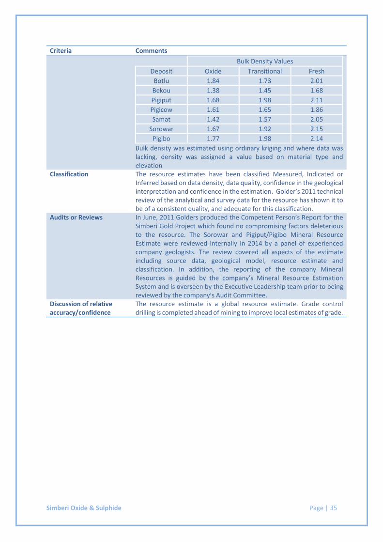
Simberi Oxide & Sulphide Page | 35
Criteria Comments
Bulk Density Values
Deposit Oxide Transitional Fresh
Botlu 1.84 1.73 2.01
Bekou 1.38 1.45 1.68
Pigiput 1.68 1.98 2.11
Pigicow 1.61 1.65 1.86
Samat 1.42 1.57 2.05
Sorowar 1.67 1.92 2.15
Pigibo 1.77 1.98 2.14
Bulk density was estimated using ordinary kriging and where data was lacking, density was assigned a value based on material type and elevation
Classification The resource estimates have been classified Measured, Indicated or Inferred based on data density, data quality, confidence in the geological interpretation and confidence in the estimation. Golder’s 2011 technical review of the analytical and survey data for the resource has shown it to be of a consistent quality, and adequate for this classification.
Audits or Reviews In June, 2011 Golders produced the Competent Person’s Report for the Simberi Gold Project which found no compromising factors deleterious to the resource. The Sorowar and Pigiput/Pigibo Mineral Resource Estimate were reviewed internally in 2014 by a panel of experienced company geologists. The review covered all aspects of the estimate including source data, geological model, resource estimate and classification. In addition, the reporting of the company Mineral Resources is guided by the company’s Mineral Resource Estimation System and is overseen by the Executive Leadership team prior to being reviewed by the company’s Audit Committee.
Discussion of relative accuracy/confidence
The resource estimate is a global resource estimate. Grade control drilling is completed ahead of mining to improve local estimates of grade.
Page | 36
Section 4
2017 Ore Reserves Statement Supporting Documentation
Gwalia Mine Page | 37
ST BARBARA LIMITED SHORT FORM ORE RESERVE REPORT
Gwalia Mine
TENEMENT: M37/25, M37/333, M37/849
OWNER: St Barbara Ltd 100%
OPERATOR: St Barbara Ltd (ACN 009 165 066)
Level 10, 432 St Kilda Road,
MELBOURNE, VIC 3004
COMMODITIES: Gold
COMPILED BY: G. Carthew, M. Dass, K. Oborne and F. Harvey
REPORT BY: Glen Carthew
REPORTING DATE: 30 June 2017
JORC CODE COMPLIANCE STATEMENT
The information in this report that relates to Ore Reserve is based on information compiled by Glen Carthew
who is a Member of the Australasian Institute of Mining and Metallurgy. Glen Carthew is a full-time employee
of St Barbara Limited and has sufficient experience relevant to the style of mineralisation and type of deposit
under consideration and to the activity which he is undertaking to qualify as a Competent Person as defined in
the 2012 Edition of the “Australasian Code for Reporting of Exploration Results, Mineral Resources and Ore
Reserves” Glen Carthew consents to the inclusion in the report of the matters based on his information in the
form and context in which it appears.
Gwalia Mine Page | 38
Project Summary
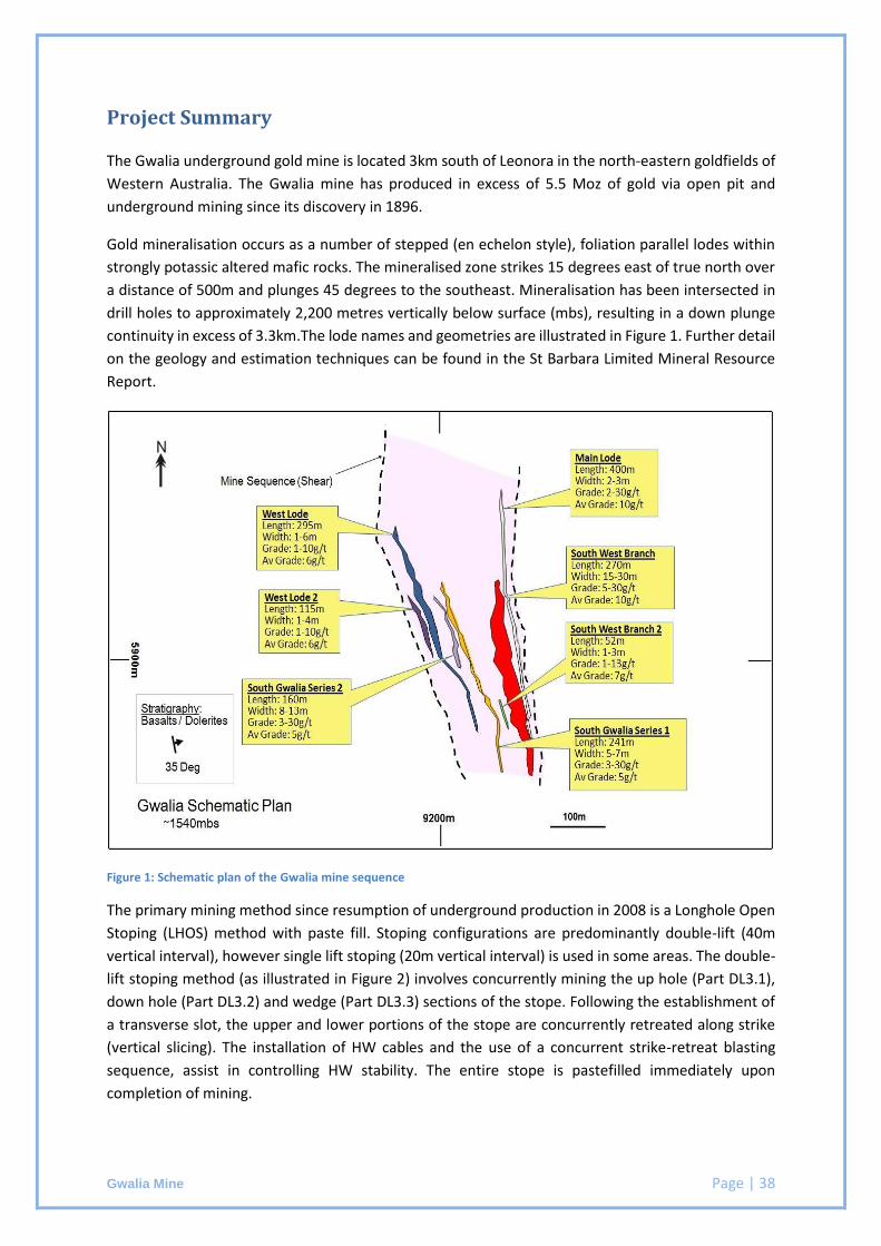
The Gwalia underground gold mine is located 3km south of Leonora in the north-eastern goldfields of
Western Australia. The Gwalia mine has produced in excess of 5.5 Moz of gold via open pit and
underground mining since its discovery in 1896.
Gold mineralisation occurs as a number of stepped (en echelon style), foliation parallel lodes within
strongly potassic altered mafic rocks. The mineralised zone strikes 15 degrees east of true north over
a distance of 500m and plunges 45 degrees to the southeast. Mineralisation has been intersected in
drill holes to approximately 2,200 metres vertically below surface (mbs), resulting in a down plunge
continuity in excess of 3.3km.The lode names and geometries are illustrated in Figure 1. Further detail
on the geology and estimation techniques can be found in the St Barbara Limited Mineral Resource
Report.
Figure 1: Schematic plan of the Gwalia mine sequence
The primary mining method since resumption of underground production in 2008 is a Longhole Open
Stoping (LHOS) method with paste fill. Stoping configurations are predominantly double-lift (40m
vertical interval), however single lift stoping (20m vertical interval) is used in some areas. The double-
lift stoping method (as illustrated in Figure 2) involves concurrently mining the up hole (Part DL3.1),
down hole (Part DL3.2) and wedge (Part DL3.3) sections of the stope. Following the establishment of
a transverse slot, the upper and lower portions of the stope are concurrently retreated along strike
(vertical slicing). The installation of HW cables and the use of a concurrent strike-retreat blasting
sequence, assist in controlling HW stability. The entire stope is pastefilled immediately upon
completion of mining.
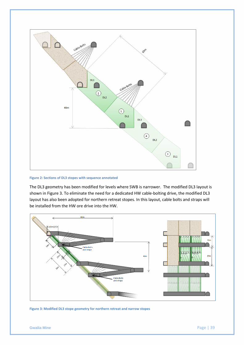
Gwalia Mine Page | 39
Figure 2: Sections of DL3 stopes with sequence annotated
The DL3 geometry has been modified for levels where SWB is narrower. The modified DL3 layout is
shown in Figure 3. To eliminate the need for a dedicated HW cable-bolting drive, the modified DL3
layout has also been adopted for northern retreat stopes. In this layout, cable bolts and straps will
be installed from the HW ore drive into the HW.
Figure 3: Modified DL3 stope geometry for northern retreat and narrow stopes
Gwalia Mine Page | 40
Gwalia is operated on a fly-in-fly-out (FIFO) basis with personnel residing in camp facilities in Leonora.
The FIFO roster for most personnel is 8 days on site, with 6 days off site.
The Gwalia mine is one of the world’s deepest trucking mines. The Hoover decline is currently at a
depth of 1650 metres below surface which is a 11 km journey to the portal. Combined ore and waste
production of around 1.1 Mtpa is trucked to surface using a fleet of nine trucks comprised of Atlas
Copco MT6020 and MT65 trucks. The truck fleet is matched with a fleet of two Sandvik LH621 and
three Caterpillar R2900 loaders operating on a combination of tele-remote and manual control.
Normal drilling fleet includes three development jumbos and three production rigs.
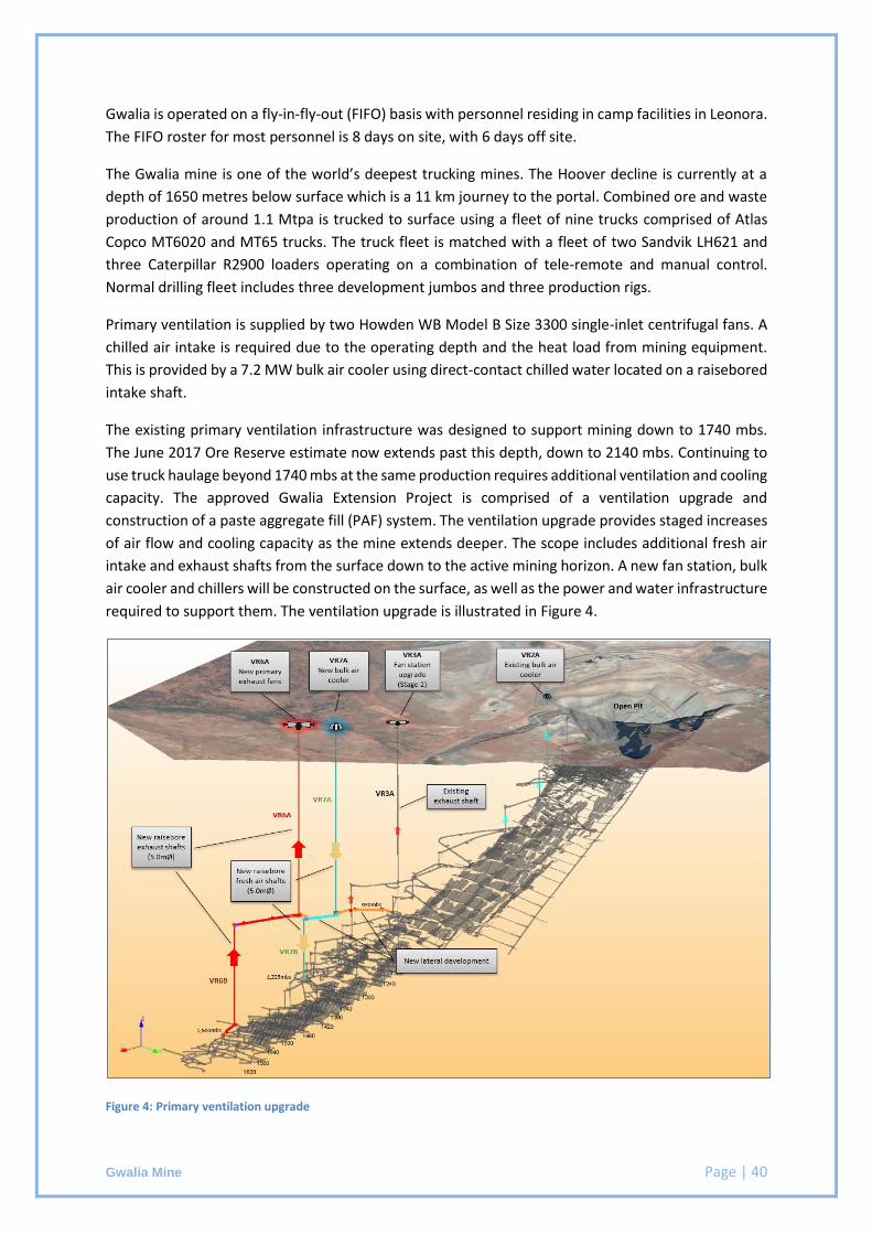
Primary ventilation is supplied by two Howden WB Model B Size 3300 single-inlet centrifugal fans. A
chilled air intake is required due to the operating depth and the heat load from mining equipment.
This is provided by a 7.2 MW bulk air cooler using direct-contact chilled water located on a raisebored
intake shaft.
The existing primary ventilation infrastructure was designed to support mining down to 1740 mbs.
The June 2017 Ore Reserve estimate now extends past this depth, down to 2140 mbs. Continuing to
use truck haulage beyond 1740 mbs at the same production requires additional ventilation and cooling
capacity. The approved Gwalia Extension Project is comprised of a ventilation upgrade and
construction of a paste aggregate fill (PAF) system. The ventilation upgrade provides staged increases
of air flow and cooling capacity as the mine extends deeper. The scope includes additional fresh air
intake and exhaust shafts from the surface down to the active mining horizon. A new fan station, bulk
air cooler and chillers will be constructed on the surface, as well as the power and water infrastructure
required to support them. The ventilation upgrade is illustrated in Figure 4.
Figure 4: Primary ventilation upgrade
Gwalia Mine Page | 41
All Gwalia ore is trucked to the Gwalia processing plant. The processing plant is located at St Barbara’s
Leonora Operations and consists of a three-stage crushing circuit, single-stage milling circuit and
hybrid carbon-in-leach (CIL) circuit with one designated leach tank and seven adsorption tanks. Gold
is recovered from activated carbon into concentrated solution via a split AARL-type elution circuit.
Electrowinning and smelting are conducted in an adjacent secure gold room. The tailings from the
process are thickened and pumped to a paddock-type tailings storage facility with multi-spigot
distribution. Gold doré bars are transported to the Perth Mint for refining.
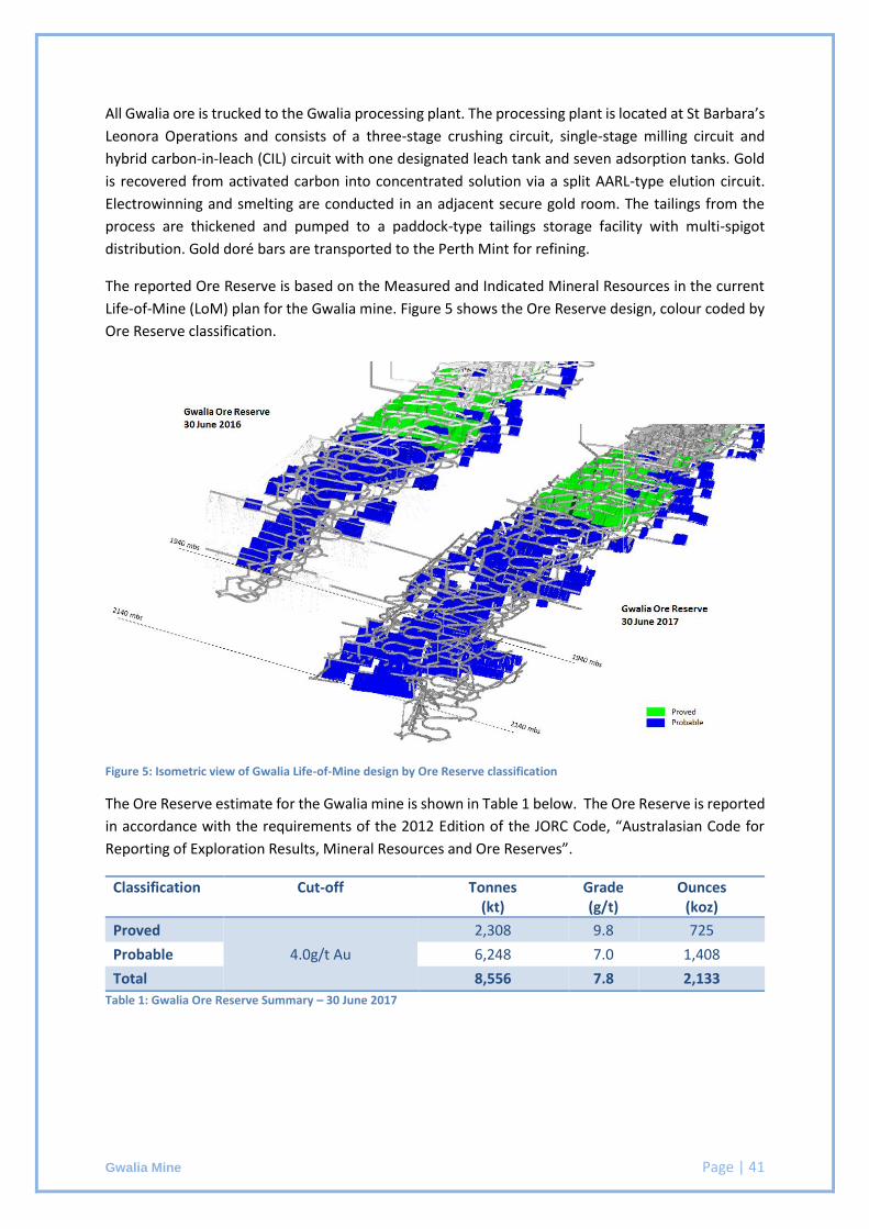
The reported Ore Reserve is based on the Measured and Indicated Mineral Resources in the current
Life-of-Mine (LoM) plan for the Gwalia mine. Figure 5 shows the Ore Reserve design, colour coded by
Ore Reserve classification.
Figure 5: Isometric view of Gwalia Life-of-Mine design by Ore Reserve classification
The Ore Reserve estimate for the Gwalia mine is shown in Table 1 below. The Ore Reserve is reported
in accordance with the requirements of the 2012 Edition of the JORC Code, “Australasian Code for
Reporting of Exploration Results, Mineral Resources and Ore Reserves”.
Classification Cut-off Tonnes (kt)
Grade (g/t)
Ounces (koz)
Proved
4.0g/t Au
2,308 9.8 725
Probable 6,248 7.0 1,408
Total 8,556 7.8 2,133
Table 1: Gwalia Ore Reserve Summary – 30 June 2017
Gwalia Mine Page | 42
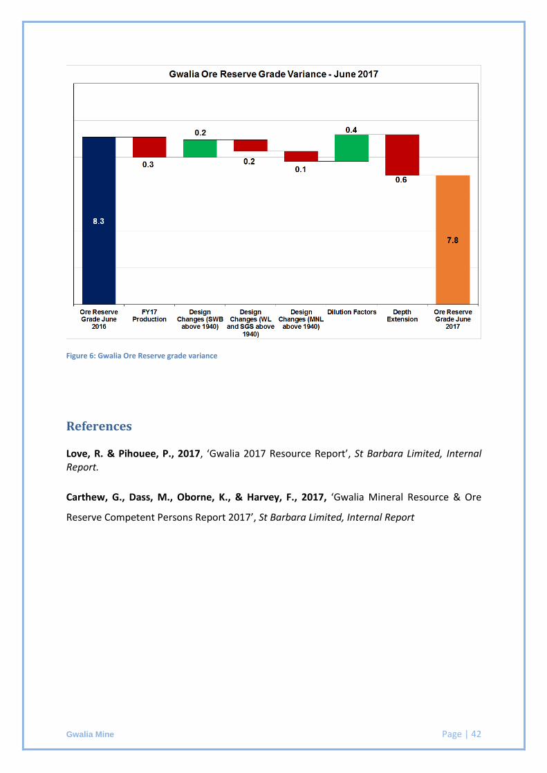
Figure 6: Gwalia Ore Reserve grade variance
References
Love, R. & Pihouee, P., 2017, ‘Gwalia 2017 Resource Report’, St Barbara Limited, Internal Report.
Carthew, G., Dass, M., Oborne, K., & Harvey, F., 2017, ‘Gwalia Mineral Resource & Ore
Reserve Competent Persons Report 2017’, St Barbara Limited, Internal Report
Gwalia Mine Page | 43
JORC 2012 Table 1 Checklist of Assessment and Reporting Criteria
Section 4 Estimation and Reporting of Ore Reserves
Criteria Comments
Mineral Resource estimate for conversion to Ore Reserves
The underground Ore Reserve estimate is based on the Mineral Resource estimate carried out by St Barbara Limited. Gold grade was estimated using ordinary kriging for all lodes with the exception of the Southwest Branch at depths exceeding 1,240 metres below surface where indicator kriging was used.
The Mineral Resources are reported inclusive of the Ore Reserve.
The Mineral Resource model used to estimate this Reserve is described as gw0417d-m.dm
Site visits The Competent Person is employed in a site-based role.
Study status A Definitive Feasibility Study was completed for the Gwalia mine in 2008. The mine has been in full production since. Any further studies undertaken are to extend the mine or optimise the current operating practices.
The Feasibility Study for the Gwalia Extension Project was completed in 2016 and approved by the board. The Gwalia Extension Project provides incremental upgrades to the ventilation infrastructure which support mining down to 2200 mbs.
Cut-off parameters Two cut-off grades have been calculated and applied based on current and forecasted costs and modifying factors for the Life-of-Mine. o Fully Costed cut-off grade includes all costs associated with
the extraction and processing of ore material o Incremental cut-off grade applies to all material that does
not require additional development.
Mining factors or assumptions
The Gwalia Ore Reserve has been estimated based on detailed mine development and stope designs. Modifying factors for dilution and mining recovery have been applied post-geological interrogation to generate the final diluted and recovered Ore Reserve.
The Gwalia Mine is in full production with an extensive production history. Mining methods referenced in this report are currently in practice on site or have been subject to trial mining. Reconciliation results and production history show this mining method to be well matched to the ore body.
Gwalia Mine Page | 44
Criteria Comments
Stope size, development placement and ground support strategies have been designed in line with recommendations from experienced geotechnical personnel and external evaluations. Grade control drilling is completed in advance of production with all stopes to be mined in the next three years already grade control drilled.
The model used to estimate the Ore Reserve is consistent with that which forms the basis of the Mineral Resource estimate for the Gwalia deposit. This model is internally known as gw0417d-m.dm.
The primary lode extracted is known as South West Branch (SWB). Mining dilution of 20% has been applied to SWB between surface and 1380 metres below surface. For all other SWB stopes, the dilution is estimated for each individual stope based on known influences. These include the mining direction, strike length, stope width, and depth below surface. The relationships between these factors and stope dilution have been modelled through back-analysis of actual reconciled stope performance. The average of the estimated dilution for all SWB stopes in the Ore Reserve is 13%.
Mining dilution of 20% has been applied to all South Gwalia Series and West Lode stopes. Mining dilution of 30% has been applied to Main Lode stopes.
A 92% mining recovery factor has been applied to double-lift long-hole open stopes. An 85% mining recovery factor has been applied to single-lift long-hole open stopes. These factors are consistent with reconciled actual performance.
The profiles of development excavations have been designed inclusive of 10% overbreak. No further dilution factors or mining recovery factors have been applied to development ore.
A global minimum mining width of 3m is used. While the ore body width generally exceeds the minimum mining width, where the ore body is narrower stoping outlines are designed to honour the minimum width and include planned dilution.
All ore in the Ore Reserve estimate is classified as a Proved or Probable Ore Reserve. No Inferred Mineral Resources are included in the Ore Reserve. The Inferred Mineral Resources in the Life-of-Mine plan have been removed from the Ore Reserve plan and estimate.
Gwalia Mine Page | 45
Criteria Comments
The infrastructure requirements of the stoping methods used are either already in place or have been accounted for in the Life-of-Mine evaluation on which the project costings are based. The capital and operating costs of extending the ventilation infrastructure to support truck haulage down to the base of the Ore Reserve have been included in the economic evaluation which demonstrates the economic viability of the Ore Reserve.
Metallurgical factors or assumptions
All Gwalia ore is trucked to the Gwalia processing plant. The processing plant is located at St Barbara’s Leonora Operations and consists of a three-stage crushing circuit, single-stage milling circuit and hybrid carbon-in-leach (CIL) circuit with one designated leach tank and seven adsorption tanks. Gold is recovered from activated carbon into concentrated solution via a split AARL-type elution circuit. Electrowinning and smelting are conducted in an adjacent secure gold room. The tailings from the process are thickened and pumped to a paddock-type tailings storage facility with multi-spigot distribution.
The technology associated with processing of Gwalia ore is currently in operation and is based on industry standard practices.
Mine production and cash flow estimates are based on a metallurgical recovery of 97%, which is consistent with current performance.
A recent study on capacity requirements of the tailings storage facility (TSF) showed that the total capacity that will be created (new lifts and void created by reclaiming) is will be adequate for the life-of-mine plan. This includes an additional lift on TSF3 and construction of TSF4, which is planned for FY20.
Environmental The Gwalia mine is currently compliant with all environmental
regulatory agreements under the Environmental Protection Act 1986.
All external reporting against the environmental licenses are recorded and reported in the Annual Environmental Report available on the St Barbara website.
Infrastructure An upgrade to the mine’s primary ventilation system is required
to support truck haulage at current production rates down to the base of the Ore Reserve. The capital and operating costs for the ventilation upgrade have been estimated to Feasibility Study
Gwalia Mine Page | 46
Criteria Comments
level and included in the economic evaluation which demonstrates the economic viability of the Ore Reserve.
All other equipment required for the mining and processing of the Ore Reserve is in place and operational. It is located on tenements held by St Barbara Limited. The infrastructure includes, but is not limited to:
o Dedicated gas and diesel power station
o Water supply from three sources to provide redundancy
o Processing plant
o Mine development
o Underground power and dewatering infrastructure
o Workshop facilities on surface and underground
o Ventilation fans and refrigeration plant
o Paste-fill plant
o Camp facilities
o Access to public roads and airstrips.
Costs All costs used in the estimation of Ore Reserves are based on the Ore Reserve plan. This plan excludes the Inferred Mineral Resources in the Life-of-Mine plan.
Operating costs are estimated as part of the internal budgeting process and approved by the St Barbara Limited board.
A gold price of AU$1350/oz has been used in all calculations.
Exchange rates are sourced from recommendations by the Group Treasury and accepted by the Executive Leadership Team (ELT).
Costs associated with treatment and transport have been included in the cost modelling completed for the project based on the Life-of-Mine plan.
Royalties have been included at the WA government royalty of 2.5% of gold produced. A Resource Capital Royalty (IRC) is also applied to the Gwalia tenements and is applied at 1.5% of gold produced.
Revenue factors A gold price of AU$1350/oz has been used in all revenue
calculations
Gwalia Mine Page | 47
Criteria Comments Market assessment All gold doré produced at the Gwalia processing plant is
transported to the Perth Mint for refining.
Economic The mine is an operating asset and is not subject to project-type analysis.
Life-of-Mine plans are developed or updated on an annual basis. These plans reflect current and projected performances for the Ore Reserve.
Social St Barbara Limited’s social licence to operate is underpinned by
the excellent relationship that the Company has built, over many years, with the local community of Leonora. St Barbara Limited also recognises, and has a good relationship with, the Aboriginal groups within the Leonora Region. Formal Access and/or Heritage Protection Agreements exist with most of the Aboriginal groups in the Leonora and the eastern Kalgoorlie Region.
Other The Gwalia mine is an operating asset in full production. The
approvals required for the Gwalia Extension Project infrastructure are well advanced with no known impediments to approval. All other required government and statutory permits and approvals are in place.
A company risk register is maintained to address and mitigate against all foreseeable risks that could impact the Ore Reserve.
Contracts are in place for all critical goods and services required to operate the mine.
Classification The Ore Reserve includes only Proved and Probable classifications.
The economically minable component of the Measured Mineral Resource has been classified as a Proved Ore Reserve.
The economically minable component of the Indicated Mineral Resource has been classified as a Probable Ore Reserve.
Audits or reviews SRK Consulting undertook a review of the Gwalia underground mine Ore Reserve process and estimate in July 2016. The review included a review of the Ore Reserve estimation process and the basis of the inputs and modifying factors. SRK did not audit the Ore Reserve estimate but considered that the technical basis and process undertaken was of a suitable standard and supports reporting under the JORC Code (2012).
Gwalia Mine Page | 48
Criteria Comments Discussion of relative accuracy/ confidence
The Ore Reserve estimate has been prepared in accordance with the guidelines of the JORC Code (2012). The relative confidence of the estimates contained fall with the criteria of Proved and Probable Ore Reserves. Significant operating history supports the modifying factors applied.
The Ore Reserve has been estimated in line with the St Barbara Ore Reserve process. The Ore Reserve process was externally audited in 2012 and found to be of good industry standard. The Ore Reserve has been peer reviewed internally and the Competent Person is confident that it is an accurate estimation of the current Gwalia reserve.

Tower Hill Page | 49
ST BARBARA LIMITED SHORT FORM ORE RESERVE REPORT
Tower Hill
TENEMENT: M37/0055
OWNER: St Barbara Ltd 100%
OPERATOR: St Barbara Ltd (ACN 009 165 066)
Level 10, 432 St Kilda Road,
MELBOURNE,VIC 3000
COMMODITIES: Gold
COMPILED BY: Laura Wilson & Michael Beswick
REPORT BY: Laura Wilson, Michael Beswick, John de Vries & Glen Carthew
REPORTING DATE: 30 June 2013
JORC CODE COMPLIANCE STATEMENT
The information in this report that relates to Ore Reserve is based on information compiled by Glen Carthew
who is a Member of the Australasian Institute of Mining and Metallurgy. Glen Carthew is a full-time employee
of St Barbara Limited and has sufficient experience relevant to the style of mineralisation and type of deposit
under consideration and to the activity which he is undertaking to qualify as a Competent Person as defined in
the 2012 Edition of the “Australasian Code for Reporting of Exploration Results, Mineral Resources and Ore
Reserves” Glen Carthew consents to the inclusion in the report of the matters based on his information in the
form and context in which it appears.
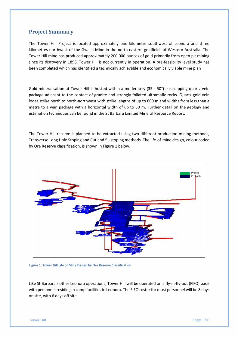
Tower Hill Page | 50
Project Summary
The Tower Hill Project is located approximately one kilometre southwest of Leonora and three
kilometres northwest of the Gwalia Mine in the north-eastern goldfields of Western Australia. The
Tower Hill mine has produced approximately 200,000 ounces of gold primarily from open pit mining
since its discovery in 1898. Tower Hill is not currently in operation. A pre-feasibility level study has
been completed which has identified a technically achievable and economically viable mine plan
Gold mineralisation at Tower Hill is hosted within a moderately (35 - 50°) east-dipping quartz vein
package adjacent to the contact of granite and strongly foliated ultramafic rocks. Quartz-gold vein
lodes strike north to north-northwest with strike lengths of up to 600 m and widths from less than a
metre to a vein package with a horizontal width of up to 50 m. Further detail on the geology and
estimation techniques can be found in the St Barbara Limited Mineral Resource Report.
The Tower Hill reserve is planned to be extracted using two different production mining methods,
Transverse Long Hole Stoping and Cut and fill stoping methods. The life-of-mine design, colour coded
by Ore Reserve classification, is shown in Figure 1 below.
Figure 1: Tower Hill Life of Mine Design by Ore Reserve Classification
Like St Barbara’s other Leonora operations, Tower Hill will be operated on a fly-in-fly-out (FIFO) basis
with personnel residing in camp facilities in Leonora. The FIFO roster for most personnel will be 8 days
on site, with 6 days off site.
Proved Probable

Tower Hill Page | 51
All Tower Hill ore will be trucked to the Gwalia processing plant. The processing plant is located at St Barbara’s Leonora Operations and consists of a three-stage crushing circuit, single-stage milling circuit and hybrid carbon-in-leach (CIL) circuit with one designated leach tank and seven adsorption tanks. Gold is recovered from activated carbon into concentrated solution via a split AARL-type elution circuit. Electrowinning and smelting are conducted in an adjacent secure gold room. The tailings from the process are thickened and pumped to a paddock type tailings storage facility with multi-spigot distribution. Gold doré bars are transported to the Perth Mint for refining.
The Ore Reserve estimate for the Tower Hill mine in shown Table 1 below. The Ore Reserve is reported in accordance with the requirements of the 2012 Edition of the JORC Code, “Australasian Code for Reporting of Exploration Results, Mineral Resources and Ore Reserves”.
Classification Cut-off Tonnes (kt)
Grade (g/t)
Ounces (koz)
Proved
2.8g/t Au
- - -
Probable 2,572 3.7 306
Total 2,572 3.7 306
Table 1: Tower Hill Ore Reserve Summary - June 2013
References
Wilson, L, Beswick, M and de Vries, J., 2013., St Barbara Limited Ore Reserve Report - Gwalia June
2013, SBM Report. June, 2013
Tower Hill Page | 52
JORC 2012 Table 1 Checklist of Assessment and Reporting Criteria
Section 4 Estimation and Reporting of Ore Reserves
Criteria Comments
Mineral Resource estimate for conversion to Ore Reserves
The underground Ore Reserve estimate is based on the Mineral Resource estimate carried out by St Barbara. Gold grade was estimated using ordinary kriging.
The Mineral Resources are reported inclusive of the Ore Reserve.
Site visits The Competent Person is employed in a site-based role.
Study status A Pre-Feasibility Study has been completed for the Tower hill project that has identified a technically achievable and economically viable mine plan. This PFS has since been reviewed and updated with modifying factors calibrated for company experience with a similar operating mine within the same mining district.
Cut-off parameters A reserve cut-off grade of 2.8 g/t has been used in line with the
now-divested King of the Hills mine which used similar mining methods with the same production profile. Two cut-off grades have been calculated and applied based on historical costs from the King of the Hills mine and forecasted costs and modifying factors for the Tower Hill life-of-mine plan. o Fully Costed cut-off grade includes all operating costs associated
with the extraction and processing of ore material o Incremental cut-off grade applies to all material that does not
require additional development.
Mining factors or assumptions
The Tower Hill Ore Reserve has been estimated by generating detailed mining shapes for all development and stoping shapes. Modifying factors for dilution and mining recovery have been completed post-geological interrogation to generate the final diluted and recovered ore reserve.
A pre-feasibility level of study has been completed for the Tower Hill mine. St Barbara successfully operated the King of the Hills mine using the mining methods planned for Tower Hill. The planned mining methods align with external geotechnical recommendations for the regional geology.
Stope size, development placement and ground support strategies have been designed in line with recommendations from external evaluations. Grade control drilling will be completed in advance of production with Grade control drilling plans generated as part of the final Definitive Mining Study.
The model used to estimate the Ore Reserve is consistent with that produced for the Mineral Resource declared for the Tower Hill deposit. This model is internally known as twh_feb2011.mdl.
Tower Hill Page | 53
Criteria Comments
Mining dilution has been applied at 5% at a grade of 1.3g/t for the Long Hole stoping areas and 6% at a grade of 0g/t for the cut and fill stoping areas. This is consistent with the dilution factors applied for the similar King of the Hills mine.
A mining recovery of 95% has been applied to all stopes. This recovery has been applied to allow for any ore loss that may occur during stoping extraction. This is consistent with the recovery factors achieved for the similar King of the Hills mine.
For the longhole stoping production, a global minimum mining width of 3.5m is used. While the ore body width generally exceeds the minimum mining width, where the ore body is narrower, stoping outlines are designed to honour the minimum width and include planned dilution. The cut and fill areas are mined to a minimum height of 5m, though split firing of the production face is used to prevent dilution of the ore zone.
The vast majority of the life-of-mine plan is classified as a Probable Ore Reserve. Inferred Mineral Resources are included in the life-of-mine plan to allow for well-informed strategic planning. They are not included in the Ore Reserve estimate.
The infrastructure requirements of the stoping methods used have been accounted for in the life-of-mine evaluation on which the project costings are based.
Metallurgical factors or assumptions
All Tower hill ore will be trucked to the Gwalia processing plant. The processing plant is located at St Barbara’s Leonora Operations and consists of a three stage crushing circuit, single stage milling circuit and hybrid CIL circuit with one designated leach tank and 7 adsorption tanks. Gold is recovered from activated carbon into concentrated solution via a split AARL type elution circuit. Electrowinning and smelting are conducted in an adjacent secure gold room. The tailings from the process are thickened and pumped to a paddock type tailings storage facility with multi-spigot distribution
The technology associated with processing of Tower Hill ore is currently in operation and is based on industry standard practices.
Target Recovery Performance is 95%.
Environmental St Barbara currently holds a license for Tower Hill and is compliant with all environmental regulatory agreements under the Environmental Protection Act 1986.
All external reporting against the environmental licenses are recorded and reported in the Annual Environmental Report available on the St Barbara website.
Tower Hill Page | 54
Criteria Comments
Infrastructure All equipment required for the mining and processing of the reserve is
either already available or anticipated to be available as required by the Life of Mine plan. Existing infrastructure is located on St Barbara held tenements and leases. Surrounding tenements have been secured for the purpose of new infrastructure installation. The infrastructure currently available for usage for the Tower Hill project includes but is not limited to:
Dedicated gas and diesel power station,
Water supply
Processing plant
Access to Workshop facilities on surface and underground
Paste Plant
Additional planned infrastructure includes but is not limited to:
Explosive magazine
Fuel bay and wash bay
Ventilation fan and associated works
Workshop facilities
Costs All costs used in the generation of the Ore Reserve estimate have been based on the life-of-mine plan.
Operating costs are based on actual costs from the King of the Hills mine, and approved by the St Barbara board.
A gold price of AU$1,250/oz has been used in all calculations.
Exchange rates are sourced from recommendations by the Group Treasury and accepted by the Executive Leadership Team (ELT).
Costs associated with treatment and transport have been included in the cost modelling completed for the project based on the life-of-mine plan.
Royalties have been included at the WA government royalty of 2.5% of gold produced. A Resource Capital Royalty (IRC) is also applied to the Gwalia tenements and is applied at 1.5% of gold produced.
Revenue factors A gold price of AU$1,250/oz has been used in all revenue calculations.
Market assessment All Gold doré bars produced at the Gwalia processing plant are
transported to the Perth Mint for refining. Economic The project has been defined to a pre-feasibility study level of
confidence. Operating assumptions are supported by company experience with similar operating mines within the same mining district. The mine is intended to operate as a satellite mine.
Tower Hill Page | 55
Criteria Comments Social St Barbara Limited’s social licence to operate is underpinned by
the excellent relationship that the Company has built, over many years, with the local community of Leonora. St Barbara Limited also recognises, and has a good relationship with, the Aboriginal groups within the Leonora Region. Formal Access and/or Heritage Protection Agreements exist with most of the Aboriginal groups in the Leonora and the eastern Kalgoorlie Region.
Other A company risk register is maintained to address and mitigate against all foreseeable risks that could impact the Ore Reserve.
Classification The Ore Reserve has been classified as a Probable Ore Reserve.
The economically minable component of the Indicated Mineral Resource has been classified as a Probable Ore Reserve.
Audits or reviews While a direct audit of the Tower Hill reserve has not been conducted,
the St Barbara reserve estimation process was independently reviewed in December 2012 by Scott Dunham of Quantitative Group (QG). “The review did not identify any material flaws in either the ore reserve estimate itself or the process used to generate the estimate. In QG’s opinion the estimate is suitable for reporting under the JORC Code (2004 edition) and is of a good industry standard.” (Dunham, S. 2012) “The ore reserve estimate is incorporated into St Barbara’s long, medium and short term planning processes and this increases confidence in the deliverability of the ore reserve. The ore reserve represents a snapshot of the expected metal production over the life of each operation based on currently available data and mine planning assumptions.” (Dunham, S. 2012)
Discussion of relative accuracy/ confidence
The Ore Reserve estimate is prepared within the guidelines of the 2012 JORC code. The relative confidence of the estimates contained fall with the criteria of Probable Ore Reserves. Significant operating history supports the modifying factors applied.
The Ore Reserve has been estimated in line with the St Barbara Ore Reserve process. The Ore Reserve process was externally audited in 2012 and found to be of good industry standard. The Ore Reserve has been peer reviewed internally and the Competent Person is confident that it is an accurate estimation of the current Tower Hill reserve.
Simberi Gold Mine Page | 56
ST BARBARA LIMITED SHORT FORM ORE RESERVE REPORT
Simberi Gold Mine
TENEMENT: ML136
OWNER: St Barbara Ltd 100% (ACN 009 165 066)
OPERATOR: Simberi Gold Company Limited
Simberi Island, New Ireland Province,
Papua New Guinea
COMMODITIES: Gold
COMPILED BY: Owen Peters
REPORT BY: Tim Richards
REPORTING DATE: 30 June 2017
JORC CODE COMPLIANCE STATEMENT
The information in this report that relates to Ore Reserve is based on information compiled by Tim Richards
who is a Member of the Australasian Institute of Mining and Metallurgy. Tim Richards was a full-time employee
of St Barbara Limited at the time this report was compiled and has sufficient experience relevant to the style of
mineralisation and type of deposit under consideration and to the activity which he is undertaking to qualify as
a Competent Person as defined in the 2012 Edition of the “Australasian Code for Reporting of Exploration
Results, Mineral Resources and Ore Reserves” Tim Richards consents to the inclusion in the report of the
matters based on his information in the form and context in which it appears.
Simberi Gold Mine Page | 57
Project Summary
St Barbara Limited acquired the existing operating Simberi open pit project on 7th September
2012. The Simberi Gold (SGCL) operation includes the mining of the Sorowar, Pigiput, Pigibo,
Samat, Botlu, Pigicow and Bekou pits which are all located on Simberi Island and in close
proximity to the Simberi processing facility.
The SGCL operation is located on Simberi Island in the Tabar Islands Group and is comprised
of an oxide plant and a sulphide development project. The oxide treatment plant previously
designed as a 2 Mtpa, underwent an expansion to 3.5 Mtpa during 2013 and is currently
operating at 3.5Mtpa nameplate capacity.
The Tabar Islands are situated in the New Ireland Province of Papua New Guinea (PNG),
approximately 500km north-east of the PNG mainland and 90km NW of Lihir Island. The mine
is located within the Mining Lease ML136 which covers the eastern half of Simberi Island. The
island experiences a tropical maritime climate regime, however heavy rainfall can occur
throughout the year
The currently known gold prospects (Sorowar, Pigiput, Pigibo, Botlu, Pigicow, Samat and
Bekou) on Simberi Island are located in the eastern half of the island within the central
volcanic core. They are contained within a sub-cropping epithermal alteration system and
structural corridor extending 4km north-south and 2km east-west. The host rocks for the
mineralisation comprise Pliocene altered alkaline lava flows or intrusives (porphyries),
volcaniclastics and tuffs. Gold mineralisation, however, does not appear to be closely
associated with any particular lithology.
Of the seven separate deposits, Sorowar in the north is by far the largest oxide gold resource.
Samat and Bekou lie to the south, and while relatively small, are relatively higher grade.
Pigiput, Pigibo, Botlu and Pigicow lie between the Sorowar and Samat areas and have oxide
gold resources of intermediate tonnage but at a grade similar to Sorowar. Pigiput has the
largest sulphide gold resource. All deposits lie within 2 to 3km of each other. Sorowar,
Pigiput and Pigibo are currently being mined for oxides via open pit methods.
The estimation was unconstrained by geological boundaries, with data categorised according
to oxidation type, (oxide and fresh). The resource classification was assigned based on the
number and configuration of data used. Gold grade was estimated for each of the deposits
using ordinary kriging technique.
The mineralisation being shallow, low grade and low strip ratio deposits make these deposits
suitable to open pit mining.
During the financial year, a pre-feasibility study was completed for the sulphide project.
Sulphide reserves are estimated on the basis of this study completed internally by St Barbara
Limited with the assistance of specialist consultants as required.
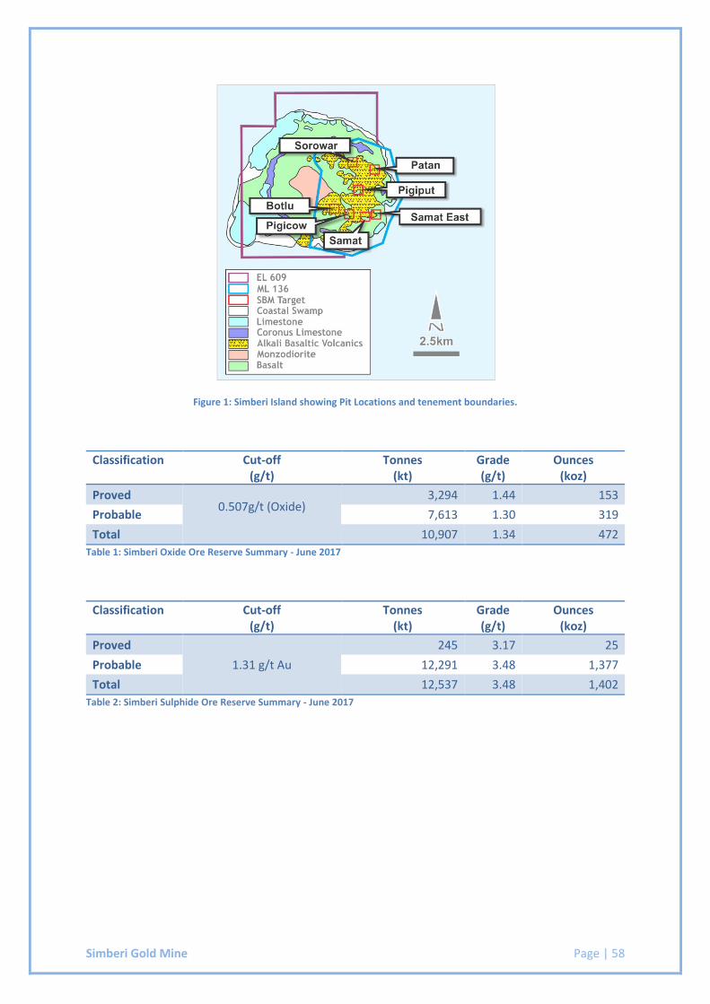
Simberi Gold Mine Page | 58
Figure 1: Simberi Island showing Pit Locations and tenement boundaries.
Classification Cut-off (g/t)
Tonnes (kt)
Grade (g/t)
Ounces (koz)
Proved 0.507g/t (Oxide)
3,294 1.44 153
Probable 7,613 1.30 319
Total 10,907 1.34 472
Table 1: Simberi Oxide Ore Reserve Summary - June 2017
Classification Cut-off (g/t)
Tonnes (kt)
Grade (g/t)
Ounces (koz)
Proved
1.31 g/t Au
245 3.17 25
Probable 12,291 3.48 1,377
Total 12,537 3.48 1,402
Table 2: Simberi Sulphide Ore Reserve Summary - June 2017
Simberi Gold Mine Page | 59
JORC 2012 Table 1 Checklist of Assessment and Reporting Criteria
Section 4 Estimation and Reporting of Ore Reserves
Criteria Comments
Mineral Resource estimate for conversion to Ore Reserves
The Ore Reserve estimate is based on the Mineral Resource estimate carried out by St Barbara. Gold grade was estimated using ordinary kriging. The Mineral Resources are reported inclusive of the Ore Reserve.
Site visits The Competent Person is employed in a site based role
Study status SGCL is currently an operating mine. Pit Optimisation, Design and Life of Mine studies have been conducted to enable the Mineral Resource to be converted to Ore Reserves. Reserves are supported by operational budget planning and evaluations based on operational designs and current practices. The Sulphide component has been subject to a pre-feasibility study carried out internally by St Barbara Limited during 2016.
Cut-off parameters Cut-Off grades have been determined on a pit by pit basis. The calculation of cut-off grade takes the following factors into consideration:
Gold Price
Milling Cost
G&A Costs
Metallurgical Recoveries
Royalties
Mining factors or assumptions
The Simberi Reserve has been estimated after running pit optimisations using costs, recoveries, dilution and slope angles that are based on zero base build approach using current operating history as a data source. The pit shells generated from these pit optimisations were then used as a guide to staged pit designs. The material inside these pit designs represents what was available for reporting. The staged pit designs were then used to generate a life of mine plan. The mining methods used to do the LOM schedules are in line with what is currently used on site. The overall slopes used for the pit optimisation and design work were sourced from reports carried out by external geotechnical consultants. Grade control drilling is carried out in advance of mining and the information obtained from this drilling is made available for decision making in advance of mining.
The models used for the Ore Reserve are consistent with that produced for the Mineral Resource declared for the Simberi deposits. These models are internally known as:
Sorowar/Pigiput/Pigibo/Botlu -Bot_pgb_pgp_sor_June2107.mdl
Simberi Gold Mine Page | 60
Criteria Comments
Pigicow/Samat/Bekou - Bek_Pco_sam_June2017.mdl Mining Dilution of 5% has been applied at a grade of 0.5 g/t for oxide resources. Mining Dilution of 5% has been applied at a grade of 0.5g/t for sulphide resources. Mining Ore recovery was applied at 95% for oxide resources. Mining ore recovery was applied at 95% for sulphide resources. A minimum mining width of 30m was applied for all design work. Inferred material is set to zero value in the optimisation. Subsequently, inferred material reported in the pit shells is considered in the Life of Mine, but not included in the Reserve. Additional optimisations were run, and shells produced, to evaluate the influence of inferred material prior to the Mine Design phase to ensure potential future mill feed is not sterilised when generating current optimum Pit Designs. Inferred material can only present a potential upside to the ore reserve if and when it is reclassified as indicated. The infrastructure requirements of the current mining methods used are already in place. Replacement costs, expected maintenance costs or costs of additional items required have been accounted for in the life of mine evaluation on which the project costings are based.
Metallurgical factors or assumptions
Material from the various Simberi Deposits is trucked and conveyed to the Simberi processing plant. The Simberi processing plant consists of a Wet Scrubber, Oversize Ball Mill, Semi-Autogenous Grinding Mill, Cyclone Circuit, CIL Circuit, elution and acid washing facilities, electrowinning cells, and Kiln. Tails from the process are discharged using a Deep Sea Tailings Placement where the tailings is diluted with sea water, to the ratio of 8:1, prior to its disposal. Expansion of the Oxide Circuit was completed towards the end of 2013 and since then, the operation has been operating at 3.5 Mtpa. A pre-feasibility study has been completed to evaluate the options for Sulphide processing.
The technology associated with processing of Simberi ore is conventional carbon in leach and based on industry standard practices.
Recovery performance is variable for the different weathering profile of the material. The predicted recoveries are shown below:
Oxide Recovery – 86% (via Oxide circuit)
Sulphide Recovery – ~82% (via Sulphide circuit)
Environmental SGCL holds two environmental permits. One for the extraction of water and one for the discharge of waste. Together these two permits form the environmental legislative basis in which the SGCL can operate. Compliance with these conditions is continuously monitored and
Simberi Gold Mine Page | 61
Criteria Comments
reported on in Quarterly Environment Performance Reports which are submitted to the National Government, Department of Environment and Conservation (DEC).
SGCL has received a new permit for the 3.5Mtpa expansion project to replace the previous discharge permit. Both the environmental permits are only relevant to operational mining activities within the Mining Lease.
In addition, SGCL maintains an Environment Permit for Exploration relating to Waste Discharge. This Permit is referred to as Environment Permit WDL-2A(65).
Infrastructure All equipment required for the mining and processing of the reserve is in place and operational, or have been selected and costed for installation as part of the sulphide PFS. They are, or will be, located on St Barbara held tenements and leases. The infrastructure includes but is not limited to:
Dedicated heavy fuel oil diesel generators
Water supply
Simberi Oxide Processing plant
Future Simberi Sulphide Processing Plant
Surface roads and communications
Plant maintenance workshop facilities
Process plant buildings, administration offices, training rooms, assay laboratory, site security buildings, ablution and stores.
Core shed
Mobile communication tower
Accommodation and camp facilities
Airstrip
Wharf
Costs All costs used in the generation of the reserves have been derived from the Simberi 3 Year Forecast cost model or through the sulphide PFS work. Operating costs are estimated as part of the internal budgeting process and approved by the St Barbara board. A gold price of US$1,200/oz has been used in all calculations. Exchange rates are sourced from recommendations by the Group Treasury and accepted by the Executive Leadership Team (ELT). Costs associated with treatment and transport have been included in the cost modelling completed for the project based on the Life of Mine plan. Royalties have been included at the PNG government royalty of 2.0% of gold produced. A MRA levy is also applied to at 0.25% of gold produced.
Revenue factors A gold price of US$1,200/oz has been used in all revenue calculations.
Simberi Gold Mine Page | 62
Criteria Comments
Market assessment Gold doré bars are transported fortnightly by dedicated service provider
from Gold room to final destination Perth Mint. Armoured vehicles are used from start to end of shipment process. Gold is sold on an $A basis with a call option of $USD sales. Sulphide ore is proposed to be treated in a Sulphide Circuit and sold as a concentrate.
Economic SGCL is an operating asset and is not subject to project type analysis.
Social There are two community agreements which set the guidelines for community relations at Simberi.
The Memorandum of Agreement between SGCL, the national government, New Ireland Provincial Government, Simberi Land Owners Association and the Tabar Community Government
The compensation Agreement.
Other SGCL is operating on St Barbara 100% held mining leases with all required government and statutory permits and approval in place. A company risk register is maintained to address and mitigate against all foreseeable risks that could impact the Ore Reserve.
Classification The ore reserve includes only Proved and Probable classifications. The economically mineable component of the resource material identified as Measured has been included in the Proved category. The economically mineable component of the resource material identified as Indicated has been included in the Probable category. No portion of the Probable ore reserve has been derived from Inferred Mineral Resources. The Competent Person believes the ore reserve declared is an accurate representation for the Simberi deposit.
Audits or reviews No external audits or reviews have been conducted on the current ore
reserve.
Discussion of relative accuracy/ confidence
The Ore Reserve estimate is prepared within the Guidelines of the 2012 JORC code. The relative confidence of the estimates contained fall within the criteria of Proved and Probable Reserves. Significant operating history supports the magnitude of modifying factors which have been applied. The ore reserve has been estimated in line with the St Barbara Ore Reserve process. The ore reserve process has been conducted to industry standard.

Simberi Gold Mine Page | 63
Criteria Comments
The ore reserve has been peer reviewed internally and the Competent Person is confident it is an accurate estimation of the current Simberi ore reserve.
Page | 64
Appendix 1
Competent Person Consent Forms


St Barbara Limited ACN 009 165 066
Level 10, 432 St Kilda Road, Melbourne VIC 3004
Locked Bag 9, Collins Street East, Melbourne VIC 8003
Tel +61 3 8660 1900 Fax +61 3 8660 1999
www.stbarbara.com.au
Competent Person’s Consent Form
Pursuant to the requirements of ASX Listing Rules 5.6, 5.22 and 5.24 and
Clause 9 of the JORC Code 2012 Edition (Written Consent Statement)
Report names
St Barbara Limited Short Form Reserve Report – Simberi Mine
Company
Simberi Gold Company Limited
Deposits
Sorowar, Pigiput, Pigibo, Botlu, Pigicow, Samat, Bekou
30 June 2017
(Date of Report)
2
Statement
I,
Tim Richards
confirm that I am the Competent Person for the Reports and:
I have read and understood the requirements of the 2012 Edition of the Australasian Code for
Reporting of Exploration Results, Mineral Resources and Ore Reserves (JORC Code, 2012 Edition).
I am a Competent Person as defined by the JORC Code, 2012 Edition, having five years experience
that is relevant to the style of mineralisation and type of deposit described in the Reports, and to the
activity for which I am accepting responsibility.
I am a Fellow of The Australasian Institute of Mining and Metallurgy or the Australian Institute of
Geoscientists or a ‘Recognised Professional Organisation’ (RPO) included in a list promulgated by
ASX from time to time.
I have reviewed the Reports to which this Consent Statement applies.
I am a full time employee of
Simberi Gold Company Limited
I have disclosed to the reporting company the full nature of the relationship between myself and the
company, including any issue that could be perceived by investors as a conflict of interest.
I verify that the Report is based on and fairly and accurately reflects in the form and context in which it
appears, the information in my supporting documentation relating to Ore Reserves.
3
Consent
I consent to the release of the Reports and this Consent Statement by the directors of:
St Barbara Limited
31 July 17
Signature of Competent Person:
AusIMM
Date:
204564
Professional Membership:
(insert organisation name)
Membership Number:
Steab Barrie, Brisbane
Signature of Witness:
Print Witness Name and Residence:
(eg town/suburb)