2014 idaho wolf monitoring progress report · 2014 idaho wolf monitoring progress report ... wolf...
TRANSCRIPT
2014 IDAHO WOLF MONITORING PROGRESS REPORT
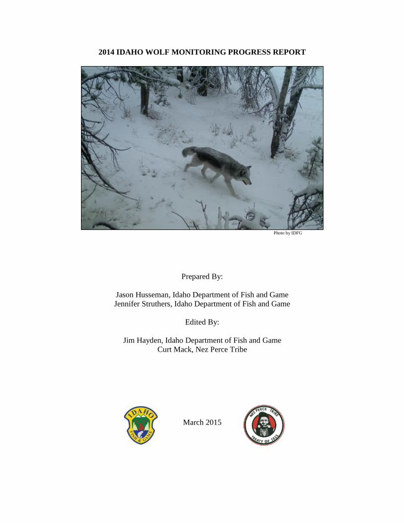
Photo by IDFG
Prepared By:
Jason Husseman, Idaho Department of Fish and Game
Jennifer Struthers, Idaho Department of Fish and Game
Edited By:
Jim Hayden, Idaho Department of Fish and Game
Curt Mack, Nez Perce Tribe
March 2015

ii
EXECUTIVE SUMMARY
During January 1995 and January 1996, the U.S. Fish and Wildlife Service (USFWS)
reintroduced 66 gray wolves to central Idaho and Yellowstone National Park as part of efforts to
restore populations of endangered gray wolves (Canis lupus) in the northern Rocky Mountain
states of Idaho, Montana, and Wyoming. In May 2011, the USFWS removed (delisted) gray
wolves in the Northern Rocky Mountain Distinct Population Segment, excluding Wyoming,
from the protections of the Endangered Species Act, and wolf management responsibility was
transferred to the Idaho Department of Fish and Game and Montana Fish, Wildlife and Parks.
During March 2002, the Idaho Legislature adopted the Idaho Wolf Conservation and
Management Plan (2002 Wolf Plan). This plan guides management of wolves in Idaho. The
State of Idaho and Nez Perce Tribe monitored wolves cooperatively in 2014 through a
Memorandum of Agreement signed in 2005.
Wolves range in Idaho from the Canadian border south to the Snake River Plain, and from the
Washington and Oregon borders east to the Montana and Wyoming borders. Dispersing wolves
are occasionally reported in previously unoccupied areas.
Biologists documented 104 packs within the state at the end of 2014. In addition, there were 23
documented border packs counted by Montana, Wyoming, and Washington that had established
territories overlapping the Idaho state boundary. Additional packs are suspected but not included
due to lack of documentation.
Determination of breeding pair status was made for 43 packs. Of these, 26 packs met breeding
pair criteria at the end of 2014, and 17 packs did not (Table 1). No determination of breeding pair
status was made for the remaining 61 packs. Reproduction (production of at least 1 pup) was
documented in a minimum 55 packs.
The year-end population for documented packs, other documented groups not qualifying as
packs, and lone wolves was estimated at 770 wolves.
Mortalities of 360 wolves were documented in Idaho in 2014, 113 wolves (24%) less than in
2013. Human-caused mortality accounted for 342 of 344 (99%) wolf mortalities during 2014
where cause of death could be determined. Legal harvest was 256 wolves, agency removal and
legal take was 67 wolves, and mortality from other human causes was 19 wolves. Sixteen wolf
mortalities were attributed to unknown causes and two were attributed to natural causes.
USDA APHIS Wildlife Services agents classified 43 cattle, 100 sheep, 3 dogs, and 1 horse as
confirmed wolf depredations in 2014. Ten cattle, 7 sheep, and 1 dog were classified as probable
wolf depredations.
iii
ACKNOWLEDGEMENTS
Wolf monitoring and management in Idaho is a cooperative effort between the State of Idaho,
Nez Perce Tribe (NPT), USDA APHIS Wildlife Services, and the U.S. Fish and Wildlife
Service. The NPT’s Executive Committee and Wildlife Management Division Director Keith
Lawrence provided support and input. Dustin Miller, Administrator of the Governor’s Office of
Species Conservation, provided valuable administrative support. Todd Grimm, George Graves,
and all WS field personnel worked to resolve wolf-livestock conflicts. U.S. Fish and Wildlife
Service personnel Mike Jimenez, Brian Kelly, Mike Carrier, and Hilary Cooley provided support
and assistance with wolf monitoring.
We would like to recognize NPT wildlife biologist Jim Holyan and Idaho Department of Fish
and Game (IDFG) State Game Manager Jon Rachael for their exceptional contributions to the
wolf monitoring program throughout the year, and to this report. We would like to thank IDFG
personnel Jeff Ashmead, Pam Bond, Crystal Christensen, Mike Elmer, Debbie Hribik, Jerry
Hugo, Walter Loesberg, Craig Parker, Lacy Robinson, Jessie Roughgarden, David Smith,
Kathleen Trever, Andrew Underwood, and Jack Whitman for their superb contributions. Bryan
Aber, Bruce Ackerman, Summer Crea, Marshall Haynes, Jon Hunter, Dave Koehler, Andrew
Mackey, Joel Sauder, Tom Schrempp, Dave Silcock, Carisa Stansbury, and Josh White
contributed greatly to wolf monitoring efforts in addition to their regular responsibilities.
Dr. Mark Drew provided training and valuable advice. Tricia Hebdon, Stacey Dauwalter, and
Kathryn Keeton provided laboratory support and technical assistance. IDFG Wildlife Research
staff Scott Bergen, Lindsey Bischoff, Jon Horne, and Mark Hurley provided collaborative
assistance both in the field and the office. We would also like to extend our thanks to the
multitude of IDFG employees that assisted in deploying and maintaining numerous trail cameras
and collecting DNA samples across the state to facilitate a substantial increase in wolf
monitoring effort during 2014.
Thanks go out to Katrina Chandler, NPT Wolf Recovery Project; wildlife managing agencies of
the states of Montana, Oregon, Washington, and Wyoming, and their respective wolf staffs;
Dr. Mike Mitchell and David Ausband, and their field crews (Kristen Barker, Adam Fahnestock,
Abby Sage, Ryan Wilbur), University of Montana Cooperative Wildlife Research Unit;
Dr. Lisette Waits and Jennifer Adams, University of Idaho Laboratory for Ecological,
Evolutionary and Conservation Genetics; Cam Heusser and Nate Albrecht, Coeur D’Alene
Tribe; Trent Brown, Quicksilver Air; Mike Feiger and Scott Bodle, U.S. Forest Service; and
Jared Hedelius and Julie Young, USDA APHIS Wildlife Services. Clarence Binninger, NPT
Wolf Recovery Program veterinarian, continued to lend assistance.
We especially recognize the following for their excellent piloting: John Blakely, AvCenter; Mike
Dorris, Sawtooth Flying Service; Brian Elfers, Doug Gadwa, Bobby Godwin, Joe Myers, and
Neil Odenborg, Inter-State Aviation; Bob Hawkins and Tony Herby, Sky Aviation; Dave Parker,
Northern Air; Joe Rimensberger, Osprey Aviation; John Romero, Janna Greenhalgh, and Ben
Blake, Owyhee Air Research; Rick Swisher, Quicksilver Air; Marty Webb, Tundra Air; and
other pilots that were involved in 2014.

iv
Suggested Citation: Idaho Department of Fish and Game and Nez Perce Tribe. 2014. Idaho wolf
monitoring progress report. Idaho Department of Fish and Game, 600 South Walnut, Boise,
Idaho; Nez Perce Tribe Wolf Recovery Project, P.O. Box 365, Lapwai, Idaho. 70 pp.
v
TABLE OF CONTENTS
EXECUTIVE SUMMARY ............................................................................................................ II
ACKNOWLEDGEMENTS ...........................................................................................................III
INTRODUCTION ...........................................................................................................................1
STATEWIDE SUMMARY .............................................................................................................5
Wolf Population Monitoring ................................................................................................5
Population Status .....................................................................................................5
Number of Packs Documented ................................................................................6
Pack Size ..................................................................................................................6
Reproduction ............................................................................................................6
Breeding Pair Criteria ..............................................................................................6
Distribution ..............................................................................................................7
Mortality ................................................................................................................13
Wolf Depredations .................................................................................................14
Research .............................................................................................................................18
Effects of wolf predation on elk and moose populations .......................................18
Outreach .............................................................................................................................18
PANHANDLE WOLF MANAGEMENT ZONE .........................................................................20
Background ........................................................................................................................20
Monitoring Summary .........................................................................................................20
PALOUSE-HELLS CANYON WOLF MANAGEMENT ZONE ................................................24
Background ........................................................................................................................24
Monitoring Summary .........................................................................................................24
DWORSHAK-ELK CITY WOLF MANAGEMENT ZONE .......................................................27
Background ........................................................................................................................27
Monitoring Summary .........................................................................................................27
LOLO WOLF MANAGEMENT ZONE .......................................................................................31
Background ........................................................................................................................31
Monitoring Summary .........................................................................................................31
SELWAY WOLF MANAGEMENT ZONE .................................................................................35
Background ........................................................................................................................35
Monitoring Summary .........................................................................................................35
TABLE OF CONTENTS (Continued)
vi
MCCALL-WEISER WOLF MANAGEMENT ZONE .................................................................38
Background ........................................................................................................................38
Monitoring Summary .........................................................................................................38
MIDDLE FORK WOLF MANAGEMENT ZONE ......................................................................42
Background ........................................................................................................................42
Monitoring Summary .........................................................................................................42
SALMON WOLF MANAGEMENT ZONE .................................................................................45
Background ........................................................................................................................45
Monitoring Summary .........................................................................................................45
SAWTOOTH WOLF MANAGEMENT ZONE ...........................................................................49
Background ........................................................................................................................49
Monitoring Summary .........................................................................................................49
SOUTHERN MOUNTAINS WOLF MANAGEMENT ZONE ...................................................53
Background ........................................................................................................................53
Monitoring Summary .........................................................................................................53
BEAVERHEAD WOLF MANAGEMENT ZONE.......................................................................57
Background ........................................................................................................................57
Monitoring Summary .........................................................................................................57
ISLAND PARK WOLF MANAGEMENT ZONE .......................................................................60
Background ........................................................................................................................60
Monitoring Summary .........................................................................................................60
SOUTHERN IDAHO WOLF MANAGEMENT ZONE ..............................................................64
Background ........................................................................................................................64
Monitoring Summary .........................................................................................................64
LITERATURE CITED ..................................................................................................................68
APPENDIX A. POPULATION ESTIMATION TECHNIQUE USED TO DETERMINE
WOLF POPULATION NUMBERS IN IDAHO ...........................................................................69
APPENDIX B. CONTACTS FOR IDAHO WOLF MANAGEMENT ........................................70
vii
LIST OF TABLES
Table 1. Number of wolves detected, documented packs, and other documented wolf
groups, pack reproductive status, known dispersal, documented mortality by cause, and
wolf-caused depredations within Idaho Wolf Management Zones, 2014. ......................................8
Table 2. Minimum number of wolves detected, reproductive status, and known dispersal
for documented and suspected wolf packs and other documented wolf groups within the
Panhandle Wolf Management Zone, 2014. ....................................................................................22
Table 3. Documented wolf mortality and wolf-caused depredations by Game Management
Unit within the Panhandle Wolf Management Zone, 2014. ..........................................................23
Table 4. Minimum number of wolves detected, reproductive status, and known dispersal
for documented and suspected wolf packs and other documented wolf groups within the
Palouse-Hells Canyon Wolf Management Zone, 2014..................................................................26
Table 5. Documented wolf mortality and wolf-caused depredations by Game Management
Unit within the Palouse-Hells Canyon Wolf Management Zone, 2014. .......................................26
Table 6. Minimum number of wolves detected, reproductive status, and known dispersal
for documented and suspected wolf packs and other documented wolf groups within the
Dworshak-Elk City Wolf Management Zone, 2014. .....................................................................29
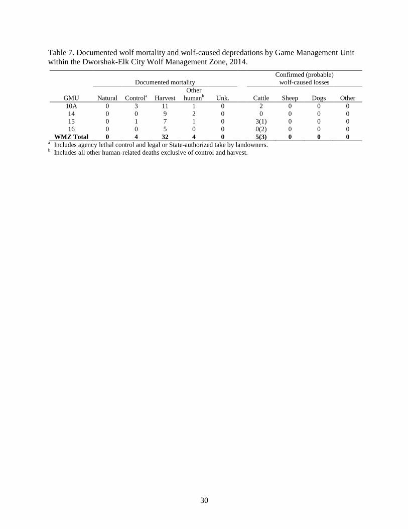
Table 7. Documented wolf mortality and wolf-caused depredations by Game Management
Unit within the Dworshak-Elk City Wolf Management Zone, 2014. ............................................30
Table 8. Minimum number of wolves detected, reproductive status, and known dispersal
for documented and suspected wolf packs and other documented wolf groups within the
Lolo Wolf Management Zone, 2014. .............................................................................................33
Table 9. Documented wolf mortality and wolf-caused depredations by Game Management
Unit within the Lolo Wolf Management Zone, 2014. ...................................................................34
Table 10. Minimum number of wolves detected, reproductive status, and known dispersal
for documented and suspected wolf packs and other documented wolf groups within the
Selway Wolf Management Zone, 2014. ........................................................................................37
Table 11. Documented wolf mortality and wolf-caused depredations by Game
Management Unit within the Selway Wolf Management Zone, 2014. .........................................37
Table 12. Minimum number of wolves detected, reproductive status, and known dispersal
for documented and suspected wolf packs and other documented wolf groups within the
McCall-Weiser Wolf Management Zone, 2014. ............................................................................40
Table 13. Documented wolf mortality and wolf-caused depredations by Game
Management Unit within the McCall-Weiser Wolf Management Zone, 2014. ............................41
Table 14. Minimum number of wolves detected, reproductive status, and known dispersal
for documented and suspected wolf packs and other documented wolf groups within the
Middle Fork Wolf Management Zone, 2014. ................................................................................44
Table 15. Documented wolf mortality and wolf-caused depredations by Game
Management Unit within the Middle Fork Wolf Management Zone, 2014. .................................44
LIST OF TABLES (Continued)
viii
Table 16. Minimum number of wolves detected, reproductive status, and known dispersal
for documented and suspected wolf packs and other documented wolf groups within the
Salmon Wolf Management Zone, 2014. ........................................................................................47
Table 17. Documented wolf mortality and wolf-caused depredations by Game
Management Unit within the Salmon Wolf Management Zone, 2014. .........................................48
Table 18. Minimum number of wolves detected, reproductive status, and known dispersal
for documented and suspected wolf packs and other documented wolf groups within the
Sawtooth Wolf Management Zone, 2014. .....................................................................................51
Table 19. Documented wolf mortality and wolf-caused depredations by Game
Management Unit within the Sawtooth Wolf Management Zone, 2014. ......................................52
Table 20. Minimum number of wolves detected, reproductive status, and known dispersal
for documented and suspected wolf packs and other documented wolf groups within the
Southern Mountains Wolf Management Zone, 2014. ....................................................................55
Table 21. Documented wolf mortality and wolf-caused depredations by Game
Management Unit within the Southern Mountains Wolf Management Zone, 2014. .....................56
Table 22. Minimum number of wolves detected, reproductive status, and known dispersal
for documented and suspected wolf packs and other documented wolf groups within the
Beaverhead Wolf Management Zone, 2014. .................................................................................59
Table 23. Documented wolf mortality and wolf-caused depredations by Game
Management Unit within the Beaverhead Wolf Management Zone, 2014. ..................................59
Table 24. Minimum number of wolves detected, reproductive status, and known dispersal
for documented and suspected wolf packs and other documented wolf groups within the
Island Park Wolf Management Zone, 2014. ..................................................................................62
Table 25. Documented wolf mortality and wolf-caused depredations by Game
Management Unit within the Island Park Wolf Management Zone, 2014. ...................................63
Table 26. Minimum number of wolves detected, reproductive status, and known dispersal
for documented and suspected wolf packs and other documented wolf groups within the
Southern Idaho Wolf Management Zone, 2014. ............................................................................66
Table 27. Documented wolf mortality and wolf-caused depredations by Game
Management Unit within the Southern Idaho Wolf Management Zone, 2014. .............................67
ix
LIST OF FIGURES
Figure 1. Recovery areas established by the U.S. Fish and Wildlife Service to restore gray
wolf populations in the northern Rocky Mountains of Idaho, Montana, and Wyoming. ................1
Figure 2. Northern Rocky Mountain Gray Wolf Distinct Population Segment boundaries
established by the U.S. Fish and Wildlife Service in 2008 and 2009. .............................................2
Figure 3. Idaho Wolf Management Zones. ......................................................................................4
Figure 4. Estimated number of wolves in documented packs, other documented groups,
and lone wolves in Idaho at year-end, 1995-2014. ........................................................................10
Figure 5. Number of documented wolf packs and documented breeding pairs in Idaho,
1995-2014. .....................................................................................................................................11
Figure 6. Distribution of documented and suspected wolf packs in Idaho, 2014. .........................12
Figure 7. Annual documented wolf mortality by cause, 2005-2014..............................................13
Figure 8. Number of confirmed and probable cattle and sheep killed by wolves, and
corresponding number of wolves removed through agency control and legal take
(exclusive of harvest) by private citizens, 2005-2014. ..................................................................14
Figure 9. Number of confirmed and probable cattle depredation incidents (including
injured cattle) and corresponding losses in Idaho attributed to wolves by Game
Management Unit and Wolf Management Zone, 2014. ................................................................16
Figure 10. Number of confirmed and probable sheep depredation incidents (including
injured sheep) and corresponding losses in Idaho attributed to wolves by Game
Management Unit and Wolf Management Zone, 2014. ................................................................17
Figure 11. Distribution of documented and suspected wolf packs in the Panhandle Wolf
Management Zone, 2014. ..............................................................................................................21
Figure 12. Distribution of documented and suspected wolf packs in the Palouse-Hells
Canyon Wolf Management Zone, 2014. ........................................................................................25
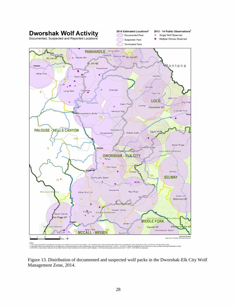
Figure 13. Distribution of documented and suspected wolf packs in the Dworshak-Elk City
Wolf Management Zone, 2014. .....................................................................................................28
Figure 14. Distribution of documented and suspected wolf packs in the Lolo Wolf
Management Zone, 2014. ..............................................................................................................32
Figure 15. Distribution of documented and suspected wolf packs in the Selway Wolf
Management Zone, 2014. ..............................................................................................................36
Figure 16. Distribution of documented and suspected wolf packs in the McCall-Weiser
Wolf Management Zone, 2014. .....................................................................................................39
Figure 17. Distribution of documented and suspected wolf packs in the Middle Fork Wolf
Management Zone, 2014. ..............................................................................................................43
Figure 18. Distribution of documented and suspected wolf packs in the Salmon Wolf
Management Zone, 2014. ..............................................................................................................46
LIST OF FIGURES (Continued)
x
Figure 19. Distribution of documented and suspected wolf packs in the Sawtooth Wolf
Management Zone, 2014. ..............................................................................................................50
Figure 20. Distribution of documented and suspected wolf packs in the Southern
Mountains Wolf Management Zone, 2014. ...................................................................................54
Figure 21. Distribution of documented and suspected wolf packs in the Beaverhead Wolf
Management Zone, 2014. ..............................................................................................................58
Figure 22. Distribution of documented and suspected wolf packs in the Island Park Wolf
Management Zone, 2014. ..............................................................................................................61
Figure 23. Distribution of documented and suspected wolf packs in the Southern Idaho
Wolf Management Zone, 2014. .....................................................................................................65
1
INTRODUCTION
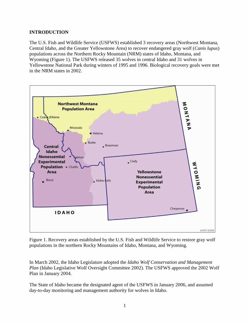
The U.S. Fish and Wildlife Service (USFWS) established 3 recovery areas (Northwest Montana,
Central Idaho, and the Greater Yellowstone Area) to recover endangered gray wolf (Canis lupus)
populations across the Northern Rocky Mountain (NRM) states of Idaho, Montana, and
Wyoming (Figure 1). The USFWS released 35 wolves in central Idaho and 31 wolves in
Yellowstone National Park during winters of 1995 and 1996. Biological recovery goals were met
in the NRM states in 2002.
Figure 1. Recovery areas established by the U.S. Fish and Wildlife Service to restore gray wolf
populations in the northern Rocky Mountains of Idaho, Montana, and Wyoming.
In March 2002, the Idaho Legislature adopted the Idaho Wolf Conservation and Management
Plan (Idaho Legislative Wolf Oversight Committee 2002). The USFWS approved the 2002 Wolf
Plan in January 2004.
The State of Idaho became the designated agent of the USFWS in January 2006, and assumed
day-to-day monitoring and management authority for wolves in Idaho.
2
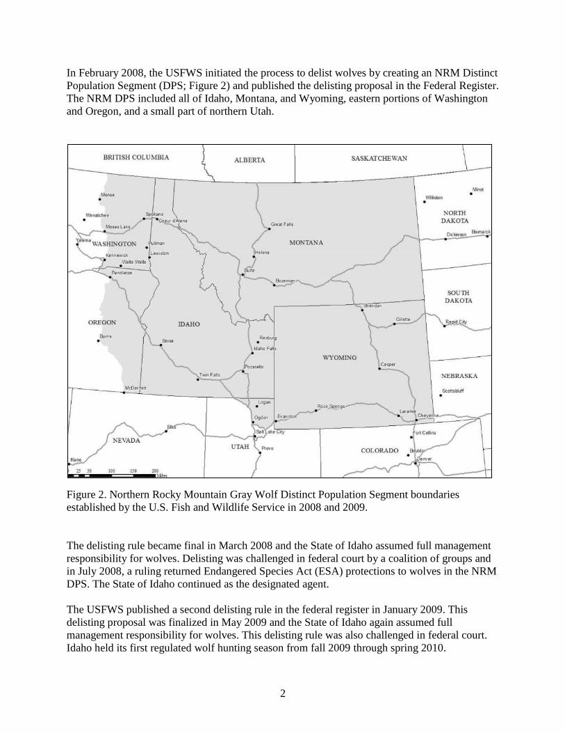
In February 2008, the USFWS initiated the process to delist wolves by creating an NRM Distinct
Population Segment (DPS; Figure 2) and published the delisting proposal in the Federal Register.
The NRM DPS included all of Idaho, Montana, and Wyoming, eastern portions of Washington
and Oregon, and a small part of northern Utah.
Figure 2. Northern Rocky Mountain Gray Wolf Distinct Population Segment boundaries
established by the U.S. Fish and Wildlife Service in 2008 and 2009.
The delisting rule became final in March 2008 and the State of Idaho assumed full management
responsibility for wolves. Delisting was challenged in federal court by a coalition of groups and
in July 2008, a ruling returned Endangered Species Act (ESA) protections to wolves in the NRM
DPS. The State of Idaho continued as the designated agent.
The USFWS published a second delisting rule in the federal register in January 2009. This
delisting proposal was finalized in May 2009 and the State of Idaho again assumed full
management responsibility for wolves. This delisting rule was also challenged in federal court.
Idaho held its first regulated wolf hunting season from fall 2009 through spring 2010.
3
A federal judge ordered in August 2010 that the rule to delist wolves be vacated, which restored
ESA protections to wolves (USFWS 2010). Subsequently, on April 15, 2011, President Obama
signed the 2011 federal appropriations bill that included language that directed the Secretary of
the Interior to reissue the 2009 delisting rule. As a result of this action, wolves were again
delisted in Idaho, Montana, eastern Washington, eastern Oregon, and north-central Utah. Wolf
management responsibility returned to the State of Idaho on May 5, 2011.
For a more comprehensive chronology of events related to wolf recovery, conservation, and
management in Idaho and the NRM, see:
http://fishandgame.idaho.gov/public/wildlife/wolves/?getPage=161
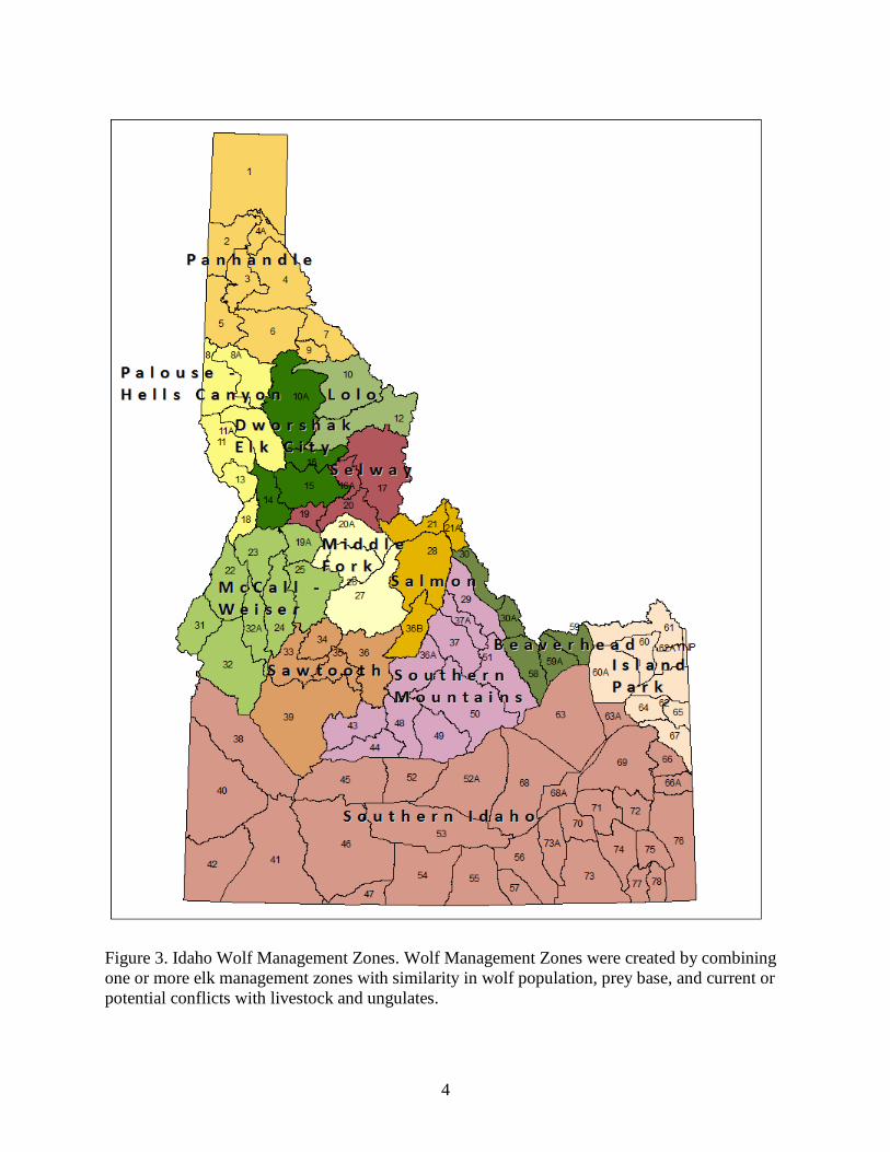
Wolf monitoring and management activities have been reported by Wolf Management Zone
(WMZ or Zone), since 2008. The Idaho Department of Fish and Game (IDFG) divided the
Southern Mountains Zone into 2 zones in 2011 (Southern Mountains, Beaverhead) and the Upper
Snake Zone was renamed the Island Park Zone. There are currently 13 WMZs (Figure 3).
4
Figure 3. Idaho Wolf Management Zones. Wolf Management Zones were created by combining
one or more elk management zones with similarity in wolf population, prey base, and current or
potential conflicts with livestock and ungulates.
5
STATEWIDE SUMMARY
Idaho has a diverse landscape comprised of large expanses of varied habitats which support
populations of elk (Cervus elaphus), mule deer (Odocoileus hemionus), white-tailed deer
(Odocoileus virginianus), moose (Alces alces), and other wolf prey species. Central Idaho
includes 3 contiguous wilderness areas: the Selway-Bitterroot, Frank Church-River of No
Return, and Gospel Hump wildernesses. These wilderness areas encompass almost 4 million
acres (1.6 million ha), the largest block of wilderness in the lower 48 states. Outside of
wilderness areas, land ownership and human use patterns result in varying levels of potential
human conflict with wolves. Southern Idaho includes the vast Snake River Plain, which is
predominantly private agricultural land and also contains most of Idaho’s urban centers. Three
major mountain chains and 2 large river systems intersect these very different landscapes, many
of which are managed for multiple uses. A moisture gradient also influences habitats of both
wolves and their prey, with maritime climates in the north supporting western red cedar-western
hemlock (Thuja plicata, Tsuga heterophylla) vegetation types, transitioning into continental
climates of Douglas-fir (Pseudotsuga menziesii) and ponderosa pine (Pinus ponderosa) to the
south. Elevations vary from 1,500 feet (457 m) to just over 12,000 feet (3,657 m). Annual
precipitation across the state varies from less than 8 inches (20 cm) to almost 100 inches
(254 cm).
Wolf Population Monitoring
Information presented in this report was obtained primarily from a concerted undertaking by
State and Tribal biologists collecting important demographic information (reproduction,
mortality, pack size, breeding pair status, etc.) through intensive field surveys, capture and
radiocollaring, and year round monitoring.
Wolf observations from hunters afield have also proven to be a reliable means of enumerating
wolf packs when analyzed in a patch occupancy modeling framework (Ausband et al. 2014).
Data collected from harvested wolves has provided confirmation of pack presence, particularly
useful for remote areas where traditional monitoring methods were not feasible due to access
difficulties. DNA sampling (tissue or scat) has provided information on summer pack sizes,
verification of reproduction, apparent survival, and other relevant demographic information.
Public sightings and confirmed depredations also facilitated the confirmation of wolf activity by
directing agency personnel efforts to areas in need of further investigation. In 2014, 193 wolf
observations were reported through the IDFG online wolf reporting system. Combining these
sources of information allowed for a greater understanding of the wolf population than would
have been achieved otherwise.
Population Status
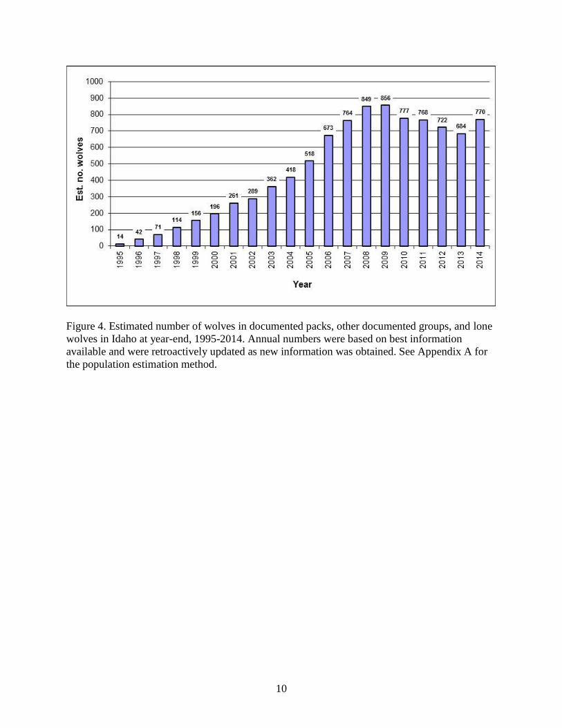
The year-end estimate for documented packs, other documented groups of wolves, and
associated lone wolves was 770 (Figure 4, and see Appendix A), well above the minimum of 150
wolves required in the 2009 de-listing rule (USFWS 2009). Based on additional data collected
during 2014, the 2013 population estimate for documented packs, other documented groups, and
lone wolves was revised from 659 to 684 wolves.
6
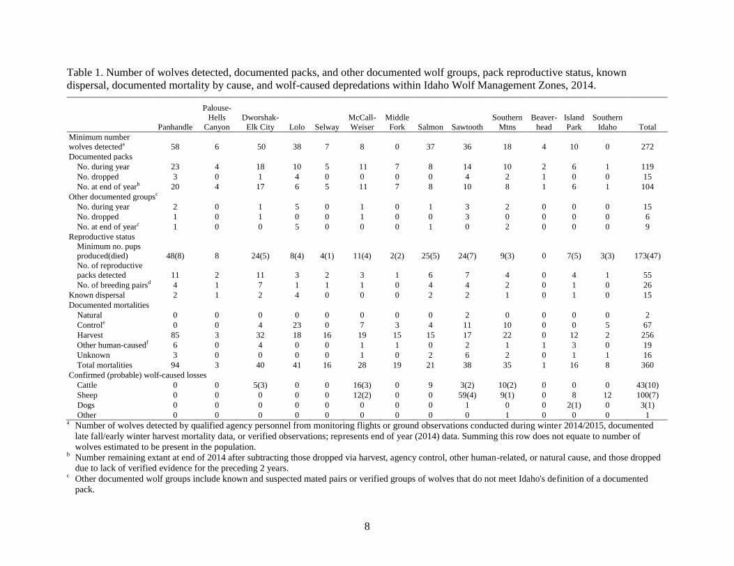
Number of Packs Documented
During 2014, 119 Idaho wolf packs were documented at some point during the year. The number
of packs documented year-end was 104 (Table 1). Twelve new packs were documented during
2014. Fifteen previously documented packs were dropped by the end of the year because either
there was no more than one wolf left in the pack, or there was a lack of documentation within the
previous two years that the pack remained extant.
Of the 12 newly documented packs, 5 packs were retroactively added to 2013 totals based on
evidence of multiple adults or reproductive confirmation via harvested pups (typically from tooth
cementum results) from the 2013 litter-year. One pack (Rattlesnake) was retroactively dropped
from 2013 totals when new location data confirmed an adjacent documented pack (Steel
Mountain) accounted for the activity in question.
Pack Size
Mean observed pack size at the end of December 2014 was 6.5 wolves per pack (n = 27), 20%
higher than the 5.4 wolves per pack during 2013, but also 20% less than the pre-harvest average
of 8.1 wolves per pack (2005-2008 average). The larger 2014 average pack size was a prominent
influence on the increase in the number of wolves estimated in documented packs in 2014.
Reproduction
A minimum of 55 packs were confirmed to have produced a minimum of 173 wolf pups, with
litter sizes ranging from 1-8 pups. The mean litter size for 2014 was 4.7 pups (n = 18), similar to
previous years.
Breeding Pair Criteria
The number of reproductive wolf packs (or pairs) in Idaho is far higher than the number of wolf
packs documented to meet the federal breeding pair criteria. Under the federal definition, a pack
meeting breeding pair criteria consists of “an adult male and a female wolf that have produced at
least 2 pups that survive until December 31 of the year of their birth” (USFWS 2009).
Breeding pair status was evaluated considering all data collected for a pack from spring through
winter. Breeding pair status was determined by either harvest or capture of ≥2 pups after
December 31, 2014 from a documented pack with 2 adults of opposite sex present at end of year,
or summer verification (via visual/aural/remote camera observations or DNA analysis) of ≥2
pups and 2 adults of opposite sex and one or more of the following: late fall/winter aerial, ground
or trail camera observations by IDFG/NPT or cooperating agency biologists consistent with the
persistence of ≥2 pups and 2 adults of opposite sex; late fall/winter verified public observations
consistent with existing pack information and indicating the persistence of ≥2 pups and 2 adults
of opposite sex; and/or no documented mortality indicating <2 pups or <2 adults of opposite sex.
Determination of breeding pair status was made for 43 packs. Of these, 26 packs (60%) met
breeding pair criteria at the end of 2014 (Table 1), and 17 packs did not. No determination of
breeding pair status could be made for the remaining 61 packs.
7
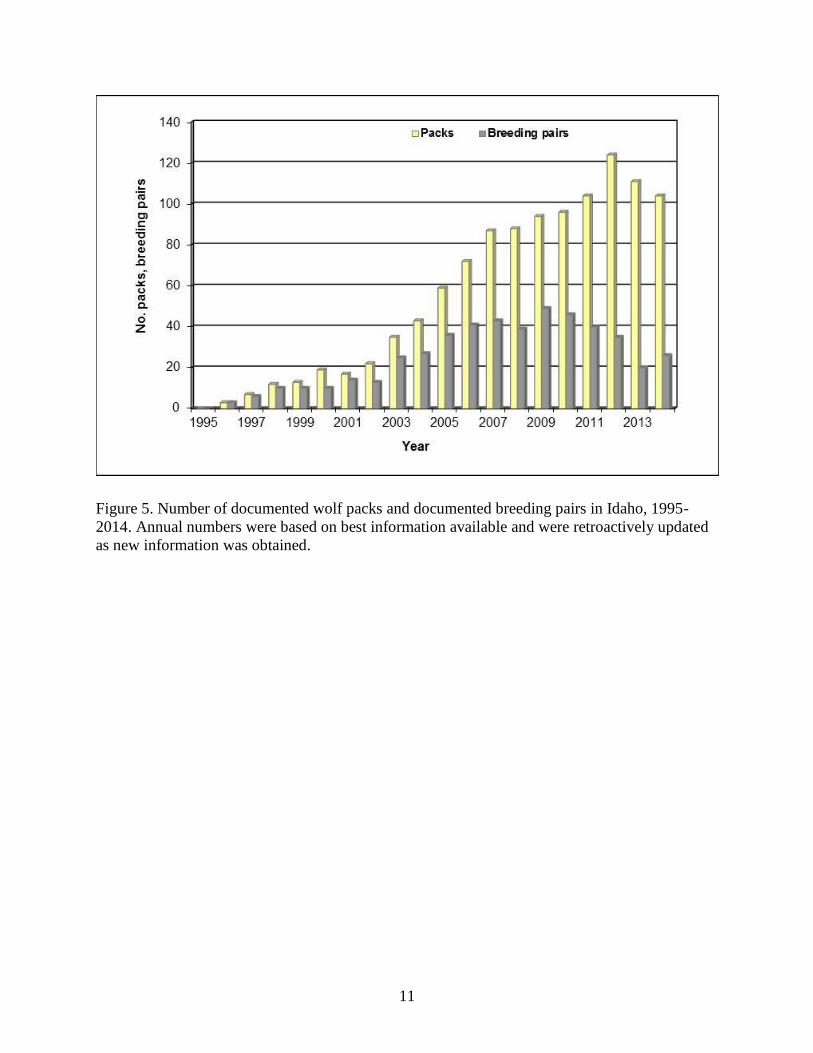
The probability that a pack meets breeding pair criteria increases as pack size increases (Mitchell
et al. 2008). Consistent with this relationship, the proportion of packs meeting the breeding pair
criterion decreased noticeably as pack size diminished after harvest began in 2009 (Figure 5).
The increase in breeding pairs detected during 2014 was associated both with an increase in
mean pack size, and with an increase in field effort during 2014.
Distribution
Wolf distribution was assessed directly through monitoring radiocollared wolves, field
investigations, and wolf observation reports received from the public. We monitored 133
radiocollared wolves at least once during 2014 that originated from, or had established residence
within Idaho, including 60 wolves captured and radiocollared during the year. Fifty-five
radiocollared wolves died or were suspected to have died during the year, and 4 wolves were
either missing or had non-functioning collars at year-end. Seventeen wolves with functioning
radiocollars were harvested during 2014.
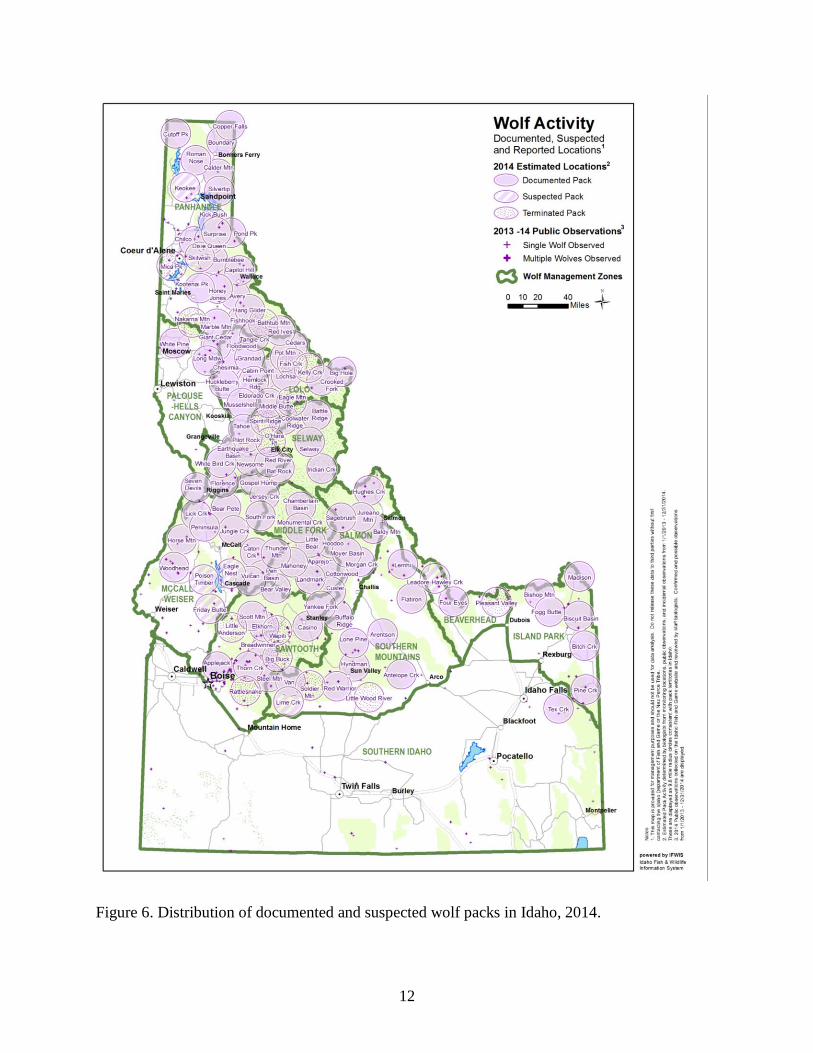
Wolves were distributed across the state from the Canadian border, south to the Snake River
Plain, and from the Washington and Oregon borders east to the Montana and Wyoming borders
(Figure 6). In addition to the 104 documented packs present in Idaho at the end of 2014, there
were 23 documented border packs counted by Montana, Wyoming, and Washington that had
established territories overlapping the Idaho state boundary. Territories of most wolf packs were
predominantly on public lands managed by the U.S. Forest Service (USFS).
Occupancy modeling provides a useful methodology for estimating distribution using multiple
survey methods in a robust sampling design (MacKenzie et al. 2002). To further evaluate
distribution of wolves in Idaho during 2013, a single-season occupancy model was developed
using hunter observations (n = 4,656) and radio-telemetry data (n = 36 packs) with 9 covariates:
forest cover, elevation, slope, antlered deer harvest density, antlered elk harvest density, hunter
days expended, cattle density, sheep density, and month. We estimate 61% of Idaho (132,162
km2) was used by groups or packs of 2+ wolves during fall 2013.
8
Table 1. Number of wolves detected, documented packs, and other documented wolf groups, pack reproductive status, known
dispersal, documented mortality by cause, and wolf-caused depredations within Idaho Wolf Management Zones, 2014.
Panhandle
Palouse-
Hells
Canyon
Dworshak-
Elk City Lolo Selway
McCall-
Weiser
Middle
Fork Salmon Sawtooth
Southern
Mtns
Beaver-
head
Island
Park
Southern
Idaho Total
Minimum number
wolves detecteda 58 6 50 38 7 8 0 37 36 18 4 10 0 272
Documented packs
No. during year 23 4 18 10 5 11 7 8 14 10 2 6 1 119
No. dropped 3 0 1 4 0 0 0 0 4 2 1 0 0 15
No. at end of yearb 20 4 17 6 5 11 7 8 10 8 1 6 1 104
Other documented groupsc
No. during year 2 0 1 5 0 1 0 1 3 2 0 0 0 15
No. dropped 1 0 1 0 0 1 0 0 3 0 0 0 0 6
No. at end of yearc 1 0 0 5 0 0 0 1 0 2 0 0 0 9
Reproductive status
Minimum no. pups
produced(died) 48(8) 8 24(5) 8(4) 4(1) 11(4) 2(2) 25(5) 24(7) 9(3) 0 7(5) 3(3) 173(47)
No. of reproductive
packs detected 11 2 11 3 2 3 1 6 7 4 0 4 1 55
No. of breeding pairsd 4 1 7 1 1 1 0 4 4 2 0 1 0 26
Known dispersal 2 1 2 4 0 0 0 2 2 1 0 1 0 15
Documented mortalities
Natural 0 0 0 0 0 0 0 0 2 0 0 0 0 2
Controle 0 0 4 23 0 7 3 4 11 10 0 0 5 67
Harvest 85 3 32 18 16 19 15 15 17 22 0 12 2 256
Other human-causedf 6 0 4 0 0 1 1 0 2 1 1 3 0 19
Unknown 3 0 0 0 0 1 0 2 6 2 0 1 1 16
Total mortalities 94 3 40 41 16 28 19 21 38 35 1 16 8 360
Confirmed (probable) wolf-caused losses
Cattle 0 0 5(3) 0 0 16(3) 0 9 3(2) 10(2) 0 0 0 43(10)
Sheep 0 0 0 0 0 12(2) 0 0 59(4) 9(1) 0 8 12 100(7)
Dogs 0 0 0 0 0 0 0 0 1 0 0 2(1) 0 3(1)
Other 0 0 0 0 0 0 0 0 0 1 0 0 0 1 a Number of wolves detected by qualified agency personnel from monitoring flights or ground observations conducted during winter 2014/2015, documented
late fall/early winter harvest mortality data, or verified observations; represents end of year (2014) data. Summing this row does not equate to number of
wolves estimated to be present in the population. b Number remaining extant at end of 2014 after subtracting those dropped via harvest, agency control, other human-related, or natural cause, and those dropped
due to lack of verified evidence for the preceding 2 years. c Other documented wolf groups include known and suspected mated pairs or verified groups of wolves that do not meet Idaho's definition of a documented
pack.

Table 1. Continued.
9
d Breeding pairs are the measure of Federal and State wolf recovery and management goals. A breeding pair is defined as "an adult male and a female wolf that
have produced at least 2 pups that survive until December 31 of the year of their birth.” e Includes agency lethal control and legal or State-authorized take by landowners.
f Includes all other human-related deaths exclusive of control and harvest.
10
Figure 4. Estimated number of wolves in documented packs, other documented groups, and lone
wolves in Idaho at year-end, 1995-2014. Annual numbers were based on best information
available and were retroactively updated as new information was obtained. See Appendix A for
the population estimation method.
11
Figure 5. Number of documented wolf packs and documented breeding pairs in Idaho, 1995-
2014. Annual numbers were based on best information available and were retroactively updated
as new information was obtained.
12
Figure 6. Distribution of documented and suspected wolf packs in Idaho, 2014.
13
Mortality
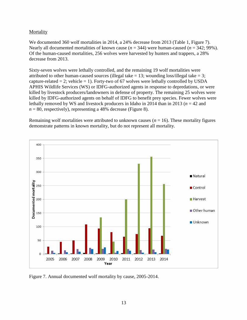
We documented 360 wolf mortalities in 2014, a 24% decrease from 2013 (Table 1, Figure 7).
Nearly all documented mortalities of known cause (n = 344) were human-caused (n = 342; 99%).
Of the human-caused mortalities, 256 wolves were harvested by hunters and trappers, a 28%
decrease from 2013.
Sixty-seven wolves were lethally controlled, and the remaining 19 wolf mortalities were
attributed to other human-caused sources (illegal take = 13; wounding loss/illegal take = 3;
capture-related = 2; vehicle = 1). Forty-two of 67 wolves were lethally controlled by USDA
APHIS Wildlife Services (WS) or IDFG-authorized agents in response to depredations, or were
killed by livestock producers/landowners in defense of property. The remaining 25 wolves were
killed by IDFG-authorized agents on behalf of IDFG to benefit prey species. Fewer wolves were
lethally removed by WS and livestock producers in Idaho in 2014 than in 2013 (n = 42 and
n = 80, respectively), representing a 48% decrease (Figure 8).
Remaining wolf mortalities were attributed to unknown causes (n = 16). These mortality figures
demonstrate patterns in known mortality, but do not represent all mortality.
Figure 7. Annual documented wolf mortality by cause, 2005-2014.
14
Figure 8. Number of confirmed and probable cattle and sheep killed by wolves, and
corresponding number of wolves removed through agency control and legal take (exclusive of
harvest) by private citizens, 2005-2014.
Between May and September 2014, 31 pups were fitted with light-weight (74 gram) expandable
vhf collars.We confirmed 9 collars were shed or chewed off shortly after deployment, leaving 22
pups with viable collars. At the end of 2014, 7 collared pups were confirmed alive, 10 pups were
confirmed dead, and 5 pups were of undetermined status (the collar was not detected or was
transmitting a mortality signal but had not yet been recovered).
Two of the 10 mortalities were attributable to harvest. Cause of death for the remaining 8
mortalities could not be determined because of decomposition.
Wolf Depredations
USDA APHIS Wildlife Services agents recorded 53 cattle, 107 sheep, 4 dogs, and 1 horse that
were classified as confirmed or probable wolf depredations (killed by wolves) during the 2014
calendar year (Table 1; T. Grimm, USDA APHIS Wildlife Services, personal communication).
Confirmed and probable wolf depredations on cattle increased by 15% in 2014 compared to 2013
(n = 53 and n = 46, respectively; Figure 8). Wolf depredation incidents (including cases of
injured cattle) and cattle losses were highest in the McCall-Weiser Zone (Figure 9).
Confirmed and probable wolf depredations on sheep decreased 74% in 2014 compared to 2013
(n = 107 and n = 413, respectively; Figure 8). Wolf depredation incidents (including cases of

15
injured sheep) and sheep losses occurred primarily within the Sawtooth and McCall-Weiser
Zones (Figure 10).
During 2014, 42 wolves were killed by WS, or killed legally by livestock producers or private
citizens to resolve wolf conflicts with livestock or dogs in Idaho (Figure 10).
16
Figure 9. Number of confirmed and probable cattle depredation incidents (including injured
cattle) and corresponding losses in Idaho attributed to wolves by Game Management Unit and
Wolf Management Zone, 2014.
17
Figure 10. Number of confirmed and probable sheep depredation incidents (including injured
sheep) and corresponding losses in Idaho attributed to wolves by Game Management Unit and
Wolf Management Zone, 2014.
18
Research
The IDFG, NPT, and other organizations continued to coordinate and support scientific research
assisting in long-term wolf monitoring efforts, conservation, and management.
Effects of wolf predation on elk and moose populations
During 2014, IDFG continued long-term efforts to measure the effects of wolf predation and
habitat on elk and moose populations within Idaho. Project objectives include: 1) determining
survival, cause-specific mortality, pregnancy rates, and body condition for radiocollared animals;
2) monitoring wolf distribution and abundance within study areas; 3) developing habitat
condition and trend maps for Idaho; and 4) developing a model set to predict elk mortality across
a range of wolf:elk ratios and habitat/environmental conditions. This project is focused on 2
intensive areas (Lowman study area in the Sawtooth Zone and North Fork Clearwater River
study area in the Lolo Zone) where detailed information regarding wolf and ungulate interactions
is being gathered via satellite radiocollars.
Data collection began in the Lowman study area in 2008 and in the North Fork of the Clearwater
River study area in 2009. Data collection was completed in the Lowman area in 2013, when
satellite radiocollars were recovered. During 2014, IDFG researchers captured 5 wolves and 29
elk including 10 cows and 19 calves in the North Fork study area. All were fitted with GPS radio
collars and we obtained various measurements and biological samples from each. These data will
improve our understanding of predator/prey dynamics in contrasting landscapes. This research is
providing contemporary data regarding survival, important mortality factors, and productivity of
elk populations that will help biologists identify and evaluate specific predator and habitat
management actions necessary to address ungulate population objectives.
Outreach
IDFG, NPT and cooperating agency biologists provided wolf-specific information and education
programs to high school and college students, community and professional groups, wildlife
biologists, cooperating agency personnel, the Fish and Game Commission, the Idaho Legislature,
Idaho Master Naturalists, University of Idaho students and faculty, sportsmen’s clubs, and
outfitters and guides. Additionally IDFG staff produced 2 public safety videos and an
informational brochure related to avoiding traps while hiking with dogs and releasing dogs from
traps. We participated in dozens of interviews with local radio, newspaper, and TV outlets and
talked to members of the public via telephone, email, and in person. Also, news articles were
released by IDFG regularly that summarized noteworthy items about wolves. Wolf issues
continued to be an interesting topic for the public; and television, radio, and print media
contacted program staff often to obtain wolf information and agency perspective.
The Fish and Game Commission established wolf trapping seasons that were first implemented
during the 2011-2012 wolf harvest year. Those wishing to participate in the trapping seasons
were required to attend a wolf trapper education class before purchasing wolf trapping tags.
Program biologists, in collaboration with regional staff and volunteers, developed and delivered
a curriculum for the classes. Classes focused on trapping ethics, trapping regulations, wolf
biology and conservation, avoiding non-target captures, equipment selection, and trapping and

19
snaring techniques. Fourteen classes were held during the 2014-2015 season and 270 trappers
were certified.
20
PANHANDLE WOLF MANAGEMENT ZONE
GAME MANAGEMENT UNITS (GMUs) 1, 2, 3, 4, 4A, 5, 6, 7, 9
Background
The Panhandle Zone is predominantly timbered and consists of public forests managed by state
and federal agencies, as well as large areas of private corporate timber holdings. Timber harvest
is the predominant land use, but large tracts of roadless designation or remote access are
scattered throughout the area. White-tailed deer, elk, mule deer, and moose occur throughout the
zone. Livestock grazing is minimal on public properties but exists on many private lands. The
climate is strongly influenced by Pacific maritime patterns that produce heavy late fall and
winter precipitation and moderate temperatures. Typical spring weather has prolonged periods of
rain, while summer months are warm and dry.
Monitoring Summary
The Panhandle Zone was occupied by 20 documented packs (including 4 Idaho border packs),
and 1 other documented group at the conclusion of 2014 (Figure 11, Table 2); 3 packs and 1
other documented group were no longer considered extant by the end of 2014. Three suspected
packs were attributed to this zone. Nine border packs reported for Washington and Montana
were presumed to spend some time in this zone. Three new packs were documented in 2014 and
1 pack was retroactively added to the 2013 pack count. Eleven packs were confirmed to have
produced litters, and four qualified as breeding pairs (Table 2). The reproductive status of 10
packs was unknown. Two radiocollared wolves were known to have dispersed in 2014.
Documented mortalities (n = 94) were attributed to harvest (n = 85), other human (n = 6), and
unknown causes (n = 3; Table 3). No confirmed or probable depredations occurred in this zone
during 2014 (Table 3).
21
Figure 11. Distribution of documented and suspected wolf packs in the Panhandle Wolf
Management Zone, 2014.
22
Table 2. Minimum number of wolves detected, reproductive status, and known dispersal for
documented and suspected wolf packs and other documented wolf groups within the Panhandle
Wolf Management Zone, 2014.
Reproductive status
Wolf groupa
Min. no. wolves
detectedb
Min. no. pups
prod. (died)c
Breeding paird
Known dispersal
Documented Pack
Avery ? 4(1) NO 0
Bathtub Mountain 0 5(2) NO 0
Boundary ? ? UNK 1
Bumblebee 14 8(1) YES 0
Calder Mountain (ID)e ? ? UNK 0
Capitol Hill 4 4(1) YES 0
Chilco 4 4 UNK 0
Copper Falls (ID) ? ? UNK 0
Cutoff Peak (ID) ? ? UNK 0
DeBorgia (MT)
Diamond (WA)
Dixie Queen 7 7(1) NO 0
Fishhook 10 ? UNK 0
Hang Glider 5 1 NO 0
Honey Jones ? ? UNK 0
Kick Bush ? 4 NO 0
Kootenai Peak 4 2 YES 0
Lost Peak (MT)
Marble Mountain ? ? UNK 0
Mica Peak 0
Mullan (MT)
Nakarna Mountain 0
Pond Peak (ID) 4 6(2) YES 0
Preacher (MT)
Red Ives ? ? UNK 0
Roman Nose ? ? UNK 0
Silver Lake (MT)
Silvertip 3 3 NO 0
Solomon Mountain (MT)
Tangle Creek 2 ? NO 1
Twilight (MT)
Wiggletail (MT)
Subtotal 57 48(8) 2
Suspected Pack
Keokee ?
Skitwish ?
Surprise ?
Subtotal 0
Other Documented Group
ID634 0
ID696 1
Subtotal 1
WMZ Total 58 48(8) 3 a Documented packs = territorial groups of wolves usually consisting of an adult male and female and their
offspring from 1 or more generations, and has the potential to reproduce (2 adults of opposite sex). Suspected
packs = geographic areas where wolf pack presence was suspected but not verified, or where wolf presence was
verified but did not meet documented pack status. Other documented group = verified groups not meeting either
documented or suspected pack status (e.g., lone wolves, potential mated pairs, etc.). Strikethroughs indicate packs
Table 2. Continued.
23
no longer assumed extant at the end of 2014. Border packs officially tallied to (STATE); territory known/likely
shared with ID. Data on these packs can be found in Rocky Mountain Wolf Recovery 2014 Annual Report. b Number of wolves detected by qualified agency personnel from monitoring flights or ground observations
conducted during winter 2014/2015, documented late fall/early winter harvest mortality data, or verified
observations; represents end of year (2014) data. Summing this row does not equate to number of wolves
estimated to be present in the population. c Number in parentheses indicates known pup mortality; pup mortalities tallied in the appropriate row/column in
Documented Mortality in Table 3. d Breeding pairs are the measure of Federal and State wolf recovery and management goals. A breeding pair is
defined as "an adult male and a female wolf that have produced at least 2 pups that survive until December 31 of
the year of their birth….”
Table 3. Documented wolf mortality and wolf-caused depredations by Game Management Unit
within the Panhandle Wolf Management Zone, 2014.
Documented mortality
Confirmed (probable)
wolf-caused losses
GMU Natural Controla
Harvest
Other
humanb
Unk.
Cattle Sheep Dogs Other
1 0 0 25 2 1 0 0 0 0
2 0 0 0 1 0 0 0 0 0
3 0 0 1 0 0 0 0 0 0
4 0 0 23 1 2 0 0 0 0
4A 0 0 3 0 0 0 0 0 0
5 0 0 0 0 0 0 0 0 0
6 0 0 22 0 0 0 0 0 0
7 0 0 5 0 0 0 0 0 0
9 0 0 6 2 0 0 0 0 0
WMZ Total 0 0 85 6 3 0 0 0 0 a Includes agency lethal control and legal or State-authorized take by landowners.
b Includes all other human-related deaths exclusive of control and harvest.
24
PALOUSE-HELLS CANYON WOLF MANAGEMENT ZONE
GMUs 8, 8A, 11, 11A, 13, 18
Background
The Palouse-Hells Canyon Zone is composed of GMUs 8, 8A, 11, 11A, 13, and 18. Game
Management Units 8, 8A, and 11A contain portions of the highly productive Palouse and Camas
prairies. Dry-land agriculture began in this zone in the 1880s and, until the 1930s, large areas of
native grassland existed. Currently, virtually all non-forested land has been tilled, and only small,
isolated patches of native perennial vegetation remain. Timber harvest in the corporate timber,
private timber, state land, and federal land areas of GMU 8A increased dramatically through the
1980s and 1990s, creating vast acreages of early successional ungulate habitat. Non-forested
habitat is not anticipated to provide habitat where wolves would persist.
Habitat within GMUs 11, 13, and 18 varies widely from steep, dry, river-canyon grasslands
having low annual precipitation to higher elevation forests with greater precipitation. This area
contains large tracts of both privately- and publicly-owned land: GMU 11 is mostly private land
except for Craig Mountain Wildlife Management Area along the Snake and Salmon rivers (Craig
Mountain has been extensively logged); GMU 13 has been mostly under private ownership since
settlement and has been managed mostly for agriculture and livestock; GMU 18 is one-third
private ownership located at lower elevations along the Salmon River. Road density is moderate,
with restricted access in many areas. The majority of Hells Canyon Wilderness Area is in
GMU 18.
Monitoring Summary
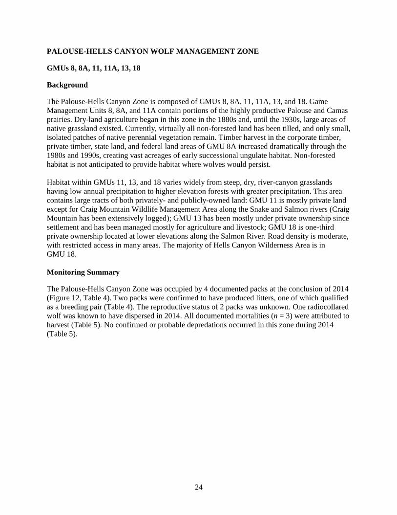
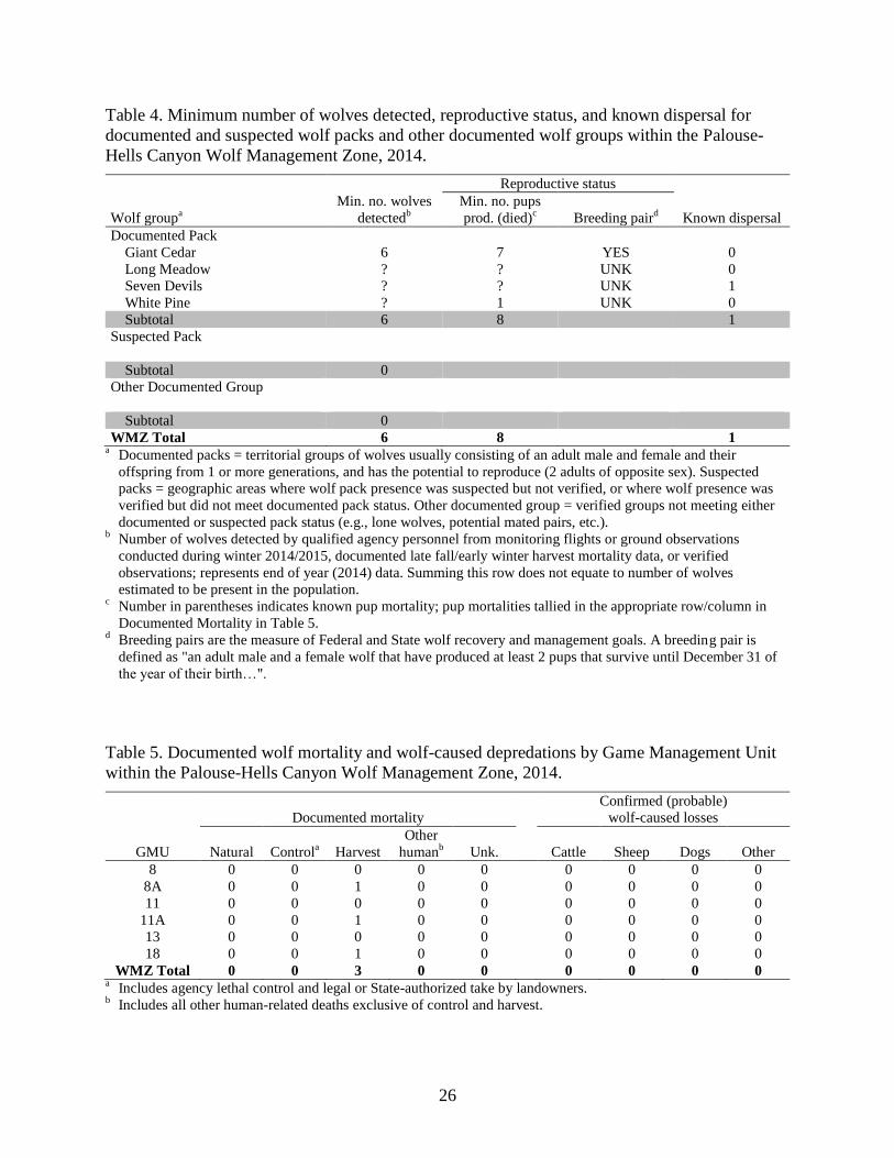
The Palouse-Hells Canyon Zone was occupied by 4 documented packs at the conclusion of 2014
(Figure 12, Table 4). Two packs were confirmed to have produced litters, one of which qualified
as a breeding pair (Table 4). The reproductive status of 2 packs was unknown. One radiocollared
wolf was known to have dispersed in 2014. All documented mortalities (n = 3) were attributed to
harvest (Table 5). No confirmed or probable depredations occurred in this zone during 2014
(Table 5).
25
Figure 12. Distribution of documented and suspected wolf packs in the Palouse-Hells Canyon
Wolf Management Zone, 2014.
26
Table 4. Minimum number of wolves detected, reproductive status, and known dispersal for
documented and suspected wolf packs and other documented wolf groups within the Palouse-
Hells Canyon Wolf Management Zone, 2014.
Reproductive status
Wolf groupa
Min. no. wolves
detectedb
Min. no. pups
prod. (died)c
Breeding paird
Known dispersal
Documented Pack
Giant Cedar 6 7 YES 0
Long Meadow ? ? UNK 0
Seven Devils ? ? UNK 1
White Pine ? 1 UNK 0
Subtotal 6 8 1
Suspected Pack
Subtotal 0
Other Documented Group
Subtotal 0
WMZ Total 6 8 1 a Documented packs = territorial groups of wolves usually consisting of an adult male and female and their
offspring from 1 or more generations, and has the potential to reproduce (2 adults of opposite sex). Suspected
packs = geographic areas where wolf pack presence was suspected but not verified, or where wolf presence was
verified but did not meet documented pack status. Other documented group = verified groups not meeting either
documented or suspected pack status (e.g., lone wolves, potential mated pairs, etc.). b Number of wolves detected by qualified agency personnel from monitoring flights or ground observations
conducted during winter 2014/2015, documented late fall/early winter harvest mortality data, or verified
observations; represents end of year (2014) data. Summing this row does not equate to number of wolves
estimated to be present in the population. c Number in parentheses indicates known pup mortality; pup mortalities tallied in the appropriate row/column in
Documented Mortality in Table 5. d Breeding pairs are the measure of Federal and State wolf recovery and management goals. A breeding pair is
defined as "an adult male and a female wolf that have produced at least 2 pups that survive until December 31 of
the year of their birth…".
Table 5. Documented wolf mortality and wolf-caused depredations by Game Management Unit
within the Palouse-Hells Canyon Wolf Management Zone, 2014.
Documented mortality
Confirmed (probable)
wolf-caused losses
GMU Natural Controla
Harvest
Other
humanb
Unk.
Cattle Sheep Dogs Other
8 0 0 0 0 0 0 0 0 0
8A 0 0 1 0 0 0 0 0 0
11 0 0 0 0 0 0 0 0 0
11A 0 0 1 0 0 0 0 0 0
13 0 0 0 0 0 0 0 0 0
18 0 0 1 0 0 0 0 0 0
WMZ Total 0 0 3 0 0 0 0 0 0 a Includes agency lethal control and legal or State-authorized take by landowners.
b Includes all other human-related deaths exclusive of control and harvest.
27
DWORSHAK-ELK CITY WOLF MANAGEMENT ZONE
GMUs 10A, 14, 15, 16
Background
The Dworshak-Elk City Zone is comprised of GMUs 10A, 14, 15, and 16. Game Management
Unit 10A is predominantly timbered, with the remaining areas in either open or agricultural lands,
and is bisected by canyons leading to the Clearwater River. During the 1980s and 1990s, timber
harvest occurred on almost all available state and private land as demand for timber and
management of these lands intensified. In GMUs 14, 15, and 16, most of the land base is in public
ownership with privately-owned portions at lower elevations along the Clearwater and Salmon
rivers. Productive conifer forests with intermixed grasslands characterized the majority of this
zone. Many forested areas have become overgrown with lodgepole pine (Pinus contorta) and fir
species due to fire suppression during the past 40 years. A small segment of this zone is federally-
designated wilderness.
Monitoring Summary
The Dworshak-Elk City Zone was occupied by 17 documented packs at the conclusion of 2014
(Figure 13, Table 6); 1 documented pack and 1 other documented group were no longer
considered extant by the end of 2014. Three new packs were documented in 2014, one of which
was retroactively added to the 2013 pack count. Eleven packs were confirmed to have produced
litters, and 7 packs qualified as breeding pairs (Table 6). The reproductive status of 6 packs was
unknown. Two radiocollared wolves were known to have dispersed in 2014. Documented
mortalities (n = 40) included harvest (n = 32), control (agency control and legal take; n = 4), and
other human causes (n = 4; Table 7). Five confirmed and 3 probable wolf-caused cattle losses
occurred within the zone in 2014 (Table 7).
28
Figure 13. Distribution of documented and suspected wolf packs in the Dworshak-Elk City Wolf
Management Zone, 2014.
29
Table 6. Minimum number of wolves detected, reproductive status, and known dispersal for
documented and suspected wolf packs and other documented wolf groups within the Dworshak-
Elk City Wolf Management Zone, 2014.
Reproductive status
Wolf groupa
Min. no. wolves
detectedb
Min. no. pups
prod. (died)c
Breeding paird
Known dispersal
Documented Pack
Bat Rock ? ? UNK 0
Cabin Point 4 4 YES 0
Chesimia ? ? UNK 1
Coolwater Ridge 4 2 YES 0
Earthquake Basin 2 ? UNK 0
Eldorado Creek ? ? UNK 0
Floodwood 8 1(1)e UNK 0
Florence ? ? UNK 0
Grandad ? 1 UNK 0
Hemlock Ridge 4 3 YES 0
Huckleberry Butte ? 3(3) UNK 0
Musselshell 4 1 NO 0
Newsome 9 2 YES 0
O'Hara Point 0
Pilot Rock 5 3(1) YES 0
Red River 4 2 YES 1
Tahoe ? ? UNK 0
White Bird Creek 6 2 YES 0
Unknown 1(1)
Subtotal 50 24(5) 2
Suspected Pack
Subtotal 0
Other Documented Group
ID631 0
Subtotal 0
WMZ Total 50 24(5) 2 a Documented packs = territorial groups of wolves usually consisting of an adult male and female and their offspring
from 1 or more generations, and has the potential to reproduce (2 adults of opposite sex). Suspected packs =
geographic areas where wolf pack presence was suspected but not verified, or where wolf presence was verified but
did not meet documented pack status. Other documented group = verified groups not meeting either documented or
suspected pack status (e.g., lone wolves, potential mated pairs, etc.). Strikethroughs indicated packs no longer
assumed extant at the end of 2014. b Number of wolves detected by qualified agency personnel from monitoring flights or ground observations
conducted during winter 2014/2015, documented late fall/early winter harvest mortality data, or verified
observations; represents end of year (2014) data. Summing this row does not equate to number of wolves estimated
to be present in the population. c Number in parentheses indicates known pup mortality; pup mortalities tallied in the appropriate row/column in
Documented Mortality in Table 7. Pups documented via mortality whose pack association could not be definitively
assigned were designated as Unknown in DOCUMENTED PACK column, and were not counted towards the zone
reproduction total to avoid potential double-counting only in cases where adjacent packs with documented pups
could not be ruled out as the potential source for the unknown pup(s). d Breeding pairs are the measure of Federal and State wolf recovery and management goals. A breeding pair is
defined as "an adult male and a female wolf that have produced at least 2 pups that survive until December 31 of
the year of their birth….” e
Mortality occurred in adjacent zone (Lolo) and is counted towards that zone’s mortality total (Table 9).
30
Table 7. Documented wolf mortality and wolf-caused depredations by Game Management Unit
within the Dworshak-Elk City Wolf Management Zone, 2014.
Documented mortality
Confirmed (probable)
wolf-caused losses
GMU Natural Controla
Harvest
Other
humanb
Unk.
Cattle Sheep Dogs Other
10A 0 3 11 1 0 2 0 0 0
14 0 0 9 2 0 0 0 0 0
15 0 1 7 1 0 3(1) 0 0 0
16 0 0 5 0 0 0(2) 0 0 0
WMZ Total 0 4 32 4 0 5(3) 0 0 0 a Includes agency lethal control and legal or State-authorized take by landowners.
b Includes all other human-related deaths exclusive of control and harvest.
31
LOLO WOLF MANAGEMENT ZONE
GMUs 10, 12
Background
The Lolo Zone is primarily forested and land ownership is almost entirely publicly-owned
national forests administered by the USFS. Historically, habitat productivity was high in this
zone, but has decreased following decades of intensive fire suppression. Until the 1930s, wildfires
were the primary habitat disturbance in this zone. Between 1900 and 1934, approximately 70% of
the Lochsa River drainage was burned by wildfires. Approximately one- third of the zone
provides good access for motorized vehicles with medium road densities. The remaining portion
has low road densities, but contains good hiking trails. In 1964, most of the southern portion of
GMU 12 was designated as part of the Selway-Bitterroot Wilderness.
Monitoring Summary
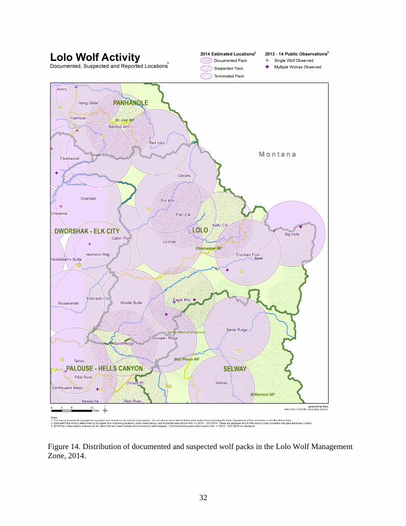
The Lolo Zone was occupied by 6 documented packs (including 2 Idaho border packs), and 5
other documented wolf groups at the conclusion of 2014; 4 documented packs were no longer
considered extant by the end of the year (Figure 14, Table 8). Five border packs reported for
Montana were presumed to spend some time in this zone. One new pack was documented in this
zone in 2014, and was retroactively added to the 2013 pack count. Reproduction was confirmed in
3 packs, one of which qualified as a breeding pair (Table 8). The reproductive status of 3 packs
was unknown. Four radiocollared wolves were known to have dispersed in 2014. Documented
mortalities (n = 41) included control (agency removal and legal take; n = 23) and harvest (n =18;
Table 9). There were no confirmed or probable wolf-caused depredations in this zone in 2014
(Table 9).
32
Figure 14. Distribution of documented and suspected wolf packs in the Lolo Wolf Management
Zone, 2014.
33
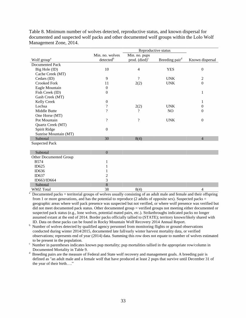
Table 8. Minimum number of wolves detected, reproductive status, and known dispersal for
documented and suspected wolf packs and other documented wolf groups within the Lolo Wolf
Management Zone, 2014.
Reproductive status
Wolf groupa
Min. no. wolves
detectedb
Min. no. pups
prod. (died)c
Breeding paird
Known dispersal
Documented Pack
Big Hole (ID) 10 4 YES 0
Cache Creek (MT)
Cedars (ID) 9 ? UNK 2
Crooked Fork 11 2(2) UNK 0
Eagle Mountain 0
Fish Creek (ID) 0 1
Gash Creek (MT)
Kelly Creek 0 1
Lochsa ? 2(2) UNK 0
Middle Butte ? ? NO 0
One Horse (MT)
Pot Mountain ? ? UNK 0
Quartz Creek (MT)
Spirit Ridge 0
Sunrise Mountain (MT)
Subtotal 30 8(4) 4
Suspected Pack
Subtotal 0
Other Documented Group
B574 1
ID625 1
ID636 1
ID637 2
ID663/ID664 3
Subtotal 8
WMZ Total 38 8(4) 4 a Documented packs = territorial groups of wolves usually consisting of an adult male and female and their offspring
from 1 or more generations, and has the potential to reproduce (2 adults of opposite sex). Suspected packs =
geographic areas where wolf pack presence was suspected but not verified, or where wolf presence was verified but
did not meet documented pack status. Other documented group = verified groups not meeting either documented or
suspected pack status (e.g., lone wolves, potential mated pairs, etc.). Strikethroughs indicated packs no longer
assumed extant at the end of 2014. Border packs officially tallied to (STATE); territory known/likely shared with
ID. Data on these packs can be found in Rocky Mountain Wolf Recovery 2014 Annual Report. b Number of wolves detected by qualified agency personnel from monitoring flights or ground observations
conducted during winter 2014/2015, documented late fall/early winter harvest mortality data, or verified
observations; represents end of year (2014) data. Summing this row does not equate to number of wolves estimated
to be present in the population. c Number in parentheses indicates known pup mortality; pup mortalities tallied in the appropriate row/column in
Documented Mortality in Table 9. d Breeding pairs are the measure of Federal and State wolf recovery and management goals. A breeding pair is
defined as "an adult male and a female wolf that have produced at least 2 pups that survive until December 31 of
the year of their birth….”
34
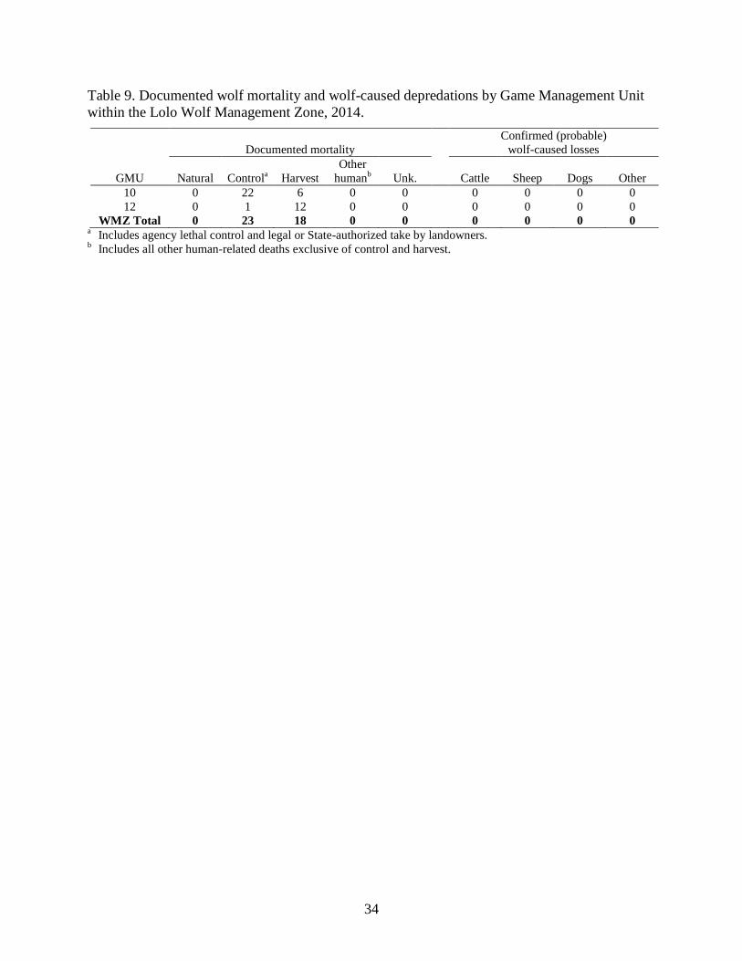
Table 9. Documented wolf mortality and wolf-caused depredations by Game Management Unit
within the Lolo Wolf Management Zone, 2014.
Documented mortality
Confirmed (probable)
wolf-caused losses
GMU Natural Controla
Harvest
Other
humanb
Unk.
Cattle Sheep Dogs Other
10 0 22 6 0 0 0 0 0 0
12 0 1 12 0 0 0 0 0 0
WMZ Total 0 23 18 0 0 0 0 0 0 a Includes agency lethal control and legal or State-authorized take by landowners.
b Includes all other human-related deaths exclusive of control and harvest.
35
SELWAY WOLF MANAGEMENT ZONE
GMUs 16A, 17, 19, 20
Background
Habitat within the Selway Zone varies from high-precipitation, forested areas along the lower
reaches of the Selway River to dry, steep, south-facing Ponderosa pine and grassland habitat
along the Salmon River. Many areas along the Salmon River represent a mix of successional
stages due to frequent fires within the wilderness. Fire suppression within portions of the Selway
River drainage has led to decreasing forage production for big game. Road densities within this
zone are low.
Noxious weeds, especially spotted knapweed (Centaurea maculosa), have encroached upon many
low-elevation areas. Due to the rugged and remote nature of this zone, human impacts have been
limited. In 1964, almost all of GMU 17 and a small portion of GMU 16A were included in the
Selway-Bitterroot Wilderness. Most of GMU 19 became part of the Gospel Hump Wilderness in
1978, and in 1980, part of GMU 20 was included in the Frank Church-River of No Return
Wilderness.
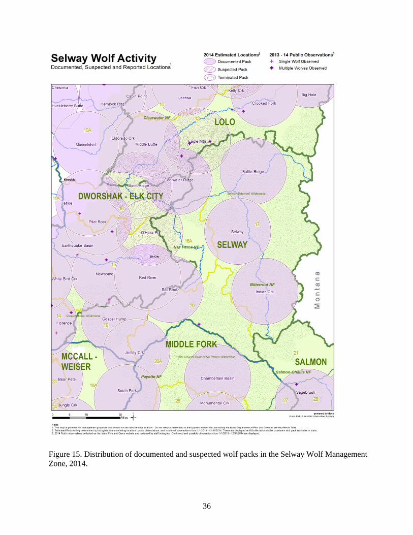
Monitoring Summary
The Selway Zone was occupied by 5 documented packs (including 2 Idaho border packs) in 2014
(Figure 15, Table 10). One border pack reported for Montana was presumed to spend some time
in this zone. Reproduction was verified for 2 packs within this zone, one of which qualified as a
breeding pair (Table 10). The reproductive status of 3 packs was unknown. No radiocollared
wolves were known to have dispersed in 2014. All documented wolf mortalities (n = 16) in this
zone were attributed to harvest (Table 11). There were no confirmed or probable wolf-caused
depredations in this zone in 2014 (Table 11).
36
Figure 15. Distribution of documented and suspected wolf packs in the Selway Wolf Management
Zone, 2014.
37
Table 10. Minimum number of wolves detected, reproductive status, and known dispersal for
documented and suspected wolf packs and other documented wolf groups within the Selway Wolf
Management Zone, 2014.
Reproductive status
Wolf groupa
Min. no. wolves
detectedb
Min. no. pups
prod. (died)c
Breeding paird
Known dispersal
Documented Pack
Battle Ridge (ID) ? ? UNK 0
Gospel Hump 3 1 UNK 0
Indian Creek (ID) 4 3(1) YES 0
Jersey Creek ? ? UNK 0
Selway ? ? UNK 0
Watchtower (MT)
Subtotal 7 4(1) 0
Suspected Pack
Subtotal 0
Other Documented Group
Subtotal 0
WMZ Total 7 4(1) 0 a Documented packs = territorial groups of wolves usually consisting of an adult male and female and their offspring
from 1 or more generations, and has the potential to reproduce (2 adults of opposite sex). Suspected packs =
geographic areas where wolf pack presence was suspected but not verified, or where wolf presence was verified but
did not meet documented pack status. Other documented group = verified groups not meeting either documented or
suspected pack status (e.g., lone wolves, potential mated pairs, etc.). Border packs officially tallied to (STATE);
territory known/likely shared with ID. Data on these packs can be found in Rocky Mountain Wolf Recovery 2014
Annual Report b Number of wolves detected by qualified agency personnel from monitoring flights or ground observations
conducted during winter 2014/2015, documented late fall/early winter harvest mortality data, or verified
observations; represents end of year (2014) data. Summing this row does not equate to number of wolves estimated
to be present in the population. c Number in parentheses indicates known pup mortality; pup mortalities tallied in the appropriate row/column in
Documented Mortality in Table 11. d Breeding pairs are the measure of Federal and State wolf recovery and management goals. A breeding pair is
defined as "an adult male and a female wolf that have produced at least 2 pups that survive until December 31 of
the year of their birth…".
Table 11. Documented wolf mortality and wolf-caused depredations by Game Management Unit
within the Selway Wolf Management Zone, 2014.
Documented mortality
Confirmed (probable)
wolf-caused losses
GMU Natural Controla
Harvest
Other
humanb
Unk.
Cattle Sheep Dogs Other
16A 0 0 1 0 0 0 0 0 0
17 0 0 8 0 0 0 0 0 0
19 0 0 3 0 0 0 0 0 0
20 0 0 4 0 0 0 0 0 0
WMZ Total 0 0 16 0 0 0 0 0 0 a Includes agency lethal control and legal or State-authorized take by landowners.
b Includes all other human-related deaths exclusive of control and harvest.
38
MCCALL-WEISER WOLF MANAGEMENT ZONE
GMUs 19A, 22, 23, 24, 25, 31, 32, 32A
Background
The McCall-Weiser Zone is composed of GMUs 19A, 22-25, 31, 32, and 32A. Over 70% of the
land area in GMUs 19A, 23, 24, and 25 is in public ownership and management. The Little
Salmon River and North Fork Payette River valley bottoms comprise most of the private
ownership. Private land in these GMUs is predominantly agricultural or rural subdivision in
nature. Timber harvest and livestock grazing are prevalent. Several large fires have burned in
these GMUs in the last few decades. Road densities are relatively low in GMUs 19A and 25.
Road densities in GMUs 23 and 24 are moderate to high.
About 60% of GMUs 22 and 32A and 20% of GMU 32 is in public ownership and management.
Privately-owned land comprised much of the western portion of GMU 32 and the Weiser River
Valley of GMUs 22 and 32A. Timber harvest and livestock grazing are prevalent. Most forested
habitat is in the early- to mid-successional stage. Andrus Wildlife Management Area in the
southwest portion of GMU 22 is managed for elk and mule deer winter range and encompasses
about 8,000 acres (3,237 ha).
About 50% of GMU 31 is in public ownership and management. Privately-owned land comprises
much of the southern and eastern portions of the GMU. Higher elevations are timbered, whereas
lower elevations are primarily shrub-steppe or desert habitat types. Timber harvest and livestock
grazing are prevalent.
Monitoring Summary
The McCall-Weiser Zone was occupied by 11 documented packs at the conclusion of 2014; 1
other documented group was no longer considered extant by the end of the year (Figure 16,
Table 12). Three suspected packs were attributed to this zone. Two new packs were documented
in this zone in 2014, including 1 suspected pack in 2013 that was upgraded to documented status
in 2014 and retroactively added to the 2013 pack counts. Three packs were confirmed to have
produced litters, and one qualified as a breeding pair (Table 12). The reproductive status of 8
packs was unknown (Table 12). No radiocollared wolves were known to have dispersed in this
zone in 2014. Documented mortalities (n = 28) included harvest (n = 19), control (agency removal
and legal take; n = 7), other human (n = 1), and unknown causes (n = 1; Table 13). Sixteen
confirmed and 3 probable wolf-caused cattle losses occurred within the zone; and confirmed and
2 probable wolf-caused domestic sheep losses occurred within the zone (Table 13).
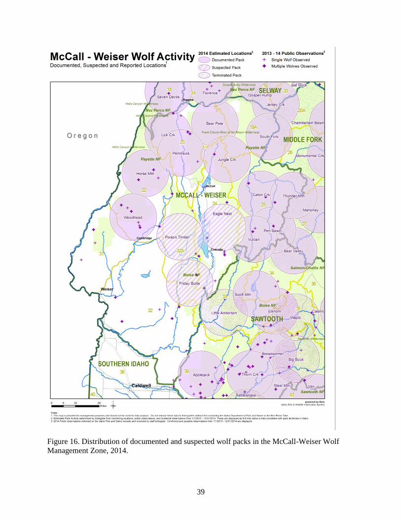
39
Figure 16. Distribution of documented and suspected wolf packs in the McCall-Weiser Wolf
Management Zone, 2014.
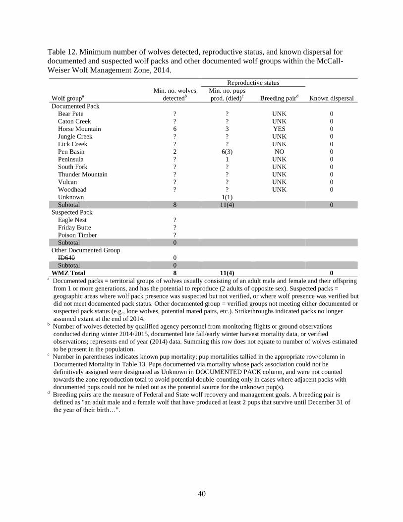
40
Table 12. Minimum number of wolves detected, reproductive status, and known dispersal for
documented and suspected wolf packs and other documented wolf groups within the McCall-
Weiser Wolf Management Zone, 2014.
Reproductive status
Wolf groupa
Min. no. wolves
detectedb
Min. no. pups
prod. (died)c
Breeding paird
Known dispersal
Documented Pack
Bear Pete ? ? UNK 0
Caton Creek ? ? UNK 0
Horse Mountain 6 3 YES 0
Jungle Creek ? ? UNK 0
Lick Creek ? ? UNK 0
Pen Basin 2 6(3) NO 0
Peninsula ? 1 UNK 0
South Fork ? ? UNK 0
Thunder Mountain ? ? UNK 0
Vulcan ? ? UNK 0
Woodhead ? ? UNK 0
Unknown 1(1)
Subtotal 8 11(4) 0
Suspected Pack
Eagle Nest ?
Friday Butte ?
Poison Timber ?
Subtotal 0
Other Documented Group
ID640 0
Subtotal 0
WMZ Total 8 11(4) 0 a Documented packs = territorial groups of wolves usually consisting of an adult male and female and their offspring
from 1 or more generations, and has the potential to reproduce (2 adults of opposite sex). Suspected packs =
geographic areas where wolf pack presence was suspected but not verified, or where wolf presence was verified but
did not meet documented pack status. Other documented group = verified groups not meeting either documented or
suspected pack status (e.g., lone wolves, potential mated pairs, etc.). Strikethroughs indicated packs no longer
assumed extant at the end of 2014. b Number of wolves detected by qualified agency personnel from monitoring flights or ground observations
conducted during winter 2014/2015, documented late fall/early winter harvest mortality data, or verified
observations; represents end of year (2014) data. Summing this row does not equate to number of wolves estimated
to be present in the population. c Number in parentheses indicates known pup mortality; pup mortalities tallied in the appropriate row/column in
Documented Mortality in Table 13. Pups documented via mortality whose pack association could not be
definitively assigned were designated as Unknown in DOCUMENTED PACK column, and were not counted
towards the zone reproduction total to avoid potential double-counting only in cases where adjacent packs with
documented pups could not be ruled out as the potential source for the unknown pup(s). d Breeding pairs are the measure of Federal and State wolf recovery and management goals. A breeding pair is
defined as "an adult male and a female wolf that have produced at least 2 pups that survive until December 31 of
the year of their birth…".
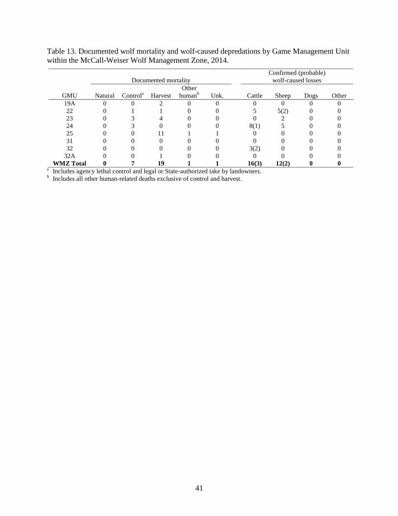
41
Table 13. Documented wolf mortality and wolf-caused depredations by Game Management Unit
within the McCall-Weiser Wolf Management Zone, 2014.
Documented mortality
Confirmed (probable)
wolf-caused losses
GMU Natural Controla
Harvest
Other
humanb
Unk.
Cattle Sheep Dogs Other
19A 0 0 2 0 0 0 0 0 0
22 0 1 1 0 0 5 5(2) 0 0
23 0 3 4 0 0 0 2 0 0
24 0 3 0 0 0 8(1) 5 0 0
25 0 0 11 1 1 0 0 0 0
31 0 0 0 0 0 0 0 0 0
32 0 0 0 0 0 3(2) 0 0 0
32A 0 0 1 0 0 0 0 0 0
WMZ Total 0 7 19 1 1 16(3) 12(2) 0 0 a Includes agency lethal control and legal or State-authorized take by landowners.
b Includes all other human-related deaths exclusive of control and harvest.
42
MIDDLE FORK WOLF MANAGEMENT ZONE
GMUs 20A 26, 27
Background
That portion of the Middle Fork Zone comprised of GMUs 20A and 26 is predominantly within
the federally-designated Frank Church-River of No Return Wilderness. That portion within GMU
27 is primarily publicly-owned USFS lands within the Middle Fork of the Salmon River drainage.
Large areas of the wilderness have burned creating a patchwork of vegetative seral stages.
Monitoring Summary
The Middle Fork Zone was occupied by 7 documented packs in 2014 (Figure 17, Table 14); 1
other documented group was no longer considered extant by the end of the year. Lack of
radiocollared wolves in conjunction with the remote nature of this management zone precluded
efforts to conduct reproductive surveys; reproduction was verified for 1 pack based on the harvest
of juvenile wolves from areas encompassed by known pack territories (Table 14). No
radiocollared wolves were known to have dispersed in 2014. Documented mortalities (n = 19)
were attributed to harvest (n = 15), control (agency removal and legal take; n = 3), and other
human causes (n = 1; Table 15). This predominantly wilderness zone contains few domestic
livestock and no losses were reported (Table 15).
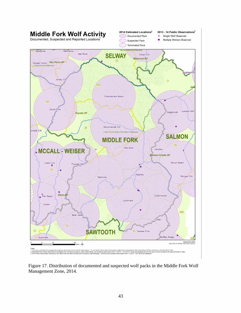
43
Figure 17. Distribution of documented and suspected wolf packs in the Middle Fork Wolf
Management Zone, 2014.
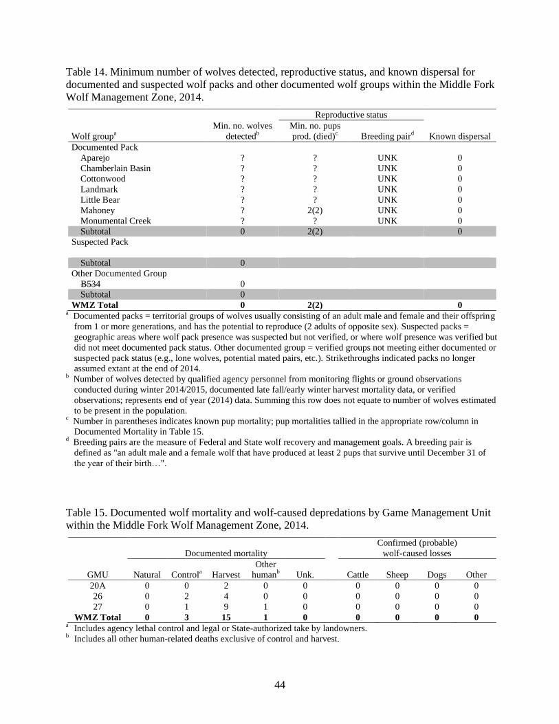
44
Table 14. Minimum number of wolves detected, reproductive status, and known dispersal for
documented and suspected wolf packs and other documented wolf groups within the Middle Fork
Wolf Management Zone, 2014.
Reproductive status
Wolf groupa
Min. no. wolves
detectedb
Min. no. pups
prod. (died)c
Breeding paird
Known dispersal
Documented Pack
Aparejo ? ? UNK 0
Chamberlain Basin ? ? UNK 0
Cottonwood ? ? UNK 0
Landmark ? ? UNK 0
Little Bear ? ? UNK 0
Mahoney ? 2(2) UNK 0
Monumental Creek ? ? UNK 0
Subtotal 0 2(2) 0
Suspected Pack
Subtotal 0
Other Documented Group
B534 0
Subtotal 0
WMZ Total 0 2(2) 0 a Documented packs = territorial groups of wolves usually consisting of an adult male and female and their offspring
from 1 or more generations, and has the potential to reproduce (2 adults of opposite sex). Suspected packs =
geographic areas where wolf pack presence was suspected but not verified, or where wolf presence was verified but
did not meet documented pack status. Other documented group = verified groups not meeting either documented or
suspected pack status (e.g., lone wolves, potential mated pairs, etc.). Strikethroughs indicated packs no longer
assumed extant at the end of 2014. b Number of wolves detected by qualified agency personnel from monitoring flights or ground observations
conducted during winter 2014/2015, documented late fall/early winter harvest mortality data, or verified
observations; represents end of year (2014) data. Summing this row does not equate to number of wolves estimated
to be present in the population. c Number in parentheses indicates known pup mortality; pup mortalities tallied in the appropriate row/column in
Documented Mortality in Table 15. d Breeding pairs are the measure of Federal and State wolf recovery and management goals. A breeding pair is
defined as "an adult male and a female wolf that have produced at least 2 pups that survive until December 31 of
the year of their birth…".
Table 15. Documented wolf mortality and wolf-caused depredations by Game Management Unit
within the Middle Fork Wolf Management Zone, 2014.
Documented mortality
Confirmed (probable)
wolf-caused losses
GMU Natural Controla
Harvest
Other
humanb
Unk.
Cattle Sheep Dogs Other
20A 0 0 2 0 0 0 0 0 0
26 0 2 4 0 0 0 0 0 0
27 0 1 9 1 0 0 0 0 0
WMZ Total 0 3 15 1 0 0 0 0 0 a Includes agency lethal control and legal or State-authorized take by landowners.
b Includes all other human-related deaths exclusive of control and harvest.
45
SALMON WOLF MANAGEMENT ZONE
GMUs 21, 21A, 28, 36B
Background
The Salmon Zone encompasses 4 GMUs (21, 21A, 28, 36B) that also comprise the Salmon Elk
Zone. The topography within the Salmon Zone is characterized by steep, mountainous slopes
interspersed by river valleys. The habitat consists primarily of timbered hillsides with grass
understory, although lower elevations are arid rangelands comprised of sagebrush and bunchgrass
vegetation. Land ownership is primarily public, with approximately 95% under USFS, Bureau of
Land Management (BLM), or State ownership. Cattle ranching, livestock grazing, mining, timber
harvesting, and recreation are the dominant human uses in this zone.
Monitoring Summary
The Salmon Zone was occupied by 8 documented packs (including 1 Idaho border pack) and 1
other documented group during 2014 (Figure 18, Table 16). Four border packs attributed to
Montana were presumed to spend some time within Idaho. Six packs produced litters, 4 of which
qualified as breeding pairs (Table 16). The reproductive status of the remaining 2 packs was
unknown. Two radiocollared wolves were known to have dispersed in 2014. Documented
mortalities within the Salmon Zone (n = 21) were attributed to harvest (n = 15), control (agency
removal and legal take; n = 4), and unknown causes (n = 2; Table 17). Nine confirmed wolf-
caused cattle losses occurred in this zone (Table 17).
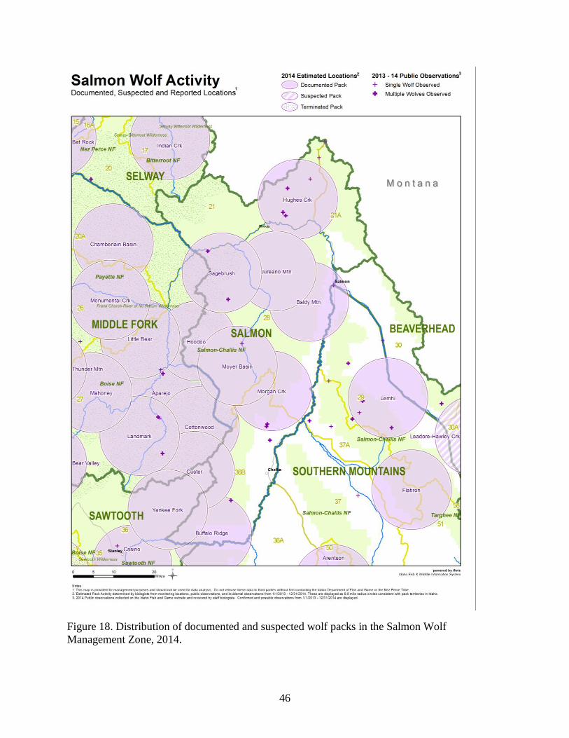
46
Figure 18. Distribution of documented and suspected wolf packs in the Salmon Wolf
Management Zone, 2014.
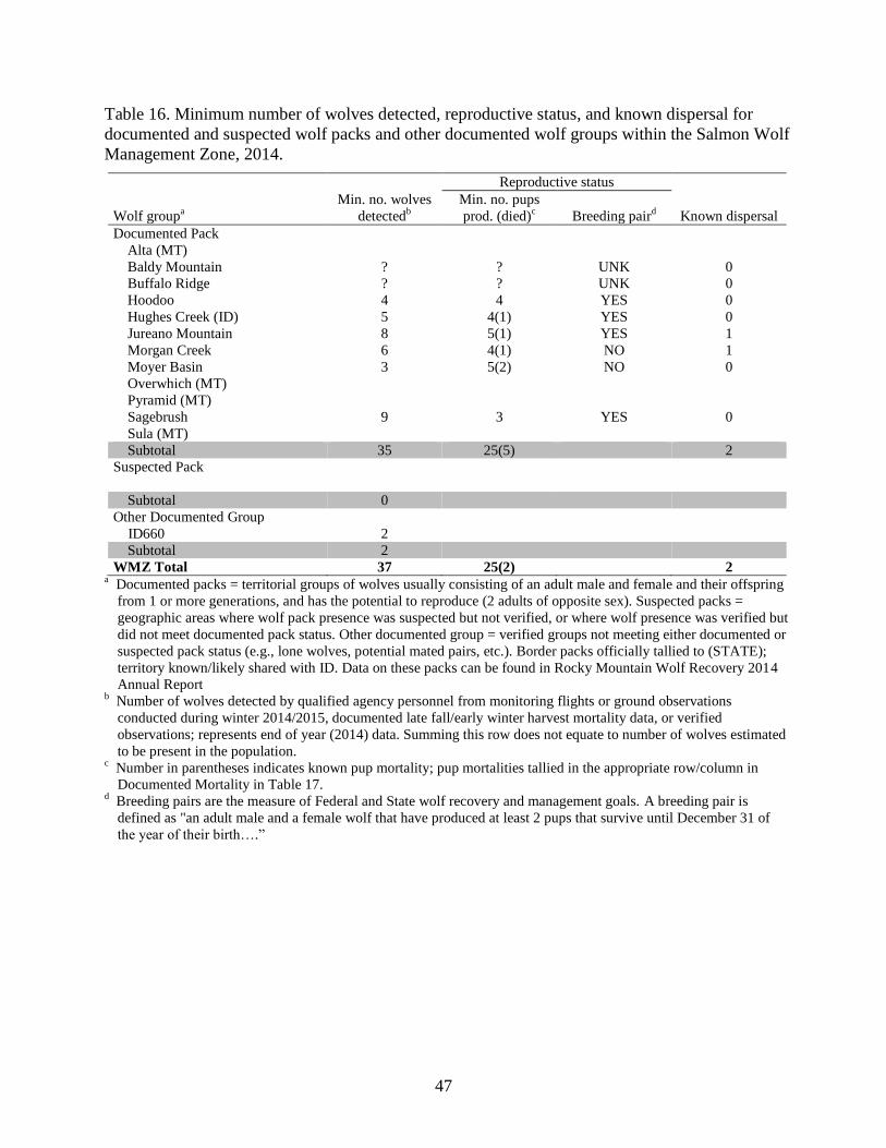
47
Table 16. Minimum number of wolves detected, reproductive status, and known dispersal for
documented and suspected wolf packs and other documented wolf groups within the Salmon Wolf
Management Zone, 2014.
Reproductive status
Wolf groupa
Min. no. wolves
detectedb
Min. no. pups
prod. (died)c
Breeding paird
Known dispersal
Documented Pack
Alta (MT)
Baldy Mountain ? ? UNK 0
Buffalo Ridge ? ? UNK 0
Hoodoo 4 4 YES 0
Hughes Creek (ID) 5 4(1) YES 0
Jureano Mountain 8 5(1) YES 1
Morgan Creek 6 4(1) NO 1
Moyer Basin 3 5(2) NO 0
Overwhich (MT)
Pyramid (MT)
Sagebrush 9 3 YES 0
Sula (MT)
Subtotal 35 25(5) 2
Suspected Pack
Subtotal 0
Other Documented Group
ID660 2
Subtotal 2
WMZ Total 37 25(2) 2 a Documented packs = territorial groups of wolves usually consisting of an adult male and female and their offspring
from 1 or more generations, and has the potential to reproduce (2 adults of opposite sex). Suspected packs =
geographic areas where wolf pack presence was suspected but not verified, or where wolf presence was verified but
did not meet documented pack status. Other documented group = verified groups not meeting either documented or
suspected pack status (e.g., lone wolves, potential mated pairs, etc.). Border packs officially tallied to (STATE);
territory known/likely shared with ID. Data on these packs can be found in Rocky Mountain Wolf Recovery 2014
Annual Report b Number of wolves detected by qualified agency personnel from monitoring flights or ground observations
conducted during winter 2014/2015, documented late fall/early winter harvest mortality data, or verified
observations; represents end of year (2014) data. Summing this row does not equate to number of wolves estimated
to be present in the population. c Number in parentheses indicates known pup mortality; pup mortalities tallied in the appropriate row/column in
Documented Mortality in Table 17. d Breeding pairs are the measure of Federal and State wolf recovery and management goals. A breeding pair is
defined as "an adult male and a female wolf that have produced at least 2 pups that survive until December 31 of
the year of their birth….”

48
Table 17. Documented wolf mortality and wolf-caused depredations by Game Management Unit
within the Salmon Wolf Management Zone, 2014.
Documented mortality
Confirmed (probable)
wolf-caused losses
GMU Natural Controla
Harvest
Other
humanb
Unk.
Cattle Sheep Dogs Other
21 0 0 3 0 1 0 0 0 0
21A 0 0 3 0 0 0 0 0 0
28 0 3 6 0 1 6 0 0 0
36B 0 1 3 0 0 3 0 0 0
WMZ Total 0 4 15 0 2 9 0 0 0 a Includes agency lethal control and legal or State-authorized take by landowners.
b Includes all other human-related deaths exclusive of control and harvest.
49
SAWTOOTH WOLF MANAGEMENT ZONE
GMUs 33, 34, 35, 36, 39
Background
The Salmon Zone encompasses 5 GMUs (33, 34, 35, 36, 39) that also comprise the Sawtooth and
Boise River Elk zones. Access within the Sawtooth Zone ranges from heavily roaded urban areas
to roadless wilderness areas. The majority of this zone is forested public land administered by the
Boise and Sawtooth National forests. However, sections of private agricultural land also exist in
the Mayfield and Horseshoe Bend areas. A portion of the Treasure Valley, Idaho’s largest
metropolitan area, is also found in this zone. The climate tends to be warm and dry in the summer
and wet and cold in the winter. Lower elevations tend to receive more rain in the winter trending
to heavy snow in higher elevations . Dominant human uses in this zone include livestock grazing,
mining, and recreation.
Monitoring Summary
The Sawtooth Zone was occupied by 10 documented packs and 1 other documented group at the
conclusion of 2014; 4 packs and 3 other documented groups were considered no longer extant at
the end of the year (Figure 19, Table 18). One new pack was documented in this zone in 2014.
Seven packs produced litters, and 4 packs qualified as breeding pairs (Table 18). The reproductive
status of 3 packs was unknown. Two radiocollared wolves were known to have dispersed in 2014
(Table 18). Documented mortalities (n = 38) included harvest (n = 17), control (agency removal
and legal take; n = 11), unknown (n = 6), natural (n = 2), and other human causes (n = 2; Table
19). Three confirmed and 2 probable wolf-caused cattle losses occurred in this zone (Table 19).
Fifty-nine confirmed and 4 probable wolf-caused sheep losses occurred in this zone. There was 1
confirmed wolf-caused domestic dog loss in this zone in 2014 (Table 19).
50
Figure 19. Distribution of documented and suspected wolf packs in the Sawtooth Wolf
Management Zone, 2014.
51
Table 18. Minimum number of wolves detected, reproductive status, and known dispersal for
documented and suspected wolf packs and other documented wolf groups within the Sawtooth
Wolf Management Zone, 2014.
Reproductive status
Wolf groupa
Min. no. wolves
detectedb
Min. no. pups
prod. (died)c
Breeding paird
Known dispersal
Documented Pack
Applejack ? ? UNK 0
Bear Valley 5 2 YES 0
Big Buck 0 1
Breadwinner 2 5(5) NO 0
Casino 3 1 NO 0
Custer ? ? UNK 0
Elkhorn 4 3(1) YES 0
Little Anderson 0
Rattlesnake 0
Scott Mountain 11 7 YES 0
Steel Mountain 10 5(1) YES 0
Thorn Creek ? 1 NO 1
Wapiti 0
Yankee Fork ? ? UNK 0
Subtotal 35 24(7) 2
Suspected Pack
Subtotal 0
Other Documented Group
B547 1
B591 0
B596 0
ID656 0
Subtotal 0
WMZ Total 36 24(7) 2 a Documented packs = territorial groups of wolves usually consisting of an adult male and female and their
offspring from 1 or more generations, and has the potential to reproduce (2 adults of opposite sex). Suspected
packs = geographic areas where wolf pack presence was suspected but not verified, or where wolf presence was
verified but did not meet documented pack status. Other documented group = verified groups not meeting either
documented or suspected pack status (e.g., lone wolves, potential mated pairs, etc.). Strikethroughs indicated
packs no longer assumed extant at the end of 2014. b Number of wolves detected by qualified agency personnel from monitoring flights or ground observations
conducted during winter 2014/2015, documented late fall/early winter harvest mortality data, or verified
observations; represents end of year (2014) data. Summing this row does not equate to number of wolves
estimated to be present in the population. c Number in parentheses indicates known pup mortality; pup mortalities tallied in the appropriate row/column in
Documented Mortality in Table 19. d Breeding pairs are the measure of Federal and State wolf recovery and management goals. A breeding pair is
defined as "an adult male and a female wolf that have produced at least 2 pups that survive until December 31 of
the year of their birth…".
52
Table 19. Documented wolf mortality and wolf-caused depredations by Game Management Unit
within the Sawtooth Wolf Management Zone, 2014.
Documented mortality
Confirmed (probable)
wolf-caused losses
GMU Natural Controla
Harvest
Other
humanb
Unk.
Cattle Sheep Dogs Other
33 1 0 4 1 0 0 0 0 0
34 0 0 1 0 0 0 0 0 0
35 0 0 2 0 0 0 0 0 0
36 0 3 4 1 0 3(2) 0 0 0
39 1 8 6 0 6 0 59(4) 1 0
WMZ Total 2 11 17 2 6 3(2) 59(4) 1 0 a Includes agency lethal control and legal or State-authorized take by landowners.
b Includes all other human-related deaths exclusive of control and harvest.
53
SOUTHERN MOUNTAINS WOLF MANAGEMENT ZONE
GMUs 29, 30, 30A, 36A, 37, 37A, 43, 44, 48, 49, 50, 51, 58, 59, 59A
Background
The Southern Mountains Zone is comprised of 4 elk management zones: The Smoky Mountains,
Pioneer, Lemhi, and Beaverhead zones. This zone contains a wide diversity of terrain
transitioning from relatively flat prairies in the southwestern portion to rolling and moderately
steep terrain of the Smoky and Soldier Mountain ranges in the central portions and steeper, spire-
like peaks of the Boulder, White Cloud, Pioneer, and Beaverhead mountain ranges in the
northeast portions of this zone. These mountain ranges are intersected by several major river
drainages, including the South Fork Boise, Big Wood, Big Lost, Little Lost, East Fork Salmon,
Salmon, Pahsimeroi, and Lemhi Rivers. Because of this varied terrain, habitats range widely and
include grass prairie, coniferous forest, high desert shrub-steppe, and alpine; this diversity
reflects the wide range of variation in annual precipitation across this region. Land ownership is
predominantly public (USFS, BLM) within this zone. Cattle ranching, livestock grazing, and
recreation are the dominant human uses in this zone.
Monitoring Summary
The Southern Mountains Zone was occupied by 8 documented packs and 2 other documented
groups at the conclusion of 2014; 2 packs were no longer considered extant at the end of the year
(Figure 20, Table 20). One suspected pack was attributed to this zone. One new pack was
documented in 2014. Four packs produced litters, two of which qualified as breeding pairs in
2014 (Table 20); the reproductive status of 4 packs was unknown. One radiocollared wolf was
known to have dispersed in 2014. Documented mortalities (n = 35) included harvest (n = 22),
control (agency removal and legal take; n = 10), unknown (n = 2), and other human causes
(n = 1; Table 21). Ten confirmed and 2 probable wolf-caused cattle losses occurred in the zone
(Table 21). Nine confirmed and 1 probable wolf-caused domestic sheep losses occurred in the
zone. One confirmed horse loss occurred in the zone (Table 21).
54
Figure 20. Distribution of documented and suspected wolf packs in the Southern Mountains
Wolf Management Zone, 2014.
55
Table 20. Minimum number of wolves detected, reproductive status, and known dispersal for
documented and suspected wolf packs and other documented wolf groups within the Southern
Mountains Wolf Management Zone, 2014.
Reproductive status
Wolf groupa
Min. no. wolves
detectedb
Min. no. pups
prod. (died)c
Breeding paird
Known dispersal
Documented Pack
Antelope Creek ? 2(2) UNK 0
Arentson ? ? UNK 0
Flatiron ? 1(1) UNK 0
Hyndman ? ? UNK 0
Lemhi ? ? UNK 0
Little Wood River 0
Lone Pine ? ? UNK 0
Red Warrior 8 2 YES 0
Soldier Mountain 0 1
Van 7 4 YES 0
Subtotal 15 9(3) 1
Suspected Pack
Lime Creek ?
Subtotal 0
Other Documented Group
ID626 2
ID658 1
Subtotal 3
WMZ Total 18 9(3) 2 a Documented packs = territorial groups of wolves usually consisting of an adult male and female and their offspring
from 1 or more generations, and has the potential to reproduce (2 adults of opposite sex). Suspected packs =
geographic areas where wolf pack presence was suspected but not verified, or where wolf presence was verified but
did not meet documented pack status. Other documented group = verified groups not meeting either documented or
suspected pack status (e.g., lone wolves, potential mated pairs, etc.). Strikethroughs indicated packs no longer
assumed extant at the end of 2014. b Number of wolves detected by qualified agency personnel from monitoring flights or ground observations
conducted during winter 2014/2015, documented late fall/early winter harvest mortality data, or verified
observations; represents end of year (2014) data. Summing this row does not equate to number of wolves estimated
to be present in the population. c Number in parentheses indicates known pup mortality; pup mortalities tallied in the appropriate row/column in
Documented Mortality in Table 21. d Breeding pairs are the measure of Federal and State wolf recovery and management goals. A breeding pair is
defined as "an adult male and a female wolf that have produced at least 2 pups that survive until December 31 of
the year of their birth….”
56
Table 21. Documented wolf mortality and wolf-caused depredations by Game Management Unit
within the Southern Mountains Wolf Management Zone, 2014.
Documented mortality
Confirmed (probable)
wolf-caused losses
GMU Natural Controla
Harvest
Other
humanb
Unk.
Cattle Sheep Dogs Other
29 0 0 1 0 0 1 0 0 0
36A 0 1 1 0 1 1(1) 0 0 0
37 0 1 1 0 0 1 2 0 0
37A 0 0 0 0 0 1 0 0 0
43 0 0 4 1 0 0 1 0 0
44 0 1 3 0 0 3(1) 3 0 0
48 0 0 3 0 0 0 1(1) 0 1
49 0 0 0 0 0 0 2 0 0
50 0 6 7 0 1 3 0 0 0
51 0 0 2 0 0 0 0 0 0
WMZ Total 0 9 22 1 2 10(2) 9(1) 0 1 a Includes agency lethal control and legal or State-authorized take by landowners.
b Includes all other human-related deaths exclusive of control and harvest.
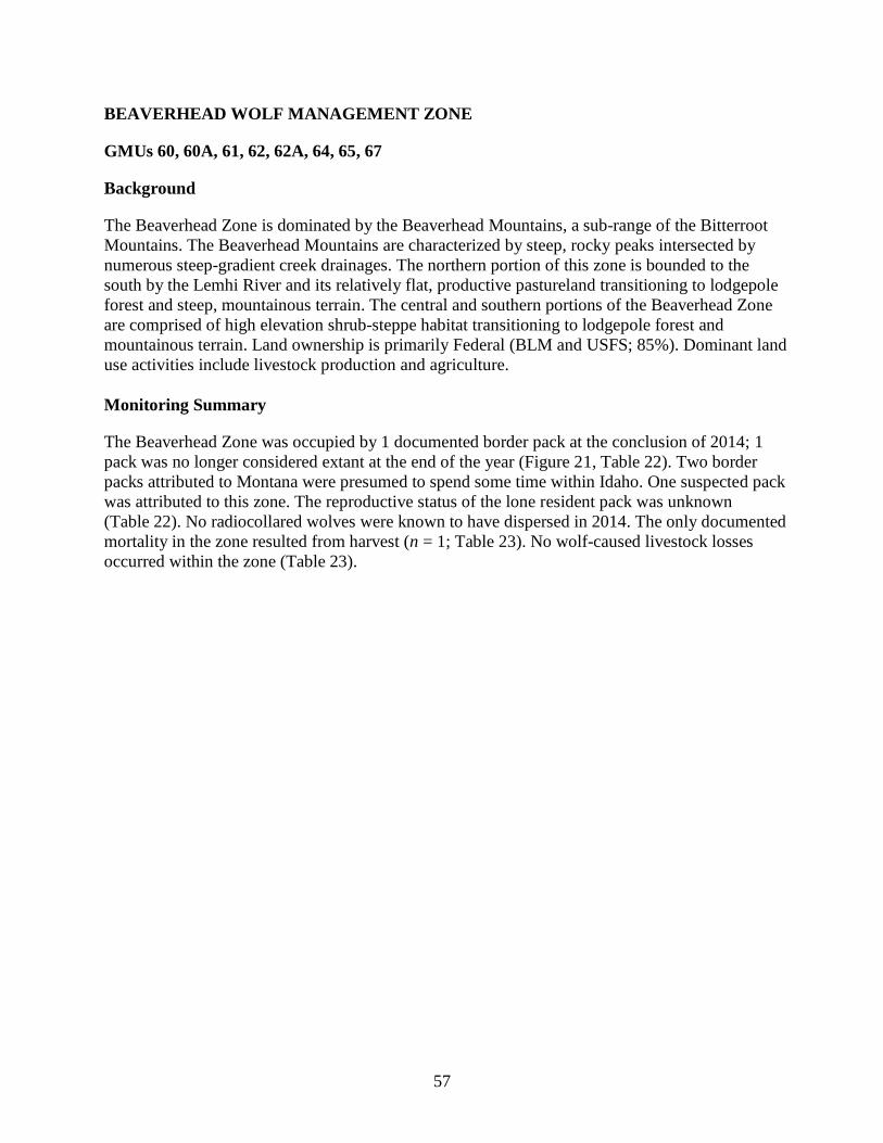
57
BEAVERHEAD WOLF MANAGEMENT ZONE
GMUs 60, 60A, 61, 62, 62A, 64, 65, 67
Background
The Beaverhead Zone is dominated by the Beaverhead Mountains, a sub-range of the Bitterroot
Mountains. The Beaverhead Mountains are characterized by steep, rocky peaks intersected by
numerous steep-gradient creek drainages. The northern portion of this zone is bounded to the
south by the Lemhi River and its relatively flat, productive pastureland transitioning to lodgepole
forest and steep, mountainous terrain. The central and southern portions of the Beaverhead Zone
are comprised of high elevation shrub-steppe habitat transitioning to lodgepole forest and
mountainous terrain. Land ownership is primarily Federal (BLM and USFS; 85%). Dominant land
use activities include livestock production and agriculture.
Monitoring Summary
The Beaverhead Zone was occupied by 1 documented border pack at the conclusion of 2014; 1
pack was no longer considered extant at the end of the year (Figure 21, Table 22). Two border
packs attributed to Montana were presumed to spend some time within Idaho. One suspected pack
was attributed to this zone. The reproductive status of the lone resident pack was unknown
(Table 22). No radiocollared wolves were known to have dispersed in 2014. The only documented
mortality in the zone resulted from harvest (n = 1; Table 23). No wolf-caused livestock losses
occurred within the zone (Table 23).
58
Figure 21. Distribution of documented and suspected wolf packs in the Beaverhead Wolf
Management Zone, 2014.
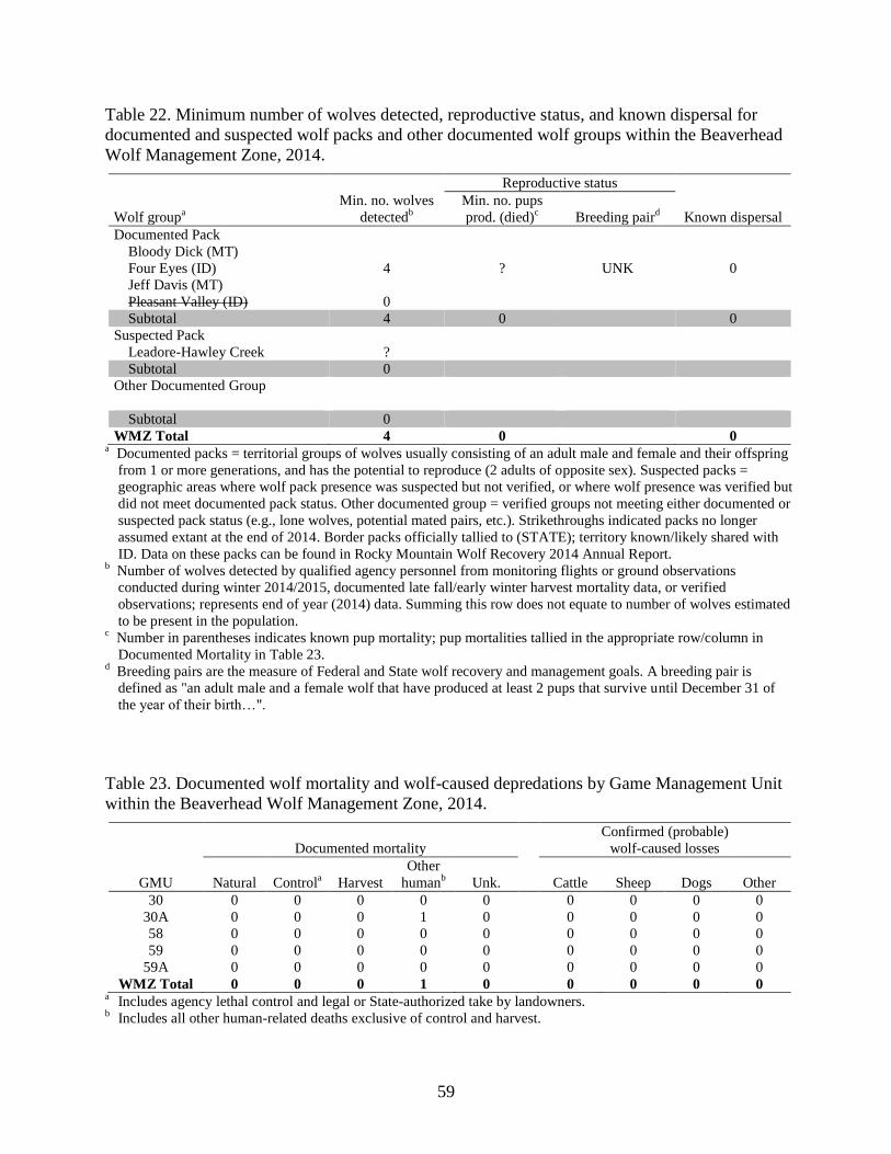
59
Table 22. Minimum number of wolves detected, reproductive status, and known dispersal for
documented and suspected wolf packs and other documented wolf groups within the Beaverhead
Wolf Management Zone, 2014.
Reproductive status
Wolf groupa
Min. no. wolves
detectedb
Min. no. pups
prod. (died)c
Breeding paird
Known dispersal
Documented Pack
Bloody Dick (MT)
Four Eyes (ID) 4 ? UNK 0
Jeff Davis (MT)
Pleasant Valley (ID) 0
Subtotal 4 0 0
Suspected Pack
Leadore-Hawley Creek ?
Subtotal 0
Other Documented Group
Subtotal 0
WMZ Total 4 0 0 a Documented packs = territorial groups of wolves usually consisting of an adult male and female and their offspring
from 1 or more generations, and has the potential to reproduce (2 adults of opposite sex). Suspected packs =
geographic areas where wolf pack presence was suspected but not verified, or where wolf presence was verified but
did not meet documented pack status. Other documented group = verified groups not meeting either documented or
suspected pack status (e.g., lone wolves, potential mated pairs, etc.). Strikethroughs indicated packs no longer
assumed extant at the end of 2014. Border packs officially tallied to (STATE); territory known/likely shared with
ID. Data on these packs can be found in Rocky Mountain Wolf Recovery 2014 Annual Report. b Number of wolves detected by qualified agency personnel from monitoring flights or ground observations
conducted during winter 2014/2015, documented late fall/early winter harvest mortality data, or verified
observations; represents end of year (2014) data. Summing this row does not equate to number of wolves estimated
to be present in the population. c Number in parentheses indicates known pup mortality; pup mortalities tallied in the appropriate row/column in
Documented Mortality in Table 23. d Breeding pairs are the measure of Federal and State wolf recovery and management goals. A breeding pair is
defined as "an adult male and a female wolf that have produced at least 2 pups that survive until December 31 of
the year of their birth…".
Table 23. Documented wolf mortality and wolf-caused depredations by Game Management Unit
within the Beaverhead Wolf Management Zone, 2014.
Documented mortality
Confirmed (probable)
wolf-caused losses
GMU Natural Controla
Harvest
Other
humanb
Unk.
Cattle Sheep Dogs Other
30 0 0 0 0 0 0 0 0 0
30A 0 0 0 1 0 0 0 0 0
58 0 0 0 0 0 0 0 0 0
59 0 0 0 0 0 0 0 0 0
59A 0 0 0 0 0 0 0 0 0
WMZ Total 0 0 0 1 0 0 0 0 0 a Includes agency lethal control and legal or State-authorized take by landowners.
b Includes all other human-related deaths exclusive of control and harvest.
60
ISLAND PARK WOLF MANAGEMENT ZONE
GMUs 60, 60A, 61, 62, 62A, 64, 65, 67
Background
Topography in the Island Park Zone consists of gentle to moderately sloping terrain, but contains
portions of several mountain ranges. At relatively high elevation, winters are often severe, with
associated deep snow accumulations. Habitat communities comprise a mixture of forest types
(lodgepole pine, Douglas-fir, quaking aspen [Populus tremuloides]) associated with adequate
moisture, and high-desert, shrub-steppe habitat types indicative of a drier climate. Land ownership
consists of a checkerboard of state, federal, and private properties, roughly one half being under
federal/state ownership. Dominant land use activities include timber harvest, livestock production,
and agriculture.
Monitoring Summary
The Island Park Zone was occupied by 6 documented packs (including 4 Idaho border packs) at
the conclusion of 2014 (Figure 22, Table 24). Two border packs reported for Wyoming were
presumed to spend some time in this zone. Four documented packs produced litters, one of which
qualified as a breeding pair for 2014 (Table 24). The reproductive status for 2 packs was
unknown, and the pack affiliation for one harvested pup was undetermined. One radiocollared
wolf was known to have dispersed in 2014. Documented mortalities (n = 16) resulted from
harvest (n = 12), other human (n = 3), and unknown causes (n = 1; Table 25). Eight confirmed
wolf-caused domestic sheep losses occurred in the zone; 2 confirmed and one probable dog losses
occurred in the zone (Table 25).
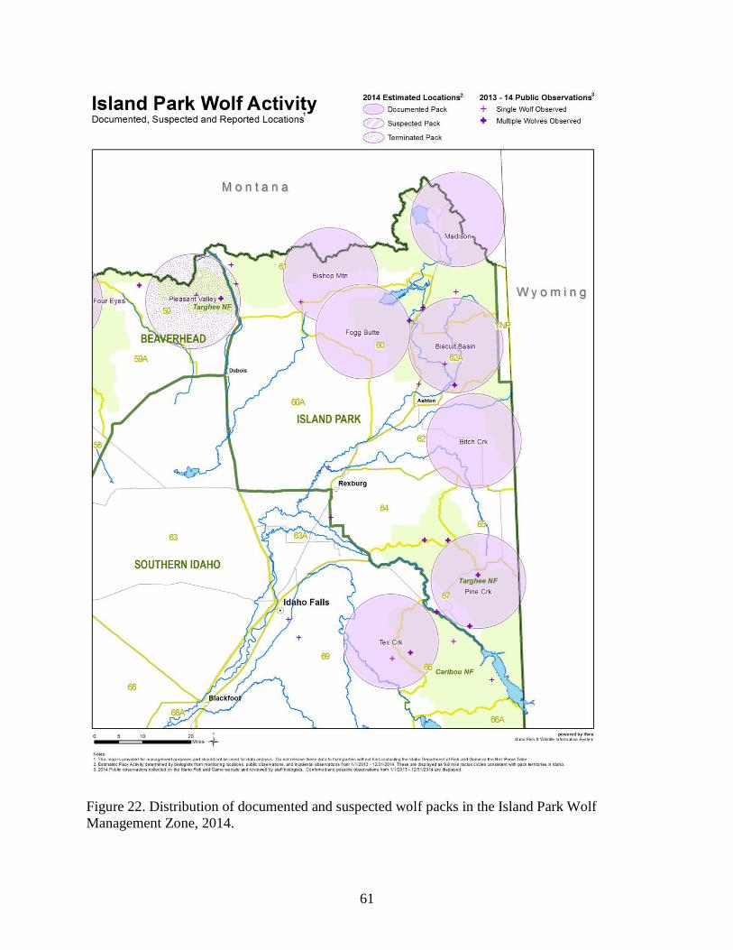
61
Figure 22. Distribution of documented and suspected wolf packs in the Island Park Wolf
Management Zone, 2014.
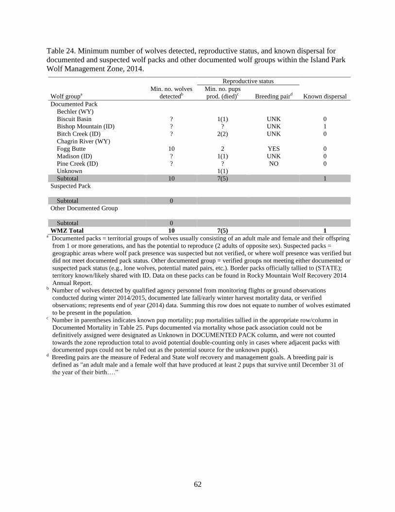
62
Table 24. Minimum number of wolves detected, reproductive status, and known dispersal for
documented and suspected wolf packs and other documented wolf groups within the Island Park
Wolf Management Zone, 2014.
Reproductive status
Wolf groupa
Min. no. wolves
detectedb
Min. no. pups
prod. (died)c
Breeding paird
Known dispersal
Documented Pack
Bechler (WY)
Biscuit Basin ? 1(1) UNK 0
Bishop Mountain (ID) ? ? UNK 1
Bitch Creek (ID) ? 2(2) UNK 0
Chagrin River (WY)
Fogg Butte 10 2 YES 0
Madison (ID) ? 1(1) UNK 0
Pine Creek (ID) ? ? NO 0
Unknown 1(1)
Subtotal 10 7(5) 1
Suspected Pack
Subtotal 0
Other Documented Group
Subtotal 0
WMZ Total 10 7(5) 1 a Documented packs = territorial groups of wolves usually consisting of an adult male and female and their offspring
from 1 or more generations, and has the potential to reproduce (2 adults of opposite sex). Suspected packs =
geographic areas where wolf pack presence was suspected but not verified, or where wolf presence was verified but
did not meet documented pack status. Other documented group = verified groups not meeting either documented or
suspected pack status (e.g., lone wolves, potential mated pairs, etc.). Border packs officially tallied to (STATE);
territory known/likely shared with ID. Data on these packs can be found in Rocky Mountain Wolf Recovery 2014
Annual Report. b Number of wolves detected by qualified agency personnel from monitoring flights or ground observations
conducted during winter 2014/2015, documented late fall/early winter harvest mortality data, or verified
observations; represents end of year (2014) data. Summing this row does not equate to number of wolves estimated
to be present in the population. c Number in parentheses indicates known pup mortality; pup mortalities tallied in the appropriate row/column in
Documented Mortality in Table 25. Pups documented via mortality whose pack association could not be
definitively assigned were designated as Unknown in DOCUMENTED PACK column, and were not counted
towards the zone reproduction total to avoid potential double-counting only in cases where adjacent packs with
documented pups could not be ruled out as the potential source for the unknown pup(s). d Breeding pairs are the measure of Federal and State wolf recovery and management goals. A breeding pair is
defined as "an adult male and a female wolf that have produced at least 2 pups that survive until December 31 of
the year of their birth….”
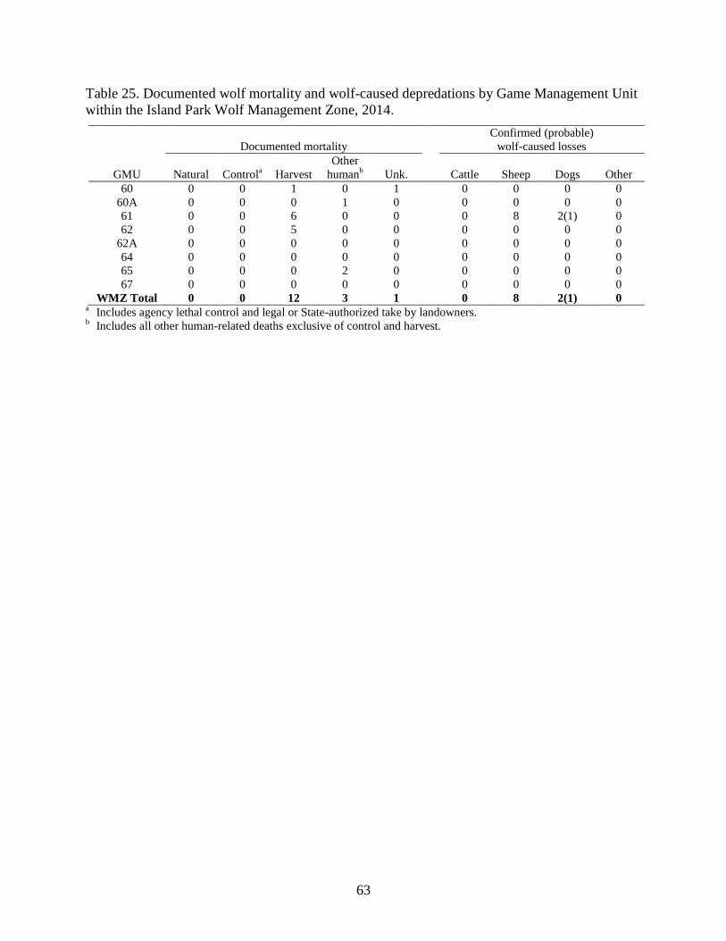
63
Table 25. Documented wolf mortality and wolf-caused depredations by Game Management Unit
within the Island Park Wolf Management Zone, 2014.
Documented mortality
Confirmed (probable)
wolf-caused losses
GMU Natural Controla
Harvest
Other
humanb
Unk.
Cattle Sheep Dogs Other
60 0 0 1 0 1 0 0 0 0
60A 0 0 0 1 0 0 0 0 0
61 0 0 6 0 0 0 8 2(1) 0
62 0 0 5 0 0 0 0 0 0
62A 0 0 0 0 0 0 0 0 0
64 0 0 0 0 0 0 0 0 0
65 0 0 0 2 0 0 0 0 0
67 0 0 0 0 0 0 0 0 0
WMZ Total 0 0 12 3 1 0 8 2(1) 0 a Includes agency lethal control and legal or State-authorized take by landowners.
b Includes all other human-related deaths exclusive of control and harvest.
64
SOUTHERN IDAHO WOLF MANAGEMENT ZONE
GMUs 38, 40, 41, 42, 45, 46, 47, 52, 52A, 53, 54, 55, 56, 57, 63, 63A, 66, 66A, 68, 68A, 69, 70,
71, 72, 73, 73A, 74, 75, 76, 77, 78
Background
The Southern Idaho Zone includes the Snake River Plain, which comprises an area of heavy
agricultural use with a metropolitan corridor along U.S. Interstate 84. The zone includes several
mountain ranges spanning from the Owyhees in the west to the Portneufs in the east. These ranges
might act as corridors for dispersing wolves, but potential for livestock conflicts could be high.
The zone also contains some protected areas including Craters of the Moon National Monument
and the Idaho National Laboratory. The climate tends to be hot and dry during summer and cold
and wet during winter. Temperatures range from mild in the west to more severe in the east.
Monitoring Summary
One documented pack occupied the Southern Idaho Zone in 2014 (Figure 23, Table 26).
Reproduction was documented in that pack in 2014, but it did not qualify as a breeding pair
(Table 26). No radiocollared wolves were known to have dispersed in 2014. Documented
mortalities (n = 8) were due to control (agency removal and legal take; n = 5), harvest (n = 2), and
unknown causes (n = 1; Table 27). Twelve confirmed wolf-caused losses of domestic sheep
occurred in this zone in 2014 (Table 27).
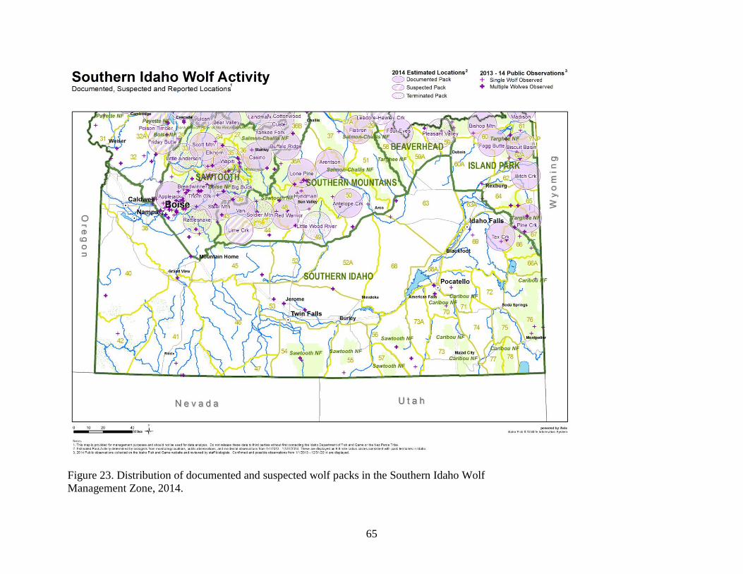
65
Figure 23. Distribution of documented and suspected wolf packs in the Southern Idaho Wolf
Management Zone, 2014.
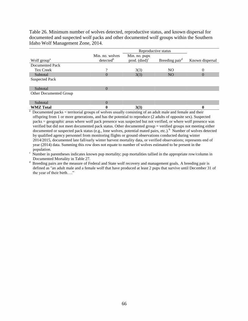
66
Table 26. Minimum number of wolves detected, reproductive status, and known dispersal for
documented and suspected wolf packs and other documented wolf groups within the Southern
Idaho Wolf Management Zone, 2014.
Reproductive status
Wolf groupa
Min. no. wolves
detectedb
Min. no. pups
prod. (died)c
Breeding paird
Known dispersal
Documented Pack
Tex Creek ? 3(3) NO 0
Subtotal 0 3(3) NO 0
Suspected Pack
Subtotal 0
Other Documented Group
Subtotal 0
WMZ Total 0 3(3) 0 a Documented packs = territorial groups of wolves usually consisting of an adult male and female and their
offspring from 1 or more generations, and has the potential to reproduce (2 adults of opposite sex). Suspected
packs = geographic areas where wolf pack presence was suspected but not verified, or where wolf presence was
verified but did not meet documented pack status. Other documented group = verified groups not meeting either
documented or suspected pack status (e.g., lone wolves, potential mated pairs, etc.).b Number of wolves detected
by qualified agency personnel from monitoring flights or ground observations conducted during winter
2014/2015, documented late fall/early winter harvest mortality data, or verified observations; represents end of
year (2014) data. Summing this row does not equate to number of wolves estimated to be present in the
population. c Number in parentheses indicates known pup mortality; pup mortalities tallied in the appropriate row/column in
Documented Mortality in Table 27. d Breeding pairs are the measure of Federal and State wolf recovery and management goals. A breeding pair is
defined as "an adult male and a female wolf that have produced at least 2 pups that survive until December 31 of
the year of their birth….”
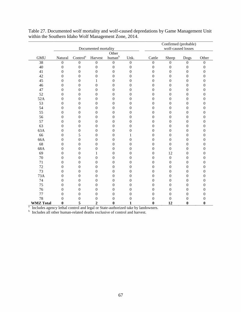
67
Table 27. Documented wolf mortality and wolf-caused depredations by Game Management Unit
within the Southern Idaho Wolf Management Zone, 2014.
Documented mortality
Confirmed (probable)
wolf-caused losses
GMU Natural Controla
Harvest
Other
humanb
Unk.
Cattle Sheep Dogs Other
38 0 0 0 0 0 0 0 0 0
40 0 0 0 0 0 0 0 0 0
41 0 0 0 0 0 0 0 0 0
42 0 0 0 0 0 0 0 0 0
45 0 0 1 0 0 0 0 0 0
46 0 0 0 0 0 0 0 0 0
47 0 0 0 0 0 0 0 0 0
52 0 0 0 0 0 0 0 0 0
52A 0 0 0 0 0 0 0 0 0
53 0 0 0 0 0 0 0 0 0
54 0 0 0 0 0 0 0 0 0
55 0 0 0 0 0 0 0 0 0
56 0 0 0 0 0 0 0 0 0
57 0 0 0 0 0 0 0 0 0
63 0 0 0 0 0 0 0 0 0
63A 0 0 0 0 0 0 0 0 0
66 0 5 0 0 1 0 0 0 0
66A 0 0 0 0 0 0 0 0 0
68 0 0 0 0 0 0 0 0 0
68A 0 0 0 0 0 0 0 0 0
69 0 0 1 0 0 0 12 0 0
70 0 0 0 0 0 0 0 0 0
71 0 0 0 0 0 0 0 0 0
72 0 0 0 0 0 0 0 0 0
73 0 0 0 0 0 0 0 0 0
73A 0 0 0 0 0 0 0 0 0
74 0 0 0 0 0 0 0 0 0
75 0 0 0 0 0 0 0 0 0
76 0 0 0 0 0 0 0 0 0
77 0 0 0 0 0 0 0 0 0
78 0 0 0 0 0 0 0 0 0
WMZ Total 0 5 2 0 1 0 12 0 0 a Includes agency lethal control and legal or State-authorized take by landowners.
b Includes all other human-related deaths exclusive of control and harvest.
68
LITERATURE CITED
Ausband, D., L. N. Rich, E. M. Glenn, M. S. Mitchell, P. Zager, D. A. W. Miller, L. P. Waits,
B. B. Ackerman, and C. M. Mack. 2014. Monitoring gray wolf populations using
multiple survey methods. Journal of Wildlife Management 78(2):335-346.
Idaho Legislative Wolf Oversight Committee. 2002. Idaho wolf conservation and management
plan as modified by the 56th
Idaho Legislature, second regular session.
MacKenzie, D. I., J. D. Nichols, G. B. Lachman, S. Droege, J. A. Royle, and C. A. Langtimm.
2002. Estimating site occupancy rates when detection probabilities are less than one.
Ecology 83:2248–2255.
Mech, D. L., and L. Boitani. 2003. Wolves: behavior, ecology, and conservation. The University
of Chicago Press, Illinois.
Mitchell, M. S., D. E. Ausband, C. A. Sime, E. E. Bangs, J. A. Gude, M. D. Jimenez, C. M.
Mack, T. J. Meier, M. S. Nadeau, and D. W. Smith. 2008. Estimation of successful
breeding pairs for wolves in the Northern Rocky Mountains, USA. Journal of Wildlife
Management 72(4):881-891.
U.S. Fish and Wildlife Service [USFWS]. 2009. Endangered and Threatened Wildlife and Plants;
Final Rule To Identify the Northern Rocky Mountain Population of Gray Wolf as a
Distinct Population Segment and To Revise the List of Endangered and Threatened
Wildlife. Federal Register 74(62):15123-15188.
U.S. Fish and Wildlife Service [USFWS]. 2010. Endangered and threatened wildlife and plants;
reinstatement of protections for the gray wolf in the northern Rocky Mountains in
compliance with a court order. Federal Register 75(206):65574-65579.
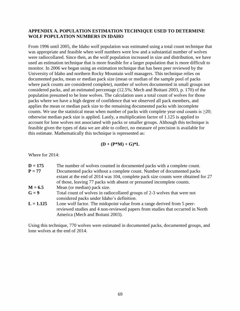
69
APPENDIX A. POPULATION ESTIMATION TECHNIQUE USED TO DETERMINE
WOLF POPULATION NUMBERS IN IDAHO
From 1996 until 2005, the Idaho wolf population was estimated using a total count technique that
was appropriate and feasible when wolf numbers were low and a substantial number of wolves
were radiocollared. Since then, as the wolf population increased in size and distribution, we have
used an estimation technique that is more feasible for a larger population that is more difficult to
monitor. In 2006 we began using an estimation technique that has been peer reviewed by the
University of Idaho and northern Rocky Mountain wolf managers. This technique relies on
documented packs, mean or median pack size (mean or median of the sample pool of packs
where pack counts are considered complete), number of wolves documented in small groups not
considered packs, and an estimated percentage (12.5%; Mech and Boitani 2003, p. 170) of the
population presumed to be lone wolves. The calculation uses a total count of wolves for those
packs where we have a high degree of confidence that we observed all pack members, and
applies the mean or median pack size to the remaining documented packs with incomplete
counts. We use the statistical mean when number of packs with complete year-end counts is ≥20;
otherwise median pack size is applied. Lastly, a multiplication factor of 1.125 is applied to
account for lone wolves not associated with packs or smaller groups. Although this technique is
feasible given the types of data we are able to collect, no measure of precision is available for
this estimate. Mathematically this technique is represented as:
(D + (P*M) + G)*L
Where for 2014:
D = 175 The number of wolves counted in documented packs with a complete count.
P = 77 Documented packs without a complete count. Number of documented packs
extant at the end of 2014 was 104, complete pack size counts were obtained for 27
of those, leaving 77 packs with absent or presumed incomplete counts.
M = 6.5 Mean (or median) pack size.
G = 9 Total count of wolves in radiocollared groups of 2-3 wolves that were not
considered packs under Idaho’s definition.
L = 1.125 Lone wolf factor. The midopoint value from a range derived from 5 peer-
reviewed studies and 4 non-reviewed papers from studies that occurred in North
America (Mech and Boitani 2003).
Using this technique, 770 wolves were estimated in documented packs, documented groups, and
lone wolves at the end of 2014.
70
APPENDIX B. CONTACTS FOR IDAHO WOLF MANAGEMENT
Idaho Fish and Game Headquarters Wildlife Bureau: (208) 334-2920
For information about wolves in Idaho and IDFG involvement or to report wolf sightings:
IDFG wolf management webpage: http://fishandgame.idaho.gov/public/wildlife/wolves/
IDFG wolf reporting webpage: https://fishandgame.idaho.gov/ifwis/observations/wolf/
The Nez Perce Tribe’s Idaho Wolf Recovery Program: Telephone: (208) 634-1061
Mail: 14054 Burr Road
McCall, ID 83638-1922
Email: [email protected]
For information about the Nez Perce Tribe’s Wildlife Program and to view Recovery Program
Progress Reports, please visit the following website:
http://www.nezperce.org/programs/wildlife_program.htm
To report livestock depredations within Idaho: USDA APHIS Wildlife Services State Director, Boise, ID
(866) 4US-DAWS or (208) 373-1630
To report information regarding the illegal killing of a wolf or a dead wolf within Idaho: Citizens Against Poaching (24hr) 1-800-632-5999 or any IDFG Office
U.S. Fish and Wildlife Service Northern Rocky Mountain Wolf Recovery: For information about wolf recovery in the Northern Rocky Mountains, please visit the USFWS
website: http://www.westerngraywolf.fws.gov/
USFWS Idaho State Office: (877) 661-1908