2005 - gloucestershire geology trust lgap.pdf · · 2009-10-28this geodiversity audit and local...
TRANSCRIPT
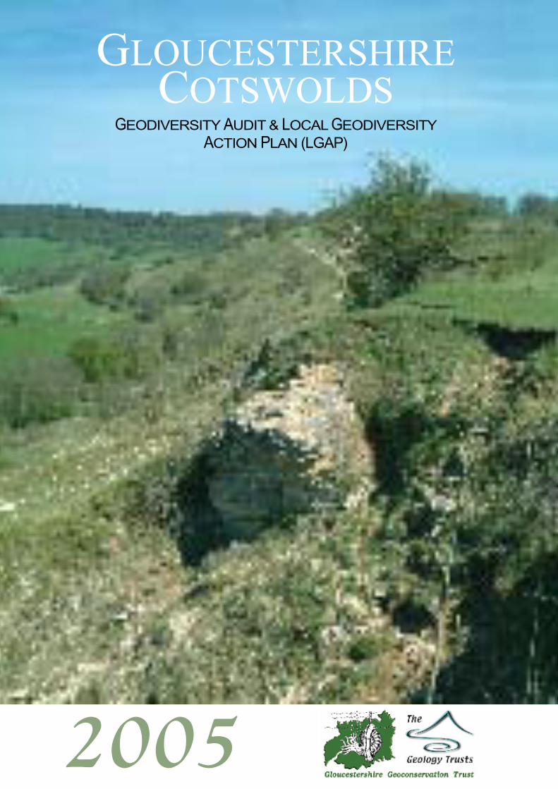
GLOUCESTERSHIRECOTSWOLDS
GEODIVERSITY AUDIT & LOCAL GEODIVERSITYACTION PLAN (LGAP)
2005

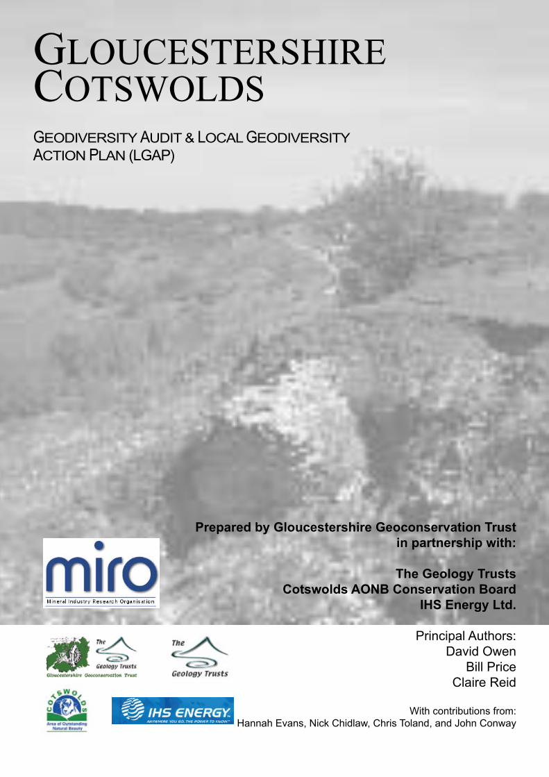
GLOUCESTERSHIRECOTSWOLDSGEODIVERSITY AUDIT & LOCAL GEODIVERSITYACTION PLAN (LGAP)
Prepared by Gloucestershire Geoconservation Trustin partnership with:
The Geology TrustsCotswolds AONB Conservation Board
IHS Energy Ltd.
Principal Authors:David Owen
Bill PriceClaire Reid
With contributions from:Hannah Evans, Nick Chidlaw, Chris Toland, and John Conway
This Geodiversity Audit and Local Geodiversity Action Plan (LGAP) has been prepared by Gloucestershire Geoconservation Trust, in partnership with The Geology Trusts, Cotswolds Area of Outstanding Natural Beauty Conservation Board and IHS Energy Ltd., with funding from the Aggregates Levy Sustainability Fund (ALSF) administered by the Minerals Industry Research Organisation (MIRO) via the Office of the Deputy Prime Minister.
This publication and references within it to any methodology, process, service, manufacturer or company do not constitute its endorsement by the Minerals Industry Research Organisation or the Office of the Deputy Prime Minister.
ISBN 1-904530-07-9
Bibliographical Reference:Owen, D., Price, W. and Reid, C. 2005. Gloucestershire Cotswolds: Geodiversity Audit & Local Geodiversity Action Plan. Gloucester: Gloucestershire Geoconservation Trust.
Cover photograph: The Cotswold Escarpment Between Crickley Hill and Shurdington Hill
Lists of sites in this document have been compiled from records in the Gloucestershire Geological Records Centre. Sites have been selected for their representitiveness and geological merits. Their listing implies no right of access and in all instances access must be arranged in advance with the appropriate landowner.
Topographic maps are based on Ordnance Survey material with the permission of Ordnance Survey, on behalf of the Controller of Her Majesty’s Stationary Office. © Crown Copyright. All rights reserved. Licence number 100043722.
Geological maps are based on British Geological Survey material reproduced by permission of the British Geological Survey. © NERC. All rights reserved. IPR/62-10C
Printed by Impressions of Monmouth Ltd. 01494 839407
Contents
Part 1 The Gloucestershire Cotswolds
Part 2 Geodiversity in the Gloucestershire Cotswolds
Part 3 Geodiversity Audit
Part 4 Implementing the Action Plan & Interpretation of Geodiversity
Part 5 Action Plan
SECTION 1 INTRODUCTION TO THE GLOUCESTERSHIRECOTSWOLDS LOCAL GEODIVERSITY ACTION PLAN
Page
1.01 Introduction 1
1.02 What Is Geodiversity? 2
1.03 What is a Geodiversity Action Plan and What is its Purpose? 3
1.04 Geoconservation 3
1.05 Geodiversity in Gloucestershire 4
1.06 A Vision for Geodiversity in the Gloucestershire Cotswolds 5
1.07 Geoconservation in Gloucestershire 6
a Gloucestershire Geoconservation Trust (GGT)
b Gloucestershire Geological Records Centre (GGRC)
c The Geology Trusts (GT)
d English Nature
e Geological Conservation Review Series
1.08 Cotswolds Area of Outstanding Natural Beauty 8
1.09 Cotswold Hills Geopark 8
1.10 Cotteswold Naturalists Field Club 9
SECTION 2 GEODIVERSITY IN THE GLOUCESTERSHIRE COTSWOLDS
Page
2.01 Introduction 11
2.02 Geological History of the Cotswolds 11
2.03 The Quaternary Record in Gloucestershire 13
2.04 Economic Geology 15
2.05 Related Issues 17
a Biodiversity
b History
c Industrial Heritage
d Communities and Settlement
2.06 Types of Geodiversity Sites 19
a The Geological Conservation Review Series (GCR)
b Sites of Special Scientific Interest (SSSI)
c Regionally Important Geological / Geomorphological Sites (RIGS)
d Local Sites
e Lost Sites
f Landscapes
g Active Quarries
h Stone Buildings, Monuments and Other Constructions
i Earth Science Interest on Sites Designated for Other Purposes
j Opportunities to Enhance Geodiversity Features
2.07 Soils 22
a Definition of Soils
b Diversity of Soils in the Gloucestershire Cotswolds
c Influence on the Landscape and Social & Industrial History
d Influence on Biodiversity
e Future Requirements
SECTION 3 GEODIVERSITY AUDIT
Page
3.00 Aims and Objectives of the Geodiversity Audit 25
3.01 The Geological Framework 25
a Regional Structural Setting
b Faults and Folds
c Sedimentological Effects on Structure
d Superficial Structure
3.02 The Palaeozoic Basement 28
3.03 The Stratigraphical Succession in the Cotswolds 29
a Lias Group (Lower Jurassic) 30
i Charmouth Mudstone Formation
ii Dyrham Formation
iii Marlstone Rock Formation
iv Whitby Mudstone Formation
v Bridport Sand Formation
b Inferior Oolite Group (Middle Jurassic) 33
i Birdlip Limestone Formation
ii Aston Limestone Formation
iii Salperton Limestone Formation
c Great Oolite Group (Middle Jurassic) 40
i Chipping Norton Limestone Formation
ii Fuller’s Earth Formation
iii Taynton Limestone Formation
iv Hampen Formation
v White Limestone Formation
vi Forest Marble Formation
vii Cornbrash Formation
d Ancholme Group (Upper Jurassic) 45
i Kellaways Formation
ii Oxford Clay Formation
e Late Jurassic to Quaternary 46
3.04 Geomorphology and Landforms 47
3.05 Landforms 48
a Escarpment
b Escarpment Valleys and Outliers
c High Wold and Dip Slope
3.06 Cotswold Valley Systems 50
a Dry Valleys and Misfit Streams
b Valley Meanders and Abandoned Meanders
c Wind Gaps
3.07 Karstic Forms 51
3.08 Summary 51
SECTION 4 IMPLEMENTING THE ACTION PLAN INTERPRETING GEODIVERSITY
Page
4.00 Implementation of the Action Plan 81
4.01 Potential Geodiversity Resources 81
4.02 Key Sites and Features 89
4.03 Recommended Sites 91
4.04 Major Footpaths, Cycle Routes and Bridleways 94
4.05 Guided Walks and Field Trips 95
FIGURES
Section 1 FiguresPage
Fig. 1.1 The Outcrop of Jurassic Rocks in Britain 1
Fig. 1.2 Simplified Geological Map of Gloucestershire 4
Fig. 1.3 Huntsmans Quarry Interpretation Board 5
Fig. 1.4 Gloucestershire Uncovered Trail Guides 6
Fig. 1.5 Geosites Database 6
Fig. 1.6 Geology Trusts in Britain 7
Fig. 1.7 English Nature Cotswolds Natural Area Map 7
Fig. 1.8 Cotswolds AONB Map 8
Fig. 1.9 Cotswold Hills Geopark Map 8
Section 3 Figures.Page
Fig. 3.1 Regional Structural Setting for the Cotswolds 25
Fig. 3.2 Faults in the Cotswolds 26
Fig. 3.3 Cotswolds AONB Landscape Character Map 27
Fig. 3.4 Geological Map of the Gloucestershire Cotswolds 28
Fig. 3.5 Stratigraphy of the Gloucestershire Cotswolds 29
Fig. 3.6 Stratigraphy of the Lias Group (Lower Jurassic) 30
Fig. 3.7 Outcrop of the Charmouth Mudstone Formation 30
Fig. 3.8 Outcrop of the Dyrham Formation 31
Fig. 3.9 Outcrop of the Marlstone Rock Formation 31
Fig. 3.10 Outcrop of the Whitby Mudstone Formation 32
Fig. 3.11 Outcrop of the Bridport Sand Formation 32
Fig. 3.12 Stratigraphy of the Inferior Oolite Group (Middle Jurassic) 33
Fig. 3.13 Outcrop of the Birdlip Limestone Formation 34
Fig. 3.14 Outcrop of the Aston Limestone Formation 36
Fig. 3.15 Outcrop of the Salperton Limestone Formation 38
Fig. 3.16 Stratigraphy of the Great Oolite Group (Middle Jurassic) 40
Fig. 3.17 Outcrop of the Chipping Norton Limestone Formation 40
Fig. 3.18 Outcrop of the Fuller’s Earth Formation 41
Fig. 3.19 Outcrop of the Taynton Limestone Formation 42
Fig. 3.20 Outcrop of the Hampen Formation 42
Fig. 3.21 Outcrop of the White Limestone Formation 43
Fig. 3.22 Outcrop of the Forest Marble Formation 44
Fig. 3.23 Outcrop of the Cornbrash Formation 44
Fig. 3.24 Stratigraphy of the Ancholme Group (Upper Jurassic) 45
Fig. 3.25 Outcrop of the Ancholme Group 45
Fig. 3.26 Topography of the Cotswolds 47
TABLES
Section 3 Tables.Page
Table 3.1 Dry Valleys and Misfit Streams 50
Table 3.2 Valley Meanders and Abandoned Meanders 51
Table 3.3 Wind Gaps 51
Table 3.4 Karstic Forms 51
Section 4 Tables.Page
Table 4.1 Local Environmental & Conservation Organisations 82
Table 4.2 Other Local Groups 83
Table 4.3 Authorities 83
Table 4.4 Parish Councils 83
Table 4.5 Quarry Operators 84
Table 4.6 Academic Institutions 84
Table 4.7 Museums 85
Table 4.8 Corporate Bodies 85
Table 4.9 Regional Associations 86
Table 4.10 National Groups 87
Table 4.11 Media 88
Table 4.12 Key Sites 89
Table 4.13 Key Features 90
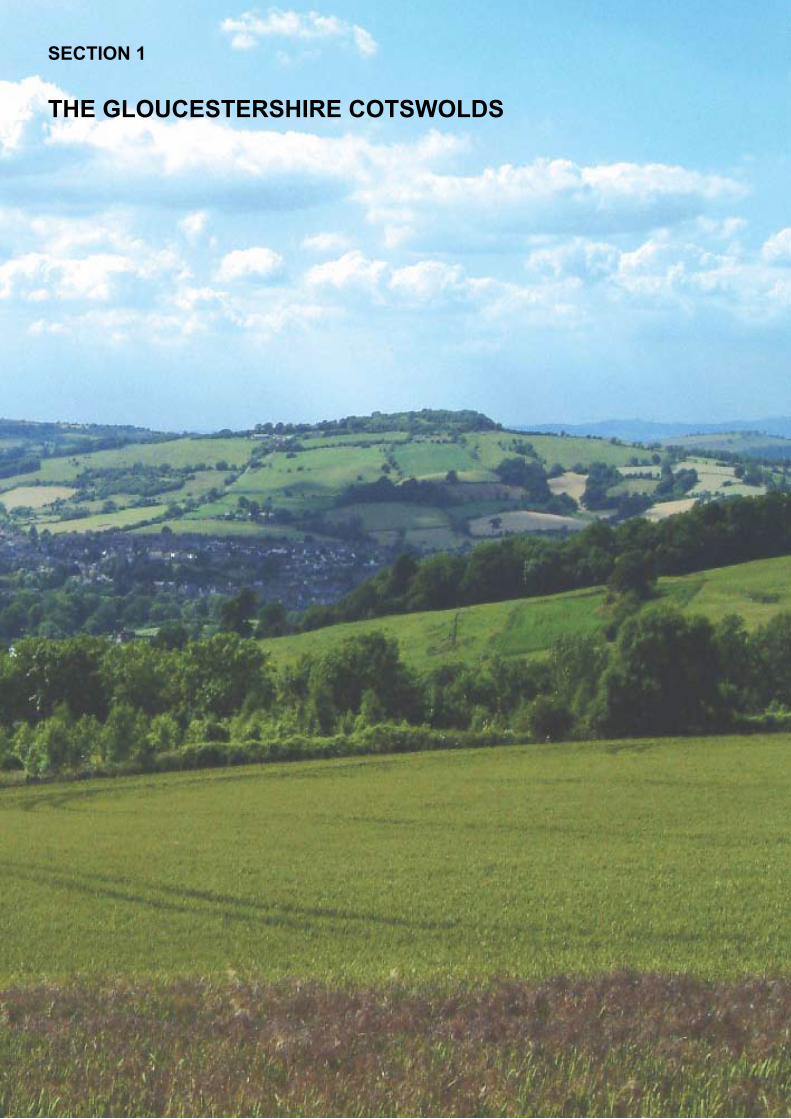
SECTION 1
THE GLOUCESTERSHIRE COTSWOLDS
1.01 Introduction
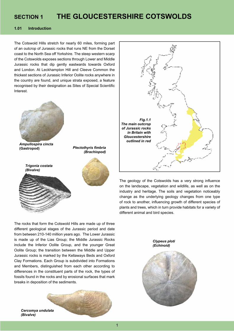
The Cotswold Hills stretch for nearly 60 miles, forming part
of an outcrop of Jurassic rocks that runs NE from the Dorset
coast to the North Sea off Yorkshire. The steep western scarp
of the Cotswolds exposes sections through Lower and Middle
Jurassic rocks that dip gently eastwards towards Oxford
and London. At Leckhampton Hill and Cleeve Common the
thickest sections of Jurassic Inferior Oolite rocks anywhere in
the country are found, and unique strata exposed, a feature
recognised by their designation as Sites of Special Scientific
Interest.
Fig.1.1The main outcrop of Jurassic rocks
in Britain with Gloucestershire
outlined in red
The rocks that form the Cotswold Hills are made up of three
different geological stages of the Jurassic period and date
from between 210-140 million years ago. The Lower Jurassic
is made up of the Lias Group; the Middle Jurassic Rocks
include the Inferior Oolite Group, and the younger Great
Oolite Group; the transition between the Middle and Upper
Jurassic rocks is marked by the Kellaways Beds and Oxford
Clay Formations. Each Group is subdivided into Formations
and Members, distinguished from each other according to
differences in the constituent parts of the rock, the types of
fossils found in the rocks and by erosional surfaces that mark
breaks in deposition of the sediments.
The geology of the Cotswolds has a very strong influence
on the landscape, vegetation and wildlife, as well as on the
industry and heritage. The soils and vegetation noticeably
change as the underlying geology changes from one type
of rock to another, influencing growth of different species of
plants and trees, which in turn provide habitats for a variety of
different animal and bird species.
Ampullospira cincta (Gastropod) Plectothyris fimbria
(Brachiopod)
Trigonia costata(Bivalve)
Cercomya undulata(Bivalve)
Clypeus ploti(Echinoid)
SECTION 1 THE GLOUCESTERSHIRE COTSWOLDS
1
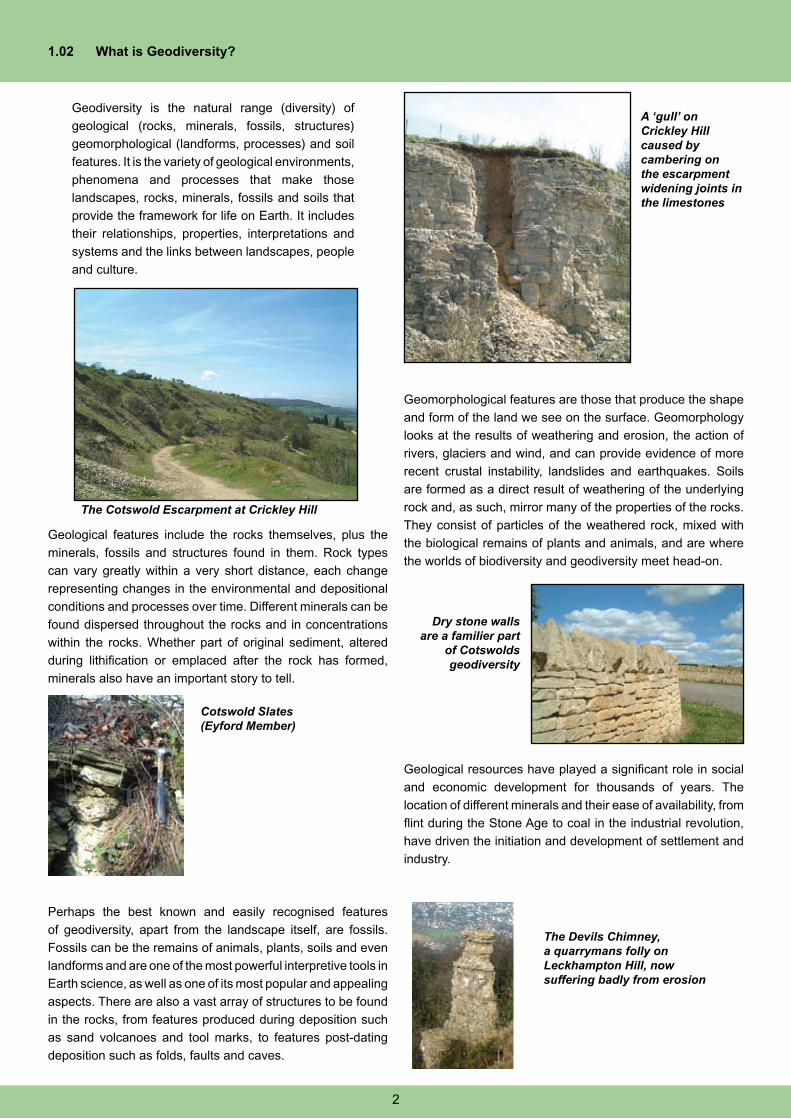
1.02 What is Geodiversity?
Geodiversity is the natural range (diversity) of
geological (rocks, minerals, fossils, structures)
geomorphological (landforms, processes) and soil
features. It is the variety of geological environments,
phenomena and processes that make those
landscapes, rocks, minerals, fossils and soils that
provide the framework for life on Earth. It includes
their relationships, properties, interpretations and
systems and the links between landscapes, people
and culture.
A ‘gull’ on Crickley Hill caused by cambering on the escarpment widening joints in the limestones
Geological features include the rocks themselves, plus the
minerals, fossils and structures found in them. Rock types
can vary greatly within a very short distance, each change
representing changes in the environmental and depositional
conditions and processes over time. Different minerals can be
found dispersed throughout the rocks and in concentrations
within the rocks. Whether part of original sediment, altered
during lithification or emplaced after the rock has formed,
minerals also have an important story to tell.
Perhaps the best known and easily recognised features
of geodiversity, apart from the landscape itself, are fossils.
Fossils can be the remains of animals, plants, soils and even
landforms and are one of the most powerful interpretive tools in
Earth science, as well as one of its most popular and appealing
aspects. There are also a vast array of structures to be found
in the rocks, from features produced during deposition such
as sand volcanoes and tool marks, to features post-dating
deposition such as folds, faults and caves.
Geomorphological features are those that produce the shape
and form of the land we see on the surface. Geomorphology
looks at the results of weathering and erosion, the action of
rivers, glaciers and wind, and can provide evidence of more
recent crustal instability, landslides and earthquakes. Soils
are formed as a direct result of weathering of the underlying
rock and, as such, mirror many of the properties of the rocks.
They consist of particles of the weathered rock, mixed with
the biological remains of plants and animals, and are where
the worlds of biodiversity and geodiversity meet head-on.
The Cotswold Escarpment at Crickley Hill
Cotswold Slates (Eyford Member)
Dry stone walls are a familier part
of Cotswolds geodiversity
Geological resources have played a significant role in social
and economic development for thousands of years. The
location of different minerals and their ease of availability, from
flint during the Stone Age to coal in the industrial revolution,
have driven the initiation and development of settlement and
industry.
The Devils Chimney, a quarrymans folly on Leckhampton Hill, now suffering badly from erosion
2
1.03 What is a Geodiversity Action Plan and What
is Its Purpose?
The variety of natural features and processes and their value
to social, economic, scientific, educational and aesthetic
issues needs to be fully and widely understood in order for
effective long term and sustainable geoconservation to take
place, An all-encompassing approach to nature conservation
is needed in order to fully understand the systems operating in
the natural world, and to learn from past events so that future
management recommendations can be made with increased
accuracy and confidence. One of the main purposes of a
Geodiversity Action Plan is to repair the imbalance between
the biotic and abiotic in nature conservation policy and to
raise awareness of the importance of geodiversity in the
management of the environment.
All geological features are vulnerable to a variety of
factors, both man-made and natural, including man-made
interference from development, landfill and fly-tipping, plus
natural processes such as overgrowth of vegetation and
natural erosion that would not be accepted at equivalent sites
of biological or archaeological importance. This Geodiversity
Action Plan aims to confront these threats and to develop
management practices and sustainable mechanisms for
developing, supporting and sustaining geodiversity.
Raising awareness of the importance of geodiversity has a
major role to play in sustaining and managing a high quality
resource, especially amongst landowners, but also with the
general public.
1.04 Geoconservation
Humans have exploited the Earth’s natural resources for
thousands of years, Gloucestershire being no exception.
Iron ore, coal, clay, aggregates and the famous Cotswold
Limestones are still extracted within the county. All of these
activities plus numerous natural landforms have created
many geological exposures, as have road, railway and canal
cuttings.
Many of these sites are so important nationally and
internationally that they are protected by law, through
designation as Sites of Special Scientific Interest (SSSI).
Other sites that are important to regional geology are identified
as Regionally Important Geological / Geomorphological Sites
(RIGS).
Although these sites would at first appear to be permanent,
robust and requiring no looking after, they can be damaged,
destroyed or lost all together by inappropriate development or
use, landfill, fly tipping or through numerous natural processes.
Site identification, suitable long-term site management plans,
publicity and interpretation aims to raise public awareness of
the geodiversity within the county and the need to protect it for
future generations to enjoy.
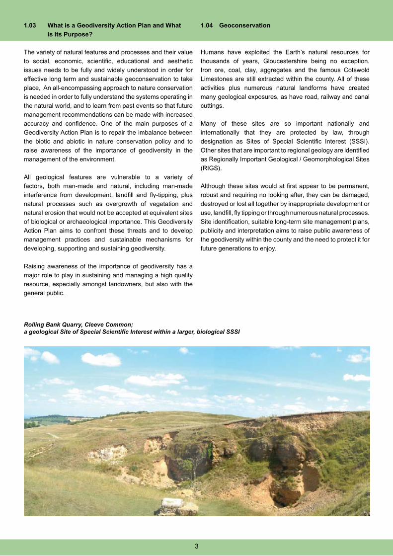
Rolling Bank Quarry, Cleeve Common; a geological Site of Special Scientific Interest within a larger, biological SSSI
3
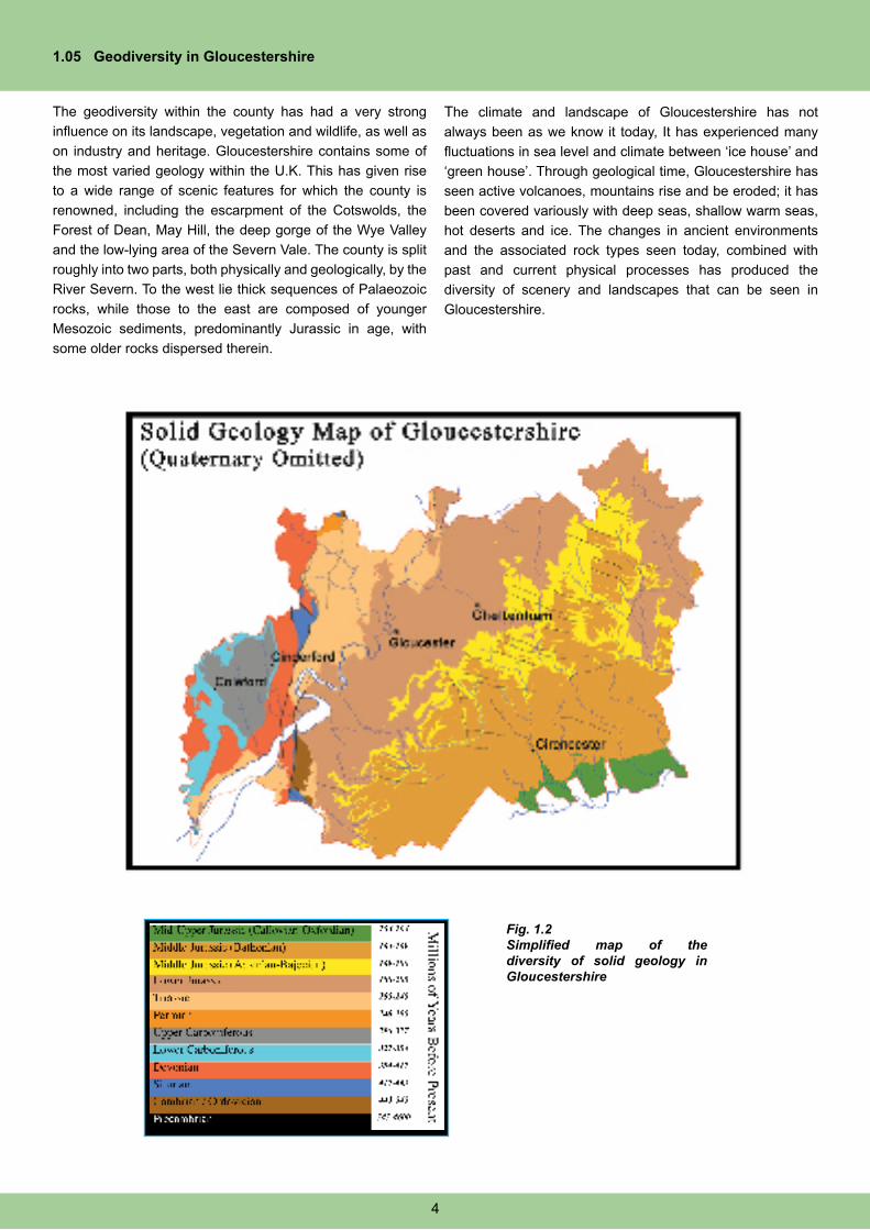
1.05 Geodiversity in Gloucestershire
The geodiversity within the county has had a very strong
influence on its landscape, vegetation and wildlife, as well as
on industry and heritage. Gloucestershire contains some of
the most varied geology within the U.K. This has given rise
to a wide range of scenic features for which the county is
renowned, including the escarpment of the Cotswolds, the
Forest of Dean, May Hill, the deep gorge of the Wye Valley
and the low-lying area of the Severn Vale. The county is split
roughly into two parts, both physically and geologically, by the
River Severn. To the west lie thick sequences of Palaeozoic
rocks, while those to the east are composed of younger
Mesozoic sediments, predominantly Jurassic in age, with
some older rocks dispersed therein.
The climate and landscape of Gloucestershire has not
always been as we know it today, It has experienced many
fluctuations in sea level and climate between ‘ice house’ and
‘green house’. Through geological time, Gloucestershire has
seen active volcanoes, mountains rise and be eroded; it has
been covered variously with deep seas, shallow warm seas,
hot deserts and ice. The changes in ancient environments
and the associated rock types seen today, combined with
past and current physical processes has produced the
diversity of scenery and landscapes that can be seen in
Gloucestershire.
Fig. 1.2Simplified map of the diversity of solid geology in Gloucestershire
4
1.06 A Vision for Geodiversity in the Gloucestershire Cotswolds
The Gloucestershire Cotswolds LGAP is intended to:
• Protect and manage the unique geodiversity
o A complete stratigraphic sequence of Cotswold rocks will be exposed and demonstrable in the area and a
variety of educational and interpretive materials will have been provided. The most important of the sites, the
SSSI and RIGS, will be protected and conserved, and plans for their ongoing management and conservation
produced, along with interpretation of their features of interest.
o Initiatives and opportunities to develop and sell distinctive, high quality “Cotswold” products will have been
developed, based on the culture and traditions of the area and using only sustainable sources and land
management. These products will be marketed throughout the area and in other suitable locations regionally
and nationally.
• Increase understanding and awareness of geodiversity
o General interpretation materials will bring together various characteristic features of Cotswolds’ geodiversity
and its links with biodiversity, industry, archaeology and history.
o The value and importance of geodiversity in the Gloucestershire Cotswolds will be well understood by
the people living and working in the area, and its value to tourism will be widely appreciated. People will
understand the influence of geodiversity on the historic and economic development of the Cotswolds.
• Promote geotourism, education and lifelong learning
o People of all abilities and from all backgrounds will be able to explore the area’s geodiversity, either as part
of organised groups and tours, or independently using the interpretation material available.
o Specific tours and guides related to the Cotswolds Earth heritage will run alongside other countryside/
natural history tours and guides and will provide high quality holidays.
o Accommodation providers and tour operators will be aware of the geodiversity and will promote it as an
added attraction to the area.
o Imaginative and informative educational visits and opportunities for learning will have been developed and
put in place, which will contribute to the local economy. Many educational visits will be run out of peak
season, so extending the visitor season and contributing further to the local economy.
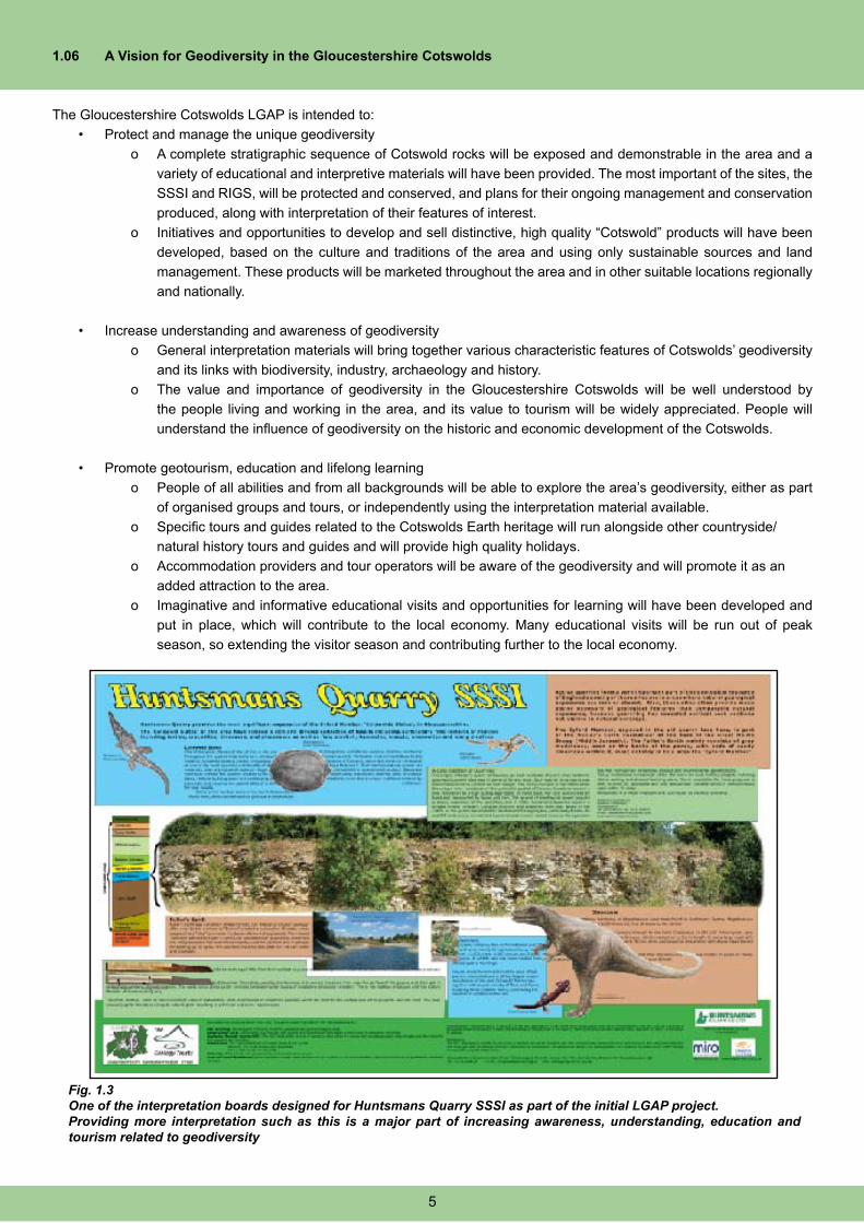
Fig. 1.3One of the interpretation boards designed for Huntsmans Quarry SSSI as part of the initial LGAP project. Providing more interpretation such as this is a major part of increasing awareness, understanding, education and tourism related to geodiversity
5
1.07 Geoconservation In Gloucestershire
a. Gloucestershire Geoconservation Trust
Gloucestershire Geoconservation Trust (GGT) is a non-profit
making group, a founder member of The Geology Trusts
and one of the leading geoconservation organisations in
the country. The Trust works in partnership with many other
organisations, and the principal aim is to publicise and
promote the geological heritage of Gloucestershire, and to
raise awareness of the need for its conservation. GGT was set
up in 1992 under the Nature Conservancy Council Regionally
Important Geological and Geomorphological Sites scheme or
“RIGS”.
The Trust does far more than just identify, survey and record
sites. GGT also actively restores, enhances and maintains
important geological sites, both SSSI & RIGS; keeps an
extensive database of geological and geomorphological
information; publishes guides and booklets and offers a variety
of events throughout the year. In addition to these services,
GGT delivers advice and information relating to geology and
geoconservation matters, as well as being the key point of
specialist Earth heritage conservation advice in the county.
The staff, committees, membership and supporters of the
Trust consists primarily of volunteers. Containing professional
geologists from industry and academia, amateur geologists and
local, non-specialist people living within the county, all those
involved contribute directly to conserving Gloucestershire’s
Earth heritage.
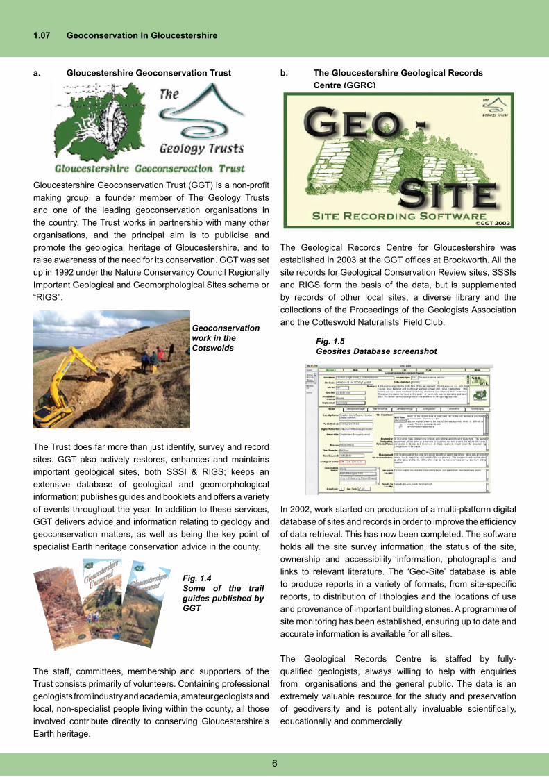
b. The Gloucestershire Geological Records
Centre (GGRC)
The Geological Records Centre for Gloucestershire was
established in 2003 at the GGT offices at Brockworth. All the
site records for Geological Conservation Review sites, SSSIs
and RIGS form the basis of the data, but is supplemented
by records of other local sites, a diverse library and the
collections of the Proceedings of the Geologists Association
and the Cotteswold Naturalists’ Field Club.
In 2002, work started on production of a multi-platform digital
database of sites and records in order to improve the efficiency
of data retrieval. This has now been completed. The software
holds all the site survey information, the status of the site,
ownership and accessibility information, photographs and
links to relevant literature. The ‘Geo-Site’ database is able
to produce reports in a variety of formats, from site-specific
reports, to distribution of lithologies and the locations of use
and provenance of important building stones. A programme of
site monitoring has been established, ensuring up to date and
accurate information is available for all sites.
The Geological Records Centre is staffed by fully-
qualified geologists, always willing to help with enquiries
from organisations and the general public. The data is an
extremely valuable resource for the study and preservation
of geodiversity and is potentially invaluable scientifically,
educationally and commercially.
Fig. 1.4Some of the trail guides published by GGT
Geoconservation work in the Cotswolds
Fig. 1.5Geosites Database screenshot
6
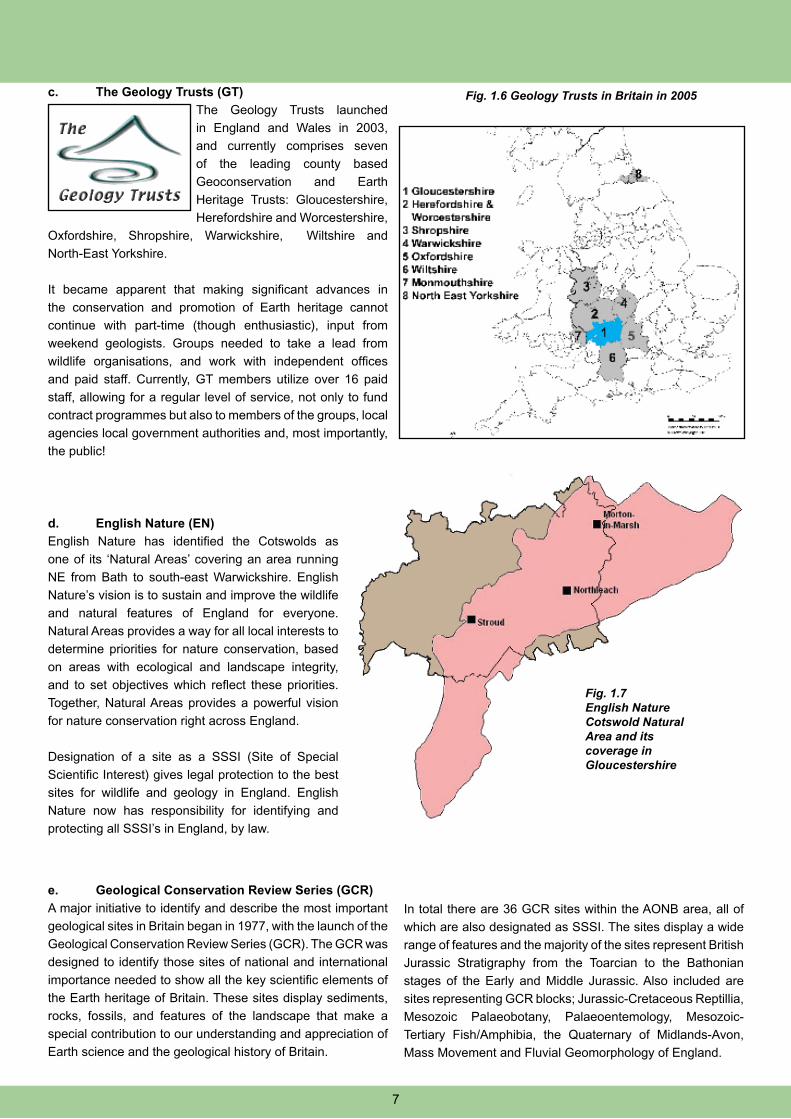
c. The Geology Trusts (GT)
The Geology Trusts launched
in England and Wales in 2003,
and currently comprises seven
of the leading county based
Geoconservation and Earth
Heritage Trusts: Gloucestershire,
Herefordshire and Worcestershire,
Oxfordshire, Shropshire, Warwickshire, Wiltshire and
North-East Yorkshire.
It became apparent that making significant advances in
the conservation and promotion of Earth heritage cannot
continue with part-time (though enthusiastic), input from
weekend geologists. Groups needed to take a lead from
wildlife organisations, and work with independent offices
and paid staff. Currently, GT members utilize over 16 paid
staff, allowing for a regular level of service, not only to fund
contract programmes but also to members of the groups, local
agencies local government authorities and, most importantly,
the public!
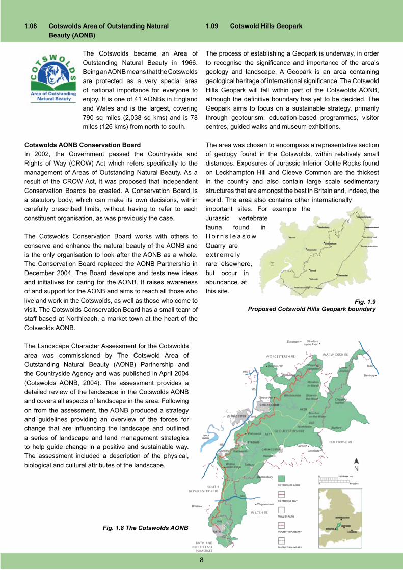
d. English Nature (EN)
English Nature has identified the Cotswolds as
one of its ‘Natural Areas’ covering an area running
NE from Bath to south-east Warwickshire. English
Nature’s vision is to sustain and improve the wildlife
and natural features of England for everyone.
Natural Areas provides a way for all local interests to
determine priorities for nature conservation, based
on areas with ecological and landscape integrity,
and to set objectives which reflect these priorities.
Together, Natural Areas provides a powerful vision
for nature conservation right across England.
Designation of a site as a SSSI (Site of Special
Scientific Interest) gives legal protection to the best
sites for wildlife and geology in England. English
Nature now has responsibility for identifying and
protecting all SSSI’s in England, by law.
e. Geological Conservation Review Series (GCR)
A major initiative to identify and describe the most important
geological sites in Britain began in 1977, with the launch of the
Geological Conservation Review Series (GCR). The GCR was
designed to identify those sites of national and international
importance needed to show all the key scientific elements of
the Earth heritage of Britain. These sites display sediments,
rocks, fossils, and features of the landscape that make a
special contribution to our understanding and appreciation of
Earth science and the geological history of Britain.
In total there are 36 GCR sites within the AONB area, all of
which are also designated as SSSI. The sites display a wide
range of features and the majority of the sites represent British
Jurassic Stratigraphy from the Toarcian to the Bathonian
stages of the Early and Middle Jurassic. Also included are
sites representing GCR blocks; Jurassic-Cretaceous Reptillia,
Mesozoic Palaeobotany, Palaeoentemology, Mesozoic-
Tertiary Fish/Amphibia, the Quaternary of Midlands-Avon,
Mass Movement and Fluvial Geomorphology of England.
Fig. 1.7English Nature Cotswold Natural Area and its coverage in Gloucestershire
Fig. 1.6 Geology Trusts in Britain in 2005
7
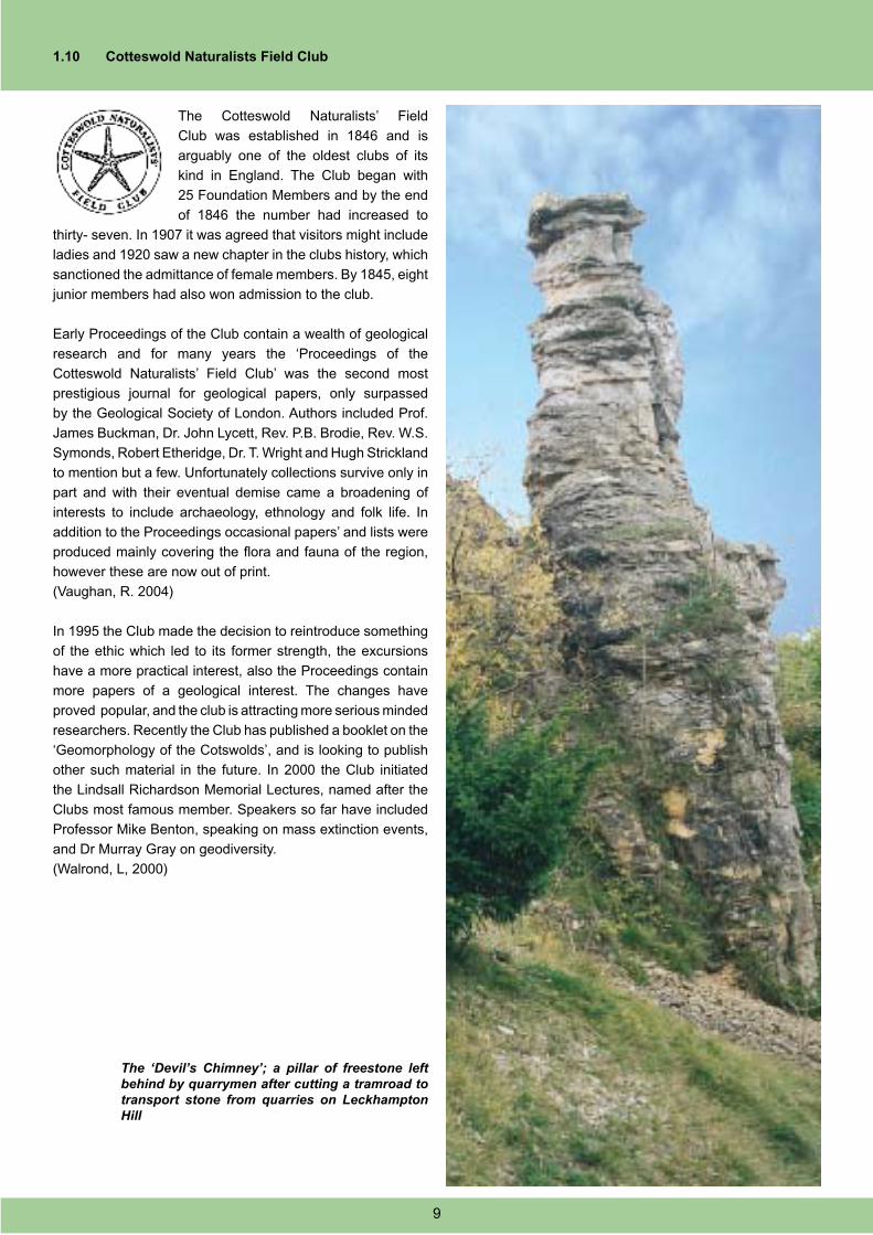
1.08 Cotswolds Area of Outstanding Natural
Beauty (AONB)
The Cotswolds became an Area of
Outstanding Natural Beauty in 1966.
Being an AONB means that the Cotswolds
are protected as a very special area
of national importance for everyone to
enjoy. It is one of 41 AONBs in England
and Wales and is the largest, covering
790 sq miles (2,038 sq kms) and is 78
miles (126 kms) from north to south.
Cotswolds AONB Conservation Board
In 2002, the Government passed the Countryside and
Rights of Way (CROW) Act which refers specifically to the
management of Areas of Outstanding Natural Beauty. As a
result of the CROW Act, it was proposed that independent
Conservation Boards be created. A Conservation Board is
a statutory body, which can make its own decisions, within
carefully prescribed limits, without having to refer to each
constituent organisation, as was previously the case.
The Cotswolds Conservation Board works with others to
conserve and enhance the natural beauty of the AONB and
is the only organisation to look after the AONB as a whole.
The Conservation Board replaced the AONB Partnership in
December 2004. The Board develops and tests new ideas
and initiatives for caring for the AONB. It raises awareness
of and support for the AONB and aims to reach all those who
live and work in the Cotswolds, as well as those who come to
visit. The Cotswolds Conservation Board has a small team of
staff based at Northleach, a market town at the heart of the
Cotswolds AONB.
The Landscape Character Assessment for the Cotswolds
area was commissioned by The Cotswold Area of
Outstanding Natural Beauty (AONB) Partnership and
the Countryside Agency and was published in April 2004
(Cotswolds AONB, 2004). The assessment provides a
detailed review of the landscape in the Cotswolds AONB
and covers all aspects of landscape in the area. Following
on from the assessment, the AONB produced a strategy
and guidelines providing an overview of the forces for
change that are influencing the landscape and outlined
a series of landscape and land management strategies
to help guide change in a positive and sustainable way.
The assessment included a description of the physical,
biological and cultural attributes of the landscape.
1.09 Cotswold Hills Geopark
The process of establishing a Geopark is underway, in order
to recognise the significance and importance of the area’s
geology and landscape. A Geopark is an area containing
geological heritage of international significance. The Cotswold
Hills Geopark will fall within part of the Cotswolds AONB,
although the definitive boundary has yet to be decided. The
Geopark aims to focus on a sustainable strategy, primarily
through geotourism, education-based programmes, visitor
centres, guided walks and museum exhibitions.
The area was chosen to encompass a representative section
of geology found in the Cotswolds, within relatively small
distances. Exposures of Jurassic Inferior Oolite Rocks found
on Leckhampton Hill and Cleeve Common are the thickest
in the country and also contain large scale sedimentary
structures that are amongst the best in Britain and, indeed, the
world. The area also contains other internationally
important sites. For example the
Jurassic vertebrate
fauna found in
H o r n s l e a s o w
Quarry are
ex t remely
rare elsewhere,
but occur in
abundance at
this site.
Fig. 1.8 The Cotswolds AONB
Fig. 1.9Proposed Cotswold Hills Geopark boundary
8
1.10 Cotteswold Naturalists Field Club
The Cotteswold Naturalists’ Field
Club was established in 1846 and is
arguably one of the oldest clubs of its
kind in England. The Club began with
25 Foundation Members and by the end
of 1846 the number had increased to
thirty- seven. In 1907 it was agreed that visitors might include
ladies and 1920 saw a new chapter in the clubs history, which
sanctioned the admittance of female members. By 1845, eight
junior members had also won admission to the club.
Early Proceedings of the Club contain a wealth of geological
research and for many years the ‘Proceedings of the
Cotteswold Naturalists’ Field Club’ was the second most
prestigious journal for geological papers, only surpassed
by the Geological Society of London. Authors included Prof.
James Buckman, Dr. John Lycett, Rev. P.B. Brodie, Rev. W.S.
Symonds, Robert Etheridge, Dr. T. Wright and Hugh Strickland
to mention but a few. Unfortunately collections survive only in
part and with their eventual demise came a broadening of
interests to include archaeology, ethnology and folk life. In
addition to the Proceedings occasional papers’ and lists were
produced mainly covering the flora and fauna of the region,
however these are now out of print.
(Vaughan, R. 2004)
In 1995 the Club made the decision to reintroduce something
of the ethic which led to its former strength, the excursions
have a more practical interest, also the Proceedings contain
more papers of a geological interest. The changes have
proved popular, and the club is attracting more serious minded
researchers. Recently the Club has published a booklet on the
‘Geomorphology of the Cotswolds’, and is looking to publish
other such material in the future. In 2000 the Club initiated
the Lindsall Richardson Memorial Lectures, named after the
Clubs most famous member. Speakers so far have included
Professor Mike Benton, speaking on mass extinction events,
and Dr Murray Gray on geodiversity.
(Walrond, L, 2000)
The ‘Devil’s Chimney’; a pillar of freestone left behind by quarrymen after cutting a tramroad to transport stone from quarries on Leckhampton Hill
9
SECTION 2
GEODIVERSITY IN THE GLOUCESTERSHIRE COTSWOLDS
2.01 Introduction
The influence of geology in the Cotswolds is widespread but
maybe not immediately noticeable away from the escarpment
where quarrying was at its most intense. The extensive quarries
and cliffs provide access to the full 14.5 million years of Earth’s
history during the Middle Jurassic, plus the uppermost part of
the Early Jurassic. Beyond the escarpment the rolling hills
and steep sided valleys extend the long and varied geological
history into the Late Jurassic, and numerous quarries display
this fascinating record of ancient environments. In total there
are over 20 million years of geological time represented in the
Cotswolds that can be seen, interpreted and understood at
numerous locations throughout the area.
The outcrop of British Middle Jurassic carbonate rocks are at
their most impressive and noticeable in the Gloucestershire
Cotswolds, and have provided classic sections for their study
since the earliest days of geology. Much of the early work on
interpreting and defining the Jurassic period was carried out
here, even the first discovery of a dinosaur came from the
Cotswolds in 1824.
The different Groups, Formations, Members and units are
distinguished from each other according to differences in
the types of rock, the types of fossils found in the rocks and
by erosional surfaces that mark breaks in deposition of the
sediments. The ages of the rocks range between roughly
200-155 million years ago (Ma). The changes in the types
of sediment that make up different rocks and the fossils
contained within them provide a wealth of information as to
the environments in which these sediments were deposited.
Close examination can provide a very clear picture of what
the geography of the area was like at the time.
At the base of the Jurassic, and making up the bulk of the
lower slopes of the Cotswold Escarpment are the clays and
silts of the Lias Group. These clays were deposited on the
floor of a failed rift basin, a deep seaway which occasionally
shallowed to allow the formation of intermittent limestones
and sandstones. The rocks that form the capping to these
sediments, the Inferior and Great Oolite Groups, are almost
exclusively marine and were formed mainly in warm tropical
seas, much like those around Bermuda today.
2.02 Geological History of the Cotswolds
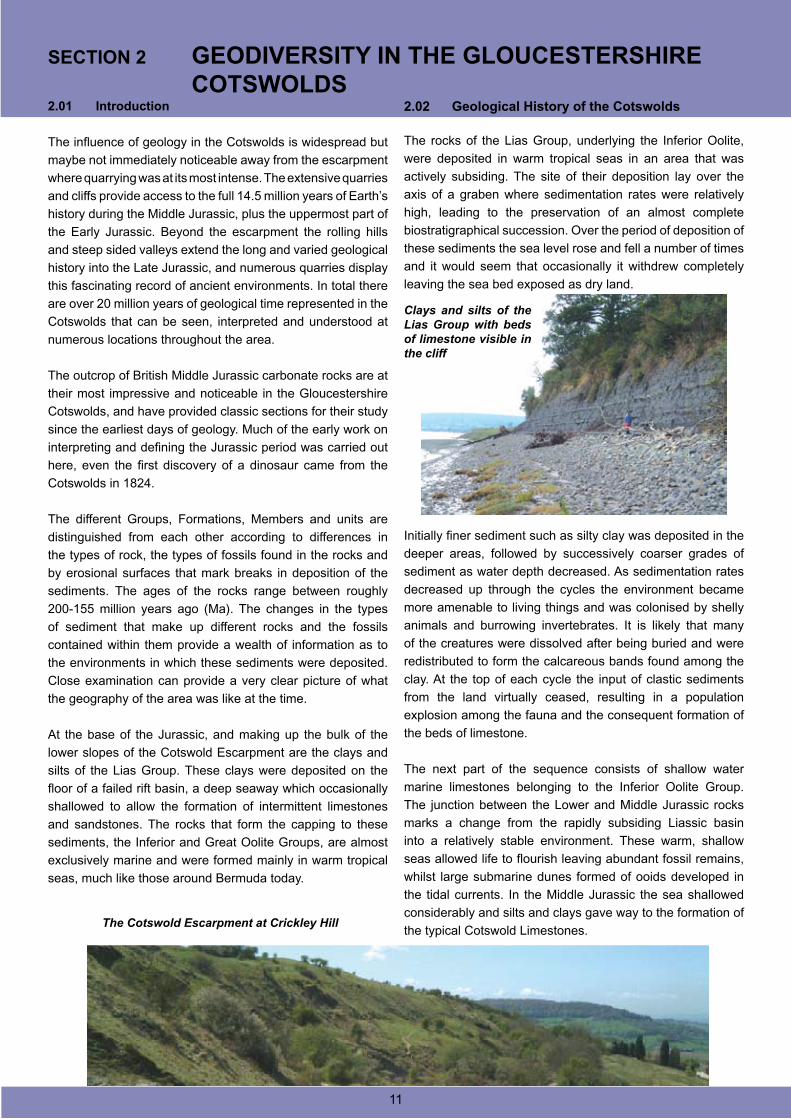
The rocks of the Lias Group, underlying the Inferior Oolite,
were deposited in warm tropical seas in an area that was
actively subsiding. The site of their deposition lay over the
axis of a graben where sedimentation rates were relatively
high, leading to the preservation of an almost complete
biostratigraphical succession. Over the period of deposition of
these sediments the sea level rose and fell a number of times
and it would seem that occasionally it withdrew completely
leaving the sea bed exposed as dry land.
Initially finer sediment such as silty clay was deposited in the
deeper areas, followed by successively coarser grades of
sediment as water depth decreased. As sedimentation rates
decreased up through the cycles the environment became
more amenable to living things and was colonised by shelly
animals and burrowing invertebrates. It is likely that many
of the creatures were dissolved after being buried and were
redistributed to form the calcareous bands found among the
clay. At the top of each cycle the input of clastic sediments
from the land virtually ceased, resulting in a population
explosion among the fauna and the consequent formation of
the beds of limestone.
The next part of the sequence consists of shallow water
marine limestones belonging to the Inferior Oolite Group.
The junction between the Lower and Middle Jurassic rocks
marks a change from the rapidly subsiding Liassic basin
into a relatively stable environment. These warm, shallow
seas allowed life to flourish leaving abundant fossil remains,
whilst large submarine dunes formed of ooids developed in
the tidal currents. In the Middle Jurassic the sea shallowed
considerably and silts and clays gave way to the formation of
the typical Cotswold Limestones.
SECTION 2 GEODIVERSITY IN THE GLOUCESTERSHIRE COTSWOLDS
The Cotswold Escarpment at Crickley Hill
Clays and silts of the Lias Group with beds of limestone visible in the cliff
11
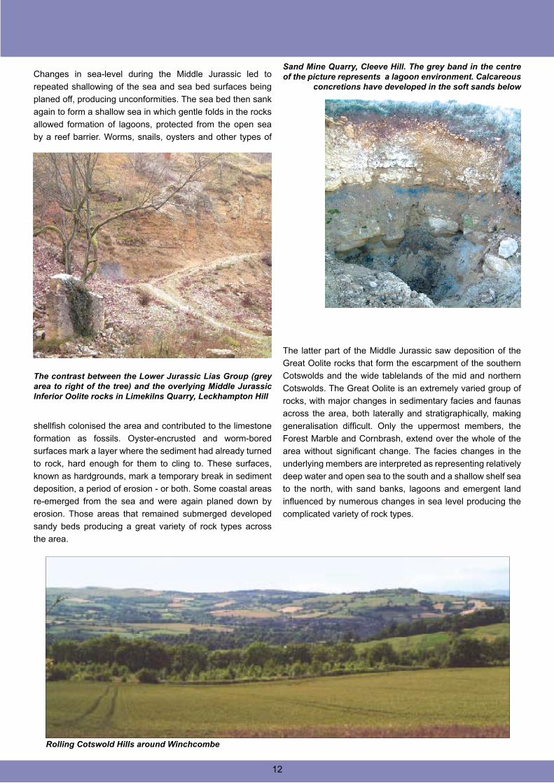
Changes in sea-level during the Middle Jurassic led to
repeated shallowing of the sea and sea bed surfaces being
planed off, producing unconformities. The sea bed then sank
again to form a shallow sea in which gentle folds in the rocks
allowed formation of lagoons, protected from the open sea
by a reef barrier. Worms, snails, oysters and other types of
shellfish colonised the area and contributed to the limestone
formation as fossils. Oyster-encrusted and worm-bored
surfaces mark a layer where the sediment had already turned
to rock, hard enough for them to cling to. These surfaces,
known as hardgrounds, mark a temporary break in sediment
deposition, a period of erosion - or both. Some coastal areas
re-emerged from the sea and were again planed down by
erosion. Those areas that remained submerged developed
sandy beds producing a great variety of rock types across
the area.
Rolling Cotswold Hills around Winchcombe
The latter part of the Middle Jurassic saw deposition of the
Great Oolite rocks that form the escarpment of the southern
Cotswolds and the wide tablelands of the mid and northern
Cotswolds. The Great Oolite is an extremely varied group of
rocks, with major changes in sedimentary facies and faunas
across the area, both laterally and stratigraphically, making
generalisation difficult. Only the uppermost members, the
Forest Marble and Cornbrash, extend over the whole of the
area without significant change. The facies changes in the
underlying members are interpreted as representing relatively
deep water and open sea to the south and a shallow shelf sea
to the north, with sand banks, lagoons and emergent land
influenced by numerous changes in sea level producing the
complicated variety of rock types.
The contrast between the Lower Jurassic Lias Group (grey area to right of the tree) and the overlying Middle Jurassic Inferior Oolite rocks in Limekilns Quarry, Leckhampton Hill
Sand Mine Quarry, Cleeve Hill. The grey band in the centre of the picture represents a lagoon environment. Calcareous
concretions have developed in the soft sands below
12
2.03 The Quaternary Record in Gloucestershire
Awareness and understanding of the sedimentary deposits
and landforms developed during the Quaternary Period,
with its glacial and interglacial episodes, is highly significant
to the geoscientist working in Great Britain. The most
extensive deposits in the Cotswolds area include the river
terrace complexes of the Severn, Upper Thames and the
Warwickshire and Wiltshire Avons, most of which were laid
down during glacial stages. Till and associated glacio-fluvial
and meltwater lake deposits from the Anglian Glaciation are
present between Gloucester and the Malvern Hills and in the
Vale of Moreton.
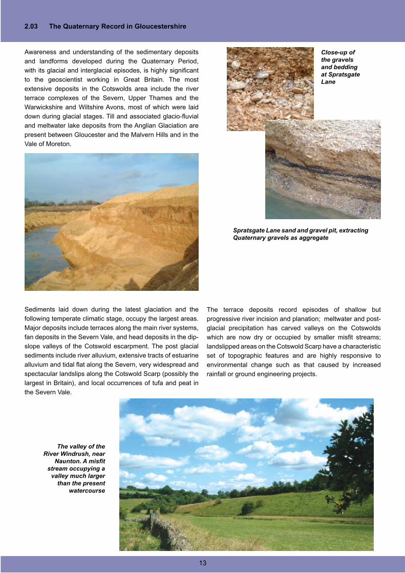
Sediments laid down during the latest glaciation and the
following temperate climatic stage, occupy the largest areas.
Major deposits include terraces along the main river systems,
fan deposits in the Severn Vale, and head deposits in the dip-
slope valleys of the Cotswold escarpment. The post glacial
sediments include river alluvium, extensive tracts of estuarine
alluvium and tidal flat along the Severn, very widespread and
spectacular landslips along the Cotswold Scarp (possibly the
largest in Britain), and local occurrences of tufa and peat in
the Severn Vale.
The terrace deposits record episodes of shallow but
progressive river incision and planation; meltwater and post-
glacial precipitation has carved valleys on the Cotswolds
which are now dry or occupied by smaller misfit streams;
landslipped areas on the Cotswold Scarp have a characteristic
set of topographic features and are highly responsive to
environmental change such as that caused by increased
rainfall or ground engineering projects.
The valley of the River Windrush, near
Naunton. A misfit stream occupying a
valley much larger than the present
watercourse
Spratsgate Lane sand and gravel pit, extracting Quaternary gravels as aggregate
Close-up of the gravels and bedding at Spratsgate Lane
13
The numerous glacial episodes in Britain have left their mark
in a variety of deposits and features, but the Cotswolds
escaped the direct effects of late Quaternary ice sheets and
glaciers. Instead the Cotswolds spent much of the Quaternary
period as a periglacial/tundra environment, with permafrost
underlying a surface regularly affected by freeze-thaw action
that produced many of the deposits and features remaining
today. During the temperate interglacial periods the area was
beyond the reach of sea level rises and instead rivers and
streams have shaped the land, developing deeply incised
valleys, extensive river terraces and channel infills.
‘The Ice Age’ was in fact composed of cold or glacial
conditions alternating with interglacial climates as warm, or
warmer, than today. During the Quaternary huge ice sheets
have repeatedly advanced and retreated across large parts of
Europe and the effect of these ice sheets has been dramatic;
they have changed sea levels, produced extensive erosion,
transportation and deposition of the resulting sediments and
caused the crust itself to sink and rise. River systems have
drastically changed their courses, cut valleys and forced
animal and plant life to migrate or in some cases become
extinct.
Erosion in Great Britain has been very extensive during the
Quaternary, so that deposits are very fragmentary. In the lower
lands of southern and eastern England, where the glaciers
reached their maximum extent, landforms and sediments
are better preserved, and it is in these areas that the oldest
and most diverse record can be found. Gloucestershire, lying
within this tract, has a great variety of Quaternary landforms
and deposits, developed over a wide time range.
The oldest Quaternary deposits in the area are the Plateau
Deposits, or Northern Drift, and the major deposits of this
age in the Cotswolds are found in the Vale of Moreton and
the Evenlode Valley. Originally they would have been more
widespread but have been eroded from most areas. A clay
layer between boulder clay and limestone gravel has been
interpreted as a possible remnant of Lake Harrison, a huge
lake that filled much of the area between the northern part of
the Cotswolds right up into Leicestershire, fed by meltwater
from the ice sheets surrounding it. Despite this, the direct
impact of glaciation in the Cotswolds is slight and there is little
or no evidence for glacial processes over most of the region,
even though it is likely that early glacial episodes covered the
whole of the Cotswolds and the Upper Thames Valley.
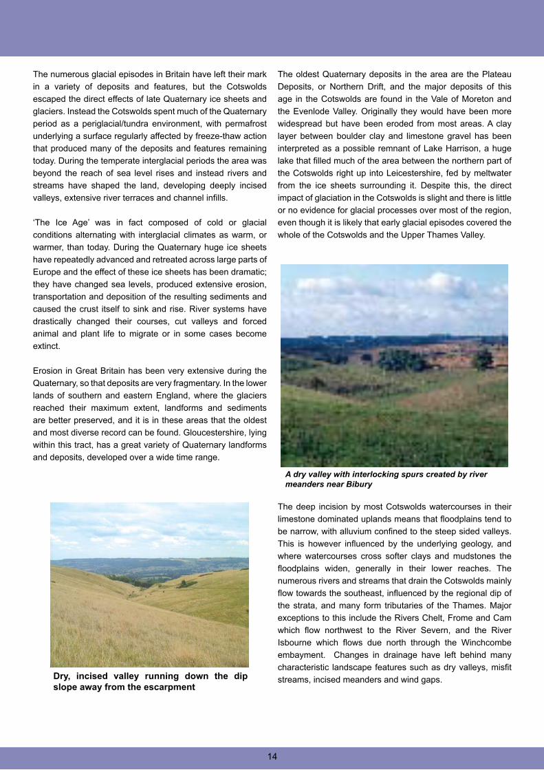
The deep incision by most Cotswolds watercourses in their
limestone dominated uplands means that floodplains tend to
be narrow, with alluvium confined to the steep sided valleys.
This is however influenced by the underlying geology, and
where watercourses cross softer clays and mudstones the
floodplains widen, generally in their lower reaches. The
numerous rivers and streams that drain the Cotswolds mainly
flow towards the southeast, influenced by the regional dip of
the strata, and many form tributaries of the Thames. Major
exceptions to this include the Rivers Chelt, Frome and Cam
which flow northwest to the River Severn, and the River
Isbourne which flows due north through the Winchcombe
embayment. Changes in drainage have left behind many
characteristic landscape features such as dry valleys, misfit
streams, incised meanders and wind gaps.Dry, incised valley running down the dip slope away from the escarpment
A dry valley with interlocking spurs created by river meanders near Bibury
14
2.04 Economic Geology
The major geological economic resource in the Cotswolds is
the stone itself, either as high quality building stone, rough
walling stone or aggregate. There is a long history of quarrying
and mining in the area dating right back to the Neolithic, and
quarrying and mining of Jurassic freestones was widespread
up until the 1st World War (Green, 1992).
Recently the use of natural freestone is mainly confined to
the highest quality construction and repair work, and the
Jurassic limestones still provide material for walling stone and
pulverised and reconstituted facing blocks. Numerous former
workings have now given way to a small number of large,
highly mechanised quarries.
The distinctive character of typical Cotswolds villages is
a result of using locally sourced building stones. The grey-
yellow-brown oolitic, sandy and shelly limestones from both
the Inferior and Great Oolite have been used for thousands of
years, and quarrying activities have been proved from Roman
times with dressed limestone used in the walls of and in villas
such as those at Chedworth and Witcombe.
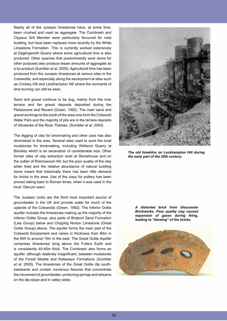
Adding to the distinctiveness of the Cotswold villages is the
extensive use of limestone roofing ‘slates’ or ‘tilestones’. The
main source of these ‘Cotswold Slates’ was from quarries in
the Eyford Member of the Fullers Earth Formation and from
mines in Oxfordshire where Stonesfield Slates were extracted.
Large blocks of rock were left out over winter to allow frost
action to separate the laminations into the correct thickness
for roofing material. The thinly bedded shelly limestones of
the Forest Marble Formation were once extensively worked
for flooring slabs and decorative mantelpieces, and also
provided tilestones, though of a lesser quality than those from
the Eyford Member. The dry stone walls of the Cotswolds were
generally constructed of the nearest and most convenient
material, often quarried out of ditches or small quarries
adjacent to the walls themselves.
‘Cotswold Slates’ forming a stone roof on a Cotswold farm building
The numerous springs and watercourses of the Cotswolds
running into waterlogged ground have, in places, led to the
development of small isolated peat deposits. Many of these
have become obscured by alluvium but still provide valuable
information on the nature of climatic and environmental
change. Pollen analysis shows a progressive change from
tundra to woodland, to cleared woodland and finally to an open
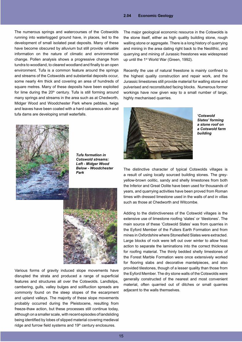
environment. Tufa is a common feature around the springs
and streams of the Cotswolds and substantial deposits occur,
some nearly 4m thick and covering an area of hundreds of
square metres. Many of these deposits have been exploited
for lime during the 20th century. Tufa is still forming around
many springs and streams in the area such as at Chedworth,
Midger Wood and Woodchester Park where pebbles, twigs
and leaves have been coated with a hard calcareous skin and
tufa dams are developing small waterfalls.
Various forms of gravity induced slope movements have
disrupted the strata and produced a range of superficial
features and structures all over the Cotswolds. Landlslips,
cambering, gulls, valley bulges and solifluction spreads are
commonly found on the steep slopes of the escarpment
and upland valleys. The majority of these slope movements
probably occurred during the Pleistocene, resulting from
freeze-thaw action, but these processes still continue today,
although on a smaller scale, with recent episodes of landsliding
being identified by lobes of slipped material covering medieval
ridge and furrow field systems and 19th century enclosures.
Tufa formation in Cotswold streams:Left - Midger WoodBelow - Woodchester Park
15
Nearly all of the Jurassic limestones have, at some time,
been crushed and used as aggregate. The Cornbrash and
Clypeus Grit Member were particularly favoured for road
building, but have been replaced more recently by the White
Limestone Formation. This is currently worked extensively
at Daglingworth Quarry where some agricultural lime is also
produced. Other quarries that predominantly work stone for
other purposes also produce lesser amounts of aggregate as
a by-product (Sumbler et al, 2000). Agricultural lime has been
produced from the Jurassic limestones at various sites in the
Cotswolds, and especially along the escarpment at sites such
as Crickley Hill and Leckhampton Hill where the remnants of
lime burning can still be seen.
Sand and gravel continue to be dug, mainly from the river
terrace and fan gravel deposits deposited during the
Pleistocene and Recent (Green, 1992). The main sand and
gravel workings to the south of the area now form the Cotswold
Water Park and the majority of pits are in the terrace deposits
of tributaries of the River Thames, (Sumbler et al, 2000).
The digging of clay for brickmaking and other uses has also
diminished in the area. Several sites used to work the local
mudstones for brickmaking, including Wellacre Quarry at
Blockley which is an excavation of considerable size. Other
former sites of clay extraction exist at Stonehouse and on
the outlier of Robinswood Hill, but the poor quality of the clay
when fired and the relative abundance of natural building
stone meant that historically there has been little demand
for bricks in the area. Use of the clays for pottery has been
proved dating back to Roman times, when it was used in the
local ‘Glevum ware’.
The Jurassic rocks are the third most important source of
groundwater in the UK and provide water for much of the
uplands of the Cotswolds (Green, 1992). The Inferior Oolite
aquifer includes the limestones making up the majority of the
Inferior Oolite Group, plus parts of Bridport Sand Formation
(Lias Group) below and Chipping Norton Limestone (Great
Oolite Group) above. The aquifer forms the main part of the
Cotswold Escarpment and varies in thickness from 80m in
the NW to around 15m in the east. The Great Oolite Aquifer
comprises limestones lying above the Fullers Earth and
is consistently 40-45m thick. The Cornbrash also forms an
aquifer, although relatively insignificant, between mudstones
of the Forest Marble and Kellaways Formations (Sumbler
et al, 2000). The limestones of the Great Oolite dip south-
eastwards and contain numerous fissures that concentrate
the movement of groundwater, producing springs and streams
on the dip-slope and in valley sides.
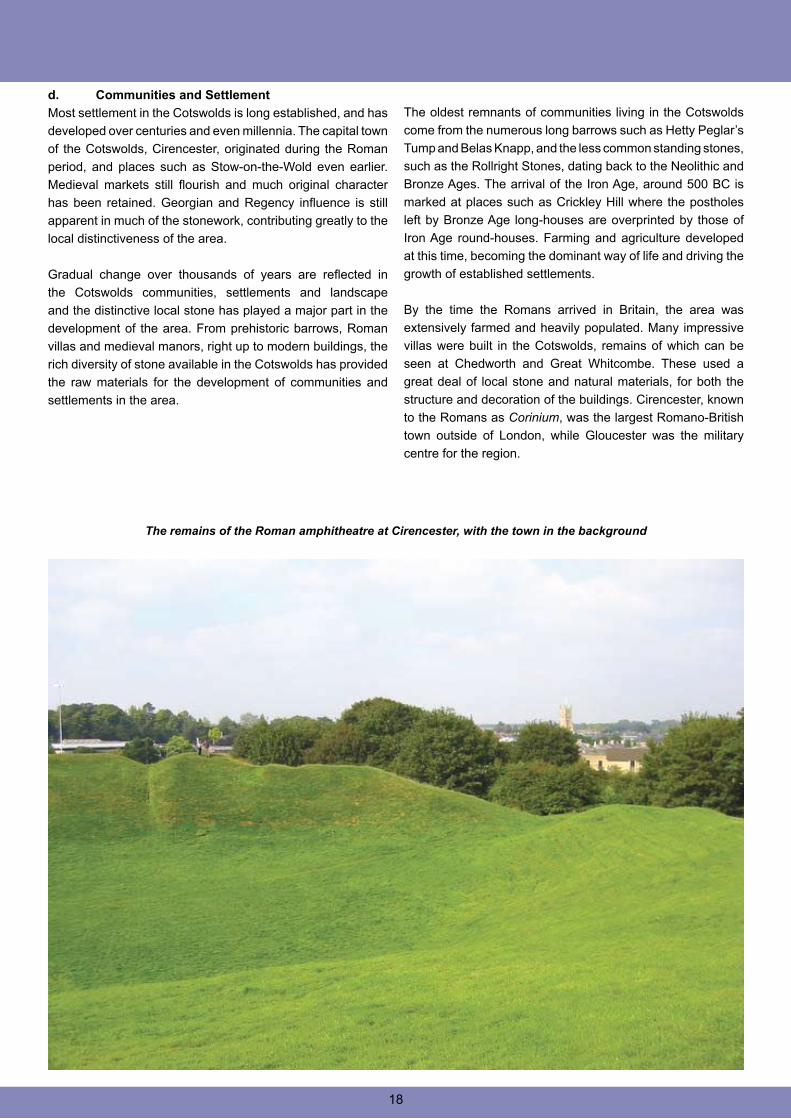
A distorted brick from Gloucester Brickworks. Poor quality clay caused expansion of gases during firing, leading to “blowing” of the bricks.
16
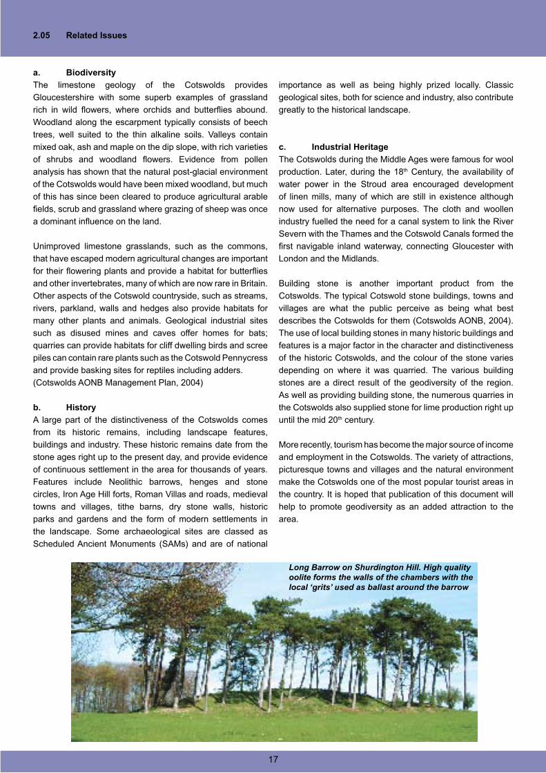
The old limekilns on Leckhampton Hill during the early part of the 20th century.
2.05 Related Issues
a. Biodiversity
The limestone geology of the Cotswolds provides
Gloucestershire with some superb examples of grassland
rich in wild flowers, where orchids and butterflies abound.
Woodland along the escarpment typically consists of beech
trees, well suited to the thin alkaline soils. Valleys contain
mixed oak, ash and maple on the dip slope, with rich varieties
of shrubs and woodland flowers. Evidence from pollen
analysis has shown that the natural post-glacial environment
of the Cotswolds would have been mixed woodland, but much
of this has since been cleared to produce agricultural arable
fields, scrub and grassland where grazing of sheep was once
a dominant influence on the land.
Unimproved limestone grasslands, such as the commons,
that have escaped modern agricultural changes are important
for their flowering plants and provide a habitat for butterflies
and other invertebrates, many of which are now rare in Britain.
Other aspects of the Cotswold countryside, such as streams,
rivers, parkland, walls and hedges also provide habitats for
many other plants and animals. Geological industrial sites
such as disused mines and caves offer homes for bats;
quarries can provide habitats for cliff dwelling birds and scree
piles can contain rare plants such as the Cotswold Pennycress
and provide basking sites for reptiles including adders.
(Cotswolds AONB Management Plan, 2004)
b. History
A large part of the distinctiveness of the Cotswolds comes
from its historic remains, including landscape features,
buildings and industry. These historic remains date from the
stone ages right up to the present day, and provide evidence
of continuous settlement in the area for thousands of years.
Features include Neolithic barrows, henges and stone
circles, Iron Age Hill forts, Roman Villas and roads, medieval
towns and villages, tithe barns, dry stone walls, historic
parks and gardens and the form of modern settlements in
the landscape. Some archaeological sites are classed as
Scheduled Ancient Monuments (SAMs) and are of national
importance as well as being highly prized locally. Classic
geological sites, both for science and industry, also contribute
greatly to the historical landscape.
c. Industrial Heritage
The Cotswolds during the Middle Ages were famous for wool
production. Later, during the 18th Century, the availability of
water power in the Stroud area encouraged development
of linen mills, many of which are still in existence although
now used for alternative purposes. The cloth and woollen
industry fuelled the need for a canal system to link the River
Severn with the Thames and the Cotswold Canals formed the
first navigable inland waterway, connecting Gloucester with
London and the Midlands.
Building stone is another important product from the
Cotswolds. The typical Cotswold stone buildings, towns and
villages are what the public perceive as being what best
describes the Cotswolds for them (Cotswolds AONB, 2004).
The use of local building stones in many historic buildings and
features is a major factor in the character and distinctiveness
of the historic Cotswolds, and the colour of the stone varies
depending on where it was quarried. The various building
stones are a direct result of the geodiversity of the region.
As well as providing building stone, the numerous quarries in
the Cotswolds also supplied stone for lime production right up
until the mid 20th century.
More recently, tourism has become the major source of income
and employment in the Cotswolds. The variety of attractions,
picturesque towns and villages and the natural environment
make the Cotswolds one of the most popular tourist areas in
the country. It is hoped that publication of this document will
help to promote geodiversity as an added attraction to the
area.
Long Barrow on Shurdington Hill. High quality oolite forms the walls of the chambers with the local ‘grits’ used as ballast around the barrow
17
d. Communities and Settlement
Most settlement in the Cotswolds is long established, and has
developed over centuries and even millennia. The capital town
of the Cotswolds, Cirencester, originated during the Roman
period, and places such as Stow-on-the-Wold even earlier.
Medieval markets still flourish and much original character
has been retained. Georgian and Regency influence is still
apparent in much of the stonework, contributing greatly to the
local distinctiveness of the area.
Gradual change over thousands of years are reflected in
the Cotswolds communities, settlements and landscape
and the distinctive local stone has played a major part in the
development of the area. From prehistoric barrows, Roman
villas and medieval manors, right up to modern buildings, the
rich diversity of stone available in the Cotswolds has provided
the raw materials for the development of communities and
settlements in the area.
The remains of the Roman amphitheatre at Cirencester, with the town in the background
The oldest remnants of communities living in the Cotswolds
come from the numerous long barrows such as Hetty Peglar’s
Tump and Belas Knapp, and the less common standing stones,
such as the Rollright Stones, dating back to the Neolithic and
Bronze Ages. The arrival of the Iron Age, around 500 BC is
marked at places such as Crickley Hill where the postholes
left by Bronze Age long-houses are overprinted by those of
Iron Age round-houses. Farming and agriculture developed
at this time, becoming the dominant way of life and driving the
growth of established settlements.
By the time the Romans arrived in Britain, the area was
extensively farmed and heavily populated. Many impressive
villas were built in the Cotswolds, remains of which can be
seen at Chedworth and Great Whitcombe. These used a
great deal of local stone and natural materials, for both the
structure and decoration of the buildings. Cirencester, known
to the Romans as Corinium, was the largest Romano-British
town outside of London, while Gloucester was the military
centre for the region.
18
2.06 Types of Geodiversity Sites
There are a number of different designations and levels of
status for geodiversity sites, covering those of importance on
international, national, regional and local scales. The majority
of all sites are the result of human quarrying activities, be
they ancient or modern. Most of these sites are no longer
worked and provide an excellent opportunity to see what the
Cotswolds are made of, quite literally. Working quarries are
also a valuable asset to understanding the geodiversity of
the Cotswolds as they are continually exposing new rock that
undoubtedly still holds a few surprises for the geologist. Both
naturally occurring changes and human influence can have
negative impacts on geological conservation unless sites are
positively managed for the geological interest.
A brief review of some of the designations used for geological
and geomorphological sites is given below.
a. The Geological Conservation Review (GCR)
The GCR was designed to identify those sites of national and
international importance needed to show all the key scientific
elements of the Earth heritage of Britain. These sites display
sediments, rocks, fossils, and features of the landscape
that make a special contribution to our understanding and
appreciation of Earth science and the geological history of
Britain. There is now an inventory of over 3000 GCR sites,
selected for around 100 categories (the GCR ‘Blocks’),
encompassing the range of geological and geomorphological
features of Britain. The GCR sites form the basis of statutory
geological and geomorphological site conservation in Britain.
GCR Sites in the Gloucestershire Cotswolds
In total there are 31 GCR sites within the Gloucestershire
Cotswolds area, displaying a wide range of features in eleven
of the GCR Blocks. The majority of these sites represent
British Jurassic stratigraphy from the Toarcian to the Bathonian
stages of the Early and Middle Jurassic, but also included
are Jurassic-Cretaceous Reptillia, Mesozoic Palaeobotany,
Palaeoentemology, Mesozoic-Tertiary Fish/Amphibia, the
Quaternary of Midlands-Avon, Mass Movement and Fluvial
Geomorphology of England.
b. Sites of Special Scientific Interest (SSSI)
SSSIs are the country’s very best wildlife and geological sites,
which include some of our most spectacular and beautiful
habitats. Geological sites include active and disused quarries,
river and coastal exposures, road, railway and canal cuttings
and various different landforms of exceptional national
importance.
The Earth Science Conservation Classification (ESCC)
has been used since 1990 by English Nature and the other
organisations to classify geological sites. The ESCC has
numerous site types organised into three major categories:
exposure, finite and integrity.
Exposure sites include active and disused quarries, pits and
cuttings; coastal and river cliffs; foreshores; river and stream
sections and mines and tunnels.
Finite sites contain geological features that are limited in
extent so that removal of material may cause depletion of the
resource. The features are often irreplaceable if destroyed.
Site types include many mineral and some fossil deposits,
mine dumps, finite underground mines and finite buried
interest sites.
Integrity sites are geomorphological and are characterised
by the need for holistic management. Site types include active
and static geomorphological sites, caves and karst.
The importance of distinguishing between these three groups
is that the successful management of each type usually
requires a quite different approach. As a rule, exposure sites
are more robust than integrity or finite sites and can often
tolerate the effects of human activities to a greater degree.
Geological / Geomorphological SSSIs in the Gloucestershire
Cotswolds
The designation of the thirty-one geological SSSIs in the
Gloucestershire Cotswolds coincides with those sites
recognised in the Geological Conservation Review (GCR).
Features recognised and protected at these sites include
stratigraphical sections and unconformities, important
palaeontological sites, unique formations and structural
features, active and fossil geomorphological sites and features
that provide evidence of past environments and processes.
c. Regionally Important Geological /
Geomorphological Sites (RIGS)
The statutory protection afforded to SSSIs protects sites of
the utmost importance but many other sites that are important
to local and regional geodiversity are excluded. This led to the
introduction of the lower tier designation of RIGS for local and
regional sites. The Malvern International Geoconservation
Conference in 1993 stated the following reasons for site
conservation:
RIGS have limited status in statute law but are widely used by
local authorities in their planning decisions as a guide to land
development, and there is a general “presumption against
development” in much the same way as “Key Wildlife Sites”.
Cooperation with landowners greatly aids this process.
19
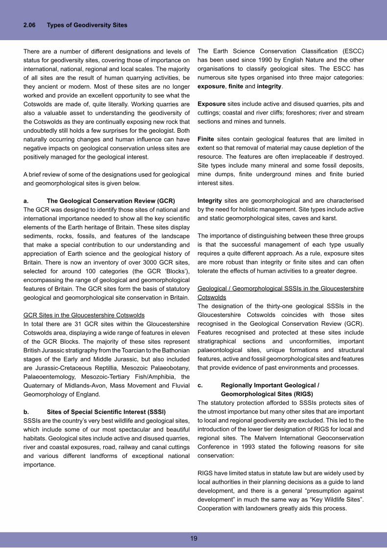
g. Active Quarries
The importance of active quarries to geodiversity in the
Gloucestershire Cotswolds cannot be over emphasised.
Working faces have the potential to produce new specimens
and features and are constantly exposing new sections
of strata not previously seen or recorded. A good working
relationship with quarry operators is essential to developing
geodiversity to its fullest potential.
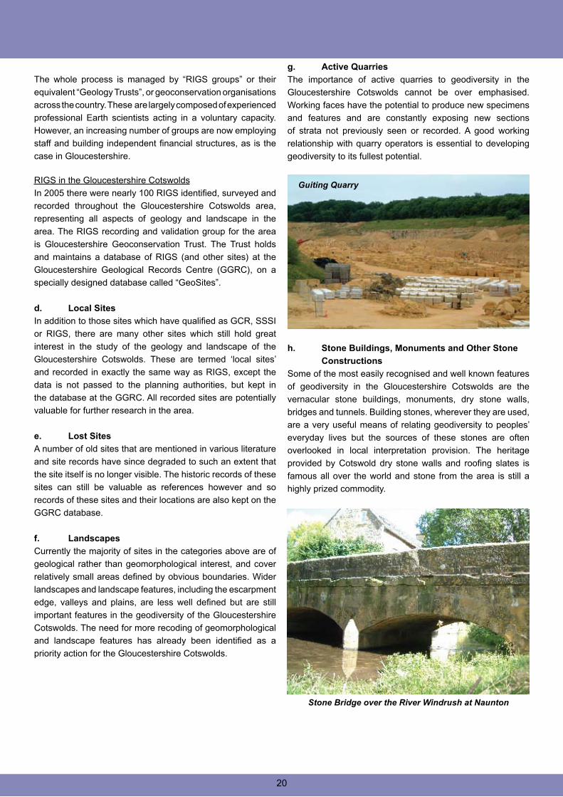
h. Stone Buildings, Monuments and Other Stone
Constructions
Some of the most easily recognised and well known features
of geodiversity in the Gloucestershire Cotswolds are the
vernacular stone buildings, monuments, dry stone walls,
bridges and tunnels. Building stones, wherever they are used,
are a very useful means of relating geodiversity to peoples’
everyday lives but the sources of these stones are often
overlooked in local interpretation provision. The heritage
provided by Cotswold dry stone walls and roofing slates is
famous all over the world and stone from the area is still a
highly prized commodity.
The whole process is managed by “RIGS groups” or their
equivalent “Geology Trusts”, or geoconservation organisations
across the country. These are largely composed of experienced
professional Earth scientists acting in a voluntary capacity.
However, an increasing number of groups are now employing
staff and building independent financial structures, as is the
case in Gloucestershire. RIGS in the Gloucestershire Cotswolds
In 2005 there were nearly 100 RIGS identified, surveyed and
recorded throughout the Gloucestershire Cotswolds area,
representing all aspects of geology and landscape in the
area. The RIGS recording and validation group for the area
is Gloucestershire Geoconservation Trust. The Trust holds
and maintains a database of RIGS (and other sites) at the
Gloucestershire Geological Records Centre (GGRC), on a
specially designed database called “GeoSites”.
d. Local Sites
In addition to those sites which have qualified as GCR, SSSI
or RIGS, there are many other sites which still hold great
interest in the study of the geology and landscape of the
Gloucestershire Cotswolds. These are termed ‘local sites’
and recorded in exactly the same way as RIGS, except the
data is not passed to the planning authorities, but kept in
the database at the GGRC. All recorded sites are potentially
valuable for further research in the area.
e. Lost Sites
A number of old sites that are mentioned in various literature
and site records have since degraded to such an extent that
the site itself is no longer visible. The historic records of these
sites can still be valuable as references however and so
records of these sites and their locations are also kept on the
GGRC database.
f. Landscapes
Currently the majority of sites in the categories above are of
geological rather than geomorphological interest, and cover
relatively small areas defined by obvious boundaries. Wider
landscapes and landscape features, including the escarpment
edge, valleys and plains, are less well defined but are still
important features in the geodiversity of the Gloucestershire
Cotswolds. The need for more recoding of geomorphological
and landscape features has already been identified as a
priority action for the Gloucestershire Cotswolds.
Guiting Quarry
Stone Bridge over the River Windrush at Naunton
20
i. Earth Science Interest on Sites
Designated for Other Purposes
There is rarely such a thing as a ‘single interest site.
Management and conservation of all sites therefore needs to
take into consideration all of the features of interest and to
resolve any conflicts of conservation interests that arise. The
Gloucestershire Cotswolds is entirely within the Cotswolds
AONB, and includes many sites designated for their biological
and wildlife importance. However, many of these sites also
have value to geodiversity, and nine of the SSSI in the area
have combined geological and biological designations. Such
sites provide excellent opportunities to develop an integrated
approach to nature conservation, and demonstrate the close
association of bio- and geo-diversity.
The long and varied history of human settlement and industry
in the Cotswolds is also related to the area’s geodiversity. The
whole length of the escarpment has been quarried and many
of these old quarries now provide some of the best geological
exposures. Building stones have been widely used from
Roman times to the present day, for villas, tithe barns and
Regency Cheltenham, as well as the characteristic Cotswold
Stone villages and towns. Other sites such as Leckhampton
and Crickley Hills have the remains of old limekilns. Even the
oldest archaeology in the area, the Cotswold-Severn Long
Barrow Group, shows a deep practical understanding of the
local geology in their construction.
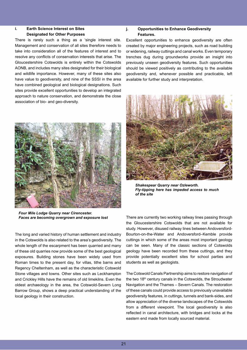
Four Mile Lodge Quarry near Cirencester. Faces are becoming overgrown and exposure lost
j. Opportunities to Enhance Geodiversity
Features.
Excellent opportunities to enhance geodiversity are often
created by major engineering projects, such as road building
or widening, railway cuttings and canal works. Even temporary
trenches dug during groundworks provide an insight into
previously unseen geodiversity features. Such opportunities
should be viewed positively as contributing to the available
geodiversity and, whenever possible and practicable, left
available for further study and interpretation.
There are currently two working railway lines passing through
the Gloucestershire Cotswolds that are not available for
study. However, disused railway lines between Andoversford-
Bourton-on-the-Water and Andoversford–Kemble provide
cuttings in which some of the areas most important geology
can be seen. Many of the classic sections of Cotswolds
geology have been recorded from these cuttings, and they
provide potentially excellent sites for school parties and
students as well as geologists.
The Cotswold Canals Partnership aims to restore navigation of
the two 18th century canals in the Cotswolds, the Stroudwater
Navigation and the Thames – Severn Canals. The restoration
of these canals could provide access to previously unavailable
geodiversity features, in cuttings, tunnels and bank-sides, and
allow appreciation of the diverse landscapes of the Cotswolds
from a different viewpoint. The local geodiversity is also
reflected in canal architecture, with bridges and locks at the
eastern end made from locally sourced material.
Shakespear Quarry near Ozleworth.Fly-tipping here has impeded access to much of the site
21
2.07 Soils
(John Conway, Royal Agricultural College,
Cirencester)
The following is extracted from English Nature’s Natural area
profile No. 55
“The Cotswolds occupy a well known part of the band of
Jurassic limestone country stretching from Somerset to
Warwickshire where the underlying geology is the major
influence determining the landscape and landform, while the
associated soils support the characteristic plant and animal
communities of the Natural Area.
For example, shallow well drained brashy soils of the dip slope
around Cirencester and into Oxford support cereals and stock
farming, while heavier soils around Bath and Moreton support
dairying. More than 80% of the Cotswolds is farmed, making
agriculture the most significant influence on biodiversity.”
The Cotswold area is easily recognised from the Soil Survey
of England and Wales National Soil Map [sheet 5 SW
England]. Soils are mapped as “associations” – convenient
mapping units defined usually by geology, topography or a
combination of both. The Cotswold Hills correspond closely
to the outcrop of Jurassic limestone; Cotswold ‘landscape’
extends to relatively narrow surrounding areas of underlying
or overlying clay [Lias / Oxford respectively] or superficial
glacial or outwash deposits.
a. Definition of Soils
Soils are formed due to the interaction of environmental factors
[climate & biota] acting on parent material within a topography
over a period of time. For the Cotswolds, this means a
postglacial sequence of climate change and ecosystem
development resulting in the current temperate climate with
natural grassland and mixed deciduous woodland occupying
an area of soft limestone interbedded with thin clay shales
forming a gentle escarpment following the geological dip, i.e.
gently to the south east. The limestone weathers slowly by
solution to leave a thin residue of non-carbonate material [silt
and clay] and residual carbonate sand, grit and stones. The
resulting soil is classified as a brown rendzina [code 343] of
the Sherborne Series or a brown calcareous soil [code 511]
of the Moreton Series
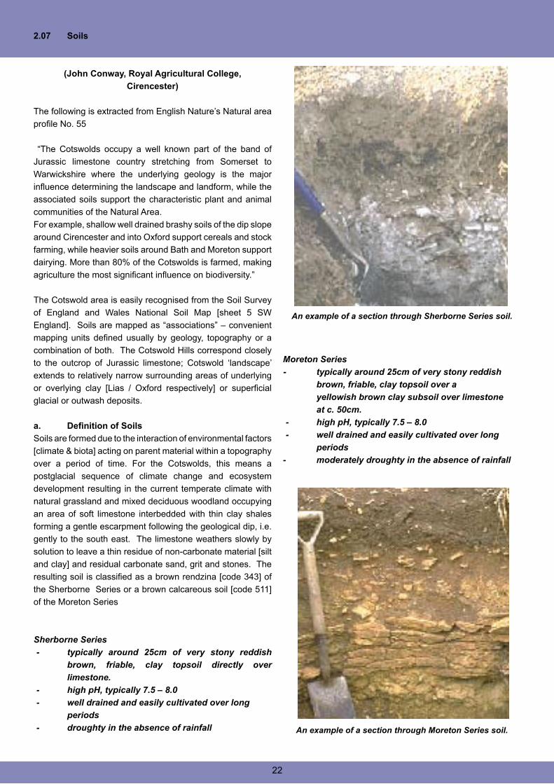
Sherborne Series
- typically around 25cm of very stony reddish
brown, friable, clay topsoil directly over
limestone.
- high pH, typically 7.5 – 8.0
- well drained and easily cultivated over long
periods
- droughty in the absence of rainfall
Moreton Series
- typically around 25cm of very stony reddish
brown, friable, clay topsoil over a
yellowish brown clay subsoil over limestone
at c. 50cm.
- high pH, typically 7.5 – 8.0
- well drained and easily cultivated over long
periods
- moderately droughty in the absence of rainfall
An example of a section through Sherborne Series soil.
An example of a section through Moreton Series soil.
22
The presence of interbedded clay shales leads to greater
diversity. Soils of typical calcareous pelosols [code 411] of
the Evesham series occur on clay, with intergrade soils of
the Haselor series where limestone is present at moderate
depths [c 50cm]. These two are greyish brown, stone free
topsoils of clay texture with poorly drained subsoils and little
or no drought problem.
b. Diversity of soils in the Gloucestershire
Cotswolds
The predominance of the Jurassic limestone leads to a
dominance of the shallow “brashy” soils of the Sherborne and
Moreton series, depending on the arbitrary depth classification
[30cm]; typically 70 -80% of the area.
The presence of the clay shales at shallow depth may lead to
situations where the limestone soils are poorly drained, and
at the surface leads to wet clay soils.
In agriculture, this tends to explain the pattern of arable
and permanent pasture, in biodiversity terms, the pattern of
grassland / beech woodland with oak woodland [in a very
simple generalisation].
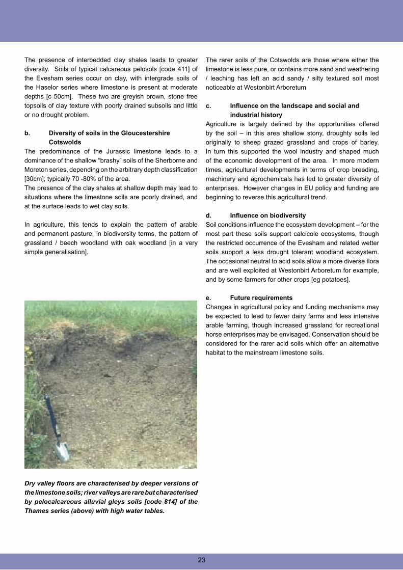
Dry valley floors are characterised by deeper versions of
the limestone soils; river valleys are rare but characterised
by pelocalcareous alluvial gleys soils [code 814] of the
Thames series (above) with high water tables.
The rarer soils of the Cotswolds are those where either the
limestone is less pure, or contains more sand and weathering
/ leaching has left an acid sandy / silty textured soil most
noticeable at Westonbirt Arboretum
c. Influence on the landscape and social and
industrial history
Agriculture is largely defined by the opportunities offered
by the soil – in this area shallow stony, droughty soils led
originally to sheep grazed grassland and crops of barley.
In turn this supported the wool industry and shaped much
of the economic development of the area. In more modern
times, agricultural developments in terms of crop breeding,
machinery and agrochemicals has led to greater diversity of
enterprises. However changes in EU policy and funding are
beginning to reverse this agricultural trend.
d. Influence on biodiversity
Soil conditions influence the ecosystem development – for the
most part these soils support calcicole ecosystems, though
the restricted occurrence of the Evesham and related wetter
soils support a less drought tolerant woodland ecosystem.
The occasional neutral to acid soils allow a more diverse flora
and are well exploited at Westonbirt Arboretum for example,
and by some farmers for other crops [eg potatoes].
e. Future requirements
Changes in agricultural policy and funding mechanisms may
be expected to lead to fewer dairy farms and less intensive
arable farming, though increased grassland for recreational
horse enterprises may be envisaged. Conservation should be
considered for the rarer acid soils which offer an alternative
habitat to the mainstream limestone soils.
23
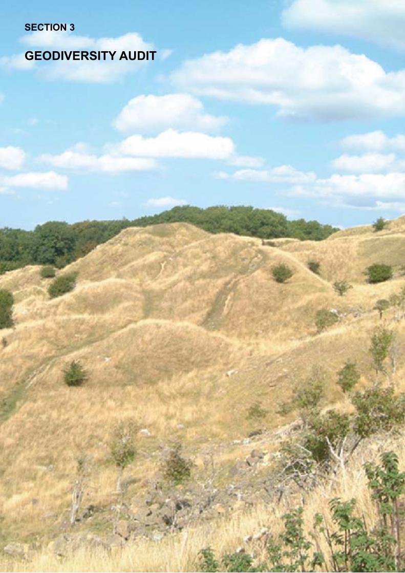
SECTION 3
GEODIVERSITY AUDIT
3.00 Aims and Objectives of the Geodiversity Audit
The following section contains a geodiversity audit of the
Cotswolds. The audit is a survey of all the geological and
Geomorphological resources within the study area. The main
aim of the audit is to review the geological components and
landforms present within the Cotswolds, and to assess their
relevance and importance in a local, regional and national
context. It will provide a geological framework to assist
in the sustainable management, planning, conservation,
interpretation and education relating to all aspects of Earth
Heritage within the Cotswolds, both now and for the future.
The audit shows the representation of the stratigraphy
and geological features present within the study area and
highlights the wide geodiversity or geoheritage and potential
geodiversity of the Cotswolds. The audit is not intended as
a detailed geological description of the Cotswolds, but an
overview of the rock succession and landforms, and forms
an essential background to the LGAP. The brief lithological
descriptions for each rock unit are modified after the British
Geological Survey (BGS) Lexicon of Named Rock Units.
The audit has indicated those groups, formations, members
and individual rock units that are poorly, moderately or well
represented, based on records held by GGT from exposures
at all recorded geological SSSI, GCR and RIGS sites. These
may be active or disused quarries, road or railway cuttings or
natural outcrops. Also included in the audit is an assessment
of the current condition of the exposures at each site; the
SSSI conditions are English Nature’s own site assessments.
The RIGS assessments are based on a similar criteria to
that used by English Nature, based on Common Standards
(Joint Nature Conservation Committee 1998), being either
in favourable or unfavourable condition, maintained, stable,
declining, partially destroyed or destroyed (lost site).
An extensive literature search and desktop study has
indicated that there are many other sites not specified in this
audit, exposing various formations and members. These sites
have been identified by GGT, but have yet to be surveyed
and therefore have no designated status. These sites will be
included in future site surveying work that the Trust will carry
out.
Each Group, Formation or Member is also referenced to
the Cotswold AONB Landscape Character Assessment,
proving the link between the underlying geology and specific
landscape character types.
3.01 The Geological Framework
a. Regional Structural Setting
The LGAP study area essentially covers the north and mid
Cotswolds, which structurally is situated to the southern end
of the Worcester Graben, a north-south trending Palaeozoic
extensional basin. It is defined and bound to the west by the
Malvern Axis, to the east by the Vale of Moreton Axis and the
westernmost part of the London Platform, and to the south by
the Wessex basin.
During the Jurassic period, the Worcester Graben was the
site of a narrow tidal seaway, linking the Wessex Basin to
the south with the East Midlands Shelf to the north and the
London Platform to the east. Subsidence within the Worcester
Basin began during Permian times, and a thick accumulation
of Triassic and Lower Jurassic Lias Group sediments had
effectively infilled the basin by the end of the Early Jurassic.
The succeeding Inferior Oolite Group rests erosively on the
underlying beds.
The basin developed as an extensional graben during Permo-
Triassic rifting, linked partly to the early stages of the opening
of the Central Proto-Atlantic ocean during the Mesozoic
(Duff & Smith 1992, Loup & Wildi 1994). Ultimately this
resulted in two episodes of east–west crustal extension and
subsidence during the Permo-Triassic. This was controlled
by the reactivation and inversion of Variscan reverse faults as
a series of major north–south trending basin margin normal
faults (Barclay et al 1997).
Fig. 3.1Regional setting of the Cotswolds, showing the principal Mesozoic structural elements
(Barron et al, 1997)
SECTION 3 GEODIVERSITY AUDIT
25
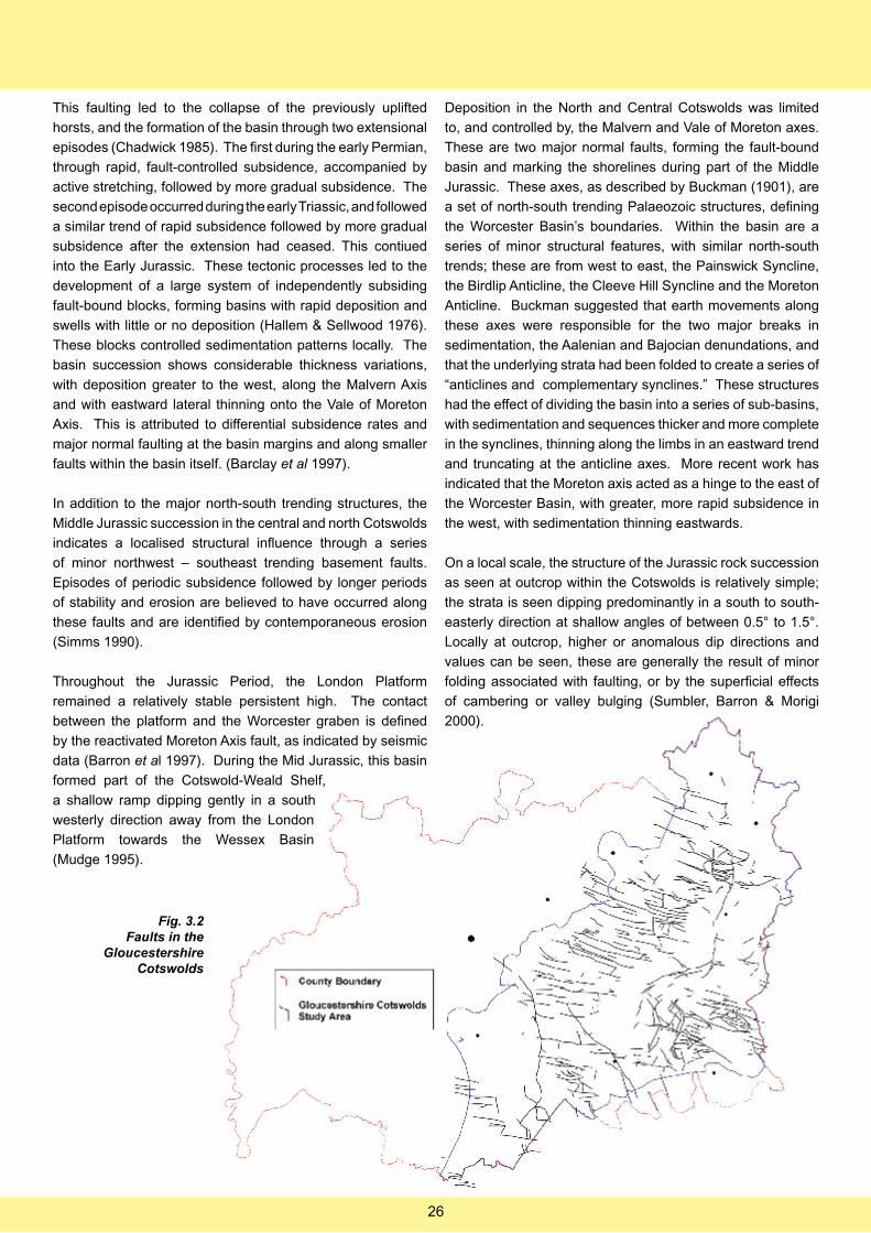
This faulting led to the collapse of the previously uplifted
horsts, and the formation of the basin through two extensional
episodes (Chadwick 1985). The first during the early Permian,
through rapid, fault-controlled subsidence, accompanied by
active stretching, followed by more gradual subsidence. The
second episode occurred during the early Triassic, and followed
a similar trend of rapid subsidence followed by more gradual
subsidence after the extension had ceased. This contiued
into the Early Jurassic. These tectonic processes led to the
development of a large system of independently subsiding
fault-bound blocks, forming basins with rapid deposition and
swells with little or no deposition (Hallem & Sellwood 1976).
These blocks controlled sedimentation patterns locally. The
basin succession shows considerable thickness variations,
with deposition greater to the west, along the Malvern Axis
and with eastward lateral thinning onto the Vale of Moreton
Axis. This is attributed to differential subsidence rates and
major normal faulting at the basin margins and along smaller
faults within the basin itself. (Barclay et al 1997).
In addition to the major north-south trending structures, the
Middle Jurassic succession in the central and north Cotswolds
indicates a localised structural influence through a series
of minor northwest – southeast trending basement faults.
Episodes of periodic subsidence followed by longer periods
of stability and erosion are believed to have occurred along
these faults and are identified by contemporaneous erosion
(Simms 1990).
Throughout the Jurassic Period, the London Platform
remained a relatively stable persistent high. The contact
between the platform and the Worcester graben is defined
by the reactivated Moreton Axis fault, as indicated by seismic
data (Barron et al 1997). During the Mid Jurassic, this basin
formed part of the Cotswold-Weald Shelf,
a shallow ramp dipping gently in a south
westerly direction away from the London
Platform towards the Wessex Basin
(Mudge 1995).
Deposition in the North and Central Cotswolds was limited
to, and controlled by, the Malvern and Vale of Moreton axes.
These are two major normal faults, forming the fault-bound
basin and marking the shorelines during part of the Middle
Jurassic. These axes, as described by Buckman (1901), are
a set of north-south trending Palaeozoic structures, defining
the Worcester Basin’s boundaries. Within the basin are a
series of minor structural features, with similar north-south
trends; these are from west to east, the Painswick Syncline,
the Birdlip Anticline, the Cleeve Hill Syncline and the Moreton
Anticline. Buckman suggested that earth movements along
these axes were responsible for the two major breaks in
sedimentation, the Aalenian and Bajocian denundations, and
that the underlying strata had been folded to create a series of
“anticlines and complementary synclines.” These structures
had the effect of dividing the basin into a series of sub-basins,
with sedimentation and sequences thicker and more complete
in the synclines, thinning along the limbs in an eastward trend
and truncating at the anticline axes. More recent work has
indicated that the Moreton axis acted as a hinge to the east of
the Worcester Basin, with greater, more rapid subsidence in
the west, with sedimentation thinning eastwards.
On a local scale, the structure of the Jurassic rock succession
as seen at outcrop within the Cotswolds is relatively simple;
the strata is seen dipping predominantly in a south to south-
easterly direction at shallow angles of between 0.5° to 1.5°.
Locally at outcrop, higher or anomalous dip directions and
values can be seen, these are generally the result of minor
folding associated with faulting, or by the superficial effects
of cambering or valley bulging (Sumbler, Barron & Morigi
2000).
Fig. 3.2Faults in the
Gloucestershire Cotswolds
26
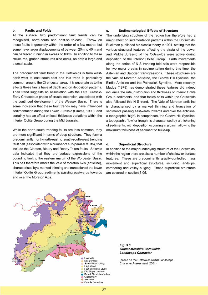
b. Faults and Folds
At the surface, two predominant fault trends can be
recognised, north-south and east-south-east. Throw on
these faults is generally within the order of a few metres but
some have larger displacements of between 20m to 40m and
can be traced running in excess of 10km. In addition to these
structures, graben structures also occur, on both a large and
a small scale.
The predominant fault trend in the Cotswolds is from west-
north-west to east-south-east and this trend is particularly
common around the Cirencester area. It is uncertain as to the
effects these faults have at depth and on deposition patterns.
Their trend suggests an association with the Late Jurassic-
Early Cretaceous phase of crustal extension, associated with
the continued development of the Wessex Basin. There is
some indication that these fault trends may have influenced
sedimentation during the Lower Jurassic (Simms, 1990), and
certainly had an effect on local thickness variations within the
Inferior Oolite Group during the Mid Jurassic.
While the north-south trending faults are less common, they
are more significant in terms of deep structure. They form a
predominantly north-north-east to south-south-west trending
fault belt (associated with a number of sub-parallel faults), that
include the Clapton, Bibury and Ready Token faults. Seismic
data indicates that they are surface expressions of the
bounding fault to the eastern margin of the Worcester Basin.
This belt therefore marks the Vale of Moreton Axis (anticline),
characterised by a marked thinning and truncation of the lower
Inferior Oolite Group sediments passing eastwards towards
and over the Moreton Axis.
c. Sedimentological Effects of Structure
The underlying structure of the region has therefore had a
major effect on sedimentation patterns within the Cotswolds.
Buckman published his classic theory in 1901, stating that the
various structural features affecting the strata of the Lower
and Middle Jurassic of the Cotswolds were active during
deposition of the Inferior Oolite Group. Earth movements
along the series of N-S trending fold axis were responsible
for two major breaks in sedimentation during this time, the
Aalenian and Bajocian transgressions. These structures are
the Vale of Moreton Anticline, the Cleeve Hill Syncline, the
Birdlip Anticline and the Painswick Syncline. More recently,
Mudge (1978) has demonstrated these features did indeed
influence the rate, distribution and thickness of Inferior Oolite
Group sediments, and that facies belts within the Cotswolds
also followed this N-S trend. The Vale of Moreton anticline
is characterised by a marked thinning and truncation of
sediments passing eastwards towards and over the anticline,
a topographic ‘high’. In comparison, the Cleeve Hill Syncline,
a topographic ‘low’ or trough, is characterised by a thickening
of sediments, with deposition occurring in a basin allowing the
maximum thickness of sediment to build-up.
d. Superficial Structure
In addition to the major underlying structure of the Cotswolds,
within the region there are also a number of shallow or surface
features. These are predominantly gravity-controlled mass
movement and superficial structures, including landslips,
cambering and valley bulging. These superficial structures
are covered in section 3.05.
Fig. 3.3Gloucestershire Cotswolds Landscape Character
(based on the Cotswolds AONB Landscape Character Assessment, 2004)
27
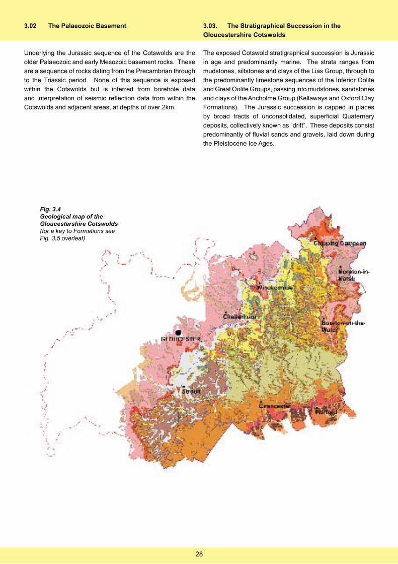
Fig. 3.4Geological map of the Gloucestershire Cotswolds(for a key to Formations see Fig. 3.5 overleaf)
3.02 The Palaeozoic Basement
Underlying the Jurassic sequence of the Cotswolds are the
older Palaeozoic and early Mesozoic basement rocks. These
are a sequence of rocks dating from the Precambrian through
to the Triassic period. None of this sequence is exposed
within the Cotswolds but is inferred from borehole data
and interpretation of seismic reflection data from within the
Cotswolds and adjacent areas, at depths of over 2km.
3.03. The Stratigraphical Succession in the
Gloucestershire Cotswolds
The exposed Cotswold stratigraphical succession is Jurassic
in age and predominantly marine. The strata ranges from
mudstones, siltstones and clays of the Lias Group, through to
the predominantly limestone sequences of the Inferior Oolite
and Great Oolite Groups, passing into mudstones, sandstones
and clays of the Ancholme Group (Kellaways and Oxford Clay
Formations). The Jurassic succession is capped in places
by broad tracts of unconsolidated, superficial Quaternary
deposits, collectively known as “drift”. These deposits consist
predominantly of fluvial sands and gravels, laid down during
the Pleistocene Ice Ages.
28

Fig.3.5The full stratigraphic sequence of formations and members in the Gloucestershire Cotswolds.(Partly based on Barron et al, 2000)
29
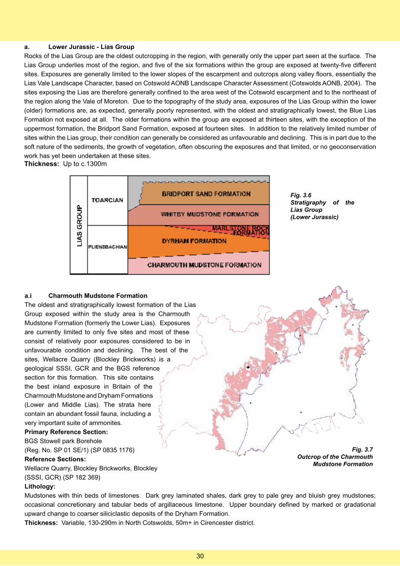
a. Lower Jurassic - Lias Group
Rocks of the Lias Group are the oldest outcropping in the region, with generally only the upper part seen at the surface. The
Lias Group underlies most of the region, and five of the six formations within the group are exposed at twenty-five different
sites. Exposures are generally limited to the lower slopes of the escarpment and outcrops along valley floors, essentially the
Lias Vale Landscape Character, based on Cotswold AONB Landscape Character Assessment (Cotswolds AONB, 2004). The
sites exposing the Lias are therefore generally confined to the area west of the Cotswold escarpment and to the northeast of
the region along the Vale of Moreton. Due to the topography of the study area, exposures of the Lias Group within the lower
(older) formations are, as expected, generally poorly represented, with the oldest and stratigraphically lowest, the Blue Lias
Formation not exposed at all. The older formations within the group are exposed at thirteen sites, with the exception of the
uppermost formation, the Bridport Sand Formation, exposed at fourteen sites. In addition to the relatively limited number of
sites within the Lias group, their condition can generally be considered as unfavourable and declining. This is in part due to the
soft nature of the sediments, the growth of vegetation, often obscuring the exposures and that limited, or no geoconservation
work has yet been undertaken at these sites. Thickness: Up to c.1300m
a.i Charmouth Mudstone Formation
The oldest and stratigraphically lowest formation of the Lias
Group exposed within the study area is the Charmouth
Mudstone Formation (formerly the Lower Lias). Exposures
are currently limited to only five sites and most of these
consist of relatively poor exposures considered to be in
unfavourable condition and declining. The best of the
sites, Wellacre Quarry (Blockley Brickworks) is a
geological SSSI, GCR and the BGS reference
section for this formation. This site contains
the best inland exposure in Britain of the
Charmouth Mudstone and Dryham Formations
(Lower and Middle Lias). The strata here
contain an abundant fossil fauna, including a
very important suite of ammonites.
Primary Reference Section:
BGS Stowell park Borehole
(Reg. No. SP 01 SE/1) (SP 0835 1176)
Reference Sections:
Wellacre Quarry, Blockley Brickworks, Blockley
(SSSI, GCR) (SP 182 369)
Lithology:
Mudstones with thin beds of limestones. Dark grey laminated shales, dark grey to pale grey and bluish grey mudstones;
occasional concretionary and tabular beds of argillaceous limestone. Upper boundary defined by marked or gradational
upward change to coarser siliciclastic deposits of the Dryham Formation.
Thickness: Variable, 130-290m in North Cotswolds, 50m+ in Cirencester district.
Fig. 3.6Stratigraphy of the Lias Group(Lower Jurassic)
Fig. 3.7Outcrop of the Charmouth
Mudstone Formation
30
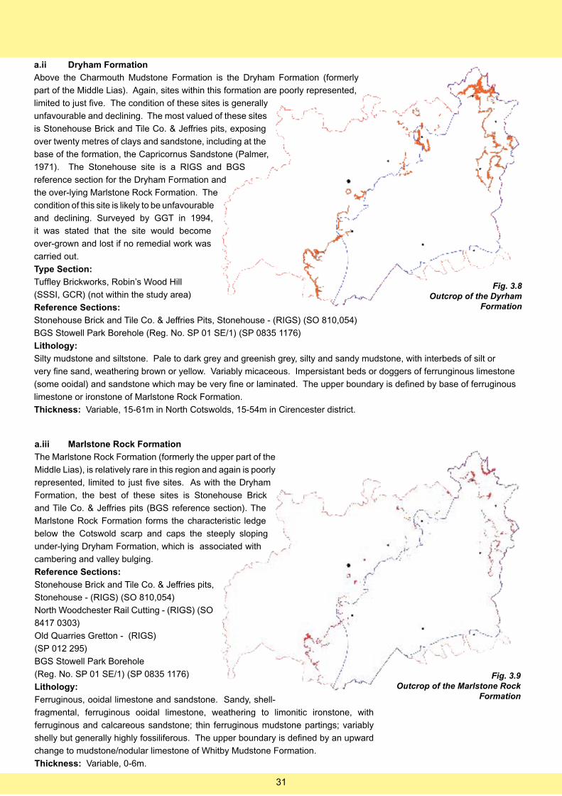
a.ii Dryham Formation
Above the Charmouth Mudstone Formation is the Dryham Formation (formerly
part of the Middle Lias). Again, sites within this formation are poorly represented,
limited to just five. The condition of these sites is generally
unfavourable and declining. The most valued of these sites
is Stonehouse Brick and Tile Co. & Jeffries pits, exposing
over twenty metres of clays and sandstone, including at the
base of the formation, the Capricornus Sandstone (Palmer,
1971). The Stonehouse site is a RIGS and BGS
reference section for the Dryham Formation and
the over-lying Marlstone Rock Formation. The
condition of this site is likely to be unfavourable
and declining. Surveyed by GGT in 1994,
it was stated that the site would become
over-grown and lost if no remedial work was
carried out.
Type Section:
Tuffley Brickworks, Robin’s Wood Hill
(SSSI, GCR) (not within the study area)
Reference Sections:
Stonehouse Brick and Tile Co. & Jeffries Pits, Stonehouse - (RIGS) (SO 810,054)
BGS Stowell Park Borehole (Reg. No. SP 01 SE/1) (SP 0835 1176)
Lithology:
Silty mudstone and siltstone. Pale to dark grey and greenish grey, silty and sandy mudstone, with interbeds of silt or
very fine sand, weathering brown or yellow. Variably micaceous. Impersistant beds or doggers of ferrunginous limestone
(some ooidal) and sandstone which may be very fine or laminated. The upper boundary is defined by base of ferruginous
limestone or ironstone of Marlstone Rock Formation.
Thickness: Variable, 15-61m in North Cotswolds, 15-54m in Cirencester district.
a.iii Marlstone Rock Formation
The Marlstone Rock Formation (formerly the upper part of the
Middle Lias), is relatively rare in this region and again is poorly
represented, limited to just five sites. As with the Dryham
Formation, the best of these sites is Stonehouse Brick
and Tile Co. & Jeffries pits (BGS reference section). The
Marlstone Rock Formation forms the characteristic ledge
below the Cotswold scarp and caps the steeply sloping
under-lying Dryham Formation, which is associated with
cambering and valley bulging.
Reference Sections:
Stonehouse Brick and Tile Co. & Jeffries pits,
Stonehouse - (RIGS) (SO 810,054)
North Woodchester Rail Cutting - (RIGS) (SO
8417 0303)
Old Quarries Gretton - (RIGS)
(SP 012 295)
BGS Stowell Park Borehole
(Reg. No. SP 01 SE/1) (SP 0835 1176)
Lithology:
Ferruginous, ooidal limestone and sandstone. Sandy, shell-
fragmental, ferruginous ooidal limestone, weathering to limonitic ironstone, with
ferruginous and calcareous sandstone; thin ferruginous mudstone partings; variably
shelly but generally highly fossiliferous. The upper boundary is defined by an upward
change to mudstone/nodular limestone of Whitby Mudstone Formation.
Thickness: Variable, 0-6m.
Fig. 3.8Outcrop of the Dyrham
Formation
Fig. 3.9Outcrop of the Marlstone Rock
Formation
31
a.iv Whitby Mudstone Formation
The Whitby Mudstone Formation (formerly the Upper Lias),
is also poorly represented, exposed at just six sites. These
are mostly considered to be in unfavourable condition and
declining, with the exception of Lower Limekiln Quarry,
Leckhampton Hill (although this is a limited exposure
of the Whitby Mudstone). Alderton Hill Quarry is a key
palaeontological site and has long been famous for its well-
preserved Lower Jurassic insect fauna, recovered
from the “Fish Bed.” This formation is commonly
associated with landslips.
Primary Reference Section:
BGS Stowell Park Borehole (Reg. No. SP 01
SE/1) (SP 0835 1176)
Lithology:
Mudstone with limestone beds at base.
Medium and dark grey fossiliferous mudstone
and siltstone, laminated and bituminous in
part, with thin siltstone or silty mudstone beds
and rare fine-grained calcareous sandstone beds; dense,
smooth argillaceous limestone nodules are very common at some
horizons; phosphatic nodules at some levels. Nodular and fossiliferous limestones occur
at the base in some areas. The upper boundary is defined, in northern areas, by a sharp,
eroded boundary with limestones or sandstones of the Inferior Oolite Group; in the south
Cotswolds, by a transition to sandy sediments of the Bridport Sand Formation.
Thickness: Variable, 25-111m in North Cotswolds, 12-98m in Cirencester district.
Fig. 3.10Outcrop of the Whitby
Mudstone Formation
a.v Bridport Sand Formation
The uppermost formation of the Lias group is the Bridport
Sand Formation (formerly the Cotteswold Sands). This
is moderately to well represented, exposed at fourteen
sites, including six geological SSSI and GCR sites. The
condition of most of these sites is generally considered to
be unfavourable and declining, with the exception of sites
at Leckhampton Hill and Crickley Hill, which are currently
considered to be in a favourable condition and
stable. Mapping of this formation is generally
difficult due to landslipping and cambering.
Reference Sections:
Wotton Hill, Wotton-under-Edge
(SSSI, GCR) (ST 754 939)
Other SSSIs:
Coaley Wood Quarries
(SSSI, GCR) (ST 788 996)
Nibley Knoll - (SSSI, GCR) (ST 744 956)
Haresfield Hill - (SSSI, GCR) (SO 819 088)
Leckhampton Hill - (SSSI, GCR) (SO 9490 1854)
Crickley Hill - (SSSI, GCR) (SO 930 160, SO 929 163)
Lithology:
Sandy mudstone and fine-grained sandstone. Grey, weathering yellow or brown, micaceous silt and fine-grained sand, locally
with calcite-cemented beds, doggers or lenticular masses (“sand-burrs”) and sporadic more argillaceous beds; commonly
includes a unit of variably sandy mudstones at the base and in the Worcester Basin area, ironshot marl and limestone
(“Cotswold Cephalopod Bed”) at the top. The upper boundary is defined by a disconformable contact with the overlying
Inferior Oolite Group.
Thickness: Variable, 0-17m in North Cotswolds, 0-10m in Cirencester district.
Fig. 3.11Outcrop of the Bridport Sand
Formation
32
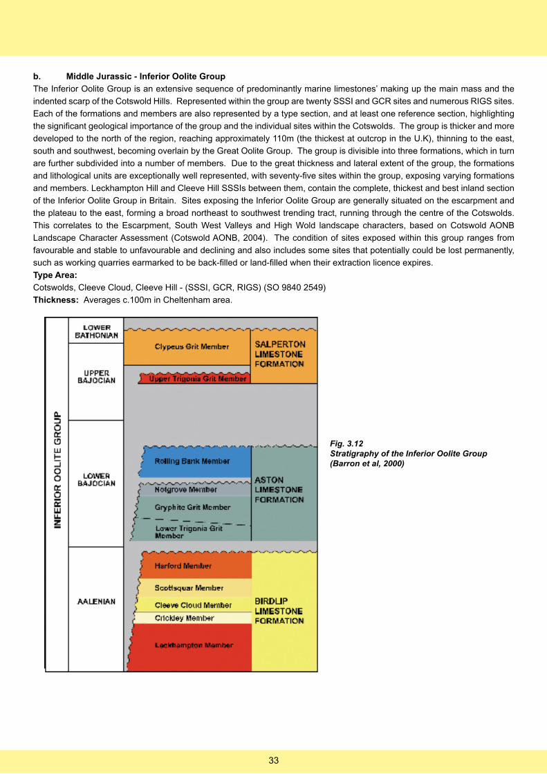
b. Middle Jurassic - Inferior Oolite Group
The Inferior Oolite Group is an extensive sequence of predominantly marine limestones’ making up the main mass and the
indented scarp of the Cotswold Hills. Represented within the group are twenty SSSI and GCR sites and numerous RIGS sites.
Each of the formations and members are also represented by a type section, and at least one reference section, highlighting
the significant geological importance of the group and the individual sites within the Cotswolds. The group is thicker and more
developed to the north of the region, reaching approximately 110m (the thickest at outcrop in the U.K), thinning to the east,
south and southwest, becoming overlain by the Great Oolite Group. The group is divisible into three formations, which in turn
are further subdivided into a number of members. Due to the great thickness and lateral extent of the group, the formations
and lithological units are exceptionally well represented, with seventy-five sites within the group, exposing varying formations
and members. Leckhampton Hill and Cleeve Hill SSSIs between them, contain the complete, thickest and best inland section
of the Inferior Oolite Group in Britain. Sites exposing the Inferior Oolite Group are generally situated on the escarpment and
the plateau to the east, forming a broad northeast to southwest trending tract, running through the centre of the Cotswolds.
This correlates to the Escarpment, South West Valleys and High Wold landscape characters, based on Cotswold AONB
Landscape Character Assessment (Cotswold AONB, 2004). The condition of sites exposed within this group ranges from
favourable and stable to unfavourable and declining and also includes some sites that potentially could be lost permanently,
such as working quarries earmarked to be back-filled or land-filled when their extraction licence expires.
Type Area:
Cotswolds, Cleeve Cloud, Cleeve Hill - (SSSI, GCR, RIGS) (SO 9840 2549)
Thickness: Averages c.100m in Cheltenham area.
Fig. 3.12Stratigraphy of the Inferior Oolite Group(Barron et al, 2000)
33
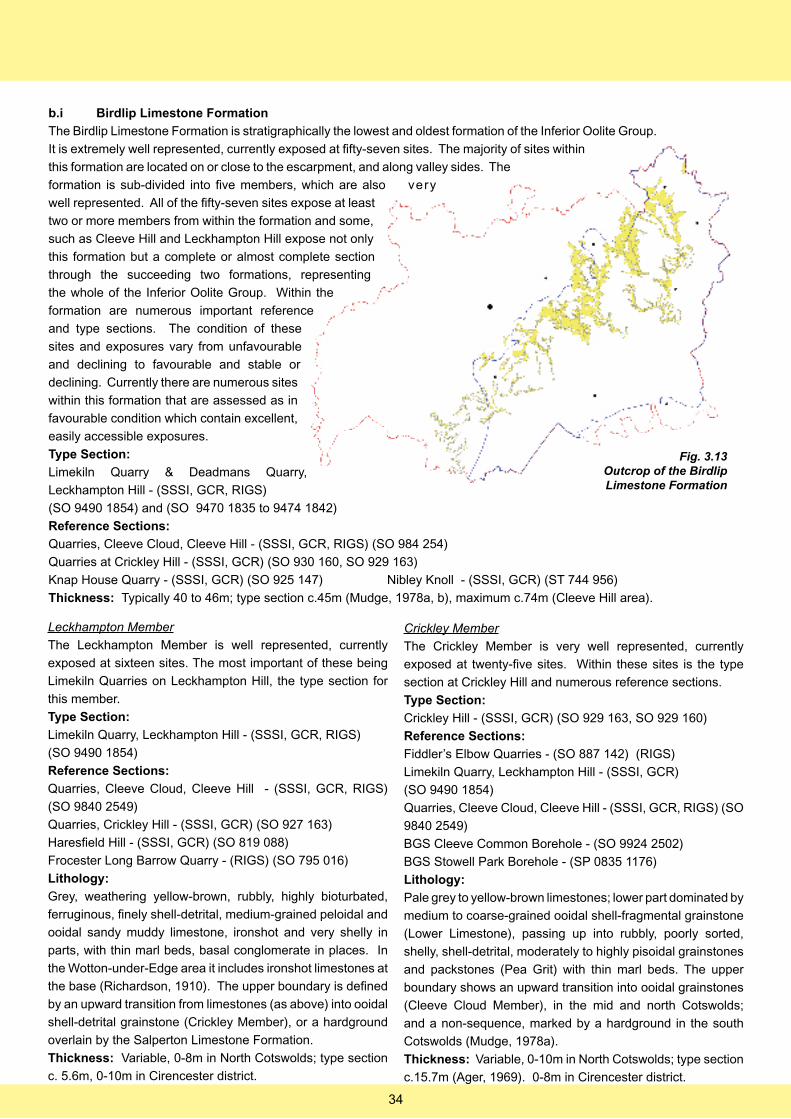
b.i Birdlip Limestone Formation
The Birdlip Limestone Formation is stratigraphically the lowest and oldest formation of the Inferior Oolite Group.
It is extremely well represented, currently exposed at fifty-seven sites. The majority of sites within
this formation are located on or close to the escarpment, and along valley sides. The
formation is sub-divided into five members, which are also very
well represented. All of the fifty-seven sites expose at least
two or more members from within the formation and some,
such as Cleeve Hill and Leckhampton Hill expose not only
this formation but a complete or almost complete section
through the succeeding two formations, representing
the whole of the Inferior Oolite Group. Within the
formation are numerous important reference
and type sections. The condition of these
sites and exposures vary from unfavourable
and declining to favourable and stable or
declining. Currently there are numerous sites
within this formation that are assessed as in
favourable condition which contain excellent,
easily accessible exposures.
Type Section:
Limekiln Quarry & Deadmans Quarry,
Leckhampton Hill - (SSSI, GCR, RIGS)
(SO 9490 1854) and (SO 9470 1835 to 9474 1842)
Reference Sections:
Quarries, Cleeve Cloud, Cleeve Hill - (SSSI, GCR, RIGS) (SO 984 254)
Quarries at Crickley Hill - (SSSI, GCR) (SO 930 160, SO 929 163)
Knap House Quarry - (SSSI, GCR) (SO 925 147) Nibley Knoll - (SSSI, GCR) (ST 744 956)
Thickness: Typically 40 to 46m; type section c.45m (Mudge, 1978a, b), maximum c.74m (Cleeve Hill area).
Leckhampton Member
The Leckhampton Member is well represented, currently
exposed at sixteen sites. The most important of these being
Limekiln Quarries on Leckhampton Hill, the type section for
this member.
Type Section:
Limekiln Quarry, Leckhampton Hill - (SSSI, GCR, RIGS)
(SO 9490 1854)
Reference Sections:
Quarries, Cleeve Cloud, Cleeve Hill - (SSSI, GCR, RIGS)
(SO 9840 2549)
Quarries, Crickley Hill - (SSSI, GCR) (SO 927 163)
Haresfield Hill - (SSSI, GCR) (SO 819 088)
Frocester Long Barrow Quarry - (RIGS) (SO 795 016)
Lithology:
Grey, weathering yellow-brown, rubbly, highly bioturbated,
ferruginous, finely shell-detrital, medium-grained peloidal and
ooidal sandy muddy limestone, ironshot and very shelly in
parts, with thin marl beds, basal conglomerate in places. In
the Wotton-under-Edge area it includes ironshot limestones at
the base (Richardson, 1910). The upper boundary is defined
by an upward transition from limestones (as above) into ooidal
shell-detrital grainstone (Crickley Member), or a hardground
overlain by the Salperton Limestone Formation.
Thickness: Variable, 0-8m in North Cotswolds; type section
c. 5.6m, 0-10m in Cirencester district.
Crickley Member
The Crickley Member is very well represented, currently
exposed at twenty-five sites. Within these sites is the type
section at Crickley Hill and numerous reference sections.
Type Section:
Crickley Hill - (SSSI, GCR) (SO 929 163, SO 929 160)
Reference Sections:
Fiddler’s Elbow Quarries - (SO 887 142) (RIGS)
Limekiln Quarry, Leckhampton Hill - (SSSI, GCR)
(SO 9490 1854)
Quarries, Cleeve Cloud, Cleeve Hill - (SSSI, GCR, RIGS) (SO
9840 2549)
BGS Cleeve Common Borehole - (SO 9924 2502)
BGS Stowell Park Borehole - (SP 0835 1176)
Lithology:
Pale grey to yellow-brown limestones; lower part dominated by
medium to coarse-grained ooidal shell-fragmental grainstone
(Lower Limestone), passing up into rubbly, poorly sorted,
shelly, shell-detrital, moderately to highly pisoidal grainstones
and packstones (Pea Grit) with thin marl beds. The upper
boundary shows an upward transition into ooidal grainstones
(Cleeve Cloud Member), in the mid and north Cotswolds;
and a non-sequence, marked by a hardground in the south
Cotswolds (Mudge, 1978a).
Thickness: Variable, 0-10m in North Cotswolds; type section
c.15.7m (Ager, 1969). 0-8m in Cirencester district.
Fig. 3.13Outcrop of the Birdlip Limestone Formation
34
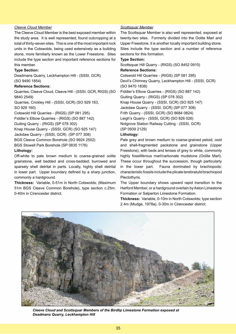
Cleeve Cloud Member
The Cleeve Cloud Member is the best exposed member within
the study area. It is well represented, found outcropping at a
total of thirty-seven sites. This is one of the most important rock
units in the Cotswolds, being used extensively as a building
stone, more familiarly known as the Lower Freestone. Sites
include the type section and important reference sections for
this member.
Type Section:
Deadmans Quarry, Leckhampton Hill - (SSSI, GCR)
(SO 9490 1854)
Reference Sections:
Quarries, Cleeve Cloud, Cleeve Hill - (SSSI, GCR, RIGS) (SO
9840 2549)
Quarries, Crickley Hill - (SSSI, GCR) (SO 929 163,
SO 929 160)
Cotswold Hill Quarries - (RIGS) (SP 081 295)
Fiddler’s Elbow Quarries - (RIGS) (SO 887 142)
Guiting Quarry - (RIGS) (SP 078 302)
Knap House Quarry - (SSSI, GCR) (SO 925 147)
Jackdaw Quarry - (SSSI, GCR) (SP 077 308)
BGS Cleeve Common Borehole (SO 9924 2502)
BGS Stowell Park Borehole (SP 0835 1176)
Lithology:
Off-white to pale brown medium to coarse-grained oolite
grainstone, well bedded and cross-bedded; burrowed and
sparsely shell detrital in parts. Locally, highly shell detrital
in lower part. Upper boundary defined by a sharp junction,
commonly a hardground.
Thickness: Variable, 0-51m in North Cotswolds; (Maximum
51m BGS Cleeve Common Borehole), type section c.25m.
0-40m in Cirencester district.
Scottsquar Member
The Scottsquar Member is also well represented, exposed at
twenty-two sites. Formerly divided into the Oolite Marl and
Upper Freestone, it is another locally important building stone.
Sites include the type section and a number of reference
sections for this formation.
Type Section:
Scottsquar Hill Quarry - (RIGS) (SO 8452 0910)
Reference Sections:
Cotswold Hill Quarries - (RIGS) (SP 081 295)
Devil’s Chimney Quarry, Leckhampton Hill - (SSSI, GCR)
(SO 9470 1838)
Fiddler’s Elbow Quarries - (RIGS) (SO 887 142)
Guiting Quarry - (RIGS) (SP 078 302)
Knap House Quarry - (SSSI, GCR) (SO 925 147)
Jackdaw Quarry - (SSSI, GCR) (SP 077 308)
Frith Quarry - (SSSI, GCR) (SO 8684 0824)
Leigh’s Quarry - (SSSI, GCR) (SO 826 026)
Notgrove Station Railway Cutting - (SSSI, GCR)
(SP 0939 2129)
Lithology:
Pale grey and brown medium to coarse-grained peloid, ooid
and shell-fragmented packstone and grainstone (Upper
Freestone), with beds and lenses of grey to white, commonly
highly fossiliferous marl/carbonate mudstone (Oolite Marl).
These occur throughout the succession, though particularly
in the lower part. Fauna dominated by brachiopods;
characteristic fossils include the plicate terebratulid brachiopod
Plectothyris.
The Upper boundary shows upward rapid transition to the
Harford Member, or a hardground overlain by Aston Limestone
Formation or Salperton Limestone Formation.
Thickness: Variable, 0-10m in North Cotswolds; type section
2.4m (Mudge, 1978a), 0-30m in Cirencester district.
Cleeve Cloud and Scottsquar Members of the Birdlip Limestone Formation exposed at Deadmans Quarry, Leckhampton Hill
35
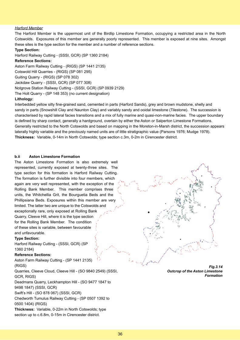
Harford Member
The Harford Member is the uppermost unit of the Birdlip Limestone Formation, occupying a restricted area in the North
Cotswolds. Exposures of this member are generally poorly represented. This member is exposed at nine sites. Amongst
these sites is the type section for the member and a number of reference sections.
Type Section:
Harford Railway Cutting - (SSSI, GCR) (SP 1360 2184)
Reference Sections:
Aston Farm Railway Cutting - (RIGS) (SP 1441 2135)
Cotswold Hill Quarries - (RIGS) (SP 081 295)
Guiting Quarry - (RIGS) (SP 078 302)
Jackdaw Quarry - (SSSI, GCR) (SP 077 308)
Notgrove Station Railway Cutting - (SSSI, GCR) (SP 0939 2129)
The Holt Quarry - (SP 148 353) (no current designation)
Lithology:
Interbedded yellow silty fine-grained sand, cemented in parts (Harford Sands), grey and brown mudstone, shelly and
sandy in parts (Snowshill Clay and Naunton Clay) and variably sandy and ooidal limestone (Tilestone). The succession is
characterised by rapid lateral facies transitions and a mix of fully marine and quasi-non-marine facies. The upper boundary
is defined by sharp contact, generally a hardground, overlain by either the Aston or Salperton Limestone Formations.
Generally restricted to the North Cotswolds and based on mapping in the Moreton-in-Marsh district, the succession appears
laterally highly variable and the previously named units are of little stratigraphic value (Parsons 1976; Mudge 1978).
Thickness: Variable, 0-14m in North Cotswolds; type section c.3m, 0-2m in Cirencester district.
b.ii Aston Limestone Formation
The Aston Limestone Formation is also extremely well
represented, currently exposed at twenty-three sites. The
type section for this formation is Harford Railway Cutting.
The formation is further divisible into four members, which
again are very well represented, with the exception of the
Rolling Bank Member. This member comprises three
units, the Whitchellia Grit, the Bourguetia Beds and the
Phillipsiana Beds. Exposures within this member are very
limited. The latter two are unique to the Cotswolds and
exceptionally rare, only exposed at Rolling Bank
Quarry, Cleeve Hill, where it is the type section
for the Rolling Bank Member. The condition
of these sites is variable, between favourable
and unfavourable.
Type Section:
Harford Railway Cutting - (SSSI, GCR) (SP
1360 2184)
Reference Sections:
Aston Farm Railway Cutting - (SP 1441 2135)
(RIGS)
Quarries, Cleeve Cloud, Cleeve Hill - (SO 9840 2549) (SSSI,
GCR, RIGS)
Deadmans Quarry, Leckhampton Hill - (SO 9477 1847 to
9498 1847) (SSSI, GCR)
Swift’s Hill - (SO 878 067) (SSSI, GCR)
Chedworth Tumulus Railway Cutting - (SP 0507 1392 to
0500 1404) (RIGS)
Thickness: Variable, 0-22m in North Cotswolds; type
section up to c.6.8m, 0-15m in Cirencester district.
Fig.3.14Outcrop of the Aston Limestone
Formation
36
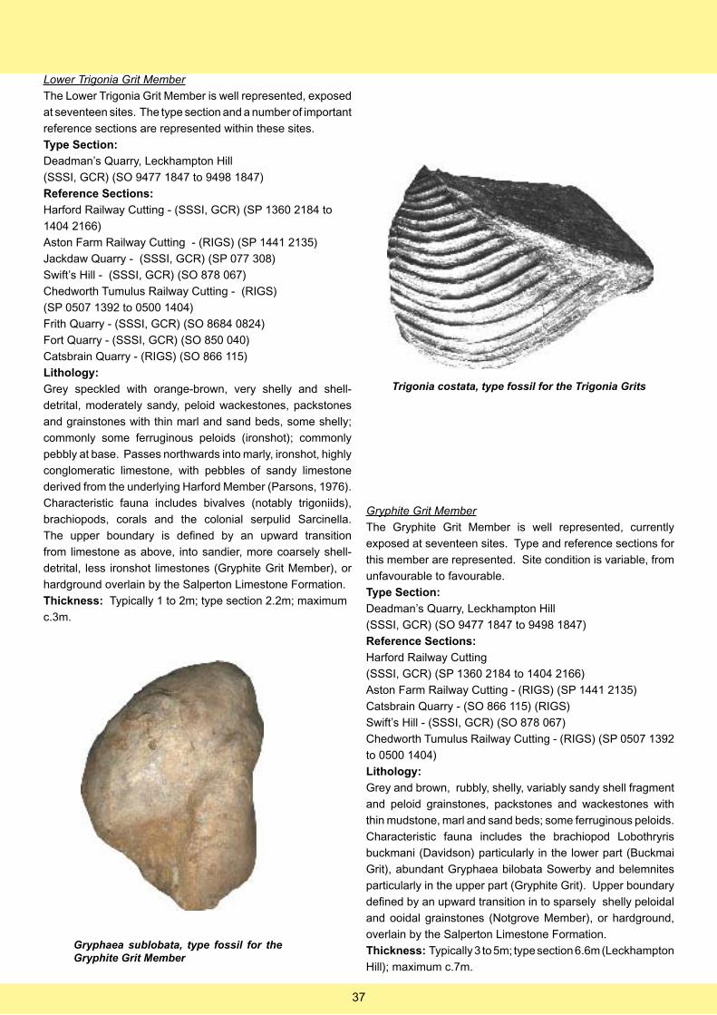
Lower Trigonia Grit Member
The Lower Trigonia Grit Member is well represented, exposed
at seventeen sites. The type section and a number of important
reference sections are represented within these sites.
Type Section:
Deadman’s Quarry, Leckhampton Hill
(SSSI, GCR) (SO 9477 1847 to 9498 1847)
Reference Sections:
Harford Railway Cutting - (SSSI, GCR) (SP 1360 2184 to
1404 2166)
Aston Farm Railway Cutting - (RIGS) (SP 1441 2135)
Jackdaw Quarry - (SSSI, GCR) (SP 077 308)
Swift’s Hill - (SSSI, GCR) (SO 878 067)
Chedworth Tumulus Railway Cutting - (RIGS)
(SP 0507 1392 to 0500 1404)
Frith Quarry - (SSSI, GCR) (SO 8684 0824)
Fort Quarry - (SSSI, GCR) (SO 850 040)
Catsbrain Quarry - (RIGS) (SO 866 115)
Lithology:
Grey speckled with orange-brown, very shelly and shell-
detrital, moderately sandy, peloid wackestones, packstones
and grainstones with thin marl and sand beds, some shelly;
commonly some ferruginous peloids (ironshot); commonly
pebbly at base. Passes northwards into marly, ironshot, highly
conglomeratic limestone, with pebbles of sandy limestone
derived from the underlying Harford Member (Parsons, 1976).
Characteristic fauna includes bivalves (notably trigoniids),
brachiopods, corals and the colonial serpulid Sarcinella.
The upper boundary is defined by an upward transition
from limestone as above, into sandier, more coarsely shell-
detrital, less ironshot limestones (Gryphite Grit Member), or
hardground overlain by the Salperton Limestone Formation.
Thickness: Typically 1 to 2m; type section 2.2m; maximum
c.3m.
Trigonia costata, type fossil for the Trigonia Grits
Gryphite Grit Member
The Gryphite Grit Member is well represented, currently
exposed at seventeen sites. Type and reference sections for
this member are represented. Site condition is variable, from
unfavourable to favourable.
Type Section:
Deadman’s Quarry, Leckhampton Hill
(SSSI, GCR) (SO 9477 1847 to 9498 1847)
Reference Sections:
Harford Railway Cutting
(SSSI, GCR) (SP 1360 2184 to 1404 2166)
Aston Farm Railway Cutting - (RIGS) (SP 1441 2135)
Catsbrain Quarry - (SO 866 115) (RIGS)
Swift’s Hill - (SSSI, GCR) (SO 878 067)
Chedworth Tumulus Railway Cutting - (RIGS) (SP 0507 1392
to 0500 1404)
Lithology:
Grey and brown, rubbly, shelly, variably sandy shell fragment
and peloid grainstones, packstones and wackestones with
thin mudstone, marl and sand beds; some ferruginous peloids.
Characteristic fauna includes the brachiopod Lobothryris
buckmani (Davidson) particularly in the lower part (Buckmai
Grit), abundant Gryphaea bilobata Sowerby and belemnites
particularly in the upper part (Gryphite Grit). Upper boundary
defined by an upward transition in to sparsely shelly peloidal
and ooidal grainstones (Notgrove Member), or hardground,
overlain by the Salperton Limestone Formation.
Thickness: Typically 3 to 5m; type section 6.6m (Leckhampton
Hill); maximum c.7m.
Gryphaea sublobata, type fossil for the Gryphite Grit Member
37
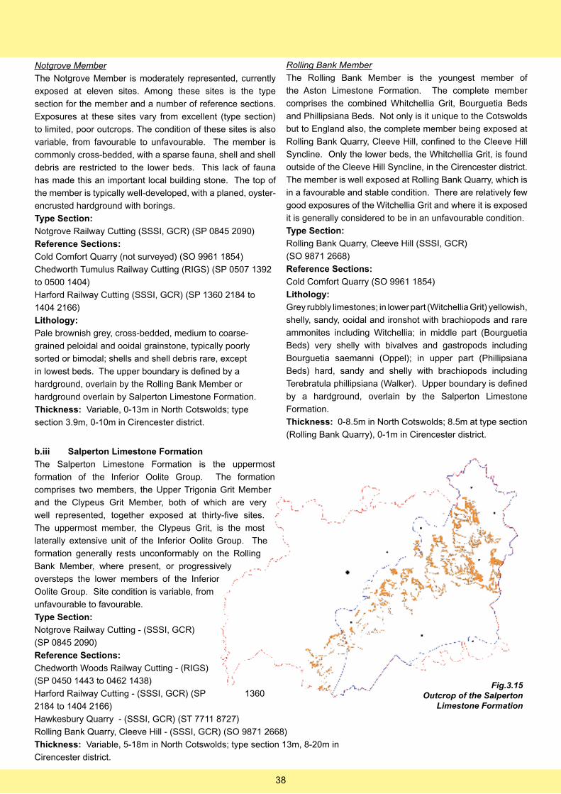
Notgrove Member
The Notgrove Member is moderately represented, currently
exposed at eleven sites. Among these sites is the type
section for the member and a number of reference sections.
Exposures at these sites vary from excellent (type section)
to limited, poor outcrops. The condition of these sites is also
variable, from favourable to unfavourable. The member is
commonly cross-bedded, with a sparse fauna, shell and shell
debris are restricted to the lower beds. This lack of fauna
has made this an important local building stone. The top of
the member is typically well-developed, with a planed, oyster-
encrusted hardground with borings.
Type Section:
Notgrove Railway Cutting (SSSI, GCR) (SP 0845 2090)
Reference Sections:
Cold Comfort Quarry (not surveyed) (SO 9961 1854)
Chedworth Tumulus Railway Cutting (RIGS) (SP 0507 1392
to 0500 1404)
Harford Railway Cutting (SSSI, GCR) (SP 1360 2184 to
1404 2166)
Lithology:
Pale brownish grey, cross-bedded, medium to coarse-
grained peloidal and ooidal grainstone, typically poorly
sorted or bimodal; shells and shell debris rare, except
in lowest beds. The upper boundary is defined by a
hardground, overlain by the Rolling Bank Member or
hardground overlain by Salperton Limestone Formation.
Thickness: Variable, 0-13m in North Cotswolds; type
section 3.9m, 0-10m in Cirencester district.
Rolling Bank Member
The Rolling Bank Member is the youngest member of
the Aston Limestone Formation. The complete member
comprises the combined Whitchellia Grit, Bourguetia Beds
and Phillipsiana Beds. Not only is it unique to the Cotswolds
but to England also, the complete member being exposed at
Rolling Bank Quarry, Cleeve Hill, confined to the Cleeve Hill
Syncline. Only the lower beds, the Whitchellia Grit, is found
outside of the Cleeve Hill Syncline, in the Cirencester district.
The member is well exposed at Rolling Bank Quarry, which is
in a favourable and stable condition. There are relatively few
good exposures of the Witchellia Grit and where it is exposed
it is generally considered to be in an unfavourable condition.
Type Section:
Rolling Bank Quarry, Cleeve Hill (SSSI, GCR)
(SO 9871 2668)
Reference Sections:
Cold Comfort Quarry (SO 9961 1854)
Lithology:
Grey rubbly limestones; in lower part (Witchellia Grit) yellowish,
shelly, sandy, ooidal and ironshot with brachiopods and rare
ammonites including Witchellia; in middle part (Bourguetia
Beds) very shelly with bivalves and gastropods including
Bourguetia saemanni (Oppel); in upper part (Phillipsiana
Beds) hard, sandy and shelly with brachiopods including
Terebratula phillipsiana (Walker). Upper boundary is defined
by a hardground, overlain by the Salperton Limestone
Formation.
Thickness: 0-8.5m in North Cotswolds; 8.5m at type section
(Rolling Bank Quarry), 0-1m in Cirencester district.
b.iii Salperton Limestone Formation
The Salperton Limestone Formation is the uppermost
formation of the Inferior Oolite Group. The formation
comprises two members, the Upper Trigonia Grit Member
and the Clypeus Grit Member, both of which are very
well represented, together exposed at thirty-five sites.
The uppermost member, the Clypeus Grit, is the most
laterally extensive unit of the Inferior Oolite Group. The
formation generally rests unconformably on the Rolling
Bank Member, where present, or progressively
oversteps the lower members of the Inferior
Oolite Group. Site condition is variable, from
unfavourable to favourable.
Type Section:
Notgrove Railway Cutting - (SSSI, GCR)
(SP 0845 2090)
Reference Sections:
Chedworth Woods Railway Cutting - (RIGS)
(SP 0450 1443 to 0462 1438)
Harford Railway Cutting - (SSSI, GCR) (SP 1360
2184 to 1404 2166)
Hawkesbury Quarry - (SSSI, GCR) (ST 7711 8727)
Rolling Bank Quarry, Cleeve Hill - (SSSI, GCR) (SO 9871 2668)
Thickness: Variable, 5-18m in North Cotswolds; type section 13m, 8-20m in
Cirencester district.
Fig.3.15Outcrop of the Salperton
Limestone Formation
38
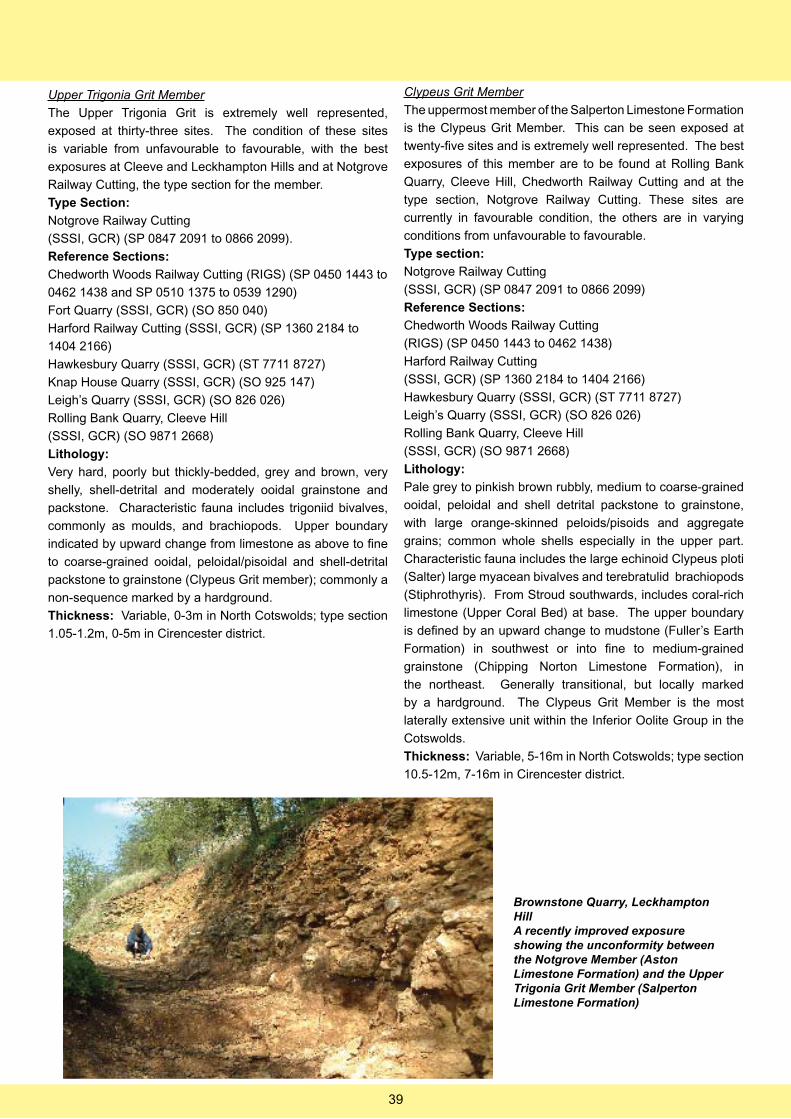
Upper Trigonia Grit Member
The Upper Trigonia Grit is extremely well represented,
exposed at thirty-three sites. The condition of these sites
is variable from unfavourable to favourable, with the best
exposures at Cleeve and Leckhampton Hills and at Notgrove
Railway Cutting, the type section for the member.
Type Section:
Notgrove Railway Cutting
(SSSI, GCR) (SP 0847 2091 to 0866 2099).
Reference Sections:
Chedworth Woods Railway Cutting (RIGS) (SP 0450 1443 to
0462 1438 and SP 0510 1375 to 0539 1290)
Fort Quarry (SSSI, GCR) (SO 850 040)
Harford Railway Cutting (SSSI, GCR) (SP 1360 2184 to
1404 2166)
Hawkesbury Quarry (SSSI, GCR) (ST 7711 8727)
Knap House Quarry (SSSI, GCR) (SO 925 147)
Leigh’s Quarry (SSSI, GCR) (SO 826 026)
Rolling Bank Quarry, Cleeve Hill
(SSSI, GCR) (SO 9871 2668)
Lithology:
Very hard, poorly but thickly-bedded, grey and brown, very
shelly, shell-detrital and moderately ooidal grainstone and
packstone. Characteristic fauna includes trigoniid bivalves,
commonly as moulds, and brachiopods. Upper boundary
indicated by upward change from limestone as above to fine
to coarse-grained ooidal, peloidal/pisoidal and shell-detrital
packstone to grainstone (Clypeus Grit member); commonly a
non-sequence marked by a hardground.
Thickness: Variable, 0-3m in North Cotswolds; type section
1.05-1.2m, 0-5m in Cirencester district.
Clypeus Grit Member
The uppermost member of the Salperton Limestone Formation
is the Clypeus Grit Member. This can be seen exposed at
twenty-five sites and is extremely well represented. The best
exposures of this member are to be found at Rolling Bank
Quarry, Cleeve Hill, Chedworth Railway Cutting and at the
type section, Notgrove Railway Cutting. These sites are
currently in favourable condition, the others are in varying
conditions from unfavourable to favourable.
Type section:
Notgrove Railway Cutting
(SSSI, GCR) (SP 0847 2091 to 0866 2099)
Reference Sections:
Chedworth Woods Railway Cutting
(RIGS) (SP 0450 1443 to 0462 1438)
Harford Railway Cutting
(SSSI, GCR) (SP 1360 2184 to 1404 2166)
Hawkesbury Quarry (SSSI, GCR) (ST 7711 8727)
Leigh’s Quarry (SSSI, GCR) (SO 826 026)
Rolling Bank Quarry, Cleeve Hill
(SSSI, GCR) (SO 9871 2668)
Lithology:
Pale grey to pinkish brown rubbly, medium to coarse-grained
ooidal, peloidal and shell detrital packstone to grainstone,
with large orange-skinned peloids/pisoids and aggregate
grains; common whole shells especially in the upper part.
Characteristic fauna includes the large echinoid Clypeus ploti
(Salter) large myacean bivalves and terebratulid brachiopods
(Stiphrothyris). From Stroud southwards, includes coral-rich
limestone (Upper Coral Bed) at base. The upper boundary
is defined by an upward change to mudstone (Fuller’s Earth
Formation) in southwest or into fine to medium-grained
grainstone (Chipping Norton Limestone Formation), in
the northeast. Generally transitional, but locally marked
by a hardground. The Clypeus Grit Member is the most
laterally extensive unit within the Inferior Oolite Group in the
Cotswolds.
Thickness: Variable, 5-16m in North Cotswolds; type section
10.5-12m, 7-16m in Cirencester district.
Brownstone Quarry, Leckhampton Hill A recently improved exposure showing the unconformity between the Notgrove Member (Aston Limestone Formation) and the Upper Trigonia Grit Member (Salperton Limestone Formation)
39
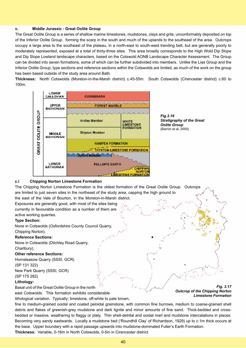
c. Middle Jurassic - Great Oolite Group
The Great Oolite Group is a series of shallow marine limestones, mudstones, clays and grits, unconformably deposited on top
of the Inferior Oolite Group. forming the scarp in the south and much of the uplands to the southeast of the area. Outcrops
occupy a large area to the southeast of the plateau, in a north-east to south-west trending belt, but are generally poorly to
moderately represented, exposed at a total of thirty-three sites. This area broadly corresponds to the High Wold Dip Slope
and Dip Slope Lowland landscape characters, based on the Cotswold AONB Landscape Character Assessment. The Group
can be divided into seven formations, some of which can be further subdivided into members. Unlike the Lias Group and the
Inferior Oolite Group, type sections and reference sections within the Cotswolds are limited, as much of the work on the group
has been based outside of the study area around Bath.
Thickness: North Cotswolds (Moreton-in-the-Marsh district) c.45-55m. South Cotswolds (Cirencester district) c.60 to
100m.
Fig.3.16Stratigraphy of the Great Oolite Group(Barron et al, 2000)
c.i Chipping Norton Limestone Formation
The Chipping Norton Limestone Formation is the oldest formation of the Great Oolite Group. Outcrops
are limited to just seven sites in the northeast of the study area, capping the high ground to
the east of the Vale of Bourton, in the Moreton-in-Marsh district.
Exposures are generally good, with most of the sites being
currently in favourable condition as a number of them are
active working quarries.
Type Section:
None in Cotswolds (Oxfordshire County Council Quarry,
Chipping Norton).
Reference Sections:
None in Cotswolds (Ditchley Road Quarry,
Charlbury).
Other reference Sections:
Hornsleasow Quarry (SSSI, GCR)
(SP 131 322)
New Park Quarry (SSSI, GCR)
(SP 175 282)
Lithology:
Basal unit of the Great Oolite Group in the north
east Cotswolds. This formation exhibits considerable
lithological variation. Typically; limestone, off-white to pale brown,
fine to medium-grained ooidal and coated peloidal grainstone, with common fine burrows, medium to coarse-grained shell
debris and flakes of greenish-grey mudstone and dark lignite and minor amounts of fine sand. Thick-bedded and cross-
bedded or massive, weathering to flaggy or platy. Thin shell-detrital and ooidal marl and mudstone intercalations in places.
Becoming very sandy eastwards. Locally a mudstone bed (‘Roundhill Clay’ of Richardson, 1929) up to c.1m thick occurs at
the base. Upper boundary with a rapid passage upwards into mudstone-dominated Fuller’s Earth Formation.
Thickness: Variable, 0-16m in North Cotswolds, 0-5m in Cirencester district.
Fig. 3.17Outcrop of the Chipping Norton
Limestone Formation
40
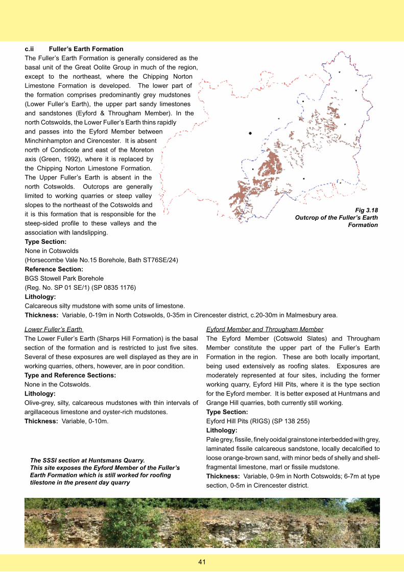
c.ii Fuller’s Earth Formation
The Fuller’s Earth Formation is generally considered as the
basal unit of the Great Oolite Group in much of the region,
except to the northeast, where the Chipping Norton
Limestone Formation is developed. The lower part of
the formation comprises predominantly grey mudstones
(Lower Fuller’s Earth), the upper part sandy limestones
and sandstones (Eyford & Througham Member). In the
north Cotswolds, the Lower Fuller’s Earth thins rapidly
and passes into the Eyford Member between
Minchinhampton and Cirencester. It is absent
north of Condicote and east of the Moreton
axis (Green, 1992), where it is replaced by
the Chipping Norton Limestone Formation.
The Upper Fuller’s Earth is absent in the
north Cotswolds. Outcrops are generally
limited to working quarries or steep valley
slopes to the northeast of the Cotswolds and
it is this formation that is responsible for the
steep-sided profile to these valleys and the
association with landslipping.
Type Section:
None in Cotswolds
(Horsecombe Vale No.15 Borehole, Bath ST76SE/24)
Reference Section:
BGS Stowell Park Borehole
(Reg. No. SP 01 SE/1) (SP 0835 1176)
Lithology:
Calcareous silty mudstone with some units of limestone.
Thickness: Variable, 0-19m in North Cotswolds, 0-35m in Cirencester district, c.20-30m in Malmesbury area.
Fig 3.18Outcrop of the Fuller’s Earth
Formation
Lower Fuller’s Earth
The Lower Fuller’s Earth (Sharps Hill Formation) is the basal
section of the formation and is restricted to just five sites.
Several of these exposures are well displayed as they are in
working quarries, others, however, are in poor condition.
Type and Reference Sections:
None in the Cotswolds.
Lithology:
Olive-grey, silty, calcareous mudstones with thin intervals of
argillaceous limestone and oyster-rich mudstones.
Thickness: Variable, 0-10m.
Eyford Member and Througham Member
The Eyford Member (Cotswold Slates) and Througham
Member constitute the upper part of the Fuller’s Earth
Formation in the region. These are both locally important,
being used extensively as roofing slates. Exposures are
moderately represented at four sites, including the former
working quarry, Eyford Hill Pits, where it is the type section
for the Eyford member. It is better exposed at Huntmans and
Grange Hill quarries, both currently still working.
Type Section:
Eyford Hill Pits (RIGS) (SP 138 255)
Lithology:
Pale grey, fissile, finely ooidal grainstone interbedded with grey,
laminated fissile calcareous sandstone, locally decalcified to
loose orange-brown sand, with minor beds of shelly and shell-
fragmental limestone, marl or fissile mudstone.
Thickness: Variable, 0-9m in North Cotswolds; 6-7m at type
section, 0-5m in Cirencester district.
The SSSI section at Huntsmans Quarry.This site exposes the Eyford Member of the Fuller’s Earth Formation which is still worked for roofing tilestone in the present day quarry
41
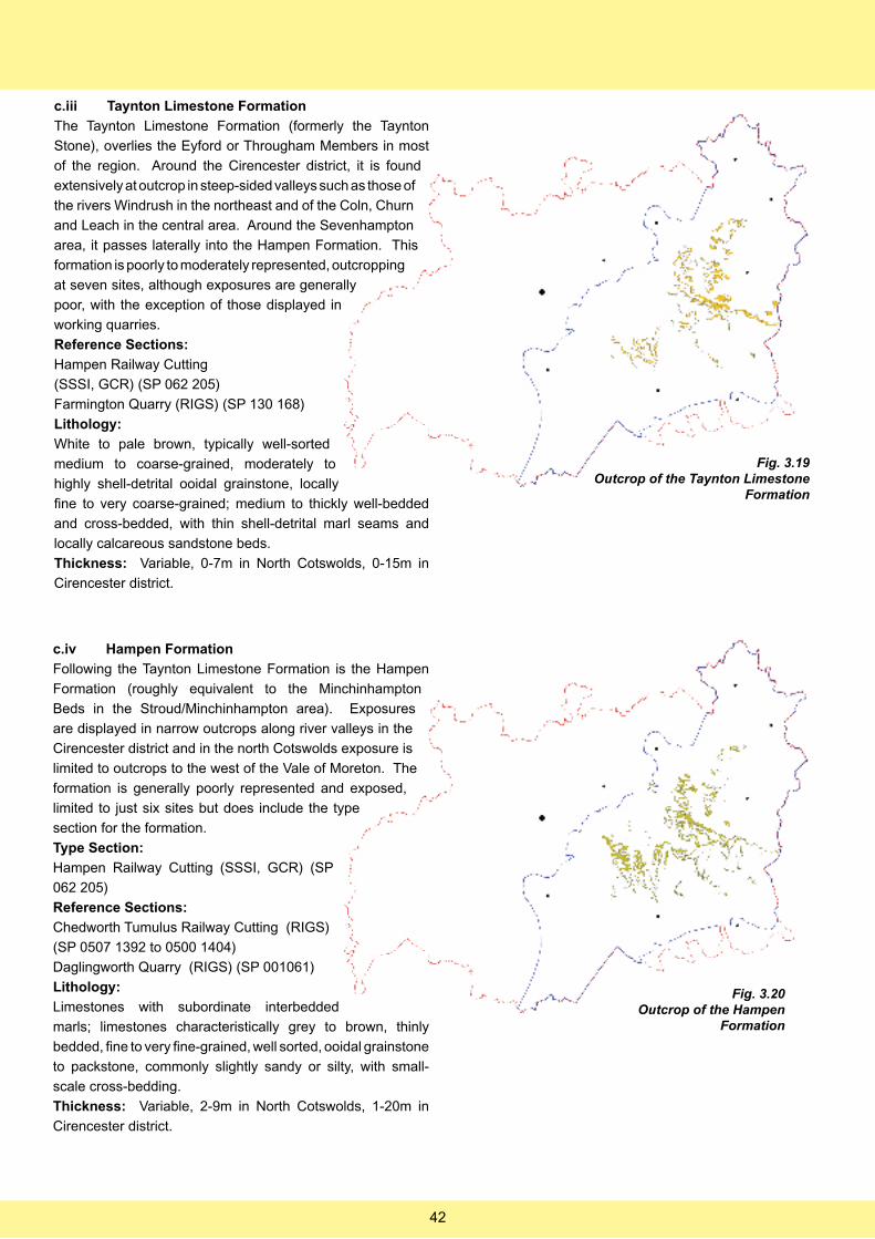
c.iii Taynton Limestone Formation
The Taynton Limestone Formation (formerly the Taynton
Stone), overlies the Eyford or Througham Members in most
of the region. Around the Cirencester district, it is found
extensively at outcrop in steep-sided valleys such as those of
the rivers Windrush in the northeast and of the Coln, Churn
and Leach in the central area. Around the Sevenhampton
area, it passes laterally into the Hampen Formation. This
formation is poorly to moderately represented, outcropping
at seven sites, although exposures are generally
poor, with the exception of those displayed in
working quarries.
Reference Sections:
Hampen Railway Cutting
(SSSI, GCR) (SP 062 205)
Farmington Quarry (RIGS) (SP 130 168)
Lithology:
White to pale brown, typically well-sorted
medium to coarse-grained, moderately to
highly shell-detrital ooidal grainstone, locally
fine to very coarse-grained; medium to thickly well-bedded
and cross-bedded, with thin shell-detrital marl seams and
locally calcareous sandstone beds.
Thickness: Variable, 0-7m in North Cotswolds, 0-15m in
Cirencester district.
c.iv Hampen Formation
Following the Taynton Limestone Formation is the Hampen
Formation (roughly equivalent to the Minchinhampton
Beds in the Stroud/Minchinhampton area). Exposures
are displayed in narrow outcrops along river valleys in the
Cirencester district and in the north Cotswolds exposure is
limited to outcrops to the west of the Vale of Moreton. The
formation is generally poorly represented and exposed,
limited to just six sites but does include the type
section for the formation.
Type Section:
Hampen Railway Cutting (SSSI, GCR) (SP
062 205)
Reference Sections:
Chedworth Tumulus Railway Cutting (RIGS)
(SP 0507 1392 to 0500 1404)
Daglingworth Quarry (RIGS) (SP 001061)
Lithology:
Limestones with subordinate interbedded
marls; limestones characteristically grey to brown, thinly
bedded, fine to very fine-grained, well sorted, ooidal grainstone
to packstone, commonly slightly sandy or silty, with small-
scale cross-bedding.
Thickness: Variable, 2-9m in North Cotswolds, 1-20m in
Cirencester district.
Fig. 3.19Outcrop of the Taynton Limestone
Formation
Fig. 3.20Outcrop of the Hampen
Formation
42
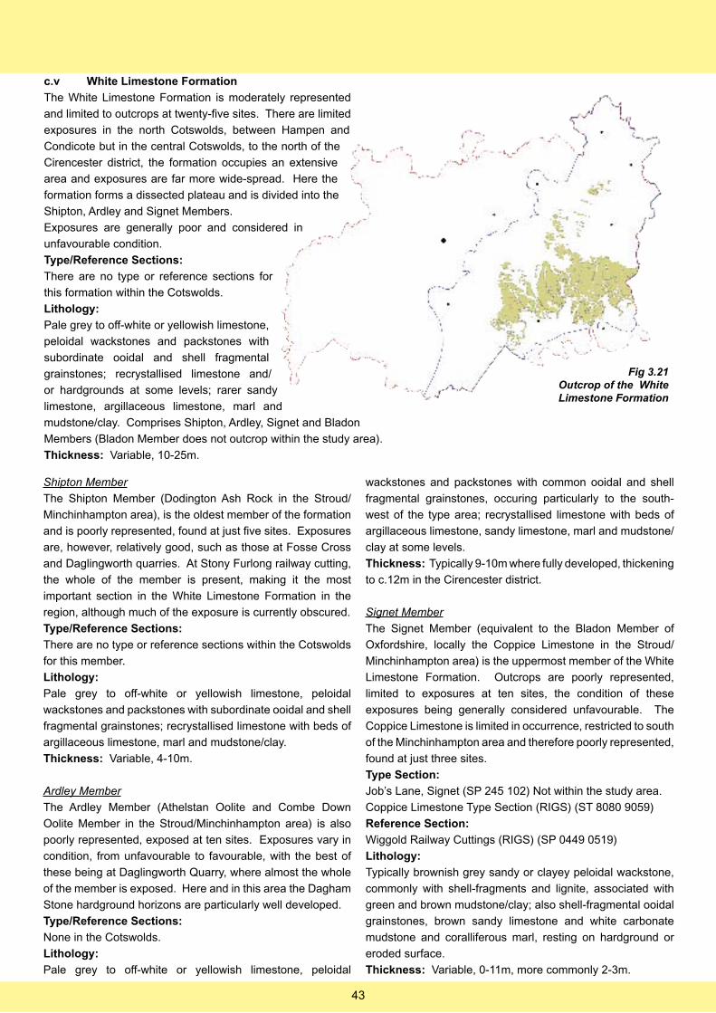
c.v White Limestone Formation
The White Limestone Formation is moderately represented
and limited to outcrops at twenty-five sites. There are limited
exposures in the north Cotswolds, between Hampen and
Condicote but in the central Cotswolds, to the north of the
Cirencester district, the formation occupies an extensive
area and exposures are far more wide-spread. Here the
formation forms a dissected plateau and is divided into the
Shipton, Ardley and Signet Members.
Exposures are generally poor and considered in
unfavourable condition.
Type/Reference Sections:
There are no type or reference sections for
this formation within the Cotswolds.
Lithology:
Pale grey to off-white or yellowish limestone,
peloidal wackstones and packstones with
subordinate ooidal and shell fragmental
grainstones; recrystallised limestone and/
or hardgrounds at some levels; rarer sandy
limestone, argillaceous limestone, marl and
mudstone/clay. Comprises Shipton, Ardley, Signet and Bladon
Members (Bladon Member does not outcrop within the study area).
Thickness: Variable, 10-25m.
Shipton Member
The Shipton Member (Dodington Ash Rock in the Stroud/
Minchinhampton area), is the oldest member of the formation
and is poorly represented, found at just five sites. Exposures
are, however, relatively good, such as those at Fosse Cross
and Daglingworth quarries. At Stony Furlong railway cutting,
the whole of the member is present, making it the most
important section in the White Limestone Formation in the
region, although much of the exposure is currently obscured.
Type/Reference Sections:
There are no type or reference sections within the Cotswolds
for this member.
Lithology:
Pale grey to off-white or yellowish limestone, peloidal
wackstones and packstones with subordinate ooidal and shell
fragmental grainstones; recrystallised limestone with beds of
argillaceous limestone, marl and mudstone/clay.
Thickness: Variable, 4-10m.
Ardley Member
The Ardley Member (Athelstan Oolite and Combe Down
Oolite Member in the Stroud/Minchinhampton area) is also
poorly represented, exposed at ten sites. Exposures vary in
condition, from unfavourable to favourable, with the best of
these being at Daglingworth Quarry, where almost the whole
of the member is exposed. Here and in this area the Dagham
Stone hardground horizons are particularly well developed.
Type/Reference Sections:
None in the Cotswolds.
Lithology:
Pale grey to off-white or yellowish limestone, peloidal
wackstones and packstones with common ooidal and shell
fragmental grainstones, occuring particularly to the south-
west of the type area; recrystallised limestone with beds of
argillaceous limestone, sandy limestone, marl and mudstone/
clay at some levels.
Thickness: Typically 9-10m where fully developed, thickening
to c.12m in the Cirencester district.
Signet Member
The Signet Member (equivalent to the Bladon Member of
Oxfordshire, locally the Coppice Limestone in the Stroud/
Minchinhampton area) is the uppermost member of the White
Limestone Formation. Outcrops are poorly represented,
limited to exposures at ten sites, the condition of these
exposures being generally considered unfavourable. The
Coppice Limestone is limited in occurrence, restricted to south
of the Minchinhampton area and therefore poorly represented,
found at just three sites.
Type Section:
Job’s Lane, Signet (SP 245 102) Not within the study area.
Coppice Limestone Type Section (RIGS) (ST 8080 9059)
Reference Section:
Wiggold Railway Cuttings (RIGS) (SP 0449 0519)
Lithology:
Typically brownish grey sandy or clayey peloidal wackstone,
commonly with shell-fragments and lignite, associated with
green and brown mudstone/clay; also shell-fragmental ooidal
grainstones, brown sandy limestone and white carbonate
mudstone and coralliferous marl, resting on hardground or
eroded surface.
Thickness: Variable, 0-11m, more commonly 2-3m.
Fig 3.21Outcrop of the White Limestone Formation
43
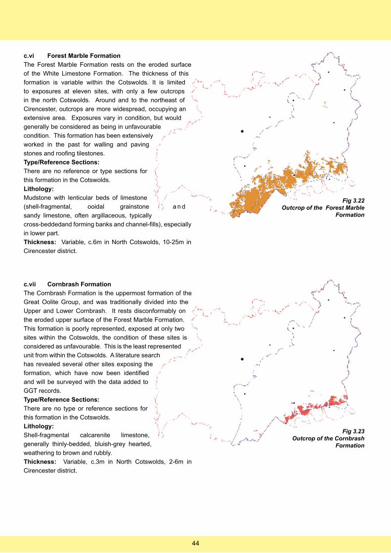
c.vi Forest Marble Formation
The Forest Marble Formation rests on the eroded surface
of the White Limestone Formation. The thickness of this
formation is variable within the Cotswolds. It is limited
to exposures at eleven sites, with only a few outcrops
in the north Cotswolds. Around and to the northeast of
Cirencester, outcrops are more widespread, occupying an
extensive area. Exposures vary in condition, but would
generally be considered as being in unfavourable
condition. This formation has been extensively
worked in the past for walling and paving
stones and roofing tilestones.
Type/Reference Sections:
There are no reference or type sections for
this formation in the Cotswolds.
Lithology:
Mudstone with lenticular beds of limestone
(shell-fragmental, ooidal grainstone a n d
sandy limestone, often argillaceous, typically
cross-beddedand forming banks and channel-fills), especially
in lower part.
Thickness: Variable, c.6m in North Cotswolds, 10-25m in
Cirencester district.
c.vii Cornbrash Formation
The Cornbrash Formation is the uppermost formation of the
Great Oolite Group, and was traditionally divided into the
Upper and Lower Cornbrash. It rests disconformably on
the eroded upper surface of the Forest Marble Formation.
This formation is poorly represented, exposed at only two
sites within the Cotswolds, the condition of these sites is
considered as unfavourable. This is the least represented
unit from within the Cotswolds. A literature search
has revealed several other sites exposing the
formation, which have now been identified
and will be surveyed with the data added to
GGT records.
Type/Reference Sections:
There are no type or reference sections for
this formation in the Cotswolds.
Lithology:
Shell-fragmental calcarenite limestone,
generally thinly-bedded, bluish-grey hearted,
weathering to brown and rubbly.
Thickness: Variable, c.3m in North Cotswolds, 2-6m in
Cirencester district.
Fig 3.22Outcrop of the Forest Marble
Formation
Fig 3.23Outcrop of the Cornbrash
Formation
44
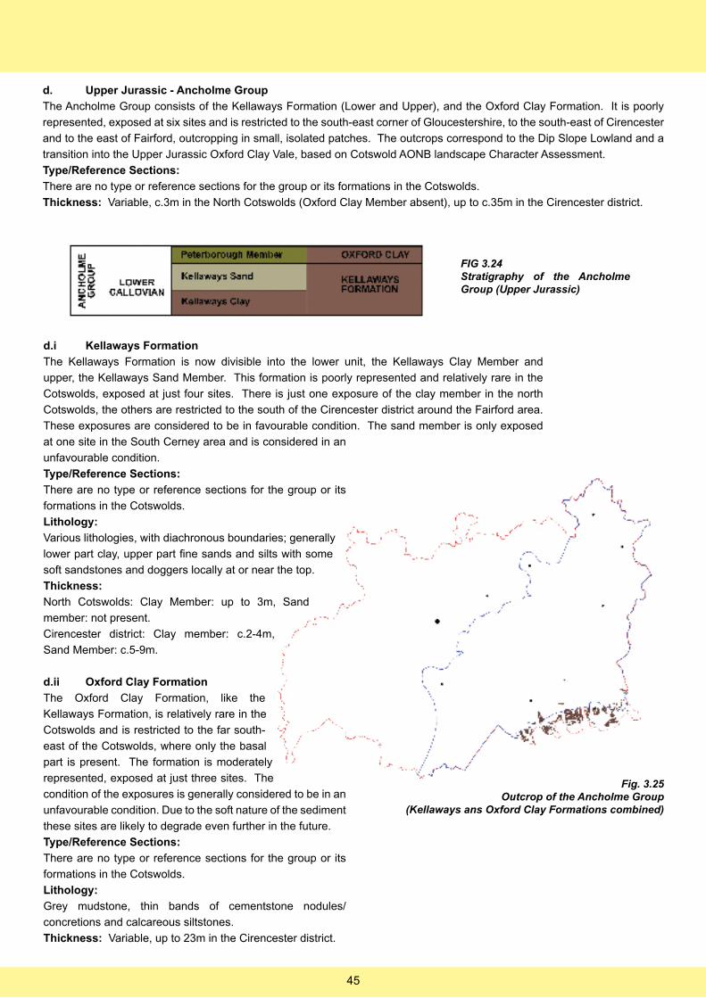
d. Upper Jurassic - Ancholme Group
The Ancholme Group consists of the Kellaways Formation (Lower and Upper), and the Oxford Clay Formation. It is poorly
represented, exposed at six sites and is restricted to the south-east corner of Gloucestershire, to the south-east of Cirencester
and to the east of Fairford, outcropping in small, isolated patches. The outcrops correspond to the Dip Slope Lowland and a
transition into the Upper Jurassic Oxford Clay Vale, based on Cotswold AONB landscape Character Assessment.
Type/Reference Sections:
There are no type or reference sections for the group or its formations in the Cotswolds.
Thickness: Variable, c.3m in the North Cotswolds (Oxford Clay Member absent), up to c.35m in the Cirencester district.
FIG 3.24Stratigraphy of the Ancholme Group (Upper Jurassic)
d.i Kellaways Formation
The Kellaways Formation is now divisible into the lower unit, the Kellaways Clay Member and
upper, the Kellaways Sand Member. This formation is poorly represented and relatively rare in the
Cotswolds, exposed at just four sites. There is just one exposure of the clay member in the north
Cotswolds, the others are restricted to the south of the Cirencester district around the Fairford area.
These exposures are considered to be in favourable condition. The sand member is only exposed
at one site in the South Cerney area and is considered in an
unfavourable condition.
Type/Reference Sections:
There are no type or reference sections for the group or its
formations in the Cotswolds.
Lithology:
Various lithologies, with diachronous boundaries; generally
lower part clay, upper part fine sands and silts with some
soft sandstones and doggers locally at or near the top.
Thickness:
North Cotswolds: Clay Member: up to 3m, Sand
member: not present.
Cirencester district: Clay member: c.2-4m,
Sand Member: c.5-9m.
d.ii Oxford Clay Formation
The Oxford Clay Formation, like the
Kellaways Formation, is relatively rare in the
Cotswolds and is restricted to the far south-
east of the Cotswolds, where only the basal
part is present. The formation is moderately
represented, exposed at just three sites. The
condition of the exposures is generally considered to be in an
unfavourable condition. Due to the soft nature of the sediment
these sites are likely to degrade even further in the future.
Type/Reference Sections:
There are no type or reference sections for the group or its
formations in the Cotswolds.
Lithology:
Grey mudstone, thin bands of cementstone nodules/
concretions and calcareous siltstones.
Thickness: Variable, up to 23m in the Cirencester district.
Fig. 3.25Outcrop of the Ancholme Group
(Kellaways ans Oxford Clay Formations combined)
45
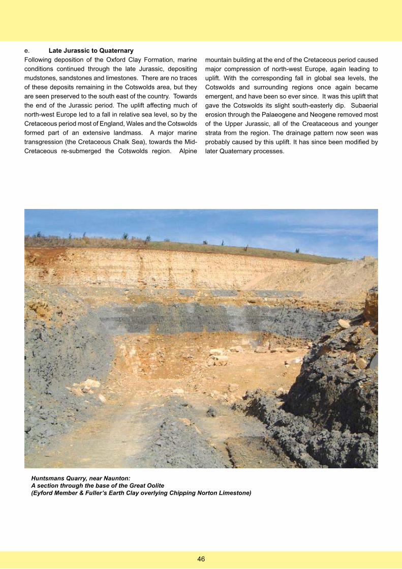
e. Late Jurassic to Quaternary
Following deposition of the Oxford Clay Formation, marine
conditions continued through the late Jurassic, depositing
mudstones, sandstones and limestones. There are no traces
of these deposits remaining in the Cotswolds area, but they
are seen preserved to the south east of the country. Towards
the end of the Jurassic period. The uplift affecting much of
north-west Europe led to a fall in relative sea level, so by the
Cretaceous period most of England, Wales and the Cotswolds
formed part of an extensive landmass. A major marine
transgression (the Cretaceous Chalk Sea), towards the Mid-
Cretaceous re-submerged the Cotswolds region. Alpine
mountain building at the end of the Cretaceous period caused
major compression of north-west Europe, again leading to
uplift. With the corresponding fall in global sea levels, the
Cotswolds and surrounding regions once again became
emergent, and have been so ever since. It was this uplift that
gave the Cotswolds its slight south-easterly dip. Subaerial
erosion through the Palaeogene and Neogene removed most
of the Upper Jurassic, all of the Creataceous and younger
strata from the region. The drainage pattern now seen was
probably caused by this uplift. It has since been modified by
later Quaternary processes.
Huntsmans Quarry, near Naunton:A section through the base of the Great Oolite (Eyford Member & Fuller’s Earth Clay overlying Chipping Norton Limestone)
46
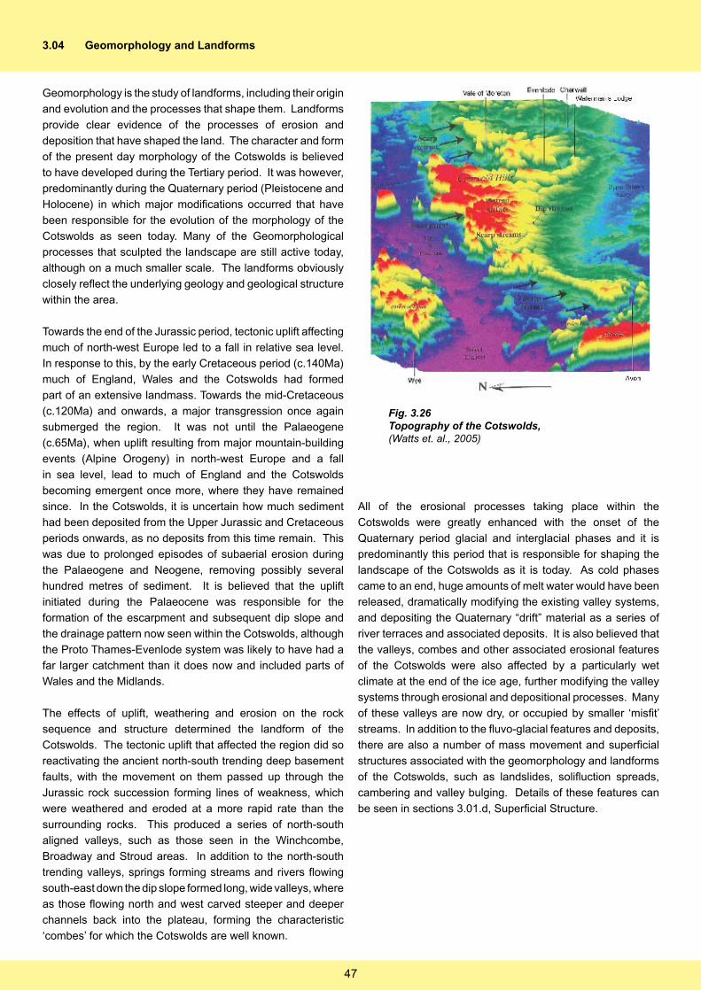
3.04 Geomorphology and Landforms
Geomorphology is the study of landforms, including their origin
and evolution and the processes that shape them. Landforms
provide clear evidence of the processes of erosion and
deposition that have shaped the land. The character and form
of the present day morphology of the Cotswolds is believed
to have developed during the Tertiary period. It was however,
predominantly during the Quaternary period (Pleistocene and
Holocene) in which major modifications occurred that have
been responsible for the evolution of the morphology of the
Cotswolds as seen today. Many of the Geomorphological
processes that sculpted the landscape are still active today,
although on a much smaller scale. The landforms obviously
closely reflect the underlying geology and geological structure
within the area.
Towards the end of the Jurassic period, tectonic uplift affecting
much of north-west Europe led to a fall in relative sea level.
In response to this, by the early Cretaceous period (c.140Ma)
much of England, Wales and the Cotswolds had formed
part of an extensive landmass. Towards the mid-Cretaceous
(c.120Ma) and onwards, a major transgression once again
submerged the region. It was not until the Palaeogene
(c.65Ma), when uplift resulting from major mountain-building
events (Alpine Orogeny) in north-west Europe and a fall
in sea level, lead to much of England and the Cotswolds
becoming emergent once more, where they have remained
since. In the Cotswolds, it is uncertain how much sediment
had been deposited from the Upper Jurassic and Cretaceous
periods onwards, as no deposits from this time remain. This
was due to prolonged episodes of subaerial erosion during
the Palaeogene and Neogene, removing possibly several
hundred metres of sediment. It is believed that the uplift
initiated during the Palaeocene was responsible for the
formation of the escarpment and subsequent dip slope and
the drainage pattern now seen within the Cotswolds, although
the Proto Thames-Evenlode system was likely to have had a
far larger catchment than it does now and included parts of
Wales and the Midlands.
The effects of uplift, weathering and erosion on the rock
sequence and structure determined the landform of the
Cotswolds. The tectonic uplift that affected the region did so
reactivating the ancient north-south trending deep basement
faults, with the movement on them passed up through the
Jurassic rock succession forming lines of weakness, which
were weathered and eroded at a more rapid rate than the
surrounding rocks. This produced a series of north-south
aligned valleys, such as those seen in the Winchcombe,
Broadway and Stroud areas. In addition to the north-south
trending valleys, springs forming streams and rivers flowing
south-east down the dip slope formed long, wide valleys, where
as those flowing north and west carved steeper and deeper
channels back into the plateau, forming the characteristic
‘combes’ for which the Cotswolds are well known.
All of the erosional processes taking place within the
Cotswolds were greatly enhanced with the onset of the
Quaternary period glacial and interglacial phases and it is
predominantly this period that is responsible for shaping the
landscape of the Cotswolds as it is today. As cold phases
came to an end, huge amounts of melt water would have been
released, dramatically modifying the existing valley systems,
and depositing the Quaternary “drift” material as a series of
river terraces and associated deposits. It is also believed that
the valleys, combes and other associated erosional features
of the Cotswolds were also affected by a particularly wet
climate at the end of the ice age, further modifying the valley
systems through erosional and depositional processes. Many
of these valleys are now dry, or occupied by smaller ‘misfit’
streams. In addition to the fluvo-glacial features and deposits,
there are also a number of mass movement and superficial
structures associated with the geomorphology and landforms
of the Cotswolds, such as landslides, solifluction spreads,
cambering and valley bulging. Details of these features can
be seen in sections 3.01.d, Superficial Structure.
Fig. 3.26Topography of the Cotswolds,(Watts et. al., 2005)
47
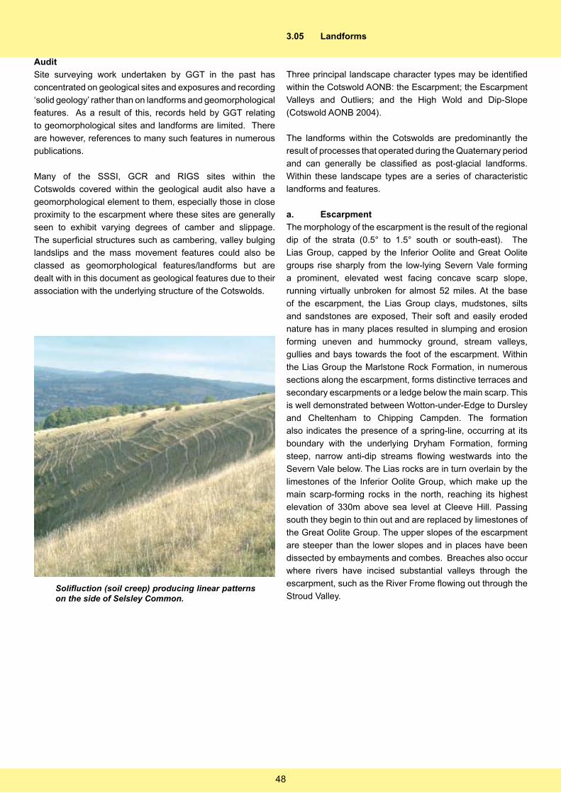
Audit
Site surveying work undertaken by GGT in the past has
concentrated on geological sites and exposures and recording
‘solid geology’ rather than on landforms and geomorphological
features. As a result of this, records held by GGT relating
to geomorphological sites and landforms are limited. There
are however, references to many such features in numerous
publications.
Many of the SSSI, GCR and RIGS sites within the
Cotswolds covered within the geological audit also have a
geomorphological element to them, especially those in close
proximity to the escarpment where these sites are generally
seen to exhibit varying degrees of camber and slippage.
The superficial structures such as cambering, valley bulging
landslips and the mass movement features could also be
classed as geomorphological features/landforms but are
dealt with in this document as geological features due to their
association with the underlying structure of the Cotswolds.
3.05 Landforms
Three principal landscape character types may be identified
within the Cotswold AONB: the Escarpment; the Escarpment
Valleys and Outliers; and the High Wold and Dip-Slope
(Cotswold AONB 2004).
The landforms within the Cotswolds are predominantly the
result of processes that operated during the Quaternary period
and can generally be classified as post-glacial landforms.
Within these landscape types are a series of characteristic
landforms and features.
a. Escarpment
The morphology of the escarpment is the result of the regional
dip of the strata (0.5° to 1.5° south or south-east). The
Lias Group, capped by the Inferior Oolite and Great Oolite
groups rise sharply from the low-lying Severn Vale forming
a prominent, elevated west facing concave scarp slope,
running virtually unbroken for almost 52 miles. At the base
of the escarpment, the Lias Group clays, mudstones, silts
and sandstones are exposed, Their soft and easily eroded
nature has in many places resulted in slumping and erosion
forming uneven and hummocky ground, stream valleys,
gullies and bays towards the foot of the escarpment. Within
the Lias Group the Marlstone Rock Formation, in numerous
sections along the escarpment, forms distinctive terraces and
secondary escarpments or a ledge below the main scarp. This
is well demonstrated between Wotton-under-Edge to Dursley
and Cheltenham to Chipping Campden. The formation
also indicates the presence of a spring-line, occurring at its
boundary with the underlying Dryham Formation, forming
steep, narrow anti-dip streams flowing westwards into the
Severn Vale below. The Lias rocks are in turn overlain by the
limestones of the Inferior Oolite Group, which make up the
main scarp-forming rocks in the north, reaching its highest
elevation of 330m above sea level at Cleeve Hill. Passing
south they begin to thin out and are replaced by limestones of
the Great Oolite Group. The upper slopes of the escarpment
are steeper than the lower slopes and in places have been
dissected by embayments and combes. Breaches also occur
where rivers have incised substantial valleys through the
escarpment, such as the River Frome flowing out through the
Stroud Valley. Solifluction (soil creep) producing linear patterns on the side of Selsley Common.
48
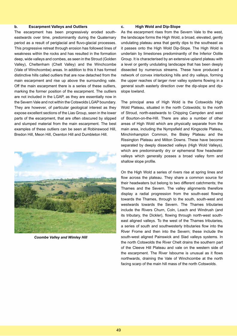
b. Escarpment Valleys and Outliers
The escarpment has been progressively eroded south-
eastwards over time, predominantly during the Quaternary
period as a result of periglacial and fluvo-glacial processes.
This progressive retreat through erosion has followed lines of
weakness within the rocks and has resulted in the formation
deep, wide valleys and combes, as seen in the Stroud (Golden
Valley), Cheltenham (Chelt Valley) and the Winchcombe
(Vale of Winchcombe) areas. In addition to this it has formed
distinctive hills called outliers that are now detached from the
main escarpment and rise up above the surrounding vale.
Off the main escarpment there is a series of these outliers,
marking the former position of the escarpment. The outliers
are not included in the LGAP, as they are essentially now in
the Severn Vale and not within the Cotswolds LGAP boundary.
They are however, of particular geological interest as they
expose excellent sections of the Lias Group, seen in the lower
parts of the escarpment, that are often obscured by slipped
and slumped material from the main escarpment. The best
examples of these outliers can be seen at Robinswood Hill,
Bredon Hill, Meon Hill, Oxenton Hill and Dumbleton Hill.
c. High Wold and Dip-Slope
As the escarpment rises from the Severn Vale to the west,
the landscape forms the High Wold, a broad, elevated, gently
undulating plateau area that gently dips to the southeast as
it passes onto the High Wold Dip-Slope. The High Wold is
underlain by limestones predominantly of the Inferior Oolite
Group. It is characterised by an extensive upland plateau with
a level or gently undulating landscape that has been deeply
dissected by numerous streams. These have produced a
network of convex interlocking hills and dry valleys, forming
the upper reaches of larger river valley systems flowing in a
general south easterly direction over the dip-slope and dip-
slope lowland.
The principal area of High Wold is the Cotswolds High
Wold Plateau, situated in the north Cotswolds; to the north
of Stroud, north-eastwards to Chipping Campden and west
of Bourton-on-the-Hill. There are also a number of other
areas of High Wold which are physically separate from the
main area, including the Nympsfield and Kingscote Plateau,
Minchinhampton Common, the Bisley Plateau and the
Rissington Plateau and Milton Downs. These have become
separated by deeply dissected valleys (High Wold Valleys),
which are predominantly dry or ephemeral flow headwater
valleys which generally posses a broad valley form and
shallow slope profile.
On the High Wold a series of rivers rise at spring lines and
flow across the plateau. They share a common source for
their headwaters but belong to two different catchments; the
Thames and the Severn. The valley alignments therefore
display a radial progression from the south-east flowing
towards the Thames, through to the south, south-west and
westwards towards the Severn. The Thames tributaries
include the Rivers Churn, Coln, Leach and Windrush (and
its tributary, the Dickler), flowing through north-west south-
east aligned valleys. To the west of the Thames tributaries,
a series of south and southwesterly tributaries flow into the
River Frome and then into the Severn; these include the
south-west aligned Painswick and Slad valleys systems. In
the north Cotswolds the River Chelt drains the southern part
of the Cleeve Hill Plateau and vale on the western side of
the escarpment. The River Isbourne is unusual as it flows
northwards, draining the Vale of Winchcombe at the north
facing scarp of the main hill mass of the north Cotswolds.
Coombe Valley and Wimley Hill
49
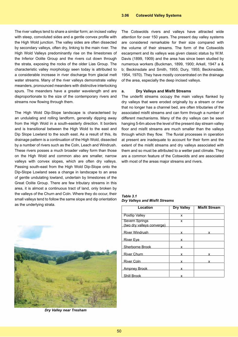
The river valleys tend to share a similar form; an incised valley
with steep, convoluted sides and a gentle convex profile with
the High Wold junction. The valley sides are often dissected
by secondary valleys, often dry, linking to the main river. The
High Wold Valleys predominantly rise on the limestones of
the Inferior Oolite Group and the rivers cut down through
the strata, exposing the rocks of the older Lias Group. The
characteristic valley morphology seen today is attributed to
a considerable increase in river discharge from glacial melt
water streams. Many of the river valleys demonstrate valley
meanders, pronounced meanders with distinctive interlocking
spurs. The meanders have a greater wavelength and are
disproportionate to the size of the contemporary rivers and
streams now flowing through them.
The High Wold Dip-Slope landscape is characterised by
an undulating and rolling landform, generally dipping away
from the High Wold in a south-easterly direction. It borders
and is transitional between the High Wold to the east and
Dip Slope Lowland to the south east. As a result of this, its
drainage pattern is a continuation of the High Wold, dissected
by a number of rivers such as the Coln, Leach and Windrush.
These rivers posses a much broader valley form than those
on the High Wold and common also are smaller, narrow
valleys with convex slopes, which are often dry valleys.
Passing south-east from the High Wold Dip-Slope onto the
Dip-Slope Lowland sees a change in landscape to an area
of gentle undulating lowland, underlain by limestones of the
Great Oolite Group. There are few tributary streams in this
area, it is almost a continuous tract of land, only broken by
the valleys of the Churn and Coln. Where they do occur, their
small valleys tend to follow the same slope and dip orientation
as the underlying strata.
3.06 Cotswold Valley Systems
The Cotswolds rivers and valleys have attracted wide
attention for over 150 years. The present day valley systems
are considered remarkable for their size compared with
the volume of their streams. The form of the Cotswolds
escarpment and its valleys was given classic status by W.M.
Davis (1899, 1909) and the area has since been studied by
numerous workers (Buckman, 1899, 1900; Arkell, 1947 a &
b; Beckinsdale and Smith, 1955; Dury, 1955; Beckinsdale,
1954, 1970). They have mostly concentrated on the drainage
of the area, especially the deep incised valleys.
a. Dry Valleys and Misfit Streams
The underfit streams occupy the main valleys flanked by
dry valleys that were eroded originally by a stream or river
that no longer has a channel bed, are often tributaries of the
associated misfit streams and can form through a number of
different mechanisms. Many of the dry valleys can be seen
hanging 5-6m above the level of the present day stream valley
floor and misfit streams are much smaller than the valleys
through which they flow. The fluvial processes in operation
at present are inadequate to account for their form and the
extent of the misfit streams and dry valleys associated with
them and so must be attributed to a wetter past climate. They
are a common feature of the Cotswolds and are associated
with most of the areas major streams and rivers.
Location Dry Valley Misfit Stream
Postlip Valley x
Severn Springs (two dry valleys converge)
x
River Windrush x x
River Eye x
Sherborne Brook x
River Churn x x
River Coln x x
Ampney Brook x
Shill Brook x
Table 3.1Dry Valleys and Misfit Streams
Dry Valley near Tresham
50
b. Valley Meanders and Abandoned Meanders
Valley meanders and to a lesser extent abandoned meanders
are well developed in the Cotswold river valleys and the
majority are occupied by modern smaller misfit streams.
A number of rivers also have abandoned meanders, their
course has been shortened by cutting across the neck of the
meander loop. A good example of this can be seen in the
valley of the River Windrush to the south of Bourton-on-the-
Water. Meanders and abandoned meanders are developed
along much of the courses of the principal rivers.
Valley / River Valley Meanders Abandoned Meander
Windrush x x
Leach x
Evenlode x x
Coln x x
Cam x
Shill Brook x
Table 3.2Valley Meanders and Abandoned Meanders
c. Wind Gaps
Wind gaps are relatively scarce in the Cotswolds. They are
found at the heads of four of the Cotswolds main rivers; the
Windrush, Coln, Churn and Frome. They mark through valleys
that were originally occupied by sizable streams which have
been beheaded by subsequent streams developed ahead of
the escarpment. They are now dry in their uppermost sections
and often contain small misfit streams in their lower courses.
Location Source
Oat Hill At head of Windrush Valley
Stumps Cross Windrush Valley
Lyne’s Barn Farm At head of tributary valley of the Windrush
Charlton Abbots At head of Coln Valley
Andoversford At head of tributary valley of the Coln
Severn Springs At head of Churn Valley
Sapperton Between the Frome and Thameshead
Charlton Kings At head of tributary valley of the Chelt
Table 3.3Wind Gaps
3.07 Karstic Forms
The Cotswolds is not a region well known for its development
of karstic forms. Some karstic features can be found,
especially the fluvio-karst forms of dry valleys (see above) and
sink holes. Many of the dip-slope streams of the Cotswolds
have discontinuous drainage with underground courses, for
example, the Leach, Shill Brook and Ampney Brook (Gouldie
et al., 1980). Arkell (1947) and Richardson et al (1946) refer
to ‘swilly holes’ (swallow holes) at numerous locations within
the Cotswolds.
Location Sink Hole
Underground Channel
Developed on
Waterman’s Lodge x Base of Forest Marble Fm.
Coombe & Ramsden Heath
x Oxford Clay Fm.
Severn Springs (New Farm)
x Fullers’ Earth Fm.
Cleeve Hill x x Inferior Oolite Gp.
Stanway x Inferior Oolite Gp.
Withington x Inferior Oolite Gp.
Sturt Farm (3 locations)
x(3)
Shill Brook Valley x
Blockley x(2) Inferior Oolite Gp.
Table 3.4Karstic Forms
Summary
The Cotswolds are a classic escarpment/dip-slope terrain,
developed on the gently dipping Jurassic strata. The
outstanding natural beauty and scenic geodiversity of
the Cotswolds is the result of the underlying structure, the
juxtaposition of the different rock types, their variations
in permeability and the geological and geomorphological
process that have acted on them. All these factors account
for the form of the escarpment, plateau, valleys and lowlands,
the drainage patterns and the nature and location of mass
movement features.
51
APPENDICES TO SECTION 3
GEODIVERSITY AUDIT
APPENDIX 1: Site Stratigrphy
APPENDIX 2: Site Inventory
52

53
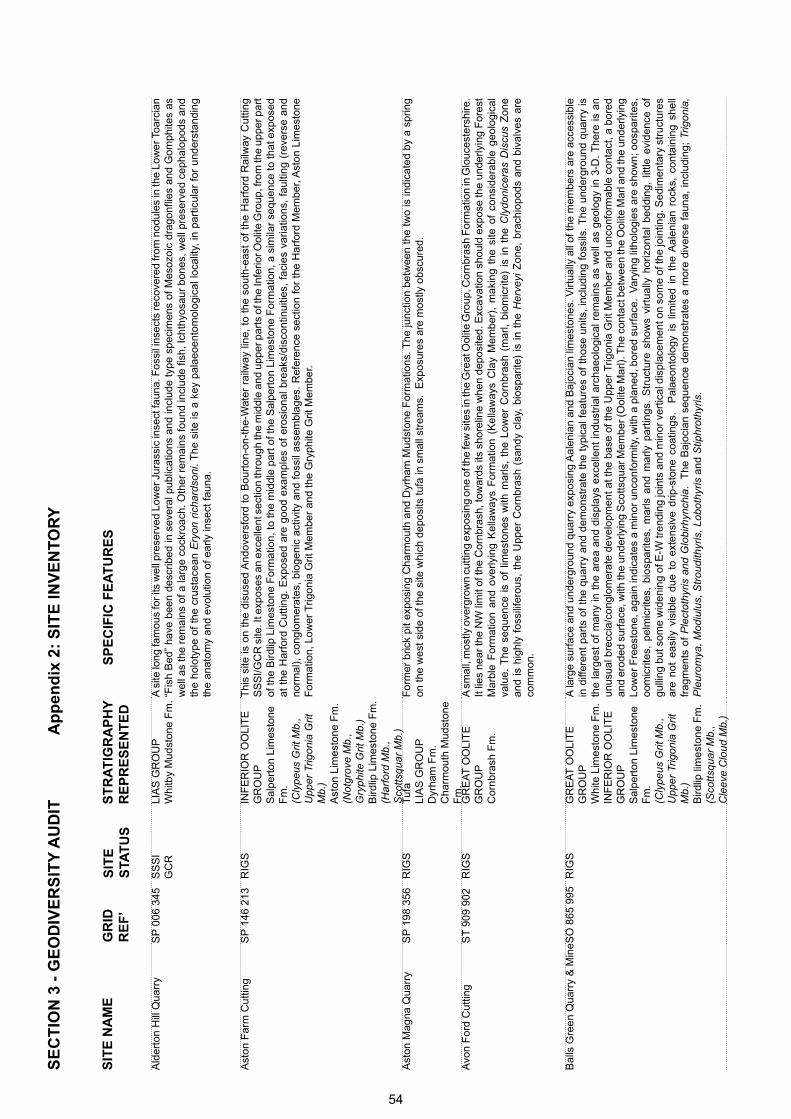
Ald
erto
n H
ill Q
uarr
yS
P 0
06 3
45S
SS
I
GC
RLI
AS
GR
OU
PW
hitb
y M
udst
one
Fm
. A
site
long
fam
ous
for i
ts w
ell p
rese
rved
Low
er J
uras
sic
inse
ct fa
una.
Fos
sil i
nsec
ts re
cove
red
from
nod
ules
in th
e Lo
wer
Toa
rcia
n “F
ish
Bed
” ha
ve b
een
desc
ribed
in s
ever
al p
ublic
atio
ns a
nd in
clud
e ty
pe s
peci
men
s of
Mes
ozoi
c dr
agon
flies
and
Gom
phite
s as
w
ell a
s th
e re
mai
ns o
f a la
rge
cock
roac
h. O
ther
rem
ains
foun
d in
clud
e fis
h, Ic
hthy
osau
r bo
nes,
wel
l pre
serv
ed c
epha
lopo
ds a
nd
the
holo
type
of
the
crus
tace
an E
ryon
ric
hard
soni
. T
he s
ite is
a k
ey p
alae
oent
omol
ogic
al lo
calit
y, in
par
ticul
ar f
or u
nder
stan
ding
th
e an
atom
y an
d ev
olut
ion
of e
arly
inse
ct fa
una.
Ast
on F
arm
Cut
ting
SP
146
213
RIG
SIN
FE
RIO
R O
OLI
TE
G
RO
UP
Sal
pert
on L
imes
tone
F
m.
(Cly
peus
Grit
Mb.
, U
pper
Trig
onia
Grit
M
b.)
Ast
on L
imes
tone
Fm
.(N
otgr
ove
Mb.
, G
ryph
ite G
rit M
b.)
Bird
lip L
imes
tone
Fm
.(H
arfo
rd M
b.,
Sco
ttsqu
ar M
b.)
Thi
s si
te is
on
the
disu
sed
And
over
sfor
d to
Bou
rton
-on-
the-
Wat
er r
ailw
ay li
ne,
to t
he s
outh
-eas
t of
the
Har
ford
Rai
lway
Cut
ting
SS
SI/G
CR
site
. It e
xpos
es a
n ex
celle
nt s
ectio
n th
roug
h th
e m
iddl
e an
d up
per p
arts
of t
he In
ferio
r Ool
ite G
roup
, fro
m th
e up
per p
art
of th
e B
irdlip
Lim
esto
ne F
orm
atio
n, to
the
mid
dle
part
of t
he S
alpe
rton
Lim
esto
ne F
orm
atio
n, a
sim
ilar
sequ
ence
to th
at e
xpos
ed
at t
he H
arfo
rd C
uttin
g. E
xpos
ed a
re g
ood
exam
ples
of
eros
iona
l bre
aks/
disc
ontin
uitie
s, f
acie
s va
riatio
ns,
faul
ting
(rev
erse
and
no
rmal
), c
ongl
omer
ates
, bi
ogen
ic a
ctiv
ity a
nd f
ossi
l ass
embl
ages
. R
efer
ence
sec
tion
for
the
Har
ford
Mem
ber,
Ast
on L
imes
tone
F
orm
atio
n, L
ower
Trig
onia
Grit
Mem
ber
and
the
Gry
phite
Grit
Mem
ber.
Ast
on M
agna
Qua
rry
SP
198
356
RIG
ST
ufa
LI
AS
GR
OU
PD
yrha
m F
m.
Cha
rmou
th M
udst
one
Fm
.
For
mer
bric
k pi
t ex
posi
ng C
harm
outh
and
Dyr
ham
Mud
ston
e F
orm
atio
ns. T
he ju
nctio
n be
twee
n th
e tw
o is
indi
cate
d by
a s
prin
g on
the
wes
t sid
e of
the
site
whi
ch d
epos
its tu
fa in
sm
all s
trea
ms.
Exp
osur
es a
re m
ostly
obs
cure
d.
Avo
n F
ord
Cut
ting
ST
909
902
RIG
SG
RE
AT
OO
LIT
E
GR
OU
PC
ornb
rash
Fm
.
A s
mal
l, m
ostly
ove
rgro
wn
cutti
ng e
xpos
ing
one
of th
e fe
w s
ites
in th
e G
reat
Ool
ite G
roup
, Cor
nbra
sh F
orm
atio
n in
Glo
uces
ters
hire
. It
lies
near
the
NW
lim
it of
the
Cor
nbra
sh, t
owar
ds it
s sh
orel
ine
whe
n de
posi
ted.
Exc
avat
ion
shou
ld e
xpos
e th
e un
derly
ing
For
est
Mar
ble
For
mat
ion
and
over
lyin
g K
ella
way
s F
orm
atio
n (K
ella
way
s C
lay
Mem
ber)
, m
akin
g th
e si
te o
f co
nsid
erab
le g
eolo
gica
l va
lue.
The
seq
uenc
e is
of
limes
tone
s w
ith m
arls
, th
e Lo
wer
Cor
nbra
sh (
mar
l, bi
omic
rite)
is
in t
he C
lydo
nice
ras
Dis
cus
Zon
e an
d is
hig
hly
foss
ilife
rous
, th
e U
pper
Cor
nbra
sh (
sand
y cl
ay,
bios
parit
e) i
s in
the
Her
veyi
Zon
e, b
rach
iopo
ds a
nd b
ival
ves
are
com
mon
.
Bal
ls G
reen
Qua
rry
& M
ineS
O 8
65 9
95R
IGS
GR
EA
T O
OLI
TE
G
RO
UP
Whi
te L
imes
tone
Fm
. IN
FE
RIO
R O
OLI
TE
G
RO
UP
Sal
pert
on L
imes
tone
F
m.
(Cly
peus
Grit
Mb.
,
Upp
er T
rigon
ia G
rit
Mb.
) B
irdlip
lim
esto
ne F
m.
(Sco
ttsqu
ar M
b.,
Cle
eve
Clo
ud M
b.)
A la
rge
surf
ace
and
unde
rgro
und
quar
ry e
xpos
ing
Aal
enia
n an
d B
ajoc
ian
limes
tone
s. V
irtua
lly a
ll of
the
mem
bers
are
acc
essi
ble
in d
iffer
ent
part
s of
the
qua
rry
and
dem
onst
rate
the
typ
ical
fea
ture
s of
tho
se u
nits
, in
clud
ing
foss
ils.
The
und
ergr
ound
qua
rry
is
the
larg
est
of m
any
in t
he a
rea
and
disp
lays
exc
elle
nt in
dust
rial a
rcha
eolo
gica
l rem
ains
as
wel
l as
geol
ogy
in 3
-D.
The
re is
an
unus
ual b
recc
ia/c
ongl
omer
ate
deve
lopm
ent a
t the
bas
e of
the
Upp
er T
rigon
ia G
rit M
embe
r an
d un
conf
orm
able
con
tact
, a b
ored
an
d er
oded
sur
face
, with
the
unde
rlyin
g S
cotts
quar
Mem
ber (
Ool
ite M
arl).
The
con
tact
bet
wee
n th
e O
olite
Mar
l and
the
unde
rlyin
g Lo
wer
Fre
esto
ne, a
gain
indi
cate
s a
min
or u
ncon
form
ity, w
ith a
pla
ned,
bor
ed s
urfa
ce.
Var
ying
lith
olog
ies
are
show
n; o
ospa
rites
, oo
mic
rites
, pe
lmic
rites
, bi
ospa
rites
, m
arls
and
mar
ly p
artin
gs.
Str
uctu
re s
how
s vi
rtua
lly h
oriz
onta
l be
ddin
g, l
ittle
evi
denc
e of
gu
lling
but
som
e w
iden
ing
of E
-W tr
endi
ng jo
ints
and
min
or v
ertic
al d
ispl
acem
ent o
n so
me
of th
e jo
intin
g. S
edim
enta
ry s
truc
ture
s ar
e no
t ea
sily
vis
ible
due
to
exte
nsiv
e dr
ip-s
tone
coa
tings
. P
alae
onto
logy
is
limite
d in
the
Aal
enia
n ro
cks,
con
tain
ing
shel
l fr
agm
ents
of
Ple
ctot
hyris
and
Glo
birh
ynch
ia.
The
Baj
ocia
n se
quen
ce d
emon
stra
tes
a m
ore
dive
rse
faun
a, in
clud
ing;
Trig
onia
, P
leur
omya
, Mod
iulu
s, S
trou
dith
yris
, Lob
othy
ris a
nd S
tiphr
othy
ris.
SIT
E N
AM
ES
PE
CIF
IC F
EA
TU
RE
SS
ITE
S
TAT
US
GR
ID
RE
F’
ST
RA
TIG
RA
PH
YR
EP
RE
SE
NT
ED
SE
CT
ION
3 -
GE
OD
IVE
RS
ITY
AU
DIT
Ap
pen
dix
2:
SIT
E IN
VE
NT
OR
Y
54
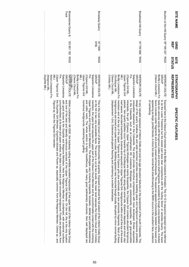
SIT
E N
AM
ES
PE
CIF
IC F
EA
TU
RE
SS
ITE
S
TAT
US
GR
ID
RE
F’
ST
RA
TIG
RA
PH
YR
EP
RE
SE
NT
ED
Bourton on the H
ill Quarry
SP
169 327R
IGS
INF
ER
IOR
OO
LITE
G
RO
UP
Birdlip Lim
estone Fm
(Cleeve C
loud Mb.)
Exposed here is the C
leeve Cloud m
ember of the B
irdlip Limestone F
ormation. T
he 10-12 m sequence exposed can be referred
to as the Lower F
reestone but the lowest part does bear com
parisons with the ‘G
uiting Stone’ of Jackdaw
Quarry. T
he lower
beds are variously sandy with ferruginous oolites and som
e shell fragments, succeeded by trough cross-bedded oolites. A
limited
fauna includes oyster fragments and poorly preserved brachiopods. T
he sequence appears horizontally bedded; the lowest unit
appearing as large, jointed blocks. A m
inor but clear normal fault dow
nthrowing to the N
NW
occurs in the southern face, evidence of cam
bering.
Breakheart H
ill Quarry
ST
755 968R
IGS
INF
ER
IOR
OO
LITE
G
RO
UP
Salperton Lim
estone F
m.
(Clypeus G
rit Mb.,
Upper Trigonia G
rit M
b.)B
irdlip Limestone F
m.
(Scottsquar M
b., C
leeve Cloud M
b., C
rickley Mb.)
A very valuable exposure of Inferior O
olite and post ice-age disruption features on the escarpment of the south C
otswolds. T
he design of the quarry (shallow
lifts and wide benches) provides extensive bedding plane and hardground exposures probably
unequalled elsewhere in the C
otswolds. T
he strata provide instructive comparisons w
ith more developed, thicker sequences
in the Cotsw
olds, such as at Leckhampton H
ill. Limestone lithologies vary; predom
inantly oosparites, with granule/cobble
intraclasts, the grit (Clypeus, U
pper Trigonia) lithologies are m
ainly biosparites, the Clypeus G
rit contains abundant ferrginous peloids. V
ein quartz pebbles occur towards top of S
cottsquar Mem
ber along with som
e tufa, dripstone deposits and minor clay/
marl seam
s. Abundant brachiopods, bivalves and serpulids in U
pper Trigonia G
rit. Hardgrounds w
ithin and at the top of the lower
mem
bers and at the top of the Upper T
rigonia and Clypeus grits plus echinoids and rare am
monite fragm
ents. Most of these
hardgrounds are bored and oyster-encrusted. Bedding appears near horizontal though locally disrupted by m
inor normal faulting
(displacement 1-2m
). Extensive post-glacial fissuring and cam
bering is evident downslope.
Broadw
ay Quarry
ST
7490 9790
RIG
SIN
FE
RIO
R O
OLIT
E
GR
OU
PS
alperton Limestone
Fm
.(C
lypeus Grit M
b., U
pper Trigonia Grit
Mb.)
Birdlip Lim
estone Fm
(Cleeve C
loud Mb.,
Crickley M
b.)
This is the m
ost widely know
n of all the Stinchcom
be Hill quarries. E
xposed is almost the full extent of the Inferior O
olite Group
on the hill in two very accessible faces. T
he quarry is cut at two levels: the low
er level exposes the Cleeve C
loud and Crickley
mem
bers, the upper level exposes the upper part of the Cleeve C
loud Mem
ber and its unconformable contact w
ith the overlying U
pper Trigonia and C
lypeus Grit M
embers. T
he lithologies vary including oosparite, bioclastic, detrital and peloidal limestones
and oolitic marls. T
he whole section is highly fossiliferous, w
ith many good sedim
entary structures. Also w
ell displayed are num
erous hardgrounds, cambering and gulling.
Brow
nstones Quarry &
T
rackS
O 951 182
RIG
SIN
FE
RIO
R O
OLIT
E
GR
OU
PS
alperton Limestone
Fm
.(U
pper Trigonia Grit
Mb.)
Aston Lim
estone Fm
. (N
otgrove Mb.,
Gryphite M
b.)
Within Leckham
pton Hill S
SS
I, the trackway cutting exhibits excellent exposures of the upper beds of the Inferior O
olite Group
and one of the best and laterally continuous outcrops of the Upper T
rigonia Grit M
ember. O
n the hill, this is the only location w
ith good access to the Gryphite and N
otgrove Mem
bers. Here the N
otgrove Mem
ber is condensed, with erosional surfaces
(unconformities) at its base and upper surface, the latter a bored and oyster encrusted hardground. F
ossils are abundant, from
the Gryphite G
rit Mem
ber, Gryphaea bilobata and P
ecten sp. especially comm
on; from the N
otgrove Mem
ber; Ostrea sp.; and
Trigonia sp. from the T
rigonia Grit m
ember.
55
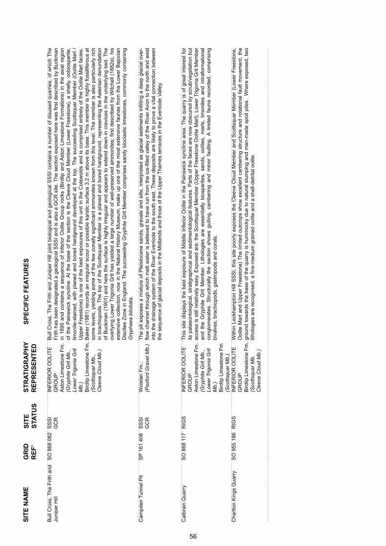
SIT
E N
AM
ES
PE
CIF
IC F
EA
TU
RE
SS
ITE
S
TAT
US
GR
ID
RE
F’
ST
RA
TIG
RA
PH
YR
EP
RE
SE
NT
ED
Bul
l Cro
ss, T
he F
rith
and
Juni
per
Hill
SO
868
082
SS
SI
G
CR
INF
ER
IOR
OO
LIT
E
GR
OU
PA
ston
Lim
esto
ne F
m.
(Gry
phite
Grit
Mb.
, Lo
wer
Trig
onia
Grit
M
b.)
Bird
lip L
imes
tone
Fm
.(S
cotts
quar
Mb.
, C
leev
e C
loud
Mb.
)
Bul
l Cro
ss,
The
Frit
h an
d Ju
nipe
r H
ill jo
int
biol
ogic
al a
nd g
eolo
gica
l SS
SI
cont
ains
a n
umbe
r of
dis
used
qua
rrie
s, o
f w
hich
The
F
rith
has
been
des
igna
ted
a ge
olog
ical
SS
SI a
nd is
als
o a
GC
R s
ite. T
he s
ectio
n ex
pose
d he
re w
as fi
rst d
escr
ibed
by
Buc
kman
in
189
5 an
d co
ntai
ns a
seq
uenc
e of
Inf
erio
r O
olite
Gro
up r
ocks
(B
irdlip
and
Ast
on L
imes
tone
For
mat
ions
) in
the
axi
al r
egio
n of
the
Pai
nsw
ick
sync
line.
At
the
base
of
the
sect
ion
is t
he C
leev
e C
loud
Mem
ber
(Low
er F
rees
tone
), a
she
lly,
oobi
ospa
rite,
lim
onite
-sta
ined
, w
ith p
lane
d an
d bo
red
hard
grou
nd d
evel
oped
at
the
top.
The
suc
ceed
ing
Sco
ttsqu
ar M
embe
r (O
olite
Mar
l /
Upp
er F
rees
tone
) is
one
of
the
best
exp
osur
es o
f th
is u
nit
in t
he C
otsw
olds
and
is c
ompr
ised
ent
irely
of
the
Ool
ite M
arl f
acie
s.
Bak
er (
1981
) re
cord
s an
irre
gula
r sc
our
or p
ossi
ble
kars
tic s
urfa
ce 3
.2 m
abo
ve it
s ba
se.
Thi
s m
embe
r is
hig
hly
foss
ilife
rous
at
som
e le
vels
, yi
eldi
ng s
ome
of t
he f
ew z
onal
ly s
igni
fican
t am
mon
ites
know
n fr
om t
his
leve
l. T
he m
embe
r is
als
o pa
rtic
ular
ly r
ich
in b
rach
iopo
ds.
The
top
of
the
Sco
ttsqu
ar M
embe
r is
a p
lane
d an
d bo
red
hard
grou
nd,
repr
esen
ting
the
Aal
enia
n de
nund
atio
n of
Buc
kman
(19
01)
and
here
the
sur
face
is h
ighl
y irr
egul
ar a
nd a
ppea
rs t
o ex
tend
dow
n in
cre
vice
s in
the
und
erly
ing
bed.
The
ov
erly
ing
Low
er T
rigon
ia G
rit h
as y
ield
ed a
larg
e nu
mbe
r of
wel
l-pre
serv
ed a
mm
onite
s; fi
rst
desc
ribed
by
Witc
hell
(188
2a),
his
ex
tens
ive
colle
ctio
n, n
ow in
the
Nat
ural
His
tory
Mus
eum
, m
ake
up o
ne o
f th
e m
ost
exte
nsiv
e fa
unas
fro
m t
he L
ower
Baj
ocia
n D
isci
tes
Zon
e in
Eng
land
. T
he s
ucce
edin
g G
ryph
ite G
rit M
embe
r co
mpr
ises
san
dy b
iocl
astic
lim
esto
nes,
com
mon
ly c
onta
inin
g G
ryph
aea
bilo
bata
.
Cam
pden
Tun
nel P
it S
P 1
61 4
08S
SS
I
GC
RW
olst
an F
m.:
(Pax
ford
Gra
vel M
b.)
The
pit
expo
ses
a m
ixtu
re o
f P
leis
toce
ne s
ands
, gr
avel
s an
d si
lts,
inte
rpre
ted
as g
laci
al s
edim
ents
infil
ling
a de
ep g
laci
al o
ver-
flow
cha
nnel
thr
ough
whi
ch m
elt
wat
er is
bel
ieve
d to
hav
e ru
n fr
om t
he ic
e-fil
led
valle
y of
the
Riv
er A
von
to t
he n
orth
and
wes
t in
to t
he d
rain
age
syst
em o
f th
e R
iver
Eve
nlod
e to
the
sou
th e
ast.
The
se d
epos
its a
re li
kely
to
prov
e a
vita
l con
nect
ion
betw
een
the
sequ
ence
of g
laci
al d
epos
its in
the
Mid
land
s an
d th
ose
of th
e U
pper
Tha
mes
terr
aces
in th
e E
venl
ode
Val
ley.
Cat
brai
n Q
uarr
yS
O 8
68 1
17R
IGS
INF
ER
IOR
OO
LIT
E
GR
OU
PA
ston
Lim
esto
ne F
m.
(Gry
phite
Grit
Mb.
, Lo
wer
Trig
onia
Grit
M
b.)
Bird
lip L
imes
tone
Fm
(Sco
ttsqu
ar M
b.)
Thi
s si
te d
ispl
ays
the
best
exp
osur
e of
Mid
dle
Infe
rior
Ool
ite in
the
Pai
nsw
ick
sync
line
area
. T
he q
uarr
y is
of
grea
t in
tere
st f
or
its p
alae
onto
logi
cal,
stra
tigra
phic
al a
nd s
edim
ento
logi
cal f
eatu
res.
Par
ts o
f th
e fa
ces
are
now
obs
cure
d by
scr
ub/v
eget
atio
n bu
t ac
cess
is s
till r
elat
ivel
y ea
sy.
Exp
osed
are
: th
e S
cotts
quar
Mem
ber
(Upp
er F
rees
tone
Ool
ite M
arl),
Low
er T
rigon
ia G
rit M
embe
r an
d th
e G
ryph
ite G
rit M
embe
r. Li
thol
ogie
s ar
e es
sent
ially
bio
spar
ites,
san
ds,
oolit
es,
mar
ls,
limon
ites
and
intr
afor
mat
iona
l co
nglo
mer
ates
. S
truc
tura
lly t
he s
ectio
n sh
ows
gulli
ng,
cam
berin
g an
d m
inor
fau
lting
. A
lim
ited
faun
a re
cord
ed,
com
pris
ing
biva
lves
, bra
chio
pods
, gas
trop
ods
and
cora
ls.
Cha
rlton
Kin
gs Q
uarr
y S
O 9
55 1
86R
IGS
INF
ER
IOR
OO
LIT
E
GR
OU
PB
irdlip
Lim
esto
ne F
m.
(Sco
ttsqu
ar M
b.
Cle
eve
Clo
ud M
b.)
With
in L
eckh
ampt
on H
ill S
SS
I, th
is s
ite p
oorly
exp
oses
the
Cle
eve
Clo
ud M
embe
r an
d S
cotts
quar
Mem
ber
(Low
er F
rees
tone
, O
olite
Mar
l and
Upp
er F
rees
tone
) T
he li
mite
d ou
tcro
ps s
how
exc
elle
nt c
ambe
ring
stru
ctur
e an
d ro
tatio
nal f
ault
mov
emen
t, th
e gr
ound
tow
ards
the
bas
e of
the
qua
rry
is h
umm
ocky
due
to
natu
ral s
lum
ping
and
man
-mad
e sp
oil p
iles.
W
here
exp
osed
, tw
o lit
holo
gies
are
rec
ogni
sed,
a fi
ne-m
ediu
m g
rain
ed o
olite
and
a s
hell-
detr
ital o
olite
.
56
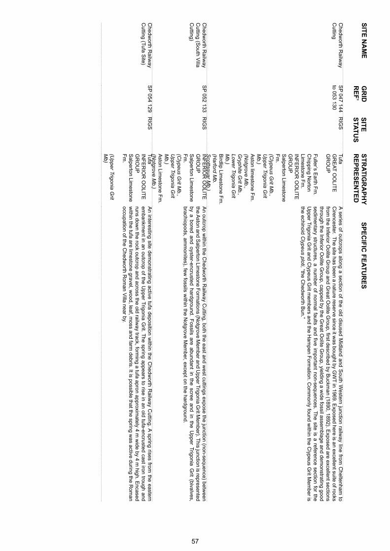
SIT
E N
AM
ES
PE
CIF
IC F
EA
TU
RE
SS
ITE
S
TAT
US
GR
ID
RE
F’
ST
RA
TIG
RA
PH
YR
EP
RE
SE
NT
ED
Chedw
orth Railw
ay C
utting S
P 047 144
to 053 130R
IGS
Tufa
GR
EA
T O
OLIT
E
GR
OU
P
F
uller’s Earth F
m.
Chipping N
orton Lim
estone Fm
.IN
FE
RIO
R O
OLIT
E
GR
OU
PS
alperton Limestone
Fm
. (C
lypeus Grit M
b., U
pper Trigonia Grit
Mb.)
Aston lim
estone Fm
.(N
otgrove Mb.,
Gryphite G
rit Mb.,
Lower Trigonia G
rit M
b.)B
irdlip Limestone F
m.
(Harford M
b. S
cottsquar Mb.)
A series of outcrops along a section of the old disused M
idland and South W
estern junction railway line from
Cheltenham
to C
irencester. The site has been a nature reserve since it w
as bought by GW
T in 1969. E
xposed here is an excellent suite of rocks from
the Inferior Oolite G
roup and Great O
olite Group, first described by B
uckman (1890, 1892). E
xposed are excellent sections through the Inferior O
olite Group, capped by the G
reat Oolite G
roup, yielding a wide fossil assem
blage and demonstrating good
sedimentary structures, a num
ber of normal faults and five im
portant non-sequences. The site is a reference section for the
Upper T
rigonia Grit and C
lypeus Grit m
embers and the H
ampen F
ormation. C
omm
only found within the C
lypeus Grit M
ember is
the echinoid Clypeus ploti, “the C
hedworth B
un.”
Chedw
orth Railw
ay C
utting (South V
illa C
utting)
SP
052 133R
IGS
INF
ER
IOR
OO
LITE
G
RO
UP
Salperton Lim
estone F
m.
(Clypeus G
rit Mb.,
Upper Trigonia G
rit M
b.)A
ston Limestone F
m.
(Notgrove M
b.)
An outcrop w
ithin the Chedw
orth Railw
ay Cutting, both the east and w
est cuttings expose the junction (non-sequence) between
the Aston and S
alperton Limestone F
ormations (N
otgrove Mem
ber and Upper T
rigonia Grit M
ember). T
his junction is represented by a bored and oyster-encrusted hardground. F
ossils are abundant in the scree and in the Upper T
rigonia Grit (bivalves,
brachiopods, amm
onites), few fossils w
ithin the Notgrove M
ember, except on the hardground.
Chedw
orth Railw
ay C
utting (Tufa S
ite)S
P 054 129
RIG
ST
ufa IN
FE
RIO
R O
OLIT
E
GR
OU
PS
alperton Limestone
Fm
. (U
pper Trigonia Grit
Mb)
An interesting site dem
onstrating active tufa deposition within the C
hedworth R
ailway C
utting. A spring rises from
the eastern em
bankment in an outcrop of the U
pper Trigonia G
rit. The spring appears to rise in an old tufa-encrusted cast iron trough and
runs down the rock outcrop and across the old railw
ay track, forming a tufa apron approxim
ately 4 m w
ide by 4 m high. E
ncased w
ithin the tufa are limestone gravel, w
ood, leaf, moss and farm
debris. It is possible that the spring was active during the R
oman
occupation of the Chedw
orth Rom
an Villa near by.
57

SIT
E N
AM
ES
PE
CIF
IC F
EA
TU
RE
SS
ITE
S
TAT
US
GR
ID
RE
F’
ST
RA
TIG
RA
PH
YR
EP
RE
SE
NT
ED
Cle
eve
Com
mon
SO
985
255
SS
SI
INF
ER
IOR
OO
LIT
E
GR
OU
PS
alpe
rton
Lim
esto
ne
Fm
.(C
lype
us G
rit M
b.,
U
pper
Trig
onia
Grit
M
b.)
Ast
on L
imes
tone
Fm
.(R
ollin
g B
ank
Mb.
,
Not
grov
e M
b.,
G
ryph
ite G
rit M
b.)
Bird
lip L
imes
tone
Fm
.
(Har
ford
Mb.
,S
cotts
quar
Mb.
,
C
leev
e C
loud
Mb.
,
C
rickl
ey M
b.,
Leck
ham
pton
Mb.
)LI
AS
GR
OU
P
B
ridpo
rt S
and
Fm
.
W
hitb
y M
udst
one
Fm
.
Cle
eve
Hill
rep
rese
nts
the
mos
t co
mpl
ete
deve
lopm
ent
of I
nfer
ior
Ool
ite G
roup
in
the
coun
try,
atta
inin
g a
thic
knes
s of
ap
prox
imat
ely
100m
. T
he s
eque
nce
expo
sed
on t
he c
omm
on e
xten
ds f
rom
the
Lia
s G
roup
(W
hitb
y M
udst
one
For
mat
ion)
th
roug
h to
the
top
of th
e In
ferio
r O
olite
gro
up. T
he c
omm
on h
as b
een
desi
gnat
ed S
SS
I sta
tus
base
d on
its
outs
tand
ing
geol
ogic
al
and
geom
orph
olog
ical
inte
rest
as
wel
l as
its b
iolo
gica
l im
port
ance
. W
ithin
the
SS
SI
boun
dary
are
num
erou
s qu
arrie
s an
d pi
ts,
desi
gnat
ed a
s re
gion
ally
im
port
ant
geol
ogic
al s
ites
(RIG
S).
T
he g
eolo
gica
l im
port
ance
of
the
com
mon
is
as f
ollo
ws:
C
leev
e C
omm
on l
ies
on t
he a
xis
of t
he t
hick
est
sequ
ence
of
Infe
rior
Ool
ite i
n th
e co
untr
y.
It is
the
onl
y ar
ea i
n th
e C
otsw
olds
whe
re
the
full
sequ
ence
can
be
seen
(in
clud
ing
the
Rol
ling
Ban
k M
embe
r).
The
val
ley
of P
ostli
p W
arre
n sh
ows
the
best
exa
mpl
e of
“r
idge
-and
-tro
ugh”
fea
ture
s in
Gre
at B
ritai
n. A
wid
e ra
nge
of s
truc
tura
l fe
atur
es a
re d
ispl
ayed
, in
clud
ing
unco
nfor
miti
es a
nd
hard
grou
nds,
faul
ts, c
ambe
ring,
gul
ling
and
num
erou
s se
dim
enta
ry s
truc
ture
s. A
div
erse
ran
ge o
f fau
na c
an b
e fo
und
on th
e hi
ll.
In a
dditi
on to
the
SS
SI i
mpo
rtan
ce o
f the
com
mon
, the
add
ition
al R
IGS
site
s fu
rthe
r en
hanc
e th
e ge
olog
ical
impo
rtan
ce, d
iver
sity
an
d po
tent
ial f
or s
tudy
on
the
hill.
Typ
e se
ctio
n fo
r the
Rol
ling
Ban
k M
embe
r and
refe
renc
e se
ctio
n fo
r the
Cric
kley
, Cle
eve
Clo
ud,
Upp
er T
rigon
ia G
rit a
nd C
lype
us G
rit m
embe
rs.
Coa
ley
Pea
k
SO
794
008
RIG
SIN
FE
RIO
R O
OLI
TE
G
RO
UP
Bird
lip L
imes
tone
Fm
.(C
leev
e C
loud
Mb.
, C
rickl
ey M
b.,
Leck
ham
pton
Mb.
)LI
AS
GR
OU
P
Brid
port
San
d F
m.
A
G.W
.T r
eser
ve lo
cate
d on
the
edg
e of
the
sca
rp,.
The
nea
r co
mpl
ete
Infe
rior
Ool
ite G
roup
seq
uenc
e ill
ustr
ates
man
y of
the
ke
y fe
atur
es o
f ca
rbon
ate
sedi
men
tatio
n. C
onta
ins
the
prob
able
Pea
Grit
equ
ival
ent
of R
icha
rdso
n (1
910)
. I
t is
als
o th
e ty
pe
loca
lity
for
Mud
ge’s
“F
roce
ster
Hill
Ool
ite”)
. S
how
s ex
celle
nt c
ross
-bed
ded
oolit
es a
nd c
ongl
omer
atic
peb
ble
beds
and
ero
sion
al
hard
grou
nds.
Goo
d S
ciss
um a
nd C
epha
lopo
d be
ds o
utcr
ops,
yie
ldin
g be
lem
nite
s an
d am
mon
ites.
Pro
min
ent W
NW
-ES
E n
orm
al
faul
t, w
ith c
.1 m
thro
w, a
lso
a fe
w s
mal
l dis
plac
ed jo
ints
and
gul
ls.
Exc
elle
nt p
anor
amic
vie
w a
cros
s th
e R
iver
Sev
ern
and
Sev
ern
Val
e.
Coa
ley
Woo
d Q
uarr
ies
ST
786
996
SS
SI
GC
RIN
FE
RIO
R O
OLI
TE
G
RO
UP
Sal
pert
on L
imes
tone
F
m.
(Upp
er T
rigon
ia G
rit
Mb.
)B
irdlip
lim
esto
ne F
m.
(Cle
eve
Clo
ud M
b.,
Cric
kley
Mb.
,Le
ckha
mpt
on M
b.)
LIA
S G
RO
UP
B
ridpo
rt S
and
Fm
.
Thi
s si
te e
xpos
es a
goo
d se
quen
ce f
orm
the
Brid
port
San
d F
orm
atio
n to
the
Sal
pert
on L
imes
tone
For
mat
ion
(Ast
on L
imes
tone
F
orm
atio
n m
issi
ng).
A
lon
g fa
mou
s ge
olog
ical
site
for
the
abu
ndan
t Lo
wer
Jur
assi
c fo
ssils
fou
nd i
n th
e C
epha
lopo
d B
ed a
nd
Cot
tesw
old
San
ds F
orm
atio
n (B
ridpo
rt S
and
For
mat
ion)
. S
ever
al p
artic
ular
hor
izon
s ar
e es
peci
ally
not
ed f
or t
heir
amm
onite
fa
una
(str
iatu
lum
and
var
iabi
lis s
ubzo
nes)
, the
latte
r co
ntai
ning
, with
in a
thin
isol
ated
san
dsto
ne la
yer,
a ra
re a
mm
onite
, Hau
gia.
W
ell d
evel
oped
cro
ss-b
eddi
ng a
nd g
ullin
g ap
pare
nt.
The
site
is v
ery
usef
ul to
dem
onst
rate
the
succ
essi
on a
long
the
esca
rpm
ent
and
the
horiz
onta
l fac
ies
chan
ge w
ith th
e B
ajoc
ian
over
-ste
p.
58
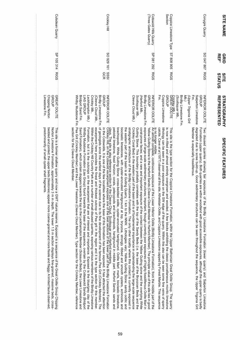
SIT
E N
AM
ES
PE
CIF
IC F
EA
TU
RE
SS
ITE
S
TAT
US
GR
ID
RE
F’
ST
RA
TIG
RA
PH
YR
EP
RE
SE
NT
ED
Conygre Q
uarryS
O 047 867
RIG
SIN
FE
RIO
R O
OLIT
E
GR
OU
PS
alperton Limestone
Fm
.(U
pper Trigonia Grit
Mb.)
Birdlip Lim
estone Fm
. (S
cottsquar Mb.,
Crickley M
b.)
Two disused quarries show
ing fair exposures of the Birdlip Lim
estone Form
ation (lower quarry) and S
alperton Limestone
Form
ation (upper quarry). Both quarries are w
ithin woodland w
ith good accessible exposures, although the upper quarry is badly degraded due to scree build-up. G
ood sedimentary structures can be seen throughout the sequence, the U
pper Trigonia G
rit M
ember is especially fossiliferous.
Coppice Lim
estone Type S
ectionS
T 808 905
RIG
SG
RE
AT
OO
LITE
G
RO
UP
Coppice Lim
estone F
m.
This site is the type section for the C
oppice Limestone F
ormation, w
ithin the Upper B
athonian Great O
olite Group. T
he quarry is now
in-filled and almost entirely overgrow
n and wooded. A
few blocks exhibiting the classic porcellaneous m
icritic limestone
lithology can be seen in a poor exposure on the SW
edge of the quarry. Within this also can be seen som
e fine veins of sparry calcite. C
ave et al (1977) observed at this site; Athelstan O
olite, and Coppice Lim
estone capped by Forest M
arble. This sequence
is no longer visible. C
otswold H
ills Quarry
(Three G
ates Quarry)
SP
081 292R
IGS
INF
ER
IOR
OO
LITE
G
RO
UP
Birdlip Lim
estone Fm
.(H
arford Mb.,
Scottsquar M
b., C
leeve Cloud M
b.)
An alm
ost complete, continuous exposure of the Low
er Inferior Oolite (B
irdlip Limestone F
ormation), from
the middle part of the
Yellow
Guiting S
tone to the Harford S
ands (Cleeve C
loud Mem
ber to Harford M
ember). T
he principle value of this site lies in good exposures of large-scale sedim
entary structures; important, though currently poor exposures of highly fossiliferous O
olite Marl in
coral-prone facies; and a rare and important exposure of the contact betw
een the Yellow
Guiting stone and the overlying W
hite G
uiting Stone. T
his boundary probably correlates with the top of the S
andy Beds (i.e. the base of the B
ryozoan Beds and the
Crickley C
oral Bed) in the w
estern part of the basin and is of fundamental im
portance in understanding the large-scale sequence stratigraphic architecture of the B
irdlip Limestone F
ormation. T
he only other locality where this contact is currently exposed in
the eastern part of the basin is at Guiting Q
uarry, 1 km to the N
NW
. Lithologies vary; Yellow
Guiting S
tone: sandy oolitic and bioclastic lim
estones, with oyster-encrusted hardground at top, bryozoa, strongly ribbed and sm
ooth oysters, echinoids and brachiopods. W
hite Guiting S
tone: cross-bedded oolite, oyster-encrusted hardground. Oolite M
arl: marls, bioclastic lim
estone, peloidal lim
estone, fossil horizon; corals, pelecypods and brachiopods, hardground in middle part. H
arford Sands: sands and
clays. The site is also reference section for the C
leeve Cloud, S
cottsquar and Harford m
embers.
Crickley H
illS
O 929 161
SS
SI
GC
RIN
FE
RIO
R O
OLIT
E
GR
OU
PB
irdlip Limestone F
m.
(Cleeve C
loud Mb.,
Crickley M
b.,Leckham
pton Mb.)
LIAS
GR
OU
P
Bridport S
and Fm
. W
hitby Mudstone F
m. C
rickley Hill, on the C
otswold escarpm
ent exposes one of the best sections of the lower part of the B
irdlip Limestone F
ormation
in the Cotsw
olds. It is one of the few localities w
here the base of this formation has been exposed. It has attracted the attention
of geologists since the earliest days of the science due to its fine development of the fam
ous Pea G
rit (Crickley M
ember). T
he escarpm
ent here provides the finest and thickest outcrop of Pea grit in the region and it is the type section for this m
ember.
Within the C
rickley Hill C
ountry Park are a num
ber of small disused quarries, exposing various m
embers of the B
irdlip Limestone
Form
ation, but it is the outcrops on the escarpment that are of interest and im
portance. Exposed is the blue/grey clay of the
Whitby M
udstone Form
ation (Lias Group) found tow
ards the base of the sequence, overlain by the Cottesw
old Sands (B
ridport S
and Form
ation), which contain doggers tow
ards the top in the Leckhampton M
ember (S
cissum B
eds), the Lower Lim
estone and P
ea Grit (C
rickley Mem
ber) and the Lower F
reestone (Cleeve C
loud Mem
ber). Type section for the Crickley M
ember, reference
section for the Cleeve C
loud Mem
ber.
Cutsdean Q
uarryS
P 105 314
RIG
SG
RE
AT
OO
LITE
G
RO
UP
Chipping N
orton Lim
estone Fm
.
This site is a form
er shallow quarry and now
a GW
T nature reserve. E
xposed is a sequence of the Great O
olite Group C
hipping N
orton Limestone F
ormation, approxim
ately 3 m in depth. T
he lower 1.5 m
section displays fine-grained, massive beds, cross-
bedded and jointed; the upper beds (tilestones) appear more coarse-grained and m
ore fissile and flaggy. A lim
ited fauna observed, predom
inantly of small oyster shell fragm
ents.
59
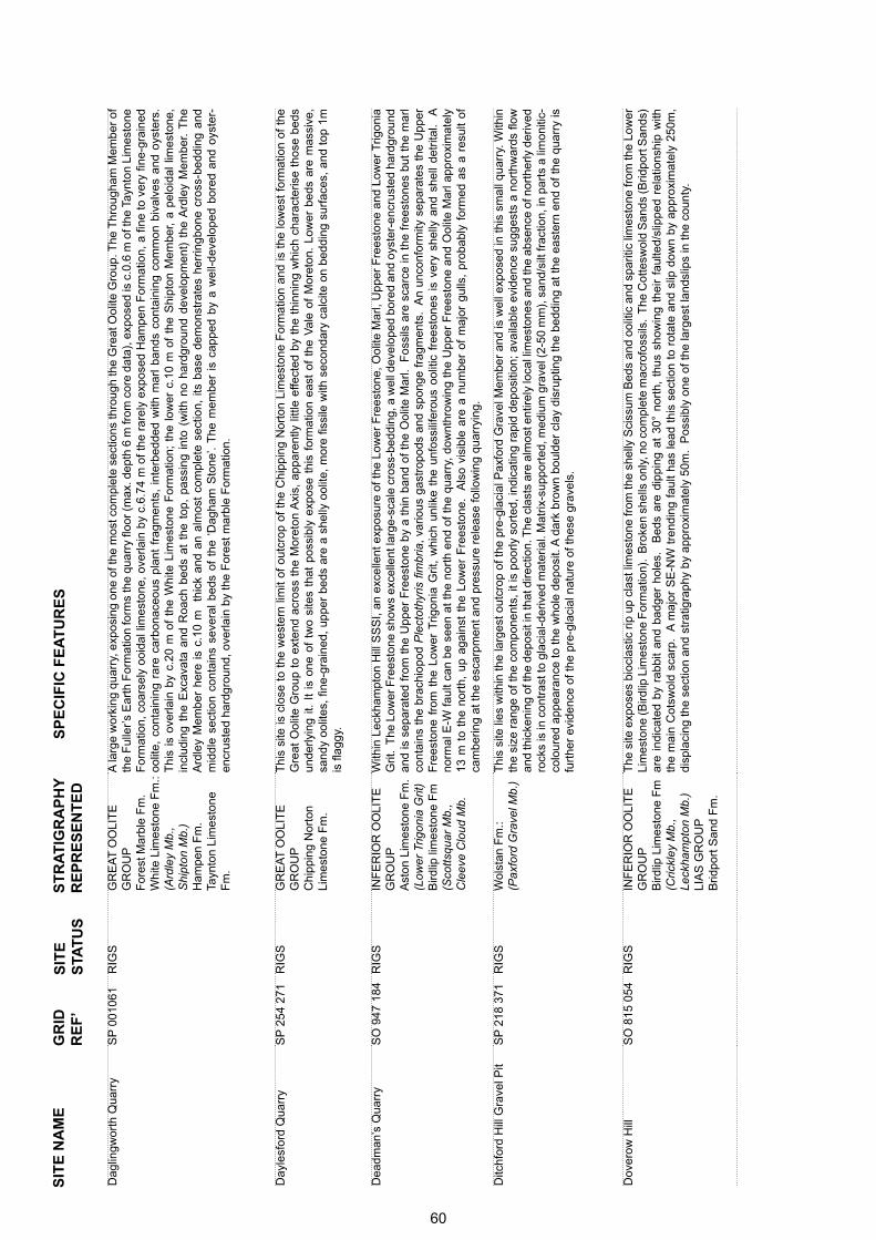
SIT
E N
AM
ES
PE
CIF
IC F
EA
TU
RE
SS
ITE
S
TAT
US
GR
ID
RE
F’
ST
RA
TIG
RA
PH
YR
EP
RE
SE
NT
ED
Dag
lingw
orth
Qua
rry
SP
001
061
RIG
SG
RE
AT
OO
LIT
E
GR
OU
PF
ores
t Mar
ble
Fm
. W
hite
Lim
esto
ne F
m.:
(A
rdle
y M
b.,
Shi
pton
Mb.
) H
ampe
n F
m.
Tayn
ton
Lim
esto
ne
Fm
.
A la
rge
wor
king
qua
rry,
exp
osin
g on
e of
the
mos
t com
plet
e se
ctio
ns th
roug
h th
e G
reat
Ool
ite G
roup
. The
Thr
ough
am M
embe
r of
th
e F
ulle
r’s
Ear
th F
orm
atio
n fo
rms
the
quar
ry fl
oor
(max
. dep
th 6
m fr
om c
ore
data
), e
xpos
ed is
c.0
.6 m
of t
he T
aynt
on L
imes
tone
F
orm
atio
n, c
oars
ely
ooid
al li
mes
tone
, ov
erla
in b
y c.
6.74
m o
f th
e ra
rely
exp
osed
Ham
pen
For
mat
ion,
a fi
ne t
o ve
ry fi
ne-g
rain
ed
oolit
e, c
onta
inin
g ra
re c
arbo
nace
ous
plan
t fr
agm
ents
, in
terb
edde
d w
ith m
arl
band
s co
ntai
ning
com
mon
biv
alve
s an
d oy
ster
s.
Thi
s is
ove
rlain
by
c.20
m o
f th
e W
hite
Lim
esto
ne F
orm
atio
n; t
he l
ower
c.1
0 m
of
the
Shi
pton
Mem
ber,
a pe
loid
al l
imes
tone
, in
clud
ing
the
Exc
avat
a an
d R
oach
bed
s at
the
top
, pa
ssin
g in
to (
with
no
hard
grou
nd d
evel
opm
ent)
the
Ard
ley
Mem
ber.
The
A
rdle
y M
embe
r he
re i
s c.
10 m
th
ick
and
an a
lmos
t co
mpl
ete
sect
ion,
its
bas
e de
mon
stra
tes
herr
ingb
one
cros
s-be
ddin
g an
d m
iddl
e se
ctio
n co
ntai
ns s
ever
al b
eds
of t
he ‘
Dag
ham
Sto
ne’.
The
mem
ber
is c
appe
d by
a w
ell-d
evel
oped
bor
ed a
nd o
yste
r-en
crus
ted
hard
grou
nd, o
verla
in b
y th
e F
ores
t mar
ble
For
mat
ion.
Day
lesf
ord
Qua
rry
SP
254
271
RIG
SG
RE
AT
OO
LIT
E
GR
OU
PC
hipp
ing
Nor
ton
Lim
esto
ne F
m.
Thi
s si
te is
clo
se t
o th
e w
este
rn li
mit
of o
utcr
op o
f th
e C
hipp
ing
Nor
ton
Lim
esto
ne F
orm
atio
n an
d is
the
low
est
form
atio
n of
the
G
reat
Ool
ite G
roup
to
exte
nd a
cros
s th
e M
oret
on A
xis,
app
aren
tly li
ttle
effe
cted
by
the
thin
ning
whi
ch c
hara
cter
ise
thos
e be
ds
unde
rlyin
g it.
It
is o
ne o
f tw
o si
tes
that
pos
sibl
y ex
pose
thi
s fo
rmat
ion
east
of
the
Val
e of
Mor
eton
. Lo
wer
bed
s ar
e m
assi
ve,
sand
y oo
lites
, fin
e-gr
aine
d, u
pper
bed
s ar
e a
shel
ly o
olite
, m
ore
fissi
le w
ith s
econ
dary
cal
cite
on
bedd
ing
surf
aces
, an
d to
p 1m
is
flag
gy.
Dea
dman
’s Q
uarr
y S
O 9
47 1
84R
IGS
INF
ER
IOR
OO
LIT
E
GR
OU
PA
ston
Lim
esto
ne F
m.
(Low
er T
rigon
ia G
rit)
B
irdlip
lim
esto
ne F
m(S
cotts
quar
Mb.
,
C
leev
e C
loud
Mb.
With
in L
eckh
ampt
on H
ill S
SS
I, an
exc
elle
nt e
xpos
ure
of th
e Lo
wer
Fre
esto
ne, O
olite
Mar
l, U
pper
Fre
esto
ne a
nd L
ower
Trig
onia
G
rit.
The
Low
er F
rees
tone
sho
ws
exce
llent
larg
e-sc
ale
cros
s-be
ddin
g, a
wel
l dev
elop
ed b
ored
and
oys
ter-
encr
uste
d ha
rdgr
ound
an
d is
sep
arat
ed f
rom
the
Upp
er F
rees
tone
by
a th
in b
and
of t
he O
olite
Mar
l. F
ossi
ls a
re s
carc
e in
the
fre
esto
nes
but
the
mar
l co
ntai
ns t
he b
rach
iopo
d P
lect
othy
ris fi
mbr
ia,
vario
us g
astr
opod
s an
d sp
onge
fra
gmen
ts.
An
unco
nfor
mity
sep
arat
es t
he U
pper
F
rees
tone
fro
m t
he L
ower
Trig
onia
Grit
, w
hich
unl
ike
the
unfo
ssili
fero
us o
oliti
c fr
eest
ones
is
very
she
lly a
nd s
hell
detr
ital.
A
norm
al E
-W f
ault
can
be s
een
at t
he n
orth
end
of
the
quar
ry,
dow
nthr
owin
g th
e U
pper
Fre
esto
ne a
nd O
olite
Mar
l app
roxi
mat
ely
13 m
to
the
nort
h, u
p ag
ains
t th
e Lo
wer
Fre
esto
ne.
Als
o vi
sibl
e ar
e a
num
ber
of m
ajor
gul
ls,
prob
ably
for
med
as
a re
sult
of
cam
berin
g at
the
esca
rpm
ent a
nd p
ress
ure
rele
ase
follo
win
g qu
arry
ing.
Ditc
hfor
d H
ill G
rave
l Pit
SP
218
371
RIG
SW
olst
an F
m.:
(Pax
ford
Gra
vel M
b.)
Thi
s si
te li
es w
ithin
the
larg
est o
utcr
op o
f the
pre
-gla
cial
Pax
ford
Gra
vel M
embe
r an
d is
wel
l exp
osed
in th
is s
mal
l qua
rry.
With
in
the
size
ran
ge o
f the
com
pone
nts,
it is
poo
rly s
orte
d, in
dica
ting
rapi
d de
posi
tion;
ava
ilabl
e ev
iden
ce s
ugge
sts
a no
rthw
ards
flow
an
d th
icke
ning
of t
he d
epos
it in
that
dire
ctio
n. T
he c
last
s ar
e al
mos
t ent
irely
loca
l lim
esto
nes
and
the
abse
nce
of n
orth
erly
der
ived
ro
cks
is in
con
tras
t to
glac
ial-d
eriv
ed m
ater
ial.
Mat
rix-s
uppo
rted
, med
ium
gra
vel (
2-50
mm
), s
and/
silt
frac
tion,
in p
arts
a li
mon
itic-
colo
ured
app
eara
nce
to t
he w
hole
dep
osit.
A d
ark
brow
n bo
ulde
r cl
ay d
isru
ptin
g th
e be
ddin
g at
the
eas
tern
end
of
the
quar
ry is
fu
rthe
r ev
iden
ce o
f the
pre
-gla
cial
nat
ure
of th
ese
grav
els.
Dov
erow
Hill
S
O 8
15 0
54R
IGS
INF
ER
IOR
OO
LIT
E
GR
OU
PB
irdlip
Lim
esto
ne F
m(C
rickl
ey M
b.,
Leck
ham
pton
Mb.
)LI
AS
GR
OU
PB
ridpo
rt S
and
Fm
.
The
site
exp
oses
bio
clas
tic r
ip u
p cl
ast l
imes
tone
from
the
shel
ly S
ciss
um B
eds
and
oolit
ic a
nd s
parit
ic li
mes
tone
from
the
Low
er
Lim
esto
ne (B
irdlip
Lim
esto
ne F
orm
atio
n).
Bro
ken
shel
ls o
nly,
no
com
plet
e m
acro
foss
ils.
The
Cot
tesw
old
San
ds (B
ridpo
rt S
ands
) ar
e in
dica
ted
by r
abbi
t an
d ba
dger
hol
es.
Bed
s ar
e di
ppin
g at
30°
nor
th,
thus
sho
win
g th
eir
faul
ted/
slip
ped
rela
tions
hip
with
th
e m
ain
Cot
swol
d sc
arp.
A
maj
or S
E-N
W t
rend
ing
faul
t ha
s le
ad t
his
sect
ion
to r
otat
e an
d sl
ip d
own
by a
ppro
xim
atel
y 25
0m,
disp
laci
ng th
e se
ctio
n an
d st
ratig
raph
y by
app
roxi
mat
ely
50m
. P
ossi
bly
one
of th
e la
rges
t lan
dslip
s in
the
coun
ty.
60
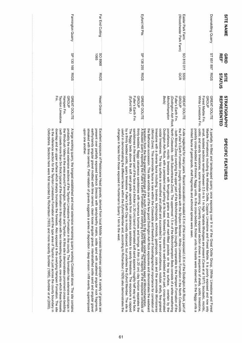
SIT
E N
AM
ES
PE
CIF
IC F
EA
TU
RE
SS
ITE
S
TAT
US
GR
ID
RE
F’
ST
RA
TIG
RA
PH
YR
EP
RE
SE
NT
ED
Dow
nskilling Quarry
ST
851 897R
IGS
GR
EA
T O
OLIT
E
GR
OU
PF
orest Marble F
m.
White Lim
estone Fm
.
A partially in-filled and landscaped quarry, once exposing over 9 m
of the Great O
olite Group, (W
hite Limestone and F
orest M
arble Form
ations) including the Athelstan O
olite, Coppice Lim
estone and Forest M
arble. It is poorly exposed and now only
small, isolated sections rem
ain between 0.5 m
to 1 m high. V
ariable lithologies are present (Cave et al 1977): bioclastic, m
icritic, oolitic and sandy lim
estones, some lim
onite staining. Currently exposed section show
s a sequence of shelly, oolitic limestone,
possibly cross-bedded and thinner, flaggy units. In the cross-bedded, thicker units no fossils were observed; in the flaggy units a
limited fauna of gastropods, shell fragm
ents and echinoid spines were seen.
Easter P
ark Farm
(W
oodchester Park F
arm)
SO
810 011S
SS
I G
CR
GR
EA
T O
OLIT
E
GR
OU
PF
uller’s Earth F
m.
(Dodington A
sh Rock,
Minchinham
pton B
eds)
A site neglected for m
any years. Recent excavation revealed 4.5 m
of the once exposed c.6 m of the D
odington Ash R
ock, part of the F
uller’s Earth F
ormation (roughly com
parable with the S
hipton Mem
ber, White Lim
estone Form
ation in the North C
otswolds
- both Morrisi Z
one) overlying the upper part of the Minchinham
pton Beds (roughly com
parable to the Ham
pen Form
ation of the N
orth Cotsw
olds - both Subcontractus Z
one). The upperm
ost 1.5 m of the M
inchinhampton B
eds consists of a white-w
eathering porcellanous, m
icritic limestone w
ith ferruginous grains and small m
arl-filled pockets on the top surface, overlain by the D
odington Ash R
ock, with a persistent m
arl parting at its base, followed by m
assive to well-bedded and in part, cross-lam
inated ooidal lim
estones. The top surface is sm
oothed and pitted and succeeded by a semi-porcellanous, nodular, shelly, fine-grained
limestone w
ith a diverse fauna including; bivalves, brachiopods, echinoids, gastropods, corals and the amm
onite Morrisiceras
(Morrisi Z
one). This am
monite fauna is rare w
ithin the Cotsw
olds and therefore of biostratigraphical importance for correlation of
the Bathonian succession. T
his site exhibits one of the few good D
odington Ash R
ock exposures and demonstrates the eastw
ard transition from
the fine-grained limestones of the south C
otswolds to the coarser ooidal lim
estones seen at Minchinham
pton.E
yford Hill P
its S
P 138 255
RIG
SG
RE
AT
OO
LITE
G
RO
UP
Fuller’s E
arth Fm
(E
yford Mb.)
A disused quarry exposing the F
uller’s Earth F
ormation and overlying E
yford Mem
ber. The m
ajority of the exposure consists of thinly-bedded, flaggy calcareous sandstones w
ith numerous burrow
s and borings. A thin (c.20 cm
) clay horizon separates the sandstones in the low
er part of the face and a thicker (c.30 cm) band of lam
inated soft sand appears roughly half way up the face.
The flaggy beds above the soft sand grade upw
ards from calcareous sandstone to sandy lim
estone. The exposure is capped
by a thinly bedded oolitic, sparry limestone. F
uller’s Earth C
lay is mostly obscured, but underlies the E
yford Mem
ber. The site is
useful in demonstrating the different facies w
ithin the Eyford M
ember and, according to R
ichardson (1929) also demonstrates the
changes in facies from those exposed in H
untsman’s Q
uarry 1 km to the w
est.
Far E
nd Cutting
SO
8968 1065
RIG
SH
ead Gravel
Excellent exposure of P
leistocene Head gravels, derived from
local Middle Jurassic lim
estones upslope. A variety of gravels are
present over partially exposed bedrock (breccia with sandy/earthy m
atrix, oolite sand with scattered angular rock fragm
ents, earthy/sandy angular gravel m
ottled with lim
e cement, clean loose angular gravel, interstratified oolite sand and angular gravel
streaked with lim
e cement). F
ield relation of gravels suggests a series of deposition / deep erosion / infill events, superimposed
upon one another.
Farm
ington Quarry
SP
130 168R
IGS
GR
EA
T O
OLIT
E
GR
OU
PH
ampen F
m.
Taynton Limestone
Fm
.
A large w
orking quarry, the longest established and most extensive rem
aining quarry working C
otswold stone. T
he site contains probably the m
ost extensive sections of the Taynton Limestone F
ormation in the county. T
he formation has extensive outcrops in
the Windrush V
alley in the area around Farm
ington, Northleach and Taynton. A
t this site it demonstrates prom
inent cross-bedding (w
ith cosets more than 5m
thick) typical of the formation in this region w
ith two interesting surfaces, one onto w
hich these foresets dow
nlap and an upper surface which sharply truncates the foresets. A
lso exposed is the overlying Ham
pen Form
ation. The site
is the reference section for the Taynton Limestone F
ormation and the type area of Taynton is just across the county boundary in
Oxfordshire. S
ections here were first recorded by R
ichardson (1933) and more recently S
umbler (1995), S
umbler et al (2000).
61
SIT
E N
AM
ES
PE
CIF
IC F
EA
TU
RE
SS
ITE
S
TAT
US
GR
ID
RE
F’
ST
RA
TIG
RA
PH
YR
EP
RE
SE
NT
ED
Fid
dler
s E
lbow
Qua
rry
SO
886
143
RIG
SG
RE
AT
OO
LIT
E
GR
OU
PF
ulle
r’s
Ear
th F
m.
(Upp
er E
stua
rine
Cla
y)
Chi
ppin
g N
orto
n Li
mes
tone
Fm
. IN
FE
RIO
R O
OLI
TE
G
RO
UP
Sal
pert
on li
mes
tone
F
m.
(Cly
peus
Grit
Mb.
,
Upp
er T
rigon
ia G
rit
Mb.
) A
ston
Lim
esto
ne
For
mat
ion
(Gry
phite
Mb.
,
Lo
wer
Trig
onia
G
rit M
b.)
Bird
lip L
imes
tone
Fm
(Sco
ttsqu
ar M
b.,
C
leev
e C
loud
Mb.
,
C
rickl
ey M
b.)
A l
arge
, di
suse
d qu
arry
on
the
scar
p, s
how
ing
a go
od s
ectio
n th
roug
h th
e In
ferio
r O
olite
Gro
up a
nd b
ase
of t
he G
reat
Ool
ite
Gro
up.
Acc
ordi
ng t
o C
hann
on (
1950
) a
typi
cal “
Pai
nsw
ick”
sec
tion
from
the
Pea
Grit
thr
ough
the
Cor
al B
ed,
Low
er F
rees
tone
, O
olite
Mar
l, th
e Lo
wer
Trig
onia
, Gry
phite
and
Cly
peus
Grit
s, o
verla
in b
y th
e C
hipp
ing
Nor
ton
Lim
esto
ne a
nd F
ulle
r’s
Ear
th.
The
st
rata
is v
ery
loos
e an
d br
oken
for
min
g la
rge
scre
es.
Lith
olog
ies
vary
, in
clud
ing
oolit
es,
sand
s, b
iom
icrit
es,
spar
ites,
pis
olite
s,
shel
ly li
mes
tone
s an
d iro
n-sh
ot m
arls
. T
here
is g
ood
cros
s-be
ddin
g an
d gr
aded
-bed
ding
in s
ome
of t
he o
olite
s.
The
qua
rry
is
note
d fo
r its
str
uctu
rally
com
plex
nat
ure
with
ste
ep d
ips
of 2
0° to
60°
to th
e N
-W, d
ue to
pos
t-gl
acia
l slu
mpi
ng a
nd u
nder
lyin
g Li
as
clay
flow
s, c
lass
ic c
ambe
ring
feat
ures
and
ero
ded
gulls
, ev
iden
ce o
f fr
ost
shat
terin
g, d
ebris
and
sol
ifluc
tion
resi
dues
. A
div
erse
fa
una
iden
tified
by
Cha
nnon
(19
50),
biv
alve
s, b
rach
iopo
ds a
nd c
oral
s ar
e ve
ry c
omm
on.
The
seq
uenc
e is
cap
ped
by th
e U
pper
E
stua
rine
Cla
y, t
he l
ater
al e
quiv
alen
t of
the
Ham
pen
Mar
ly B
eds
and
part
of
the
Whi
te L
imes
tone
For
mat
ion
and
is r
elat
ivel
y ra
re,
bein
g re
stric
ted
to s
outh
of
the
Oxf
ords
hire
boa
rder
. R
efer
ence
sec
tion
for
the
Cric
kley
Mem
ber,
Cle
eve
Clo
ud M
embe
r, S
cotts
quar
Mem
ber
Fos
s C
ross
Qua
rry
SP
056
092
SS
SI
GC
RG
RE
AT
OO
LIT
E
GR
OU
PW
hite
Lim
esto
ne F
m.:
(A
rdle
y M
b.,
Shi
pton
Mb.
)
Thi
s si
te s
how
s an
im
port
ant,
high
ly f
ossi
lifer
ous
sect
ion
thro
ugh
the
mid
dle
part
of
the
Whi
te L
imes
tone
For
mat
ion
(Ard
ley
&
Shi
pton
mem
bers
). T
he s
ite is
not
ed p
artic
ular
ly f
or t
he p
rese
nce
of t
he r
ed a
lga
Sol
enop
ora
and
is o
ne o
f a
few
loca
litie
s th
at
have
yie
lded
zon
ally
dia
gnos
tic B
atho
nian
am
mon
ites.
The
qua
rry
is p
artia
lly i
nfille
d bu
t on
e fa
ce i
s pr
eser
ved
and
expo
ses
in t
he b
asal
sec
tion
c.1.
9 m
of
the
Shi
pton
Mem
ber,
a m
assi
ve t
o ru
bbly
, sp
arse
ly p
eloi
dal
limes
tone
, w
ith a
bund
ant
foss
ils,
mos
tly b
ival
ves
and
cora
ls,
with
som
e ga
stro
pods
. T
his
pass
es u
p in
to t
he E
xcav
ata
bed,
mar
king
the
top
of
the
mem
ber.
Ove
rlyin
g th
is is
c.6
.58
m o
f the
Ard
ley
Mem
ber,
the
basa
l sec
tion
com
pris
ing
a oo
idal
, san
dy m
arl b
ed, p
assi
ng u
p in
to a
san
dy
or a
rgill
aceo
us li
mes
tone
, in
tur
n pa
ssin
g up
into
a h
ighl
y fo
ssili
fero
us li
me
mud
ston
e, t
he u
pper
par
t pe
loid
al (
‘Dag
ham
Sto
ne’)
capp
ed w
ith a
sha
rp,
bore
d ha
rdgr
ound
. Abo
ve t
his
a cr
oss-
bedd
ed o
oida
l, pe
loid
al li
mes
tone
with
sev
eral
mar
l bed
s, c
appe
d w
ith th
e S
olen
opor
a B
ed, c
onta
inin
g pi
nk/w
hite
-ban
ded
alga
l mas
ses
and
cora
l fra
gmen
ts. T
his
site
, whe
n co
mpa
red
with
oth
ers
in th
e ar
ea, a
llow
s fo
r co
mpa
rison
s an
d co
ntra
sts
to b
e m
ade.
Fou
rmile
Lod
ge Q
uarr
yS
O 9
60 0
21R
IGS
GR
EA
T O
OLI
TE
G
RO
UP
For
est M
arbl
e F
m.
(W
ychw
ood
Bed
s)
(B
radf
ord
Cla
y)
Whi
te L
imes
tone
Fm
.
(Sig
net M
b.)
Thi
s qu
arry
exp
oses
c.2
.5 m
of
the
Upp
er B
atho
nian
Gre
at O
olite
Gro
up,
incl
udin
g an
im
port
ant
basa
l se
ctio
n of
the
For
est
Mar
ble
For
mat
ion.
Dis
play
ed is
c.1
m o
f th
e S
igne
t M
embe
r, an
ooi
dal l
imes
tone
, ov
erla
in b
y a
thin
c.6
-10
cm b
and
of o
rang
e/br
own
clay
, whi
ch m
ay b
e eq
uiva
lent
to th
e B
radf
ord
Cla
y, th
is fo
rms
the
base
of t
he F
ores
t Mar
ble
and
is o
verla
in b
y c.
1.5
m o
f fla
ggy,
cro
ss-b
edde
d sh
elly
lim
esto
ne, i
n w
hich
foss
ils a
re c
omm
on (
Pec
tinac
eans
and
oys
ters
).
62
SIT
E N
AM
ES
PE
CIF
IC F
EA
TU
RE
SS
ITE
S
TAT
US
GR
ID
RE
F’
ST
RA
TIG
RA
PH
YR
EP
RE
SE
NT
ED
Frocester Long B
arrow
Quarry
SO
795 016R
IGS
INF
ER
IOR
OO
LITE
G
RO
UP
Birdlip Lim
estone Fm
.(C
rickley Mb.,
Leckhampton M
b.)LIA
S G
RO
UP
B
ridport Sand F
m.
The site com
prises a quarry section and track cutting. Exposed are key sections through the top of the Lias G
roup and lower
part of the Inferior Oolite G
roup. Visible are the C
ephalopod Bed and C
otteswold S
ands form the B
ridport Sand F
ormation and
the Scissum
Beds (Leckham
pton Mem
ber) in the track cutting and Lower Lim
estone (Crickley M
ember), containing R
ichardson’s “P
ea Grit horizon” in the quarry section. V
isible jointing, small faults, cross-bedding and erosional planes. F
ossil fauna includes the am
monite H
arpoceras, the nautiloid Cenoceras and belem
nites. The site lies w
ithin a GW
T nature reserve.
Grange H
ill Quarry
SP
114 244R
IGS
GR
EA
T O
OLIT
E
GR
OU
PTaynton Lim
estone F
m.
Fuller’s E
arth Fm
.(E
yford Mb.)
A w
orking quarry, exposing the Great O
olite Group; F
uller’s Earth F
ormation (E
yford Mem
ber) and the Taynton Limestone
Form
ation. The base of the quarry is in the F
uller’s Earth C
lay (Sharps H
ill Form
ation). The E
yford Mem
ber varies here both vertically and laterally, at the southern end of the site dem
onstrating a fine-grained limestone w
ith sparite cement lithology, at
the northern end, medium
-grained sandy limestone w
ith sparite cement. B
edding appears near horizontal, finely laminated w
ith sm
all-scale cross-bedding and ripple marks. T
he contact between the tw
o units is present but not visible.
Guiting Q
uarry S
P 078 302
RIG
SIN
FE
RIO
R O
OLIT
E
GR
OU
PB
irdlip Limestone F
m.
(Harford M
b. S
cottsquar Mb.
Cleeve C
loud Mb.)
An extensive w
orking quarry exposing excellent sections through the lower part of the Inferior O
olite Group (sim
ilar to that seen at C
otswold H
ills Quarry). T
he sequence exposes the Yellow
Guiting S
tone, White G
uiting Stone (C
leeve Cloud M
b.), O
olite Marl, U
pper Freestone (S
cottsquar Mb.), H
arford Sands and the T
ilestones (Harford M
b.) The low
est unit exposed is the Y
ellow G
uiting Stone: sandy, oolitic lim
estone, medium
-grained and cross-bedded. White G
uiting Stone: oolitic lim
estone, fine to m
edium-grained, fining up cycles, cross-bedded, top m
arked by oyster-encrusted hardground. Oolite M
arl: fine-grained oolite, interdigitating into U
pper Freestone: fine to m
edium-grained peloidal, ooidal lim
estone, fossiliferous (containing coral fragm
ents) followed by a transition into a m
edium-grained, bioturbated bioclastic lim
estone. Harford S
ands: sands with clay
lenses interbedded with lim
estone bands. Tilestones: thin, flaggy, fine to m
edium-grained oolite. B
edding is essentially horizontal, som
e evidence of minor norm
al faulting. N-S
trending fracturing. Reference section for the C
leeve Cloud, S
cottsquar and Harford
Mem
bers.
Hailey F
arm R
ailway
Cutting
SO
950 017R
IGS
GR
EA
T O
OLIT
E
GR
OU
PF
orest Marble F
m.
White Lim
estone Fm
.
The site com
prises two railw
ay cuttings, on an active line, linked by a tunnel, with high, steep faces exposing near-horizontal
Great O
olite Group, W
hite Limestone F
ormation. S
ome basal F
orest Marble F
ormation is present at the N
W end of the w
est cutting. Lithology of oolitic lim
estone, poorly fossiliferous, well bioturbated w
ith diagenetic bedding overprint.
Ham
pen Railw
ay Cutting
SP
062 205S
SS
I G
CR
GR
EA
T O
OLIT
E
GR
OU
PW
hite Limestone F
m.
(Shipton M
b.) H
ampen F
m.
Taynton Limestone
Fm
. F
uller’s Earth F
m.
(Eyford M
b.)
This site is on the disused A
ndoversford to Bourton-on-the-W
ater railway line, over a kilom
etre in length and shows one of the
more com
plete Great O
olite Group sections in the C
otswolds, including parts that are rarely exposed elsew
here, notably the F
uller’s Earth F
ormation, H
ampen F
ormation and basal W
hite Limestone F
ormation. T
he site is also the type section for the H
ampen F
ormation and reference section for the Taynton Lim
estone Form
ation. The site w
as originally described by Woodw
ard (1894), recognised as the ‘M
arly Beds’ and form
alised as the ‘Ham
pen Marly B
eds’ by Arkell (1933). T
he exposures are now
quite obscured by vegetation.
Ham
s Gulley B
rookS
O 754 900
to 757 903R
IGS
LIAS
GR
OU
PD
yrham F
m.
Charm
outh Mudstone
Fm
.
Rare exposure of the upper beds of the C
harmouth M
udstone Form
ation, Echioceras Z
one, exposed along an incised stream
section. Silty lam
inated blue-grey soft clays, interbedded with hard argillaceous lim
estones. Abundant fauna; m
ostly fragments of
belemnites, brachiopods, bivalves, gastropods and pyritised am
monites. T
he site is useful for sedimentology, stratigraphy studies
at all levels of education, including research.
63
SIT
E N
AM
ES
PE
CIF
IC F
EA
TU
RE
SS
ITE
S
TAT
US
GR
ID
RE
F’
ST
RA
TIG
RA
PH
YR
EP
RE
SE
NT
ED
Har
d S
tone
Qua
rry
SO
989
269
RIG
SIN
FE
RIO
R O
OLI
TE
G
RO
UP
Bird
lip L
imes
tone
Fm
.(S
cotts
quar
Mb.
,
C
leev
e C
loud
Mb.
)
With
in C
leev
e C
omm
on S
SS
I, a
re-e
xcav
ated
qua
rry,
exp
osin
g th
e C
leev
e C
loud
Mem
ber
(Low
er F
rees
tone
) an
d th
e S
cotts
quar
M
embe
r (O
olite
Mar
l, U
pper
Fre
esto
ne).
The
Low
er F
rees
tone
is c
ross
-bed
ded,
its
uppe
r bou
ndar
y an
d co
ntac
t with
the
over
lyin
g O
olite
Mar
l ca
n be
cle
arly
see
n, a
thi
n ha
rdgr
ound
with
a v
ery
finel
y rip
pled
sur
face
in
plac
es.
The
who
le o
f th
e O
olite
Mar
l se
quen
ce a
nd it
s co
ntac
t w
ith t
he o
verly
ing
Upp
er F
rees
tone
with
in t
he S
cotts
quar
Mem
ber
can
also
be
seen
. T
he O
olite
Mar
l is
hig
hly
foss
ilife
rous
and
exc
elle
nt s
peci
men
s of
the
brac
hiop
od P
lect
othy
ris fi
mbr
ia c
an b
e fo
und.
Har
esfie
ld H
illS
O 8
19 0
88S
SS
I G
CR
INF
ER
IOR
OO
LIT
E
GR
OU
PB
irdlip
Lim
esto
ne F
m.
(Cric
kley
Mb.
,
Leck
ham
pton
Mb.
)LI
AS
GR
OU
P
B
ridpo
rt S
and
Fm
.
An
outli
er o
f the
mai
n hi
ll-m
ass,
the
site
exp
oses
the
basa
l par
t of t
he In
ferio
r Ool
ite G
roup
, the
Lec
kham
pton
Mem
ber
(con
tain
ing
the
Sci
ssum
Bed
s) a
nd C
rickl
ey M
embe
r of
the
Bird
lip L
imes
tone
For
mat
ion
and
the
unde
rlyin
g B
ridpo
rt S
and
For
mat
ion
(Cep
halo
pod
Bed
) at
the
top
of th
e Li
as G
roup
. The
site
sho
ws
one
of th
e m
ost e
xten
sive
and
wel
l exp
osed
sec
tions
ava
ilabl
e of
th
e S
ciss
um b
eds.
T
he s
ite is
impo
rtan
t fo
r its
exp
osur
e of
the
Cep
halo
pod
Bed
at
the
top
of t
he L
ias
Gro
up a
nd t
he o
verly
ing
Leck
ham
pton
Mem
ber,
it is
one
of
the
few
loca
litie
s w
here
the
Low
er/M
iddl
e Ju
rass
ic b
ound
ary
can
be e
xam
ined
, m
akin
g it
an
impo
rtan
t si
te f
or s
trat
igra
phic
al a
nd p
alae
onto
logi
cal s
tudi
es.
The
am
mon
ites
and
brac
hiop
ods
have
bee
n su
bjec
t of
impo
rtan
t de
taile
d st
udie
s.
Har
ford
Rai
lway
Cut
ting
SP
136
218
SS
SI
G
CR
INF
ER
IOR
OO
LIT
E
GR
OU
PS
alpe
rton
Lim
esto
ne
Fm
.(C
lype
us G
rit M
b.,
Upp
er T
rigon
ia G
rit
Mb.
)A
ston
Lim
esto
ne F
m.
(Not
grov
e M
b.,
Gry
phite
Grit
Mb.
, Lo
wer
Trig
onia
Grit
M
b.)
Bird
lip L
imes
tone
Fm
.(H
arfo
rd M
b.)
Thi
s si
te is
on
the
disu
sed
And
over
sfor
d to
Bou
rton
-on-
the-
Wat
er r
ailw
ay li
ne,
expo
sing
an
exce
llent
sec
tion
thro
ugh
the
mid
dle
and
uppe
r pa
rts
of t
he I
nfer
ior
Ool
ite G
roup
, fr
om t
he u
pper
par
t of
the
Bird
lip L
imes
tone
For
mat
ion,
to
the
mid
dle
part
of
the
Sal
pert
on L
imes
tone
For
mat
ion.
It
was
firs
t de
scrib
ed b
y B
uckm
an (
1890
), m
entio
ned
by W
oodw
ard
(189
4),
sum
mar
ised
by
Ark
ell (
1947
b),
re-e
xam
ined
by
Par
sons
(19
76b)
. T
he s
ectio
n sh
ows
a nu
mbe
r of
min
or r
ever
se a
nd n
orm
al f
aults
(co
nnec
ted
with
cam
berin
g an
d gu
lling
). A
gul
l cr
osse
s th
e cu
tting
, di
spla
yed
as a
gra
ben
35 m
wid
e, w
ith s
tep-
faul
ted
mar
gins
with
the
st
rata
dow
n-fa
ulte
d by
c.5
m.
The
Not
grov
e M
embe
r sh
ows
mar
ked
thin
ning
and
ero
sion
al n
on-s
eque
nce
at i
ts t
op d
ue t
o its
pr
oxim
ity t
o th
e V
ale
of M
oret
on A
xis.
The
suc
cess
ion
has
yiel
ded
one
of t
he m
ost
com
plet
e re
cord
s of
con
secu
tive
amm
onite
fa
unas
, ra
ngin
g fr
om la
te A
alen
ian
to la
te B
ajoc
ian
in a
ge. A
lso
rhyn
cone
llids
, oy
ster
s, b
ival
ves,
cor
als.
It
is t
he t
ype
sect
ion
for
the
Har
ford
Mem
ber
and
the
Ast
on L
imes
tone
For
mat
ion
and
refe
renc
e se
ctio
n fo
r th
e S
alpe
rton
Lim
esto
ne F
orm
atio
n, N
otgr
ove
Mem
ber,
Low
er a
nd U
pper
Trig
onia
Grit
Mem
ber
and
the
Cly
peus
Grit
Mem
ber.
Hill
side
Woo
d Q
uarr
yS
T 7
42 9
88R
IGS
Hea
d
INF
ER
IOR
OO
LIT
E
GR
OU
PB
irdlip
Lim
esto
ne F
m.
(Cle
eve
Clo
ud M
b.
Cric
kley
Mb.
)
Thi
s si
te li
es w
ithin
the
Stin
chco
mbe
Hill
bio
logi
cal S
SS
I an
d re
pres
ents
one
of
the
mos
t w
este
rly o
utcr
ops
of L
ower
Lim
esto
ne
(Cric
kley
Mem
ber)
and
pos
sibl
y w
ith L
ower
Fre
esto
ne (
Cle
eve
Clo
ud m
embe
r). T
he s
ectio
n sh
ows
som
e im
port
ant
iron
stai
ned
irreg
ular
har
dgro
unds
not
see
n in
qua
rrie
s to
the
eas
t. T
he P
ea g
rit f
acie
s ap
pear
s to
hav
e w
edge
d ou
t or
has
not
dev
elop
ed
this
far
wes
t. L
ithol
ogy
incl
udes
bio
mic
rites
, ooi
tes,
peb
ble
beds
and
pel
litife
rous
ool
ites.
Few
who
le m
acro
foss
ils s
een
but m
any
brac
hiop
od a
nd b
ival
ve c
last
ic r
emai
ns.
Ove
rall
the
expo
sure
is s
ever
ely
fros
t sha
ttere
d an
d jo
inte
d, th
e lo
wer
bed
s sh
ow c
urre
nt
cros
s-be
ddin
g, th
e up
per
beds
pla
nar
bedd
ing,
als
o se
vera
l peb
ble
cong
lom
erat
e be
ds. T
he s
eque
nce
is o
verla
in b
y po
st g
laci
al
head
dep
osit.
Hor
cott
Pit
SU
149
995
RIG
SU
pper
Tha
mes
Val
ley
Fm
. (N
orth
moo
r M
b.)
Goo
d ex
posu
re o
f Upp
er T
ham
es V
alle
y (N
orth
moo
r M
embe
r) 1
st T
erra
ce s
ands
and
gra
vels
dep
osite
d du
ring
Late
Ple
isto
cene
co
ld p
hase
, ov
erly
ing
Oxf
ord
Cla
y F
orm
atio
n (n
ot e
xpos
ed).
Sim
ilar
litho
logy
to
that
see
n at
Tho
rnhi
ll F
arm
Pit
to t
he e
ast;
depo
sits
der
ived
fro
m lo
cal M
iddl
e Ju
rass
ic li
mes
tone
s, a
bund
ant
wat
er w
orn
Jura
ssic
rem
anie
fos
sils
, po
ssib
ility
of
cold
pha
se
vert
ebra
te r
emai
ns s
uch
as m
amm
oth
and
rein
deer
, alth
ough
non
e fo
und
as y
et.
64
SIT
E N
AM
ES
PE
CIF
IC F
EA
TU
RE
SS
ITE
S
TAT
US
GR
ID
RE
F’
ST
RA
TIG
RA
PH
YR
EP
RE
SE
NT
ED
Hornsleasow
Quarry
(Snow
shill Quarry)
SP
131 322S
SS
I G
CR
GR
EA
T O
OLIT
E
GR
OU
PTaynton Lim
estone F
m.
Fuller’s E
arth Fm
. C
hipping Norton
Limestone F
m.:
(Chipping N
orton Mb.,
Hornsleasow
Clay
Hook N
orton Mb.)
INF
ER
IOR
OO
LITE
G
RO
UP
Salperton lim
estone F
m.
(Clypeus G
rit Mb.)
The site exhibits excellent sections through the low
er part of the Great O
olite Group, possibly one of the best sections of Low
er B
athonian in the North C
otswolds. T
he underlying Inferior Oolite G
roup, Clypeus G
rit Mem
ber is not well exposed though. T
he m
iddle part of the section (Fuller’s E
arth Form
ation) is regarded as being attenuated and demonstrates a facies that is transitional
between the F
uller’s Earth F
ormation (typically developed further south in the C
otswolds) and of the S
harp’s Hill F
ormation in
Oxfordshire. M
uch of the exposed succession is fossiliferous, especially the Coral B
ed, within the F
uller’s Earth F
ormation and
the Hornsleasow
Clay, w
ithin the Chipping N
orton Limestone F
ormation, the latter yielding an extensive and very im
portant vertebrate fauna, including: pterosaur, turtle, lizard, frog and salam
ander remains. T
he Clypeus G
rit and Taynton Limestone
formations have both yielded age diagnostic am
monites. T
he site is well docum
ented, since first briefly mentioned by R
ichardson (1929b) and an account relating to the vertebrate-bearing H
ornsleasow C
lay was published by M
etcalf et al. (1992). Of particular
interest is an erosional surface (palaeokarst) running across the site within the C
hipping Norton Lim
estone Form
ation, at the top of the H
ook Norton M
ember, above w
hich the Hornsleasow
Clay has in-filled. T
his clay mem
ber has high kaolinite content and is indicative of w
eathering in a warm
, humid clim
ate, supporting the idea that the underlying surface represents a subaerially formed
palaeokarst. In general, the Chipping N
orton Form
ation appears as a cross-bedded oolite, its top surface is capped by a bored and oyster-encrusted hardground, overlain by the F
uller’s Earth F
ormation. T
he basal section appears highly variable, sandy lim
estones and shelly clays pass laterally into ooidal limestones, containing gastropods and bivalves and corals. T
he contact w
ith the overlying Taynton Limestone F
ormation is no longer visible but the coarse-grained shelly oolite, typical of the form
ation is exposed in the higher parts of the quarry. G
eneral dip of the strata is approximately 6° to the north, running N
-S through the site
is a shatter fault zone and evidence of minor faulting.
Huddingknoll H
illS
O 846 107
RIG
SH
ead IN
FE
RIO
R O
OLIT
E
GR
OU
PS
alperton Limestone
Fm
. (C
lypeus Grit M
b., U
pper Trigonia Grit
Mb.)
Aston Lim
estone Fm
. (N
otgrove Mb.,
Gryphite G
rit Mb.,
Lower Trigonia G
rit M
b.)
This site com
prises a quarry on Huddingknoll C
omm
on and two roadside verges. T
he site is extremely im
portant in relation to the geology of the C
otswolds, especially the S
troud area. Exposed are various m
embers from
the Aston and S
alperton Lim
estone Form
ations, found to the north of and near Stroud, preserved by the P
ainswick S
yncline. Lithologies are predominantly
biosparite, micrites, often sandy, shelly and shell detrital in parts. T
he structure here is complex, as a result of post-glacial slipping
and cambering. T
he site also shows m
any sedimentary structures as w
ell as evidence of head deposits and a diverse range of fauna.
Huntsm
ans Quarry
SP
125 259S
SS
I G
CR
GR
EA
T O
OLIT
E
GR
OU
PTaynton Lim
estone F
m.
Fuller’s E
arth Fm
.(E
yford Mb.,
Fuller’s E
arth Clay)
An extensive w
orking quarry, representative of the quarries around the Eyford H
ill area working the F
uller’s Earth F
ormation
Eyford M
ember, the ‘C
otswold S
lates’. Huntsm
ans Quarry is the type locality for this m
ember and provides the best rem
aining sections through the E
yford Mem
ber. The E
yford Mem
ber is a fine-grained sandy limestone, planar-lam
inated, cross-bedded and trough cross-bedded w
ith rippled surfaces and a sharp eroded and burrowed top surface. T
he overlying Taynton Limestone
Form
ation is a coarse-grained, ooidal limestone, cross-bedded, w
ith oysters, bivalves and gastropods. The E
yford Mem
ber has yielded a diverse range of flora and fauna, including turtles, crocodiles, dinosaurs, pterosaurs, fish, starfish, insects, an im
portant suite of am
monites of the P
rogracilis Zone and num
erous bivalves, brachiopods and gastropods.
Incline Quarry
SO
950 187R
IGS
INF
ER
IOR
OO
LITE
G
RO
UP
Birdlip Lim
estone Fm
.(C
leeve Cloud M
b.)
Within Leckham
pton Hill S
SS
I, this disused quarry worked unconsolidated oolitic lim
estone gravel used in the construction of the m
ain tramw
ay ramp from
the limekilns dow
n to Daisy B
ank Lane. The quarry is located in a rotated and slum
ped block of the B
irdlip Limestone F
ormation on the escarpm
ent, the quarry floor dips in towards the escarpm
ent at approximately 10° S
E, instead
of the normal tectonic dip of 1-2° S
E.
65
SIT
E N
AM
ES
PE
CIF
IC F
EA
TU
RE
SS
ITE
S
TAT
US
GR
ID
RE
F’
ST
RA
TIG
RA
PH
YR
EP
RE
SE
NT
ED
Jack
daw
Qua
rry
SP
077
309
SS
SI
G
CR
INF
ER
IOR
OO
LIT
E
GR
OU
PA
ston
Lim
esto
ne F
m.
(Not
grov
e M
b.,
Gry
phite
Grit
Mb.
, Lo
wer
Trig
onia
Grit
M
b.)
Bird
lip L
imes
tone
Fm
. (H
arfo
rd M
b.
T
ilest
ones
Sno
wsh
ill C
lay,
Har
ford
San
ds,
Nau
nton
Cla
y,
Sco
ttsqu
ar M
b.,
Cle
eve
Clo
ud M
b.)
The
site
exp
oses
a fi
ne s
ectio
n th
roug
h th
e up
per
part
of
the
Bird
lip L
imes
tone
For
mat
ion
and
Not
grov
e M
embe
r of
the
Ast
on
Lim
esto
ne F
orm
atio
n. T
he q
uarr
y is
par
ticul
arly
impo
rtan
t fo
r di
spla
ying
a c
ompl
ete
sect
ion
of t
he H
arfo
rd M
embe
r. T
he q
uarr
y w
as fi
rst
desc
ribed
by
Woo
dwar
d (1
894)
whe
n on
ly t
he l
ower
par
t of
the
seq
uenc
e w
as e
xpos
ed.
Buc
kman
(19
01)
desc
ribed
th
e hi
gher
bed
s ex
pose
d in
the
nea
rby
Hor
nhill
Qua
rry
and
in 1
972
the
two
quar
ries
wer
e jo
ined
but
now
are
par
tially
in-fi
lled,
w
ith a
n ex
celle
nt e
xpos
ure
rem
aini
ng in
the
nor
ther
n fa
ce.
The
qua
rry
is w
ithin
1 k
m o
f G
uitin
g Q
uarr
y to
the
sou
th,
but
show
s co
nsid
erab
le v
aria
tion
to t
hat
seen
at
Gui
ting.
The
sec
tion
visi
ble
now
is m
uch
as d
escr
ibed
by
Par
sons
(19
76b)
. The
site
is t
he
refe
renc
e se
ctio
n fo
r th
e C
leev
e C
loud
, Sco
ttsqu
ar, H
arfo
rd a
nd L
ower
Trig
onia
Grit
Mem
bers
.
Jarv
is Q
uarr
y, N
r. C
oate
sS
O 9
95 9
98R
IGS
GR
EA
T O
OLI
TE
G
RO
UP
For
est M
arbl
e F
m.
(
Ree
f B
ed)
App
roxi
mat
ely
9 m
of
Mid
to
Upp
er B
atho
nian
, G
reat
Ool
ite G
roup
was
for
mer
ly e
xpos
ed a
t th
is q
uarr
y. T
he U
pper
Ful
ler’
s E
arth
For
mat
ion
(Ath
elst
an O
olite
Mem
ber,
Ree
f B
ed)
and
For
est
Mar
ble
For
mat
ion
wer
e re
pres
ente
d. T
he A
thel
stan
Ool
ite is
no
w o
bscu
red.
The
‘Ree
f B
ed’ i
s a
rare
exa
mpl
e of
a J
uras
sic
patc
h re
ef. T
he S
SW
fac
e of
the
low
er le
vel q
uarr
y is
now
larg
ely
over
grow
n bu
t th
ere
are
still
a f
ew c
.1-2
m h
igh
expo
sure
s of
the
For
est
Mar
ble
visi
ble.
The
bor
ed s
urfa
ce a
t th
e ba
se o
f th
e F
ores
t M
arbl
e, in
dica
ted
by C
ope
et a
l. (1
977)
is s
till v
isib
le.
Lim
ited
faun
a ob
serv
ed a
lthou
gh t
he F
ores
t M
arbl
e is
ful
l of
shel
l de
bris
and
ech
inoi
d sp
ines
.K
embl
e R
ailw
ay C
uttin
gsS
T 9
75 9
76S
SS
I
GC
RG
RE
AT
OO
LIT
E
GR
OU
PF
ores
t Mar
ble
Fm
. W
hite
Lim
esto
ne
Fm
.
(S
igne
t Mb.
, A
thel
stan
Ool
ite)
Thi
s si
te c
ompr
ises
thre
e se
para
te s
ectio
ns in
railw
ay a
nd ro
ad c
uttin
gs, i
nclu
ding
the
type
sec
tion
for t
he K
embl
e B
eds
(equ
ival
ent
to a
nd n
ow r
ecog
nise
d as
the
Sig
net M
embe
r) a
nd e
xhib
it ex
celle
nt e
xpos
ures
of b
asal
For
est M
arbl
e co
ral p
atch
ree
fs a
nd in
ter-
reef
sed
imen
ts.
The
y al
so p
rovi
de a
key
ref
eren
ce s
ectio
n fo
r co
rrel
atin
g th
e su
cces
sion
s in
the
Min
chin
ham
pton
, C
irenc
este
r an
d B
ath
area
s. T
he ‘
Bra
dfor
d F
ossi
l B
ed’ a
t th
e ba
se o
f th
e F
ores
t M
arbl
e F
orm
atio
n, i
s of
im
port
ance
as
it ha
s yi
elde
d th
e am
mon
ite C
lydo
icer
as h
olla
ndi,
from
the
Bat
honi
an D
iscu
s Z
one.
Kilk
enny
Qua
rry
SP
005
185
RIG
SIN
FE
RIO
R O
OLI
TE
G
RO
UP
Ast
on L
imes
tone
Fm
.(G
ryph
ite G
rit M
b.,
Low
er T
rigon
ia G
rit
Mb.
)B
irdlip
Lim
esto
ne F
m.
(Sco
ttsqu
ar M
b.
Cle
eve
Clo
ud M
b.)
Thi
s si
te c
onta
ins
good
exp
osur
es o
f mid
-Aal
enia
n to
low
er B
ajoc
ian
Infe
rior O
olite
. The
qua
rry
is lo
cate
d be
twee
n si
mila
r sec
tions
at
Lec
kham
pton
Hill
and
Che
dwor
th R
ailw
ay C
uttin
g an
d is
ther
efor
e us
eful
for c
ompa
rativ
e st
ratig
raph
y st
udie
s. E
xpos
ed is
: Pea
G
rit,
Low
er F
rees
tone
, O
olite
Mar
l, U
pper
Fre
esto
ne (
Har
ford
Mem
ber
abse
nt),
Low
er T
rigon
ia G
rit a
nd G
ryph
ite G
rit.
Var
ying
lit
holo
gies
, in
clud
ing;
ool
ites,
mic
rites
, pi
solit
ic i
nter
digi
tatio
ns,
bioc
last
ic a
nd r
ubbl
y be
ds.
Ric
h fa
una
yiel
ded,
man
y ab
rade
d sh
ells
, br
achi
opod
s, b
ival
ves,
gas
trop
ods,
oys
ters
, be
lem
nite
s an
d am
mon
ites.
Bed
s di
ppin
g 20
°-40
° W
SW
, th
roug
h ro
tatio
nal
slip
ping
and
cam
berin
g, i
nfer
red
faul
ting,
fiss
ures
, cr
oss-
bedd
ing,
bor
ed s
urfa
ces
and
lag
depo
sits
. R
efer
ence
sec
tion
for
the
Sco
ttsqu
ar M
embe
r.
Kna
pp H
ouse
Qua
rry
SO
925
147
SS
SI
G
CR
INF
ER
IOR
OO
LIT
E
GR
OU
PS
alpe
rton
Lim
esto
ne
Fm
.(C
lype
us G
rit M
b.,
Upp
er T
rigon
ia G
rit
Mb.
)B
irdlip
Lim
esto
ne F
m.
(Sco
ttsqu
ar M
b.,
Cle
eve
Clo
ud M
b.)
A s
mal
l com
plex
of
disu
sed
wor
king
s on
the
Cot
swol
d sc
arp
just
nor
th o
f B
irdlip
, si
tuat
ed a
ppro
xim
atel
y on
the
Bird
lip A
ntic
line.
E
xpos
ed is
an
atte
nuat
ed s
ucce
ssio
n of
the
Infe
rior
Ool
ite G
roup
(S
alpe
rton
Lim
esto
ne F
orm
atio
n) r
estin
g di
rect
ly o
n th
e B
irdlip
Li
mes
tone
For
mat
ion.
The
ero
ded
surf
ace
betw
een
the
two
form
atio
ns is
bor
ed a
nd o
yste
r-en
crus
ted.
It is
a r
efer
ence
sec
tion
for
the
Bird
lip L
imes
tone
For
mat
ion,
Cle
eve
Clo
ud M
embe
r, S
cotts
quar
Mem
ber
and
the
Upp
er T
rigon
ia G
rit M
embe
r.
Leac
h B
ridge
Cut
ting
SP
144
089
RIG
SG
RE
AT
OO
LIT
E
GR
OU
PW
hite
Lim
esto
ne F
m.
Thi
s si
te is
now
par
tially
ove
rgro
wn
and
was
con
side
red
by R
icha
rdso
n (1
933)
to b
e an
impo
rtan
t sec
tion.
Exp
osed
is th
e W
hite
Li
mes
tone
For
mat
ion,
inc
ludi
ng a
t th
e to
p th
e ‘K
embl
e B
eds’
. T
he ‘
Kem
ble
Bed
s’ h
ere
are
of t
he F
ores
t M
arbl
e fa
cies
; so
me
horiz
ons
are
high
ly fo
ssili
fero
us, y
ield
ing
mos
tly b
ival
ves.
66

SIT
E N
AM
ES
PE
CIF
IC F
EA
TU
RE
SS
ITE
S
TAT
US
GR
ID
RE
F’
ST
RA
TIG
RA
PH
YR
EP
RE
SE
NT
ED
Leckhampton H
ill &
Charlton K
ings Com
mon
SO
946 183 S
O 952 187
SO
951 179
SS
SI
GC
RIN
FE
RIO
R O
OLIT
E
GR
OU
PS
alperton Limestone
Fm
.(U
pper Trigonia Grit
Mb.)
Aston Lim
estone Fm
. (N
otgrove Mb.,
Gryphite M
b., Low
er Trigonia Grit
Mb.)
Birdlip Lim
estone Fm
.(S
cottsquar Mb.,
Cleeve C
loud Mb.,
Crickley M
b., Leckham
pton Mb.)
LIAS
GR
OU
P
Bridport S
and Fm
.
The quarries at this location have been the subject of m
uch study for over 150 years. They provide one of the best and thickest
sections through the Middle Jurassic Inferior O
olite Group in the C
otswolds and all the quarries com
bined expose a sequence of over 60 m
thick. Represented are type sections for the B
irdlip Limestone F
m. (Leckham
pton Mb., C
leeve Cloud M
b, Lower
Trigonia G
rit Mb, G
ryphite Grit M
b.). Other key features include: largely absent C
otteswold S
and facies and highly attenuated C
ephalopod Bed, S
cissum beds thicker than in the south C
otswolds. T
he Lower Lim
estone is also greatly attenuated relative to the south C
otswolds, the P
ea grit facies is thinner than at Crickley H
ill and confined to the lower part of the section; large-scale
cross-bedding in the Lower F
reestone; channelling in the upper part of the Upper F
reestone. Num
erous unconformities and
excellent hardgrounds, wide range of sedim
entary structures, fine examples of cam
bered strata, rotational slipping, slumping,
faulting and gulling. A diverse fauna w
ithin various mem
bers. Lycett (1853) recorded over 184 species.
Leigh’s Quarry
(Selsley C
omm
on)S
O 826 025
SS
SI
GC
RIN
FE
RIO
R O
OLIT
E
GR
OU
PS
alperton Limestone
Fm
.(C
lypeus Grit M
b., U
pper Trigonia Grit
Mb.)
Birdlip Lim
estone Fm
.(S
cottsquar Mb.,
Cleeve C
loud Mb.) T
he site is located to the southern end of Selsley C
omm
on SS
SI. It exposes an excellent, easily accessible section of Inferior
Oolite G
roup (Birdlip and S
alperton Limestone F
ormations.) T
he sequence shows the unconform
able contact between B
irdlip and S
alperton Limestone F
ormations, m
issing completely is the A
ston Limestone F
ormation as a result of the B
ajocian denundation. E
xposed is the Cleeve C
loud Mem
ber (Lower F
reestone); massive bedded oolite w
ith large-scale cross-bedding, the Scottsquar
Mem
ber (Upper F
reestone); oolitic limestone w
ith marl bands, cross-bedded in parts, hardground at the top, the U
pper Trigonia
Grit M
ember; rubbly, shelly lim
estone, minor encrusted hardground at top, C
lypeus Grit M
ember; lim
estone, fossiliferous, minor
bored hard ground in places. Generally the sequence is fossiliferous, w
ell-developed cambering and gulling, gulls in-filled by
travertine cemented breccias.
Little Herbert’s R
ailway
Cutting
SO
965 196R
IGS
Cheltenham
Sand and
Gravel.
LIAS
GR
OU
PC
harmouth M
udstone F
m.
Rare but lim
ited exposure of Cheltenham
Sand &
Gravel. Type S
ection for the Cheltenham
Sand and G
ravel. The site exposes a
sequence of Lias clays overlain by unconsolidated Quaternary sand, lim
estone and ironstone gravel deposits of re-worked, local
material from
the Inferior Oolite G
roup.
Little London Quarry
SO
847 036R
IGS
INF
ER
IOR
OO
LITE
G
RO
UP
Salperton Lim
estone F
m.
(Upper Trigonia G
rit M
b.)B
irdlip Limestone F
m.
(Cleeve C
loud Mb.)
A sm
all, disused quarry on the west-facing slope of R
odborough Com
mon S
SS
I. Exposed is the C
leeve Cloud M
ember (Low
er F
reestone), an oosparite and the Upper T
rigonia Grit, a biosparite, highly fossiliferous w
ith abundant brachiopods. These tw
o m
embers are separated by a discontinuity, represented by a 1-2 cm
thick layer of carbonate mudstone. T
he site demonstrates
good post-glacial features, cambering and gulling, plus head deposits in the valley bottom
.
Lower Lim
ekilns Quarry S
O 949 185
RIG
SIN
FE
RIO
R O
OLIT
E
GR
OU
PB
irdlip Limestone F
m.
(Crickley M
b. Leckham
pton Mb.)
LIAS
GR
OU
P
Whitby M
udstone Fm
.
Within Leckham
pton Hill S
SS
I, a disused quarry, with the rem
ains of a once extensive lime kiln plant. E
xposed are clays of the W
hitby Mudstone F
ormation, the Leckham
pton Mem
ber (Scissum
Beds) and the C
rickley Mem
ber (Lower Lim
estone, Pea G
rit, Low
er Freestone). T
he Leckhampton M
ember is one of the m
ost fossiliferous parts of the Birdlip Lim
estone Form
ation, yielding brachiopods, large m
yacean bivalves (Pholadom
ya sp.), belemnites and am
monites. T
he Crickley M
ember is m
oderately fossiliferous, yielding brachiopods, bivalves, gastropods, echinoids and corals. N
ormal E
-W faulting w
ith a northerly downthrow
can be observed at the southern end of the m
iddle quarry. This location is the type section for the Leckham
pton Mem
ber.
67
SIT
E N
AM
ES
PE
CIF
IC F
EA
TU
RE
SS
ITE
S
TAT
US
GR
ID
RE
F’
ST
RA
TIG
RA
PH
YR
EP
RE
SE
NT
ED
Low
er L
odge
Woo
d S
T 7
81 9
21R
IGS
INF
ER
IOR
OO
LIT
E
GR
OU
PB
irdlip
Lim
esto
ne F
m.
(Cric
kley
Mb.
, Le
ckha
mpt
on M
b.)
An
exce
llent
typ
ical
Cot
swol
d ha
nger
woo
d w
hich
run
s al
ong
a re
mot
e C
otsw
old
spur
. T
he s
ite p
rovi
des
acce
ss t
o a
90m
long
ex
posu
re f
ound
on
the
east
ban
k ab
ove
the
path
run
ning
sou
th t
o no
rth.
The
exp
osur
e ex
hibi
ts t
he S
ciss
um B
eds
and
Low
er
Lim
esto
ne.
The
Sci
ssum
bed
s ar
e no
t a
sand
y lim
esto
ne,
as e
xpec
ted
but
silty
. Is
olat
ed s
ampl
es o
f th
e S
ciss
um B
eds
cont
ain
brac
hiop
ods
and
biva
lves
. B
eddi
ng a
ppea
rs v
irtua
lly h
oriz
onta
l bu
t in
par
ts t
he s
ite s
how
s in
tere
stin
g ef
fect
s of
fro
st d
amag
e,
cam
berin
g an
d la
ndsl
ippi
ng fr
om p
revi
ous
ice-
ages
, with
rec
orde
d di
ps o
f c.2
0° to
the
east
.
Luck
ley
Far
m Q
uarr
yS
P 1
61 2
87R
IGS
GR
EA
T O
OLI
TE
G
RO
UP
Chi
ppin
g N
orto
n Li
mes
tone
Fm
. F
ulle
r’s
Ear
th F
m.
(Eyf
ord
Mb.
)
A r
ecen
tly e
xpos
ed q
uarr
y sh
owin
g fla
gsto
nes
of t
he C
hipp
ing
Nor
ton
Lim
esto
ne F
orm
atio
n, d
ippi
ng i
n an
ES
E d
irect
ion
acro
ss t
he fl
oor
of t
he e
xcav
atio
n. A
n ol
d qu
arry
adj
acen
t to
thi
s sh
ows
thes
e sa
me
beds
bei
ng o
verla
in u
ncon
form
ably
by
a ho
rizon
tal
set
of b
eds,
int
erpr
eted
as
low
mem
bers
of
the
Gre
at O
olite
Gro
up (
poss
ibly
Eyf
ord
Mem
ber?
) M
ediu
m t
o co
arse
-gr
aine
d oo
litic
cal
care
nite
s fo
rm a
flag
gy s
eque
nce
of b
eds
(Chi
ppin
g N
orto
n Li
mes
tone
For
mat
ion)
dip
ping
18°
to
28°
to E
SE
, op
en jo
inte
d, u
ncon
form
ably
ove
rlain
by
oolit
ic li
mes
tone
s (E
yfor
d M
embe
r?).
The
Chi
ppin
g N
orto
n be
ds y
ield
ter
ebra
tulid
s an
d rh
ynco
nelli
ds.
Mar
mon
tsfla
t Qua
rry
SO
803
015
RIG
SIN
FE
RIO
R O
OLI
TE
G
RO
UP
Bird
lip L
imes
tone
Fm
.S
cotts
quar
Mb.
(C
leev
e C
loud
Mb.
, C
rickl
ey M
b.)
A d
isus
ed q
uarr
y an
d ad
jace
nt c
uttin
g ex
posi
ng r
ocks
fro
m t
he B
irdlip
Lim
esto
ne F
orm
atio
n. T
he s
ite is
reg
iona
lly im
port
ant
as
it co
ntai
ns r
ock
faci
es, p
artic
ular
ly a
t the
top
of th
e Lo
wer
Lim
esto
ne w
hich
are
inte
rmed
iate
bet
wee
n th
ose
foun
d in
the
nort
h of
th
e ar
ea (
Pea
Grit
s) a
nd t
hose
fou
nd in
the
sou
th (
oolit
es).
The
qua
rry
also
add
s to
the
geo
logi
cal s
eque
nce
of r
ocks
exp
osed
in
Woo
dche
ster
Par
k. E
xpos
ed a
re th
e Lo
wer
Lim
esto
ne /
Pea
Grit
(C
rickl
ey M
embe
r) w
ell d
ispl
ayed
in a
larg
e pr
omin
ent i
n si
tu
bloc
k in
the
cen
tre
of t
he q
uarr
y an
d th
e cu
tting
on
the
wes
t si
de.
Thi
s is
ove
rlain
by
the
wel
l-bed
ded
Low
er F
rees
tone
(C
leev
e C
loud
Mem
ber)
, th
e to
p un
it of
whi
ch s
eem
s to
be
a ha
rdgr
ound
c.1
5-20
cm
thi
ck,
with
the
upp
erm
ost
2-3
cm c
onsi
stin
g of
O
olite
Mar
l (S
cotts
quar
Mem
ber)
. The
re is
an
appa
rent
dip
of 6
° E
, pro
babl
y re
late
d to
cam
berin
g. T
he L
ower
free
ston
e is
hig
hly
join
ted
and
frac
ture
d an
d po
ssib
ly c
onta
ins
min
or f
aulti
ng in
pla
ces.
Gen
eral
ly n
ot a
fos
sil-r
ich
site
but
con
tain
s R
hync
hone
llid
brac
hiop
ods
in th
e Lo
wer
Lim
esto
ne a
nd b
ival
ves.
Mid
dle
& U
pper
Lim
ekiln
s
Q
uarr
ies
SO
947
184
S
O 9
50 1
86R
IGS
INF
ER
IOR
OO
LIT
E
GR
OU
PA
ston
Lim
esto
ne F
m.
(Gry
phite
Grit
Mb.
Lo
wer
Trig
onia
Grit
M
b.)
Bird
lip L
imes
tone
Fm
.(S
cotts
quar
Mb.
C
leev
e C
loud
Mb.
)
With
in L
eckh
ampt
on H
ill S
SS
I, an
isol
ated
and
diffi
cult
to r
each
seq
uenc
e ex
posi
ng a
ppro
xim
atel
y 45
m f
rom
with
in t
he I
nfer
ior
Ool
ite G
roup
. T
he m
iddl
e qu
arry
exp
oses
and
is t
he t
ype
sect
ion
for
the
Cle
eve
Clo
ud M
embe
r (L
ower
Fre
esto
ne),
the
upp
er
quar
ry e
xpos
es th
e S
cotts
quar
Mem
ber
(Ool
ite M
arl a
nd U
pper
Fre
esto
ne),
the
Low
er T
rigon
ia G
rit a
nd G
ryph
ite G
rit M
embe
rs,
and
is t
he t
ype
sect
ion
for
the
latte
r tw
o m
embe
rs.
The
mos
t fo
ssili
fero
us b
eds
are:
Ool
ite M
arl
(Ple
ctot
hyris
fim
bria
), L
ower
T
rigon
ia G
rit (
brac
hiop
ods;
tere
brat
ulid
s, r
hync
onel
lids)
and
Gry
phite
Grit
(G
ryph
aea
sp.)
Mid
ger
Woo
d T
ufa
Str
eam
ST
796
894
SS
SI
RIG
S
Allu
vium
IN
FE
RIO
R O
OLI
TE
G
RO
UP
Sal
pert
on L
imes
tone
F
m.
(Upp
er T
rigon
ia G
rit
Mb.
)B
irdlip
Lim
esto
ne F
m.
(Cle
eve
Clo
ud M
b.,
Cric
kley
Mb.
, Le
ckha
mpt
on M
b.)
LIA
S G
RO
UP
Brid
port
San
d F
m.
A s
mal
l str
eam
flow
ing
sout
h an
d in
to a
larg
er s
trea
m r
unni
ng t
hrou
gh a
val
ley
NE
to
SW
, ex
hibi
ting
smal
l tuf
a te
rrac
es a
t th
eir
confl
uenc
e.
The
str
eam
cut
s th
roug
h In
ferio
r O
olite
Gro
up,
Bird
lip L
imes
tone
For
mat
ion
(Lec
kham
pton
& C
rickl
ey M
embe
rs).
T
he m
ain
tufa
terr
ace
is a
ppro
xim
atel
y 5m
long
by
2m w
ide.
68
SIT
E N
AM
ES
PE
CIF
IC F
EA
TU
RE
SS
ITE
S
TAT
US
GR
ID
RE
F’
ST
RA
TIG
RA
PH
YR
EP
RE
SE
NT
ED
Minchinham
pton Com
mon
SO
855 015S
SS
I G
CR
GR
EA
T O
OLIT
E
GR
OU
PW
hite Limestone F
m.
A series of disused quarries (now
mostly infilled and lost) once exposing the B
athonian White Lim
estone Form
ation (Great
Oolite G
roup) and celebrated fossil sites, made fam
ous by the work of M
orris and Lycett (1851-1855) in their monograph on
the molluscan faunas of the G
reat Oolite of M
inchinhampton. In it, they describe over 150 new
species of gastropods and bivalves from
the comm
on. Most of the sm
all quarries are now lost, the only rem
aining site is Crane Q
uarry, re-excavated in 1984, exposing tw
o new faces, although no m
ajor exposure exists. Exposed are tw
o faces: the south-west face show
s c.1.8 m
of massively bedded, fine to m
edium-grained, ooidal and peloidal lim
estone, with m
arly and rubbly beds, overlain by c.2.5 m of
medium
-grained ooidal and shell-fragmental lim
estone, cross-bedded in one large co-set. The north-east face show
s c.2 m of
coarse-grained, shelly, shell fragmental and ooidal lim
estone, with large-scale cross-bedding, in turn overlain by c.2 m
of flaggy, m
edium-grained, cross-bedded, ooidal lim
estone. The site is an im
portant Bathonian locality but com
plex vertical and lateral facies changes m
ake interpretation of the local stratigraphy difficult. The lim
ited section now exposed is representative of the
Athelstan O
olite, featuring the ‘planking’ and yielding a diverse bivalve and gastropod fauna.
Montserrat Q
uarryS
O 855 033
RIG
SIN
FE
RIO
R O
OLIT
E
GR
OU
PS
alperton Limestone
Fm
.(C
lypeus Grit M
b. U
pper Trigonia Grit
Mb.)
Aston Lim
estone Fm
.(Low
er Trigonia Grit
Mb.)
Birdlip Lim
estone Fm
.(S
cottsquar Mb.)
A large, shallow
disused quarry in the Rodborough C
omm
on area. Exposed are rocks from
the upper part of the Inferior Oolite
Group: C
lypeus Grit M
ember, U
pper Trigonia G
rit Mem
ber (Salperton Lim
estone Form
ation), Lower T
rigonia Grit M
ember (A
ston Lim
estone Form
ation), and the Scottsquar M
ember (B
irdlip Limestone F
ormation). O
f particular interest here, is an excellent exposure of the hardground developed at the top of the S
cottsquar Mem
ber. This is overlain by the U
pper Trigonia G
rit Mem
ber for m
ost of the exposure, however at the northern end of the quarry, there is another hardground exposed c.5 m
below the m
ain unit. T
his may be due to faulting/cam
bering but more probably it represents the hardground below
the Lower T
rigonia Grit - if this
is proven then this is a very important outcrop. Lithologies vary here: S
cottsquar Mem
ber; oolitic limestone, top bed hard and
well bored: U
pper Trigonia G
rit; shelly oolitic limestone, w
ith some sandy pockets: C
lypeus Grit M
ember; rubbly, oolitic lim
estone. B
edding appears planar in all beds, no cross-bedded units observed. A possible fault (obscured) w
ith 5m dow
nthrow located to
north end of quarry. Possible exposure of Low
er Trigonia G
rit at south end of quarry. Bivalves and brachiopods com
mon in T
he C
lypeus and Upper T
rigonia Grit M
embers, S
cottsquar Mem
ber not very fossiliferous but the top 20 cm is heavily bored.
New
Farm
Sinkhole
SO
976 168R
IGS
GR
EA
T O
OLIT
E
GR
OU
PF
uller’s Earth F
m.
Salperton Lim
estone F
m.
This site displays a sink hole, a very rare landform
on the Cotsw
olds. The underlying stratigraphy is S
alperton Limestone
Form
ation, overlain by the Fuller’s E
arth Form
ation. The sink hole is roughly triangular, w
ith dimensions of approxim
ately 15m
long, 6-7m w
ide and 4-5m deep. It occurs w
here water crossing over the im
permeable F
uller’s Earth C
lays (or through the clays in thin lim
estone bands) reach the junction with lim
estones of the Salperton Lim
estone Form
ation. The clay here is very thin and
has been ‘breached’. Mentioned by R
ichardson (P.C.N
.F.C 1913) and G
oudie & P
arker (1996).
New
Park Q
uarry, Longborough
SP
175 282S
SS
I G
CR
GR
EA
T O
OLIT
E
GR
OU
PC
hipping Norton
Limestone F
m.
INF
ER
IOR
OO
LITE
G
RO
UP
Salperton Lim
estone F
m.
(Clypeus G
rit Mb.)
A very im
portant site, yielding abundant, well preserved rem
ains (disarticulated but well preserved) of crocodiles (S
teneosaurus) and dinosaurs (M
egalosaurus, Cetiosaurus and S
tegosaurus). This fauna is from
the Chipping N
orton Limestone F
ormation,
Lower B
athonian (Zigzag Z
one) and is the oldest Jurassic dinosaur assemblage in B
ritain. At the site is a relatively thick
development of the C
hipping Norton Lim
estone, unconformably overlying the Inferior O
olite Group, C
lypeus Grit M
ember (seen
in adjacent road cutting). Exposed are m
ainly massive, oolitic, fine bioclastic lim
estones (coarsely oolitic in places) in N-S
aligned quarry face, w
ith a sandier mem
ber visible in the NW
corner. Also seen are m
anganese-rich nodules, a sandy marl containing
black phosphatised pebble-like bodies. Structurally, the strata at the north end of the exposure dips 5° to N
. A sm
all fault in the extrem
e NW
corner is suggested by a local downfolding to the S
W.
69
SIT
E N
AM
ES
PE
CIF
IC F
EA
TU
RE
SS
ITE
S
TAT
US
GR
ID
RE
F’
ST
RA
TIG
RA
PH
YR
EP
RE
SE
NT
ED
Nib
ley
Kno
llS
T 7
44 9
56S
SS
I
GC
RIN
FE
RIO
R O
OLI
TE
G
RO
UP
Sal
pert
on L
imes
tone
F
m.
(Cly
peus
Grit
Mb.
,
Upp
er T
rigon
ia G
rit
Mb.
) B
irdlip
Lim
esto
ne F
m.
(Cle
eve
Clo
ud M
b.,
Cric
kley
Mb.
,Le
ckha
mpt
on M
b.)
LIA
S G
RO
UP
Brid
port
San
d F
m.
The
site
com
pris
es a
n in
cise
d la
ne a
nd q
uarr
y se
ctio
n. T
he la
ne c
uttin
g sh
ows
a se
ctio
n of
the
Cot
tesw
old
San
ds (
Brid
port
San
d F
orm
atio
n) o
verla
in, a
lthou
gh p
oorly
exp
osed
by
the
Cep
halo
pod
Bed
and
the
Leck
ham
pton
Mem
ber
(bas
e of
the
Infe
rior
Ool
ite
Gro
up).
Str
atig
raph
ical
ly a
bove
thi
s, e
xpos
ed in
the
qua
rry,
is t
he C
rickl
ey M
embe
r (B
irdlip
Lim
esto
ne F
orm
atio
n) c
appe
d by
a
wel
l-dev
elop
ed, e
ncru
sted
and
bor
ed h
ardg
roun
d re
pres
entin
g th
e B
ajoc
ian
denu
ndat
ion,
whi
ch c
ompl
etel
y re
mov
ed th
e m
issi
ng
Ast
on L
imes
tone
For
mat
ion.
Abo
ve th
is a
re th
e hi
ghly
foss
ilife
rous
Upp
er T
rigon
ia G
rit M
embe
r a
nd th
e C
lype
us G
rit M
embe
r. A
lso
visi
ble
are
a nu
mbe
r of
min
or f
aults
and
gul
ls (
desc
ribed
by
Don
ovan
, 19
73)
the
latte
r in
fille
d w
ith l
imes
tone
rub
ble
and
trav
ertin
e. T
he s
ite is
a r
efer
ence
sec
tion
for
the
Bird
lip L
imes
tone
For
mat
ion.
Nor
th N
ible
y Q
uarr
yS
T 7
36 9
56R
IGS
LIA
S G
RO
UP
Mar
lsto
ne R
ock
Fm
.Lo
cate
d on
the
sub-
edge
terr
ace
of th
e C
otsw
old
Sca
rp, u
nlik
e m
any
old
Mar
lsto
ne q
uarr
ies,
this
site
is n
ot p
rese
ntly
ove
rgro
wn
and
can
be s
tudi
ed a
nd is
idea
l for
sed
imen
tolo
gica
l and
pal
aeon
tolo
gica
l stu
dies
incl
udin
g re
sear
ch.
Lim
esto
ne li
thol
ogy:
Lia
s G
roup
, M
arls
tone
Roc
k F
orm
atio
n, (
Ple
uroc
eras
Spi
natu
m /
Am
alth
eus
Mar
garit
atus
Zon
es).
A
bund
ant
shel
ly f
ossi
ls i
nclu
de
bele
mni
tes,
bra
chio
pods
, biv
alve
s, c
rinoi
d co
lum
nella
frag
men
ts a
nd o
ccas
iona
l Ple
uroc
eras
.
Nor
th W
oodc
hest
er R
ail
Cut
ting
SO
841
030
RIG
SLI
AS
GR
OU
PM
arls
tone
Roc
k F
m.
Rar
e ex
posu
re o
f th
e M
arls
tone
Roc
k F
orm
atio
n, t
he r
ocks
are
hig
hly
foss
ilife
rous
, co
ntai
ning
a v
arie
ty o
f bi
valv
es,
incl
udin
g G
ryph
aea
and
Mod
iolu
s pl
us b
rach
iopo
ds a
nd b
elem
nite
s.
Not
grov
e R
ailw
ay C
uttin
gS
P 0
84 2
09S
SS
I
GC
RIN
FE
RIO
R O
OLI
TE
G
RO
UP
Sal
pert
on L
imes
tone
F
m.
(Cly
peus
Grit
Mb.
U
pper
Trig
onia
Grit
M
b.)
Ast
on L
imes
tone
Fm
. (N
otgr
ove
Mb.
)
Als
o re
ferr
ed to
as
“Firs
t Cut
ting
wes
t of N
otgr
ove”
(B
uckm
an 1
890)
. Ano
ther
site
on
the
disu
sed
And
over
sfor
d to
Bou
rton
-on-
the-
Wat
er r
ailw
ay li
ne. T
he s
ite e
xpos
es o
ne o
f the
bes
t sec
tions
of t
he u
pper
mos
t par
t of t
he In
ferio
r O
olite
Gro
up in
the
Cot
swol
ds.
It w
as fi
rst d
escr
ibed
by
Buc
kman
(18
90)
then
by
Woo
dwar
d (1
894)
. O
nly
the
uppe
r pa
rt o
f the
Not
grov
e M
embe
r is
now
vis
ible
as
a m
assi
ve a
nd u
nfos
silif
erou
s un
it. I
ts u
pper
sur
face
is u
neve
n, e
rode
d an
d a
wel
l-dev
elop
ed h
ardg
roun
d, b
ored
and
oys
ter
and
serp
ulid
enc
rust
ed.
The
ove
rlyin
g U
pper
Trig
onia
Grit
is
high
ly f
ossi
lifer
ous,
with
com
mon
biv
alve
s an
d br
achi
opod
s an
d ra
re a
mm
onite
s. T
he t
op u
nit,
the
Cly
peus
Grit
is
prob
ably
the
bes
t an
d m
ost
com
plet
e se
ctio
n in
the
Cot
swol
ds a
nd i
s al
so
foss
ilife
rous
, pa
rtic
ular
ly w
ith b
rach
iopo
ds (
Stip
hrot
hyris
) an
d in
the
upp
erm
ost
the
Cly
peus
plo
ti. A
mm
onite
s fr
om t
his
loca
lity
(fro
m t
he U
pper
Trig
onia
Grit
Mem
ber)
indi
cate
Upp
er B
ajoc
ian
age
from
the
Acr
is S
ubzo
ne o
f th
e G
aran
tiana
Zon
e. T
he s
harp
ju
nctio
n be
twee
n th
e U
pper
Trig
onia
and
Cly
peus
Grit
Mem
bers
sug
gest
s a
min
or n
on-s
eque
nce,
whi
ch c
an a
lso
be s
een
at
othe
r lo
catio
ns. T
he lo
calit
y is
the
typ
e se
ctio
n fo
r th
e S
alpe
rton
Lim
esto
ne F
orm
atio
n an
d th
e U
pper
Trig
onia
Grit
, C
lype
us G
rit
and
Not
grov
e m
embe
rs.
Oat
hill
Qua
rry
SP
111
288
RIG
SIN
FE
RIO
R O
OLI
TE
G
RO
UP
Bird
lip L
imes
tone
Fm
.(S
cotts
quar
Mb.
, C
leev
e C
loud
Mb.
)
A la
rge,
dis
used
qua
rry,
exp
osin
g a
sequ
ence
of I
nfer
ior
Ool
ite G
roup
lim
esto
nes
from
the
Bird
lip L
imes
tone
For
mat
ion.
The
mai
n se
quen
ce o
f st
rata
app
ears
hor
izon
tally
bed
ded
and
exhi
bits
mar
ked
angu
lar
cros
s-be
ddin
g (2
7°)
in t
he l
ower
sec
tion
(Low
er
Fre
esto
ne f
acie
s?).
Lith
olog
ies
are
varia
ble;
mas
sive
yel
low
ish
oolit
es,
shel
l fra
gmen
tal o
olite
, pa
le o
olite
s, f
ossi
lifer
ous
calc
ite
mud
ston
es. W
ithin
the
sequ
ence
are
a n
umbe
r of n
on-s
eque
nces
and
an
unus
ual b
recc
iate
d lim
esto
ne. F
ossi
ls m
ostly
reco
vere
d fr
om th
e up
perm
ost w
eath
ered
blo
cks
of th
e ca
lcar
eous
mud
ston
es, i
nclu
ding
bra
chio
pods
, biv
alve
s an
d ec
hino
ids.
Old
Qua
rrie
s, G
retto
nS
P 0
12 2
95R
IGS
LIA
S G
RO
UP
Whi
tby
Mud
ston
e F
m.
Mar
lsto
ne R
ock
Fm
. D
yrha
m F
m.
An
hist
oric
ally
and
sci
entifi
cally
impo
rtan
t ver
tebr
ate
site
con
tain
ing
the
fam
ous
fish,
inse
ct a
nd re
ptile
bed
of t
he W
hitb
y M
udst
one
For
mat
ion.
Onc
e w
orke
d, n
ow o
verg
row
n w
ith li
ttle
expo
sure
vis
ible
.
70

SIT
E N
AM
ES
PE
CIF
IC F
EA
TU
RE
SS
ITE
S
TAT
US
GR
ID
RE
F’
ST
RA
TIG
RA
PH
YR
EP
RE
SE
NT
ED
Pen W
ood Quarry
SO
823 023R
IGS
INF
ER
IOR
OO
LITE
G
RO
UP
Salperton Lim
estone F
m.
(Clypeus G
rit Mb.,
Upper Trigonia G
rit M
b.)B
irdlip Limestone F
m.
(Cleeve C
loud Mb.)
Site exposing m
embers from
the Inferior Oolite G
roup, disturbed by slope movem
ents at the end of the last ice-age. The site is
valuable as it illustrates the disappearance of some im
portant strata seen on Selsley C
omm
on and the Cotsw
olds to the north-east but not in the south C
otswolds. E
xposed are Cleeve C
loud Mem
ber (Lower F
reestone), Upper T
rigonia Grit and C
lypeus G
rit. The O
olite Marl and U
pper Freestone are m
issing here, as at Selsley G
ully, but present at Leigh’s Quarry S
SS
I, 800m N
E
of this location, demonstrating the m
ajor non-sequence within this part of the Inferior O
olite Group. Lithologies vary including a
variety of medium
to coarse-grained shelly, peloidal and oolitic limestones, w
ith local intraformational conglom
erates (pebbles and cobbles). A
lso evident are tufa deposition and travertine crusts. The site is situated on a scarp crest location, strata is
essentially horizontal. Joint sets have opened to form gulls and rotational shearing is evident and has produced a cave. S
olution action dow
n a gull has produced a wavy, irregular karstic surface (viz ‘rundkarren’), w
hich is an unusual feature in this type of environm
ent.
Rodborough C
omm
on (Including F
ort Quarry)
SO
851 040S
SS
IIN
FE
RIO
R O
OLIT
E
GR
OU
PS
alperton Limestone
Fm
.(C
lypeus Grit M
b., U
pper Trigonia Grit
Mb.)
Aston Lim
estone Fm
.(G
ryphite Grit M
b., Low
er Trigonia Grit
Mb.)
Birdlip Lim
estone Fm
.(S
cottsquar Mb.)
This is one of the few
remaining sections of the once num
erous Rodborough localities, exposing a good but incom
plete section through the Inferior O
olite Group. T
he Buckm
ani Grit (G
ryphite Grit M
ember) and Low
er Trigonia G
rit Mem
ber from the A
ston Lim
estone Form
ation are rarely present or exposed in the Stroud area; this area m
ust represent one of the most southerly
exposures of these lithological units as they are progressively cut out beneath the overlying Upper T
rigonia Grit M
ember. A
very im
portant and abundant fossil site, and many species, particularly of bivalves w
ere first defined from specim
ens collected here in the late nineteenth century by Lycett &
Morris; m
any of these are now in the N
atural History M
useum, London. R
eference section for the U
pper Trigonia G
rit Mem
ber,
71
SIT
E N
AM
ES
PE
CIF
IC F
EA
TU
RE
SS
ITE
S
TAT
US
GR
ID
RE
F’
ST
RA
TIG
RA
PH
YR
EP
RE
SE
NT
ED
Rol
ling
Ban
k Q
uarr
y an
d P
ot Q
uarr
yS
O 9
87 2
66
S
O 9
86 2
67S
SS
I
RIG
SIN
FE
RIO
R O
OLI
TE
G
RO
UP
Sal
pert
on L
imes
tone
F
m.
(Cly
peus
Grit
Mb.
,
Upp
er T
rigon
ia G
rit
Mb.
)A
ston
Lim
esto
ne F
m.
(Rol
ling
Ban
k M
b.,
N
otgr
ove
Mb.
,
G
ryph
ite G
rit M
b.)
Bird
lip L
imes
tone
Fm
. (C
leev
e C
loud
Mb.
)
A v
ery
impo
rtan
t si
te e
xpos
ing
mem
bers
fro
m t
he B
irdlip
, A
ston
and
Sal
pert
on L
imes
tone
For
mat
ions
, in
clud
ing
a un
ique
se
quen
ce f
rom
the
top
of
the
Ast
on L
imes
tone
For
mat
ion,
the
Rol
ling
Ban
k M
embe
r, of
whi
ch t
he u
pper
bed
s, t
he P
hilli
psia
na
and
Bou
rgue
tia B
eds
are
not
foun
d an
ywhe
re e
lse
in t
he C
otsw
olds
. T
his
is d
ue t
o th
e lo
catio
n of
the
qua
rry,
in t
he c
entr
e of
a
smal
l gra
ben
whi
ch h
as p
rese
rved
the
sec
tion
in a
dow
n-fa
ulte
d bl
ock,
dro
pped
by
appr
oxim
atel
y 30
m.
The
bou
ndin
g fa
ults
to
thi
s gr
aben
can
be
seen
at
the
nort
hern
end
of
the
quar
ry,
show
ing
a po
lishe
d fo
ot-w
all o
verla
in b
y fa
ult
brec
cia,
brin
ging
the
T
rigon
ia G
rit a
nd R
ollin
g B
ank
mem
bers
into
con
tact
with
the
Cle
eve
Clo
ud M
embe
r. A
lso
expo
sed
is th
e bo
unda
ry b
etw
een
the
Mid
dle
and
Upp
er In
ferio
r O
olite
, the
unc
onfo
rmab
le c
onta
ct b
etw
een
the
Ast
on a
nd S
alpe
rton
Lim
esto
ne F
orm
atio
ns.
Alth
ough
he
re t
his
sect
ion
is t
he m
ost
com
plet
e, t
here
is
cont
inue
d ev
iden
ce o
f a
brea
k at
the
bou
ndar
y, w
here
a b
ored
and
oys
ter-
encr
uste
d ha
rdgr
ound
is d
evel
oped
at
the
top
of t
he P
hilli
psia
na B
ed.
In t
he a
djac
ent
Pot
Qua
rry,
the
tw
o lo
wer
mem
bers
of
the
Ast
on L
imes
tone
For
mat
ion,
the
Gry
phite
Grit
and
Not
grov
e F
rees
tone
and
the
bas
al m
embe
r of
the
Rol
ling
Ban
k M
embe
r, th
e W
itche
llia
Grit
can
be
seen
. H
ere
the
Not
grov
e M
embe
r is
ful
ly e
xpos
ed,
rest
ing
on a
sha
rp,
unev
en s
urfa
ce o
f th
e G
ryph
ite
Grit
Mem
ber.
Its
cont
act w
ith th
e ov
erly
ing
Witc
helli
a G
rit is
als
o sh
arp
and
irreg
ular
, with
pos
sibl
e bo
rings
, ind
icat
ing
a br
eak
in
depo
sitio
n. T
he s
trat
a in
Pot
qua
rry
exhi
bit
a st
eep
dip,
sho
win
g th
e te
cton
ic s
epar
atio
n fr
om t
he m
ain
hill
mas
s an
d th
e R
ollin
g B
ank
Gra
ben.
Rol
ling
Ban
k Q
uarr
y es
peci
ally
, yie
lds
a di
vers
e fa
una
cont
aini
ng: e
chin
oids
; Cly
peus
plo
ti, a
mm
onite
s; L
udw
igia
m
urch
ison
ae, b
ival
ves;
Lop
ha m
arsh
i, G
ervi
llela
acu
ta, P
leur
omya
uni
form
is, P
hola
dam
ya li
rata
, Rad
ulap
ecte
n va
gans
, Ent
oliu
m
corn
eolu
m,
Trig
onia
sp.
bra
chio
pods
; R
hync
hone
llids
. ga
stro
pods
, be
lem
nite
s an
d co
rals
. R
ollin
g B
ank
Qua
rry
is t
he t
ype
sect
ion
for
the
Rol
ling
Ban
k M
embe
r an
d re
fere
nce
sect
ion
for
the
Upp
er T
rigon
ia G
rit a
nd C
lype
us G
rit M
embe
rs.
San
d M
ine
Qua
rry
S
O 9
88 2
58R
IGS
INF
ER
IOR
OO
LIT
E
GR
OU
PA
ston
Lim
esto
ne F
m.
(Low
er T
rigon
ia G
rit
Mb.
)B
irdlip
Lim
esto
ne F
m.
(Har
ford
Mb.
)
With
in C
leev
e C
omm
on S
SS
I, a
smal
l sa
ndpi
t, on
ce e
xtra
ctin
g qu
artz
-ric
h H
arfo
rd S
ands
for
use
in
the
cera
mic
s in
dust
ry.
Exp
osed
are
c.1
.8m
of t
he r
elat
ivel
y ra
re H
arfo
rd M
embe
r (H
arfo
rd S
ands
and
Sno
wsh
ill C
lay)
unc
onfo
rmab
ly o
verla
in b
y c.
0.5m
of
the
Low
er T
rigon
ia G
rit M
embe
r. T
he H
arfo
rd M
embe
r is
rar
ely
expo
sed
in t
he C
otsw
olds
and
her
e co
mpr
ise
soft
sand
s w
ith la
rge
dogg
ers
(san
dsto
ne c
oncr
etio
ns c
emen
ted
with
cal
cite
cem
ent)
. T
he S
now
shill
Cla
y is
the
upp
er p
art
of t
he H
arfo
rd
Mem
ber
and
has
been
sam
pled
and
a t
axa
of o
ver
100
spec
imen
s in
dica
te a
fre
sh/b
rack
ish
wat
er e
nviro
nmen
t (f
resh
wat
er
lago
on)
in c
ompa
rison
with
the
exc
lusi
vely
mar
ine
envi
ronm
ent
abov
e an
d be
low
. A
lso
of a
rcha
eolo
gica
l int
eres
t ar
e pi
ck/to
ol
mar
ks m
ade
by th
e qu
arry
men
in th
e H
arfo
rd M
embe
r fr
om th
e la
te n
inet
eent
h ce
ntur
y.
Sca
r H
ill Q
uarr
yS
T 8
57 9
96R
IGS
INF
ER
IOR
OO
LIT
E
GR
OU
PS
alpe
rton
Lim
esto
ne
Fm
.(C
lype
us G
rit M
b.,
Upp
er T
rigon
ia G
rit
Mb.
)B
irdlip
Lim
esto
ne F
m(C
leev
e C
loud
Mb.
)
An
aban
done
d qu
arry
and
min
e sh
ow g
ood
deve
lopm
ent
of t
ypic
al I
nfer
ior
Ool
ite G
roup
in t
he a
rea.
The
re a
re a
lso
inte
rest
ing
cont
rast
s w
ith th
e ne
arby
Bal
ls G
reen
Qua
rry
(viz
abs
ence
of O
olite
Mar
l and
thic
keni
ng o
f mic
rite
faci
es o
f Sal
pert
on L
imes
tone
F
orm
atio
n). T
he m
ine
prov
ides
an
oppo
rtun
ity f
or 3
-D e
xam
inat
ion
of t
he s
trat
a. L
imes
tone
lith
olog
ies
of b
iosp
arite
s, o
ospa
rites
an
d de
velo
pmen
t of
drip
ston
es.
Typi
cal I
nfer
ior
Ool
ite f
auna
, in
clud
ing;
Trig
onia
sp.
, te
rebr
atul
ids
and
rhyn
chon
ellid
s. E
vide
nce
of s
light
nor
mal
fau
lting
(do
wnt
hrow
c.0
.5 m
) an
d w
ell
expo
sed
plan
ed a
nd b
ored
unc
onfo
rmab
le c
onta
ct b
etw
een
Bird
lip a
nd
Sal
pert
on L
imes
tone
For
mat
ions
(B
ajoc
ian
unco
nfor
mity
).
Sco
ttsqu
ar H
ill Q
uarr
yS
O 8
45 0
92R
IGS
INF
ER
IOR
OO
LIT
E
GR
OU
PA
ston
Lim
esto
ne F
m.
(Low
er T
rigon
ia G
rit
Mb.
) B
irdlip
Lim
esto
ne F
m.
(Sco
ttsqu
ar M
b.,
Cle
eve
Clo
ud M
b.)
A l
arge
, if
som
ewha
t in
acce
ssib
le e
xpos
ure
of I
nfer
ior
Ool
ite G
roup
(B
irdlip
and
Ast
on L
imes
tone
For
mat
ions
), i
nclu
ding
a
sect
ion
of t
he L
ower
Trig
onia
Grit
, pr
eser
ved
here
in
the
Pai
nsw
ick
Syn
clin
e. T
he e
xpos
ure
exhi
bits
goo
d pl
aned
and
bor
ed
hard
grou
nds
betw
een
each
roc
k un
it. L
ithol
ogie
s in
clud
e bi
ospa
rites
, bio
mic
rites
, oos
parit
es a
nd o
obio
spar
ites.
Low
er F
rees
tone
sh
ell
frag
men
tal,
Ool
ite M
arl/U
pper
Fre
esto
ne m
oder
atel
y fo
ssili
fero
us,
Low
er T
rigon
ia G
rit f
ossi
lifer
ous;
Ple
urom
ya,
Trig
onia
, S
tiphr
othy
ris a
ll co
mm
on.
Goo
d de
velo
pmen
t of
gul
ls,
cros
s-be
ddin
g in
the
Low
er f
rees
tone
. M
uch
of t
he e
xpos
ure
is o
bscu
red
by v
eget
atio
n gr
owth
. Typ
e se
ctio
n fo
r th
e S
cotts
quar
Mem
ber.
72
SIT
E N
AM
ES
PE
CIF
IC F
EA
TU
RE
SS
ITE
S
TAT
US
GR
ID
RE
F’
ST
RA
TIG
RA
PH
YR
EP
RE
SE
NT
ED
Selsley C
omm
on New
Inn S
itesS
O 830 033
SS
SI
INF
ER
IOR
OO
LITE
G
RO
UP
Salperton Lim
estone F
m.
(Clypeus G
rit Mb.,
Upper Trigonia G
rit M
b.)B
irdlip Limestone F
m.
(Scottsquar M
b., C
leeve Cloud M
b., C
rickley Mb.)
Located towards the northern end of S
elsley Com
mon S
SS
I, combined w
ith other sites on the comm
on and others in the area, this site helps to clarify the stratigraphical relationships and tectonic history of the A
alenian-Bajocian succession in the C
otswolds.
The site provides an excellent cross-section of the Inferior O
olite Group. Included w
ithin the succession here is the Oolite M
arl (S
cottsquar Mem
ber) making its m
ost southerly occurrence, resting unconformably beneath the U
pper Trigonia G
rit Mem
ber and is capped by an excellent exam
ple of hardground development. A
s with other locations on S
elsley Com
mon and in the area, the
Aston Lim
estone Form
ation is missing. T
he site is of great value for all levels of education and research.
Selsley G
ulleyS
O 825 024
RIG
SIN
FE
RIO
R O
OLIT
E
GR
OU
PB
irdlip Limestone F
m.
(Cleeve C
loud Mb.,
Crickley M
b.,Leckham
pton Mb.)
LIAS
GR
OU
P
B
ridport Sand F
m.
Whitby M
udstone Fm
.
This site is the southernm
ost of Selsley C
omm
on and exposes a virtually continuous section from the top of the Lias G
roup through to near the top of the Low
er Inferior Oolite (B
irdlip Limestone F
m). O
f interest here is the “Pea G
rit” facies (Cleeve C
loud M
ember) w
hich appears to have thinned out between here and the sites to the northeast of the C
omm
on. Also of interest here
is the removal of m
ost or possibly all of the Upper F
reestone/Oolite M
arl (Scottsquar M
ember) found in Leigh’s Q
uarry to the northeast.
Shakespeare Q
uarryS
T 813 913
RIG
SG
RE
AT
OO
LITE
G
RO
UP
Forest M
arble Fm
. W
hite Limestone
Form
ation(A
thelstan Oolite).
The quarry exposes U
pper Bathonian lim
estones from the G
reat Oolite G
roup, the Athelstan O
olite (White Lim
estone Form
ation) and the basal section of the F
orest Marble F
ormation. T
he sequence is unusual in that the Athelstan O
olite does not display a hardground at its upper boundary and appears to gradually grade up into the m
ore shelly, coarser limestones of the F
orest M
arble. The C
oppice Limestone is also surprisingly absent from
the sequence, despite the type section site being nearby. T
he exposed sequence offers potential for enhancing comparative studies of G
reat Oolite facies and palaeoenvironm
ental changes. Lithologies: A
thelstan Oolite; w
hite, fine-grained oosparite, becoming m
ore shelly and coarser higher in the sequence, no fossils observed, good cross-bedding especially clear in basal section. F
orest Marble; shelly oobiosparite, containing sparry
calcite patches, shell fragmental, w
ell cemented, orange/brow
n limonite staining com
mon. C
ontaining small w
hole Terabratulid brachiopods
73
SIT
E N
AM
ES
PE
CIF
IC F
EA
TU
RE
SS
ITE
S
TAT
US
GR
ID
RE
F’
ST
RA
TIG
RA
PH
YR
EP
RE
SE
NT
ED
Sho
rnco
te Q
uarr
yS
U 0
28 9
68R
IGS
Upp
er T
ham
es V
alle
y F
m.
(Nor
thm
oor
Mb.
) A
NC
HO
LME
GR
OU
PK
ella
way
s F
m.
GR
EA
T O
OLI
TE
G
RO
UP
Cor
nbra
sh F
m.
Exc
elle
nt e
xpos
ures
of
the
Upp
er T
ham
es 1
st T
erra
ce g
rave
ls a
nd s
ands
, de
posi
ted
in l
ate
Ple
isto
cene
col
d ph
ase
(mid
-late
D
even
sian
), o
verly
ing
Cor
nbra
sh F
orm
atio
n in
par
t of
the
mai
n pi
t an
d th
e K
ella
way
s C
lay
Mem
ber
in o
ther
par
ts.
The
se s
trat
a ar
e ra
rely
exp
osed
long
-ter
m a
nd w
hen
avai
labl
e fo
r st
udy
are
of m
uch
pote
ntia
l edu
catio
nal v
alue
.
Sou
ndbo
roug
h Q
uarr
y S
P 0
52 2
15R
IGS
GR
EA
T O
OLI
TE
G
RO
UP
Ham
pen
Fm
. Ta
ynto
n Li
mes
tone
F
m.
The
qua
rry
disp
lays
a n
ear
com
plet
e se
ctio
n th
roug
h th
e G
reat
Ool
ite G
roup
, Ta
ynto
n Li
mes
tone
For
mat
ion
(incl
udin
g up
per
cont
act)
and
bas
al p
art
of t
he o
verly
ing
Ham
pen
For
mat
ion.
Thi
s is
a b
ette
r ex
posu
re t
han
the
near
by H
ampe
n R
ailw
ay C
uttin
g S
SS
I (n
ow h
eavi
ly o
verg
row
n) a
nd S
lade
Qua
rry,
Sal
pert
on (
site
now
los
t).
Lith
olog
y: H
ampe
n F
m;
mar
ls w
ith d
isco
ntin
uous
in
trac
last
s. T
aynt
on L
imes
tone
Fm
; cha
mos
ite o
oida
l bas
al la
g, s
andy
ool
itic
limes
tone
s an
d su
bord
inat
e m
arls
. Str
uctu
rally
, the
be
ds a
ppea
r ne
ar-h
oriz
onta
l w
ith n
o si
gnifi
cant
fau
lting
. B
asal
sec
tion
of t
he T
aynt
on L
imes
tone
sho
ws
typi
cal
med
ium
-sca
le
cros
s-st
ratifi
catio
n. T
he c
onta
ct b
etw
een
the
Tayn
ton
and
Ham
pen
For
mat
ions
is c
lean
ly e
xpos
ed. C
omm
on o
yste
rs (P
raee
xogy
ra
hebr
idic
a); c
omm
on p
elec
ypod
s, o
ccas
iona
l bra
chio
pods
, rar
e cr
ab c
law
s an
d lo
cally
com
mon
woo
d fr
agm
ents
.
Sou
th C
erne
y R
ailw
ay
Cut
ting
(Sid
ding
ton)
SU
045
980
RIG
SA
NC
HO
LME
GR
OU
PO
xfor
d C
lay
Fm
.(P
eter
boro
ugh
Mb.
) K
ella
way
s F
m.
(Kel
law
ays
San
d M
b.,
(Kel
law
ays
Cla
y M
b.)
Dis
used
rai
lway
cut
ting,
wel
l doc
umen
ted
due
to t
he r
ich
amm
onite
fau
na a
nd g
reat
thi
ckne
ss o
f th
e K
ella
way
s F
orm
atio
n on
ce
expo
sed
here
. Exp
osed
is th
e O
xfor
d C
lay
For
mat
ion
(Pet
erbo
roug
h M
embe
r), o
verly
ing
the
Kel
law
ays
For
mat
ion,
bot
h th
e cl
ay
and
sand
mem
bers
of
Kel
law
ays
For
mat
ion
are
expo
sed.
Thi
s se
ctio
n re
pres
ents
one
of
only
a f
ew e
xam
ples
of
the
Kel
law
ays
For
mat
ion
perm
anen
tly e
xpos
ed in
the
cou
nty.
Pag
e (1
989)
des
igna
ted
the
cutti
ng a
s th
e bo
unda
ry s
trat
otyp
e fo
r th
e G
alila
eii
Sub
zone
(H
erve
yi Z
one)
of t
he L
ower
Cal
lovi
an, w
ith th
e se
ctio
n be
ing
“the
bes
t ava
ilabl
e in
the
area
”. A
ccor
ding
to A
rkel
l (19
33),
th
e cu
tting
exp
oses
the
thi
ckes
t de
velo
pmen
t of
“K
ella
way
s R
ock”
(sa
nd m
embe
r) in
the
sou
th w
est
of E
ngla
nd. A
lso
expo
sed,
ab
ove
the
Kel
law
ays
beds
is th
e co
ntac
t with
the
low
er p
art o
f the
Oxf
ord
Cla
y F
orm
atio
n, th
is c
onta
ct is
not
kno
wn
to b
e ex
pose
d an
ywhe
re e
lse
in th
e co
unty
. The
face
s ex
pose
d ar
e ve
ry o
verg
row
n an
d hi
ghly
wea
ther
ed.
Spr
atsg
ate
Lane
San
d &
G
rave
l Pit
SU
025
958
Loca
lU
pper
Tha
mes
Val
ley
Fm
.(N
orth
moo
r M
b.)
AN
CH
OLM
E G
RO
UP
Kel
law
ays
Fm
.
(Kel
law
ays
Cla
y M
b.)
Exc
elle
nt e
xpos
ure
of c
.8 m
of
Riv
er C
hurn
1st
Ter
race
dep
osits
(co
rres
pond
ing
to N
orth
moo
r M
embe
r 1s
t Te
rrac
e de
posi
ts),
ov
erly
ing
Kel
law
ays
For
mat
ion
(Kel
law
ays
Cla
y M
embe
r). T
he d
epos
its c
onsi
st o
f san
ds a
nd g
rave
ls, l
ocal
ly d
eriv
ed fr
om M
iddl
e Ju
rass
ic li
mes
tone
s, m
odifi
ed b
y po
st-d
epos
ition
al c
ryot
urba
tion
and
solifl
uctio
n. T
he li
thol
ogy
is p
redo
min
antly
of
grav
els
with
sa
nds,
the
grav
els
are
poor
ly-s
orte
d, r
ound
ed to
wel
l-rou
nded
, pla
ty a
nd ta
bula
r, an
d ra
ngin
g in
siz
e fr
om fi
nes
to la
rge
pebb
les,
w
ith s
ome
rare
flin
ts a
nd c
obbl
es.
The
bas
e of
the
qua
rry
is in
the
Kel
law
ays
Cla
y M
embe
r, an
d co
mpr
ises
cla
y w
ith t
hin
sand
ba
nds.
The
bas
al s
ectio
n of
the
Nor
thm
oor
Mem
ber
com
pris
es c
.1-1
.5m
of
med
ium
to
coar
se-g
rain
ed s
ands
, in
terb
edde
d w
ith
grav
els,
pas
sing
up
into
7-8
of
grav
els
with
san
ds.
Evi
denc
e of
cry
otur
batio
n, s
olifl
uctio
n an
d im
bric
atio
n st
ruct
ures
and
gra
ded
bedd
ing
(fini
ng u
p se
quen
ces)
. A v
ery
limite
d fa
una
was
rec
orde
d (I
nfer
ior
Ool
ite G
roup
biv
alve
s/br
achi
opod
s).
Sta
ndis
h Q
uarr
yS
O 8
23 0
75R
IGS
INF
ER
IOR
OO
LIT
E
GR
OU
PB
irdlip
Lim
esto
ne
For
mat
ion
(Cric
kley
Mb.
, Le
ckha
mpt
on M
b.)
Exp
osed
are
low
er m
embe
rs o
f th
e B
irdlip
Lim
esto
ne F
orm
atio
n.
The
seq
uenc
e ex
hibi
ts g
ood
expo
sure
of
the
Sci
ssum
B
eds
(Lec
kham
pton
Mem
ber)
fau
lted
up a
gain
st t
he L
ower
Lim
esto
ne (
Cric
kley
Mem
ber)
. L
ithol
ogie
s of
ool
itic
and
bioc
last
ic
limes
tone
s, fe
w w
hole
mac
rofo
ssils
see
n, fr
agm
ente
d bi
valv
es a
nd b
rach
iopo
ds.
App
aren
t dip
of b
eddi
ng c
.30°
wes
t, th
e se
ctio
n is
cam
bere
d du
e to
pro
xim
ity t
o th
e sc
arp.
M
inor
fau
lting
in
nort
heas
t en
d of
qua
rry,
sou
thea
st e
nd s
how
s no
rmal
fau
lt w
ith
Sci
ssum
Bed
s fa
ulte
d up
aga
inst
the
Low
er L
imes
tone
, dow
nthr
ow a
ppro
xim
atel
y 3m
.
74
SIT
E N
AM
ES
PE
CIF
IC F
EA
TU
RE
SS
ITE
S
TAT
US
GR
ID
RE
F’
ST
RA
TIG
RA
PH
YR
EP
RE
SE
NT
ED
Stanley’s Q
uarryS
P 151 363
RIG
SIN
FE
RIO
R O
OLIT
E
GR
OU
PB
irdlip Limestone F
m.
(Cleeve C
loud Mb.)
The site is tow
ards the north-eastern outcrop limit for rocks of this form
ation and imm
ediately west of the V
ale of Moreton axis.
Exposed is a section through the C
leeve Cloud M
ember (Low
er Freestone). Low
er beds display cross-bedded, iron-stained oolites, upper beds are lim
e-stained with som
e calcarenite content, persistent clay bed, possibly the local equivalent of the ‘rubbly ferruginous bed’ (R
ichardson 1929 p.65) as described at Westington H
ill Quarry. T
he beds appear almost horizontal; tw
o areas of solution pipes can be seen in the south of the quarry, both are filled w
ith dark brown soils. A
limited brachiopod fauna observed.
Stonehouse B
rick and Tile
Co. &
Jeffries Pits
SO
810 054R
IGS
LIAS
GR
OU
PM
arlstone Rock F
m.
Dyrham
Fm
. C
harmouth M
udstone F
m.
Over 20 m
of Lias clays, limestones &
sandstone exposed. Reference S
ection For D
yrham &
Marlstone R
ock Form
ations. The
sequence at this site is of considerable scientific interest, showing the junction betw
een the Lower and M
iddle Lias. The rocks
consist of clays belonging to the Davoei Z
one at the top of the Lower Lias, succeeded by clays of the M
argaritatus Zone of
the Middle Lias, capped w
ith the hard Marlstone R
ock Form
ation (Spinatum
Zone). T
hese rocks are fossiliferous and enable the change in fauna at the junction to be studied. B
y careful comparison of the lim
estone bands here, with sim
ilar bands at R
obinswood H
ill, a non-sequence at the base of the Marlstone is show
n.
Stoney F
urlong Railw
ay C
uttingS
P 063 106
SS
SI
GC
RG
RE
AT
OO
LITE
G
RO
UP
White Lim
estone Fm
. (A
rdley Mb.,
Shipton M
b.) H
ampen F
m.
Cutting on the disused A
ndoversford to Cirencester railw
ay line, exposes an important section through the m
iddle and lower part
of the White Lim
estone Form
ation (Ardley and S
hipton Mem
bers) and the now obscured underlying H
ampen F
ormation. T
he section w
as first described by Harker (1892) during its construction and then later by R
ichardson (1911b). Richardson described
some 26m
of strata above the Ham
pen Form
ation, the basal section of the Shipton M
ember is no longer exposed. T
he top of this m
ember is notable for yielding specim
ens of the amm
onite Morrisiceras, confirm
ing a Mid-B
athonian age (Moruisi Z
one) of this part of the section. T
he highest strata now exposed are cross-bedded oolites, typical of the upper part of the A
rdley Mem
ber in the C
hedworth area. W
ithin the sequence are a number of planed and oyster-encrusted hard grounds and a num
ber of fossiliferous beds, yielding extensive faunas including gastropods, bivalves, brachiopods, echinoids and corals.
Stubbs F
arm S
and &
Gravel P
it (B
arden Gravel P
it)
SU
170970R
IGS
Upper T
hames V
alley F
m.
(Northm
oor Mb.)
AN
CH
OLM
E G
RO
UP
O
xford Clay F
m.
A large w
orking quarry, exposing c.6 m of Q
uaternary river terrace deposits of the Northm
oor Mem
ber (1st terrace deposits) overlying the O
xford Clay F
ormation. T
he gravels are poorly sorted, mainly flattened lim
estone pebbles between 10-50 m
m
diameter, w
ith rare flints and some fine sand.
Sw
ift’s Hill Q
uarryS
O 878 068
SS
SI
GC
RIN
FE
RIO
R O
OLIT
E
GR
OU
PS
alperton Limestone
Fm
.(U
pper Trigonia Grit
Mb.)
Gryphite G
rit Mb.
Lower T
rigonia grit M
b. S
cottsquar Mb.
The site exposes a section of the m
iddle part of the Inferior Oolite G
roup. The B
irdlip Limestone F
ormation (O
olite Marl) and the
base of the Aston Lim
estone Form
ation (Lower T
rigonia Grit) are not w
ell exposed here, although well exposed is the G
ryphite G
rit Mem
ber and the basal section of the overlying Salperton Lim
estone Form
ation (Upper T
rigonia Grit M
ember). T
he Lower
Trigonia G
rit comprises “iron-shot” lim
estones and marls, yielding an extensive fauna of D
iscites Zone am
monites. T
he Gryphite
Grit M
ember com
prises “ragstones”, containing bivalves; Gryphaea, Lobothyris buckm
ani. The top of this M
ember is m
arked by a w
ell-developed bored and encrusted hardground. Above this, the U
pper Trigonia G
rit Mem
ber comprises an ooidal packstone
with lenses of highly fossiliferous rubbly lim
estone, containing Terebratula globata, Rhactorhynchia subtetrahedra and Trigonia.
Com
bined with other sites in the area, it provides a representative section of the Inferior O
olite Group w
ithin the Painsw
ick S
yncline. Reference section for the A
ston Limestone F
ormation, Low
er Trigonia G
rit Mem
ber and the Gryphite G
rit Mem
ber.
Syreford Q
uarryS
P 025 205
RIG
SIN
FE
RIO
R O
OLIT
E
GR
OU
PB
irdlip Limestone F
m.
(Scottsquar M
b.)
Quarry exposing Inferior O
olite Group; B
irdlip Limestone F
ormation, S
cottsquar Mem
ber (Upper F
reestone). Near-horizontally
bedded.
75
SIT
E N
AM
ES
PE
CIF
IC F
EA
TU
RE
SS
ITE
S
TAT
US
GR
ID
RE
F’
ST
RA
TIG
RA
PH
YR
EP
RE
SE
NT
ED
Tetb
ury
Goo
ds Y
ard
Cut
ting
ST
893
932
RIG
SG
RE
AT
OO
LIT
E
GR
OU
PF
ores
t Mar
ble
Fm
. (G
reat
Ool
ite R
eef
Bed
(?)
) F
ulle
r’s
Ear
th F
m.
(Cop
pice
Lim
esto
ne,
Ath
elst
an O
olite
.)
A d
eep
cutti
ng,
now
for
min
g th
e ea
ster
n w
all o
f a
car
park
in T
etbu
ry.
Exp
osed
are
c.1
5-20
m o
f M
id t
o U
pper
Bat
honi
an,
Gre
at
Ool
ite G
roup
str
ata.
The
con
tact
bet
wee
n th
e F
ulle
r’s
Ear
th F
orm
atio
n an
d po
ssib
le G
reat
Ool
ite R
eef
Bed
and
For
est
Mar
ble
For
mat
ion
are
all
expo
sed.
The
lith
olog
y an
d st
ruct
ure
of s
ome
of t
he f
orm
atio
ns a
re n
ot t
ypic
al a
nd t
he e
xpos
ure
offe
rs t
he
pote
ntia
l to
stud
y th
ese
loca
l and
reg
iona
l var
iatio
ns.
Of
impo
rtan
ce h
ere
is t
he G
reat
Ool
ite R
eef
Bed
sec
tion,
out
crop
s of
thi
s ar
e ra
re,
espe
cial
ly in
the
nor
th o
f th
e M
alm
esbu
ry d
istr
ict.
Lith
olog
ies
incl
ude:
Ath
elst
an O
olite
; o
oliti
c lim
esto
ne,
piso
litic
nea
r th
e ba
se,
plan
ar b
edde
d, w
ith i
rreg
ular
bor
ed t
op s
urfa
ce.
Cop
pice
Lim
esto
ne;
not
typi
cal
litho
logy
, ba
sal
60 c
m c
onsi
sts
of a
fo
ssili
fero
us r
ubbl
y lim
esto
ne/m
arl,
top
1m is
har
d fin
e oo
litic
lim
esto
ne, w
ith o
oids
sup
port
ed in
a h
ard
calc
ite m
atrix
. Ree
f Bed
; sh
elly
ool
ite, r
eef s
truc
ture
s vi
sibl
e. F
ores
t Mar
ble
For
mat
ion;
she
lly o
oida
l lim
esto
ne, t
hinl
y be
dded
. A d
iver
se fa
una
is r
ecor
ded
form
the
vario
us b
eds.
The
Qua
rry,
Dur
sley
ST
735
994
RIG
SLI
AS
GR
OU
PM
arls
tone
Roc
k F
m.
The
site
is n
ow a
ll th
at r
emai
ns o
f a
once
ver
y la
rge
Mar
lsto
ne q
uarr
y, n
ow p
artia
lly in
-fille
d w
ith b
uild
ing
was
te.
Onl
y th
e up
per
5m a
re v
isib
le, I
ron-
stai
ned
sand
y bi
omic
rite,
ver
y fo
ssili
fero
us, S
pina
tum
Zon
e. T
ype
Loca
lity
for
Gib
birh
ynch
ia m
icra
.
Tho
rnhi
ll F
arm
Pit
SP
180
000
RIG
SU
pper
Tha
mes
Val
ley
Fm
. (N
orth
moo
r M
b.)
AN
CH
OLM
E G
RO
UP
O
xfor
d C
lay
Fm
.
Goo
d ex
posu
re o
f U
pper
Tha
mes
Val
ley
(Nor
thm
oor
Mem
ber)
1st
ter
race
san
ds a
nd g
rave
ls d
epos
ited
durin
g La
te P
leis
toce
ne
cold
pha
se, o
verly
ing
Oxf
ord
Cla
y F
orm
atio
n. T
hese
str
ata
are
rare
ly e
xpos
ed lo
ng-t
erm
and
thus
are
of m
uch
pote
ntia
l edu
catio
nal
valu
e. D
epos
its d
eriv
ed f
rom
loca
l Mid
dle
Jura
ssic
lim
esto
nes,
abu
ndan
t w
ater
wor
n Ju
rass
ic r
eman
ie f
ossi
ls,
poss
ibili
ty o
f co
ld
phas
e ve
rteb
rate
rem
ains
suc
h as
mam
mot
h an
d re
inde
er, a
lthou
gh n
one
yet f
ound
.
Tuf
fley’
s Q
uarr
yS
O 9
30 1
55S
SS
IG
CR
INF
ER
IOR
OO
LIT
E
GR
OU
PS
alpe
rton
Lim
esto
ne
Fm
.U
pper
Trig
onia
Grit
M
b.
Ast
on L
imes
tone
Fm
.(G
ryph
ite G
rit M
b.,
Low
er T
rigon
ia G
rit
Mb.
)B
irdlip
Lim
esto
ne F
m.
(Sco
ttsqu
ar M
b.)
Par
t of
the
Cric
kley
Hill
SS
SI,
GC
R. A
val
uabl
e ex
posu
re o
f th
e In
ferio
r O
olite
Gro
up,
illus
trat
ing
the
prog
ress
ive
loss
of
sect
ion
from
the
‘C
leev
e H
ill S
yncl
ine’
wes
twar
d to
war
ds t
he ‘
Bird
lip A
ntic
line’
. H
ighl
y va
ried
litho
logi
es d
emon
stra
ted:
Sco
ttsqu
ar
Mb.
; oo
spar
ite,
smal
l-sca
le c
ross
-bed
ding
. Lo
wer
Trig
onia
Grit
Mb;
bas
al m
arl
with
ool
ite p
ebbl
es,
cham
osite
ooi
dal-s
kele
tal
wac
kest
one/
pack
ston
e w
ith ir
regu
lar b
ored
, enc
rust
ed h
ardg
roun
d at
top.
Gry
phite
Grit
Mb.
; san
dy s
kele
tal p
acks
tone
/gra
inst
one,
to
p oy
ster
-enc
rust
ed h
ardg
roun
d. U
pper
Trig
onia
Grit
Mb.
; bi
ocla
stic
lim
esto
ne,
pack
ston
e/gr
ains
tone
. F
ossi
lifer
ous
in p
arts
in
clud
ing;
Aul
acot
hyris
mer
iani
, M
odio
la s
ower
byan
a, T
ereb
ratu
la b
uckm
ani,
Tere
brat
ula
cric
kley
ensi
s, R
hync
hone
lla a
ngul
ina,
R
hync
hone
lla h
ampe
nens
is, A
cant
hoth
yris
spi
nosa
. The
str
ata
here
are
ess
entia
lly h
oriz
onta
l, w
ith a
slig
ht c
ambe
r in
to th
e st
eep
scar
p sl
ope,
no
sign
ifica
nt fa
ultin
g.
Vei
zey’
s Q
uarr
yS
T 8
81 9
44S
SS
I
GC
RG
RE
AT
OO
LIT
E
GR
OU
PF
ores
t Mar
ble
Fm
. (C
oom
be D
own
Ool
ite,
Ath
elst
an O
olite
)
The
site
sho
ws
a re
pres
enta
tive
sect
ion
thro
ugh
part
of
the
Upp
er B
atho
nian
suc
cess
ion,
fro
m t
he u
pper
par
t of
the
Ath
elst
an
Ool
ite t
hrou
gh t
o th
e ov
erly
ing
For
est
Mar
ble.
Exp
osed
is c
.6.4
m o
f th
e A
thel
stan
Ool
ite,
a m
assi
ve,
thic
k-be
dded
, oo
idal
, an
d fin
ely
shel
l-det
rital
lim
esto
ne, w
ith c
lay
flake
s or
peb
bles
in p
arts
. The
lim
esto
ne b
ands
are
sep
arat
ed b
y th
in c
lay
part
ings
. The
se
beds
hav
e yi
elde
d bi
valv
es, b
rach
iopo
ds, g
astr
opod
s, e
chin
oid,
and
woo
d fr
agm
ents
. Thi
s pa
sses
into
fine
-gra
ined
, gen
tly c
ross
-be
dded
ool
ites
up t
o 0.
6m t
hick
, yi
eldi
ng f
ragm
ente
d ep
ifaun
al b
ival
ves
and
gast
ropo
ds.
The
top
of
the
form
atio
n is
cap
ped
by
a bo
red
hard
grou
nd.
Ove
rlyin
g th
e fo
rmat
ion
is t
he C
oom
be D
own
Ool
ite M
embe
r, an
ool
ite,
stee
ply
plan
ar c
ross
-bed
ded
in
the
low
er p
art.
Thi
s is
ove
rlain
by
the
For
est M
arbl
e fo
rmat
ion,
a s
helly
, flag
gy li
mes
tone
, cro
ss-b
edde
d in
par
t, w
ith s
ubor
dina
te
inte
rbed
s of
cla
y co
ntai
ning
thi
n pa
rtin
gs o
f si
lty li
mes
tone
. T
he b
asal
lim
esto
ne b
ed c
onta
ins
limes
tone
peb
bles
and
fish
tee
th.
No
foss
ils o
f dia
gnos
tic b
iost
ratig
raph
ical
val
ue h
ave
been
foun
d he
re. T
he q
uarr
y is
the
best
ref
eren
ce s
ectio
n di
spla
ying
typi
cal
Ath
elst
an O
olite
dev
elop
men
t in
the
Tetb
ury
dist
rict.
76
SIT
E N
AM
ES
PE
CIF
IC F
EA
TU
RE
SS
ITE
S
TAT
US
GR
ID
RE
F’
ST
RA
TIG
RA
PH
YR
EP
RE
SE
NT
ED
Wagon Q
uarry (S
alterley Grange Q
uarryS
O 946 177
RIG
SIN
FE
RIO
R O
OLIT
E
GR
OU
PB
irdlip Limestone F
m.
(Cleeve C
loud Mb.,
Crickley M
b.)
Within Leckham
pton Hill S
SS
I, exposing approximately 18m
of the Cleeve C
loud Mem
ber (Lower F
reestone) overlying 0.50m
of Crickley M
ember (P
ea Grit) m
aking up the quarry floor. At this location the top of the C
rickley Mem
ber is represented by a vertically heavily bored hardground, evident in the w
estern part of the quarry and the north-west face. T
he north-east and eastern face do not display the hardground but show
an upward change from
a coarse oolite at the base, containing small pisolith/peloids
including shell fragments and crinoid ossicles, to a w
ell sorted medium
-grained oosparite. Dreghorn (1965, 1967) m
entions a reverse fault caused by com
pression as a result of cambering. N
o clear evidence of this is seen but the apparent disappearance of the C
rickley Mem
ber on the north and western faces and no hardground on the eastern face m
ay be due to the effects of cam
bering to the west.
Waterw
orks Quarry
ST
767 943 R
IGS
INF
ER
IOR
OO
LITE
G
RO
UP
Salperton Lim
estone F
m.
(Clypeus G
rit Mb.,
Upper Trigonia G
rit M
b.)B
irdlip Limestone F
m.
(Cleeve C
loud Mb.,
Crickley M
b., Leckham
pton Mb.)
LIAS
GR
OU
PB
ridport Sand F
m.
A fairly com
plete section from the U
pper Lias to Inferior Oolite G
roup succession of the south Cotsw
olds, showing typical
lithologies and rock types. A very useful section for com
parison with other localities along the C
otswold edge. T
he main quarry
exposes the Crickley and C
leeve Mem
bers (Birdlip Lim
estone Form
ation), overlain unconformably by the U
pper Trigonia G
rit M
ember (S
alperton Limestone F
ormation). T
he section can be extended upwards into the C
lypeus Grit m
ember in a nearby
smaller quarry and dow
nwards through the Leckham
pton Mem
ber and into the uppermost part of the B
ridport Sands. Lithologies
are variable including oolites, biomicrites, biosparites, sand w
ith concretions and iron-rich marls. M
any of the usual Bajocian
fossil assemblages are found in the U
pper Trigonia and C
lypeus Grit m
embers; typical fauna in the C
ephalopod Bed and shell
fragments in the C
rickley Mem
ber. Structurally the sequence is slightly rotated, dipping north.
Wellacre Q
uarry (B
lockley Station Q
uarry)S
P 180 370
SS
SI
GC
RLIA
S G
RO
UP
Dyrham
Fm
. C
harmouth M
udstone F
m.
Best and m
ost complete exposure in B
ritain of part of Middle Lias rock succession (Luridum
Subzone), w
ell documented, w
ith abundant fossil fauna, including a very im
portant suite of amm
onites. Specim
ens collected from this site have been subject of
detailed research providing an important insight into am
monite evolution and physiology.
Wiggold R
ailway C
uttings (S
tow R
oad Cuttings)
SP
044 051R
IGS
GR
EA
T O
OLIT
E
GR
OU
PF
orest Marble F
m.
White Lim
estone Fm
. (incl. K
emble B
eds)
The site com
prises two disused railw
ay cuttings on part of the Cotsw
old dip slope. Exposed is a continuous section through
the White Lim
estone and Forest M
arble Form
ations, not widely available in the C
otswolds. T
he site can be linked to the well-
conserved Chedw
orth Cuttings to the north, providing a valuable geological section through m
uch of the Cotsw
old Middle Jurassic
rock sequence. The cutting rises to a m
aximum
height of approximately 6m
, exposing oolitic, shell-fragmental and m
ud-grade lim
estones, with m
inor marl seam
s, clay beds, the latter now obscured. Lithologies include: W
hite Limestone F
ormation; m
edium-
grained oolite, small shell fragm
ents. Kem
ble beds; medium
-coarse-grained oolite, shelly with local brow
n marls, the bed pinches
out to the north. Forest M
arble Form
ation; medium
-coarse-grained, shelly oosparite, cross-bedded with som
e through cross-bedding. A
variety of bivalves, brachiopods, and some echinoids observed. T
he top bed of the White Lim
estone Form
ation is particularly fossiliferous.
Winstones “T
ropical S
urprise”S
O 855 033
RIG
SIN
FE
RIO
R O
OLIT
E
GR
OU
PS
alperton Limestone
Fm
.C
lypeus Grit M
b. [U
pper Coral B
ed], U
pper Trigonia Grit
Mb.)
In close proximity to M
ontserrat Quarry in the R
odborough Com
mon area and exposing various m
embers of the S
alperton Lim
estone Form
ation (Inferior Oolite G
roup), including the relatively rare ‘Coral B
ed’. The site is degrading due to scree build-up
and vegetation cover. Exposed are the U
pper Trigonia G
rit Mem
ber and the overlying Upper C
oral Bed and C
lypeus Grit of the
Clypeus G
rit Mem
ber. The site yields num
erous specimens of the Jurassic S
cleractinian coral Liastrea, a colonial reef forming
coral. These coral ‘patch reef’ sections are now
poorly exposed.
77
SIT
E N
AM
ES
PE
CIF
IC F
EA
TU
RE
SS
ITE
S
TAT
US
GR
ID
RE
F’
ST
RA
TIG
RA
PH
YR
EP
RE
SE
NT
ED
Woo
dche
ster
Par
k T
ufa
Str
eam
SO
826
006
RIG
ST
ufa
G
RE
AT
OO
LIT
E
GR
OU
P
F
ulle
r’s
Ear
th F
m.
The
site
com
pris
es a
sec
tion
of a
nar
row
, sh
allo
w s
trea
m o
utcr
oppi
ng f
rom
the
Ful
ler’
s E
arth
For
mat
ion
(pos
sibl
y at
the
top
of
the
Low
er F
ulle
r’s
Ear
th C
lay
Mem
ber)
app
roxi
mat
ely
200m
abo
ve t
he m
ain
valle
y on
the
sou
ther
n si
de o
f W
oodc
hest
er P
ark.
T
he s
trea
m fl
ows
EN
E d
own
a st
eep
hills
ide
with
man
y sm
all w
ater
falls
alo
ng it
s le
ngth
. It
cuts
thr
ough
the
Ful
ler’
s E
arth
and
A
ccum
inat
a B
eds
whi
ch f
orm
loca
lised
slu
mp
depo
sits
. T
ufa
depo
sitio
n is
act
ive
here
, fo
rmin
g an
exp
osur
e ap
prox
imat
ely
11m
w
ide
and
at le
ast 1
50m
long
alo
ng th
e st
ream
bed.
Dep
ositi
on is
als
o ac
tive
over
a w
ider
are
a (o
ver
10m
wid
e) lo
wer
dow
n sl
ope
whe
re t
he s
trea
m is
sha
llow
er.
Man
y tu
fa-e
ncru
sted
leaf
and
woo
d fr
agm
ents
are
vis
ible
and
thi
ck t
ufac
eous
sed
imen
ts fi
ll th
e st
ream
bed
and
surr
ound
ing
area
. O
ther
str
eam
s on
the
sou
ther
n si
de o
f th
e va
lley
also
dem
onst
rate
tuf
a fo
rmat
ion
alon
g th
eir
leng
th.
Woo
dche
ster
Par
k C
onta
iner
Qua
rry
SO
826
013
RIG
SIN
FE
RIO
R O
OLI
TE
G
RO
UP
Bird
lip L
imes
tone
Fm
.(C
rickl
ey M
b.)
LIA
S G
RO
UP
Brid
port
San
d F
m.
Thi
s cu
tting
exh
ibits
a r
are
expo
sure
of
the
Cep
halo
pod
Bed
(B
ridpo
rt S
and
For
mat
ion)
at
the
top
of t
he L
ias
Gro
up.
Zon
al
amm
onite
s ob
tain
ed f
rom
the
sec
tion
indi
cate
tha
t th
e G
ram
moc
eras
tho
uars
ense
zon
e w
ithin
the
Low
er J
uras
sic,
Upp
er
Toar
cian
sub
stag
e ar
e ex
pose
d he
re.
The
Cep
halo
pod
Bed
als
o co
ntai
ns c
oncr
etio
nary
nod
ular
fer
rugi
nous
san
dsto
ne a
nd
mar
ls,
over
lyin
g th
e B
ridpo
rt S
and
For
mat
ion.
T
he s
ectio
n is
cap
ped
by c
.1m
of
slum
ped,
rub
bly
limes
tone
, pr
obab
ly d
eriv
ed
from
the
over
lyin
g Lo
wer
Fre
esto
ne (
Cric
kley
Mem
ber)
.
Wot
ton
Hill
Qua
rrie
sS
T 7
53 9
42S
SS
I G
CR
INF
ER
IOR
OO
LIT
E
GR
OU
PS
alpe
rton
Lim
esto
ne
Fm
.(U
pper
Trig
onia
Grit
M
b.)
B
irdlip
Lim
esto
ne F
m.
(Cric
kley
Mb.
,
Leck
ham
pton
Mb.
)
LIA
S G
RO
UP
Brid
port
San
d F
m.
The
site
com
pris
es t
wo
quar
ries,
the
low
er q
uarr
y (O
ld L
ondo
n R
oad)
and
the
upp
er q
uarr
y.
The
low
er q
uarr
y ex
pose
s an
ex
celle
nt s
ectio
n th
roug
h th
e to
p of
the
Lia
s G
roup
, B
ridpo
rt S
and
For
mat
ion
(Cot
tesw
old
San
ds)
whi
ch i
s un
foss
ilife
rous
he
re,
over
lain
by
the
Cep
halo
pod
Bed
. T
his
loca
lity
is a
ref
eren
ce s
ectio
n fo
r th
e B
ridpo
rt S
and
For
mat
ion.
T
his
bed
yiel
ds
com
mon
bel
emni
tes
and
occa
sion
al a
mm
onite
s of
Str
iatu
lum
to A
alen
sis
Zon
e ag
e. T
he C
epha
lopo
d be
d he
re is
rel
ativ
ely
thic
k an
d co
mpl
ete,
the
top
of
the
bed
is m
arke
d by
a r
eman
ie h
oriz
on o
f pr
obab
le A
alen
sis
zone
age
, ch
arac
teris
ed b
y ab
unda
nt
amm
onite
s, c
oate
d in
trac
last
s an
d iro
nsho
t T
hala
ssin
oide
s bu
rrow
s.
The
Cep
halo
pod
Bed
is a
brup
tly o
verla
in b
y th
e S
ciss
um
Bed
s (L
eckh
ampt
on M
embe
r),
mar
king
the
Low
er M
iddl
e Ju
rass
ic b
ound
ary,
whi
ch in
tur
n is
ove
rlain
by
the
Low
er L
imes
tone
(C
rickl
ey M
embe
r).
The
con
tact
bet
wee
n th
ese
two
beds
is o
bscu
red.
T
he s
ucce
ssio
n co
ntin
ues
in t
he u
pper
qua
rry
with
the
Lo
wer
Lim
esto
ne, s
how
ing
cros
s-be
ddin
g. T
he o
verly
ing
Low
er F
rees
tone
(C
rickl
ey M
embe
r) y
ield
s pe
lecy
pod
debr
is, b
ryoz
oa,
serp
ulid
s an
d ga
stro
pods
, with
crin
oid
ossi
cles
, ech
inoi
d pl
ates
, cor
al fr
agm
ents
and
rar
e qu
artz
peb
bles
. T
he L
ower
Fre
esto
ne
is i
n tu
rn o
verla
in u
ncon
form
ably
by
the
Upp
er T
rigon
ia G
rit M
embe
r, th
e co
ntac
t be
twee
n th
ese
two
beds
is
heav
ily b
ored
. T
his
basa
l di
scon
form
ity r
epre
sent
s a
cons
ider
able
non
-seq
uenc
e, s
pann
ing
appr
oxim
atel
y 6.
71M
a.
The
upp
erm
ost
part
of
the
quar
ry p
oorly
and
unc
onfo
rmab
ly e
xpos
es b
eds
repr
esen
ting
the
Upp
er C
oral
Bed
, yi
eldi
ng v
ery
rare
am
mon
ites,
incl
udin
g Li
ssoc
eras
psi
lodi
scum
.
78

79
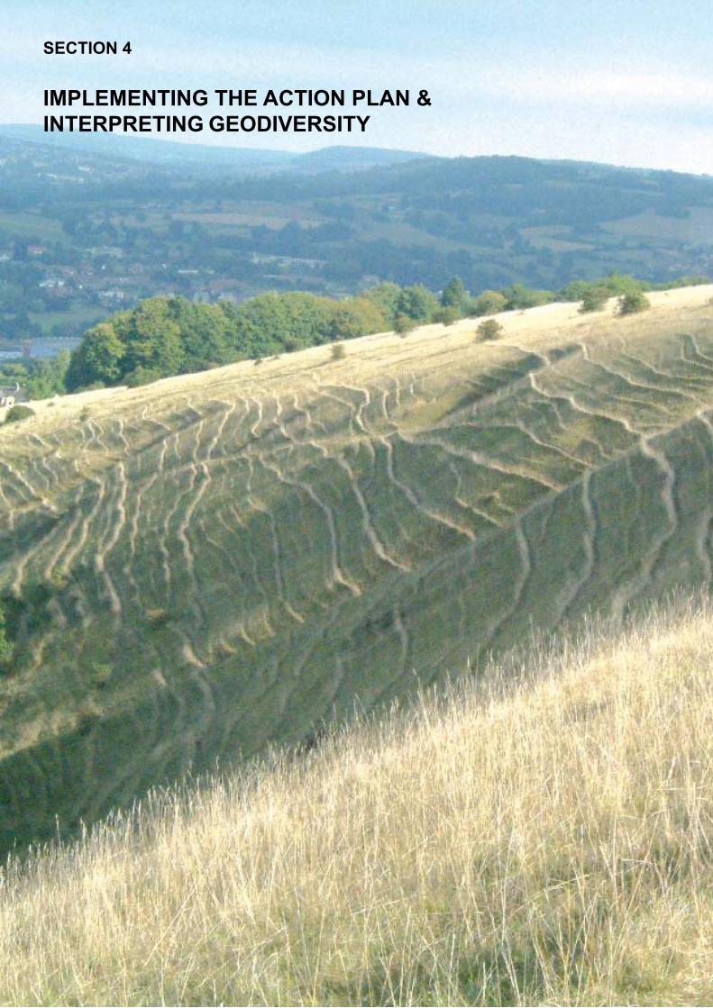
SECTION 4
IMPLEMENTING THE ACTION PLAN & INTERPRETING GEODIVERSITY
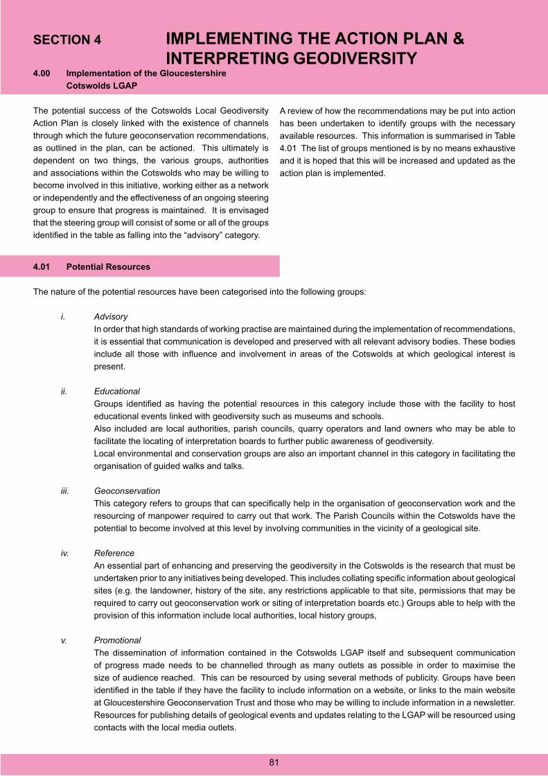
4.00 Implementation of the Gloucestershire
Cotswolds LGAP
The potential success of the Cotswolds Local Geodiversity
Action Plan is closely linked with the existence of channels
through which the future geoconservation recommendations,
as outlined in the plan, can be actioned. This ultimately is
dependent on two things, the various groups, authorities
and associations within the Cotswolds who may be willing to
become involved in this initiative, working either as a network
or independently and the effectiveness of an ongoing steering
group to ensure that progress is maintained. It is envisaged
that the steering group will consist of some or all of the groups
identified in the table as falling into the “advisory” category.
A review of how the recommendations may be put into action
has been undertaken to identify groups with the necessary
available resources. This information is summarised in Table
4.01 The list of groups mentioned is by no means exhaustive
and it is hoped that this will be increased and updated as the
action plan is implemented.
4.01 Potential Resources
The nature of the potential resources have been categorised into the following groups:
i. Advisory
In order that high standards of working practise are maintained during the implementation of recommendations,
it is essential that communication is developed and preserved with all relevant advisory bodies. These bodies
include all those with influence and involvement in areas of the Cotswolds at which geological interest is
present.
ii. Educational
Groups identified as having the potential resources in this category include those with the facility to host
educational events linked with geodiversity such as museums and schools.
Also included are local authorities, parish councils, quarry operators and land owners who may be able to
facilitate the locating of interpretation boards to further public awareness of geodiversity.
Local environmental and conservation groups are also an important channel in this category in facilitating the
organisation of guided walks and talks.
iii. Geoconservation
This category refers to groups that can specifically help in the organisation of geoconservation work and the
resourcing of manpower required to carry out that work. The Parish Councils within the Cotswolds have the
potential to become involved at this level by involving communities in the vicinity of a geological site.
iv. Reference
An essential part of enhancing and preserving the geodiversity in the Cotswolds is the research that must be
undertaken prior to any initiatives being developed. This includes collating specific information about geological
sites (e.g. the landowner, history of the site, any restrictions applicable to that site, permissions that may be
required to carry out geoconservation work or siting of interpretation boards etc.) Groups able to help with the
provision of this information include local authorities, local history groups,
v. Promotional
The dissemination of information contained in the Cotswolds LGAP itself and subsequent communication
of progress made needs to be channelled through as many outlets as possible in order to maximise the
size of audience reached. This can be resourced by using several methods of publicity. Groups have been
identified in the table if they have the facility to include information on a website, or links to the main website
at Gloucestershire Geoconservation Trust and those who may be willing to include information in a newsletter.
Resources for publishing details of geological events and updates relating to the LGAP will be resourced using
contacts with the local media outlets.
SECTION 4 IMPLEMENTING THE ACTION PLAN & INTERPRETING GEODIVERSITY
81

GR
OU
PS
SP
EC
IFIC
R
ES
OU
RC
ES
P
OT
EN
TIA
LLY
A
VA
ILA
BL
E
AR
EA
TO
WH
ICH
SP
EC
IFIC
SK
ILL
S C
AN
PO
TE
NT
IAL
LY B
E A
PP
LIE
D
Ad
viso
ryE
du
cati
on
Geo
con
serv
atio
n
Wo
rkR
efer
ence
Pro
mo
tio
n
Tale
4.0
1E
nvi
ron
men
tal/C
on
serv
atio
n -
Lo
cal
Glo
uces
ters
hire
G
eoco
nser
vatio
n T
rust
Geo
logi
cal e
xper
tise
XX
XX
X
Eng
lish
Nat
ure
XX
XX
Cot
swol
d A
ON
B
Par
tner
ship
XX
XX
The
Geo
logy
Tru
sts
XX
XC
otte
swol
d N
atur
alis
ts’
Fie
ld C
lub
XX
Wild
fow
l & W
etla
nds
Tru
stX
X
Glo
uces
ters
hire
Wild
life
Tru
stX
X
Brit
ish
Tru
st fo
r C
onse
rvat
ion
Vol
unte
ers
Vol
unte
er m
anpo
wer
X
Str
oud
Val
leys
Pro
ject
XX
Wes
tonb
irt A
rbor
etum
XX
Nat
iona
l Tru
st
Glo
uces
ters
hire
XX
The
Woo
dlan
d T
rust
S
outh
Wes
tX
X
Glo
uces
ters
hire
Soc
iety
fo
r In
dust
rial A
rcha
eolo
gyX
X
Woo
dche
ster
Man
sion
T
rust
XX
82

GR
OU
PS
SP
EC
IFIC
R
ES
OU
RC
ES
P
OT
EN
TIA
LLY
A
VA
ILA
BL
E
AR
EA
TO
WH
ICH
SP
EC
IFIC
SK
ILL
S C
AN
PO
TE
NT
IAL
LY B
E A
PP
LIE
D
Ad
visory
Ed
ucatio
nG
eoco
nservatio
n
Wo
rkR
eference
Pro
mo
tion
Table 4.02
Lo
cal gro
up
sF
riends of Leckhampton
Hill
XX
Cleeve C
omm
on C
onservatorsX
X
Stinchcom
be Hill
Conservation G
roupX
X
Table 4.03
Au
tho
ritiesG
loucestershire County
Council
Advice, inform
ation, links to planning strategies
XX
X
Cotsw
old District C
ouncil¨
XX
XTew
kesbury Borough
Council
¨X
XX
Cheltenham
Borough
Council
¨X
XX
Stroud D
istrict Council
¨X
XX
Table 4.04
Parish
Co
un
cilsSelsley P
arish Council
XX
83

GR
OU
PS
SP
EC
IFIC
R
ES
OU
RC
ES
P
OT
EN
TIA
LLY
A
VA
ILA
BL
E
AR
EA
TO
WH
ICH
SP
EC
IFIC
SK
ILL
S C
AN
PO
TE
NT
IAL
LY B
E A
PP
LIE
D
Ad
viso
ryE
du
cati
on
Geo
con
serv
atio
n
Wo
rkR
efer
ence
Pro
mo
tio
n
Tab
le 4
.05
Qu
arry
Op
erat
ors Hun
tsm
an’s
Qua
rrie
s Lt
d.E
duca
tiona
l out
let f
or
inte
rpre
tatio
nX
X
Cot
swol
d S
tone
Qua
rrie
s Lt
d.¨
X
Far
min
gton
Nat
ural
S
tone
Ltd
.¨
X
Nat
ural
Sto
ne M
arke
t Lt
d.¨
X
Han
son
Agg
rega
tes
Ltd.
¨X
XS
ound
boro
ugh
Qua
rrie
s Lt
d.X
Gol
dhill
Qua
rry
XTe
tbur
y S
tone
Co.
Ltd
.X
Tab
le 4
.06
Aca
dem
ic In
stit
uti
on
sU
nive
rsity
of
Glo
uces
ters
hire
Geo
logi
cal,
geom
orph
olog
ical
in
form
atio
nX
X
Roy
al A
gric
ultu
ral
Col
lege
Cire
nces
ter
Soi
lsX
84

GR
OU
PS
SP
EC
IFIC
R
ES
OU
RC
ES
P
OT
EN
TIA
LLY
A
VA
ILA
BL
E
AR
EA
TO
WH
ICH
SP
EC
IFIC
SK
ILL
S C
AN
PO
TE
NT
IAL
LY B
E A
PP
LIE
D
Ad
visory
Ed
ucatio
nG
eoco
nservatio
n
Wo
rkR
eference
Pro
mo
tion
Table 4.07
Mu
seum
sT
he Museum
in the Park,
Stroud
Venue for public
events, location for displays
XX
Cheltenham
Museum
&
Art G
allery¨
XX
Corinium
Museum
, C
irencester¨
XX
Table 4.08
Co
rpo
rate Bo
diesI.H
.S. E
nergy (Tetbury)X
XO
olithicaX
X
85

GR
OU
PS
SP
EC
IFIC
R
ES
OU
RC
ES
P
OT
EN
TIA
LLY
A
VA
ILA
BL
E
AR
EA
TO
WH
ICH
SP
EC
IFIC
SK
ILL
S C
AN
PO
TE
NT
IAL
LY B
E A
PP
LIE
D
Ad
viso
ryE
du
cati
on
Geo
con
serv
atio
n
Wo
rkR
efer
ence
Pro
mo
tio
n
Tab
le 4
.09
Reg
ion
al A
sso
ciat
ion
sQ
uarr
y P
rodu
cts
Ass
ocia
tion
(Sou
th W
est)
Adv
ice,
link
s w
ith lo
cal
quar
ry o
pera
tors
, ed
ucat
iona
l out
let
XX
Sou
th W
est R
egio
nal
Dev
elop
men
t Age
ncy
Link
s to
tour
ist i
ndus
try
X
Wes
t of E
ngla
nd
Geo
logi
sts’
Ass
ocia
tion
Geo
logi
cal e
xper
tise
X
Far
min
g W
ildlif
e A
dvis
ory
Gro
up S
outh
Wes
tLi
nks
to lo
cal f
arm
ers
X
The
Nat
iona
l Tru
st
Glo
uces
ters
hire
Adv
ice,
info
rmat
ion
on
land
owne
rshi
pX
XX
86

GR
OU
PS
SP
EC
IFIC
R
ES
OU
RC
ES
P
OT
EN
TIA
LLY
A
VA
ILA
BL
E
AR
EA
TO
WH
ICH
SP
EC
IFIC
SK
ILL
S C
AN
PO
TE
NT
IAL
LY B
E A
PP
LIE
D
Ad
visory
Ed
ucatio
nG
eoco
nservatio
n
Wo
rkR
eference
Pro
mo
tion
Table 4.10
Natio
nal G
rou
ps
The N
ational Trust
XX
Joint Nature C
onservancy C
ouncilX
X
The G
eological Society
XX
XT
he Geologists’
Association
XX
X
British G
eological Survey
XX
XF
orestry Com
mission
XF
arming &
Wildlife
Advisory G
roupX
Cam
paign to Protect R
ural E
nglandX
UK
RIG
SX
XT
he Woodland T
rustX
XC
ountry Landowners
Association
Advice, links to
landowners
XX
87

GR
OU
PS
SP
EC
IFIC
R
ES
OU
RC
ES
P
OT
EN
TIA
LLY
A
VA
ILA
BL
E
AR
EA
TO
WH
ICH
SP
EC
IFIC
SK
ILL
S C
AN
PO
TE
NT
IAL
LY B
E A
PP
LIE
D
Ad
viso
ryE
du
cati
on
Geo
con
serv
atio
n
Wo
rkR
efer
ence
Pro
mo
tio
n
Tab
le 4
.11
Med
iaR
adio
Glo
uces
ters
hire
XC
otsw
old
Life
Mag
azin
eX
Sev
ern
Sou
ndX
Citi
zen
New
spap
erX
Glo
uces
ter
Ech
oX
Gaz
ette
New
spap
ers
XD
own
to E
arth
Pub
licat
ion
X
88
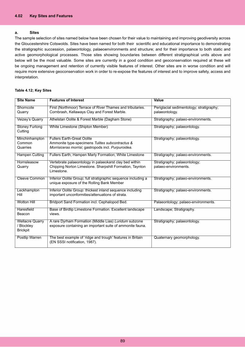
4.02 Key Sites and Features
a. Sites
The sample selection of sites named below have been chosen for their value to maintaining and improving geodiversity across
the Gloucestershire Cotswolds. Sites have been named for both their scientific and educational importance to demonstrating
the stratigraphic succession, palaeontology, palaeoenvironments and structure; and for their importance to both static and
active geomorphological processes. Those sites showing boundaries between different stratigraphical units above and
below will be the most valuable. Some sites are currently in a good condition and geoconservation required at these will
be ongoing management and retention of currently visible features of interest. Other sites are in worse condition and will
require more extensive geoconservation work in order to re-expose the features of interest and to improve safety, access and
interpretation.
Site Name Features of Interest Value
Shorncote Quarry
First (Northmoor) Terrace of River Thames and tributaries. Cornbrash, Kellaways Clay and Forest Marble.
Periglacial sedimentology; stratigraphy; palaeontology.
Veizey’s Quarry Athelstan Oolite & Forest Marble (Dagham Stone) Stratigraphy; palaeo-environments.
Stoney Furlong Cutting
White Limestone (Shipton Member) Stratigraphy; palaeontology.
Minchinhampton Common Quarries
Fullers Earth-Great OoliteAmmonite type-specimens Tulites subcontractus & Morrisiceras morrisi; gastropods incl. Purpuroidea.
Stratigraphy; palaeontology.
Hampen Cutting Fullers Earth; Hampen Marly Formation; White Limestone Stratigraphy; palaeo-environments.
Hornsleasow Quarry
Vertebrate palaeontology in palaeokarst clay bed within Chipping Norton Limestone. Sharpshill Formation, Taynton Limestone.
Stratigraphy; palaeontology; palaeo-environments.
Cleeve Common Inferior Oolite Group; full stratigraphic sequence including a unique exposure of the Rolling Bank Member
Stratigraphy; palaeo-environments.
Leckhampton Hill
Inferior Oolite Group: thickest inland sequence including important unconformities/attenuations of strata.
Stratigraphy; palaeo-environments.
Wotton Hill Bridport Sand Formation incl. Cephalopod Bed. Palaeontology; palaeo-environments.
Haresfield Beacon
Base of Birdlip Limestone Formation. Excellent landscape views.
Landscape; Stratigraphy.
Wellacre Quarry / Blockley Brickpit
A rare Dyrham Formation (Middle Lias) Luridum subzone exposure containing an important suite of ammonite fauna.
Stratigraphy; palaeontology.
Postlip Warren The best example of ‘ridge and trough’ features in Britain (EN SSSI notification, 1987).
Quaternary geomorphology.
Table 4.12; Key Sites
89

b. Features
In addition there are certain features/formations that are not currently exposed or are poorly exposed that are needed to
complete a full account of the geodiversity of the Gloucestershire Cotswolds. References to potential sites come from fieldwork
and past literature. The database at the Gloucestershire Geological Records Centre holds data on potential sites, so far
unsurveyed, which could improve and advance the available geodiversity of the area. The table below (Table 4.13) gives
examples of some geological units currently under-represented and potential sites where they could be exposed.
Feature / Unit Potential Site(s) Comment
Lower Fuller’s Earth Clay & Acuminata Beds
An old, overgrown quarry beside the B4066 Stroud-Uley Road at
Due to the soft nature of the clays, exposures in the Fullers Earth are difficult to maintain. However it is an important unit both geologically and historically and efforts should be made to create a sustainable exposure.
Cephalopod Bed Cud Hill Quarry, Upton St Leonards. The Cephalopod Bed is exposed in the south of the area around Stroud and, in its condensed form, in the north at Cleeve and Leckhampton Hills but correlation in the mid-Cotswolds is missing.
Marlstone Rock Bed Cotswold Escarpment; Vale of Moreton; Vale of Bourton
The MRB is an important landscape forming bed but is infrequently exposed although the flat ledge it forms easily distinguishes its location.
Harford Member The Holt Quarry, Nr. Bourton-on-the-Hill SP 148353: Buckholt Wood, Nr. Cranham SO 894131
The Harford Member is cut out by unconformities in some parts of the area and a number of sites in this member would aid interpretation of past environments.
Rolling Bank Member Pegglesworth area, SW of Cheltenham SO 990180
The Rolling Bank Member is currently only exposed in Rolling Bank Quarry on Cleeve Hill. Another exposure in this member would greatly aid interpretation of this member in the area.
Table 4.13; Key Features
90
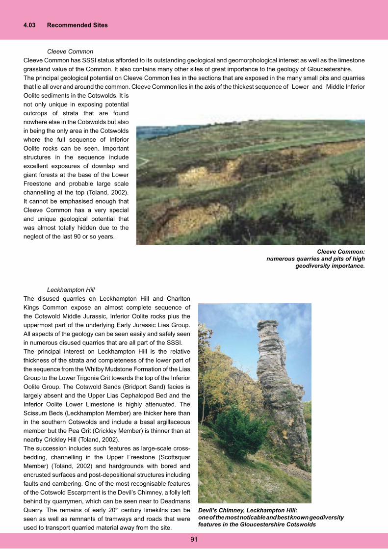
4.03 Recommended Sites
Cleeve Common
Cleeve Common has SSSI status afforded to its outstanding geological and geomorphological interest as well as the limestone
grassland value of the Common. It also contains many other sites of great importance to the geology of Gloucestershire.
The principal geological potential on Cleeve Common lies in the sections that are exposed in the many small pits and quarries
that lie all over and around the common. Cleeve Common lies in the axis of the thickest sequence of Lower and Middle Inferior
Oolite sediments in the Cotswolds. It is
not only unique in exposing potential
outcrops of strata that are found
nowhere else in the Cotswolds but also
in being the only area in the Cotswolds
where the full sequence of Inferior
Oolite rocks can be seen. Important
structures in the sequence include
excellent exposures of downlap and
giant forests at the base of the Lower
Freestone and probable large scale
channelling at the top (Toland, 2002).
It cannot be emphasised enough that
Cleeve Common has a very special
and unique geological potential that
was almost totally hidden due to the
neglect of the last 90 or so years.
Leckhampton Hill
The disused quarries on Leckhampton Hill and Charlton
Kings Common expose an almost complete sequence of
the Cotswold Middle Jurassic, Inferior Oolite rocks plus the
uppermost part of the underlying Early Jurassic Lias Group.
All aspects of the geology can be seen easily and safely seen
in numerous disused quarries that are all part of the SSSI.
The principal interest on Leckhampton Hill is the relative
thickness of the strata and completeness of the lower part of
the sequence from the Whitby Mudstone Formation of the Lias
Group to the Lower Trigonia Grit towards the top of the Inferior
Oolite Group. The Cotswold Sands (Bridport Sand) facies is
largely absent and the Upper Lias Cephalopod Bed and the
Inferior Oolite Lower Limestone is highly attenuated. The
Scissum Beds (Leckhampton Member) are thicker here than
in the southern Cotswolds and include a basal argillaceous
member but the Pea Grit (Crickley Member) is thinner than at
nearby Crickley Hill (Toland, 2002).
The succession includes such features as large-scale cross-
bedding, channelling in the Upper Freestone (Scottsquar
Member) (Toland, 2002) and hardgrounds with bored and
encrusted surfaces and post-depositional structures including
faults and cambering. One of the most recognisable features
of the Cotswold Escarpment is the Devil’s Chimney, a folly left
behind by quarrymen, which can be seen near to Deadmans
Quarry. The remains of early 20th century limekilns can be
seen as well as remnants of tramways and roads that were
used to transport quarried material away from the site.
Cleeve Common: numerous quarries and pits of high
geodiversity importance.
Devil’s Chimney, Leckhampton Hill:one of the most noticable and best known geodiversity features in the Gloucestershire Cotswolds
91
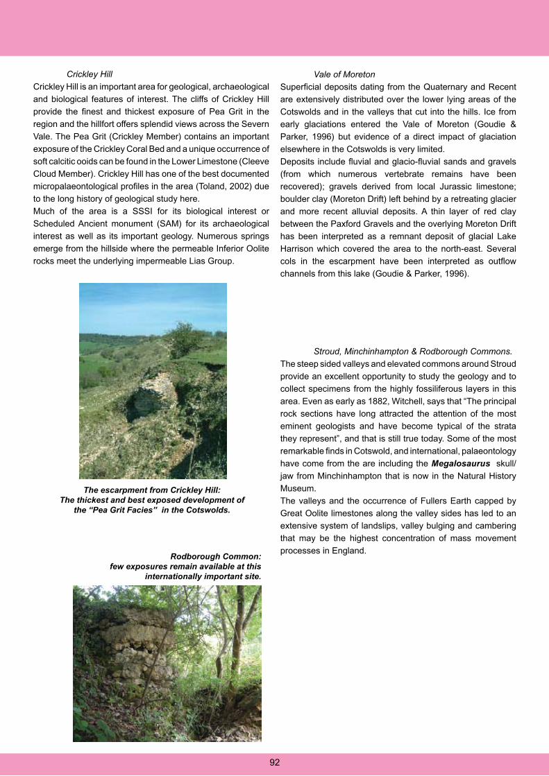
Crickley Hill
Crickley Hill is an important area for geological, archaeological
and biological features of interest. The cliffs of Crickley Hill
provide the finest and thickest exposure of Pea Grit in the
region and the hillfort offers splendid views across the Severn
Vale. The Pea Grit (Crickley Member) contains an important
exposure of the Crickley Coral Bed and a unique occurrence of
soft calcitic ooids can be found in the Lower Limestone (Cleeve
Cloud Member). Crickley Hill has one of the best documented
micropalaeontological profiles in the area (Toland, 2002) due
to the long history of geological study here.
Much of the area is a SSSI for its biological interest or
Scheduled Ancient monument (SAM) for its archaeological
interest as well as its important geology. Numerous springs
emerge from the hillside where the permeable Inferior Oolite
rocks meet the underlying impermeable Lias Group.
The escarpment from Crickley Hill:The thickest and best exposed development of
the “Pea Grit Facies” in the Cotswolds.
Vale of Moreton
Superficial deposits dating from the Quaternary and Recent
are extensively distributed over the lower lying areas of the
Cotswolds and in the valleys that cut into the hills. Ice from
early glaciations entered the Vale of Moreton (Goudie &
Parker, 1996) but evidence of a direct impact of glaciation
elsewhere in the Cotswolds is very limited.
Deposits include fluvial and glacio-fluvial sands and gravels
(from which numerous vertebrate remains have been
recovered); gravels derived from local Jurassic limestone;
boulder clay (Moreton Drift) left behind by a retreating glacier
and more recent alluvial deposits. A thin layer of red clay
between the Paxford Gravels and the overlying Moreton Drift
has been interpreted as a remnant deposit of glacial Lake
Harrison which covered the area to the north-east. Several
cols in the escarpment have been interpreted as outflow
channels from this lake (Goudie & Parker, 1996).
Stroud, Minchinhampton & Rodborough Commons.
The steep sided valleys and elevated commons around Stroud
provide an excellent opportunity to study the geology and to
collect specimens from the highly fossiliferous layers in this
area. Even as early as 1882, Witchell, says that “The principal
rock sections have long attracted the attention of the most
eminent geologists and have become typical of the strata
they represent”, and that is still true today. Some of the most
remarkable finds in Cotswold, and international, palaeontology
have come from the are including the Megalosaurus skull/
jaw from Minchinhampton that is now in the Natural History
Museum.
The valleys and the occurrence of Fullers Earth capped by
Great Oolite limestones along the valley sides has led to an
extensive system of landslips, valley bulging and cambering
that may be the highest concentration of mass movement
processes in England.Rodborough Common:
few exposures remain available at this internationally important site.
92

Wotton Hill
Wotton Hill is also a SSSI and represents a relatively inshore
setting during the time of deposition of the sediments The
Birdlip Limestone Formation (Lower Inferior Oolite) is less
than half the thickness here than it is further north in the
Cotswolds and the top of the Lower Jurassic is represented
by oolitic ironstones with reworked sediments and fossils
capping the formation. The Scottsquar Member of the Birdlip
Limestone Formation and the whole of the Aston Limestone
Formation are absent through erosion or non-deposition
meaning that the Lower Freestone (Cleeve Cloud Member) is
directly overlain by Upper Trigonia Grit (Clypeus Grit Member
(Toland, 2002).
Windrush and Evenlode Valleys
The head of the River Windrush appears just south of Snowshill
and quickly becomes confined within a steep sided valley with
incised meanders. All along its length the river exhibits misfit
stream form and valley in valley meanders indicative of much
higher flow rates earlier in its development, almost certainly
dating from the end of the last Ice Age around 10,000 years
ago. These features are particularly well developed to the
east of Naunton.
The Evenlode Valley is much wider than that of the Windrush
and provides the most extensive deposits of recent alluvium
in the area. Classic valley in valley meanders occur south of
Moreton-in-Marsh and the “misfit” of the river within the valley
can clearly be seen. Smaller misfit streams and dry valleys
lead into the Evenlode Valley and again provide evidence for
long term climatic change.
Two Views of the River Windrush:Right - flowing through Naunton village;
Below - as a misfit stream passing through an oversized valley (the river is flowing along the line of trees to the right of the
photograph).
Wotton Hill Quarry:in danger of becoming obscured by trees.
93
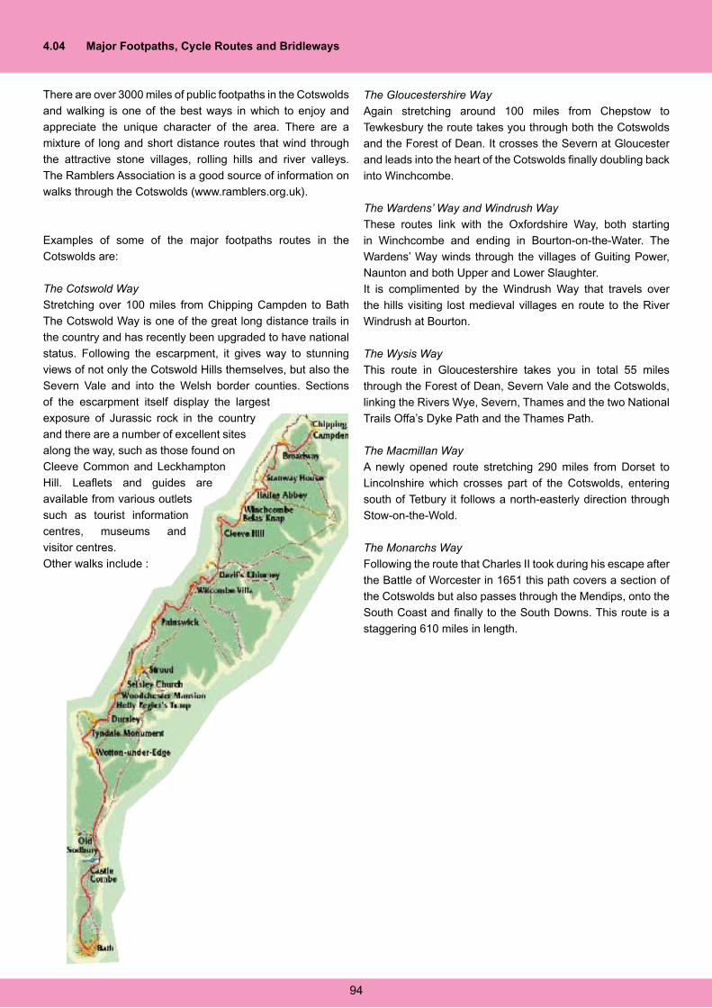
4.04 Major Footpaths, Cycle Routes and Bridleways
There are over 3000 miles of public footpaths in the Cotswolds
and walking is one of the best ways in which to enjoy and
appreciate the unique character of the area. There are a
mixture of long and short distance routes that wind through
the attractive stone villages, rolling hills and river valleys.
The Ramblers Association is a good source of information on
walks through the Cotswolds (www.ramblers.org.uk).
Examples of some of the major footpaths routes in the
Cotswolds are:
The Cotswold Way
Stretching over 100 miles from Chipping Campden to Bath
The Cotswold Way is one of the great long distance trails in
the country and has recently been upgraded to have national
status. Following the escarpment, it gives way to stunning
views of not only the Cotswold Hills themselves, but also the
Severn Vale and into the Welsh border counties. Sections
of the escarpment itself display the largest
exposure of Jurassic rock in the country
and there are a number of excellent sites
along the way, such as those found on
Cleeve Common and Leckhampton
Hill. Leaflets and guides are
available from various outlets
such as tourist information
centres, museums and
visitor centres.
Other walks include :
The Gloucestershire Way
Again stretching around 100 miles from Chepstow to
Tewkesbury the route takes you through both the Cotswolds
and the Forest of Dean. It crosses the Severn at Gloucester
and leads into the heart of the Cotswolds finally doubling back
into Winchcombe.
The Wardens’ Way and Windrush Way
These routes link with the Oxfordshire Way, both starting
in Winchcombe and ending in Bourton-on-the-Water. The
Wardens’ Way winds through the villages of Guiting Power,
Naunton and both Upper and Lower Slaughter.
It is complimented by the Windrush Way that travels over
the hills visiting lost medieval villages en route to the River
Windrush at Bourton.
The Wysis Way
This route in Gloucestershire takes you in total 55 miles
through the Forest of Dean, Severn Vale and the Cotswolds,
linking the Rivers Wye, Severn, Thames and the two National
Trails Offa’s Dyke Path and the Thames Path.
The Macmillan Way
A newly opened route stretching 290 miles from Dorset to
Lincolnshire which crosses part of the Cotswolds, entering
south of Tetbury it follows a north-easterly direction through
Stow-on-the-Wold.
The Monarchs Way
Following the route that Charles II took during his escape after
the Battle of Worcester in 1651 this path covers a section of
the Cotswolds but also passes through the Mendips, onto the
South Coast and finally to the South Downs. This route is a
staggering 610 miles in length.
94
Cycle Paths
There are a number of cycle routes around the Cotswolds,
the best way of finding these are through the National Cycle
Network website (www.sustrans.org.uk). Pocket and foldout
maps of cycle routes are also available from Tourist Information
Centres, selected shops and museums. Gradually small
wooden signs are being installed onto signposts at junctions
to help navigate.
Bridleways
The Cotswolds is an ideal location for anyone with an
interest in horse related activities. Numerous riding centres
cater for both the experienced and novice rider and take
advantage of the many miles of public bridleways found in the
Cotswolds. These paths like the footpaths and cycle routes
have the benefit of passing through areas with outstanding
geological sites and landscapes. Again some of the major
paths are located on Cleeve Common and Leckhampton Hill
both of which form part of the escarpment.
4.05 Guided Walks & Field Trips
A number of groups and organisations operating within the
Gloucestershire Cotswolds organise a variety of walks and
field meetings, many if not all of which include elements of
geodiversity in their attractions. A sample of some of the
organisations that regularly lead walks and field meeting in
the Cotswolds is given below, although there are many others.
Local Tourist Information Centres can provide further details
of walks and events throughout the year.
It is intended, through the adoption of this plan, to establish
a regular programme of geological and landscape themed
walks and field trips in order to further interpret and raise
awareness of the great diversity of geological features and
landforms in the area.
Gloucestershire Geoconservation Trust
GGT have published a series of guided trails entitled
‘Gloucestershire Uncovered’ looking primarily at geology
and landscape but which also include information on related
matters of historical, archaeological and biological interest. At
present three trails are published for the Cotswold area but
others are planned for release in the near future. The three
current trail guides are Cleeve Common, Leckhampton Hill
and Crickley Hill.
Contact: Gloucestershire Geoconservation Trust, 01452
864438, [email protected]
Cotswolds AONB
The programme guide comprises walks and events throughout
the Cotswolds. The walks are mainly led by the Cotswold
Voluntary Wardens and the events are run by a variety of
other organisations such as National Trust, Gloucestershire
County Council, Gloucestershire Geoconservation Trust and
Gloucestershire Wildlife Trust.
Contact: Cotswolds AONB, 01451 862000
(www.cotswoldsaonb.com)
Cotswolds Tourist Guides
The Cotswolds Guides provide guides for regular summer
coach and walking tours organised by Cheltenham Tourist
Office and other tour operators. Tours and country walks
can follow established formats or be tailored to suit a groups
requirements and interests.
Contact: Cotswold Guides, 01242 226033,
Gloucestershire Wildlife Trust
The Wildlife Trust lead various walks on their reserves and
other parts of the Cotswolds looking at all aspects of nature
and wildlife.
Contact: Gloucestershire Wildlife Trust, 01452 383333,
The Ramblers Association
There are eight regional groups of ramblers that cover
different parts of Gloucestershire. They lead a variety of
walks each weekend and two weekday walks each month.
Contact: Gloucester Ramblers Group, 01452 864451, www.
ramblers.co.uk
The National Trust (Wessex Region)
Gloucestershire is part of the Wessex Regional National
Trust and contains numerous properties, commons and
country parks where they run regular walks and workshops.
Contact: 01985 843600, [email protected]
Stroud Valleys Project
The Stroud Valleys Project runs a varied programme of
activities from carrying out conservation work to wildlife
watching days. One of their most popular activities is a
regular fossil hunt, led by geologists from Gloucestershire
Geoconservation Trust.
Contact: 01453 753358, [email protected]
95
Abbreviations used in this document:
ALSF Aggregates Levy Sustainability Fund
AONB Area of Outstanding Natural Beauty
AONB-SDF Area of Outstanding Natural Beauty – Sustainable Development Fund
BGS British Geological Survey
BRERC Bristol Regional Environmental Records Centre
CNFC Cotteswold Naturalists Field Club
EH English Heritage
EN English Nature
GCER Gloucestershire Centre for Environmental Records
GCR Geological Conservation Review
GGRC Gloucestershire Geological Records Centre
GGT Gloucestershire Geoconservation Trust
GT Geology Trusts
HLF Heritage Lottery Fund
LBAP Local Biodiversity Action Plan
LGAP Local Geodiversity Action Plan
LTCS Landfill Tax Credit Scheme
MIRO Mineral Industry Research Organisation
RIGS Regionally important Geological / Geomorphological Site
SSSI Site of Special Scientific Interest
UKGAP United Kingdom Geodiversity Action Plan

REFERENCES
Ager, D.V. (1964) Geology of the Cotswold Hills, Geologists Association Guides, No.36. Colchester: BenhamAhnert, F. (1996) Introduction to Geomorphology, Arnold: LondonAllingham, K.D., Cartwright, R., Donaghy, D., Conway, J.S., Jarvis, S.C. & Goulding, K.W.T. (2002) Nitrate leaching losses and their control in a mixed farm system in the Cotswold Hills, England, Soil Use and Management, 18 (4), p.421-427Angseesing, J., Barron, A.J.M. & Campbell, M. (2002) Geology on Cleeve Hill: enlarged sections in the Aston Limestone Formation (Middle Inferior Oolite), Proceedings of the Cotteswold Naturalists’ Field Club, XLII (II), p.128-145Arkell, W.J. (1933) The Jurassic System in Great Britain. Reprint. Oxford University Press 1970.Arkell, W.J. (1973) English rock terms: Chiefly as used by miners and quarrymen, University of Durham: Oxford University PressAustralian Heritage Commission (2002) Australian National Heritage Charter, In: Gray, M. Geodiversity: conserving abiotic nature, Wiley: ChichesterBaker, P.G. (1981) Interpretation of the Oolite Marls (Upper Aalenian, Lower Inferior Oolite) of the Cotswolds, England. Proc. Geol. Ass., 92 (3)Barron, A.J.M. Sumbler, M.G. & Morigi, A.N. (1997) A revised lithostratigraphy for the Inferior Oolite Group (Middle Jurassic) of the Cotswolds, England. Proc. Geol. Assoc. 108. Geol. Soc. LondonBarron, A.J.M. (2000) Broadway Quarry, Worcestershire: an enlarged section in the Inferior Oolite Group, Proceedings of the Cotteswold Naturalists’ Field Club, XLI (III), p.309-321
Barron, A.J.M., Sumbler, M.G. and Morigi, A.N., 2002, Geology of. Moreton-in-Marsh District. British Geological Survey.Beckinsdale. R.P. (1970) Physical problems of Cotswold rivers and valleys. Proc. Cots. Nats. Vol. XXXV. (IV). 1969-70Beckinsale, R.P. (1982) Pot Holes on the escarpment summit of the North Cotswolds, Proceedings of the Cotteswold Naturalists’ Field Club, XXXVIII (III & IV), p.62-70Beckinsale, R.P. (1991) The Cotswold Hills: a geographical definition, Proceedings of the Cotteswold Naturalists’ Field Club, XL (I), p.20-30Bowen, D.Q. (Ed.) (1999) A revised correlation of Quaternary Deposits in the British Isles, Geological Society Special Publication No.23Breeze, G. (1987) The geology collection of Cheltenham Art Gallery and Museums, Proceedings of the Cotteswold Naturalists’ Field Club, XXXIX (III), p.201Bridgland, D.R., (1994) Quaternary of the Thames, Geological Conservation Review Series No. 7, Chapman & Hall, London, pp. 441British Waterways (2003) Cotswold Canals Restoration Conservation Statement: towards a conservation management plan for the Cotswold Canals, Cotswold Canals Project: StroudBrodie P.B. (1894) Notice on the discovery of a dragonfly and a new species of Leptolepis in the Upper Lias near Cheltenham. Quart. Jl. Geol. Soc. Vol. 5Brown, C.J. (1991) A geotechnical study of abandoned mine workings in the Bath area, In: Self & Boycott (2004), Landslip caves in the middle Cotswolds, Proc Univ. Bris. Spelaeological Society, 23(2), 97-117Burek, C. & Potter, J. (2004) Chesire Region Local Geodiversity Action Plan. Burek, C. & Potter, J. (2004) Local Geodiversity Action Plans: setting the context for geological conservation, English Nature Research Report, No 560.Burek, C. & Potter, J. (2004) Local Geodiversity Action Plans: sharing good practice workshop, English Nature Research Report, No 601.Campbell, M. (2000) The nature and cause of the 1995 Amberley Court landslip, Proceedings of the Cotteswold Naturalists’ Field Club, XLI (III), p.322-340Carter, S. Houlston, I. & Jenkinson, L. (2004) Landscape Character Assessment: Cotswolds Area of Outstanding Natural Beauty, Landscape Design Associates for the Cotswolds AONB Partnership.Cave, R. (1977) Geology of the Malmesbury District , Memoir of the Geological Survey of Great BritainChidlaw N. (1987a) Middle Lias of the Cotswolds. Unpublished Ph.D Thesis.Chidlaw N. (1987b) The sedimentology of the Marlstone Rock Bed & Dryham Silt Formation (Pliensbachian, Lower Jurassic) of the Cotswold Hills. CNAA. (Un-published PhD Thesis).Chidlaw, N. (2000) Commentary on Geology and Scenery in the West of England by A.E. TruemanChidlaw, N. (2001) An overview of the Quaternary Record in the Severn Vale and Cotswolds: deposits and landforms, Proceedings of the Cotteswold Naturalists’ Field Club, XLII (I), p.41Chidlaw, N. (2002) The Quaternary Record in Gloucestershire, Bedrock Issue 12, Gloucestershire Geoconservation Trust NewsletterChidlaw, N. (2005) Personal CommunicationCleal, C.J. & Rees, P.M. (2003) The Middle Jurassic flora from Stonesfield, Oxfordshire, UK, Palaeontology, 46 (4), p.739-801Coe, J. (1996) The Northern Drift of the Evenlode Valley, Oxfordshire, Proceedings of the Cotteswold Naturalists’ Field Club, XLI (I), p.106-117
Conway, J.S. (2001) Limestone, soils and nitrogen in Cotswold farming systems, Proceedings of the Cotteswold Naturalists’ Field Club, XLII (I), p.31- 37Conway, J.S., (2005) http://www.rac.ac.uk/soils/college_soils/default.htmConway, J.S., (2005) http://www.rac.ac.uk/soils/esoils/sher.htm Cotswolds AONB Partnership (2004) Landscape Character Assessment, Landscape Design AssociatesCotswolds AONB Partnership (2004) Cotswolds Area of Outstanding Natural Beauty Management Plan.Courtney, F.M. & Findlay D.C. (1978) Soils in Gloucestershire II sheet SP12 Stow on the Wold, Soil Survey of England and WalesCox, L.R, (1949) Field meeting in the Cotswolds, Proc. Geol. Assoc., 61, 4, 1950Cox, B.M., Sumbler, M.G. & Ivimey-Cook, H.C. (1999) A formational framework for the Lower Jurassic of England & Wales. Research Report No. RR/99/01. BGSCox, B.M. & Sumbler, M.G. (2002) British Middle Jurassic Stratigraphy, JNCCDixon, G. (1996) Geoconservation: An international review and strategy for Tasmania, In: Gray, M. Geodiversity: conserving abiotic nature, Wiley: Chichesterdo Carmo, D.A., Whatley, R.C. & Timberlake, S. (1999) Variable nodding and palaeoecology of a Middle Jurassic limnocytherid ostracod: implications for modern brackish water taxa, Palaeogeography, Palaeoclimatology, Palaeoecology, 148 (1), p.23-35Donovan, D.T., Ager, D.V. & Torrens, H. (1969) International field symposium on the British Jurassic: Excursion No.2: Guide for North Somerset and Gloucestershire, Geology Department; Keele UniversityDreghorn, W. (1973) Geology Explained in the Severn Vale and Cotswolds, David & Charles; Newton AbbotEberhard, R. (Ed) (1997) Pattern and Process: Towards a Regional Approach to National Estate Assessment of Geodiversity, In: Gray, M. Geodiversity: conserving abiotic nature, Wiley: ChichesterEllis, N.V. (Ed), Bowen, D.Q., Campbell, S., Knill, J.L., McKirdy, A.P., Prosser, C.D., Vincent, M.A. and Wilson, R.C.L. (1996) An introduction to the geological conservation review. GCR Series No.1, Joint Nature Conservation Committee, PeterboroughEyles, J.M., Callomon, J.H. & Torrens, H. (1969) International field symposium on the British Jurassic: William Smith, a chronology of significant dates in his life; Guides to field excursions from London, Geology Department; Keele UniversityFindlay, D.C., (1976) The Southern Cotswolds & Surrounding country, Soil Survey of England and WalesFindlay, D.C., et al, (1984) Soils and their use in South West England, Soil Survey of England and WalesGloucestershire Trust for Nature Conservation (1984) The Rivers and Streams of Gloucestershire, Gloucestershire Trust for Nature Conservation: GloucesterGoudie, A.S. & Parker, A.G. (1996) The Geomorphology of the Cotswolds, The Cotteswold Naturalists Field Club: OxfordGray, M. (2003) Geodiversity: valuing and conserving abiotic nature, John Wiley: ChichesterGreen, G.W. (1992) British Regional Geology: Bristol and Gloucester Region (3rd Ed)London: HMSO for British Geological SurveyHallam, A. (1975) Jurassic Environments, Cambridge University PressHarding, G.T. (1985) The subterranean quarries of the Witcombe Valley, Proceedings of the Cotteswold Naturalists’ Field Club, XXXIX (II), p156-164Harker, A. (1884) On a remarkable exposure of the Kellaways rock in a recent cutting near Cirencester. Proc. Cotts. Nat., 8, 176-187.Haslett, S.K. (2001) Quaternary geology of the Severn Basin, Proceedings of the Cotteswold Naturalists’ Field Club, XLII (I), p38-40Hunt, J. (2005) Personal CommunicationHutchinson, J.N. & Coope, G.R. (2002) Cambering and valley bulging, periglacial solifluction and lateglacial Coleoptera at Dowdeswell, near Cheltenham, Proc. Geol. Assoc., 113 (4), p.291-300Joint Nature Conservation Committee (2004) The Geological Conservation Review, http://www.jncc.gov.uk/earthheritage/gcr/default.htm, 22/12/2004Kerrow, S. & Smith, R. (1985) A Bathonian Hardground at Foss Cross near Cirencester. Proceedings of the Cotteswold Naturalists’ Field Club, XXXIX (II), p.165-179Larwood, J. (2004) Local Geodiversity Action Plans – sharing good practice, English Nature; Peterborough LoveToKnow 1911 Online Encyclopedia. © (2003, 2004) LoveToKnow. http://43.1911encyclopedia.org/S/SM/SMITH_WILLIAM_GEOLOGIST_.htmMee, A. (1938) The King’s England: Gloucestershire, London: Hodder & StoughtonMcCall, J. (2000) A Cotswold meteorite: the Aldsworth fall of 1835, , Proceedings of the Cotteswold Naturalists’ Field Club, XLI (III), p.303-308McKerrow, Ager & Donovan, 1973. Geology of the Cotswold Hills, G.A Guide No. 36.McMillan. A.A., Gillanders, R.J. & Fairhurst, J.A. (1999) The building stones of Edinburgh, In Gray, M. (2003) Geodiversity: valuing and conserving abiotic nature, Wiley, Chichester)Moore, C. (1867) On the Middle and Upper Lias of the South-West of England. Proc. Somerset Arch & Nat. Hist. Soc. Vol. 5Mudge, D.C. (1973) The Faunistic and Facies Variations in the Lower Inferior Oolite of the Cotswolds. PhD thesis, University of Wales
Mudge, D.C. (1978) Stratigraphy and sedimentation of the Lower Inferior Oolite of the Cotswolds. Jl. Geol. Soc. London, 135Mudge, D.C. (1995) The Middle Jurassic of the Cotswolds. From Taylor, P.D. (Ed.) 1995, Field Geology of the British Jurassic. Geol. Soc. LondonNature Conservancy Council (1991) Earth Science Conservation in Great Britain: A Strategy, NCCNeumann, I. (2003) Baseline report series: 7. The Great and Inferior Oolite of the Cotswolds District, British Geological Survey; National Groundwater and contaminated land cemtre.North Pennines AONB Partnership (2004) North Pennines Area of Outstanding Natural Beauty: A geodiversity audit and action plan 2004-09.Nordic Council of Ministers, 2003, Diversity in Nature, In: Gray, M. Geodiversity: conserving abiotic nature, Wiley: ChichesterParker, A.G. & Goudie, A.S. (1998) The distribution and modes of origin of peat and calcareous tufa deposits in the Upper Thames Valley, Proceedings of the Cotteswold Naturalists’ Field Club, XLI (II), p.230-245O’Neil H.E. (1974) Mammoth remains from gravel pits in the North Cotswolds. Proc. Cott. Nat. Field Club, 36 (4), Pemberton, M. (2001) Conserving Geodiversity, The Importance of Valuing our Geological Heritage, In Gray, M. Geodiversity: conserving abiotic nature, Wiley: Chichester)Price, A. (2005) Personal CommunicationRadley, J. (2004a) Warwickshire Permian-Triassic Fossil Site LGAP: Geodiversity Action Plan for the Permian Ashow Formation Fossil Sites, Warwickshire Museum.Radley, J. (2004b) Warwickshire Permian-Triassic Fossil Site LGAP: Geodiversity Action Plan for Bromsgrove Sandstone Fossil Sites, Warwickshire Museum.Radley, J. (2004) Warwickshire Permian-Triassic Fossil Site LGAP: Geodiversity Action Plan forArden Sandstone Fossil Sites, Warwickshire Museum.Richardson, L. (1904) Geology of Cheltenham, Norman Sawyer & Co.Richardson L. (1929) The geology of the country around Moreton-in-Marsh. Geol. Survey G.B. Sheet memoirs.Richardson L. (1933) The Country Around Cirencester. Mem. Geol. Surv. H.M.S.ORobinson, H. (1969) Morphology and Landscape, University Tutorial Press Ltd: LondonRobson, P. 1975. The sand and gravel resources of the Thames Valley, the country around Cricklade, Wiltshire: Description of 1:25 000 resource sheet SU 09/19 and parts of SP 00/01. Miner. Assess. Rep. Inst. Geol. Sci.,No. 18Self, C.A. & Boycott, A. (1999) Landslip Caves of the Southern Cotswolds, Proc. Univ. Bris. Spelaeological Society, 21(3), 197-214Self, C.A. & Boycott, A. (2004) Landslip Caves of the Middle Cotswolds, Proc. Univ. Bris. Spelaeological Society, 23(2), 97-117Sharples, C (2002) Concepts and Principles of Geoconservation, In Gray, M. Geodiversity: conserving abiotic nature, Wiley: ChichesterSimms, M.J., Chidlaw, N., Moreton, N. & Page, K.N. (2004) British lower Jurassic Stratigraphy, JNCCSmiles, S. (1997) Self help; with illustrations of conduct and perseverance, World Wide School: Seatle USASmith F. and Lucy W.C. (1892) Some remarks on the geology of Alderton, Gretton and Ashton-under-Hill. Proc. Cotts. Nat. Field Club. Vol. 10.Stanley, M. (2001) Editorial, Geodiversity Update 1. 1.Stanley, M. (2001) Foreword, In: North Pennines AONB Partnership (2004) North Pennines Area of Outstanding Natural Beauty: A geodiversity audit and action plan 2004-09.Sumbler, M.G. (1995) Geological notes and local details for 1:10 000 Sheet SP 11NW (Farmington). British Geological Survey Technical Report WA/95/3.Sumbler, M.G. & Barron, A.J.M. (1996) The type section of the Hampen Formation (Middle Jurassic, Great Oolite Group) at Hampen Cutting, Gloucestershire, XLI (I), p.118-128Sumbler , M.G. (1998) Lee’s Quarry, Taynton: a type location for the Taynton Limestone Formation (Middle Jurassic, Great Oolite Group, Proceedings of the Cotteswold Naturalists’ Field Club, XLI (II), p.222-229Sumbler, M.G., Barron, A.J.M. & Morigi, A.N. (2000) Geology of the Cirencester District. Memoir of the British Geological Survey, Sheet 235 (England & Wales) Taylor, P.D. (ed) (1995), Field Geology of the British Jurassic. Geological Society, London, 286p.Toland, C. (2002) The Lower Inferior Oolite (Aalenian) of the Cotswolds: towards a sequence stratigraphic framework, Oolithica Geoscience; CheltenhamTorrens, H. (2003) Memoirs of William Smith, LL.D. author of the “Map of the Strata of England and Wales”, Bath Royal Literary and Scientific Institution. Trueman, A. & Chidlaw, N. (2000) Geology and Scenery in the West of England (2nd Ed.) Allegro: BristolVaughan, R. (2004) The Cotteswold Naturalists’ Field Club: Biographical Notes on the Geologists. http://www.rogerco.freeserve.co.uk/cotts.htmWatts, A.B., McKerrow, W.S. & Fielding, E. (2000) Lithospheric flexure, uplift and landscape evolution in south-central England, Journal of the Geological Society, 157 (6), p.1169-1177Watts, A.B., McKerrow, W.S. & Richards, K. (2005) Localised Quaternary Uplift of South-Central England, Journal of the Geological Society, 162 (1), p.13-24Wright, J.K. & Cox, B.M. (2001) British Upper Jurassic Stratigraphy, JNCCWalrond, L (2000) The Cotteswolds Naturalists Field Club, Bedrock, 7, p. 3

Whitworth, M, Giles, D. & Murphy, W. (2002) Landslides of the Cotswold escarpment, Broadway, Worcestershire, UK, Proceedings of the Cotteswold Naturalists’ Field Club, XLII (II), p.118-127Woodward H B. (1894) The Jurassic Rocks of Britain. Mem. Geol. Surv. Vol ivWyatt, R.J. (2004) Interpretation of Stowell Park Borehole, Gloucestershire and definition of the Middle Jurassic Througham Formation, Proc. Geol. Assoc., 115 (2), p187-188
SECTION 5
GLOUCESTERSHIRE COTSWOLDS LOCAL GEODIVERSITY ACTION PLAN
Acknowledgements:
The Gloucestershire Cotswolds LGAP Partnership wishes to express its thanks to the many individuals and organisations that have contributed in many ways to the production of this Geodiversity Audit and Local Geodiversity Action Plan.
Cheltenham Borough Council
Chris Toland, Oolithica Geoscience
Cotswold District Council
Cotswolds AONB Conservation Board
Cotteswold Naturalists Field Club
Country Landowners Association (CLA)
Daglingworth Quarry
Dr Nick Chidlaw
English Heritage
English Nature
Farming and Rural Conservation Agency (FRCA)
Farming and Wildlife Advisory Group (FWAG)
Farmington Natural Stone Ltd
Gloucestershire County Council
Gloucestershire Environmental Records Centre
Gloucestershire Society for Industrial Archaeology
Gloucestershire Tourism
Gloucestershire Wildlife Trust
Herefordshire & Worcestershire Earth Heritage Trust
Huntsmans Quarries
IHS Energy Ltd.
Impressions of Monmouth Ltd.
Mineral Planning Dept, Gloucestershire County Council
National Farmers Union
National Trust
Ramblers Association
Stroud District Council
Tewkesbury Borough Council
The Geology Trusts
United Utilities
Wildfowl & Wetlands Trust
For more information on the Gloucestershire Cotswolds Geodiversity Audit and Local Geodiversity Action Plan, contact:
Gloucestershire Geoconservation TrustThe Geological Records CentreThe Tithe Barn CentreBrockworthGloucestershireGL3 4QU
Tel: 01452 864438E-mail: [email protected]
Web: www.glosgeotrust.org.uk
www.miro.co.ukwww.glosgeotrust.org.ukwww.cotswoldsaonb.com
www.ihsenergy.com